Embed Size (px)
Citation preview
Land Information Centre (LIC) Survey and Mapping Office (SMO), Lands Department The Government of the Hong Kong Special Administrative Region
23/F North Point Government Offices, 333 Java Road, North Point, Hong Kong
Geo-Reference Database Introduction:
Geo-Reference Database provides geographic references information for users to carry out location enquiry and spatial analysis.
Types of Geo-reference Database: (A) Building Name and Address (BG1000)
(B) Site Polygon (SG1000)
(C) Road Centre Line (RG1000)
Formats available:
Database Structure: Format = Data File(s) + Textual Information + Additional Information ASCII =
<sheet>.txt + <sheet>.sdf + add_<sheet>.csv E00 = <sheet>.E00 + --- + add_<sheet>.csv DGN = <sheet>.dgn + <sheet>.csv + add_<sheet>.csv DWG =
<sheet>.dwg + <sheet>.csv + add_<sheet>.csv DXF = <sheet>.dxf + <sheet>.csv + add_<sheet>.csv
(A) Building Name and Address (BG1000)
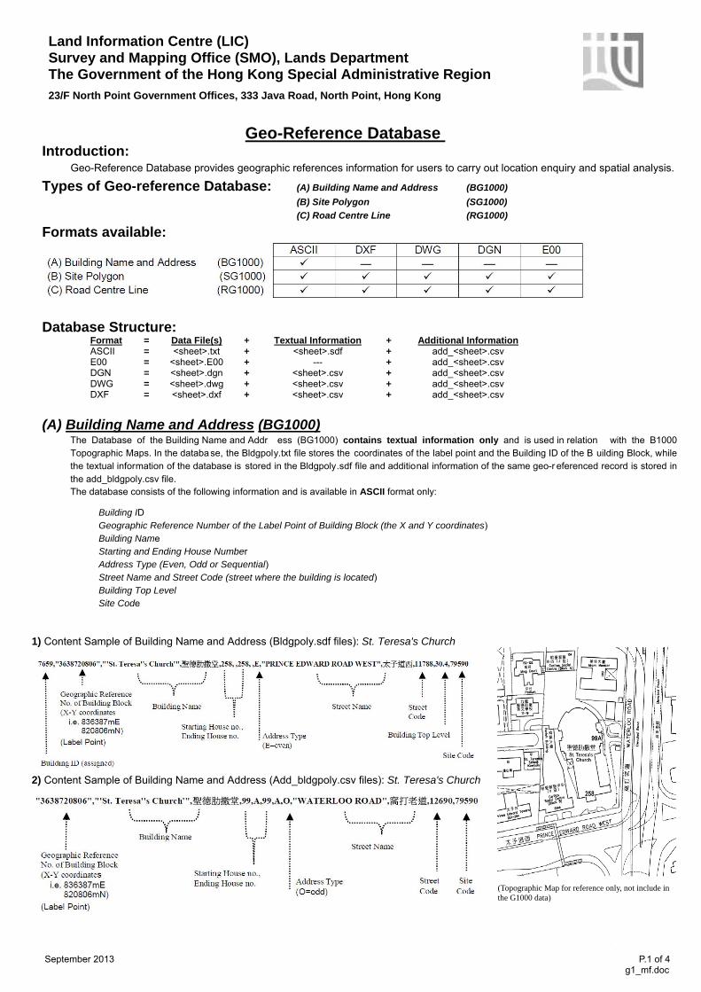
The Database of the Building Name and Addr ess (BG1000) contains textual information only and is used in relation with the B1000 Topographic Maps. In the databa se, the Bldgpoly.txt file stores the coordinates of the label point and the Building ID of the B uilding Block, while the textual information of the database is stored in the Bldgpoly.sdf file and additional information of the same geo-r eferenced record is stored in the add_bldgpoly.csv file. The database consists of the following information and is available in ASCII format only:
Building ID Geographic Reference Number of the Label Point of Building Block (the X and Y coordinates) Building Name Starting and Ending House Number Address Type (Even, Odd or Sequential) Street Name and Street Code (street where the building is located) Building Top Level Site Code
1) Content Sample of Building Name and Address (Bldgpoly.sdf files): St. Teresa's Church
2) Content Sample of Building Name and Address (Add_bldgpoly.csv files): St. Teresa's Church
(Topographic Map for reference only, not include in the G1000 data)
September 2013 P.1 of 4 g1_mf.doc
1
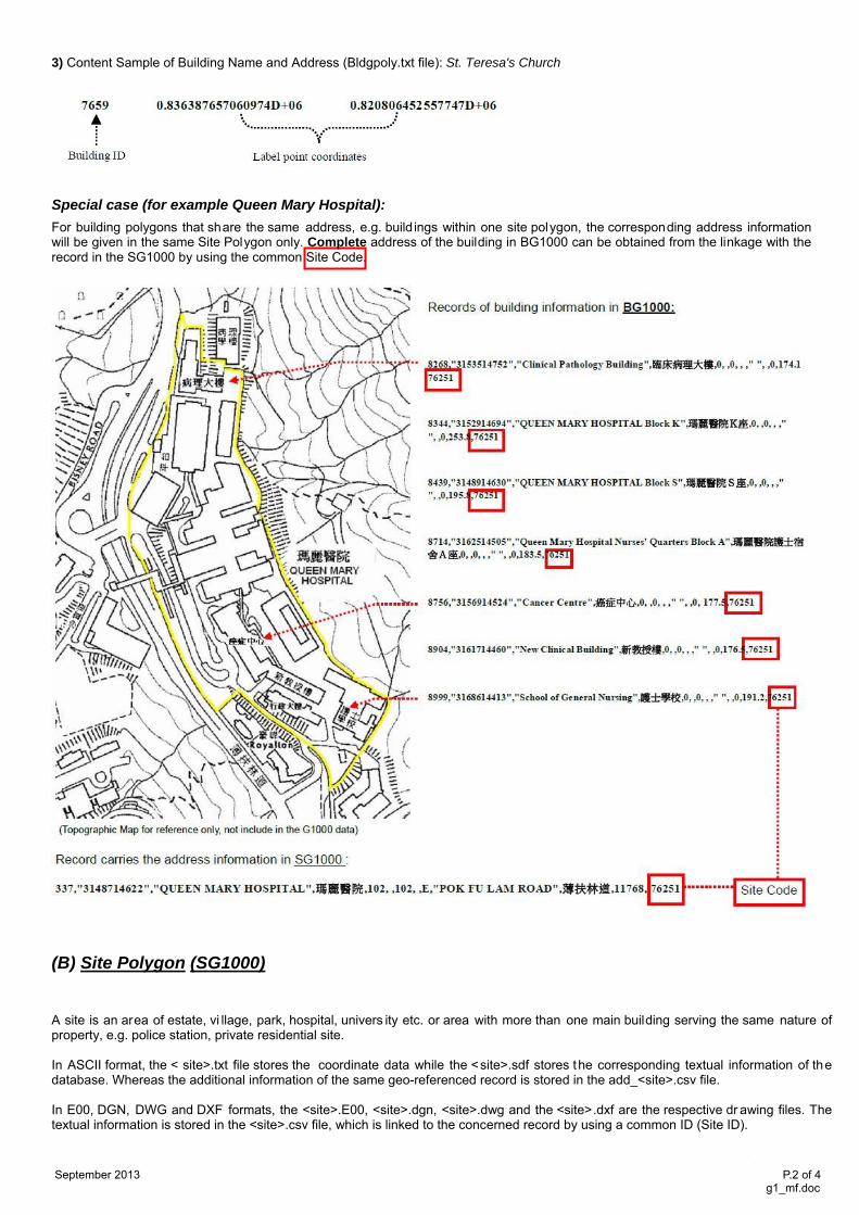
3) Content Sample of Building Name and Address (Bldgpoly.txt file): St. Teresa's Church
Special case (for example Queen Mary Hospital):
For building polygons that share the same address, e.g. build ings within one site polygon, the corresponding address information will be given in the same Site Polygon only. Complete address of the building in BG1000 can be obtained from the linkage with the record in the SG1000 by using the common Site Code.
(B) Site Polygon (SG1000)
A site is an area of estate, vi llage, park, hospital, univers ity etc. or area with more than one main building serving the same nature of property, e.g. police station, private residential site. In ASCII format, the < site>.txt file stores the coordinate data while the <site>.sdf stores the corresponding textual information of the database. Whereas the additional information of the same geo-referenced record is stored in the add_<site>.csv file. In E00, DGN, DWG and DXF formats, the <site>.E00, <site>.dgn, <site>.dwg and the <site>.dxf are the respective dr awing files. The textual information is stored in the <site>.csv file, which is linked to the concerned record by using a common ID (Site ID). September 2013 P.2 of 4 g1_mf.doc
2
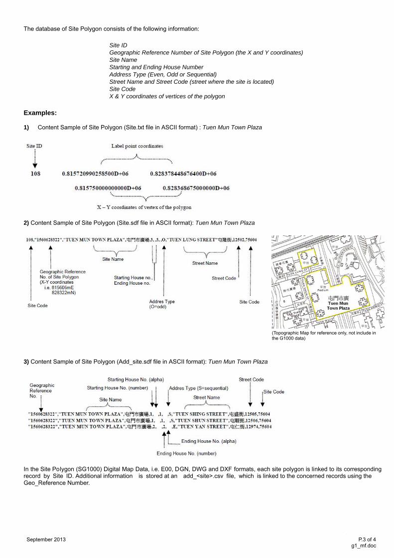
The database of Site Polygon consists of the following information: Site ID
Geographic Reference Number of Site Polygon (the X and Y coordinates) Site Name Starting and Ending House Number Address Type (Even, Odd or Sequential) Street Name and Street Code (street where the site is located) Site Code X & Y coordinates of vertices of the polygon
Examples:
1) Content Sample of Site Polygon (Site.txt file in ASCII format) : Tuen Mun Town Plaza
2) Content Sample of Site Polygon (Site.sdf file in ASCII format): Tuen Mun Town Plaza
(Topographic Map for reference only, not include in the G1000 data)
3) Content Sample of Site Polygon (Add_site.sdf file in ASCII format): Tuen Mun Town Plaza
In the Site Polygon (SG1000) Digital Map Data, i.e. E00, DGN, DWG and DXF formats, each site polygon is linked to its corresponding record by Site ID. Additional information is stored at an add_<site>.csv file, which is linked to the concerned records using the Geo_Reference Number.
September 2013 P.3 of 4 g1_mf.doc
3
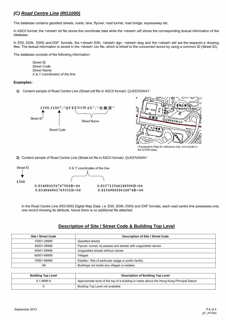
(C) Road Centre Line (RG1000) The database contains gazetted streets, roads, lane, flyover, road tunnel, road bridge, expressway etc. In ASCII format, the <street>.txt file stores the coordinate data while the <street>.sdf stores the corresponding textual information of the database. In E00, DGN, DWG and DXF formats, the <street>.E00, <street>.dgn, <street>.dwg and the <street>.dxf are the respectiv e drawing files. The textual information is stored in the <street>.csv file, which is linked to the concerned record by using a common ID (Street ID). The database consists of the following information:
Street ID Street Code Street Name X & Y coordinates of the line
Examples:
1) Content sample of Road Centre Line (Street.sdf file in ASCII format): QUEENSWAY
2) Content sample of Road Centre Line (Street.txt file in ASCII format): QUEENSWAY
In the Road Centre Line (RG1000) Digital Map Data, i.e. E00, DGN, DWG and DXF formats, each road centre line possesses only one record showing its attribute, hence there is no additional file attached.
Description of Site / Street Code & Building Top Level
Site / Street Code Description of Site / Street Code
10001-29999 Gazetted streets 30001-39999 Flyover, tunnel, by-passes and streets with ungazetted names 40001-59999 Ungazetted streets without names 60001-69999 Villages
70001-89999 Estates / Site of particular usage or public facility -99 Buildings not inside any villages or estates
Building Top Level Description of Building Top Level
0.1-9999.9 Approximate level of the top of a building in metre above the Hong Kong Principal Datum
0 Building Top Level not available
September 2013 P.4 of 4 g1_mf.doc
(Topographic Map for reference only, not include in the G1000 data)
4