Embed Size (px)
Citation preview
JKAU: Mar. Sci., Vol. 20, pp: 91-108 (2009 A.D. / 1430 A.H.)
91
Geoelectrical Survey for Groundwater Exploration at the Asyuit Governorate, Nile Valley, Egypt
Mahmoud I.I. Mohamaden, Abuo Shagar S. and Gamal Abd. Allah*
National Institute of Oceanography and Fisheries, Alexandria, Egypt
*Research Institute for Water Resources, Water Research Center, Ministry of Public Works and Water Resource, Egypt
Abstract. Asyuit area is considered as the most promising area for irrigated agriculture and development in both the Eastern Desert and the Western Desert. Groundwater is the most important resources necessary for such development. Forty-two vertical electrical soundings (VES.'s), using Schlumberger array were carried out in Asyuit area. The main goal of such survey was to elucidate hydrogeological information and to delineate subsurface structural elements.
VES. curves were interpreted using a 2-D horizontal layering resistivity model assumption. The interpretation results showed that the geoelectrical succession consists of four layers. The top layer is formed of gravely sand with relatively high electrical resistivity values, the second layer is composed of sand (aquifer) with relatively intermediate electrical resistivity values, the third layer is made up of clay (aquiclude) with relatively low electrical resistivity values and the fourth layer consists of limestone with relatively high electrical resistivity values. As for groundwater potentiality, the second layer is highly promising to be the water-bearing layer. The maximum depth to water ranges between 9.9 to 522 m.
Keywords: Groundwater, VES., Aquifer.
Correspondence to: Dr. Mahmoud I. I. Mohamaden: National Institute of Oceanography and Fisheries, Alexandria, Egypt [email protected]

Mahmoud I.I. Mohamaden et al.
92
Introduction Asyuit area which lies on both sides of the Nile River is considered as one of the promising areas for sustainable irrigated agriculture. It is located to the east of Asyuit city between Longitudes 27°10' and 27°20' E and Latitudes of 31°10' and 31°30' N (Fig. 1). Groundwater is important in environmental geophysics i.e. many of the environmental studies are directly or indirectly related to groundwater, such as exploration, effects of groundwater on the soil, effects on archaeological sites and groundwater pollution (Gaber et al., 1999; Mesbah, 2003; and Mohamaden, 2005). Geophysics, particularly geoelectrical resistivity techniques, has been extensively used for a wide variety of geotechnical and groundwater exploration problems (e.g. Zohdy, 1975; Barker, 1980; Bernard and Valla, 1991; Nowroozi et al., 1999; Mousa, 2003, Ibrahim, et al., 2004; Youssef et al., 2004; Al-Abaseiry et al., 2005; Hosny et al., 2005; Alotaibi and Al-Amri, 2007; Nigm, et al., 2008). This is due to the fact that, the electrical resistivity survey is one of the simplest and less costly geophysical surveys employed. Moreover, it can be used either in the form of vertical electrical soundings (VES's) or horizontal profiling to search for groundwater in both porous and fissured media (e.g., Barker, 1980; Van Overmeeren, 1989; Abd El-Rahman, A. and Khaled, M.A., 2005; and Abd Alla et al., 2005).
Fig. 1. Location map.
Geoelectrical Survey for Groundwater Exploration at the Asyuit…
93
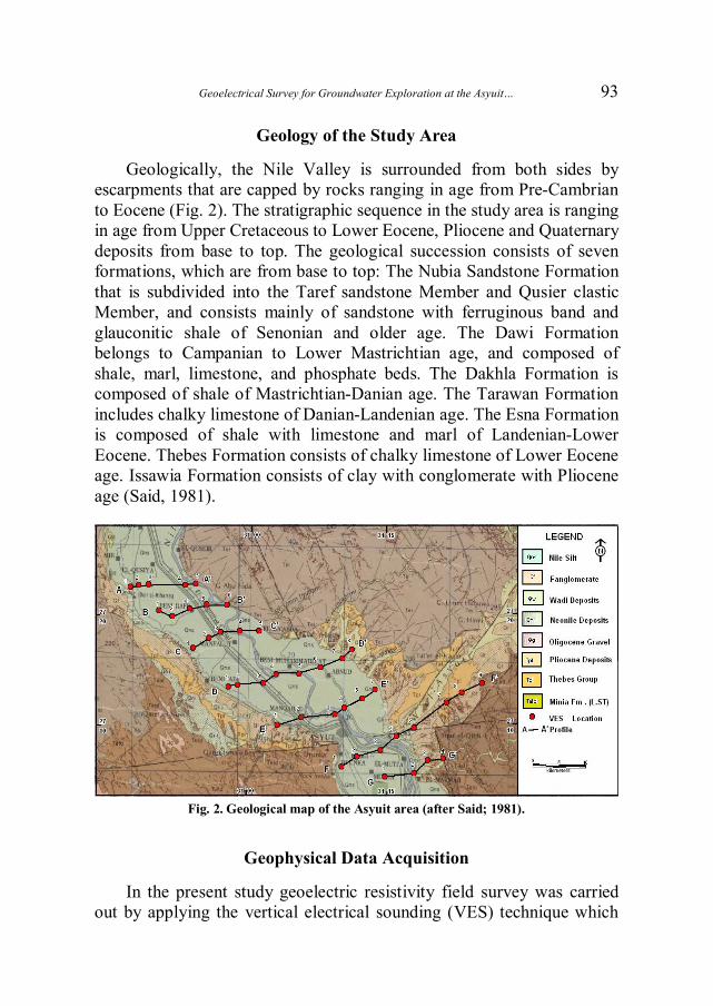
Geology of the Study Area Geologically, the Nile Valley is surrounded from both sides by
escarpments that are capped by rocks ranging in age from Pre-Cambrian to Eocene (Fig. 2). The stratigraphic sequence in the study area is ranging in age from Upper Cretaceous to Lower Eocene, Pliocene and Quaternary deposits from base to top. The geological succession consists of seven formations, which are from base to top: The Nubia Sandstone Formation that is subdivided into the Taref sandstone Member and Qusier clastic Member, and consists mainly of sandstone with ferruginous band and glauconitic shale of Senonian and older age. The Dawi Formation belongs to Campanian to Lower Mastrichtian age, and composed of shale, marl, limestone, and phosphate beds. The Dakhla Formation is composed of shale of Mastrichtian-Danian age. The Tarawan Formation includes chalky limestone of Danian-Landenian age. The Esna Formation is composed of shale with limestone and marl of Landenian-Lower Eocene. Thebes Formation consists of chalky limestone of Lower Eocene age. Issawia Formation consists of clay with conglomerate with Pliocene age (Said, 1981).
Fig. 2. Geological map of the Asyuit area (after Said; 1981).
Geophysical Data Acquisition
In the present study geoelectric resistivity field survey was carried out by applying the vertical electrical sounding (VES) technique which
Mahmoud I.I. Mohamaden et al.
94
measures the electrical resistivity variation with depth. It is worth mentioning here that the electric resistivity of a rock formation varies according to the rock nature of material (density, porosity, pore size and shape), water content and its quality and temperature. Hence, there are no sharp limits for electric resistivity of porous formations. The resistivity is more controlled by the water contents and its quality within the matrix of the formation than by the solid granular resistivity value itself. Therefore, the geological unit may be subdivided into different geoelectrical units according to the different percentage of humidity within it. (Parasnis, 1997).
In present work, Schlumberger array was applied with half current electrode spacing (AB/2) starting from 1m to 1000 m. This spacing is sufficient to reach adequate depths covering the Quaternary aquifer in the study area (Abd El Fattah, 1994). A total number of 42 vertical electrical soundings were measured along 7 profiles (Fig. 1). The sounding number 1 is located to the extreme north eastern part of the investigated area. These profiles run mainly from west to the east direction to cut the Nile River.
The geoelectrical resistivity measurements were performed applying two U.S.A. multimeter units of the type Fluke-27 allowing to filter the potential of the earth and measure the potential difference (ΔV) due to the fed current (I) and the current itself simultaneously. About 20% of the total measurements were recorded twice by changing the supply voltage. According to these repetitions the mean relative error for the field measurements was calculated and found to be ± 1.45% or within the permissible limits.
The result of the geoelectric survey was processed and quantitatively interpreted using available geological information and presented as geoelectrical sections along the various profiles. Many authors such as Koefoed (1965 a, b, and c), Gosh (1971), Zohdy (1975 and 1989), and Hemeker (1984) studied the quantitative interpretation of the geoelectric resistivity measurements. The interpretation of the apparent electrical resistivity data were achieved using two methods, the first is based on curve matching technique using Generalized Cagniard Graph method constructed by Koefoed (1960), in which the results obtained treated with the inverse problem method using computer programs constructed by Hemeker (1984).
Geoelectrical Survey for Groundwater Exploration at the Asyuit…
95
Geoelectrical Sections
The careful examination of the constructed geoelectrical sections (Fig. 3 - 9 and Table 1) indicates the following:
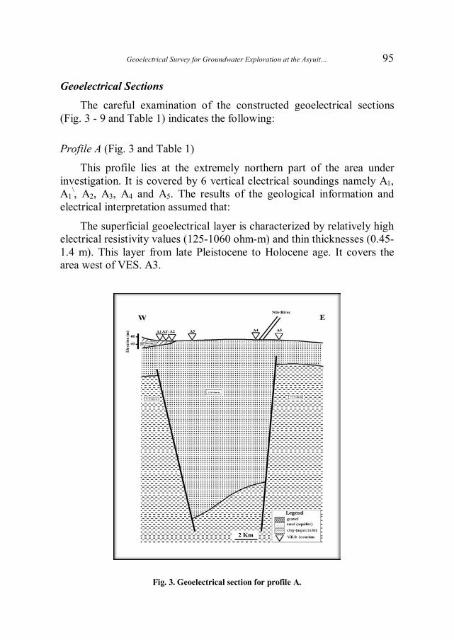
Profile A (Fig. 3 and Table 1)
This profile lies at the extremely northern part of the area under investigation. It is covered by 6 vertical electrical soundings namely A1, A1
\, A2, A3, A4 and A5. The results of the geological information and electrical interpretation assumed that:
The superficial geoelectrical layer is characterized by relatively high electrical resistivity values (125-1060 ohm-m) and thin thicknesses (0.45-1.4 m). This layer from late Pleistocene to Holocene age. It covers the area west of VES. A3.
Fig. 3. Geoelectrical section for profile A.

Mahmoud I.I. Mohamaden et al.
96
The second geoelectrical resistivity layer extends from the Qena- Dandara complex (Prenile) is formed from fluviated sand with thin clay lenses. This layer is the main groundwater aquifer. It is characterized by relatively moderate electrical resistivity values (13-95 ohm-m) and the maximum depths from 64.2 to 467 m. We can notice that the maximum thicknesses of this unit occupy the central part of this profile. While it thins toward the eastern and western directions as a result of two deep faults at the west of VES. A1
\, and west of VES. A5 with down thrown side toward the central part.
The third geoelectrical layer can be represented by the maximum depth of this profile. It is considered as the aquiclude from Pliocene age. It is characterized by relatively very low electrical resistivity values (0.6-9 ohm-m). Table 1. Geoelectrical parameters for the area under investigation.
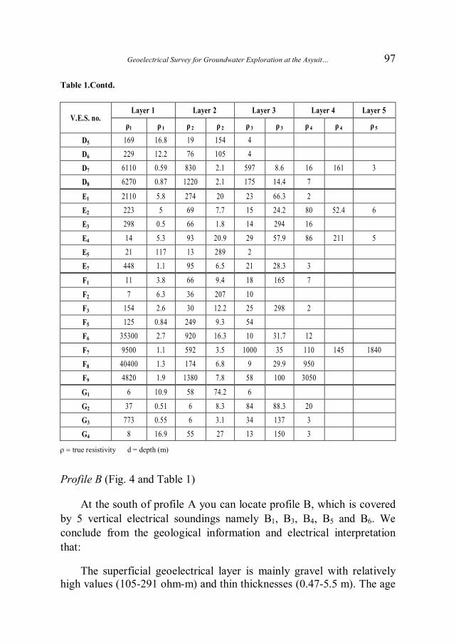
V.E.S. no. Layer 1 Layer 2 Layer 3 Layer 4 Layer 5
ρ1 ρ 1 Ρ 2 ρ 2 ρ 3 ρ 3 ρ 4 ρ 4 ρ 5
A1 286 1.4 62 9.6 52 88.6 2 A1\ 1060 0.45 67 10.9 21 38.1 15 224 0.6 A2 125 0.45 13 3.1 38 199 4 A3 14 9.3 45 467 4
A4 42 0.76 16 19.8 95 95.9 30 384 4 A5 32 2.3 93 3.2 17 6.6 56 64.2 9
B1 691 0.47 138 3.5 42 39.4 19 210 2 B3 126 2.2 35 135 10 413 0.8
B4 9 13.8 65 350 6 B5 10 5.1 29 99 19 427 2 B6 105 5.5 10 23.2 94 82.3 4
C1 1200 1.7 84 9.5 21 117 155 144 3
C2 78 84.4 50 351 10 C3 293 26.8 60 522 8 C4 21 10.9 50 204 4 C5 87 10.5 116 47.3 11 186 2
D1 2990 0.81 329 2.7 30 9.9 8 D2 259 7.1 7 D3 126 0.5 19 17.6 50 292 3
D4 151 0.9 20 33.9 71 129 5
Geoelectrical Survey for Groundwater Exploration at the Asyuit…
97
Table 1.Contd.
true resistivity d = depth (m)
Profile B (Fig. 4 and Table 1)
At the south of profile A you can locate profile B, which is covered by 5 vertical electrical soundings namely B1, B3, B4, B5 and B6. We conclude from the geological information and electrical interpretation that:
The superficial geoelectrical layer is mainly gravel with relatively high values (105-291 ohm-m) and thin thicknesses (0.47-5.5 m). The age
V.E.S. no. Layer 1 Layer 2 Layer 3 Layer 4 Layer 5
ρ1 ρ 1 ρ 2 ρ 2 ρ 3 ρ 3 ρ 4 ρ 4 ρ 5
D5 169 16.8 19 154 4 D6 229 12.2 76 105 4 D7 6110 0.59 830 2.1 597 8.6 16 161 3 D8 6270 0.87 1220 2.1 175 14.4 7
E1 2110 5.8 274 20 23 66.3 2 E2 223 5 69 7.7 15 24.2 80 52.4 6 E3 298 0.5 66 1.8 14 294 16
E4 14 5.3 93 20.9 29 57.9 86 211 5 E5 21 117 13 289 2 E7 448 1.1 95 6.5 21 28.3 3
F1 11 3.8 66 9.4 18 165 7
F2 7 6.3 36 207 10 F3 154 2.6 30 12.2 25 298 2 F5 125 0.84 249 9.3 54 F6 35300 2.7 920 16.3 10 31.7 12
F7 9500 1.1 592 3.5 1000 35 110 145 1840 F8 40400 1.3 174 6.8 9 29.9 950 F9 4820 1.9 1380 7.8 58 100 3050
G1 6 10.9 58 74.2 6
G2 37 0.51 6 8.3 84 88.3 20 G3 773 0.55 6 3.1 34 137 3 G4 8 16.9 55 27 13 150 3

Mahmoud I.I. Mohamaden et al.
98
of this layer is from late Pleistocene to Holocene. This layer can be detected at VES.'s B1, B3 and B6.
The second geoelectrical layer from Qena-Dandara complex (Prenile) is formed from sand (main aquifer). It is characterized by relatively moderate electrical resistivity values (9-94 ohm-m). The maximum depth (350-427 m) is located at the area between west of VES B3 and east of VES B5. The area is bounded by two deep sited faults with downthrown side towards the central part. While at the eastern and western part the thicknesses of this unit ranges from 82.3 to 210 m.
At the maximum depth of penetration can be regarded as the third layer with relatively very low electrical resistivity values (0.8-6 ohm-m) formed from clay and silt (aquiclude). It reached to the maximum depth of penetration along this profile.
Fig. 4. Geoelectrical section for profile B.

Geoelectrical Survey for Groundwater Exploration at the Asyuit…
99
Profile C (Fig. 5 and Table 1) It is located south of profile B. It is covered by 5 VES's named C1,
C2, C3, C4 and C5. From the previous geological information and geoelectrial interpretation, we can conclude that:
A superficial geoelectrical layer covered the ground surface around V.E.S.'s C1 and C3. It is mainly from dry sand and gravel with relatively high electrical resistivity values (293-1200 ohm-m) and thin thicknesses (1.7-26.8 m).
The superficial geoeletrical layer is followed by Qena-Dandara complex (Prenile – main aquifer) from sand and thin clay lenses around VES.'s C1 and C3. While it can be regarded at the ground surface for the rest of this profile. It is characterized by relatively moderate electrical resistivity values (11-116 ohm-m) and depth range from 144 to 522 m. This depth decreases to the east and west directions as a result of two deep sited faults between VES's C1 and C2 and between C3 and C4. The maximum depth at the eastern direction ranges from 186 to 204 m. While at the western part a maximum depth of about 144 m.
The third geoelectrical layer (aquiclude) which is formed from clay or shale can be detected at the maximum depth of penetration with relatively low electrical resistivity values (2-10 ohm-m).
Fig. 5. Geoelectrical section for profile C.
Mahmoud I.I. Mohamaden et al.
100
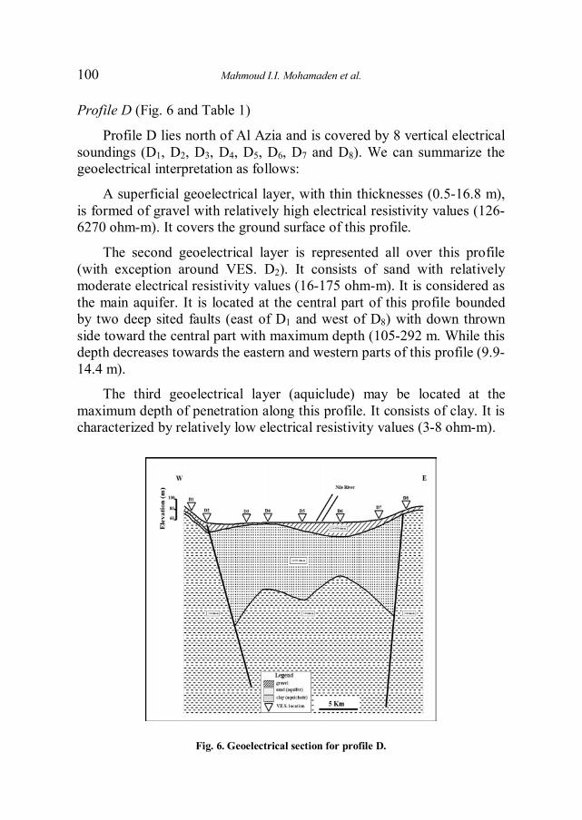
Profile D (Fig. 6 and Table 1)
Profile D lies north of Al Azia and is covered by 8 vertical electrical soundings (D1, D2, D3, D4, D5, D6, D7 and D8). We can summarize the geoelectrical interpretation as follows:
A superficial geoelectrical layer, with thin thicknesses (0.5-16.8 m), is formed of gravel with relatively high electrical resistivity values (126-6270 ohm-m). It covers the ground surface of this profile.
The second geoelectrical layer is represented all over this profile (with exception around VES. D2). It consists of sand with relatively moderate electrical resistivity values (16-175 ohm-m). It is considered as the main aquifer. It is located at the central part of this profile bounded by two deep sited faults (east of D1 and west of D8) with down thrown side toward the central part with maximum depth (105-292 m. While this depth decreases towards the eastern and western parts of this profile (9.9-14.4 m).
The third geoelectrical layer (aquiclude) may be located at the maximum depth of penetration along this profile. It consists of clay. It is characterized by relatively low electrical resistivity values (3-8 ohm-m).
Fig. 6. Geoelectrical section for profile D.
Geoelectrical Survey for Groundwater Exploration at the Asyuit…
101
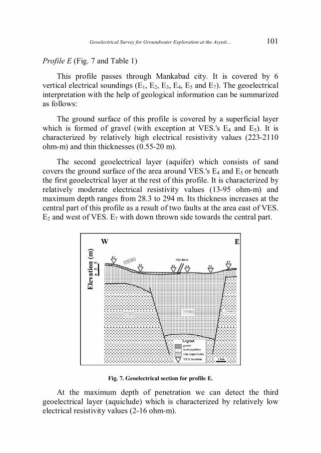
Profile E (Fig. 7 and Table 1)
This profile passes through Mankabad city. It is covered by 6 vertical electrical soundings (E1, E2, E3, E4, E5 and E7). The geoelectrical interpretation with the help of geological information can be summarized as follows:
The ground surface of this profile is covered by a superficial layer which is formed of gravel (with exception at VES.'s E4 and E5). It is characterized by relatively high electrical resistivity values (223-2110 ohm-m) and thin thicknesses (0.55-20 m).
The second geoelectrical layer (aquifer) which consists of sand covers the ground surface of the area around VES.'s E4 and E5 or beneath the first geoelectrical layer at the rest of this profile. It is characterized by relatively moderate electrical resistivity values (13-95 ohm-m) and maximum depth ranges from 28.3 to 294 m. Its thickness increases at the central part of this profile as a result of two faults at the area east of VES. E2 and west of VES. E7 with down thrown side towards the central part.
Fig. 7. Geoelectrical section for profile E.
At the maximum depth of penetration we can detect the third geoelectrical layer (aquiclude) which is characterized by relatively low electrical resistivity values (2-16 ohm-m).
Mahmoud I.I. Mohamaden et al.
102
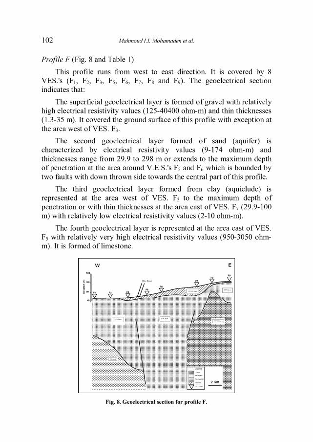
Profile F (Fig. 8 and Table 1) This profile runs from west to east direction. It is covered by 8
VES.'s (F1, F2, F3, F5, F6, F7, F8 and F9). The geoelectrical section indicates that:
The superficial geoelectrical layer is formed of gravel with relatively high electrical resistivity values (125-40400 ohm-m) and thin thicknesses (1.3-35 m). It covered the ground surface of this profile with exception at the area west of VES. F3.
The second geoelectrical layer formed of sand (aquifer) is characterized by electrical resistivity values (9-174 ohm-m) and thicknesses range from 29.9 to 298 m or extends to the maximum depth of penetration at the area around V.E.S.'s F5 and F6 which is bounded by two faults with down thrown side towards the central part of this profile.
The third geoelectrical layer formed from clay (aquiclude) is represented at the area west of VES. F3 to the maximum depth of penetration or with thin thicknesses at the area east of VES. F7 (29.9-100 m) with relatively low electrical resistivity values (2-10 ohm-m).
The fourth geoelectrical layer is represented at the area east of VES. F5 with relatively very high electrical resistivity values (950-3050 ohm-m). It is formed of limestone.
Fig. 8. Geoelectrical section for profile F.

Geoelectrical Survey for Groundwater Exploration at the Asyuit…
103
Profile G (Fig. 9 and Table 1) This profile exists at the extremely south east of the area under
investigation. It is covered by 4 VES.'s G1, G2, G3 and G4. The geoelectrical section indicated that:
The upper most geoelectrical layer formed of gravel mixed with sand. It is characterized by electrical resistivity values ranging from 6 to 773 ohm-m and thin thicknesses (0.5-16.8 m).
Fig. 9. Geoelectrical section for profile G.
The second geoelectrical layer (aquifer) is characterized by relatively moderate electrical resistivity values (13-84 ohm-m). It is formed of sand with depth ranging from 74.2 to 150 m.
The third geoelectrical layer is represented at the maximum depth of penetration with relatively low electrical resistivity values (3-20 ohm-m). It mainly consists of clay (aquiclude).
Hydrogeology Setting Aquifer System
The Quaternary aquifer is composed of graded sand and gravel with thin interbeds of clay, the aquifer reaches a thickness of approximately 200 meters and is highly productive. It occupies much of the Nile valley and is covered by a Holocene silty clay layer, which acts as an aquitard. Groundwater in this aquifer is present under semi-confined conditions (Said, 1981).
Mahmoud I.I. Mohamaden et al.
104
Recharge and Discharge The aquifer system is recharged mainly from seepage of water from
irrigation canals and percolation of excess irrigation water from the fields. Recharge rates from irrigation water seepage vary according to the thickness of the clay layer and the drainage system conditions. The recharge rate from irrigation is about 1 mm/day. There is a lateral recharge occurs by seepage from the Nile (backwater curve zone).
Discharge from the aquifer takes place along the river course. Groundwater extraction by wells is another important discharge component (RIGW/IWACO B.V., EMGR.; 1997).
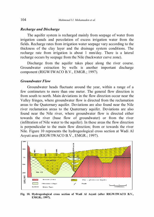
Groundwater Flow Groundwater heads fluctuate around the year, within a range of a
few centimeters to more than one meter. The general flow direction is from south to north. Main deviations in the flow direction occur near the Valley fringes, where groundwater flow is directed from the reclamation areas to the Quaternary aquifer. Deviations are also found near the Nile river reclamation areas to the Quaternary aquifer. Deviations are also found near the Nile river, where groundwater flow is directed either towards the river (base flow of groundwater) or from the river (infiltration of Nile water to the aquifer). In these areas the flow direction is perpendicular to the main flow direction; from or towards the river Nile. Figure 10 represents the hydrogeological cross section at Wadi Al Asyuti area (RIGW/IWACO B.V., EMGR.; 1997).
Fig. 10. Hydrogeological cross section of Wadi Al Asyuti (after RIGW/IWACO B.V., EMGR.; 1997).
Geoelectrical Survey for Groundwater Exploration at the Asyuit…
105
Results and Conclusions
A superficial geoelectrical layer mainly covered the ground surface of the area under investigation with relatively high electrical resistivity values (105-40400 ohm-m) and varied depths (0.43-35 m). The wide ranges of the electrical resistivity values are due to dry nature and percentage of gravel and sand.
The second geoelectrical resistivity layer is supposed to belong to the Qena – Dandara complex (Prenile) that is formed of sand with thin clay lenses. This layer is considered as the main groundwater aquifer. It is characterized by relatively moderate electrical resistivity values (9-175 ohm-m.) and of maximum depth ranges from 9.9 to 522 m (reached to a maximum depth of penetration as in profiles C and the central part of profile F). It could be noticed that the maximum thickness of such aquifer layer is reached at the central part of all profiles. While it becomes thin at the eastern and western direction as a result of two deep faults with down thrown side towards the central part.
The third geoelectrical layer can be countered at the maximum depth of penetration with some exception as at VES A5, B5 and the central part of profile F. It is considered as the aquiclude (clay and silt) belongs to Pliocene age. It is characterized by relatively very low electrical resistivity values (0.6-15.5 ohm-m.).
Occasionally, the fourth geoelectrical layer can be countered at the maximum depth with relatively high electrical resistivity values (104- 3050 ohm-m.) which may be attributed to the presence of highly fossiliferous limestone or marly limestone from Eocene age (Wadi El Asyuti Formation).
The area under investigation is affected by two faults mainly bounded the Nile Valley with down thrown side towards the central area. These faults are barrier for the groundwater at the central part.
References
Abd Alla, M.A., El-Qady, G. and Fathy, R. (2005) Groundwater exploration using geophysics at wadi EL-Assuity, Eastern Desert, Egypt, Journal of Geophysics, 4(1): 23-34.
Abd El Fattah, Th. (1994) Current Penetration and Depth Investigation in Schlumberger Configuration, Bull. Fac. Sci., Qena Univ., Egypt, 2: 41-48.

Mahmoud I.I. Mohamaden et al.
106
Abd El-Rahman, A. and Khaled, M.A. (2005) Geophysical Exploration for Groundwater Possibilities in Wadi El-Rahba, Eastern Desert, Egypt, Geophysical Society Journal, 3(1): 99-108.
Al-Abaseiry, A., Abdel Rahman and Ezz El-Deen, M.M. (2005) Geophysical Exploration for Groundwater Potientialities in Wadi El-Rahba, Eastern Desert, Egypt, Geophysical Society Journal, 3(1): 119-1128.
Alotaibi, A.M. and AlAmri, A.M. (2007) Ground Water Potentialities of Wadi Malakan-Southern Makkah AlMokadash City, Saudi Arabia, Geophysical Society Journal, 5(1): 101-116.
Barker, R.D. (1980) Application of geophysics in groundwater investigations, Water Surv., 84: 489-492.
Bernard, J. and Valla, P. (1991) Groundwater exploration in fissured media with electric and VLF methods, Geoexploration, 27: 81-91.
Elkheder, H.I., Shereef, M.R., El Galladi, A.A. and Pederson, L.B. (2004) Geoelectric Study on Quaternary Groundwater Aquifers in Northwest Sainai, Egypt, Geophysical Society Journal, 2 (1): pp. 69-74.
Gaber, S., El-Fiky, A.A., Abou Shagar, S. and Mohamaden, M. (1999) Electrical Resistivity Exploration of the Royal Ptolemic Necropolis in the Royal Quarter of Ancient Alexandria, Egypt, Archaeological Prospection, 6: 1-10.
Gosh, D.A. (1971) The application of geoelectrical resistivity measurements, Geophysical Prospecting, 19: 192-217.
Hemeker, C.J. (1984) Vertical Electrical Sounding Model Interpretation Program, IWCO, The Netherlands.
Hosny, M.M., EZZ El-Deen, Abdallah, A.A., Abdel Rahman and Barseim, M.S.M. (2005) Geoelectrical Study on the Groundwater Occurrence in the Area Southwest of Sidi Barrani, Northwestern Coast, Egypt, Geophysical Society Journal, 3(1): 109-118.
Ibrahim, E.H., Shereef, M.R., El Galladi, A.A. and Pederson, L.B. (2004) Geoelectric Study on Quaternary Groundwater Aquifers in Northwest Sainai, Egypt, Geophysical Society Journal, 2(1): 69-74.
Koefoed, O. (1960a) A generalized Cagniard graph for the interpretation of geoelectrical sounding data, Geophysical Prospecting, 8: 459-469.
Koefoed, O. (1965b) A semi direct method of interpreting resistivity observations, Geophysical Prospecting, 13(2): 259-282.
Koefoed, O. (1965c) A direct methods of interpreting resistivity observations, Geophysical Prospecting, 13(4): 568-591.
Mesbah, M.A. (2003) Groundwater Environmental Prospection Using Electrical Resistivity Survey at the New Kattamiya City, Near Cairo, Egypt, Annals of Geological Survey of Egypt, XXVI: 409-420.
Mohamaden, M.I.I. (2005) Electric Resistivity Investigation at Nuweiba Harbour of Aqaba, South Sinai, Egypt, Egyptian Journal of Aquatic Research, 31(1): 58-68.
Mousa, D.A. (2003) The role of 1-D sounding and 2-D resistivity inversions in delineating the near-surface lithologic variations in Tushka area, south of Egypt, Geophysical Society Journal, 1: 57-64.
Nigm, A.A., Elterb, R. A., Nasr, F.E. and Thobaity, H.M. (2008) Contribution of Ground Magnetic and Resistivity Methods in Groundwater Assessment in Wadi Bany Omair. Holy Makkah Area, Saudi Arabia, Egyptian, Geophysical Society Journal, 6(1): 67-79.
Nowroozi, A., Horrocks, B. and Henderson, P. (1999) Saltwater intrusion into the freshwater aquifer in the eastern shore of Virginia: a reconnaissance electrical resistivity survey, J. Applied Geophysics, 42: 1-22.
Parasnis, D. (1997) Principle of Applied Geophysics, London: Chapman & Hall., 275 p. RIGW/IWACO B.V., EMGR. (1997) Water Quality Monitoring Programme
(TN/70.00067/WQM/97/20).

Geoelectrical Survey for Groundwater Exploration at the Asyuit…
107
Said, R. (1981) The Geological Evaluation of the River Nile, Springer-Verlag, New York, 174 p. Van Overmeeren, R. (1989) Aquifer boundaries explored by geoelectrical measurements in the
coastal plain of Yemen, A Case of Equivalence. Geophysics, 54: 38-48. Youssef, A.M.A., Abdellatief, T.A., El Mousa, S.E.D. and Tamamy, M.M.A. (2004)
Geoelectrical Survey to Delineate the Extension of the Water Bearing Formations in Wadi Gharandal, Southwest Sainai, Egypt, Geophysical Society Journal, 2(1): 75-84.
Zohdy, A.A.R. (1975) Automatic interpretation of Schlumberger sounding curves using modified Dar Zarrouk functions, U.S. Geological Survey Bull., 13 B-E.
Zohdy, A.A.R. (1989) A new method for the automatic interpretation of Schlumberger and Wenner sounding curve, Geophysics, 54(2): 245-253.

Mahmoud I.I. Mohamaden et al.
108
لاستكشاف المياه الجوفية بمحافظة أسيوط ائيالكهربالمسح مصر -بوادي النيل
*محمود إسماعيل محمدين، و السيدة أبوشجر، و جمال عبداالله جمهورية مصر العربية -المعهد القومي لعلوم البحار والمصايد، الإسكندرية
جمهورية مصر العربية - معهد بحوث المياه، القاهرة *
تقع منطقة الدراسة في جنوب وادي النيل بين خطـي .المستخلص ٣٠َ – ٣١ ١٠َشرقًا وخطي عـرض ٢٧ ٢٠َ – ٢٧ ١٠َطول
٣١ كثر أمنطقة هذه التعتبر و .محافظة أسيوطمنطقة شمالاً وهيحتمالا للزراعة في كلتا الصحراء الشرقية والصـحراء الغربيـة، ا
إن المياه الجوفية إحدى أهـم . وإحدى أكثر المناطق الواعدة للتنمية ـ مسـح ولقد تم عمل . المنطقة هلهذ ةمصادر الضروريال ي ائكهرب
ن جسة كهربية ين وأربعياثنت لمنطقة الدراسة بطريقة شلمبرجيربعدد ـت هـو سي لهذا المسـح والهدف الرئي. رأسية معلومـات الح يوض
مسار الميـاه ىهيدروجيولوجية والتراكيب الجيولوجية المؤثرة علال .الجوفية
التتـابع : يـة وجـد أن ائمن نتائج التحليل للجسـات الكهرب الطبقة العليا . ي لمنطقة الدراسة مكون من أربع طبقاتائالجيوكهرب
عاليـة، وهـي يةائكهرب وهي ذات مقاومة ،وتغطي سطح الأرضوالطبقة الثانية مكونة من الرمل ذي المقاومـة . مكونة من الحصى
ية المتوسطة، وتعتبر الخزان الجوفي الخـاص بصـخور ائالكهرب. متـرا ٢٣.٢إلي ٠.٤٥أعماق تتراوح بين ىعل ،الزمن الرباعي
وهـي ) الطبقة غير المنفذة للمياه(والطبقة الثالثة المكونة من الطين وأخيرا الطبقة الرابعة ذات المقاومة . ة كهربية منخفضةذات مقاوم
.ية العالية وهي مكونة من الحجر الجيريائالكهرب