Embed Size (px)
Citation preview
31
EG-1998-03-109-HQ Activities in Planetary Geology for the Physical and Earth Sciences
PurposeThe objective of this exercise is to use stereoscopic
(Òthree-dimensionalÓ) photographs in understandingthe four major geologic processes (gradation, impactcratering, tectonism, and volcanism).
MaterialsPocket stereoscope, protractor, ruler, calculator
BackgroundBefore working this exercise, students should be
introduced to the concept of stereoscopic viewing.Objects appear Òthree-dimensional,Ó that is theyshow depth, because we view them with each eyefrom slightly different perspectives. Stereoscopicphotographs appear three-dimensional becausethey consist of two images of the same feature takenfrom two different perspectives. When viewed in astereoscope, the features appear to have depth. Thestereo images have different degrees of Òverticalexaggeration,Ó the apparent increase in verticalrelief that results when viewing images obtainedfrom viewing perspectives separated by a large dis-tance. These ideas are further explained in the stu-dent part of this activity.
This exercise uses pairs of stereoscopic pho-tographs that illustrate landforms shaped by the fourprincipal geologic processes: volcanism, tectonism,gradation, and impact cratering. Students should beintroduced to these processes through lecture beforeworking the exercise (see introduction to Unit One).
Parts A through D concentrate on specific examplesof the four geologic processes and generally increasein difficulty; part E involves synthesis of the preced-ing parts. Starred (*) questions might be omitted atthe high school level. In some instances, in-depthmaterial that pertains to specific questions is found inthe instructor answer key.
It is best for students to work this exercise in pairs orsmall groups. If the availability of images or stereo-scopes is limited, then students might move amongwork stations prearranged by the instructor.
When first trying to view stereo photographs, somestudents may become frustrated. Encouragement andpatience are important in getting this exercise started.It is helpful to have the students place their index fin-gers on the same object within each photo of the stereopair and then adjust the position of the stereoscopeuntil their fingers appear to overlap. When theyremove their fingers, the stereo effect should becomeapparent. However, vision problems may preventsome students from seeing in stereo at all. These stu-dents should not be penalized, but should analyze thephotographs Òmonoscopically,Ó while working withother students who can achieve the stereo effect.
The instructor may wish to explore some additionaldemonstrations to illustrate aspects of stereo pho-tography. If a stereo pair is cut along the dividingline and the left and right images are switched,inversion occurs; that is, mountains become depres-sions, and valleys become ridges. If you have a cam-era (an instant camera is best), you can make yourown stereo pairs. Take two photos of your class-room (or any other object) from positions a few feetapart. Place the photos side by side under a stereo-scope and adjust them until they align and thestereo effect is seen. The further apart the photos aretaken, the greater the vertical exaggeration.
ExerciseThree
GeologicLandforms Seen onStereoscopic Photos
Instructor Notes
Suggested Correlation of Topics
Gradation, impact cratering, tectonism,volcanism, photography, scientific tools
2.0 hours
Exercise Two is suggested as anintroductory exercise.
Exercise Three: Geologic LandformsSeen on Stereoscopic Photos
32
Activities in Planetary Geology for the Physical and Earth Sciences EG-1998-03-109-HQ
1. a. Sketch should show steep sides and a rela-tively flat top.
b. The crater is roughly circular, but is irregu-lar in detail, with multiple scallops.
c. The scalloped outline reflects craters frommultiple eruptions.
d. Gullies have been carved down its flanksby runoff of rainfall, waves have erodedthe visible base of the volcano, and theinlet has cut into volcanic material.
e. The flanks have been eroded to form deepparallel gullies. The easily eroded materialis unlikely to be rock but is probably ash.
f. Rainfall is typically greatest on the wind-ward side of a high-standing volcano. Thisis because air cools as it rises up the moun-tain's flanks, promoting condensation andprecipitation of water. The air is relativelydry as it passes over the other side of thevolcano.
2. a. Wind blows from the southwest (lowerright). The dunes show slip faces on theirnortheast sides.
b. A dune in the center of the photo willmigrate towards the northeast (the upperleft of the photo).
c. In the lower right, dunes coalesce into lin-ear ridges (called Òtransverse dunesÓ).Crescent shaped (ÒbarchanÓ) dunes formtoward the center, near a dark area blownfree of dunes. Toward the upper left of thephoto, dunes are U-shaped and convex theopposite way from the dunes in the lowerright.
d. Sand supply, consistency of wind direction,wind velocity, and the presence of vegeta-tion all affect dune morphology.
3. a. The sketch should show a tree-like Òden-driticÓ pattern of smaller branches that joininto the main trunk stream.
b. South. The downhill direction is indicatedby the direction small streams flow neartheir intersection with the larger one. AÒYÓ pattern typically results, with the Ypointing downstream.
c. Material is eroded from the rock cliffs ofthe waterfall and washed downstream.Gradually the cliffs will retreat in the
upstream direction, lowering the overalltopography of the region. This process istermed Òheadward erosion.Ó
d. The ridge is becoming more narrow asdebris is washed down the steep slopes toeither side during rains. Some of this mate-rial is visible in fans near the bases of thesteep slopes. Eventually the more resistantmaterial atop the ridge will be erodedthrough, and the less resistant materialbeneath will erode away relatively rapidly.
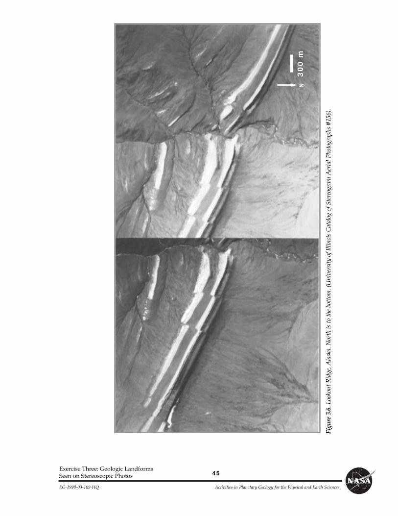
4. a. Gray. The white layers form ridges but thegray material is eroded out into valleys. Insome locations, white layers have shelteredand protected the gray material from ero-sion. No river channels are apparent in thewhite material; gullies indicate that thegray material erodes easily.
b. SSW c. N65W
d. 35m e. 220m
f. The stereo view reveals that the strata areprobably not curved, but have a constantstrike, and a constant dip to the south-southwest. As the river cut downward, itexposed portions of the white layers to thesouth that are still buried elsewhere.Therefore, the apparent curvature in themonoscopic photo is a geometric conse-quence of the river having cut into the dip-ping strata, exposing the white layer at dif-ferent elevations.
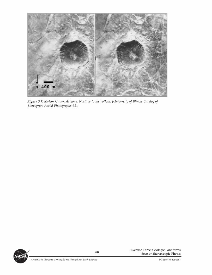
5. a. About 1200m. b. About 240m.
c. Large vertical exaggeration (appears asdeep or deeper than wide).
d. The crater shows a raised rim that standsabove the surrounding plain. The rim rises30 to 60m above the surrounding plain.
e. Sketch should include bowl shape, rim-to-rim width of about 1200m [6cm] depth ofabout 200m [1cm], and raised rim.
f. Similarities: Roughly round shape overall,steep and gullied interior walls, highest
Answer Key
Exercise Three: Geologic LandformsSeen on Stereoscopic Photos

33
EG-1998-03-109-HQ Activities in Planetary Geology for the Physical and Earth Sciences
along rim, relatively flat along crater bottom.Differences: volcanic crater is irregular inoutline and shows multiple scallops, sitsatop an edifice; impact crater lies principallybelow surrounding plains, has a raised rim,is round to squared off in shape.
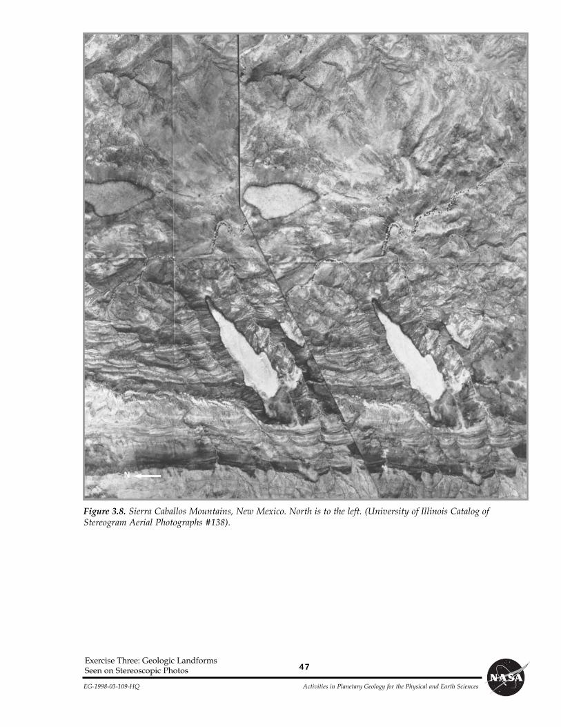
6. a. Steeply tilted.
b. Roughly north-south strike; eastward dip.
c. Erosion has destroyed most of a volcanicplain that once was continuous across theregion.
d. As is true of most places on Earth, impactcraters have been long since destroyed bydeposition of sediments, by tectonism, byvolcanic flooding, and by gradation.
e. Top to bottom: 2, 1, x, 4, 3
Answer Key
Exercise Three: Geologic LandformsSeen on Stereoscopic Photos

Purpose
By using stereoscopic pairs of aerial photographs,you will learn to recognize some of the landformsthat result from the four major geologic processes:volcanism, gradation, tectonism, and impact cra-tering.
MaterialsStereoscope, protractor, ruler, calculator.
IntroductionBecause our eyes are separated by a short dis-
tance, we view the world from two slightly differentperspectives simultaneously. This enables us to per-ceive a scene in three dimensions. In other words,we are able to perceive the distances to objects anddepth within them. When you look at a photograph,your eyes see the distance to the flat photo, ratherthan the relative distances of objects within the
image. The photo appears flat, even though it is animage of the three-dimensional world. To perceiveapparent depth in photographs, geologists obtain twopictures of the same object or region from slightly dif-ferent perspectives,as illustrated inFigure 3.1. When theimages are viewedsimultaneously, onewith each eye, aÒthree-dimension-al,Ó or stereoscopic,effect results.
This perception ofvertical relief in aeri-al photos can greatlyaid the geologicinterpretation oflandforms in theimage. Most stereo-scopic photographsare obtained fromaircraft. Becausethe distance the plane moves between subsequentphotos is much greater than the distance between apersonÕs eyes, the apparent vertical relief of thestereo photos is exaggerated, appearing muchgreater than the actual relief. This vertical exagger-ation increases the farther apart the photographsare taken.
Figure 3.2 shows how to set up a pocket stereo-scope. Place the stereoscope over a stereo pair withthe seam of the photos in the middle of the stereo-scope. Look through the lenses at the two photos, sothat each eye sees just one photo. Pick out a featurethat is visible in both photos, relax your eyes, andallow your focus to change until the two imagesappear to merge. You may need to adjust the positionof your stereoscope slightly as you look through it tohelp the photos merge. When they do merge, youshould see a stereoscopic effect. This may take timeand patience. Some of the photographs are stereo
35
EG-1998-03-109-HQ Activities in Planetary Geology for the Physical and Earth Sciences
Figure 3.2. Using the pocket stere-oscope. The stereoscope is alignedhorizontally and centered along theseam separating the image pairs.
Name
Figure 3.1. Stereoscopic photographs are typicallyobtained from airplanes. The farther apart two pho-tographs are obtained, the greater the vertical exaggera-tion of the resulting stereoscopic images.
ExerciseThree
GeologicLandforms Seen onStereoscopic Photos
Exercise Three: Geologic LandformsSeen on Stereoscopic Photos

36
Activities in Planetary Geology for the Physical and Earth Sciences EG-1998-03-109-HQ
QuestionsVolcanism
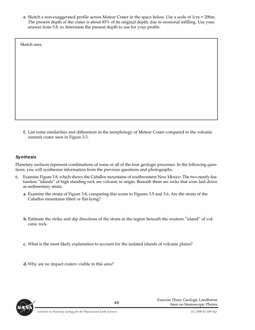
1. Figure 3.3 shows a volcano on the island of New Britain, north of Australia. First study the photosÒmonoscopically,Ó without the stereoscope. In the photos, water appears black. The top of the high-standing volcano shows a circular depression termed a summit crater.
a. Sketch how the volcano might look from the ground.
ÒtripletsÓ with one photograph in the middle andadditional photographs on both the right and leftsides. The stereoscope should be positioned to view
the middle and right photos as one image pair, andthe middle and left photos as another image pair.
Sketch area
Now position the stereoscope over the left dividing line and view the volcano in stereo. Reposition thestereoscope over the right seam and view this portion of the volcano in stereo.
b. Observe and describe the shape of the summit crater.
c. Do you think the summit crater formed by a single eruption or from multiple eruptions? Explain.
d. List at least two pieces of evidence that the volcano has been eroded.
e. Do you think the volcano is made of hard rock that is difficult to erode or soft ash that is easy toerode? Explain.
*f. Why is the volcano more heavily forested on one side than the other?
Exercise Three: Geologic LandformsSeen on Stereoscopic Photos
37
EG-1998-03-109-HQ Activities in Planetary Geology for the Physical and Earth Sciences
Exercise Three: Geologic LandformsSeen on Stereoscopic Photos
Gradation
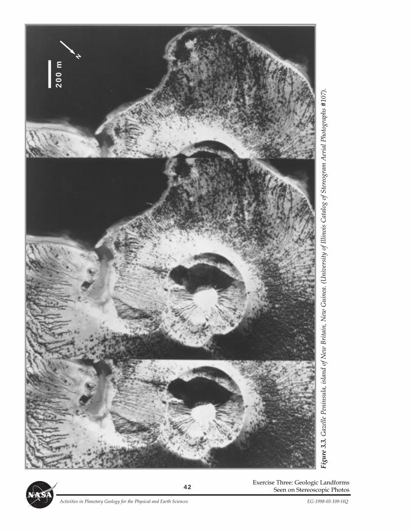
2. Figure 3.4 shows a portion of White Sands, New Mexico, an area affected by aeolian (wind) processes.The crescent-shaped features are dunes composed of sand. Most sand dunes have a gentle slope on theirwindward side and a steeper slope to the leeward side. High velocity winds blow sand up the wind-ward side to the brink of the dune; sand then slides down the leeward slip face of the dune.
a. Examine the photographs stereoscopically and identify the slip faces on the dunes. From which direc-tion is the wind blowing?
b. Consider one of the dunes near the center of the photo. Where will its sand go in time?
c. How does the morphology of the sand dunes change across the photo? Use sketches of at least twodunes to illustrate your answer.
Sketch area
Sketch area

38
Activities in Planetary Geology for the Physical and Earth Sciences EG-1998-03-109-HQ
*d. What factors might affect the dune morphology across the region?
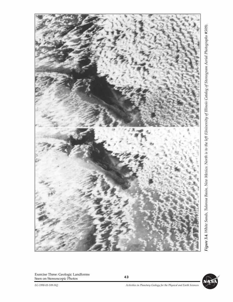
3. Examine Figure 3.5, which shows a system of canyons cut by rivers and streams in northwestern NewMexico. The gradation is affecting relatively flat-lying sedimentary rocks.
a. Look at the places where smaller tributary streams join larger rivers. In the space below, make asketch of the pattern you see.
Sketch area
b. Which direction does the water flow in the prominent river that crosses the central portion of thephoto?
c. Identify a place in the photograph where you might expect a tall, steep waterfall. How would such awaterfall aid the process of erosion in this area?
d. Over time, what will happen to the high standing, narrow ridge that separates two east-west trendingvalleys in the central portion of the photo?
Tectonism
Most rocks on Earth are laid down in relatively flat layers. Sedimentary rocks (such as those in Figure 3.5) arelaid down over broad areas by wind or water, in layers called strata. Tectonism deforms such rocks in variousways. Tectonic stresses in the Earth can pull or push on rocks until they break, moving along faults. Broad-scale tectonic deformation can also cause originally horizontal rock layers to be tilted.
4. Figure 3.6 shows Lookout Ridge, Alaska, an area affected by tectonic deformation. Notice that the whiteand gray sedimentary rocks have been steeply tilted, now standing nearly on their ends.
a. Which rock layers are more easily eroded, the white or the gray? Support your answer.
Exercise Three: Geologic LandformsSeen on Stereoscopic Photos
39
EG-1998-03-109-HQ Activities in Planetary Geology for the Physical and Earth Sciences
Exercise Three: Geologic LandformsSeen on Stereoscopic Photos
b. Examine the broad, steep face that is shown by one of the white layers near the center of the stereo photo.When rainfall lands on this surface, in which direction would it run down? This is the dip direction ofthese tilted rocks.
c. Examine the overall trend of the visible edges of the tilted strata. Use a protractor to measure the directionof this trend, and report your answer in terms of the number of degrees west of north. (For example,N20W would mean the trend is 20¡ west of north.) This is the strike direction of the tilted rocks.
d. Notice the small-scale faults that cut and displace the white and gray strata near the center of the stereoimage. Use the scale bar on the photograph to estimate the amount of displacement along these faults.
e. A greater displacement of strata can also be observed in the southeast corner of the left hand monoscopicimage. Use the scale bar to estimate the amount of displacement there.
*f. In the right hand image, the strata appear to curve as they cross the prominent river that cuts north-south across the photo. Using information available to you from the stereo scene, explain this appar-ent curvature.
Impact Cratering
5. Figure 3.7 shows Meteor Crater, Arizona. The impact crater is about 20,000 years old and is one of thebest-preserved impact structures on Earth. In this stereo pair you can see the crater floor, walls, rim, andremnants of ejecta, material thrown from the crater by the impact. Some ejecta appears as irregularbright patches around the crater.
a. Using the scale bar on the photograph, determine the diameter of the crater in meters.
b. Before erosional infilling, an impact crater in Meteor CraterÕs size class has a diameter about fivetimes greater than its depth. Based on this, how deep was Meteor Crater when it formed?
c. Based on the appearance of Meteor Crater in these stereo images, and considering your previousanswers, is the vertical exaggeration of this stereo pair large or small?
d. What do you notice about the elevation of the rim of the crater compared to the elevation of the sur-rounding plain?
40
Activities in Planetary Geology for the Physical and Earth Sciences EG-1998-03-109-HQ
e. Sketch a non-exaggerated profile across Meteor Crater in the space below. Use a scale of 1cm = 200m.The present depth of the crater is about 85% of its original depth, due to erosional infilling. Use youranswer from 5.b. to determine the present depth to use for your profile.
Exercise Three: Geologic LandformsSeen on Stereoscopic Photos
Sketch area
f. List some similarities and differences in the morphology of Meteor Crater compared to the volcanicsummit crater seen in Figure 3.3.
Synthesis
Planetary surfaces represent combinations of some or all of the four geologic processes. In the following ques-tions, you will synthesize information from the previous questions and photographs.
6. Examine Figure 3.8, which shows the Caballos mountains of southwestern New Mexico. The two nearly fea-tureless ÒislandsÓ of high standing rock are volcanic in origin. Beneath them are rocks that were laid downas sedimentary strata.
a. Examine the strata of Figure 3.8, comparing this scene to Figures 3.5 and 3.6. Are the strata of theCaballos mountains tilted or flat-lying?
b. Estimate the strike and dip directions of the strata in the region beneath the western ÒislandÓ of vol-canic rock.
c. What is the most likely explanation to account for the isolated islands of volcanic plains?
d. Why are no impact craters visible in this area?

41
EG-1998-03-109-HQ Activities in Planetary Geology for the Physical and Earth Sciences
Exercise Three: Geologic LandformsSeen on Stereoscopic Photos
e. Determine the sequence of events that affected this region by numbering the events below from 1(first event) to 4 (most recent event). Mark with an ÒxÓ the one event that did not occur in this region.
___ Tectonic forces caused folding and tilting of the rocks.
___ Sedimentary strata were laid down horizontally.
___ Volcanic plains were faulted and tilted.
___ Erosion by rivers and streams dissected the region.
___ Volcanic plains were laid down horizontally.
42
Activities in Planetary Geology for the Physical and Earth Sciences EG-1998-03-109-HQ
Exercise Three: Geologic LandformsSeen on Stereoscopic Photos
Figu
re 3
.3.G
azel
le P
enin
sula
, isl
and
of N
ew B
rita
in, N
ew G
uine
a. (
Uni
vers
ity
of I
llino
is C
atal
og o
f Ste
reog
ram
Aer
ial P
hoto
grap
hs #
107)
.200 m
N
43
EG-1998-03-109-HQ Activities in Planetary Geology for the Physical and Earth Sciences
Exercise Three: Geologic LandformsSeen on Stereoscopic Photos
Figu
re 3
.4.W
hite
San
ds, T
ular
osa
Bas
in, N
ew M
exic
o. N
orth
is t
o th
e le
ft (
Uni
vers
ity
of I
llino
is C
atal
og o
f Ste
reog
ram
Aer
ial P
hoto
grap
hs #
509)
.
N
44
Activities in Planetary Geology for the Physical and Earth Sciences EG-1998-03-109-HQ
Exercise Three: Geologic LandformsSeen on Stereoscopic Photos
Figure 3.5. Monument Rocks, San Juan County, New Mexico. North is to the left. (University of Illinois Catalog ofStereogram Aerial Photographs #521).
1 kmN
45
EG-1998-03-109-HQ Activities in Planetary Geology for the Physical and Earth Sciences
Exercise Three: Geologic LandformsSeen on Stereoscopic Photos
Figu
re 3
.6.L
ooko
ut R
idge
, Ala
ska.
Nor
th is
to th
e bo
ttom
. (U
nive
rsity
of I
llino
is C
atal
og o
f Ste
reog
ram
Aer
ial P
hoto
grap
hs #
156)
.
300 m
N
46
Activities in Planetary Geology for the Physical and Earth Sciences EG-1998-03-109-HQ
Exercise Three: Geologic LandformsSeen on Stereoscopic Photos
Figure 3.7. Meteor Crater, Arizona. North is to the bottom. (University of Illinois Catalog ofStereogram Aerial Photographs #5).
400 mN
47
EG-1998-03-109-HQ Activities in Planetary Geology for the Physical and Earth Sciences
Exercise Three: Geologic LandformsSeen on Stereoscopic Photos
Figure 3.8. Sierra Caballos Mountains, New Mexico. North is to the left. (University of Illinois Catalog ofStereogram Aerial Photographs #138).
N


![Landforms Mady By Wind [Desert Landforms]](https://img.pdfslide.net/doc/110x75/56813971550346895da1066c/landforms-mady-by-wind-desert-landforms.jpg)