Embed Size (px)
Citation preview

Research ArticleGeological Characteristics of Mud Volcanoes and Diapirs in theNorthern Continental Margin of the South China Sea:Implications for the Mechanisms Controlling the Genesis of FluidLeakage Structures
Siling Zhong ,1,2 Jinfeng Zhang ,1,2 Junsheng Luo ,1 Yajuan Yuan ,3 and Pibo Su 4
1School of Marine Sciences, Sun Yat-sen University/Southern Marine Science and Engineering Guangdong Laboratory (Zhuhai),Zhuhai 519000, China2Southern Marine Science and Engineering Guangdong Laboratory (Zhanjiang), Zhanjiang 524000, China3School of Geography, South China Normal University, Guangzhou 510631, China4MLR Key Laboratory of Marine Mineral Resources, Guangzhou Marine Geological Survey, Ministry of Natural Resources,Guangzhou 510075, China
Correspondence should be addressed to Yajuan Yuan; [email protected] and Pibo Su; [email protected]
Received 17 January 2021; Accepted 10 May 2021; Published 27 May 2021
Academic Editor: Priyank Jaiswal
Copyright © 2021 Siling Zhong et al. This is an open access article distributed under the Creative Commons Attribution License,which permits unrestricted use, distribution, and reproduction in any medium, provided the original work is properly cited.
Mud volcanoes and diapirs are geological structures formed due to arch piercing or diapiric intrusion of ductile sedimentarymaterials into the overlying strata along high permeability channels. A detailed study on the processes controlling the formationof mud volcanoes and diapirs in the northern continental margin of the South China Sea is of vital importance to theexploration of economically viable oil and gas reservoirs and can be helpful to the exploration of natural gas hydrate in asedimentary basin. The fluid seepage structures that occur in the Mesozoic and Cenozoic sedimentary basins of the northernSouth China Sea show significant differences in their morphological and tectono-structural characteristics. We used high-resolution seismic profiles and instantaneous frequency profiles to understand the mechanisms that are critical with respect tothe differential development of the investigated piercement structures. Differences in stress field do not directly lead to thedifference in the scale of mud volcanoes or diapirs. Fractures may play an important role in the formation of mud volcanoesand diapirs. The thickness of the sediment was found to have a strong impact on the formation of fluid leakage structures thatthicker sediments are more conducive to the development of mud diapirs and the thinner one is more likely to formmud volcanoes.
1. Introduction and Rationale of the Study
Mud volcanoes and diapirs are piercement structures formeddue to subterranean high pressure (P) imposed on ductilematerial in deep basins hosting relatively thick sedimentarysequences. These structures are produced by arching or dia-piric intrusion into the overlying strata along high-permeability channels, such as zones of mechanical weakness(e.g., fractures and faults [1–4]). Mud volcanoes are formedwhen a mud slurry exudate is forced upwards, piercing thesurface or the seafloor. Conversely, when the oozing, high-
plasticity material cannot pierce to the surface or the seafloor,mud diapirs are formed [2].
Piercement structures are widely distributed all over theworld. Mud volcanoes have been reported from more than40 continental regions and 20 seas around the world [1, 2,5–9]. Among them, the Mediterranean Ridge, the NigerDelta, Azerbaijan, and the northern continental margin ofthe South China Sea host a huge number of mud volcanoesor mud diapirs [10–13]. Mud volcanoes and diapirs com-monly occur in accretionary wedge regions subjected to com-pressive stress such as the Mediterranean Ridge [14–16] and
HindawiGeofluidsVolume 2021, Article ID 5519264, 17 pageshttps://doi.org/10.1155/2021/5519264

the Island of Barbados [17]. Less frequently, they appear inextensional provinces such as the Black Sea [18, 19] and theSoutheastern Tyrrhenian Sea [20]. Furthermore, some mudvolcanoes and diapirs are both associated with stretchingand extrusion environments such as the Western AlboranSea [21, 22].
Mud volcanoes and diapirs are structures of great geolog-ical significance. They are closely linked to the tectono-sedimentary evolution of basins and may play an importantrole in hydrocarbon migration and accumulation [1, 23–25]. Submarine mud volcanoes and diapirs can be importantmarkers of deep-water petroleum and shallow gas hydratedeposits [26–30]. In addition, mud volcanic activity can beused as an important indicator of early oil and gas evaluationin sedimentary basins [31–33]. The large amount of methane(CH4) emitted from mud volcanoes accelerates the green-house effect, contributing to climate changes on a global scale[1, 34, 35]. Lastly, diapiric and volcanic activities underneathgeological basins are prominent indicators of neotectonicmovements and may lead to fatal geological disasters [36, 37].
Previous studies on mud volcanoes and diapirs focusedon various aspects, including their geological structure [2, 5,8, 38, 39] and geochemical [8, 34, 40, 41] and geophysical[4, 36, 42, 43] signatures. Some of these researches tried todiscuss the formation mechanism of mud volcanoes or dia-pirs (e.g., [9, 13]) and the relationships between the evolutionof such piercement structures and hydrocarbon or gashydrate accumulation [2, 44].
Investigating the genetic mechanisms of mud volcanoesand diapirs in the northern part of the South China Sea isof great significance for understanding the migration andaccumulation processes of petroleum and gas. According tothe analysis of geology, geophysics, geochemistry, biology,and thermodynamics of the South China Sea (e.g., [12, 43,45–48]), hundreds of mud volcanoes and diapirs have beenreported in the northern continental marginal basins of theSouth China Sea (Figure 1), i.e., the Yinggehai, Qiongdong-nan, Pearl River Mouth, and Southwest Taiwan Basins. Pre-vious studies mainly describe the types, morphology,development characteristics, and distribution of fluid leakagestructures in one of these basins or inferred the source offluid by combining seismic profile and geochemical analysis(e.g., [49]). These cannot sufficiently explain the differencesin the formation processes of the mud volcanoes and diapirsdeveloping in the northern South China Sea. At present, themechanisms that control the formation of mud volcanoesand diapirs around the world remain unclear or debatable(e.g., [50–52]). Therefore, it is essential to thoroughly analyzethe characteristics of the overlying Cenozoic sediments, over-pressure, and the tectonic stress background of basins to bet-ter understand the mechanisms that control the evolution ofmud volcanoes and diapirs in the northern South China Sea.And it plays an important part in the exploration of oil andgas reservoirs and can be helpful to the exploration of naturalgas hydrate in a sedimentary basin.
In this paper, the development characteristics of mudvolcanoes and mud diapirs in the northern margin of theSouth China Sea were summarized by combining literatureresearch and seismic profile interpretation. We analyze the
differences in the type and thickness of the Cenozoic sedi-ments, tectonic stress, and lithostatic pressure (P) betweenthe Yinggehai, Qiongdongnan, Pearl River Mouth, andSouthwest Taiwan Basins and discuss influences of the over-pressure, the thickness of sediments, and the stress on theformation process of piercement structures.
2. Geological Background
The northern continental margin of the South China Sea islocated on the southeastern margin of the Eurasian mega-plate. The geodynamic environment of this area is very com-plex due to the competitive influence of the Eurasian, Indian-Australian, and Pacific-Philippines Sea lithospheric platesand the opening of the South China Sea, among other factors[53–56]. The South China Sea has experienced multiple tec-tonic events, and its Cenozoic evolution is marked by an earlyPaleogene episode of continental fault depression and a lateNeogene and Quaternary event of subsidence of marinefacies. Furthermore, the northern continental marginal basinof the South China Sea has undergone rapid subsidence andsedimentation, giving rise to a thick Cenozoic sedimentarysequence characterized by high (fluid and lithostatic) pres-sure (P) and temperature (T) conditions in its lowermostparts.
There are many Mesozoic and Cenozoic sedimentarybasins in the northern continental margin of the South ChinaSea including the Yinggehai, Beibu Gulf, Qiongdongnan,Pearl River Mouth, and Southwest Taiwan Basins [57]. TheYinggehai Basin is controlled by a strike-slip fault zone inthe western margin of the South China Sea. The Qiongdong-nan and Pearl River Mouth Basins are characterized byextensional rifting and uplift structures that were formedduring the rift period. The Southwest Taiwan Basin, locatedat the edge of the South China Sea subduction and conver-gence zone, is controlled by lithospheric slab subductionand compressional faulting [58–61]. In the late Cenozoic(~5Ma years ago), the continental marginal structure of thenorthern South China Sea was relatively stable, but the east-ern margin of the South China Sea was strongly affected bythe westward pushing Philippine plate. And the process ofthe strike-slip movement of the Red River Fault Zone affectedthe activity of the fault zone alongside the western margin ofthe study area [62].
The thickness of the sedimentary sequences over thenorthern continental margin of the South China Sea variessignificantly (Figure 2). The thickness of the Cenozoic sedi-ment is ~17 km in the Yinggehai Basin, whereas it mayexceed 10 km in the deep-water area of the southern Qiong-dongnan Basin. The Baiyun sag of the Pearl River MouthBasin has a sedimentary sequence more than 10 km thick[49]. The thickness of the Cenozoic sedimentary rocks ofthe Southwest Taiwan Basin is 5 km on average and ~8 kmat its maximum. The above-mentioned basins all have obvi-ous formation overpressure, except the Pearl River MouthBasin. Among them, the pressure coefficient in the centraldepression area of the Yinggehai Basin is basically greaterthan 2.0 and the pressure coefficient is 1.5~2.2 approximatelyin the center of the Qiongdongnan Basin and the depression
2 Geofluids
center of this basin. These differences strongly affected thedistribution and evolution characteristics of mud volcanoesand diapirs in each sediment basin of the South China Sea.
3. Research Approach
Guangzhou Marine Geological Survey (GMGS) and ChinaNational Offshore Oil Corporation (CNOOC) conductedextensive and detailed geophysical studies in the northerncontinental margin of the South China Sea. A large numberof mud volcanoes and diapirs were recognized in the Yingge-hai, Qiongdongnan, and Pearl River Mouth Basins on 2Dand 3D seismic profiles and instantaneous frequency profiles(e.g., 25, 39, 43, 47-49). High-resolution multichannel 2Dand 3D seismic datum we used below belong to the Guang-zhou Marine Geological Survey (GMGS). In the course ofgeological and geophysical investigations, the seismicstreamer was a Seal 24-bit digital cable produced by the SercelCompany in French. The cable was immersed in 8m, and theair gun is immersed in 5m. The channel number of a seismicstreamer was 240, and the number of coverage is 60 times.The interval between receivers, shot interval, and the offsetwere 12.5, 25, and 175m, respectively. The sampling ratewas 1ms, and the record length was 6 s. The frequency rangeof the original seismic data is 6 to 160Hz, and the main fre-quency was about 75Hz. GMGS processing datum is by the
GeoCluster 2.1 (CGG) processing system of French Geo-physical Company. In addition, the instantaneous frequencyprofile can help to detect high attenuation areas such as freegas zones and gas chimneys [47]. Our datum and preexistinginformation on the type of fluid seepage structures in theaforementioned basins and the Southwest Taiwan Basin areused herein to discuss the distribution, genetic mechanism,and development characteristics of mud volcanoes anddiapirs.
4. Results
Fluid seepage structures in mud volcanoes and diapirs fre-quently occur in Yinggehai, Qiongdongnan, Pearl RiverMouth, and Southwest Taiwan Basins. Their distributionand evolution characteristics differ much among basins(Table 1). For instance, mud diapirs were recognized in theYinggehai, Qiongdongnan, Pearl River Mouth, and South-west Taiwan Basins. And most mud volcanoes occur in thePearl River Mouth Basin, Southwest Taiwan Basin, and theTaiwan land [13, 39, 49, 63].
4.1. Characteristics of Mud Diapirs in the Yinggehai Basin.Mud diapirs in the Yinggehai Basin are the most typical ofthose found in the northern continental marginal basin ofthe South China Sea. Most of them are located in the central
South China Sea
117°00′105°00′ 107°00′ 109°00′ 111°00′ 113°00′ 115°00′ 119°00′ 121°00′
16°00′
18°00′
20°00′
22°00′
24°00′
16°00′
18°00′
20°00′
22°00′
24°00′117°00′105°00′ 107°00′ 109°00′ 111°00′ 113°00′ 115°00′ 119°00′ 121°00′
Land/Islands
Mud diapirs
Mud volcanoes
South China Block
Taiwan
island
YGHB
BBWB PRMBBaiyundepression
SW-TWB
QDNB
Indochina Block
Seismic lines
Uplift area
Bulge area
Central diapirs belt
Basin boundaries
Tectonic boundaries
Depression area
3 Cenozic sediment thickness
Fig. 3 Fig. 4
Fig. 5
Fig1 6 . Fig. 7 Fig. 8
17
15
13
11
975
119753 1
1 3 5 7 11
9 13
13579111315
13119753 3
35 57
5 33
97533
5 7 7
11 975
53
535
5
5
13 779 97
3 35
35 55
5
53
3
7
75353
7
33 3
91
53 3
35 3
311 13 3 3
53
5
3 3 3
3
33
3333
33 3
3333 3 3
3
1
13
1 111
79
5
5
77
97557
3
5 1
57 755
5
5
53
3
353
3 3 33
3
3
5
7
57 5
55
31
1
53
33
3
5
3
55
55 5
5
313
17 53
5
5 5 5
135
53315
733
35
7531
755
5 775
13
3175 3
1
Hainanisland
Figure 1: Distribution of mud volcanoes and mud diapirs in the northern margin of the South China Sea. Grey parts indicate mud diapirs ofYinggehai Basin (YGHB), Qiongdongnan Basin (QDNB), and Pearl River Mouth Basin (PRMB); grey triangles indicate mud volcanoes in theDongsha Islands and Southwest Taiwan Basin (SW-TWB). Red lines indicate the location of seismic lines. Different colors (pink, yellow, andgreen) represent uplift, bulge, and depression areas, respectively (modified from [13, 49]). Black solid lines with numbers represent Cenozoicsediment thickness (modified from “Map of Cenozoic Sediment Thickness 1:2 000 000,” Atlas of geology and geophysics of the South ChinaSea, compiled by Guangzhou Marine Geological Survey); mud volcanoes and mud diapirs are found in areas of thick sediment.
3Geofluids

depression of the basin in five rows parallel to the long axis ofthe basin in the central uplift belt [25]. The largest covers anarea of more than 700 km2 and most others tens to hundredsof km2 [25, 64]. The seismic profile shows that there areblank and cluttered anomalous seismic emission characteris-tics that are significantly different from the surrounding rockinside the mud diapir (Figure 3). Mud diapirs are developedin the Miocene stratum, piercing the T30 interface verticallyand reaching the upper Yinggehai Formation. Mud diapircaused the “pull up” of the surrounding rock on both sidesof it, and an upward arching phenomenon occurs on thetop of the diapir.
4.2. Characteristics of Mud Diapirs in the QiongdongnanBasin.Mud diapirs in the Qiongdongnan Basin are predom-inantly concentrated in the sedimentary center of the basindepression and in the deeper, thicker deposits in the transi-tion zone of the sags and bulges of the basin (Figure 1). Dia-pirs are typically distributed in a NE direction at the deep-water area in the south and relatively concentrated in theSongnan low bulge and Lingnan low bulge areas [65]. Muddiapirs appear as vertically oriented or chimney-like struc-tures on the seismic profiles, have some seismic anomaliessuch as clutter and blank inside them, and vary in sizes(Figure 4(a)). These blank or cluttered reflection signals
Cretaceous
Quaternary
Pliocene
Mio
cene
Olig
ocen
eEo
cene
Pale
ocen
e
Middle
Stratum Pearl RiverMouth Basin
QiongdongnanBasin
65
56
35
23
5
Time (Ma)Strati graphic unit
SouthwestTaiwan Basin
YinggehaiBasin
Facies
Ner
itic-
Bath
yal f
acie
s
Ner
itic
Zhuj
iang
Fm
Zhuh
ai F
mEn
ping
Fm
Sanm
inFm
Chan
gjik
eng
FmTa
ngen
shan
FmDel
taca
rbon
ate
plat
form
Fan
delta
-ne
ritic
faci
esCo
asta
lsw
amp
faci
es
Lake
-Sw
amp-
Fluv
ial f
acie
sSe
mi-d
eep
lake
faci
es
Ner
itic f
acie
sCo
ntin
enta
l-Tra
nsiti
onal
faci
es o
f lan
d an
d se
aM
arin
e-Tr
ansit
iona
lfa
cies
of l
and
and
sea
Bath
yal
faci
es
Mar
ine d
epos
it
Wan
shan
Fm
Yueh
ai F
mH
anjia
ng F
m
Globaleustatic FaciesFm
Ledo
ng F
m
Mar
ine
depo
sitLi
ttora
l-ner
itic
faci
esLi
ttora
lfaci
esN
eriti
cfac
ies
Litto
ral
nerit
ic fa
cies
Fand
elta
-ner
itic
faci
esCo
asta
lsw
amp
faci
esA
lluvi
al, fl
uvia
l fac
ies
Yach
eng
FmLi
ngsh
ui F
mSa
nya F
mM
eish
an F
mH
uang
liu F
mYi
ngge
hai F
mLe
dong
Fm
Allu
vial
, fluv
ial f
acie
s
Shen
hu F
mW
ench
ang
Fm
Allu
vial
-dilu
vial
faci
es
Ying
geha
i Fm
Hua
ngliu
Fm
Mei
shan
Fm
Sany
a Fm
Ling
shui
Fm
Yach
eng
Fm
Early
Middle
Fm Fm
Mar
ine
depo
sitLi
ttora
l-ner
itic
faci
esLi
ttora
lfa
cies
Ner
itic
faci
esLi
ttora
lne
ritic
faci
es
Litto
ral n
eriti
cfa
cies
Fm
Late
Late
Early
Late
Early
Late
Early
Argillite
???
HistogramHistogramHistogramLithology Facies Facies
Pebbly sandstone
Sandy siltstone
Sandstone
Limestone
Shale
Granite
Metamorphic rock
Unconformity boundary
Figure 2: Stratigraphic integrative column map of basins in the northern margin of the South China Sea (modified from [57]).
4 Geofluids

exhibit lower instantaneous frequency values from deep toshallow on the instantaneous frequency profile, which is sig-nificantly different from the higher instantaneous frequencyvalues of the surrounding rocks (Figure 4(b)). Owing to theupward migration of gas, some mud diapirs may give “pull-down” internal seismic reflection signatures (Figure 4(a)).The overlying strata of the mud diapirs are plastically archedowing to the puncturing effect of diapirism, resulting in the
formation and propagation of high-angle brittle faults andradially arranged fractures.
4.3. Characteristics of Mud Volcanoes and Diapirs in the PearlRiver Mouth Basin. A large number of mud diapirs have beenrecorded in the Baiyun sag of the Pearl River Mouth Basin.The maximum intrusion height of mud diapirs in this areareaches 8 km, and the largest one covers a total area of
Table 1: Characteristics of mud volcanoes and mud diapirs in the northern South China Sea [25, 39, 43, 65–68].
Scales Distribution Characteristics
YinggehaiBasin
Mud diapirs tens to hundreds of squarekilometers, up to 700 km2.
Primarily distribute in the centraldepression of the basin.
Mud diapir belts are arranged in a rowof 5 rows of geese along the long axis of
the basin.
QiongdongnanBasin
Mud diapirs.
Predominantly concentrate in thesedimentary center of the basin
depression and in the deeper, thickerdeposits in the transition zone of the
sags and bulges.
Mud diapirs varying in scale, structuralstyle, and piercing layers. Mud diapirs
are randomly distributed butoccasionally occur in groups.
Pearl RiverMouth Basin
Mud diapirs in Baiyun sag reach up to8 km, and the largest one covers an area
of 1000 km2. Mud volcanoes inDongsha islands have widths and
heights of 0.5–2.0 km and 50–200m.
Mud diapirs of Baiyun sag extendapproximately NWW and are
predominantly distributed in thesouthwestern part of the center of
Baiyun sag.
Relatively concentrated distribution,generally consistent with the NWWfault system in the late Miocene, and
the piercing layers are different.
Many active mud volcanic belts werefounded in the southwestern area of the
Dongsha Islands.
Mud volcanoes have characteristics ofstructural extrusion and are distributed
in a SWW-NEE direction.
SouthwestTaiwan Basin
94 mud volcanoes ranging in heightfrom 65 to 345m, with a pedestal
diameter of approximately680~4100m. Mud ridges ranging from3.9 to 56.5 km in length and 1.6 to
8.3 km in width.
Mud volcanoes and mud diapirs areprimarily distributed in the deep watersof the southern depression of the basin.
Mainly distributed in the structuralfault zone, mud volcanoes are mostly
distributed on mud diapirs.
1.0
2.0
3.0
4.0
5.0
6.0
7.0
Two-
way
trav
el ti
me (
s)
T27
T30
T40
T41
T60
DF 1-1-2
Mud
dia
pir
Anticline
Pull-up
Pull-up
NE SW
Figure 3: Seismic profile over the Yinggehai Basin. There are blank and cluttered anomalous seismic emission characteristics that aresignificantly different from the surrounding rocks. The mud diapir is developed in the Miocene stratum, piercing the T30 interface in avertical column and reaching the upper stratigraphic layer of the Yinggehai Formation stratum. Above the top of the diapir, there is aphenomenon of upward arching of the stratum. Uplift of the mud diapirs caused the “pull up” of the surrounding rock on both sides.
5Geofluids

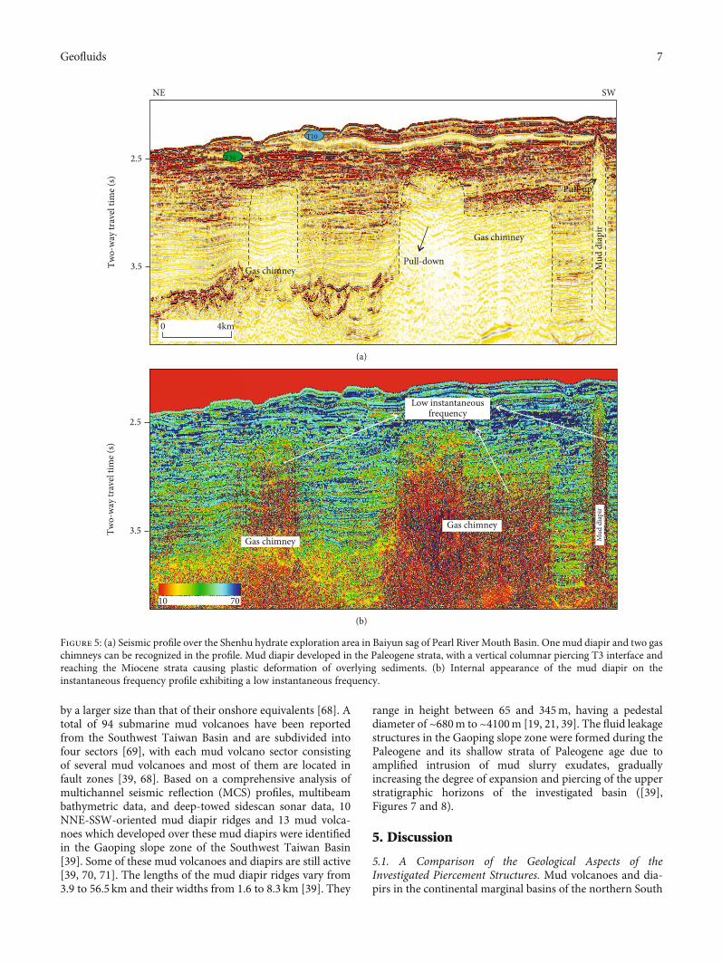
~1000 km2. Mud diapirs are mainly distributed in the south-western side of the central part of the Baiyun sag (Zhuerdepression) and extend ~NWW, which is generally consis-tent with the direction of the fault system developed in thelate Miocene [65, 66]. The Shenhu area in the Baiyun sag ofthe Pearl River Mouth Basin displays typical diapiric struc-tures. Mud diapirs are mainly developed in Paleogene stratapierced vertically through the T3 interface (Figure 5(a)).The tops of the mud diapirs reach theMiocene stratum, caus-ing ductile arching of the overlying sedimentary layer. Inaddition, numbers of gas chimneys have been found in thePearl River Mouth Basin. We can recognize two gas chim-neys near the diapir in Figure 5(a). The left one shows pull-down continuous reflection inside while the right one showspull-down and blank zone inside. Mud diapirs give lowerinstantaneous frequency values on the instantaneous fre-quency profiles (Figure 5(b)). Many mud volcanoes have
been found in the southwestern area of the Dongsha Islands,which distribute in a SWW-NEE direction, with single-mound widths of 0.5-2.0 km and heights of 50-200m. Thereare more than 100-kilometer-wide mud volcanoes in thestudy area, and the largest one was 5 kilometers wide and200 meters high [43, 67]. In the Dongsha Sea, the seismicprofile reveals a thin Cenozoic sedimentary cover and theuplift of the Mesozoic basement caused the upward deforma-tion of the overlying sediment (Figure 6).
4.4. Characteristics of Mud Volcanoes and Diapirs in theSouthwest Taiwan Basin. Mud volcanoes and diapirs arewidely distributed in the Southwest Taiwan Basin. Terrestrialmud volcanoes primarily occur in the hilly areas of south-western Taiwan, whereas underwater mud volcanoes aremainly concentrated in the deep waters of the southerndepression of the investigated basin and are characterized
Mud diapir
Mud diapir
Mud diapir
Uplift
Anticline
Bright spots
Pull-up
2.50
3.00
3.50
4.00
4.50
Two-
way
trav
el ti
me (
s)
0 4km
NW SE
T10
T20
T30
T6 0
(a)
Low instantaneous frequency
2.50
3.00
3.50
4.00
4.50
Two-
way
trav
el ti
me (
s)
10
70
NW SE
(b)
Figure 4: (a) Seismic profile over the Qiongdongnan Basin. Mud diapirs puncture into the Neogene strata in a vertical columnar or chimney-like form. Diapir intrusions caused arch-up deformation of the overlying strata and “uplift” of the wall layers. The interior of the diapirs ischaracterized by blank, clutter, bright spots and other abnormal seismic reflection characteristics. (b) Instantaneous frequency distributionmap. The blank or cluttered reflection area presents a low instantaneous frequency from the deep to shallow part on the instantaneousfrequency distribution profile, which is significantly different from the higher instantaneous frequency value of the surrounding rock.
6 Geofluids
by a larger size than that of their onshore equivalents [68]. Atotal of 94 submarine mud volcanoes have been reportedfrom the Southwest Taiwan Basin and are subdivided intofour sectors [69], with each mud volcano sector consistingof several mud volcanoes and most of them are located infault zones [39, 68]. Based on a comprehensive analysis ofmultichannel seismic reflection (MCS) profiles, multibeambathymetric data, and deep-towed sidescan sonar data, 10NNE-SSW-oriented mud diapir ridges and 13 mud volca-noes which developed over these mud diapirs were identifiedin the Gaoping slope zone of the Southwest Taiwan Basin[39]. Some of these mud volcanoes and diapirs are still active[39, 70, 71]. The lengths of the mud diapir ridges vary from3.9 to 56.5 km and their widths from 1.6 to 8.3 km [39]. They
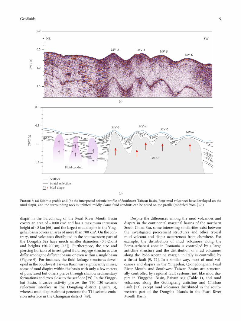
range in height between 65 and 345m, having a pedestaldiameter of ~680m to ~4100m [19, 21, 39]. The fluid leakagestructures in the Gaoping slope zone were formed during thePaleogene and its shallow strata of Paleogene age due toamplified intrusion of mud slurry exudates, graduallyincreasing the degree of expansion and piercing of the upperstratigraphic horizons of the investigated basin ([39],Figures 7 and 8).
5. Discussion
5.1. A Comparison of the Geological Aspects of theInvestigated Piercement Structures. Mud volcanoes and dia-pirs in the continental marginal basins of the northern South
2.5
3.5Two-
way
trav
el ti
me (
s)
0 4km
T10
T30
Gas chimney
Mud
dia
pir
Pull-down
Pull-up
Gas chimney
NE SW
(a)
2.5
3.5Two-
way
trav
el ti
me (
s)
Gas chimney
Gas chimney
Low instantaneousfrequency
10 70M
ud d
iapi
r
(b)
Figure 5: (a) Seismic profile over the Shenhu hydrate exploration area in Baiyun sag of Pearl River Mouth Basin. One mud diapir and two gaschimneys can be recognized in the profile. Mud diapir developed in the Paleogene strata, with a vertical columnar piercing T3 interface andreaching the Miocene strata causing plastic deformation of overlying sediments. (b) Internal appearance of the mud diapir on theinstantaneous frequency profile exhibiting a low instantaneous frequency.
7Geofluids

China Sea are characterized by noteworthy differences intheir distribution, morphology, and piercing horizon(Figure 9). Mud diapirs in the Qiongdongnan Basin are ran-domly distributed but occasionally occur in groups. In con-
trast, mud volcanoes and diapirs in the Southwest TaiwanBasin are distributed alongside the strike of deep faults andmud diapirs are arranged in 5 rows in an echelon patternalong the long axis of Yinggehai Basin. The largest mud
5.50
4.50
3.50
Two-
way
trav
el ti
me (
s)
2km
Upward deformation of sediment
Basement uplift
Basement uplift
Seafloor
SW NE
0
Figure 6: Seismic profile of the Dongsha Islands. The seismic profile reveals a thin Cenozoic sedimentary cover, and the uplift of theMesozoicbasement caused the upward deformation of the overlying sediment.
SENW
KCSB-1
STRSB-3
FC
FR
TWT
(s)
0.0
1.0
2.0
3.0
(a)
TWT
(s)
0.0
1.0
2.0
3.0
KC: Kaoping CanyonSB: Slope basinSTR: Shell-Tomb RidgeFC: Fangliao CanyonFR: Fangliao Ridge
KCSB-1
STRSB-3
FC
FR
Fault
MD-1
MD-5MD-8
MD-3-1
Mud diapir
SeafloorStratal reflection
MD-3
(b)
Figure 7: (a) Seismic profile and (b) the interpreted seismic profile over the Southwest Taiwan Basin. Five mud diapirs are present in thisprofile, and the two on the right have pierced through thick sediments and are exposed at the seafloor, and the surrounding rock isuplifted, obviously (modified from [39]).
8 Geofluids
diapir in the Baiyun sag of the Pearl River Mouth Basincovers an area of ~1000 km2 and has a maximum intrusionheight of ~8 km [66], and the largest mud diapirs in the Ying-gehai basin covers an area of more than 700 km2. On the con-trary, mud volcanoes distributed in the southwestern part ofthe Dongsha Sea have much smaller diameters (0.5-2 km)and heights (50-200m; [43]). Furthermore, the size andpiercing horizon of investigated fluid seepage structures alsodiffer among the different basins or even within a single basin(Figure 9). For instance, the fluid leakage structures devel-oped in the Southwest Taiwan Basin vary significantly in size,some of mud diapirs within the basin with only a few metersof punctured but others pierce through shallow sedimentaryformations and even close to the seafloor [39]. In the Yingge-hai Basin, invasive activity pierces the T40-T30 seismicreflection interface in the Dongfang district (Figure 3),whereas mud diapirs almost penetrate the T14 seismic emis-sion interface in the Changnan district [49].
Despite the differences among the mud volcanoes anddiapirs in the continental marginal basins of the northernSouth China Sea, some interesting similarities exist betweenthe investigated piercement structures and other typicalmud volcano and diapir occurrences from elsewhere. Forexample, the distribution of mud volcanoes along theBerca-Arbanasi zone in Romania is controlled by a largeanticline structure and the distribution of mud volcanoesalong the Pede-Apennine margin in Italy is controlled bya thrust fault [9, 72]. In a similar way, most of mud vol-canoes and diapirs in the Yinggehai, Qiongdongnan, PearlRiver Mouth, and Southwest Taiwan Basins are structur-ally controlled by regional fault systems, just like mud dia-pirs in Yinggehai Basin, Baiyun sag (Table 1), and mudvolcanoes along the Gutingkeng anticline and ChishanFault [73], except mud volcanoes distributed in the south-western part of the Dongsha Islands in the Pearl RiverMouth Basin.
NE SW
MV-3 MV-4 MV-5MV-6
TWT
(s)
0.0
0.5
1.0
1.5
(a)
TWT
(s)
0.0
0.5
1.0
1.5
MV-3 MV-4MV-5
MV-6
MD
MD-3
Mud diapir
SeafloorStratal reflection
Fluid conduit
(b)
Figure 8: (a) Seismic profile and (b) the interpreted seismic profile of Southwest Taiwan Basin. Four mud volcanoes have developed on themud diapir, and the surrounding rock is uplifted, mildly. Some fluid conduits can be noted on the profile (modified from [39]).
9Geofluids

0
5
10
15
T20
T60
1
2
34
5
Seafloor
Dep
th (k
m)
1
22
344
55
(a)
T60
SN Sag
BJ Sag
0
2
4
Dep
th (k
m)
6
8
Seafloor 1
2
3
4
11111
222
3
4 4
(b)
T50
BY Sag LY Sag
2
4
6
8
10
Seafloor
1 2
Dep
th (k
m)
2222
(c)
T20
Seafloor2
4
6
8
MV-1
MD-1
MD-2MD-3
MV-2
Dep
th (k
m)
T2T200
MD-1MM
D 222D 222MD-222DDD 222MD 22MMDMMMD
MV-2
(d)
Figure 9: (a) Developmental pattern of mud diapirs in Yinggehai Basin. Mud diapirs developed based on the sediments from the NeogeneSanya Formation to Yinggehai Formation. Mud diapirs vertically pierce through to the Quaternary strata. The grey-purple part indicatesthe Paleogene stratum. The source of MD-1 and MD-5 is deeper than other mud diapirs, and MD-1 pierces the shallower stratum; thesources of MD-2, MD-3, and MD-4 are shallow, and they pierce through strata at different depths. (b) Developmental pattern of muddiapirs in Qiongdongnan Basin. Mud diapirs are derived from Paleogene (Eocene-Oligocene) shale, which penetrates the Neogene stratavertically. The grey-purple part indicates the Paleogene stratum. The source of MD-1 and MD-3 is deeper than other mud diapirs, andMD 1 pierces the shallower stratum; the sources of MD 2 and MD-4 are shallow, and they pierce through strata at different depths. (c)Developmental pattern of mud diapirs in Baiyun sag of Pearl River Mouth Basin. The source of the diapir material is Paleogene (Eocene-Oligocene) shale, and diapirs pierce the Neogene strata vertically. The grey-purple part indicates the formation below the T50 interface.The source of MD-1 and MD-4 is deeper than other mud diapirs, and MD-1 pierces the shallower stratum; the sources of MD-2, MD-3,and MD-5 are shallow, and they pierce through strata at different depths. (d) Developmental pattern of mud volcanoes and mud diapirsin Southwest Taiwan Basin. The source of mud volcanoes and mud diapirs is Neogene (Miocene and Pliocene) shale, and the fluidpenetrates through the Quaternary strata or the seafloor. The grey-purple part indicates the Paleogene stratum. MV-1 and MV-2represent mud volcanoes of different scales; MD-1 indicates the shallow diapir of the source, and the vertical piercing is close to theseabed; MD-2 and MD-3 have deeper sources and pierce through different horizons.
10 Geofluids
Piercement structures in the northern continental mar-ginal basin of the South China Sea predominantly occur indeep-water areas covered by thick sediment (Figure 1). Fromwest to east, the mud volcanoes and diapirs are distributed inthe central depression, the deep-water areas of the southerndepression, in the Baiyun sag, the deep-water areas of thesouthwestern of the Dongsha Islands, and the deep-waterareas in the southern depression of the basin. This may berelated to the high temperature and overpressure caused bythe rapid subsidence and later hydrocarbon generation indeep-water areas covered by sedimentary sequences of sub-stantial thickness.
5.2. The Influence of Overpressure on the Formation Process ofPiercement Structures. The Cenozoic sedimentary sequenceshosted in the marginal basins of the South China Sea showevidence of rapid subsidence and sedimentation. These thickCenozoic sediment sequences contributed to the establish-ment of high T and overpressure conditions in the investi-gated marginal basins.
More specifically, the Yinggehai Basin is characterized bya high sedimentation-deposition rate which is conducive tothe development of overpressure in the Paleogene and Neo-gene strata. The central mud diapir belt was generated understrong overpressure and has a large formation pressure coef-ficient. The formation pressure coefficient of most areas inthe Yinggehai Basin is above 2.0, and the biggest formationpressure coefficient in the central mud diapir belt can reachto 2.28 (Table 2). Moreover, geophysical and geochemicalstudies suggest that the source of mud diapirs in the Yingge-hai Basin may be the Neogene Sanya Formation to the bot-tom of the Yinggehai Formation [49, 68], which isequivalent to the position of the initiation of overpressurein the Yinggehai Basin. Seismic profiles also reveal that thepuncture layer of mud diapirs in the Yinggehai Basin encom-passes Neogene to Quaternary strata.
In the Qiongdongnan Basin, the geothermal gradient ishigh and overpressure is generally developed in the centralpart of the basin and the central depression in the southernside of the basin [62, 74]. The anomalous overpressure inthe central depression is mainly developed in mudstones ofthe Paleogene to Meishan Formation of Miocene, with apressure coefficient of 1.5-2.2 [75]. Geophysical and geo-chemical evidences suggest that the source material of muddiapirs/mud volcanoes in the Qiongdongnan Basin is mostlikely consists of shales in Eocene and Oligocene [49], whichis equivalent to the position of the initiation of overpressurein the Qiongdongnan Basin. Seismic profiles reveal that thediapir puncture layer in the Qiongdongnan Basin encom-passes Paleogene to Neogene strata.
Neotectonic movements since the late Miocene haveobliterated any signs of extremely high P in most areas ofthe Pearl River Mouth Basin. However, low-overpressure stillexists in the deep-water areas of the southern slope of thebasin [76]. Overpressure simulation analysis carried out byShi et al. [76] revealed that during the sedimentary evolutionof the Baiyun sag, overpressure was only 9.0MPa, which maynot be high enough to drive the flux of fluids in the Baiyunsag. Geological and geochemical studies suggest that the
source material of mud diapirs in the Pearl River MouthBasin may be Eocene and Oligocene argillite [49]. Further-more, seismic profiles reveal that mud diapirs in the Baiyunsag intruded the overlying strata up to the level of the Quater-nary sedimentary layer (like mud diapirs in Shenhu hydrateexploration area (Figure 5(a))).
The Southwest Taiwan Basin has undergone a longperiod of compression. The large amount of terrigenous clas-tic material coupled with the high sedimentary filling rate inthe Southwest Taiwan Basin resulted in a rapid deposition offine-grained materials of Miocene to Pliocene shales. Andundercompaction resulted by high filling rate, coupled withthe genesis of hydrocarbons, finally led to the formation ofan abnormal high T and overpressure environment, provid-ing a significant source of muddy material and energy for theformation of mud volcanoes and diapirs in Southwest Tai-wan Basin. Geophysical and geochemical investigations sug-gest that the source material of mud diapirs and mudvolcanoes in the Southwest Taiwan Basin was most likelyMiocene and Pliocene argillite, penetrating the overlyingstrata up to the level of Quaternary sediments to form mudvolcanoes.
In conclusion, the distribution of mud volcanos and dia-pirs is closely related to the distribution of overpressure in thebasin, except in the Pearl River Mouth Basin.
5.3. Controls on Variations in the Type and Mode ofPiercement Structures. The genesis of mud volcanoes and dia-pirs in the northern continental margin of the South ChinaSea is generally controlled by quite similar geological pro-cesses. Consequently, the question arises as to what causesthe different geological modes of occurrence of the investi-gated piercement structures. The reasons for this differenceare most likely the following: (1) variations in the regionaltectonic setting, leading to a different stress status in eachbasin, and (2) variations in the type and thicknesses of thesediment filling each basin, and difference of overpressure.
In general, most mud volcanoes and diapirs are formed inaccretionary wedges, some occur in extensional settings, anda few are linked to both convergent and divergent environ-ments [39]. The formation and evolution process of the Ying-gehai Basin is controlled by the NW strike-slip Red RiverFault Zone, and mud diapirs distributed in the centraldepression area are in the form of en echelon along theNW axis of the basin. The formation of the Qiongdongnanand Pearl River Mouth Basins was mainly controlled byextensional rifting and uplift structures formed during therift period, among which the Pearl River Mouth Basin is con-trolled by the dextral tensional-torsional environment in theEarly Cenozoic [62]. A series of NWW-oriented strike-slipfaults are produced within the Baiyun sag [49] consistentwith the distribution of mud diapirs/volcanoes. And the gen-esis and evolution history of the Southwest Taiwan Basin arelargely controlled by a subduction-related reverse fault sys-tem. The distribution of mud volcanoes in the Southwest Tai-wan Basin and the southwest part of Taiwan Island isobviously related to the distribution of the strike-slip faultor anticline [77]. Consequently, mud diapirs distributed inthe Yinggehai Basin may be related to strike-slip tectonism,
11Geofluids

mud diapirs in the Qiongdongnan and Pearl River MouthBasins may be linked to an extensional geotectonic regimeand in Southwest Taiwan Basin, and mud volcanoes and dia-pirs may be linked to a strike-slip and compressional setting.According to the distribution and scale of mud volcanoes anddiapirs mentioned above and previous research results [39],the extrusion background and strike-slip stress may be ofkey importance to the genesis of mud volcanoes and diapirs,but differences in stress field do not directly lead to the differ-ence in the scale of mud volcanoes or diapirs (Table 1, muddiapirs in Yinggehai or Southwest Taiwan Basins are notlarger than those in the Pearl River Mouth Basin), and thetrends of tectonic (such as faults) in these basins can affectthe distribution of mud volcanoes and diapirs.
Thick Cenozoic sediments are generally deposited in thedeep-water area of the northern South China Sea, whichcommonly show characteristics of rapid subsidence and sed-imentation. These fine-grained sediments of Cenozoic arepresumed to comprise the essential material for the genesisof mud volcanoes and diapirs [49, 68]. The material sourcesof mud diapirs in the Yinggehai Basin are mainly mud shaleof Miocene and Pliocene, but the source layers of mud volca-noes or diapirs in the Qiongdongnan Basin and Pearl RiverMouth Basin are Eocene and Oligocene mud shale [49]. Par-ticularly, geochemical and isotopic analysis shows that fine-grained and loose sediments of Mesozoic age provided theessential sources for the genesis of mud volcanoes in theDongsha area [43]. Furthermore, thick Miocene and Pliocenemarine shales and argillites probably provided the geological
material for the formation of diapiric structures in the South-west Taiwan Basin [49]. We conclude that source materials ofthe fluid seepage structures in the investigated sedimentarybasins were of similar lithology but were derived from differ-ent stratigraphic horizons.
The thickness of the sedimentary sequence of a basin mayaffect the formation of piercing structures to some extent (weused drilling datum to calculate the average depth of thesource layer of mud volcanoes/mud diapirs in Yinggehai,Qiongdongnan, Pearl River Mouth, and Southwest TaiwanBasins in Table 2). For basins filled with thick sedimentary,it may require more power to move fluids along a fractureto the surface (physical simulation results of our researchgroup can verify it (unpublished)). Assume that there aretwo sets of formations with similar pressure and the heightsof the intrusion are the same, for areas where we have a thin-ner deposition thickness, mud may travel to the surface toform mud volcanoes. In contrast, in areas covered by thicksediment deposits, mud diapirs may be formed. The studyof the seismic profiles of mud diapirs (with multipleperiods of activity) from the Qiongdongnan Basin and ofmud volcanoes (superimposed on mud diapirs) from theSouthwest Taiwan Basin indicates that fluid intrusion-related activities can pierce shallower sediments or evengiving rise to the formation of mud volcanoes if the fluidpenetrates the seabed [39].
Compared to other basins in the northern continentalmargin of the South China Sea, the Yinggehai Basin is char-acterized by relatively significant overpressure of the
Table 2: Characteristics of the Yinggehai Basin, Qiongdongnan Basin, Pearl River Mouth Basin, and Southwest Taiwan Basin in the northernSouth China Sea [43, 57, 65, 67, 76].
Sediment thickness of Cenozoic Characteristics of overpressureThe age of the source
layers
YinggehaiBasin
The maximum deposition thickness of Tertiaryand Quaternary in the central depression
exceeds 17000m.
Overpressure is generally developed in Tertiary,and the pressure coefficient∗ in most areas ofthe central mud diapir belt is more than 2.0,
and the maximum is 2.28.
Neogene SanyaFormation to thebottom of the
Yinggehai Formation
QiongdongnanBasin
The Cenozoic sediment thickness is up to11000m. The maximum thickness of
Paleogene and Neogene is over 7000m and3000~5000m, respectively.
The overpressure is generally developed in thecenter of the basin. The pressure coefficient∗ ofthe central depression in the deep-water area inthe south, Ledong-Lingshui sag, and Songnan
sag reaches 1.5-2.2, over 2.2, and 2.0,respectively.
Eocene and Oligocene
Pearl RiverMouth Basin
The maximum thickness of Cenozoic is over10000m, of which the maximum thickness ofPaleogene, Neogene, and Quaternary is over
6000m, 3500m, and less than 400m,respectively.
The abnormal overpressure has disappeared inmost areas, and only a small overpressure exists
in marine mudstone strata below thecontinental slope and deep source rock strata.The maximum overpressure once possessed by
Baiyun sag is only 9.0MPa.
Eocene and Oligocene
Dongsha area is characterized by thin(~0.5 km) Cenozoic sediments and thick (up to
5 km) Mesozoic strata.Mesozoic
SouthwestTaiwan Basin
The Cenozoic thickness of the northerndepression and southern depression is 5000-7000m and generally 5000m, respectively, andthe maximum thickness of the sedimentarycenter near Kaohsiung is more than 10000m.
Abnormal high temperature and overpressureare develop in the basin.
Miocene and Pliocene
∗Formation pressure coefficient (αp) = formation pressure (PP)/hydrostatic pressure (Ph), αp of YGHB and QDNB refer to [49, 75], respectively.
12 Geofluids

sedimentary strata and affected by large-scale strike-slipfaults. However, this basin hosts a large number of mud dia-pirs instead of mud volcanoes, which may be attributed to athick Cenozoic sedimentary sequence. Due to the depositionof thick Quaternary sediments on thick Neogene mud shales,it becomes more difficult for fluids to invade the seafloor toform mud volcanoes. For the Southwest Taiwan Basin, withanalogous overpressure status and stress background to thoseof the Yinggehai Basin, it is likely that a relatively thin Ceno-zoic sedimentary cover favored the genesis of mud volcanoes.From the seismic profiles mentioned above (Figures 3–6), itcan be found that mud diapirs and mud volcanoes areformed by the upward migration of deep fluids into the over-lying strata, and the difference between them is only whetherthey reach to the seafloor or the surface and accumulate toform a mound structure. We can regard mud diapir as theintermediate link of the formation process of mud volcano.Therefore, we do not rule out the possibility of the formationof mud volcanoes in the Yinggehai Basin after multiple diapiractivities.
Overall data indicate that the extrusion background andstrike-slip stress may be of key importance to the genesis ofmud volcanoes and diapirs, but differences in stress field donot directly lead to the difference in the scale of mud volca-noes or diapirs. The thickness of the sedimentary cap (abovethe mud source layer) and the existence of deep faults in ageological basin also play a fundamental role in determiningthe type of the ensuing piercing structure.
5.4. The Factors Controlling the Genesis of Fluid LeakageStructures. The genesis of mud volcanoes has been the subjectof many frontline studies and remains a hotly debated issueamong geologists, many of whom passionately defend theo-ries about the formation of such piercement structures.Briefly, two elements are essential for the genesis of a mudvolcano; namely, thick muddy strata with high pore-fluid P(overpressure) and substantial power required to enablemud volcanic eruption (i.e., seismic activity; [78–80]). Zhang[49] carried out a detailed investigation on the formationconditions and genetic mechanisms of mud volcanoes anddiapirs in the northern continental margin of the SouthChina Sea. He concluded that the genesis of piercing struc-tures in the Yinggehai, Qiongdongnan, and Southwest Tai-wan Basins and the Baiyun sag of the Pearl River MouthBasin is primarily controlled by the establishment of a highT and overpressure environment, suitable tectonic stress,sufficient supply of mud, and a well-developed fracturesystem.
By the reasoning in the foregoing paragraph, it is inferredthat regional tectonic, sedimentary sequence, and overpres-sure are of central importance in the formation of fluid seep-age structures. In particular, faults in the central depressionof the Yinggehai Basin are not very extensive, but local over-pressure is significant. The Pearl River Mouth Basin is gener-ally characterized by extensional rifting. However, lowoverpressure is remarked only in a small area. Overpressureis moderate in the Qiongdongnan Basin. Among them, faultsare not well-developed in the Ledong-Lingshui sag with highand widespread overpressure (overpressure characteristics of
these basins are recorded in Table 2), but faults are widelydeveloped in the Changchang sag with local and weak over-pressure [75]. The Pearl River Mouth Basin has been affectedby neotectonic movements, abnormally high P has disap-peared, and the overpressure in the Baiyun sag during thesedimentary evolution of the Pearl River Mouth Basin hasbeen estimated to be only 9.0MPa [76], which is not suffi-cient to drive diapiric activities. Nevertheless, the large num-ber of mud diapirs in the Pearl River Mouth Basin indicatesthat extremely high pore-fluid P may not be the only drivingforce for the formation of fluid seepage structures in theregion. A system of NWW-striking fractures most likelyaided the formation of diapiric structures in the Baiyun sagarea.
Mud volcanoes are not true volcanoes as they do not pro-duce lava and are not associated with igneous activity. Sincemud volcano systems and magma systems have similarmechanisms and are controlled by similar processes [9, 81,82], a mathematical model developed to quantify the erup-tion mechanism of a magmatic volcano may be quite usefulfor understanding the commencement, buildup, and opera-tion of a mud volcano as well. Cheng et al. [83] used a numer-ical model to apply the finite element and finite differencemethods, to study the effects of magma viscosity, effectivedensity difference, and depth on minimum overpressure(minimum magma chamber pressure required for magmamigration to the surface). He concluded that an increase inthe tectonic stress and effective density difference of the ver-tical fault plane can reduce the minimum overpressure andthe minimum overpressure will increase due to an increasein magma viscosity and model depth.
These results have significant implications for the mech-anisms that control the formation of mud volcanoes or dia-pirs. More specifically, the depth of a mud source layer, theregional tectonic stress, and physical properties of the muditself can affect the process of moving mud slurry to the sur-face. If the depth of the mud source layer (thickness of sedi-ment), the stress, and physical properties of the mud itselfare constant, fluid will rise to the surface to form a mud vol-cano once the overpressure of the mud source layer becomesgreater than the minimum overpressure required to move theslurry to the surface (Figure 10). If overpressure is less thanthe minimum overpressure, the mud slurry will intrude theoverlying layers without reaching the surface. In this case, amud diapir will be produced. This is in agreement with thenotion we discussed above that the thickness of a sedimentaffects the type of the fluid leakage structure that will beformed. A deep-seated mud source layer requires a largerminimum overpressure to form mud volcanoes, favoringthe formation of a mud diapir. In contrast, for a thin sedi-ment sequence, small pressure will be required in the mudsource layer giving rise to a mud volcano.
The multiphase mud diapir/volcanic activity presentedon the seismic profile reflects the process of “release-accumulation-release” of energy (overpressure) in the sourcelayer. During the upward movement of the piercingstructure-forming fluid, the P decreases and this leads tothe cessation of intrusion activity. When energy accumula-tion reaches a high level and tectonic activity occurs, energy
13Geofluids

is released and the fluid starts rising again through a net-work of open fractures. When the mud source layer isunder high P conditions, the fluid can be transported upto the seabed to form a mud volcano. If not, mud diapirwill be formed. Therefore, the existence of a thick Ceno-zoic sedimentary sequence in the Yinggehai Basin mostlikely permitted the formation of mud diapirs instead ofmud volcanoes. In contrast, the relatively thin sedimentarysequence in the Southwest Taiwan Basin led to the genesisof mud volcanoes.
By the reasoning in the foregoing paragraphs, it is con-cluded that tectonic stress, the thickness of sediment, andregional faulting are factors that exert significant control overthe type of the resultant piercing landform.
6. Conclusions
The fluid leakage structures cropping out on the seafloorof the sediment basins hosted in the northern continentalmargin of the South China Sea show significant variationsin their morphological and structural characteristics. Dif-ferences in stress field do not directly lead to the differencein the scale of mud volcanoes or diapirs. Overpressure isnot the only energy for the formation and evolution ofmud diapirs/volcanoes; fractures may play an importantrole in this process. The thickness of the sediment has astrong impact on the formation of fluid leakage structuresthat thicker sediment is more conducive to the develop-ment of mud diapirs and the thinner one is more likelyto form mud volcanoes.
Data Availability
The data used to support the findings of this study are avail-able from the corresponding author upon request.
Disclosure
The findings achieved herein are solely the responsibility ofthe authors.
Conflicts of Interest
The authors declare that they have no conflicts of interest.
Acknowledgments
This work was supported by the Fund of National Key R&DProgram of China (No. 2018YFC0310000), the SouthernMarine Science and Engineering Guangdong Laboratory(Zhanjiang, No. ZJW-2019-03-001), the National Nature Sci-ence Foundation of China (Nos. 41776056 and 42076054),the China Postdoctoral Science Foundation (No.2020M672671), the China National Hydrate Project (Nos.DD20190217 and DD20190224), and the Natural ScienceFoundation of Guangdong Province (No. 2018B030311030).
References
[1] L. I. Dimitrov, “Mud volcanoes–the most important pathwayfor degassing deeply buried sediments,” Earth Science Reviews,vol. 59, no. 1-4, pp. 49–76, 2002.
[2] A. V. Milkov, “Worldwide distribution of submarine mud vol-canoes and associated gas hydrates,”Marine Geology, vol. 167,no. 1-2, pp. 29–42, 2000.
[3] G. Etiope and A. V. Milkov, “A new estimate of global methaneflux from onshore and shallow submarine mud volcanoes tothe atmosphere,” Environmental Geology, vol. 46, no. 8,pp. 997–1002, 2004.
[4] A. J. Kopf, “Making calderas from mud,” Nature Geoscience,vol. 1, no. 8, pp. 500-501, 2008.
[5] A. J. Kopf, “Significance of mud volcanism,” Reviews of Geo-physics, vol. 40, no. 2, pp. 1–52, 2002.
Sea level
Seafloor
MV-1 MV-2
MD-1
MD-2
MD-3
Sealevel
Seafloor
Mud reservoirs
Cond
uit
Mud volcano
Δσz Δσz
𝜌m
𝜌s
P
Ζ
(a)
(b)
Figure 10: Pattern diagram of the formation mechanism of mud volcanoes and mud diapirs. (a) Stratigraphic profile of mud volcanoes andmud diapirs. MD-1, MD-2, and MD-3 are mud diapirs, which puncture through different layers, and the source layers of MD-1 are shallowerthan MD-2 and MD-3. MV-1 and MV-2 are mud volcanoes, and the source layers of MV-2 are deeper than MV-1. (b) Internal structurediagram of MV-2, Z is the depth of the source, Δσ is the tectonic stress, P is the overpressure in mud reservoirs, and ρs and ρm are thedensities of the surrounding rock and mud, respectively.
14 Geofluids

[6] D. Behain, Gas Hydrate Offshore NW Sabah: Morpho-TectonicInfluence on the Distribution of Gas Hydrate and Estimation ofConcentration of Gas Hydrate above and Free Gas below theGas Hydrate Stability Zone, Clausthal University of Technol-ogy, Clausthal-Zellerfeld, Germany, 2005.
[7] A. Judd and M. Hovland, Seabed Fluid Flow: The Impact onGeology, Biology and the Marine Environment, CambridgeUniversity, 2007.
[8] Z. Wan, Q. Shi, F. Guo, Y. Zhong, and B. Xia, “Gases in south-ern Junggar Basin mud volcanoes: chemical composition, sta-ble carbon isotopes, and gas origin,” Journal of Natural GasScience and Engineering, vol. 14, pp. 108–115, 2013.
[9] M. Bonini, M. L. Rudolph, and M. Manga, “Long- and short-term triggering and modulation of mud volcano eruptions byearthquakes,” Tectonophysics, vol. 672-673, pp. 190–211, 2016.
[10] U. Ujiie, “Mud diapirs observed in two piston cores from thelandward slope of the northern Ryukyu Trench, northwesternPacific Ocean,”Marine Geology, vol. 163, no. 1-4, pp. 149–167,2000.
[11] C. Huguen, J. Mascle, J. Woodside, T. Zitter, and J. P. Foucher,“Mud volcanoes andmud domes of the Central MediterraneanRidge: near-bottom and in situ observations,” Deep SeaResearch Part I: Oceanographic Research Papers, vol. 52,no. 10, pp. 1911–1931, 2005.
[12] C. Lei, J. Ren, P. D. Clift, Z. Wang, X. Li, and C. Tong, “Thestructure and formation of diapirs in the Yinggehai–SongHong Basin, South China Sea,” Marine and Petroleum Geol-ogy, vol. 28, no. 5, pp. 980–991, 2011.
[13] Z. Wan, Y. Yao, K. Chen, S. Zhong, B. Xia, and Y. Sun, “Char-acterization of mud volcanoes in the northern ZhongjiannanBasin, western South China Sea,” Geological Journal, vol. 54,no. 1, pp. 177–189, 2019.
[14] A. Camerlenghi, M. B. Cita, B. Della Vedova, N. Fusi,L. Mirabile, and G. Pellis, “Geophysical evidence of mud dia-pirism on the Mediterranean Ridge accretionary complex,”Marine Geophysical Research, vol. 17, no. 2, pp. 115–141, 1995.
[15] A. F. Limonov, J. M. Woodside, M. B. Cita, and M. K. Ivanov,“The Mediterranean Ridge and related mud diapirism: a back-ground,” Marine Geology, vol. 132, no. 1-4, pp. 7–19, 1996.
[16] A. Kopf, A. H. F. Robertson, and N. Volkmann, “Origin ofmud breccia from the Mediterranean Ridge accretionary com-plex based on evidence of the maturity of organic matter andrelated petrographic and regional tectonic evidence,” MarineGeology, vol. 166, no. 1-4, pp. 65–82, 2000.
[17] R. H. Sumner and G. K. Westbrook, “Mud diapirism in frontof the Barbados accretionary wedge: the influence of fracturezones and North America–South America plate motions,”Marine and Petroleum Geology, vol. 18, no. 5, pp. 591–613,2001.
[18] A. F. Limonov, T. C. E. vanWeering, N. H. Kenyon, M. K. Iva-nov, and L. B. Meisner, “Seabed morphology and gas ventingin the Black Sea mudvolcano area: observations with theMAK-1 deep-tow sidescan sonar and bottom profiler,”MarineGeology, vol. 137, no. 1-2, pp. 121–136, 1997.
[19] S. Krastel, V. Spiess, M. Ivanov et al., “Acoustic investigationsof mud volcanoes in the Sorokin Trough, Black Sea,” Geo-Marine Letters, vol. 23, no. 3-4, pp. 230–238, 2003.
[20] F. Gamberi and M. Rovere, “Mud diapirs, mud volcanoes andfluid flow in the rear of the Calabrian arc orogenic wedge(southeastern Tyrrhenian Sea),” Basin Research, vol. 22,no. 4, pp. 452–464, 2010.
[21] F. Pérez-Belzuz, B. Alonso, and G. Ercilla, “History of muddiapirism and trigger mechanisms in the western AlboranSea,” Tectonophysics, vol. 282, no. 1-4, pp. 399–422, 1997.
[22] A. Sautkin, A. R. Talukder, M. C. Comas, J. I. Soto, andA. Alekseev, “Mud volcanoes in the Alboran Sea: evidencefrom micropaleontological and geophysical data,” MarineGeology, vol. 195, no. 1-4, pp. 237–261, 2003.
[23] T. F. Yang, G.-H. Yeh, C.-C. Fu et al., “Composition and exha-lation flux of gases from mud volcanoes in Taiwan,” Environ-mental Geology, vol. 46, no. 8, pp. 1003–1011, 2004.
[24] G. Etiope, A. Feyzullayev, and C. L. Baciu, “Terrestrial meth-ane seeps and mud volcanoes: a global perspective of gas ori-gin,” Marine and Petroleum Geology, vol. 26, no. 3, pp. 333–344, 2009.
[25] J. He, Y. Zhu, S. Weng, and S. Cui, “Characters of north-westmud diapirs volcanoes in South China Sea and relationshipbetween them and accumulation and migration of oil andgas,” Earth Science-Journal of China University of Geosciences,vol. 32, no. 1, pp. 75–86, 2010.
[26] G. D. Ginsburg, V. L. I. Vanov, and V. A. Soloviev, “Naturalgas hydrates of the World’s Oceans. Oil and gas content ofthe World’s Oceans,” in Oil and gas content of the World’sOceans, pp. 141–158, PGO Sevmorgeologia, 1984.
[27] D. Chen, D. Feng, G. Chen, X. Chen, and L. M. Cathles, “Evo-lution of marine gas venting system and impact on gas hydratecrystallization,” Acta Sedimentologica Sinica, vol. 23, no. 2,pp. 323–328, 2005.
[28] Z. Sha, G. Zhang, J. Liang, and H. Wang, “Mud volcano-onelive evidence of the existence of gas hydrates,” Research ofGological South China Sea, vol. 17, no. 1, pp. 48–56, 2005.
[29] A. V. Egorov and A. N. Rozhkov, “Formation of gas hydratereservoirs in submarine mud volcanos,” Fluid Dynamics,vol. 45, no. 5, pp. 769–778, 2010.
[30] P. Franek, J. Mienert, S. Buenz, and L. Géli, “Character of seis-mic motion at a location of a gas hydrate-bearing mudvolcano on the SW Barents Sea margin,” Journal of Geo-ghysical Research Solid Earth, vol. 119, no. 8, pp. 6159–6177, 2015.
[31] W. K. Link, “Significance of oil and gas seeps in world oilexploration,” AAPG Bulletin, vol. 36, no. 8, pp. 1505–1540,1952.
[32] M. A. Abrams, “Significance of hydrocarbon seepage relativeto petroleum generation and entrapment,” Marine and Petro-leum Geology, vol. 22, no. 4, pp. 457–477, 2005.
[33] M. Rovere, F. Gamberi, and A. Mercorella, “Venting and seep-age systems associated with mud volcanoes and mud diapirs inthe southern Tyrrhenian Sea,” Marine Geology, vol. 347,pp. 153–171, 2014.
[34] A. J. Kopf, “Global methane emission through mud volcanoesand its past and present impact on earth climate,” Interna-tional Journal of Earth Science, vol. 94, no. 3, pp. 493-494,2005.
[35] E. J. Sauter, S. I. Muyakshin, J.-L. Charlou et al., “Methane dis-charge from a deep-sea submarine mud volcano into the upperwater column by gas hydrate-coated methane bubbles,” Earthand Planetary Science Letters, vol. 243, no. 3-4, pp. 354–365,2006.
[36] R. Mellors, D. Kilb, A. Aliyev, A. Gasanov, and G. Yetirmishli,“Correlations between earthquakes and large mud volcanoeruptions,” Journal of Geophysical Research: Solid Earth,vol. 112, no. B4, article B04304, 2007.
15Geofluids

[37] M. Manga, M. L. Rudolph, and M. Brumm, “Earthquake trig-gering of mud volcanoes,” Marine and Petroleum Geology,vol. 26, no. 9, pp. 1785–1798, 2009.
[38] Z. Wan, Q. Shi, Q. Zhang, S. Cai, and B. Xia, “Characteristicsand developmental mechanisms of mud volcanoes on thesouthern margin of the Junggar Basin, NW China,” GeologicalJournal, vol. 50, no. 4, pp. 434–445, 2015.
[39] S.-C. Chen, S.-K. Hsu, Y. Wang et al., “Distribution and char-acters of the mud diapirs and mud volcanoes off southwestTaiwan,” Journal of Asian Earth Sciences, vol. 92, pp. 201–214, 2014.
[40] C.-H. Sun, S.-C. Chang, C.-L. Kuo, J.-C. Wu, P.-H. Shao, andJ.-N. Oung, “Origins of Taiwan’s mud volcanoes: evidencefrom geochemistry,” Journal of Asian Earth Sciences, vol. 37,no. 2, pp. 105–116, 2010.
[41] Q. Sun, S. Wu, J. Cartwright, and D. Dong, “Shallow gas andfocused fluid flow systems in the Pearl River Mouth Basin,northern South China Sea,” Marine Geology, vol. 315-318,pp. 1–14, 2012.
[42] A. Zoporowski and S. A. Miller, “Modelling eruption cyclesand decay of mud volcanoes,”Marine and Petroleum Geology,vol. 26, no. 9, pp. 1879–1887, 2009.
[43] P. Yan, Y. Wang, J. Liu, G. Zhong, and X. Liu, “Discovery ofthe southwest Dongsha Island mud volcanoes amid the north-ern margin of the South China Sea,” Marine and PetroleumGeology, vol. 88, pp. 858–870, 2017.
[44] M. Nuzzo, M. Elvert, M. Schmidt et al., “Impact of hot fluidadvection on hydrocarbon gas production and seepage inmud volcano sediments of thick Cenozoic deltas,” Earth andPlanetary Science Letters, vol. 341-344, no. 8, pp. 139–157,2012.
[45] J. Chen, H. Song, Y. Guan et al., “Morphologies, classificationand genesis of pockmarks, mud volcanoes and associated fluidescape features in the northern Zhongjiannan Basin, SouthChina Sea,” Deep Sea Research Part II: Topical Studies inOceanography, vol. 122, pp. 106–117, 2015.
[46] Z.Wan, X. Xu, X.Wang, B. Xia, and Y. Sun, “Geothermal anal-ysis of boreholes in the Shenhu gas hydrate drilling area,northern South China Sea: influence of mud diapirs onhydrate occurrence,” Journal of Petroleum Science and Engi-neering, vol. 158, 2017.
[47] W. Zhang, J. Liang, X. Yang, P. Su, and Z. Wan, “The forma-tion mechanism of mud diapirs and gas chimneys and theirrelationship with natural gas hydrates: insights from thedeep-water area of Qiongdongnan Basin, northern SouthChina Sea,” International Geology Review, vol. 62, no. 7-8,pp. 789–810, 2018.
[48] W. Zhang, J. Liang, P. Su et al., “Distribution and characteris-tics of mud diapirs, gas chimneys, and bottom simulatingreflectors associated with hydrocarbon migration and gashydrate accumulation in the Qiongdongnan basin, northernslope of the South China Sea,” Geological Journal, vol. 54,no. 6, pp. 3556–3573, 2019.
[49] W. Zhang, Research on the Development and Evolution of MudDiapir/Mud Volcano and their Relationship with Migrationand Accumulation of Petroleum and Natural Gas-Hydrate inMajor Basins, Northern South China Sea, Graduate Universityof Chinese Academy of Sciences (Guangzhou Institute of Geo-chemistry), 2016.
[50] C. Berndt, “Focused fluid flow in passive continental margins.Philosophical Transactions of the Royal Society A: Mathemat-
ical,” Physical and Engineering Sciences, vol. 363, no. 1837,pp. 2855–2871, 2005.
[51] M. Huuse, C. A. L. Jackson, P. Van Rensbergen, R. J. Davies,P. B. Flemings, and R. J. Dixon, “Subsurface sediment remobi-lization and fluid flow in sedimentary basins: an overview,”Basin Research, vol. 22, no. 4, pp. 342–360, 2010.
[52] A. Gay, Y. Takano, W. P. Gilhooly III et al., “Geophysical andgeochemical evidence of large scale fluid flow within shallowsediments in the eastern Gulf of Mexico, offshore Louisiana,”Geofluids, vol. 11, no. 1, 47 pages, 2011.
[53] W. Hamilton, Tectonics of the Indonesian Region. GeologicalSurvey Professional Paper, Government Printing Office, 1979.
[54] P. Tapponnier, G. Peltzer, A. Y. L. Dain, R. Armijo, andP. Cobbold, “Propagating extrusion tectonics in Asia: newinsights from simple experiments with plasticine,” Geology,vol. 10, no. 12, pp. 611–616, 1982.
[55] A. Briais, P. Patriat, and P. Tapponnier, “Updated interpreta-tion of magnetic anomalies and seafloor spreading stages inthe South China Sea: implications for the tertiary tectonics ofsoutheast Asia,” Journal of Geophysical Research, vol. 98,no. B4, pp. 6299–6328, 1993.
[56] J. Li, “Dynamics of the continental margins of South ChinaSea: scientific experiments and research progresses,” ChineseJournal of Geophysics, vol. 54, no. 12, pp. 2993–3003, 2011.
[57] Y. Qiu, L. Wang, and W. Huang, Sedimentary Basins in Meso-zoic and Cenozoic in the China Seas, Geological PublishingHouse, Beijing, China, 2016.
[58] S. Nissen, D. Hayes, B. Peter et al., “Deep penetration seismicsoundings across the northern margin of the South ChinaSea,” Journal of Geophysical Research: Solid Earth, vol. 100,no. B11, pp. 22407–22433, 1995.
[59] P. Clift, J. Lin, and U. Barckhausen, “Evidence of low flexuralrigidity and low viscosity lower continental crust during conti-nental break-up in the South China Sea,” Marine and Petro-leum Geology, vol. 19, no. 8, pp. 951–970, 2002.
[60] B. Xia, Y. Zhang, X. J. Cui et al., “Understanding of the geolog-ical and geodynamic controls on the formation of the SouthChina Sea: a numerical modelling approach,” Journal of Geo-dynamics, vol. 42, no. 1-3, pp. 63–84, 2006.
[61] Z. Sun, Z. Zhong, M. Keep et al., “3D analogue modeling of theSouth China Sea: a discussion on breakup pattern,” Journal ofAsian Earth Sciences, vol. 34, no. 4, pp. 544–556, 2009.
[62] W. Zhu, G. Zhang, and S. Yang, Natural gas geology in thesouthern southern part of the south China sea, PetroleumIndustry Press, Beijing, China, 2007.
[63] J. Chen, Y. Guan, H. Song et al., “Distribution characteristicsand geological implications of pockmarks and mud volcanoesin the northern and western continental margins of the SouthChina Sea,” Chinese Journal of Geophysics, vol. 58, no. 3,pp. 919–938, 2015.
[64] Z. Gong and S. Li, Dynamic Research of Oil and Gas Accumu-lation in Northern Margin Basins of South China Sea, SciencePress, Beijing, China, 2004.
[65] W. Zhang, J. Liang, J. He, X. Cong, and P. Su, “Characteristicsof mud diaper and gas chimney and their relationship withreservoir forming for petroleum and natural gas hydrate onnorthern slope of the South China Sea,”Marine Geology Fron-tiers, vol. 33, no. 7, pp. 11–23, 2017.
[66] J. Wang, X. Pang, C.Wang, M. He, and S. Lian, “Discovery andrecognition of the central diapiric zone in Baiyun depression,
16 Geofluids
Pearl River Mouth Basin,” Earth Science-Journal of China Uni-versity of Geosciences, vol. 31, no. 2, pp. 209–313, 2006.
[67] P. Yan, Y.Wang, H. Zheng, D. Zou, and Z. Chen, “Geophysicalfeatures of mud volcanoes in the waters southwest of DongshaIslands,” Acta Oceanologica Sinica, vol. 36, no. 7, pp. 142–148,2014.
[68] S. Chen, H. He, J. He et al., “The characters of the mud volca-noes in the north-east marginal of the South China Sea and therelationship with the accumulation and migration of oil andgas,” Natural Gas Geoscience, vol. 20, no. 6, pp. 872–878, 2009.
[69] J.-K. Chiu, W.-H. Tseng, and C.-S. Liu, “Distribution of gassysediments and mud volcanoes offshore southwestern Taiwan,”Ocean, vol. 17, no. 4, pp. 703–722, 2006.
[70] S.-C. Sun and C.-S. Liu, “Mud diapir and submarine channeldeposits in offshore Kaosiung-Hengchun, southwest Taiwan,”Petroleum Geology of Taiwan, vol. 28, pp. 1–14, 1993.
[71] A. T. Lin, B. Yao, S.-K. Hsu, C.-S. Liu, and C.-Y. Huang, “Tec-tonic features of the incipient arc-continent collision zone ofTaiwan: implications for seismicity,” Tectonophysics, vol. 479,no. 1-2, pp. 28–42, 2009.
[72] M. Bonini, “Mud volcanoes: indicators of stress orientationand tectonic controls,” Earth Science Reviews, vol. 115, no. 3,pp. 121–152, 2012.
[73] T. Zhu, X. Lu, Y. Zhu, and W. Hu, “A preliminary geneticstudy of the Wushanding mud volcano in southwestern Tai-wan,” Acta Petrologica et Mineralogica, vol. 28, no. 5,pp. 465–472, 2009.
[74] J. He, H. Liu, Y. Yao, S. Zhang, and X. Luan, Petroleum Geologyand Resource Prospect of the Northern Marginal Basin of theSouth China Sea, Petroleum Industry Press, Beijing, China,2008.
[75] Z. Wang, Z. Liu, Z. Wang et al., “Distribution characteristics ofabnormal pressure in central depression belt, deepwater area,Qiongdongnan (Southeast Hainan) basin,” Acta GeoscienticaSinica, vol. 35, no. 3, pp. 355–364, 2014.
[76] W. Shi, Z. Song, X. Wang, and M. Kong, “Diapir structure andits origin in the Baiyun depression, Pearl River Mouth Basin,China,” Earth Science-Journal of China University of Geos-ciences, vol. 34, no. 5, pp. 778–784, 2009.
[77] Q. Sung, H. Chang, H. Liu, and Y. Chen, “Mud volcanoesalong the Chishan fault in southwestern Taiwan: a release bendmodel,” Geomorphology, vol. 118, no. 1-2, pp. 188–198, 2010.
[78] A. M. Pitt and R. A. Hutchinson, “Hydrothermal changesrelated to earthquake activity at mud volcano, YellowstoneNational Park, Wyoming,” Journal of Geophysical Research,vol. 87, no. B4, pp. 2762–2766, 1982.
[79] R. J. Davies, M. Brumm, M. Manga, R. Rubiandini,R. Swarbrick, and M. Tingay, “The East Java mud volcano(2006 to present): an earthquake or drilling trigger?,” Earthand Planetary Science Letters, vol. 272, no. 3-4, pp. 627–638,2008.
[80] T. Feseker, A. Boetius, F. Wenzhöfer et al., “Eruption of adeep-sea mud volcano triggers rapid sediment movement,”Nature Communications, vol. 5, no. 1, p. 5385, 2014.
[81] C. Nostro, R. S. Stein, M. Cocco, M. E. Belardinelli, andW. Marzocchi, “Two-way coupling between Vesuvius erup-tions and southern Apennine earthquakes, Italy, by elasticstress transfer,” Journal of Geophysical Research: Solid Earth,vol. 103, no. B10, pp. 24487–24504, 1998.
[82] T. R. Walter, “How a tectonic earthquake may wake up volca-noes: stress transfer during the 1996 earthquake–eruptionsequence at the Karymsky Volcanic Group, Kamchatka,”Earth and Planetary Science Letters, vol. 264, no. 3-4,pp. 347–359, 2007.
[83] X. Cheng, Z. Chen, and W. Bai, “A numerical simulation ofmagma migration in crust fracture-an application to Chang-baishan Tianchi volcano,” Chinese Journal of Geophysics,vol. 57, no. 5, pp. 1522–1533, 2014.
17Geofluids