Embed Size (px)
Citation preview
Geology of the Cosio Knob and Espinosa Canyon Quadrangles Monterey County, California
GEOLOGICAL SURVEY BULLETIN 1161-H
Geology of the Cosio Knob and Espinosa Canyon Quadrangles Monterey County, CaliforniaBy DAVID L. DURHAM
CONTRIBUTIONS TO GENERAL GEOLOGY
GEOLOGICAL SURVEY BULLETIN 1161-H
A study of stratigraphy and structure of Cenozoic sedimentary rocks in part of the Salinas Valley
UNITED STATES GOVERNMENT PRINTING OFFICE, WASHINGTON : 1964
UNITED STATES DEPARTMENT OF THE INTERIOR
STEWART L. UDALL, Secretary
GEOLOGICAL SURVEY
Thomas B. Nolan, Director
For sale by the Superintendent of Documents, U.S. Government Printing Office Washington, D.C. 20402
CONTENTS
Page
Abstract-___-,---_--__------_-------------__--------_-----___----_ HiIntroduction-_____________________________________________________ 2
Purpose and scope_____________________________________________ 2Location of area______________________________________________ 2Previous work_______________________________________________ 3Fieldwork and acknowledgments________________________________ 5
Stratigraphy _ _____________________________________________________ 5Pre-Tertiary basement complex_________________________________ 5Tertiary System_______________________________ ________________ 5
Eocene Series Reliz Canyon Formation _____________________ 5Oligocene(?) and Miocene Series Vaqueros Formation___-_-__- 6Miocene Series Monterey Shale_ ___________________________ 8
Sandholdt Member_ __________________________________ 9Pliocene Series Unnamed formation_________________________ 12
Tertiary and Quaternary (?) Systems________ _______ ______________ 16Pliocene and Pleistocene(?) Series Paso Robles Formation_____ 16
Quaternary System.__________ _________________________________ 17Pleistocene and Recent(?) Series Older alluvium______________ 17Recent Series Alluvium ___________________________________ 18
Structure. ________________________________________________________ 19General features-______________________________________________ 19Faults______________________________________________________ 20Folds._______________________________________________________ 21
Economic geology _________________________________________________ 22Petroleum, ___________________________________________________ 22Gold_______________________________________________________ 22
Measured sections_________________________________________________ 251. Section northeast of Oat Hills in sec. 17, T. 21 S., R. 7 E., Cosio
Knob quadrangle_________________________________________ 252. Section east of Mission Creek in projected sec. 6, T. 22 S., R. 7 E.,
and projected sees. 31 and 32, T. 21 S., R. 7 E., Cosio Knobquadrangle_ __ ____________________________________________ 26
References. _ _________________________________________________ 27
ILLUSTRATIONS
[Plates are, in pocket]
PLATE 1. Geologic map of the Cosio Knob quadrangle.2. Geologic map of the Espinosa Canyon quadrangle.3. Structure sections A-B-C and D-E-F.4. Composite generalized stratigraphic section.
in
IV CONTENTS
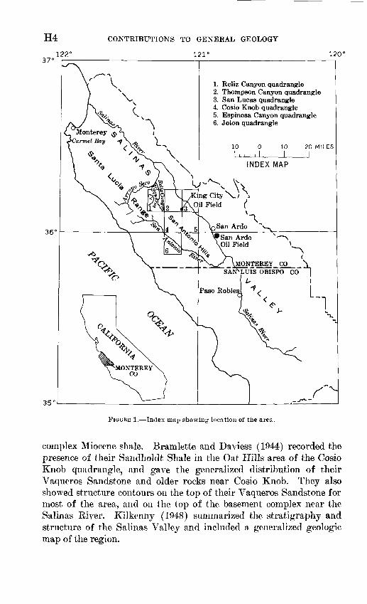
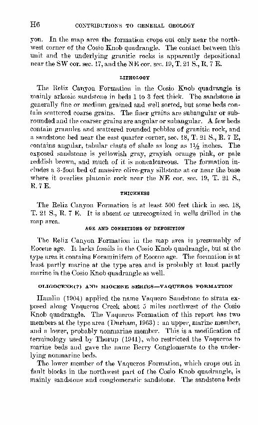
Page FIGURE 1. Index map showing location of the area_ ___________________ H4
2. Steeply dipping Monterey Shale___________________________ 93. Sandstone and mudstone beds of the unnamed formation_____ 134. Fine-grained sandstone and mudstone of the unnamed forma
tion __________________________________________________ 14
TABLES
Page
TABLE 1. Mollusks from the unnamed formation in the Cosio Knob quad rangle ----__--__________________--_____-_-_-__-___-___ H16
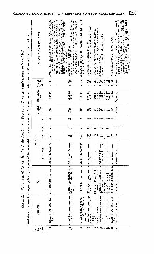
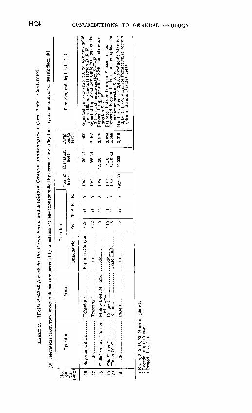
2. Wells drilled for oil in the Cosio Knob and Espinosa Canyonquadrangles before 1962_________________________________ 23
3. Fossil localities._________-_________----_-__-_--__-_-____ 25
CONTRIBUTIONS TO GENERAL GEOLOGY
GEOLOGY OF THE COSIO KNOB AND ESPINOSA CANYON QUADRANGLES, MONTEREY COUNTY, CALIFORNIA
By DAVID L. DURHAM
ABSTRACT
The Cosio Knob and Bspinosa Canyon quadrangles are on the west side of the Salinas Valley in southern Monterey County, Calif. They include hills that flank the high Santa Lucia Range and lie between the San Antonio and Salinas Rivers.
Granitic rocks of the basement complex crop out near the northwest corner of the Cosio Knob quadrangle. They are correlated with the Santa Lucia Quartz Diorite of Trask (1926), and are presumably of Late Cretaceous age.
The Reliz Canyon Formation of Eocene age nonconformably overlies the base ment complex. It is mainly thick-bedded arkosic sandstone that is probably marine. The formation is at least 500 feet thick where it is exposed in the Cosio Knob quadrangle, but it is absent or unrecognized in ^rells drilled in the map area.
The Vaqueros Formation overlies the Reliz Canyon Formation with apparent conformity and has two members. The lower member is mainly massive con glomeratic arkosic sandstone that is probably nonmarine. The upper member is chiefly thick-bedded arkosic marine sandstone and interbeclded siltstone. Each member is at least 1,250 feet thick in the Cosio Knob quadrangle, but the forma tion is absent in the subsurface near the Salinas River. The Vaqueros is of early Miocene and possibly Oligocene age.
The Monterey Shale overlies the Vaqueros Formation with a gradational contact. The Monterey that is exposed in the map area is about 45 percent mudstone, 35 percent porcelaneous mudstone, 15 percent porcelanite, less than 5 percent carbonate beds and concretions, and less than 1 percent sandstone. About one-third of the unit is thin bedded or shaly. The upper part of the formation is mainly noncalcareous. The lower part, which is chiefly calcareous shale and interbedded mudstone and sandstone, is distinguished as the Sandholdt Member. Exposures of sandstone in the Monterey are restricted to the Sandholdt Member, but sandstone occurs in the upper part of the formation in the subsurface near the Salinas River. The Monterey is apparently at least 5,800 feet thick in the center of the map area, but it is absent in the subsurface near the Salinas River. The formation is marine and of at least middle and late Miocene age.
An unnamed formation that consists of fine-grained sandstone and interbedded mudstone and porcelaneous rocks conformably overlies the Monterey Shale. It is nearly 900 feet thick near the west edge of the Cosio Knob quadrangle, but is much thinner near the Salinas River. Marine fossils in the unit suggest a Pliocene age.
HI712-590 O 64 2
H2 CONTRIBUTIONS TO GENERAL GEOLOGY
The nonmarine Paso Robles Formation, which overlies the unnamed forma tion with apparent conformity, contains poorly bedded and poorly sorted con glomerate, sandstone, and mudstone. It is at least 550 feet thick and is of Pliocene and Pleistocene (?) age.
Older alluvium unconformably overlies the Paso Robles and older formations and covers the bottoms of valleys in the map area. It resembles the Paso Robles Formation and is of Pleistocene and possibly Recent age.
Recent alluvium along the major streams is chiefly sand and gravel. The most common trend of faults and folds in the map area is northwest. The base ment complex is structurally high near the Salinas River, where it has only a thin cover of Pliocene and younger sedimentary rocks. It is overlain by a thick sequence of Cenozoic strata southwest of the Salinas River, where Monterey Shale is the principal exposed formation. Folds in the Monterey Shale are gen erally structures restricted to the fault block in which they occur, rather than segments of larger structures offset by cross faults. The basement complex is structurally low near the San Antonio River, where it is covered by the Vaqueros and younger formations.
Twenty-one exploratory wells were drilled in the map area before 1962, but none of them were commercially successful. The operators of most of the wells sought oil from either the Vaqueros Formation or sandstone beds in the Monterey Shale.
An unsuccessful placer operation for the recovery of gold from the Paso Robles Formation or the older alluvium was conducted in the Cosio Knob quadrangle.
INTRODUCTION
PURPOSE AND SCOPE
Cenozoic sedimentary rocks crop out in an area about 80 miles long and as much as 30 miles wide in the southern two-thirds of the Salinas Valley, Monterey, and San Luis Obispo Counties, Calif. The rocks are generally well exposed and their distribution along the length of the valley is favorable for study of individual formations over a large area. A study of this kind is important, both regionally, as a con tribution to understanding the geologic history of the California Coast Kanges, and locally, in attacking problems connected with the economic development of the area.
This report, the second that presents results of U.S. Geological Survey studies in the Salinas Valley, describes the geology of the Cosio Knob and Espinosa Canyon T1/^-minute quadrangles. The first report (Durham, 1963) described the Keliz Canyon, Thompson Canyon, and San Lucas quadrangles (fig. 1). Both reports are pre liminary in that some of the interpretations, and conclusions are tentative and may be modified when work in adjacent areas is complete.
LOCATION OF AREA
The Cosio Knob and Espinosa Canyon quadrangle are west of the Salinas Kiver at the latitude of San Ardo in southern Monterey
GEOLOGY, COSIO KNOB AND ESPINOSA CANYON QUADRANGLES H3
County, Calif, (fig. 1). They extend from the edge of the high Santa Lucia Kange at the northwest comer of the Cosio Knob quad rangle, to the plain of the Salinas Kiver in the northeast part of the Espinosa Canyon quadrangle, and include part of the range of hills, formerly (jailed San Antonio Hills, that lies between the Salinas and San Antonio Kivers.
PREVIOUS WORK
Geological investigations in and near the Cosio Knob and Espinosa Canyon quadrangles began in the middle of the 19th century, but pub lished details about the geology of the area are few. Whitney (1865, p. Ill) called the area between the San Antonio and Salinas Rivers by the local name, "San Antonio Hills." He described the part of the hills that he saw (Whitney, 1865, p. 150) as composed of "bituminous slate," an early term for the Monterey Shale. Fairbanks (1894, p. 519) observed that the hills between the rivers contain Miocene rocks, which he later (1900, p. 143) described as "flinty, organic shales of the oil-producing formation," that is, of Monterey Shale. He also noted surface indications of oil along the eastern slope of the hills (Fair banks, 1900, p. 144), probably east of the Espinosa Canyon quadrangle. Hamlin (1904, p. 12) characterized the "San Antonio Hills" as a range that diverges from the most elevated part of the Santa Lucia Range and is deeply eroded by many canyons. C. A. Waring (1914, p. 419) also remarked on the divergence of the "San Antonio Hills" from the main Santa, Lucia Range. G. A. Waring (1915, p. 276, 385) reported a "sulphur spring on Mission Creek" which was probably in the Cosio Knob quadrangle. Waring and Bradley (1917, p. 606) reported on placer mining for gold in Old Man Canyon in the southern part of the Cosio Knob quadrangle. English (1918, p. 245) noted the wide spread occurrence of Monterey Shale in the "San Antonio Hills," and concluded (1918, p. 236) that any oil found there would be in sandy lenses or crushed zones within the shale. Vander Leek (1921, p. 87) described the "San Antonio Hills" as a detached part of the Santa Lucia Range that is bordered on the northeast by a major fault along the Salinas River later called King City fault by Reed (1925, p. 590) and on the southwest by a fault extending southeast from sec. 3, T. 22 S., R. 7 E., along the margin of the San Antonio River valley. He recognized the Monterey Shale as the principal formation of the area and regarded the thickness and structure of the Monterey as ob scured by intense folding and crushing. Dorn (1932) described cores from the Standard Oil Piedmont 1, a deep well drilled in the southern part of the Cosio Knob quadrangle. Reed (1933, p. 44) represented the "San Antonio Hills" as underlain by a thick series of structurally
H4122'
CONTRIBUTIONS TO GENERAL GEOLOGY
121° 120'
1. Reliz Canyon quadrangle2. Thompson Canyon quadrangle3. San Lucas quadrangle4. Cosio Knob quadrangle5. Espinosa Canyon quadrangle6. Jolon quadrangle
King City \. i il Field (
San Ardo "v_
Ardo
FIGURE 1. Index map showing location of the area.
complex Miocene shale. Bramlette and Daviess (1944) recorded the presence of their Sandholdt Shale in the Oat Hills area of the Cosio Knob quadrangle, and gave the generalized distribution of their Vaqueros Sandstone and older rocks near Cosio Knob. They also showed structure contours on the top of their Vaqueros Sandstone for most of the area, and on the top of the basement complex near the Salinas River. Kilkenny (1948) summarized the stratigraphy and structure of the Salinas Valley and included a generalized geologic map of the region.
GEOLOGY, COSIO KNOB AND ESPINOSA CANYON QUADRANGLES H5
FIELDWOBK AND ACKNOWLEDGMENTS
The Espinosa Canyon quadrangle was mapped in 1959 and 1960; the Cosio Knob quadrangle was mapped in 1960 and 1961. P. J. Pat- tee assisted in the field in December 1959. Field mapping on aerial photographs of approxmiately 1 : 20,000 scale was compiled on top ographic maps of 1 : 24,000 scale.
The landowners in the map area were helpful in providing access to their property, and Lt. Frank H. Bosworth kindly gave permission to work on part of the Hunter Liggett Military Keservation. R. R. Thorup, consulting geologist, King City, generously furnished data on many wells in the map area, and H. H. Haun, Humble Oil and Refining Co., provided other well data.
Ellen J. Moore identified Mollusca from the area, and Patsy J. Smith identified Foraminifera.
STRATIGRAPHY
Grantitic rocks of presumed Late Cretaceous age are overlain in the Cosio Knob and Espinosa Canyon quadrangle by strata of Eocene and later Cenozoic age. Plate 4 shows the succession, generalized lithology, and approximate thickness of the stratigraphic units in the map area. The older formations are absent near the Salinas River.
PBE-TEETIAEY BASEMENT COMPLEX
Granitic rocks of the basement complex crop out in the northwest part of the Cosio Knob quadrangle in a fault-bounded block less than 1 square mile in area. They are part of the plutonic mass that Lawson (1893, p. 6) named the Santa Lucia Granite, and Trask (1926, p. 134) called the Santa Lucia Quartz Diorite.
The exposed granitic rocks generally are deeply weathered and resemble massive friable coarse-grained sandstone. They commonly contain quartz veins and aplite and pegmatite dikes as thick as 2 inches.
The granitic rocks underlie the Reliz Canyon Formation of Eocene age and presumably have an age similar to that of the granodiorite at Carmel Bay, which Curtis, Evernden, and Lipson (1958) determined by the potassium-argon method as 81.6 million years. This age is Late Cretaceous according to the geological time scale of Holmes (1959).
TEETIAEY SYSTEM
EOCENE SERIES RJECLIZ CANYON FORMATION
The type area of the Reliz Canyon Formation (Durham, 1963) is about 5 miles northwest of the Cosio Knob quadrangle in Reliz Can-
H6 CONTRIBUTIONS TO GENERAL GEOLOGY
yon. In the map area the formation crops out only near the north west corner of the Cosio Knob quadrangle. The contact between this unit and the underlying granitic rocks is apparently depositional near the SW cor. sec. 17, and the NE cor. sec. 19, T. 21 S., R. 7 E.
LITHOLOGY
The Reliz Canyon Formation in the Cosio Knob quadrangle is mainly arkosic sandstone in beds 1 to 3 feet thick. The sandstone is generally fine or medium grained and well sorted, but some beds con tain scattered coarse grains. The finer grains are subangular or sub- rounded and the coarser grains are angular or subangular. A few beds contain granules and scattered rounded pebbles of granitic rock, and a sandstone bed near the east quarter corner, sec. 18, T. 21 S., R. 7 E, contains angular, tabular clasts of shale as long as iy2 inches. The exposed sandstone is yellowish gray, grayish orange pink, or pale reddish brown, and much of it is noncalcareous. The formation in cludes a 3-foot bed of massive olive-gray siltstone at or near the base where it overlies plutonic rock near the NE cor. sec. 19, T. 21 S., R.7E.
THICKNESS
The Reliz Canyon Formation is at least 500 feet thick in sec. 18, T. 21 S., R. 7 E. It is absent or unrecognized in wells drilled in the map area.
AGE AND CONDITIONS OF DEPOSITION
The Reliz Canyon Formation in the map area is presumably of Eocene age. It lacks fossils in the Cosio Kndb quadrangle, but at the type area it contains Foraminifera of Eocene age. The formation is at least partly marine at the type area and is probably at least partly marine in the Cosio Knob quadrangle as well.
OLIGOCENEC?) AND MIOCENE SERIES VAQUEROS FORMATION
Hamlin (1904) applied the name Vaquero Sandstone to strata ex posed along Vaqueros Creek about 5 miles northwest of the Cosio Knob quadrangle. The Vaqueros Formation of this report has two members at the type area (Durham, 1963) : an upper, marine member, and a lower, probably nonmarine member. This is a modification of terminology used by Thorup (1941), who restricted the Vaqueros to marine beds and gave the name Berry Conglomerate to the under lying nonmarine beds.
The lower member of the Vaqueros Formation, which crops out in fault blocks in the northwest part of the Cosio Knob quadrangle, is mainly sandstone and conglomeratic sandstone. The sandstone beds
GEOLOGY, COSIO KNOB AND ESPINOSA CANYON QUADRANGLES H7
are generally more massive and conglomeratic than are those in the underlying Reliz Canyon Formation. The lower contact of the mem ber is at the base of the stratigraphically lowest massive, cobble- bearing, conglomeratic sandstone bed above sandstone beds character istic of the Reliz Canyon Formation. The contact is poorly exposed in the Cosio Knob quadrangle, but in sec. 17, T. 21 S., R. 7 E., the lower member apparently overlies the Reliz Canyon Formation conformably.
The upper member of the Vaqueros Formation also crops out in the northwest part of the Cosio Knob quadrangle. It is chiefly arkosic sandstone, but at some localities it contains interbedded fine grained sandstone and siltstone. Unlike the lower member, the upper member contains marine fossils and generally lacks coarse-grained sandstone or conglomeratic beds. The depositional contact between the two members is concealed in the map area, but about 5 miles north west of the Cosio Knob quadrangle, it is gradational and interfinger- ing (Durham, 1963).
LITHOLOGY
Sandstone in the lower member of the Vaqueros Formation is mainly arkosic, massive or thick bedded, conglomeratic, poorly sorted, and locally cross-stratified. The sand grains are generally medium or coarse and angular to subrounded. The exposed sandstone is yel lowish gray or grayish orange and is commonly friable. The sand stone contains pebbles, cobbles, and rare boulders of plutonic and metamorphic rocks, both in poorly defined lenses and scattered at random. A sandstone bed in the lower member in a small fault block in sec. 19, T. 21 S., R. 7 E., contains angular chips of siltstone as long as half an inch.
Sandstone in the upper member of the Vaqueros Formation is mainly arkosic, massive or thick bedded, medium or coarse grained, and poorly sorted. Locally it is fine grained, thin bedded or lam inated, and interbedded with siltstone, but at a few other places it contains scattered granules and pebbles. The sandstone is generally friable and about half of it is calcareous. Moulds, casts, and frag ments of mollusk shells are abundant in the sandstone at a few places, and cavernous weathering is common. The exposed sandstone is very light gray, pale yellowish orange, or dark yellowish orange.
Siltstone interbedded with sandstone of the upper member is mas sive, pale yellowish brown, calcareous, and has a hackly fracture.
THICKNESS
Only partial sections of the Vaqueros Formation are exposed in the map area. The thickness of the upper member near sec. 19,
H8 CONTRIBUTIONS TO GENERAL GEOLOGY
T. 21 S., K. 7 E., measured on the geologic map of the Cosio Knob quadrangle (pi. 1), is about 1,250 feet. The lower member appears to be at least as thick near the northwest corner of the quadrangle, but the unit there is poorly exposed and complexly deformed. Beds cor related with the Vaqueros Formation were penetrated in the Union Oil Keens 1 for about 2,350 feet and in the Standard Oil Piedmont 1 for more than 2,200 feet (pi. 3).
AGE AND CONDITIONS OF DEPOSITION
Fossils from the Vaqueros Formation in the Cosio Knob quadrangle are too fragmentary or poorly preserved to be useful as indicators of the age of the unit. Nearby, in the Reliz Canyon quadrangle, the Vaqueros is of Oligocene( ?) and early Miocene age (Durham, 1963), Fossils in the upper member indicate that it is marine; the lack of fossils, poor sorting, and cross-stratification of the lower member sug gest that it is nonmarine.
MIOCENE SERIES MONTEREY SHALE
Blake (1855) named the Monterey Shale for exposures about 40 miles northwest of the Cosio Knob quadrangle at the town of Monterey.
The Monterey Shale constitutes about 70 percent of the rock exposed in the map area. It crops out principally between the Salinas Kiver and Jolon Valley in a northwest-trending belt about 7 miles wide.
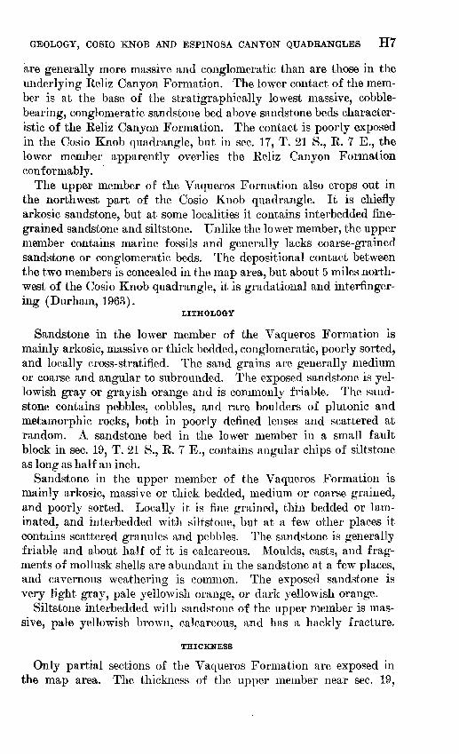
The Monterey Shale in the map area is approximately 45 percent mudstone, 35 percent porcelaneous mudstone, 15 percent porcelanite, less than 5 percent carbonate beds and concretions, and less than 1 percent sandstone and chert. (Composition percentages are estimated from notes made at about 1,200 localities in the map area.) It is about 40 percent thin-bedded or shaly rocks, similar to those shown in figure 2. The Monterey is chiefly noncalcareous, except for the lower part, which is distinguished as the Sandholdt Member. Exposures of sand stone are restricted to the Sandholdt, but sandstone occurs stratigraph- ically higher in the formation in the subsurface near the margin of the hills west of the Salinas Kiver.
The Montery Shale is conspicuously finer grained and commonly thinner bedded than most of the underlying Vaqueros Formation. Where the Sandholdt Member of the Monterey overlies the Vaqueros in the northwest quarter of the Cosio Knob quadrangle, the lower contact of the Sandholdt is placed at the base of the stratigraphically lowest unit of calcareous shale above the dominantly sandy beds characteristic of the Vaqueros. The contact is poorly exposed; it is probably gradational and is not necessarily at the same stratigraphic horizon throughout the map area.
GEOLOGY, COSIO KNOB AND ESPINOSA CANYON QUADRANGLES H9
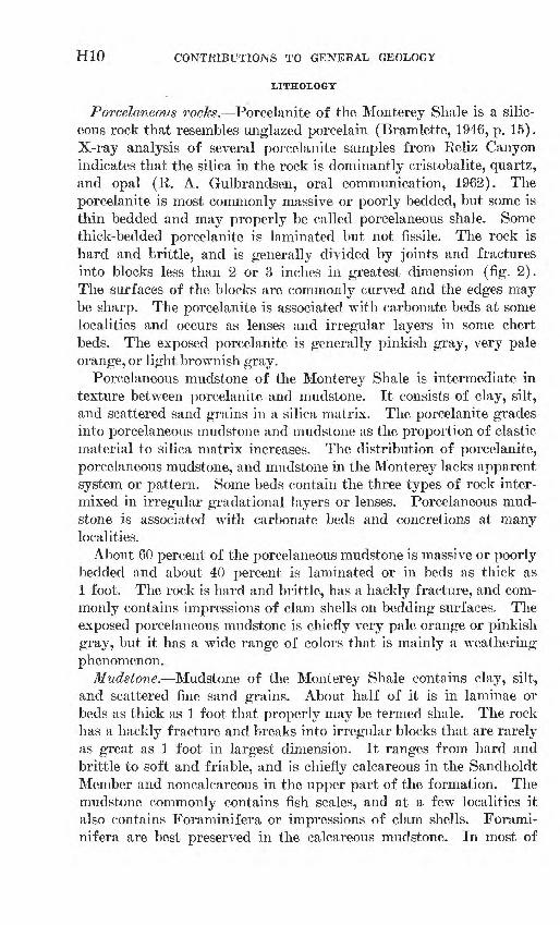
FIGURE 2. Steeply dipping Monterey Shale exposed in sec. 30, T. 21 S., R. 7 E., near the west edge of the Cosio Knob quadrangle. Joints and fractures divide the rock into angular blocks no more than 2 or 3 inches in greatest dimension.
SANDHOLDT MEMBER
The type area of the Sandholdt Member (Durham, 1963) of the Monterey Shale is about 5 miles northwest of the Cosio Knob quad rangle in Reliz Canyon. The member corresponds approximately to the Sandholdt Shale of Thorup (1941) and of Bramlette and Daviess (1944).
The Sandholdt Member crops out in the northwest quarter of the Cosio Knob quadrangle. It is absent in wells drilled near and north east of the edge of the hills along the Salinas River.
Its stratigraphic position and high proportion of calcareous rocks distinguish the Sandholdt Member from the upper part of the Monte rey Shale. The Sandholdt contains minor, but at some places con spicuous, amounts of sandstone, chert, porcelanite, and carbonate beds. The upper contact of the Sandholdt is placed at the top of the stratigraphically highest beds of calcareous shale or mudstone in the Monterey and is not necessarily at the same stratigraphic hori zon throughout the map area.
H10 CONTRIBUTIONS TO GENERAL GEOLOGY
LITHOLOGY
Porcelaneous rocks. Porcelanite of the Monterey Shale is a silic eous rock that resembles unglazed porcelain (Bramlette, 1946, p. 15). X-ray analysis of several porcelanite samples from Reliz Canyon indicates that the silica in the rock is dominantly cristobalite, quartz, and opal (R. A. Gulbrandsen, oral communication, 1962). The porcelanite is most commonly massive or poorly bedded, but some is thin bedded and may properly be called porcelaneous shale. Some thick-bedded porcelanite is laminated but not fissile. The rock is hard and brittle, and is generally divided by joints and fractures into blocks less than 2 or 3 inches in greatest dimension (fig. 2). The surfaces of the blocks are commonly curved and the edges may be sharp. The porcelanite is associated with carbonate beds at some localities and occurs as lenses and irregular layers in some chert beds. The exposed porcelanite is generally pinkish gray, very pale orange, or light brownish gray.
Porcelaneous mudstone of the Monterey Shale is intermediate in texture between porcelanite and mudstone. It consists of clay, silt, and scattered sand grains in a silica matrix. The porcelanite grades into porcelaneous mudstone and mudstone as the proportion of clastic material to silica matrix increases. The distribution of porcelanite, porcelaneous mudstone, and mudstone in the Monterey lacks apparent system or pattern. Some beds contain the three types of rock inter mixed in irregular gradational layers or lenses. Porcelaneous mud- stone is associated with carbonate beds and concretions at many localities.
About 60 percent of the porcelaneous mudstone is massive or poorly bedded and about 40 percent is laminated or in beds as thick as 1 foot. The rock is hard and brittle, has a hackly fracture, and com monly contains impressions of clam shells on bedding surfaces, The exposed porcelaneous mudstone is chiefly very pale orange or pinkish gray, but it has a wTide range of colors that is mainly a weathering phenomenon.
Mudstone. Mudstone of the Monterey Shale contains clay, silt, and scattered fine sand grains. About half of it is in laminae or beds as thick as 1 foot that properly may be termed shale. The rock has a hackly fracture and breaks into irregular blocks that are rarely as great as 1 foot in largest dimension. It ranges from hard and brittle to soft and friable, and is chiefly calcareous in the Sandholdt Member and noncalcareous in the upper part of the formation. The mudstone commonly contains fish scales, and at a few localities it also contains Foraminifera or impressions of clam shells. Forami- nifera are best preserved in the calcareous mudstone. In most of
GEOLOGY, COSIO KNOB AND ESPINOSA CANYON QUADRANGLES Hll
the noncalcareous beds they are represented only by external molds. Mudstone in the Sandholdt Member at some places has a fetid odor when it is freshly broken. The exposed mudstone is generally very pale orange, but locally it has a wide range of colors that is related to weathering of the rock.
Carbonate beds and concretions. Carbonate beds and ellipsoidal concretions of similar composition are conspicuous in the Monterey Shale at many places (Bramlette, 1946, p. 20-22). The beds range from y2 foot to 5 feet, but are generally about 2 feet thick. The concretions are 6 to 12 inches thick and as much as 3 feet long. The carbonate beds and concretions are associated with porcelaneous rocks and both calcareous and noncalcareous mudstone and shale. They are most common in thin-bedded rocks. The concretions occur in individual beds or groups of beds, rather than uniformly throughout the formation.
The carbonate beds consist of clay, silt, and an abundant carbon ate cement. X-ray analysis of several samples of carbonate beds from Keliz Canyon suggests that the carbonate is a ferrous dolomite (R. A. Gulbrandsen, oral communication, 1962). The rock is hard and dense, and is generally more resistant to weathering than the enclosing beds. At some localities, the carbonate rock contains white calcite veins as thick as y± inch. The exposed rock is generally grayish orange, and less commonly pale yellowish brown, pale red dish brown, or very pale orange.
Chert. Beds of chert 1 to 12 inches thick are interbedded with porcelaneous rocks and mudstone of the Monterey Shale. They com monly thicken and thin or pinch out along the strike. The chert is light brownish gray, brownish black, brownish gray, or pale brown. Some strikingly banded beds contain alternate layers or lenses of chert and light-colored porcelanite.
Sandstone. Sandstone beds in the Sandholdt Member are gen erally 1 to 10 inches thick, and a few are as much as 3 feet thick. They commonly are grouped to form sandstone units several tens of feet thick. The sandstone is arkosic, fine to coarse grained, and calcareous, and it contains calcite veins. The exposed sandstone is medium light gray, yellowish gray, or pale yellowish brown. A thin section of sandstone from near the middle of the Sandholdt Member in sec. 16, T. 21 S., R. 7 E., contains about 40 percent calcite cement, 35 percent feldspar, 20 percent quartz, less than 5 percent rock fragments, and less than 1 percent mica and dark minerals.1 The grains are subangular or subrounded and range from 0.25 to 1 mm in diameter.
1 The percentages of minerals In this and other thin sections were determined by the Chayes point-count method.
H12 CONTRIBUTIONS TO GENERAL GEOLOGY
A few sandy beds crop out in the Espinosa Canyon quadrangle near the east edge of the hills in projected sees. 30 and 32, T. 21 S., R. 9 E. Two thin sections from these beds contain about 50 percent clay and silt matrix, 20 to 25 percent feldspar, 10 percent quartz, as much as 2 percent mica, and 15 percent phosphatic pellets. The sand grains are angular and subangular and are generally less than 0.15 mm in diameter. The pellets range from 0.25 to 2 mm in diameter and are circular or elliptical in cross section. They consist mainly of clay- or silt-size material, but 60 to 70 percent of them surround one or more grains of quartz, feldspar, or rarely mica. They resemble phosphatic pellets in the Monterey Shale in the Reliz Canyon and Thompson Canyon quadrangles that contain carbonate fluorapatite (R. A. Gulbrandsen, oral communication, 1962).
Tuff. A tuff bed in the Monterey Shale is poorly exposed on a ridge in the SW*4 sec. 13, T. 21 S., R, 8 E. in the north part of the Espinosa Canyon quadrangle. It is probably no more than 3 feet thick. The tuff is yellowish gray, porous, and contains shards as long as 0.25 mm.
THICKNESS
The Monterey Shale is incompletely exposed in the map area. The thickness of the Sandholdt Member in the northwest part of the Cosio Knob quadrangle, is about 625 feet (measured section 1). The thick ness of the entire formation near the Union Oil Keans 1, measured on structure section D-E-F (pi. 3), is apparently at least 5,800 feet. The Sandholdt Member is absent in wells drilled near the margin of the hills west of the Salinas River, and the entire formation is absent in the subsurface near the river (pi. 3).
AGE AND CONDITIONS OF DEPOSITION
At fossil locality Mf481, in sec. 17, T. 21 S., R. 7 E., the Sandholdt Member contains Bolivina advena striatetta, Bolivina sinuata ali- soensis, Bulimina carnerosensis, Buliminella curta, and Valvulineria depressa, which suggest the middle Miocene lower Luisian or Relizian Stage of Kleinpell (Patsy B. Smith, written communication, 1960). Fossils are scarce or poorly preserved in the siliceous rocks of the formation, but the overlying unit contains mollusks considered to be of Pliocene age (E. J. Moore, written communication, 1961). Thus, in the map area, the Monterey Shale represents at least part of middle and most or all of late Miocene time.
PLIOCENE SERIES UNNAMED FORMATION
An unnamed formation crops out around a structural high of Mon terey Shale in the southwest quarter of the Cosio Knob quadrangle
GEOLOGY, COSIO KNOB AND ESPINOSA CANYON QUADRANGLES H13
and in a narrow strip that trends southeast across the center of the quadrangle and down the east side of Jolon Valley. Beds in and near sec. 13, T. 21 S., K. 8 E., in the Espinosa Canyon quadrangle that are sandy and stratigraphically higher than strata typical of the Monterey Shale are questionably assigned to the unnamed formation.
The unnamed formation contains very fine grained sandstone inter- bedded with mudstone and porcelaneous rocks similar to the Monterey Shale. The formation is about 60 percent sandstone, 25 percent mud- stone, and 15 percent porcelaneous rocks. Composition percentages are estimated from notes made at about 150 localities in the map area.
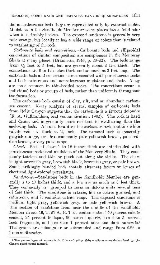
The sandstone beds in the unnamed formation are the obvious lith- ologic feature that distinguishes the unit from the underlying Mon terey Shale. These typically form resistant ledges on grassy tree- studded slopes (fig. 3). The lower contact of the unnamed formation is at the base of the stratigraphically lowest sandstone bed that over lies the finer grained rocks of the Monterey Shale. Where exposed, the contact is conformable, but it may not be at the same stratigraphic horizon throughout the map area. The unnamed formation appar ently overlaps the Monterey Shale eastward and lies directly on the basement complex near the Salinas River (pi. 3).
The unnamed formation in the Cosio Knob quadrangle is equiva lent to the unnamed formation that overlies the Monterey Shale 1 to
FIGURE 3. Sandstone and mudstone beds of the unnamed formation exposed at the end of a strike ridge on the south flank of the syncline in projected sec. 31, T. 21 S., R. 7 E.. near the west edge of the Coslo Knob quadrangle.
H14 CONTRIBUTIONS TO GENERAL GEOLOGY
10 miles north of the map area in the Reliz Canyon, Thompson Canyon, and San Lucas quadrangles (Durham, 1963). The unit is unnamed here because of uncertainty as to its relationship to beds east of the Salinas River that have been called the King City Forma tion by Clark (1940), Poncho Rico Formation by Reed (1925), and Etchegoin and Jacalitos Formations by English (1918, p. 231).
LITHOLOGY
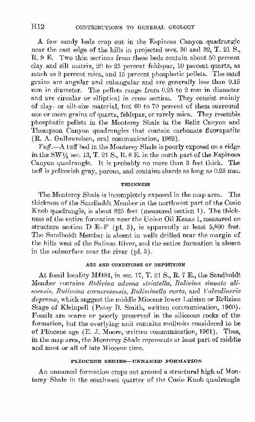
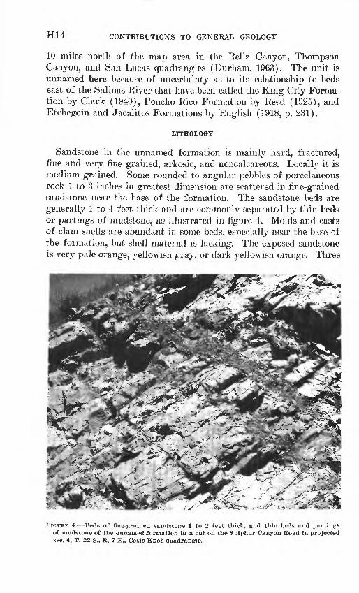
Sandstone in the unnamed formation is mainly hard, fractured, fine and very fine grained, arkosic, and noncalcareous. Locally it is medium grained. Some rounded to angular pebbles of porcelaneous rock 1 to 3 inches in greatest dimension are scattered in fine-grained sandstone near the base of the formation. The sandstone beds are generally 1 to 4 feet thick and are commonly separated by thin beds or partings of mudstone, as illustrated in figure 4. Molds and casts of clam shells are abundant in some beds, especially near the base of the formation, but shell material is lacking. The exposed sandstone is very pale orange, yellowish gray, or dark yellowish orange. Three
; s.T^ffi^*
FIGITUE 4. Beds of fine-grained sandstone 1 to 2 feet thick, and thin beds and partings of mudstone of the unnamed formation in a cut on the Sulphur Canyon Road in projected sec. 4, T. 22 S., R. 7 E., Cosio Knob quadrangle.
GEOLOGY, COSIO KNOB AND ESPINOSA CANYON QUADRANGLES H15
thin sections of fine-grained sandstone from the Cosio Knob quad rangle contain 45 to 60 percent clay and silt matrix, 20 to 30 percent feldspar, 20 to 25 percent quartz, and less than 1 percent mica and dark minerals. The sand grains are mainly angular and subangular and less than 0.15 mm in diameter.
Sandstone exposed in the Espinosa Canyon quadrangle near the west line of sec. 13, T. 21 S., R. 8 E., and questionably assigned to the unnamed formation, is massive and friable, and contains some hard calcareous beds. A thin section from one of these calcareous beds contains about 60 percent calcite cement, 30 percent feldspar, 10 percent quartz, and less than 1 percent mica. A thin section from another of the beds contains about 70 percent calcite cement, 20 per cent feldspar, 10 percent quartz, and less than 1 percent mica. The sand grains in the sections are angular or subangular and less than 0.15 mm in diameter.
Massive friable sandstone near the top of the unnamed formation in the Cosio Knob quadrangle in the NE^ projected sec. 31, T. 21 S., R. 7 E., is calcareous and contains scattered cherty pebbles and angular charcoallike clasts as long as half an inch.
Mudstone in the unnamed formation is massive or poorly bedded, fractured, and noncalcareous. It commonly contains molds and casts of clam shells and at some localities it contains abundant diatoms. The weathered rock is yellowish gray, light gray, or light olive gray.
Porcelaneous rocks are interbedded with the mudstone and fine grained sandstone. They are generally massive or poorly bedded and fractured. The porcelanite and porcelaneous mudstone contain molds and casts of clam shells at a few places.
THICKNESS
The thickness of the unnamed formation near the west edge of the Cosio Knob quadrangle in projected sees. 31 and 32, T. 21 S., R. 7 E., and projected sec. 6, T. 22 S., R. 7 E. (measured section 2), is nearly 900 feet. The formation is incompletely exposed elsewhere in the map area,-but it must be thin near the Salinas River, where the Superior Oil Echenique 1 reached the basement complex 480 feet below the sur face (pi. 3).
AGE AND CONDITIONS OF DEPOSITION
The meager molluscan fauna from the unnamed formation listed in table 1 is considered to be of Pliocene age (E. J. Moore, written communication, 1961). According to Patsy B. Smith (written com munication, 1961), a sample from locality M1060, near the north quarter corner, sec. 2, T. 22, R. 7 E., contains a small poorly preserved benthonic foraminiferal fauna that indicates middle Miocene age, but
H16 CONTRIBUTIONS TO GENERAL GEOLOGY
TABLE 1. Mollusks from the unnamed formation in the Cosio Knob quadrangle[Identified by E. J. Moore]
Anadara (Anadara) cf. A. (A.) trilineata (Con rad) ................. __ ...........
Lyropectenf cf. L. terminus (Arnold) _ ..
Locality (USGS No.)
M1060
X
M1062
X
M1063
X
M1064
X
X
M1065
X
X
X
M1066
X
M1067
X
X
the condition and preservation of the specimens suggest that they are reworked from older rocks. The same sample contains well-preserved unfilled specimens of Globigerina bulloides, a pelagic Foraminifera of indeterminate age. The fossil mollusks and indigenous fossil Fora minifera in the unnamed formation indicate that the unit is marine.
TERTIARY AND QUATERNARY(P) SYSTEMS
PLIOCENE AND PLEISTOCENE(?) SERIES PASO KOBLJBS FORMATION
Fairbanks (1898) gave the name Paso Robles Formation to beds exposed about 37 miles southeast of the Cosio Knob quadrangle near the town of Paso Robles. The formation crops out along Jolon Valley and west to Mission Creek around the structural high in the southwest quarter of the Cosio Knob quadrangle. It contains conglomerate, con glomeratic sandstone, sandstone, and mudstone, and resembles older alluvium. Although the formation apparently is absent or concealed in the Espinosa Canyon quadrangle, some poorly exposed beds near the Salinas River that are mapped as older alluvium may belong to the Paso Robles.
The Paso Robles Formation is generally coarser and less well sorted and cemented than the underlying unnamed formation. The contact between the two units is poorly exposed in the map area, but it is apparently conformable. The contact is at the base of the strati- graphically lowest conglomerate bed above the fossiliferous fine grained sandstone and mudstone of the unnamed formation. In the map area the contact is best exposed on a small hill north of the Sulphur Spring Road about 2 miles west of Jolon Road.
LITHOLOGY
Conglomerate in the Paso Robles Formation generally contains rounded pebbles in a poorly cemented matrix of sandstone or silty sandstone. The larger clasts are chiefly % to 1 inch in greatest dimen-
GEOLOGY, COSIO KNOB AND ESPINOSA CANYON QUADRANGLES H17
sion, but a few are as long as 4 inches. They are nearly all of rocks similar to those in the Monterey Shale.
The conglomerate grades into conglomeratic sandstone and sand stone as the proportion of larger clasts to matrix decreases. The sand stone is arkosic, generally noncalcareous, massive or poorly bedded, friable, poorly sorted, and conglomeratic. The exposed sandstone is commonly very pale orange. A thin section of hard poorly sorted pebbly sandstone from near the base of the formation in the NW*4 projected sec. 4, T. 22 S., R. 7 E., contains about 40 percent calcite cement, 30 percent feldspar, 15 percent quartz, 15 percent rock frag ments, and less than 1 percent mica. The grains are angular to sub- rounded and generally less than 0.5 mm in diameter.
Mudstone of the Paso Robles Formation is massive or thick bedded and commonly contains scattered pebbles. It is locally calcareous and includes beds of fine-grained sandstone as thick as 1 foot. The exposed mudstone is generally very pale orange.
THICKNESS
The Paso Robles Formation is at least 550 feet thick, as measured on the geologic map, in projected sec. 31, T. 21 S., R. 7 E., near the west edge of the Cosio Knob quadrangle (pi. 1). It is apparently much thicker near Jolon Valley (pi. 3). The Paso Robles was partly removed by erosion prior to deposition of the older alluvium.
AGE AND CONDITIONS OF DEPOSITION
The Paso Robles Formation is unfossiliferous in the map area, but it overlies beds that contain marine fossils considered to be of Pliocene age. It is imconformably overlain by older alluvium, which is of Pleistocene and possibly Recent age.
The Paso Robles Formation is apparently nonmarine because it lacks marine fossils and generally resembles the overlying older allu vium. The base of the Paso Robles ideally represents the beginning of nonmarine deposition following the last withdrawal of the Tertiary sea from the map area.
QUATERNARY SYSTEM
PLEISTOCENE AND RECENT(?) SERIES OLDER ALLUVIUM
The older alluvium consists of fluviatile sediments that unconform- ably overlie the Paso Robles and older formations, and that are older than alluvium in the beds of active streams. It occurs mainly in areas of low relief near the Salinas and San Antonio Rivers and in the valleys of the larger tributary streams. The older alluvium near the northwest corner of the Cosio Knob quadrangle in sec. 17, T. 21 S.,
712-590 O-64 3
HIS CONTRIBUTIONS TO GENERAL GEOLOGY
R. 7 E., occupies a remnant of a valley related to a nearly destroyed old erosion surface. Patches of older alluvium southwest of Espinosa Canyon in sec. 11, T. 22 S., R. 8 E., may be relics of deposits that formerly covered the bottom of an ancient valley. Older alluvium that caps ridges near the mouth of Broadhurst Canyon extends south west through a break in the hills that apparently represents a former valley unrelated to modern streams.
Older alluvium, which ranges from friable uncemented sediment to well-cemented rock, is mainly poorly consolidated mudstone, pebbly mudstone, pebbly sandstone, and conglomerate, or their unconsolidated equivalents. It is massive or poorly bedded, and noncalcareous, except locally where it is associated with caliche. It contains pebbles of rocks common in the Monterey Shale that are subangular to rounded and less than 2 inches in greatest dimension. It is yellowish gray or gray ish orange at most localities.
Small remnants of formerly more extensive alluvial deposits that lie on ridges or the sides of canyons are generally omitted from the geologic maps (pis. 1 and 2). They commonly contain abundant angular pebbles of Monterey Shale that appear to be of local derivation.
Older alluvium resembles part of the Paso Robles Formation, but unlike the Paso Robles, it is undeformed. The contact between the two units on the geologic map of the Cosio Knob quadrangle (pi. 1) is at some places drawn arbitrarily at the break in slope at the base of hills composed of the Paso Robles.
The older alluvium is most extensive and perhaps thickest near the Salinas River in the northeast part of the Espinosa Canyon quad rangle. Hills that are as much as 200 feet above the river may be composed entirely of older alluvium, or they may be only mantled with it.
The older alluvium overlies the Paso Robles Formation of Pliocene and Pleistocene (?) age and is older than alluvium in active streams. Its age is thus limited to Pleistocene and possibly Recent.
RECENT SERIES AIjL.UVIUM
Alluvium along the Salinas and San Antonio Rivers and Mission Creek is chiefly sand and gravel. About three-fourths of the larger clasts on a gravel bar near the main channel of the Salinas River at the bridge in the northeast part of the Espinosa Canyon quadrangle are from the basement complex and volcanic rocks, but nearly all the larger clasts in the alluvium farther from the main channel are of porcelaneous rocks. About 80 percent of the larger clasts in the San Antonio River are from the basement complex and the rest are por celaneous rocks, chert, and sandstone. Clasts from the basement com-
GEOLOGY, COSIO KNOB AND ESPINOSA CANYON QUADRANGLES H19
plex are much more common in the alluvium than in either the older alluvium or the Paso Eobles Formation.
STRUCTURE
GENERAL FEATURES
The major structural divisions of the mapvarea, listed from north east to southwest, are (a) the area near the Salinas River, where the basement complex has only a thin sedimentary cover; (b) the hills between the Salinas River and Jolon Valley, where a thick sequence of beds, mainly Monterey Shale and older units, overlies the basement complex; and (c) the area near and west of Jolon Valley, where a thick sequence of beds, including units younger than the Monterey Shale, overlies the basement complex. The divisions are separated, in a general way, by fault zones near the margins of the hills between the Salinas River and Jolon Valley.
The basement complex is structurally high near the Salinas River, where it is 480 feet below the surface at the Superior Oil Echenique 1 (pi. 3). It is overlain there by strata that are unlike the Monterey Shale and older formations and that are presumably of Pliocene or younger age. The basement complex is deeper near the margin of the hills southwest of the river, but whether the basement surface slopes steeply, or steps down across one or more faults, is unclear.
A belt more than 5 miles wide of Monterey Shale and older forma tions extends diagonally southeast across the map area from the north west part of the Cosio Knob quadrangle. It is characterized by large northwestward-trending faults and lesser northeastward-trending cross faults, except in the northwest quarter of the Cosio Knob quad rangle near the edge of a structural high that extends into the map area from the northwest. Formations older than the Monterey Shale crop out in the map area only in and around this structural high. Monterey Shale crops out elsewhere in the belt, except near the mar gins, wThere the unnamed formation of Pliocene age occurs locally. The Monterey Shale, Sandholdt Member of the Monterey, and Vaqueros Formation occur above the basement complex in wells drilled in the southwest half of the belt. In wells drilled near the Salinas River, sandstone is common in the Monterey, and both the Sandholdt Member and Vaqueros Formation are absent.
The area along and west of Jolon Valley is structurally and topo graphically lower than the belt of Monterey Shale and older rocks to the northeast. The Paso Robles Formation and older alluvium crop out over most of the area, except near the west edge of the Cosio Knob quadrangle, where Monterey Shale and a fringe of the unnamed formation of Pliocene age form a local structural high. The Monterey
H20 CONTRIBUTIONS TO GENERAL GEOLOGY
Shale and Vaqueros Formation overlie the basement complex in wells drilled near Jolon Valley. Westward- to northwestward-trending faults and folds are common west of Jolon Valley, but near the west edge of the Cosio Knob quadrangle, northeastward-trending cross faults modify the general structure.
Plate 3 illustrates the structure in the Cosio Knob and Espinosa Canyon quadrangles as interpreted from surface evidence and data of exploratory wells. Most of the faults on the structure sections are arbitrarily shown as vertical because indication of their dip is gen erally lacking. The Vaqueros Formation is undivided on the struc ture sections because strata typical of the lower member are absent or unrecognized in the wells. The Keliz Canyon Formation is also absent, or possibly unrecognized, in wells drilled in the map area. The structure sections incorporate the following assumptions: (a) exposed faults and folds extend into the subsurface without marked change in character; (b) the thickness of stratigraphic units in the subsurface is constant, or changes uniformly where well data indicate change; (c) the basement complex surface slopes evenly between wells; (d) the Keliz Canyon and Vaqueros Formations and the Monterey Shale thin to the northeast by progressive overlap of older beds by younger.
FAULTS
Faults in the Monterey Shale are generally obscure because they juxtapose similar rocks. They are generally marked by zones of crushed, contorted, or steeply dipping beds, and are also evidenced by the termination of sets of folds or by other abrupt changes in struc ture across their trace. The inferred faults shown on the geologic maps (pis. 1 and 2) are suggested to account for apparent structural anomalies in areas of poor exposure.
A fault system that in places is at least a mile wide parallels the front of the hills southwest of the Salinas River between sec. 23, T. 21 S., R. 8 E., and sec. 4, T. 22 S., R. 9 E. It contains blocks bounded by northwestward-trending faults and northward- or northeastward- trending cross faults. The pattern of folds in each block is different from that in adjacent blocks, indicating that the folds are at least partly contemporaneous with or younger than the bounding faults.
The fault that trends from sec. 12, T. 21 S., R. 7 E., in the northeast part of the Cosio Knob quadrangle, to sec. 26, T. 21 S., R. 8 E., in the central part of the Espinosa Canyon quadrangle, is the southeast end of a major structure that extends more than 15 miles northwest of the map area to and beyond the Arroyo Seco (fig. 1). It dips 70° south west where it is exposed on the bank of the Arroyo Seco, but its attitude in the Cosio Knob and Espinosa Canyon quadrangles is unknown.
GEOLOGY, COSIO KNOB AND ESPINOSA CANYON QUADRANGLES H21
The fault trace in the map area is a zone of crushed and contorted beds against which nearby faults and folds terminate.
The fault that extends southeast from sec. 11, T. 21 S., R. 7 E., in the northeast part of the Cosio Knob quadrangle, to sec. 34, T. 21 S., R. 8 E., west of the center of the Espinosa Canyon quadrangle, is marked by a zone of crushed beds and discordant structure north of Quinado Canyon, and by steeply dipping beds in Mansfield and upper Feliz Canyons. The fault may extend farther southeast than indi cated on the geologic map of the Espinosa Canyon quadrangle (pi. 2), but its trace is obscure in the area of poor exposures southeast of Feliz Canyon. As shown on structure section A-B-C (pi. 3), the basement- complex surface is probably downdropped to the northeast along this or a nearby fault.
The fault that trends southeast from sec. 11, T. 22 S., R. 8 E., in the south part of the Espinosa Canyon quadrangle, extends at least 8 miles beyond the south edge of the map area. It may extend farther northwest than shown on the geologic map of the Espinosa Canyon quadrangle (pi. 2), but its trace beyond the mouth of Loridon Canyon is indistinct. In upper Espinosa Canyon, the fault is expressed as a zone of crushed and contorted beds more than 500 feet wide. As indicated on structure section D-E-F (pi. 3), the basement complex may be downdropped on the northeast side of this fault.
A complex fault system forms the southwest border of the belt of Monterey Shale and older formations that extends diagonally across the map area. It is most conspicuous north and northwest of Jolon Valley, where overturned beds of Monterey Shale and the younger unnamed formation are in fault contact with the Paso Robles Forma tion. East of Jolon Valley, the fault system is marked by structural discordances, steep or overturned beds and downfaulted blocks that contain sandstone beds of the unnamed formation. The fault at the edge of the hills in sec. 18, T. 22 S., R. 8 E., is shown dipping north east on structure section D-E-F (pi. 3) to account for the anomalous sequence of beds in the Humble Oil and Refining Burchard 1, although the attitude of the fault is concealed at the surface.
The inferred fault near the edge of the hills northeast of the San Antonio River near the southwest corner of the Cosio Knob quad rangle, is the northwest projection of a large fault in the Jolon quad rangle to the south. Direct evidence of the fault is lacking in the Cosio Knob quadrangle because the beds along its presumed trace are poorly exposed.
FOLDS
The folds in the map area are generally structures restricted to the fault block in which they occur, rather than segments of larger struc-

H22 CONTRIBUTIONS TO GENERAL GEOLOGY
tures offset by cross faults. This implies that the folds were formed independently in each block during or after, instead of before, move ment on the faults.
Folds near the margins of the belt of Monterey Shale that extends diagonally across the map area are commonly tighter and more closely spaced than are those near the middle of the belt. The folds, like the faults, generally trend northwestward except where the pattern is disrupted near the structural high in the north part of the Cosio Knob quadrangle.
ECONOMIC GEOLOGY
PETBOLEUM
Twenty-one exploratory wells drilled in the Cosio Knob and Espi- nosa Canyon quadrangles before 1962 are listed in table 2. The prin cipal objective for most of the wells drilled near the edge of the hills southwest of the Salinas River was oil-bearing sandstone beds in the Monterey Shale. The chief objective for wells drilled farther south west was oil in the Vaqueros Formation. The Espinosa Canyon quadrangle is midway between the San Ardo and King City oil fields. For descriptions of the San Ardo oil field see Baldwin (1950), Barger and Zulberti (1950), and Bradford and Lawrence (1956); for a description of the King City oil field see Thorup (1961).
GOLD
The operators of the Ruby placer mine, in Old Man Canyon near the south edge of the Cosio Knob quadrangle, attempted briefly in 1914 to recover gold in commercial quantities from the Paso Robles Formation or older alluvium. They installed a hoist with a dragline bucket and washed loosely consolidated sand and gravel through a rotary tube with water from small reservoirs that held runoff of winter rains behind dams in nearby canyons. Although they reportedly found good indications of gold while prospecting with a pan, their recovery of gold with a screen and riffle board was too small to be commercially profitable (Waring and Bradley, 1917, p. 606).
TABL
E 2
. W
ells
dri
lled
fo
r oi
l in
the
Cos
io K
nob
and
Esp
inos
a C
anyo
n qu
adra
ngle
s be
fore
19
62
[Wel
l el
evat
ions
tak
en f
rom
top
ogra
phic
map
are
pre
cede
d by
an
aste
risk
(*)
; el
evat
ions
sup
plie
d by
ope
rato
r ar
e: k
elle
y bu
shin
g, k
b; g
roun
d, g
r; o
r de
rric
k fl
oor,
df]
No.
on
pi
s.
Ior2
' 1 2 32
4 5 6 7 8 9 10
11
12
13
14 152
Ope
rato
r
Hum
ble
Oil
and
Re
fi
ning
Co.
.....d
o.... ..
...........
.....d
o ..
....
....
....
Inde
pend
ent
Exp
lora
ti
on C
o. a
nd O
cean
ic
Oil
Co.
..
-d
o -
...
.......
Kad
ane,
Q
. E
., an
d S
ons.
... _
do
. ..
........
-d
o... .
....
. ...
..... .
do
... .
....
. ..
...
....do ... .
....
.... ..
.... d
o ...
. ... .
....
....
do
_ _
__
_
R
eser
ve
Oil
and
Gas
C
o.
Sta
ndar
d O
il C
o __ ...
Wel
l
Mer
vin
V.
Mer
ritt
, et
al
. 1.
Juli
us T
resc
ony
5
Tre
scon
y-E
chen
ique
1.
Pie
dmon
t 1.
...
....
...
Loc
atio
n
Qua
dran
gle
Esp
inos
a C
anyo
n.
...-
do
...
... ....
Esp
inos
a C
anyo
n.
. .d
o- ........
-- d
o -
-
. .do -- -
- do-
Esp
inos
a C
anyo
n.
- d
o -
..
- d
o -
- -d
o -
----
- d
o
--
Cos
io K
nob. _
...
Sec. 21 18
36
313
332
3 30 16
10
17
31
3
31
31
31
30
3 23
T.
S. 21 22
21 21 21 21 21
21
21 21
21 21 22
R.
E. 8 8 7 8 9 9 8 8 8 9 9 9 9 9 7
Yea
r(s)
dr
ille
d
1949
1958
19
56
1948
1948
19
61
1956
19
58
1961
19
58
1960
19
60
1960
19
61
1929
-31
Ele
vati
on
(fee
t)
825
gr
1,34
0 kb
1,
320
gr
489
gr
?730
kb
672
df
821
kb
611
kb
651
kb
701
kb
715
kb
?708
kb
?606
kb
610
kb
*1, 1
40(?
)
Tot
al
dept
h(f
eet)
6,74
3
3,86
9 2,
932
1,50
2
3,26
6 3,
383
4,51
2 2,
995
3,00
0 4,
354
2,50
5 3,
496
3,07
6 3,
365
6,09
3
Rem
arks
, an
d de
pths
, in
fee
t
Dri
ll s
tem
tes
ts:
2,69
0 to
2,7
22,
open
45
min
, re
cove
red
120
ft m
ud w
ith
spot
s of
low
gra
vity
bl
ack
oil;
2,79
0 to
2,8
34,
open
1
hr
50 m
in,
reco
vere
d 14
0 ft
gas
-cut
mud
wit
h tr
aces
of
low
gra
vity
bla
ck o
il; r
epor
ted
top
of u
pper
L
uisi
an S
tage
of K
lein
pell
, 3,6
59; t
op o
f up
per
Rel
izia
n S
tage
of
Kle
inpe
ll,
4,29
9; o
n st
ruc
tu
re s
ecti
on A
-B-C
. O
n st
ruct
ure
sect
ion
D-E
-F.
Rep
orte
d di
ps
85°-
90°
in
core
fr
om
1,45
9 to
1,
477;
gra
nodi
orit
e in
cor
e fr
om 2
,920
to
2,92
9;
top
"Mio
cene
san
d,"
1,7
80;
on s
truc
ture
sec
ti
on A
-B-C
. R
epor
ted
bott
om
in
"gne
iss"
; on
st
ruct
ure
sect
ion
A-B
-C.
On
stru
ctur
e se
ctio
n D
-E-F
. R
epor
ted
bott
om i
n ba
sem
ent
com
plex
(?) .
Rep
orte
d in
Mon
tere
y S
hale
to
bot
tom
. R
epor
ted
bott
om i
n up
per
Mio
cene
roc
ks.
Red
rill
ed t
o 2,
720
. R
epor
ted
bott
om i
n M
ioce
ne r
ocks
.
Tes
ted
inte
rval
fro
m 3
,305
to
3,36
5.
Gas
sho
ws
3,05
2 to
3,0
77 a
nd
5,84
0 to
5,8
51;
dips
5°-
10°
to 2
,500
, 10
°-20
° to
4,2
00;
5°-1
5°
belo
w 4
,200
(B
ram
lett
e an
d D
avie
ss,
1944
); di
scus
sed
by
Dor
n (1
932)
an
d K
lein
pell
(1
938,
p.
50
and
ta
ble
9);
also
ca
lled
K
ing
Cit
y o
n 1;
str
uctu
re s
ecti
on D
-E-F
.
o hrl
H
-J
bO
00
H24 CONTRIBUTIONS TO GENERAL GEOLOGY
s3C
«
2
1fc4O
o>
T-f
1 O"
a
be .s&z>,
' aCD,M
< 120n
5 1 f. o Sft fts
!, g
1
1'3
Cw c
> «
> fl> C3
1 *
! §» -O* CD5
S 5 ftCD a
s ae
1 I1 0
fl§ gs I1S |" ao
«w
* aa ia **
H 1"S>5CD
"3
£
"S(U
.S
gftCD o o
"§
CD
tf
^H ^ ..csi3:p IS & »o S^CD EH aii
§^
||f^H~
®|
w
tf05EH'
S g.0 ffl
g
"§)
g
oc3
O1
1
1
O
|§4g<H O-O
S 3
ft fe!2 i4 ~^
o?(i
«o
0^J^5 Q;
T3 £S 5
g| o E
.a e
!i?5 VM <r
&i
1
So3
02OS
OS
s
seo
O
03
g'ft
W
r-
^C '
si
dO
SSft
CO
CO
w w
cm§**"*o"^
^4jaC)
-^ cJ^'*3
[ontere ture sei
A g
|]CD , f
^ C^ft"?
O CM
1OCO
CM
M
1
C35
O2
OS
CN
«"
cT
>>Co o
1
c c
(^
CD rt Ui rt
1 ? |I
2 44 ^ u 5^ 0 ft ^^
S fl CCIH P ^J
fl o> o [3® rt 'o .2
^ ^ B fc, j^ O rH
*» aJ^sCsI
- feiSo'Sa*'^''^
QjScDCDrjCD^ig
t-)^t^t.)^_CD2 C3
n CD n & K ^ ^KS M ,2|V *S ^^M MW S
g i§ aCO CO >O CO
3
1 11 t.. * - <N"
?S COOO I ^ ^ Oi
OS OS OS CMi-l i t i t OS
c/j os on oo
(M r-i CS) (M CM CM CM CM
OS OS OO CO
»
o
M c c o cT 1
O
oflw
g1-5
44 rh fe T tCSC3S « % "-1
|atl 1S OW PH
IH
1
1 ^kl *Q
1 ^§ T
"il ,§[3
00 OS O i-l r-H r-H (N CM
«
r^
s03"ft
got* cu
CN c3
8-gg>o tiT»
Os"§""
" oS« -§_!_0 g'g"
?^^

GEOLOGY, COSIO KNOB AND ESPINOSA CANYON QUADRANGLES H25
TABLE 3. Fossil localities [Projected sections are marked by an asterisk (*)]
USQS No.
Location
Quadrangle Sec. T. S. R. E,
Member or formation
Types of fossils
Foram- inifera Pelecypods
Mf481_
M1060. M1062. M1063_ M1064_ M1065_ M1066. M1067
Cosio Knob.______
_do -.- -do_ .do.-do._do_ _do_ .do.
23334*6*8
*32
Sandholdt Member ofMonterey Shale.
Unnamed formation __.
_do_ .do_ _do. _do_ _do_
MEASURED SECTIONS
1. Section northeast of Oat Hills in sec. 17, T. 21 S., E. 7 E., Cosio Knobquadrangle
ThicknessMonterey Shale (in part) : (feet)
18. Porcelanite and porcelaneous mudstone, very pale orange (10 YR 8/2), beds % to 1 in. thick, well- bedded, fractured___________________-_ 118+
17. Covered __________________________ 48
Monterey Shale, in part_______________ 166+ Approximate contact, apparently conformable. Sandholdt Member of Monterey Shale:
16. Covered _____________________________ 25 15. Sandstone, arkosic, pale-orange (10F.R 8/2), very fine
grained, calcareous, well-cemented; contains beds of carbonate rock, light-olive-gray (5Y 6/1), hard, dense, massive, % to 1 ft thick__________________ 18
14. Siltstone, light-olive-gray (5Y 6/1), calcareous, hard, dense; laminated but not fissile; fetid odor when freshly broken____________________ 4
13. Covered _____________________________ 53 12. Siltstone, light-olive-gray (5Y 6/1), calcareous, hard,
dense; laminated but not fissile; fetid ordor when freshly broken_____________________ 8
11. Covered _____________________________ 29 10. Sandstone, arkosic, pale-yellowish-brown (10Y.R 6/2),
medium- to coarse-grained; contains scattered gran ules and small pebbles of quartz and basement rock; calcareous, massive; fetid odor when freshly broken- 2
9. Siltstone, grayish-orange (1QYR 7/4), calcareous, dense, shaly; thin interbeds of sandstone and mud- stone near base_ _ 30
8. Sandstone, arkosic, white (N 9), medium- to coarse grained, slightly calcareous, friable, contains inter beds 1 to 2 feet thick of harder well-cemented sand stone ________-_____-__-_ _ 41
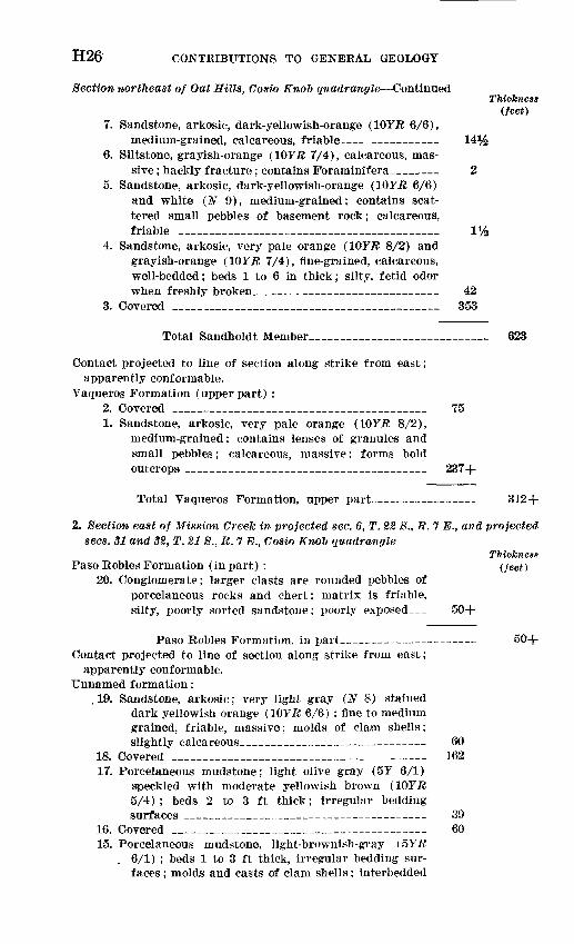
H26 CONTRIBUTIONS TO GENERAL GEOLOGY
Section northeast of Oat Hills, Cosio Kno~b quadrangle ContinuedThickness
(feet)7. Sandstone, arkosic, dark-yellowish-orange (WYR 6/6),
medium-grained, calcareous, friable________ 14%6. Siltstone, grayish-orange (10Y.R 7/4), calcareous, mas
sive ; hackly fracture; contains Forarninifera___ 25. Sandstone, arkosic, dark-yellowish-orange (IOYR 6/6)
and white (N 9), medium-grained; contains scat tered small pebbles of basement rock; calcareous, friable ___________________________ 1%
4. Sandstone, arkosic, very pale orange (IOYR 8/2) and grayish-orange (10F.R 7/4), fine-grained, calcareous, well-bedded; beds 1 to 6 in thick; silty, fetid odor when freshly broken____________________ 42
3. Covered _____________________________ 353
Total Sandholdt Member__________________ 623
Contact projected to line of section along strike from east;apparently conformable.
Vaqueros Formation (upper part) :2. Covered ____________________________ 75 1. Sandstone, arkosic, very pale orange (10Y-B 8/2),
medium-grained; contains lenses of granules and small pebbles; calcareous, massive; forms bold outcrops __________________________ 237+
Total Vaqueros Formation, upper part___________ 312+
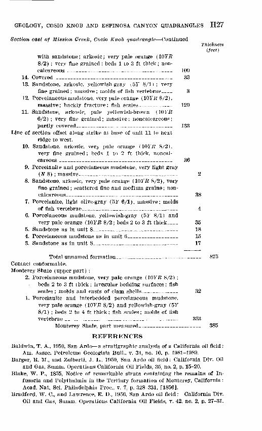
2. Section east of Mission Creek in projected sec. 6, T. 22 S., R. 7 E., and projected sees. 31 and 32, T. 21 S., R. 7 E., Cosio Knol quadrangle
ThicknessPaso Robles Formation (in part) : (feet)
20. Conglomerate; larger clasts are rounded pebbles of porcelaneous rocks and chert; matrix is friable, silty, poorly sorted sandstone; poorly exposed 50+
Paso Robles Formation, in part 50+ Contact projected to line of section along strike from east;
apparently conformable. Unnamed formation:
,19. Sandstone, arkosic; very light gray (N 8) stained dark yellowish orange (WYR 6/6) ; fine to medium grained, friable, massive; molds of clani shells; slightly calcareous______________ 60
18. Covered ____________________________ 162 17. Porcelaneous mudstone; light olive gray (5Y 6/1)
speckled with moderate yellowish brown (WYR 5/4); beds 2 to 3 ft thick; irregular bedding surfaces _________________ - 39
16. Covered ____________________________ 60 15. Porcelaneous mudstone, light-brownish-gray (5YR
6/1) ; beds 1 to 3 ft thick, irregular bedding sur faces ; molds and casts of clam shells; interbedded
GEOLOGY, COSIO KNOB AND ESPINOSA CANYON QUADRANGLES H27
Section east of Mission Greek, Cosio Knob quadrangle ContinuedThickness
(feet)with sandstone; arkosic; very pale orange (WYR 8/2) ; very fine grained; beds 1 to 3 ft thick; non- calcareous _________________________ 100
14. Covered ____________________________ 33 13. Sandstone, arkosic, yellowish-gray (5Y 8/1) ; very
fine grained ; massive ; molds of fish vertebrae- _ 3 12. Porcelaneous niudstone, very pale orange (10YR8/2),
massive; hackly fracture; fish scales______ _ 120 11. Sandstone, arkosic, pale yellowish-brown (10Y^
6/2) ; very fine grained; massive; noncalcareous; partly covered_____________________ 133
Line of section offset along strike at base of unit 11 to nextridge to west.
10. Sandstone, arkosic, very pale orange (ior.7? 8/2), very fine grained; beds 1 to 2 ft thick, noncal careous ___________________________ 36
9. Porcelanite and porcelaneous mudstone, very light gray(N 8) ; massive________________________ 2
8. Sandstone, arkosic, very pale orange (1QYR 8/2), very fine grained; scattered fine and medium grains; non- calcareous________________.__________ 38
7. Porcelanite, light olive-gray (5Y 6/1), massive; moldsof fish vertebrae_______________________ 4
6. Porcelaneous mudstone, yellowish-gray (5Y 8/1) andvery pale orange (WYR 8/2 ; beds 2 to 3 ft thick__ 35
5. Sandstone as in unit 8____________________ 18 4. Porcelaneous mudstone as in unit 6___________ 15 3. Sandstone as in unit 8____________________ 17
Total unnamed formation____________________ 875 Contact conformable. Monterey Shale (upper part) :
2. Porcelaneous mudstone, very pale orange (10Y1? 8/2) ; beds 2 to 3 ft thick; irregular bedding surfaces; fish scales ; molds and casts of clam shells________ 32
1. Porcelanite and interbedded porcelaneous mudstone, very pale orange (10Y.R 8/2) and yellowish-gray (5Y 8/1) ; beds 2 to 4 ft thick: fish scales; molds of fish vertebrae ___________________________ 353
Monterey Shale, part measured_______________ 385
REFERENCES
Baldwin, T. A., 1950, San Ardo a stratigraphic analysis of a California oil field: Am. Assoc. Petroleum Geologists Bull., v. 34, no. 10, p. 1981-1989.
Barger, R. M., and Zulberti, J. L., 1950, San Ardo oil field: California Div. Oil and Gas, Surnm. Operations California Oil Fields, 35, no. 2, p. 15-20.
Blake, W. P., 1855, Notice of remarkable strata containing the remains of In fusoria and Polythalmia in the Tertiary formation of Monterey, California: Acad. Nat. Sci. Philadelphia Proc., v. 7, p. 328-331, [1856].
Bradford, W. C., and Lawrence, E. D., 1956, San Ardo oil field: California Div. Oil and Gas, Summ. Operations California Oil Fields, v. 42, no. 2, p. 27-31.
H28 CONTRIBUTIONS TO GENERAL GEOLOGY
Bramlette, M. N., 1946, The Monterey formation of California and the origin ofits siliceous rocks: U.S. Geol. Survey Prof. Paper 212, 57 p.
Bramlette, M. N., and Daviess, S. N., 1944, Geology and oil possibilities of theSalinas Valley, California: U.S. Geol. Survey Oil and Gas Inv. Prelini.Map 24.
Clark, B. L., 1940, Two new Pliocene formations in California [abs.] : Geol. Soc.America Bull., v. 51, No. 12, p. 1956-1957.
Curtis, G. H., Evernden, J. F., and Lipson, J. I., 1958, Age determination of somegranitic rocks in California by the potassium-argon method: CaliforniaDiv. Mines Spec. Rept. 54,16 p.
Dorn, C. L., 1932, Report on a deep 'boring in Salinas Valley, California: Micro- paleontology Bull., v. 3, p. 28-29.
Durham, D. L., 1963, Geology of the Reliz Canyon, Thompson Canyon, and SanLucas quadrangles, Monterey County, California: U.S. Geol. Survey Bull.1141-Q, p. Q1-QI41. [1964.]
English, W. A., 1918, Geology and oil prospects of the Salinas Valley-Parkfieldarea, California : U.S. Geol. Survey Bull. 691-H, p. 219-250.
Fairbanks, H. W., 1894, Geology of northern Ventura, Santa Barbara, San LuisObispo, Monterey, and San Benito Counties: California Mining Bur. 12thRept. State Mineralogist, p. 493-526.
1898, Geology of a portion of the southern Coast Ranges: Jour. Geology, v. 6, p. 551-576.
1900, Monterey County, [chap.] 1 of pt. 8, of Watts, W. L., Oil and gasyielding formations of California: California Mining Bur. Bull. 19, p. 143-146.
Hamlin, Homer, 1904, Water resources of Salinas Valley, California: U.S. Geol. Survey Water-Supply Paper 89, 91 p.
Holmes, Arthur, 1959, A revised geological time-scale: Edinburgh Geol. Soc. Trans., v. 17, pt. 3, p. 183-216.
Kilkenny, J. E., 1948, Geology and exploration for oil in Salinas Valley, Cali fornia : Am. Assoc. Petroleum Geologists Bull., v. 32, p. 2254-2268.
Kleinpell, R. M., 1938, Miocene stratigraphy of California: Tulsa, Okla., Am. Assoc. Petroleum Geologists, 450 p.
Lawson, A. C., 1893, The geology of Carmelo Bay: California Univ., Dept. Geology Bull., v. 1, no. 1, p. 1-59.
Reed, R. D., 1925, The post-Monterey disturbance in the Salinas Valley, Cali fornia : Jour. Geology, v. 33, p. 588-607.
1933, Geology of California: Tulsa, Okla., Am. Assoc. Petroleum Geolo gists, 355 p.
Thorup, R. R., 1941, Vaqueros formation (Tertiary) at its type locality, Juni- pero Serra, quadrangle, Monterey County, California [abs.] : Geol. Soc. America Bull., v. 52, p. 1957-1958.
1961, King City oil field, Monterey County, California [abs.l : Am. Assoc.Petroleum Geologists Bull., v. 45, p. 130.
Trask, P. D., 1926, Geology of the Point Sur quadrangle, California: CaliforniaUniv., Dept. Geol. Sci. Bull., v. 16, no. 6, p. 119-186.
Vander Leek, Lawrence, 1921, Petroleum resources of California with specialreference to unproved areas: California Mining Bur. Bull. 89, 186 p.
Waring, C. A., 1914, Geology and possibilities of oil in portions of Monterey,San Luis Obispo, and San Benito Counties, [chap.] 10 of McLaughlin, R. P.,Petroleum Industry of California: California Mining Bur. Bull. 69, p.418-^38.
GEOLOGY, COSIO KNOB AND ESPINOSA CANYON QUADRANGLES H29
Waring, C. A., and Bradley, W. W., 1917, Monterey County, in Bradley, W. W., Huguenin, Emile, Logan, C. A., and Waring, C. A., The counties of Monterey, San Benito, San Luis Obispo, Santa Barbara, Ventura: California Mining Bur. 15th Kept. State Mineralogist, pt. 5, p. 595-615.
Waring, G. A., 1915, Springs of California: U.S. Geol. Survey Water-Supply Paper 338, 410 p.
Whitney, J. D., 1865, Report of progress and synopsis of the field work from 1860 to 1864 : California Geol. Survey, Geology, v. 1, 498 p.
o


![New t New CUBEs with Heavy Attitude t - American Musical Supply · 2013. 11. 26. · METAL ZONE, EXTREME), GAIN Knob, VOLUME Knob, [EQUALIZER] BASS Knob, MIDDLE Knob, TREBLE Knob](https://img.pdfslide.net/doc/110x75/6067859789f730682b1d8a47/new-t-new-cubes-with-heavy-attitude-t-american-musical-supply-2013-11-26.jpg)


![t New CUBEs with Heavy Attitude t€¦ · METAL ZONE, EXTREME), GAIN Knob, VOLUME Knob, [EQUALIZER] BASS Knob, MIDDLE Knob, TREBLE Knob Indicators CLEAN Channel, LEAD Channel Connectors](https://img.pdfslide.net/doc/110x75/6067859789f730682b1d8a48/t-new-cubes-with-heavy-attitude-t-metal-zone-extreme-gain-knob-volume-knob.jpg)