Embed Size (px)
Citation preview
Geophysical and Geological Services
for Oil & Gas Exploration and Development
Company Profile
www.gww.uk.com
v10

2
3
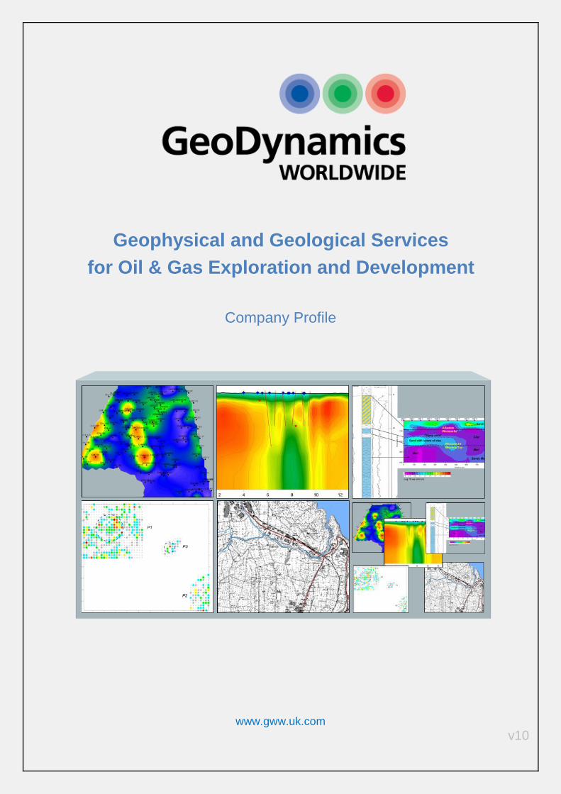
The Company
Geodynamics Worldwide s.r.l. (GWW) is a private company with headquarters in Rovereto (North
Italy) which offers geophysical services, as well as expert consultancy to the Oil & Gas industry.
Our services:
Passive Seismic Spectroscopy
Remote sensing
Magnetotellurics
Surface Geochemical Analysis
Cartographic Services (GIS)
Data Integration
These technologies and services are designed to reduce the risk of exploration and development
plans. They can drastically minimize the capital expenditure by concentrating the efforts of other
geophysical methods (2D and 3D conventional seismic) only on the areas with the highest
hydrocarbon potential. Our services are designed to be complementary to each other: most of them
require data collection on a grid basis, so the contemporary application over the same field is a
cost - effective way for producing reliable G&G data at a fraction of the cost of a conventional
seismic survey.
GWW’s technologies have much less limitations than conventional seismic when it comes to
explore frontier areas such as sub- salt, sub- basalt and complex geology like faults compartments
and stratigraphic traps. Our experts and partners provide these consultancy services in exploration,
seismic interpretation, uncertainty and risk management in addition to other operational support.
Our experts have wide and long experience on sub-surface knowledge to support authorities and
oil companies in licence and assets management.

4
5
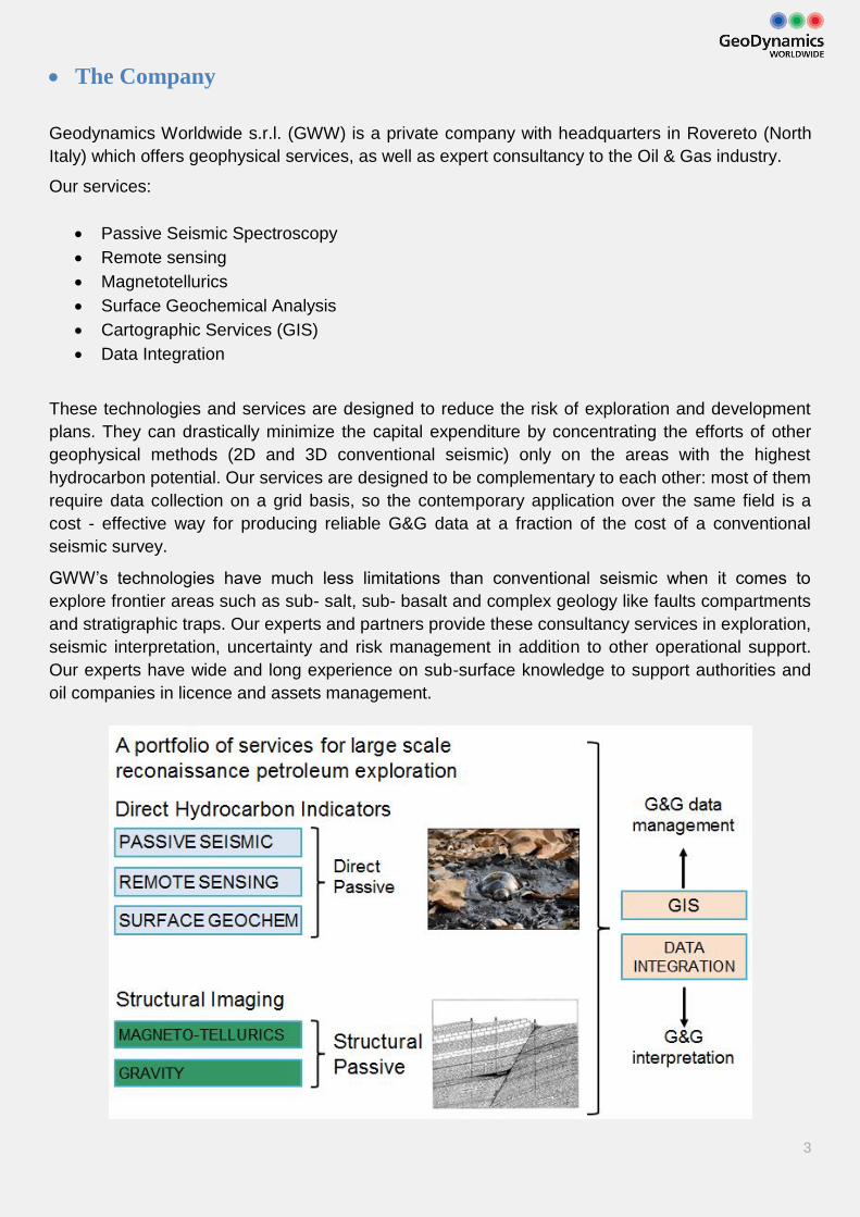
Benefits
Quick evaluation of the value of an asset
Risk reduction during exploration:
• Structural data + DHI data
• Multiple methods
Reduction of expenditure by focusing conventional seismic to prospective areas
Full coverage of the area-of-interest, not merely on seismic lines
Limited men and equipment on the ground, particularly suitable for:
• Vast acreages
• Mountain areas
• At the boarder with neighbouring countries
• High-risk areas
Improves the management of producing reservoirs
Environmental-friendly
Reduces cost - $/Barrel
Are there actually any Hydrocarbons?

6
7
Passive Seismic Spectroscopy This new technology is applied as a Direct Hydrocarbon Indicator (DHI). It is a low-frequency seismo - acoustic spectroscopy for hydrocarbon reservoir detection and monitoring. GWW, by using ultrasensitive acoustic sensors (Broad Band Sensors), has the ability to detect the areas where the probability of presence of hydrocarbons is higher, minimizing the uncertainty of the subsurface fluid system. This technology, applied in more than 100 locations worldwide, has ultimate benefit to oil companies and petroleum authorities throughout the life of their hydrocarbon assets.
Different surveys over different oil and gas fields have established the presence of spectral anomalies in a low-frequency window (1.5 – 10 Hz), i.e. micro-tremors [Dangel et al:2003] [Holzner et al:2003] [Akrawi and Bloch:2006] [Birialtsev et al:2006] [Rahced:2006]. [Suntsov et al:2006] [Graf al:2007] [Lambert et al:2008].
The usage of low-frequency seismic waves avoids the problems of velocity inversions, thin layering, lateral heterogeneity, such as in basalt and evaporitic settings or very complex geology (fault compartments and stratigraphic traps). Passive seismic can be virtually applied in any environmentally sensitive place, as it leaves no traces and has no negative impact on local flora and fauna. The passive seismic acquisition does not require any explosions, vibrations or similar.
Typical fields of application are:
Exploration (identification of structural and stratigraphic hydrocarbon traps on green fields)
Exploration (prospect ranking)
Field development (field appraisal, field delineation, identification of development wells)
Field monitoring (determination of water front, water fingering, hydrocarbon fluid barriers)
Time lapse field monitoring and assessment of the hydrocarbon recovery scheme
For the acquisition part of the surveys Geodynamics Worldwide deploys in the field a team of 3 – 6 operators as well as a full set of seismometer units. Depending on the survey design, a set of 5 to 10 seismometer units is displaced in the field per one operating survey team.. A grid of data points is designed to cover the target area. Spacing of the grid begins from 250 m and can reach up to 2 km. Each data point is designated by one seismometer unit and the acquisition at every point is of several hours.
Depending on client’s objectives, the passive seismic survey can have various settings with different outputs. The main one is the spectroscopy analysis.
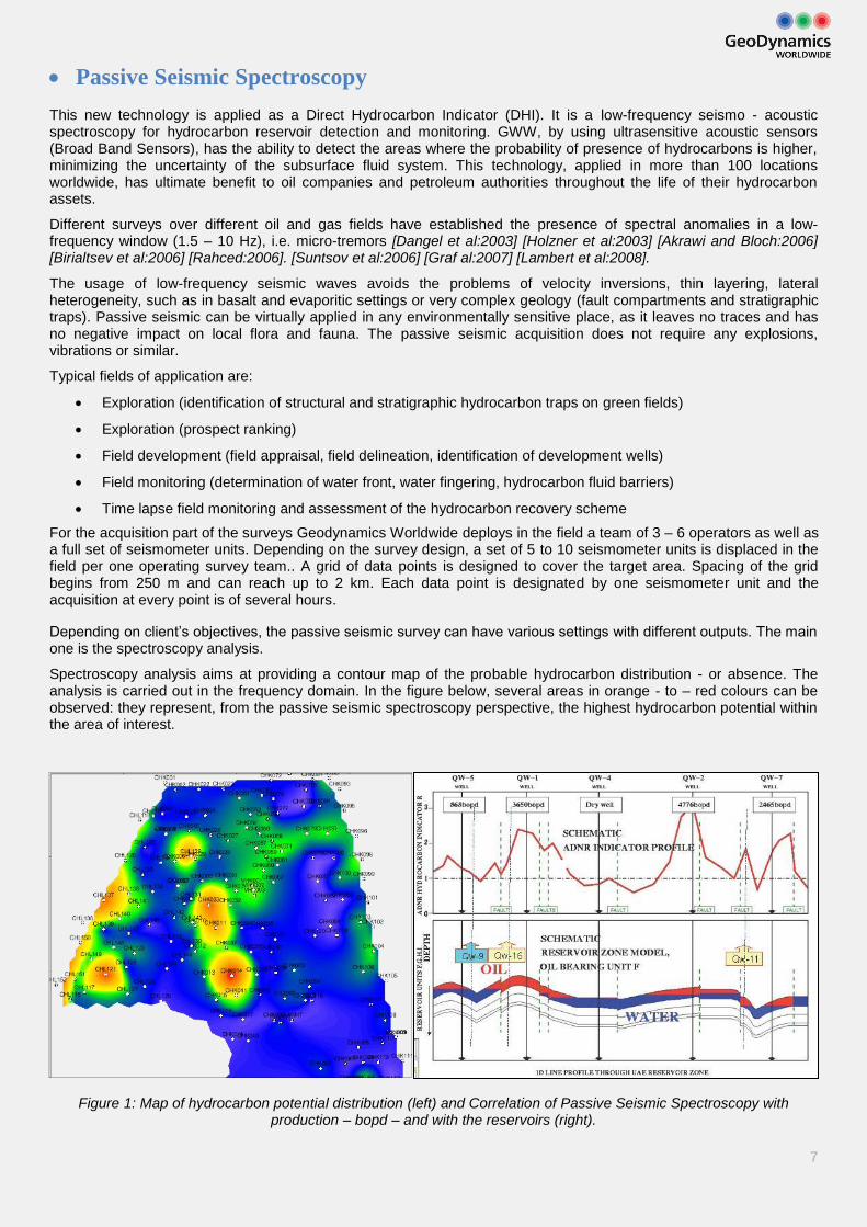
Spectroscopy analysis aims at providing a contour map of the probable hydrocarbon distribution - or absence. The analysis is carried out in the frequency domain. In the figure below, several areas in orange - to – red colours can be observed: they represent, from the passive seismic spectroscopy perspective, the highest hydrocarbon potential within the area of interest.
Figure 1: Map of hydrocarbon potential distribution (left) and Correlation of Passive Seismic Spectroscopy with production – bopd – and with the reservoirs (right).
8
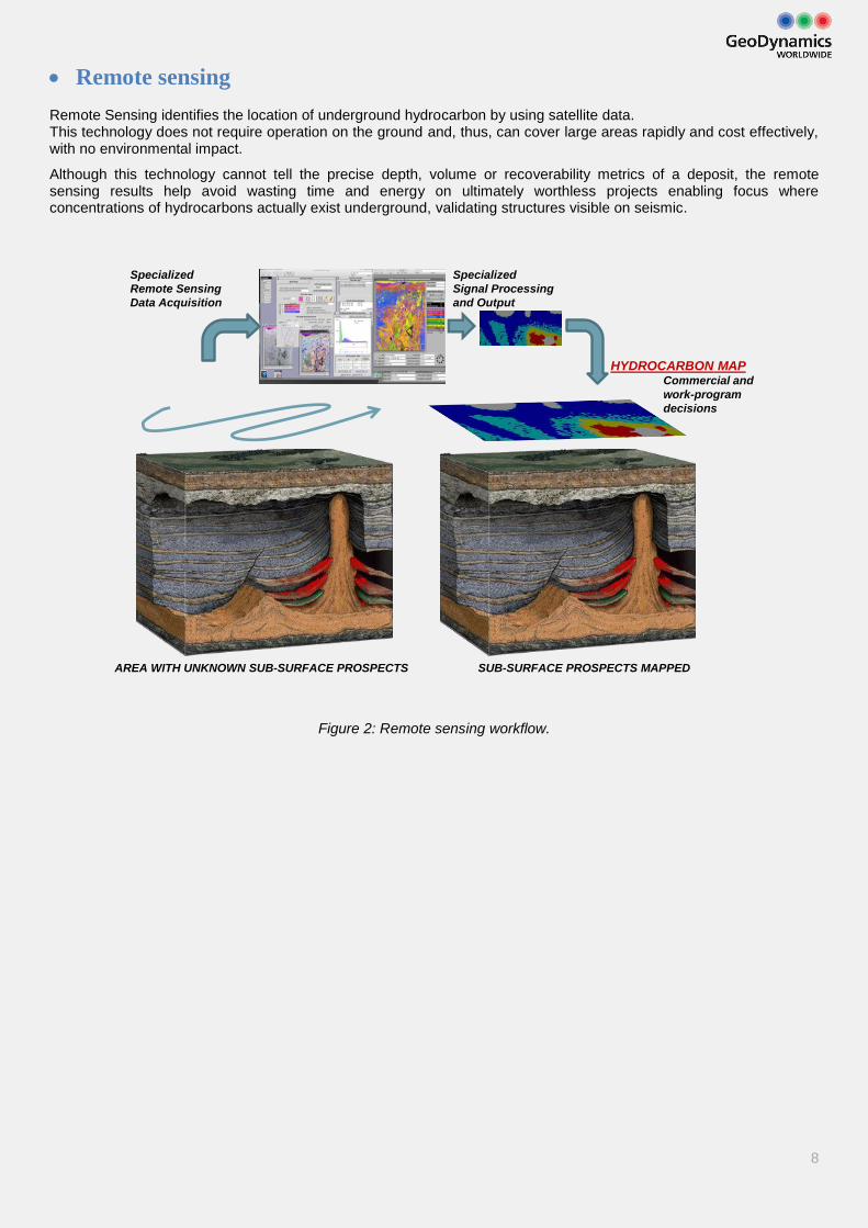
Remote sensing Remote Sensing identifies the location of underground hydrocarbon by using satellite data. This technology does not require operation on the ground and, thus, can cover large areas rapidly and cost effectively, with no environmental impact.
Although this technology cannot tell the precise depth, volume or recoverability metrics of a deposit, the remote sensing results help avoid wasting time and energy on ultimately worthless projects enabling focus where concentrations of hydrocarbons actually exist underground, validating structures visible on seismic.
Figure 2: Remote sensing workflow.
AREA WITH UNKNOWN SUB-SURFACE PROSPECTS SUB-SURFACE PROSPECTS MAPPED
Specialized
Remote Sensing
Data Acquisition
Specialized
Signal Processing
and Output
Commercial and
work-program
decisions
HYDROCARBON MAP
9
Magnetotelluric Method The Magnetotelluric method is an electromagnetic (EM) geophysical exploration technique that images the electrical properties (resistivity) of the earth. Resistivity data are interpreted to create a model of the subsurface. Passive magnetotelluric methods can be divided into Magnetotellurics (MT) and Audio-Magnetotellurics (AMT): the latter is a higher-frequency magnetotelluric technique.
For hydrocarbon exploration, MT is mainly used as a complement to the primary technique of reflection seismology for low-cost reconnaissance of sedimentary basins and for exploration in areas where seismic surveys are difficult because of severe topography or the presence high-impedance volcanic rocks near the surface (Colombo et al., 2012). Many oil companies world-wide have used electromagnetic methods as a cost-effective, useful complement to seismic techniques and as a substitute where seismic cannot be used at all.
High-velocity layers are typically highly resistive, whereas sediments, porous and permeable, are typically much less resistive. While high-velocity layers are an acoustic barrier and make seismic ineffective, their electrical resistivity means the magnetic signal passes through almost unimpeded. This allows MT to see deep beneath these acoustic barrier layers, complementing the seismic data and assisting interpretation.
Just as in seismic exploration, electromagnetic geophysics can contribute to effective hydrocarbon exploration in two distinct ways. Most often, EM methods are used to image structures that could host potential reservoirs and/or source rocks. In certain cases, they may also give evidence for direct indication of the presence of hydrocarbons – DHI (Ingerov et al, 2003).
Data is acquired at each point for a period of time: duration of the acquisition for each data point ranges from several minutes to 6 hours. Audio Magnetotelluric surveys (AMT), which have higher frequencies (1 Hz to 90 kHz), usually require smaller time of acquisition. The physical spacing between points depends on the target size and geometry, local terrain constraints and budget: reconnaissance surveys can have spacings of several kilometers, while more detailed work can have 200m spacing’s, or even adjacent soundings.
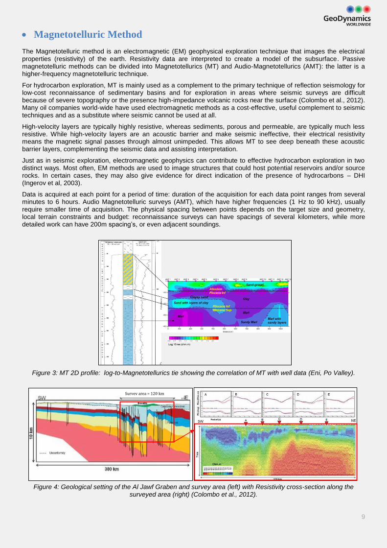
Figure 3: MT 2D profile: log-to-Magnetotellurics tie showing the correlation of MT with well data (Eni, Po Valley).
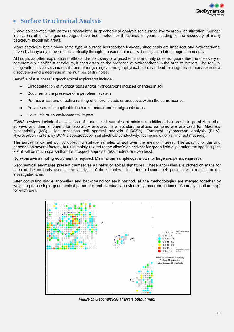
Figure 4: Geological setting of the Al Jawf Graben and survey area (left) with Resistivity cross-section along the surveyed area (right) (Colombo et al., 2012).
Survey area = 120 km
10
Surface Geochemical Analysis GWW collaborates with partners specialized in geochemical analysis for surface hydrocarbon identification. Surface indications of oil and gas seepages have been noted for thousands of years, leading to the discovery of many petroleum producing areas.
Many petroleum basin show some type of surface hydrocarbon leakage, since seals are imperfect and hydrocarbons, driven by buoyancy, move mainly vertically through thousands of meters. Locally also lateral migration occurs.
Although, as other exploration methods, the discovery of a geochemical anomaly does not guarantee the discovery of commercially significant petroleum, it does establish the presence of hydrocarbons in the area of interest. The results, along with passive seismic results and other geological and geophysical data, can lead to a significant increase in new discoveries and a decrease in the number of dry holes.
Benefits of a successful geochemical exploration include:
Direct detection of hydrocarbons and/or hydrocarbons induced changes in soil
Documents the presence of a petroleum system
Permits a fast and effective ranking of different leads or prospects within the same licence
Provides results applicable both to structural and stratigraphic traps
Have little or no environmental impact
GWW services include the collection of surface soil samples at minimum additional field costs in parallel to other surveys and their shipment for laboratory analysis. In a standard analysis, samples are analyzed for: Magnetic susceptibility (MS), High resolution soil spectral analysis (HRSSA), Extracted hydrocarbon analysis (EHA), Hydrocarbon content by UV-Vis spectroscopy, soil electrical conductivity, Iodine indicator (all indirect methods).
The survey is carried out by collecting surface samples of soil over the area of interest. The spacing of the grid depends on several factors, but it is mainly related to the client’s objectives: for green field exploration the spacing (1 to 2 km) will be much sparse than for prospect appraisal (500 meters or even less).
No expensive sampling equipment is required. Minimal per sample cost allows for large inexpensive surveys.
Geochemical anomalies present themselves as halos or apical signatures. These anomalies are plotted on maps for each of the methods used in the analysis of the samples, in order to locate their position with respect to the investigated area.
After computing single anomalies and background for each method, all the methodologies are merged together by weighting each single geochemical parameter and eventually provide a hydrocarbon induced “Anomaly location map” for each area.
Figure 5: Geochemical analysis output map.
11
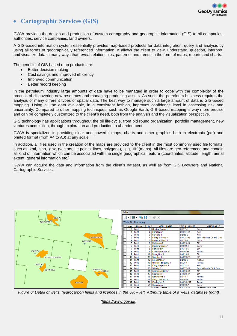
Cartographic Services (GIS)
GWW provides the design and production of custom cartography and geographic information (GIS) to oil companies, authorities, service companies, land owners.
A GIS-based information system essentially provides map-based products for data integration, query and analysis by using all forms of geographically referenced information. It allows the client to view, understand, question, interpret, and visualize data in many ways that reveal relationships, patterns, and trends in the form of maps, reports and charts.
The benefits of GIS-based map products are:
Better decision making
Cost savings and improved efficiency
Improved communication
Better record keeping
In the petroleum industry large amounts of data have to be managed in order to cope with the complexity of the process of discovering new resources and managing producing assets. As such, the petroleum business requires the analysis of many different types of spatial data. The best way to manage such a large amount of data is GIS-based mapping. Using all the data available, in a consistent fashion, improves confidence level in assessing risk and uncertainty. Compared to other mapping techniques, such as Google Earth, GIS-based mapping is way more precise and can be completely customized to the client’s need, both from the analysis and the visualization perspective.
GIS technology has applications throughout the oil life-cycle, from bid round organization, portfolio management, new ventures acquisition, through exploration and production to abandonment.
GWW is specialized in providing clear and powerful maps, charts and other graphics both in electronic (pdf) and printed format (from A4 to A0) at any scale.
In addition, all files used in the creation of the maps are provided to the client in the most commonly used file formats, such as .kml, .shp, .gpx, (vectors, i.e points, lines, polygons), .jpg, .tiff (maps). All files are geo-referenced and contain all kind of information which can be associated with the single geographical feature (coordinates, altitude, length, aerial extent, general information etc.).
GWW can acquire the data and information from the client’s dataset, as well as from GIS Browsers and National Cartographic Services.
Figure 6: Detail of wells, hydrocarbon fields and licences in the UK – left, Attribute table of a wells’ database (right)
(https://www.gov.uk)
12
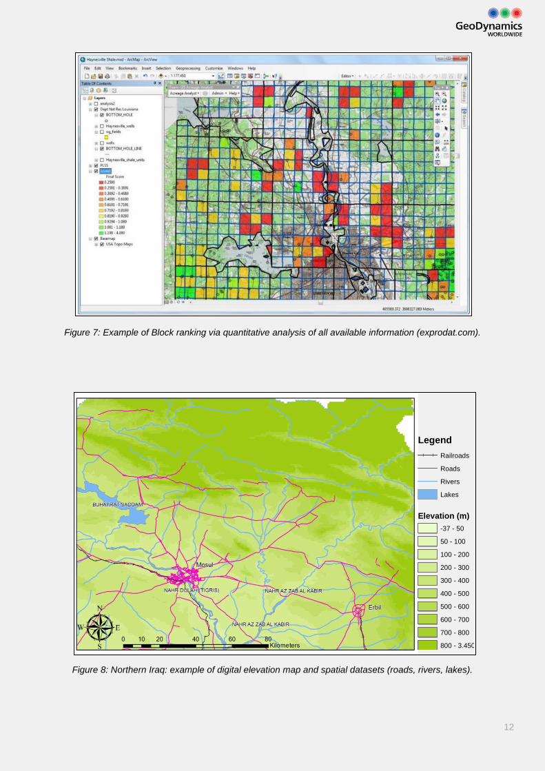
Figure 7: Example of Block ranking via quantitative analysis of all available information (exprodat.com).
Figure 8: Northern Iraq: example of digital elevation map and spatial datasets (roads, rivers, lakes).
Legend
Elevation (m)
Railroads
Roads
Rivers
Lakes
-37 - 50
50 - 100
100 - 200
200 - 300
300 - 400
400 - 500
500 - 600
600 - 700
700 - 800
800 - 3.450
13
Data Integration
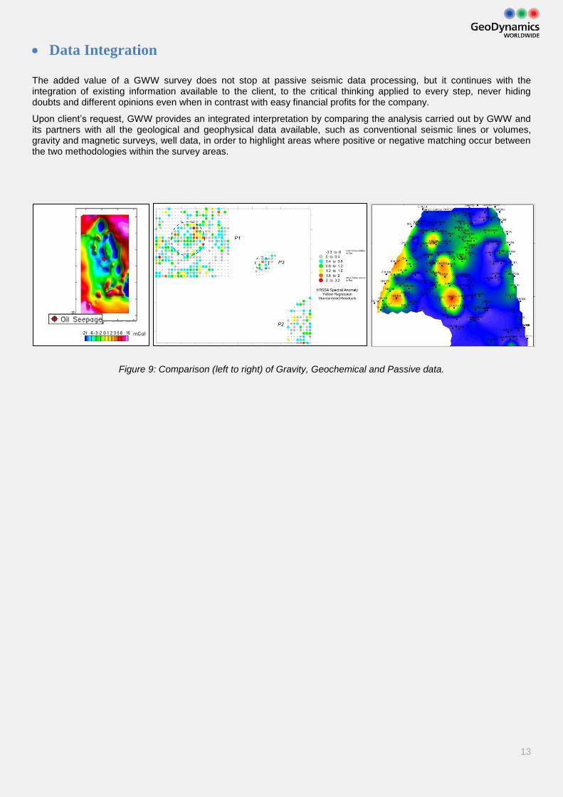
The added value of a GWW survey does not stop at passive seismic data processing, but it continues with the integration of existing information available to the client, to the critical thinking applied to every step, never hiding doubts and different opinions even when in contrast with easy financial profits for the company.
Upon client’s request, GWW provides an integrated interpretation by comparing the analysis carried out by GWW and its partners with all the geological and geophysical data available, such as conventional seismic lines or volumes, gravity and magnetic surveys, well data, in order to highlight areas where positive or negative matching occur between the two methodologies within the survey areas.
Figure 9: Comparison (left to right) of Gravity, Geochemical and Passive data.

14

15
Who we are
Andrew Shrager, CEO
A well-respected private investor with long experience in investment banking. Some of his main roles include senior adviser at Renaissance Capital (emerging markets), senior advisor to Merrill Lynch (Energy & Power group throughout Russia and Central Europe), esp. the British Petroleum TNK acquisition, director of corporate finance at Lazard Brothers - advisor for both the Central Electricity Generating Board on privatization and National Power on its IPO, director of Utilyx2001-2012, director of GeoDynamics Research 2007-2010, director of GeoDynamics Worldwide since 2010.
Radwan Hadi, Director
Managing Director of Blackwatch Petroleum Consultants Ltd., United Kingdom
Samuel Metcalfe, Director
Managing Director of Blackwatch Petroleum Consultants Ltd., United Kingdom
Michele Armano, Physicist, Senior Advisor on Satellite Data Integration Services
Michele holds a Ph.D. in Physics from the University of Trento. He worked at the University of Trento and with ConsorzioCriospazioRicerche for the LISA pathfinder experiment, in the Ph.D. education program. Since 2007 is Scientist for the LISA Pathfinder (LPF) Space Mission of the European Space Agency. He is now the primary support to the processing department for the development and quality assurance of processing pipelines and for data management.
Carlo Brentari, Geologist
Carlo Brentari holds a M.Sc. in Geology from the University of Padova, Italy and a MBA in Energy and Environmental Management and Economics from Eni Corporate University, Milan, Italy. He joined Eni in 2007 as a geophysicist for time-lapse reservoir studies. Experienced in managing geological and geophysical data for Oil & Gas exploration, he also has several years of experience on GIS-based softwares. He fluently speaks English, Spanish, Italian.
Federica Antonucci, Physicist
Federica holds a M.Sc. in Physics from the University of Rome “Sapienza” and a Ph.D. in Physics from the University of Bologna. She worked as a researcher at the University of Trento in the LISA pathfinder experiment and LTP Project for data analysis, data integration, statistical treatment of data and mathematical modelling applied on large data sets. She is now responsible for data processing.
Elisaveta Ugrinova, Project Manager
Graduated from the Applied University of Furtwangen (Germany and USA) in Business Management. In her first working experience in International sales (Bosch) and Enterprise sales (Microsoft) she gained skills in team work, organizing and planning as well as problem solving. Entered the oil & gas sector in 2007 first in the finance and administration team, then eventually acquired knowledge of the industry and the exploration technologies, she took up end-to-end project coordination, commercial negotiation and resource management. With over 13 years of international experience, she fluently speaks English, Italian, Russian, German and Bulgarian.
16
Contacts:
ITALY operational seat
Elisaveta Ugrinova
Project Coordinator
Tel: +39-0464-43-9142
Email: [email protected]
Skype: geodynamcis.worldwide
UAE office
Geodynamics WorldWide
P.O.Box: 70375, Abu Dhabi,
United Arab Emirates
RUSSIA office
LLC “Geodynamika”
OOO «НПП Геодинамика»
г. Казань, ул. Товарищеская, д. 27
Тел/факс: (843) 212 20 54
Email: [email protected]
EGYPT office
Geodynamics WorldWide
c/o Ferry for Transport & Comm LLC
10D, street 198, Degla,
Maadi, Egypt
Tel: +20-128-2826867
Carlo Brentari
Geologist
Tel: +39-0464-43-9142
Email: [email protected]
Skype: carlobrentari1