Embed Size (px)
Citation preview
3. Data Availability for Habitat, Watershed, and Recreation Planning in Southern California
Christine S. LamHong ChenChristina Li
John P. Wilson
DECEMBER 2004
The authors are grateful to John Wilson for his guidance and to William Vuong
and Maureen Phelan for administrative support. Any errors herein lie with the
authors of this Technical Publication.
San Gabriel and Lower Angeles Rivers and Mountains Conservancy
900 South Fremont Avenue Alhambra CA 91802-1460
San Gabriel and Lower Los Angeles Rivers and Moutain Conservancy website
Lam, C.S., H. Chen, C. Li, and J.P. Wilson. 2004. Green Visions Plan for 21st
Century Southern California: A Guide for Habitat Conservation, Watershed
Health, and Recreational Open Space. 3. Data Availability for Habitat,
Watershed, and Recreation Planning in Southern California. University of
Southern California GIS Research Laboratory and Center for Sustainable
Cities, Los Angeles, California.
Acknowledgements:
Prepared for:
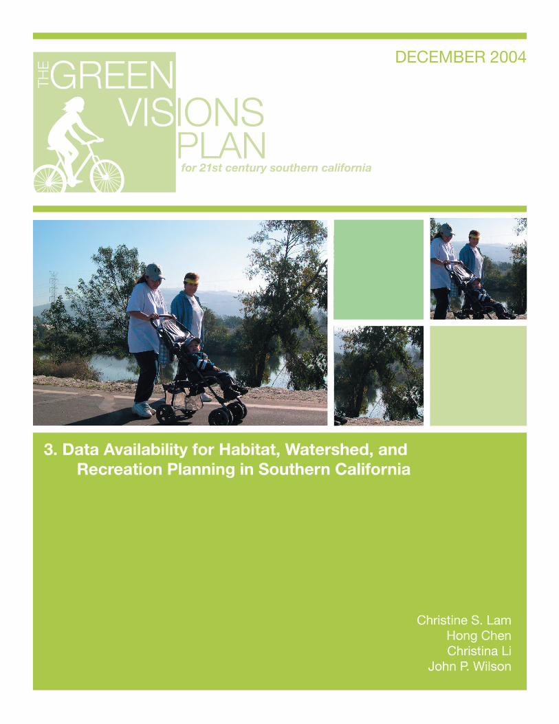
Cover Photo:
Preferred Citation:
This report was printed on recycled paper.
www.greenvisionsplan.net
The mission of the Green Visions Plan for 21st Century Southern California is to offer a guide to habitat conservation, watershed health and recreational open space for the Los Angeles metropolitan region. The Plan will also provide decision support tools to nurture a living green matrix for southern California. Our goals are to protect and restore natural areas, restore natural hydrological function, promote equitable access to open space, and maximize support via multiple-use facilities. The Plan is a joint venture between the University of Southern California and the San Gabriel and lower Los Angeles Rivers and Mountains Conservancy, Santa Monica Mountains Conservancy, Coastal Conservancy, and Baldwin Hills Conservancy.

www.rmc.com
www.coastalconservancy.com
FUNDERS AND COLLABORATORS
TABLE OF CONTENTS
INTRODUCTION 3
PLAN DATA REQUIREMENTS 5
GEOSPATIAL DATA INVENTORY 7
CONCLUSIONS 17
LITERATURE CITED 18
3
INTRODUCTIONThe Green Visions Plan for 21st Century Southern California is a joint venture by the San Gabriel and Lower Los Angeles Rivers and Mountains Conservancy (RMC), Santa Monica Mountains Conservancy (SMMC), Baldwin Hills Conservancy (BHC), and California Coastal Conservancy (CC) to develop a comprehensive habitat conservation, watershed protection, and recreational opportunities plan for southern California. This effort, involving academic experts, political leaders, and stakeholders from the business, government, nonprofi t and community sectors, will provide a set of values and principles as well as technical planning tools, capable of guiding the development of a living green matrix for southern California. The Plan’s area includes the RMC, SMMC, and BHC territories, as well as CC’s dual mandated territories (the coastal zone itself, and watersheds draining into the Pacifi c Ocean). Figure 1 illustrates the entire Plan area.
The long-term goals of the Green Visions Plan are to:Protect and restore natural areas to ensure the persistence of native biodiversity and reintroduction of historically present natural communities;Restore natural function to the hydrological cycle to maximize groundwater recharge, improve storm water quality, and minimize fl ood hazards;Increase and ensure equitable access for residents to a range of open space types and recreational opportunities, and thereby reduce socioeconomic and geographic disparities in present-day patterns of access to these types of resources; andMaximize political and fi nancial support for the Plan by proposing multiple-use facilities wherever possible to meet the goals of habitat restoration and conservation, restoration of hydroecological function, and provision of recreational open space.
Clearly, these are ambitious goals. Although they are widely shared by the many public agencies and private organizations and residents concerned with making southern California more livable, equitable, and ecologically sustainable, the Green Visions Plan is not a regulatory plan. It will thus have no power to direct local land use. The primary value of the Green Visions Plan will be to set forth a needs-based, long-range plan designed to help the multitude of actors involved in shaping the region’s future.
The Plan will highlight the opportunities and constraints that may arise as habitat conservation and restoration projects, open space acquisitions and recreation improvements, and efforts to protect watersheds are proposed and implemented. The tools and data developed as part of the Plan will also expand the analytic and planning capabilities of local agencies and organizations that seek to attract public funding or allocate their own resources, reduce the fragmented, piecemeal approach to regional resource planning, and promote projects whose collective impacts – because they are part of a larger scientifi cally grounded vision – are greater than the sum of their parts.
The USC Center for Sustainable Cities and GIS Research Laboratory (hereafter referred to as the Center and GIS Lab respectively) have been tasked to take the lead in development of the Green Visions Plan and the accompanying GIS planning tools and datasets. The work, itself, will be completed in two phases. Phase I, which occurred in 2004, involved the specifi cation of analytic frameworks to guide the work conducted for each of the three focus areas, the hosting of a workshop to solicit additional ideas and feedback about these frameworks, the creation of an inventory of existing plans in the Plan Area, and the development of a data catalogue to identify gaps in geospatial data and other information that must be fi lled before more detailed plans and the GIS-based planning tools can be developed. This particular report describes the public domain GIS data that are freely available for the Plan Area. The major tasks identifi ed in the framework – the identifi cation and assessment of opportunities for habitat conservation and restoration, open space acquisition and recreational facilities development, watershed protection efforts, and the development of the GIS planning tools and geospatial datasets will be completed during Phase II.
•
•
•
•

4
The remainder of this report discusses the plan data requirements that were specifi ed in the habitat conservation, watershed health, and recreational open space analytical frameworks prepared for the Phase I workshop (Wolch et al. 2004) and the availability of these geospatial data sets in the Plan Area. While it provides as detailed guidance as possible, the fi nal geospatial data sets used for the preparation of the plan and GIS planning tools in Phase II will need to incorporate the goals and needs of those who will use the fi nal outputs. Feasibility on paper does not always translate well to the fi eld and/or the board room.
5
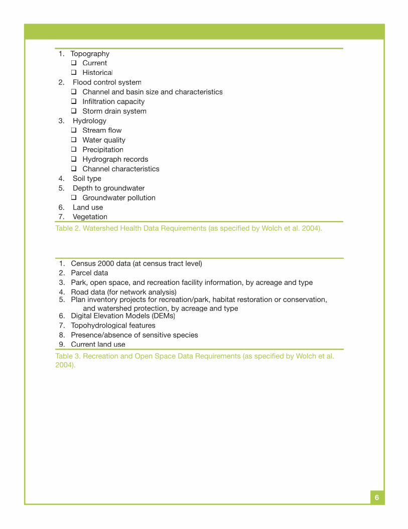
The documents describing the habitat conservation, watershed health, and recreational open space analytical frameworks that were prepared for distribution at the Phase I workshop included sample lists of geospatial data requirements (see Tables 1 to 3 for details). The three tables highlight the existence of several common needs across the three focus areas and taken as a whole, they point to the need to acquire and use a large number of geospatial datasets containing a large number and variety of geographic features or shapes (i.e. points, lines, pixels, polygons) and their attributes to support the forms of analysis and interpretation that have been proposed to date (see Wolch et al., 2004 for additional details).
Using the various data themes listed in Tables 1 through 3 as a guide, we fi rst checked the geospatial data housed at the GIS Lab and the RMC, and then conducted an internet search to identify additional geospatial data sources. Numerous leads identifi ed from the internet search were followed up via e-mail and telephone calls. This search targeted those agencies and organizations that are likely to collect and distribute publicly available data sets. The entities searched and/or contacted included a variety of federal agencies (e.g. Bureau of Census, Park Service, USGS), state agencies (e.g. California Spatial Information Library), other conservancies (e.g. SMMC, BHC, and CC), county departments (e.g. County of Ventura Water Resources Department), GIS clearinghouses (e.g. GIS Data Depot), and private companies (e.g. Thomas Bros. Maps).
PLAN DATA REQUIREMENTS
1. VegetationWetlandUplandRare speciesInvasive species
2. Soils3. Topography
CurrentHistorical
4. WildlifeThreatened, rare, and endangered (point data)Point and range data for target speciesIdentifi ed recovery areas for endangered species
5. Fire History6. Land Use7. Hydrology
Stream fl owWater qualityPrecipitationChannel characteristics (e.g., soft or hard bottom)Flood control system
8. Climate9. Other Disturbances
Noise (modeled from road network)Artifi cial night lighting (from satellite observation)
Table 1. Habitat Conservation Data Requirements (as specifi ed by Wolch et al. 2004).
6
1. TopographyCurrentHistorical
2. Flood control systemChannel and basin size and characteristicsInfi ltration capacityStorm drain system
3. HydrologyStream fl owWater qualityPrecipitationHydrograph recordsChannel characteristics
4. Soil type5. Depth to groundwater
Groundwater pollution6. Land use7. Vegetation
Table 2. Watershed Health Data Requirements (as specifi ed by Wolch et al. 2004).
1. Census 2000 data (at census tract level)2. Parcel data3. Park, open space, and recreation facility information, by acreage and type4. Road data (for network analysis)5. Plan inventory projects for recreation/park, habitat restoration or conservation,
and watershed protection, by acreage and type6. Digital Elevation Models (DEMs)7. Topohydrological features8. Presence/absence of sensitive species9. Current land use
Table 3. Recreation and Open Space Data Requirements (as specifi ed by Wolch et al. 2004).
7
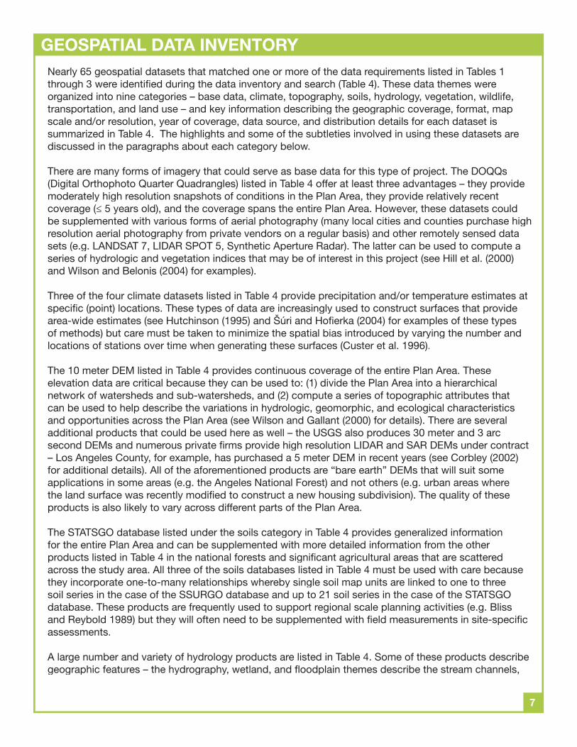
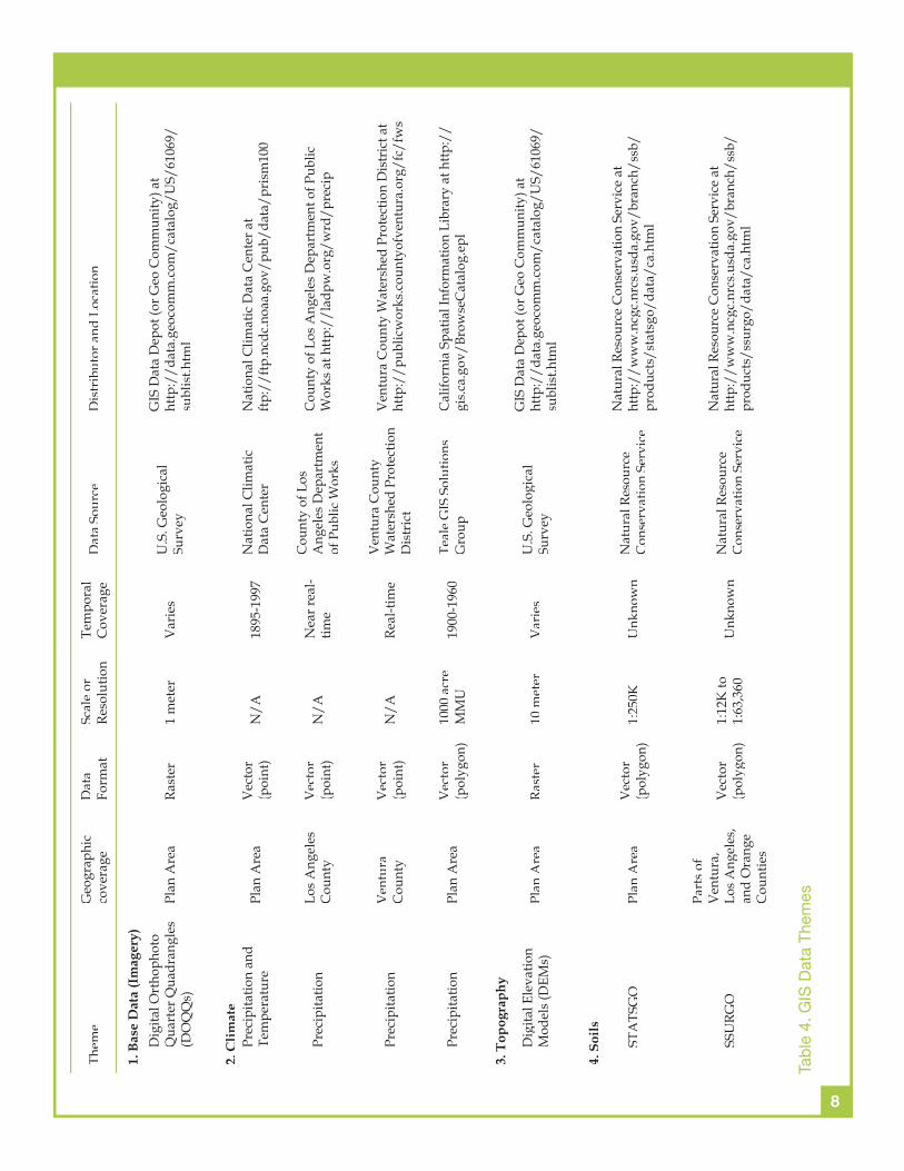
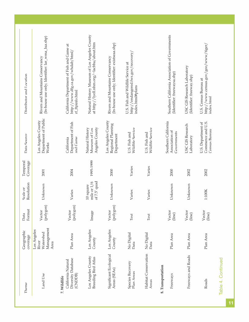
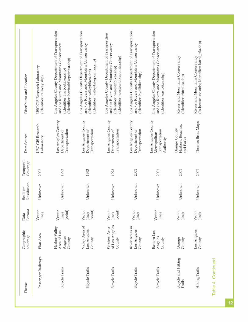
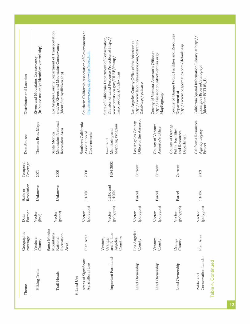
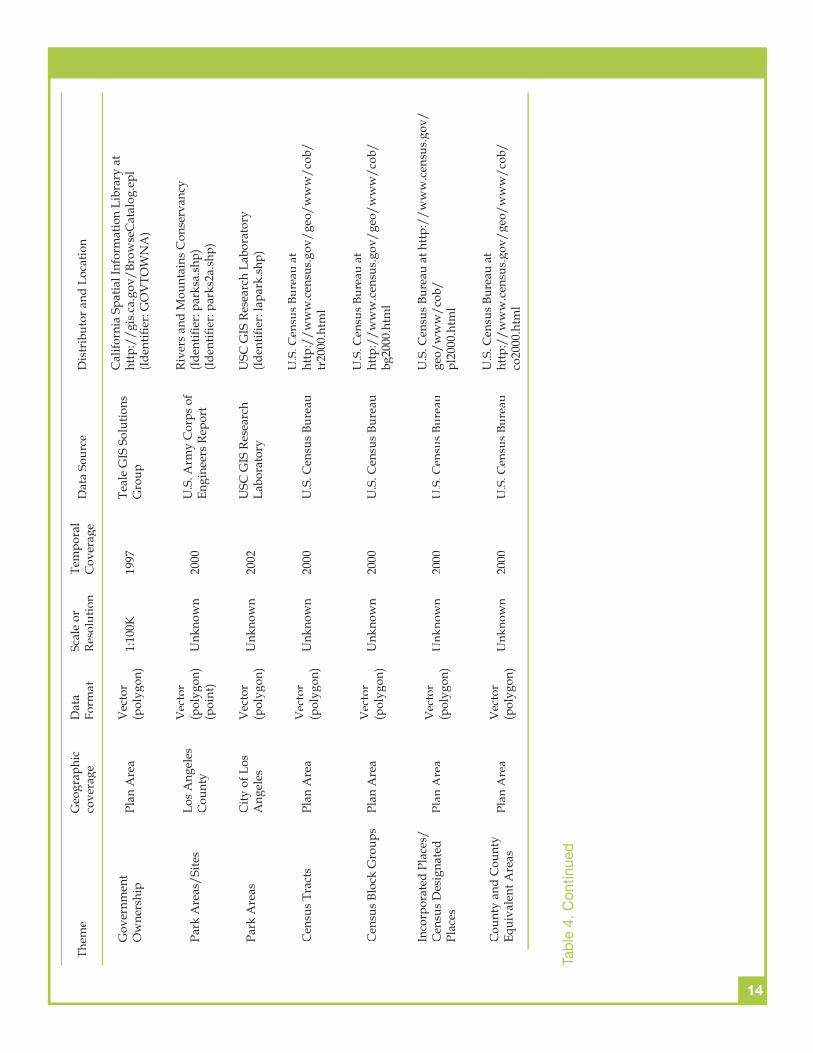
Nearly 65 geospatial datasets that matched one or more of the data requirements listed in Tables 1 through 3 were identifi ed during the data inventory and search (Table 4). These data themes were organized into nine categories – base data, climate, topography, soils, hydrology, vegetation, wildlife, transportation, and land use – and key information describing the geographic coverage, format, map scale and/or resolution, year of coverage, data source, and distribution details for each dataset is summarized in Table 4. The highlights and some of the subtleties involved in using these datasets are discussed in the paragraphs about each category below.
There are many forms of imagery that could serve as base data for this type of project. The DOQQs (Digital Orthophoto Quarter Quadrangles) listed in Table 4 offer at least three advantages – they provide moderately high resolution snapshots of conditions in the Plan Area, they provide relatively recent coverage (≤ 5 years old), and the coverage spans the entire Plan Area. However, these datasets could be supplemented with various forms of aerial photography (many local cities and counties purchase high resolution aerial photography from private vendors on a regular basis) and other remotely sensed data sets (e.g. LANDSAT 7, LIDAR SPOT 5, Synthetic Aperture Radar). The latter can be used to compute a series of hydrologic and vegetation indices that may be of interest in this project (see Hill et al. (2000) and Wilson and Belonis (2004) for examples).
Three of the four climate datasets listed in Table 4 provide precipitation and/or temperature estimates at specifi c (point) locations. These types of data are increasingly used to construct surfaces that provide area-wide estimates (see Hutchinson (1995) and Šúri and Hofi erka (2004) for examples of these types of methods) but care must be taken to minimize the spatial bias introduced by varying the number and locations of stations over time when generating these surfaces (Custer et al. 1996).
The 10 meter DEM listed in Table 4 provides continuous coverage of the entire Plan Area. These elevation data are critical because they can be used to: (1) divide the Plan Area into a hierarchical network of watersheds and sub-watersheds, and (2) compute a series of topographic attributes that can be used to help describe the variations in hydrologic, geomorphic, and ecological characteristics and opportunities across the Plan Area (see Wilson and Gallant (2000) for details). There are several additional products that could be used here as well – the USGS also produces 30 meter and 3 arc second DEMs and numerous private fi rms provide high resolution LIDAR and SAR DEMs under contract – Los Angeles County, for example, has purchased a 5 meter DEM in recent years (see Corbley (2002) for additional details). All of the aforementioned products are “bare earth” DEMs that will suit some applications in some areas (e.g. the Angeles National Forest) and not others (e.g. urban areas where the land surface was recently modifi ed to construct a new housing subdivision). The quality of these products is also likely to vary across different parts of the Plan Area.
The STATSGO database listed under the soils category in Table 4 provides generalized information for the entire Plan Area and can be supplemented with more detailed information from the other products listed in Table 4 in the national forests and signifi cant agricultural areas that are scattered across the study area. All three of the soils databases listed in Table 4 must be used with care because they incorporate one-to-many relationships whereby single soil map units are linked to one to three soil series in the case of the SSURGO database and up to 21 soil series in the case of the STATSGO database. These products are frequently used to support regional scale planning activities (e.g. Bliss and Reybold 1989) but they will often need to be supplemented with fi eld measurements in site-specifi c assessments.
A large number and variety of hydrology products are listed in Table 4. Some of these products describe geographic features – the hydrography, wetland, and fl oodplain themes describe the stream channels,
GEOSPATIAL DATA INVENTORY
8
Them
eG
eogr
aphi
c co
vera
geD
ata
Form
atSc
ale
or
Reso
lutio
nTe
mpo
ral
Cov
erag
eD
ata
Sour
ceD
istr
ibut
or a
nd L
ocat
ion
1. B
ase
Dat
a (I
mag
ery)
Dig
ital O
rtho
phot
o Q
uart
er Q
uadr
angl
es
(DO
s)Pl
an A
rea
Rast
er1
met
erV
arie
sU
.S. G
eolo
gica
l Su
rvey
GIS
Dat
a D
epot
(or G
eo C
omm
unity
) at
http
://d
ata.
geoc
omm
.com
/cat
alog
/US/
6106
9/su
blis
t.htm
l
2. C
limat
ePr
ecip
itatio
n an
d Te
mpe
ratu
rePl
an A
rea
Vec
tor
(poi
nt)
N/A
1895
-199
7N
atio
nal C
limat
ic
Dat
a C
ente
rN
atio
nal C
limat
ic D
ata
Cen
ter a
t ftp
://f
tp.n
cdc.
noaa
.gov
/pub
/dat
a/pr
ism
100
Prec
ipita
tion
Los
Ang
eles
C
ount
yV
ecto
r (p
oint
)N
/AN
ear r
eal-
time
Cou
nty
of L
os
Ang
eles
Dep
artm
ent
of P
ublic
Wor
ks
Cou
nty
of L
os A
ngel
es D
epar
tmen
t of P
ublic
W
orks
at h
ttp:/
/lad
pw.o
rg/w
rd/p
reci
p
Prec
ipita
tion
Ven
tura
C
ount
yV
ecto
r (p
oint
)N
/ARe
al-ti
me
Ven
tura
Cou
nty
Wat
ersh
ed P
rote
ctio
n D
istr
ict
Ven
tura
Cou
nty
Wat
ersh
ed P
rote
ctio
n D
istr
ict a
t ht
tp:/
/pub
licw
orks
.cou
ntyo
fven
tura
.org
/fc/
fws
Prec
ipita
tion
Plan
Are
aV
ecto
r (p
olyg
on)
1000
acr
e M
MU
1900
-196
0Te
ale
GIS
Sol
utio
ns
Gro
upC
alifo
rnia
Spa
tial I
nfor
mat
ion
Libr
ary
at h
ttp:/
/gi
s.ca
.gov
/Bro
wse
Cat
alog
.epl
3. T
opog
raph
y
Dig
ital E
leva
tion
Mod
els
(DEM
s)Pl
an A
rea
Rast
er10
met
erV
arie
sU
.S. G
eolo
gica
l Su
rvey
GIS
Dat
a D
epot
(or G
eo C
omm
unity
) at
http
://d
ata.
geoc
omm
.com
/cat
alog
/US/
6106
9/su
blis
t.htm
l
4. S
oils
STA
TSG
OPl
an A
rea
Vec
tor
(pol
ygon
)1:
250K
Unk
now
nN
atur
al R
esou
rce
Con
serv
atio
n Se
rvic
e
Nat
ural
Res
ourc
e C
onse
rvat
ion
Serv
ice
at
http
://w
ww
.ncg
c.nr
cs.u
sda.
gov/
bran
ch/s
sb/
prod
ucts
/sta
tsgo
/dat
a/ca
.htm
l
SSU
RGO
Part
s of
V
entu
ra,
Los
Ang
eles
, an
d O
rang
e C
ount
ies
Vec
tor
(pol
ygon
)1:
12K
to
1:63
,360
Unk
now
nN
atur
al R
esou
rce
Con
serv
atio
n Se
rvic
e
Nat
ural
Res
ourc
e C
onse
rvat
ion
Serv
ice
at
http
://w
ww
.ncg
c.nr
cs.u
sda.
gov/
bran
ch/s
sb/
prod
ucts
/ssu
rgo/
data
/ca.
htm
l
Tab
le 4
. GIS
Dat
a Th
emes
9
Them
eG
eogr
aphi
c co
vera
geD
ata
Form
atSc
ale
or
Reso
lutio
nTe
mpo
ral
Cov
erag
eD
ata
Sour
ceD
istr
ibut
or a
nd L
ocat
ion
Los
Ang
eles
Cou
nty
Soils
Dat
a
Ang
eles
N
atio
nal
Fore
st A
rea
Vec
tor
(pol
ygon
)U
nkno
wn
2001
Los
Ang
eles
Cou
nty
Publ
ic W
orks
Rive
rs a
nd M
ount
ains
Con
serv
ancy
(Iden
tifi e
r: so
ilsa.
shp)
5. H
ydro
logy
Hyd
rogr
aphy
Plan
Are
aV
ecto
r (li
ne)
1:10
0K19
98Te
ale
GIS
Sol
utio
ns
Gro
upC
alifo
rnia
Spa
tial I
nfor
mat
ion
Libr
ary
at h
ttp:/
/gi
s.ca
.gov
/Bro
wse
Cat
alog
.epl
Dis
char
gePl
an A
rea
Vec
tor
(poi
nt)
Unk
now
n19
01-2
002
and
real
-tim
e
U.S
. Geo
logi
cal
Surv
eyU
.S. G
eolo
gica
l Sur
vey
atht
tp:/
/wat
erda
ta.u
sgs.
gov/
ca/n
wis
/nw
is
Dis
char
geLo
s A
ngel
es
Cou
nty
Vec
tor
(poi
nt)
Unk
now
n19
30–2
004
Cou
nty
of L
os
Ang
eles
Dep
artm
ent
of P
ublic
Wor
ks
Cou
nty
of L
os A
ngel
es D
epar
tmen
t of P
ublic
W
orks
at h
ttp:/
/lad
pw.o
rg/w
rd/R
unof
f/in
dex.
cfm
Dis
char
geV
entu
ra
Cou
nty
Vec
tor
(poi
nt)
Unk
now
nRe
al-ti
me
Ven
tura
Cou
nty
Wat
ersh
ed P
rote
ctio
n D
istr
ict
Ven
tura
Cou
nty
Wat
ersh
ed P
rote
ctio
n D
istr
ict a
t ht
tp:/
/pub
licw
orks
.cou
ntyo
fven
tura
.org
/fc/
fws
Wat
er Q
ualit
yLo
s A
ngel
es
and
Ven
tura
C
ount
ies
Vec
tor
(poi
nt)
Unk
now
n19
97-2
004
Cal
iforn
ia
Dep
artm
ent o
f Wat
er
Reso
urce
s
Cal
iforn
ia D
epar
tmen
t of W
ater
Res
ourc
es a
t ht
tp:/
/wdl
.wat
er.c
a.go
v/w
q/gs
t/w
ater
_qua
lity_
repo
rt1/
gst.a
sp
Floo
dpla
ins
Plan
Are
aV
ecto
r (p
olyg
on)
Unk
now
n19
96FE
MA
Nat
iona
l Fl
ood
Insu
ranc
e Pr
ogra
m
Fede
ral E
mer
genc
y M
anag
emen
t Age
ncy
CD
-RO
M
Wet
land
sPl
an A
rea
Vec
tor
(pol
ygon
)1:
250K
2002
U.S
. Fis
h an
d W
ildlif
e Se
rvic
eU
.S. F
ish
and
Wild
life
Serv
ices
at
http
://w
etla
nds.
fws.
gov/
dow
nloa
ds.h
tm
Gro
undw
ater
Plan
Are
aV
ecto
r (p
oint
)U
nkno
wn
1909
-200
2U
.S. G
eolo
gica
l Su
rvey
U.S
. Geo
logi
cal S
urve
y at
ht
tp:/
/wat
erda
ta.u
sgs.
gov/
ca/n
wis
/gw
Gro
undw
ater
Plan
Are
aV
ecto
r (p
oint
)U
nkno
wn
1969
-200
1C
alifo
rnia
D
epar
tmen
t of W
ater
Re
sour
ces
Cal
iforn
ia D
epar
tmen
t of W
ater
Res
ourc
es a
tht
tp:/
/wdl
.wat
er.c
a.go
v/gw
/adm
in/
mai
n_m
enu_
gw.a
sp
Tab
le 4
. Con
tinue
d
10
Them
eG
eogr
aphi
c co
vera
geD
ata
Form
atSc
ale
or
Reso
lutio
nTe
mpo
ral
Cov
erag
eD
ata
Sour
ceD
istr
ibut
or a
nd L
ocat
ion
Gro
undw
ater
Ven
tura
C
ount
yV
ecto
r (p
oint
)U
nkno
wn
1971
-200
1C
ount
y of
Ven
tura
W
ater
Res
ourc
es
Cou
nty
of V
entu
ra W
ater
Res
ourc
es D
epar
tmen
t C
ount
y of
Ven
tura
Wat
er R
esou
rces
Dep
artm
ent
at h
ttp:/
/pub
licw
orks
.cou
ntyo
fven
tura
.org
/vc
pwa
Dra
ins
Los
Ang
eles
C
ount
yV
ecto
r (li
ne)
Unk
now
n19
69-2
001
Los
Ang
eles
Cou
nty
Publ
ic W
orks
Rive
rs a
nd M
ount
ains
Con
serv
ancy
(Id
entifi
er:
drai
nsa.
shp)
6. V
eget
atio
n
Sout
hern
Coa
stal
C
alifo
rnia
Lan
d C
over
/Lan
d U
sePl
an A
rea
Rast
er30
met
er20
00N
OA
A C
oast
al
Serv
ices
Cen
ter
Nat
iona
l Oce
anic
and
Atm
osph
eric
A
dmin
istr
atio
n (N
OA
A) a
tht
tp:/
/ww
w.c
sc.n
oaa.
gov/
crs/
lca/
ca_s
o200
0.ht
ml
Nat
iona
l Lan
d C
over
D
ata
Plan
Are
aRa
ster
30 m
eter
2001
U.S
. Geo
logi
cal
Surv
eyU
.S. G
eolo
gica
l Sur
vey
at h
ttp:/
/lan
dcov
er.u
sgs.
gov/
natio
nalla
ndco
ver.a
sp
LCM
MP,
Veg
etat
ion
Dat
aPl
an A
rea
Vec
tor
(pol
ygon
)2.
5 ac
re
MM
U19
97-2
001
Cal
iforn
ia
Dep
artm
ent o
f Fo
rest
ry a
nd F
ire
Prot
ectio
n
Cal
iforn
ia D
epar
tmen
t of F
ores
try
and
Fire
Pr
otec
tion
at h
ttp:/
/fra
p.cd
f.ca.
gov/
data
/fr
apgi
sdat
a/se
lect
.asp
?rec
ord=
cveg
Cal
iforn
ia G
AP
Ana
lysi
s Pr
ojec
tPl
an A
rea
Vec
tor
(pol
ygon
)1:
100K
1999
Uni
vers
ity o
f C
alifo
rnia
San
ta
Barb
ara
Uni
vers
ity o
f Cal
iforn
ia S
anta
Bar
bara
at
http
://w
ww
.bio
geog
.ucs
b.ed
u/pr
ojec
ts/g
ap/
gap_
data
.htm
l
Atla
s of U
nite
d St
ates
Tr
ees
Plan
Are
aV
ecto
r (p
olyg
on)
1:10
,000
,000
1996
U.S
. Geo
logi
cal
Surv
eyU
nite
d St
ates
Geo
logi
cal S
urve
y at
http
://
clim
chan
ge.c
r.usg
s.go
v/in
fo/v
eg-c
lim
Wie
slan
der
Veg
etat
ion
Type
M
aps
(VTM
)Pl
an A
rea
Vec
tor
(pol
ygon
)6
min
ute
quad
MM
U19
20s-
1930
s
Uni
vers
ity o
f C
alifo
rnia
Ber
kele
y,
Kel
ly L
ab
Uni
vers
ity o
f Cal
iforn
ia B
erke
ley,
Kel
ly L
ab a
t ht
tp:/
/nat
ure.
berk
eley
.edu
/~ku
eda/
vtm
Gat
eway
Citi
es C
OG
G
ener
al P
lan
Use
S/SE
Los
A
ngel
es
Cou
nty
Vec
tor
(pol
ygon
)U
nkno
wn
1990
Cal
iforn
ia S
tate
U
nive
rsity
, Lon
g Be
ach
Map
Lab
Rive
rs a
nd M
ount
ains
Con
serv
ancy
(Id
entifi
er:
gen_
plan
_citi
esa.
shp
and
gen_
plan
_ot
hera
.shp
)
Tab
le 4
. Con
tinue
d
11
Them
eG
eogr
aphi
c co
vera
geD
ata
Form
atSc
ale
or
Reso
lutio
nTe
mpo
ral
Cov
erag
eD
ata
Sour
ceD
istr
ibut
or a
nd L
ocat
ion
Land
Use
Los
Ang
eles
Ri
ver
Wat
ersh
ed
Man
agem
ent
Are
a
Vec
tor
(pol
ygon
)U
nkno
wn
2001
Los
Ang
eles
Cou
nty
Dep
artm
ent o
f Pub
lic
Wor
ks
Rive
rs a
nd M
ount
ains
Con
serv
ancy
(In-h
ouse
use
onl
y; Id
entifi
er:
lar_
wm
a_lu
a.sh
p)
7. W
ildlif
eC
alifo
rnia
Nat
ural
D
iver
sity
Dat
abas
e (C
ND
DB)
Plan
Are
aV
ecto
r (p
olyg
on)
Var
ies
2004
Cal
iforn
ia
Dep
artm
ent o
f Fis
h an
d G
ame
Cal
iforn
ia D
epar
tmen
t of F
ish
and
Gam
e at
ht
tp:/
/ww
w.d
fg.c
a.go
v/w
hdab
/htm
l/rf
_ftp
info
.htm
l
Los
Ang
eles
Cou
nty
Bree
ding
Bir
d A
tlas
Los
Ang
eles
C
ount
yIm
age
10 s
quar
e m
ile o
r 1/6
of
7.5
’ qua
d19
95-1
999
Nat
ural
His
tory
M
useu
m o
f Los
A
ngel
es C
ount
y
Nat
ural
His
tory
Mus
eum
of L
os A
ngel
es C
ount
y at
http
://l
yell.
nhm
.org
/~la
cbba
/abo
ut.h
tm
Sign
ifi ca
nt E
colo
gica
l A
reas
(SEA
s)Lo
s A
ngel
es
Cou
nty
Vec
tor
(pol
ygon
)U
nkno
wn
2000
Los
Ang
eles
Cou
nty
Regi
onal
Pla
nnin
g D
epar
tmen
t
Rive
rs a
nd M
ount
ains
Con
serv
ancy
(In
-hou
se u
se o
nly;
Iden
tifi e
r: ex
ists
eaa.
shp)
Spec
ies
Reco
very
Pl
an A
reas
No
Dig
ital
Dat
aTe
xtV
arie
sV
arie
sU
.S. F
ish
and
Wild
life
Serv
ice
U.S
. Fis
h an
d W
ildlif
e Se
rvic
e at
ht
tp:/
/end
ange
red.
fws.
gov/
reco
very
/in
dex.
htm
l#pl
ans
Hab
itat C
onse
rvat
ion
Are
asN
o D
igita
l D
ata
Text
Var
ies
Var
ies
U.S
. Fis
h an
d W
ildlif
e Se
rvic
e
8. T
rans
port
atio
n
Free
way
sPl
an A
rea
Vec
tor
(line
)U
nkno
wn
2000
Sout
hern
Cal
iforn
ia
Ass
ocia
tion
of
Gov
ernm
ents
Sout
hern
Cal
iforn
ia A
ssoc
iatio
n of
Gov
ernm
ents
(Iden
tifi e
r: fr
eew
aysa
.shp
)
Free
way
s an
d Ro
ads
Plan
Are
aV
ecto
r (li
ne)
Unk
now
n20
02U
SC G
IS R
esea
rch
Labo
rato
ryU
SC G
IS R
esea
rch
Labo
rato
ry
(Iden
tifi e
r: fr
eew
ay.s
hp)
Road
sPl
an A
rea
Vec
tor
(line
)1:
100K
2002
U.S
. Dep
artm
ent o
f C
omm
erce
and
U.S
. C
ensu
s Bu
reau
U.S
. Cen
sus
Bure
au a
t ht
tp:/
/ww
w.c
ensu
s.go
v/ge
o/w
ww
/tig
er/
inde
x.ht
ml
Tab
le 4
. Con
tinue
d
12
Them
eG
eogr
aphi
c co
vera
geD
ata
Form
atSc
ale
or
Reso
lutio
nTe
mpo
ral
Cov
erag
eD
ata
Sour
ceD
istr
ibut
or a
nd L
ocat
ion
Pass
enge
r Rai
lway
sPl
an A
rea
Vec
tor
(line
)U
nkno
wn
2002
USC
GIS
Res
earc
h La
bora
tory
USC
GIS
Res
earc
h La
bora
tory
(Id
entifi
er:
railw
ay.s
hp)
Bicy
cle
Trai
ls
Har
bor V
alle
y A
rea
of L
os
Ang
eles
C
ount
y
Vec
tor
(line
) (p
oint
)U
nkno
wn
1993
Los
Ang
eles
Cou
nty
Dep
artm
ent o
f Tr
ansp
orta
tion
Los A
ngel
es C
ount
y D
epar
tmen
t of T
rans
port
atio
n an
d/or
Riv
ers
and
Mou
ntai
ns C
onse
rvan
cy
(Iden
tifi e
r: ha
rbor
bike
a.sh
p)(Id
entifi
er:
harb
orbi
kepo
ints
a.sh
p)
Bicy
cle
Trai
lsV
alle
y A
rea
of
Los
Ang
eles
C
ount
y
Vec
tor
(line
) (p
oint
)U
nkno
wn
1993
Los
Ang
eles
Cou
nty
Dep
artm
ent o
f Tr
ansp
orta
tion
Los A
ngel
es C
ount
y D
epar
tmen
t of T
rans
port
atio
n an
d/or
Riv
ers
and
Mou
ntai
ns C
onse
rvan
cy
(Iden
tifi e
r: va
lleyb
ikea
.shp
)(Id
entifi
er:
valle
ybik
epoi
ntsa
.shp
)
Bicy
cle
Trai
lsW
este
rn A
rea
of L
os A
ngel
es
Cou
nty
Vec
tor
(line
) (p
oint
)U
nkno
wn
1993
Los
Ang
eles
Cou
nty
Dep
artm
ent o
f Tr
ansp
orta
tion
Los
Ang
eles
Cou
nty
Dep
artm
ent o
f Tra
nspo
rttio
n an
d/or
Riv
ers
and
Mou
ntai
ns C
onse
rvan
cy
(Iden
tifi e
r: w
estc
enbi
kea.
shp)
(Iden
tifi e
r: w
estc
enbi
kepo
ints
a.sh
p)
Bicy
cle
Trai
lsRi
ver A
reas
in
Los
Ang
eles
C
ount
y
Vec
tor
(line
)U
nkno
wn
2001
Los
Ang
eles
Cou
nty
Dep
artm
ent o
f Tr
ansp
orta
tion
Los A
ngel
es C
ount
y D
epar
tmen
t of T
rans
port
atio
n an
d/or
Riv
ers
and
Mou
ntai
ns C
onse
rvan
cy
(Iden
tifi e
r: hy
dlbi
kea.
shp)
Bicy
cle
Trai
lsEa
ster
n Lo
s A
ngel
es
Cou
nty
Vec
tor
(line
)U
nkno
wn
2001
Los
Ang
eles
Cou
nty
Met
ropo
litan
Tr
ansp
orta
tion
Aut
hori
ty
Los A
ngel
es C
ount
y D
epar
tmen
t of T
rans
port
atio
n an
d/or
Riv
ers
and
Mou
ntai
ns C
onse
rvan
cy
(Iden
tifi e
r: ea
stbi
kea.
shp)
Bicy
cle
and
Hik
ing
Trai
lsO
rang
e C
ount
yV
ecto
r (li
ne)
Unk
now
n20
01O
rang
e C
ount
y H
arbo
rs, B
each
es,
and
Park
s
Rive
rs a
nd M
ount
ains
Con
serv
ancy
(Iden
tifi e
r: rh
trai
lsa.
shp)
Hik
ing
Trai
lsLo
s A
ngel
es
Cou
nty
Vec
tor
(line
)U
nkno
wn
2001
Thom
as B
ros.
Map
sRi
vers
and
Mou
ntai
ns C
onse
rvan
cy
(In-h
ouse
use
onl
y; Id
entifi
er:
latr
nl_t
rla.
shp)
Tab
le 4
. Con
tinue
d
13
Them
eG
eogr
aphi
c co
vera
geD
ata
Form
atSc
ale
or
Reso
lutio
nTe
mpo
ral
Cov
erag
eD
ata
Sour
ceD
istr
ibut
or a
nd L
ocat
ion
Hik
ing
Trai
lsV
entu
ra
Cou
nty
Vec
tor
(line
)U
nkno
wn
2001
Thom
as B
ros.
Map
sRi
vers
and
Mou
ntai
ns C
onse
rvan
cy
(In-h
ouse
use
onl
y; Id
entifi
er:
vent
rnl.s
hp)
Trai
l Hea
ds
Sant
a M
onic
a M
ount
ains
N
atio
nal
Recr
eatio
n A
rea
Vec
tor
(poi
nt)
Unk
now
n20
00Sa
nta
Mon
ica
Mou
ntai
ns N
atio
nal
Recr
eatio
n A
rea
Los A
ngel
es C
ount
y D
epar
tmen
t of T
rans
port
atio
n an
d/or
Riv
ers
and
Mou
ntai
ns C
onse
rvan
cy(Id
entifi
er:
hydl
bike
a.sh
p)
9. L
and
Use
Are
as o
f Sig
nifi c
ant
Agr
icul
tura
l Use
Plan
Are
aV
ecto
r (p
olyg
on)
1:10
0K20
00So
uthe
rn C
alifo
rnia
A
ssoc
iatio
n of
G
over
nmen
ts
Sout
hern
Cal
iforn
ia A
ssoc
iatio
n of
Gov
ernm
ents
at
http://mapsvr.scag.ca.gov/wags/index.html
Impo
rtan
t Far
mla
nd
Ven
tura
, O
rang
e,
and
N. L
os
Ang
eles
C
ount
ies
Vec
tor
(pol
ygon
)1:
24K
and
1:
100K
1984
-200
2Fa
rmla
nd
Mon
itori
ng a
nd
Map
ping
Pro
gram
Stat
e of
Cal
iforn
ia D
epar
tmen
t of C
onse
rvat
ion,
D
ivis
ion
of L
and
Reso
urce
Pro
tect
ion
at h
ttp:/
/w
ww
.con
srv.
ca.g
ov/D
LRP/
fmm
p/m
ap_p
rodu
cts/
inde
x.ht
m
Land
Ow
ners
hip
Los
Ang
eles
C
ount
yV
ecto
r (p
olyg
on)
Parc
elC
urre
ntLo
s A
ngel
es C
ount
y O
ffi ce
of t
he A
sses
sor
Los
Ang
eles
Cou
nty
Offi
ce o
f the
Ass
esso
r at
http
://w
ww
.laco
unty
asse
ssor
.com
/ext
rane
t/D
ataM
aps/
pais
.asp
Land
Ow
ners
hip
Ven
tura
C
ount
yV
ecto
r (p
olyg
on)
Parc
elC
urre
ntC
ount
y of
Ven
tura
A
sses
sor’s
Offi
ce
Cou
nty
of V
entu
ra A
sses
sor’s
Offi
ce a
t ht
tp:/
/ass
esso
r.cou
ntyo
fven
tura
.org
/M
apPa
ge.a
sp
Land
Ow
ners
hip
Ora
nge
Cou
nty
Vec
tor
(pol
ygon
)Pa
rcel
Cur
rent
Cou
nty
of O
rang
e Pu
blic
Fac
ilitie
s an
d Re
sour
ces
Dep
artm
ent
Cou
nty
of O
rang
e Pu
blic
Fac
ilitie
s an
d Re
sour
ces
Dep
artm
ent a
t ht
tp:/
/ww
w.o
cgeo
mat
ics.
com
/def
ault.
asp
Publ
ic a
nd
Con
serv
atio
n La
nds
Plan
Are
aV
ecto
r (p
olyg
on)
1:10
0K20
03C
alifo
rnia
Res
ourc
es
Age
ncy
Lega
cy
Proj
ect
Cal
iforn
ia S
patia
l Inf
orm
atio
n Li
brar
y at
http
://
gis.
ca.g
ov/B
row
seC
atal
og.e
pl
(Iden
tifi e
r: PC
TL03
_1)
Tab
le 4
. Con
tinue
d
14
Them
eG
eogr
aphi
c co
vera
geD
ata
Form
atSc
ale
or
Reso
lutio
nTe
mpo
ral
Cov
erag
eD
ata
Sour
ceD
istr
ibut
or a
nd L
ocat
ion
Gov
ernm
ent
Ow
ners
hip
Plan
Are
aV
ecto
r (p
olyg
on)
1:10
0K19
97Te
ale
GIS
Sol
utio
ns
Gro
up
Cal
iforn
ia S
patia
l Inf
orm
atio
n Li
brar
y at
ht
tp:/
/gis
.ca.
gov/
Brow
seC
atal
og.e
pl(Id
entifi
er:
GO
VTO
WN
A)
Park
Are
as/S
ites
Los
Ang
eles
C
ount
y
Vec
tor
(pol
ygon
) (p
oint
)U
nkno
wn
2000
U.S
. Arm
y C
orps
of
Engi
neer
s Re
port
Rive
rs a
nd M
ount
ains
Con
serv
ancy
(Iden
tifi e
r: pa
rksa
.shp
)(Id
entifi
er:
park
s2a.
shp)
Park
Are
asC
ity o
f Los
A
ngel
esV
ecto
r (p
olyg
on)
Unk
now
n20
02U
SC G
IS R
esea
rch
Labo
rato
ryU
SC G
IS R
esea
rch
Labo
rato
ry(Id
entifi
er:
lapa
rk.s
hp)
Cen
sus
Trac
tsPl
an A
rea
Vec
tor
(pol
ygon
)U
nkno
wn
2000
U.S
. Cen
sus
Bure
auU
.S. C
ensu
s Bu
reau
at
http
://w
ww
.cen
sus.
gov/
geo/
ww
w/c
ob/
tr20
00.h
tml
Cen
sus
Bloc
k G
roup
sPl
an A
rea
Vec
tor
(pol
ygon
)U
nkno
wn
2000
U.S
. Cen
sus
Bure
auU
.S. C
ensu
s Bu
reau
at
http
://w
ww
.cen
sus.
gov/
geo/
ww
w/c
ob/
bg20
00.h
tml
Inco
rpor
ated
Pla
ces/
Cen
sus
Des
igna
ted
Plac
esPl
an A
rea
Vec
tor
(pol
ygon
)U
nkno
wn
2000
U.S
. Cen
sus
Bure
auU
.S. C
ensu
s Bu
reau
at h
ttp:/
/ww
w.c
ensu
s.go
v/ge
o/w
ww
/cob
/pl
2000
.htm
l
Cou
nty
and
Cou
nty
Equi
vale
nt A
reas
Plan
Are
aV
ecto
r (p
olyg
on)
Unk
now
n20
00U
.S. C
ensu
s Bu
reau
U.S
. Cen
sus
Bure
au a
t ht
tp:/
/ww
w.c
ensu
s.go
v/ge
o/w
ww
/cob
/co
2000
.htm
l
Tab
le 4
. Con
tinue
d
15
wetlands, and associated fl oodplains for example – whereas others describe the conditions at specifi c places and times – stream discharge and water quality at stream gauging stations and groundwater depth at groundwater well locations for example. The drain fi le listed in Table 4 provides some information on storm water collection and routing but there is an urgent need to check and update this fi le to produce a GIS dataset for the storm water conveyance system that covers the entire Plan Area given the impact this infrastructure is likely to have on opportunities for improving habitat conservation and/or watershed health.
Table 4 also lists numerous datasets describing the natural vegetation across all or parts of the Plan Area. Several products provide complete coverage at moderate resolution (30 meter cell size) but use different classifi cation schemes for the vegetation itself. This is a problem because these differences will make it diffi cult to combine datasets and most, if not all, of these schemes will be too general for the work with focal species envisaged in the habitat conservation section of the analytical framework document (see Wolch et al., 2004 for details). More precise and detailed datasets are available for some existing open space areas (e.g. Angeles National Forest, Santa Monica Mountains) and the Wieslander maps will provide a rich guide to what types of vegetation were present in the Plan Area in the 1920s and 1930s when they are released later this year.
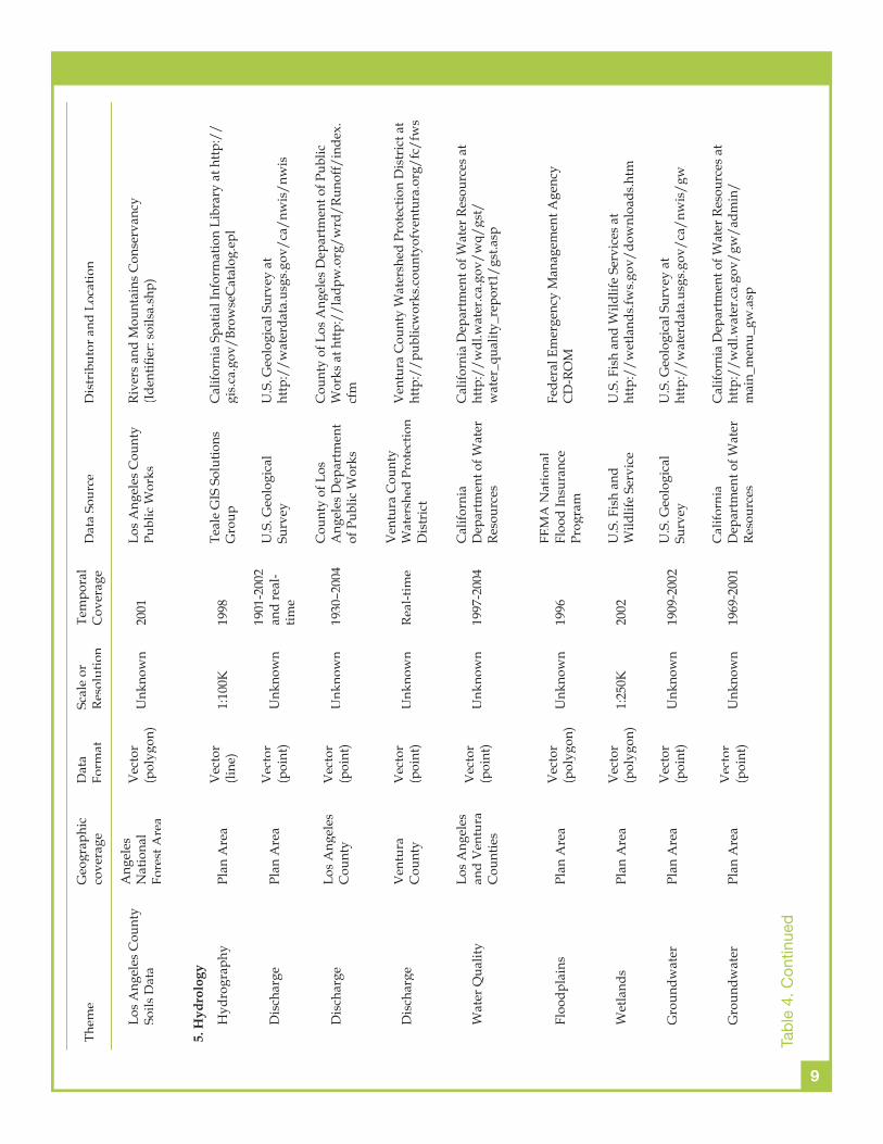
The wildlife layers listed in Table 4 provide only spotty information about the species present in different parts of the Plan Area. The fi rst three products listed under this category provide very general information about the species themselves and their potential presence on the ground whereas the fi nal three products provide greater detail about specifi c species in specifi c locations and/or areas. Some substantial geocoding work would be required to convert the verbal descriptions of Species Recovery Plan Areas and Habitat Conservation Areas to GIS data layers and these data would need to be checked against the vegetation actually present in these locations to determine whether or not the designated species are actually present or not. Substantial GIS database development as well as additional fi eld work will be required to fi ll many of the gaps identifi ed in the natural vegetation and wildlife categories.
The transportation fi les listed in Table 4 provide more or less complete coverage of road and railway systems across the Plan Area and some information about recreational trails and pathways. The latter spans several fi les that vary substantially in terms of their accuracy and the types of features included. Further work to combine and evaluate the quality (i.e. completeness, currency, accuracy, etc.) of these GIS datasets would be needed to support the recreational open space planning efforts envisaged in the appropriate analytical framework (see Wolch et al., 2004 for additional details).
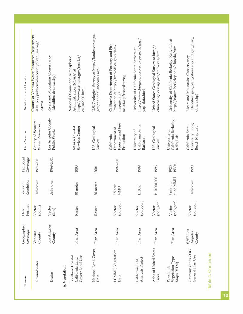
The fi nal land use category identifi ed in Table 4 includes numerous datasets that describe the role and impact of people in the Plan Area. Hence, there are several GIS datasets that describe property ownership, another group delineates signifi cant agricultural areas, a third group delineates park and designated open space areas, and the fi nal group consists of 2000 Census boundary fi les that can be used to organize and integrate the 2000 Census results with any and all of the GIS datasets identifi ed in Table 4. Most of the datasets in this category provide coverage for the entire Plan Area but several lack specifi city (for example most of the park data layers do not adequately describe the facilities present in specifi c parks) and soon will be out-of-date (the 2000 Census data already refers to conditions four years ago and this information will be fi ve or six years old when the fi nal plans and tools are completed and released).
Last but not least, the large number and diversity of data themes listed in Table 4 will require the management of multiple geospatial data formats – point/line/polygon features (vectors), grid cells/pixels

16
(rasters), and various forms of imagery and photography – and implementation of a series of solutions to cope with the geographic registration and confl ation problems that typically accompany geospatial data drawn from different sources in the next phase of the project.
17
This report summarizes the results of the GIS data search that was conducted as a part of Phase I of the Green Visions Plan Project. The search focused on freely available, public domain data sources and the results in Table 4 indicate that many GIS datasets that meet these criteria were found for parts or all of the Plan Area. However, this inventory also indicates that there are many data gaps given the goals and data requirements as outlined in the habitat conservation, watershed health, and recreational open space analytical frameworks prepared by Wolch et al. (2004).
The data gaps and shortcomings affect all aspects of the project. For example, the natural vegetation and wildlife layers identifi ed in Table 4 provide varying levels of information about these landscape components across the Plan Area today. However, the information about habitat conditions and opportunities for restoration in the urban core is particularly poor, and there is little or no information about historic conditions. Turning next to watershed health, the DEM data will allow the division of the Plan Area into a series of nested watersheds and sub-watersheds but these data will need to be integrated with information about storm water conveyance systems to improve our knowledge of current hydrologic conditions and the opportunities for improving or restoring watershed health. Finally, the various park layers identifi ed in Table 4 will need to be checked for completeness (prior work by the Green Visions Plan project team has found these data to suffer from various gaps and omissions –see Wolch et al., 2002 for details) and then augmented to identify the types of facilities present and the quality of the facilities located at specifi c parks.
The search for, acquisition, and use of these various data themes will accelerate over the lifespan of the Green Visions Project. From this vantage point, this particular report serves as a status report that summarizes our fi ndings as of 30 June 2004. That said, there are numerous data sets describing the public transit network, schools, libraries, and land cover/land use that we need but which we have not acquired to date. Similarly, there are other data sets that we know about and will require some additional processing and/or modifi cation to serve the needs in this project – the examples in this latter category include the historical topographic map series produced by the California Geographical Survey at California State University-Northridge and the general plan, traffi c analysis zone, and related business activity data sets maintained by the Southern California Association of Governments.
The fi nal two comments worthy of mention focus on data quality and maintenance. This report has described a large number and variety of GIS datasets that were developed by different agencies from a variety of sources. Substantial time and effort will be needed to not only fi ll the data gaps identifi ed in this report, but also to check, modify, and fi x the numerous spatial registration, attribute defi nition, and other inconsistencies that are embedded in the GIS datasets that were found. The long-term usefulness of the planning tools that will be developed in Phase II of the Green Visions Plan Project will also require that some further thought is given to data management issues. There are various paths that can be taken to manage the geospatial datasets that are prepared and used to develop the plan and the accompanying tools. The technical possibilities are numerous and the most substantial data maintenance challenges probably involve the development and implementation of data sharing agreements among the various government agencies that might contribute their data to the Green Visions Project.
CONCLUSIONS
18
Bliss, N.B. and W.U. Reybold. 1989. Small-scale Digital Soil Maps for Interpreting Natural Resources. Journal of Soil and Water Conservation 44: 30-34.
Corbley, K.P. 2002. LA County Combines IFSAR with Digital Imaging to Produce Accurate Orthos and DEMs. Earth Observation Magazine Online (http://www.eomonline.com/Common/currentissues/Sep02/corbley.htm)
Custer, S.G., P. Farnes, J.P. Wilson, and R.D. Snyder. 1996. A Comparison of Hand- and Spline-drawn Precipitation Maps for Mountainous Montana. Water Resources Bulletin 32: 393-405.
Hill, J.M., L.A. Graham, R.J. Henry, D.M. Cotter, and D. Young. 2000. Wide-area Topographic Mapping and Applications with Airborne Light Detection and Ranging (LIDAR) Technology. Photogrammetric Engineering and Remote Sensing 66: 901-906.
Hutchinson, M.F. 1995. Interpolating Mean Rainfall Using Thin Plate Smoothing Splines. International Journal of Geographical Information Systems 9: 385-403.
Šúri, M. and J. Hofi erka. 2004. A New GIS-based Solar Radiation Model and Its Application to Photovoltaic Assessments. Transactions in GIS 8: 175-190.
Wilson, J.P. and A. Belonis. 2004. Mapping the Distribution and Density of Green Cover in Los Angeles County. University of Southern California Lusk Center for Real Estate, Los Angeles, California.
Wilson, J.P. and J.C. Gallant. 2000. Terrain Analysis: Principles and Applications. John Wiley and Sons, New York.
Wolch, J.R., J. Devinny, T. Longcore, and J.P. Wilson. 2004. The Green Visions Plan for 21st Century Southern California: A Guide for Habitat Conservation, Watershed Health, and Recreational Open Space. 1. Analytic Frameworks for the Green Visions Plan. University of Southern California GIS Research Laboratory and Center for Sustainable Cities, Los Angeles, California.
Wolch, J.R., J.P. Wilson, and J. Fehrenbach. 2002. Parks and Park Funding in Los Angeles: An Equity Mapping Analysis. University of Southern California Center for Sustainable Cities, Los Angeles, California.
LITERATURE CITED