Embed Size (px)
Citation preview
Giscome Quarry and Lime Plant Project Description
Graymont Western Canada Inc.
final_giscome_pd_18april07.doc Page i
Graymont Western Canada Inc.
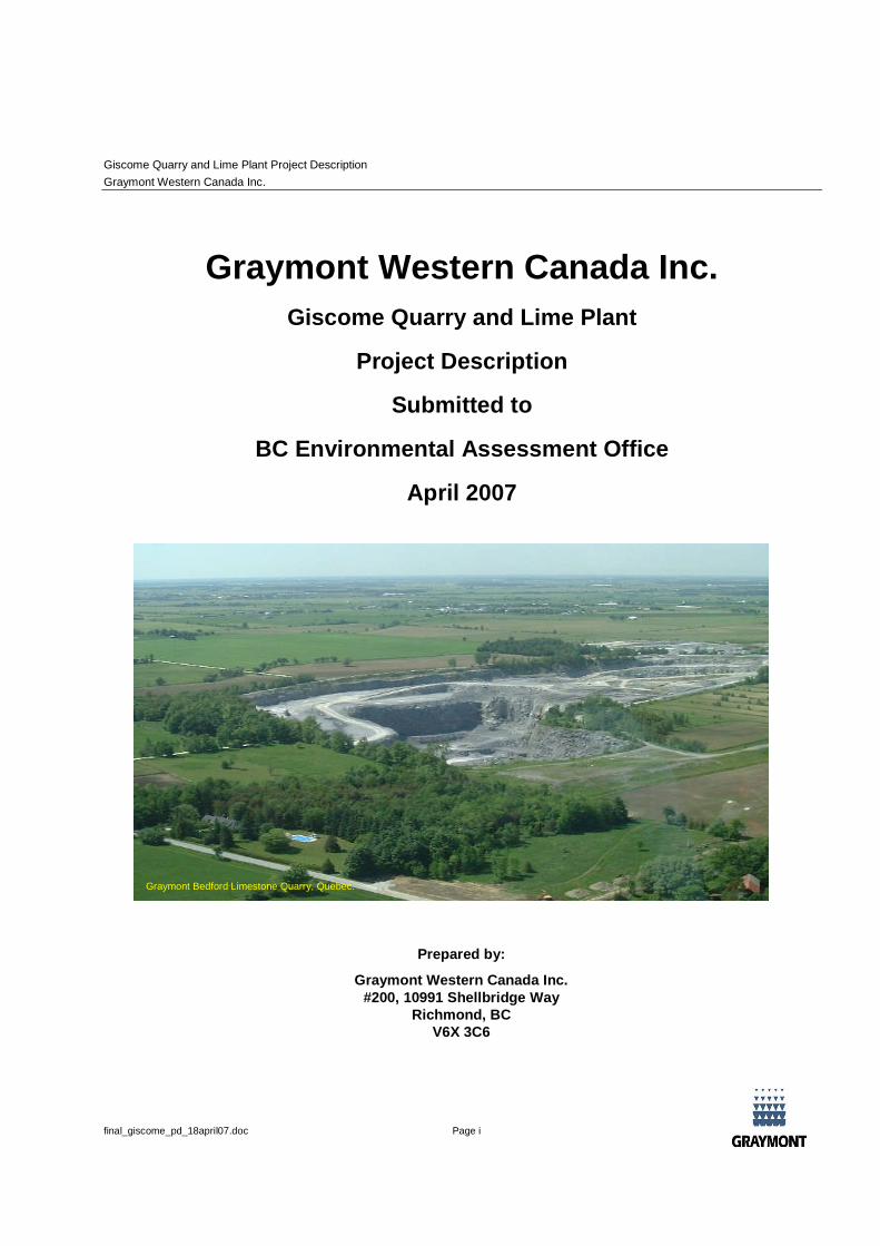
Giscome Quarry and Lime Plant
Project Description
Submitted to
BC Environmental Assessment Office
April 2007
Prepared by:
Graymont Western Canada Inc.#200, 10991 Shellbridge Way
Richmond, BCV6X 3C6
Graymont Bedford Limestone Quarry, Quebec.
Giscome Quarry and Lime Plant Project Description
Graymont Western Canada Inc.
final_giscome_pd_18april07.doc Page ii
Contents
1. INTRODUCTION ................................................................................................................................ 1
2. PROPONENT INFORMATION............................................................................................................ 2
3. PROJECT LOCATION AND HISTORY ............................................................................................... 3
3.1 Project Location.................................................................................................................................. 3
3.2 History ................................................................................................................................................ 3
4. PROJECT CHARACTERISTICS......................................................................................................... 4
4.1 Operational Overview ......................................................................................................................... 4
4.2 Project Components ........................................................................................................................... 4
4.2.1 Limestone Quarrying .............................................................................................................. 4
4.2.2 Haul Road .............................................................................................................................. 5
4.2.3 Lime Processing Plant ............................................................................................................ 5
4.2.4 Storage, Loading and Shipping Facilities ................................................................................ 6
4.2.5 Rail Spur and Access Roadway.............................................................................................. 6
4.2.6 Co-product Storage and Handling........................................................................................... 7
4.2.7 Fuel Storage and Handling ..................................................................................................... 7
4.2.8 Ancillary Structures................................................................................................................. 7
4.3 Project Development Schedule ........................................................................................................... 7
5. PROJECT SETTING........................................................................................................................... 8
5.1 Bedrock Geology ................................................................................................................................ 8
5.2 Terrain and Surface Geology .............................................................................................................. 8
5.3 Climate ............................................................................................................................................... 8
5.4 Surface Water................................................................................................................................... 11
5.5 Aquatic Habitat ................................................................................................................................. 12
5.6 Vegetation ........................................................................................................................................ 12
5.7 Wildlife.............................................................................................................................................. 13
6. FIRST NATIONS SETTING .............................................................................................................. 15
Giscome Quarry and Lime Plant Project Description
Graymont Western Canada Inc.
final_giscome_pd_18april07.doc Page iii
6.1.1 Lheidli T’enneh Band............................................................................................................ 15
7. SOCIO-ECONOMICS AND CONTEMPORARY LAND USE.............................................................. 16
7.1 Local Communities: Giscome, Newlands and Willow River................................................................ 16
7.2 Prince George .................................................................................................................................. 17
7.3 Contemporary Land Use................................................................................................................... 17
7.3.1 Land Use Regulation and Zoning.......................................................................................... 17
7.3.2 The Prince George Land and Resource Management Plan................................................... 18
7.3.3 The Official Community Plan for Electoral Area F.................................................................. 18
7.3.4 Prince George Area Crown Land Plan .................................................................................. 19
7.3.5 Environmental Important Areas............................................................................................. 21
7.3.6 Forestry 21
7.3.7 Agricultural ........................................................................................................................... 21
7.3.8 Hunting, Fishing and Recreational Activities ......................................................................... 22
8. CONSULTATION.............................................................................................................................. 23
9. REGULATORY FRAMEWORK AND PERMITTING .......................................................................... 25
10. REFERENCES ................................................................................................................................. 27
Giscome Quarry and Lime Plant Project Description
Graymont Western Canada Inc.
final_giscome_pd_18april07.doc Page 1
1. INTRODUCTION
The Proponent (Graymont Western Canada Inc.) is proposing to construct and operate a lime processing facility
and associated quarry (the Project) in the Giscome area of British Columbia. The proposed Project will produce
high quality lime products for use in environmental and industrial applications and limestone products for use as
construction stone. The principle markets for the proposed Giscome lime plant will be flue gas desulphurization
and mining applications. The proposed Project is well suited to development of a lime manufacturing facility
because of its proximity to the Canadian National Railway and the presence of high quality limestone deposits.
The proposed limestone quarry is to be located on Crown land in an area measuring approximately 200
hectares and is located approximately 4 km south east of the settlement of Giscome. The proposed lime plant is
to be located approximately 1 km east northeast of the settlement of Giscome on a 20 ha plot owned by
Graymont.
The rate of limestone extraction will initially be up to approximately 600,000 tonnes a year corresponding to an
initial annual lime production rate from one kiln of approximately 200,000 tonnes. Depending on market
conditions, Graymont may expand the capacity of the Giscome operation in the future. In this case, the
limestone extraction rate will be up to 1.2 million tonnes per year, which corresponds to an annual lime
production rate from two kilns of 400,000 tonnes.
The limestone quarry life is expected to be in excess of 25 years based on preliminary drilling and on current
expectations of market demand. Reclamation of the quarry site will be an ongoing process and following quarry
closure the site will be reclaimed to an appropriate land use.
The first phase of the Project is expected to require a labour force equivalent to approximately 30 person-years
during construction, and approximately 30 permanent positions will be generated through operation of the plant.
The capital cost for Phase I of the Project is estimated to be $90 million Canadian. The second phase of the
Project is expected to require a labour force equivalent to approximately 15 person-years during construction,
but will not require additional employees to operate. The capital cost for Phase II of the Project is estimated at
$40 million Canadian.
Giscome Quarry and Lime Plant Project Description
Graymont Western Canada Inc.
final_giscome_pd_18april07.doc Page 2
2. PROPONENT INFORMATION
Graymont is a privately-owned company committed to responsibly meeting society's needs for mineral products.
Graymont's management team and employees are dedicated to meeting or exceeding customer needs with
reliable supply of quality products and service. Graymont has been in the lime and limestone business for over
50 years, and is the largest lime producer in Canada as well as the third largest producer of lime in North
America.
Graymont’s corporate headquarters is located as follows:
#200-10991 Shellbridge Way
Richmond, BC V6X 3C6
Office Telephone: (604) 276-9331
Office Facsimile: (604) 276-9337
Website: www.graymont.com
Chairman: Anthony R. Graham
President and Chief Executive Officer: Stuart Wolfe
Chief Operating Officer: William Dodge
Vice President and Chief Financial Officer: Stephane Godin
Vice President and General Counsel: Garry Kehler
Vice President Environmental Affairs: Mike Brown
Vice President Marketing and New Business Development: Jeffrey Higgs
Further information on the company and its projects can be found on Graymont’s website.
Giscome Quarry and Lime Plant Project Description
Graymont Western Canada Inc.
final_giscome_pd_18april07.doc Page 3
3. PROJECT LOCATION AND HISTORY
3.1 Project Location
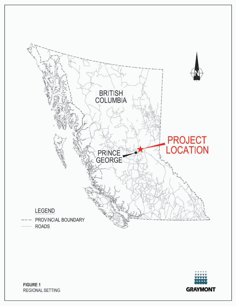
The Project is located approximately 27 kilometres east-northeast of Prince George, British Columbia. The
proposed lime processing plant is located on Graymont owned land, approximately 1 km east northeast of the
settlement of Giscome (Grid Reference for approximate centre: 542430.32E, 5992122.14N; Latitude
54°04'32.17" N, Longitude 122°21’05.97" W). The proposed lime processing plant site is level and is located
immediately to the south of Eaglet Lake at an elevation of approximately 600 m above sea level (asl). It is
proposed that an adjacent CN Rail line will be the main form of access to the site. Road access to the site will
be along an existing road which currently connects to the south western edge of the proposed plant area.
The proposed quarry is located on Crown land, approximately 4 km south east of the settlement of Giscome
(Grid Reference for approximate centre: 546604.52E, 5989513.51N; Latitude: 54°03'07.02"N, Longitude
122°17'17.54"W). The topography in the vicinity of the proposed quarry is characterized by rolling hills
separated by low-lying, generally swampy areas. Elevations range up to 855 m in the hills to the northeast. The
proposed limestone quarry will be accessed by a haul road, the route of which is currently being evaluated.
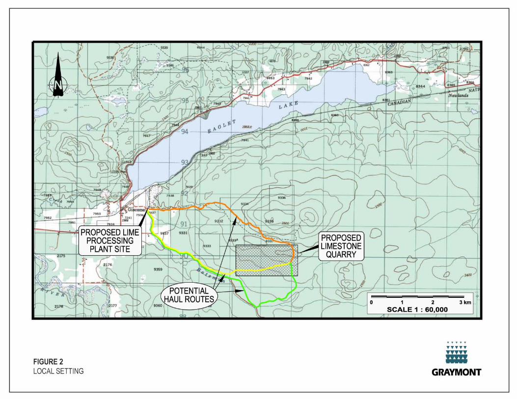
The regional setting of the Project is illustrated in Figure 1, and the local setting and Project location are
illustrated in Figure 2.
3.2 History
The mineral claims (known as the Pat claims) located over the proposed quarry location were staked in 1993 by
one of Graymont’s predecessor companies. During late 1993 and 1994, eight diamond drill holes tested the
limestone potential in the timber cut-block on the Pat 2 claim. This drilling plus surface mapping and sampling
surveys conducted at the same time determined there were significant volumes of high-calcium limestone
resources on the property. The field work defined the northern and eastern boundaries of the limestone deposit.
The property was held in good standing until 2005 when additional geological mapping and sampling was
performed on the claims and the surrounding area. More claims were staked around the periphery of the original
claim block in early 2006.
In the summer and late fall of 2006, an additional 18 diamond drill holes totalling 8299 feet of drilling further
tested and defined the eastern and northern limits of the deposit and confirmed additional limestone resources
to the west. Ore tonnage estimates indicate greater than 30 million tonnes of high quality limestone on
Graymont’s property.
In 2007 Graymont agreed to purchase from CNR approximately 150 acres (60 hectares) of land at the
southwest end of Eaglet Lake, just east of the settlement of Giscome. This site was formerly used by CN for
quarrying ballast rock, and is the proposed location for the lime processing plant. In 2006 Graymont also
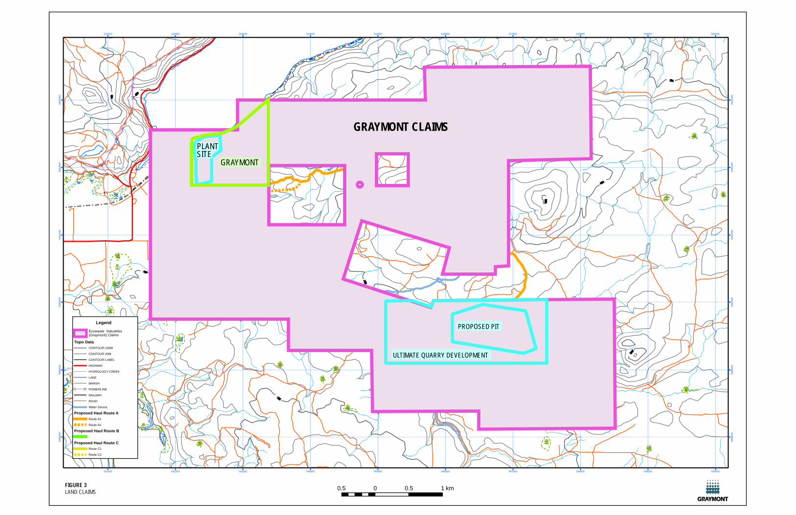
acquired an adjoining parcel of land immediately to the east of the former CNR land. Figure 3 illustrates land
claims and land ownership in the vicinity of the Project.
SS
SS
S
S
S
S
SS
S
S
S
S
S
S
S
S
S
SS
S
S
S
S
S
S
SSS
S
S
SS
SS
SS
SSSS
S
S
S
S
S
S
S SS
541000
541000
542000
542000
543000
543000
544000
544000
545000
545000
546000
546000
547000
547000
548000
548000
549000
549000
550000
550000
5988
000
5988
000
5989
000
5989
0 00
5990
000
599 0
000
5991
000
5991
000
5992
000
5992
000
5993
000
5993
000
0.5 0 0.5 1 km
Legend
Topo DataCONTOUR-100M
CONTOUR-20M
CONTOUR-LABEL
HIGHWAY
HYDROLOGY-CREEK
LAKE
MARSH
S S POWERLINE
RAILWAY
ROAD
Water Source
Proposed Haul Route ARoute A1
Route A2
Proposed Haul Route B
Proposed Haul Route CRoute C1
Route C2
FIGURE 3LAND CLAIMS
PLANTSITE
eEcowaste Industri s(Graymont) Claims
GRAYMONT
GRAYMONT CLAIMS
ULTIMATE QUARRY DEVELOPMENT
PROPOSED PIT
Giscome Quarry and Lime Plant Project Description
Graymont Western Canada Inc.
final_giscome_pd_18april07.doc Page 4
4. PROJECT CHARACTERISTICS
4.1 Operational Overview
Graymont proposes to construct and operate a lime processing facility and associated quarry (the Project) in the
Giscome area of British Columbia. The Project consists of the following major components:
a limestone quarry;
a 7 km long (approximate) haul road connecting the limestone quarry to the lime processing plant;
a lime processing plant;
storage, loading and shipping facilities;
a 600 m long (approximate) rail spur connecting the lime processing plant facilities to Canadian National
Railway’s main line, and an access roadway that connects the processing plant facilities to the existing
public roadways;
co-product storage and handling;
fuel storage and handling; and
ancillary structures.
4.2 Project Components
4.2.1 Limestone Quarrying
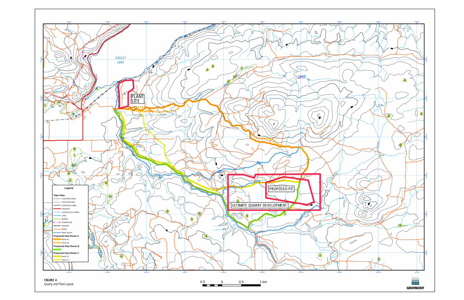
The limestone quarry is proposed to ultimately cover an area of just over 2 km2
or 220 hectares of Crown Land.
The initial focus for the quarry operations will be a 70 hectare central block determined based on a geologic
resource model developed from Graymont’s drilling data, geological studies and exploration program. Figure 4
shows proposed initial and ultimate quarry extents. The rate of limestone extraction will initially be up to
approximately 600,000 tonnes a year, with a future potential limestone extraction rate of up to 1.2 million tonnes
per year.
Conventional quarry-type mining methods will be used to extract ore and unsuitable rock from the proposed
quarry. Drilling and blasting will be used to break the rock. The ore will be loaded into haul trucks for transport
to the crusher. The economics of crushing limestone in the quarry or in the processing plant area is being
evaluated as part of the Mine Feasibility Study. Hydraulic front-end loaders will load blasted rock into haul
trucks. As part of the Mine Feasibility Study, Graymont is also evaluating options for electrical power supply to
the quarry and explosives storage areas.
Fugitive dust emission, water and sediment control and management measures will be incorporated into to all
phases of quarry development and operation to ensure safety and environmental protection.
Quarry activities, including loading and hauling operations, will normally occur during two 8-hour shifts, five days
SS
SS
S
S
S
S
SS
S
S
S
S
S
S
S
S
S
SS
S
S
S
S
S
S
SSS
S
S
SS
SS
SS
SSSS
S
S
S
S
S
S
S SS
541000
541000
542000
542000
543000
543000
544000
544000
545000
545000
546000
546000
547000
547000
548000
548000
549000
549000
550000
550000
5988
000
5988
000
5989
000
5989
0 00
5990
000
599 0
000
5 991
000
599 1
000
5 992
000
599 2
0 00
599 3
000
5 993
000
0.5 0 0.5 1 kmFIGURE 4Quarry and Plant Layout
Legend
Topo DataCONTOUR-100M
CONTOUR-20M
CONTOUR-LABEL
HIGHWAY
HYDROLOGY-CREEK
LAKE
MARSH
S S POWERLINE
RAILWAY
ROAD
Water Source
Proposed Haul Route ARoute A1
Route A2
Proposed Haul Route B
Proposed Haul Route CRoute C1
Route C2
ULTIMATE QUARRY DEVELOPMENT
PROPOSED PIT
PLANTSITE
EAGLETLAKE

Giscome Quarry and Lime Plant Project Description
Graymont Western Canada Inc.
final_giscome_pd_18april07.doc Page 5
per week, for 80 hours per week, but could extend beyond this if required.
4.2.2 Haul Road
A number of potential haul routes are currently being evaluated. Crushed or uncrushed stone will be
transported to the processing plant using a connecting haul road, which is approximately 7 km long. The
proposed haul road may cross a combination of crown and private land. Negotiations with Crown and local land
owners will be necessary in order to gain any relevant authorisations and to develop road use agreements and
sharing conditions. The haul road will be designed in line with regulatory requirements to safely accommodate
two-way truck traffic and to ensure surface water runoff is managed appropriately. The road will be graded into
the natural ground and will be surfaced with crushed limestone.
A small network of service vehicle roads will also be developed within the proposed quarry disturbance limits
that will allow access to the quarry and other portions of the Project site.
4.2.3 Lime Processing Plant
The lime processing plant will be located on a level parcel of land approximately 1 km east northeast of the
settlement of Giscome and approximately 400 m south of Eaglet Lake. A schematic of the initial plant layout
(one kiln) is provided in Figure 5. This layout is indicative only and is subject to change and finalization.
Operations at the lime processing plant will include the following processing stages:
Conventional crushing and screening of the raw limestone to a suitable size for processing (where this
hasn’t already taken place at a crusher in the quarry);
Thermally treating the crushed limestone in horizontal or vertical kilns;
Storing manufactured product, raw materials and fuels;
Controlling dust and stack emissions;
Managing wastewater, co-products and off-specification product, and
Providing support and administrative facilities.
A simplified lime manufacturing process flow sheet for a typical lime plant with one kiln is provided in Figure 6.
This flow sheet is indicative only and is subject to finalization for the proposed Giscome plant.
The processing plant will operate 24 hours per day, 7 days per week. Crushed stone is fed from conventional
stockpiles into one or two rotary kilns (or vertical kilns, if deemed more appropriate considering fuel efficiency
and market quality requirements) with a combined feed capacity for two kilns of 2,400 tonnes per day of
limestone. Lime is created through the thermal processing of limestone in a process known as calcination.
Calcination drives carbon dioxide (CO2) gas out of calcium carbonate to form calcium oxide or lime.
FIGURE 5Plant Layout on Aerial Photo
CN Rail Land
Graymont Land
FIGURE 6Process Flow Sheet
Giscome Quarry and Lime Plant Project Description
Graymont Western Canada Inc.
final_giscome_pd_18april07.doc Page 6
The rate of annual lime production will initially equal approximately 200,000 tonnes, with a potential annual lime
production rate of 400,000 tonnes from two kilns.
Depending on the solid fuel source utilized, it is estimated that up to 225 tonnes per day of solid fuel will be
required to produce enough heat for combustion in one kiln. Graymont is currently evaluating a variety of solid
fuel sources, such as pulverized petroleum coke and thermal coal. Graymont is also currently investigating the
burning of biosolids (wood waste) to verify whether it would be a feasible alternate fuel source.
Additional heat energy sources may also include liquid or gaseous fuels such as, oil #6, propane and natural
gas. These fuels are currently not economical as a full-time fuel source; however; they will be suitable for
starting the process and will also improve heat distribution throughout the process.
An air quality management plan and best industry practice will be implemented where practicable in the lime
processing plant and associated storage, loading and shipping facilities to ensure that emissions from all
operations within the plant site boundary are controlled and minimized. Such control measures may include
baghouses, scrubber systems or filtration devices; minimizing product and fuel handling activities; covering
stockpiles; and, collection and recycling of dust back into the process.
A water and wastewater management plan that conforms with best industry practice will also be implemented
where practicable within the boundaries of the lime processing plant site (including the plant, the product and
fuel storage, handling and shipping areas and ancillary structures) to ensure that potential impacts to surface
water quality are minimized.
4.2.4 Storage, Loading and Shipping Facili ties
The storage, loading and shipping facilities will be located entirely on private lands that are owned by Graymont.
The lime loading facility will incorporate automated truck and rail loading capabilities. Finished lime products will
be loaded into railcars and trucks at controlled flow rates to minimize spills of the lime products. The rail
deliveries and shipments will coincide with the CNR rail schedules. Shipments by truck may occur anytime
during a 24-hr period and are dependant on customer needs.
4.2.5 Rail Spur and Access Roadway
Rail is expected to be the primary means of transporting lime products to customers and receiving solid fuel for
kilns. A rail spur that once connected the plant site area to CNR’s rail line was removed in years past. Graymont
is proposing to rebuild this rail-spur in its former location. Once the rail spur is connected to the plant site, it will
branch off into several parallel sidings to facilitate both empty and loaded railcars.
An existing road currently connects to the western edge of the processing plant; however, the road access will
need to be upgraded in order to allow truck traffic to the plant site area. Trucks will be used to ship and receive
a lesser quantity of the lime products and raw materials, respectively. Trucks will also be used to transport small
volumes of consumables and manufactured products.
Giscome Quarry and Lime Plant Project Description
Graymont Western Canada Inc.
final_giscome_pd_18april07.doc Page 7
4.2.6 Co-product Storage and Handling
Co-products will be generated through quarrying and processing the limestone, as follows.
Overburden and excess rock associated with the quarrying operation. The overburden and excess rock
will be stockpiled for later use as reclamation materials within the quarry.
Undersized materials or material rejects removed from the lime process prior to thermal treatment.
These materials will also be stockpiled for later use in reclamation activities within the quarry.
Lime collected from dust collection and partially calcined limestone minerals from the lime
manufacturing process and emission control systems will be reused within the process or sold where
possible. Where no other use can be found for the lime kiln dust, it will be disposed of in an authorized
non-hazardous landfill.
Graymont is currently assessing whether or not the kilns will be equipped with baghouses or semi-wet
scrubbers. If scrubbers are incorporated in the kilns, water is consumed and evaporated at 40 L/min. Water
enhances the semi-wet scrubbing process but does not result in a wastewater discharge.
4.2.7 Fuel Storage and Handling
In general, rail access will allow the processing plant to receive solid fuel shipments on a regular basis reducing
the requirements for on-site storage. However, winter weather conditions will more than likely necessitate
stockpiling a six month reserve of solid fuel.
A fuel management plan will be implemented to ensure handling, storage, transfer and spill response
procedures are adhered to for all phases of the Project and that potential impact to surface water quality is
minimized.
4.2.8 Ancil lary Structures
Additional ancillary structures include: an administrative office, truck weigh scale, maintenance shop, oil storage
building, electrical substation building and liquid fuel storage tanks.
On-site liquid fuel storage will be in dual-lined, above-ground tanks. These tanks will contain diesel and
gasoline, used for plant vehicles and possibly for auxiliary engines. Propane storage would also be considered
for heating, and possibly for auxiliary and standby engine fuel.
4.3 Project Development Schedule
Graymont plans to submit the Application for an Environmental Assessment Certificate by the end of December
2007 and anticipates the Project Approval Certificate decision in the end of September 2008. A summary of the
proposed Project Development Schedule is provided in Figure 7.
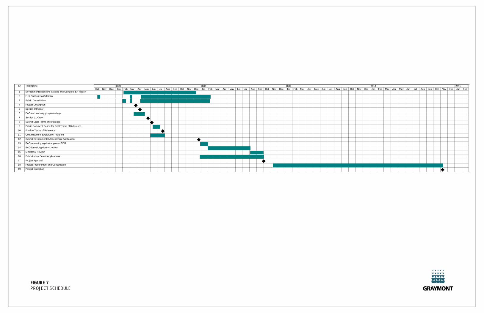
FIGURE 7PROJECT SCHEDULE
ID Task Name
1 Environmental Baseline Studies and Complete EA Report
2 First Nations Consultation
3 Public Consultation
4 Project Description
5 Section 10 Order
6 EAO and working group meetings
7 Section 11 Order
8 Submit Draft Terms of Reference
9 Public Comment Period for Draft Terms of Reference
10 Finalize Terms of Reference
11 Continuation of Exploration Program
12 Submit Environmental Assessment Application
13 EAO screening against approved TOR
14 EAO formal Application review
15 Ministerial Review
16 Submit other Permit Applications
17 Project Approval
18 Project Procurement and Construction
19 Project Operation
Oct Nov Dec Jan Feb Mar Apr May Jun Jul Aug Sep Oct Nov Dec Jan Feb Mar Apr May Jun Jul Aug Sep Oct Nov Dec Jan Feb Mar Apr May Jun Jul Aug Sep Oct Nov Dec Jan Feb Mar Apr May Jun Jul Aug Sep Oct Nov Dec Jan Feb2007 2008 2009 2010 2011
Giscome Quarry and Lime Plant Project Description
Graymont Western Canada Inc.
final_giscome_pd_18april07.doc Page 8
5. PROJECT SETTING
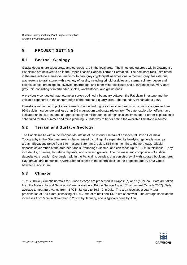
5.1 Bedrock Geology
Glacial deposits are widespread and outcrops rare in the local area. The limestone outcrops within Graymont’s
Pat claims are believed to be in the Upper Triassic Cariboo Terrane Formation. The dominant rock units noted
in the area include a massive, medium- to dark-grey cryptocrystlline limestone; a medium-grey, fossiliferous
wackestone to grainstone, with a variety of fossils, including crinoid ossicles and stems, solitary rugose and
colonial corals, brachiopods, bivalves, gastropods, and other minor bioclasts; and a carbonaceous, very-dark-
grey unit, consisting of interbedded shales, wackestones, and grainstones.
A previously conducted magnetometer survey outlined a boundary between the Pat claim limestone and the
volcanic exposures in the eastern edge of the proposed quarry area. The boundary trends about 340°.
Limestone within the project area consists of abundant high calcium limestone, which consists of greater than
95% calcium carbonate and less than 5% magnesium carbonate (dolomite). To date, exploration efforts have
indicated an in-situ resource of approximately 30 million tonnes of high calcium limestone. Further exploration is
scheduled for this summer and mine planning is underway to better define the available limestone resource.
5.2 Terrain and Surface Geology
The Pat claims lie within the Cariboo Mountains of the Interior Plateau of east-central British Columbia.
Topography in the Giscome area is characterized by rolling hills separated by low-lying, generally swampy
areas. Elevations range from 640 m along Bateman Creek to 855 m in the hills to the northeast. Glacial
deposits cover much of the area near and surrounding Giscome, and can reach up to 100 m in thickness. They
include tills, drumlins, lacustrine deposits, and outwash gravels. The thickness and composition of surficial
deposits vary locally. Overburden within the Pat claims consists of greenish-grey till with isolated boulders, grey
clay, gravel, and bentonite. Overburden thickness in the central block of the proposed quarry area varies
between 0 and 25 m.
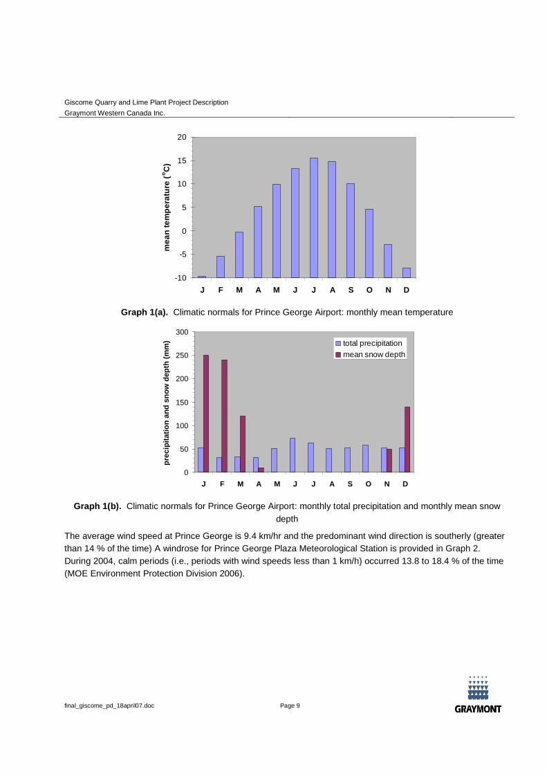
5.3 Climate
1971-2000 key climatic normals for Prince George are presented in Graphs1(a) and 1(b) below. Data are taken
from the Meteorological Service of Canada station at Prince George Airport (Environment Canada 2007). Daily
average temperature varies from -8 °C in January to 16.5 °C in July. The area receives a yearly total
precipitation of 554.4 mm, consisting of 406.7 mm of rainfall and 147.6 cm of snowfall. The average snow depth
increases from 5 cm in November to 28 cm by January, and is typically gone by April.
Giscome Quarry and Lime Plant Project Description
Graymont Western Canada Inc.
final_giscome_pd_18april07.doc Page 9
-10
-5
0
5
10
15
20
J F M A M J J A S O N D
me
an
tem
pe
ratu
re(o
C)
Graph 1(a). Climatic normals for Prince George Airport: monthly mean temperature
0
50
100
150
200
250
300
J F M A M J J A S O N D
pre
cip
itati
on
an
dsn
ow
dep
th(m
m) total precipitation
mean snow depth
Graph 1(b). Climatic normals for Prince George Airport: monthly total precipitation and monthly mean snow
depth
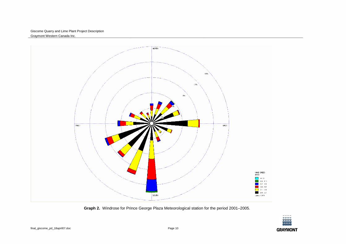
The average wind speed at Prince George is 9.4 km/hr and the predominant wind direction is southerly (greater
than 14 % of the time) A windrose for Prince George Plaza Meteorological Station is provided in Graph 2.
During 2004, calm periods (i.e., periods with wind speeds less than 1 km/h) occurred 13.8 to 18.4 % of the time
(MOE Environment Protection Division 2006).
Giscome Quarry and Lime Plant Project Description
Graymont Western Canada Inc.
final_giscome_pd_18april07.doc Page 10
Graph 2. Windrose for Prince George Plaza Meteorological station for the period 2001–2005.
Giscome Quarry and Lime Plant Project Description
Graymont Western Canada Inc.
final_giscome_pd_18april07.doc Page 11
5.4 Surface Water
The proposed Graymont project is located within the Bateman Creek watershed, which lies largely within the
Nechako Plateau provincial hydrologic zone. Bateman Creek is a small system which flows in a north-westerly
direction, ultimately draining into Eaglet Lake near the settlement of Giscome. Eaglet Lake in turn drains
westwards via Hay Creek into the Willow River and then into the Fraser River. The Fraser watershed is a major
North American river basin supporting a highly significant salmon population. The confluence of the Willow and
Fraser Rivers lies upstream of the confluence of the Nechako and Fraser Rivers at Prince George.
A number of tributaries to Bateman Creek have been named; however, the majority of the sub-catchments are
unnamed. No previously collected water quality or systematic hydrometric data appears to be available for this
watershed. The BC Ministry of Transportation holds a water license on Eaglet Lake for a maximum of 36,000
gallons per day (GPD) for the purpose of dust control (license number C115132), and the BC Fish and Wildlife
Branch holds a water license for a maximum of 10 cubic feet per second (ft3/s) for the purpose of works
constructed for conserving fish or wildlife (license number C064588) (MOE, 2007a). MOE (2007a) does not
report actual water usages. An older reconnaissance report suggests that beaver dams may play a role in the
hydrology of Bateman Creek, and lists spot discharge measurements (taken in May 1984, but assumed by the
report authors to be representative of “average summer conditions”) of 10-15 ft3/s (Griffith, 1984).
The overall local climatic regime is typically nordic, with subfreezing temperatures and significant snow
accumulation from about November through March. Streamflow regimes in such regions tend to be nival in
character, with maximum flows occurring during spring snowmelt freshet, and a low-flow (baseflow) period
during winter. Although Bateman Creek does not appear to have been monitored, Water Survey of Canada
data are available for the adjacent (but substantially larger) Willow River watershed (Hay Creek joins Willow
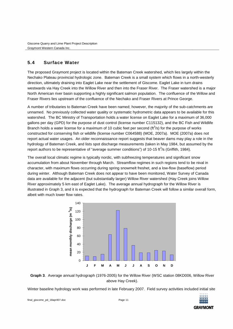
River approximately 5 km east of Eaglet Lake). The average annual hydrograph for the Willow River is
illustrated in Graph 3, and it is expected that the hydrograph for Bateman Creek will follow a similar overall form,
albeit with much lower flow rates.
0
20
40
60
80
100
120
140
J F M A M J J A S O N D
mea
nm
on
thly
dis
ch
arg
e(m
3/s
)
Graph 3. Average annual hydrograph (1976-2005) for the Willow River (WSC station 08KD006, Willow River
above Hay Creek).
Winter baseline hydrology work was performed in late February 2007. Field survey activities included initial site
Giscome Quarry and Lime Plant Project Description
Graymont Western Canada Inc.
final_giscome_pd_18april07.doc Page 12
reconnaissance, assessment of winter hydrologic conditions, and winter water quality sampling.
Snowpack was at least 1.0-1.5 m throughout the watershed and icecover was extensive (up to 1 m thick), even
in the lower reaches of Bateman Creek. Two surveying stations were established in the lower section of the
Bateman Creek mainstem. The lower of the two sites was located approximately 200 m upstream from the
Eaglet Lake confluence; the upper station was situated approximately 700 m upstream from Eaglet Lake, 20 m
above the Giscome South Bridge crossing.
Results from this survey indicate minimal winter flow in the Bateman Creek mainstem. The downstream site
exhibited free-flowing water depths less than 0.1 m, while the upper site had an impounded depth of just under
0.5m. To the limited extent that surface water quality could be sampled (from one wider pooled area), the
results do not suggest substantial impact from anthropogenic activities within the basin, and overall
hydrochemical characteristics appear generally consistent with wintertime groundwater contributions, possibly
imprinted by carbonate catchment geology (e.g., low TSS, moderately high hardness, slightly alkaline [ph-7.8]).
5.5 Aquatic Habitat
There are historic reports of both Chinook and rainbow trout in Bateman Creek, and of burbot, largescale and
longnose sucker, rainbow trout, mountain whitefish, dolly varden, northern pikeminnow, and a number of forage
fish species in Eaglet Lake.
Migration into Bateman Creek from Eaglet Lake during the open water season is likely; however, year-round use
of the watershed by different fish species is currently not well understood.
Eaglet Lake was observed to support recreational fishing during the winter, and it almost certainly supports
fishing during the open-water season.
A preliminary winter field assessment was conducted in conjunction with the surface water field assessment in
late February 2007. Although the observed water levels were very low at the two survey stations established on
the lower reaches of Bateman Creek, the dissolved oxygen concentration was high, and flow was present at the
downstream site, providing the necessary habitat elements for fish eggs to survive through the winter.
The upper sampling location indicates “pooled areas” are present in the lower river section, which provide limited
over-wintering habitat for juvenile fish. The dissolved oxygen concentration at this site was also high, providing
the necessary habitat elements for over-wintering; however, it is unlikely that adult life stages are present in the
system. Large-bodied fish would likely over-winter in Eaglet Lake, where habitat and food are more abundant.
5.6 Vegetation
The Project is located in the Fraser Basin Ecoregion, which is located in the Sub-boreal Interior Ecoprovince, to
the east of the Coast Mountains and to the west of the Interior Plains in the north-central part of British
Columbia. Within the Fraser Basin Ecoregion, the Project is located in the McGregor Plateau Ecosection and
near the Nechako Lowland Ecosection.
Vegetation in the Project area is within the Willow variant of the wet cool sub-boreal spruce subzone (SBSwk1).
This is bordered on the west by the Mossvale variant of the moist cool sub-boreal spruce subzone (SBSmk1)
and on the east by the very wet cool sub-boreal spruce subzone (SBSvk). Broad Ecosystem Inventory (BEI)
mapping of the area (1:250,000; BC MoE 2006, Internet site) shows that white spruce – subalpine fir and sub-
boreal white spruce – lodgepole pine are the most common forest types. Smaller amounts of
Giscome Quarry and Lime Plant Project Description
Graymont Western Canada Inc.
final_giscome_pd_18april07.doc Page 13
lodgepole pine and hybrid white spruce – black cottonwood riparian forest are also present. Also present in the
area are wetlands, cultivated fields, and Eaglet Lake. The mapping indicates several patches of old growth
forest in the area. Due to the mountain pine beetle outbreak in central BC, it is expected that most of the
lodgepole pine in the area will be infested or dead.
Rare plants and ecosystems may occur in the local area. There are three designations of rare plants: two federal
and one provincial. These include species listed by the Committee on the Status of Endangered Wildlife in
Canada (COSEWIC 2006, Internet site) as Endangered, Threatened, or Special Concern, those listed on
Schedules 1, 2, and 3 of the Species at Risk Act (SARA 2006, Internet site), and those listed as Red
(endangered or threatened) or Blue (special concern) by the BC Conservation Data Centre (BC CDC 2006,
Internet site). Rare ecosystems are not listed by COSEWIC or SARA but are listed by the BC CDC.
71 rare plant species are listed by the CDC as occurring in the Sub Boreal Spruce (SBS) biogeoclimatic zone.
Two blue-listed species (special concern); pygmy waterlily (Nymphaea tetragona) and American sweet-flag
(Acorus americanus), have been observed near the Project in Eaglet Lake. Several other CDC-listed species,
including short-flowered evening primrose (Camissonia breviflora), Smith’s melic (Melica smithii), tender sedge
(Carex tenera), and bald sedge (Carex tonsa var. tonsa), have been observed in the region.
A BC CDC search for red- and blue-listed ecological communities revealed 11 communities that occur in the
SBSwk1 in the McGregor Plateau Ecosection. A search for the SBSwk1, SBSmk1 and SBSvk in both the
McGregor Plateau and Necako Lowland revealed a further 17 ecological communities.
5.7 Wildlife
Over 200 species of wildlife may occur in the study area, including a number of species at risk. Similar to the
vegetation classifications outlined in Section 5.6, there are three designations of wildlife Species at Risk (SAR):
two federal and one provincial.
Five species of amphibians, including the long-toed salamander, western toad, Columbia spotted frog, wood
frog, and pacific treefrog potentially occur in the region (Green and Campbell 1992; B.C. CDC 2006, Internet
site; Klinkenberg 2006). All of these species are listed as yellow or secure in British Columbia. One species of
reptile potentially occurs in the region, the common garter snake, which is also listed as secure in British
Columbia (Gregory and Campbell 1987; B.C. CDC 2006, Internet site).
The Sub-Boreal Interior Ecoprovince supports a large number of bird species. Close to half of all birds generally
found in British Columbia are known to breed in the region (Demarchi 2002). Eaglet Lake, which is just north of
the site, supports both osprey and bald eagles, and these species could use the study area for nesting and
foraging (Wilson, pers. Comm.). Depending on the habitat, several other species may be nesting in the area.
The mixed deciduous and coniferous forests of the local area are known to support a wide variety of species
including common ravens, pine siskins and yellow warblers (B.C. Ministry of Forests 1992). Riparian areas may
support black terns and rusty blackbirds, which are listed as Blue in B.C. and as Special Concern by COSEWIC
(B.C. Ministry of Forests 1992; COSEWIC 2002, Internet site; B.C. CDC 2006, Internet site). Older pine forests
commonly support great horned owls, northern hawk owls, and spruce grouse (B.C. Ministry of Forests 1992).
Of the bird species occurring in the ecoregion, at least eight are listed as blue (special concern) in British
Columbia including the sharp-tailed grouse, great blue heron, American bittern, sandhill crane, short-eared owl,
barn swallow, rusty blackbird, and Le Conte’s sparrow (B.C. CDC 2006, Internet site). At least four species are
listed as red (endangered or threatened) including the peregrine falcon, Swainson’s hawk, upland sandpiper,
Giscome Quarry and Lime Plant Project Description
Graymont Western Canada Inc.
final_giscome_pd_18april07.doc Page 14
and Cape May warbler (B.C. CDC 2006, Internet site).
Ungulates such as moose and elk are common regionally, as well as locally (B.C. Ministry of Forests 1992).
Woodland caribou (southern population) are found in the region, with two herds being located within 50 km of
the site. The Hart Range is located approximately 45 km east of the site and supports approximately 450
caribou and has a stable population (B.C. CDC 2006, Internet site). The Narrow Lake caribou range is located
approximately 50 km south east of the site and supports approximately 50 caribou. This population is believed
to be declining (B.C. CDC 2006, Internet site). One other herd was historically located approximately 50 km
south of the site, but it is believed to be extirpated as of 2004 (B.C. CDC 2006, Internet site). Grizzly bear may
also be found in the region. Although grizzly bear are listed as threatened, the Grizzly Bear Population Units
(GBPU) that fall within the study area have populations that are listed as viable (Hamilton et al. 2004). Local
wildlife biologist, Doug Wilson (pers. comm.), indicated that he was not aware of any mammalian species that
are at risk in the Project area and that the wildlife values in the Project area are standard for the region.
Giscome Quarry and Lime Plant Project Description
Graymont Western Canada Inc.
final_giscome_pd_18april07.doc Page 15
6. FIRST NATIONS SETTING
The proposed project site is located in Lheidli T'enneh First Nations' traditional territory.
6.1.1 Lheidli T’enneh Band
The Lheidli T’enneh are Carrier people who speak a dialect of the Carrier language and are tied to the lands and
waters surrounding the confluence of the Fraser and Nechako rivers. There are currently 319 people on the
Lheidli T’enneh band list. There are approximately 120 people living on reserve which is located in Shelly,
approximately 18 km south west of Giscome. A further 100 band members live in Prince George with the
remaining people living in various communities within British Columbia and Canada.
The Lheidli T’enneh have signed protocols and memorandums of understanding with both aboriginal and non-
aboriginal organizations including: Nisga’a Nation, Sai’kuz, Red Bluff, Nazko, Snuneymuxw, City of Prince
George and the Regional District of Fraser Fort George.
In October 2006 and March 2007 Graymont met with Chief Dominic Frederick and a number of other Lheidli
T’enneh Band members. Consultation is ongoing between Graymont and the Lheidli T’enneh Band and it is
anticipated that they will remain actively involved in the Project over the duration of the Environmental
Assessment process and beyond.
Giscome Quarry and Lime Plant Project Description
Graymont Western Canada Inc.
final_giscome_pd_18april07.doc Page 16
7. SOCIO-ECONOMICS AND CONTEMPORARY LAND USE
7.1 Local Communities: Giscome, Newlands and Willow River
The proposed Giscome Quarry and Lime Plant are located in the Regional District of Fraser-Fort George
(RDFFG) in British Columbia. The Regional District of Fraser-Fort George is a federation of four municipalities,
including the City of Prince George, and seven electoral areas, including Electoral Area F: Willow River-Upper
Fraser.1
More specifically, the Project site is located approximately 27 kilometres to the east-northeast of
Prince George.
The project area is located in a rural area, with the communities of Giscome and Newlands and the Town of
Willow River in the near vicinity. These communities fall under Electoral Area F. Giscome and Newlands are
located on either end of Eaglet Lake, with Giscome on the southern end. Newlands is approximately 10 km
northeast of Giscome at the northern end of Eaglet Lake. Willow River is located 10 km west of Giscome.
Historically, Giscome, Newlands and Willow River were ‘railway towns’ that were founded with the building of the
Grand Trunk Pacific Railroad in the early 1910’s. The Railroad surveyed residential lots along the tracks, many
of which still exist in the area. The lumber industry developed in the early 1920s, and the communities were
bustling mill towns for the next 50 years. A sawmill used to operate approximately 20 miles to the northeast of
the Giscome and was one of the largest and longest running sawmills in the district.2
The mill industry thrived
until the 1970’s, when larger companies bought out the smaller operations. Since then, the former towns have
disbanded and the population in the area has dwindled. The economy is now based on small-scale agriculture.
The communities of Giscome and Newlands rely largely on hay and cattle. There are approximately 21 houses
in Giscome. The community has very few services: a school and regional park. Until recently, the CN Railway
ballast pit was operational in Giscome (on the proposed lime processing plant site). A small scale quarry, locally
known as the Kode-Jerrat quarry is located approximately 0.6 km north of Graymont’s proposed quarry footprint.
It is understood that small scale limestone extraction operations take place in this quarry.
Newlands is also a small farming community, with no services. Both Giscome and Newlands depend on Willow
River and Prince George for services and amenities.
According to Stats Canada 2001 findings, the population of the area is 155, although that takes into account the
communities of McGregor, Wolverine, Hansard, Aleza Lake and Upper Fraser, in addition to Newlands and
Giscome. The estimated population of Newlands and Giscome combined is approximately 70 people.3
The town of Willow River was established in 1912 by the Grand Trunk Pacific Railway.4
The Railway surveyed
2000 – 3000 lots in the area, many of which still exist but are undeveloped. The former ‘railroad town’ and mill
town is now a bedroom community for Prince George. It has a post office, grocery store, liquor store, gas station
and video store. The population of Willow River in 2001 was 197 people.
1http://rdffg.bc.ca/About_us/ (03/06/07) Including Giscome, Willow River and Newlands
2http://www.floatingrock.net/ipg/Tourism/default.asp?TID=8812f76a-69e2-4193-b160-ceb2efe7e1ea (03/07/07)
3Personal communication with Gordon Simmons, RDFFG Planning Department (09/03/07)
4http://www.floatingrock.net/ipg/Tourism/default.asp?TID=8812f76a-69e2-4193-b160-ceb2efe7e1ea (03/07/07)
Giscome Quarry and Lime Plant Project Description
Graymont Western Canada Inc.
final_giscome_pd_18april07.doc Page 17
7.2 Prince George
Prince George was founded in the early 1800s as “Fort George”, which was a fur trading post at the junction of
the Nechako and Fraser Rivers. The site remained a trading post for close to a century, but with the arrival of the
Grand Trunk Pacific Railway line the Fort was officially incorporated as the City of Prince George.5
The region’s economy has hinged on the forestry industry for over 8 decades. Prince George has approximately
15 paper and sawmills. Forestry alone comprises 31% of the income for the city.6
Other key facilities in the area
include two chemical plants and an oil refinery.
The Fraser Fort-George Regional District, with Prince George as the principal urban centre, is home to
approximately 101,000 people.7 Although the population for the area decreased slightly from 1996 to 2001, the
past five years have witnessed a rebound. Approximately 85% of the inhabitants have lived in the area for at
least the last 5 years, with 15% of the population migrating to the area from outside of the district within the past
5 years.8
Given Prince George’s proximity to the Giscome Quarry and Lime Plant, the city will likely serve as the Project’s
primary source of labour. The labour force for the Prince George area was approximately 48,000 in 2001, with
an unemployment rate of 11.4%.9
According to provincial statistics, the unemployment rate in 2005 was 4.2%.10
The population of Prince George is well educated, particularly since the founding of the University of Northern
British Columbia in 1994. More than a third of the population has completed a post-secondary certificate or
diploma program. Approximately 32% of the educational population above 15 years of age have Engineering
and Applied Sciences Technical/Trades as their field of study.11
7.3 Contemporary Land Use
Prince George is the hub for central British Columbia and provides major services for the regional area,
including health, emergency response (fire and ambulances), higher education, government services, and an
international airport. In addition, all major businesses are located in the city. It is anticipated that Prince George
will be the principal provider of major services for the Project.
7.3.1 Land Use Regulation and Zoning
Land use in the Giscome area is governed by Zoning Bylaw No.833, which applies to most of the Regional
District of Fraser-Fort George.12
The area is regulated by three major plans: the Prince George Land and
5http://www.city.pg.bc.ca/pages/location/ (03/07/07)
6http://www.bcstats.gov.bc.ca/ (03/08/07)
7http://www.bcstats.gov.bc.ca/ (03/08/07)
8http://www.statcan.ca/menu-en.htm (03/07/07)
9http://www.statcan.ca/menu-en.htm (03/07/07)
10http://www.bcstats.gov.bc.ca/ (03/08/07)
11http://www.bcstats.gov.bc.ca/ (03/08/07)
12http://rdffg.bc.ca/Services/Development/Planning/Zoning/ (03/06/07)

Giscome Quarry and Lime Plant Project Description
Graymont Western Canada Inc.
final_giscome_pd_18april07.doc Page 18
Resource Management Plan (LRMP), the Prince George Area Crown Land Plan, and the Official Community
Plan for Electoral Area F. The LRMP and Prince George Area Crown Land Plan regulate Crown land, while the
Official Community Plan regulates private land. The proposed site for the Graymont Quarry site is on Crown land
and therefore the LRMP and Crown Land Plan will regulate the quarry to a greater degree than the Official
Community Plan. The opposite is true for the proposed Plant site, which is located on private land and will be
regulated largely by the Community Plan.13
7.3.2 The Prince George Land and Resource Management Plan
The Prince George LRMP is a long-term plan for land use and resource development on Crown land within the
Prince George District. 14 The plan is based on the principles of integrated resource management and has
developed recommendations (accepted by government) for a number of resources including: forestry,
recreation, minerals, energy, agriculture, range, water resources, fish, wild-life, access, heritage and culture.15
The LRMP planning area is subdivided into five broad land use categories: Agriculture & Settlement, Enhanced
Resource Management, General Resource Management, Special Management and Protected Areas. The
Giscome Lime Plant and Quarry fall under the category of “Agriculture and Settlement”.
One of the key objectives of the LRMP is to “ensure opportunities and access for the exploration and
development of subsurface resources.”16
The Prince George LRMP supports exploration and development on
suitable Crown land that is not within the protected areas. The Giscome project falls under this category. The
plan provides strategic direction for detailed planning to allow responsible resource development.
7.3.3 The Official Community Plan for Electoral Area F
Land use in the area is also regulated by the Official Community Plan for Electoral Area F.17
The Community
Plan is the long term development policy of the Regional Board for the Willow River – Upper Fraser Valley.
Consistent with other community plans in the RDFFG, the plan indicates the overall objectives of managing land
and resource use so as to: reflect the wishes of local residents; minimize conflict between adjacent land uses;
account for other governmental policies; and allow for the cost-efficient provision of public services.18
The plan is intended to be relevant for 5 to 10 years and includes a general resource management objective “to
recognize the importance of the region’s forest, agricultural and mineral resource base and to support an
integrated approach to their management, such as is progressing under Local Resource Management Plan,
Protected Area Strategy and similar planning exercises, including non-extraction uses such as wildlife
13Personal communication with Gordon Simmons, RDFFG Planning Department (03/09/07)
14http://ilmbwww.gov.bc.ca/ilmb/lup/lrmp/northern/pgeorge/toc.htm (03/06/07)
15http://ilmbwww.gov.bc.ca/lup/lrmp/northern/pgeorge/summ99/jan99upd.htm
16http://ilmbwww.gov.bc.ca/lup/lrmp/northern/pgeorge/summ99/jan99upd.htm
17http://rdffg.bc.ca/Services/Development/Planning/OCP_Plans/index.html (03/06/07)
18Schedule “A” to Bylaw No. 1589, Willow River-Upper Fraser Valley Official Community Plan (p. 5)
Giscome Quarry and Lime Plant Project Description
Graymont Western Canada Inc.
final_giscome_pd_18april07.doc Page 19
management, watershed and scenic protection, lakeshore conservation and other special environmental
considerations for the maximum long term benefit of the region’s residents”.19
The plan includes management objectives in the areas of: transportation; agriculture; commerce; industry; crown
land; water resources; fish and wildlife; the environment; recreation and heritage; and services and
infrastructure. A key objective is to recognize that the extractive industry is often best located in rural areas
close to the resource.20
According to the plan, resource extraction is allowed in the area, but resource
processing requires an application for a zoning change. 21
The plan also aims to support the general objectives of the BC Land Reserve Commission, namely to preserve
agricultural land and encourage the establishment and maintenance of farms, as well as the use of Agricultural
Land Reserve compatible with agricultural purposes.22
7.3.4 Prince George Area Crown Land Plan
The Crown Land Plan contains a comprehensive inventory of Crown land use and resource attributes, as well as
future land requirements for various settlement and resource-oriented uses, including: agricultural and grazing
land; forest; wildlife habitat; public recreation land; conservation land; rural residential land; aggregate materials,
industrial and commercial land.23
Privately owned lands, which may be shown as allocated to a specific Crown
land use, are not governed by the provisions and policy guidelines of the Plan.24
According to the Prince George Crown Land Plan map and based on conversations with a representative of
Front Counter BC, the proposed Graymont Lime Plant will be located on privately held lands, whereas the
proposed Graymont Quarry will be located on Crown land. The approximately 7 km haul road will cross both
private and crown land.
Crown land designations include:
Wildlife Habitat Management Area (WHMA): Crown lands considered both suitable for wildlife habitat
use and important to the continuous production, maintenance and conservation of local and regional
wildlife resources.25
19Schedule “A” to Bylaw No. 1589, Willow River-Upper Fraser Valley Official Community Plan (p. 5)
20Schedule “A” to Bylaw No. 1589, Willow River-Upper Fraser Valley Official Community Plan (p. 6)
21Phone conversation with Gordon Simmons, RDFFG Planning Department (03/07/07)
22Schedule “A” to Bylaw No. 1589, Willow River-Upper Fraser Valley Official Community Plan (p. 6)
23Prince George Area Sub-District Crown Land Plan (1981), Ministry of Lands, Parks and Housing, Province of British
Columbia (page 1)
24Prince George Area Sub-District Crown Land Plan (1981), Ministry of Lands, Parks and Housing, Province of
British Columbia (page 34)
25Prince George Area Sub-District Crown Land Plan (1981), Ministry of Lands, Parks and Housing, Province of
British Columbia (page 37)
Giscome Quarry and Lime Plant Project Description
Graymont Western Canada Inc.
final_giscome_pd_18april07.doc Page 20
Recreation and Conservation Management Area (RCMA): Crown lands considered most suitable for
outdoor recreation and natural or heritage conservation uses and which may be required to meet the
future outdoor recreational and conservation needs of the region. 26
Settlement Reserve Area (SRA): Crown lands with capability or suitability for a range of future
settlement-oriented uses and which should be reserved until development for an appropriate use is
considered desirable.27
Agricultural Development Area (ADA): Crown lands considered most suitable for agricultural production
and necessary for the expansion and development of a viable agricultural industry, the diversification of
the regional economic base, and strengthening of the agricultural community in the Prince George Area.28
Integrated Forestry Management Area (IFMA): Crown lands considered most suitable for timber, range,
watershed, fish and wildlife production and forest-oriented recreation, which should be managed in an
integrated and coordinated fashion to maximize the long-term environmental, social and economic
benefits of these resources for local and regional residents.29
The primary objectives of the Plan are as follows:
Resolve existing land/resource use conflicts by allocating available Crown lands to their most suitable
uses, based on biophysical and socio-economic information.
Establish guidelines and policies for management, future planning and development of Crown land
identified as suitable for different uses.
Facilitate the land and resource use programs of affected government agencies involved with Crown
land in the Prince George Area.
Eliminate the uncertainty surrounding future timber supplies and promote silvicultural programs for
Crown forest land most suited for inclusion in a Provincial Forest.
Reduce processing time for Crown land applications and minimize their referral to other agencies. 30
26Prince George Area Sub-District Crown Land Plan (1981), Ministry of Lands, Parks and Housing, Province of British
Columbia (page 40)
27Prince George Area Sub-District Crown Land Plan (1981), Ministry of Lands, Parks and Housing, Province of British
Columbia (page 45)
28Prince George Area Sub-District Crown Land Plan (1981), Ministry of Lands, Parks and Housing, Province of
British Columbia (page 50)
29Prince George Area Sub-District Crown Land Plan (1981), Ministry of Lands, Parks and Housing, Province of British
Columbia (page 58)
30Prince George Area Sub-District Crown Land Plan (1981), Ministry of Lands, Parks and Housing, Province of British
Columbia (page 3-4)
Giscome Quarry and Lime Plant Project Description
Graymont Western Canada Inc.
final_giscome_pd_18april07.doc Page 21
The Plan lists four alternative means of achieving the basic Plan objectives:
Alternative “A” – The Forest Management Plan Emphasis maximizes Crown land available for short and
long-term timber harvesting and forest management.
Alternative “B” – The Mixed Resource Management Emphasis maximizes Crown land available for
management, conservation and protection of a full range of natural resources, including forest
resources.
Alternative “C” – The Mixed Management and Development Emphasis maximizes Crown land available
to accommodate a variety of development oriented uses according to anticipated Crown land
requirements.
Alternative “D” – The Agricultural Development Emphasis maximizes Crown land available for short and
long-term agricultural development.31
Alternative “C” best applies to the proposed Graymont Quarry site and associated haul road.
7.3.5 Environmental Important Areas
Environmental important areas near the proposed project site include Eaglet Lake and Aleza Lake, the latter of
which is located approximately 15 km northeast of Giscome.32
The Aleza Lake Research Forest is a 9000 ha
university-based outdoor research facility and working forest. The research and education programs are
multidisciplinary in nature, with an emphasis on partial cut harvest systems, biological diversity, climate change
and environmental monitoring in small forest tenures.33
7.3.6 Forestry
The local area was once characterized by a thriving lumber industry and mill towns. A large sawmill used to
operate approximately 20 miles to the northeast of the area but that has been closed for several years, and
there are currently no active saw mills in the area. Logging still occurs to the northwest of Eaglet Lake.34
7.3.7 Agricultural
Small scale agricultural is prominent in the area, especially hay and cattle farming.35
31Prince George Area Sub-District Crown Land Plan (1981), Ministry of Lands, Parks and Housing, Province of
British Columbia (page 22-23)
32Phone conversation with Gordon Simmons, RDFFG Planning Department (03/07/07)
33http://alrf.unbc.ca/index.html (03/07/07)
34Phone conversation with Gordon Simmons, RDFFG Planning Department (03/07/07)
35Phone conversation with Gordon Simmons, RDFFG Planning Department (03/07/07)
Giscome Quarry and Lime Plant Project Description
Graymont Western Canada Inc.
final_giscome_pd_18april07.doc Page 22
7.3.8 Hunting, Fishing and Recreational Activities
Hunting and fishing are both popular in the area. Fishing is especially popular in Eaglet Lake and Willow River.
The area is not a popular area for outdoor recreational activities, although there is occasionally snowmobiling in
winter and horseback riding in the summer.36
36Phone conversation with Gordon Simmons, RDFFG Planning Department (03/07/07)
Giscome Quarry and Lime Plant Project Description
Graymont Western Canada Inc.
final_giscome_pd_18april07.doc Page 23
8. CONSULTATION
Graymont is committed to undertaking meaningful consultation with all relevant stakeholders throughout the pre-
application and application review phases of the Project. It is Graymont’s intention to proceed with consultation
throughout the application process in the following ways: one on one key stakeholder meetings; public open
houses; advertisements; and, newsletters. Table 1 indicates the pre-application consultation that has taken
place to date.
Table 1: Pre-Application consultation undertaken by Graymont to date
First Nations Consultation Contact Person(s)
Lheidli T’enneh Band Chief Dominic Frederick
Joe Gosnell Jr. (Band Manager)
Edith Frederick (Councillor)
Government Consultation Contact Person (Specialist field)
Ministry of Agriculture and Lands Honourable Pat Bell, Minister MLA Prince George
Ministry of Education Honourable Shirley Bond, Minister of Education, Deputy Premier and
MLA for Prince George - Mount Robson
Ministry of Energy, Mines and PetroleumResources
Honourable Kevin Krueger, Minister of State, MLA Kamloops – NorthThompson
Ministry of Energy, Mines and PetroleumResources
Ricci Berdusco, Assistant Chief Inspector of Mines
Ministry of Energy, Mines and PetroleumResources
Spencer Sproule, Ministerial Assistant
Ministry of Environment Lynn Bailey, Assistant Deputy Minister Environmental Protection Division
Ministry of Environment Jim Hofweber, Director
Ministry of Environment Lee Thiessen, Manager, Climate Change Environmental Quality Branch
Department of Fisheries and Oceans Shane Smith forwarded onto Jon Summers (Aquatics-EnvironmentalAssessment)
Ministry of Environment Dennis Fudge (Air Pollution Meteorologist)
Ministry of Environment Ray Pilapow (Aquatics)
Ministry of Environment, EnvironmentProtection Division
Allan Gibson (Waste regulations)
Giscome Quarry and Lime Plant Project Description
Graymont Western Canada Inc.
final_giscome_pd_18april07.doc Page 24
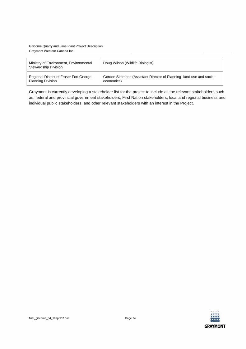
Ministry of Environment, EnvironmentalStewardship Division
Doug Wilson (Wildlife Biologist)
Regional District of Fraser Fort George,Planning Division
Gordon Simmons (Assistant Director of Planning- land use and socio-economics)
Graymont is currently developing a stakeholder list for the project to include all the relevant stakeholders such
as: federal and provincial government stakeholders, First Nation stakeholders, local and regional business and
individual public stakeholders, and other relevant stakeholders with an interest in the Project.
Giscome Quarry and Lime Plant Project Description
Graymont Western Canada Inc.
final_giscome_pd_18april07.doc Page 25
9. REGULATORY FRAMEWORK AND PERMITTING
Federal permits may be required for the Project. Three possible federal triggers are outlined in the Table 2
below.
Table 2: Possible Federal CEAA Triggers
Federal Agency and Regulatory Act Possible Regulatory Trigger
Canada Transportation Agency –
Canada Transportation Act
There will be construction of a rail spur off Canadian National Railway.
Proposed lime plant site is on former CNR land where a rail spur
previously existed. The former embankment still remains in place and
Graymont is proposing to rebuild the rail spur on this embankment.
Fisheries and Ocean Canada –
Fisheries Act
Proposed plant site will be located on the south side of Bateman Creek
mainstem, near its confluence with Eaglet Lake.
There are historic reports of both Chinook and rainbow trout in Bateman
Creek, and of burbot, largescale and longnose sucker, rainbow trout,
mountain whitefish, dolly varden, northern pikeminnow, and a number of
forage fish species in Eaglet Lake.
No harmful alteration, disruption or destruction to fish and fish habitat is
anticipated during plant construction or normal operational conditions.
Natural Resources Canada -
Explosives Act
Ammonium Nitrate Fuel Oil explosives will be stored and blended in the
quarry area for down hole blasting.
Based on the current schedule for this project (Figure 7) the Environmental Impact Assessment will be submitted
to the BC Environmental Assessment Office in December 2007. Graymont will be in consultation with each of
the various regulatory agencies throughout the assessment program to ensure that permit applications will be
made at a concurrent time as the EIA submission, where appropriate. It is anticipated that permits will be
required under the following Provincial and Federal Acts:
Mines Act, (BC Ministry of Energy Mines and Petroleum Resources)
Environmental Management Act, (BC Ministry of Environment)
Water Act, (BC Ministry of Environment)
Forest Act, (BC Ministry of Forests)
Giscome Quarry and Lime Plant Project Description
Graymont Western Canada Inc.
final_giscome_pd_18april07.doc Page 26
Fisheries Act, (Department of Fisheries and Oceans)
Explosives Act, (Natural Resources Canada); and,
Canada Transportation Act, (Canada Transportation Agency).
The regulatory consultation process planned for 2007 will determine what other Act(s) may apply to the
development and operation of the Giscome Project and the list outlined above may be expanded.
Discussions with the Regional District of Fraser Fort-George (RDFFG) Planning department have indicated that
the proposed plant site is located within the Provincial Agricultural Land Reserve, while the proposed quarry site
is not. The Official Community Plan for Electoral Area F also designates the lands as agricultural in both the
plant and quarry site. Graymont will submit a series of applications to the RDFFG to re-designate the land to
heavy industry and to apply for a ‘non-farm’ use within the ALR. Some site specific zoning approval will also be
required. Graymont will also work with the appropriate agencies to secure Graymont’s tenure on the proposed
quarry site.
Giscome Quarry and Lime Plant Project Description
Graymont Western Canada Inc.
final_giscome_pd_18april07.doc Page 27
10. REFERENCES
Literature Cited
B.C. Ministry of Forests. 1991. Ecosystems of British Columbia. Special Report Series. Victoria, BC.
Demarchi D.A. 1992b. Ecoregions of British Columbia. Second Edition. British Columbia Wildlife Branch,
Ministry of Environment, Lands and Parks, Victoria BC Map (1:2,000,000).
Green, D.M. and R. W. Campbell. 1992. The amphibians of British Columbia. British Columbia Provincial
Museum. Victoria, British Columbia.
Gregory, P.T. and R. W. Campbell. 1987. The reptiles of British Columbia. British Columbia Provincial
Museum. Victoria, British Columbia.
Griffith, R.P., 1984. Reconnaissance Report: Spawning Habitat Improvement in Bateman Creek, Tributary to
Eaglet Lake, Report Number FRN255. BC Ministry of Environment. www.env.gov.bc.ca/cgi-
bin/apps/faw/searchresult.cgi?series=Fisheries %20Report
Hamilton, A.N.. D.C. Heard, and M.A. Austin, 2004. British Columbia Grizzly Bear (Ursus arctos) Population
Estimate. B.C. Ministry of Water, Land and Air Protection, Victoria, BC. 7pp.
Klinkenberg, Brian (Editor). 2006. E-Fauna BC: Electronic Atlas of the Fauna of British Columbia.
[www.efauna.bc.ca]. Lab for Advanced Spatial Analysis, Department of Geography, University of
British Columbia, Vancouver. Accessed March 13, 2007.
Ministry of Environment, 2006. Environmental Protection Division, Omenica and Peace Regions, Prince George
BC, 2004 Annual air quality report for Prince George, July 2006.
Personal Communications
Wilson, Doug. Wildlife Biologist. Ministry of Environment, Environmental Stewardship Division. Prince George,
B.C. E-mail: Feb 22, 2007.
Giscome Quarry and Lime Plant Project Description
Graymont Western Canada Inc.
final_giscome_pd_18april07.doc Page 28
Internet Sites
BC Conservation Data Centre: Conservation Data Centre Mapping Service [web application] (B.C. CDC). 2006.
Victoria, British Columbia, Canada, March 13. Available: http://maps.gov.bc.ca/imf50/imf.jsp?site=cdc.
Committee on the Status of Endangered Wildlife in Canada (COSEWIC). 2006. COSEWIC Status Assessments,
April 2006. www.cosewic.gc.ca/eng/sct5/index_e.cfm.
Environment Canada, 2007. Canadian Climate Normals 1971 – 2000, at website
http://www.climate.weatheroffice.ec.gc.ca/climate_normals/index_e.html
MOE, 2007a. Water Licenses Web Query. Water Stewardship Division, BC Ministry of Environment.
www.elp.gov.bc.ca:8000/pls/wtrwhse/water_licences.input
MOE, 2007b. Water Quality Guidelines (Criteria) Reports, Guideline Executive Summaries. Environmental
Protection Division, BC Ministry of Environment. www.env.gov.bc.ca/wat/wq/wq_guidelines.html#working
Species at Risk Act. (SARA) 2006. Species at Risk Act Public Registry: Species List, October 2006.
http://www.sararegistry.gc.ca/species/default_e.cfm.