Embed Size (px)
Citation preview
GISMO Airborne Experiment Planning
Proposed Greenland 2006 Campaign
WFF Meeting Feb. 2006
GISMO TeamK.Jezek, E. Rodriguez, P. Gogineni, J. Curlander, X. Wu, J. Sonntag, W. Krabill, P. Kanagaratnam, C.Allen, A. Freeman. T. AkinsD. MacAyeal, R. Forster, S. Tulazek, M. Fahnestock, S. Clifford

Meeting Objectives
• Review Project Goals• Objectives for Airborne Experiment• Aircraft Configuration• Airborne Experiment Design• Navigation and location• Proposed flight lines• Schedule• Flight Planning Guidance and Milestones• Costs

GISMO Project Summary

Glaciers and Ice Sheets ‘Grand Challenges’
• Understand the polar ice sheets sufficiently to predict their response to global climate change and their contribution global sea level rise
•What is the mass balance of the polar ice sheets?
•How will the mass balance change in the future?

National Geographic Magazine
GISMO Vision
Build an instrument that images the hidden continental land masses beneath the Antarctic and Greenland Ice
Sheets. Demonstrate this technology on Earth and apply it to icy bodies in the outer solar system

Primary Challenges
• Separate basal return from surface clutter
• Investigate spatial variation in strength of basal reflectivity
Surface Clutter
Weak EchoesStrong Attenuation

Objective
Key Milestones
TRLin =3
Approach
Develop and test radars and algorithms for imaging the base of the polar ice sheets
• Investigate interferometric and tomographic clutter rejection and basal imaging methods
- 3-d topography of the glacial bed- Images of subglacial conditions
• Develop multiphase center P-band and VHF radars
- Capable of sounding 5 km of ice- Single and repeat pass interferometric
operation• Assess the requirements for extension to
continental scale campaigns
PI: Prof. Kenneth C. Jezek, The Ohio State University
Global Ice Sheet Interferometric Radar (GISIR)
• Use available topography data to simulate interferograms for testing the InSAR and tomographic concepts.
• Modify the SAR simulator to include operating characteristics of several aircraft and several radar designs
• Develop UHF and VHF radars and antenna systems• Test methodology by collecting data over the Greenland
and Antarctic ice sheets• Algorithm validation and sensitivity assessment.
Co-Is: E. Rodriguez, JPL; P. Gogineni, U. Kansas; J. Curlander, Vexcel Corp.; John Sonntag, EG&G; C. Allen, U. Kansas; P. Kanagaratnam, U. Kansas
1/ 06 Phase History Simulations and Algorithm Testing
9/06 Radar and Antenna Development
11/06 First flight test in Greenland
7/06 InSAR and tomography algorithm refinement
11/07 Second flight test in Antarctica
7/08 Algorithm and methodology assessment
8/08 Requirements doc. for continental scale imaging
http://esto.nasa.gov
Repeat passtomography
Filtered basalinferogram
InSAR Concept
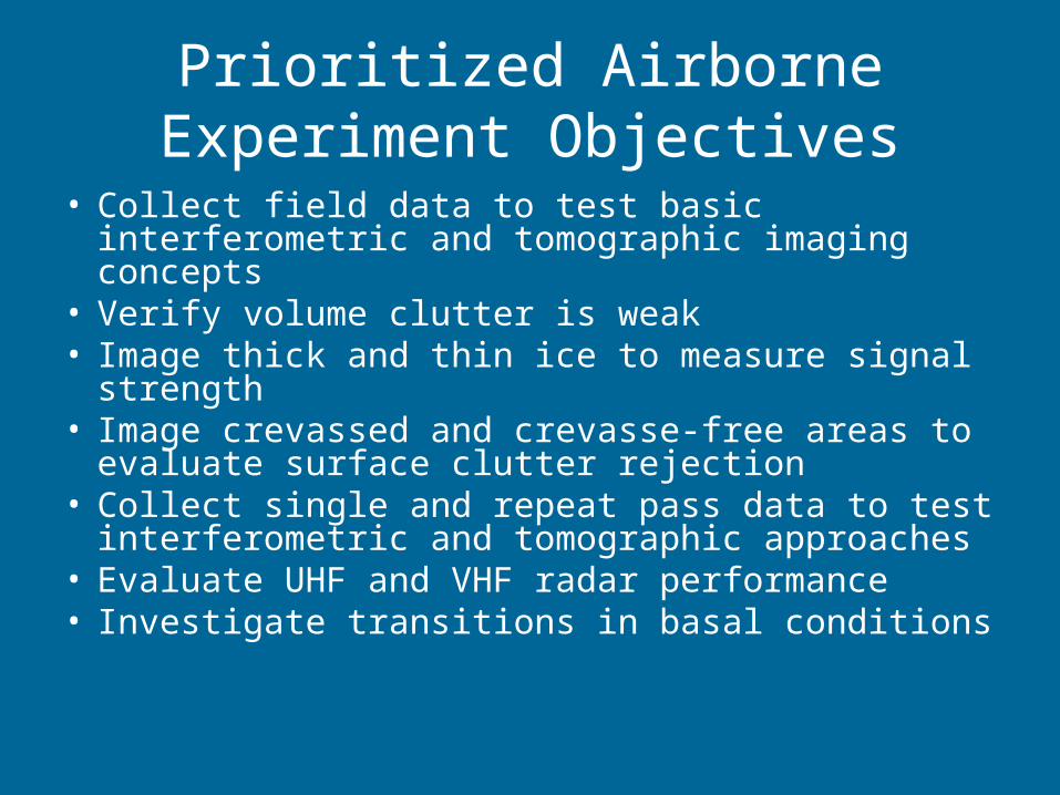
Prioritized Airborne Experiment Objectives
• Collect field data to test basic interferometric and tomographic imaging concepts
• Verify volume clutter is weak• Image thick and thin ice to measure signal
strength• Image crevassed and crevasse-free areas to
evaluate surface clutter rejection• Collect single and repeat pass data to test
interferometric and tomographic approaches• Evaluate UHF and VHF radar performance• Investigate transitions in basal conditions
Aircraft Configuration

Airborne Radar Depth Sounder: Rely on Design Heritage
Alo
ng-t
rack
(m
)
Cross-track (m)
150 MHz, HH, Greenland (Pass 1)
600 800 1000 1200
500
1000
1500
2000
2500
Cross-track (m)
150 MHz, HH, Greenland (Pass 2)
600 800 1000 1200
Rel
ativ
e P
ower
(dB
)
-18
-16
-14
-12
-10
-8
-6
-4
-2
0
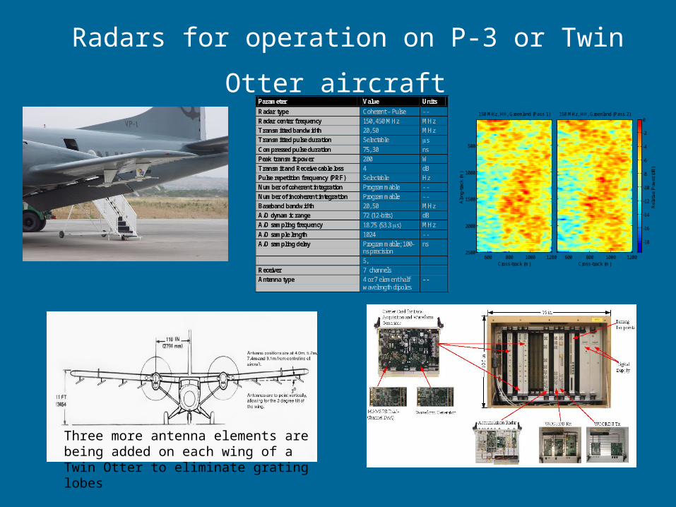
Radars for operation on P-3 or Twin Otter
aircraft
Three more antenna elements are being added on each wing of a Twin Otter to eliminate grating lobes
P-3 Modifications
• Multiple conductors to antenna array (one conductor used in past experiments)
• Additional antenna elements beneath wings
• Additional element in the tail
• GPS and Inertial navigation information on aircraft position and attitude

Cable Spec’s
SMA (2x) onBPE240, bundledWith polyolefin jacket

Airborne Experiment Design

Single Pass InterferometryMaximize altitudeMaximize antenna array separation
6 km swath
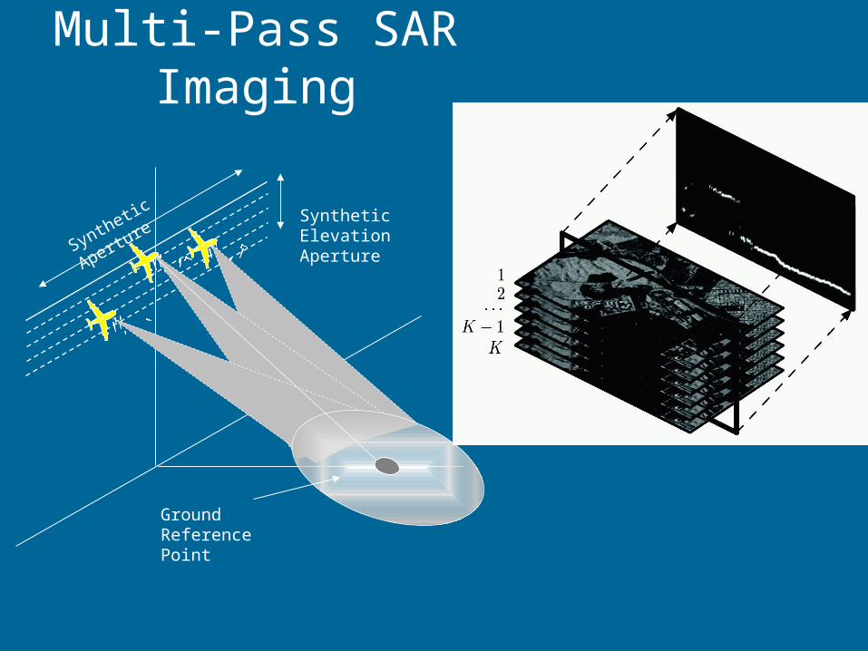
Multi-Pass SAR Imaging
Synthetic Elevation Aperture
Ground Reference Point
Synthetic Aperture

Constraints on Flight Operations
• Fly at maximum allowable altitude• Limit flight duration to allow for daily data Q/A and
experiment modifications (about 6 hours assuming 150 Gb/hour and 3, 300 Gb disks)
• Allow enough field time to repeat flight lines• Fly over high and low clutter areas• Fly over areas where some information on basal
properties is known• VHF and UHF radars cannot operate simultaneously –
P-band outbound; VHF inbound along same track to within 30 m
• Schedule 2 to 4 repeat flights at 30 horizontal offsets for tomography

Aircraft NavigationExpected Performance
• 20 m ground track repeatability
• 0.02 degree post flight knowledge on aircraft roll and pitch
• 1 degree post flight knowledge on yaw

Proposed Flight Lines

Sonde to Summit
• 780 km outbound• 3-4 hours total• 100 m to 3000 m thick ice• Known basal scattering
characteristics around summit• PARCA data available

Clutter Test and Ocean Cal
• 490 Km outbound (about 2 hours)• Clutter obscures bottom echo for nadir sounder• Ice edge to 1000 m thick ice
X’
X
X’ X
a
b
b
a
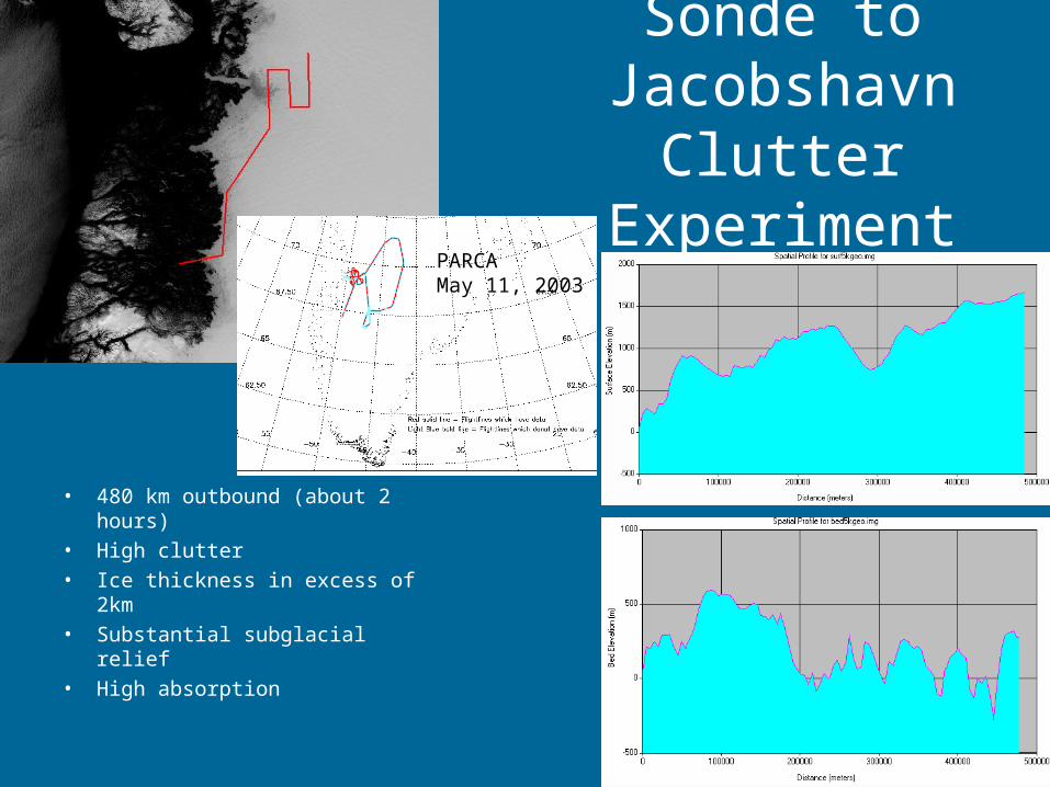
Sonde to Jacobshavn Clutter
Experiment
• 480 km outbound (about 2 hours)
• High clutter• Ice thickness in excess of
2km• Substantial subglacial relief• High absorption
PARCAMay 11, 2003

Schedule
• May/June Twin Otter flights will provide crucial information for planning
• Optimized flight plan in July• Earliest flights in November 2006 (cold surface;
timely data available for analysis; high project costs)
• Latest flights in May 2007 (partner with WFF planned activity; complementary science data; shared costs and personnel time; warm surface; late data)

Beyond 2007
• IPY Proposal for second set of flights
• Flights in 2007/08 to address technology issues uncovered in 2006 and to focus on detecting transitions in basal conditions

Additional topics
• Status of P-3• Condition of existing antenna arrays• Flight Planning and Costing Guidance• WFF Milestones• Efficient planning (flight duration vs number of
flights vs down time to check data)• Refine flight lines based on previous PARCA
flight lines• GISMO information posted at www-bprc.mps.ohio-state.edu/rsl/gismo/
![Reconstruction of Alpine Digital Elevation Models From ... · dimensional cylindrical coordinate system of the radar. As described by (Curlander [8], Bolter [4], Schreier [48], Kropatsch](https://img.pdfslide.net/doc/110x75/5fd511ac43102156cb037a04/reconstruction-of-alpine-digital-elevation-models-from-dimensional-cylindrical.jpg)