Embed Size (px)
Citation preview
Snow and Glacier Hydrology (Proceedings of the Kathmandu Symposium, November 1992). IAHSPubl. no. 218,1993. 3 1 9
Glacier Lakes and Outburst Floods In the Nepal Himalaya
T. YAMABA1 & C. K. SHARMA2
1 The Institute of Low Temperature Science, Hokkaido University, Sapporo 060, Japan 2 Royal Nepal Academy of Science and Technology, PO Box 3323, Kathmandu, Nepal
Abstract Severe floods caused by glacier outburst have been frequent in the Nepal Himalayas, occurring more than every three years over the approximately thirty years since the 1960s. Nine potentially dangerous glaciers were identified from flight observations which were carried out in the Eastern and Central Nepal Himalayas on pre- and post-monsoon seasons in 1991. Field surveys were made at the beginning of April, 1992 to Imja Glacier lake located in Khumbu district of Eastern Nepal. This is one of the most dangerous typical glacier lakes that were identified by the flight observations. The field surveys revealed the maximum depth of the lake to be 98.5 m and the total amount of stored water to be 28 million m3. Since this lake is dammed up by ice-cored moraine it is concluded as one of the most dangerous glacier lakes in the Himalayas.
INTRODUCTION
Most of the perennial rivers in Nepal originate from the high Himalayas and they are fed in large amounts by meltwater of snow and glacier ice. Snow and glaciers are important water resources in Nepal. While liquid precipitation (rain) is directly discharged through a river in a relatively short period, solid precipitation (snow) accumulates on the ground and melts gradually. The meltwater from snow and ice contribute significantly to the sustained base flow of mountain areas throughout the dry period of the year. The sustained base flow is important for water resources planning and management.
However, the glacier-fed river has one serious problem, the potential flood that may be caused by an outburst of a glacier lake. A glacier lake outburst flood (GLOF) is one of the major natural hazards in Nepal. Most of the glacier lakes in Nepal Himalayas are embanked by a moraine formed in the previous neo-glaciation period. The moraine dam structure is often not consolidated and unstable. The breach of a moraine dam and the catastrophic outflow of the lake creates serious problems for the infrastructure, in addition to the inhabitants in the downstream areas. Therefore, GLOF-control is especially important for the development of water resources in Nepal. In order to control the hazard, one
320 T. Yamada & C. K. Sharma
has to first get enough information and knowledge on a glacier lake in the Himalayas. Very little, however, is known.
Since the basic information such as location, number and type of glacier lakes in Nepal Himalayas still remains incomplete, a flight observation of glacier lakes and their mother glaciers was carried out on a reconnaissance basis in 1991 (Yamada, 1991). As a result of the observation, potentially dangerous glacier lakes were found at many places in the Himalayas. For obtaining detailed information of a glacier lake, Imja Glacier Lake in Khumbu district was chosen as one of the dangerous glacier lakes in the Nepal Himalayas. A site visit to the lake was made in the pre-monsoon season from the end of March to the beginning of April, 1992 (Yamada, 1992).
This paper describes some records of past GLOF hazards in Nepal, as well as the results of the flight observations and investigation of Imja Glacier Lake.
HAZAMD RECORDS OF GLACIER LAKE OUTBURST FLOOD IN NEPAL
The list shown below is a recent history of the flood hazards derived from the outbursts of glacier lakes compiled from various papers and reports prepared by previous investigators and engineers (Ives, 1986, Water and Energy Commission Secretariat, 1987 and Lanzhou Institute of Glaciology and Geocryology, Water and Energy Commission Secretariat and Nepal Electricity
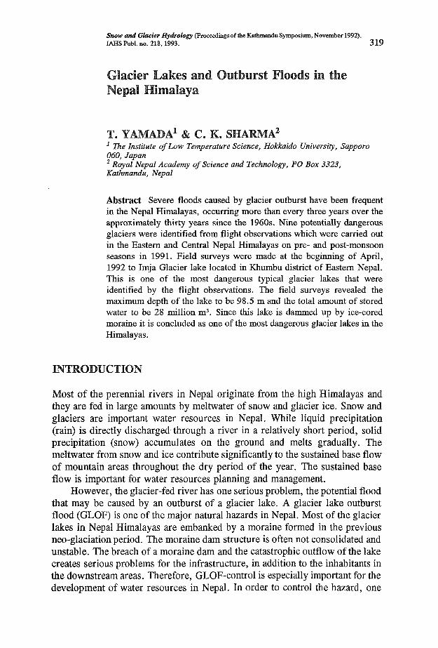
Fig. 1 Positions of the glacier lakes outbursts in the past in the Himalayas.
Glacier lakes and outburst floods in the Nepal Himalaya 321
Authority, 1988). The distribution of the outburst of lakes in the past is illustrated in Fig. 1. However, the records are only available for a part of Eastern and Central Nepal Himalayas, because no systematic inspection has been carried out yet for all over the Nepal Himalayas. Some more records may be added in this list if inspection will progress in the future.
Sapta Koshi river system
Tamur Khola 1. 1980 Phucan Glacier Lake. Water level rising 20 m. Including
heavy debris of big rocks etc. Damaging forest, river bed etc.
Arun River (Pumqu River in Tibet) 2. 21 September 1964
3,4,5. 1968,69,70
6. 27 August 1985
7. around 1964
Gelhaipco lake outburst. End moraine collapse due to glacier-fall into lake. Damaging road, 12 trucks etc. Ayico lake. GLOF occurred three times at the same glacier lake. Damaging road, bridges, etc. Jinco lake. Moraine collapse due to glacier sliding into lake. Damaging eight villages, livestock, cultivation field, roads, bridges, etc. GLOF noticed by local people along the Arun river. Timber, concrete block and parts of trucks flowing down. GLOF along the Barun Khola. Some traces of past GLOF on the river channel recognized from aerial survey.
Dudh Koshi River 9. 3 September 1977
10. 4 August 1985
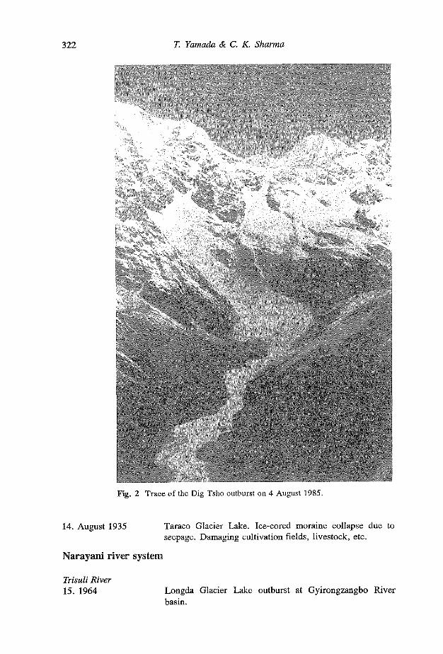
Nare Drangka Glacier Lake (South slope of Mt. Ama Dablam). Ice-cored moraine collapse. Damaging min-hydro plant, roads, bridges, cultivation fields, etc. Dig Tsho. Moraine collapse due to rock avalanche. Initial discharge of 2000 m3 s"1. Destroying Namche hydropower plant completely, damaging roads, bridges, cultivation fields, livestock, houses, inhabitants, etc. Fig. 2 shows the trace of the outburst.
Tama Koshi 11. Mid-July 1991 Chubung Lake outburst at the end of Ripimo Shar Glacier.
Damaging houses, cultivation field at Beding village.
Sun Koshi River (Poiqu River in Tibet) 12. 1964 Zhangzangbo Glacier Lake outburst. Moraine collapse due
to seepage. Water level rising 8 m. 13. 1981 The same lake above. Moraine collapse due to glacier
calving. Initial discharge of 16,000 m3/s. Damaging Arniko Highway, Friendship Bridge, Sun Koshi hydropower plant, cultivation fields, livestock, inhabitants, etc.
322 T. Yamada & C. K. Sharma
Fig. 2 Trace of the Dig Tsho outburst on 4 August 1985.
14. August 1935 Taraco Glacier Lake. Ice-cored moraine collapse due to seepage. Damaging cultivation fields, livestock, etc.
Narayani river system
Trisuli River 15. 1964 Longda Glacier Lake outburst at Gyirongzangbo River
basin.
Glacier lakes and outburst floods in the Nepal Himalaya 323
Seti Khola 16. 450 years ago Outburst of a glacier lake with the area of 10 km2 located
behind Machhapuchhare. Ice-cored moraine collapse. 50-60 m thick debris covering Pokhara basin.
Except for records 8, 14 and 16, the data of outburst lakes listed were obtained after 1960. The older records may be incomplete for several reasons, the information may be lost from the memory of the inhabitants and also from the natural features in a river bed. But in the thirty years since 1960, thirteen GLOFs were counted, which is a very high frequency when compared with other natural hazards. GLOF in Nepal Himalayas happened more than once per every three years.
AERIAL OBSERVATION OF GLACIER LAKES IN THE NEPAL HIMALAYAS
Since it is very difficult to gain access to glacier areas in the high Himalayan mountains, a flight observation was planned in the Eastern and Central parts of the Nepal Himalayas as the most effective measure. The aims of the flight observations were to inspect and to identify potentially dangerous glacier lakes and to record features of the mother glaciers and topographical condition in the vicinity of the lakes.
Area of flight observations
The flights were made in the Langtang Khola basin on 22 April 1991, and in Barun Khola basin, a tributary of Aran River, and Dudh Koshi basins including Honku and Hinku River basins on 25 April and in Chilime Khola basin, tributary of Trisuli River, and Marsyangdi River basins on 5 May. The glacier lakes identified did not include all of the lakes that may have been found in the above basins. The observations were limited because of the flight pattern taken through the basins and the cloudy condition during part of the flight course.
Evaluation of dangerous glacier lakes
The flight observation produced one set of oblique photos of glacier lakes and their mother glaciers along the flight courses. Using these photos the potentially dangerous glacier lakes are identified by consideration of the following points: (a) dam material condition, (b) size of the lake, (c) topographical features in the vicinity of the lake.
324 T. Yamada & C. K. Sharma
If the dam material is composed of loose moraine, the dam may be easily broken. The degree of solidification of a dam is determined by evaluating whether it is fresh or not by means of the vegetation cover on it and its colour.
Glacier lakes are often dammed by ice-cored moraines. As the ice-core gradually melts, the dam decreases in its level and is weakened. Ice-cored dams are evaluated by the features of an end moraine.
A large amount of stored water in a glacier lake poses an extremely serious hazard. Therefore, ground surveys have to be carried out in the future for measuring the depth of a lake. At present only the area of a lake is employed as an evaluation criteria of hazardous glacier lakes.
A glacier lake surrounded by steep slope(s) has a chance to incur snow, ice and rock avalanches into the lake. If the glacier has a cliff in the terminus and it contacts with the lake, the carving and sliding of the glacier will help trigger the dam burst.
Dangerous glacier lakes in the Nepal Himalayas
The identified dangerous glacier lakes are listed as follows. All the lakes were formed in the terminus of their mother glaciers and are dammed by lateral and end moraines.
Barun Khola drainage basin, a tributary of the Arun River 1. Lower Barun Glacier lake dammed by ice-cored moraine on the terminus of
Lower Barun Glacier, which is located in the upper reach of the Barun Khola. The glacier lake contacts with cliff shaped glacier end, which is stagnant and covered with thick debris.
Because of heavy cloud and dangerous turbulence during the flight, only two glaciers, namely Barun glacier lake and Lower Barun glacier lake, were observed in the Barun Khola (river) drainage basin.
Dudh Koshi drainage basin 2. Chamlang Tsho and three nameless glacier lakes formed on the terminus of both
nameless glaciers flowing down from the mountains in the left bank side of the Hunku river, a tributary of the Dudh Koshi. Both the lakes are now separated from the mother glaciers.
4. Nameless. The biggest one among the four glacier lakes formed in front of Naulekh Glacier located in the right bank side of the Hunku River. The lake is separated from the glacier.
Because of cloud and turbulence, the flight was made only partially along the Hunku River. Though 14 glacier lakes were visible in the basin, 10 glacier lakes were taken in photos. Panchi Pokhari glacier lakes in the uppermost reach of the Hunku River were fully covered by thick snow, and were thus quite difficult to evaluate.
5. Sabai Tsho formed on the terminus of Sabai Glacier in the upper reach of the Hinku River, a tributary of the Dudh Koshi. The very steep mother glacier approaches the lake.
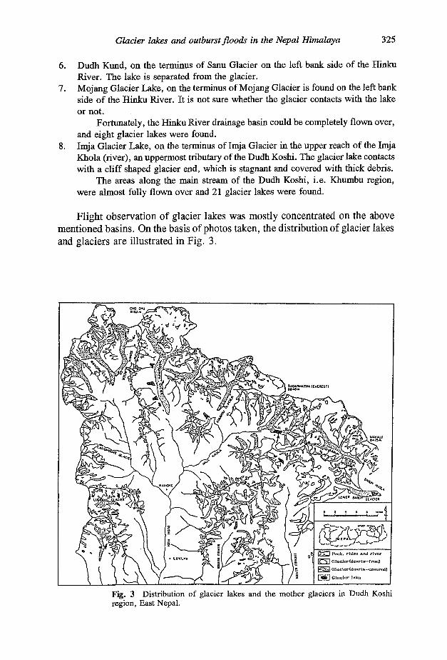
Glacier lakes and outburst floods in the Nepal Himalaya 325
6. Dudh Kund, on the terminus of Sanu Glacier on the left bank side of the Hinku River. The lake is separated from the glacier.
7. Mojang Glacier Lake, on the terminus of Mojang Glacier is found on the left bank side of the Hinku River. It is not sure whether the glacier contacts with the lake or not.
Fortunately, the Hinku River drainage basin could be completely flown over, and eight glacier lakes were found.
8. Imja Glacier Lake, on the terminus of Imja Glacier in the upper reach of the Imja Khola (river), an uppermost tributary of the Dudh Koshi. The glacier lake contacts with a cliff shaped glacier end, which is stagnant and covered with thick debris.
The areas along the main stream of the Dudh Koshi, i.e. Khumbu region, were almost fully flown over and 21 glacier lakes were found.
Flight observation of glacier lakes was mostly concentrated on the above mentioned basins. On the basis of photos taken, the distribution of glacier lakes and glaciers are illustrated in Fig. 3.
Fig. 3 Distribution of glacier lakes and the mother glaciers in Dudh Koshi region, East Nepal.
326 T. Yamada & C. K. Sharma
Tama Khola drainage basin 9. Tsho Rolpa, is found on the terminus of Trambau Glacier in the upper reach of
the Tama Khola (Rolwaling Chhu). The glacier lake contacts with a cliff shaped glacier end, which is stagnant and covered with thick debris.
As for the Tama Kosbi drainage basin, no full observation was made. More lakes may be added in the future for inspection.
Marsyangdi Khola drainage basin 10. Thulagi Glacier Lake, is situated on the terminus of Thulagi Glacier at the
Southwest end of Mt. Manaslu. The glacier lake contacts with a cliff shaped glacier end, which is stagnant and covered with thick debris.
The basin was also only partially flown over, covering areas in the Southern portions of Mt. Manaslu and extending to the uppermost reach of the Marsyangdi River. Further inspection will be necessary in the future.
In addition to the above drainage basins, the full area of Langtang Khola drainage basin and partial areas of the Chilime Khloa drainage basin were observed. Both the rivers are tributaries of the Trisuli River. Due to very poor development of glacier lakes in these regions, there were no dangerous lakes identified.
INVESTIGATION OF IMJA GLACIER LAKE
Imja Glacier Lake in the Khumbu region is located at the uppermost reach of the Imja Khola (as shown by the arrow in Fig. 3). It was chosen as a typical dangerous glacier lake for obtaining detailed information on these lakes. The observation was carried out from 1 to 5 April 1992.
General features of Imja Glacier Lake
As we expected, the lake was covered by thick ice. Being as the ice measured 50 cm, this was found to be safe enough to walk on around the lake.
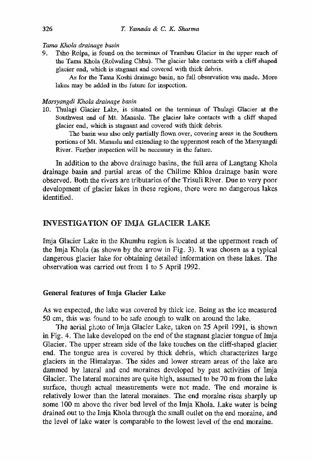
The aerial photo of Imja Glacier Lake, taken on 25 April 1991, is shown in Fig. 4. The lake developed on the end of the stagnant glacier tongue of Imja Glacier. The upper stream side of the lake touches on the cliff-shaped glacier end. The tongue area is covered by thick debris, which characterizes large glaciers in the Himalayas. The sides and lower stream areas of the lake are dammed by lateral and end moraines developed by past activities of Imja Glacier. The lateral moraines are quite high, assumed to be 70 m from the lake surface, though actual measurements were not made. The end moraine is relatively lower than the lateral moraines. The end moraine rises sharply up some 100 m above the river bed level of the Imja Khola. Lake water is being drained out to the Imja Khola through the small outlet on the end moraine, and the level of lake water is comparable to the lowest level of the end moraine.
Glacier lakes and outburst floods in the Nepal Himalaya 327
Fig. 4 Aerial photo of Imja Glacier Lake taken on 22 April 1991.
The end moraine still includes glacier ice, that is, an ice-cored moraine. This is easily recognized by several characteristics: the existence of many outcrops of bare ice, numerous ponds formed by the meltwater of an ice body buried under the moraine, and traces of ponds previously formed and drained out. The lateral and end moraines are quite fresh and no vegetation cover is found on them. Furthermore, the moraine material is not cemented. The moraines may have been formed in the previous neo-glaciation period which occurred over the 15th to 19th centuries. During this period, Imja glacier surely advanced to the position of end moraine with the thickness up to the level of the top of the lateral moraines. The ice body under the end moraine is a fossil ice of Imja Glacier, which has remained without melting out due to the thick debris cover. This cover acts as a good heat insulator and results in a very low melting rate.
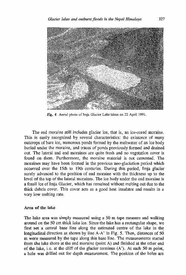
Area of the lake
The lake area was simply measured using a 50 m tape measure and walking around on the 50 cm thick lake ice. Since the lake has a rectangular shape, we first set a central base line along the estimated centre of the lake in the longitudinal direction as shown by line A-A' in Fig. 5. Then, distances of 50 m were measured by the tape along this base line. The measurements started from the lake shore at the end moraine (point A) and finished at the other end of the lake, i.e. at the cliff of the glacier terminus (A'). At each 50 m point, a hole was drilled out for depth measurement. The position of the holes are
328 T. Yamada & C. K. Sharma
Fig. 5 Depth contour map of Imja Glacier Lake. Solid circles show the measuring points of depth. The line A-A' and B-B' show the cross sections from Fig. 4.
shown by solid circles in Fig. 5. The longitudinal distance along the base line was measured as 1330 m with the error of less than 1 m.
The transversal distances of the lake were perpendicularly measured from some of the 50 m points on the base line to the right and left banks of the lateral moraines. It was very dangerous near both lateral moraines because stones were almost constantly falling down into the lake along the inner steep slopes of the moraines. Also near the right lateral moraine the lake ice had partially melted out and surface water was exposed along the moraine in the width of around 10-15 m. This was due to radiation from the steep moraine slope which faces South. The distance was visually estimated from the final measuring points to the banks of the lateral moraines. Therefore the latitudinal distance of the lake is less accurate than the longitudinal distance. The error is assumed to be around 30 m.
The area of the lake is estimated at 595 000 m2 (approximately 0.6 km2).
Depth of the lake
The depth of the lake was directly measured with an accuracy of within 10 cm. There were measurements taken at 61 points around the lake through holes using a fishing rod and a reel with 100 m long fishing thread.
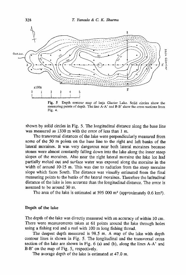
The deepest depth measured is 98.5 m. A map of the lake with depth contour lines is shown in Fig. 5. The longitudinal and the transversal cross section of the lake are shown in Fig. 6 (a) and (b), along the lines A-A' and B-B' on the map of Fig. 5, respectively.
The average depth of the lake is estimated at 47.0 m.
Glacier lakes and outburst floods in the Nepal Himalaya 329
Imja Glacier
Fig. 6 (a) Longitudinal and (b) transversal cross section of Imja Glacier Lake along the lines indicated A-A' and B-B' on the map of the lake in Fig. 3.
Volume of stored water
It is concluded that Imja Glacier Lake stores 27 965 000 m3 (about 28 x 106 m3) of water, which is derived from the lake area of 595 000 m2 and average depth of 47.0 m.
Conclusion
It is concluded that Imja Glacier Lake is one of the most dangerous glacier lakes in the Nepal Himalayas because of the huge amount of stored water, unstable ice-cored moraine and the relatively high density of population, including the many trekkers in the downstream area. This glacier lake has to be monitored constantly.
CONCLUDING REMARKS
According to the records of GLOF in the Nepal Himalayas, thirteen GLOFs happened in the thirty years since 1960. The records show that the average frequency is more than once every three years, which is quite high in comparison with other natural hazards such as a typhoon, a tsunami, etc. GLOF can be concluded to be a rather common natural hazard in the Nepal Himalayas.
The flight observation yielded sufficient information to identify dangerous glacier lakes, as expected. Ten potentially dangerous lakes were discovered in spite of the fairly limited areas in the basins which had been were planned to be observed. Further full scale flight observation over the entire Nepal Himalayas may yield more information on the hazardous lakes.
The maximum depth of Imja Glacier Lake was around 100 m. The end moraine of Imja Glacier is also about 100 m in height from the river bed level
330 T. Yamada & C. K. Sharma
of the Imja Khola (river), with lake water being discharged through a small outlet on the end moraine into the Imja Khola. This suggests that the depth of a glacier lake is comparable to the height of an end moraine. If thickness of a glacier was the same as the height of an end moraine, it is reasonable to say that the lake depth is comparable to the moraine height after all of the glacier ice melts away. The depth measurement was made for only one typical glacier lake. Further successive observations should be continued with other glacier lakes in the future to confirm the inferences mentioned above.
We strongly recommend that the planner and engineer have to pay careful attention to GLOF(s) to avoid unexpected hazard(s) for water resource development and construction of infrastructures in the high Himalayan regions in Nepal.
Acknowledgements The authors would like to express their hearty gratitude to Dr B. P. Upadhyay, Professor, Tribhuvan University, Mr. T. Shiraiwa and Mr. K. Ueno, the members of Glaciological Expedition of Nepal Himalayas (GEN), Mr. S. Yamashita and Ms. I. Okuda, the member of Japan Overseas Cooperation Volunteer (JOCV) in Nepal, Mr. A. Okamoto, Sabo Expert of Japan International Cooperation Agency (JICA) and Ms. M. Tachika, the manager of Hotel Everest View for their sincere technical help in aerial photography during flight observation in the cold, suffocating and turbulent condition. Thanks are due to Mr. Damodar Shrestha, Nepal Electricity Authority (NEA), for his useful assistance in the laborious field work at Imja Lake, and to Mr. B. R. Manandhar, Water and Energy Commission Secretariat (WECS), and Mr. M. Higa, the members of JOCV Nepal, for their cooperation in the preparation of the first research expedition to Imja Glacier Lake, and to Mr. J. P. Lama Sherpa, the president of the trekking agency, Guide for All Seasons, (Pvt) Ltd., for his useful logistical support.
REFERENCES
Ives, J. D. (1986) Glacier lake outburst floods and risk engineering in the Himalayas. ICIMOD Occasional Paper No. 5.
Water and Energy Commission Secretariat (1987) Preliminary study of glacier lake outburst floods in the Nepal Himalaya. Phase I Interim Report.
Lanzhou Institute of Glaciology and Geocryology, Water and Energy Commission Secretariat and Nepal Electricity Authority (1988) Report on first expedition to glaciers and glacier lakes in the Pumqu (Arun) and Poiqu (Bhote-Sun Koshi) river basins, Xizang (Tibet), China. Science Press, Beijing, China.
Yamada, T. (1991) Preliminary work report on glacier lake outburst flood in the Nepal Himalayas. WECS Report No.4/1/291191/1/1 Seq. No. 387.
Yamada, T. (1992) Report for the first research expedition to Imja Glacier Lake. WECS Report No. 3/4/120892/1/1 Seq. No. 412.