Embed Size (px)
Citation preview

I
I
!
I
GRANULAR RESOURCES RESEARCH:
SLAVE PROVINCE, N.W.T.
E
!
! e
Written By:
Stephen Harrison
August 23, 1994
Land Management Division
Department of Indian Affairs and Northern Development

GRANULAR RESOURCES RESEARCH:
SLAVE PROVINCE, N.W.T.
Written By:
Stephen Harrison
August 23, 1994
Land Management Division
Department of Indian Affairs and Northern Development

TABLE OF CONTENTS
Page
1.0 INTRODUCTION ................................................................................. 1
2.0 GEOLOGICAL HISTORY ...................................................................... 4
3.0 CURRENT DEVELOPMENT ACTIVITY IN THE SLAVE PROVINCE .. . ..... . . 9 4.0 RECENT DIAND GRANULAR RESEARCH ACTIVITIES ........................... 13
4.1 MOLLARD GRANULAR REPORTS ............................................... 13
4.2 YELLOWKNIFE DEPOSIT DATABASE ......................................... 14
4.3 REMOTE SENSING RESEARCH .................................................. 15
4.4 GNWT RENEWABLE RESOURCES ESKER STUDY ........................ 16
5.0 RECOMMENDATIONS AND CONCLUSIONS ........................................... 25
6.0 GLOSSARY ....................................................................................... 27
7.0 BIBLIOGRAPHY ................................................................................. 29
APPENDIX A: SAMPLE DESCRIPTION SHEETS
1

LIST OF MAPS AND FIGURES
Page
MAP 1 .1 . LAC DE GRAS REGION ............................................................ 3
MAP 2.1 - SLAVE GEOLOGICAL PROVINCE .............................................. 5
FIGURE 2.1 - MODEL OF A KIMBERLITE PIPE ........................................... 6
FIGURE 2.2 - TYPICAL ESKER STRUCTURE .............................................. 8
MAP 3.1 . PROPOSED IZOK MINE AND HAUL ROAD ................................. 10
MAP 3.2 . STAKED PROPERTY IN THE REGION ........................................ 11
MAP 4.1 . ESKERS WITHIN THE STUDY AREA .......................................... 19
FIGURE 4.1 - SITE AND SAMPLE DESCRIPTION SHEET .............................. 23
ii

INTRODUCTION
Over the past several years, several large scale mining projects have been proposed for the
Slave Geological Province in the Northwest Territories 0. In addition to currently
operating mines such as Echo Bay's Lupin, Metall Mining Corporation has proposed a base
metal mine situated at Izok Lake. As well, BHP Minerals and several other mining firms are
in various stages of exploration or development of diamond mines in the Lac de Gras region.
in the region, there also comes greater need for
granular e projects will require granular materials for all-
weatherhinter roads, landing strips, building pads, containment facilities, etc.) Other than
preliminary airphoto analysis, very little research has been conducted on the availability of
granular materials within this remote northern district. With development in the region still
in its infancy, the opportunity presents itself to conduct several predevelopment initiatives.
These include regional granular material surveys, encouraging the proper use of this valuable
and all-@-scarce resource, and cooperating with other levels of the government, and private
industry to ensure that all patties concerned act based on facts and understood ideas.
In response to the recent mining activity in the Slave region and the need to understand the
relationship between increased development and the impact it will have on the regional
ecosystem, the Government of the Northwest Territories (GNWT) Department of Renewable
Resources has, with funding from the Department of Indian Affairs and Northern
Development (DIAND), established a monitoring station/field camp in the region. The

2
research station is located on Daring Lake, near the southwest corner of Yamba Lake as
shown in map 1 . 1 , One GNWT Renewable Resources study hopes to discover the
relationship between mammal denning practices and the granular composition of eskers.
During the summer of 1994, the Northern Granular Resources Program of DIAND was
invited to take part in the initial phase of this research project covering an area roughly
defined by 1 :250 OOO series NTS mapsheets 76D and 86A.
This report summarizes the geological history of the Slave Geological Province, examines the
current exploration and mining activities taking place within the region and DIAND's recent
activities with respect to the compilation of information on granular materials in the Slave
Province; reports on the field work conducted from the field camp at Daring Lake; and
makes several recommendations regarding future DIAND Granular Resources Program
activities in the Slave Province.

3
3

4
2.0 GEOLOGICAL HISTORY
The Slave Geological Province is an area of the Canadian Shield that runs from Great Slave
Lake to Coronation Gulf in the Arctic Ocean (see map 2.1). This area of the shield formed
1.8 - 2.8 billion years ago during the Kenoran and Hudsonian orogenies. During these
orogenies, or periods of mountain formation, the parent rock was extensively folded, faulted,
and thrust up. Most of the Slave Province is underlain by granitic' rocks consisting of
migmatide, mixed gneiss, banded gneiss, and granitic gneiss.
Approximately 50 - 100 million years ago, long after the formation of the Canadian Shield,
magmatic intrusions into the parent rock occurred. These intrusions are known as kimberlite
pipes. Kimberlite is an igneous rock that typically occurs in cone shaped vertical structures
(see figure 2.1). They can also rarely form in the shape of dykes and sills. The texture is
inequigranular with large clasts in a fine grained matrix. The clasts are fern-magnesian
minerals such as olivine, phlogopite, and clino- and orthopymxenes. The matrix consists
mostly of olivine with small amounts of phlogopite, calcite serpentine,monticellite, apatite,
spinel, and ilmenite. Kimberlite may contain diamonds, but only as a very rare component.
The last period of glaciation in the region, the Wisconsin, began approximately 100 000
years ago and lasted for almost 90 000 years. During this time, the landscape was severely
'Definitions for all bold italicized terms can be found in 6.0 GLOSSARY

MAP 2.1 - SLAVE GEOLOGICAL PROVINCE 5
102'
km 200 O-

FIGURE 2.1 - MODEL OF A KIMBERLITE PIPE 6

7
scoured. When the glaciers finally did begin to retreat, the resulting sediment-laden
meltwater streams formed a whole series of landforms such as eskers, drumlins,and drift
deposits, Aylsworth and Shilts (1989) described the study arm as consisting of two zones.
In the first zone, "a well developed dendritic esker system passes across a till-covered terrain
which is commonly drumlinized, but includes only rare occurrences of ribbed moraine." The
second zone "comprises extensive arm of nearly drift-free ice-moulded bedrock with
virtually no esker development. " Field observation during the study suggests that most of
the area has a well developed esker system with extensive areas of drift-free bedrock.
Eskers, numerous in the Lac de Gras study region, are long snake-like ridges composed of
glacial meltwater sediment. They can run for several kilometres, be 40-50 metres in height,
and 500-600 metres in width. Most of the eskers within the study region are narrower and
of less height, but do run for several kilometres in length. Eskers occur generally aligned
parallel to the direction of ice flow. In the study region, they trend southeast-northwest.
Branching is quite common. The grain size is highly variable and can range from sandy silt
to coarse gravel to boulders within the same deposit. Figure 2.2 shows the typical structure
of an esker deposit with its sinusoidal form and highly variable composition.

I I I I I 1 I I I I I I I I I I I I I
FIGURE 2.2 - TYPICAL ESKER STRUCTURE
--.* 0
Coarse gravel (particle diameter 20-6mm)
Fine gravel (6-2mm) '* , Dy **be.. .
f-"?j ....* ......... . . . . . ...-. . . . . I . Coarse sand (2-0-6mm)
... _..... Medium to fine sand ..... -,. ...' ..' (0.6-0-06mm)
a

9
3.0 CURRENT DEVELOPMENT ACTIVITY IN THE SLAVE PROVINCE
Besides the currently operating Lupin gold mine on Contwoyto Lake (see map 3. l), several
other projects are in various stages of development. Although currently on hold, Metall
Mining Corporation has proposed an open pit base metal mine to be developed in the Izok
Lake basin. Map.3.1 shows the location of the mine and winter haul road that has been
proposed to haul concentrate north from the mine site to a port facility on Coronation Gulf.
Metall officials estimate that approximately 2.8 million cubic metres of granular material will
be required for the winter road (EBA, 1993). An all-weather road from Yellowknife to the
mine site has also been suggested. This would require even greater amounts of granular
material.
BHP Minerals Canada Ltd. (BHP) is in the process of developing their NWT Diamonds
project. BHP hopes to open North America's first diamond mine located just north of Lac
de Gras (see map 3.2). The development plan currently consists of mining 3 different
diamondiferous kimberlite pipes. The pipes, named "Koala", "FOX" and "Leslie" are all
located under small lakes that BHP has designated by the same name. After draining the
lakes, mining will first proceed by open pit and then be followed by underground
development.
As shown in map 3.2, severaI other mining companies are in various stages of exploration or
development of diamond mines. These companies include Monopros, Lytton Minerals,
Kennicott, DHK and several others. To date, approximately 28 potentially diamond
producing pipes have been identified.

"
VJ
E 0 F
D
IO
1

MAP 3.2 - STAKED PROPERTY JN THE REGION "
651
64N
n i o 20 30 40 50
KM
n Diamond Discoveries
Dykes Staked Property
LL
i

12
Considering the BHP developments alone, the granular material requirements are extensive.
Currently under consideration is an all-weather haul road linking BHP’s mine site to the
Lupin winter road and an airstrip suitable for use by Hercules aircraft and boeing 737 jets.
Granular materials will also be required for use in containment facilities, settling ponds,
building pads, etc. Preliminary studies are being conducted on a possible all-weather
corridor from Yellowknife to Bathurst Inlet. This road could serve the Lupin mine, the
proposed Izok mine, the diamond projects, and would make viable many other potential
mining operations. In the future, it is conceivable that the need will arise for increased
power generation being supplied by hydroelectric facilities. This will require additional large
amounts of granular material.

13
4.0 RECENT DIAND GRANULAR RESEARCH activities
In order to be prepared for the currently-under-way and future developments taking place
within the Slave Province, DIAND's Land Management Division in Hull, Quebec has
initiated a series of small research projects focusing on granular resources. These projects
include:
1. the preparation of a series of reports by J.D. Mollard and Associates (Mollard) on
granular resources in the central arctic,
2. the compilation of granular reports by Mollard and others into a computerized
deposit database,
3. preliminary research into the detection of granular deposits using remote sensing
techniques and
4. the participation of DIAND in a GNWT Renewable Resources study hoping to
determine the relationship between mammal denning practices and the granular
composition of eskers.
4.1 mollard GRANULAR REPORTS
Under contract from DIAND, Mollard has conducted an airphoto-based study of potential
granular sources within the Izok Corridor. This corridor represents a series of possible
transportation routes between Yellowknife, the proposed Izok mine sitqand a shipping

14
facility on Coronation Gulf. Mollard (1993) identifies almost 900 potential sources of
granular materials within 18 1:250 OOO series NTS mapsheets. The information within the
study consists of deposit location, landform typeJ and an airphoto-based volume estimate. In
1994, a new contract was issued to Mollard to extend the preliminary airphoto-based
mapping of granular deposits east of Bathurst Inlet (an additional 20 1 :250 O00 NTS
mapsheets) including the Lac de Gras region. This report should be available in the Fall of
1994.
4.2 YELLOWKNIFE DEPOSIT DATABASE
As part of the Northern Granular Resources Inventory program, a Yellowknife District
deposit database has been initiated. This database is similar to those that have been set up
for many districts within the Yukon as well as the Inuvik and Fort Smith Districts within the
NWT. These deposit databases contain information on deposit location, status, past use, lab
results, etc. Based on two consultants reports (Mollard,1993 and EBA 1993), the
Yellowknife District database currently contains almost 900 occurrences. A series of maps
showing the locations of each of these deposits have been produced using the desktop
mapping system "QUIKMAP" for "Windows". As well, the proposed winter haul road
linking Metall's Izok mine to Coronation Gulf has been digitized onto these maps.

15
4.3 REMOTE SENSING RESEARCH
One problem with conducting studies of granular resources in the North is the vastness of the
area. Performing detailed granular investigations is a very costly undertaking. a effective
and cost-efficient way of searching would be a very useful tool. To this end, a literature
review was conducted into the use of remote sensing to l o c a t e granular resources.
Some research has been conducted in California by the Naval Civil Engineering Laboratory
in the United States into the use of vegetation to discriminate parent material for use as
aggregate. Minor el al (1988) studied the use of thematic Mapper (TM) data to reveal
differences in alluvial sites caused by moisture stress on vegetation resulting from aggregate
size. Vegetation on well drained, coarse grained material tended to become prematurely
desiccated.
In Mollard (1985) the possibility of identification of sand and gravel deposits through the use
of high resolution Landsat TM imagery was explored. The report concludes that "the
principal advantage of using TM imagery is one of scale. Some 1200 contact airphotos must
be obtained in order to cover the same area shown by the four quadrants viewed in TM
imagery. " Considering the vastness of the North, the use of TM imagery seems ideally
suited.

16
4.4 GNWT RENEWABLE RESOURCES ESKER STUDY
Presently, very little data is available on the relationship between the denning practices of
animals and the granular material of eskers within which they den. In the central arctic
tundra environment, eskers represent one of the few habitats for many burrowing animals.
As well, the eskers represent the primary source of granular material for mining
infrastructure projects. Baseline data is needed in order to assess the effect of esker
development on the regional ecosystem. In response, GNWT Department of Renewable
Resources has established, with financial support from DIAND, a research station in the
central arctic. The Tundra Ecosystem Research Station (TERS) is located on Daring Lake,
near the Southwest corner of Yamba Lake (see map 1,l). The main purpose, of TERS is to
"facilitate reasearch monitoring and mitigation studies associated with mineral exploration and
the development of mines and transportation infrastructure in the lac de Gras area" (GNWT,
1994). The research area is roughly defined by the two 1 :250 0oO series mapsheets 76D and
86A. Planned research at the camp includes:
1. description and assessment of the plant and animal communities on esker systems
within the Lac de Gras region,
2. ground truthing of Landsat imagery of esker systems and tundra habitats in the
Slave Province and
3. a quantitative description and comparison of esker den site granular material
requirements of bears, wolves, fox and arctic ground squirrels.

17
The idea of conducting a cooperative research program on eskers was first discussed by
DIAND Granular Resources Program and GNWT Renewable Resources personnel in
September, 1993 during an aerial and limited ground reconnaissance of potential granular
deposits on the proposed Izok winter haul route. Further discussions beginning in April,
1994 identified the opportunity for cooperation in the den site study. GNWT requested the
participation of DIAND Granular Resources personnel to provide background data on the
characteristics of eskers and to ensure that granular materials sampling and testing conform
to standard procedures. The overall objectives of the GNWT den site research program are
to:
1. determine the importance of eskers as animal habitats in the region,
2. identify the relationship between esker granular materials and animal denning sites
and
3. assess the impact of large scale use of eskers for infrastructure projects on animals.
In preparation for the field study, a reference manual was prepared (Harrison, 1994). This
manual contains various studies and research papers describing the formation,
characterization, and granular make-up of eskers. This manual contains ten different articles
and serves as a detailed reference source on eskers, depositional sedimentary environments,
and glacial geology in general.
Two articles of particular interest are Aylsworth and Shilts (1989) and John and Sugden
(1984). The report by Alysworth and Shilts discusses the glacial geology around the

18
Keewatin Ice Divide, an area stretching 700 kilometres north from the N.W,T./Manitoba
border. The divide is the centre of the laurentide ice sheet that covered the region in the
last ice age. John and Sugden examine the formation and surface appearance of deposits laid
down by glacial meltwater.
In order to link the research to the Northern Granular Resources Inventory, all eskers shown
on nts mapsheets 76D and 86A were digitized using the desktop mapping program
IIQUIKMAP" (see map 4.1). This enables research data to be easily geographically
referenced and displayed. As well, possible granular sources based on the upcoming Mollard
study will be directly linked to a digitized esker. Hopefully, this report will also identify
several new eskers.
Before departure for the field camp, DIAND staff participated in a miniseminar on sampling
and testing of eskers conducted by Mr. Terry Jordan of EBA Engineering Consultants Ltd.,
Yellowknife. This included demonstration and discussion, both in the field and in the
laboratory, of sampling and testing techniques for granular materials. During the field
portion, most of the accessible deposits in the vicinity of Yellowknife were visited and a
sample test pit was dug in one of the loose sand deposits in order to discuss procedures. As
well, an esker sampling and testing methods manual (EBA, 1994a), prepared as part of
EBA's current contract with DIAND was received and discussed.

I9

20
The general purpose of the sampling program was to compare surface and subsurface
conditions (including vegetation, soil particle size,and moisture) at den sites, with those near
den sites, with conditions at potential quarry sites and with random sites along eskers. After
arriving at the field camp, two days were spent with GNWT Renewable Resources staff
refining granular sampling techniques, establishing a common methodology and sampling
several local denning sites accessible from the camp by foot and boat. Four different
species of animals were to be included in the study - grizzly bears, wolves, fox,and ground
squirrels. Several wolf and bear dens had been previously identified by Renewable
Resources during other studies. Others were to be identified during the study using a
helicopter,. The identification of denning sites from the air was made possible by several
key markers:
1. the presence of fireweed. This plant seems to thrive in disturbed a r e a s such as that
caused by animal activity.
2. caverns or diggings in the ground.
3. the splaying out of fine granular material indicating a recent dig.
For identification purposes, each sample taken was given a unique name. The name consists
of three components - a site identifier, a pit number, and a pit type. The site identifier
consists of d) (den), Q (quarry) and R (random). Possible quarry sites would be identified
based on site conditions and topography. Favourable factors include a steep slope, easy
accessability and good development potential. This information would serve as baseline

21
reference data for future studies. Random sites were chosen as a control along the esker at a
set interval of ten kilometres. The second component, pit number, represents the sequential
number of that pit. The third component, pit type, depends on the site identifier. At each D
site, two pits were dug, a D (den) pit and a G/C (geological/control) pit.
The D pit was dug adjacent to the actual den and the G/C pit is a local control pit and was
dug in a random location near the D pit. Each Q site has three associated pits, L (left), C
(centre) and R (right) based upon the location of the pit relative to the top of the esker and
looking along the flightline of the helicopter. Each R site has one pit and alternates between
L (left), C (centre), and R (right). For Example, the first site chosen might have samples
named D1D and D2G/C. A second site might have a sample named R3L.
Each pit was logged and samples taken according to the following methodology:
1. excavation of test pit - each pit was dug to a depth of approximately 1 metre
where possible.
2. acquire granular sample - two samples per pit where acquired, a surface sample
and a bulk sample at depth, representing the natural undisturbed soil column.
3. Draw test pit log
4. Video tape site and take picture - a video tape was made of each site for later
inspection.
5 . Close pit.

22
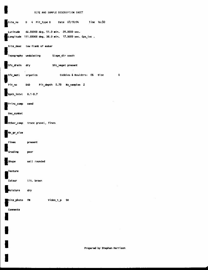
Data for each pit was recorded on a Site and Sample Description Sheet as shown in figure
4.1. This sheet includes location information, general site information and relatively detailed
information regarding stratigraphy. Description Sheets for all of the pits can be found in
Appendix A, Sampling procedures and descriptions followed standard engineering practices.
The report "Manual for Sampling Esker Deposits and Laboratory Testing Procedures" (EBA,
1994a) was used as a guideline. Individual samples were double bagged, labelled, and stored
in plastic pails for shipment. All samples are being shipped to EBA Engineering Consultants
Ltd. in Yellowknife for testing and analysis.
Originally, five days were allocated for sampling and den identification. However, due to
mechanical difficulties, the helicopter did not arrive at Daring Lake until the last day of the
study. This left only one full day for joint DIANDlG/NWT sampling before Stephen
Harrison had to leave the camp. To ensure that GNWT personnel could continue the
sampling, some additional time was spent before the helicopter arrived carefully reviewing
the sampling procedures to heIp ensure that accurate methods were followed.
Although much less than anticipated, 10 sites were sampled during the one available day. A
total of 32 samples were collected. 31 of these samples were den(D) samples and 1 sample
was a random@) sample. Unfortunately, due to the time constraints, no quarry samples
were taken for analysis.

23
latitude deg . min. SeC. GPS-loc Yes No .
Longitude deg . min . SeC. Site-desc topography Slope-dir
Sfc-drain Sfc-veget
Sfc-matl Cobbles & Boulders: % Size
Pit - no Pit-depth No-samples
I I I I
Dpth-intvl
Princ-comp
Usc-symbol
Other-comp
Fines
Grading
Shape
Texture
Colour
Moisture
Sikghoto VideoTape No.
Comments
Prepared by Stephen Harrison

24
Although presentation of the final results and conclusions will have to wait until all samples
have been tested and analyzed, some initial observations can be made. Den sites tend to
range between sandy silt and coarse sand, with silty sand being most common. Of the 10 den
pits sampled, 6 consisted of silty sand. Off den pits averaged a coarse sand with t r a c e gravel
to gravelly sand. Grain size curves, moisture contents and further analysis will be presented
in a separate report (EBA, 1994b) available in the fall of 1994.
25
5.0 RECOMMENDATIONS AND CONCLUSIONS
While some progress has been made towards the development of a Yellowknife District
deposit database, the information is incomplete at this time. Very little information is known
about the deposits used by GNWT Department of Transportation (DOT) personnel along the
highway between Yellowknife and Fort Providence. Based upon previous interest expressed
in the Northern Granular Resources Inventory program by GNWT DOT in Hay River (see
Harrison, 1993), Yellowknife DOT officials should be interested in sharing data.
The identification and evaluation of granular resources in an area as large and undeveloped
as the Northwest Territories is a very expensive undertaking. One possible method of
examining this large area is through the use of remote sensing techniques to identify the
relationship between grain size, moisture, soil,and vegetation. The possibility of conducting
a pilot study in the central arctic similar to Minor el al (1988) (see 4.3) should be examined.
This project could be coordinated with the vegetation mapping study being conducted by
Renewable Resources and with the GNWT Centre for Remote Sensing. Given the likelihood
of development in the area, there will certainly be future opportunity to ground truth the
results of the pilot study prior to applying these techniques to larger, relatively unknown
areas.
During the summer of 1994, DIAND had the opportunity to participate in the initial phase of
the TERS esker research project being conducted by GNWT Renewable Resources. The

to Renewable Resources for the purposes of sampling.
26
mutual interest that DIAND and Renewable Resources have in the proper management of the
North’s resources resulted in a successful initial study. Renewable Resources was able to
accurately sample the granular material within denning sites and DIAND has been able to
gather some initial baseline granular resources data. The experiences and collaboration
between DIAND and GNWT should be continued by expanding the field study area to
produce a regional granular materials inventory within the Lac de Gras area. The field
sampling program should be extended to include ground truthing potential granular sources
identified by Mollard (1993 and in progress).
If the results of this study would be beneficial to Renewable Resources, the TERS camp
might be used as a base camp if available. The location of the TERS camp makes it an ideal
location from which to conduct the study. The investigation could be coordinated at the
office by the Geotechnical Advisor and conducted in the field by two or three field
technicians over a two to four week period. As well, continued assistance could be provided

27
6.0 GLOSSARY
All definitions have been taken from Stiegeler (1976).
APATITE - A phosphorus mineral common in igneous rocks.
CALCITE - A common rock forming mineral with the chemical formula CaCO3.
CLINO AND ORTHOPYROXENE - A group of ferromagnesian rock forming minerals.
DIAMONDIFEROUS - In the case of kimberlite pipes, any pipe which contains relatively abundant quantities of diamonds.
DRIFT - Glacial and glaciofluvid deposits.
DRUMLIN - A glacial deposit tending to form in groups and aligned parallel to the direction of ice movement. The deposit is roughly egg shaped containing stratified or unstratified material.
FERROMAGNESIAN - A mineral which contains the components iron and magnesium.
GNEISS - A coarse grained metamorphic rock in which quartz and feldspar predominate over mica.
IGNEOUS - Rocks that have crystallized from a magma.
ILMENITE - A black mineral found in igneous and metamorphic rocks.
METAMORPHIC A rock in which mineralogical and chemical changes take place as a result of increasing temperature and pressure.
MAGMATIC - Igneous rocks formed from the solidification of magma within a reservoir within the earth’s lithosphere.
MIGMATITE - A coarse grained, banded mineral consisting of quartz/feldspar and biotite/hornblende bands.
MONTICELLITE - A calcium bearing variety of olivine.
OLIVINE - A group of rock forming minerals with the general formula R2Si04 where:

28
R stands for magnesium, iron, manganese or calcium; Si represents silicon and 0 represents oxygen.
PHLOGOPITE - A mineral that has a layered structure and cleaves as the pages of a book would separate.
REMOTE SENSING - The use of reflected or radiated electromagnetic energy to collect data about an object.
SERPENTINE - One of a group of layered minerals having the general composition Mg,Si,O5(W4.
SPINEL - A mineral occurring in high-temperature metamorphosed rocks.
THEMATIC MAPPER - One of a series of imaging devices used in the Iadsat series of satellites.

29
7.0 BIBLIOGRAPHY
BHP Minerals Canada Ltd. 1994. NWT Diamonds Project - project Description report BHP Minerals Canada Ltd., Vancouver, B.C.
EBA Engineering Consultants Ltd. 1993. izok Project Feasibility study Winter Haul Road. Report prepared for Metall Mining Corporation.
EBA Engineering Consultants Ltd. 1994a. Manual for Sampling Esker Deposits and laboratory b Prepared for Department of Indian Affairs and Northern Development.
EBA Engineering Consultants Ltd. 1994b. Laboratory Test Results of Daring Lake Esker Study. Report prepared for Department of Indian Affairs and Northern Development.
GNWT 1994. Mission Statement for the Tundra ecosystem Research Station. Prepared by The Government of the Northwest Territories Department of Renewable Resources.
Harrison, Stephen K. 1993. Granular Resources Inventory Propram: database Updating and Field Data Collection Summer 1993. Report prepared for Department of Indian Affairs and Northern Development.
Harrison, Stephen K. 1994. Reference Manual for Eskers and Glacial geology Prepared for Department of Indian Affairs and Northern Development and GNWT Renewable Resources.
John, Brain S. and Sugden, David E. 1984. Glaciers and Landscape A Geomorphical Approach. John Wiley and Sons. New York.
Minor, Timothy et al. 1988. geobotanical determination of aggregate regate Source Material using Airborne Thematic Mapper imagery Presented at the International Symposium on Remote Sensing of Environment, Houston, Texas, May 16-18, 1988.
Mollard, J.D. and Associates Ltd. 1985. The Utility of high Resolution Landsat Imagery in the Identification of Large Sand and Gravel prospect in South-Central Saskatchewan. Prepared for Canada Centre for Remote Sensing, Ottawa, Ontario.

I I I I I I I
I I I I I I I I I I I
Mollard, J.D. and Associates Ltd. 1993. Compilation Inventory Of Granular Material Resources Information Within The Izok Lake Transportation Corridor. Report prepared for Department of Indian Affairs and Northern Development.
Stiegeler, Stella E. 1976. A Dictionary of Earth Sciences. PICA Press. New York.
30
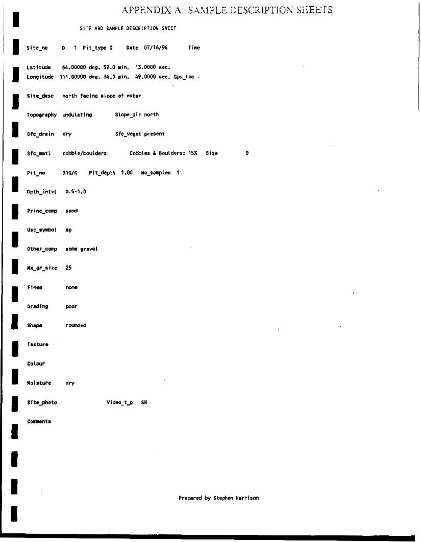
I s i tc-no D
APPENDIX A: SA\I?LE DESCRIPTIOnS SHEETS
SITE AUD SAMPLE OESCRIPTION SHEET
1 P i t - t w C Date 07/16/94 Tim
I L a t i t d e 64.00000 deg. 52.0 min. 13.0000 sec.
Longitudc 111.00000 deg. 34.0 min. 49.0000 su. G p - l o c .
I Site-derc north facing slop? of esker
Topography vwkriating Slope-dir north
I steprain dry Sfc-vegct present
Sfc-mtl cobble/boulders Cobbles & Boulders: 15% Size 0
Pit" DlG/C Pit-depth 1.00 No-sevles 1
Dpth-intvl 0.5-1.0
I Texture
I Moisture dry
Prepared by Stephen Harrison

I S I T E AND SAMPLE DESCRIPTION SHEET
I site_no D 2 Pit-type G Date 07/16/94 T i m e
I Lati tude 64.00000 deg. 51.0 min. 30.0000 sec.
Longitude 111.00000 deg. 37.0 min. 0.0000 sec. Gps-Loc .
I Sfc-drain
I Sfc-met
P i t-no
I Dpth-intvl
I Princ-conp
use_symbol
I Other-comp
Fines
I Grading
Texture
colour
I Moisture
I S i te_photo
Comnents
top of esker r idge - surrounding k e t t l e lake; south slope of 40;
north slope of 25
undulating Slope-dir north
dry Sfc-veget present
cobble/boulder
DZG/C P i t-depth
0.0-0.7
send
SP
grevely
30
nom
poor
rounded
Cobbles & Boulders: 15% Si te
0.70 No-sampler 1
0
Video__g SH
Prepared by Stephen Harrison

I S I T E AMD SAMPLE DESCRIPTIOn S H E E T
Time
I Latitude 64.00000 deg. 51.0 min. 30.0000 sec.
Longitude 111.00000 deg. 37.0 min. 1.0000 sec. Gps-loc .
I Sfc-drain
I Sfc-mat l
P i t-no
Dpth-intvl
I princ_comp
use-symbol
I -
Other-comp
I Texture
colour
Moisture
I Site_photo
top of esker r idge - surrounding kettle lake; south slope of 40; north slope of 25
undulating Slope-dir north
dry Sfc-veget present
cobble/boulder Cobbles & Boulders: 15%
D2D Pit-depth 1.00 No-samples 2
0.3-1 .O
f ine sand
SP
trace s i l t , t race gravel
10
present
poor
rounded
Video-t_p SH
S i ze 0
comments
Prepared by Stephen Harrison

I S I T E AND SAMPLE DESCRIPTION SHEET
Site-no D 3 Pit-type G Date 07/19/94 T i m e 13:30
Lati tude 64.00000 deg. 51.0 min. 54.0000 sec.
Longitude 111.00000 deg. 36.0 min. 14.0000 sec. Gps-loc .
Sfc-drain
Sfc_matl
P i t-no
I Dpth-intvl
Fines Grading
Texture
coulour
Moisture
low flank of esker just above beach
undulating slope_dir south facing
dry Sfc-veget present
organics Cobbles & Boulders: OX Size
D3WC Pit-depth 0.40 no-samples 2
0.1-0.4
Sand
SP
some cobble, trace gravel
'130
none
gap
well rounded cobble
lit. brown
dry
fm Video-t_p SH
comments unable t o dig past 0.4 m due t o presence of cobble
0
Prepared by Stephen Harrison

I S I T E AND SAMPLE DESCRIPTION SHEET
site-no D 3 Pit-type 0 Date 07/19/94 T i m e 14:45
Latitude 64.00000 deg. 51.0 min. 52.0000 sec.
longitude 111.00000 deg. 36.0 min. 15.0000 sec. Gps-loc .
Sfc-drain
Sf c-mat
Pit"
I Dpth-intvl
Prim-comp
Other-comp
Texture
Colour
i te_photo
Comments
edge of embakment of flank of esker
undulating Slop-dir south
dry Sfc-veget present
organics Cobbles & Boulders: 0% S i t e
D3D Pit-depth 0.80 No-samples 2
0.15-0.8
s i l t
l ight gray
dry
FM Video-t_p SH
1 large cobbte a t 0.4 m
0
Prepared by Stephen Harrison
I S I T E AUD SAMPLE DESCRIPTION SHEET
Site-no D 4 Pit-type D Date 07/19/94 Time
Latitude 64.00000 deg. 51.0 min. 29.0000 sec.
Longitude 111.00000 deg. 38.0 min. 17.0000 sec. Gps-loc . Site-desc low f lank of esker
Topography vwlulating Slope-dir south
Sfc-drain dry Sfc-veget present
Sfc-mat1 organics Cobbles & Boulders: O X
P i t-no D4D Pit-depth 0.70 No-samples 2
I Dpth-intvl
I P r i nc-ccq
I other-comp
I Fines
Grading
Texture
Colour
oisture
1c S i t e 9 o t o
comments
0.1-0.7
sand
trace gravel, f ines
present
poor
u e l l rounded
lit. brown
dry
fm Video- tg SH
16:30
S i ze
Prepared by Stephen Harrison

I S I T E AND SAMPLE DESCRIPTION SHEET
I Site" D 4 Pit-type G Date 07/19/94 Time
lat i tude 64.00000 deg. S1.0 min. 29.0000 aec.
Longitude 111.00000 deg. 38.0 min. 19.0000 sec. Gps-Loc . Site-desc south facing lower flank of esker
Topography undulating Slope-di r south
I Sfc-drain dry Sfc-veget present
I sfc-mat1 organics Cobbles 8 Boulders: OX Site 0
P i t-no D4G/C Pit-depth 1-00 No-samples 2
1 Dpth-intvl 0.0-1 .O
I Other-comp sandy
I s h a w subangular cobble
Co 1 our l it . brow
c oisturc dry
1 S i tc-photo FM Video-tg SH
Conrnentr 1 cobble ih p i t a 0.3 m
Prepared by Stephen Harrison

I S I T E AND SAMPLE DESCRIPTKON SHEET
Time 21:40
1 latitude U.00000 deg. 52.0 min. 16.0000 scc.
Longitude 111.00000 deg. 33.0 min. 59.0000 sec. Gps-loc . S i ta-desc
Topography undulating S 1 ope-d i r south
I Sfc-drain dry Sfc-veget present
I Sfc-mat1 organics Cobbles 8 Boulders: 0% Sire
P i t-no D50 Pit-depth 0.80 No-samples 2
I Dpth-intvl 0.0-0.8
I Princ-corrp 4. sand
I Dthcr-conp trace f i m s
1 Hx-gr-site 30
I Texture
Colwr l it . brown
I Moisture dry
1 Siteghoto Fn Video- tg SH
0
C-ts
Prepared by Stephen Harrison

I S I T E AND SAMPLE DESCRIPTIOM SHEET
LatitudE 64.00000 deg. 52.0 min. 16.0000 set.
4 longitude 111.00000 deg. 33.0 min. 59.0000 sec. Gps-loc .
1 Site-desc low ridge perpendicular to esker
Topography vldukating slope-dir west
1 Sfc-drain dry Sfc-veget present
Cobbles & Boulders: 0% Size
P i t-no DSG/C Pit-depth 1.00 No-sanples 2
1 Dpth-intvl 0.2-1.0
I Other-conp trace grevel
I Moisture dry
i s i tcJhoto FH Video-tg SH
0
cbmnents
Prepared by Stephen Harrison

I SITE AND SAMPLE DESCRIPTION SHEEI
I Site-no D 6 Pit-type D Date 07/22/94
I Latitude 64.00000 deg. 50.0 min. 9.0000 stc.
longitude 111.00000 deg. 47.0 min. 15.0000 set. Gps-
I S i t e-desc
Topography udulet ing S I ope-di r
I sfc-drain dry Sfc-vegct present
Tim
*Lot .
I Sfc-mat 1 s e d Cobbles & Boulders: 0% Size 0
P i t-no DbD Pit-depth 0.90 No-samples 2
I Dpth-intvl 0.15-0.9
I Other-conp son# s i l t
f ims present
1 Hoisture dry
1 SiteJjloto FH Video-tg SH
Prepared by Stephen Harrison

S I T E AND SAMPLE DESCRIPTION SHEET
Site-no D 6 Pit-type G Date 07/22/44 Time
I Latitude 64.00000 deg. 52.0 min. 57.0000 sec.
Longitude 112.00000 deg. 12.0 min. 57.0000 sec. Gps-loc .
I Site-desc Low esker ridge
Topography mdulating S L ope-di r
I Sfc-drain dry Sfc-veget present
I Sfc-mat1 gravel Cobbles & Boulders: 5% Size 1000
P i t-no D6G/C P i t-depth 1 .OO No-salrplcs 2
1 Dpth-intvl 0.1-1.0
I Other-conp some fines
I Fines present
Grading 9 O d
"
Colour lit. brom
I Moisture dry
I S i te_photo FM Video-tg SH
COnrnents 21 rn frm D6D
Prepared by Stephen Harrison
I

I S I T E AND SAMPLE DESCRIPTION SHEET
I S i te-no R 7 Pit-type C Date 07/22/94 T i m e 9:15
Latitude 64.00000 deg. 47.0 min. 30.0000 sec.
Longitude 112.00000 deg. 23.0 min. 26.0000 sec. Cps-loc .
I Site-desc low flank o f esker ridge
Topography mdutating Stop-dir
I Sfc-drain dry
I Sf c-mot 1 organi EB
Sfc-veget present
Cobbles & Boulders: 0% Size
P i t-no R 7C Pit-depth 0.80 No-samples 2
1 Dpth-intvl 0.1-0.8
I Prim-corrp coarse sand
B Other-cotrp gravel
I Mx-gr-sire
Texture
Co 1 our
8 moisture dry
1 Sitcghoto FM video-tg Sn
Comnents 1 cobble found 8 0.12 m
0
Prepared by Stephen Harrison

S I T E AND SAMPLE DESCRIPTION SHEET
I Site" D 8 Pit-type D Date 07/22/94 T i m e 11:20
Latitude 64.00000 deg. 30.0 min. 42.0000 sec.
Longitude 112.00000 deg. 8.0 min. 27.0000 sec. Gps-loc .
I Sfc-drain
I S f c-mat 1
Pit"
1 Dpth-intvl
1 Princ-colrp
USC-symbol
I Othsr-corrp
I Fines
Grading
I Texture
Colwr
1 Moisture
1 S i teghoto
low flank of esker
vldulating Slope-dir
dry Sfc-veget present
organics Cobbles & Boulders: 0% Size
D8D Pit-depth 0.60 No-semples 2
0.1-0.6
sand
SP
s i l t y , very l i t t l e gravel
present
poor
l i t . brown
dry
FM Video-tg SH
0
Prepared by Stephen Harrison

I S I T E AUD SAMPIPLE DESCRIPTION SHEET
I Site-no D 8 Pit-type G Date 07/22/94 Time 11:05
I Latitude 64.00000 deg. 38.0 min. 40.0000 o s .
Longitude 112.00000 deg. 8.0 min. 33.0000 sec. Gps-loe .
I Sf c-drai n
I Sfc-met 1
P i t-no
li Dpth-intvl
USC-SymbOl
I Other-conp
I Mx-gr-s i ze
F ims
Grading
I Texture
Co lwr
1 Moisture
I s i teghoto
low f lank o f esker
undulating S 1 ope-di r
dry Sfc-veget none
coarse gravel Cobbles & Boulders: 0% Size
D W C Pit-depth 0.80 No-samples 2
0.1-0.8
medim sard
SW
sune f ines, very l i t t l e gravel
18
present
good
rounded
Light grey
dry
FM Video-tg SH
0
Comnents
Preparcd by Stephen Harrison

I S I T E AND SAMPLE DESCRIPTION SHEET
I S i te-no D 9 Pit-type 0 Date 07/22/94 Tim 12:35
I Latitude 64.00000 deg. 39.0 mfn. 18.0000 8ec.
Longitude 112.00000 deg. 9.0 min. 43.0000 set. Gps-loc .
Site-desc low flank of esker
Topography undulating Slop-dir
I Sfc-dratn dry Sfc-veget present
Cobbles & Boulders: 0% Site
P i t-no Dm Pit-depth 0.70 No-ssnples 2
1 Dpth-intvl 0.25-0.7
I Other-comp s i I t y
I Texture
Colwr
I Moisture dry
I S i te_photo FM Video-tg SH
0
Prepared by Stephen Harrison

I S I T E AND SAMPLE DESCRIPTION SHEET
I I
Site-no D 9 Pit-type G Date 07/22/94 Time 12:30
Latitude 64.00000 deg. 39.0 min. 16.0000 sec.
Longitude 112.00000 deg. 9.0 min. 35.0000 sec. Gps-loc .
I Site-desc low flank of esker
Topography undulating S 1 ope-di r
I Sfc-drain dry
1 sfc-matt gravel
Sfc-vcget present but scarce
Cobbles B Boulders: 25% Size
P i t-no D9G/C Pit-depth 0.70 No-samples 2
I Dpth-intvl
I Princ-conp
USC-Synhl
Other-conp
I Fines
Grading
u Texture
Colwr
I Wofsturr
I Siteghoto
ComnentS
0.3-0.7
gravel
gw
s a w
40
present
good
rounded
dry
FH Video-tg SH
unable to dig past 0.8 m due t o sloughing of sand
800
Prepared by Stephen Harrison

S I T E AND SAMPLE DESCRIPTION SHEET
T i m e 15:40
I Latitude 64.00000 deg. 36.0 min. 45.0000 sec.
Longitude 111.00000 deg. 30.0 min. 1.0000 sec. Gps-loc .
I Sfc-drain
I Sfc-mat 1
Pit"
I Dpth-intvl
I Texture
Colour
I Moisture
Low flank of esker
d u l e t i n g S 1 ope-di r
dry Sfc-veget present
organics Cobbles & Boulders: 0% Size
010D Pit-depth 0.60 No-sarrples 2
0.1-0.6
coarse sand
sw
sane gravel
20
present
good
sub- rounded
1 f t .' brown
dry
FM Video-tg SH
0
Prepared by Stephen Harrison

I S I T E AND SAMPLE DESCRIPTION SHEET
I ite-no D 10 Pit-type G Date 07/22/94 T i m e 15:15
atitude 64.OOOOD deg. 36.0 min. 45.0000 sec.
ongitude 111.00000 deg. 30.0 min. 1.0000 set. Gps-loc .
I ite-desc low flamk of esker
Toposrephy vdulat ing S 1 ope-di r
I fe-drain dry Sfc-veget scattered
fe-mat1 organics Cobbles & Boulders: 5% Size 150
P i t-no DlOGC Pit-depth 0.90 No-sarrples 2
N pth-intvl 0.2-0.9
P rim-corrp coarse send
I USC-SynbOl BY
Other-comp suw gravel
I""' present
Cot our l i t . brown
I Moisture dry
I Sitcghoto FM Video-tg SH
Prepared b y Stephen Harrison