Embed Size (px)
Citation preview

TEXAS WATER COMMISSION Joe D. Carter, Chairman
0. F. Dent, Commissioner H. A. Beckwith, Commissioner
········ �� OJI• ••
(�� .. �.· ·····=······
GROUND-WATER GEOLOGY OF
EDWARDS COUNTY. TEXAS
Prepared in cooperation with the Geological Survey United States Department of the Interior
and the City of San Antonio
April 1962
I ' i i f
TgXAs WATER COMMISSION
Joe D . Ca rter, Cha irma n 0. F. Dent, Commis s ioner
R. A. Beck with, Commis s ioner
BULLETIN 6 2 08
G ROUND-WATER G EOLOG Y OF
EDWARDS COUNTY, TEXAS
By
A. T. Long, Geologis t United States Geologica l Survey
Prepared in cooperation with the Geological Survey United States D epartment of the Interior
and th e City of San Antonio
May 196 2

TABLE OF CONTENTS
Page
ABSTRA CT................................................................ 1
INTRODU CTION . . . . . . . . . . . . . . . . . . . . . . . . . . . . . . . . . . . . . . . . . . . . . . . . . . . . . . . . . . . . 3
Location and Economic Development.................................. 3
Purpose and Scope of Investigation................................. 3
Acknowledgments.. . . . . . . . . . . . . . . . . . . . . . . . . . . . . . . . . . . . . . . . . . . . . . • . . . . 5
TOPOGRAPHY AND DRAINAGE • . . . . . . .. . . . . . . . . . . . . . . . . . . . . . . . . . . . . . . . . . . . . . . . . . 5
CLIMATE . ...... . .. . .. . . , ... , . . . . . . . . . . . . . . . . . . . . . . . . . . . . . . . . . . . . . . . . . . . . . 7
GENERAL GEOLOGY AND STRU CTURE • . . . . . . . . . . . . . . . . . . • . . . . . . . . . . . . . . , . . . . . . . . 7
ROCK FORMATIONS AND THEIR WATER-BEARING PROPERTIES...................... 9
Pre- Cretaceous Rocks .. . ..... . ..... , .... , . . . . . . . . . . . . . . . . . . . . . . . . . . . 9
Cretaceous System .......... . .. . ........ . ... . . ............. , ........ 9
Pre- Comanche and Comanche Rocks, Undifferentiated.. . .......... 9
"Basement Sands 11• • • • • • • • • • • • • • • • • • • • • • • • • • • • • • • • • • • • • • • • • 9
Trinity Group................................................. 1 0
Glen Rose Limestone... . . . . . . . . . . . . . . . . . . . . . . . . . . . . . . . . . . . 1 0
Fredericksburg and Washita Groups............................. 16
Edwards and Associated Limestones..................... . .. 1 6
Grayson Shale. . . . . . . . . . . . . . . . . . . . . . . . . . . . . . . . . . . . . . . . . . . . 17
Buda Limes tone.·, . . . . . . . . . . . . . . . . . . . . . . . . . . . . . . . . • . . . . . . . . 1 8
Gulf Series. . . . . . . . . . . . . . . . . . . . . . . . . . . . . . • . . . . . . . . . . . . . . . . . . . . 18
Eagle Ford Shale. . . . . . . . . . . . . . . . . . . . . . . . . . . . . . . . . . . . . . . . . 18
Qu.aternary System.......................... . .............. . ....... . 18
Pleistocene and Recent Rocks, Undifferentiated........ . ....... 18

TABLE OF CONTENTS (Cont'd . )
Page
Alluvium . . . ...... . ........... . ............... . . . . ...... . . 18
GROUND WATER. . . . . . . . . . . . . . . . . . . . . . . . . . . . . . . . . . . . . . . . . . . . . . . . . . . . . . . . . . . . 19
Occurrertce and Movement ......... . . . . . . . . , ... . .... : . . . . . . . . . . . . . . . . . 1 9
Relation Between Ground Water and Streamflow..... . . . . . . .. . . ... . . . . . 2 0
Developn1ent. . . . . . . . . . . . . . . . . . . . . . . . . . . . . . . . . . . . . . . . . . . . . . . . . . . . . . . . 2 7
PrE!Sent Development ... . . . . .. . . . .. , . , . . . . . . . . . . . . . . . . . . . . . . . . . . 27
Potential Development.. . ... . ............ . .... . .... . .... . . . . . . . . 27
QUALITY OF WATER . . . .. . . .... . .. . ... . ... . I • • • • • • • • • • • • • • • • • • • • • • • • • • • • • • • • 28
S�RY . . . I I • • • • • • I • • • • • I • • • • I . I . I • • • • • • • I • • • • • • • • • • • • • • • • • • • • • • • I . I • • • I 3 0
SELECTED REFERENCES .... . ..... . . ..... I • • • • • • • • • • • • • • • • • • • • • • • • • I • • • • I • • I I 33
TABLES
1. Geologic formations and their water-bearing characteristics in Edwards County . . . I I • • • • • • • I • • • • • • • • • I • • • • • • • • • I • • • • • • • • • • • • • • • • 12
2. Measured geologic sections in Edwards County . ....... . .... . . .. . . .... . 35
3 . Records of wells and springs in. Edwards County. . . .... . . . . . ... . . . .... 42
4. Drillers' logs of wells in Edwards County. . . . . . . . . . . . . . . . . . . . . . . . . . . 84
5. Water levels in selected wells in Edwards County . . .. . . . .. . . . . . . . . .. . 114
6 . Analyses of water from representative wells and spring� in Edwards County . .. . . . . . . . . . . . . . . . . . . . . . . . . . . . . . . . . . . . . . . . . . . . . . . . . . 1 1 6
ILLUSTRATIONS
Figures
1. Map of Texas showing location of Edwards County.. . . . . . . . . . .. . . . . ... . 4
2 . Map of central Texas showing physiographic provinces.. . . . . . . . . . . . . . . 6
3 . Temperature and precipitation at Texas A. & M. College Experime.ntal Substation No. 14........ . ........................... 8
4. Composite geologic section in Edwards County . . ..... . . . . · · · · · · � · . . . . . 11

TABLE OF CONTENTS (Cont'd.)
Page
5. Geologic section A-A', Edwards County ............................ , 13
6. Approximate altitude of the base of the Cretaceous rocks in Edwards County. . . • . . . . . . . . . . . . . . . . . . . . . • . . . . . . . . . . . . . . . . . . . . . . . . 15
7 . Approximate altitude of water levels in wells in the Edwards and associated limestones, Edwards County, October 1953-September 1955 ............. , ...................... , 21
8. Locations of stream-gaging stations in the vicinity of Edwards County • . . . . . . . . . . . . . . . . . . . . . . . . . . . . . . . , . . . . . . . . . . . . . . . . . 2 3
9 . Chemical quality of water from representative wells in Edwards County .................................... , . . . . . . . . . . . . . 2 9
Plates
Follows
1. Geologic map of Edwards County, Texas, showing location of well.s and springs ............................................ . Page 124

G R O U N D - WA T E R G E 0 L 0 G Y 0 F
E D W A R D S C 0 U N T Y , T E X A S
ABSTRACT
This report pr�sents the results of a study of the ground-water resources of Edwards County (area 2,075 square miles) in southwest Texas . The purpose of the investigation, carried on simultaneously with an investigation in Real County, was to ascertain the quantity and quality of available ground water in the southern part of the Edwards Plateau . The report contains records of 6 13 wells and 46 springs, 13 9 analyses of water samples, and 6 4 well logs .
The Glen Rose lDnestone of Cretaceous age, the oldest formation that supplies water to wells in the county, yields small quantities of rather highly mineralized water . Springs in the Glen Rose discharge water that is generally less mineralized than that obtained from wells. Nearly all the wells and springs that produce water from the� Glen Rose are in the southeastern part of the county, where the Edwards and associated lDnestones have been removed by erosion or are very thin .
The Comanche Peak, Edwards, and Georgetown limestones, collectively called the Edwards and associated limestones, underlie most of the county and form the principal aquifer. Generally, the water in the aquifer is under water-table conditions, but locally it may be artesian . The Edwards and associated limestones yield small to moderate quantities of water, which is hard but otherwise of good chemical quality.
The alluvium in the major stream valleys yields small to moderate quantities of hard water, similar in quality to that of the Edwards and associated limestones .
The main ground-water divides in the Edwards and associated limestones follow the topographic divides . Most of the ground water flows southward and either appears as springflow in the Nueces River drainage or flows underground into Kinney or Val Verde County. The remainder flows northward and ultimately appears as springflow in the South Llano River drainage.
Records of base flow of the major streams indicate that about 150,000 acrefeet of water is annually recharged to and discharged from the Edwards anq associated lDnestones in Edwards County. Most of this water is available for
'addi
tional development as only about 900 acre-feet per year is currently being used. However, additional development of ground water will result in a reduction in streamflow .

G R 0 U N D - ·w A T E R G E O L OGY 0 F
E D W A R D S C 0 U N T Y , T E X A S
INTRODUCTION
Location and Economic Development
Edwards County in southwest ern part of the Edwards Plateau . Counties, on the south by Kinney Counties, and on the west by Val
Texas occupies 2 ,075 square miles of the southIt is bounded on the north by Sutton and Kimble
and Uvalde Counties, on the east by Kerr and Real Verde County (Figure 1) .
The thin limestone soil found in most of the county supports the characteristic grass, shrubs, and small trees of a semiarid region . Cedar, live oak, red oak, and mesquite grow on the rolling uplands and cypress and pecan along the streams. Edwards County is largely ranch country; the raising of cattle, sheep, and goats is the principal occupation . Agricultural products include wool and mohair, and small amounts of pecans, feed crops, and cedar fenceposts . Oil and gas, bat guano, road metal, and building stones are produced in small quantities . The landowners in the county derive a considerable income by leasing their property for deer and turkey hunting .
According to the U . S . Bureau of the Census, the population of Edwards County in 1960 was 2,317 . Rocksprings, the county seat, population 1,182 in 1960, is a market for wool and mohair and a tourist center noted for rodeos . Other towns and communities in the county are Barksdale, Carta Valley, and the Texas A . & M. College Experimental Substation No . 14 .
Purpose and Scope of Investigation
The investigation in Edwards County was made in 1954 -55 1>-Y. .. �t:_!l.e U, S . �ogical Survey in cooperation with the Texas Board of Water Engineers (now the Texas Water Commission) and the city of San Antonio . Its purpose was to ascertain the quantity and quality of available ground water in the southern part of the Edwards Plateau . The program included inventorying wells and springs, mapping the surface geology, and mapping the water table . The data studied, which are on file in the offices of the Geological Survey in Austin, Texas, included drillers' logs of 64 wells (Table 4) , records of 613 wells and 46 springs (Table 3) , and chemical analyses of samples of water from 114 wells and 25 springs (Table 6) . Prior to 1940 chemical analyses of ground water were made by employees of the Works Progress Administration under the supervision of E . P . Schoch of the Bureau of Industrial Chemistry of The University of Texas and E . W . Lohr of the U . S . Geological Survey . Although these analyses may not meet the present standards of the Geological Survey, and should be used with caution, they probably are indicative of the general chemical quality of the water . Some data used in this report were
- 3 -

Texas Water Commission in cooperation with the U.S. Geological Survey and the city of Son Antonio Figure I
0 50 100 ...... lwiii::::Jw-=:J�Mit===:::ll
83
FIGURE I.- Map of Texas showing location of Edwards County
- 4

obtained front an inventory of wells and springs in Edwards County made as a Works Progress Administration project in 1 9 38 -39 (Frazier, 1 9 39 ).
Plate 1 , which shows the locations of wells and springs in Edwards County, is divided ir.to quadrangles or grids each measuring 1 0 minutes of longitude and of latitude. Each quadrangle is designated by a letter, beginning with '�'' in the northwest corner of the map. Wells and springs are numbered serially according to their location within the quadrangles.
The repcrt was prepared under the direct superv1s1on of R. W. Sundstrom, district engineer of the U . S. Geological Survey in charge of ground-water investigations in Texas, and under the administrative supervision of S. W. Lohman, branch area chief, and A. N. Sayre, former chief of the Ground Water Branch.
Acknowledgments
Appreciation is expressed for the cooperation and assistance of oil-company personnel and well drillers who furnished geologic information and well logs. Thanks are also due to landowners who allowed access to the wells and provided information concerning them.
TOPOGRAPHY AND DRAINAGE
Edwards County is on the southern part of the Edwards Plateau, and the topography is closely related to the geologic structure of the plateau (Figure 2 ). The county is underlain by nearly flat-lying beds of limestone and a few beds of shale and marl; generally, the surface is gently rolling but, in places, erosion of resistant beds of limestone has formed steep slopes and narrow valleys. Along the southeastern border, the Nueces River has cut through the resistant limestone into the underlying less-resistant beds of marl and marly limestone and has formed a relatively broad valley. Sinkholes and other features associated with lim.estones that have undergone extensive solution are common throughout the county. The best known of these is the Devils Sinkhole, about 3 miles northeast of Rocksprings; its opening is 41 by 58 feet; the depth is 1 55 feet (Frazier, 1 9 39 , p. 1 0). Caves are commonly found throughout the county and many have been reported by drillers, particularly in the vicinity of Rocksprings.
Edwards 8ounty is drained by tributaries of three of the major drainage systems in TeKas (Figure 2 ). The southern part of the county is drained by the Nueces and West Nueces Rivers, the Nueces ultimately flowing into the Gulf of Mexico. The South Llano River, which drains the northeastern part of the count� empties into the Colorado River. The Dry Devils River and the West Fork Sycamore Creek, both tributaries of the Rio Grande, drain the western part of the county. The Nueces an·i South Llano Rivers are perennial streams; the Dry Devils and the West Nueces are intermittent.
Rocksprirrgs, the highest point on the divide between the Nueces and South Llano Rivers, is 2 , 41 0 feet above mean sea level. The lowest point in the county, 1 , 400 feet, Ls in the bed of the Nueces River just south of Barksdale.
- 5 -

Texas Water Commission in cooperation with the U S Geological Survey and the city of San Antonio
0
83
I I
L RIO J' . I 1, I �-----T-
-· � I 0 � t
� �I
Sc a le
� �' c; L--
� I�
Fioure 2
FIGURE 2.- Map of central Texas showing physiographic provinces
- f -
CLIMATE
The climate of Edwards County is typical of the semiarid regions of the Edwards Plateau. Average annual precipitation on the plateau ranges from more than 35 inches in the east to less than 2 0 inches in the west. The east-towest decline :nay be illustrated by comparing the average annual precipitation for Real, Edwards, and Val Verde counties. The average annual precipitation in Edwards County (about 2 2 inches) is about 6 inches less than in Real County and 5 inches more than in Val Verde County.
Figure 3 shows graphically the annual precipitation, the mean monthly temperature, and the average monthly precipitation recorded at the Texas A. & M. College Experimental Substation No. 14. The highest annual precipitation recorded at the station was 41. 51 inches in 19 35; the lowest was 6. 31 in 1951. The average annual precipitation was 2 2 . 17 inches during the period 19 19 -55 (Bloodgood and others, 1954, p. 57, and Bloodgood, personal communication). May and September are the wettest m�nths of the year, having averages of 3. 07 and 3. 01 inches, respectively.
The mean annual temperature at the Experimental Substation for the period 19 04-53 was 65°F (Bloodgood and others, 1954, p. 23). The mean monthly temperature ranged from 47. 5° in January to 80. 5°F in July and August (Figure 3).
GENERAL GEOLOGY AND STRUCTURE
Edwards �ounty is on the Edwards Plateau, a partially dissected remnant of an uplifted plain capped chiefly by resistant limestones. The county is underlain by �retaceous rocks which overlie a basement of Paleozoic rocks. The Cretaceous rocks dip 10 to 12 feet per mile generally south and southwestward toward the Gulf Coastal Plain and the Rio Grande Embayment (Cartwright, 19 32 , p. 69 9 , Pl. 4). Sellards and Baker (19 34, p. 86) reported slight domes, anticlines, and synclines that interrupt the regional dip of the Cretaceous beds of the Edwards Plateau. In the northern part of the county the beds dip northwestward about 3 feet per mile. Minor faults and fractures trending northeastward roughly parallel the Balcones fault zone, a major structural feature in the counties to the south and southeast. However, a few faults northeast of Rocksprings trend north to northwest. Most of the faults are downthrown on the southeast and have displacements of 30 feet or less; however, one fault about 12 miles southeast of Rocksprings has a displacement of about 60 feet.
The Cretaceous rocks exposed in Edwards County, from oldest to youngest, consist of the Glen Rose limestone, Edwards and associated limestones (Comanche Peak, Edwards, and �eorgetown limestones), Grayson shale, Buda limestone, and Eagle Ford shale (Plate 1). The oldest exposed formation, the Glen Rose, is found only in stream valleys where erosion has cut through the overlying formations. The Edwards and associated limestones crop out in most of the county, except on a few of the higher divides which are capped by younger formations and in the southeastern part of the county. Some valleys in Edwards County are underlain by alluvial deposits of Pleistocene and Recent age. These sediments are most extensive in the Nueces River valley, where they attain a maximum thickness of about 40 feet.
- 7 -

Texas Water Commin1on In c ooperation with I he U.S. Geological Survey and the city of San Antonio Figure 3
90
80
1-iii 2 70 11.1 a: :I: rl! en 60 11.1 11.1 a: (!) 11.1 0
50
4 0
45
40
35
30
2 5 en 11.1 :I: u z
2 0
15
10
5
0
-
---
/
JAN.
r·
-- ----� I
v /
FEB MAR. APR.
-....__
/ "I\ /.eon annual temperature, 65°F{
-\ --- ---- �----- --i
\ 1\. "
I i MAY JUNE JULY AUG. SEPT OCT I NOV DEC.
en 11.1 :I: u z
4r---�--�--+---+--- +---+--�--�--��--r---�__,
-2r---�--��r-�bL�����---;����--�--�
Mean monthly temperature, 1904-53 Average monthly precipitation, 1919-55
1920 1925 1930 1935 1940 1945 1950 1955
Annual precipitation
FIGURE 3. - Temperature and precipitation at Texas A. 8 M. College Experimental Substation No.l4
(Records from Bloodg ood, Patterson and Smith, 1954, and Bloodgood, personal communication)
8 -

The composite geologic section of the formations in Edwards County is shown in Figure 4. The lithologic and water-bearing characteristics are summarized in Table 1. The stratigraphic and structural relations of the Cretaceous units are shown in Figure 5.
ROCK FORMATIONS AND THEIR WATER-BEARING PROPERTIES
Pre-Cretaceous Rocks
Rocks of pre-Cretaceous age are not exposed in Edwards County. However, their lithologic characteristics and age have been revealed in a few places by exploration for oil and gas. The rocks consist chiefly of noncalcareous shale, sandstone, and limestone; their total thickness is not known. Different formations of probable Pennsylvanian age underlie the Cretaceous rocks in various parts of the county because of the unconformity between the Cretaceous and preCretaceous rocks. The approximate altitude of the base of the Cretaceous rocks is shown in Figure 6.
No fresh water has been reported in the pre-Cretaceous rocks; the base of the overlying Cretaceous rocks is considered to be the base of the fresh-waterbearing beds in the county.
Cretaceous System
Pre-Comanche and Comanche Rocks, Undifferentiated
The oldest Cretaceous rocks reported by well drillers in Edwards County are identified in this report as "basement sands." Correlation of these beds is not certain, but it is believed that they may include the Pearsall formation of Comanche age and the Hosston and Sligo formations of Coahuila age ( Imlay, 1945, p. 1426-41). None of these rocks crop out in Edwards County.
"Basement Sands"
In Edwards County the "basement sands" may be divided into three zones. The lowest consists of varicolored marl interbedded with poorly sorted quartz sand. The middle zone, a dolomitic limestone, which is very thin or absent in the northern part of the county, reaches a maximum thickness of 50 feet in the southern part. vTell-sorted sand and gravel, generally interbedded with marl and limestone, is found in the uppermost zone. The "basement sands" unit becomes generally more calcareous from north to south. The thickness of the "basement sands" ranges from about 150 feet in the northern part of the county to more than 400 feet in the southern part ( Figure 5). The "basement sands" unit is not tapped by water wells in Edwards County; however, it yields potable water to wells elsewhere on the Edwards Plateau and it is probable that small to moderate supplies could be obtained in Edwards County.
- 9 -
Trinity Group
Glen Rose Limestone
The Glen Rose limestone overlying the "basement sands" is the oldest formation exposed in Edwards County. The Glen Rose crops out in the valleys of the tributaries of the Nueces River in the southeastern part of the county (grids S and T, Plate 1), in a small area in the valley of the West Nueces River (grid R), and in scattered small patches along Hackberry Creek (grid P). The Little Hackberry Creek section is described in detail in Table 2. The Glen Rose ranges in thickness from 450 feet in the northern part of the county to about 750 feet in the southern part.
George (1952, p. 17) divided the Glen Rose limestone in Carnal County into a lower and upp«�r member by designating the top of the Salenia texana zone as the line of separation. Only the upper member is exposed in Edwards County.
The lower member of the Glen Rose consists of massive fossiliferous limestone and limy fJhale, the shale predominating in the upper part. Many of the limestone beds are reefy and contain large rudistids in places.
The upper ntember of the Glen Rose consists chiefly of alternating beds of resistant limestone and soft marl which produce a typical stair-step or terraced topography. The relatively gentle terraced slopes contrast with the steep bluffs formed by the overlying Edwards and associated limestones. The beds of the upper part of the Glen Rose are brown where weathered, but in the subsurface they are blue and are referred to by drillers as the "blue" or "blue mud. " Two beds of gypsum and anhydrite, each about 2 0 feet in thickness, are generally present about 200 and 400 feet: below the top of the formation.
The large foraminifer Orbitolina texana (Roemer), which is common throughout the lower member of the Glen Rose; is less connnon in the upper member. Beds containing it and Porocystis globularis (Giebel) are exposed in stream valleys in the vicinity of Barksdale.
The Glen Rose limestone is one of the principal aquifers in Edwards County; however, in comparison with the major aquifers in Texas it is relatively unimportant. The formation is recharged by precipitation on its outcrop, by overland runoff, and by seepage from the overlying Edwards and associated limestones. The amount of recharge to the formation and the overall potential,development in Ed
wards County have not been estimated but are, no doubt, small.
The water in the Glen Rose occurs in cracks, crevices, and solution channels in the limestone. The upper member of the Glen Rose consists of thin beds of limestone interbedded with marl and shale; consequently, the interconnection of the cracks and channels is small and the resultant permeability is low. The thick massive limestone beds in the lower member might be'expected to contain a more highly interconnected system of openings. However, the beds are deeply buried in Edwards County, and there are no opportunities for extensive circulation of ground water.
The Glen Rose limestone yields small quantities of water to domestic and stock wells in Edwards County, chiefly in the southeastern part where the more productive Edwards and associated limestones are absent. The yields of individual wells are generally not more than 10 gpm (gallons per minute), although well T-26 had a yield
- 10 -
Texo• Water Commission in cooperation with the U.S. Geoto<;�ical Survey ond the city of Son Antonio
83
��:::::;;==:::;=:::::X::.====:::::t= I 0 ft. ��""-.!!!!.!��:1!.--------T- 20:t ft. ---.lot!.X""'"'!J...jlt!.!l<.!�-----lr-- 20ft.
limestones
Edwards and associated 555:!: ft.
r Elevation -1840' lt mile north of
U.S.C.8GS. BM C-148 -==--=---=--
Glen Rose limestone
" Basement s ands"
Pre -Cretaceous
rocks
450-750 ft.
150-400 ft.
j UJ .5 "t:J ..
! 0 z
Figure 4
L1mestone, brown, crysta l I ine, sandy. Lim estone, liqht-groy, herd
Shale, �uff to brown, �gyro orietina (Roemer) and echina1ds common.
L1mestone, massive, light-gray to buff, cherty, highly fossiliferous. Rudi sti ds common Max&mum thickness 240'±.
Dolomote and dolom1tic limest one, cherty, dark, soft, oronulcH; small caverns. some beds vuggy. Leaching and secondary depos iIi on common Max1mum t hi ckn ess 135'±
L1mestone, cherty, mass 1 ve, I i ghtgray to cream, medium-gra ined to ltthooraph&c, few dolomitic beds; fossiliferous. Rudlstids common. Maximum thickness 130'!: Limestone, nodular, marly, Exogyra � (Roemer) scattere d . Maximum thiCknes s 50'!. Shale, soft, interbedded with t hin beds of limestone and dolomite.
Gypsum and anhydrite.
Poroc yst o s globularos (Giebel).
L1mestone, Orbitolina texona (Roemer)
Gypsum and ltmestone, Corbula martinae (Ill. Whitney), Salenoa texano zone
Marl and \trnestone.
Lt mestone, massive, r eet- type, large rudis t t d s
Sand, calcareous, ftne to medium.
Ltmestone, sandy.
Sand, cclcareous, and gravel
Limestone, dolomit•c.
Marl, vortcolored, and poorly sorted Quartz send
Shale, noncafcareo u s, s and stone, and l i mestone.
FIGURE 4. - Composite geologic section in Edwards County Litholagoc descriptions from measured sections and logs
11 -

System
Quaternary
0
IU
0
PreCretaceous
Series or group
Pleistoeene and Recent,
undifferentiated
Gulf series
Washita
group
J.. 1-----------IU co
Fredericksburg
group
Trinity
group
Pre..Camanc:he rocks
1
Table l. --Geologie formations and their water-bearing cllaraeteristies in Edwards County
Stratigraphie unit
Al.J.uvium.
Eagle Ford s�e
Buds limestone
Grayson sba.le
Zone D
Maximum thic:kness
(feet) 40
10
20
20
240
Deseription of rocks
Sand, silt, and gravel.
\
Sandy' crysta.J.llne 1 brown limestone.
liard, brittle, llgb.t-gray porce.laneous limestone.
Il.tff-brown clay or marl; contains thin lenses of limestone.
Massive, light-gray cherty limestone; rudistids, gastropods, and brachiopods abundant.
Surface expression
Terraces in stream valleys.
Water-beariilg cllaracter
Yields small. to moderate supplies of bard water to shallow dug wells in stream vall.eys.
IsoJ.ated patches capping Yields no water to wells hills. in Edwards COUIIty.
Fragments or boulders capping divides.
Caps interstream divides; forms rolling topography.
Cliffs or steep slopes. Rolling surface in the interstream areas.
Do.
Do.
Principal water-bearing �--------------�------------�----------------------------�-----------------------� formation in Edwards
Zone C
ZoneB
Zone A
G�en Rose limestone
"Basement sands''
1
135
60
750
400
'l
Dolomite and dolomitic limestone; secondary deposits of calcite, quartz, and siliceous limestone; chert nodules; highly leached; cavernous in places •
Alternating beds of hard limestone and soft marl; gray- blue in subsurfaee; weathers brown; gypsum.
Well-sorted sand interbeddedwith marl and limestone; dolomitic limestone; interbedded varicolored marl and poorly sorted quartz sand.
Sbal.e 1 sandstone 1 and limestone.
Gentle slopes that retain more soil than zones B or D.
Farms gentle slopes.
Terraced topography; relatively gentle slopes.
Not exposed in Edwards County.
do
County. Yields small to moderate supplies of hard water to wells. Large discharge through the springs tbat feed the streams •
Yields � quantities of fresh to moderately saline water.
Yields no water to wells in Edwards County.
Do.

.. ...... �
' '
I
�-+ - � - ---C 0 U N
100'20 100"10'
K I M B L E
UVALDE COUNT Y
C O U N T Y
EXPLAIIATIOII ··" --10<-lrol
_..., __ .,_., ___ ... -c .. -loto ..... IOOIMt -·---
Fi ure 6
Boll compiled from veneral hlpay mop of the
Texos Hipoy Deportment, SoN ConMtvatton
Service oerfol photos, u s ArMy topooropNe
maps, on4 field notes
N
l
FIGURE 6 ;- Approximate altitude of the base of the Cretaceous rocks in Edwards County

of 40 gpm when drilled. Most of t:he wells are shallow, being about 100 feet deep. A few, however, are deep; well T-33, the deepest drawing from the Glen Rose, is 9 00 feet.
The Glen Rose yields small to moderate quant�ties of water to many springs in Edwards County, the largest being Taylor Springs (S-6) which had a measured flow of 430 gpm on October 15, 1953. Most of the springs are at or near the contact with the overlying Edwards and associated limestones. The similarity of the chemical analysis of the water to that of water from the Edwards indicates a direct hydraulic connection between the two formations in the area of the springs.
Fredericksburg and Washita Groups
The Fredericksburg group in Edwards County includes the Comanche Peak limestone and the Edwards limestone; the Walnut clay, the lowest unit, and the K iamichi formation, the uppermost unit, have not been identified. The Washita group includes the Georgetown limestone, the Grayson shale, and the Buda limestone.
The Comanche Peak, Edwards, and Georgetown limestones form a single hydrologic unit which in the San Antonio area has been termed the "Edwards and associated limestones" (Petitt and George, 1956, p. 16). All formations between the Glen Rose ltmestone and the base of the Grayson shale are also referred to in this report as one stratigraphic and hydrologic unit- - the Edwards and associated limestones--one of the most important aquifers in Texas.
Edwards and Associated Limestones
The Edwards and associated limestones crop out throughout Edwards County, except on the high divides where they are capped by younger formations and in the stream valleys where erosion has exposed the underlying Glen Rose limestone. The thickness of the unit at Rocksprings is about 550 feet; elsewhere in the county the thickness has not been precisely determined.
The oldest formation in the unit, the Comanche Peak limestone which conformably overlies the Glen Rose, crops out in deep valleys. It consists chiefly of buff-to-gray nodular marly limestone and is equivalent to zone A in Table 2 and Figure 4. The limestone is honeycombed in places and is rather soft, forming relatively gentle slopes. The nodular appearance is the most distinctive characteristic of the Comanche Peak. Specimens of Exogyra texana
' (Roemer) are found
throughout zone A, especially in the lower part; unidentified high-spired gastropods are common in the upper part. The Comanche Peak ranges in thickness from about 45 to 60 feet but probably averages about 50 feet in Edwards County. The Comanche Peak and the lower part of the overlying Edwards formation are similar in lithology, but are very different in their fauna and mode of weathering.
The upper 500 feet of the Edwards and associated limestones consists of the Edwards limestone and the GeorgetorNn limestone. In Edwards County, the two limestones have not been differentiated as such; however, they can be divided into three zones, zones B, c, and D in Table 2 and Figure 4.
Zone B, which overlies the Comanche Peak limestone, is a light-gray to cream massive limestone, medium-grained to lithographic in texture. Dark streaks of very fine texture, believed to be siliceous, probably represent a stage in the
- 16 -

development of chert. A few dolomitic beds are present. Pelecypods, chiefly Toucasia sp. and Caprina sp. , are abundant. The zone, about 130 feet thick, forms bluffs which retain very little soil and consequently support sparse vegetation.
Zone c, about 135 feet thick, consists of gray to dark-brown dolomite and dolomitic limestone containing chert nodules and a few chert beds. Clayey and flaggy to thin-bedded limestone is interbedded with the dolomitic limestone. The dolomite is soft and granular in places and contains many cavities ranging from a few inches to several feet in diameter. Secondary deposits of calcite, silica in the form of quartz, silic eous limestone, and chert are abundant in many beds. The upper part of the zone shows an exceptionally high degree of leaching, which has destroyed or obscured much of the bedding. A few beds contain rudistids and gastropods. The beds altered by leaching are nonfossiliferous, but some of the chert nodules and chert beds contain fossils. The relatively gentle slopes of Zone C hold more soil and support more vegetation than the limestones of Zone B or Zone D.
Zone. D, about 240 feet thick, consists chiefly of massive highly fossiliferous light-gray to buff limestone. Beds near the base consisting mainly of shells underlie beds containing Pecten sp. , gastropods, and rudistids--chiefly Caprina sp. , and Toucasia .s p. A brachiopod, Kingena wacoens is (Roemer), is found near the top of the zone. In the northeastern part of the county, thin beds composed mainly of pelecypod fragments, probably GryPhaea sp. , form a terrace·in many places . Beds near the top of the zone are relatively finegrained and thin-bedded. Chert as nodules and in beds is common throughout most of the zone. In the interstream areas, zone· D forms the slightly rolling sur� face characteris tic of the Edwards Plateau; however, in the stream valleys, the massive limestone f orms prominent cliffs or steep slopes which retain little soil and support s pars e vegetation.
The Edwards and associated limestones is the principal aquifer in Edwards County. It supplies small to moderate quantities of water of good chemical quality to wells and springs in all parts of the county, except in the southeastern part, where it has been removed by erosion. Of the 568 water wells for which records are available (Table 3), 524 obtain water from the Edwards and associated limestones. The yields of most of the wells are small, generally less than 10 gpm. However, generally only small quantities of water are needed and the wells are cons tructed accordingly. In many places much larger yields could be obtained from properly constructed wells drawing from the full thickness of the aquifer. For example, well H-44 used for municipal supply at Rocksprings, had a measured yield of 280 gpm on December 7, 1953. Additional information on ground water in the Edwards and associated limestones is given in the section of the report entitled "Ground Water. "
Grayson Shale
The Grayson s hale, formerly known as the D el Rio clay, which overlies the Edwards and associated limestones, crops out on the high divides in the vicinity of Rocksprings and eastward along State Highway 41. In the outcrop the Grayson forms a typically rolling topography which supports a considerable growth of mesquite. The Grayson and overlying Buda are not water-bearing in the county and are shown as a unit on Plate� 1 . The buff-to-brown clay and marl beds and thin
limestone lenses that compos e the Grayson reach a maximum thickness of 20 feet in Edwards County. A marly facies north of Rocksprings contains many echinoids, but only a few specimens of Exogyra arietina (Roemer) characteristically found
- 17 -

in abundance in the Grayson. The cephalopod Turrilites brazoensis (Roemer) is found in the lower part of the formation. The Grayson shale is relatively impermeable and is not a source of ground water in the county. Many surface reservoirs or tanks for stock use are dug in the outcrop area.
Buda Limestone
The Buda limestone lies conformably upon the Grayson shale in Edwards County, but the two formations have not been differentiated in Plate 1. The Buda consists of hard, brittle, fine-grained, dense, light-gray limestone. It has a porcelaneous texture and breaks with a conchoidal fracture. Erosion of the soft underlying Grayson shale generally reduces the brittle limestone to angular boulders. The presence of the Buda can generally be recognized by the heavy growth of live oak that it supports. The Buda limestone reaches a maximum thickness of 20 feet in Edwards County and is not a source of ground water in the county.
Gulf Series
Eagle Ford Shale
The Eagle Ford shale, the only formation of the Gulf series in Edwards County, overlies the Buda limestone, the uppermost formation of the Comanche series. Erosion has removed most of the formation; only the lower 1 0 feet, which consists chiefly of sandy brown crystalline limestone, is found in isolated patches capping a few hills. The Eagle Ford is not water bearing in Edwards County. Because of its limited areal extent, it is no� shown on the geologic map (Plate 1) , but is included in Table 1 and in the composite geologic section (Figure 4).
Quaternary System
Pleistocene and Recent Rocks, Undifferentiated
Alluvium
The alluvium in Edwards County consists of terrace deposits in stream valleys, ranging in texture from gravel to silt. The deposits reach a maximum thickness of 40 feet in the Nueces River valley where the river has cut deeply into the soft beds of the underlying Glen Rose limestone. Recent boulders and gravel in the streambeds are composed of slightly rounded chert and limestone.
The alluvium is in direct hydraulic connection with the river in many places and probably derives most of its recharge from that source. The rest of the recharge is from infiltration of precipitation, overland runoff from adjoining areas, and possibly from discharge from the underlying Glen Rose limestone.
The alluvium supplies small to moderate quantities of water to many wells in the county, particularly in the valley of the Nueces River. Most of the wells are dug wells less than 40 feet deep. The yields range from a few to as much as 400 gpm in well T- 9 .
- 18 -

Most of the wells that draw from the alluvium are used for domestic and stock supply; however, well T-9 is used in part to irrigate 2 acres of land and well T-2 7 is used for public supply at Barksdale.
The water in the alluvium is of good chemical quality except that it is hard. In samples from five wells the dissolved-solids content ranged from 1 9 5 to 2 7 6 ppm ( parts per million) .
GROUND WATER
Occurrence and Movement
The source of all ground water in Edwards County is precipitation. Part of the water that falls as precipitation is returned to the atmosphere by evaporation or transpiration by plants; part of the water runs off as streamflow. A small part moves downward through the fractures and solution channels in limestones and through sandy zones in the alluvium until it reaches the top of the zone of saturation. The top of this zone, the water table, is not a level surface but has irregularities which are similar to and related to the topography of the land surface.
Some of the seepage from precipitation may be held by relatively impermeable materials at some level above the main ground-water body. Ground water thus separated from an underlying body of ground water by unsaturated rock is called perched water. In Edwards County such perched- water bodies are held by lenses of clay, shale, or impervious limestones. The perched-water bodies in Edwards County, though few and not extensive, may yield sufficient water for domestic and stock use as long as recharge conditions are favorable.
Figure 7 shows by contours the configuration of the water table in the Edwards and associated limestones in Edwards County. The water moves slowly along the hydraulic gradient ( at right angles to the contours) until it is intercepted by wells or is discharged through springs or some other natural outlet or until it percolates into overlying or underlying beds. The contours of the water table in Edwards County indicate the presence of a ground-water divide that approximates in position the topographic divide.
The lithology, structure, thickness, and degree of weathering of a waterbearing formation determine its capacity to receive, store, and transmit water. The ground water moves from areas of recharge towards areas of discharge, the rate and direction of the movement of the water being controlled by the geologic structure and the permeability of the rock material. The permeability varies according to the size, shape, number, and degree of interconnection of the rock pores. Locally, rocks of low porosity may contain fractures, fissures, and solution channels through which water moves freely. This is particularly true in the massive limestones in the Edwards and associated limestones in Edwards County.
Structural geologic features such as faults and folds affect the movement of ground water. Faults may bring a water-bearing formation into contact with less permeable clay or shale, thus creating a barrier or impediment to the movement of ground water. Folding may up-warp beds, thus facilitating their exposure to recharge.
- 1 9 -

Ground water is discharged naturally from water- bearing formations by evapotranspiration in areas where the water table is near the land surface, through springs, by seepage into streams, and artificially through wells. The quantity of water discharged from wells in Edwards County is small compared to the natural discharge.
Most of the important areas of discharge through springs are shown on Plate 1. Seven Hundred Springs (E-4) in the upper South Llano valley is one of the largest in the interior of the Edwards Plateau. Most of the base flow of the South Llano River comes from it and other springs.
Ground water moving toward an area of discharge may pass between beds of impermeable material and thus become confined under artesian pressure. It will then rise above the bottom of the overlying confining layer in a well that draws from the water- bearing formation. In some places in Edwards County, water in the Edwards and associated limestones rises above the point where it is encountered by the drill bit, indicating local artesian conditions. It is believed, however, that in general the water in this aquifer is unconfined. The water in nearly all the wells in the Glen Rose limestone is under artesian pressure. Water in the alluvium generally is unconfined.
Relation Between Ground Water and Streamflow
Streamflow can be divided into two major parts: water that goes directly from precipitation to the streams, known as direct runoff, and water that discharges from the saturated zone through seeps and springs, known as base flow. In Edwards County the base flow sustains the flow of the streams during periods between storms. Being sustained by ground-water discharge, the base flow is dependent on ground-water recharge. Changes in base flow are related to changes in ground- water storage. Consequently, estimates of the ground- water recharge to the Edwards and associated limestones can be made from studies of the base flow of the streams in Edwards County. Estimates of the base flow were made purposely low to eliminate the effects of bank storage and temporary storage in the alluvium in the stream valleys. Over a long period of time the average base flow is approximately equal to the average recharge to the water- bearing formations, ignoring the other forms of discharge, which in Edwards County are negligible. For a particular year or other relatively short period of time, the two quantities will differ depending upon changes in storage during the period. The annual discharge, however, generally indicates whether recharge was greater or less than in the previous year because changes in storage are reflected in changes in base flow. The estimates of recharge� therefore, have been made on a long- term basis rather than on an annual basis.
Recharge and discharge estimates are based chiefly on records of the four stream- gaging stations shown in the table on page 24. (For locations of the stations see Figure 8.)
- 2 0 -

Texas Water Commission in eooperation with the U.S. Geol
N
4
R E A L
C 0 U N T Y
100° 40' 100° oo'
83
Fi ure 8
0 4
99° 20'
8 12 16 Miles
----, I
I I
I I
I 0
20
FIGURE 8.- Locations of stream-gaging stations in the vicinity of Edwards County
- 23 -

Station
Llano River near Junction, Kimble County
Nor th Llano River near Junction, Kimble County
Nueces River at Laguna, Uvalde County
Wes t Nueces River near Brackettville, Kinne� County
Dr aina ge ar ea ( s q. mi.)
1,874
914
764
700
Recor ds available
September 1915-57
September 1915-57
October 1923-5 7
September 1939-50 a nd Apr il 1956-57
The bas e flow in the South Llano a nd Nueces bas ins is believed to clos ely a ppr oximate th e total gr ound-water dis charge from thes e bas ins . The bas e flow a t the s tation on the Wes t Nueces , h owever , r epr es ents only a par t of the gr ound water dis char ge. A lar ge par t of the gr ound-water dis char ge out of that bas in is by underflow into Kinney County. The gr ound-water dis char ge of the Wes t Nueces bas in in Edwards County, therefor e, has been es timated from unit dis char ge figures obtained from the other two bas ins .
The South Llano River drains appr oximately 606 s quar e miles in northeas tern Edwar ds County. The r iver flows gener ally northeas twar d,, Joining the Nor th Llano River at Junction in KUnble County to form the Llano River , which flows eas twar d into the Color ado River . The flow of the South Llano River can be computed by compar ing the r ecords of two s tr eam -gaging s tations near Junction in Kimble County--one on the Nor th Llano River 3 miles nor thwes t o:f Junction a nd the other on the Llano River 3 miles eas t of Junction (Figur e 8). The difference in r ecor ds of dis charge of the two s tations approximates the dis char ge of the South Llano River . Ups tream from the cros s ing of U. S. Highway 377 in Edwar ds County the South Llano River generally is intermittent. Fr om the cros s ing of the h ighway to the town of Telegr aph in KUnble County mos t of the bas e flow of the river comes from s pr ings which dis charge from the Edwar ds and as s ociated limestones . F rom Telegraph to Junction the bas e flow of the river does not incr eas e a ppreciably. The inflow in the r each between the Kimble-Edwards County line and Junction, ther efor e, is appr oximately equal to the los s from eva poration and trans piration. Cons equently, the bas e flow of the South Llano a boye its confluence with the North Llano a t Junction is as s umed to be equal to the bas e flow of the river at the Kimble-Edwar ds County line.
·
By compa r ing the flows at the Llano a nd Nor th Llano s tream-gaging s tations , h ydrogr aphs were made for the computed daily flow of the South Llano River from J anuary 1923 thr ough D ecember 1954; from thes e gr aphs the bas e flow and the s tormflow for the South Llano wer e es timated: s epar ately. The bas e flow as es timated in this manner pr obably is r eas onably accur ate, but es tim ates of floodflow are les s a ccur ate becaus e of an u ndetermined time la g of flood peaks between gaging s tations . The following table s h ows the computed a nnual runoff of the South Llano River and the es timated bas e flow.
- 24 -
Total runoff Base flow Total runoff Base flow Year Year
(Thousands Inches (Thousands (Thousands Inches (Thousands of acre-ft.) of acre-ft.) of acre-ft.) of acre-ft.)
1923 343. 0 6. 72 64. 5 1939 99. 5 1.95 50. 1
1924 85. 5 1. 69 64.8 1940 54.8 1.06 50. 0
1925 111. 0 2. 18 55.0 1941 57.3 1.11 49.4
1926 60.9 1.19 54.6 1942 71.9 1. 41 52.1
192 7 52. 0 1.01 45.6 1943 71.9 1.40 54.3
1928 44. 6 .87 41. 0 1944 43.7 .85 43.3
1929 37. 0 . 72 35.4 1945 35.1 . 69 33. 6
1930 42.4 .83 38.7 1946 33.4 .65 29.8
1931 56. 2 1.10 41.0 1947 32. 1 .63 31.6
1932 183. 0 3.56 55.9 1948 225.6 4. 41 41.8
1933 59. 6 1. 17 48.3 1949 84.6 1.65 57.5
1934 29.7 . 58 29.2 1950 42.0 .82 41.5
1935 32 7. 7 6. 40 67. 1 1951 29.1 • 57 29.1
1936 154.6 3. 04 69. 8 1952 20.0 .39 20. 0
1937 77. 8 1. 51 43. 2 1953 17.9 . 35 17. 8
1938 147.4 2.87 62. 6 1954 22.0 .43 17. 9
The average annual precipitation in the South Llano River basin is about 24 inches. The total annual runoff ranged from 6.40 inches in 1935 to 0.35 inch in 1953, averaging 1.71 inches during the 32-year period 1923-54. Therefore, the average annual runoff is less than 10 percent of the average annual precipitation; more than 90 percent of the water falling on the basin is disqharged by evapotranspiration. About 54 percent of the total runoff is estimated to be base flow.
·
The computed base flow of the South Llano River at Junction (presumed to be about the same as the base flow at the Kimble-Edwards County line) suggests that the average annual recharge to and discharge from the Edwards and associated limestones in the South Llano basin in Edwards County during the 32-year period was about 45 thousand acre-feet per year, or about 40 mgd (million gallons per day). This is about 74 acre-feet per square mile or �.4 inches.
The Nueces River, which forms part of the boundary between Edwards and Real Counti'es, drains 353 square miles in Edwards County and about 213 square miles in Real County. Along the county line, the Nueces is perennial, deriving its base flow from the many springs which drain the Edwards and associated limestones.
- 25 -

The stream - gaging station at Laguna is about 14 m il es downstream from the Edwards- Uv al de C ounty l ine ( Figure 8 ). A l thou gh springs discharge to the N ueces downstream from the co unty l ine, d:l scharge m easu rem ents m ade du ring seepage investigations indicate that the b ase fl ow of the stream where it l eaves E dwards C ounty is about the sam e as th at m easured at Laguna and thu s indicate that l osses in t his re ach ar� abou t equa l to the gains. I t is probabl e, therefore, that the base fl ow at Laguna is about equal to the d ischa rg e from the Edwards and associated l imestones in the upp er N ueces basin in E dwards an d Real C ou nties. A bout 62 percent of the base fl ow is presum ed to com e from E dwards C ounty, based on the percentage of the drainage area in Ed ward s C ounty.
The fol l owing tabl e shows the annual runoff of the Nu ece s River at Laguna and the e stimated base fl ow as estimated from hydrographs of the dail y fl ow at the stat ion.
To t al runoff B ase fl ow Total runoff B ase fl ow Y ear Y ear
( Thou s ands I nches
( Thousands ( Thousands Inches
( Thou sands of acre - ft. ) of acre- ft. ) of acre- ft. ) of acre- ft. )
1 92 4 4 9 . 7 1 . 2 2 41 . 1 1 940 52 . 8 1 . 3 0 44. 1
1 92 5 1 02 . 0 2 . 50 3 6. 7 1 941 8 6. 7 2 . 1 3 53 , 6
1 92 6 7 7 . 0 1 . 8 9 4 0. 9 1 942 9 6. 0 2. 3 6 48 . 8
1 92 7 64 . 1 1 . 57 42 . 8 1 943 43 . 4 1 . 07 3 7 . 7
1 92 8 3 8 . 9 , 9 6 2 6. 8 1 944 63 . 7 1 . 56 48 . 9
1 92 9 47 . 2 1 . 1 6 25. 9 1 945 45. 5 1 . 1 2 3 6. 2
1 93 0 1 2 1 . 0 . 9 7 43 . 1 1 946 66. 8 1 . 64 40. 0
1 93 1 1 1 8 . 0 2 . 9 0 7 0 . 6 1 947 66. 0 1 . 62 41 . 9
1 9 3 2 2 55. 0 6. 2 6 68 . 9 1 948 3 9 . 5 . 9 7 25. 6
1 93 3 4 0. 4 . 9 9 40. 0 1 94 9 1 8 3 . 4 4 . 50 58 . 7
1 93 4 1 7 . 9 . 44 1 6. 9 1 950 47 . 2 1 . 1 6 41 . 3
1 93 5 465. 0 1 1 . 42 60, 0 1 951 1 9 . 4 . 48 1 9 . 1
1 93 6 2 3 3 . 4 5. 7 4 60. 2 1 952 2 2 . 0 . 54 1 4 . 2
1 93 7 6 2 . 0 1 . 52 4L� , 5 1 953 2 2 . 4 . 55 1 6. 9
1 9 3 8 7 2 . 5 1 . 7 8 52 . 0 1 9 54 59 . 2 1 . 45 22 . 6
1 93 9 1 5 8 . 4 3 . 8 9 3 9 . 4 1 9 55 1 94. 5 4. 77 26. 6
The av erage annu al precip itat ion in the N ueces drainage area abov e the gaging station at Laguna is about 24 inches. The av e rage ru noff for the 3 2 - year period, as m easured at the gaging station at Laguna, was abou t 2 . 3 3 inches. A bout 42 perce nt of the t otal runoff for the 3 2 -year peri od is estim ated to be base fl ow.
- 2 6 -

The esti mated a verage a nnual recharge to and discharge from the Edwards and a s socia t ed l i mestones i n the Nueces River basi n in Edwards County for the 32-yea r peri od i s 25 thousa nd a cre- feet (about 22 mgd) . This i s nea rl y 7 1 acre- feet per s qua re mi le or 1. 3 i nches .
·
The a vera ge recha rge to and di scharge from the Edwards a nd a ssocia ted limes tones in t he South Lla no a nd Nueces Ri ver basi ns in Edwards Cou nty is esti mated to be a bout 7 3 a cre- feet per square mi l e per year. The geol ogy and topography of t he West Nueces bas i n and the r ema i ni ng area in Edwards County are simi l ar to those of the Ll ano a nd Nueces basi ns ; therefore, the uni t value probabl y is val id for the entire a rea . On thi s basis the a verage a nnual recharge to and di scharge from the Edwa rd s a nd a ss ocia ted l i mestones i n the county is about 150, 000 a crefeet.
Development
P res ent Development
The a vera ge us e of wa t er from wel l s in Ed wards County is esti mated to be a bout 800, 000 gpd ( ga l l ons per day) or a bout 900 a cre- feet p er yea r. The principa l use of ground wa ter is for d omesti c a nd st ock purposes; smal l qua nti ties are used for publ i c suppl i es a t Rock spri ngs a nd Bark sdale. The use o� water from wel l s for ind us tri al and i rri gation purposes i n Edwards Cou nty i s negl i gibl e.
Nearl y al l the wa ter for domesti c a nd stock use is obta ined from pri vately owned smal l -d i ameter wel l s, most of whi ch ra nge from 200 to 500 feet deep a nd a re equipped with wi ndmil l s. Most of these wel l s yield onl y a few gal l ons per minute a nd a re pumped onl y when water i s needed.
Withdrawal rates from i ndi vidual wel l s range from less tha n 1 gpm in some of the wel l s dra wi ng from the G l en Ros e l i mestone to as mu ch as 400 gpm i n wel l T-9 d ra wing from the al luvium. The l argest yi eld from a wel l drawi ng from the Edwards and a ssocia ted l imestones was 280 gpm from wel l H-44, a municipal wel l a t Rock springs. Most of the wel ls are designed to produce onl y smal l quanti ties of wa ter; la rger yi elds cou l d be obtained from properl y constructed, deeper wel l s.
P otentia l Devel op ment
Ba s ed on t he estima tes of average a nnual recharge ma de fr om a study of the base fl ow records of the South Ll ano a nd Nueces R i vers, i t i s esti mated that about 150, 000 acre-feet of water per year ( 135 mgd ) i s avai l able for perenni al devel opment. Thi s i s more than 150 ti mes t he present withdrawal of water from wel l s i n Ed wa rd s County. The qua nti t y of water avai l able duri ng any particu l ar yea r may va ry cons id era bl y from the a verage, depending upon changes in recharge ra t es and the a mount of ground water i n s tora ge. The range is unpre di cta bl e because the qua nti ty of ground water i n storage i s unk nown. The base flow of the streams i s s usta i ned by the natura l ground- water d i scharge whi ch i s redu ced b y the a mount of withdrawa l s from wel l s . Thus , additi onal devel opment from wel l s wou l d resu l t i n reduced strea mflow.
- 27 -

QUALITY OF WATER
The dr inking -wa ter s tandard s of the U. S . Pub l ic Hea l th Serv ic e (1 946, p . 13) p l ac e de f in i t e l linita t ions o n water supp l ie s us ed by inter s t a t e carriers subj ec t to federal r egul a t ions . The s e s tandards are o f general int ere s t because they de f ine an acc ep tabl e wat er tha t can be used a s a bas is for compar ing wa ter supp l ie s . Th e s tandards p er t a ining to chem ic a l charac t er i s t ic s app ear in abr idged form b e l � .
Iron ( F e ) and Mangane s e (Mn) together should no t exc eed 0. 3 ppm (pa r t s p e r m i l l ion) .
Magnes ium (Mg ) should no t exc eed 1 2 5 ppm .
Sul fa t e ( S04 ) shou l d no t exc eed 250 ppm .
Ch l o r ide ( C l ) shou l d no t exc e ed 250 ppm.
F luo r id e ( F ) mus t not exc eed 1 . 5 ppm.
D i s so lved s o l ids shoul d no t exceed 500 ppm ; however , if such wa t er is no t ava i l ab l e , a d is s o lved-s o l ids cont ent of 1 , 000 ppm may b e p erm i t ted .
The hardne s s o f wa t er , def ined a s the p rop er ty o f water a t t r ibutab l e t o the p r e s ence of a lka l ine ear th s , is exp re s s ed a s e qu ival ent cal c ium c arbona t e ( Caco3 ) . An arb itrary c l a s s i f ic a t ion o f wa t e r w i th r e ferenc e to hardnes s is a s fo l l ows : 60 ppm or l es s , s o f t ; 6 1 to 1 2 0 ppm, mod era t e ly hard ; 1 2 1 t o 2 00 ppm, har d ; and more than 2 00 ppm, very hard o Wa t er hav ing a hardnes s o f mor e than 2 00 ppm should be s o f tened for mos t us e s .
Ch emical ana ly s e s o f wa ter from 1 14 wel l s and 25 s p r ings i n Edwards C ounty were made dur ing the inv e s t iga t ion and are g iv en in Tab l e 6. Rep re s enta t iv e ana ly s es o f wat er from the thr ee p r inc ipal aqu i f er s are shown graph ica l ly in F igur e 9. A bar over the we l l or sp r ing numb er on P l a t e 1 ind ic a t e s that an analy s is is inc lud ed in Tab l e 6 .
The ana ly s e s b e fo r e 1 941 were mad e by p er s onnel o f the Works Progres s Admini s t ra t ion and may no t conform to the s tandard s of accuracy o f the Geo l o g ical Sur vey ; however , they d o show the general typ e and app r ox ima t e conc entrat ion o f the m ineral ma t t er o I t is l ikely tha t the values for d i s s o lved so l ids in mo s t o f the s e analy s es a r e l ow becau s e s i l ica and n it r a t e d e t e rm ina t ions were omi t t ed and becau s e there was p r obab ly s ome p r ec ip i ta t ion o f CaC03 b e f o r e the analys e s were mad e .
Wa t er f rom t h e G l en Ro s e l imes tone i n Edwards C ounty range s w id ely i n d is s o lv ed-s o l id s cont ent . Wa ter f r om wel l T-10 had a d is s o lv ed - s o l id s content o f 259; wat er f rom wel l R-3 1 h a d 3,23 0 ppmo Th e h igh sul fa t e content o f the Gl en Ros e water is p r obab ly the mo s t obj ec t ionab l e f ea tur e . The su l fa t e content ranged from 13 ppm in we l l T- 1 0 to 2,26 0 ppm in wel l R-3 1 . The p r e s ence o f sul fate i s probably the r e sul t o f the so lut ion o f gyp sum in the Gl en Ros e . In g en eral , t h e wat e r from t h e spr ings i n the Gl en Ros e i s o f b e t ter ch emical qua l ity than tha t f r om the wel l s . Th e sp r ing wa t e r mor e nea r ly r e s emb l es wa t e r from the Edwards and a s soc ia ted l line s tonE� s , ind ica t ing a p o s s ibl e hy drau l ic conne c t ion b e tween the Edwards and G l en Ros e i n the v ic inity o f the sp r ing s .
- 2� -

Texas W a te r Com m i ssion in coopera t i o n w i t h t h e U . S . Geo log i c a l S u r v e y and t h e c i t y of S an A n t o n i o Figu re 9
8 3
55 �------------------------------------------------------------�
D Sodium and potas sium m Chloride
Glen Rose l imestone
R-31
50 �------------------------------------------------�--���--�
� M agnesium 11m Sulfate
45r---------------------------------�G�I-en�R�o-�----����--�
� Ca lcium � Bicarbonate l imestone
T- 16
z l Q 35 �'
--
----
----
----
--
----
-------------------�����---
�������
..J ..J 2
ffi 3o�------------------------------------�����--�������--� CL
F I GURE 9. - C hemica l qua l ity of water from representative wel ls in Edwards County
- 2 9 -
The Edwards a nd a s s ociated limes tones yield water of a rather uniform q uality which is s uitable for mos t purpos es . The dis s olved -s olids content of this wa t er is low, the concentrations rangi ng from 1 71 to 386 ppm. Mos t of the s amples conta ined b e tween 200 and 300 ppm of di s s olved s olids . The pri ncipal obj ectiona ble fea ture of water from the Edwards and a s s ociated limes t ones is hardnes s , which ranged frrnn 1 52 to 3 05 ppm i n the s amples analyz ed, the average being about 200 ppm.
Water f rom the a lluvium is s imilar in chemical quality to water from the Edwa rds and as s ociated limes tones . It is hard, but otherwis e of good q uality. The dis s olved-s olids content ranged from 1 95 ppm in well E- 1 7 to 276 in well T-43 .
SUMMARY
The Edwards and as s ociate d limes tones of Creta ceous age form the princi pal a quifer in Edwards County. It yields s mall to moderate quantities of water t o wells thr oughout the county except in the s outheas tern part where the aqui fer has been removed by eros ion and i n the maj or s tream valleys . The G len Ros e limes tone underlying the Edwards and as s ociated limes tones yields s ma ll q uantities of wa ter to wells and s prings , particularly in the s outheas tern part of the county where the Edwards and as s ociated limes tones are abs ent. Small s upplies , pri ncipally for domes tic and s tock purpos es , are obtained from alluvial : depos its in th e maj or s tream va lleys . Little is k nown c oncerning the water- bearing properties of the older Cretaceous rock s in Edwards County, but they are at leas t partly s a nd a nd ma y be a potentia l s ource of ground water.
Ground water in Edwards County is derived from precipitation. The waterbearing formations are recharged by precipitation and overland runoff. The G le n Ros e limes tone is rech arged, at leas t in part, by water from the overlying Edwards and a s s ociated limes tones . The water table in the Edwards and as s ociated limes tones in Edwards County is a s ubdued replica of the land s urface and ground wa ter divides follow approxi mately the topograph ic divi d es . Mos t of the ground wa ter flows s outhward and either appears a s s pringflow i n the Nueces River draina ge in the s outheas tern part of the county or flows unde rground into Kinney or Va l Verde County. Mos t of the remainder of the ground water in Edwards County flows northward and is ultimately dis charged i nto the dr ainage of the South Llano River.
The ba s e flow of the perennial s treams of the county is dependent on s pri ngflow wh ich in turn is dependent upon the rate of recharge to the Edwards and a s s o-
'
ci ated limes tones . From a s tudy of the bas e- flow records it can be s h own that th e a verage rate of recharge � o the Edwards and a s s oc iated limes tones in th e county is a bout 1 . 3 inches , or a bout 1 50, 000 acre- feet annually.
The yie l ds of wells i n the county range wi dely from les s th an 1 gpm in s ome of the wells that draw from th e G l en Ros e l i mestone to as much as 400 gpm : in a well that draws from the alluvium. Nearly all the wells i n the county draw from the Edwa rds and as s oci ated limes tones and a re us ed to s upply water to ranches for domes tic a nd s tock us e. Thes e wells are des igned to produce only a few gallons per minute; much la rger yi elds could be obtained from wells drawing from the complete thick nes s of the aquifer.
Es timates of average annual rech arge in the county i ndicate tha t about 1 50, 000 acre- feet of water per year ( 13 5 mgd) is a vailable for perennial development.
- 30 -

This is more tha n 150 t�es the pres ent d evelopment of wa ter from wel ls i n the county. However, a n i ncrea s e in the d evel opment of ground wa ter wou ld caus e a d ecreas e i n s tream f l ow.
The Edwards a nd a s s ocia ted l �es tones a nd the a l luvium conta i n the wa ter of bes t qua l i ty i n the county. Mos t of the wa ter is l ow i n dis s olved s ol id s , ra ngi ng between 2 00 a nd 3 0 0 ppm. The onl y obj ectionable fea ture o f the water is ha rdnes s , whi ch a vera ges a bout 2 00 ppm.
The water from the G l en Ros e l �es tone ra nges wid ely i n qua l ity. Some of the G l en Ros e wa ter cl os el y resembles tha t of the Edwards a nd a s s ocia ted l �es tones a nd of the a l luvium. Mos t of the wa ter, h owever, is mor e h i gh l y m i nera l i z ed, the h i gh s u lfa te content bei ng the mos t obj ec ti ona ble cons ti tuent.
- 3 1 -

SELECTED REFERENCES
Bl oodgood, Dean W . , Pa tters on, R. E. , a nd Smith, R. L. , Jr. , 1954, Water evapora tion studies in Texas : Texas A gr. Expt. Sta. Bul l . 78 7, p. 2 3 , 5 7 .
Cartwright, L. D . , Jr. , 193 2 , Regional s tructure of Cretaceous on Edwards P la tea u of s outh west Texas : Am . As soc. Petroleum Geol ogis ts Bul l . , v. 16 , no. 7, p. 6 9 1- 700 .
Fraz ier) J . M . , Jr. , 193 9 , Edwards County, Texas, records of wel l s and springs , dril lers ' l ogs, water anal yses, and map showing l ocation of wel l s a nd s prings : Texas Boar d Water Engi neers * dupl icated rept. , 2 9 p .
George, W . 0 . , 195 2 , Geol ogy a nd ground- water res ources of Carnal County, Texas : U . S. Geol . Survey Wa ter-Suppl y P aper 1 138 .
I ml ay, R. W . , 1945 , Subs urface Lower Cretaceous formati ons of south Texas : Am . Assoc. P etroleum Geol ogists Bul l . , v . 2 9 , no. 10 , p . 14 16- 146 9 .
Long, A . T. , 195 8 1 Ground- wa ter geol ogy of Real County, Texas : Texas Board Water Engineers * Bul l . 5 803 , 46 p.
P etitt, B . M . , a nd George, W. 0 . , 195 6 , Ground- water r es ources of the Sa n A ntonio a rea, Texas , a progres s r eport on current s tudies : Texas Board Water Engineers* Bul l . 5608 , v. I , 80 p.
Sel l ards , E. H . , and Baker, C. L. , 19341 The geol ogy of Texas : v. 2 , Structura l a nd economic geol ogy: U niv. Texas Bul l . 340 1, 884 p.
U . S. P ubl ic Heal th Service, 1946 , Drink ing- water standards : Reprint 2 6 9 7, p. 13 .
*Name of agency ch anged to Texas Water Commis s ion Ja nuary 30, 1962 .
- 33 -

Table 2 . - -Measured geologic s ections in Edwards County
The following composite geologic section was measured along Highway 5 5 be ginning at the foot of a hill near Little Hackberry Creek and the Highway De partment dynamite house , 14 miles south of Rocksprings . Tentative correlations are given . Refer to F igure 4 for corre sponding lettered zones .
Edwards and as sociated lime stones
Zone Thicknes s and bed Description ( feet ) D
c
2
1
37
36
35
34
33
32
31
30
29
28
Limestone , buff , massive ; Toucasia sp . abundant - - - - - - - - - - - - - 1 . 0
Limestone , buff , massive ; Toucasia sp . and Caprina sp . abundant- - - - - - - - - - -- - - - - - - - - - - - - - - - - - - - - - - - - - - - - - - - - - - 18 . 1
Covered- - - - - - - - - - - - - - - - - - - - - - - - - - - - - - - - - - - - - - - - - - - - - - - - - - - - - 10 . 1
Limestone , coquinal, cream, coarse -grained , hard; large fossils - - - -- - - - - - - - - - - - - - - - - - - - - - - - - - - - - - - - - - - - - - - - - 0 . 8
Covered- - - - - - - - - - - - - - - - - - - - - - - - - - - - - - - - - - - - - - - - - - - - - - - - - - - - - 10 . 6
Limestone , coquinal , cream, medium-grained , hard; small foss ils - - - - - - - -- - - - - - - - - - - - - - - - - - - - - - - - - - - - - - - - - - - - - 3 . 4
Limestone , pelletal, cream, medium-grained , hard- - - - - - - - - - - - 1 . 2
Limestone , cream alternating with gray, mediumgrained; lithographic at top ; mostly thin-bedded; partially covered- - - - - - - - - - - - - - - - - - - - - - - - - - - - - - - - - 5 . 2
Limestone , cream, red-flecked, medium-grained , thin:-bedded ; powdery on weathered surfaee - - - - - - - - - - - -- - - - -
Covered- - - - - - - - - - - - - - - - - - - - - - - - - - - - - - - - - - ·- - - - - - - - - - - - - - - - - - -
Limestone , dolomit ic , sugary, brown t o yellow , slightly honeycombed ; scattered large brown chert nodules ; Toucasia sp . common- - - - - - - - - - - - - - - - - - - - - - - -
Limestone , pelletal, cream, hard ; coarse -grained at base , finer at top ; dark flecks in lower part ; inclusions of finer grained limestone ; scattered gastropods - - - - - - - - - - - - - - - - - - - - - - - - - - - - - - - - - - - - - -
6 . 0
27 Limestone , dolomitic , sugary, cream; small solution
26
25
caverns - - - - - - - - - - - - - - - - - - - - - - - - - - - - - - - - - - - - - - - - - - - - - - - - - - - 2 . 7
Limestone , dolomitic , sugary , gray , massive ; nodules and lenses of chert ; few caverns - ·- - - - - - - - - - - - - - - - - 2 . 0
Limestone , sugary, gray to yellow , coarse -grained ; leached , vuggy; may be flaggy; contains calcite- - - - - - - - - - - 3 - 7
(Continued on next page )
- ' 35 -
Table 2 . - -Measured geologic sections in Edwards County- -Cont inued
Edwards and associated limestones - -Continued
Zone and bed Description
Thickness ( feet )
c 24 Limestone , dolomit ic , cream, hard, thin-bedded ; lenses of gray s ilic ified limestone - - - - - - - - - - -- - -- - - - - - - - -
23 Dolomite , sugary, gray, :flaggy, medium hard;
1 . 8
caverns common- - - - - - - - - - - - - - - - - - - -- - - - - - - - -- - - - - - - - - - - - - - - 2 . 6
22 Chert , fossiliferous , purple - - - - - - - - - - -- -- -- - - - - - - - - - - - - - - - - 0 . 3
21 Dolomite , sugary, gray to yellow, soft ; large purple-pink chert nodules ; relatively large caverns common; large gastropods in upper part ; Toucasia sp . and Caprina sp . common- - - - - - - - - - - - - - - - - 7 . 3
20 Limestone , dolomit ic , sugary, gray to buff ; scattered brown chert ; solution cavities in upper part ; casts and molds- - - - - -- - - - - - - - - - - - - - - - - - - - -- 3 . 8
19 Limestone , dolomitic , gray, coarse-grained to powdery, highly leached; blue-purple chert nodules ; small caves common- - - - - - - - - - - - - -- - - - - - - - - -- - - - - - - 3 . 5
18 Limestone , dolomitic , gray, leached ; caves in upper part ; cavities partly filled with calcite - - - - - - - - - - - 3 . 5
17 Limestone , dolomit ic , sugary, gray, highly leached , thin-bedded to flaggy; brown chert nodules ; much calcite replacement - - - - - - - - - - - - - - - - - - - - - - - - - 1 . 8
16 Limestone , yellow-gray; large purple chert nodule s ; cavities lined with quartz and calcite ; may be dolomitic ; much calcite replacement - - - - - - - - - - - -· - - - - - - - - - - - - - - - - - - - - -- -- - - - - - - - - - - - 2 . 2
15 Limestone , gray-purple , coarse -grained; upper surface uneven; partly bedded purple chert - - - - - - - - - - - - - - - - 1 . 3
14 Dolomite , sugary to powdery, buff , soft ; pink chert nodules ; upper 2 ft . cons ists of layered calcite deposits ; geodes ; bedding obscured by solut ion- - - - - - - - - - - - - - - - - - - - - - - - - - - - - - - - - - - - - - - - - - - - - - - - - - 4 . 9
13 Dolomite , nodular, yellow-buff , soft , highly leached ; gray-purple chert nodules ; bedding obscured- - - - - - - - - - - - - - - - - - - - - - - - - - - - -- - - - - - - - - - - - - - - - - - - - - 5 . 0
12 Limestone , dolomitic , yellow-brown, hard, leached ; purple -pink chert nodules ; contains small rounded unidentifiable objects that may be fos s ils ; may be partially s ilic ified- - - - - - - - - - - - - - - - - - - 3 . 5
(Continued on next page ) . - 36 -

Table 2 . - -Measured geologic s ections in Edwards County- -Continued
Edwards and associated limestones--Continued
Zone and bed
c 11
10
9
8
7
6
5
4
3
2
1
Description
Dolomite , sugary, gray, soft ; coquina of Nerinea sp . and pelecypod shells ; hard layer in middle part ; probably s ilicified- - - - - - - - - - - - - - - - -
Limestone , yellow-gray; consists mostly of calcite crystals ; probably dolomitic; small solution caverns - - - - - - - -- - - - - - - - - - -- - -- -- - -- - - - - - - - -
Limestone , dolomitic , coquinal, buff ; Nerinea sp . abundant ; calcite deposits - - - - -- - - - - -- - - - - - - - -
Limestone , cream-buff , fine -grained; pink at top ; upper part very fos siliferous ; Nerinea sp . small pelecypod shells abundant ; mottled with dark patches ; believed to be s iliceous - - - - - - - - - ·· - - - - - - -- - - - - - - - - - - - - - - - - - - - - - - - - - - - - - - -
Limestone , sugary, white ; mottled with dark patche s ; believed to be siliceous- - - - - - - - - - - - -- - - - - - - - - - - -
Limestone , dolomitic , yellow , highly leached , vuggy; calcite crystals- - - -- - -- - - - -- -- -- - - - - - - -- -- - - - - - - - -
Limestone , fos siliferous , cream, fine -grained , thin-bedded ; lower half dolomitic ; pink chert - - - - - - - - - - - - -
Dolomite , sugary, gray, soft ; pink-gray chert nodules common; cavernous - - - - - - - - - - - - - - - - - - - - - - - - - - - - - - - - -
Dolomite , gray, soft ,; calcite deposits ; small solut ion cavities common- - - - - - - - - - - - - - - - - -- - - - - - - - - - - - - - - -
Limestone , highly leached; calcite deposits ; probably dolomitic ; large gray chert nodule s contain fossils - - - - - - - - - - - - - - -- -- - - - - - - - -- - - - - - - - - -- -- - - - -
Limestone , cavernous , highly leached ; secondary deposits of calcite ; probably dolomitic ; much of bedding de stroyed or obscured by solution; large chert nodule s contain fos sils - - - - - - - - - - - - - - - - - - - - - - -
Subtotal
Thickness ( feet )
2 . 8
3 . 0
0 . 6
3 . 2
2 . 4
2 . 4
3 · 3
2 . 6
154 . 1
Section cont inued on a hill near Highway 5 5 , about half a mile north of the Highway Department dynamite house .
( Continued on next page )
- 3 7 -

Table 2 . - -Measured geologic s ections in Edwards County- -Continued
Edwards and as sociated limestones - -Continued
Top of hill :
Zone and bed Description
Thickness ( feet )
c
B
1 Limestone , dolomit ic ; bed No . 1 in preceding section- - - - - - - - - - - - - - -- - - - - - - - -- - - - -- - - - - - - - - - - - - - - - - - - - - -
35 Limestone , thin-bedded ; mostly covered- - - - - - - - - - - - - - - - - - - - -
34 Limestone , lithographic , buff; Caprina sp . scattered- - -- - - - - - - - - - - - - - - - - - - -- - - - - - - - - - - - - - - - - - - - - - - - - 3 . 7
33 Limestone, buff, fine -grained- - -- - -- -- -- - - - - - - - - - - - - - - - - -- - 3 . 2
32 Limestone , crystalline , light -gray; Caprina sp . - - - - - - - - - - - - - - - - - - - - - - - - - - -- - - - - - - - - - - - - - - - - - - 5 . 5
31 Covered- - - - - - - - - - - - - - - - - - - - - - - - -- - - - - - -- -- - - - - - - - - - - - - - - - -- 4 . 7
30 Limestone , buff , fine -grained; rosettes of milky quartz- - - - - - - - - - - - - - - - - - - - - - - - - - - - - - - - - - - - - - - - - - - - - 2 . 0
29 Limestone , light -gray, fine -grained -- --- - - - - - -- - - - - - - - - - - - - 1 . 0
28 Covered- - - - - - - - - - - - - - - - - - - - - - - - - - - - - - - - - - - - - - - - - - - - - - - - - - - - 4 . 7
27 Limestone, light -gray, fine -grained - - - - - - - - - - - - - - - - - - - -- - - - 2 . 0
26 Covered- - - - - - - - - - - -- - - - - - - - - - - - - - - -- - - - - - - - - - - - - - - - - - - - - - - - 4 . 0
25 Limestone , fine -grained to lithographic , partly leached- - - - - - - - - - - - - - - - - - - - - - - - - - - -- - - - - - - - - - - -- - - - - - - -- - 1 . 2
24 Covered- - - - - - - - - - - - - - - - - - - - - - - - - - - - - - - - - - - - - - - - - - - - - - - - - - - - 4 . 8
23 Limestone , crystalline , cream; fos sil fragments ; blue chert nodules - - - - - - - - -- - - - - - - - - - - - - - - - - - - - - - - - - - - - - - 7 . 6
22 Covered- - - - - - - - - - - - - -- - - - - - - - - - - - - - - - - - - - - - - - - - - - - - - - - - - - - - 3 . 0
21 Limestone , gray, ,fine -grained , hard- - - - - - - - - - - - - -- - - - - - - - - - 2 . 0
20 Covered- - - - - - - - - - - - - - - - - - - - - - - - - - - - - - - - -- - - - - - -- -- - - - - - - - - - 4 . 0
19 Lime stone , bed No . 19 in following section- - - - - - - - - - - - - - - - -
Subtotal
( Cont inued on next page )
... 38 ...
62 . 4

Table 2 . - -Measured geologic sections in Edwards County- -Continued
Section cont inued from the foot of a hill at the Highway Department dynamite house on Highway 5 5 , 15 mile s south of Rocksprings o
Edwards and as soc iated limestones - -Continued
Zone and bed
Fault :
B 19
18
17
16
15
14
12
11
10
9
8
7
Description
Limestone , buff , fine-grained , massive , hard; Toucasia sp . and Caprina sp . silic ified and exposed on weathered surface ; large chert nodules at top contain fos sils fl.lled with calcite - - - - - - - - -- -- - - - - - - - - - - - -
Limestone , buff, fine -grained; lower part highly fos siliferous - - - - - - -- - - - - - - - -- - - - - - - - - - - - - - - - - -
Limestone; mostly calcite and caliche - - - - - - - - - - - - - - - - - - - - - - - -
Limestone , buff , fine -grained to lithographic , hard- - - - - - - - - - - -- - - - - - - - - - - - - - - - - - - - - - - - - - - - -
Limestone , coquinal, light -gray, hard; small gastropods abundant - - -- - - - - - - - - - - - - -- - - - - - - - - - - - - - - - -
Limestone , dolomitic , sugary, pelletal , gray; medium to large chert nodules ; brown-banded calcite ; geodes lined with calcite - - - - - - - - - - -· - - - - - - - - - - - - - - - - - - - - - - - - - - - - - - - - - - - - - - - - -
Limestone , fine -grai.ned to lithographic , light -gray, hard-- - - - - - - - - - - - - - - - - - - - - - - - - - - - - - - - - - - - - - - - - -
Limestone , dolomit ic , fossiliferous , dark-gray, medium-grained ; appears pelletal- - - - - - - - - - - - - - - - - -- - -
Limestone , buff , medium-grained ; orange flecks ; small fossils that may be frag-ments - - - - - - - - - - - - - - - -- -- - - - - - - - - - - - - - - - - - - - - - - - - - - - - - - - - - - -
Limestone , pelletal , gray, medium-grained- - - - - - - - - - - - - - - - - - - -
Limestone , foss iliferous , light -gray, coarse -grained ; orange flecks - - - - - - - - - - - - - - - - - - - - - - - - - - - - - -
Lime stone , semilithographic , buff to brown; chert nodules common- - - - - - - - - - - - - - - - - - - - - - - - - - - - - - --
Limestone , gray, medium-grained, thin-bedded ; scattered chert nodule s- - - - - - - - - - - - - - - - - - - - - - - - - - - -
(Continued on next page )
" 3 9 -
Thickness ( feet )
7 - 5
3 - 7
1 . 8
1 . 0
6 . 6
1 . 4
1 . 6
3 · 9
2 . 9

Table 2 . - -Measured geologic s ections in Edwards County- -Continued
Edwards and associated limestones- -Continued
Zone and bed
B 6
5
4
3
2
1
Description
Limestone , light -gray, mas sive , hard ; Toucasia sp . and Caprina sp . abundant- - - - - - - - - - - - - - - - - - - - - - - - - - - - - - -
Limestone , light -gray, coarse -grained; patches of dark lithographic limestone believed to be siliceous ; Toucasia� sp . scattered- - - - - -- - - - - - - - - - - - - - - - -
Limestone , gray to dark-gray, coarse -grained , mottled ; contains areas of lithographic siliceous limestone ; scattered chert nodules ; weathers nodular- - - - - - - - - - - - - -- - - - - - - - - - - - - - - - - - - - - - - - - - - - -
Limestone , gray t o dark-gray, fine-grained; upper part contains patches of siliceous limestone ; lower part contains caliche - - - - - - - - - - - - - - -- - - - - -
Limestone , buff-gray, highly bored; partly honeycombed- - - - - - - - - - -· - - - - - - - - - - - - - - - - - - - - - - - - - - - - - - - - - - - - -
Limestone , buff-gray, fine -grained , massive ; bedding planes contain irregular bands of brown calcite - - - - - - - - - - - - -- - - - - - - - - - -- - - - - - - - - - - - - - - - - - - - - -
Thickne ss (feet )
3 · 3
1 . 8
5 · 5
4 . 6
6 . 0
Comanche Peak l imestone
A l Limestone , marly, nodular , buff to gray; matrix fine -grained to semilithographic ; bedding obscured by solution and borings ; Exogyra texana scattered- - - - - - - - - - - - - - - - - - - - - - - - - - - - - - - - - - - 43 · 9
Subtotal
TOI'AL ( composite section ) - - - - - - - -- - - - - - - - - - - - - - - 330 . 3
The following section was measured on the south side of Little Hackberry Creek, 0 . 7 mile east of Highway 5 �5 . Altitude of the creekbed is 1 , 760 feet . Tentative correlations are given .
Comanche Peak limestone
Description
Limestone , nodular ; scattered Exogyra texana; forms · vertical bluff - - - - - - - - - - - - - - - - - - - - - - - - - - - - - - - - - - - - - - - - - - - - - - - - - - - - - - -
( Cont inued on next page )
... 40 ...
Thickness ( feet )

Table 2 . - -Measured geologic sections in Edwards County- -Continued
Glen Rose limestone
Thickne ss Description ( feet )
Clay, yellow; few Exogyra texana; mostly covered by limestone boulders - - - - - - - - -- - - -- - - - - - -- -- -- - - - - - - - - - - - - - - - - - -- - - - - - - - 21 . 1
Marlstone , yellow- - - - - - - - - - - - - - - - -- - - - - - - -- - - - -- -- - -- -- - -- - - - - - - - - - - - - - 6 . 1
Clay, yellow; few fossils ; partly covered by boulders - - - - - - - - - -- -- -- - -- 19 . 4
Siltstone , calcareous ; some fossils - - - - - - - - - - - - - - - - - - - - - - - - - - - - - - - - - - - - 0 . 5
Coquina of Exogyra texana- - - -- - - - - - - - - - - - - - - - - - - - - - - - - - - - - - - - - - - - - - - - - - 0 . 9
Limestone , fos siliferous , light -gray, fine -grained-- - - - - - - - - - - - - - - - - - - - 1 . 4
Shale , buff; coquina of Exogyra texana in lower part - - - - - - - - - - -- - - - - - - - 1 . 4
Limestone , otllitic , reddish-brown, hard- - - - - - - -- - - - - - - - - - - - - - - - - - - - - - - - 0 . 8
Limestone, light -gray; few fos sil fragments - - - -- - - - - -- - - - - -- - - - - -- - - - - - 1 . 0
Siltstone , dolomitic , buff, porous - - - -- - - - -- - - - - - - - - - - - - - - - - - - - - - - -- - - - 2 . 0
Shale , buff; Exogyra texana abundant- - - - - - - - - - - - -- - - - -- -- - - - - - - - -- - - - - - 6 . 7
Silt stone , dolomitic ; upper part calcareous - -- - - - - - - - - - - - - - - - - - - - - - - - -- 2 . 0
Shale , buff ; pelecypod molds abundant ; Exogyra texana- - - - - - - -- - - - - - - - - - 3 . 0
Marlstone , light -gray; contains calcite crystals - - - - - - - - - - - - - - - - - - - - - - - 0 .8
Shale , buff ; Exogyra texana abundant - - -- - - - - - - - - - - - - - - - - - - - - - - - - - - - - - - - 10 . 1
Limestone , calcarenitic , hard ; cream matrix with brown detrital- - - - - - - - 0 . 5
Shale , light -brown; interbedded with limestone; fossil fragments ; molds ; Exogyra texana abundant ; Engonoceras sp . - - -- -- - - - - - - - - - - - - - - -- 4 . 9
Shale , buff to brown; pelecypod molds abundant ; fos sil fragments in light -gray limestone layer in middle of bed - - - - - - - - - - - - - - - - - - - - - - - 5 . 5
Limestone , light -gray, fine-grained ; abundant fossils in creekbed- - - - - - - - - - - - - - - - - - - - - - - - - - - - - - - - -- - - - - - - - - - - - - - - - - - - - - - - - - - - -
TorAL 88 . 1
- 4 1 -

Table 4 . - -Drillers ' logs of wells in Edwards County
Thickness Depth Thickness Depth ( feet ) ( feet � ( feet ) ( feet )
-----�
- 84 -
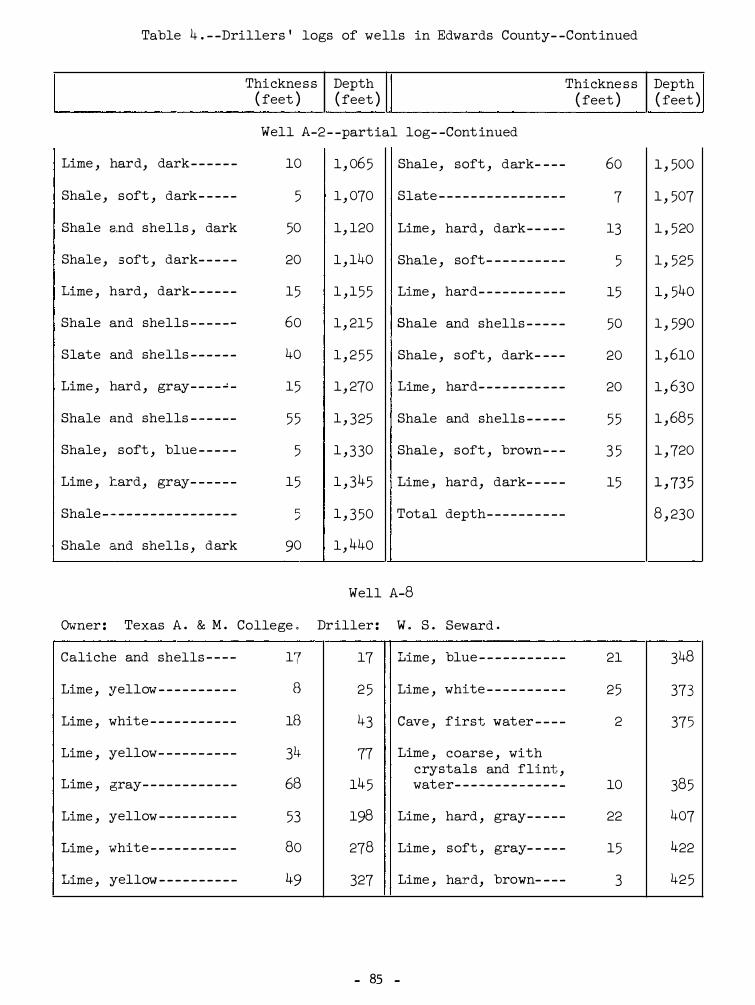
Table 4 . - -Drillers ' logs of wells in Edwards County- -Cont inued
Thickne s s Depth Thickne s s Depth ( feet ) ( feet ) ( feet ) ( feet ) Well A-2 - -partial log- -Cont inued
Lime , hard, dark- - - - - - 10 1 , 06 5 Shale , soft , dark- - - - 60 1 , 500
Shale , soft , dark- - - - - 5 1 , 070 Slate - - - - - - - - - - - - - - - - 7 1 , 507
Shale a.nd shells , dark 50 1, 120 Lime , hard , dark- - - - - 13 1 , 520
Shale , s oft , dark- - - - - 20 1 , 140 Shale , soft - - - - - - - - - - 5 1 , 525
Lime , hard , dark- - - - - - 15 1 , 15 5 Lime , hard- ·- - - - - - - - - - 15 1, 540
Shale and shells - - - - - - 60 1 , 21 5 Shale and shells - - - - - 50 1 , 590
Slate and shells - - - - - - 40 1 , 2 5 5 Shale , s oft , dark- - - - 20 1 , 610
Lime , hard , gray- - - - ..! - 15 1 , 270 Lime , hard- - - - - - - - - - - 20 1 , 630
Shale and shells - ·- - - - - 5 5 1 , 325 Shale and shells - - - - - 5 5 1 , 68 5
Shale , soft , blue - - - - - 5 1 , 3 30 Shale , soft , brown- - - 3 5 1 , 720
Lime , :tard , gray- - - - - - 15 1 , 345 Lime ., hard, dark- - - - - 15 1 , 735
Shale - - - - - - - - - - - - - - - - - h 1 , 3 50 Tot al depth- - - - - - - - - - 8 , 230 ,i
Shale and shells , dark 90 1 , 440
Well A-8
Owner : Texas A . & M . College ,. Driller : w . s . Seward .
Caliche and shells - - - - 17 17 T • .wlme , blue - - - - - - - - - - - 21 348
Lime , yellow - - - - - - - - - - B 2 5 Lime , white - - - - - - - - - - 25 373
Lime , white - - - - - - - - - - - 1B 43 Cave , f irst water - - - - 2 375
Lime , yellow - - - - - - - - - - 31+ 77 Lime , coarse , with crystals and flint ,
Lime , gray- - - - - - - - - - - - 6e 14 5 water- - - - - - - - - - - - - - 10 38 5
Lime , yellow - - - - - - - - - - 53 198 Lime , hard , gray- - - - - 22 407
Lime , white - - - - - - - - - - - 80 278 Lime , soft , gray- - - - - 15 422
T • .ulme , yellow - - - - - - - - - - 49 327 Lime , hard, brown- - - - 3 42 5
- 85 -

Table 4 . - -Drillers ' logs of wells in Edwards County- -Continued
Thickness Depth ( feet ) ( feet )
Well A-12
Owner : J . H . Taylor . Driller : 0 . L . Williams .
Lime- - - - - - - - - - - - - - - - -- 335 335 Lime , brown- - - - - - - -- -
Sand , water- - - - - - - - - - - 5 340 Shale , blue- - -- - - - - - -
Lime - - - - - - - - - - - - - - - - - - 160 500 Sand, oil and lime - - -
Shale and lime - - - - - - - - 20 520 Shale , blue- - - - - - - - - -
Sand , water - - - - - - - - - - - 5 525
Well A-24
Owner : Paul Turney . Driller : H. H . Sides .
Lime , yellow and gray, · with broken crevices
Lime , gray- - - - - - - - - - - -
Lime , yellow - - - - - - - - - -
Lime , gray- - - - - - - - - - - -
Lime , yellow- - - - - - - - - -
Lime , gray- - - - - - - - - - - -
Lime , yellow - - - - - - - - --
Lime , gray- - - - - - - - - - - -
Lime , and shale - - - - - - -
Lime - - - - - - - - - - - -- - - - - -
Lime , gray- - - - - - - - - - - -
Shale- - - - - - - - - - - - - - - - -
Lime , gray- - - - - - - - - - - -
Lime- - - - - - - - - - - - - - - - - -
Lime , gray- - -- - - - - - - - -
100
30
10
10
20
10
10
30
10
10
10
20
10
10
10
100
130
140
150
170
180
190
220
230
240
250
270
280
290
300
Shale- - - - - - - - - - - - - - - -
Shale, blue - - - - - - - - - -
Lime - - - - -- - - - - - - - - - - -
Sand and shale - - - - - - -
Shale , blue and sand-
Lime , gray- - - - - - - - - - -
Lime - - -- - - - - - - - - - - - - -
Lime , gray- - - - - - - - - - -
Shale, gray- - -- - - - - --
Shale, blue - - - - - - - - - -
Sand, oil show- - - - - - -
Shale, blue - - -- - - - -- -
Shale- - - - - - - - - - - - - - - -
Shale, blue- - - - - - - - - -
Lime , gray- - - - - - - - - - -
( Cont inued on next page }
- 86 -
Thicknes s ( feet }
5
50
10
10
10
10
5
5
5
25
10
10
10
20
10
5
15
20
10
Depth ( feet }
530
580
590
600
310
320
325
330
335
360
370
380
390
410
420
42 5
440
460
470

Table 4 . - -Drillers ' logs of wells in Edwards County- -Continued
Shale , blue- - - - - - - - - - -
Lime , blue- - - - - - - - - - - -
Lime , gray- -- - - - - - - - - -
Sand and shale , blue- -
Lime - - - - - - - - - - - - - - - - - -
Lime , gray- - - - - - - - - - - -
Lime - - - - - - - - - - - - - - - - - -
Lime and sand- - - - - - - - -
Lime , gray- - - - - - - - - - - -
Shale , gray- - -- - - - - - - -
Lime , gray- - - - - - - - - - - -
Lime and sand- - - - - - - - -
Sand and lime - - - - - - - - -
Lime - - - - - - - - - - - - - - - - - -
Lime and sand- - - - - - - - -
Lime , gray- - - - - - - - - - - -
Sand- - - - - - - - - - - - - - - - - -
Sand, dry- - - - - - - - - - - - -
Thickness Depth ( feet )
50
10
10
10
20
10
20
10
10
10
20
10
20
10
10
10
10
10
( feet ) Well A-24 - -Continued
520 Sand- - - - - - - - - - - - - - - -
530 Sand and gravel- - - - -
540 Shale , blue- - - - - - - - -
550 Sand and shale- - - - - -
570 Sand and gravel- - - - -
580 Sand and lime- - - - - - -
600 Sand , gummy, oil- - --
610 Sand and shale - - - - - -
620 Shale , sandy- - - - - - - -
630 Shale- - - - - - - - - - - - - - -
650 Sand and shale- - -- --
660 Shale , brown- - -- - - - -
680 Shale , blue- - - - - -- - -
690 Shale , gray- - - - - - - - -
700 Shale , brown- - - - - - - -
710 Shale , gray- - - - - - - - -
720 Shale - - - - - - - - - - - - - --
730
Well B-4
Owner : W . L . Miers . Driller : Sinclair Oil & Gas Co .
Caliche- - - -- - - - - - - - - - - 30 30 Anhydrite - -- - - - -- - - -
Lime, water- - - - - - - - - - - 330 360 Lime and shale- - - - - -
Thickness ( feet )
50
40
10
10
10
5
5
10
20
40
10
10
10
10
10
10
13
169
221
Shale , blue - - - - - - - - - -- 115 475 Lime and shale , sandy 156
Lime , sandy- - - - - - - - - - - 321 796 Lime and shale- -- - -- 224
Lime and shale - - - - - - -- 492 1, 288 Total depth- - - - - - - - -
- 8 7 -
Depth ( feet )
780
820
830
840
850
855
860
870
890
930
940
950
960
970
980
990
1 , 003
1 , 457
1 , 678
1 , 834
2 , 058
6 , 2 5 5

rable 4 . - -Drillers ' logs of wells in Edwards County- -Cont inued
I Thickness Depth Thickness Depth
( feet ) ( feet ) ( feet ) ( feet ) Well B-15
Owner : W. L. Holland . Driller : V. J. Meyer .
Lime, white- - - - ·- - - - - 185 185 Lime , gray, water- - - 23 395
Lime , gray- - - - - - - - - - 53 238 Lime , dark-gray- - - -- 70 46 5
Lime , hard, gray- - - - 16 254 Lime , light-gray- - -- 57 522
Lime , brown- - - - - - - - - 11 26 5 Shale - - - - - - - - - - - - - - - 16 538
Lime , gray- - - - - ·- - - - - 13 278 Lime , soft - - - - - - - - - - 13 551
Lime , yellow- - - ·- - -- - 22 300 Shale , green- - - - - - - - 10 561
Lime , gray- - - - - - - - - - 72 372
Well D- 5 - -partial log
Owner : J. H . Gutherie . Driller : Humble Oil & Refining Co .
Clay, surface and Lime and sand- - - - - - - 130 1, 042 gravel- - - - - - - - - - - - 50 50
Sand and shale- - - - - - 63 1 , 105 Lime , gray- -- - - - - - - - 151 201
Lime - - -- - - - - - - - - - - - - 77 1 , 182 Shale , green._- - - - - - - - 183 384
Lime and sand- - -- - - - 71 1 , 2 53 Shale and sand - - - - - - 157 541
Sand , lime , and Shale and lime- - - - - - 125 666 shale- - - - - - - - - - - - - 73 1 , 326
Shale and sand- - - - - - 207 873 Total depth- - - - - -- - - 4 , 140
Lime - - - - - - - - - - - - - - - - 39 912
Well D-9
Owner : S . J . Epperson . Driller : W . S . Seward .
Surface - - - - - - - - - - -- - 2 2 Lime , white - - - - - - - - - 2 5 115
Lime , yellow- - - - - - - - 16 18 Lime , prawn .._.. - :.. _ ·_ .,. _ _ _ 23 138
Lime , broken, caves- 72 90 Lime , yellow- - - - - - - - 38 176
(Continued on next page )
- 88 -

Table 4 . - -Drillers ' logs of wells in Edwards County- -Continued
I Thickne ss Depth
( feet ) ( feet ) Well D-9- -Continued
Lime , gray- ·- - - - - - - - - - - 16 192 Lime , yellow - - - - - - - -
Flint - - - - - - ·- - - - - - - - - - - ·4- 196 Lime , white - - - - - - - - -
Lime , white - - - - - - - - - - - 19 215 Lime , gray , water - - -
Lime , yellovT - - - - - - - - - - 38 2 53 Lime , brown- - - - - - - - -
Lime , white - - - - - - - - - - - 21 274 Lime , gray- - - - - - - - - -
Well D-12
Owner : s . �r . Epperson . Driller : w . s . Seward .
Surface - - - - - - - - - - - - - - - l+ 4 Lime , white - - - - - - - - -
Lime , yellow - - - - - - - - - - 76 80 Lime , gray- - - - - - - - - -
Lime , white - - - - - - - - - - - 97 177 Lime , brown, water 320-3 50- - - - - - - - - - -
Lime , yellow' - - - - - - - - - - 100 277
Well D-13
Owner : G . Lovelady . Driller : W . S . Seward .
No record - - - - - - - - - - - - - 247 247 Lime , brown , (water ) Lime , white - - - - - - - - - - - 31 278 Lime , gray- - - - - - - - - -
Well E-1
Owner : Mrs . V . Shurley . Driller : P . Urban .
Lime , white , and Lime , yellow- - - - - - - -caliche - - - - - - - - - - - - - 95 95
Lime , white - - - - - - - - - - - 90 18 5
Well E-13 - -part ial log
Owner : Mrs . W . C . Rigsby . Driller : Auld , Dodson and Lyman .
I Lime - - - - - - - - - - - - - - - - - - 290 290 I I Lime , water - - - - - - - - -
( Cont inued on next page }
- 8 9 -
Thicknes s ( feet )
19
1 5
42
14
6
13
30
30
9
13
20
60
Depth ( feet )
293
308
3 50
364
370
290
320
3 50
287
300
205
3 50

Table 4 . - -Drillers ' logs of wells in Edwards County- -Continued
Lime - - - - - - - - - - - - - - --
Shale - - - - - - - - - - - - - - -
Lime - - - - - - - - - - - - - - - -
Shale , blue - - - - - - - - -
Shale - - - - - - - - - - - - - --
Shale , blue - - - - - - - - -
Shale - - - - - - - - - - - - - - -
Shale and lime - - - - - -
Lime, gray- - - - - - - - - -
Lime and shale - - - - - -
Lime - - - - - - - - - - - - - - - -
Thickne ss Depth ( feet ) ( feet ) Well E-13 --partial log- -Continued
95
20
5
5 5
20
5 5
20
20
20
30
100
44 5 Lime and shale - - - - -
46 5 Lime -- --- - - -- -- - - - -
470 Shale - - - - - - - - - - - - - -
52 5 Sand, water- - - - - - - -
54 5 Sand- - -- - - - - - - - - - - -
600 Shale - - - - - - - - - - - - - -
620 Sand and shale -- - - -
640 Shale , brown- - - - - - -
660 Shale - - - - - - - - - - - - - -
690 Total depth- - - - - - - -
790
Well E-18� -partial log
Owner : P . & L . Jackson . Driller : McMann Oil & Gas Co .
Lime - - - - - - - - - - - - - - - -
Lime , sandy- - - - - - - - -
Lime - - - - - - - - - - - - - - --
Mud, blue - - - - - - - - - - -
Lime , sandy- - - - - - - - -
Mud , blue - - - - - - - - - - -
Lime - - - - - - - - - - - - - - - -
Mud , blue - - - - - - - - - - -
Shale , gray sandy- - -
Lime , broken- - - - - - - -
32 5
40
130
80
10
7 5
10
60
20
15
32 5 Shale , light - - - - -- -
36 5 Mud, blue - - - - - - - - - -
495 Shale, light - - - - - - -
575 Mud , blue- - - - -- - - - -
585 Lime - - -- - - - - - - - - - - -
660 Sand- - - - - - - - - - - - - - -
670 Mud, :red - - - - - - - - - - -
730 Lime , sandy- - - - - - - -
750 Sand, heavy- - - - - - - -
76 5 Gravel- - - - - - - - - -- - -
( Continued on next page )
- 90 -
Thickness ( feet )
5 5
15
5
2 5
10
2 5
15
1 5
2 5
3 0
4 0
15
15
7
13
20
10
Depth ( feet )
84 5
860
86 5
890
900
925
940
9 5 5
980
3 , 952
810
8 5 5
88 5
925
940
9 5 5
962
975
995
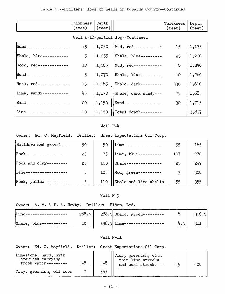
Table 4 . - -Drillers ' logs of wells. in Edwards County- -Continued
Thickness Depth Thickness Depth ( feet ) ( feet ) ( feet ) { feet )
Well E-18-partial log- -Continued
Sand- - - - - - - - - - - - - - - - - - 45 1 , 050 Mud, red- - - - - - - - - - -- 15 1 , 175
Shale , blue- - - -- - - - - - - 5 1 , 05 5 Shale, blue- - - - - - - - - 2 5 1 , 200
Rock, red- - - - - - - - - - - - - 10 1 , 065 Mud , red- - - - - - - - - - - - 40 1 , 240
Sand- - - - - - - - - - - - - - - - - - 5 1 , 070 Shale , blue - - -- - - - - - 40 1 , 280
Rock, red- - - - - - - - - - - - - 15 1 , 085 Shale , dark- - -- - - - - - 330 1 , 610
Lime , sandy- - - - - - - - - - - 4 5 1 , 130 Shale , dark sandy- - - 75 1 , 685
Sand- - - - - - - - - - - - - - - - - - 20 1 , 150 Sand- - - - - - - - - - - - - - - - 30 1 , 715
Lime - - - - - - - - - - - - - - - - -- 10 1 , 160 Total depth- - -- - - - - - 3 , 897
Well F-4
Owner : Ed . C . Mayfield . Driller : Great Expectat ions Oil Corp .
Boulders and gravel- - - 50 50 Lime - - - - - - - - - - - - - - -- 5 5 165
Rock- - - - - - - - - - - - - - - - - - 2 5 75 Lime , blue - - - - - - - - - - 107 272
Rock and clay- - - - - - - - - 2 5 100 Shale - - - - - - - - - - - - - - - 2 5 297
Lime - - - - - - - - - - - - - - - - -- 5 105 Mud , green- - - - - - - - - - 3 300
Rock, yellow- - - - - - - - - - 5 110 Shale and lime shells 55 355
Well F -9
Owner : A . M . & B . A . Newby . Driller : Eldon, Ltd .
Lime - - - - - - - - - - - - - - - - - - 288 . 5 288 . 5 Shale , green- - - - - - - - - 8 306 . 5
Shale , blue - - - - - - - - - - - 10 298 . 5 Lime - - -- - - - - - - - - - - - - - 4 . 5 311
Well F-11
Owner : Ed . C . Mayfield . Driller : Great Expectations Oil Corp .
Limestone , hard, with Clay, greenish, with crevices carrying
348 348 thin lime streaks
fresh water - - - - - - - - - • and sand streaks - - - 4 5 400
Clay, greenish, oil odor 7 3 5 5
- 9 1 -
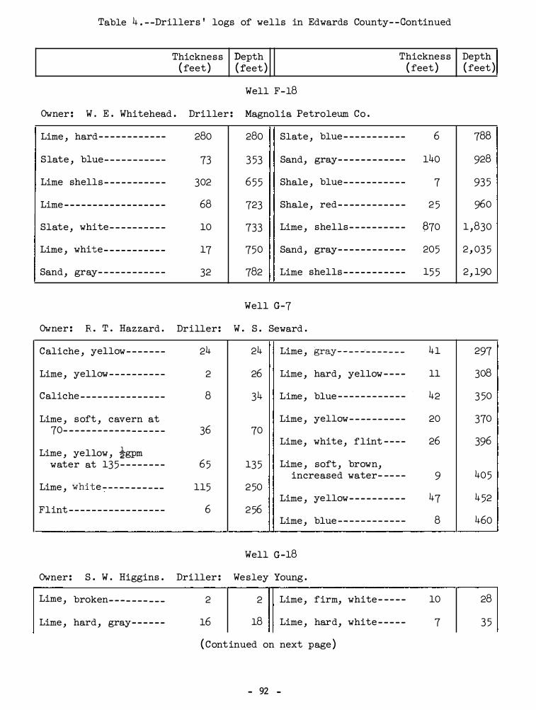
Table 4 . - -Drillers ' logs of wells in Edwards County- -Continued
Thickness Depth Thickness Depth ( feet ) ( feet ) ( feet ) ( feet )
Well F-18
Owner : W . E . Whitehead . Driller : Magnolia Petroleum Co .
Lime , hard- - - - - - - - - - -- 280 280 Slate , blue- - - - - - - - - -- 6 788
Slate , blue- - - - - - - - - - - 73 3 53 Sand, gray- - - - - - - - - - - - 140 928
Lime shells - - - - - -- - - - - 302 6 5 5 Shale , blue- - - - - - - - - - - 7 93 5
Lime - - - - - - - - - - - - - - - - - - 68 723 Shale , red- - -- - - - - - - - - 2 5 960
Slate , white- - - -- - - - - - 10 733 Lime , shells - - -- - - - - - - 870 1 ,830
Lime , white- - - - - - - - - - - 17 750 Sand , gray- - - - - - - - - - - - 205 2 , 03 5
Sand , gray- - - - - - - - - - - - 32 782 Lime shells - - - - - - - - - -- 15 5 2 , 190
Well G-7
Owner : R . T . Hazzard . Driller : W . S . Seward .
Caliche , yellow- - - - - - - 24 24 Lime , �ray- - - - �- - - - - - - 41 297
Lime , yellow - - - - - - - - - - 2 26 Lime , hard, yellow - - - - 11 308
Caliche - - - - - - - - - - - - - - - 8 34 Lime , blue - - - - - - - - - - - - 42 3 50
Lime , soft , cavern at Lime , yellow- - -- - - - - - - 20 370 70- - - - - - - - - - - - - - - - - - 36 70
Lime , white , flint - - - - 26 396 Lime , yellow , �gpm
water at 13 5 - - - - - - - - 6 5 13 5 Lime , soft , brown, increased water- -- - - 9 40 5
Lime , white - - � - - - - - --- 115 2 50 Lime , yellow- - - - - - - - - - 47 4 52
Flint - - - - - - - - - - - - - - - - - 6 2 56 Lime , blue - - - - - - - - - - - - 8 460
Well G-18
Owner : S . W . Higgins . Driller : Wesley Young .
Lime , broken- - - - - - - - - - 2 2 Lime , firm, white - - - - - 10 28
Lime , hard , gray- - - - - - 16 18 Lime , hard, white - - - - - 7 3 5
( Continued on next page )
- 92 -

Table 4 . - -Drillers ' logs of wells in Edwards County- -Continued
Thickness Depth Thickness Depth ( feet ) ( feet ) ( feet ) ( feet )
Well G-18- -Continued
Lime , hard, yellow- - - - 7 42 Lime , hard , yellow- - - - 40 23 5
Lime , white - - - - - - - - - - - 43 85 Lime , hard , leaky, pink- - - - - - - - - - - - - - - - 15 250
Blind , no samples - - - - - 2 5 110 Cavity, blind, no
Lime , hard , pink- - - - - - 20 130 samples- - - - - - - - - - - - - 10 260
Lime , sandy, sharp- - - - 15 145 Sand , coarse (water ) -- 5 26 5
Lime , pink- - - - -- - - - - - - 50 195 Sand , hard , brown- - - - - 17 282
Well H-4 - -partial log
Owner : Mrs . H . H . Hough o Driller : The Texas Co .
Boulders and surface Lime , brown streaks - - - 50 495 dirt - - - - - - - - - - - - - - - - - 3 3
Lime , gray- - - - - - - - - - - - 23 518 Stone , yellow and lime - 29 32
Shale , gray- - - - - - - - - - - 27 545 Blind- - - - - - - - - - - - - - - - - - 18 50
Shale , green- - -- - - - - - - 4 5 590 Lime , hard- - - - - - - - - - - - - 30 80
Shale - - - - - - - - - - - - - - - -- 20 610 Lime , yellow- - - - - - - - - - - 4 5 12 5
Shale , green- - - - -- -- - - 15 625 Anhydrite - - - - - - - - - - - - - - 2 5 150
Lime , sandy- - - - - - - - - - - 122 747 Lime, honeycombed, and
anhydrite - - - - - - - - - - - - 35 185 Shale and lime - - - - - - -- 326 1 , 073
Blind- - - - - - - - - - - - - - - - - - 70 255 Shale and lime , with shells - - - - - - - - - - - - - - 171 1 , 244
Ha.rd and blind- - - - - - - - - 5 5 310 Shale and lime - - - - - - - - 32 1 , 276
Lime , yellow- - - - - - - - - - - 5 315 Shale , black- - - - - - - - - - 10 1, 286
Sand , water - - - - - - - - - - - - 15 330 Shale and lime - - - - - - - - 54 1, 340
Sand- - - - - - - - - - - - - - - - - - - 10 340 Shale , black- - - - - - - - - - 202 1 , 542
Lime , sandy brown- - - - -- 60 400 Total depth- - - - - - - - - - - 5 , 307
Lime brown- - - - - - - - - - - - - 4 5 445
- 93 -

I
Table 4 . --Drillers ' logs of wells in Edwards County- -Continued
Thickness Depth Thickness ( feet ) ( feet ) ( feet )
Well H-30
Owner : Homer Rudasill . Driller : W. S . Seward .
Lime , white --- - - - - - - - - 60 60 Lime , white- -- - - - - - - 16
Lime , yellow- - - - - - - - - - 110 170 Lime , yellow-- - - - - - - 16
Lime , white - - - - - - - - - - - 90 260 Lime , white - - - - - - - -- 43
Lime , gray- - - - - - - - - - - - 13 273 Lime , gray, water - -- 15
Lime , yellow- - - - - - - - - - 27 300
Well H-44
Owner : City of Rocksprings . Driller : Lets inger Sonora Drilling Co .
Depth ( feet )
316
332
375
390
.... . _ . .... . ""·"·· ---------------- ---------..,...-----.
No record - - - - - - - - - - - - - L1-34 Lime , gray- - - - - - - - --
Water formation- - - - - - - 44 5 Mud , blue - - - - - - - - - - -
Well H-46
Owner : City of Rocksprings . Driller : Layne -Texas Co .
Lime , sandy, yellow Lime , white -- - - - - - --and whit e , lime shells , cave at Lime , pink- - - - - - - - - -150-160 feet - - - - - - - - 175 175
Lime , white - - - - - - - - -Lime , and flint lime - - 120 295
Sand , fine , water- - -Lime , yellow , flint- -- 25 320
Slate , blue - - - - - - - - -
Well J-6 _- -partial log
Owner : Hal Bradford . Driller : Dan Auld , et al .
( Continued on next page )
- 94 -
115
3
4 5
20
50
50
115
560
563
36 5
385
43 5
485
6oo
930
94 5

I
Table 4 . --Drillers ' logs of wells in Edwards County- -Continued
Thickness Depth Thickne ss
Sand , water- - - -- - - - - - -
Rock, red- -- - - - - - - - - - -
Conglomerate- - - - - - - - - -
Rock, red- - - - - - - - - - - - -
( feet ) ( feet ) Well J-6- -partial log- -Continued
10
15
17
990 Lime , broken and slate
1 , 000 Shale , blue- - -- - - - - - - -
1 , 015 Total depth- -- - - - - - - --
Well J-18- -partial log
Owner : J . S . Peterson . Driller : James Dalglish, et al .
Lime , water- ·- - - - - - - - - - 525 525 Sand- - - - - - - - - - - - - - - - - -
Slate , broken, gray- - - 19 544 Slate , yellow- - - - - - - - -
Shale , green- - - - -- - - - - 119 663 Slate , dark- - - - - - - - - - -
Shale , gray- -- - - - - - - - - 110 773 Sand- -- -- - - - - - - - - - - - - -
Lime , broken- - - - -- - - -- 41 814 Lime, gray, sandy- - - - -
Slate , white - - - - - - - - - - 36 850 Slate, black- - - -- - - - --
Lime , broken- - - - - - - - - - 50 900 Lime , gray- - - - - - - - - - - -
Slate and lime shells - 112 1 , 012 Sand, gray- - - - - - - - - - - -
Sand , water- - - - - - - - - - - 28 1 , 040 Lime , black- - - - - - - - - - -
Red beds , sandy- - - - - -- 5 5 1 , 095 Total depth- - - - - - - - - - -
Slate , red - - - - -- - - - - - - 52 1 , 147
Well J-20- -partial log
Owner : J. S . Peterson . Driller : - -Weymeyar .
Limestone - - - - - - - - - - - -- 310 310 Shale , light green- - - -
Lime , (water unbail- Shale - -- - - - - - - - - - - - - - -able ) - - - - - - - - - - - - - - - 10 320
Sand, water (top Limestone- -- - - - - - - - - - - 180 500 Hensell ) - - - - - - - - - - --
( Continued on next page )
- 95 -
( feet )
33
75
45
25
36
319
46
39
40
180
290
52
Depth ( feet )
1 , 095
1 , 180
4 , 224
1 , 180
1 , 255
1 , 300
1 , 325
1 , 361
1 , 680
1 , 726
1 , 765
1 , 805
5 , 206
680
970
1 , 022

Table 4 . - -Drillers ' logs of wells in Edwards County- -Cont inued
Thicknes s Depth ( feet ) ( feet )
Well J-20- -partial log- -Continued
Sand shells-- - - -- -- - -- - 53 1 , 075 Shell- - -- -- - - - - - - - - - -
Shale- - - - - - - - - - - - - - - - - - 33 1 , 108 Shale , black- - - - - - - - -
Shale-reddish color- - - - 32 1 , 140 Total depth- - - - - -- - - -
Shale , black- - - - - - - -- - - 70 1 , 210
Well J-21- -partial log
Thickness ( feet )
4
56
Owner : J . S . Peterson . Driller : X . K . Stout .
Lime , surface - - - - - - - - - - 235 235 Clay, yellow- -- -- - -- - 25
Sand, water- - - - -- - - - - - - 12 247 Shale , gray- - - - -- - - - - 20
Lime , water- - - - - - - - - - - - 153 400 Shale , mi:xed, red and green- - - -- - - - - - - - - - 50
Lime , broken- - - - - - - - - - - 130 530 Shale, mixed , rotten- 68
Shale , green- - - - - - -- - - - 60 590 Shale, sandy, black- - 122
Shale , gray- - - - - - - - - - - - 105 695 Shale, sandy, gray- - - 240
Shale , gray and lime shells - - - - - - - - - - - - - - - 30 725 Sand, broken- - - - - - - - - 40
Lime , broken- - -- -- - -- - - 325 1 , 050 Shale , sandy and shells 45
Sand , water- - - - - - -- - - - - 60 1 , 110 Shale , brown and black 45
Sand , broken- -- - - - - - - - - 2 5 1 , 13 5 Total depth- - - - - - - - - - -
Well J-23- -partial log
Owner : J . S . Peterson . Driller : X . K . Stout .
Lime- -- - - - - - - - - - - - - - - - - 550 5 50 Limestone - - - - - -- - - - - - - 5
Shale, light green and Shale , sandy- - - - - - - - -- 85 gray- - - - - - - - - -- - - - - - - 16 5 715
Slate , white and shells 25 Shale , gray- - - - - -- - - - - - 3 5 750
Limestone , broken:- - - - - 130 Shale , white- - - -- - - - - - - 5 755
( Continued on next page )
- 96 -
Depth ( feet )
1 , 214
1 , 270
3 , 962
1 , 160
1 , 180
1 , 230
1 , 298
1, 420
1, 660
1, 700
1, 745
1 , 790
2 , 440
760
845
870
1 , 000

Table 4 . - -Drillers ' logs of wells in Edwards County- -C ontinued
Thickne s s Depth Thickness Depth { feet ) ( feet ) { feet ) ( feet )
Lime , water - - - - - - - - - - 5 50 5 50 Sand - - - - - - - � - - - - - - - - 8 1 , 108
Shale , green and gray 16 5 715 Shale , blue - - - - - - - - - 42 1 , 150
Shale , gray- - - - - - - - - - 3 5 7 50 Shale , yellow - - - - - - - 13 1 , 16 3
Shale , -white - - - - - - - - - 5 7 5 5 Shale , brown- - - - - - - - 22 1 , 18 5
Shale , s andy- - - - - - - - - 90 84 5 Shale , red- - - - - - - - - - 5 1 , 190
Slate , white and shells 2 5 870 Shale , brown and yellow - - - - - - - - - - - - 30 1 , 220
Lime , broken- - - - - - - - - 130 1 , 000 Shale , mixe d , brown- 15 1 , 23 5
Lime - - - - - - - - - - - - - - - - - 20 1 , 020 Shale , mixed - - - - - - - - 3 5 1 , 270
Shale - - - - - - - - - - - - - - - - 3 5 1 , 0 5 5 Shale , black- - - - - - - - 6 0 5 1 , 875
Sand , water - - - - - - - - - - 20 1 , 075 Total depth- - - - - - - - - 4 , 600
Lime - - - - - - - - - - - - - - - - - 2 5 1 , 100
- 9 7 -

Table 4 . - -Drillers ' logs of wells in Edwards County- -Continued
Thickness Depth Thicknes s Depth ( feet ) ( feet ) ( feet ) ( feet ) Well J-3 5- -partial log
Owner : C . & H . Peterson . Driller : Dan Auld , et al .
Lime and caliche - - - - -- 100 100 Lime - -- - - - - - - -- - - - - - 67 785
Lime- - - - - - - - - - - - - - -- - - 30 130 Shale and lime - - - - - - 15 Boo
Lime , sandy- - - - - - - - - - - 10 140 Lime - - - - - - - - - - - - - - - - 8 5 885
Lime - - - - - - - - - - - - - - - - - - 70 210 Lime , broken- - - - - - - - 4 5 930
Lime and caliche - -- - - - 60 270 Lime - - - - - - - - - - - - - - - - 30 960
Lime - - - - - - - - - - - - - - - - - - 10 280 Anhydrite and lime - - 4 5 1 , 005
Lime and caliche - - - - - - 10 290 Lime , broken- - - - - - - - 20 1 , 025
Anhydrite and lime - - - - 6 5 3 5 5 Sand- - - - - - - - - - - - - - - - 6 5 1 , 090
Lime and sands - - - - - - - - 2 5 380 Shale- - - - - - - - - - - - - - - 20 1 , 110
Shale , blue and caliche 10 390 Lime - - - - - - - - - - - - - - - - 7 1 , 117
Lime and shale- - - - - -- - 40 430 Shale , green- - -- - - - - 5 1, 122
Shale - - - - - -- - - - - - - - - - - 3 0 460 Lime and shale - - - - - - 18 1 , 140
Lime and caliche - - - - - - 20 480 Shale , blue - - - - - - - - - 13 1, 153
Lime - - - - - - - - - - - - - - - - - - 45 525 Red beds - - - - - - - - - - - - 9 1 , 162
Shale , blue- - - - - - - - - - - 20 545 Rock, red- - - - - - - - - - - 13 1, 175
Shale- - - - - - -- - - - - - - - - - 64 609 Clay, yellow- - - - - - - - 10 1 , 185
Lime - - - - - - - - - - - - - - - - - - 6 615 Shale and lime shells 4 5 1 , 230
Shale , blue- -- - - - - - - - - 2 5 640 Shale , black- - - - - - - - 17 1 , 247
Shale , blue , and Lime , black- - - - - - - - - 10 1 , 257 caliche- - - - - - - - -- - - - 30 670
Shale , black, and Shale - - - - - - - - - - - - - - - - - 30 700 lime - - - - - - - - - - - - - - 18 1 , 275
Anhydrite and lime - - -- 18 718 Total depth 5 , 078
- 98 -

I
Table 4 . - -Drillers ' logs of wells in Edwards County- -Continued
Thickne ss Depth ( feet ) ( feet )
Well K-4
Owner : W . G . Welch . Driller : K . E . Edmonds .
Soil- - - - - - - - - - - - - - - - 3 3 Rock, broken- - - - - - - -
Lime , soft - - - - - - - - - - 17 20 Lime , yellow- - - - - - - -
Lime , hard- - - - - - - - - - 5 25 Lime , white - - - - - - - - -
Rock, honeycombed- - - 2 5 50 Lime , soft , and gravel , water- - - - -
Lime , hard , white - - - 45 95 Lime , white - - - - - - - - -
Rock, broken crevices 59 154
Lime , white --· - - - - - - - 36 190
Well K-15 - -partial log
Owner : Mrs . S . A . Hatch . Driller : Plateau Oil and Gas Co .
Lime- - - - - - - - -· - - - - - - -
Gravel- - - - - - -· - - - - - --
Lime , brown- -· - - - - - - -
Lime - - - - - - - - - - - - - - - -
Shale , blue - - - - - - - - -
Lime - - - - - - - - - - - - - - - -
Lime , brown- -- - - - - - -
Lime - - - - - - - - - - -- - - - -
Shale , gray- - - - - - - - -
Shale and lime- - - - - -
Lime shells and shale
Lime - -- -- - - - - - - - - - - -
Shale , gray- - - - - - - - -
290
20
8
177
133
112
20
20
25
80
70
15
10
290 Sand, water- - - - - - - - -
310 Sand , hard- - - - - - - - - -
318 Rock, red- - -- - - - - - - -
495 Sand- - - - - - -- - - - -- - - -
628 Sand conglomerate- --
740 Rock, red and sand - -
760 Rock, red- - - - -- - - - --
780 Lime , broken- - - -- - - -
805 Mud, blue- - - - - - - - - - -
885 Lime - - - - - - - - - - - - - - - -
955 Sand- - -- - - - - - - - - - - - -
970 Rock , red- - - - - - - - - - -
980 Sand- - -- - - - -- - - - - - - -
(Continued on next page )
- 9 9 -
Thickness ( feet )
18
5 5
17
12
8
25
2 5
10
20
25
15
10
30
22
3
5
54
18
Depth ( feet )
208
263
280
292
300
1 , 005
1 , 030
1 , 040
1 , 060
1 , 085
1 , 100
1 , 110
1 , 140
1 , 162
1 , 16 5
1 , 170
1 , 224
1 , 242

Table 4 . --Drillers ' logs of wells in Edwards County- -Cont inued
Rock, red- - - - - - - - - - - -
Red beds , hard- - - - - - -
Shale , brown- - - - - - - - -
Shale , red , white , and blue- - - - - - - - - - -
Slat e , blue - - - - - - - - - -
Thickness Depth (feet ) (feet ) Well K-15--partial log- -Continued
18 1, 260 Shale , blue and brown- - - - - - - - - - - -
40 1 , 300 Shale , blue- - - - - - - -
20 1, 320 Shale , gray- - - - - - - -
10 1 , 330 Total depth- - - - - - - -
2 5 1 , 3 5 5
Well L-1
Thicknes s Depth ( feet ) ( feet )
20 1 , 375
5 5 1, 430
10 1 , 440
5 , 176
Owner : C . H . Whitehead and C . B . Wardlaw . Driller : E . B . Fuller . -
Lime - - - - - - - - - - - - - - - - - 100 100 Lime , yellow- - - - - - - 25 260
Flint - - - - - - - - - - - - - - - - 1 5 115 Lime , white- - - - - - - - 40 300
Lime , white - - - - - - - - - - 6 5 180 Lime, gray- - - - - - - - - 50 3 50
Lime , yellow- - - - - - - - - 1 5 195 Lime , white - - - - - - - - 2 5 375
Clay, red - - - - - - - - - - - - · 10 205 Lime , gray, water- - 20 395
Lime , yellow- - - - - - - - - 20 225 Edwards lime- - - - - - - 60 455
Lime , white - - - - - - - - - - 10 235 Shale , blue - - - - - - - - 47 502
Well L-14
Owner : Ned Dunbar . Driller : W . S . Seward .
Surface ( soil ) - - - - - - - 4 4 Lime, white - - - - - - - - 129 257
Lime , yellow- - - - - - -- - 26 30 Lime , yellow- - - - - - - 13 270
Lime , white - - - - - - - - - - 80 110 Lime , gray, water- - 10 280
Lime , yellow- - - - - - - - - 18 128 Lime , brown- - - - - - - - 11 291
- 100· -

Table 4 . - -Drillers ' logs of wells in Edwards County- -Cont inued
I Thickness Depth Thickness Depth ( feet ) (feet ) ( feet ) (feet )
Well L-15
Owner : Ned Dunbar . Driller : W . S . Seward .
Boulders - - - - - - - - - - - - - 2 2 Lime , yellow , water seep, 225 -230- -- - - - - 75 280
Lime , white- - - - - - - - - - 8 10 Lime , white- - -- -- - - - -- 30 310
Lime , yellow- - - - - - - -- 3 5 4 5 Lime , gray- - - - - - - - - - - - 9 319
Lime and flint - - - - - - - 77 122 Lime , white , water ,
Lime , yellow- - - - - - - -- 41 163 36 5 - - - - - - - - - - - - - - - - - 72 391
Lime , white - - - - - - - - - - 42 205
Well L-17
Owner : Barron and McClain Ranch . Driller : W . S . Seward .
Soil and boulders- - - - 5 5 Lime , yellow- - - - - - - - - - 17 290
Lime , yellow- - - - - - - - - 20 25 Lime , white , water - - - - 2 5 315
Lime, white - - - - - - - - - - 131 156 Lime , gray- - - -- - - - - - - - 40 355
Lime , brown- - - - - - - -- - 44 200 Lime , blue- - - - - - - - - - - - 29 384
Lime , white- - - - - - - - - - 73 273
Well L-20
Owner : Ned Dunbar . Driller : W . S . Seward .
Soil and boulders- - - - 2 2 Lime , white- -- - - - - - - - - 70 310
Lime , white - - - - - - - - - - 6 8 Lime , yellow- - - - - - - - - - 12 322
Lime , yellow- - - - - - - - - 24 32 Lime, white - - - - - - - - - - - 30 352
Lime , broken- - - - - - - - - 38 70 Lime , yellow, water- -- 16 368
Lime and flint - ---- - - 114 184 Lime , gray- - - - - -- - - - - - 2 370
Lime , yellow- - - - - - - - - 56 240
- 101 -
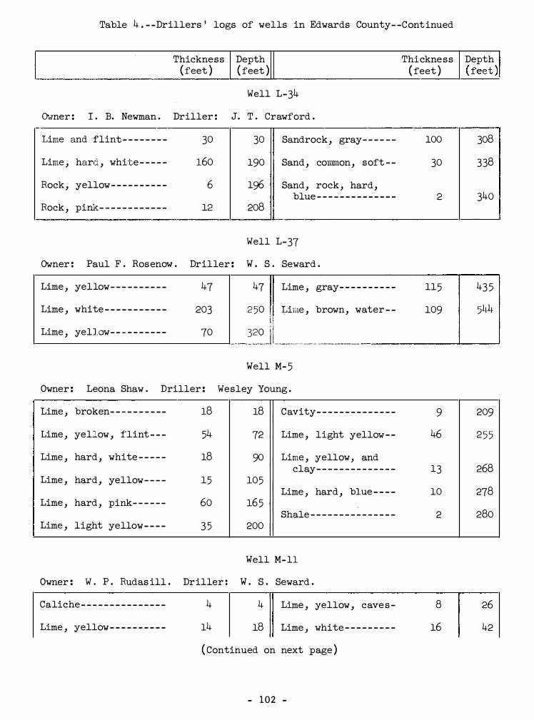
Table 4 . - -Drillers ' logs of wells in Edwards County- -Continued
Thickness ( feet )
Depth ( feet )
Thickness ( feet )
--------------------------------�----�------------------------
Well L-34
Owner : I . B. Newman . Driller : J. T . Crawford . -·-
Lime and flint - - - - - - - - 30 30 Sandrock, gray- - - - - - 100
Lime , hard , white - - - - - 160 190 Sand , cormnon, soft - - 30
Rock, yellow- - - - - - - - - - 6 196 Sand, rock, hard, blue - - - - - - - - - - - - - - · 2
Rock, pink- - - - - - - - - - - - 12 208
Well L-37
Owner : Paul F . Rosenow . Driller : W . S . Seward .
Lime , yellow- - - - - - - - - - 47 47 Lime , gray- - - - - - - - - - 115
Lime , white - - - - - - - - - - - 203 2 50 �ime , brown, water - - 109 d
Lime , yellow- - - - - - - - - - 70 320 1 ! ____ l. t. ___________________ ·-----------
Well M- 5
Owner : Leona Shaw . Driller : Wesley Young .
Lime , broken- - - - - - - - -- 18 18 Cavity- - - - - - - - - - - - - - 9
Lime , yellow , flint - - - 54 72 Lime , light yellow - - 46
Lime , hard , white - - - - - 18 90 Lime , yellow, and clay- - - - - - - - - - - - - - 13
Lime , hard, yellow- - - - 15 105 Lime , hard , blue - - - - 10
Lime , hard , pink- - - - - - 60 165 Shale - - - - - - - - - - - - - - - 2
Lime , light yellow- - - - 3 5 200
Well M-11
Owner : W . P . Rudas ill . Driller : W . S . Seward .
Caliche - - - - - - - - - - - - - - - 4 4 Lime , yellow , cave s - 8
Lime , yellow- - - - - - - - - - 14 18 Lime , white - - - - - - - - - 16
( Continued on next page )
- 102 -
Depth I ( feet ) !
308
338
340
43 5
5l1.l�
209
2 5 5
268
278
280
26
42

Table 4 . - -Drillers ' logs of wells in Edwards County- -Continued
Thickness Depth Thickness Depth ( feet ) (feet ) ( feet ) ( feet )
104
110
Well M-14
Owner : W . E . Wittenburg . Driller : W . S . Seward .
Lime , yellow- - - - - - - - - 68 68 Lime , blue , water, 268-270 feet - - - � - - - 2 5 295
Lime , gray- - - - - - - - - - - 177 245 Shale , blue- - -- - - - - - - 9 304
Lime , yellow- - - - - - - - - 25 270
Well M-26
Owner : Mrs . M . I . Dragoo . Driller : W . S . Seward .
Lime , white- - - - - - - - - 143 143 Lime , yellow- - - - - - -- - 30 350
Lime , yellow - - - - - - - - 57 200 Lime , brown, water at 3 50 - - - - - - - - - - - - 8 3 58
Lime , white - - ,- - - - - - - 120 320 Lime , gray- - - - - - - - - - - 65 423
Well M-30
Owner : L . L. Ellis . Driller : W. S . Seward .
Surface- - -- -- -- - - - - - - 4 4 Lime , gray- - -- -- -- - - - 27 167
Lime , yellow- - - - - - - - - 14 18 Lime , yellow- - - - - - - - - 56 223
Flint , cave - - - - - - - - - - 5 23 Lime , white - - - - - - - - - - 17 240
Lime , yellow- - - - - - - - - 67 90 Lime , yellow- - - - - - - - - 28 268
Lime , white- - - - - - - - - - 8 98 Lime , yellow , water- - 12 280
Lime , yellow- - - - - - - - - 42 140 Lime , blue- - - - - - - - - - - 24 304
- 103 -

Table 4 . - -Drillers ' logs of wells in Edwards County- -Continued
Thickness Depth Thickness Depth ( feet ) ( feet ) ( feet ) ( feet �
Well M-5 5
Owner : J . S . Balentine . Driller : W . S . Seward .
Flint - - - - - - - - - - - - - - - - 2 2 Lime , yellow- - - - - - - - -
Lime , hard , yellow- - - 113 115 Lime , yellow , water at 160-165 - - - - -- - - - -
Lime , hard, white - - - - 30 145
Well N-1
Owner : H . S . Martindale . Driller : W . S . Seward .
Surface - - - - - - - - - - - - - - 2 2 Lime , broken, yellow-
Lime , broken, white - - 143 145 Lime , solid, yellow- -
Lime , yellow- - - - - - - - - 7 152 Lime , yellow- - - - - - - - -(water from 300-315 )
Lime , white - - - - - - - - - - 38 190
Well N-12
Owner : W . P . Rudasill . Driller : Seward & Placker .
No record- - - - - - - - - - - - 213 213 Lime , brown, water (well deepended from
Lime , white - - - - - - - - - - 3 5 248 212 to 304 feet ) - - -
Lime , yellow- - - - - - - - - 3 5 283
Well N-22
Owner : S . S . Henry . Driller : W . S . Seward .
Soil- - - - - - - - - - - - - - - - - 2 2 Lime , yellow- - - - - - - - -
Lime , yellow- - - - - - - - - 16 18 Lime , white , caves - - -
Lime , broken- - - - - - - - - 12 30 Lime , yellow , cave s - -
Lime , yellow- - - - - - - - - 27 57 Lime , solid, yellow , water , first water
Flint , red- -- -- - - - - - - 7 64 at 218 feet - - - - - - - -
( Continued on next page )
- 104 -
15 160
20 180
15 205
30 23 5
103 338
21 304
6 70
56 126
92 218
25 243
l

Table 4 . - -Drillers ' logs of wells in Edwards County- -Continued
Thickness Depth Thickness ( feet ) ( feet ) ( feet )
Well N-23
Owner: S . S . Henry . Driller : W . S . Seward .
Surface - - - - -- - - - - - - - - - 1 1 Lime , white- - -- - - - - - - 62
Lime , white - - - - -- - - - - - 99 100 Lime , gray- - - - - - - - - - - 53
Lime , yellow- - - - - - - - - - 70 170
Well N-37
Owner : F . L . Speck . Driller : W . S . Seward .
Lime , white - - - - - - - - - - - 90 90 Lime , white .., - - - - - - - - - 23
Lime , yellow- - - - - - - - - - 20 110 Lime , gray- - - - - - - - - - - 20
Lime , white - - - - - - - - - - - 80 190 Lime , brown, water at 450-460 feet - - - - - - - 42
Lime , yellow-- - - - - - - - - 6 5 2 5 5 Shale , blue- - - - - - - - - - 30
Lime , white - - - - - - - - -- - 8 263
Lime , gr�y- - - - -- - - - - - - 142 405
Well N-38
Owner : F . L . Speck . Driller : L . J . Crawford "
Soil and surface boulders - - - - - - - - - - - - -
Lime , brown- - - - - - - - - - - 78 2 2
( Continued on next page )
- 105 -
Depth ( feet )
232
285
428
448
490
520
80
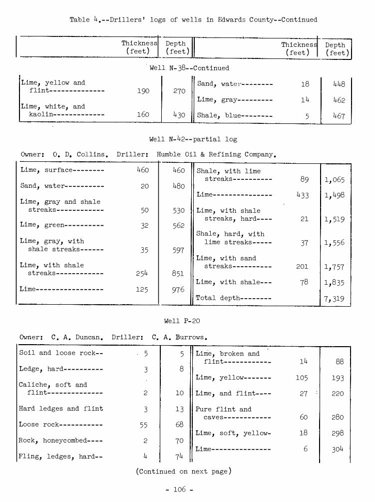
Table 4 . - - Drillers ' logs of wells in Edwards C ounty- -C ontinued
Thickne s s Depth Thickne s s Depth ( feet ) ( feet ) ( fe et ) ( fe et )
Well N- 38- -C ontinued
Lime, yellow and Sand, water- - ..:. - - - - - 18 448 flint- - - - - - - - - - - - - - 190 270
Lime , gray- - - - - - - - - 1 4 462 Lime , white, and
kaolin- - - - - - - - - - - - - 1 60 4 30 Shale, blue- - - - - - - - 5 467
Well N- 42- - partial log
Owner : o . D. Collins . Driller : Humble Oil & Refining C ompany .
Lime, sur face- - - - - - - - 46o 460 Shale , with l ime s treaks - - - - - - - - - - 89 1, 065
Sand, water- - - - - - - - - - 20 480 Lime- - - - - - - - - - - - - - - 4 3 3 1, 498
Lime, gray and shale streaks - - - - - - - - - - - - 50 530 Lime, with shale
streaks , hard- - - - 21 1 , 519 Lime, gre en- - - - - - - - - - 32 562
Shale , hard, with Lime, gray, with lime s treaks - - - - - 37 1 , 556
shale streaks - - - - - - 3 5 597 Lime , with sand
Lime, with shale streaks - - - - - - - - - - 201 1, 7 57 streaks - - - - - - - - - - - - 2 54 8 51
L ime , with shale- - - 78 1 , 8 3 5 Lime- - - - - - - - - - - - - - - - - 12 5 97 6
Total depth- - - - - - - - 7, 319
Well P- 20
Owner : c . A . Duncan . Driller : c. A . Burrows .
Soil and loo s e rock- - 5 5 Lirrie, broken and flint- - - - - - - - - - - - 14 88
Ledge , hard- - - - - - - - - - 3 8 Lime, yellow- - - - - - - 105 193
Cal iche , s oft and flint- - - - - - - - - - - - - - 2 10 Lime , and flint- - - - 27 220
Hard ledges and flint 3 1 3 Pure flint and cave s- - - - - - - - - - - - 60 280
Loose rock- - - - - - - - - - - 5 5 68 Lime , soft, yellow- 18 298
Rock, honeyc ombed- - - - 2 70 Lime- - - - - - - - - - - - - - - 6 304
Fl ing, ledge s , hard- - 4 74
( C ont inued on next page )
- 106 -

Table 4 . - -Drillers ' logs of wells in Edwards County- -Continued
Thickness Depth Thickness Depth ( feet ) ( feet ) ( feet ) ( feet �
Well P-20- -Cont inued
Pure flint - - - - - - - - - - - 11 315 Lime , white - - - - - - - -- 5 345
Lime - - - - - - - - - - - - - - - - - 10 325 Lime , sandy, gray, water- - - - - - - - - - - - - 15 360
Flint - - - - - - - - - - - - - - - - 10 335 Lime - - - - - - - - - - - - - - - - 54 414
Lime , gray, water- - - - 5 340
Well P-25
Owner : Bill Wall . Driller : C . A . Burrows .
Soil- - - - - - - - - - - - - - - - - 3 3 Flint ledge- - - - - - - - - 14 77
Caliche - - - - - - - - - - - - - - 13 16 Clay, yellow- - - - - - - - 4 81
Boulders - - - - - - - - - - - - - 1 17 Lime , water at 85 feet - - - - - - - - - - - - - - 14 95
Caliche and rock- - - - - 15 32 Lime , hard - - - - - - - - - - 9 104
Flint ledge - - - - - - - - - - 1 33 Lime - - -- - - - - - - - - - - - - 23 127
Caliche , rock- - - - - - - - 9 42 Lime , soft , gray- - - - 8 13 5
Flint ledge - - - - - - - - - - 1 43 Lime , water- - - - - - - - - 2 137
Clay, red- - - - - - - - - - - - 5 48 Lime , soft , gray- - - - 2 139
Caliche , hard- - - - - - - - 15 63 Lime - - -- - - - - - - - - - - - - 1 140
Well P -38
Owner : F . W . Pope . Driller : C . A . Burrows .
Lime - - - - - - - - - - - - - - - - - 17 17 Lime and flint- - - - - - 87 141
Flint - - - - - - - - - - - - - - - - 4 21 Flint - - - - - - - - - - - - - - - 5 146
Lime - - - - - - - - - - - - - - - - - 14 3 5 Lime , hard- - - - - - - - -- 62 2o8
Flint - - - - - - - - - - - - - - - - 1 36 Lime , soft , gray- - - - 2 210
Lime - - - - - - - - - - - - - - - - - 18 54 Lime , hard- - - - - - - - - - 15 225
(Continued on next page )
- 107 -

Table 4 . - -Drillers ' logs of wells in Edwards County- -Continued
Lime- - - - - - - - - - - - - - - -
Lime , sandy, water- -
Lime , gray- - - - - - - - - -
Thicknes s Depth ( feet ) ( feet }
Well P-38- -Continued
51
14
90
276 Lime , sandy, water- - -
290 Lime , hard- - - - - - -- - - -
380
Well P-44- -partial log
Owner : Wahlenmaier et al . Driller : Paul Teas .
Limestone - - - - - - - - - - - 348 348 Shale and lime shells
Shale , gray and Shale -- - - - - - - - - - - - - - -limestone - - - - - - - - - 47 395
Lime , broken- -- -- - - - -Lime - - - - - - - - - - - - - - -- 435 830
Lime , hard , sandy- - - -Shale , sandy- - - - - - - - 145 975
Lime , gray- - - - - - - - - - -Lime and shale- - - - - - 47 1 , 022
Lime , sandy, and Lime - - - - - - - - - - - - - - - - 33 1, 055 pyrite- - - - - - - - - - - - -
Shale and sand- - - - - - 15 1 , 070 Shale and lime - - -- - - -
Lime , hard, brown- - - 72 1 , 142 Lime , broken- - - - - - - - -
Lime and shale- - - - - - 18 1 , 160 Shale , dark- - - - - - - - - -
Lime - - - - - - - - - - - - - - - - 40 1 , 200 Shale , black- - - - - - - - -
Shale and shells - - - - 32 1 , 232 Total depth
Well Q-11
Owner : S . Carruthers . Driller : W . S . Seward .
Lime , white- - - - - - - - - 40 40 Lime , yellow, water at 450-455 feet - - - -
Flint - - - - - - - - - - - - - - - 30 70 Lime , white , water
Lime , white - - - - - - - - - 93 163 at 500- 510 feet - - - -
Lime , yellow- - - - - - - - 157 320 Lime , yellow- -- - - - - - -
Lime , gray- - - - - - - - - - 130 4 50
- 108 ...
Thickness ( feet }
15
5
143
100
63
75
92
46
54
38
4
53
30
20
25
Depth { feet )
395
400
1 , 375
1 , 475
1 , 538
1 , 613
1 , 705
1 , 751
1 , 805
1 , 843
1 , 847
1 , 900
5 , 270
480
500
525

Table 4 . - -Drillers ' logs of wells in Edwards County- -Continued
Thickness Depth Thickness (feet ) ( feet ) ( feet )
Well Q-18
Owner : Mrs . J . W . Carruthers . Driller : W . S . Seward .
Lime , white - - - - - - - - - - - 340 340 Lime , gray- - - - - - - - - - 20
Lime , yellow- - - - - - - - - - 25 36 5 Lime , hard , yellow- - 5 3
Lime , white - - - - - - - - - - - 40 405 Lime , yellow, water- 12
Lime , yellow- - - - - - - - - - 15 420
Well R-23 - -partial log
Owner : 0 . L . McNealy, Jr . Driller : Empire Gas and Fuel Company .
Lime - - - - - - - - - - - - - - - - - -
Shale - - - - - - - - - - - - - - - - -
Lime - - - - - - - - - - - - - - - - - -
Clay, red- -- - - - - - - - - - -
Shale - - - - - - - - - - - - - - - - -
Limestone , white - - - - - -
Shale - - - - - - - - - - - - - - - - -
Shale , blue - - - -- - - - - - -
Shale and lime - - - - - - - -
Lime , hard- - - - - - - - - - - -
Lime , shaly- - - - - - - - - - -
Lime , hard- - - - - - - - - - - -
Shale - - - - - - - - - - - - - - - - -
Lime , hard- - - - - - - - - - - -
Lime and shale- - - - - - - -
Lime , hard- - - - - - - - - - - -
Lime- - - - - - - - - - - - - - - - - -
54
10
23
53
20
26
4
10
15
10
20
3
2
5
20
13
7
54 Shale , soft - - - - - - - - -
64 Lime - - - - - - - - - - - - - - - -
87 Shale - - - - - - - - - - - - - - -
140 Lime - - - - - - - - - - - - - - - -
160 Shale - - - -- -- - - -- - - - -
186 Lime - - - - - - - - - - - - - - - -
190 Shale- -- -- - - - - - - - - - -
200 Missing, oil and gas
215
225
24 5
248
250
255
275
288
295
show- - - - - - - - - - - - - -
Shale - - - - - - - - - - - - - - -
Sand- - - - - - - - - - - - - - - -
Shale - - - - - - - - - -- - - - -
Lime - - -- - - - - - - - - - - - -
Shale - - - - - - - - - - - - - - -
Lime - - - - - - - - - - - - - - - -
Shale - - - - - - - - - - - - - - -
Lime - - -- -- - - - - - - - - - -
( Cont inued on next page )
- 10 9 -
5
20
8
15
17
5
8
12
13
5
2
26
5
44
14
46
Depth ( feet )
440
493
505
300
320
328
343
360
36 5
373
385
398
403
405
431
436
480

Table 4 . - -Drillers ' logs of wells in Edwards County- -Continued
Thicknes s Depth Thickness Depth (feet ) ( feet ) ( feet ) (feet ) Well R-23 - -partial log- -Continued
Shale - - - - - - - - - - - - - - - 40 580 Shale- - - - - - - - - - - - - - - 11 1 , 050
Lime - - - - - - - - - - - - - - - - 61 641 Shale , reddish color 10 1 , 060
Shale - - - - - - - - - - - - - - - 15 656 Shale , blue- - - - - - - - - 15 1 , 075
Lime - - - - - - - - - - - - - - - - 34 690 Lime , hard, gray- - - - 5 1 , 080
Shale - - - - - - - - - - - - - - - 10 700 Sand, coarse , white and shale , hard,
Lime - - - - - - - - - - - - - - - - 110 810 gray- - - - - - - - - - - - - - 10 1, 090
Coal- - � - - - - - - - - - - - - - 3 813 Shale - - - - - - - - - - - - - - - 2 1 , 092
Lime , soft - - - - - - - - - - 12 825 Shale and sand, hard 4 1 , 096
Lime - - - - - - - - - - - - - - - - 4 5 870 Shale , red- - - - - - - - - - 12 1 , 108
Sand, water- - - - - - - - - 2 5 895 Shale , black- - - - - - - - 13 1 , 121
Gumbo- - - - - - - - - - - - - - - 5 900 Clay, soft , red- - - - - 21 1 , 142
Shale - - - - -- - - - - - - - - - 20 920 Shale , blue - - - - - - - -- 4 1 , 146
Sand , gray- - - - - - - - - - 7 927 Shale , hard - - - - - - - - - 1 1 , 147
Shale - - - - - - - - - - - - - - - 31 958 Sand , sulphur water- 13 1, 160
Sandrock- - - - - - - - - - - - 7 965 Limestone , hard- - - - - 10 1 , 170
Sand and shale-- - - - - 10 975 Sandrock, hard- - - - - - 20 1 , 190
Shale , sticky- - - - - - - 8 983 Sand , soft - - - - - - - - - - 1 5 1 , 205
Shale - - - - - - - - - - - - - - - 22 1 , 005 Sand , water- - - - - - - -- 8 5 1 , 290
Slate - - - - - - - - - - - - - - - 13 1 , 018 Clay, yellow- -- - - - - - 10 1, 300
Shale , gray- - - - - - - - - 3 1 , 021 Shale , broken, cavey 26 1 , 326
Shale- - - - - - - - - - - - - - - 4 1 , 025 Shale , black- - - - - - - - 124 1 , 4 50
Sand- - - - - - - - - - - - - - - - 5 1 , 030 Total depth- - -- - - - - - 3 , 63 5
Gumbo- - - - - - - - - - - - - - - 9 1 , 039
- 110 -

Table 4 . --Drillers ' logs of wells in Edwards County- -Continued
Thickness Depth Thickness ( feet } ( feet }
Well R-28
Owner : J . G . Blackman Estate . Driller : W . S . Seward .
Lime , broken, caves - - 50 50 Lime , broken, hard- - -
Lime , soft , yellow- - - 68 118 Lime , hard , yellow - - -
Flint - - - - - - - - - - - - - - - - 29 147 Lime , blue , water . seep
Lime , hard , yellow- - - 43 190 Lime -- - - - - - - - - - - - - - - -
Lime , broken, soft , Shale , gray- - - - - - - - - -yellow- - - - - - - - - - - - - 28 218
Shale , blue - - - - - - - - - -Lime , yellow- - - - - - - - - 90 308
Well S-8
Owner : F . J . Weldon . Driller : W . S . Seward .
Lime , w�ite - - - - - - - - - - 18 18 Lime , yellow- - - - - - - - -
Lime , yellow- - -- ... -· - - - 6 24 Lime , gray- - - - - - - - - - -
Lime , -w-:ni te - - - - - - - - - - 71 95 Lime , yellow- - - - - - - - -
Lime , soft , yellow- - - 7 102 Conglomerate , coarse -
Lime , hard, yellow- - - 48 150 Lime , porous , gray- - -
Flint rock- - - - - - - - - - - 7 157 Lime , brown- - - - - - - - - -
Lime , yellow , flint - - 33 190 Lime , gray- - - - - - - - - - -
Lime , hard, yellow- - - 15 205 Lime , gray, flint - - - -
Lime , yell!ow - - ... J J +-:� - - 9 214 Lime , brown, water at 418- - - - - - - - - - - - -
Well T-14 - -partial log
Owner : Neal Jernigan . Driller : Gale Oil Co .
Lime - - - - - - - - - - - - - - - - -
Shale , gray, bluish, and lime shells - - - -
14
99
14
113
Shale , blue and lime shells - - - - - - - - - - - - -
Lime , sandy- - - - - - - - - -
(Continued on next page )
- 1 1 1 -
( feet )
22
33
4
23
30
18
36
42
13
10
53
12
23
15
14
56
3
Depth ( feet }
330
363
367
390
420
438
250
292
305
315
368
380
403
418
432
172

Table 4 . - -Drillers ' logs of wells in Edwards County- -Continued
( feet ) ( feet ) ( feet ) Thickness I Depth I I Thicknes s
�--------�--------------------�------�----------------------
Lime , gray- - -- - - - - - - -
Shale , light blue - - - -
Lime , sandy- - - - -- - - - -
Lime , gray- - - - - - - - - - -
Shale , blue - - - - - - - - - -
Lime , gray- - - - - - - - - - -
Shale , blue - - - - - - - - - -
Lime and shale , blue-
Lime , gray- - - - - - - - - - -
Shale , broken, blue - -
Lime , brown- - - - - - - - - -
Lime , gray- - - - - - - - - - -
Shale , blue- - - - - - - - - -
Lime , gray- - - - - - - - - - -
Shale , blue and shells
Lime - - - - - - - - - - - - - - - - -
Sand, water- - - - - - - - - -
Lime- - - - - - - - - - - - - - - - -
Well T-14 - -part ial log- -Continued
19
33
19
33
26
30
43
60
2 5
3 3
82
75
20
5
20
3 5
4 5
60
191 Shale , blue- - - - - - - - - -
224 Sand , water- - - - - - - - - -
243 Sand, water and lime shells - - - - - - - - - - - - -
276
302
332
375
43 5
460
493
Lime , sandy- - - - - - - - - -
Sand and lime , sandy-
Lime , gray- - -- - - - - - - -
Sand, water- - - - - - - - - -
Lime , caving, gray- - -
Lime and sand- - - - - - - -
Rock, red , or shale 575 red , caving- - - - - - - -
6 50 Shale , sandy- - - -- - - - -
670 Mud , blue - - - - - - - - - - - -
675 Shale , sandy- - - - - - - - -
695 Ltmee - - - - - - - - - - - - - - - -
730 Shale , brown- - - - - - - - ,-
775 Total depth- - -- - - - - - -
835
Well T-26
Owner : S . A . Williams . Driller : C . A . Burrows .
Soil- - - - - - - - - - - - - - - - - 2 2 Caliche- - - - - - - - - - - - - -
Caliche and rocks - - - - 3 5 Gravel- - - - - - - - - - - - - - -
Caliche - - - - - - - - - - - - - - 10 15 Caliche and rock- - - - -
Loose rock- - - - - - - - - - - 5 20 Caliche , solid - - - - - - -
( Cont inued on next page )
- 1 1 2 -
15
20
20
25
10
10
20
5
20
30
5
5
10
10
8
4
6
18
Depth ( fee t )
93 5
955
980
990
1 , 000
1 , 020
1 , 025
1 , 045
1 , 075
1, 080
1 , 085
1 , 095
1 , 105
4 , 010
28
32
38
56
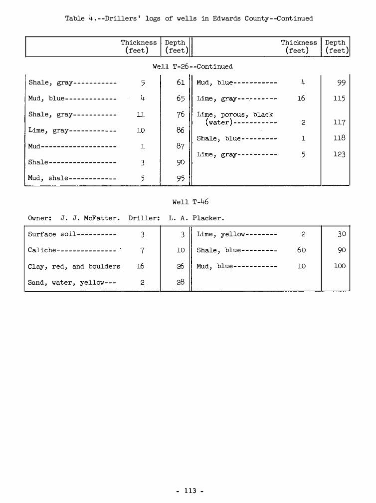
Table 4 . - -Drillers ' logs of wells in Edwards County- -Continued
Thickness . Depth ( feet ) ( feet )
Shale , gray- - - - - - - - - - -
Mud, blue - - - - - - - - - - - - -
Shale , gray- - - - - - - - - - -
Lime, gray- -- -- - - - - - --
Mud- - - - - - - - - - - - - - - - - - -
Shale - - - - - - - - - - - - - - - - -
Mud, shale - - - - - - - - - - - -
Well T-46
Owner : J . J . McFatter . Driller : L . A . Placker .
Surface soil- - - - - - - - - - 3 3 Lime , yellow- - - - - - - -
Caliche - - - - - - - - - - - - - - - 7 10 Shale , blue- - - - -- - - -
Clay, red , and boulders 16 26 Mud , blue- - -- - - - - - --
Sand , water, yellow- - - 2 28
- 1 13 -
Thickness Depth ( feet ) ( feet )
4 99
16 115
2 117
1 118
5 123
2 30
60 90
10 100