Embed Size (px)
Citation preview
Guidance Material
DATE : 01/11/13 REVISION : 1.0 ISSUED BY : EUR PBN TF
SUBJECT: AIRCRAFT AND OPERATOR APPROVAL FOR RNP 4 OPERATIONS
1. PURPOSE
This guidance material establishes the requirements for the approval of aircraft and operators to conduct RNP 4 operations in oceanic or remote airspace.
An operator may use alternate means of compliance, provided those means are acceptable to the Civil Aviation Administration (CAA).
2. RELATED DOCUMENTS
Annex 2 Rules of the air
Annex 6 Operation of aircraft
Annex 11 Air traffic services
Annex 15 Aeronautical information services
Annex 10 Aeronautical telecommunications
ICAO Doc 9997 PBN operational approval manual
ICAO Doc 9613 Manual on performance-based navigation (PBN)
ICAO Doc 4444 Procedures for air navigation services – Air traffic management (PANS-ATM)
ICAO Doc 7030 Regional Supplementary Procedures
ICAO Doc 8168 Procedures for air navigation services - Aircraft operations (PANS-OPS): Volume II – Parts I and III
FAA Order 8400.33 Procedures for obtaining authorization for required navigation performance 4 (RNP-4) oceanic and remote area operations
3. DEFINITIONS AND ABBREVIATIONS
3.1 Definitions
a) Controller-pilot data link communications (CPDLC).- A means of communication between controller and pilot, using data link for air traffic control (ATC) communications.
b) Track.- The projection on the earth´s surface of the path of an aircraft, the direction of which path at any point is usually expressed in degrees from North (true, magnetic or grid).
c) Fault detection and exclusion (FDE).- A function performed by some on-board GNSS receiver that can detect the signal of a faulty satellite, and exclude it from the position estimation. At least one satellite needs to be available (6 satellites) in addition to the number required in order to have the receiver autonomous integrity monitoring (RAIM) function.
d) Path definition error (PDE).- The difference between the defined path and the desired path at a given place and time.
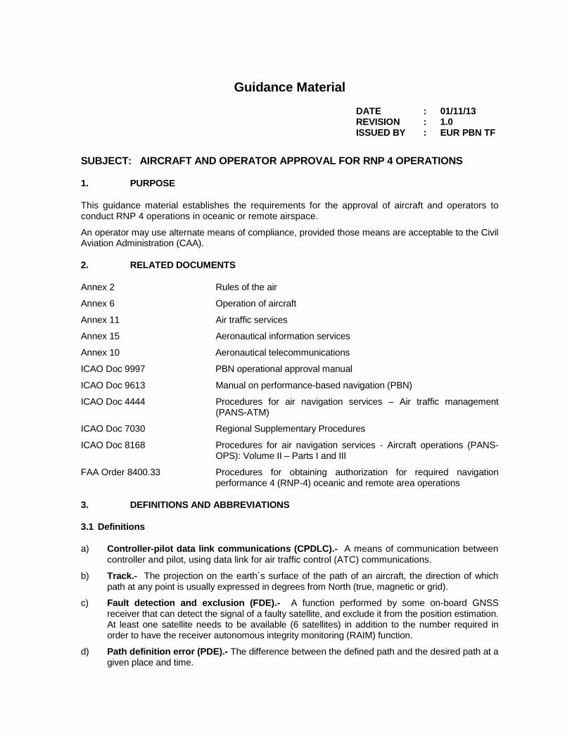
e) Navigation system error (NSE).- The difference between the true position and the estimated position.
f) Flight technical error (FTE).- The accuracy with which an aircraft is controlled as measured by the indicated aircraft position with respect to the indicated command or desired position. It does not include blunder errors.
a) Total system error (TSE).- The difference between the true position and the desired position. This error is equal to the sum of the vectors of the path definition error (PDE), the flight technical error (FTE), and the navigation system error (NSE).
Note.- On occasions, the FTE is known as path steering error (PSE), and the NSE as position estimation error (PEE).
Total system error (TSE)
Desired path
Path definition error (PDE) Defined path
Flight technical error (FTE) Estimated position
Navigation system error (NSE)
Tr ue position
Tota
l syste
m e
rror
(TS
E)
g) Navigation specifications.- Set of aircraft and flight crew requirements needed to support performance-based navigation operations in a defined airspace. There are two kinds of navigation specifications:
Required Navigation Performance (RNP) Specification.- Navigation specification based on area navigation (RNAV) that includes the on-board performance control and alerting requirement, designated by the prefix RNP; e.g., RNP 4, RNP APCH, RNP AR APCH.
Area Navigation (RNAV) Specification.- Navigation specification based on area navigation that does not include the on-board performance control and alerting requirement, designated by the prefix RNAV; e.g., RNAV 5, RNAV 2, RNAV 1.
Note 1.- The Manual on Performance-Based Navigation (PBN) (Doc 9613), Volume II, contains detailed guidelines on navigation specifications.
h) Estimated position uncertainty (EPU).- A measure in nautical miles (NM) based on a defined scale that indicates the estimated performance of the current position of the aircraft, also known as actual navigation performance (ANP) or estimated position error (EPE) in some aircraft. The EPU is not an estimate of the actual error but a defined statistical indication of potential error.
b) Area navigation (RNAV).- A navigation method that allows aircraft to operate on any desired flight path within the coverage of ground - or space- based navigation aids, or within the coverage limits of self-contained aids, or a combination of both.
i) Waypoint (WPT). A specified geographical location used to define an area navigation route or the flight path of an aircraft employing area navigation. Way-points are identified as either:
Fly-by waypoint (fly-by WPT).- A waypoint which requires turn anticipation to allow tangential interception of the next segment of a route or procedure.
Fly over waypoint (fly over WPT).- A waypoint at which a turn is initiated in order to join the next segment of a route or procedure.
j) Heading (of the aircraft).- The direction in which the longitudinal axis of an aircraft is pointed,
usually expressed in degrees from North (true, magnetic, compass or grid).
k) Aircraft-based augmentation system (ABAS).- A system which augments and/or integrates the information obtained from the other GNSS elements with information available on board the aircraft. The most common form of ABAS is the receiver autonomous integrity monitoring (RAIM).
l) Flight management system (FMS).- An integrated system consisting of an on-board sensor, a receiver and a computer with databases on navigation and aircraft performance, capable of providing performance values and RNAV guidance to a display and automatic flight command system.
m) Primary-means navigation system.- Navigation system approved for a given operation or flight phase, which has to meet the precision and integrity requirements, but not full service availability and continuity conditions. Safety is ensured by limiting flights to specific time periods and by establishing timely restrictive procedures.
n) Supplemental-means navigation system.- A navigation system that must be used together with a sole means navigation and meet the precision and integrity requirements but not availability and continuity conditions.
o) Global navigation satellite system (GNSS).- A generic term used by ICAO to define any global position, speed, and time determination system that includes one or more main satellite constellations, such as GPS and the global navigation satellite system (GLONASS), aircraft receivers and several integrity monitoring systems, including aircraft-based augmentation systems (ABAS), satellite-based augmentation systems (SBAS), such as the wide area augmentation systems (WAAS), and ground-based augmentation systems (GBAS), such as the local area augmentation system (LAAS).
p) Global navigation satellite system (GLONASS). - The satellite navigation system operated by the Russian Federation.
q) Global positioning system (GPS). - The satellite navigation system operated by the United States.
r) RNP system.- An area navigation system which supports on-board performance monitoring and alerting.
s) Receiver autonomous integrity monitoring (RAIM).- A technique used in a GPS receiver/processor to determine the integrity of its navigation signals, using only GPS signals or GPS signals enhanced with barometric altitude data. This determination is achieved by comparing redundant pseudo-range measurements. At least one available satellite is required in addition to the number of satellites needed for the navigation solution.
3.2 Abbreviations
a) CAA Civil Aviation Administration/Civil Aviation Authority
b) AAIM Aircraft autonomous integrity monitoring
c) ABAS Aircraft-based augmentation system
d) ADS-C Automatic dependent surveillance - contract
e) AC Advisory circular (FAA)
f) AFM Aircraft flight manual
g) AIP Aeronautical information publication
h) ANP Actual navigation performance
i) AP Automatic pilot
j) ATC Air traffic control
k) ATS Air traffic services
l) CDI Lateral deviation indicator
m) CDU Control and display unit
n) CF Course to a fix
o) CNS/ATM Communications, navigation and surveillance/air traffic management systems
p) CPDLC Controller-pilot data link communications
q) CS Certification specifications (EASA)
r) DAC Director of civil aviation
s) DF Direct to a fix
t) DME Distance-measuring equipment
u) DV Flight dispatcher
v) EASA European Air Safety Agency
w) EHSI Electronic horizontal situation indicator
x) EPE Estimated position error
y) EPU Estimated position uncertainty
z) ETOPS Extended range operations by twin-engine aeroplanes
aa) ETSO European technical standard order
bb) FAA United States Federal Aviation Administration
cc) FD Flight director
dd) FDE Fault detection and exclusion
ee) FMS Flight management system
ff) FTE Flight technical error
gg) GBAS Ground-based augmentation system
hh) GNSS Global Navigation Satellite System
ii) GLONASS GLObal NAvigation Satellite System
jj) GPS Global positioning system
kk) GS Ground speed
ll) HAL Horizontal alerting system
mm) IF Initial fix
nn) IMC Instrument meteorological conditions
oo) IPC Illustrated part catalogue
pp) LAAS Local area augmentation system
qq) LNAV Lateral navigation
rr) LOA Letter of authorisation/letter of acceptance
ss) LRNS Long-range navigation system
tt) MCM Maintenance control manual
uu) MEL Minimum equipment list
vv) NAVAIDS Navigation aids
ww) NM Nautical mile
xx) NSE Navigation system error
yy) ICAO International Civil Aviation Organization
zz) OM Operations manual
aaa) OpSpecs Operation specifications
bbb) PANS-OPS Procedures for Air Navigation Services - Aircraft operations
ccc) PANS-ATM Procedures for Air Navigation Services - Air traffic management
ddd) PBN Performance-based navigation
eee) PDE Path definition error
fff) PEE Position estimation error
ggg) POH Pilot operations handbook
hhh) PSE Path steering error
iii) RAIM Receiver autonomous integrity monitoring
jjj) RNAV Area navigation
kkk) RNP Required navigation performance
lll) RNP APCH Required navigation performance approach
mmm) RNP AR APCH Required navigation performance authorisation required approach
nnn) SBAS Satellite-based augmentation system
ooo) SOP Standard operating procedures
ppp) SLOP Strategic lateral displacement procedures
qqq) SSR Secondary surveillance radar
rrr) STC Supplemental type certificate
sss) TC Type certificate
ttt) TF Track to a fix
uuu) TSE Total system error
vvv) TSO Technical standard order
www) VMC Visual meteorological conditions
xxx) VOR VHF omnidirectional radio range
yyy) WAAS Wide area augmentation system
zzz) WGS World geodetic system
aaaa) WPT Waypoint
4. INTRODUCTION
4.1. This document provides guidance on airworthiness and operational approvals for RNP 4 based operations. It does not address all the requirements that can be specified for a given
operation. These requirements are specified in other documents, such as aeronautical information publications (AIPs) and Doc 7030 – Regional supplementary procedures.
4.2. Although operational approval is mainly related to airspace navigation requirements, operators and flight crews must take into account all of the associated operational documents required by the CAA before conducting flights.
4.3. The approval process described in this document is limited to the aircraft that have received airworthiness certification indicating that the installed navigation systems meet RNP 4 performance requirements. This certification may have been issued at the time of manufacture or during service, when the aircraft was retrofitted to meet RNP 4 requirements, through the granting of an appropriate supplemental type certificate (STC).
4.4. The material described in this document has been developed based on ICAO Doc 9613 and FAA Order 8400.33 – Procedures for obtaining authorization for required navigation performance 4 (RNP 4) oceanic and remote area operations.
5. GENERAL CONSIDERATIONS
5.1. Navigation aid infrastructure
RNP 4 was developed for operations in oceanic and remote areas, therefore, it does not require any ground-based navaid infrastructure. The global navigation satellite system (GNSS) is the primary navigation sensor that supports RNP 4, either as a stand-alone navigation system or as part of a multi-sensor system.
5.2. ATS communications and surveillance
This document does not specifically address the air traffic service (ATS) communications or surveillance requirements for a given operations. These requirements would be determined by States and published in the respective AIPs and Regional SUPPS.
5.3. Obstacle clearance and en-route spacing
a) Doc 8168 – Procedures for air navigation services – Aircraft operations (PANS OPS), Volume II, provides a detailed guide on obstacle clearance. The general criteria of Parts I and III apply.
b) RNP 4 may be used to support the application of en-route separation/spacing standards of 30 Nm or less, provided that the necessary safety assessments described in Doc 4444, PANS-ATM were carried out, taking into account the ATS communications and surveillance requirements.
5.4. Publications
a) When reference is made to the existing routes, the AIP should clearly indicate that the navigation application is RNP 4. The route should identify the minimum altitude requirements of the segments.
b) The navigation information published in the AIP for routes and supporting navigation aids must meet the requirements of Annex 15 – Aeronautical information services. All routes must be based on the World Geodetic System - 1984 (WGS-84) coordinates.
5.5. Additional considerations
a) Many aircraft have the following capabilities:
1) Fly parallel paths displaced to the left or right of the original active route; and
2) Execute a holding pattern manoeuvre using an RNP system. The purpose of this function is to give the ATC flexibility for the design of RNP operations.
6. AIRWORTHINESS AND OPERATIONAL APPROVAL
6.1 Commercial air transport operators require two types of approvals before receiving an RNP 4
authorisation:
6.1.1. Airworthiness approval, issued by the State of Registry (see Article 31 of the Chicago Convention, and Paragraphs 5.2.3 and 8.1.1 of Annex 6, Part I); and
6.1.2. Operational approval, issued by the State of the Operator (see Paragraph 4.2.1 and Attachment F to Annex 6, Part I).
6.2. For general aviation operators, the State of Registry will determine if the aircraft meets the applicable RNP 4 requirements, and will issue the operational authorisation (e.g., a letter of authorisation – LOA) (see paragraph 2.5.2.2 of Annex 6, Part II).
6.3. Before submitting their request, operators shall review all aircraft qualification requirements. Compliance with airworthiness or equipment installation requirements, by themselves, does not constitute operational approval.
7. AIRWORTHINESS APPROVAL
7.1. Aircraft requirements
7.1.1. Navigation systems
7.1.1.1. For RNP 4 operations in oceanic or remote airspace, the aircraft must have, at least two fully operational and independent long-range navigation systems (LRNS), with integrity such that the navigation system does not provide misleading information and form part of the basis upon which RNP 4 operations approval is granted. GNSS must be used as either a stand-alone navigation system or as one of the sensors in a multi-sensor system.
7.1.1.2. The United Stated Federal Aviation Administration (FAA) AC 20-138A – Airworthiness approval of global navigation satellite system (GNSS) equipment, or equivalent documents provide an acceptable means of complying with installation requirements for aircraft that use, but do not integrate, the GNSS output with that of other sensors.
7.1.1.3. The FAA AC 20-130A – Airworthiness approval of navigation or flight management systems integrating multiple navigation sensors, or equivalent documents describe an acceptable means of compliance for navigation systems with multiple sensors that incorporate GNSS.
7.1.1.4. The configuration of the equipment used for demonstrating the required accuracy must be identical to the one specified in the minimum equipment list (MEL) or in the aircraft flight manual (AFM).
7.1.1.5. The installation design must meet the design standards applicable to the aircraft that is being modified, and changes must be reflected in the AFM before starting operations requiring RNP 4 navigation approval.
7.1.2. System performance, monitoring and alert
7.1.2.1. Accuracy.- During operations in airspace or on routes designates as RNP4:
a) The lateral total system error must not exceed + 4 NM for at least 95% of the total flight time.
b) Likewise, the along-track error must not exceed + 4 NM at least 95% of the total flight time.
c) A flight technical error (FTE) of 2.0 NM (95%) may be assumed.
7.1.2.2. Integrity.- Malfunctioning of the aircraft navigation equipment is classified as a major failure according to airworthiness regulations (e.g., 10
-5 per hour).
7.1.2.3. Continuity.- Loss of function is classified as a major failure for oceanic and remote navigation. The continuity requirement is met by carrying on board two independent LRNS systems (excluding the signal-in-space).
7.1.2.4. Performance monitoring and alerting.- The RNP system or the RNP system in combination with the pilot will provide an alert if the accuracy requirement is not met, or if the probability that the lateral total system error exceeds 8 NM is greater than 10-5.
7.1.2.5. Signal-in-space.- If GNSS is used, the aircraft navigation equipment must provide an alert if the probability of signal-in-space errors causing a lateral position error greater than 8 NM exceeds 10-7 per hour (Annex 10, Volume I, Table 3.7.2.4-1).
Note.- Compliance with the performance monitoring and alerting requirement does not imply an automatic monitor of FTE. The on-board monitoring and alerting function should consist at least of a navigation system error (NSE) monitoring and alerting algorithm and a lateral deviation display that enables the crew to monitor the FTE. To the extent operational procedures are used to monitor FTE, the crew procedures, equipment characteristics, and installations are evaluated for their effectiveness and equivalence as described in the functional requirements and operating procedures. The path definition error (PDE) is considered negligible due to the quality assurance process and crew procedures.
7.1.3. GNSS Monitor
The GNSS navigation system must detect satellite failures before they cause the aircraft to exceed the limits of the defined airspace. This requirement is derived from the overall effect of a GNSS failure and applies to all navigation uses of the system. The probability of missed detection of satellite failures must be less than or equal to 10
-3 and the effective limit of the monitor for these failures of the
navigation solution, known as the horizontal alert limit (HAL) must consider the other normal errors that may exist during the satellite fault, the latency of the alert, the crew reaction time to an alert and the aircraft response. An acceptable means of compliance is to use a HAL of 4 NM for RNP 4 oceanic airspace.
7.1.4. Determination of aircraft eligibility for RNP 4 operations
7.1.4.1. Airworthiness eligibility documents
7.1.4.1.1. The operator must have relevant documentation acceptable to the CAA of the State of Registry showing that aircraft are equipped with RNP systems that meet RNP 4 requirements.
7.1.4.1.2. In order to avoid unnecessary regulatory activity, the determination of the eligibility of existing systems should take into account the acceptance of manufacturer documentation of compliance, e.g., EASA AMC 20 series.
7.1.4.1.3. New systems may demonstrate compliance with RNP 4 requirements for oceanic or remote operations as part of their airworthiness approval.
7.1.4.1.4. For existing systems, the operator shall determine RNP 4 compliance as stated in the AFM supplement or additional airworthiness documents, or as obtained per amended type certificate (TC) or supplemental type certificate (STC).
7.1.4.1.5. Documented confirmation by the manufacturer will be required, indicating that aircraft meet the RNP 4 performance requirements of this document, if the operator chooses to claim additional performance beyond the original airworthiness approval or as declared in the AFM, amended TC or STC. Navigation performance must consider the navigation infrastructure used in the original airworthiness approval.
7.1.4.2. Aircraft eligibility groups
7.1.4.2.1. Group 1: RNP certification
Group 1 aircraft are those that have official certification and approval of on-board RNP integration. RNP compliance is documented in the AFM.
Certification will not be necessarily limited to a given type of RNP. The AFM must address the RNP levels that have been demonstrated and any related provisions applicable to their use (e.g., navaid sensor requirements). Operational approval is based on the performance stated in the AFM.
This method is also applicable in case where certification is received through an STC issued to cover retrofitting of equipment, such as the installation of GNSS receivers to enable the aircraft to meet RNP 4 requirements in oceanic and remote airspace.
7.1.4.2.2. Group 2: Previous certification of the navigation system
Group 2 aircraft are those than can equate their certified level of performance, granted on the basis of previous requirements, to RNP 4 criteria. The standards shown in Sub-paragraphs (a) to (c) can be used to classify aircraft in Group 2.
(a) Global navigation satellite systems (GNSS) as primary means of navigation.- Aircraft equipped only with GNSS as primary means of long-range navigation, approved for operations in oceanic and remote airspace, must meet the technical requirements specified in this section. The AFM must indicate that dual GNSS equipment, approved according to an appropriate standard, is required. The appropriate standards are FAA technical standard orders (TSO) C129a or C146(), and the European technical standard orders (ETSO) C129a or C146() of EASA. Furthermore, an approved dispatch fault detection and exclusion (FDE) availability prediction programme must be used. The maximum allowable time for which FDE capability is projected to be unavailable on any event is 25 minutes. This maximum outage time must be included as a condition for RNP 4 operational approval. If predictions indicate that the maximum allowable FDE outage time will be exceeded, the operation must be rescheduled to a time when FDE is available.
(b) Multi-sensor systems that incorporate GNSS with integrity provided by receiver autonomous integrity monitoring (RAIM).- Multi-sensor systems that incorporate the global positioning system (GPS) with RAIM and FDE, and which are approved based on FAA AC 20-130A or other equivalent documents, meet the performance requirements specified in this section. It should be noted that there is no requirement to use dispatch FDE availability prediction programmes when multi-sensor systems are installed and used.
(c) Multi-sensor systems that incorporate GNSS with integrity provided by aircraft autonomous integrity monitoring (AAIM).- The AAIM uses the redundancy of position calculations from multiple sensors, including GNSS, to provide integrity performance that is at least equivalent to RAIM. These airborne augmentations must be certified according to TSO C-115b, ETSO C-115b or other equivalent documents. An example is the use of an inertial navigation system or other navigation sensors as an integrity check on GNSS data when RAIM is not available but GNSS positioning information continues to be valid.
7.1.4.2.3. Group 3: New technology
This group has been included in order to cover new navigation systems that meet the technical requirements for operations in RNP 4 airspace.
7.1.4.3. Required functions
7.1.4.3.1. The on-board navigation system must provide the following functions:
a) navigation data display;
b) track to a fix (TF);
c) direct to a fix (DF);
d) direct to function;
e) course to a fix (CF);
f) parallel offset;
g) fly-by transition criteria
h) user interface displays;
i) displays and controls;
j) flight planning path selection;
k) flight planning fix sequencing;
l) user defined course to fix (CF);
m) path steering;
n) alerting requirements;
o) navigation database access; and
p) WGS 84 reference system.
7.1.4.3.2. Explanation of the required functions
a) Navigation data display
The navigation data display must use either a lateral deviation display or a navigation map display that meets the following requirements:
1) a non-numerical lateral deviation display (e.g., a lateral deviation indicator (CDI) or an electronic horizontal situation indicator ((E)HSI)), with a to/from indication and failure annunciation, to be used as a primary flight instrument for aircraft navigation, for manoeuvre anticipation, and for failure/status/integrity indication, with the following attributes:
(a) the display must be visible to the pilot and located in his/her primary field of view (+ 15 degrees from the pilot´s normal line of sight) when looking forward along the flight path;
(b) lateral deviation scaling must agree with any alerting and annunciation limits, if implements;
(c) the lateral deviation display must be automatically slaved to the RNP computed path. The lateral deviation display also must have full-scale deflection suitable for the current phase of flight, and must be based on the required track-keeping accuracy. The course selector of the lateral deviation display should be automatically slewed to the RNP computed path, or the pilot must adjust the CDI or HSI selected course to the computed desired track.
Note.- The normal function of stand-alone GNSS equipment meets this requirement.
(d) the display scaling may be set automatically by default logic or set to a value obtained from the navigation database. The full-scale deflection value must be known or must be available to the pilot and must be consistent with the values of the en-route, terminal or approach phases.
2) A navigation map display, readily visible to the pilot, with appropriate map scales (scaling may be set manually by the pilot), and giving equivalent functionality to a lateral deviation display.
b) Track to a fix (TF)
The primary segment of an RNAV straight route is a TF route. The TF leg is a geodetic path between two waypoints (WPT). The first is a termination WPT of the previous leg or an initial fix (IF). The intermediate and final approach segments should always be TF routes. In cases where an FMS requires a course to fix (CF) to the final approach segment, the database coder may use a CF instead of a TF. The termination fix is normally provided by the navigation database, but can also be defined by the user.
c) Direct to a fix (DF)
The DF leg is used to define a route segment from an unspecified position, on the aircraft´s present track, to a specified fix/WPT. The DF path termination does not provide a predictable flight path that can be repeated, and is very variable in its application.
d) “Direct to” function
The “direct to” function must be able to be activated at any time by the flight crew, as necessary. The “direct to” function must be available to any fix. The system must be capable of generating a geodetic path to the designated “to” fix. The aircraft must capture this path without “S turns” and without undue delays.
e) Course to a fix (CF)
A CF is defined as a course that ends at a fix/WPT followed by a specific route segment. The inbound course at the termination fix and the fix are provided by the navigation database. If the inbound course is defined as the magnetic course, the source of the magnetic variation needed to convert magnetic courses to true courses is required.
f) Parallel offset
The system must have the capability to fly parallel tracks at a selected offset distance. When executing a parallel offset, the navigation precision and all the performance requirements of the original route in the active flight plan must be applicable to the offset route. The system must permit the entry of offset distances in increments of 1 MN, to the left or right of the course. The system must be capable of offsets of at least 20 NM. When in use, the system offset mode of operation must be clearly indicated to the flight crew. When in offset mode, the system must provide reference parameters (for example, cross-track deviation, distance to-go, time to-go) relative to the offset path and offset reference points. An offset must not be propagated through route discontinuities, unreasonable (excessive) path geometries, or beyond the initial approach fix. An announcement must be given to the flight crew before the end of the offset path, giving sufficient time to return to the original path. Once a parallel offset has been activated, it must remain active throughout all the route segments of the flight plan until removed automatically, until the flight crew enters a direct-to route, or until manually cancelled by the flight crew. The parallel offset function must be available for the en-route TF segment and the geodetic portion of DF leg types.
g) “Fly-by” transition criteria
The navigation system must be capable of performing “fly-by” transitions. No predictable and repeatable path is specified because the optimum path varies with airspeed and bank angle. However, the boundaries of the transition are defined. The path definition error (PDE) is defined as the difference between the defined path and the theoretical transition area. If the path lies within the transition area, there is no PDE. “Fly-by” transitions must be the default transitions when the type of transition is not specified. The theoretical transition area requirements are applicable for the following assumptions:
1) course changes do not exceed 120º for low altitude transitions (when the barometric altitude of the aircraft is less than FL 195); and
2) course changes do not exceed 70º for high-altitude transitions (when the barometric altitude of the aircraft is equal to or greater than FL 195).
h) User interface displays
The general features of user interface displays must permit the display of information, provide situational awareness, and be designed and implemented taking into account human factors. The main design considerations include:
1) minimizing reliance on flight crew memory for any operational procedure or task of a system;
2) developing a clear and unambiguous display of system modes and sub-modes and navigation data, with emphasis on the requirements for enhanced situational awareness for any automatic changes in the mode, if provided;
3) the use of the context-sensitive help capability and error messages (e.g., invalid inputs or invalid data entry messages should provide a simple means for determining how to enter “valid” data);
4) failure-tolerant data entry methods instead of rigid rule-based concepts;
5) placing special emphasis on the number of steps and minimizing the time required to accomplish flight plan modification to accommodate ATS clearances, holding procedures, changes of runway and instrument approaches, missed approaches and diversions to alternate destination aerodromes; and
6) minimizing the number of nuisance alerts so that the flight crew may recognize the real ones and properly respond when so required.
i) Displays and controls
1) Each display element used as primary flight instrument for aircraft guidance and control, for manoeuvre anticipation, or for failure/status/integrity annunciation, must be located in a place clearly visible to the pilot (in the pilot´s primary field of view) with the least possible deviation with respect to the normal position of the pilot and his/her line of vision when looking forward towards the flight path.
2) All system displays, controls and annunciations must be readable under normal cockpit conditions and under foreseen ambient lighting conditions. Night lighting provisions must be compatible with other lighting conditions in the cockpit.
3) All displays and controls must be arranged to facilitate access and use by the flight crew. The controls that are normally adjusted in flight must be readily accessible and have standardized labels indicating their function. System controls and displays must be designed to maximize operational suitability and minimize pilot workload. The controls intended for use during the flight must be designed to minimize errors, and when operated in all possible combinations and sequences, they must not result in a condition that would be detrimental to the continued performance of the system. System controls must be arranged to provide adequate protection against inadvertent system failure.
j) Flight planning path selection
The navigation system must provide the crew the capability to create, review and activate a flight plan. The system must provide the capability for modification (e.g., deletion and addition of fixes and creation of along the track fixes), review and user acceptance of changes to the flight plans. When this capability is exercised, guidance output must not be affected until the modification(s) is(are) activated. The activation of any flight plan modification must require a positive action and verification by the flight crew after data entry.
k) Flight planning fix sequencing
The navigation system must provide the capability for automatic sequencing of fixes.
l) User-defined course to a fix (CF)
The navigation system must provide the capability to define a user-defined course to a fix. The pilot must be able to intercept the user-defined course.
m) Path steering
The system must provide data to enable the generation of command signals for the autopilot/flight director/CDI, as applicable. In all cases, a path steering error (PSE) must be defined at the time of certification, which will meet the requirements of the desired RNP operation in combination with the other system errors. During the certification process, the ability of the crew to operate the aircraft within the specified PSE must be demonstrated. Aircraft type, operating enveloped, displays, autopilot performance and leg transition guidance (specifically between arc legs) should be accounted for in the demonstration of PSE compliance. A measured PSE value may be used to monitor system compliance with RNP requirements. For operations in all leg types, this value must be the distance to the defined path. In order to comply with cross-track containment, any inaccuracies in the cross-track errors computation (e.g., resolution) must be accounted for in the total system error (TSE),
n) Alerting requirements
The system must also provide an annunciation if the manually entered navigation accuracy is larger than the navigation accuracy associated with the current airspace as defined in the navigation data base. Any subsequent reduction of the navigation accuracy must reinstate this annunciation. When an aircraft is approaching to RNP airspace from non-RNP airspace, an alert must be provided when the cross-track distance to the desired path is equal to or less than one-half the navigation accuracy and the aircraft has passed the first fix in the RNP airspace.
o) Navigation database access
The navigation database must provide access to navigation information in support of navigation system references and flight planning characteristics. Manual modification of data in the navigation database must not be possible. This requirement does not preclude the storage of “user-defined data” in the equipment (e.g., for flex-track routes). When data are retrieved from storage they must also be retained in storage. The system must provide a means to identify the version of the navigation database and the validity of the operating period.
p) Geodetic reference system
The World Geodetic System - 1984 (WGS-84) or an equivalent Earth reference model must be the reference Earth model for error determination. If the WGS-84 is not used, any differences between the selected Earth model and the WGS-84 Earth model must be included as part of the PDE. Errors induced by the data resolution must also be taken into account.
7.1.4.4. Recommended functions
7.1.4.4.1. The following additional functions are recommended:
a) display of cross-track error on the control and display unit (CDU);
b) display present position of the aircraft in terms of distance/bearing to the selected waypoints (WPT);
c) provide time to WPTs on the CDU;
d) display along-track distance;
e) display ground speed (GS);
f) indication of track angle;
g) provide automatic navigation aids selection;
h) manually inhibit a navigation facility;
i) automatic selection and tuning of the distance-measuring equipment (DME) and/or VHF omnidirectional radio range (VOR);
j) estimate of position uncertainty (EPU);
k) display current RNP level and type selection;
l) capability to display flight plan discontinuities; and
m) display of operating and degraded navigation sensors.
7.1.4.5. Automatic radio position updating
7.1.4.5.1. Automatic updating is considered to be any updating procedure that does not require the crew to insert the coordinates manually. If used, automatic updating may be considered as acceptable for operations in RNP 4 airspace, provided:
a) automatic updating procedures are included in the operator training programme; and
b) crews are knowledgeable of the updating procedures and of the effect of the update on the navigation solution.
7.2. Continued airworthiness
7.2.1. Operators of RNP 4 approved aircraft must ensure the continuity of their technical capability to meet the technical requirements established in this document.
7.2.2. Each operator requesting an RNP 4 operational approval shall submit to the CAA of the State of Registry a maintenance and inspection programme that includes all those maintenance requirements needed to ensure that the navigation systems will continue to meet the RNP 4 approval criteria.
7.2.3. The following maintenance documents must be revised, as applicable, to incorporate RNP 4 aspects:
a. Maintenance control manual (MCM);
b. Illustrated part catalogues (IPC); and
c. Maintenance programme.
7.2.4. The approved maintenance programme for the aircraft involved must include the maintenance practices indicated in the corresponding maintenance manual of the aircraft and component manufacturer, and must consider that:
a. Equipment involved in RNP 4 operations must be maintained according to the instructions of the component manufacturer;
b. Any modification or change in the navigation system that affects in any way the initial RNP 4 approval must be reported and reviewed by the CAA for acceptance or approval of said changes prior to their implementation; and
c. Any repair that is not included in the approved/accepted maintenance documentation and that could affect navigation performance integrity must be reported to the CAA for its acceptance and approval of such repair.
7.2.5. RNP maintenance documentation must contain the training programme for maintenance personnel, which, amongst other aspects, must include:
a. The PBN concept;
b. RNP 4 implementation;
c. The equipment involved in the RNP 4 operation; and
d. Use of the MEL.
8. OPERATIONAL APPROVAL
8.1. Airworthiness approval alone does not authorise an applicant or operator to conduct RNP 4 operations. In addition to the airworthiness approval, the applicant or operator must obtain an operational approval to confirm the suitability of normal and contingency procedures in connection to the installation of specific equipment.
8.2. For commercial air transport, applications for RNP 4 operational approval are assessed by the State of the Operator, in accordance with current operating rules supported by the criteria described in this dpcument.
8.3. For general aviation, applications for RNP 4 operational approval are assessed by the State of Registry, in accordance with current operating rules supported by the criteria established in this document.
8.4. Operational approval requirements
8.4.1. In order to obtain RNP 4 approval, the applicant or operator will take the following steps, taking into account the criteria established in this document:
a) Airworthiness approval.- Aircraft shall have the corresponding airworthiness approvals, pursuant to the requirements of this document.
b) Application.- The operator will submit the following documentation to the CAA:
1) The application for RNP 4 operational approval;
2) Airworthiness documents related to aircraft eligibility.- The operator will submit relevant documentation, acceptable to the CAA, establishing that the aircraft has long-range navigation systems (LRNS) that meet RNP 4 requirements, as described in this document. For example, the operator will submit the parts of the AFM or AFM supplement that contain the airworthiness statement.
3) Description of aircraft equipment.- The operator will provide a configuration list with details of the relevant components and the equipment to be used for RNP 4 operations. The list shall include each manufacturer, model and version of the GNSS equipment and of the software of the installed FMS.
4) Flight crew and flight dispatcher training programme
(a) Commercial operators shall submit to the CAA the training curriculum and other appropriate material (e.g., computer-based training) to show that operational procedures and practices and the training aspects of RNP 4 operations, have been included in the training programmes, as applicable (for example, in the initial, upgrade or recurrent training curriculum for flight crews and flight dispatchers).
Note.- A separate training programme is not required if the RNP 4 training has already been included in the training programme of the operator. However, it should be possible to identify what aspects of RNP 4 are covered in the training programme.
(b) Non-commercial operators must be familiar with, and demonstrate that they will implement the practices and procedures described in this document.
5) Operations manual and checklists
(a) Commercial operators shall revise the operations manual (OM) and the checklists to include information and guidance on the standard operating procedures (SOP) detailed in this document. The appropriate manuals shall contain the operating instructions of the navigation system and the contingency procedures, where specified (e.g., procedures for deviations due to weather conditions). The manuals and checklists must be submitted for review as attachments to the formal application in Phase 2 of the approval process.
(b) Non-commercial operators shall develop navigation system operating instructions and contingency procedures. This information must be available for crews in the OM or in the pilot operations handbook (POH). These manuals and manufacturer instructions on the operation of aircraft navigation equipment, as appropriate, must be submitted as attachments to the formal application, for review by the CAA.
6) Minimum equipment list (MEL).- Any revision of the MEL to incorporate RNP 4 provisions must be approved. Operators shall modify the MEL and specify the required dispatch conditions.
7) Maintenance.- All operators or owners must submit for approval, at the time of the application, their maintenance programmes, including equipment monitoring reliability programme. The holder of the design approval, including either the type certificate (TC) or supplemental type certificate (STC), for each individual navigation system installation, must provide at least one set of complete instructions for continuing airworthiness.
8) Training programme for maintenance personnel.- Operators will send the training curriculum that corresponds to their maintenance personnel, pursuant to Paragraph 8.6 e).
9) Performance history.- The application will include the operating history of the operator. The applicant will include the events or incidents related to navigation errors in oceanic or remote airspace (e.g., those reported in the navigation error investigation forms of each State) and the methods used by the operator to address such events or incidents through new or revised training programmes, procedures, maintenance or aircraft modifications.
10) Navigation data validation programme.- The operator will present the details of the navigation data validation programme, as described in this document.
c) Programming of the training.- Once the amendments to manuals, programmes and documents submitted have been accepted or approved, the operator will provide the required training to its personnel.
d) Validation flight.- The CAA may deem it advisable to conduct a validation flight before granting the operational approval. Such validation may be performed on commercial flights.
e) Issuance of the authorisation to conduct RNP 4 operations - Once the operator has successfully completed the operational approval process, the CAA will grant the operator the authorisation to conduct RNP 4 operations.
9. OPERATIONAL REQUIREMENTS
9.1. Navigation performance
For RNP 4 operations, aircraft must meet a cross-track (lateral) keeping accuracy and along-track (longitudinal) position accuracy of not greater than + 4 NM for 95% of the flight time.
9.2. Navigation equipment
For RNP 4 operations in oceanic or remote airspace, the aircraft must have, at least two fully operational and independent long-range navigation systems (LRNS), with integrity such that the navigation system does not provide misleading information and form part of the basis upon which RNP 4 operations approval is granted. GNSS must be used as either a stand-alone navigation system or as one of the sensors in a multi-sensor system.
9.3. Flight plan designation
9.3.1. Operators must indicate their ability to meet RNP 4 for the route or airspace in accordance with Doc 4444 - Procedures for air navigation services – Air traffic management (PANS-ATM). Likewise, operators must meet other additional flight planning requirements specified in Doc 7030 and in the State AIP.
9.3.2. The insertion of the appropriate descriptors in the flight plan indicates that the pilot has:
1) Examined the planned flight route, including routes to alternate aerodromes, in order to determine the types of RNP involved;
2) Confirmed that the operator and the aircraft have been approved by the CAA for conducting RNP 4 operations; and
3) Confirmed that the aircraft can meet all the approval conditions for the planned flight route, within airspace or on routes requiring RNP 4.
9.4. Controller-pilot data link communication (CPDLC) and automatic dependent surveillance - contract (ADS-C) systems will also be required when the lateral and/or longitudinal separation standard is 30 NM or less, as prescribed in the appropriate AIPs and Regional SUPPS. The on-board navigation data must be current and include appropriate procedures.
Note.- It is expected that navigation databases will be valid for the duration of the flight. If the AIRAC cycle expires during the flight, operators and pilots must establish procedures to ensure the accuracy of the navigation data, including the adequacy of navigation facilities used for defining the routes and procedures for the flight.
9.5. Availability of navigation aids (NAVAIDS)
At the time of aircraft dispatch or during flight planning, the operator must make sure that the
appropriate en-route navigation aids are available to allow the aircraft to conduct RNP 4 operations.
10. OPERATING PROCEDURES
10.1. The following topics must be standardized and included in the training programmes and in the operational practices and procedures. Some topics may have been properly standardized in the existing programmes and procedures of the operator. The new technologies can also eliminate the need for the crew to take some actions. If this is the case, it can be considered that the objective of this text has been met.
Note.- This guidance material has been written for a wide variety of operator types and therefore some topics may not be applicable to all operators.
10.1.1. Flight planning.- During flight planning, flight crews and flight dispatchers must pay special attention to the conditions that may affect operations in RNP 4 airspace or routes, including, but not limited to:
a) verifying if the aircraft is approved for RNP 4 operations in oceanic or remote airspace;
b) verifying if the operator is authorised to conduct RNP 4 operations in oceanic or remote airspace. This authorisation supports the 30 NM lateral and longitudinal separation (or other) minima required by RNP 4 operations.
i. it should be noted that the authorisation only addresses navigation requirements associated to these standards.
ii. the authorisation does not consider communications or surveillance requirements. These requirements are listed in the AIPs and in the regional supplementary procedures (ICAO Doc 7030) for a specific airspace or ATS route.
c) verifying that letter “R” has been entered in Block 10 (equipment) of the ICAO flight plan;
d) verifying GNSS requirements, such as FDE, if applicable to the operation; and
e) verifying if any operating restriction related to the RNP 4 approval has been taken into account, if so required.
10.1.2. Pre-flight procedures.- The following action must be taken during pre-flight:
a) review the technical flight records (maintenance logs) and forms to determine the condition of the equipment required for flying in RNP 4 airspace or route.
b) ensure that maintenance action has been taken to correct defects on the required equipment; and
c) review the contingency procedures for operations in airspace or routes that require RNP 4 navigation capability. These are no different than normal oceanic contingency procedures with one exception: crews must be able to recognize, and the ATC must be advised, when the aircraft is no longer able to navigate to its RNP 4 navigation capability.
10.1.3. GNSS availability.- During flight planning or at dispatch, the operator must ensure that GNSS availability requirements on which the operator approval has been based will be met throughout the flight.
10.1.4. En-route procedures.- The following shall be obtained:
a) At least two LRNS, capable of navigating to RNP 4 and listed in the AFM must be operational at the entry point of the RNP airspace. In an item of equipment required for RNP 4 operations is unserviceable, then the pilot will consider an alternate route or diversion for repairs;
b) In-flight operating procedures of the operator must include mandatory cross-check procedures to identify navigation errors sufficiently in advance, in order to prevent the aircraft from inadvertently deviating from the routes cleared by the ATC;
c) Crews must advise the ATC of any deterioration or failure of the navigation equipment that cause navigation performance to fall below the required level, and/or any deviation required for a contingency procedure; and
d) Pilots must use a lateral deviation indicator, flight director, or autopilot in lateral navigation mode on RNP 4 routes. Pilots may use a navigation map display with equivalent functionality to a lateral deviation indicator. Pilots of aircraft with a lateral deviation indicator must ensure that the lateral deviation indicator scaling (full-scale deflection) is suitable for the navigation accuracy associated with the route (i.e. ± 4 NM). All pilots are expected to maintain route centrelines, as depicted by on-board lateral deviation indicators and/or flight guidance during all RNP 4 operations, unless authorized to deviate by ATC or under emergency conditions. For normal operations, cross-track error/deviation (the difference between the RNAV system computed path and the aircraft estimated position relative to that path, i.e. FTE) must be limited to ± ½ the navigation accuracy associated with the route (i.e. 2 NM). Brief deviations from this standard (e.g. overshoots or undershoots) during and immediately after route turns, up to a maximum of one-times the navigation accuracy (i.e. 4 NM), are allowable.
11. Contingency procedures
11.1. Flight crews and flight dispatchers shall be familiar with the following general provisions:
(a) if an aircraft cannot continue the flight according to the current ATC authorization or cannot maintain RNP 4 accuracy, it will not enter into or continue operating in RNP 4 airspace. In this case, the pilot will obtain a revised clearance, if that is possible, before initiating any action.
(b) in all cases, the flight crew shall follow the contingency procedures established for each region or area of operation and obtain ATC clearance as soon as possible.
11.2. Procedures for flight contingencies, deviations due to weather conditions and strategic lateral offset procedures.- The operator will develop procedures for flight contingencies, deviations due to weather conditions and strategic lateral offset procedures (SLOP), in accordance with Paragraph 15.2 of ICAO Doc 4444 – Special procedures for flight contingencies in oceanic airspace. These procedures are of general application in oceanic and remote continental areas of operation. As a minimum, the following aspects will be included:
(a) Special procedures for flight contingencies in oceanic airspace.
(1) Introduction;
(2) General procedures; and
(3) Extended-range operations by twin-engine aeroplanes (ETOPS).
(b) Procedures for deviating due to weather conditions.
(1) General;
(2) Measures to be adopted when controller-pilot communications are established;
(3) Measures to be adopted if a revised clearance from the ATC cannot be obtained; and
(c) Strategic lateral offset procedures in oceanic airspaces and remote continental areas.
12. TRAINING PROGRAMME
12.1 Operators or owners must ensure that flight crews have been trained and have the appropriate knowledge on the topics contained in these guidelines.
12.2 Commercial operators - Commercial operators must make sure that their programmes cover training for flights crews and flight dispatchers on the following aspects:
a) General
i. definition of RNP in relation to RNP 4 requirements;
ii. knowledge of the airspace where RNP 4 is required;
iii. aeronautical charts and documents that reflect RNP 4 operations;
iv. equipment required to operate in RNP 4 airspace, and its operation;
v. limitations associated to navigation equipment; and
vi. use of the MEL.
b) Operational procedures
i. flight planning;
ii. pre-flight procedures;
iii. GNSS availability;
iv. en-route operations;
v. contingency procedures; and
vi. aspects contained in this document.
12.3 Non-commercial operators - Non-commercial operators must demonstrate the CAA that their pilots have knowledge of the material contained in this document. Upon determining whether the training of a non-commercial operator is appropriate, the CAA may:
a) accept a certificate from a training centre without any further assessment;
b) assess a training course before accepting a certificate from a given training centre;
c) accept a statement in the operator application in the sense that the operator guarantees and will continue to guarantee that flight crews are aware of the RNP 4 practices and operational procedures contained in this document; and
d) accept a statement by the operator in the sense that it has already implemented or will implement an RNP 4 at-home training programme and that it will use the guide contained in this document.
13. NAVIGATION DATABASE
13.1 The on-board database must be valid and suitable for RNP 4 operations and must include the navigation aids and waypoints (WPTs) required for the route.
a) The operator must obtain the navigation database from a supplier that complies with document RTCA DO 200A/EUROCAE ED 76 – Standards for processing aeronautical data.
b) Navigation data suppliers must have a letter of acceptance (LOA) for processing navigation information (e.g., FAA AC 20-153 or a document on the conditions for the issuance of letters of acceptance to navigation data suppliers by the European Aviation Safety Agency – EASA (EASA IR 21 Sub-part G) or equivalent documents). An LOA recognises as data suppliers the one whose information quality, integrity and quality management practices are consistent with the criteria contained in document DO-200A/ED-76. The database suppliers of an operator must have a Type 2 LOA and its respective suppliers must have a Type 1 or 2 LOA. The CAA may accept an LOA issued to navigation data suppliers or issue its own LOA.
c) The operator must advise the navigation data supplier of any discrepancy that invalidates a route, or prohibit the use of the procedures involved through a notice to flight crews.
d) Operators should consider the need to conduct periodic verifications of the navigation databases in order to maintain the existing requirements of the quality system or safety
management system.
14. SURVILLANCE, INVESTIGATION OF NAVIGATION ERRORS AND WITHDRAWAL OF RNP 4 AUTHORISATION
14.1. The operator will establish a process to receive, analyse and follow-up on navigation error reports in order to determine the appropriate corrective action.
14.2. The information on the potential of repetitive errors may call for a modification of the training programme of the operator.
14.3. Information that attributes multiple errors to the pilot may call for additional training or a license revision.
14.4. The occurrence of repetitive navigation errors attributed to a piece of equipment or a specific part of the navigation equipment or to operating procedures may result in the cancellation of the operational approval (withdrawal of RNP 4 authorisation from the OpSpecs or withdrawal of the LOA in the case of private operators).
APPENDIX 1
RNP 4 APPROVAL PROCESS
a) The RNP 4 approval process consists of two types of approvals, airworthiness and operational. Although the two have different requirements, they must be considered in one single process.
b) This process is an orderly method used by the CAA to ensure that applicants meet the established requirements.
c) The approval process is made up by the following phases:
1) Phase one: Pre-application
2) Phase two: Formal application
3) Phase three: Documentation evaluation
4) Phase four: Inspection and demonstration
5) Phase five: Approval
d) In Phase one - Pre-application, the CAA calls the applicant or operator to a pre-application meeting. At this meeting, the CAA informs the applicant or operator of all the operational and airworthiness requirements that must be met during the approval process, including the following:
1) the contents of the formal application;
2) the review and evaluation of the application by the CAA;
3) the limitations (if any) applicable to the approval; and
4) conditions under which the RNP 4 approval could be cancelled.
e) In Phase two – Formal Application, the applicant or operator submits the formal application along with all the relevant documentation, as established in this document.
f) In Phase three – Documentation evaluation, the CAA evaluates all the documentation and the navigation system to determine their eligibility and the approval method to be followed in connection with the aircraft. As a result of this analysis and evaluation, the CAA may accept or reject the formal application along with the documentation.
g) In Phase four – Inspection and demonstration, the operator will provide training to its personnel and will carry out the validation flights, if required.
h) In Phase five - Approval, the CAA issues the RNP 4 approval (e.g. OpsSpec or LOA) once the operator has met the airworthiness and operational requirements.