Embed Size (px)
Citation preview
University of Nebraska - LincolnDigitalCommons@University of Nebraska - Lincoln
Robert F. Diffendal, Jr., Publications Natural Resources, School of
9-1982
Gully, Scour Hole, and Pothole Development at theBase of the Gering Formation (Miocene?),Southeastern Banner County, NebraskaRobert F. Diffendal Jr.University of Nebraska-Lincoln, [email protected]
Follow this and additional works at: http://digitalcommons.unl.edu/diffendal
Part of the Geology Commons, Geomorphology Commons, Hydrology Commons, and theStratigraphy Commons
This Article is brought to you for free and open access by the Natural Resources, School of at DigitalCommons@University of Nebraska - Lincoln. Ithas been accepted for inclusion in Robert F. Diffendal, Jr., Publications by an authorized administrator of DigitalCommons@University of Nebraska -Lincoln.
Diffendal, Robert F. Jr., "Gully, Scour Hole, and Pothole Development at the Base of the Gering Formation (Miocene?), SoutheasternBanner County, Nebraska" (1982). Robert F. Diffendal, Jr., Publications. 36.http://digitalcommons.unl.edu/diffendal/36
Gully, scour hole, and pothole development at the base of the Gering Formation (Miocene?), southeastern Banner County, Nebraska
Robert F. Diffendal, Jr. Conservation and Survey Division, IANR, University of Nebraska-Lincoln, Lincoln, Nebraska 68588-0517
ABSTRACT
Several sediment-filled paleovalleys belonging to the Arikaree Group of Miocene (?) age occur in southeastern Banner County, Nebraska. One gully and a main paleovalley exhibit, respectively, erosional features like those in modern gullies in the area and like those on the bedrock floors of modern straight streams carrying an appreciable sediment load. Scour holes and a pothole on the valley floor of the main paleovalley are similar to those produced experimentallyon the bed of a straight stream.
INTRODUCTION
The Gering Formation of the Arikaree Group (Miocene?), a predominantly fluvial deposit (Vondra, 1967), is exposed in many places in western Nebraska. In these places the Gering Formation rests unconformably upon rocks of the Brule Formation of the White River Group of Oligocene age. Lugn (1939, p. 1251) reported on the geology of the Arikaree and described the contact surface between the two groups as a pronounced erosional unconformity, yet evidence of pronounced erosion can be viewed in only a few places. Previous studies (Vondra, 1963; Schultz, Falkenbach, and Vondra, 1967) of the Arikaree report over one hundred meters of erosional relief on the top of the Brule Formation, but none of the studies made in Nebraska describes the nature of the erosional surface or the type of stream that produced it. In-
'0 0- '0 lei 50 40 :10
." .. -a ... UT{ "'t"" O"Eel. .... "o ... ,"'"
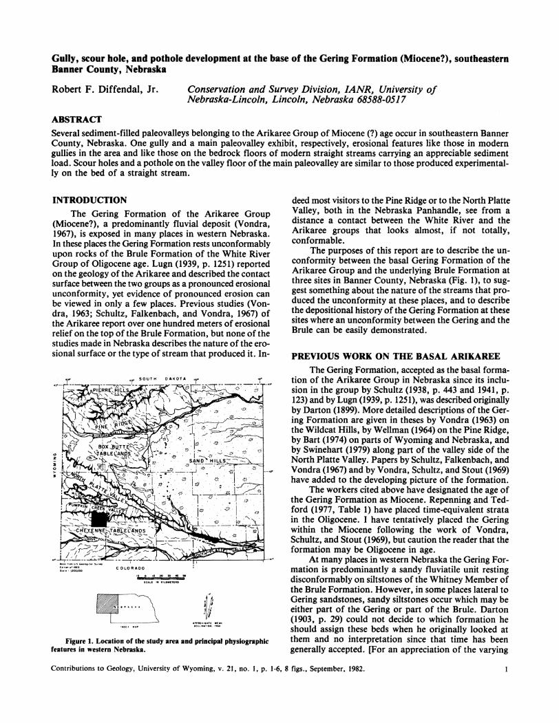
Figure 1. Location of the study area and principal physiographic features in western Nebraska.
deed most visitors to the Pine Ridge or to the North Platte Valley, both in the Nebraska Panhandle, see from a distance a contact between the White River and the Arikaree groups that looks almost, if not totally, conformable.
The purposes of this report are to describe the unconformity between the basal Gering Formation of the Arikaree Group and the underlying Brule Formation at three sites in Banner County, Nebraska (Fig. 1), to suggest something about the nature of the streams that produced the unconformity at these places, and to describe the depositional history of the Gering Formation at these sites where an unconformity between the Gering and the Brule can be easily demonstrated.
PREVIOUS WORK ON THE BASAL ARIKAREE
The Gering Formation, accepted as the basal formation of the Arikaree Group in Nebraska since its inclusion in the group by Schultz (1938, p. 443 and 1941, p. 123) and by Lugn (1939, p. 1251), was described originally by Darton (1899). More detailed descriptions of the Gering Formation are given in theses by Vondra (1963) on the Wildcat Hills, by Wellman (1964) on the Pine Ridge, by Bart (1974) on parts of Wyoming and Nebraska, and by Swinehart (1979) along part of the valley side of the North Platte Valley. Papers by Schultz, Falkenbach, and Vondra (1967) and by Vondra, Schultz, and Stout (1969) have added to the developing picture of the formation.
The workers cited above have designated the age of the Gering Formation as Miocene. Repenning and Tedford (1977, Table 1) have placed time-equivalent strata in the Oligocene. I have tentatively placed the Gering within the Miocene following the work of Vondra, Schultz, and Stout (1969), but caution the reader that the formation may be Oligocene in age.
At many places in western Nebraska the Gering Formation is predominantly a sandy fluviatile unit resting disconformably on siltstones of the Whitney Member of the Brule Formation. However, in some places lateral to Gering sandstones, sandy siltstones occur which may be either part of the Gering or part of the Brule. Darton (1903. p. 29) could not decide to which formation he should assign these beds when he originally looked at them and no interpretation since that time has been generally accepted. [For an appreciation of the varying
Contributions to Geology, University of Wyoming, v. 21, no. I, p. 1-6, 8 figs., September, 1982.

R. F. DIFFENDAL, JR.
views expressed on this problem see Schultz (1941), Vondra (1963), Schultz, Falkenbach, and Vondra (1967), Vondra, Schultz, and Stout (1969), Bart (1974), Swinehart (1979), and Swinehart and Souders (1979).J
Figure 2A. Basal Gering Fonnation (fmg) sediments filling a steepwalled gully carved into the Brule Fonnation (fob). Gully is about 10 m wide.
Figure 2B. Steeply inclined gravel bed within sediments shown in Fig. 2A. Fossil turtle shell (T) lies just below gravel bed.
DESCRIPTION OF ARIKAREE SITES
Site 1
At site 1 (NE14 SE14 SW14 sec. 16, T. 17 N., R. 53 W.) a steep-sided gully was carved into the Whitney Member of the Brule Formation (Fig. 2A) and later was filled with a basal fine sand rich in volcanically derived material, overlain by trough-cross bedded gray sands containing concentrations of heavy minerals, chaotic deposits containing a heterogeneous mixture of locally derived clasts and broken fossil turtle shells, and horizontal to steeply inclined beds of gravel derived by local stream erosion of Brule siltstones and concretions (Fig. 2B). These gully-fill deposits are considered to be part of the Gering Formation. Within the study area similar gullies occur
SCALE 1:24,000 o
Figure 3. Map showing distribution of basal Gering Formation (dark gray) and overlying (medium gray) strata of Arikaree Group at sites 2 and 3. Probable channel trend is shown by dashed lines and light gray color. Base map is composite from U.S. Geological Survey Lone Pine Butte and Singleton Ranch 7.S' topographic maps.
Figure 4. View of site 2 showing unconformities (1-4) at the base of and within the
2 Contributions to Geology, University of Wyoming, v. 21, no . I, p. 1-6, 8 figs., September, 1982.

EROSIONAL FEATURES AT BASE OF GERING FORMATION
Figure 5. Unconformity (1) exhibiting scour holes at base of the Gering Formation at site 2. Second unconformity (2) above truncates unconformity 1. The man is 1.83 m tall.
Figure 6. Scour hole carved in Brule Formation and f'dled with basal sand and gravel of the Gering Formation. Depth of hole is about 3.3 m.
in other paleovalleys as well as along the sides of major presently existing valleys (Diffendal, in press, and Vondra, 1963).
Site 2 and Site 3
These two sites include cuts through all (site 2-NW \4 NW\4 NE\4 and SW\4 NE\4 NW\4 sec. 36, T. 17 N., R. 54 W.) and most (site 3-SE\4 NE\4 NE\4 sec. 27, T. 17 N., R. 54 W.) of the Arikaree sediments in a paleovalley that was carved into the Whitney Member of the Brule Formation (Fig. 3). The paleovalley floor is exposed along a prominent cut-bank on the north side of Rocky Hollow at site 2 (Fig. 4). In addition to this unusual basal Arikaree unconformity, this exposure also includes two, or possibly three, other unconformities.
One of the more frustrating facets of the study of Cenozoic fluvial systems in western Nebraska is the rarity of exposed paleovalley floors. Shepherd and Schumm (1974, p.256) pointed out:
"Moreover, the alluvial fill found in nearly all valleys obscures the configuration of the bedrock-alluvium interface that constitutes the valley floor."
Thanks to their experimental work on river incision, however, we do know what types of bed-scour features to expect in both straight and meandering stream systems if we find an exhumed ancient valley floor.
Contributions to Geology, University of Wyoming, v. 21, no. I, p. 1-6,8 figs., September, 1982. 3
R. F. D1FFENDAL, JR.
c: o
o E .... o -Q) Q) .... o
..>c:
. ..
.. ' :
.. " . . .
. . ' '
.. ' . . '.
? . . . .. --' '. = . . -' . ------: --:---:--:-=-------;,--:-----:-. .' ---- -.-.--'
c: '" C> { .. --- .... , -.- --', . " .---
'-~ .... Q)
Q).a (!)
._._. _._ .. _. - -' -' .. . --- .
-.- --.-.. -. '.
Q)
=> .... CD
= ''':- -- '=,'.=-. '=. --.-: ~ -:--:.. -:-~ -:-....:.... -:--.: -:- ~-.' = . =-:~. :-~ --:- ~ - ~--:. :--. --- '-- ~- . ::.. '.-~ -.:..--: --- '.=-,' = : =-::
o 5 10 15 feet I I I I
o 5 10 15 meters I I I I
Verticol scole
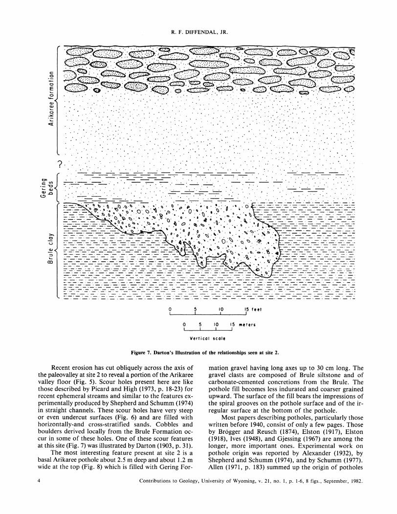
Figure 7. Darton's Illustration of the relationships seen at site 2.
Recent erosion has cut obliquely across the axis of the paleovalley at site 2 to reveal a portion of the Arikaree valley floor (Fig. 5). Scour holes present here are like those described by Picard and High (1973, p. 18-23) for recent ephemeral streams and similar to the features experimentally produced by Shepherd and Schumm (1974) in straight channels. These scour holes have very steep or even undercut surfaces (Fig. 6) and are filled with horizontalIy-and cross-stratified sands. Cobbles and boulders derived locally from the Brule Formation occur in some of these holes. One of these scour features at this site (Fig. 7) was illustrated by Darton (1903, p. 31).
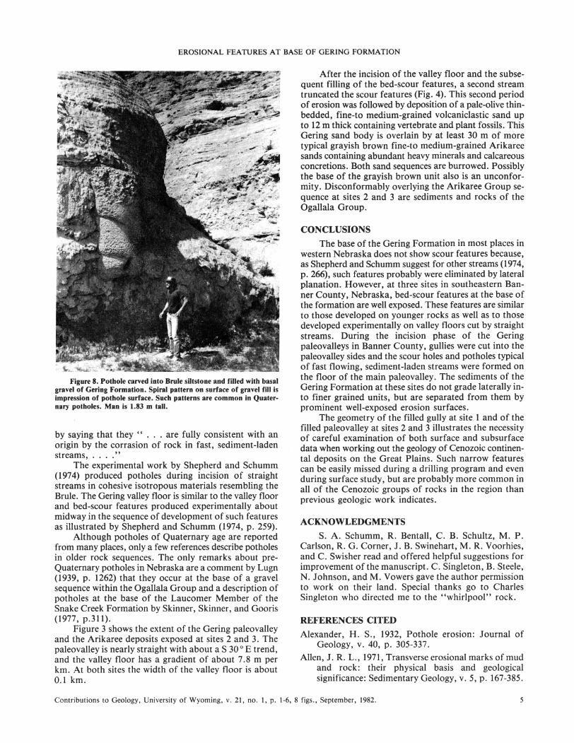
The most interesting feature present at site 2 is a basal Arikaree pothole about 2.5 m deep and about 1.2 m wide at the top (Fig. 8) which is filled with Gering For-
mation gravel having long axes up to 30 cm long. The gravel clasts are composed of Brule siltstone and of carbonate-cemented concretions from the Brule. The pothole fill becomes less indurated and coarser grained upward. The surface of the fill bears the impressions of the spiral grooves on the pothole surface and of the irregular surface at the bottom of the pothole.
Most papers describing potholes, particularly those written before 1940, consist of only a few pages. Those by Bragger and Reusch (1874), Elston (1917), Elston (1918), Ives (1948), and Gjessing (1967) are among the longer, more important ones. Experimental work on pothole origin was reported by Alexander (1932), by Shepherd and Schumm (1974), and by Schumm (1977). AlIen (1971, p. 183) summed up the origin of potholes
4 Contributions to Geology, University of Wyoming, v. 21, no. I, p. 1·6,8 figs., September, 1982.
EROSIONAL FEATURES AT BASE OF GERING FORMATION
Figure 8. Pothole carved into Brule siltstone and filled with basal gravel of Gering Formation. Spiral pattern on surface of gravel fill is impression of pothole surface. Such patterns are common in Quaternary potholes. Man is 1.83 m tall.
by saying that they " . . . are fully consistent with an origin by the corrasion of rock in fast, sediment-laden streams, .... "
The experimental work by Shepherd and Schumm (1974) produced potholes during incision of straight streams in cohesive isotropous materials resembling the Brule. The Gering v~lley floor is similar to the valley floor and bed-scour features produced experimentally about midway in the sequence of development of such features as illustrated by Shepherd and Schumm (1974, p. 259).
Although potholes of Quaternary age are reported from many places, only a few references describe potholes in older rock sequences. The only remarks about preQuaternary potholes in Nebraska are a comment by Lugn (1939, p. 1262) that they occur at the base of a gravel sequence within the Ogallala Group and a description of potholes at the base of the Laucomer Member of the Snake Creek Formation by Skinner, Skinner, and Gooris (1977, p.311).
Figure 3 shows the extent of the Gering paleovalley and the Arikaree deposits exposed at sites 2 and 3. The paleovalley is nearly straight with about a S 30 0 E trend, and the valley floor has a gradient of about 7.8 m per km. At both sites the width of the valley floor is about 0.1 km.
After the incision of the valley floor and the subsequent filling of the bed-scour features, a second stream truncated the scour features (Fig. 4). This second period of erosion was followed by deposition of a pale-olive thinbedded, fine-to medium-grained volcaniclastic sand up to 12 m thick containing vertebrate and plant fossils. This Gering sand body is overlain by at least 30 m of more typical grayish brown fine-to medium-grained Arikaree sands containing abundant heavy minerals and calcareous concretions. Both sand sequences are burrowed. Possibly the base of the grayish brown unit also is an unconformity. Disconformably overlying the Arikaree Group sequence at sites 2 and 3 are sediments and rocks of the Ogallala Group.
CONCLUSIONS
The base of the Gering Formation in most places in western Nebraska does not show scour features because, as Shepherd and Schumm suggest for other streams (1974, p. 266), such features probably were eliminated by lateral planation. However, at three sites in southeastern Banner County, Nebraska, bed-scour features at the base of the formation are well exposed. These features are similar to those developed on younger rocks as well as to those developed experimentally on valley floors cut by straight streams. During the incision phase of the Gering paleovalleys in Banner County, gullies were cut into the paleovalley sides and the scour holes and potholes typical of fast flowing, sediment-laden streams were formed on the floor of the main paleovalley. The sediments of the Gering Formation at these sites do not grade laterally into finer grained units, but are separated from them by prominent well-exposed erosion surfaces.
The geometry of the filled gully at site 1 and of the filled paleovalley at sites 2 and 3 illustrates the necessity of careful examination of both surface and subsurface data when working out the geology of Cenozoic continental deposits on the Great Plains. Such narrow features can be easily missed during a drilling program and even during surface study, but are probably more common in all of the Cenozoic groups of rocks in the region than previous geologic work indicates.
ACKNOWLEDGMENTS
S. A. Schumm, R. Bentall, C. B. Schultz, M. P. Carlson, R. G. Corner, J. B. Swinehart, M. R. Voorhies, and C. Swisher read and offered helpful suggestions for improvement of the manuscript. C. Singleton, B. Steele, N. Johnson, and M. Vowers gave the author permission to work on their land. Special thanks go to Charles Singleton who directed me to the "whirlpool" rock.
REFERENCES CITED
Alexander, H. S., 1932, Pothole erosion: Journal of Geology, v. 40, p. 305-337.
Allen, J. R. L., 1971, Transverse erosional marks of mud and rock: their physical basis and geological significance: Sedimentary Geology, v. 5, p. 167-385.
Contributions to Geology. University of Wyoming. v. 21. no. 1. p. 1-6.8 figs .• September. 1982. 5
R. F. DIFFENDAL, JR.
Bart, H. A., 1974, A sedimentologic and petrographic study of the Miocene Arikaree Group of southeastern Wyoming and west central Nebraska [unpub. Ph.D. Thesis]: Lincoln, University of Nebraska, 106 p.
Brogger, W. C., and Reusch, H. H., 1874, Giants' kettles at Christiania: Quarterly Journal of the Geological Society of London, v. 30, p. 750-771.
Darton, N. H., 1899, Preliminary report on the geology and water resources of Nebraska west of the one hundred and third meridian: U.S. Geological Survey 19th Annual Report, Part 5, p. 719-814.
_____ , 1903, Preliminary report on the geology and water resources of Nebraska west of the one hundred and third meridian: U.S. Geological Survey Professional Paper 17, 69 p.
Diffendal, R. F., Jr., in press, Regional implications of the geology of the Ogallala Group (Upper Tertiary) of southwestern Morrill County, Nebraska, and adjacent areas: Geological Society of America, Bulletin.
Elston, E. D., 1917, Potholes: their variety, origin, and significance. I: Scientific Monthly, v. 5, p. 554-567.
____ , 1918, Potholes: their variety, origin, and significance. II: Scientific Monthly, v. 6, p. 37-51.
Gjessing, J., 1967, Potholes in connection with plastic scouring forms: Geografiska Annaler, v. 49A(2-4), p. 178-187.
Ives, R. L., 1948, Plunge pools, potholes, and related features: Rocks and Minerals, v. 23(1), p. 3-10.
Lugn, A. L., 1939, Classification of the Tertiary System in Nebraska: Geological Society of America, Bulletin, v. 50, p. 1245-1276.
Picard, M. D., and High, L. R., Jr., 1973, Sedimentary structures of ephemeral streams: Amsterdam, London, New York, Elsevier Scientific Publishing Co., 223 p.
Repenning, C. A., and Tedford, R. H., 1977, Otarioid seals of the Neogene: U.S. Geological Survey Professional Paper 992, 93 p.
Schultz, C. B., 1938, The Miocene of western Nebraska: American Journal of Science, 5th Series, v. 35, p. 441-444.
____ , 1941, Oreodonts from the Marsland and Sheep Creek formations, with notes on the Miocene stratigraphy of Nebraska [unpub. Ph.D. Thesis]: Lincoln, University of Nebraska, 203 p.
Schultz, C. B., Falkenbach, C. H., and Vondra, C. F., 1967, The Brule-Gering (Oligocene-Miocene) contact in the Wildcat Ridge area of western Nebraska: University of Nebraska State Museum Bulletin, v. 6(4), p. 43-58.
Schumm, S. A., 1977, The fluvial system: New York, John Wiley and Sons, 338 p.
Shepherd, R. G., and Schumm, S. A., 1974, Experimental study of river incision: Geological Society of America, Bulletin, v. 85, p. 257-268.
Skinner, M. F., Skinner, S. M., and Gooris, R. J., 1977 , Stratigraphy and biostratigraphy of late Cenozoic deposits in central Sioux County, western Nebraska: American Museum of Natural History, Bulletin, v. 158, art. 5, p. 263-371.
Swinehart, J. B., II, 1979, Cenozoic geology of the North Platte River valley, Morrill and Garden counties, Nebraska [unpub. M. Sc. Thesis]: Lincoln, University of Nebraska, 127 p.
Swinehart, J. B., II, and Souders, V. L., 1979, New siltstone unit recognized in Brule Formation in northwestern Nebraska [abs.]: Nebraska Academy of Science, Proceedings of the 89th Annual Meeting, p. 52-53.
Vondra, C. F., 1963, The stratigraphy of the Gering Formation in the Wildcat Ridge in western Nebraska [unpub. Ph.D. Thesis]: Lincoln, University of Nebraska, 155 p.
Vondra, C. F., Schultz, C. B., and Stout, T. M., 1969, New members of the Gering Formation (Miocene) in western Nebraska: Nebraska Geological Survey Paper 18, 18 p.
Wellman, S. S., 1964, Stratigraphy of the Lower Miocene Gering Formation, Pine Ridge area, northwestern Nebraska [unpub. M. Sc. Thesis]: Lincoln, University of Nebraska, 54 p.
MANUSCRIPT RECEIVED JANUARY 26,1982
REVISED MANUSCRIPT RECEIVED MARCH 10, 1982
MANUSCRIPT ACCEPTED MARCH 17, 1982
6 Contributions to Geology, University of Wyoming, v. 21, no. I, p. 1-6, 8 figs., September, 1982.