Embed Size (px)
Citation preview

GUYANA
MARITIME ADMINISTRATION DEPARTMENT
MARITIME
SEARCH AND RESCUE MANUAL
MAY 2009

MARITIME ADMINISTRATION DEPARTMENT
MARITIME SEARCH AND RESCUE MANUAL
MAY 2009 Page i
FOREWORD Search and Rescue (SAR) comprises the search for and provision of aid to persons who are, or are believed to be in imminent danger of loss of life. The two operations; Search and Rescue, may take many forms, depending on whether they are both required or not, on the size and complexity of the operation and on the available staff and facilities.
According to the National Search and Rescue Plan, the Maritime Administration Department (MARAD), shall assume responsibility for maritime search and rescue in Guyana’s maritime Search and Rescue Region (SRR).
The National Search and Rescue Committee have been established as the coordinating body for search and rescue operations. Among its immediate tasks is the adoption of this document. It establishes the policies, standards and procedures for maritime SAR in Guyana.
This manual is the standard reference document for use by the maritime SAR authority and prescribes the agreed methods of coordination through which search and rescue operations are conducted within Guyana’s maritime SRR. It is supplemented by various legal, informative and instructional documents used within and between organisations concerned with search and rescue.
It has been developed with due regard to the relevant international instruments such as the International Convention for the Safety of Life at Sea, 1974 as Amended (SOLAS); Convention on International Civil Aviation, 1944; International Convention on Maritime Search and Rescue, 1979; Convention on the High Seas, 1958; the International Convention on the Law of the Sea, 1982; and the International Aeronautical and Maritime Search and Rescue Manual (IAMSAR).

MARITIME ADMINISTRATION DEPARTMENT
MARITIME SEARCH AND RESCUE MANUAL
MAY 2009 Page ii
For this document to be up-to-date and relevant, it has to be amended from time–to-time during the year, and then it will have to be reviewed annually. Proposed amendments will be considered by the Maritime Administration Department and they should be sent to the Director, Maritime Safety. However, before being implemented they shall be approved by the Director General and the National Search and Rescue Committee.
Record of Amendments
AMENDMENT DATE DATE ENTERED ENTERED BY

MARITIME ADMINISTRATION DEPARTMENT
MARITIME SEARCH AND RESCUE MANUAL
MAY 2009 Page iii
Annual Amendment List Reference Amendment

MARITIME ADMINISTRATION DEPARTMENT
MARITIME SEARCH AND RESCUE MANUAL
MAY 2009 Page iv
TABLE OF CONTENTS PAGES Foreword i Amendments ii-iii Contents v-viii Abbreviations and Acronyms v-xiv Glossary xiv-xxx Chapter 1 – Search and Rescue System 1 1.1 Organisation and Arrangements 1 1.2 SAR Management 2-8 1.3 SAR Responses and Coordination in Guyana 9-15 1.4 Search and Rescue Resources 16-18 1.5 Public Relations 18-23 Chapter 2 – Communications 24 2.1 Overview 24 2.2 Distress and Emergency Signals 25-28 2.3 Global Maritime Distress and Safety System 28 2.4 Emergency Signalling Devices 28-30 2.5 COSPAS-SARSAT Distress Beacon Detection System 30-33 2.6 Inmarsat-E (L-Band) EPIRB 33-34 2.7 Radar SAR Transponder (SART) 34-35 2.8 Communications in support of SAR operations 35-36 2.9 Communications Facilities 37-39 Chapter 3 – Awareness and Initial Action 40 3.1 Awareness and Notification 40 3.2 SAR Stages 40-41 3.3 SAR Incidents 41-42 3.4 Emergency Phases 42-44 3.5 Awareness Stage 45-48 3.6 Sequence of SAR Events 49-53 3.7 Communication Checks 53-54 3.8 Intelligence Gathering and Assessment 54-63

MARITIME ADMINISTRATION DEPARTMENT
MARITIME SEARCH AND RESCUE MANUAL
MAY 2009 Page v
Chapter 4 – Search Planning and Evaluation 64 4.1 Overview 64 4.2 Search Planning Steps 64-67 4.3 Datum Definition 67-68 4.4 Search Stages 69-70 4.5 Factors Affecting Initial SAR Response 70-72 4.6 Basic Search Planning 72-77 4.7 Determination of Search Areas 77-90 4.8 Coastal Search Planning 90-95 Chapter 5 – Search Techniques and Operations 96 5.1 Overview 96 5.2 General Guidelines for Searches 96-97 5.3 Search Area Coverage 97-99 5.4 Search Patterns 100 5.5 Visual Search 100-101 5.6 Flare Searches 101 5.7 Electronic Searches 101-103 5.8 SAR Unit Selection and Characteristics 103-107 5.9 Search Unit Allocation 107 5.10 SAR Crew Briefing 107-108 5.11 SAR Crew Debriefing 108-109 Chapter 6 – Rescue Planning and Operations 110 6.1 General 110 6.2 Preparation 110-111 6.3 Medical assistance 111 6.4 Crashed Aircraft 111-112 6.5 Rescue at sea 112-116 6.6 Supply dropping and delivery of survival equipment 116-117 Chapter 7 – Conclusion of SAR Operations 118 7.1 General 118 7.2 Conclusion of a successful SAR action 118 7.3 Suspension of a search when the target is not found 119-121
MARITIME ADMINISTRATION DEPARTMENT
MARITIME SEARCH AND RESCUE MANUAL
MAY 2009 Page vi
7.4 Reopening a suspended search 121 7.5 Records and reports 121 7.6 Incident Debrief 122-123 7.7 Case studies 123-124 7.8 Performance improvement 124 Chapter 8 – Training and Exercises 125 8.1 General 125 8.2 Search and Rescue Exercises 8.4 Training of search and rescue units Appendix A – Guyana Search and Rescue Region Appendix B – Search and Rescue functions and responsibilities Appendix C – Distress and Emergency Signals Appendix D – Maritime SAR Recognition Code (MAREC) Appendix E – Plotting symbols Appendix F– Tables and graphs Appendix G – Probable errors of position Appendix H – Worksheets Appendix I – Tier capabilities

MARITIME ADMINISTRATION DEPARTMENT
MARITIME SEARCH AND RESCUE MANUAL
MAY 2009 Page vii
ABBREVIATIONS AND ACRONYMS A............................................................................................................... search area A/C…..…........................................................................................................ aircraft ACC ........................................................................................... area control Centre ACO............................................................................................. aircraft coordinator AES ...................................................................................aeronautical earth station AFN ................................................................................ aeronautical fixed network AFTN ............................................ aeronautical fixed telecommunications network AIP ................................................................ Aeronautical Information Publication AIS ........................................................................aeronautical information services AM ...........................................................................................amplitude modulation AMS ................................................................................aeronautical mobile service AMS(R)S............................................... aeronautical mobile satellite (route) service AMSS ............................................................... aeronautical mobile satellite service Amver..................................................... automated mutual-assistance vessel rescue ANC ..............................................................................Air Navigation Commission ARCC .......................................................... aeronautical rescue coordination centre ARSC......................................................................... aeronautical rescue sub-centre ASW …………........................................................................ average surface wind ASWe .............................................................................. average surface wind error ASWDVe ............................................................... drift velocity error due to ASWe ATC ................................................................................................ air traffic control ATN ........................................................ aeronautical telecommunications network ATS ................................................................................................air traffic services C ........................................................................................................ coverage factor C/C .........................................................................................................cabin cruiser CES................................................................................................ coast earth station CIRM............................................................... Centro Internazionale Radio-Medico Cospas............................................. Space System for Search of Vessels in Distress CRS .............................................................................................. coast radio station C/S .................................................................................................................call sign CS ...............................................................................................creeping line search CSC ....................................................................... creeping line search, coordinated CSP ...................................................................................... commence search point CW ……......................................................................................... continuous wave
MARITIME ADMINISTRATION DEPARTMENT
MARITIME SEARCH AND RESCUE MANUAL
MAY 2009 Page viii
D.................................................................................................................. total drift De ........................................................................................................total drift error DD............................................................................... (leeway) divergence distance DF ................................................................................................... direction finding DMB ........................................................................................... datum marker buoy DME.......................................................................... distance-measuring equipment DRU................................................................................................ desert rescue unit DSC ...................................................................................... digital selective calling DVe ...................................................................................... total drift velocity error E ................................................................................ total probable error of position EGC ...................................................................................... enhanced group calling ELR .....................................................................................extra-long-range aircraft ELT .............................................................................emergency locator transmitter ENID ............................................................................................. enhanced identity EPIRB.................................................. emergency position-indicating radio beacon ETA .................................................................................... estimated time of arrival ETD ................................................................................ estimated time of departure F/V ....................................................................................................... fishing vessel FIC ...................................................................................... flight information centre FIR ..................................................................................... flight information region FLAR........................................................................ forward-looking airborne radar FLIR ................................................................................... forward-looking infrared FM ...........................................................................................frequency modulation fs .............................................................................................. optimal search factor fv ................................................................ search facility velocity correction factor fw ........................................................................................weather correction factor fZ ............................................................................................................ effort factor GES ........................................................................................... ground earth station GHz ............................................................................................................. gigahertz GLONASS........................................... Global Orbiting Navigation Satellite System GMDSS ......................................................Global Maritime Distress Safety System GNSS......................................................................global navigation satellite system

MARITIME ADMINISTRATION DEPARTMENT
MARITIME SEARCH AND RESCUE MANUAL
MAY 2009 Page ix
GPS ................................................................................... global positioning system GS ......................................................................................................... ground speed gt ...........................................................................................................gross tonnage HEL-H.............................................................................................. heavy helicopter HEL-L................................................................................................ light helicopter HEL-M ........................................................................................ medium helicopter HF ...................................................................................................... high frequency HQ.......................................................................................................... headquarters I/B ................................................................................................................. inboard ICAO....................................................... International Civil Aviation Organization ICS .................................................................................. incident command system IFR ......................................................................................... instrument flight rules ILS ...................................................................................instrument landing system IMC ............................................................... instrument meteorological conditions IMO ................................................................ International Maritime Organization IMSO .................................................... International Mobile Satellite Organization Inmarsat .......................... satellite communication service provider for the GMDSS INS ................................................................................... inertial navigation system INTERCO................................................................... International Code of Signals IP ........................................................................................................ initial position ITU …........................................................ International Telecommunication Union JRCC ........................ joint (aeronautical and maritime) rescue co-ordination centre JRSC ..................................................................................... joint rescue sub-centre kHz .............................................................................................................. kilohertz km ............................................................................................................. kilometres kt ................................................................................ knot (nautical miles per hour) l ............................................................................................. search sub-area length L ...................................................................................................................... length Lb ......................................................................................................datum base line LCB ...................................................................................... line of constant bearing LES ..................................................................................................land earth station

MARITIME ADMINISTRATION DEPARTMENT
MARITIME SEARCH AND RESCUE MANUAL
MAY 2009 Page x
LKP..............................................................................................last known position LOP.................................................................................................... line of position Loran............................................................................. long-range aid to navigation LRG ..............................................................................................long-range aircraft LSB .................................................................................................. lower side band LUT.............................................................................................. local user terminal LW ................................................................................................................. leeway LWe ....................................................................................................... leeway error m ..................................................................................................................... metres M/V ...................................................................................................merchant vessel MCC........................................................................................ mission control centre MCW.....................................................................................modulated carrier wave MEDEVAC ….............................................................................medical evacuation MEDICO .................................................................medical advice, usually by radio MF ............................................................................................... medium frequency MHz............................................................................................................megahertz MMSI......................................................................maritime mobile service identity MRCC ............................................................. maritime rescue co-ordination centre MRG ...................................................................................... medium-range aircraft MRO....................................................................................... mass rescue operation MRSC.............................................................................. maritime rescue sub-centre MRU ..........................................................................................mountain rescue unit MSI ................................................................................maritime safety information n ........................................................................... number of required track spacings N .........................................................................................number of SAR facilities NATO..................................................................North Atlantic Treaty Organization NBDP............................................................................. narrow-band direct printing NM …....................................................................................................nautical mile NOTAM........................................................................................... notice to airmen NVG........................................................................................... night vision goggles O/B ……...................................................................................................... outboard O/S ............................................................................................................... on-scene OS ....................................................................................................... contour search OSC ...........................................................................................on-scene coordinator
MARITIME ADMINISTRATION DEPARTMENT
MARITIME SEARCH AND RESCUE MANUAL
MAY 2009 Page xi
OSV ....................................................................................... offshore supply vessel P/C ........................................................................................................ pleasure craft PIW.................................................................................................... person in water PLB....................................................................................... personal locator beacon POB................................................................................................. persons on board POC ................................................................................. probability of containment POD........................................................................................probability of detection POS ......................................................................................... probability of success POSc......................................................................cumulative probability of success PRU ......................................................................................... parachute rescue unit PS ............................................................................................ parallel sweep search R ..............................................................................................search radius (actual) Ro ….........................................................................................optimal search radius R&D...................................................................................research and development RANP............................................................................. regional air navigation plan RB …........................................................................................................ rescue boat RC .......................................................................................................... river current RCC .................................................................................rescue co-ordination centre RF ..................................................................................................... radio frequency RSC ................................................................................................ rescue sub-centre RTG…….......................................................................................... radio telegraphy RV ......................................................................................................... rescue vessel S/S ..............................................................................................................steam ship S/V..........................................................................................................sailing vessel S ........................................................................................................... track spacing SAR ............................................................................................... search and rescue Sarsat ................................................... Search and Rescue Satellite-Aided Tracking SART ......................................................................... search and rescue transponder SC ............................................................................... search and rescue coordinator SC ............................................................................................................ sea current SCe ...................................................................................................sea current error SDP.......................................................................... search and rescue data provider SES.................................................................................................. ship earth station

MARITIME ADMINISTRATION DEPARTMENT
MARITIME SEARCH AND RESCUE MANUAL
MAY 2009 Page xii
SITREP............................................................................................... situation report SMC...............................................................search and rescue mission coordinator SOA ................................................................................................ speed of advance SOLAS ...................................................................................... Safety of Life at Sea SPOC ................................................................... search and rescue point of contact SR ...................................................................................................... separation ratio SRG ............................................................................................. short-range aircraft SRR .................................................................................... search and rescue region SRS ............................................................................. search and rescue sub-region SRU..........................................................................................search and rescue unit SS ....................................................................................... expanding square search SSB ………...................................................................................... single side-band SU ............................................................................................................. search unit SUBSAR....................................................................... submarine search and rescue SURPIC .............................................................................................. surface picture T ............................................................................................... search time available T/V ........................................................................................................... tank vessel TAS....................................................................................................... true air speed TC ...........................................................................................................tidal current TCe ................................................................................................ tidal current error TCA.....................................................................................time of closest approach TFR................................................................................. temporary flight restriction TLX.................................................................................................................... telex TSN .............................................................................. track line search, non-return TSR ..................................................................................... track line search, return TWC............................................................................................. total water current TWCe .................................................................................. total water current error U ............................................................................................................. wind speed UHF.............................................................................................ultra high frequency UIR ...........................................................................upper flight information region ULR ..................................................................................... ultra-long-range aircraft USAR....................................................................................urban search and rescue USB ................................................................................................. upper side-band UTC ................................................................................ coordinated universal time

MARITIME ADMINISTRATION DEPARTMENT
MARITIME SEARCH AND RESCUE MANUAL
MAY 2009 Page xiii
UTM.................................................................... universal transverse Mercator grid v ………….............................................................................. speed of search object V ..................................................................................... SAR facility ground speed VFR ............................................................................................... visual flight rules VHF............................................................................................ very high frequency VLR......................................................................................very-long-range aircraft VMC........................................................................visual meteorological conditions VOR ....................................................................VHF Omni directional radio range VS ......................................................................................................... sector search w............................................................................................. search sub-area width W ….......................................................................................................sweep width WC ........................................................................................................wind current WCe ............................................................................................. wind current error WMO................................................................ World Meteorological Organization Wu ..................................................................................... uncorrected sweep width X..................................................................................................initial position error Y …..................................................................................SAR facility position error Z ........................................................................................................... search effort Za............................................................................................ available datum effort Zr.......................................................................................................... relative effort Zrc ..................................................................................... cumulative relative effort Zta .................................................................................. total available search effort

MARITIME ADMINISTRATION DEPARTMENT
MARITIME SEARCH AND RESCUE MANUAL
MAY 2009 Page xiv
GLOSSARY Aircraft Coordinator (ACO)
A person or team who co-ordinates the involvement of multiple aircraft SAR operations in support of the SAR mission coordinator and on-scene coordinator.
Aeronautical drift (Da) Drift caused by bailout trajectory or aircraft gliding distance
Aeronautical position Initial position of a distressed aircraft at the time of re-entry, engine failure, aircrew ejection or bailout
Aircraft glide Maximum ground distance an aircraft could cover during descent
Alert Phase A situation wherein apprehension exists as to the safety of an aircraft or marine vessel, and of the persons on board
Alerting post Any facility intended to serve as an intermediary between a person reporting an emergency and a rescue co-ordination centre or rescue sub-centre.
Amver A world-wide ship reporting system for search and rescue
Available datum effort (Za)
The amount of effort available for assignment to a particular datum.
Awareness range Distance at which a search scanner can first detect something different from its surroundings but not yet recognize it.
Awareness stage A period during which the SAR system becomes aware of an actual or potential incident
Captain Master of a ship or pilot-in-command of an aircraft, commanding officer of a warship or an operator of any other vessel.
Checksum digit A digit which is appended to a numeric data element and used to verify its accuracy.

MARITIME ADMINISTRATION DEPARTMENT
MARITIME SEARCH AND RESCUE MANUAL
MAY 2009 Page xv
Checksum digits are computed by adding the digits of the data element.
Coast earth station (CES) Maritime name for an Inmarsat shore-based station linking ship earth stations with terrestrial communications networks
Commence search point (CSP)
Point normally specified by the SMC where a SAR facility is to begin its search pattern
Conclusion stage A period during a SAR incident when SAR facilities return to their regular location and prepare for another mission
Coordinated search pattern
Multi-unit pattern using vessel(s) and aircraft
Coordinated universal time (UTC)
International term for time at the prime meridian.
Cospas–Sarsat System A satellite system designed to detect distress beacons transmitting on the frequencies 121.5 MHz and 406 MHz.
Course The intended horizontal direction of travel of a craft.
Coverage factor (C) The ratio of the search effort (Z) to the area searched (A). C = Z/A. For parallel sweep searches, it may be computed as the ratio of sweep width (W) to track spacing (S). C = W/S.
Craft Any air or sea-surface vehicle, or submersible of any kind or size.
Cumulative probability of Success (POSc)
The accumulated probability of finding the search object with all the search effort expended over all searches to date. POSc is the sum of all individual search POS values.
Cumulative relative effort (Zrc)
The sum of all previous relative efforts plus the relative effort for the next planned search effort. This value determines the optimal search factor. Zrc = Zr-1 + Zr-2 + Zr-3 +...+ Zr-next search
Datum A geographic point, line, or area used as a

MARITIME ADMINISTRATION DEPARTMENT
MARITIME SEARCH AND RESCUE MANUAL
MAY 2009 Page xvi
reference in search planning. Datum area Area in where it is estimated that the search
object is most likely to be located. Datum base line That portion of a datum line that is drawn
between two specific locations, such as way points on a distressed or missing craft’s intended track line. May be extended to form a datum line that accounts for the probable error(s) of one or both locations.
Datum line A line, such as the distressed craft’s intended track line or a line of bearing, which defines the centre of the area where it is estimated that the search object is most likely to be located.
Datum marker buoy (DMB)
Droppable floating beacon used to determine actual total water current, or to serve as a location reference
Datum point A point, such as a reported or estimated position, at the centre of the area where it is estimated that the search object is most likely to be located.
Dead reckoning (DR) Determination of position of a craft by adding to the last fix the craft’s course and speed for a given time.
Digital selective calling (DSC)
A technique using digital codes which enables a radio station to establish contact with, and transfer information to, another station or group of stations
Direction of current Direction toward which a current is flowing. Also called ‘‘set’’
Direction of waves, swell or seas
Direction from which the waves, swells, or seas are moving
Direction of wind Direction from which the wind is blowing. Distress Phase A situation wherein there is reasonable
certainty that a vessel or other craft, including an aircraft or a person, is threatened by grave

MARITIME ADMINISTRATION DEPARTMENT
MARITIME SEARCH AND RESCUE MANUAL
MAY 2009 Page xvii
and imminent danger and requires immediate assistance.
Ditching The forced landing of an aircraft on water Divergence distance Distance between the left and right leeway
divergence datums Drift The movement of a search object caused by
environmental forces. Drift error (De) See Total probable drift error. Effort factor (fZ) (1) For point and leeway divergence datums,
the effort factor is the square of the total probable error of position (E). fZp = E2. (2) For line datums, the effort factor is the product of the total probable error of position (E) and the length of the line (L). fZl = E 6 L.
Emergency Phase A generic term meaning, as the case may be, uncertainty phase, alert phase, or distress phase.
False alarm Distress alert initiated for other than an appropriate test, by communications equipment intended for alerting, when no distress situation actually exists
False alert Distress alert received from any source, including communications equipment intended for alerting, when no distress situation actually exists, and a notification of distress should not have resulted.
Fetch The distance over which the wind blows in a constant direction, without obstruction
First RCC RCC affiliated with the shore station that first acknowledges a distress alert, and which should assume responsibility for all subsequent SAR co-ordination unless and until responsibility is accepted by another RCC better able to take action
Fix A geographical position determined by visual reference to the surface, referencing to one or

MARITIME ADMINISTRATION DEPARTMENT
MARITIME SEARCH AND RESCUE MANUAL
MAY 2009 Page xviii
more radio navigation aids, celestial plotting, or other navigation device
Forward-looking airborne radar (FLAR)
Any aircraft-mounted radar designed to detect targets on or near the ocean surface by scanning a sector typically centred in the direction of aircraft heading. FLAR may also perform weather avoidance/navigation in support of aircraft operations.
Forward-looking infrared (FLIR)
An imaging system, mounted on board surface vessels or aircraft, designed to detect thermal energy (heat) emitted by targets and convert it into a visual display
General communications Operational and public correspondence traffic other than distress, urgency and safety messages transmitted or received by radio.
Global Maritime Distress and Safety System (GMDSS)
A global communications service based upon automated systems, both satellite-based and terrestrial, to provide distress alerting and promulgation of maritime safety information for mariners
Global Navigation Satellite System (GNSS)
World-wide position and time determination system that includes one or more satellite constellations and receivers
Grid Any set of intersecting perpendicular lines spaced at regular intervals.
Grid cell A square or rectangular area formed by pairs of adjacent, perpendicular grid lines
Ground speed (GS) The speed an aircraft is making relative to the earth’s surface
Heading The horizontal direction in which a craft is pointed.
Hypothermia Abnormal lowering of internal body temperature (heat loss) from exposure to cold air, wind, or water.
Indicated air speed (IAS) The aircraft speed shown on the air speed
MARITIME ADMINISTRATION DEPARTMENT
MARITIME SEARCH AND RESCUE MANUAL
MAY 2009 Page xix
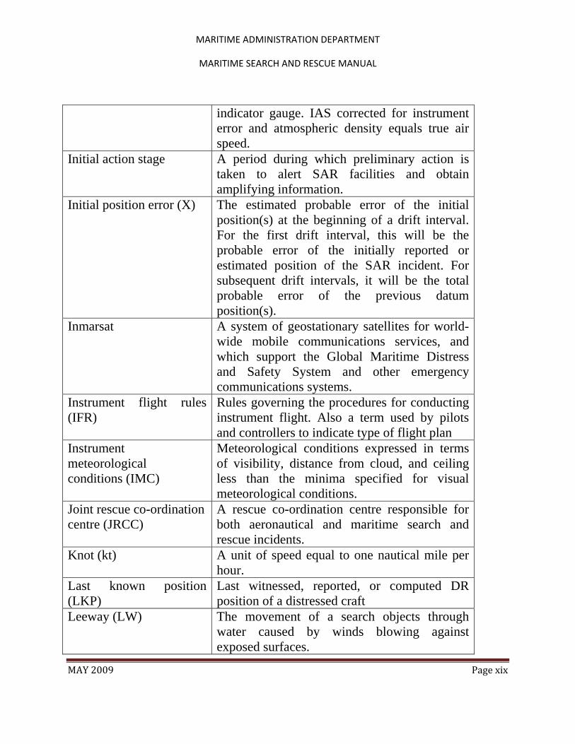
indicator gauge. IAS corrected for instrument error and atmospheric density equals true air speed.
Initial action stage A period during which preliminary action is taken to alert SAR facilities and obtain amplifying information.
Initial position error (X) The estimated probable error of the initial position(s) at the beginning of a drift interval. For the first drift interval, this will be the probable error of the initially reported or estimated position of the SAR incident. For subsequent drift intervals, it will be the total probable error of the previous datum position(s).
Inmarsat A system of geostationary satellites for world-wide mobile communications services, and which support the Global Maritime Distress and Safety System and other emergency communications systems.
Instrument flight rules (IFR)
Rules governing the procedures for conducting instrument flight. Also a term used by pilots and controllers to indicate type of flight plan
Instrument meteorological conditions (IMC)
Meteorological conditions expressed in terms of visibility, distance from cloud, and ceiling less than the minima specified for visual meteorological conditions.
Joint rescue co-ordination centre (JRCC)
A rescue co-ordination centre responsible for both aeronautical and maritime search and rescue incidents.
Knot (kt) A unit of speed equal to one nautical mile per hour.
Last known position (LKP)
Last witnessed, reported, or computed DR position of a distressed craft
Leeway (LW) The movement of a search objects through water caused by winds blowing against exposed surfaces.
MARITIME ADMINISTRATION DEPARTMENT
MARITIME SEARCH AND RESCUE MANUAL
MAY 2009 Page xx
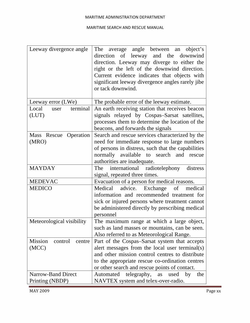
Leeway divergence angle The average angle between an object’s direction of leeway and the downwind direction. Leeway may diverge to either the right or the left of the downwind direction. Current evidence indicates that objects with significant leeway divergence angles rarely jibe or tack downwind.
Leeway error (LWe) The probable error of the leeway estimate. Local user terminal (LUT)
An earth receiving station that receives beacon signals relayed by Cospas–Sarsat satellites, processes them to determine the location of the beacons, and forwards the signals
Mass Rescue Operation (MRO)
Search and rescue services characterized by the need for immediate response to large numbers of persons in distress, such that the capabilities normally available to search and rescue authorities are inadequate.
MAYDAY The international radiotelephony distress signal, repeated three times.
MEDEVAC Evacuation of a person for medical reasons. MEDICO Medical advice. Exchange of medical
information and recommended treatment for sick or injured persons where treatment cannot be administered directly by prescribing medical personnel
Meteorological visibility The maximum range at which a large object, such as land masses or mountains, can be seen. Also referred to as Meteorological Range.
Mission control centre (MCC)
Part of the Cospas–Sarsat system that accepts alert messages from the local user terminal(s) and other mission control centres to distribute to the appropriate rescue co-ordination centres or other search and rescue points of contact.
Narrow-Band Direct Printing (NBDP)
Automated telegraphy, as used by the NAVTEX system and telex-over-radio.
MARITIME ADMINISTRATION DEPARTMENT
MARITIME SEARCH AND RESCUE MANUAL
MAY 2009 Page xxi
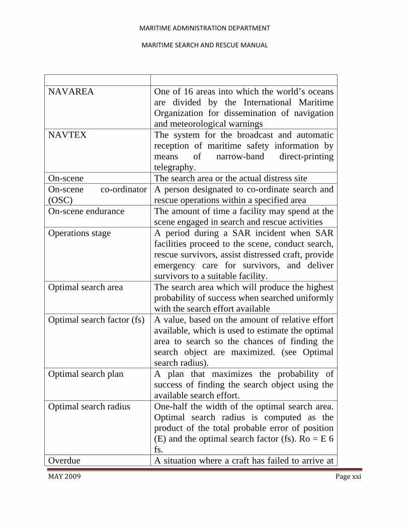
NAVAREA One of 16 areas into which the world’s oceans
are divided by the International Maritime Organization for dissemination of navigation and meteorological warnings
NAVTEX The system for the broadcast and automatic reception of maritime safety information by means of narrow-band direct-printing telegraphy.
On-scene The search area or the actual distress site On-scene co-ordinator (OSC)
A person designated to co-ordinate search and rescue operations within a specified area
On-scene endurance The amount of time a facility may spend at the scene engaged in search and rescue activities
Operations stage A period during a SAR incident when SAR facilities proceed to the scene, conduct search, rescue survivors, assist distressed craft, provide emergency care for survivors, and deliver survivors to a suitable facility.
Optimal search area The search area which will produce the highest probability of success when searched uniformly with the search effort available
Optimal search factor (fs) A value, based on the amount of relative effort available, which is used to estimate the optimal area to search so the chances of finding the search object are maximized. (see Optimal search radius).
Optimal search plan A plan that maximizes the probability of success of finding the search object using the available search effort.
Optimal search radius One-half the width of the optimal search area. Optimal search radius is computed as the product of the total probable error of position (E) and the optimal search factor (fs). Ro = E 6 fs.
Overdue A situation where a craft has failed to arrive at

MARITIME ADMINISTRATION DEPARTMENT
MARITIME SEARCH AND RESCUE MANUAL
MAY 2009 Page xxii
its intended destination when expected and remains missing
PAN-PAN The international radiotelephony urgency signal. When repeated three times, indicates uncertainty or alert, followed by nature of urgency.
Personal Locator Beacon (PLB)
Personal radio distress beacon for alerting and transmitting homing signals.
Pilot-in-command The pilot responsible for the operation and safety of the aircraft during flight time
Planning stage A period during a SAR incident when an effective plan of operations is developed
Position A geographical location normally expressed in degrees and minutes of latitude and longitude
Positioning Process of determining a position which can serve as a geographical reference for conducting a search.
Possibility area (1) The smallest area containing all possible survivor or search objects locations. (2) For a scenario, the possibility area is the smallest area containing all possible survivor or search object locations which are consistent with the facts and assumptions used to form the scenario
Primary swell The swell system having the greatest height from trough to crest.
Probability of containment (POC)
The probability that the search object is contained within the boundaries of an area, sub-area, or grid cell.
Probability of detection (POD)
The probability of the search object being detected, assuming it was in the areas that were searched. POD is a function of coverage factor, sensor, search conditions and the accuracy with which the search facility navigates its assigned search pattern. Measures sensor effectiveness under the prevailing search conditions

MARITIME ADMINISTRATION DEPARTMENT
MARITIME SEARCH AND RESCUE MANUAL
MAY 2009 Page xxiii
Probability of success (POS)
The probability of finding the search object with a particular search. For each sub-area searched, POS = POC 6 POD. Measures search effectiveness.
Probability map A set of grid cells covering a scenario’s possibility area where each grid cell is labeled with the probability of the search object being in that grid cell. That is, each grid cell is labeled with its own POC value.
Probable error (from statistics)
The range on either side of the average or expected value such that the probability of being within that range is 50%.
Relative effort (Zr) The amount of available search effort (Z) divided by the effort factor. The relative effort relates the size of the effort available for a particular search to the size of the search object’s location probability distribution at the time of the search. Zr = Z/fZ.
Rescue An operation to retrieve persons in distress, provide for their initial medical or other needs, and deliver them to a place of safety.
Rescue co-ordination centre (RCC)
A unit responsible for promoting efficient organization of search and rescue services and for coordinating the conduct of search and rescue operations within a search and rescue region. Note: The term RCC will be used within this Manual to apply to either aeronautical or maritime centres; ARCC or MRCC will be used as the context warrants.
Rescue sub-centre (RSC) A unit subordinate to a rescue co-ordination centre, established to complement the latter according to particular provisions of the responsible authorities. Note: The term RSC will be used within this Manual except where it applies only to aeronautical or maritime; then ARSC or MRSC will be used.
MARITIME ADMINISTRATION DEPARTMENT
MARITIME SEARCH AND RESCUE MANUAL
MAY 2009 Page xxiv
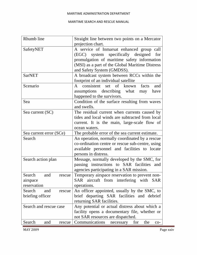
Rhumb line Straight line between two points on a Mercator projection chart.
SafetyNET A service of Inmarsat enhanced group call (EGC) system specifically designed for promulgation of maritime safety information (MSI) as a part of the Global Maritime Distress and Safety System (GMDSS).
SarNET A broadcast system between RCCs within the footprint of an individual satellite
Scenario A consistent set of known facts and assumptions describing what may have happened to the survivors.
Sea Condition of the surface resulting from waves and swells.
Sea current (SC) The residual current when currents caused by tides and local winds are subtracted from local current. It is the main, large-scale flow of ocean waters.
Sea current error (SCe) The probable error of the sea current estimate. Search An operation, normally coordinated by a rescue
co-ordination centre or rescue sub-centre, using available personnel and facilities to locate persons in distress.
Search action plan Message, normally developed by the SMC, for passing instructions to SAR facilities and agencies participating in a SAR mission.
Search and rescue airspace reservation
Temporary airspace reservation to prevent non-SAR aircraft from interfering with SAR operations.
Search and rescue briefing officer
An officer appointed, usually by the SMC, to brief departing SAR facilities and debrief returning SAR facilities.
Search and rescue case Any potential or actual distress about which a facility opens a documentary file, whether or not SAR resources are dispatched.
Search and rescue Communications necessary for the co-

MARITIME ADMINISTRATION DEPARTMENT
MARITIME SEARCH AND RESCUE MANUAL
MAY 2009 Page xxv
coordinating communications
ordination of facilities participating in a search and rescue operation.
Search and rescue coordinator (SC)
One or more persons or agencies within an Administration with overall responsibility for establishing and providing SAR services, and ensuring that planning for those services is properly coordinated.
Search and rescue data provider (SDP)
A source for a rescue co-ordination centre to contact to obtain data to support search and rescue operations, including emergency information from communications equipment registration databases, ship reporting systems, and environmental data systems (e.g., weather or sea current).
Search and rescue facility Any mobile resource, including designated search and rescue units, used to conduct search and rescue operations.
Search and rescue incident
Any situation requiring notification and alerting of the SAR system and which may require SAR operations.
Search and rescue liaison officer
An officer assigned to promote co-ordination during a SAR mission.
Search and rescue mission coordinator (SMC)
The official temporarily assigned to co-ordinate response to an actual or apparent distress situation.
Search and rescue plan A general term used to describe documents which exist at all levels of the national and international search and rescue structure to describe goals, arrangements, and procedures which support the provision of search and rescue services.
Search and rescue point of contact (SPOC)
Rescue co-ordination centres and other established and recognized national points of contact which can accept responsibility to receive Cospas–Sarsat alert data to enable the rescue of persons in distress.

MARITIME ADMINISTRATION DEPARTMENT
MARITIME SEARCH AND RESCUE MANUAL
MAY 2009 Page xxvi
Search and rescue region (SRR)
An area of defined dimensions, associated with a rescue co-ordination centre, within which search and rescue services are provided.
Search and rescue service The performance of distress monitoring, communication, co-ordination and search and rescue functions, including provision of medical advice, initial medical assistance, or medical evacuation, through the use of public and private resources, including co-operating aircraft, vessels and other craft and installations.
Search and rescue stage Typical steps in the orderly progression of SAR missions. These are normally Awareness, Initial Action, Planning, Operations, and Mission Conclusion.
Search and rescue Sub-region (SRS)
A specified area within a search and rescue region associated with a rescue sub-centre.
Search and rescue unit (SRU)
A unit composed of trained personnel and provided with equipment suitable for the expeditious conduct of search and rescue operations.
Search area The area, determined by the search planner that is to be searched. This area may be sub-divided into search sub-areas for the purpose of assigning specific responsibilities to the available search facilities.
Search effort (Z) A measure of the area a search facility can effectively search within the limits of search speed, endurance, and sweep width. Search effort is computed as the product of search speed (V), search endurance (T), and sweep width (W). Z = V 6 T 6 W.
Search endurance (T) The amount of ‘‘productive’’ search time available at the scene. This figure is usually taken to be 85% of the on-scene endurance, leaving a 15% allowance for investigating

MARITIME ADMINISTRATION DEPARTMENT
MARITIME SEARCH AND RESCUE MANUAL
MAY 2009 Page xxvii
sightings and navigating turns at the ends of search legs
Search facility position error (Y)
Probable error in a search craft’s position, based on its navigational capabilities.
Search object A ship, aircraft, or other craft missing or in distress or survivors or related search objects or evidence for which a search is being conducted.
Search pattern A track line or procedure assigned to an SRU for searching a specified area.
Search radius The actual search radius used to plan the search and to assign search facilities. It is usually based on adjustments to the optimal search radius that are needed for operational reasons.
Search speed (V) The speed (or velocity) with which a search facility moves over the ground when searching.
Search sub-area A designated area to be searched by a specific assigned search facility or possibly two facilities working together in close co-ordination.
Secondary swells Swell systems of less height than the primary swell.
Sensors Human senses (sight, hearing, touch, etc.), those of specially trained animals (such as dogs), or electronic devices used to detect the object of a search.
Separation ratio (SR) The ratio of the divergence distance (DD) between two leeway divergence datums to the total probable error of position (E). (SR = DD/E).
Set Direction towards which a current flows Situation report (SITREP) Reports, from the OSC to the SMC or the SMC
to interested agencies, to keep them informed of on-scene conditions and mission progress.
Sortie Individual movement of a resource in conducting a search or rendering assistance.

MARITIME ADMINISTRATION DEPARTMENT
MARITIME SEARCH AND RESCUE MANUAL
MAY 2009 Page xxviii
Surface drift Vector sum of total water current and leeway. Sometimes called Total Drift.
Surface picture (SURPIC) A list or graphic display from a ship reporting system of information about vessels in the vicinity of a distress situation that may be called upon to render assistance.
Surface position The position of the search object on the earth’s surface at the time of initial distress, or its first contact with the earth’s surface.
Sweep width (W) A measure of the effectiveness with which a particular sensor can detect a particular object under specific environmental conditions.
Swell Condition of the surface caused by a distant wind system. The individual swell appears to be regular and smooth with considerable distance between rounded crests.
Swell direction The direction from which a swell is moving. The direction toward which a swell is moving is called the down swell direction.
Swell face The side of the swell toward the observer. The backside is the side away from the observer. These definitions apply regardless of the direction of swell movement.
Swell velocity Velocity with which the swells advance with relation to a fixed reference point, measured in knots.
Tidal current (TC) Near-shore currents caused by the rise and fall of the tides.
Tidal current error (TCe) The probable error of the tidal current estimate. Time of closest approach (TCA)
Time during a satellite pass when the satellite is closest to a signal source.
Total available search effort (Zta)
The total amount of search effort available at the scene; equal to the sum of the search efforts available from each of the search facilities at the scene.
Total drift error (De) Also total probable drift error. The total

MARITIME ADMINISTRATION DEPARTMENT
MARITIME SEARCH AND RESCUE MANUAL
MAY 2009 Page xxix
probable error in the datum position that is contributed by the total drift velocity error (DVe). De = DVe 6 t, where t is the length of the drift interval in hours.
Total drift velocity error (DVe)
Also total probable drift velocity error. The total probable error of the total drifts velocity based on the probable errors contributed by the probable errors in the average surface wind, leeway, and total water current.
Total probable error (E) The estimated error in the datum position. It is the square root of the sum of the squares of the total drift error, initial position error, and search facility position error.
Total water current (TWC)
The vector sum of currents affecting search objects.
Total water current error (TWCe)
Also total probable water current error. The total probable error of the total water current based on either (a) the probable error of the measured total water current or (b) the probable errors of the wind current, tidal or sea current, and any other current that contributed to the total water current.
Track spacing (S) The distance between adjacent parallel search tracks.
Triage The process of sorting survivors according to medical condition and assigning them priorities for emergency care, treatment, and evacuation.
True air speed (TAS) The speed an aircraft is travelling through the air mass. TAS corrected for wind equals ground speed.
Uncertainty Phase A situation wherein doubt exists as to the safety of an aircraft or a marine vessel, and of the persons on board.
Unnecessary SAR alert (UNSAR)
A message sent by an RCC to the appropriate authorities as a follow-up when the SAR system is unnecessarily activated by a false
MARITIME ADMINISTRATION DEPARTMENT
MARITIME SEARCH AND RESCUE MANUAL
MAY 2009 Page xxx
alert. Unreported A situation where a craft has failed to report its
location or status when expected and remains missing.
Vector A graphic representation of a physical quantity or measurement, such as wind velocity, having both magnitude and direction.
Visual flight rules (VFR) Rules governing procedures for conducting flight under visual meteorological conditions. In addition, used by pilots and controllers to indicate type of flight plan.
Visual meteorological conditions (VMC)
Meteorological conditions expressed in terms of visibility, distance from cloud, and ceiling equal to or better than specified minima.
Wave (or Chop) The condition of the surface caused by local wind and characterized by irregularity, short distance between crests, whitecaps, and breaking motion.
Wind-corrected heading The actual heading an aircraft is required to fly to make good an intended course.
Wind current (WC) The water current generated by wind acting upon the surface of water over a period of time.
Wind current error (WCe) The probable error of the wind current estimate.

MARITIME ADMINISTRATION DEPARTMENT
MARITIME SEARCH AND RESCUE MANUAL
MAY 2009 Page 1
Chapter 1 Search and Rescue System 1.1 SAR System Organisation Global SAR System Organisation 1.1.1 The International Civil Aviation Organization (ICAO) and the International Maritime Organization (IMO) coordinate, on a global basis, member States’ efforts to provide search and rescue (SAR) services. Briefly, the goal of ICAO and IMO is to provide an effective worldwide system, so that wherever people sail or fly, SAR services, as referenced in the International Aeronautical and Maritime Search and Rescue Manual, Resolution A.894 (21), will be available if needed. The overall approach a State takes in establishing, providing and improving SAR services is affected by the fact that these efforts are an integral part of a global SAR system. 1.1.2 Maritime search and rescue services are defined as the performance of distress monitoring, communication, coordination and search and rescue functions, provision of medical advice and initial medical assistance to ships at sea, through the use of public and private resources, including cooperating aircraft, vessels and other craft and installations. 1.1.3 In providing assistance to persons in distress and to survivors of SAR incidents, member States shall do so regardless of the nationality or status of such a person or the circumstances in which that person is found. National SAR System Organisation 1.1.4 Guyana, by being Party to the Safety of Life at Sea (SOLAS) Convention and the Convention on International Civil Aviation, has accepted the obligation to provide aeronautical and maritime SAR co-ordination and services within its Search and Rescue Region (SRR). 1.1.5 The Government of Guyana has established a national SAR Committee in the year 2008, to carry out these responsibilities, 1.1.6 Guyana’s maritime SRR coincides with the aeronautical SRR as defined in the ICAO Regional Air Navigation Plans (RANPs).
MARITIME ADMINISTRATION DEPARTMENT
MARITIME SEARCH AND RESCUE MANUAL
MAY 2009 Page 2
The purpose of having a SRR is to clearly define who has primary responsibility for coordinating responses to distress situations in every area of the world, which is especially important for automatic routing of distress alerts to the responsible Rescue Coordinating Centre (RCC). In accordance with the International Convention for the Safety of Life at Sea (SOLAS) and the International Convention on Maritime Search and Rescue1, the Government of Guyana through Maritime Administration Department (MARAD), accepts responsibility for the coordination of maritime search and rescue in Guyana’s Search and Rescue Region (SRR). These responsibilities shall be exercised through a Rescue Coordination Centre (RCC)2. The RCC is to be staffed continuously and is responsible for:
a. coordinating SAR in respect of civil aircraft in the maritime SAR area; b. coordinating maritime SAR for all classes of ships c.. promulgation of Maritime Safety Information (MSI); d. provision of information on maritime activities such as oil pollution, offshore mineral exploration and dumping at sea;
1.2 SAR MANAGEMENT Overview 1.2.1 There are three levels of management within the SAR system. Overall management of SAR responsibilities by SAR Authority, management of individual SAR incidents by SAR mission coordinators (SMCs), and direction of SAR activities at an incident by on-scene coordinators (OSCs) specifically designated by the SMC. This section outlines, in general terms, the management and
1 Guyana is not a Signatory to this Convention, but the National SAR Committee has recommended that the Government accept it. Nevertheless since it is the basis of maritime search and rescue, it is relied upon heavily inn this document.
2 The Guyana RCC has not yet being established, but since it is a condition precedent for the establishment of a search and rescue regime, therefore, this document is being prepared as if it is already in place.
MARITIME ADMINISTRATION DEPARTMENT
MARITIME SEARCH AND RESCUE MANUAL
MAY 2009 Page 3
coordination actions required when a decision is made to implement procedures in prosecuting a SAR.). SAR Authority 1.2.2 A SAR Authority shall ensure that a SAR operation can be promptly initiated and prosecuted with the efficient use of available SAR resources, until rescue has been completed or until the chance of success is no longer a reasonable possibility. 1.2.3 The Guyana SAR Authority has the overall responsibility for establishing, staffing, equipping and managing the SAR system, including providing appropriate legal and funding support, establishing RCCs, providing or arranging for SAR assets, coordinating SAR training and developing SAR policies. The SAR authority, where applicable, shall:
a. establish a Rescue Coordination Centre (RCC) to coordinate all participating search and rescue assets and facilities; b. ensure that the RCC conforms to the SAR procedures contained in this manual or local SOPs and manuals; c. establish close liaison and formulate agreements with other authorities and organisations having SAR potential; d. establish liaison with SAR authorities of adjacent areas to ensure mutual cooperation and coordination in combined operations; e. ensure that a comprehensive and current SAR plan is prepared and distributed; f. establish and supervise communication facilities and assign SAR frequencies from those authorised to assets designated for SAR tasks; g. establish communications with adjoining RCCs and appropriate organisations to ensure two-way alerting and dissemination of SAR information; h. ensure immediate action is taken to provide assistance, advising the appropriate SAR authorities and passing all information received concerning the distress incident and any action taken; i. ensure that the operating authority or agency of any craft, aviation asset or land party in need of assistance has been advised of initial actions taken, and they are kept informed of all pertinent developments; j. designate an SMC for a specific SAR incident;
MARITIME ADMINISTRATION DEPARTMENT
MARITIME SEARCH AND RESCUE MANUAL
MAY 2009 Page 4
k. ensure that each incident is prosecuted until assistance is no longer necessary, rescue has been completed or chance of success is no longer a reasonable possibility; l. ensure that if the scope of the operation exceeds the authority’s capacity to plan and execute the operation, it shall seek advice and assistance from, or by mutual agreement, hand over coordination, to an appropriate authority; m. maintain and preserve adequate records; and n. develop new and improved techniques and procedures.
1.2.4 SAR Coordinators SCs have the overall responsibility for establishing, staffing, equipping, and managing the SAR system, including providing appropriate legal and funding support, establishing RCCs and rescue sub-centres (RSCs), providing or arranging for SAR facilities, coordinating SAR training, and developing SAR policies. SCs are the top level SAR managers; each State normally will have one or more persons or agencies for whom this designation may be appropriate. More information on SAR management responsibilities may be found in the International Aeronautical and Maritime Search and Rescue Manual on Organization and Management. SCs are not normally involved in the conduct of SAR operations RCC Staff 1.2.5 RCC staff performs duties in the prosecution of search and rescue events. In addition they have responsibility for maintaining the RCC in a continuous state of preparedness. RCC staff shall consist of personnel who are experienced and/or trained in SAR operations. When a period of heavy activity is anticipated or during major SAR incidents, the regular staff may be supplemented as required. 1.2.6 Authorities and agencies that may be involved in providing services to an RCC in the event of an incident are to be alerted as early as practicable so that staffing can be managed. SAR Mission Coordinator 1.2.7 Each SAR operation is carried out under the coordination of a SAR Mission Coordinator (SMC) designated for the purpose.

MARITIME ADMINISTRATION DEPARTMENT
MARITIME SEARCH AND RESCUE MANUAL
MAY 2009 Page 5
The SMC must understand the extent of their authority and responsibility and must be capable of taking immediate and adequate action, basing their decisions on knowledge, logic and good judgment. Qualifications 1.2.8 The SMC must have completed appropriate SAR training and must review and maintain proficiency as per the organisational procedures. The SMC must be capable of performing all SAR functions required by the Guyana SAR Authority. 1.2.9 To fulfill the foregoing requirements, the SMC must have a good knowledge of the communications available, the geographical features of the region, and the capabilities and limitations of SAR assets. The SMC must use initiative and be inquisitive in the search for information, cross-checking the sources in doubtful cases. Responsibility 1.2.10 The SMC is responsible for efficiently prosecuting a SAR incident using the assets available. The SMC is responsible for all stages of the SAR operation. Their responsibilities include the prompt dispatch of appropriate and adequate SAR assets and the prosecution of SAR operations until rescue has been completed, or chance of success is no longer a reasonable possibility. 1.2.11 The SMC is responsible for ensuring that the following duties are carried out depending on the SAR incident and local circumstances:
a. Obtaining and evaluating all information pertaining to the incident, including emergency equipment carried by the person or craft in distress. b. Classifying the SAR incident into the appropriate emergency phase (Uncertainty, Alert/Urgency, or Distress). c. Alerting appropriate SAR assets and SAR organisations that may be of assistance during the incident. d. Conducting a risk assessment. e. Dispatching SRUs immediately, if situation warrants. f. Conducting initial communications checks. If unsuccessful, making an extended communications search to obtain additional information on the

MARITIME ADMINISTRATION DEPARTMENT
MARITIME SEARCH AND RESCUE MANUAL
MAY 2009 Page 6
incident, personnel involved and equipment carried by the vessel, aircraft or party in distress. g. Calculating the search area. Preparing optimum plans and promulgating attainable plans; h. Obtaining past/present/forecast weather, drift information and oceanographic conditions if applicable. i. Providing for SAR crew briefing, dispatching of appropriate SRUs, or other assets. j. Organising logistical support for all SAR assets including fuel, food and accommodation, through to the completion of the incident. k. Making arrangements for appropriate communications. l. Maintaining a continuous, chronological plot showing, for example sighting and hearing reports, DF bearings, air plot, radar plot, fixes, reports of debris, areas searched or not searched and other intelligence. m. Maintaining a continuous, chronological record or log of the search effort, including actions taken in relation to intelligence, SRUs employed, sorties, hours flown/underway, sightings, leads, results obtained, message traffic, briefing notes, telephone calls, daily evaluation of progress and probability of detection. n. Initiating maritime distress broadcasts or maritime information broadcasts and initiating the alerting of en-route aircraft. Consideration should be given to arranging for announcements to be made over radio and TV networks. o. Arranging communication schedules when and if needed. p. Requesting additional SAR assets, as required. q. Exercising overall coordination of SAR assets. r. Maintaining liaison with the next of kin, owner, agent or management of the missing craft or persons. s. Keeping all authorities involved fully advised of SAR incident progress with timely and regular situation reports (SITREPs). SITREPs should be sent in a numbered sequence. t. Making recommendations in relation to the continuation or suspension of searches. u. Issuing news media releases on the progress of incidents in accordance with the local SAR organisational procedures and policies. v. Providing debriefs of SRUs, cancel alerts, release SAR assets and organisations involved, and issuing the final SITREP to all concerned.

MARITIME ADMINISTRATION DEPARTMENT
MARITIME SEARCH AND RESCUE MANUAL
MAY 2009 Page 7
w. Acting as required to cope with unique, unusual or changing circumstances of the emergency.
1.2.12 For the overall coordination of a SAR operation, the SMC shall give particular attention to the following matters as relevant to the search:
a. In conjunction with the meteorological office, keeping a watch on weather conditions in the probability area, routes used by SAR units in transit to and from the search area and at aerodromes used as bases or alternate aerodromes for search aircraft. b. Coordination of search aircraft in the light of operational conditions by diverting or recalling aircraft or reassigning search areas as conditions dictates. c. Planning so as to minimise conflict between search aircraft in adjoining areas. d. Attending to logistical requirements, in particular, accommodation, fuel, availability of relief crews and observers and all necessary ground facilities at aerodromes to be used by SAR units. e. Coordination of the use of maritime resources and facilities and efficient distribution of message traffic regarding sea state and weather conditions which may affect marine craft engaged in search activities. f. Ensure that all search units are kept informed about actions and developments affecting their operations. g. Make effective use of personnel from medical agencies, public relations, company representatives and other maritime organisations.
1.2.13 The SMC may have access to other qualified SAR personnel. Some functions may be shared where there are insufficient numbers of staff to allocate individual tasks to a staff member. The following roles are listed for completeness. Assistant SAR Mission Coordinator (A/SMC) 1.2.14 As the title implies, the A/SMC assists, and is subordinate to, the SMC assigned to a particular SAR mission. Qualifications

MARITIME ADMINISTRATION DEPARTMENT
MARITIME SEARCH AND RESCUE MANUAL
MAY 2009 Page 8
1.2.15 Officers performing A/SMC duties should, as a rule, hold SMC qualifications. Generally, the title A/SMC refers to the SAR qualifications held by a particular officer, e.g. an officer rated as A/SMC may serve in any capacity within the Guyana SAR Authority, except in the position of SMC. Officers rated as SMC may, on the other hand, be allocated A/SMC duties. As a general guide, the objective of any SAR organisation is to ensure that staff employed in the management of SAR operations are qualified to perform the highest level of duties i.e. SMC. Authority 1.2.16 The A/SMC is under the direct supervision of the SMC and therefore has the full operational authority of the SMC when carrying out specific duties assigned. Responsibilities and Duties 1.2.17 The A/SMC is responsible for routine documentation, allocation of SRUs and presentation of the search plan under the direction of the SMC. On Scene Coordinator 1.2.18 When a number of SAR assets are working together on the same SAR mission in the same location, there may be an advantage if one unit is assigned to coordinate the activities of all participating assets. The SMC will designate this role to an On Scene Coordinator (OSC), who may be the person in charge of a ship or aircraft participating in the search or someone at another nearby facility in a position to handle OSC duties. The OSC should be the most capable person available, taking into consideration SAR training; communications capabilities of the asset; and the length of time that the asset the OSC is aboard can stay in the search area. Frequent changes in the OSC should be avoided. Duties that the SMC may assign to the OSC, depending on needs and qualifications include:
a. assuming operational coordination of all SAR facilities on scene; b. receiving the search action plan from the SMC; c. modifying the search action plan based on prevailing environmental conditions and keeping the SMC advised of any changes to the plan (in consultation with the SMC when practicable);

MARITIME ADMINISTRATION DEPARTMENT
MARITIME SEARCH AND RESCUE MANUAL
MAY 2009 Page 9
d. providing relevant information to the other SAR assets; e. implementing the search and rescue plan where required; f. monitoring the performance of other assets participating in the search; g. developing and implementing the rescue plan (when needed); h. providing regular SITREPS to the SMC.
1.3 SAR Response and Coordination in Guyana
1.3.1. The Guyana SAR Authority coordinates SAR response in Guyana. However, MARAD is responsible for maritime SAR, the Guyana Civil Aviation Department is responsible for the organisation and coordination of aeronautical SAR, and the Guyana Police Force is responsible for land SAR. 1.3.2 It is common for a number of agencies to contribute to one SAR operation. In such circumstances it is vital that one agency has overall coordination and other agencies involved cooperate with this agency to produce the best response possible within available resources. The SAR agency that assumes overall coordination is determined by the nature and location of the party in distress. Determination of Responsible RCC 1.3.3 In practice, the first agency to become aware of a distress situation is obliged to respond until the appropriate SAR agency with overall coordination responsibility is in a position to assume that responsibility. It is imperative that the appropriate SAR agency is notified as soon as possible. 1.3.4 From time to time a maritime SAR operation may be commenced independent of the MARAD. Once the MARAD is alerted to the incident it will, initiate the RCC to coordinate the activities of the responding assets in order that the integrity of the search is maintained. Cooperation with Foreign Rescue Coordination Centres 1.3.5 When the area of SAR operations is near or straddles the border between international search and rescue regions (SRR), Guyana RCC is to be informed and will take overall coordination, while it liaise with neighbouring foreign RCCs in accordance with the relevant International SAR Arrangements.

MARITIME ADMINISTRATION DEPARTMENT
MARITIME SEARCH AND RESCUE MANUAL
MAY 2009 Page 10
1.3.6 In general, when the position of a party in distress is known, the responsibility for initiation of SAR action will be that of the neighbouring RCC in whose SRR the party is located. 1.3.7 The International RCC to assume responsibility for conduct of a SAR action when the distressed craft’s position is unknown shall be the RCC responsible for:
a. the SRR in which the craft was operating according to its last reported position; or b. the SRR to which the craft was proceeding if the last reported position was at the boundary of two SRRs; or c. the SRR to which the craft was destined if it was not equipped with suitable two–way radio communication equipment or not under obligation to maintain radio communication.
1.3.8 If, after a SAR action has been initiated, it is determined that the area of probability lies across the boundaries of two or more adjoining SRRs, the initiating RCC shall normally remain the responsible SAR Authority. 1.3.9 Alternatively, where search areas are extensive, it may be agreed that the Guyana RCC coordinates search efforts in the Guyana SRR and the adjacent International RCC coordinates search efforts in the foreign SRR. Should this be considered the preferable strategy, RCC Guyana may initiate the proposal to its foreign counterpart. Transferring Overall Coordination Responsibility Early initiation of effective response 1.3.10 It is essential that the SAR Authority initiate early and effective response. 1.3.11 Accordingly, the Guyana SAR authority should evaluate all available information and intelligence and make an initial assessment of the probable search area and assets required. If the required response is assessed as being beyond the capacity of the authority, then they should request assistance at an early stage. Delaying requests for assistance, may lead to reduced chances of survival and/or significant increase in the size of the search area. Reasons for transfer of coordination
MARITIME ADMINISTRATION DEPARTMENT
MARITIME SEARCH AND RESCUE MANUAL
MAY 2009 Page 11
1.3.12 Coordination for SAR events shall remain with or be transferred to and accepted by, the SAR authority that has overall coordination responsibility for the incident in accordance with established procedures, immaterial of which SAR authorities are involved. Overall coordination responsibility may be transferred from MARAD to the GCCA SAR organisation or vice versa, within Guyana’s SRR in the following circumstances: a. When an RCC is fully committed, overall coordination of a further incident in that region may be transferred. b. Where one of the SAR authorities has activated a SAR operation in response to a distress or other emergency situation that is found to be outside their responsibility. For example, a SAR operation is mounted by the maritime RCC in response to a distress beacon activation that is, after investigation, found to be a land environment incident. In such a case the RCC, will transfer overall coordination of the SAR operation to the Police Force. 1.3.13 Where either SAR authority wishes/requires to transfer coordination, the accepting SMC shall ascertain from that the reasons for seeking to transfer coordination. It is essential that the SMC is aware of the reasons for taking coordination, or the SMC may seek to use that SAR agency for delegated tasks beyond their current capability. 1.3.14 In taking coordination for the SAR event, the SMC should operate in the knowledge that SAR assets/assistance from the (current) Coordinating SAR Authority may not be available, depending on the reasons given for transferring coordination. 1.3.15 On completion of the SAR event, if it is appropriate to consider transferring the event back to the original Coordinating SAR Authority, the SMC shall establish that the operational limitations for the earlier transfer of coordination no longer exist. Allocation of functional responsibilities

MARITIME ADMINISTRATION DEPARTMENT
MARITIME SEARCH AND RESCUE MANUAL
MAY 2009 Page 12
1.3.16 The SAR authority with specific functional responsibility for the target type involved in a SAR incident is responsible for the overall coordination of a SAR incident. 1.3.17 Any transfer of responsibility of overall coordination for a SAR operation between SAR Authorities will be by mutual agreement. Following a transfer of overall coordination, the initial authority will continue to provide support as necessary. 1.3.18 When an SMC has activated the SAR system in response to an emergency situation that, by agreement, is subsequently deemed to be the responsibility of another authority, he or she shall contact the SAR coordinator who is to assume responsibility and apprise them of all known information relating to the incident and actions taken or contemplated. Only then should a transfer of SAR responsibility take place. If a SAR coordinator is unable to accept SAR responsibility immediately, the initiating SMC shall retain responsibility until a mutually agreed time of handover/takeover. Accepting overall coordination from another SAR Authority 1.3.19 Where MARAD SAR Authority accepts overall coordination of an incident, the SMC shall ensure that full responsibility for the event is accepted, in which case: a. The SMC shall ensure that all aspects, including air and surface search, are coordinated by the maritime RCC. b. A Transfer of Coordination form shall be completed and exchanged. Accepting coordination for a component of the SAR event from another SAR Authority 1.3.20 Where the maritime SAR authority decides to accept coordination for a component of an event (e.g. air search) from the GCCA SAR Authority, the SMC shall ensure that responsibility for specific functions (e.g. air search) is accepted, in which case: a. the SMC shall operate within the terms of the agreed responsibility and report progress to the SAR Authority with overall coordination; and b. conduct the specific functions in accordance with accepted standards, procedures and practices.

MARITIME ADMINISTRATION DEPARTMENT
MARITIME SEARCH AND RESCUE MANUAL
MAY 2009 Page 13
Effective consultation and coordination 1.3.21 In order to ensure the successful prosecution of a SAR incident involving more than one SAR authority, the SMC with overall coordination should initiate consultation with all participating SAR Authorities at the commencement of an incident. The SMC should conduct frequent reviews of the progress of the incident and produce a SITREP at regular intervals. This should not preclude all participants offering advice and suggestions. Information Exchange in Support of Transfer of Coordination 1.3.22 Where the overall coordinator needs or requires another cooperating SAR Authority to take responsibility for a component of a SAR event or a specific activity in the SAR event: a. the cooperating authority must be provided with: i. Clear objectives, scope and scale of the delegated responsibility and service required; ii. Full briefing on the SAR event to the extent that it will affect the service to be provided; iii. Conditions and constraints on use of assets; iv. Time requirements and constraints; and v. Tactical intelligence, information and data as it becomes available that may affect the progress of the support service provided. b. the Cooperating Authority must: i. Accept, or reject the proposed delegation. If the action is other than to accept the delegation, then the Coordinating Authority must be informed of the operational reasons; ii. Operate within the terms of reference for the supporting service; iii. Inform the Coordinating Authority of any circumstances, if they arise where the specified service cannot be provided or needs to be varied, together with reasons; iv. Exchange with the Coordinating Authority, tactical intelligence, information and data as it becomes available that may affect the progress of the SAR event; and v. Report progress of the support activity to the Coordinating Authority. Transfer of coordination after suspension of SAR action.

MARITIME ADMINISTRATION DEPARTMENT
MARITIME SEARCH AND RESCUE MANUAL
MAY 2009 Page 14
1.3.23 When a SAR action is suspended, the authority with overall coordination at the time shall inform all authorities, units and facilities that have been activated and/or alerted. 1.3.24 Where a search is suspended for a target that is the responsibility, under the terms of Appendix B, of the authority with overall coordination at the time of suspension, SAR coordination shall not be transferred to another SAR authority. Rather, the Police, and other SAR agencies, should be informed that search has been suspended pending the availability of further intelligence. The Police may then instigate further Police (non SAR) actions as appropriate. 1.3.25 Where a search is suspended for a target that another SAR authority has responsibility for under the terms of Appendix B, SAR coordination shall be transferred to that authority. The expectation would be that if further intelligence is received that indicates the search should be re-commenced, the SAR authority that has functional responsibility will consider its capability to coordinate the search at that time and either retain coordination, seek assistance or transfer coordination. Also, it may be necessary for that authority to fulfill their coronial or missing person responsibilities. 1.3.26 On occasions, after the suspension of a search, it may be necessary for the Police to continue to search for bodies or aircraft/vessel wreckage. In such cases the RCC may: a. review intelligence to assist search; b. source aircraft for transport or search purposes; c. brief search crews on (a) above; and d. provide drift information. 1.3.27 MARAD will not fund assets for the search for bodies or aircraft/vessel wreckage once the search has been suspended. 1.3.28 Should any other organisation, e.g. the operating company, wish to continue an independent search, the RCC should ascertain whether there is any new intelligence that indicates that the search should be continued. If there is: a. new intelligence then this should be evaluated and, if considered valid, the search should be continued/re-initiated;

MARITIME ADMINISTRATION DEPARTMENT
MARITIME SEARCH AND RESCUE MANUAL
MAY 2009 Page 15
b. no new intelligence then the RCC may assist the requesting organisation with: c. briefings on path prior to disappearance, splash/crash point, area searched and related intelligence; and/or d. drift information. 1.3.29 MARAD will neither fund nor provide air or surface assets for continuation of the search unless the request is supported by new intelligence
Requests for Assistance from Foreign RCCs 1.3.30 RCC Guyana or the Ministry of Foreign Affairs may receive requests from foreign RCCs for Guyanese assistance in SAR operations. If requests are received the RCC shall immediately establish communications with the RCC responsible for the area to establish and arrange any assistance that may be required. Distress Beacons 1.3.31 RCC Guyana will normally receive distress beacon alerts first and will advise other relevant SAR Authorities as soon as practicable because they may: a. be coordinating a response already and have more information; b. be the responsible authority in accordance with established procedures; or c. be in a position to assist in a SAR response. 1.3.32 Beacon registration or on-scene corroborating information available may allow the Responsible Authority (Appendix B) to be determined quickly, and before a SAR response is initiated. In such cases the Responsible Authority will assume overall coordination immediately based on the SAR alert passed through the RCC. 1.3.33 In other circumstances MARAD SAR will exercise overall coordination until the nature of the distress situation is established. At that stage the Responsible Authority will be determined in accordance with Appendix B. Overall coordination will then be transferred from MARAD SAR to the Responsible Authority at the first practicable opportunity, subject to the operational requirements of the SAR responses in progress.

MARITIME ADMINISTRATION DEPARTMENT
MARITIME SEARCH AND RESCUE MANUAL
MAY 2009 Page 16
1.4 Search and Rescue Resources Overview 1.4.1 Search and Rescue within the Guyana SRR is based on the use of aircraft and marine craft which are normally used for other purposes but which can be made available to form part of the SAR effort. 1.4.2 The SMC shall arrange for the provision of suitable search units. The terms SAR unit is used to describe one or more types of air or maritime facility. 1.4.3 Some of these facilities are immediately suitable for SAR use; others have been adapted by way of providing them with extra equipment or training. A number of units considered suitable for the provision of SAR services have been designated as specialised SAR units with trained personnel and are described as Search and Rescue Units (SRUs). 1.4.4 Every endeavor should be made to obtain sufficient search assets to search the determined area at a satisfactory coverage factor in the shortest possible time. However certain factors, such as inclement weather or darkness, may make an optimum air search impractical and the use of surface crafts should be considered. 1.4.5 Identification and deployment of rescue units shall commence at the time of the initial SAR response and a review of requirements shall continue through the action. Personnel 1.4.6 While a SAR unit will conduct a SAR operation under the general direction of the SMC, the person in charge of the unit will retain the responsibility for carrying out the operation assigned to it. 1.4.7 Medical personnel should be alerted in a timely manner if it is anticipated that they may be required. 1.4.8 MARAD SAR shall ensure that regular training is undertaken by SRUs in its jurisdiction.

MARITIME ADMINISTRATION DEPARTMENT
MARITIME SEARCH AND RESCUE MANUAL
MAY 2009 Page 17
Dropmasters, Dispatchers and Observers 1.4.9 Dropmasters, dispatchers and observers are an integral part of the SAR team and its effective operation. 1.4.10 Dropmasters will be required if an aerial delivery of stores is to be made to survivors. The dropmaster shall be responsible for the preparation of the equipment for delivery and for briefing the drop team and aircrew on dropping techniques. During the drop mission, the dropmaster will take charge of the aircraft cabin and control the dropping operation. Dispatchers should be available to assist the Dropmaster in the delivery of supplies when required. 1.4.11 Whenever possible, trained Observer Leaders and Observers shall be used in all search aircraft. Where it is inevitable that some untrained Observers must be used, the SMC shall make every effort to have at least one trained Observer Leader or Observer in each search aircraft. 1.4.12 Sufficient Observers should be assigned to large aircraft to enable the Observer Leader to arrange relief periods. Ideally, search sorties should be approximately of two hours duration. 1.4.13 An Observer Leader allocated to an aircraft shall attend the briefing with the pilot or obtain a copy of the briefing, and will then be responsible for briefing Observers allocated to that aircraft. Observer Leaders may be issued with binoculars where available. 1.4.14 Should a prolonged search be foreseen, Observer Leaders and Observers should be rostered to avoid fatigue. If there are insufficient Observers available locally, additional Observers should be obtained and taken to the area. 1.4.15 It is the SMC responsibility, either directly or by delegation to make reasonable provision for and to monitor the welfare of Observers. This includes the provision of refreshments, accommodation and rest breaks. Local T/SES assets and aero clubs, especially those from which a number of search aircraft may be deployed, may be of assistance in this regard and should be invited to cooperate in making appropriate arrangements.

MARITIME ADMINISTRATION DEPARTMENT
MARITIME SEARCH AND RESCUE MANUAL
MAY 2009 Page 18
Rescue Preparation 1.4.16 Planning for rescue shall commence at the time of the initial SAR response and continue throughout the action. Plans shall be appropriately updated, as the circumstances require. 1.4.17 For further considerations in rescue planning refer to Chapter 6
Ship Reporting
Ship Reporting System 1.4.18 The Georgetown Lighthouse and the Berbice Pilot Station maintain logs of ships transiting the Demerara and Berbice main ships channel. (This is inadequate, but with the establishment of the CRS and RCC, ships will have to comply with the mandatory ship reporting requirements3). Merchant ships, pleasure crafts and fishing vessels shall also report their positions to the CRS.
Public Relations Overview 1.5.1 Search and Rescue operations for missing aircraft and vessels generate considerable publicity. By virtue of its nature, an RCC is a source of news and this is especially true during SAR incidents. The public should be informed during SAR operations, within the limits of confidentiality, of SAR actions. The potential benefits of early release of information include: a. additional information from the public, leading to more effective use of SAR resources; b. fewer time-consuming requests from the news media; and c. reduction of inaccurate public speculation about the SAR mission.
3 MSC/Circ.1043 31 May 2002, GUIDANCE ON SHIPS' DAILY REPORTING OF THEIR POSITIONS TO THEIR COMPANIES

MARITIME ADMINISTRATION DEPARTMENT
MARITIME SEARCH AND RESCUE MANUAL
MAY 2009 Page 19
1.5.2 RCC staff should be governed by their parent authority’s public relations procedures when dealing with the media. It is important that a relationship between the media and an RCC is established such that: a. the media's legitimate interest in an incident of concern and the public's “right to know” is respected; b. information reaching the public is factual and as complete as possible; c. the operational functioning of an RCC is not prejudiced; and d. benefit is derived from publicity of an incident and from media broadcasts for information made at the request of SAR staff.
Public Relations Officers (PROs) 1.5.5 SAR Authorities usually have a designated PRO. The PRO, or the officer nominated, should have knowledge of search and rescue and the techniques of disseminating information to the public. 1.5.6 The authority of the PRO will be covered by organisational policies and procedures. The commercial distribution of news is highly competitive and therefore news releases must be impartial. Specifically, the PRO will perform the following duties:
a. receive briefings from the SMC, RCC personnel, SlTREPs, SAR log and interviews with rescued personnel if available; b. make proper and full use of existing news media such as press, radio, television and wire services to disseminate information; c. establish liaison with media sources early in the mission in order to prevent the SMC from being flooded with requests for information as the mission progresses; d. keep well informed on the procedures and techniques being used in the search and in which stage the SAR system is functioning at any particular time; and e. process and review for news-worthiness all photographs taken of mission activities

MARITIME ADMINISTRATION DEPARTMENT
MARITIME SEARCH AND RESCUE MANUAL
MAY 2009 Page 20
Press Releases 1.5.7 The early release of information will frequently aid in preventing time-consuming requests from news media concerning the operation. In cases where extensive searches are being conducted release of information to the public may bring important leads to the SMC. 1.5.8 News releases should be written following the time-proved format of who, what, where, when, why and how. In drafting a release all six of these items should be covered in paragraph one. Subsequent paragraphs can provide additional detailed information concerning one or more of these questions. By drafting releases in this fashion the news media will be able to chop portions of the release in order to meet their space requirements without damaging the overall story. The release of names can be a sensitive issue and organisational policies and procedures should be established in accordance with privacy guidelines. 1.5.9 A good news release will be well written, factual and newsworthy. It should not contain personal opinion, judgements, elaboration, colouring or any classified material. Asking the following questions may test news-worthiness: Is story still timely? Are the people involved known? Is the story unusual? Is locality within the range of the news media’s interest? Does the story have general interest? Has the story a personal or human-interest appeal to many people? 1.5.10 SAR officers shall not disclose to the media: a. the names of any crew or other missing persons; b. any personal judgments pertaining to any persons involved in the incident; c. any comments on the judgment, experience or training of persons involved in the incident; d. degrading opinions on the conduct of the SAR operation or personalities involved; e. personal opinions and theories; f. names of those associated with the search; g. names of persons who have given information relating to the incident.

MARITIME ADMINISTRATION DEPARTMENT
MARITIME SEARCH AND RESCUE MANUAL
MAY 2009 Page 21
1.5.11 Media releases may include the following information: a. type of vessel, factual details of the vessel b. reason for the SAR operation, eg. vessel overdue, report of weather situation; beacon activation c. owner of the vessel (subject to consent) d. number of missing persons e. area being searched f. number and types of assets engaged in the search; g. arrangements for the search; h. details of other authorities participating in the search; and/or i. reinforce the positive aspects relating to safety and survival. 1.5.12 As the operation progresses, releases should be made periodically to keep the public updated on the progress that is being made. A final release should be made when the case is concluded. This release should summarise the activities conducted during the operation, giving full particulars on the efforts expended to locate and rescue the distressed persons. The final release should be a complete summary of the incident and detail: a. the number of aircraft missions, total hours flown and use of vessels; b. auxiliary land or marine search, if applicable; c. the reasons for termination; d. any other information relevant to the incident that should be made public.
Requesting Public Assistance 1.5.13 The SMC may enlist the news media to access information from the general public. In sparsely populated areas, information from the general public may be sought through the media, requesting members of the public to contact the RCC. An RCC telephone number should be included as part of the release. Liaison with Relatives 1.5.14 Information that may significantly affect the conduct of a search may be obtained from relatives and friends of missing persons. Information relating to the personal history and possible courses of action taken by the missing persons should be collected by officers trained in investigation methods and competent to describe the current and proposed search plan in a reassuring manner.
MARITIME ADMINISTRATION DEPARTMENT
MARITIME SEARCH AND RESCUE MANUAL
MAY 2009 Page 22
Notification of Next Of Kin 1.5.15 The SMC should be aware of the concerns of the relatives of the missing persons. During a search, it is recommended that one staff member should maintain regular contact with the relatives to provide information and outline plans. If appropriate, relatives should be encouraged to visit the RCC to enable them to see the search effort. Next of kin/relatives should be advised at an early stage of any SAR operation, to ensure where possible that the timing of associated media releases) does not cause them undue concern. 1.5.16 Where available, police liaison officers should be utilised to give initial advice to relatives and particularly when providing advice that a death or deaths have occurred. It is preferable that this information can be passed personally rather than by telephone, so as to ensure that appropriate support services are provided. 1.5.17 In any event, before a search is suspended or terminated SAR management should ensure that the next of kin are consulted as far as possible. They should be fully briefed on the complete search effort, conditions in the search area, and the reasons for proposing the termination of the search. Relatives are more able to accept the SMC’s decision to suspend or conclude search operations if they are privy to the processes. 1.5.18 Whenever foreign nationals are the subjects of a search and rescue action, the Foreign Affairs Ministry should be informed. 1.5.19 The GDF s is the sole authority for releasing any information to next of kin of its members. Casualties 1.5.20 The Police will be responsible for the releasing the names of civilian casualties. The names of military casualties of a SAR Incident are only to be released by the GDF or the appropriate national authority for visiting military units. 1.5.21 The names and addresses of survivors shall not be released until a positive check and identification has been accomplished. Generally, survivor information should not be released prior to the release of casualty information, although

MARITIME ADMINISTRATION DEPARTMENT
MARITIME SEARCH AND RESCUE MANUAL
MAY 2009 Page 23
circumstances may dictate some departure from this procedure. Survivors shall be encouraged to contact their own families as soon as possible and all reasonable assistance towards accomplishing this shall be provided. Controlling the dissemination of information by survivors is difficult and requires tactful briefing. Whenever possible the PRO should brief survivors on what information may be released. Information on survivors who are GDF members or members of foreign military units is only to be released by the GDF or the appropriate national military authority.

MARITIME ADMINISTRATION DEPARTMENT
MARITIME SEARCH AND RESCUE MANUAL
MAY 2009 Page 24
Chapter 2 - Communications
2.1 Overview 2.1.1 Distress traffic includes all messages relating to immediate assistance required by persons, aircraft, or marine craft in distress, including medical assistance. Distress traffic may also include SAR communications and on-scene communications. Distress calls take absolute priority over all other transmissions; anyone receiving a distress call must immediately cease any transmissions that may interfere with the call and listen on the frequency used for the call. Presently there is no Coast Radio Station (CRS) or Rescue Coordination Centre (RCC) in Guyana, but these are absolute necessary for search and rescue in addition to other safety functions. For the purpose of this manual it is assumed that Guyana establishes a joint CRS and RCC4 and declares and provides facilities for SOALS Sea Area A2. The shore facilities required for this area primarily are DSC MF and VHF radio. The criteria for the establishment of shore facilities are contained in various IMO and ITU Resolutions and Circulars. 2.1.2 Distress and safety communications require the highest possible integrity and protection from harmful interference. Any interference that puts at risk the operation of safety services degrades, obstructs or interrupts any radio communications, is harmful. Some frequencies are protected, in that they have no authorised uses other than for distress and safety. SAR personnel should be particularly careful not to cause harmful interference, and should co-operate with authorities to report and stop incidents of interference. 2.1.3 The object of search and rescue (SAR) communications is to make possible the conduct of SAR operations. Communications must allow for:
4 1. IMO Resolution A.856(20) , Guidelines to Administrations on development of shore‐based SAR telecommunication infrastructure.
2. IMO Resolution MSC.199(80) Adoption of amendments to provision of radio services for Global Maritime Distress and Safety system (GMDSS) (Res.A. 801(19))
MARITIME ADMINISTRATION DEPARTMENT
MARITIME SEARCH AND RESCUE MANUAL
MAY 2009 Page 25
a. rapid transmission of distress messages from aircraft, ships and small craft, including for medical assistance; b. rapid communication of distress information to the authorities responsible for organising and effecting rescue; c. coordination of the operation of the various SAR units; and d. liaison between controlling/coordinating authorities and SAR units. 2.2 Distress and Emergency Signals 2.2.1 There are many signals that can be used to indicate a distress or other emergency. 2.2.2 Personnel involved in SAR operations must be familiar with the types of signals they can expect to encounter in order to evaluate their meaning correctly and take appropriate action. 2.2.3 These emergency signals may be made by radio, radar (e.g. transponders), flags, pyrotechnics, flashing light, smoke, sounds, shapes and ground panels. Marine Radio Alarm Signal 2.2.4 With the full implementation of the Global Maritime Distress and Safety System (GMDSS) in February 1999 the automatic alarm devices used on 2182 kHz are no longer required. However, some maritime communications stations may still use the voice alarm signal consisting of two sinusoidal audio frequency tones, one of 2200 Hz and the other of 1300 Hz, producing a distinct warbling sound to draw attention to a distress broadcast. Merchant shipping complying with the SOLAS Convention now guard the Digital Selective Calling (DSC) distress frequencies. RTF Distress Signal 2.2.5 The distress signal is used to indicate that a craft or person is threatened by grave and imminent danger and requires immediate assistance. It has precedence over all other communications. The distress message is preceded by the word MAYDAY spoken three times. RTF Urgency Signal 2.2.6 The urgency signal is used to indicate that the calling station has a very urgent message to transmit covering the safety of a ship, aircraft or person. It has

MARITIME ADMINISTRATION DEPARTMENT
MARITIME SEARCH AND RESCUE MANUAL
MAY 2009 Page 26
precedence over all other communications, except distress traffic. The urgency message is preceded by the words ’PAN PAN’ spoken three times. RTF Safety Signal 2.2.7 The safety signal indicates that the station is about to transmit a message concerning the safety of navigation or providing an important meteorological warning. The safety message is preceded by the word ’SECURlTE’ spoken three times. 2.2.8 All stations hearing either the urgency or safety signals shall not make any transmissions that might interfere with those signals. Radiotelephony Distress/Emergency Frequencies 2.2.9 The following frequencies have been designated as distress or emergency frequencies: GMDSS Distress, Urgency, Safety and Calling Frequencies Radio Telephone DSC NBDP 2182 2187.5 2174.5
4125 4207.5 4177.5
6215 6312.0 6268.0
8291 8414.5 8376.5
12 290 12 577.0 12 520.0
16 420 16 804.5 16 695.0
VHF: Ch 16 VHF: Ch 70 VHF not used
Note: None of the MF/HF DSC or NBDP frequencies are used when calling.

MARITIME ADMINISTRATION DEPARTMENT
MARITIME SEARCH AND RESCUE MANUAL
MAY 2009 Page 27
2182 kHz 2.2.10 The international MF voice distress frequency primarily for ship-to-ship communications, 2182 kHz is used for follow-on communications after an initial DSC distress alert on 2187.5 kHz for GMDSS shipping. 2182 is monitored by a number of Limited Coast Radio Stations operated around the coast. The two-tone alarm may still be used on 2182 kHz to draw attention but auto alarms are no longer a part of the Radio Regulations. 121.5 MHz 2.2.12 The international aeronautical emergency frequency for aircraft and those aeronautical stations primarily concerned with the safety and regularity of flight and having equipment in the 118-136 MHz VHF band. 2.2.13 Ships fitted with the capability are authorised to communicate on this frequency with aircraft for safety purposes. 156.8 MHz (Marine VHF Channel 16) 2.2.14 The international distress, safety and calling frequency for radiotelephony stations of the maritime mobile service, when using frequencies in the Marine VHF bands 156 to 174 MHz. 2.2.15 Port authorities, merchant ships, fishing craft and pleasure craft use VHF Ch 16. Merchant ships maintain continuous bridge listening watches on VHF channel 16 to the maximum extent practicable when at sea although this is being reviewed by IMO. 2.2.16 156.3 MHz (Marine VHF Channel 6) is the secondary distress and safety frequency in the VHF band and is used for coordination at the scene of an incident. 243MHz 2.2.17 243 MHZ is the international military aeronautical emergency frequency. Safety Frequencies 156.375 MHz VHF FM RTF (Marine channel 67)

MARITIME ADMINISTRATION DEPARTMENT
MARITIME SEARCH AND RESCUE MANUAL
MAY 2009 Page 28
Marine safety: Supplementary to Channel 16 and used to broadcast weather and warnings 27.88 MHz (Channel 88) HF (Marine) RTF 27 MHz band, pleasure craft safety frequency (2524 kHz MF (Marine) RTF Pleasure boat safety 2.3 Global Maritime Distress and Safety System 2.3.1 Ships subject to the Safety of Life at Sea (SOLAS) Convention are obliged to be outfitted with certain communications equipment to participate in the Global Maritime Distress and a Safety System (GMDSS). Fishing vessels and small craft around Guyana, if carrying compatible GMDSS equipment can also participate. 2.3.2 MARAD is now responsible for the provision of shore facilities for the GMDSS and all distress and safety traffic through the GMDSS shore infrastructure in the Guyana. SRR will be handled by RCC Guyana. 2.3.3 Ships operating under GMDSS requirements in the Guyana SRR can be expected to carry: a. MF DSC; b. VHF radiotelephone (Channels 6, 13, 16 and 67); c. VHF DSC (Channel 70) d. a SART; and e. an EPIRB. 2.4 Emergency Signaling Devices 2.4.1 People in a craft in distress may use any possible means of alerting others to their situation. These devices range from emergency radio beacons to mirrors. Daylight Devices 2.4.2 Reflective mirrors, used by survivors to reflect the sun’s rays towards a SAR unit, are an effective daylight device. Mirrors have been detected as far away as 45 miles and from as high as 10000 feet, although the average distance is about 10 miles. Fluorescent material (known as retro-reflective tape) that reflects a large

MARITIME ADMINISTRATION DEPARTMENT
MARITIME SEARCH AND RESCUE MANUAL
MAY 2009 Page 29
percentage of sunlight is usually sewn on one side of lifesaving craft coverings and has been detected as far away as 5 miles with an average of 3.5 miles. 2.4.3 Fluorescent sea dye marker, which stains the water a green or red colour, has been sighted as far away as 10 miles, with an average of 3 miles. However, sea dye is not visible when searching up-sun because of surface glare. 2.4.4 Orange smoke generating signals have been sighted as far away as 12 miles with an average of 8 miles. Smoke signals are most effective in calm wind conditions and open terrain. The effectiveness of smoke signals decreases rapidly with an increase of wind speed above 15 knots. 2.4.5 Pyrotechnic flares may be used in daylight; however their detectable range is only about 10 per cent of the night-time range. Night-time Devices 2.4.6 On land, fires are arguably the most effective night time signal that survivors may use. Fires have been sighted as far as 50 miles away, with the average range varying with the size of the fire and the absence of other light sources on the earth’s surface. 2.4.7 Flashing strobe lights are an effective compact night signalling device available for individual survivors. Strobe lights have been sighted as far as 20 miles away with an average of 3.5 miles. 2.4.8 Incandescent lights that are used on some individual lifejackets have a much smaller detectable range than strobe lights, generally about 0.5 mile. 2.4.9 Flares, star shells and rockets have been detected as far away as 35 miles, with an average of 25 miles. Radar/IFF/SSR 2.4.10 Besides the obvious radar target of the distressed craft itself, IFF (Identification Friend or Foe) may be used not only to indicate distress but also to increase the detectable range by radar.
MARITIME ADMINISTRATION DEPARTMENT
MARITIME SEARCH AND RESCUE MANUAL
MAY 2009 Page 30
2.4.11 The basic equipment consists of an interrogator and a transponder. The interrogator, which is usually incorporated into air search radar systems, transmits electronic challenges, and if any replies are received will display them on the radarscope. The transponder, which is usually installed in aircraft, ships and boats, is triggered into operation by the interrogator’s challenge and transmits a series of pulses. The reply is displayed as small bars slightly beyond the radar target of the transponder-equipped craft. Since interrogators usually use the same antenna as the air search radar, replies are only received as the search radar beam sweeps across the transponder-equipped craft. In addition, transponder replies will be detected at much greater ranges than the radar return from the craft itself. Radio and Distress Beacons 2.4.12 In addition to the obvious uses of standard radio for transmitting emergency signals and messages, there are a variety of types of emergency equipment designed for use by survivors. These include: a. Hand held VHF transmitters found in life rafts; b. 406 MHz distress beacons (GMDSS approved); c. Inmarsat E (L-Band) EPIRBS (GMDSS approved); d. 121.5 MHz distress beacons; and e. 9 GHz SAR Transponders;
2.5 COSPAS-SARSAT Distress Beacon Detection System Overview 2.5.1 COSPAS-SARSAT is a satellite system designed to provide distress alert and location data to assist SAR operations, using spacecraft and ground facilities to detect and locate the signals of distress beacons operating on 406 MHz or 121.5 MHz. The responsible Cospas-Sarsat Mission Control Centre (MCC) forwards the position of the distress and other related information to the appropriate SAR authorities. Its objective is to support all organisations in the world with responsibility for SAR operations, whether at sea, in the air or on land. 2.5.2 The Cospas-Sarsat System provides distress alert and location data to RCCs for 121.5 MHz beacons within the coverage area of Cospas-Sarsat ground stations (Local User Terminals - LUTs), and for 406 MHz beacons activated anywhere in the world.
MARITIME ADMINISTRATION DEPARTMENT
MARITIME SEARCH AND RESCUE MANUAL
MAY 2009 Page 31
Purpose 2.5.3 The primary purpose of this system is to detect, positively identify and provide the positions of 406 MHz EPIRBs, ELTs and PLBs anywhere in the world. It will also detect and provide the positions of 121.5 MHz beacons activated within LUT coverage. Some of the SARSAT satellites are also able to detect and provide positions of 243 MHz beacons while the COSPAS (Russian) satellites do not detect transmissions on this frequency. Worldwide system 2.5.4 The worldwide system comprises: a. Low orbiting satellites in near polar orbits; b. Satellites in geostationary orbit; c. Local User Terminals (LUTs), which are ground stations that receive and initially process the raw distress signal data relayed by a satellite; d. Mission Control Centres (MCCs) which are responsible for the final processing and appropriate distribution of beacon detections; and e. Frequency stable 406 MHz beacons, each with a unique identification code and capable of transmitting for 24 or 48 hours depending on their use. Satellites 2.5.5 The satellite constellation is made up of search and rescue satellites in low earth orbit (LEOSAR) and geostationary orbit (GEOSAR). 2.5.6 Each LEOSAR satellite makes a complete orbit of the earth around the poles in about 100 – 105 minutes. The satellite views a "swath" of the earth of approximately 4000 km wide as it circles the globe, giving an instantaneous "field of view" about the size of a continent. When viewed from the earth, the satellite crosses the sky in about 15 minutes, depending on the maximum elevation angle of the particular pass. 2.5.7 Satellites are not equally spaced and hence do not pass over a particular place at regular intervals. In view of this, pass schedules are computed for each LUT every day. 2.5.8 Not all LEOSAR satellites have a global detection capability for 406 MHz beacons and only some are able to detect transmissions on 243 MHz. 121.5 and

MARITIME ADMINISTRATION DEPARTMENT
MARITIME SEARCH AND RESCUE MANUAL
MAY 2009 Page 32
243 MHz distress signals may only be passed to the MCC when the satellite views the transmitting beacon and the receiving LUT simultaneously. 2.5.9 The current GEOSAR constellation is composed of two satellites provided by the USA, GOES 8 and GOES 10, and one satellite provided by India (INSAT-2B). These satellites provide continuous global coverage for 406 MHz beacons with the exception of the Polar Regions. To take full advantage of the real-time alerting capability the beacon must be designed to transmit, in its distress message, position data derived from a satellite navigation system such as GPS. Beacon detection 2.5.10 With the exception of the GEOSAR, the position of a distress beacon is calculated by using Doppler shift, which is caused by the relative movement between a satellite and a beacon. As a satellite approaches a beacon there is an apparent rise in the beacon frequency and as the satellite moves away the frequency appears to fall. When a satellite is at its closest point to a beacon the received frequency is the same as the transmitted frequency (the point of inflection) and provides the “Time of Closest Approach” (TCA). 2.5.11 This method of calculation produces two possible positions for each beacon (labelled A and B), either side of the satellite’s ground track; one is the true position and the other is its mirror image. The ambiguity is due to the equipment only being able to determine the distance between a satellite and a beacon and not the direction. Position ambiguity is subsequently resolved by using: a. Data obtained by the same LUT from the next satellite pass which “sees” the beacon or b. Data from another satellite pass observed by a different LUT. Beacons 2.5.12 There are three types of Cospas-Sarsat distress beacons: a. Emergency Locator Transmitters (ELT) used by aviators; b. Emergency Position Indicating Radio Beacons (EPIRB) used by mariners; and c. Personal Locator Beacons (PLB) used on land. 2.5.13 Aviators and mariners often carry PLBs as personal back up devices to ELTs and EPIRBs.

MARITIME ADMINISTRATION DEPARTMENT
MARITIME SEARCH AND RESCUE MANUAL
MAY 2009 Page 33
2.5.14 Because 406 MHz beacons transmit an extremely stable frequency, positions calculated by the LUT usually fall within a radius of 5km from the actual beacon position. On the other hand, 121.5/243 MHz beacons do not have the same frequency stability that results in less accuracy with positions within a 20 km radius. 2.5.15 406 MHz beacons use digital technology that allows an identifier to be sent when the beacon is activated. This identifier correlates to a registration database held at the MCC and allows additional information to be gained about the target. 406 MHz beacons should be coded with a country code and registered in the country that maintains the database for that country code. It is therefore important that all Guyanese 406 MHz beacons are registered with RCC Guyana. 2.5.16 If a Guyanese beacon is detected overseas, the overseas SAR authority may contact the RCC for appropriate details. Similarly, if a foreign-registered 406 MHz beacon is detected in the Guyana SAR area, the local RCC contacts the appropriate overseas registration authority to obtain further relevant SAR data.
2.5.17 Satellite processing of 121.5 MHz alerts ceased from 1 February 2009.
2.6 Inmarsat-E (L-Band) EPIRB Overview 2.6.1 T he INMARSAT-E EPIRB is an approved alternative to the 406 MHz beacon for carriage by merchant ships, in compliance with the Global Maritime Distress and Safety System (GMDSS). 2.6.2 These beacons are designed for detection by the International Maritime Satellite Organisation’s (INMARSAT) geostationary satellites. These satellites are located over the Indian, Pacific and Atlantic Oceans and cover the world except for the high Polar Regions. The beacons transmit on l.6 GHz in the L-Band. Because geostationary satellites are used, beacon position information cannot be obtained by the measurement of movement (Doppler effect), as is the case with the

MARITIME ADMINISTRATION DEPARTMENT
MARITIME SEARCH AND RESCUE MANUAL
MAY 2009 Page 34
COSPASSARSAT system. Instead the position information must be loaded into the beacon in one of three ways: a. By a GPS system actually built into the L-Band EPIRB; b. Fed in automatically by the craft’s navigation system; or c. Manual input. 2.6.3 At present vessels operating in the European area have mainly purchased the Inmarsat-E EPIRB. The EPIRB is designed to be manually released or automatically launched and activated; but it must also be capable of being carried by one person into a survival craft. 2.6.4 This beacon is coloured high-visibility yellow or orange, has retro reflective tape, is equipped with a flashing light (48 hour battery life) and is designed to remain afloat in heavy seas. It transmits a distress alert that contains the vessel identity, position and additional information such as the nature of the distress. 2.6.5 If the beacon has the position information fed in automatically by the ship’s navigation system, then the position information will be correct only at the moment of launch. In this case the distress alert is transmitted 120 times over a ten-minute period; to ensure reception this is repeated three more times over the next 4 hours, giving a total transmit duration of 40 minutes. 2.6.6 This beacon must have a built-in SAR Transponder (SART) for final homing, (see next section). If the beacon has an in-built GPS receiver, it will transmit the distress alert 120 times during the first ten minutes and then will transmit a message with the updated position every 4 hours for a further 48 hours. This beacon is not required to have a SART for final homing, but may have one fitted. 2.6.7 To ensure the integrity of the system, each ocean region will be monitored by at least two Land Earth Stations (LES). These Land Earth Stations require special equipment to monitor L-Band EPIRBS. 2.7 Radar SAR Transponder (SART) Overview 2.7.1 Satellites can detect and provide the positions of the latest distress beacons to an accuracy of a few miles/kilometres. Though this is extremely good, in poor

MARITIME ADMINISTRATION DEPARTMENT
MARITIME SEARCH AND RESCUE MANUAL
MAY 2009 Page 35
visibility it may not be sufficient to permit a searching craft to quickly locate survivors. To overcome this problem, a SAR transponder (SART) has been developed which will respond to the normal 3cm X-band (9GHz) radar fitted to merchant ships. It will NOT respond to l0cm S-band (3GHz) radar. It is a short-range homing device, which enables ships and other suitably equipped craft to home on the source of the signal. 2.7.2 The SART can be either a stand-alone item of equipment or built into an EPIRB. When within radar range, the SART will respond to 3cm radar pulses by painting a line of blips extending outwards from the SART’s position along its line of bearing on the radar screen. When within about 1 mile of the SART, the blips may change to wide arcs or even complete circles thus giving an indication of the close proximity of the SART, but masking its bearing. Decreasing the GAIN on the search craft’s radar should restore the blips to view. 2.7.3 Since the radar detection range depends primarily upon the height of the radar scanner and the height of the beacon, it is probably not realistic to expect a detection range of much more than 30 miles for an aircraft flying at 3000 ft equipped with 3cm (9GHz) radar and about 10 miles for a ship’s radar and a few miles for a motor launch. However, bearing in mind that it is a short-range homing device, this should be adequate for final location. 2.7.4 Tests have shown that the operation of a SART inside the canopy of a liferaft will significantly decrease its detection range, so every effort should be made to operate it from outside the canopy and as high as possible. Battery life in the “standby” mode is 96 hours and about 8 hours during radar interrogation. 2.8 Communications in support of SAR operations Overview 2.8.1 The SMC is responsible for designating specific frequencies for on-scene use during SAR operations, and for establishing reliable communications with adjacent operations centres. When appointed, the Coordinator Surface Search (CSS) or the On Scene Commander (OSC) is responsible for establishing reliable communications between all participating search units and the RCC.

MARITIME ADMINISTRATION DEPARTMENT
MARITIME SEARCH AND RESCUE MANUAL
MAY 2009 Page 36
2.8.2 The SMC is responsible for informing all SAR participants of the specific frequencies selected for an operation. The SMC should designate a primary and secondary frequency in the appropriate frequency bands (HF, VHF and UHF) for use as on-scene channels. SAR Frequencies 2.8.3 The following frequencies have been authorised for use in SAR operations: a. 2182, 3023, 4125, 5680 kHz. These frequencies may be used for communications between mobile stations when employed in coordinated search and rescue operations, including communications between these stations and participating land stations. b. 123.1 MHz. The international SAR on-scene frequency for use in coordinated SAR operations. Ships with this capability are authorised to communicate on this frequency with aircraft for safety purposes. c. 123.2 MHz. For supplementary use in on-scene coordination within the Guyana SRR d. 282.8 MHz. Used by military ships and aircraft for communications during coordinated SAR operations. 2.8.4 The aeronautical mobile service uses amplitude modulation (AM) for VHF telephony while the maritime mobile service uses frequency modulation (FM). These services are incompatible. SAR Call Signs 2.8.5 While it was traditional for aircraft to only use ‘RESCUE’ call signs when engaged on actual SAR operations, the growth of the Emergency Medical Service sector has seen call signs prefixed with ‘RESCUE’ being used on a day-to day basis. 2.8.6 The normal practice is for aircraft engaged in SAR operations to continue to use their existing civil or military call-sign. In exceptional circumstances, search aircraft may be allocated a ’RESCUE’ call-sign followed by a three-digit number.
MARITIME ADMINISTRATION DEPARTMENT
MARITIME SEARCH AND RESCUE MANUAL
MAY 2009 Page 37
2.9 Communications Facilities Overview 2.9.1 There are many communication facilities available for use in SAR operations. It is important that personnel employed in SAR learn what facilities and services are available at their specific location and throughout their area of operations. Some of the more extensive and readily available facilities are: a. The MARAD MF & VHF DSC network operating a maritime communications station. b. coast radio station around monitoring 4,6 and 8 MHz distress frequencies in the HF voice band (see Para 2.6.5). These authorities also operate VHF sites covering channel 16 and 67 MF bands. c. Mobile phone and fax communications.
Merchant Shipping and GMDSS 2.9.7 Communications between merchant vessels in distress and SAR organisations are achieved by a satellite and radio watch system known as the Global Maritime Distress and Safety System (GMDSS). The GMDSS enables a distress alert to be transmitted and received automatically over short and long distances. The system allows SAR authorities as well as shipping in the vicinity of the distress to be rapidly alerted so that a coordinated search and rescue operation can be commenced with the minimum of delay. 2.9.8 Additionally the GMDSS provides for urgency and safety communications, and the dissemination of Maritime Safety Information (MSI). Certain fishing vessels and other marine craft may also carry GMDSS equipment. SAR personnel may seek advice from RCC Guyana staff who are familiar with the SOLAS GMDSS provisions and associated IMO documents. GMDSS equipped vessels can be expected to perform the following functions wherever they operate: a. Transmit ship-to-shore distress alerts by two independent means b. Receive shore-to-ship alerts (usually relayed by International RCCs) c. Transmit and receive i. Ship-to-shore alerts ii. SAR coordinating communications iii. On-scene communications iv. Locating signals
MARITIME ADMINISTRATION DEPARTMENT
MARITIME SEARCH AND RESCUE MANUAL
MAY 2009 Page 38
v. Maritime safety information vi. General radio communications to and from shore vii. Bridge to bridge communications Limited Coast Radio Stations 2.9.9 In Guyana Coast Radio Station and the RCC will be located together in Georgetown (planned), and maintain a continuous radio watch by monitoring the following distress frequencies: a. 4125, 6215, and 8291 kHz with 8176 kHz used to broadcast weather and warnings at regular times. b. 156.8 MHz (VHF CH16). Channel 16 is monitored in various other locations including the Georgetown Lighthouse and Berbice Pilot Station. c. Channel 67 is used to broadcast weather and warnings. Ship Stations 2.9.12 There are three distinct categories of vessels to be catered for by the marine SAR system; these are: a. Deep sea vessels (SOLAS) b. Fishing vessels and c. Pleasure craft. 2.9.13 Most deep-sea vessels will carry communications equipment compatible with the GMDSS. Other vessels, most of which use satellite communications, may extend this coverage. A continuous bridge listening watch is kept on VHF Ch16, as far as is practicable Fishing Vessels 2.9.14 Some fishing vessels will carry GMDSS equipment; however the majority of small fishing vessels do not carry any of radio equipment. However, the larger/decked vessels are equipped with VHF radio but do not maintain regular watches. 2.9.15 Some fishing vessel operators are members of cooperatives and their normal procedure whilst fishing is to maintain daily radio schedules with the owners and or cooperative base station.
MARITIME ADMINISTRATION DEPARTMENT
MARITIME SEARCH AND RESCUE MANUAL
MAY 2009 Page 39
These authorities may be able to assist an RCC in contacting or locating fishing vessels. Pleasure Craft 2.9.17 These craft are generally not administered in a formal manner, without any dedicated regulations but minimum requirements are required depending upon the type and size of craft and its area of operations. 2.9.18 There is a general acceptance by the boating community of the need to carry some type of radio, which is the VHF, but they do not maintain continuous watches.

MARITIME ADMINISTRATION DEPARTMENT
MARITIME SEARCH AND RESCUE MANUAL
MAY 2009 Page 40
Chapter 3 - Awareness and Initial Action
3.1 Awareness and Notification Introduction 3.1.1 When the SAR system first becomes aware of an actual or potential emergency, the information collected and the initial action taken are often critical to successful SAR operations. It must be assumed that in each incident there are survivors who will need assistance and whose chances of survival are reduced by the passage of time. The success of a SAR operation depends on the speed with which the operation is planned and carried out. Information must be gathered and evaluated to determine the nature of the distress, the appropriate emergency phase, and what action should be taken. Prompt receipt of all available information by the RCC is necessary for thorough evaluation, immediate decision on the best course of action and a timely activation of SAR assets to make it possible to: a. locate, support and rescue persons in distress in the shortest possible time; and b. use any contribution survivors may still be able to make towards their own rescue while they are still capable of doing so. 3.1.2 Experience has shown that the chances for survival of injured persons decrease by as much as 80% during the first 24 hours, and those for uninjured persons diminish rapidly after the first three days. Following an accident, even uninjured persons who are apparently able-bodied and capable of rational thought are often unable to accomplish simple tasks and are known to have hindered, delayed or even prevented their own rescue. 3.2 SAR Stages 3.2.1 The response to a SAR incident usually proceeds through a sequence of five stages. These stages are groups of activities typically performed by the SAR system in responding to a SAR incident from the time the system becomes aware of the incident until its response to the incident is concluded. The response to a particular SAR incident may not require the performance of every stage. For some incidents, the activities of one stage may overlap the activities of another stage such that the portions of two or more stages are being performed simultaneously. The five SAR stages are: a. Awareness. Knowledge by any person or agency in the SAR system that an emergency situation exists or may exist.

MARITIME ADMINISTRATION DEPARTMENT
MARITIME SEARCH AND RESCUE MANUAL
MAY 2009 Page 41
b. Initial Action. Preliminary action taken to alert SAR assets and obtain more information. The stage may include evaluation and classification of the information, alerting of SAR assets, communication checks and, in urgent situations, immediate performance of appropriate activities from other stages. c. Planning. The development of operational plans including plans for search, rescue and final delivery of survivors to medical facilities or other places of safety as appropriate. d. Operations. Dispatching SAR assets to the scene, conducting searches, rescuing survivors, assisting distressed craft, providing necessary emergency care for survivors and delivering casualties to medical facilities. e. Conclusion. Return of SRUs to a location where they are debriefed, re-fuelled, replenished and prepared for other missions, return of SAR assets to their normal activities and completion of all required documentation. 3.3 SAR Incidents 3.3.1 There are many different types of incidents reported to the SAR system that must be evaluated and resolved. Most of these incidents may be grouped by the type of craft involved, the environment, and in the case of individuals, by the type of difficulty being encountered. 3.3.2 In general a SAR incident is considered imminent or actual when it is apparent that persons are, or may be, in distress or when a request for assistance has been received. Maritime SAR Incident 3.3.3 A maritime SAR incident is considered imminent or actual when any of the following conditions exist: a. a surface vessel or craft has requested assistance; b. a surface vessel or craft has transmitted a distress signal; c. It is apparent that a surface vessel or craft is in distress; d. a surface vessel or craft is reported to be sinking or to have sunk; e. the crew is reported to have abandoned ship or is about to do so; f. reports indicate that the operating efficiency of the craft is so impaired that the craft may sink or the crew may be forced to abandon; g. the surface vessel or craft is overdue or unreported; h. persons are in the water and require assistance;

MARITIME ADMINISTRATION DEPARTMENT
MARITIME SEARCH AND RESCUE MANUAL
MAY 2009 Page 42
i. an EPIRB has been activated; or j. a Medevac is required on medical advice.
3.4 Emergency Phases 3.4.1 Emergency phases are based on the level of concern for the safety of persons, vessels or aircraft. Upon initial notification the notified SAR authority or ATS unit classifies the SAR incident as being in one of the three emergency phases: a. Uncertainty Phase (INCERFA); b. Alert Phase (ALERFA); or c. Distress Phase (DETRESFA). 3.4.2 The emergency phase may be reclassified by the SMC as the situation develops. The current emergency phase should be used in all communications about the SAR incident as a means of informing all interested parties of the current level of concern for the safety of persons or craft which may be in need of assistance. 3.4.3 Maritime search and rescue in Guyana is based on the GMDSS and although there are three forms of messages from a ship to the SAR authority, there is no mention of emergency phases in GMDSS documentation or IAMSAR Volume 3, the SAR manual carried by ships. However emergency phases are referred to in IAMSAR Volume 1 and 2 and SAR officers do escalate incidents as information is received that indicates a heightened level of concern for the safety of a vessel or aircraft. Therefore emergency phases can be used internally among maritime SAR authorities to describe criteria for escalating a SAR action. An uncertainty phase relates to a safety broadcast, the alert phase to an urgency broadcast and a distress phase to the distress broadcast. Uncertainty Phase 3.4.4 The uncertainty phase is assigned any time doubt exists as to the safety of a craft or person because of knowledge of possible difficulties, or because of lack of information concerning progress or position. The keyword is DOUBT. 3.4.5 An Uncertainty Phase is said to exist when there is knowledge of a situation that may need to be monitored, or to have more information gathered, but that does

MARITIME ADMINISTRATION DEPARTMENT
MARITIME SEARCH AND RESCUE MANUAL
MAY 2009 Page 43
not require dispatching of resources. When there is doubt about the safety of an aircraft, ship, other craft or persons, the situation should be investigated and information gathered. For aircraft, an Uncertainty Phase is declared when: a. no communication has been received from an aircraft within a period of fifteen (15) minutes after the time a communication should have been received, or from the time an unsuccessful attempt to establish communication with such aircraft was first made, whichever is the earlier; or b. an aircraft fails to report departure from a Mandatory Broadcast Zone (MBZ) or non-standard Common Traffic Advisory Frequency (CTAF) area after a call notifying readiness to taxi or take-off or after an airborne call from within a MBZ or CTAF area, within five (5) minutes after estimate for the boundary; or c. an aircraft fails to arrive within fifteen (15) minutes of the last estimated time of arrival last notified to or estimated by ATS units, whichever is the later, except when no doubt exists as to the safety of the aircraft and its occupants. 3.4.6 For ships or other craft or missing persons, an Uncertainty Phase is declared where the craft or persons have: a. been reported overdue at the intended destination; b. failed to make an expected position safety report; or c. there has been no immediate request for assistance received but the possibility exists that a situation could escalate Alert Phase 3.4.7 The alert phase is assigned any time apprehension exists for the safety of a craft or person because of definite information that serious difficulty exists which does not amount to a distress or because of a continued lack of information concerning progress or position. The key word is APPREHENSION. 3.4.8 An Alert Phase exists when an aircraft, ship or other craft, or persons are having some difficulty and may need assistance, but are not in immediate danger. Apprehension is usually associated with the Alert Phase, but there is no known threat requiring immediate action. SRUs may be dispatched or other SAR assets diverted to provide assistance if it is believed that conditions might worsen or that SAR assets might not be available or able to provide assistance if conditions did worsen at a later time. For overdue craft, the Alert Phase is considered when there is a continued lack of information concerning the progress or position of a craft.

MARITIME ADMINISTRATION DEPARTMENT
MARITIME SEARCH AND RESCUE MANUAL
MAY 2009 Page 44
SAR resources should begin or continue communications searches, and the dispatch of SRUs to investigate high-probability location or overfly the craft’s intended route should be considered. Vessels and aircraft passing through areas where the concerned craft might be located should be asked to maintain a sharp lookout, report all sightings and render assistance if needed. An Alert Phase is declared when: a. following the Uncertainty Phase, subsequent attempts to establish communication with the ship or craft or missing persons have failed or inquiries to other relevant sources have failed to reveal any news; b. information has been received which indicates that the operating efficiency of the, ship or other craft has been impaired but not to the extent that a forced landing or distress situation is likely, except when evidence exists that would allay apprehension as to the safety of that craft and its occupants; Distress Phase 3.4.9 The distress phase is assigned whenever immediate assistance is required by a craft or person threatened by grave or imminent danger or because of continued lack or information concerning progress or position. The key words are GRAVE OR IMMINENT DANGER and IMMEDIATE ASSISTANCE. 3.4.10 The Distress Phase exists when there is reasonable certainty that a ship or craft or persons are in imminent danger and require immediate assistance. For overdue craft, a distress exists when communications searches and other forms of investigation have not succeeded in locating the craft or revising its ETA so that it is no longer considered overdue. If there is sufficient concern for the safety of a craft and the persons aboard to justify search operations, the incident should be classified as being in the Distress Phase. 3.4.11 For ships or other craft, a Distress Phase is declared when: a. positive information is received that a ship or other craft or persons are in danger and need immediate assistance; or b. information is received which indicates that the operating efficiency of the ship or other craft has been impaired to the extent that a distress situation is likely.

MARITIME ADMINISTRATION DEPARTMENT
MARITIME SEARCH AND RESCUE MANUAL
MAY 2009 Page 45
3.5 Awareness Stage 3.5.1 When a SAR authority becomes aware of a possible SAR incident the SAR system is activated. The information is assessed and coordination is assumed or passed to the appropriate SAR authority for coordination. 3.5.2 Members of the public are encouraged to report any abnormal occurrence they have witnessed or heard about. Notification of an event may reach the RCC from any source including a member of the public, an ATS Unit or through a designated alerting post such as a police station. 3.5.3 For almost all emergency situations, action can be started as soon as the nature and general position of the emergency is known. Additional information, which might be helpful to the resolution of the incident, should be obtained after the initial action has been taken. Communications should be maintained with a craft or person reporting an emergency situation and they should be kept advised of the action being taken. Evaluation of Reports 3.5.4 All reports relating to a SAR operation must be carefully evaluated to determine their validity, the urgency for action and the extent of the response. 3.5.5 While evaluation of reports might be difficult and time-consuming, decisions must be made and action taken as quickly as possible. If confirmation of uncertain information cannot be obtained without undue delay, the RCC should act on a doubtful message rather than wait for verification. 3.5.6 The evaluation of reports on overdue or missing craft/persons should take account of: a. Communication delays: In some areas of the SRR, communication delays may prevent timely reporting. This should be kept in mind when evaluating the significance of a report in order to prevent unnecessary activation of the SAR system while ensuring that the SAR response is appropriate should the circumstance be real; b. Weather conditions: Adverse weather may contribute to communication delays or deviations from flight plan; and c. Habits of the individual: Some individuals, including pilots, masters and hikers are known to react or may have been briefed to react in a certain manner in certain

MARITIME ADMINISTRATION DEPARTMENT
MARITIME SEARCH AND RESCUE MANUAL
MAY 2009 Page 46
circumstances. Knowledge of these habits/company procedures may provide guidance in the evaluation of an incident and the subsequent planning and execution of search operations. Distress Alerts 3.5.7 Distress alerts may be received by the RCC from various sources, eg: a. aural reception of a distress beacon by an aircraft; b. detection by the Cospas – Sarsat satellite system; c. receipt through Air Traffic Control; d. receipt through a coast radio station; e. direct communications from the public or the distressed craft; or f. another RCC or SAR authority.
SAR Incident Information 3.5.8 The following information, or as much of it as is required to address an emergency situation, should be obtained from the craft or the individual reporting the actual or potential emergency situation or incident. As many of the items should be obtained as circumstances permit. Marine Incident information a. name, address, and telephone number or contact point of person reporting; b. distressed craft (name/type/callsign/registration) or identification; c. position of emergency (latitude/longitude or bearing/distance) from a known point or the last reported position and the next reporting position); d. nature of emergency (fire, collision, person overboard, disabled, overdue, crash or missing hiker etc.); e. date/time of emergency occurrence; f. date/time of notification; g. craft description (size, type, markings, hull, colour of cabin, deck, rigging, fuselage colour, tail colour, wingtip colour, unusual features); h. details of persons on board, persons involved (POB) including number of people involved, ages, state of health, injuries, intentions; i. date, time and departure point, planned route, speed, ETA and destination; j. radio frequencies currently in use, monitored or scheduled; k. emergency radio equipment and frequencies, EPIRB, ELT, or flares;

MARITIME ADMINISTRATION DEPARTMENT
MARITIME SEARCH AND RESCUE MANUAL
MAY 2009 Page 47
l. actual weather/sea conditions; m. local action being taken or assistance required; n. owner/agent of distressed craft and contact method; o. possible route deviations; p. navigation capabilities; q. survival equipment including quantity of food/water and signalling devices; r. other information sources, e.g. friends, relatives, associates, yacht clubs, and aero clubs; s. mobile phone numbers of any person. Person Overboard Incident Information a. name and call-sign of ship with man overboard; b. position, course and speed of the ship; c. date, time and position when the person went overboard; d. if time of person overboard unknown, when last seen; e. weather conditions (include water temperature); f. person’s name, age and gender; g. person’s height and weight to determine survivability; h. person’s physical/mental condition and swimming ability; i. person’s clothing (amount and colour); j. height of fall from ship to water; k. lifejacket (worn, missing); l. has the ship been completely searched; m. will the ship search for the person overboard and, if so, for how long; n. radio frequencies in use, monitored or scheduled; o. whether an urgency broadcast is requested; p. assistance desired; q. assistance being received; r. initial reporter (parent agency, radio station, name/call-sign of ship); s. other pertinent information. 3.5.9 After evaluating all available information in every case, the RCC should declare the appropriate emergency phase (if not already declared), or review phase as appropriate.

MARITIME ADMINISTRATION DEPARTMENT
MARITIME SEARCH AND RESCUE MANUAL
MAY 2009 Page 48
Recording of Events 3.5.10 The RCC shall maintain records for each incident in which all information should be recorded as it is received, either in full or by reference to other permanent records such as flight plans, forms, charts, hard copy messages, recorded radar data etc. Details of all phases notified to the RCC and all information relating to action initiated by the RCC shall be recorded in chronological order. 3.5.11 Where information is contained in other records, (messages, forms etc.), these shall be held in such a way that reference to them may be easily made throughout the operation. All hard copy information shall be retained for filing. 3.5.12 Each day's search activity shall be plotted. The total search area shall be subdivided into sections assigned to each SAR unit showing individual search patterns, heights and other relevant details. A plot shall be kept of areas searched as well as those not searched. 3.5.13 Records may be kept of the actual hours of operation of search craft, showing individual transit times and times engaged in search and/or rescue activity. These records may be used for assessment of financial claims received from operators. 3.5.14 Records shall be kept of names of all volunteers used in SAR operations on assets tasked by the RCC usually in the form of a manifest 3.5.15 When a search has been terminated without locating a missing aircraft or its occupants, all records, charts etc shall be retained and be accessible to SAR staff to allow easy resumption of search activity should further intelligence be received. 3.5.16 Records relating to search and rescue operations, including air searches, on behalf of other organisations shall be retained. 3.5.17 Records should be retained for coroner’s court/civil proceedings and for the possible access of other authorities.

MARITIME ADMINISTRATION DEPARTMENT
MARITIME SEARCH AND RESCUE MANUAL
MAY 2009 Page 49
3.6 Sequence of SAR Events Overview 3.6.1 Since no two SAR operations follow the same pattern, it is not possible to develop comprehensive procedures to apply to all situations. The actions described in the following paragraphs should be interpreted with flexibility as many of the activities described may be performed simultaneously or in a different order to suit specific circumstances. Uncertainty Phase Initial Action 3.6.2 When a SAR authority has declared an uncertainty phase, the RCC should: a. designate an appropriately qualified officer as SMC for that action; b. verify the information received, considering the need to extend inquiries to: i. RCC Guyana, Police, or the Master of a vessel; ii. Family, friends, operator of the ship, marinas, fishing cooperative, etc. c. In the case of ships or other craft, no information is available on the intentions of the captain, attempt to obtain information from which the route and departure, arrival times of the, ship or other craft may be determined; d. establish close liaison with alerting units to ensure that: i. new information, (eg: obtained through widespread communication checks, requests to the public, review of weather factors, etc.), will be made immediately available to the RCC for evaluation, plotting, decision making etc.; and ii. duplication of action will be avoided; e. plot the route of the subject craft, making use of all available intelligence; f. conduct a communications search; g. determine actual weather conditions along the route and at the destination; and h. record all incoming information and progress reports, details of action as described below, subsequent developments and decisions. Communication search 3.6.3 The communication search can be conducted by two primary methods: a. attempting to communicate with the ship or other craft by all means of electronic communications through various paths; and b. determining the target craft’s most probable location by: i. making inquiries at locations where a ship or other craft might have stopped or called (including the point or port of departure); and

MARITIME ADMINISTRATION DEPARTMENT
MARITIME SEARCH AND RESCUE MANUAL
MAY 2009 Page 50
ii. contacting other appropriate sources including persons who may have knowledge of the intentions of the ship’s captain. Phase Transition 3.6.4 When the communications search or other information received indicates that the ship or other craft is not in distress, the SAR authority will close the incident and immediately inform the operating agency, the reporting source and any alerted authorities, centres, or services. However, if apprehension regarding the safety of the aircraft and its occupants continues, the Uncertainty Phase should progress to the Alert Phase. Alert Phase Procedures 3.6.5 When an Alert Phase has been declared by the RCC or transferred from another RCC or SAR authority, the RCC should: a. initiate or continue any appropriate actions normally performed during the Uncertainty Phase and in particular, ensure an SMC has been appointed and that all interested parties have been informed of the incident; b. record all incoming information and progress reports, details of action as described below, subsequent developments and decisions; c. verify the information received; d. obtain information about the ship or other craft from other sources not previously contacted, such as: i. communications stations associated with radio navigation aids, radar facilities, direction-finding stations any may other communication stations that might have received transmissions from the craft; ii. all possible stopping points along the intended route and other agencies and assets included in the voyage plan that may be capable of providing additional information or verifying information; e. plot relevant details obtained through the actions described above on an appropriate chart to determine the probable position of the craft and its maximum range of action from its last known position and plot the positions of any craft known to be operating in the vicinity; f. consider initiating en route diversions of other craft to attempt to locate or confirm the safety of the target craft subject to the agreement of the operator or master and there being no hazard due to weather or other factors including: i. the diverted craft's operator shall be advised whenever a diversion is undertaken,
MARITIME ADMINISTRATION DEPARTMENT
MARITIME SEARCH AND RESCUE MANUAL
MAY 2009 Page 51
g. thoroughly evaluate the plan, weather, terrain, possible communication aberrations, last known position, last radio communication and operator's qualifications and experience; h. estimate time of fuel exhaustion and research the craft's performance under possibly adverse conditions; i. determine and plot the most probable position of the craft and, if relevant, its maximum range of operation from its last known position; j. alert SAR units to the possible need for search and rescue action, obtaining relevant details of asset availability; if necessary placing assets on a higher level of readiness k. notify other SAR authorities, shipping authorities, etc. as soon as possible where they are likely to be called upon to conduct search activity; l. consider the need for military assistance where the situation is judged likely to be beyond the capacity of available civil resources; and m. ensure that the procedures for notification of next of kin of the occupants are implemented. Phase Transition 3.6.6 When information received indicates that the craft is not in distress, the RCC will close the incident and immediately inform the operating agency, the reporting source and any alerted authorities, centres or services. If the craft has not been located when all efforts have been completed, the craft and its occupants should be considered to be in grave and imminent danger. The Alert Phase should then progress to the Distress Phase. The decision to declare the Distress Phase should be taken without undue delay and on the basis of past experience with similar situations. Distress Phase Procedures 3.6.7 When a distress phase has been declared by a SAR authority or transferred by another RCC or SAR authority, the SAR authority should: a. initiate or continue any appropriate actions normally performed during the Uncertainty and Alert Phases; b. ensure an SMC has been appointed and that all interested parties have been informed of the incident; c. examine the detailed plans of operation for the conduct of SAR operations in the area;

MARITIME ADMINISTRATION DEPARTMENT
MARITIME SEARCH AND RESCUE MANUAL
MAY 2009 Page 52
d. determine the availability of SAR assets to conduct SAR operations and attempt to obtain more assets if a need for them is anticipated; e. estimate the position of the distressed craft, estimate the degree of uncertainty of this position and determine the extent of the area to be searched and if a significant search effort is anticipated, use search planning techniques to maximize the chances of finding the survivors; f. develop a search action plan or rescue planning as appropriate for the conduct of the SAR operation and communicate the plan to the appropriate authorities; g. initiate action, activating SAR assets as appropriate: i. craft may be dispatched from their bases in accordance with the search plan; or, ii. craft may be en-route; iii. whenever practicable, aircraft dispatched early should carry droppable supplies (suitable for the environment in which the incident is occurring) unless these aircraft are unsuitable for dropping and/or an unacceptable delay would result to their departure on account of loading. iv. In the latter case, droppable supplies should be loaded on a suitable aircraft as soon as possible. h. amend the plan as the operation develops; i. at an early stage, request aircraft, vessels, coastal radio stations and other relevant services to: i. maintain a listening watch for transmissions from the target craft, by voice, survival radio equipment and from an emergency beacon (ELT/EPIRB/PLB); ii. assist the target craft as far as practicable if found; and iii. inform the RCC of any developments; l. maintain close liaison: i. with appropriate agencies for onward transmission to the target craft (if possible) and for traffic coordination, ii. with other RCCs along the planned route of the target craft as well as those whose SRRs are within the target craft's maximum radius of action as determined from its last known position (i.e. the possibility area), ensuring that any information they receive regarding the incident is conveyed to the coordinating RCC; and m. inform community groups by way of radio and television broadcasts requesting sighting and hearing reports and any other intelligence regarding the whereabouts of the subject craft using established procedures for contacting designated personnel at broadcasting stations and specifying messages in precise form.

MARITIME ADMINISTRATION DEPARTMENT
MARITIME SEARCH AND RESCUE MANUAL
MAY 2009 Page 53
Phase transition 3.6.8 When the distressed craft has been located and the survivors rescued, the RCC will terminate the SAR operation, close the case and immediately advise the operating agency, the reporting source and any alerted authorities, centres and services. To ensure that search assets remain under some type of vessel following system, the SMC should not terminate activities until all SAR assets have established alternative following plans, where they apply.
3.7 Communication Checks General 3.7.1 Communication checks are conducted by the SMC when information, in addition to the initial report, is required. A most common situation is where the craft is overdue or unreported. It is the time when detective work is required of the SMC. Communication checks may be conducted prior to, during or after dispatching search units, depending upon the urgency of the incident. 3.7.2 Communication checks involve not only extensive use of various networks to provide additional information, but also may involve physical checks of areas where the craft may be located. Generally the purpose of communication checks is to continue efforts to contact the craft, to determine if the craft is overdue or unreported, to localise the search area, and to get more factual data for evaluation of subsequent SAR action. 3.7.3 Initial communication checks may consist of contacting and checking major facilities within the areas where the craft might be or might have been seen, and is normally conducted during the uncertainty phase. These checks should have a reasonably effective probability of locating the missing craft within a short period of time, if the craft is merely unreported rather than actually missing. 3.7.4 Where initial checks fail to locate the craft, communication checks are to be expanded to check a wider variety of possible sources of information on the missing craft, including physically checking possible locations, such as harbours and marinas.

MARITIME ADMINISTRATION DEPARTMENT
MARITIME SEARCH AND RESCUE MANUAL
MAY 2009 Page 54
Communication Checks for Marine Craft 3.7.5 Communications checks for marine craft may include the following: a. Satellite and radio communications b. Inquiries should be made to facilities in locations that will give reasonably thorough and rapid coverage of the area: i. Port authorities ii. Marinas, yacht clubs and other water-side facilities iii. Fishing cooperatives iv. Harbour masters v. Volunteer organisations vi. If the missing craft is known to have a radio aboard, contact by CRS vii. Vessel/boat owners or agents viii. Police ix. Customs, Immigration (if applicable) x. Relatives, neighbours and associates 3.7.6 Check and confirm departure and reported non-arrival and request the RCC be notified immediately if it does arrive.
3.8 Intelligence Gathering and Assessment
General Considerations for the SMC 3.8.1 SMC duties can be demanding. The gathering of information, evaluation of this information and initiation of action all require concentrated effort on many details. The SMC will find the various forms, checklists, worksheets, tables and graphs provided in the appendices to be very helpful. The following paragraphs provide some general guidance for the early stages of a SAR operation, including information gathering and preparation for the possible need to plan searches. 3.8.2 Several factors will influence the extent and manner of an initial SAR response. In general these are the: a. extent and reliability of information about the location of the distressed craft and its occupants; b. availability of aircraft, marine craft and land parties for searching; c. actual and forecast weather conditions;

MARITIME ADMINISTRATION DEPARTMENT
MARITIME SEARCH AND RESCUE MANUAL
MAY 2009 Page 55
d. times of daylight/darkness; e. nature of terrain; f. availability of survival supplies and supply dropping teams. g. Sea currents. h. Time delay in notification. Urgency of Response 3.8.3 Evaluating incidents to determine the urgency and the extent of required SAR response, or the termination of response is a function requiring information, judgement and experience. In emergency situations requiring immediate assistance, the action taken must be accomplished quickly and positively. Where uncertainty exists, evaluation is usually more difficult and time consuming because of the many factors involved. 3.8.4 Perhaps the most difficult task the SMC undertakes is the evaluation of these factors. They usually become apparent between the time the incident is reported and the execution of the search. This is a time when speed and reliability will be most important, however it is also a time when incident reports may be incomplete or confused. 3.8.5 The most serious limitation is time. When persons are injured or are subjected to adverse climatic or water conditions, the chances of survival decrease rapidly. Time limitation also may be dictated by the number of hours left for a daylight search, although the SMC should not arbitrarily rule out night search, especially over the ocean. 3.8.6 The facilities available to conduct a search may be limited by lack of available personnel and search assets. The SMC must be aware of availability of SAR facilities within the region. 3.8.7 Terrain, weather and oceanographic conditions can affect all areas in SAR planning and operations. Search visibility, aircraft limitations, search effectiveness, safety of flight and time available to complete the search are some of the factors that will affect search capability.

MARITIME ADMINISTRATION DEPARTMENT
MARITIME SEARCH AND RESCUE MANUAL
MAY 2009 Page 56
3.8.8 Whenever practicable, pertinent data should be plotted on a chart to aid in evaluating related factors. 3.8.9 Normally the SMC determines the urgency and extent of SAR services required for an incident. A rapid but systematic approach is essential since prompt response to emergency incidents is the essence of the SAR system. General Time Factors 3.8.10 The probability of finding survivors and their chances of survival diminish with each minute after an incident occurs. Prompt positive action is required so that no life will be lost or jeopardized through wasted or misdirected effort. Individual incidents will vary with local conditions such as climatic conditions, ability and endurance of survivors, emergency equipment available and SAR units available to the SAR system. 3.8.11 In the case of seriously injured survivors or survivors in a hostile environment, the reaction time of the SAR system must be measured in minutes. Critically injured survivors of any accident usually die within the first 24 hours if not given emergency medical care. Daylight Factor 3.8.12 For survivors not equipped with any type of detection aids daylight visual search is usually the only search method available to the SMC. If darkness were approaching this would be another limiting factor for the SMC to consider. Night Factor 3.8.13 If it is known or suspected that the survivors have detection aids such as pyrotechnic flares or other night signalling devices or can display other lights, night searches should always be conducted. Night searches, visual and electronic are particularly effective at sea. 3.8.14 Night aural and visual search should be considered. Modern electronic detection methods may be effective in locating targets. The capability of these devices should be discussed with the operators of the equipment.

MARITIME ADMINISTRATION DEPARTMENT
MARITIME SEARCH AND RESCUE MANUAL
MAY 2009 Page 57
Weather/Oceanographic Factors 3.8.15 Adverse weather prevailing in or approaching an area where survivors are located may also limit the time available to conduct a SAR operation. Not only are survivors of a distressed craft more difficult to detect under adverse weather conditions, but also SAR units themselves operate at lower efficiency due to the added turbulence, rough seas and higher stresses on both the search personnel and their craft. 3.8.16 Accurate knowledge of weather conditions and the prudent judgment based on it will enhance the likelihood of a successful mission. Knowledge of the prevailing weather conditions will also play an important role in the safety of the search units. 3.8.17 If weather will not allow for a search operation to be mounted without endangering additional lives, the search effort should be deferred. If weather is currently good but forecast to deteriorate in a short time, more rapid action is required and detailed planning may suffer due to the time available. If weather is good and forecast to remain so, more extensive planning may be accomplished. 3.8.18 Wind, visibility and cloud cover influences the search track spacing. Therefore, the better the weather information, the more realistic will be the derived track spacing. Maintaining accurate search patterns is difficult in adverse weather. Aerial units are particularly vulnerable. For this reason the patterns selected should allow for more precise navigational accuracy. 3.8.19 Safety may sometimes be prejudiced by actual weather conditions, which must, therefore, be monitored continuously by the SMC. Low cloud base and restricted visibility are particularly hazardous during searches that cover large areas where many aircraft are employed. Should air search be conducted under adverse weather conditions that deteriorate below the required flight conditions, then air search may have to be suspended. 3.8.20 In situations where survivors are adrift in regions of high velocity water current, searches should be mounted without delay. The probability of locating survivors is high during the early stages of survival craft drift as the drift factor
MARITIME ADMINISTRATION DEPARTMENT
MARITIME SEARCH AND RESCUE MANUAL
MAY 2009 Page 58
allowed for in search calculations will be of reasonable accuracy over a short time period. 3.8.21 When missions involve overdue craft, the weather situation should be evaluated to determine what effect it may have had upon the craft’s operating capabilities and/or the actions of the craft’s operator prior to SAR system activation. To obtain an overall weather picture an attempt should be made to complete the following questionnaire: a. What was the weather at the departure point, destination and along the planned track at the time the overdue craft should have been in those areas? If no established weather facilities are available, the information should be obtained from local reliable sources in the areas concerned, such as police, if possible. b. What was the en route and forecast weather briefing given to the crew of the missing craft, and what was the operator’s reaction to the weather briefing? c. What was the weather in the area where the missing craft is presumed to be and if the time of emergency is known, what were the actual weather conditions at the craft’s estimated position? d. Were there any marked changes in wind or sea currents that might have resulted in navigation errors? Weather Reports by Survivors 3.8.22 Occasionally missions will occur during which radio contact can be established with survivors who do not know their exact position. If survivors can report sufficient weather information, the SMC and meteorological personnel may be able to develop an approximation of the survivor’s position by fitting the survivor’s weather into the current synoptic picture. 3.8.23 The following weather information should be requested immediately, and on a scheduled basis thereafter, if possible: a. percentage of cloud cover; b. estimated height of clouds; c. type of description of cloud; d. estimated surface wind velocity; e. winds aloft direction, if discernible by cloud movement; f. prevailing weather phenomena such as snow, rain, fog, sea state, etc.;

MARITIME ADMINISTRATION DEPARTMENT
MARITIME SEARCH AND RESCUE MANUAL
MAY 2009 Page 59
g. the times of sudden changes in wind or weather such as rapid clearing, quick deterioration, sudden changes in wind direction, noticeable change in temperature or any other condition that might indicate frontal passage; h. outside air temperature; i. pressure reading of barometer or altitude reading of altimeter set for 1013 HPA; j. pressure trends from altimeter or barometer; and k. observed times of sunset and/or sunrise. Survival Environment Factors 3.8.24 The environment in which the survivor is exposed is another factor that limits the time available to complete their rescue. In some cases, environment will be the most time critical of all. Climatic atlases are useful to evaluate probable climatic conditions in regions where few or no weather reporting facilities are available. 3.8.25 The relation of survival time to water temperature, air temperature, humidity and wind velocity is not a simple one. These and other factors often exist in combination to complicate the problem of estimating life expectancy of survivors. Individuals will vary in their reaction to cold and heat stresses. 3.8.26 Additional factors which will vary a survivor’s life expectancy include the type of clothing worn, the clothing’s wetness, the survivor’s activity during their exposure, initial body temperature, physical conditions, thirst, exhaustion, hunger, and various psychological stresses such as isolation, loneliness and remoteness, and the all important individual will to live. 3.8.27 The graphs at Figures 3.1 and 3.2 are provided to assist the SMC in determining the urgency required to remove survivors from the environment, and to assist in evaluating the practicality of terminating a search. These graphs are based upon case histories, field tests, laboratory experiments and analysis of all known data. However, the SMC must understand that some individuals will exceed the life expectancy or tolerance times indicated in these figures, and therefore should consider these figures as helpful guidelines rather than absolute controlling factors.
MARITIME ADMINISTRATION DEPARTMENT
MARITIME SEARCH AND RESCUE MANUAL
MAY 2009 Page 60
Hypothermia 3.8.28 Hypothermia is the abnormal lowering of internal body temperature (heat loss) and results from exposure to the chilling effects of cold air, wind or water. Death from hypothermia may occur in both land survival and water survival situations. Hypothermia is the leading cause of death for survivors of maritime disasters. 3.8.29 Internal body temperature is the critical factor in hypothermia. If the body temperature is depressed to only 35°C, most persons will survive. If the body temperature is depressed to approximately 33°C, most persons will return to useful activity. At about 32°C, the level of consciousness becomes clouded and unconsciousness occurs at 30°C. Only 30 percent would be expected to survive these temperatures. At body temperature depressions of 26°C and below, the average individual will die and ventricular fibrillation (heart attack) will usually occur as the final event. However in some cases individuals have survived with body temperatures as low as 17°C. 3.8.30 The warmest ocean water that can be expected at any time of the year is 29oC. About one third of the earth’s ocean surface has water temperatures above 19oC. Water Hypothermia 3.8.31 The body will cool when immersed in water having a temperature of less than 33°C. The warmest temperature that ocean water can be at any time of year is 29°C. Approximately one-third of the earth’s oceans have water temperatures of 19°C or above. 3.8.32 The rate of body heat loss increases as the temperature of air and water decreases. If a survivor is immersed in water, hypothermia will occur very rapidly due to the decreased insulating quality of wet clothing and the fact that water will displace the layer of still air that normally surrounds the body. Water allows a rate of heat exchange approximately twenty five times greater than that of air at the same temperature.
MARITIME ADMINISTRATION DEPARTMENT
MARITIME SEARCH AND RESCUE MANUAL
MAY 2009 Page 61
3.8.33 In water temperatures above 21°C survival time depends solely upon the fatigue factor of the individual, some individuals having survived in excess of 80 hours at these temperatures. Staying afloat and fighting off sharks are the major problems at these temperatures. 3.8.34 Between 15°C and 21°C an individual can survive up to 12 hours. At 15°C skin temperatures will decrease to near water temperature within 10 minutes of entry and shivering and discomfort is experienced immediately upon immersion. Dunking and submersion difficulties become increasingly distressful to the survivor. 3.8.35 From 10°C to 15°C the survivor has a reasonably good chance if rescue is completed within 6 hours. Faintness and disorientation occur at water temperatures of 10°C and below. Violent shivering and muscle cramps will be present almost from the time of entering the water and intense pain will be experienced in the hands and feet. This very painful experience will continue until numbness sets in. 3.8.36 All skin temperatures decrease to that of the surrounding water temperature in about 10 minutes. In the temperature range from 4°C to 10°C, only about 50 per cent of a group can be expected to survive longer than 1 hour. In water temperatures of 2°C and below the survivor suffers a severe shock and intense pain on entering the water. This shock in some instances may be fatal owing to loss of consciousness and subsequent drowning. 3.8.37 Water survivors who die within 10 to 15 minutes after entry into frigid water apparently do not succumb because of reduced body temperature, but rather from the shock of rapid entry into cold water. Fifteen minutes is too short a time for the internal body temperature to fall to a fatal level, even though the outer skin temperatures are at the same temperature as the water. In addition, the temperatures of the hands and feet fall so rapidly that such immersions are frequently less painful than those in 4°C to 10°C water. 3.8.38 Figure 3.1 displays predicted calm-water survival time, the time required to cool a lightly clothed, non-exercising human to 30oC in cold water. Figure 3.1 shows a line for the average expectancy and a broad zone that indicates the large amount of individual variability associated with different body size, build, fatness,

MARITIME ADMINISTRATION DEPARTMENT
MARITIME SEARCH AND RESCUE MANUAL
MAY 2009 Page 62
physical fitness, and state of health. The zone would include approximately 95% of the variation expected for adult and teenage humans under the conditions specified. Factors that slow the loss of body heat are: high body weight, heavy clothing, survival clothing, or the use of a huddling or other protective behaviour. Factors that make a person lose body heat faster are: low body weight, light clothing, or exercising (such as the situation where survivors without lifejackets must swim to stay afloat). Specialised insulated protective clothing, such as immersion suits or wet suits, is capable of increasing survival time from 2 to 10 times the basic duration shown on the figure. Survivor Stress Factors 3.8.39 Two basic assumptions are to be made concerning survivors of a distress incident: a. there are always survivors who require emergency medical care; and b. they are under a condition of great stress and experiencing shock. 3.8.40 It may also be assumed that not even able-bodied, logical-thinking survivors will be able to help themselves. 3.8.41 Records include numerous accounts where supposedly able-bodied, logical-thinking survivors failed to accomplish extremely simple tasks in a logical order, and thus hindered, delayed or even prevented their own rescue. 3.8.42 This is due to shock that, following an accident, is often so great that even those of strong mind think and act illogically. All survivors will be in some degree of shock. Some may be calm and somewhat rational, some may be hysterical and in panic, while the remainder will be temporarily stunned and bewildered. 3.8.43 This last group will generally have passive attitude and can be easily led during the first 24 hours after the incident. As the shock wears off, most of them will develop active attitudes. Those that do not develop active attitudes will die unless rescued quickly. 3.8.44 Individuals who observe an emergency situation and reporting it to the SAR system should also be considered as being under stress. Many times it will be necessary for SAR personnel to specifically request essential information from an

MARITIME ADMINISTRATION DEPARTMENT
MARITIME SEARCH AND RESCUE MANUAL
MAY 2009 Page 63
individual reporting an emergency. This situation should be expected and SAR personnel should be prepared to cope with it.

MARITIME ADMINISTRATION DEPARTMENT
MARITIME SEARCH AND RESCUE MANUAL
MAY 2009 Page 64
Chapter 4 - Search Planning and Evaluation
4.1 Overview 4.1.1 The wellbeing of survivors is critically dependent on early location and support. It is vital that as soon as possible after becoming aware of an incident, SAR authorities quickly implement procedures for a rapid search of the most likely area of distress. In general, the initial SAR response requires ready application of simple procedures to quickly cover the most likely area of distress. The search area described will be of rudimentary construction, eg. a circle, square or rectangle depending on the nature of the distressed craft's operation. The area will be of sufficient proportions to cover all reasonable alternative tracks of the distressed craft and will incorporate areas highlighted by intelligence information. This strategy precedes the more complex calculations that will give rise to a more precise area which, failing the success of stage one search will form the basis for a formally planned and executed action at a later time. The stage one search may be undertaken in relatively short time and allow ready allocation and briefing of the few necessary resources. 4.1.2 All of the basic search theory concepts are described in this chapter. Practical examples are provided for each concept, showing how it may be applied to the search-planning problem. These examples require only basic arithmetic skills and an understanding of the basic probability concepts encountered in everyday life. Although search planning may be perceived to be complex, each step is relatively simple. Note: It is essential when planning commences for search operations that rescue planning is commenced as outlined in Chapter Six (6). This is to occur as a concurrent action. Rescue planning forms an integral part of the Search Planning. 4.2 Search Planning Steps 4.2.1 Search planning involves the following steps: a. evaluating the situation, including the results of any previous searching; b. estimating the distress incident location and probable error of that location; c. estimating the survivors’ post-distress movements and probable error of that estimate;

MARITIME ADMINISTRATION DEPARTMENT
MARITIME SEARCH AND RESCUE MANUAL
MAY 2009 Page 65
d. using these results to estimate the most probable location (datum1) of survivors and the uncertainty (probable error of position) about that location; e. determining the best way to use the available search assets so the chances of finding the survivors are maximized (optimal search effort allocation); f. defining search sub-areas and search patterns for assignment to specific search assets; and g. providing a search plan that includes a current description of the situation, search object description(s), specific search responsibilities to search facilities, on-scene coordination instructions and search asset reporting requirements. 4.2.2 These steps are repeated until either the survivors are located or evaluation of the situation shows that further searching would be futile. Evaluating the Situation 4.2.3 Searching is the most expensive, risky and complex aspect of the SAR system. Often it is also the only way survivors may be located and assisted. All information received about the incident must be carefully analysed and evaluated before a search is undertaken and at frequent intervals during its progress. In the early stages of a SAR incident, it is almost certain that the SMC will need to make some assumptions about the nature, time or place of the incident. It is very important that such assumptions be kept separate from the known facts. It is important to distinguish conclusions based on known facts from those based partially on assumptions. It is also important to re-evaluate all assumptions regularly and as new information becomes available. Any assumption, which is allowed to go unquestioned for too long a period, begins to falsely assume the appearance of fact, and can compromise the search effort. 4.2.4 Some of the clues that may indicate the survivors’ location or situation include: a. intentions; b. last known position; c. hazards; d. condition and capabilities; e. crew behaviour; f. on scene environmental conditions; and

MARITIME ADMINISTRATION DEPARTMENT
MARITIME SEARCH AND RESCUE MANUAL
MAY 2009 Page 66
g. results of previous searching. Estimating the Distress Incident Location 4.2.5 The first step in marine search planning is to determine the limits of the area containing all possible survivor locations. This is usually done by determining the maximum distance the survivors could have travelled between the time of their last known position (LKP) and the known or assumed time the distress incident and drawing a circle of that radius around the LKP. Knowing the extreme limits of possible locations allows the search planner to determine where to seek further information related to the missing craft or persons and whether an incoming report might apply to the incident. However, systematic search of such a large area is normally not practical. Therefore, the next step is to develop one or more scenario/s or sets of known facts plus some carefully considered assumptions, describing what may have happened to the survivors since they were last known to be safe. Each scenario must be consistent with the known facts of the case, have a high likelihood of being true and allow the search planner to establish a corresponding geographic reference or datum for the survivors’ most probable position (MPP). 4.2.6 Three possible situations may exist with respect to the location of a distress incident when it is reported. 4.2.7 Approximate Position Known. The incident may have been witnessed: reported as a navigational fix by another craft or the craft in distress; or computed by the SMC as a dead reckoning position from a previously reported and reliable position of the craft in distress. 4.2.8 Approximate Track Known. The craft in distress may have filed a trip or voyage plan prior to departure that included the intended track or route but the craft’s actual position along the track is unknown. A single line of position, such as a flare sighting or DF, should be treated the same as a track known situation. 4.2.9 Approximate Area Known. When neither the position nor the intended track is known, at least an area that the craft in distress was probably within can usually be determined. The SMC should try to reduce this area to an area of high

MARITIME ADMINISTRATION DEPARTMENT
MARITIME SEARCH AND RESCUE MANUAL
MAY 2009 Page 67
probability that can be used as the initial search area or, if the area is small enough, use it. 4.3 Datum Definition 4.3.1 The datum is the geographic point, line or area used as a reference in search planning. A datum for the initial distress incident is first estimated from the known facts of the case and possibly some assumptions that have a high likelihood of being true. This datum for the distress incident is then adjusted to account for estimates of post-distress survivor motion, either through effects of drift at any particular moment during the incident. Finally, the level of uncertainty about the new datum is evaluated and limits are estimated for the smallest area containing all possible locations consistent with the scenario on which the new datum is based. This area is called the possibility area for that scenario. Datum Point Definition 4.3.2 A datum point is the datum developed at a specific time when the initial position of the search object is known. Datum Line Definition 4.3.3 A datum line is the line connecting two or more datum points computed for the same specified time, along which the search object is assumed to be located with equal probability. The most common instance when a datum line is developed is when the initial location reported of the search object falls within the track-line-known category. Datum Area Definition 4.3.4 A datum area is an area in which the search object is assumed to be located with equal probability throughout the area. A datum area is most often necessary in those incidents in which there is no initial position or trackline known. Drift Definitions 4.3.5 Drift is vectorial movement, (direction and distance), of the search object caused by momentum, drag, wind, water and other external forces. Drift may be spoken of as individual drift (d), which is the drift occurring in a specified time interval (t); or may be spoken of as a total drift (D), for a specified clock time or total elapsed time since the incident occurred (T). Total Drift (D) of a search object

MARITIME ADMINISTRATION DEPARTMENT
MARITIME SEARCH AND RESCUE MANUAL
MAY 2009 Page 68
is the vectorial sum of all the individual drifts accumulated during an incident, for the elapsed time since the search object was first exposed to any external forces which cause drift movement, to the time of the latest computed datum. 4.3.6 Both total drift and individual drifts may be given subscripts to indicate their specified time or time intervals. 4.3.7 (e.g.: ds is sinking drift) 4.3.8 Drifts caused by wind and water currents must be continually recomputed during an incident to correct the datum as the errors become greater with the passage of time. Recomputed Datum 4.3.9 Datum is computed periodically during a search incident when drift forces continue to affect the position of the search target. These recomputed datums are usually labelled sequentially: 4.3.10 Datum1, Datum2, Datum3, etc. Datum Search Planning 4.3.11 The first step in search planning is to determine Datum. Datum calculations begin with the reported position of the SAR incident. The initially reported location may be a position, a line or an area. The 'position known' category are the reported positions of vessels sinking, boat's engine breakdown, sailboat's dismasting, man overboard, etc. Drift Corrections 4.3.12 External forces may move a distressed craft or distressed person away from the initial position of distress. These include such things as water current drifts, leeway, etc.

MARITIME ADMINISTRATION DEPARTMENT
MARITIME SEARCH AND RESCUE MANUAL
MAY 2009 Page 69
4.4 Search Stages 4.4.1 A search typically involves three stages: Stage 1 Immediate response. An initial visual and/or electronic search along the missing craft’s planned route. Stage 2 Nominated areas either side of track. Normally a search conducted in an area 10 nautical miles either side of track but this can be varied depending on circumstances. Stage 3 Mathematically derived area. An expanded search of a probability area calculated using the navigational tolerances of the missing and search craft, allowing for drift if applicable and the application of a safety factor. 4.4.2 Stage 1 and 2 searches can be run concurrently. By way of example, if a Distress incident occurs at the end of daylight or during the night, when the first visual search cannot be undertaken until the following day, then it may be appropriate to conduct both stages simultaneously. 4.4.3 Note that an essential part or any search stage will be the establishment of a rescue plan and consideration of the early dropping of SAR datum buoys. 4.4.4 Some emergency situations will suggest a still more spontaneous reaction. Where a craft reports encountering a distress situation, the location is reasonably well known and there are other craft in the near vicinity, it may be possible to divert an asset to the area or intercept the distressed craft's track with instructions to undertake a track crawl search along the known route. 4.4.5 If circumstances allow, the diverted asset may be instructed to proceed parallel to the distressed craft's track at an appropriate off-set distance and to return at the same off-set distance on a reciprocal heading. Such a procedure can provide coverage of the distressed craft's track and the most likely lateral area either side of it. Whether this is practicable will be dependent on such factors as endurance of the diverted craft, its suitability for the task, weather, daylight and terrain. The pertinent factors should be discussed with the crew of the diverted craft prior to tasking.

MARITIME ADMINISTRATION DEPARTMENT
MARITIME SEARCH AND RESCUE MANUAL
MAY 2009 Page 70
4.4.6 In other types of situations, a similarly rapid response may be made by tasking an airborne aircraft or one ready for departure at a nearby aerodrome or a vessel to undertake a square or sector search around a known distress position. In any case, the imperatives of this response are: a. Rapid assessment of the type of emergency circumstance; b. Early assessment of the most likely position of distress; c. A quick appraisal of readily available assets; d. Rapid determination of achievable effort in the prevailing circumstances; e. Consultation with crew well placed to assist; f. Dispatch or diversion of SAR unit asset(s) without delay; g. Deployment of rescue platform(s). 4.5 Factors Affecting Initial SAR Response Overview 4.5.1 As discussed in Chapter 3 there is a wide spectrum of factors that may influence the extent and manner of an initial SAR response. To summarise some of the more important ones: a. Extent and reliability of information about the location of the distressed craft and its occupants; b. Availability of aircraft, marine craft and land parties for searching; c. Actual and forecast weather conditions; d. Times of daylight/darkness; e. Nature of terrain; f. Availability of survival supplies and rescue assets Location of a Distressed Craft 4.5.2 If the craft is in radio communication, or reports have been received from other sources, the problem of where to search is simplified and may only require the calculation of a DR position. However, should a craft disappear without a distress call being received, the following assumptions are made: a. that the craft is probably between the last reported position and its destination; and b. that the craft is most likely to be found on the section of the planned track between the last reported position and the position where the next report was due.

MARITIME ADMINISTRATION DEPARTMENT
MARITIME SEARCH AND RESCUE MANUAL
MAY 2009 Page 71
4.5.3 The possibility of a communications failure, and a subsequent diversion should not be overlooked. The operating agency should be questioned concerning policy as to diversion 4.5.4 New intelligence information may cause the SMC to re-evaluate the assumptions made during the initial planning phase. The possibility of these evolutionary changes to search strategy should not, however, dissuade a SMC from basing initial search procedures on the above assumptions as long as there is, at that time, no indication of contrary tracking by the distressed craft. 4.5.5 When conducting an initial response, it is not necessary to draw up a probability area accurately based on the navigational history of the distressed craft's route, nor is it normally necessary to take water movement into account, unless the interval between the Last Known Position Time and the estimated time of arrival of search units at the scene is longer than four hours. This will vary in high drift areas and the SMC may make an arbitrary allowance in the first instance, which may be applied until an accurate probability area is calculated in readiness for a more intensive search. 4.5.6 The terms "Last Known Position" and "Last Known Position Time" are used when referring to last known position and associated times. Initial Search Procedures 4.5.8 When the distress position is not known with certainty, the procedure most frequently used first is to search along the intended track of the missing craft. The size of the area to be considered for this purpose will be at the discretion of the SMC. 4.5.9 Unless it is positively determined that the missing craft does not have an emergency beacon, information should be obtained from the MCC on the satellite pass schedule and an aircraft should be quickly allocated to an electronic search. It may be possible to arrange for an electronic search to be flown either before or after some other task but it should be noted that it is not practicable for an aircraft to be tasked for a combined electronic and visual search. All aircraft on visual searches however, as on other tasks, should be briefed to keep a listening watch on 121.5 MHz and 243.0 MHz if UHF equipped, but the maintenance of a listening

MARITIME ADMINISTRATION DEPARTMENT
MARITIME SEARCH AND RESCUE MANUAL
MAY 2009 Page 72
watch will be supplementary to the primary task. Likewise, an aircraft assigned to an electronic search should be briefed to keep a general look out for visual signals if possible. 4.5.10 In addition to aircraft being tasked to conduct an electronic search, a general request should be promulgated through Air Traffic Services (ATS) for other non-search aircraft to monitor 121.5 MHz. 4.5.11 In a situation where a craft has been reported missing, the time of the next programmed COSPAS-SARSAT satellite pass from which an ELT/EPIRB signal radiating from the subject area may be received should be established. Otherwise obtain a history of satellite passes for the period the craft was known to be in transit. 4.6 Basic Search Planning Overview 4.6.1 A search plan is required for every mission. It may be a very abbreviated plan for a single search unit, or it may be a complex plan involving a large number of units. In any case, a search plan should always be developed by the SMC, as many lives may depend upon the care with which the search is planned and conducted. When a search mission is required, four factors are of immediate importance to the search unit for conducting their search: a. An adequate description of the search target; b. The search area, including weather conditions and any possible risks or dangers; c. The best search pattern; and d. The appropriate track spacing. 4.6.2 The SMC will most likely provide much more detailed information to the first search unit to be dispatched to the search area, but the above four items comprise a minimum. The SMC develops the original or optimum search plan on the assumption that sufficient and suitable search units will be available for conducting the operation. Once the optimum plan is developed, the SMC must make every effort to obtain the services of the search units he needs.

MARITIME ADMINISTRATION DEPARTMENT
MARITIME SEARCH AND RESCUE MANUAL
MAY 2009 Page 73
Controlling Factors 4.6.3 When developing a search plan, the SMC must carefully weigh the limitations of time, weather, navigational aids, search target detect ability, suitability of available search units, search area size, distance between search area and SAR unit staging bases, and the particular POD desired under the circumstances. 4.6.4 As the ability to survive after an emergency is limited, time is of paramount importance, and any delay or misdirected effort will greatly diminish the chances of locating survivors. While thorough mission planning and good conditions for search are desirable, positive and immediate action is also required. The SMC should exercise best judgement and initiate search with a minimum of information and few SAR units while additional data are obtained and more extensive search operations are planned. 4.6.5 Of all the factors involved in search planning, one or more may prove so important in a particular situation that the others can generally be regarded as secondary or even disregarded entirely. These important factors are referred to as the controlling factors, and are the ones given the most consideration when developing the attainable search plan. For example, when only a limited number of SAR units are available, the following relationships might exist between datum, search area, time available and probability of detection (POD): a. Inaccurate datum requires a larger search area at the expense of time or POD. b. Limited time available for the search requires a rapid search rate at the expense of the POD c. High POD requires close track spacing at the expense of area searched or time. 4.6.6 The preceding paragraph illustrates a few of the factors that the particular circumstances may dictate as controlling factors. In any of the above circumstances additional SAR units would alleviate the situation, but (apart from SAR units availability) there is a practical limit to the number of search units that can be safely used within a given area. With the realisation that emphasis on any factor will usually be at the expense of others, the SMC must decide which factors are the most important. Once this is decided, the search effort is planned to meet the requirements of the controlling factors, while at the same time satisfying the other factors as much as possible.

MARITIME ADMINISTRATION DEPARTMENT
MARITIME SEARCH AND RESCUE MANUAL
MAY 2009 Page 74
4.6.7 A controlling factor peculiar to most maritime areas is the drift rate. In situations where a high drift rate is encountered, the SMC must allow for sufficient extension of the search area in the direction of drift in order to prevent the target from slipping out of the area during the search. 4.6.8 Search legs must be planned so that the target cannot slip out of the search craft’s track spacing during successive sweeps. The simplest and most effective way of accomplishing the latter is to orientate the search legs with the drift direction. 4.6.9 If the search leg must be oriented across the drift direction, then the search craft should take no longer than 30 minutes to complete each search leg. 4.6.10 To ascertain if the drift rate presents a problem, compare the targets drift rate to the rate of creep of the search aircraft. If the targets drift rate exceeds the aircraft’s rate of creep, remedial action is necessary. This may take the form of a barrier search at the end of the search area. Search Effort Expenditure Rate 4.6.11 Some situations, such as a declared distress or overdue craft, call for an initial maximum search effort over wide areas. However, a maximum search effort cannot be mounted every time a fishing boat or aircraft is first reported overdue. The great majority of overdue aircraft and small boat missions can be effectively handled by a planned build-up of the search effort. By using the repeated expansion concept with a small coverage factor, a reasonable build-up of search effort is possible. This build up of search effort is combined with an expansion of the search area, and reaches the maximum effort and largest area on the last search. At that time, if no contact has been made with the target, the POD will have been strongly established that the target is not visible in the area searched. Maximum Search Effort 4.6.12 When a situation of actual distress is either known or strongly suspected to exist, the time available for search will usually be limited. A maximum search effort must be completed within this time. Quite often a large search area is also involved, further compounding the SMC’s problems. The following method has proved successful in approaching this situation.
MARITIME ADMINISTRATION DEPARTMENT
MARITIME SEARCH AND RESCUE MANUAL
MAY 2009 Page 75
a. Determine a search area that gives a high POD of successfully finding the search object. b. Use a track spacing equal to sweep width (C = 1.0, or at least 0.5). c. Decide the time by which the search must be completed. d. Select the number of SAR units hours required to complete one search of the area within the allocated time. e. Dispatch sufficient SAR units to complete one search of the area within the allocated time. f. If unsuccessful, expand and/or repeat in accordance with the repeated expansion concept. 4.6.13 Do not re-orientate the search or change SAR unit assignments whilst on task if it can be avoided 4.6.14 Once a large-scale search is ordered and SAR Units are dispatched, reorientation of the search area for that particular search is both difficult and wasteful. Planning should therefore be thorough and then adhered to. The SMC must also resist the temptation to re-deploy units whenever new intelligence or doubtful hearing or sighting reports are received. New intelligence should be evaluated with the possibility that the information needs immediate action. Additional units should be dispatched to investigate leads that come to light after the assigned units have commenced searching. Search Sequence 4.6.15 There is no single sequence of search types, search patterns, etc. which can be suggested as standard procedures. The matrix in Table 4.1 shows one search sequence employing various factors and search parameters. Such a sequence could be used where large areas must be searched initially and search craft are limited. Each incident will require its own specific sequence and parameters should be recalculated for each search.

MARITIME ADMINISTRATION DEPARTMENT
MARITIME SEARCH AND RESCUE MANUAL
MAY 2009 Page 76
Search No. Type Period Target Speed (kt) Track Spacing (NM)
Altitude (ft)
Initial Track line Day/night Active target
100/200 5 Below 5000
1 Electronic beacons
Day/night Electronic 150/500 20 High as practicable
2 Visual (aids)
Night Fires, flames, torch, etc.
100/150 10 1500 – 3000
3 Visual (aids)
Day Mirrors, dye, smoke, etc.
Mirrors, dye, smoke, etc.
10 1500-2000
4 Visual (rafts)
Day Liferafts 1.5 300-1500
5 Visual (wreckage)
Day Wreckage, survivors
75/130 0.5 200-2000
Table 4.1 Search sequence Notes: 1. Some specialist aircraft may be able to provide radar and or electronic sensor searches. This type of search must be considered when conditions are favourable. 2. Searches Initial, 1 and 2 could take place simultaneously at night and 3, 4 and 5 during the ensuing daylight hours; hence all five searches could be completed by the end of a 24 or 36 hour period. Search number is not to be confused with Day number. 4.6.16 The most effective search, by far, is an electronic search for a beacon. Electronic searches cover larger areas very rapidly with a high POD. After a beacon search, and given that it is known that the survivors from a maritime incident have distress flares, the next most effective detection aids are luminous types used at night. The SMC therefore plans to use a search unit on a night track line search during the first darkness period following the ditching. This pattern is also expanded laterally, but at a track spacing of 20 miles. Since the survivors will be in better physical and mental condition during the early stages of their ordeal, the SMC takes advantage of this by deploying a night search at the first opportunity. This minimises the possibility of the detection aids being lost prior to their use, or of the survivors becoming too weak to use them effectively.

MARITIME ADMINISTRATION DEPARTMENT
MARITIME SEARCH AND RESCUE MANUAL
MAY 2009 Page 77
4.6.17 The third most effective group of detection aids are the daylight aids such as mirrors, smoke and sea dye marker. The first daylight visual search is therefore based on this group of detection aids. A larger area can be covered initially by using10-mile track spacing. In addition, the SMC is taking advantage of the probable better physical and mental condition of the survivors, in the same manner as when the early night search for the luminous detection aids was commenced. 4.6.18 If in a maritime incident, the electronic search, the night visual search and the day visual search for detection aids are unsuccessful, the SMC must next plan to search for liferafts. Just as the SMC assumed that the survivors were able to use their beacon, luminous detection aids and daylight detection aids in previous searches, he now assumes that the survivors were able to board their liferafts after ditching or abandoning their vessel. Therefore the SMC uses slower aircraft at close track spacing to search visually for liferafts. 4.6.19 If these raft searches were also unsuccessful, the SMC must then use extremely small track spacing and search for survivors in the water, wreckage and debris. From the second search on, the SMC should have also directed that all SAR Units maintain radar search, where radar available, even though the search was planned on the more tangible effective detection aids available to the survivors. 4.7 Determination of Search Areas Planning 4.7.1 Should an initial response fail to locate either the distressed craft or its occupants, it will be necessary to plan and execute an intensive search. The planning of a search may be considered under six broad headings: a. Determination of the most probable position of the distressed craft and/or its occupants; b. Delineation of an area large enough to ensure that the survivors are within the area; c. Selection of facilities and equipment to be employed; d. Selection of the search procedures to be used; e. Allocation of search resources; f. Preparation for rescue.

MARITIME ADMINISTRATION DEPARTMENT
MARITIME SEARCH AND RESCUE MANUAL
MAY 2009 Page 78
4.7.2 Additionally, it must be decided what is desirable in terms of search coverage and what may be achievable using available resources. 4.7.3 The most probable position (MPP) of a distress incident may be determined from a position reported at the time of the incident, or by the calculation of a DR position. 4.7.4 The extent of a search area is based on the accuracy with which the position of the occurrence is known. The SMC should take into account such factors as the possible navigation error of the distressed craft and the search craft, meteorological conditions, and drift of the distressed craft or survivors if in the water. 4.7.5 When the location of a craft is not known, a reconstruction of the probable route and some estimation of the most likely position of the incident must be made by the RCC. 4.7.6 Two concepts of value in SAR Planning are the Possibility Area, and the Probability Area. Possibility Area 4.7.7 The possibility area is the area in which a missing craft could be located. Usually the area is too big to be considered the search area but knowledge of its extent and boundaries may be of use when assessing intelligence information, in particular sighting or hearing reports. 4.7.8 The possibility area is displayed as a circle drawn around the last known position (LKP) of the craft. The radius of this circle should equal the endurance at the time of the LKP expressed in terms of distance and taking into account wind velocity for aircraft or drift for vessels. It is assumed that the craft may have proceeded in any direction until its fuel was exhausted. 4.7.9 The possibility area may be determined by: a. for aircraft, drawing a wind vector downwind from the LKP to a scale representing a distance equal to the wind speed multiplied by the known or estimated remaining fuel endurance time, while for vessels, drawing the drift for the time period since the LKP; then

MARITIME ADMINISTRATION DEPARTMENT
MARITIME SEARCH AND RESCUE MANUAL
MAY 2009 Page 79
b. drawing a circle from the end of the wind vector or drift, of a radius (using the same scale) representing a distance equal to the aircraft TAS or vessel speed multiplied by the known or estimated remaining fuel endurance. 4.7.10 Figure 4.1 shows the possibility area for an aircraft with a last known position of A. Position B is the aircraft’s datum once the wind vector has been applied. The circle is derived using a radius, centered on B, of the aircrafts remaining endurance, which in this example is 150 nm. Where: A = LKP, TAS = 100 kts, W/V +180/15, Endurance remaining at A = 90 minutes. Therefore A-B = 22.5 NM and radius B-C = 150 NM (left blank for diagram) Probability Area 4.7.11 The probability area is the area in which a missing craft and/or survivors, are most likely to be found, taking into account possible errors in the navigation of the missing craft and of the search craft, together with an allowance for any water movement (should the incident occur on or over water) and a safety factor. 4.7.12 When the position of an incident is reported by a witness, or reported as a navigational fix determined by radar or another craft or by the distressed craft itself, or calculated by the RCC in the form of DR position, the probability area is enclosed by a circle of probability centred on that position, taking into account the applicable above mentioned factors. 4.7.13 When Stage 1 and Stage 2 search actions fail to locate the target, the probability area should be determined by drawing circles of probability around the last known position, the first missed report position, and any turning points along

MARITIME ADMINISTRATION DEPARTMENT
MARITIME SEARCH AND RESCUE MANUAL
MAY 2009 Page 80
the planned track. Tangents to the circles then enclose the intervening area. This is referred to as a Stage 3 search and is shown in Figure 4.3. Planning for the Stage 3 search should commence when it is apparent the target cannot be located by the Stage 2 search. 4.7.14 When a route had been planned to cross the sea, or a large expanse of inland water, or the search involves a marine craft, allowance must be made for movement of survivors in or on the water, brought about by currents and wind. 4.7.15 The assumption is made that unless otherwise known, or indicated, the pilot/captain would follow their planned track as closely as possible. Use of information indicating otherwise would be at the discretion of the SMC. Calculation of Circles of Probability 4.7.16 The Total Probable Error of Position (E) is found from the formula: E = {x2 + y2 + De2} where: x is the probable navigation error of the distressed craft (initial position error); y is the probable navigation error of a search craft (search craft error); and De is the probable error of the calculated drift of a target in water (total error). 4.7.17 In an environment where drift is not available, or does not exist (eg coastal or land), the value for de should be zero. Probable Errors of Position 4.7.18 Initial Position Error (X) of the distressed craft and Search Craft Position Error (Y) are the estimated errors of position based on navigational accuracy of the distressed craft and of the search assets. Search Radius (R) 4.7.19 This is defined as the radius of a circle, centred at the most probable position of the target at any given time (the Datum), equal in length to the Total Probable Error of Position (E) in nautical miles, increased by a safety factor. For successive searches of the probability area the safety factor is increased progressively.
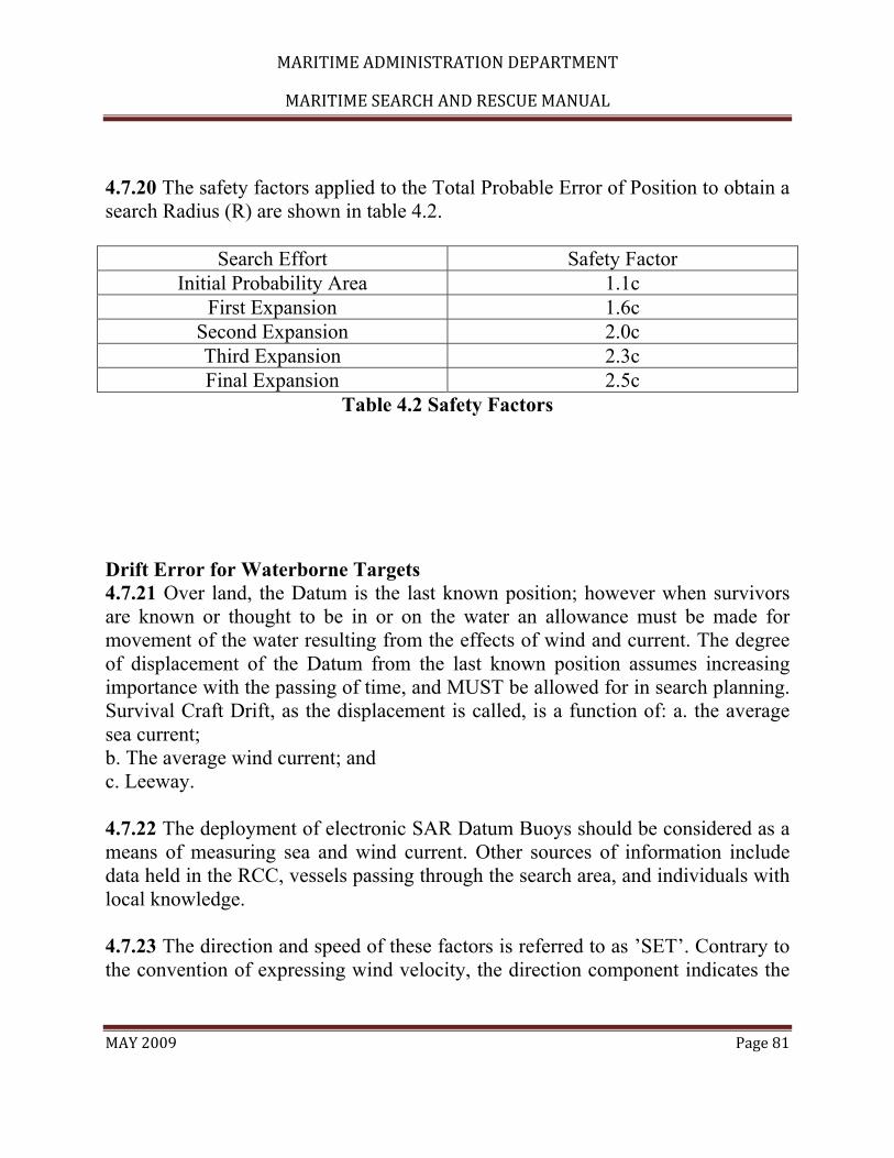
MARITIME ADMINISTRATION DEPARTMENT
MARITIME SEARCH AND RESCUE MANUAL
MAY 2009 Page 81
4.7.20 The safety factors applied to the Total Probable Error of Position to obtain a search Radius (R) are shown in table 4.2.
Search Effort Safety Factor Initial Probability Area 1.1c
First Expansion 1.6c Second Expansion 2.0c Third Expansion 2.3c Final Expansion 2.5c
Table 4.2 Safety Factors Drift Error for Waterborne Targets 4.7.21 Over land, the Datum is the last known position; however when survivors are known or thought to be in or on the water an allowance must be made for movement of the water resulting from the effects of wind and current. The degree of displacement of the Datum from the last known position assumes increasing importance with the passing of time, and MUST be allowed for in search planning. Survival Craft Drift, as the displacement is called, is a function of: a. the average sea current; b. The average wind current; and c. Leeway. 4.7.22 The deployment of electronic SAR Datum Buoys should be considered as a means of measuring sea and wind current. Other sources of information include data held in the RCC, vessels passing through the search area, and individuals with local knowledge. 4.7.23 The direction and speed of these factors is referred to as ’SET’. Contrary to the convention of expressing wind velocity, the direction component indicates the

MARITIME ADMINISTRATION DEPARTMENT
MARITIME SEARCH AND RESCUE MANUAL
MAY 2009 Page 82
direction of movement. The speed component is usually quoted in knots. Care must be taken to ensure that the speed unit is both stated, and interpreted, correctly. 4.7.24 To determine a value for Survival Craft Drift Error (De) it is necessary to complete a Datum Plot. A Datum Plot provides information both to calculate De and to measure the displacement of the Datum from the Last known position for the period under consideration. Drift error is derived by the resolution of the three factors (average sea current, average wind current, leeway), by way of vector addition. Sea Current 4.7.25 Sea current data can be obtained from the RCC, which has access to various sources of information. 4.7.26 Tidal and local geographic features may affect sea currents near the coast. When areas near the coast are to be searched, the water movement for the area should be discussed more fully with local experts. Tidal Streams 4.7.27 Tides are caused by the gravitational pull of the moon and sun, modified by the depth and shape of the sea basin along the coastal areas. Currents in coastal waters are usually be effected by tides, changing in predictable velocity as the state of the tide changes. In some locations tidal streams are of the reversing type, abruptly changing direction 180 degrees at about the time of high and low water. In other places the direction will change in small increments so as to create a constant rotary movement. Variations of these tidal effects may also be found. 4.7.28 The exact effect of the tide on currents in any specific area may be found by consulting tide tables or local charts. Local knowledge is again of great value in dealing with movements of tidal streams. While the changes in direction of tidal streams have a tendency to nullify the cumulative effect, they must nevertheless be considered in computing drift for the following reasons: a. Often, with reversing streams, the effect in one direction is greater than in the other so that, over a period of time, the resultant effect is more in one direction than in the other.

MARITIME ADMINISTRATION DEPARTMENT
MARITIME SEARCH AND RESCUE MANUAL
MAY 2009 Page 83
b. Even over short periods of time the flow of tidal streams will cause significant changes in the probable position of a search object. 4.7.29 Since most areas affected by tidal streams will be close to landmasses, wind current will usually not be a factor in determining drift. Because of this, drift occurring in inshore waters over short periods will be more greatly affected by tidal streams than current or leeway. However, if the cumulative effect of tidal streams and coastal currents thrusts the target into areas where sea current takes effect then drift considerations will need to be revised. River Current 4.7.30 River current will affect SAR incidents that occur in offshore areas near river mouths. Tidal streams affect the river current speeds near the mouths of the rivers. In large rivers this affect may be noticed several kilometres upstream from the mouth. Published current tables often give values which are combinations of tidal and river flow effects. These are among areas where reversing streams will be greater in one direction that the other. __________ __ 4.7.31 On the other hand, river current affects both total current and sea current at its mouth. Some major rivers extend their influence quite significantly off shore. Seasonal variations in water volume and velocity should be considered. 4.7.32 When estimating river current in the discharge area an assumption that the current direction is a straight line from the river mouth to the discharge boundary and the river current speed decreases linearly from the river mouth to the discharge boundary should be made. The river current speed at the mouth can usually be obtained from local knowledge or by direct observation. 4.7.33 If any type of offshore current is present, the SMC should expect that the river discharge will not fan out symmetrically, but will be displaced in the direction of the offshore current. Long Shore Current 4.7.34 Long shore currents are caused by incoming swells striking the shore at an angle. Long shore current information must be obtained from direct observation or local knowledge.

MARITIME ADMINISTRATION DEPARTMENT
MARITIME SEARCH AND RESCUE MANUAL
MAY 2009 Page 84
Swell/Wave Current 4.7.35 In calm conditions, swells and waves may affect rafts and other small marine search targets. The effect is similar to leeway in that the raft is being moved through the water. However swell/wave current speed is so small, under 0.1 knot, that the drift force is usually ignored in determining general search areas. It is useful however for determining probable direction of target movement in some cases. Surf Current 4.7.36 Surf current is only considered for incidents occurring in coastal surf areas. It is more of a rescue or salvage factor than a search planning factor. Surf currents will move a drifting object after it enters the surf zone. If no long shore current is present, the surf current will move the object towards the shore perpendicular to the line of breakers. If a long shore current is present, the object will be displaced in the direction of the long shore current. Rip Current 4.7.37 Rip current is a special type of surf current. It is a narrow band of current flowing seaward through the surf line as a result of the long shore current building up a large volume of water along the beach line, and then bursting through the incoming surf on its way back to sea. Rip currents are only a few metres wide through the surf line, but they fan out and slow down when in smoother water. Rip currents occur when long shore currents are present, and in places where some form of bottom trough, bottom rise or shoreline feature assists in deflecting the long shore current build up in a seaward direction. Local Wind Current 4.7.38 Local wind current is the current generated by wind acting on the surface of the water. The current changes with variations of the wind pattern. 4.7.39 Near the coast, wind current can be affected by various factors and consideration should be given to omitting the wind current vector from search areas close to the coast. Offshore, consideration should also be given to omitting the wind current vector, if it is considered to be an area of consistent winds. The velocity of a wind current is calculated from: a. Wind data for the 48 hours preceding splash time; b. Actual and forecast winds between splash time and Datum time; and

MARITIME ADMINISTRATION DEPARTMENT
MARITIME SEARCH AND RESCUE MANUAL
MAY 2009 Page 85
c. The application of coefficients taken from tables held in RCCs. 4.7.40 Wind current is calculated for 6-hour periods, the periods being coincident with the meteorological synoptic periods. The current for any given synoptic period is the cumulative effect of the wind in the area for the 48 hours prior to the end of the synoptic period being considered. The direction and speed coefficients obtained from the tables allow for the effect of coriolis, and the reversal of wind direction, to express the result as ’SET’. Leeway 4.7.41 Leeway is the movement of a search object caused by it being pushed through the water by local winds blowing against its exposed surfaces. A boat, raft or any other type of marine craft has a certain proportion of its hull and superstructure exposed above the surface of the water at all times. This exposed area is blown against by local winds, which in turn have the effect of pushing the marine craft through the water. The more surface area the wind has to blow against, the greater will be the wind’s effect on drift. If the silhouette of a boat were projected onto a flat plane, which was perpendicular to the wind direction, the area enclosed by the silhouette would be called the exposed flat-plane area. As the boat’s heading changes relative to the wind, its flat-plane area also changes, usually becoming least when the boat is heading directly into the wind or downwind. 4.7.42 The pushing force of the wind is countered by the water drag on the underwater hull. The drag varies with the volume, shape, depth and orientation of the underwater hull. When a marine craft is parallel to the wind direction the least amount of underwater drag will exist since the craft will be pushed through the water in the direction its hull is designed to move. Almost the same conditions exist when the boat is pointed directly into the wind and is being pushed backwards through the water longitudinally. When the boat’s heading is perpendicular to the local wind, however, the greatest amount of underwater drag will exist since the boat must now be pushed sideways through the water. Between these extremes the amount of underwater drag will vary depending on the heading of the boat.

MARITIME ADMINISTRATION DEPARTMENT
MARITIME SEARCH AND RESCUE MANUAL
MAY 2009 Page 86
Divergence 4.7.43 When a search object first begins to drift, the wind will push the object in a downwind direction. As the search object continues to drift, the wind will cause the search object to deflect (or diverge) to either the left or to the right of the downwind direction. The amount of divergence is dependent upon the shape of the “sail” area of the search object. Divergence is caused by the lack of symmetry of the drift object. Calculating Leeway 4.7.44 A search object’s leeway speed is measured as a percentage of the of the wind speed. The Multiplier value listed in the Taxonomy provides the leeway speed percentage. In some cases, it is necessary to add or subtract a Modifier to further refine the search object’s leeway speed. 4.7.45 Thus, the formula to determine leeway speed is: Leeway Speed (knots) = Multiplier x Wind Speed (knots) + Modifier Note: By international agreement, wind direction is reported in most places based on the direction the wind is blowing from. For search planning we are interested in the direction the wind is blowing to. When using downwind leeway, the leeway direction is equal to the reciprocal of the wind direction (Wind direction + or – 180 DEG). 4.7.46 When directional uncertainty applies, the divergence angle is both added and subtracted to the downwind direction to account for the search object’s divergence to the left or right of the downwind direction. Thus, the formula to determine the direction of the divergence is: Wind Direction +/- 180 DEG �= Downwind Direction Downwind Direction + Divergence Angle = Angle to right of Downwind Direction Downwind Direction – Divergence Angle = Angle to left of Downwind Direction 4.7.47 The following example illustrates how the Taxonomy is used to determine directional uncertainty leeway. Refer to the Leeway Taxonomy to obtain the appropriate multiplier, modifier, and divergence angle. 4.7.48 A search is being conducted for a missing scuba diver. The winds are blowing from 270 DEG �true at 15 knots.

MARITIME ADMINISTRATION DEPARTMENT
MARITIME SEARCH AND RESCUE MANUAL
MAY 2009 Page 87
(0.007 x 15) + 0.08 = 0.185 kts x hours of drift = vector length (NM) (270 DEG �- 180 DEG) + 30 DEG �= 120 DEG �T (270 DEG �- 180 DEG) – 30 DEG �= 060 DEG �T 4.7.49 The leeway speed would be multiplied by the number of hours of drift to determine the leeway vector’s length. The two leeway vectors would be added to the end of the total water current vector to determine the Right and Left Datum. 4.7.50 The magnitude of leeway speed in relation to wind speed (u) and leeway divergence for persons in water and various types of marine craft can be found in Appendix I Plotting Drift 4.7.51 Using the vector values determined for average sea current, wind current and leeway it is possible to plot a simple vector diagram and obtain a datum point. However as the leeway data is generally uncertain it is necessary to plot both a left and right drift, and to calculate drift error (De). Whenever possible the owner or operating agency should be contacted to verify the type of liferaft carried and its equipment. 4.7.52 Any change to surface wind conditions has an immediate effect on a craft’s leeway, and a recalculation of vectors is required. Datum Plot 4.7.53 The bearing and distance of a Datum from its associated Last known position is found by combining four vectors as shown in figure 4.6: The sea current The wind current Two leeway vectors, one each for left, and right divergence 4.7.54 The value of the vectors may change with time, therefore it is necessary to calculate a mean value for each vector for the period between splash time and datum time. All calculations are related to meteorological synoptic periods, or part thereof. The objective being to calculate the movement attributable to each factor during the period under consideration, with a vector summation for the whole period and then to combine the individual effects to establish a most probable
MARITIME ADMINISTRATION DEPARTMENT
MARITIME SEARCH AND RESCUE MANUAL
MAY 2009 Page 88
position for the target. When the most probable position has been established, an allowance is made for possible errors, which is then combined with the navigation error allowances in the Total Probable Error of Position formula. 4.7.55 A Datum Plot may be drawn on graph paper, or more readily on the face of a navigation computer, using the squared section of the slide. To construct the plot, draw the sea current vector from the last known position, add the wind current vector, and then from the end of the wind current vector draw the two leeway vectors. Although not quite correct mathematically, the mid point between the ends of the leeway vectors may be taken as the Datum. Drift Error (De) 4.7.56 Drift Error (De) is the radius of a circle of probability around the Datum. The circle is externally tangential to two circles of probability drawn around the end of each leeway vector, the radius of each circle being equal to 12.5% of the distance from Last Known Position (LKP) to the end of the appropriate leeway vector. The value of De therefore, is the sum of the radii of the two leeway probability circles and the distance between the ends of the leeway vector, LR divided by two, i.e. De = {de (L) + de (R) + distance LR} 2 Search area based on non-moving datum 4.7.57 For a typical last report/missed report situation, where the track between positions is a straight line, the probability area may be modified as in Figure 4.8 to form a trapezium. The area of the trapezium may be found from the formula 4.7.58 Where L is the distance between datum A and datum B plus the two radii of the circles of probability, and D and d are the measured distances across the ends of the trapezium. It will be readily apparent that this modification will result in a larger area than the original probability area. An estimate of the excess area can be made and taken into account in planning calculations necessary. Search based on moving datum 4.7.59 To calculate the area of an irregularly shaped probability or search area, it will be necessary to sub-divide the area into squares, rectangles or triangles, calculate the size of the smaller area, and sum the results. Use may be made of a

MARITIME ADMINISTRATION DEPARTMENT
MARITIME SEARCH AND RESCUE MANUAL
MAY 2009 Page 89
surveyor’s grid to determine the size of the irregularly shaped areas. In a maritime situation the datum point is moving and areas will move on the chart as depicted. 4.7.60 It may be necessary to redefine a search area, which is either an unsearched portion of an area, or one derived from intelligence information but located wholly, or partly, over water. In such cases one, or more points on the boundary of the area should be selected, which may then be treated in the same way as any other last known position from which a Datum may be determined. That is, drift vectors and drift error should be applied to them to give new boundary positions that will compensate for drift effect over the intervening period. The area may then be reconstructed relative to these Data and expanded in proportion to the Search Radii. In doing this it is necessary to draw circles of probability around the Data with Radii equal to “de” and joined by tangents. 4.7.61 The appropriate safety factor will have been included in the calculations to determine the original area (See Figure 4.10). Labeling the Datum 4.7.62 During an extended over water search involving several Datum Points it may be necessary to calculate a series of Data. To avoid confusion when referring to Data, a standard system shall be used. The Datum referring to the distress position or last known position shall be identified as ’A’, with subsequent positions along a path identified in alphabetical order. Data referring to a particular Datum Point shall be numbered consecutively, and in addition, shall be annotated with a date/time group when depicted on a chart as shown in figure 4.11. Fig 4.11 Labelling of data Modification of the Probability Area 4.7.68 Modification of a calculated probability area may be suggested from an assessment of intelligence information received in the RCC, limitations imposed by search unit availability or for other reasons. 4.7.69 It should always be understood that SAR calculations are intended to be a guide to search planning, and may be modified to suit any particular situation as suggested by the accumulated SAR experience within the RCC.

MARITIME ADMINISTRATION DEPARTMENT
MARITIME SEARCH AND RESCUE MANUAL
MAY 2009 Page 90
4.7.70 Any member of the RCC team who considers that a modification would be to advantage shall make the SMC aware of the suggestion. When offering such suggestions, every attempt should be made to present viable alternatives, together with a summary of the advantages, and disadvantages of each. The authority to make any such modification rests solely with the SMC.
4.8 Coastal Search Planning Search Area 4.8.1 A great number of maritime search and rescue incidents occur within 25 nms of the coast, in under 300 metres of water. The coastal search-planning model is to assist with a rapid response and should ideally be used when the report of a craft in distress is notified to a SAR authority within 6 hours of the actual distress situation arising. 4.8.2 This section is aimed at simplifying the search planning methods when this situation arises. If time and unit availability allows, the oceanic model should be used. The principles in other sections under search planning should be referred to. If this model is used and overall coordination of the incident is handed to another SAR authority that SAR authority should be made aware of the situation and model used. 4.8.3 In most cases, considering the short response time to coastal SAR incidents, if the search unit proceeds to the last known position (LKP) of the craft in distress it will be found. However, the craft in distress may not be in sight because of inaccuracies in the initial position reported; inherent errors associated with drift factors; and/or errors in navigation of the search unit. 4.8.4 If the time since the craft became distressed is less than four hours and it is not located at the LKP draw a 6nm radius centred at the LKP. Then draw a square search area with the sides tangential to the circle. This will give a search area of 144 nm2 (as shown in figure 4.13).

MARITIME ADMINISTRATION DEPARTMENT
MARITIME SEARCH AND RESCUE MANUAL
MAY 2009 Page 91
4.8.5 The purpose of drawing a radius around the datum is to describe the geographical area most likely to contain the search object. The formula uses the Total Probable Error (E), which includes the Initial Position Error (X) of the distressed craft and the Navigation Error of the SRU (Y), but does not include Drift Error (De).E = (X2 + Y2) 4.8.6 For coastal SAR cases when an SRU arrives on scene and the search object is not seen, a 5 nm position error for the distressed craft and a 1 nm navigation error for the SRU may be assumed. Using the formula, when X = 5 and Y = 1 then: E = (52 + 12) E = 26 E = 5.099 nm 4.8.7 Applying the safety factor for the first search (fs = 1.1), then: Radius = (E)(fs) Radius = (5.099)(1.1) Radius = 5.6 nm This is rounded up to 6 nm. 4.8.8 If the time is greater than 4 hours but less than 6 hours, and/or the drift, based on local knowledge and/or on scene conditions, is considered to be significant, the search objects drift should be established, and the 6 nm radius applied to the drift datum position. 4.8.9 In coastal SAR, the initial datum is determined by calculating drift using the object’s LKP and the effects of water current and leeway speed and direction without considering leeway divergence (leeway direction is considered to be directly downwind). Time of datum must take the underway transit time for the SRU into consideration. 4.8.10 If the craft in distress reports a position in shallow water there is always the possibility that the vessel may attempt to anchor. Therefore, particular attention should be paid to the situation when the LKP is outside the established search area. In many cases, it should be possible to search along the drift line from the LKP to the datum during the initial search. However, it may be necessary to search the drift line after the search area has been completed.

MARITIME ADMINISTRATION DEPARTMENT
MARITIME SEARCH AND RESCUE MANUAL
MAY 2009 Page 92
Time Uncertainty 4.8.11 If the time of the incident is uncertain, calculate a datum for the shortest possible time the vessel could be adrift, and calculate a second datum for the longest possible time the vessel could be adrift. Draw a circle of 6 nms around each datum point and then enclose the circles in a rectangle. To determine the size of the area, multiply the length in miles by the width in miles. Fig 4.15 Circles of probability when time uncertain Position Uncertainty 4.8.12 If the position of the craft in distress is in question, calculate a datum for each position and draw a 6 nm circle around each and enclose the circles (fig 4.16). If extreme distances separate the positions in doubt, consideration should be given to treating them as separate vessel adrift incidents (fig 4.17). Fig 4.16 Circles of probability when position uncertain Fig 4.17 Circles of probability when position uncertain & extreme distances separate positions Track Line Overdue Incident 4.8.13 If a craft in distress is overdue along a track line, determine a datum near the beginning of the track, another near the end of track and one at each turning point. The datum line is the line joining each datum. Draw a 6 nm circle around each datum and enclose the circles in rectangles with sides drawn tangentially to the datum circles. Fig 4.18 Track line overdue incident ≤ 4 hours 4.8.14 If time late to datum is more than 4 hours allow for drift of starting, ending and turning points as seen in fig 4.19. Fig 4.19 Track line overdue incident > 4 hours

MARITIME ADMINISTRATION DEPARTMENT
MARITIME SEARCH AND RESCUE MANUAL
MAY 2009 Page 93
Recomputed Datum 4.8.15 As a general rule in coastal situations, the datum is recomputed every 2 to 4 hours. 4.8.16 When re-computing a datum that was initially established using the coastal model the drift error (de) of the target must be calculated. As with the case in oceanic search planning, drift error rate estimates usually fall between 1/8 and 1/3 of the total distance drifted. The search planner depending on the confidence, or lack thereof, in the relevant drift data may also use values outside this range. The higher the confidence in the data the smaller the value used to estimate drift error. 4.8.17 In addition, the total drift error for two or more successive drift updates is the sum of all the individual drift errors up to that point therefore, drift error always increases with the passage of time. 4.8.18 In this model the distance from datum1 to the recomputed datum2 is measured. The de of the position is established, generally using 1/8th of the drifted distance as error, and then adding this distance to the 6 nm assumed error (E) used to establish the initial search area. Example 4.8.19 The target is drifted from its LKP to datum1 and an E = 6 nm is plotted. The targets drift is recalculated some time later and its drift is established as 8 nm from datum1. Using 1/8th of the targets drift as error, 1 nm is added to the initial 6 nm error used for the first datum. Therefore the error used for datum2 is 6 nm + 1 nm = 7 nm. See Figure 4.20. Fig 4.20 Recomputing datum Track Spacing 4.8.20 For the coastal search model, the following standard track spacings are recommended on search objects less than 30 feet high.

MARITIME ADMINISTRATION DEPARTMENT
MARITIME SEARCH AND RESCUE MANUAL
MAY 2009 Page 94
Good Search Conditions 4.8.21 In conditions where the wind speed is less than 15 knots and/or visibility is greater than 3 nms, use a track spacing of up to 3 nms by day or night but reduce the separation depending on the size of the search target. After dark, the effect of the search light should be considered. Poor Search Conditions 4.8.22 Where winds are greater than 15 knots and /or visibility is less than 3 nms but greater than 1 nm, a track spacing of 1 nm should be considered by day or night but reduced depending on the size of the search target. After dark, the effect of the search light should be considered. Person in Water 4.8.23 When searching for a person in the water it should be assumed that the person is not wearing a floatation device and will therefore be more difficult to detect. For good search conditions a track spacing of a 0.25 nautical mile should be considered. For poor search conditions, the track spacing should be reduced as appropriate, taking into account the visibility and the navigational and operational capabilities of the search units. 4.8.24 Note that the track spacings suggested are given as a guide only. The track spacings used in any one search will be decided by the SMC in consultation with the OSC taking into consideration all the available information at the time. General 4.8.25 As outlined earlier, the coastal SAR planning model described here is used to facilitate ease of determining a search area and a rapid deployment of search assets into a search area. 4.8.26 Although it is ideally used when the response is mounted less than 6 hours from the time of distress the principles can also be applied for up to 24 hours after this time by drifting the datum as described in the section headed Recomputed Datum. This provides the SMC with a tool to rapidly determine a search area.
MARITIME ADMINISTRATION DEPARTMENT
MARITIME SEARCH AND RESCUE MANUAL
MAY 2009 Page 95
4.8.27 The oceanic model incorporating leeway divergence and solving for total probable error should be used for all situations in excess of 24 hours or when time and unit availability allows.
MARITIME ADMINISTRATION DEPARTMENT
MARITIME SEARCH AND RESCUE MANUAL
MAY 2009 Page 96
Chapter 5 - Search Techniques and Operations 5.1 Overview 5.1.1 Chapter 4 described how to determine the optimal area where the available search effort should be deployed. Once the optimal search area has been determined, a systematic search for the search object should be planned. Before a search operation takes place, the search planner should provide a detailed search action plan to all involved, specifying when, where and how individual search assets are to conduct their search operations. Coordination instructions, communications frequency assignments, reporting requirements, and any other details required for the safe, efficient and effective conduct of the search must also be included in the search action plan. 5.1.2 As a minimum, developing a search action plan consists of the following steps: a. selecting search assets and equipment to be used; b. assessing search conditions; c. selecting search patterns to cover the optimal search area as nearly as may be practical; d. dividing the search area into appropriate sub-areas for assignment to individual search assets; and e. planning on-scene coordination. 5.2 General Guidelines for Searches Overview 5.2.1 As discussed in the previous chapter, a search typically involves three stages including the immediate response, a search based on a nominated area either side of track, and a search based on a mathematically derived search area. This applies equally to aviation searches as well as maritime searches, whether using oceanic principles or those of the coastal search plan. The following sections describe these stages in further depth.

MARITIME ADMINISTRATION DEPARTMENT
MARITIME SEARCH AND RESCUE MANUAL
MAY 2009 Page 97
Stage One Search. Immediate response 5.2.2 The stage one or initial search normally consists of: a. a visual search along, and possibly also parallel to, the track of the missing craft; b. action to detect a signal from an emergency beacon; c. formulation of a rescue plan; d. coordination with other agencies as appropriate; and e. for over water searches, dropping of SAR datum buoys to establish drift. 5.2.3 The stage one search may comprise: a. single or multiple Track Line searches; b. implementing procedures to detect a signal from an emergency beacon, such as monitoring by aircraft flying over the area; tasking a dedicated search unit; monitoring by aircraft or vessel on a visual Track Line search; monitoring by passes of the satellite system; c. developing a rescue plan to return survivors to a place of safety; d. preparing aircraft with SAR droppable supplies; e. arranging observers; and f. gathering intelligence relevant to the search. 5.2.4 The SMC should consider: a. diverting aircraft or ships if they are available; b. tasking aircraft from an SRU or local resources where the urgency of the situation and the locality will determine the assets to be used; c. that a surface response for search or rescue may be required; d. that the height and track spacing of search aircraft can be higher than book values as there is an expectation that an active target may be available to assist; e. that the coverage factor should generally not be less than 0.5; and f. the use of electronic or thermal imagery equipment. 5.3 Search Area Coverage General 5.3.1 Once the search area has been determined, a systematic search for the target should be planned. Factors such as the weather conditions, time available for search, aircraft speed, search altitude, sighting range, size of target, etc, should be taken into account. These factors are related but some may be more important than

MARITIME ADMINISTRATION DEPARTMENT
MARITIME SEARCH AND RESCUE MANUAL
MAY 2009 Page 98
others. In planning a search operation, the SMC should endeavour to meet the requirements of the more important factors while satisfying the requirements of the others as far as practicable. 5.3.2 Search Area coverage is the systematic search of selected areas of land, or water, to ensure the optimum probability of detecting the object being sought. The factors affecting detection capability have been reduced to four inter-related expressions. Type of target 5.3.3 The sweep width will depend on the type, size, colour and shape of the target, its colour contrast with the surrounding medium, amount of freeboard, and whether or not the target is moving. Targets may vary from wreckage of an aircraft on land to a person in the water. All targets should be sought from a direction in which they receive the best illumination, colour brightness or contrast. Over water, this is usually the direction in which whitecaps can be seen at the farthest distance. Meteorological visibility 5.3.4 If visibility conditions are poor, the subsequent reduction in sweep width and POD may cause an interruption or necessitate a suspension of search effort, eg: a. Fog makes visual search ineffective if not impossible. Only an electronic search to determine the approximate position of the target, or, perhaps, a ground search, may normally be an appropriate option; b. Smog and haze may reduce the effectiveness of daylight search and, to a lesser extent, night signals; c. Low clouds may render search ineffective or impossible; and d. Precipitation reduces visibility; e. Terrain/Sea Condition Type of terrain/conditions of the sea 5.3.5 The type of terrain to be searched obviously affects the ease with which the search target will be detected. The more level the terrain the more effective will be the search. Not only can the search aircraft maintain a constant search altitude, but also there is less likelihood that undulations or irregularities on the terrain surface

MARITIME ADMINISTRATION DEPARTMENT
MARITIME SEARCH AND RESCUE MANUAL
MAY 2009 Page 99
will hide the distressed craft, wreckage or survivors. Thus calm water areas and flat deserts are easier to search than rough seas or rolling hills, while rugged mountain areas are the most difficult. The more trees, vegetation, rock outcroppings and other surface irregularities that exist on land, the more difficult will be the search. Likewise the more whitecaps, wind streaks, foam streaks, breaking seas, swell systems, salt spray and sun reflections, the more difficult will be a search over water. 5.3.6 In addition, patches of seaweed, oil slicks and flotsam may be mistaken for liferafts, or worse, a liferaft may be mistakenly identified as seaweed or flotsam. On a glassy sea any object, or disturbance, will probably attract the attention of the eye. On a glassy or smooth sea accompanied by a swell system, chance of detection is also good, being lessened primarily by the intervals in which the object is in the trough between swells. During such intervals, the object may be hidden from the lookouts of a low-flying search aircraft or the lookouts of a ship. With small targets on glassy seas, however, difficulty will be experienced in detection due to the reflections of sun, sky and clouds on the sea surface. 5.3.7 The presence of whitecaps and foam streaks on the water breaks the uniformity of the surface and markedly reduces lookout effectiveness. As the whitecaps become more numerous, the probability of detecting a small object becomes less. With numerous whitecaps and foam streaks in a heavy, breaking sea, even very large objects are difficult to detect, and small objects are unlikely to be detected at all. 5.3.8 With high winds, which accompany rough seas, visual aids are rendered less effective. Dye marker tends to dissipate rapidly and smoke signals cling close to the surface and cannot be differentiated from the foam streaks. The reflection of the sun off the breaking seas and whitecaps tends to dull the perception of lookouts to visual signals. With high winds, the wind-driven salt spray constitutes a very real visual obscuration due to both a reduction in visibility and the accumulation of salt on the search craft’s windows. 5.3.9 Rough seas also adversely affect radar detection due to the large amount of sea return on the scope, and the fact that small targets in the trough of a sea cannot be detected.
MARITIME ADMINISTRATION DEPARTMENT
MARITIME SEARCH AND RESCUE MANUAL
MAY 2009 Page 100
5.4 Search Patterns General 5.4.1 The selection of a search pattern is very important and should only be made after all factors have been considered. The search pattern selected should meet the following criteria: 5.4.2 Suitability: It should permit the search to be completed within the time limits; 5.4.3 Feasibility: It should be within the operational capability of the available search units; 5.4.4 Acceptability: The expected result should be worth the estimated time and effort; 5.4.5 Safety of the search units: Close attention should be paid to air traffic in the area of the search. Normally more than one aircraft should not be assigned to a search area segment at the same time. Multiple aircraft operating in the same search area distracts aircrew attention from the search and decreases the flexibility to respond to sightings and drop markers or flares, if required. This does not preclude an electronic search from taking place at high altitude while a visual search is done at a lower level. 5.5 Visual Search Track Line Search 5.5.1 This procedure is normally employed when an aircraft or vessel has disappeared without a trace. It is based on the assumption that the target has crashed, made a forced landing or ditched on or near the intended route and will be easily seen, or that there are survivors capable of signalling their position by a flashing lamp or other means. It consists of a rapid and reasonably thorough search on either side of the intended route of the target, normally at a height of 1000 to 2000 FT during day or at 2000 to 3000 FT at night. A track line pattern is often used as an initial reaction to a distress situation, the second, intensive phase being introduced on the failure of the track line search.

MARITIME ADMINISTRATION DEPARTMENT
MARITIME SEARCH AND RESCUE MANUAL
MAY 2009 Page 101
5.5.2 Aircraft and ships following the same route as that of the missing aircraft or ship should be asked if they are available to divert to assist in the search for the target. For ships, this will mean diverting to intercept the most probable track line of the target. For aircraft, this type of search should be regarded as additional to searches by SAR units, as an enroute aircraft may not be entirely suitable as a search platform due to its performance, configuration, endurance, navigational capabilities or lack of observers. 5.6 Flare Searches General 5.6.1 Military aircraft may be capable of conducting a Flare Search at night. The procedure is appropriate to nighttime operations when it is known that survivors are equipped with distress signal flares. The military authority concerned will decide the practicality of such a search. 5.6.2 The search is flown at 5000 FT or below the cloud base if lower. The crew fires a green flare every 3-5 minutes after entering the search area and at each turning point of the search pattern. 5.6.3 The frequency with which flares are fired from the aircraft should ensure that survivors could sight at least two successive flares. The survivors are expected to respond to green flares by firing their own red flares. The crew will acknowledge the sighting of the distress flares by firing a succession of green flares and switching on the aircraft's landing lights 5.7 Electronic Searches General 5.7.1 Distress beacons are carried by ships, aircraft and land parties and operate on one or more of the international distress, safety and calling frequencies. When activated to indicate a distress situation, they emit a characteristic signal. The signal serves, in the first instance, to alert to a distress situation and, during an ensuing electronic search, as a homing beacon. The equipment can be activated either manually or automatically as a result of immersion in water or on impact.

MARITIME ADMINISTRATION DEPARTMENT
MARITIME SEARCH AND RESCUE MANUAL
MAY 2009 Page 102
5.7.2 The RCC shall use whatever resources are required to locate a distress beacon even if it is believed to be an inadvertent activation. Beacon Types 5.7.3 ELT (Emergency Locator Transmitter) is the name given to an aviation distress beacon carried by aircraft; it operates on 121.5/243 MHz and/or 406 MHz. 5.7.4 EPIRB (Emergency Position Indicator Radio Beacon) is the name for a maritime beacon. A specific feature of an EPIRB is that it should be able to float upright. An EPIRB operates on 121.5/243 MHz and/or 406 MHz. 5.7.5 PLB (Personal Locator Beacon) is a beacon for land use and operates on 121.5/243 MHz and/or 406 MHz. 5.7.6 Signals from beacons operating on 121.5/243 MHz are modulated with a characteristic swept-tone, which is normally continuous; however there are still old style maritime beacons that operate on an interrupted swept tone, generally a three on three off cycle. 5.7.7 Beacons operating on 406 MHz have no audio signal but transmit in microburst. Transmitted data, generally, cannot be monitored or interrogated by aircraft as the signal is generated by chip as a discrete data-package. Homing on 406 MHz beacons can only be achieved by using very specialised airborne equipment or by fitting the beacons with supplementary low-powered 121.5 MHz transmitters with conventional audio signal output. The Australian Standard for 406MHz beacons requires that beacons manufactured for use in Australia be fitted with a 121.5 MHz transmitter to provide a homing signal. Beacon Transmission Characteristics 5.7.8 The range at which a beacon may be detected varies considerably, being dependent on a number of factors: a. Surrounding terrain - the range will be extended if the transmitter is located on the top of a mountain or hill and reduced if located in a valley, on a hill-side or mountain-side, amongst trees or bushes, or in a rain forest b. Power output of the transmitter
MARITIME ADMINISTRATION DEPARTMENT
MARITIME SEARCH AND RESCUE MANUAL
MAY 2009 Page 103
c. Condition of the beacon - if a transmitter's aerial or aerial lead has been broken or disconnected, it will, if the unit is otherwise serviceable, still transmit but its range may be reduced to 1 km or less, and may only radiate on 243MHz d. Nature of surrounding surface - the range will be reduced if the transmitter is operated in dry, sandy country unless placed on a good earth mat, e.g. a space blanket, aircraft wing, or similar reflective surface e. Presence of interference - interference sources can cause beacon-like transmissions, e.g. strobe and navigational lights 5.7.9 A transmitter operating over water or relatively flat country will emit a radiation pattern approximately circular in horizontal cross section. However, if activated in rough country, between trees or amongst wreckage, its radiation pattern will be interrupted by obstructions and shaped as a series of irregular lobes. Flying a track that cuts these lobes, a pilot will hear the signal while within their coverage but receive only noise or hash between them. 5.7.10 Depending on the aircraft's distance from the transmitter and the particular pattern of the lobes, the period during which the signal is heard will vary from a few seconds to several minutes. 5.7.11 It should be noted that when a beacon is placed above a water surface, lobes are formed in the vertical plane, one additional lobe for each 112 cm that the beacon is located above the water level. The presence of vertical lobes will be indicated by variations in the received signal. Regardless of aircraft heading, the signal will fluctuate, and may disappear completely, for a distance of several miles. 5.7.12 When a buoyant beacon is radiating in rough seas, its aerial may dip into the waves. This results in the swept tone missing a beat or two without any increase in hash. There is little discernible effect on the radiation pattern should an aerial be bent or otherwise distorted, provided it is clear of the water. 5.8 SAR Unit Selection and Characteristics Overview 5.8.1 The selection by SAR staff of available SAR units to be used in SAR operations should take into account the following considerations:

MARITIME ADMINISTRATION DEPARTMENT
MARITIME SEARCH AND RESCUE MANUAL
MAY 2009 Page 104
a. the need to reach the distress scene quickly; and b. suitability for at least one of the following operations: i. provision of assistance to prevent or lessen the severity of accidents; ii. conduct of a search, primarily by air but with the assistance of marine or land units as required; iii. carriage of supplies to the scene of an accident and, if necessary, delivery of supplies; or iv. execution of a rescue, (by marine and land units or by helicopters; and as required fixed wing aircraft to provide guidance to units or to relay communications). 5.8.2 In coordinating a search, the SMC, as guided by local procedures, may charter, arrange or request the provision of suitable aircraft or resources. Maritime Assets 5.8.3 Search operations are generally best carried out by aircraft while rescue is best carried out by helicopter, marine craft or land assets. However, it will sometimes be necessary to use marine craft or land assets for some search efforts, particularly when weather conditions prevent or hamper air search, when the location of the distress scene is known with reasonable accuracy, or the location is remote and non-aviation assets are best placed to render assistance. 5.8.4 The speed of marine craft is usually their maximum speed possible under the prevailing sea conditions. Generally, small boats search at 15 –40 knots and larger vessels search at 10 – 30 knots. At these speeds excellent coverage for small targets is possible. However, the area that can be searched is limited due to the low level of the vessel and the earth’s curvature. Tables 1-3 and 1-4 at Appendix I provide uncorrected visual sweep widths for visual search over water at eye heights of eight and fourteen feet and from the height of a merchantman’s bridge. Category Abbreviation Rescue boat - short-range coastal and/or river craft RB Rescue vessel - long-range seagoing craft RV Note: The boat/vessel’s speed may be inserted, e.g. RB(14) or RV(10).
MARITIME ADMINISTRATION DEPARTMENT
MARITIME SEARCH AND RESCUE MANUAL
MAY 2009 Page 105
5.8.5 The abbreviations listed in the table above may be used when referring to vessels made available for SAR purposes: 5.8.6 Rescue vessels can participate in operations at considerable distance from their base. Their main design requirements are good manoeuvrability, seaworthiness, long range, relatively high speed and sufficient size to accommodate survivors and equipment. Naval vessels, offshore lifeboats, seagoing tugs, customs and pilot launches and patrol boats are of particular value because of their special equipment, including communications equipment, and trained personnel. 5.8.7 Generally, the strategy for sustenance and rescue of survivors of accidents in oceanic areas will depend upon aerial supply drops and/or deployment of parachute rescue personnel pending rescue by ship or helicopter. 5.8.8 Rescue boats such as lifeboats, patrol boats and crash boats are short-range vessels capable of operating a limited distance off shore in good sea conditions. Pleasure craft, yachts or rigid inflatable boats fitted with an outboard motor could also be used provided they carry appropriate equipment. 5.8.9 Other sources of maritime assistance may include: a. Naval vessels; b. merchant vessels; c. fishing vessels; d. police vessels; e. harbour craft, ferries, pilot launches and tugs; Naval Vessels 5.8.10 When available, it is usually preferable to use naval vessels for SAR operations. The training and discipline of naval crews, communications fits and other specialised equipment with which the ships are fitted makes naval vessels eminently suitable for SAR operations. Some naval vessels can also be more freely used for combined aircraft/ surface vessel search operations than merchant vessels. In the event of a major operation a navy vessel may be appointed Coordinator Surface Search and coordinate the activities of other vessels.

MARITIME ADMINISTRATION DEPARTMENT
MARITIME SEARCH AND RESCUE MANUAL
MAY 2009 Page 106
Use of Merchant Shipping 5.8.11 Some ships do not maintain a continuous communications watch and consequently must be alerted by means of an automatic alarm system. As this system is traditionally employed only for emergencies involving the safety of human life, the decision to request its use must be made advisedly and responsibly. Actual requests for use of the automatic alarm shall be limited to genuine emergencies. 5.8.12 Knowledge of the positions of merchant ships is of considerable value in SAR operations as merchant ships are often the nearest means of rescue during an incident off shore. The International Convention for the Safety of Life at Sea (SOLAS) contains an obligatory provision for the captain of a vessel to proceed with all speed to the assistance of persons in distress at sea, provided the safety of his ship or crew is not compromised. At all times the safety of the vessel and crew is the responsibility of the master and RCCs should ensure this responsibility is not compromised. In a distress situation, where doubt exists as to a vessel’s intentions, the master should be requested to advise his intentions or confirm that he is responding. Given that a master is not obliged to respond to situations that are not distress, during these situations the master should be requested to divert/assist if practicable. When vessels are known to be proceeding to assist it is encumbent on the RCC to ensure that only the most suitable vessel or vessels are used and to release other responding vessels as soon as possible. Equipment for Marine Craft 5.8.13 In the case of oceanic SAR operations, it is desirable that the ship(s) used are fitted with basic equipment appropriate to the task: navigation aids, communication equipment and life-saving and rescue items. (eg: inflatable life rafts, signaling devices, line-throwing apparatus, non-sparking boat hooks, rescue baskets, litters, boarding ladders and scrambling nets). 5.8.14 Some larger merchant vessels and all service ships will possess equipment for rescue operations. However, additional assistance and supplies, particularly medical, may be required to sustain survivors until they can be landed at a point of safety or transferred to an evacuation vehicle.

MARITIME ADMINISTRATION DEPARTMENT
MARITIME SEARCH AND RESCUE MANUAL
MAY 2009 Page 107
5.8.15 Depending on the distance from the coast, inshore rescue craft may be available to assist. 5.9 Search Unit Allocation Introduction 5.9.1 Before committing resources to an intensive search, an evaluation should be made of the total search effort required and the contribution that may reasonably be expected from each search unit 5.9.2 When assessing available search capacity, care must be taken not to over-estimate either the time that a particular aircraft and its crew can spend in a search area or the capability of the observers to remain effective over long periods of flight time. 5.9.3 Failure to make a sound estimation of these factors may result in one or more of the search units being unable to complete its allocated task and the efficiency of the entire effort being seriously compromised. 5.10 SAR Crew Briefing General 5.10.1 Comprehensive briefing and de-briefing of search crews is a vital component of search planning. They are time consuming processes, and in the case of briefing, preparation must commence at an early stage and, whenever possible, in good time before departure. It must be appreciated that many personnel engaged for search operations are neither trained for nor experienced in the search role. Field SAR personnel shall therefore be given every opportunity to familiarise with all relevant details of the distress. All instructions for the SAR operation shall be clearly and precisely presented. 5.10.2 The officer appointed to the briefing task, must be thoroughly familiar with the overall plan and individual search unit tasks.
MARITIME ADMINISTRATION DEPARTMENT
MARITIME SEARCH AND RESCUE MANUAL
MAY 2009 Page 108
Search Briefing 5.10.3 Comprehensive briefing of search units is vital to every search operation. The SMC should be satisfied that the briefings are well prepared, and that where group briefings are to be conducted, the venue is suitable for the purpose. 5.10.4 Briefings for marine units will cover similar topics to those given to air and land units, but there may be less opportunity for face-to-face briefing contact. Briefing Officers should be aware of the difficulties inherent in briefing indirectly and the increased potential for misunderstanding. 5.10.5 Similar arrangements shall be made for debriefing SAR units. Search Area Description 5.10.6 There are many ways of describing search patterns and the boundaries of search areas. In selecting the method to be used, RCC staff must consider the SAR knowledge of the recipients and the method to be used for the transmission of the information. Geographical Coordinates 5.10.7 This is the generally accepted method of designating an area, the corners of a search area being defined by latitude and longitude. To avoid confusion, the positions should be listed in a clockwise sequence, ending with a repeat of the initial coordinates. The disadvantages of this system are the possibilities of error in measurement and transmission. Universal Grid Reference 5.10.8 The Universal Grid is overprinted on all charts of the JOG series and is also shown on the majority of larger scale maps. 5.11 SAR Crew Debriefing Overview 5.11.1 Full and proper de-briefing of search units is as important as the briefing process. Included in the briefing shall be instructions on the de-briefing procedure to be followed on completion of the search task. Where possible, blank debriefing

MARITIME ADMINISTRATION DEPARTMENT
MARITIME SEARCH AND RESCUE MANUAL
MAY 2009 Page 109
forms will be given to the aircrew. A careful interrogation and evaluation of each search crew's effort is essential for intelligent forward planning. 5.11.2 Where a FCP is established, pilots, observer leaders, surface search unit leaders and others shall be instructed to attend after their sortie for de-briefing. 5.11.3 Reports are required on anything that the search teams themselves consider pertinent, and may include: a. Report on actual weather conditions; b. Positions at which sighting investigations were made; c. Descriptions of items which were investigated; d. Accurate description of areas searched and not searched with an assessment of the effectiveness of the search; e. Results of monitoring of radio frequencies; f. Any operational difficulties encountered. g. Observer debrief forms when available and completed
MARITIME ADMINISTRATION DEPARTMENT
MARITIME SEARCH AND RESCUE MANUAL
MAY 2009 Page 110
Chapter 6 - Rescue Planning and Operations 6.1 General 6.1.1 The primary purpose of any SAR action is the speedy return to a place of safety of the survivors of a distress situation. 6.1.2 It is essential that from the start of any SAR action, the RCC plans for the rescue of survivors and ensures that the appropriate resources are alerted, briefed and positioned so that the rescue may take place with the minimum of delay after the location of the survivors. 6.1.3 Without jeopardising the ultimate safety of survivors, foremost consideration shall be given to the potential impact on any medical condition of survivors by the method of recovery or the actions of unqualified persons. 6.1.4 The method of rescue to be used shall be decided after consideration of all relevant factors including: a. action taken by sighting unit and the action that can be taken by other units at the distress scene; b. location of the survivors; c. condition of survivors and medical considerations; d. number of persons reported to be on board the craft and number who have been located; e. environmental considerations; f. available SAR facilities and their state of readiness; g. effect of weather; h. time of day; i. any risks involved to SAR personnel at a crash site e.g. dangerous goods. 6.1.5 To reduce delay, the SAR facilities that are likely to be used should be alerted and deployed to a suitable location while the search is still in progress. 6.2 Preparation 6.2.1 It is the responsibility of the SMC to ensure that appropriate rescue resources are brought to a state of readiness and, as necessary, strategically positioned to be moved quickly into action immediately survivors are located.
MARITIME ADMINISTRATION DEPARTMENT
MARITIME SEARCH AND RESCUE MANUAL
MAY 2009 Page 111
6.2.2 The SMC shall ensure that proper attention is given to the preparation and execution of the rescue effort. 6.3 Medical assistance 6.3.1 It must be assumed that the survivors of an emergency will be in need of medical attention, and arrangements should be made to include medically qualified persons in the rescue team. 6.4 Crashed Aircraft Overview 6.4.1 When it is known that an aircraft will crash or has crashed and the crash position is incidentally reported or known with reasonable certainty, the RCC shall confirm the crash site and ensure the provision of medical assistance to the occupants and rescue of survivors. 6.4.2 The police should be given early notification of a crash for a decision for their attendance at the crash site. Next of kin should be kept fully informed through the appropriate liaison channel; normally the police 6.4.3 The RCC shall endeavour to arrange security at the crash site to prevent interference with the wreckage or with marks made by the aircraft in landing. The police are responsible for securing the accident scene. Instructions for police officers and emergency services personnel are developed separately. Health hazards - aircraft accidents 6.4.4 Movement in the vicinity of crash sites can be extremely hazardous for ground parties on account of toxic fumes, dangerous substances and explosives. Deaths have resulted from ground personnel breathing noxious air and contacting extremely poisonous substances in the proximity of wrecked aircraft. 6.4.5 Precautions have to be taken at an aircraft accident site. This is developed separately

MARITIME ADMINISTRATION DEPARTMENT
MARITIME SEARCH AND RESCUE MANUAL
MAY 2009 Page 112
6.4.6 To the extent that it can be governed, the RCC shall advise that permission should be secured from the GDF before members of the public or other agencies approach a crash site of a military aircraft. 6.4.7 There have been aviation mishaps where search and rescue personnel became ill or died as a result of exposure to gases and hazardous materials that were present at aircraft accident sites. 6.4.8 Modern aircraft use composite materials for some of their structure, skin, and access panels. Significant health hazards exist at crash sites from the effects of crash damage and fire on composite materials. When burnt, released fibres and resins may be toxic through inhalation and/or skin and eye contact. Damaged composites may also produce needle-like edges that render handling hazardous. Carbon fibres are electrically conductive and may short-circuit nearby electrical equipment. 6.4.9 Certain exotic metals (radioactive substances) can also be found in military aircraft types, which are also poisonous in their own right. The inhalation, ingestion or absorption of radioactive substances is hazardous, as low-level radiation will continue to be emitted inside the body, possibly resulting in damage to surrounding tissues and organs. 6.4.10 The police and army shall be given reasonable access to SAR facilities and staff during salvage operations. 6.5 Rescue at sea 6.5.1 The SMC is responsible for the coordination of surface vessels engaged in the rescue of survivors in or on the sea except that in-shore rescue may be arranged and coordinated by the police. 6.5.2 The RCC shall make flotation equipment available for use by survivors whilst awaiting transportation to the shore. 6.5.3 When an aircraft has ditched or a vessel is in danger of sinking, or sunk, it is imperative that rescue action is taken immediately. The time that a craft will float

MARITIME ADMINISTRATION DEPARTMENT
MARITIME SEARCH AND RESCUE MANUAL
MAY 2009 Page 113
may be very limited, entry to life rafts is difficult, especially for aged or infirm personnel in rough seas, and the sea is a hostile survival environment. 6.5.4 When both maritime rescue units and helicopters are dispatched to the same distress scene, it may be advisable to transfer survivors to the helicopters for a more rapid delivery to medical facilities. Use of rescue boats and vessels 6.5.5 Specialised rescue boats are available only in scattered localities and their capacity is small. Each boat dispatched to a distress scene should, if possible, carry additional life-saving devices to enable those survivors, who cannot be immediately rescued, are able to stay afloat while awaiting the arrival of another boat. 6.5.6 If neither specialised rescue boats nor rescue vessels are available, merchant vessels may be the only means of implementing an early rescue. However, if possible, support or alternative rescue units should be considered because merchant ships have significant limitations as a rescue platform, including: a. generally not readily available; b. relatively slow speed; c. restricted manoeuvrability; d. high freeboard, making retrieval of survivors difficult; e. small crew numbers; and f. language difficulties if foreign crewed. 6.5.7 It is desirable that SAR vessels be equipped to lift survivors from the water without expecting any help from the survivors. 6.5.8 It is desirable that SAR vessels be equipped to lift survivors from the water without expecting any help from the survivors. Use of aircraft for rescue 6.5.9 When considering the use of aircraft to bring about the recovery of survivors, care must be taken to ensure that the rescue aircraft and crew are not exposed to inordinate danger

MARITIME ADMINISTRATION DEPARTMENT
MARITIME SEARCH AND RESCUE MANUAL
MAY 2009 Page 114
6.5.10 Fixed wing aircraft should only be used to retrieve survivors when there is significant advantage over the use of surface transport and when there is a suitable aerodrome or landing area near the scene. Pilots shall be discouraged from attempting to land at other than prepared landing areas to pick up survivors. However, should this prove to be the best or only viable option, all available specialist advice concerning the operation shall be obtained. It may be possible to have a qualified person lowered or parachuted in to survey the area. Helicopters may be employed to shuttle survivors from a distress site to a suitable fixed-wing landing area. Use of helicopters for rescue 6.5.11 When available, helicopters should be considered for rescue work. While eminently suited to the task in many respects, helicopters do have specific limitations that may be summarised as: a. the adverse effects of turbulence; b. the need for a level, or near level, landing area; c. a requirement for a cleared landing area of specific dimensions to avoid rotor blade damage; d. a requirement for safe approach and take-off paths; e. potential for adverse effects on certain serious injuries; f. limited endurance; g. inability to hover with loads at high altitudes; h. limited accommodation. 6.5.12 Helicopters can be used to rescue survivors by winching or by landing at a suitable location. Owing to their unique flying characteristics, helicopters should be considered for use as a rescue unit as a matter of course. 6.5.13 They are particularly suitable for rescues at locations where surface units are unable to operate. At the same time, some helicopter evacuations may be hazardous, particularly in mountainous areas at high altitudes and over rough seas. Such evacuations should therefore only be carried out by specially qualified and experienced crews and then only in the event of serious injury or illness or when lack of other means of rescue might result in loss of life. It is important that any information on the condition of survivors is considered by specialists before committing to helicopter use.

MARITIME ADMINISTRATION DEPARTMENT
MARITIME SEARCH AND RESCUE MANUAL
MAY 2009 Page 115
6.5.14 Operations by surface parties may be hampered by the noise and rotor wash produced by helicopters. To avoid damage to rotor blades, the landing site should be cleared to a diameter specified by the pilot-in-command for each proposed operation. To facilitate the coordination between helicopters and surface rescue units and to minimise the hazard of collision associated with helicopters operating in a confined space during rescue operations, their operations should be carefully planned by the RCC and coordinated. 6.5.15 The helicopter's mass may be a factor limiting the number of survivors that may be taken aboard each trip. It may, therefore, be necessary to reduce weight by all possible means, e.g. removal of non-essential equipment, minimum fuel, use of advance bases with fuelling capabilities, etc. 6.5.16 It must be ensured that the route followed by the helicopter as well as the location where the survivors are to disembark are known to the SMC. 6.5.17 A medically qualified person, medical equipment and respiratory equipment, when available, should be carried on a helicopter recovery mission, at least on the first flight to the distress scene. 6.5.18 When being rescued by helicopter, survivors in a liferaft may have to leave the raft to catch the sling since the rotor downwash below the helicopter will blow the raft away. 6.5.19 Survivors may not know how to operate a strop. A two-person winch is preferred to a single winch. A double strop allows one rescuer to supervise while being winched down and up again with each survivor. Note: A helicopter should not be approached unless directed and/or escorted by a member of the helicopter’s crew. Helicopters may require approach from different aspects dependant on type. Use of top cover aircraft with rescue and MEDEVAC helicopters 6.5.20 The provision of a top cover aircraft should be considered during operations that may expose the helicopter to undue risk.

MARITIME ADMINISTRATION DEPARTMENT
MARITIME SEARCH AND RESCUE MANUAL
MAY 2009 Page 116
6.5.21 The SMC is to discuss the requirement for a top cover aircraft with pilot in command of the helicopter. The decision to task a top cover aircraft can be made by the SMC alone or on request by the pilot in command. 6.5.22 Circumstances that may require the provision of a top cover aircraft may include: a. helicopters operating over water. This will vary with the type of helicopter involved. If in doubt, consult with the crew. b. helicopters operating at or near the limit of their endurance c. helicopters operating in poor or marginal weather conditions d. helicopters operating at a rescue scene presenting special dangers, e.g. night. 6.5.23 Aircraft tasked for top cover should be a SRU aircraft carrying suitable supply drop equipment. The primary tasks of the top cover aircraft will be to: a. provide navigation assistance to the helicopter to locate the target; b. provide communications assistance to the helicopter; and c. provide immediate assistance by way of supply drop should the helicopter ditch. 6.6 Supply dropping and delivery of survival equipment General 6.6.1 Situations will arise where the immediate recovery of survivors is not possible and arrangements will have to be made to deliver sustenance, medical and survival equipment. Such situations shall be anticipated and planned for by the SMC during the conduct of a search. 6.6.2 Where possible delivery will be by way of surface vehicle or craft, or by helicopter or aircraft landing nearby. An example of this would be a situation with seriously injured survivors who may need stabilising prior to being moved, or where specialised evacuation vehicles / craft needed are not immediately available. 6.6.3 Supply of survival equipment by air should be considered where there is an expected delay in the recovery of survivors from remote locations either at sea or on land.

MARITIME ADMINISTRATION DEPARTMENT
MARITIME SEARCH AND RESCUE MANUAL
MAY 2009 Page 117
Civil SAR equipment 6.6.4 The inventory of Civil SAR Equipment should include: a. Target marking devices including SAR Datum Buoys and strobe lights b. Heliboxes for the supply of sustenance, medical and survival equipment c. Six person Liferafts. d. Life Raft Locator Beacons packed within droppable liferafts. e. EPIRBs packed in crew liferafts. f. EPIRBs. g. Precision Aerial Delivery System (PADS) for the delivery of a single liferaft, storpedo or pump. h. US Coastguard De-watering pumps. i. Search and Rescue Communicators (SARCOM) emergency AM radios operating on the aviation band of 123.1MHz that are suitable for dropping in Heliboxes or storpedos. Some liferafts are equipped with these radios. 6.6.5 Guyana SAR staff would be familiar with the type and disposition of Civil and GDF SAR equipment and its usage and can be contacted for advice. Detailed procedures and instructions relating to the operation and delivery of the equipment are incorporated in the Search and Rescue Manual for SAR Unit Pilots and Dropmasters that can be obtained from the SAR Resources. 6.6.6 Only suitably qualified, trained and equipped crews shall be tasked for supply dropping. 6.6.7 Aircraft tasked for supply dropping will be suitable for the purpose. It is the aircraft operator’s responsibility to ensure the appropriate flight manual supplements / flight manual limitations and dispensations are held. Marking targets 6.6.8 Where recovery of maritime survivors is delayed it may be necessary to track their position by dropping visual or electronic aids, which have long and short term characteristics. 6.6.9 Long-term devices include:

MARITIME ADMINISTRATION DEPARTMENT
MARITIME SEARCH AND RESCUE MANUAL
MAY 2009 Page 118
6.6.8 Specifically, dropping of articles from aircraft at night requires the approval of GCCA Chapter 7 - Conclusion of SAR Operations 7.1 General 7.1.1 SAR Operations enter the conclusion stage when: a. the target is located and the survivors are rescued; b. the emergency beacon has been located and the survivors rescued, or if there was no distress, the beacon has been turned off; c. information is received that the target is no longer in distress; d. all known persons on board are accounted for, or it has been determined that there is no longer a chance of survival; or e. the SAR Authority determines that further searching has no significant chance of succeeding and either suspend or terminate the search. 7.1.2 The authority to end a search rests with different levels within the SAR organisation, depending on the circumstances. In particular, the SAR Authority is responsible for deciding when to suspend or terminate an unsuccessful search where lives were known to be at risk. 7.1.3 The SAR Authority may delegate to the SMC the authority to conclude the operation in all other circumstances (ie: when the SMC determines that the target is no longer in distress and in situations where an identified beacon has ceased transmitting). 7.2 Conclusion of a successful SAR action 7.2.1 When the target of a search action has been located and the survivors removed to a place of safety, the RCC shall ensure: a. all people and organisations involved in the SAR action are stood down; b. all appropriate agencies are notified; c. next of kin are fully informed; d. shipping is advised of any hazard caused by abandoned vessels etc; e. arrangements are made for the recovery of dropped survival equipment eg rafts;
MARITIME ADMINISTRATION DEPARTMENT
MARITIME SEARCH AND RESCUE MANUAL
MAY 2009 Page 119
f. the collection all maps, worksheets, notes, messages in chronological order and file on a SAR incident file; and g. that administrative and financial procedures are completed. 7.3 Suspension of a search when the target is not found 7.3.1 When it is determined that further search would be of no avail, the SMC shall consider recommending the suspension or termination of the SAR operation. However, search action shall not be suspended or terminated nor the distress phase cancelled without the specific concurrence of the SAR Authority. 7.3.2 The decision to suspend a search shall not be made until a thorough review of the search is conducted. The review will focus on the probability of there being survivors from the initial incident, the probability of survival after the incident, the probability that the survivors were in the search area, and the effectiveness of the search. 7.3.3 The review should: a. examine search decisions to ensure that proper assumptions were made and that planning scenarios were reasonable; b. reconfirm the certainty of initial position and any drift factors used in determining the search area; c. re-evaluate any significant clues and leads; d. examine datum computations and data calculations; e. confirm that all reasonable means of obtaining information about the target have been exhausted; f. review all intelligence material to ensure no information had been overlooked; g. examine the search plan to ensure that: i. assigned areas were searched; ii. the probability of detection was as high as desired; and iii. compensation was made for search degradation caused by weather, navigational, mechanical or other difficulties; and h. consider the survivability of the survivor/s taking into account: i. time elapsed since the incident; ii. environmental conditions; iii. age, experience and physical condition of (potential) survivors; iv. survival equipment available;

MARITIME ADMINISTRATION DEPARTMENT
MARITIME SEARCH AND RESCUE MANUAL
MAY 2009 Page 120
v. studies or information relating to survival in similar circumstances; and i. consider the rescue plan to ensure that: i. best use was made of available resources; ii. contingency plans were sufficient to cater with unexpected developments; and iii. coordination with other agencies was effective in ensuring best treatment of survivors. 7.3.4 Before an unsuccessful search is suspended or terminated, the SAR Authority shall make arrangements to ensure that the next of kin are fully briefed on the complete search effort, including conditions in the search area, other salient operational factors and the reasons for proposing the suspension or termination of the search. 7.3.5 Consideration may be given to notifying the decision to suspend or terminate search effort at least one day prior to suspension of operations allowing next of kin at least one more day of hope while giving them time to accept that the search cannot continue indefinitely. Accordingly, the SMC should maintain regular contact with the relatives during the conduct of the search, providing access to the RCC if practical and appropriate. 7.3.6 In a case where foreign nationals are involved, liaison shall occur with the Ministry of Foreign Affairs. 7.3.7 The reasons for suspending a search shall be clearly recorded. 7.3.8 When a SAR action is discontinued or a search is suspended, the RCC shall inform all authorities, units and facilities that have been activated and/or alerted. 7.3.9 On occasions, after the suspension of a search, it may be necessary for the Police or Defence to continue to search for bodies and/or aircraft/vessel wreckage. In such cases the SAR Authority that had responsibility for the coordination of the search and rescue operation may, where possible: a. provide briefings on the path of the aircraft/vessel prior to disappearance, last known position, area searched and related intelligence; b. review intelligence to assist search; c. source aircraft for transport or search purposes; and/or
MARITIME ADMINISTRATION DEPARTMENT
MARITIME SEARCH AND RESCUE MANUAL
MAY 2009 Page 121
d. provide drift information. 7.3.10 Should any other organisation such as the operating company, wish to continue with or initiate an independent search, the SAR Authority that had responsibility for the coordination of the search and rescue operation should ascertain whether there is any new intelligence that provides grounds to resume or continue the search. Under the circumstances where there is new intelligence, it should be evaluated and if considered valid the search should be continued or resumed. Where there is no new intelligence, then the SAR Authority may assist the requesting organisation by: a. briefing the aircraft/vessel’s path prior to disappearance, splash/crash point, area searched and related intelligence; b. advising the possible location of suitable search aircraft; and/or c. providing drift information. 7.4 Reopening a suspended search 7.4.1 If significant new information or clues are developed, reopening of a suspended case should be considered. Reopening without good reason may lead to unwarranted use of resources, risk of injury to searchers, possible inability to respond to other emergencies, and false hopes among relatives. 7.5 Records and reports 7.5.1 Records relating to search and rescue operations, including air searches on behalf of other organisations, shall be retained for periods as required under the relevant legislation and regulation. 7.5.2 When a search has been terminated without locating a missing aircraft or its occupants, all records, charts etc. shall be retained and be accessible to SAR staff to allow easy resumption of search activity should further intelligence be received. 7.5.3 Reports on SAR Actions shall be generated as required for Coroners Inquiries, Management purposes and for training requirements.

MARITIME ADMINISTRATION DEPARTMENT
MARITIME SEARCH AND RESCUE MANUAL
MAY 2009 Page 122
7.6 Incident debriefs 7.6.1 Following an incident the conduct of a debrief of agencies and groups involved should be considered. The purpose of incident debriefs is to establish opportunities for improvement in the operation of the national SAR system. 7.6.2 Incidents worthy of debrief may include those where: a. lives have been lost unexpectedly; b. large and complex searches have been conducted; c. multi agency involvement occurred; or d. where coordination, communication or response challenges were experienced during the incident. 7.6.3 This list is not exhaustive and the conduct of a post incident, multi-agency debrief is at the discretion of the SAR Authority in overall coordination of the incident with mutual agreement of other SAR Authorities and agencies involved. 7.6.4 Post incident debriefs should be used to; a. establish opportunities for improvement in the operation of the National SAR System; and b. ensure current policies and procedures are appropriate. 7.6.5 The SAR Authority with overall coordination is to: a. decide the need for a debrief in consultation with other SAR participants; b. organize and host the debrief unless otherwise agreed by the participants; c. establish a venue that maximizes opportunity for participation in, and learning from, the debrief; d. capture and share the opportunities for improvement arising; e. initiate changes to the National SAR Manual as appropriate arising from the debrief; and f. include lessons learned from debriefs in their jurisdiction reports to the National SAR Committee. 7.6.6 Participation at debriefs may be restricted to particular SAR Authorities and agencies depending on the issues that are likely to arise and would be a decision for the SAR Authority with overall coordination for the incident.

MARITIME ADMINISTRATION DEPARTMENT
MARITIME SEARCH AND RESCUE MANUAL
MAY 2009 Page 123
7.6.7 SAR Authorities that participate in the debrief will meet their own attendance costs, unless otherwise agreed by the participants. 7.6.8 The debrief should include the opportunity for all significant parties involved in the incident to contribute and learn from it. 7.7 Case studies 7.7.1 Case studies may be conducted at the direction of the SAR Authority. IAMSAR provides guidance on case studies as follows. 7.7.2 Sometimes a SAR case has a surprise ending, as when the survivors are found by someone not involved in the search effort in a location outside the search area, or they are found, alive and well, in the search area after the search effort has been suspended. There are also occasions when there seems to have been an unusual number of problems in spite of the best efforts of the SAR personnel. Finally, there may be important and valuable lessons to learn from a SAR incident and the subsequent response of the SAR system that would be revealed only by a careful after-the-fact review. a. A SAR case study is an appropriate method for addressing those aspects of an incident that are of particular interest. Individual aspects of interest could include problems with communications, assumptions made, scenario development, search planning, or international co-ordination. SAR case studies or incident reviews also provide opportunities to analyse survivor experiences and lifesaving equipment performance. Survival in hostile environments is affected by many variables, including the physical condition of the survivors, survivor actions, reinforcement given by rescue forces prior to rescue, and the effectiveness of safety or survival equipment. Knowing more about these factors can help the SAR system become more effective. b. When used to review and evaluate all aspects of a response to an incident, SAR case studies are one of the most valuable and effective tools for improving SAR system performance. Therefore, SAR case studies or reviews should be performed periodically even when no problems are apparent. There is almost always room for improvement, especially in large, complex cases. The most important outcome, however, is that early detection and correction of apparently small problems or potential problems will prevent them from growing into serious deficiencies later.

MARITIME ADMINISTRATION DEPARTMENT
MARITIME SEARCH AND RESCUE MANUAL
MAY 2009 Page 124
7.7.3 To get a balanced view, more than one person should conduct SAR case studies; the case study team should include recognized experts in those aspects of the case being reviewed. To achieve maximum effectiveness, case studies should not assign blame, but rather, should make constructive suggestions for change where analysis shows that such change will improve future performance. 7.8 Performance improvement 7.8.1 Constant improvement in the performance of the SAR system should be a clearly stated goal of SAR managers. One method to encourage performance improvement is to set up goals whose degree of attainment can be measured by key performance data. This data should be collected, analysed, and published on a routine basis so that individuals can see how the system as a whole is doing, and how their performance is contributing to the achievement of the established goals. Routine reports from the SMCs to the SAR managers can be used for monitoring system performance and highlighting areas where improvement is possible through changes in policies, procedures, or resource allocation.

MARITIME ADMINISTRATION DEPARTMENT
MARITIME SEARCH AND RESCUE MANUAL
MAY 2009 Page 125
Chapter 8 - Training and Exercises 8.1 General 8.1.1 The importance of thorough training for all personnel employed on SAR missions cannot be over-emphasised. Failure of a single link in the often complex chain of action required in SAR missions can compromise the success of the operation, resulting in loss of lives that might otherwise have been saved. The purpose of training is to meet SAR system objectives by developing SAR specialists. Since considerable experience and judgement are needed to handle SAR situations, necessary skills require significant time to master. Training can be expensive but contributes to operational effectiveness. Quality of performance will match the quality of training. Professionalism 8.1.2 Consistency in training and sharing of information relating to search and rescue is promoted through the National Amendment and Training sub-committee and the National SAR Council. Standardisation to the prosecution of SAR Operations is encouraged through these fora. 8.1.3 Efforts to ensure professionalism extend to career development for individuals who are assigned to undertake SAR duties. The aim is to ensure SAR officers are competent. In additions, agencies should consider making assignments of sufficient length to develop expertise and take advantage of SAR experience in subsequent assignments of officers. Who to train 8.1.4 All personnel involved in SAR Operation need to undertake SAR-specific training. 8.1.5 Specialist team training may also be required. Where there is a requirement for multi-agency response, teams should be exercised in such a manner that each team and each team member understands the role that they play in support of the incident. Requirement for Training 8.1.6 Training is critical to performance and safety. The SAR system should save those in distress when it can, and also use training to reduce risks to its own

MARITIME ADMINISTRATION DEPARTMENT
MARITIME SEARCH AND RESCUE MANUAL
MAY 2009 Page 126
valuable personnel and facilities. Training personnel in making sound risk assessment will help to ensure that these trained professionals and valuable facilities remain available for future operations. 8.1.7 Search and rescue organisations are responsible for the establishment of training programs for SAR personnel to reach and maintain competence appropriate to their role. 8.1.8 Training of SAR personnel should focus on both the practical and theoretical application of SAR and can include the following: a. Study of SAR procedures, techniques and equipment through lectures, demonstrations, films, SAR manuals and journals; b. Assisting in or observing actual operations; and c. Exercises in which personnel are trained to coordinate individual procedures and techniques, or operate specialised equipment, in an actual or simulated environment. 8.2 Search and Rescue Exercises 8.2.1 Each search and rescue organisation should periodically take part in coordinated search and rescue exercises (SAREX). These SAREXs should be designed to exercise the SAR system, in whole or part, and test such things as operational plans, communication procedures and facilities, individual staff performance, SAR unit performance and inter-organisation and/or international operations. 8.2.2 It is equally important that personnel have a good knowledge of the duties and procedures of other units and person who may be involved in a SAR operation, particularly those with whom they will have direct contact. It is especially important that SMCs be aware of the time, effort, and risk involved when requests are made to other units or organisations. 8.2.3 Liaison visits between personnel likely to become involved together in SAR operations are encouraged. SMCs and SAR personnel should visit other SAR units or RCC’s to become familiar with their facilities and capabilities and when possible take part in training exercises.

MARITIME ADMINISTRATION DEPARTMENT
MARITIME SEARCH AND RESCUE MANUAL
MAY 2009 Page 127
8.2.4 The regular conduct of joint SAR exercises should form a part of any training program.