Embed Size (px)
Citation preview
[1]
Happy Valley Neighborhood Plan As adopted by Ordinance No. 8868 and amended by Ordinance 2004-12-087, 2010-12-072, 2010-12-073 and 2014-09-047.
Happy Valley Neighborhood – January 1, 2011

Neighborhood Plan Adoption: In 1980, the Bellingham Plan was adopted and included individual plans for each neighborhood. When the Washington State Growth Management Act (GMA) was adopted in 1990, the City was required to update and amend the Bellingham Plan to include comprehensive planning elements required by the GMA. The Bellingham Comprehensive Plan was adopted in 1995 and again included all of the individual neighborhood plans. Neighborhood Plan Amendment: The Bellingham Municipal Code (BMC) 20.20 includes procedures by which individual property owners may petition the City for an amendment to an individual neighborhood plan. This may be a simple text amendment to address a condition or concern in a particular neighborhood or it may be a request for a change to the land use designation in a portion of a neighborhood. Because the neighborhood plans are adopted as part of the Bellingham Comprehensive Plan, the GMA restricts amendments to once per year. The deadline for submitting neighborhood plan amendments to the City is December 1 of each year (See BMC 20.20). An amendment to a neighborhood plan is made by ordinance. All of the changes made to this plan since it was originally adopted are listed on the last page of the plan. Neighborhood Plan Update: Periodically, individual neighborhood plans merit a complete update due to changes of conditions in the neighborhood and/or the City. A complete neighborhood plan update can be a complex process requiring a great deal of time, public participation, and planning staff resources. Some of the individual neighborhood plans that were originally adopted in 1980 have received complete updates, while others have not.
Happy Valley Neighborhood Plan

INDEX Happy Valley Neighborhood Plan
Title Page Number I. COMP PLAN & NEIGHBORHOOD GOALS AND POLICIES . . . . . 1 II. NEIGHBORHOOD CHARACTER . . . . . . . . . . . . . . . . . . 1
Neighborhood Vision Statement . . . . . . . . . . . . . . . . . . 3 III. NATURAL AREAS, PARKS, AND TRAILS . . . . . . . . . . . . . . 5 A. Natural Areas . . . . . . . . . . . . . . . . . . . . . . . . . . 5 HV GOAL-1. . . . . . . . . . . . . . . . . . . . . . . . . . . . 5 B. Parks . . . . . . . . . . . . . . . . . . . . . . . . . . . . . . 6 C. Trails . . . . . . . . . . . . . . . . . . . . . . . . . . . . . . 7 D. Sensitive Areas . . . . . . . . . . . . . . . . . . . . . . . . . . 8 E. Conceptual Green Infrastructure Plan . . . . . . . . . . . . . . 10 IV. CIRCULATION . . . . . . . . . . . . . . . . . . . . . . . . . . . . 21 HV GOAL-2 . . . . . . . . . . . . . . . . . . . . . . . . . . . . 21 A. Interstate Highway 5 (I-5) . . . . . . . . . . . . . . . . . . . . . 21 B. Arterials. . . . . . . . . . . . . . . . . . . . . . . . . . . . . . 21 21st Street Issues Summary . . . . . . . . . . . . . . . . . . . 23 Other Arterials. . . . . . . . . . . . . . . . . . . . . . . . . . . 25 C. Neighborhood Streets . . . . . . . . . . . . . . . . . . . . . . 30 D. Parking . . . . . . . . . . . . . . . . . . . . . . . . . . . . . . 31 E. Unimproved Rights-of-Way . . . . . . . . . . . . . . . . . . . 31 F. Pedestrian Circulation . . . . . . . . . . . . . . . . . . . . . . 32 G. Bicycle Circulation . . . . . . . . . . . . . . . . . . . . . . . . 33 H. Safe School Routes. . . . . . . . . . . . . . . . . . . . . . . . 33 I. Transit . . . . . . . . . . . . . . . . . . . . . . . . . . . . . . 34 V. UTILITIES . . . . . . . . . . . . . . . . . . . . . . . . . . . . . . . 36 A. Drainage and Stormwater. . . . . . . . . . . . . . . . . . . . . 36 B. Sanitary Sewer . . . . . . . . . . . . . . . . . . . . . . . . . . 37 C. Water. . . . . . . . . . . . . . . . . . . . . . . . . . . . . . . . 37 VI. PUBLIC FACILITIES . . . . . . . . . . . . . . . . . . . . . . . . . 38 A. Western Washington University (WWU) . . . . . . . . . . . . . . 38 HV GOAL-3 . . . . . . . . . . . . . . . . . . . . . . . . . . . . 38 B. Schools . . . . . . . . . . . . . . . . . . . . . . . . . . . . . . 39 HV GOAL-4 . . . . . . . . . . . . . . . . . . . . . . . . . . . . 39
HV GOAL-5 . . . . . . . . . . . . . . . . . . . . . . . . . . . . 39 C. Fire Protection . . . . . . . . . . . . . . . . . . . . . . . . . . 39 VII. DESIGN CRITERIA . . . . . . . . . . . . . . . . . . . . . . . . . . 40 A. All Development . . . . . . . . . . . . . . . . . . . . . . . . . . 40
HV GOAL-6 . . . . . . . . . . . . . . . . . . . . . . . . . . . . 40 B. Goals and Policies for Residential Development . . . . . . . . . 40
HV GOAL-7 . . . . . . . . . . . . . . . . . . . . . . . . . . . . 40 C. Neighborhood Commercial and Mixed-Use Criteria . . . . . . . 41
Happy Valley Neighborhood Plan
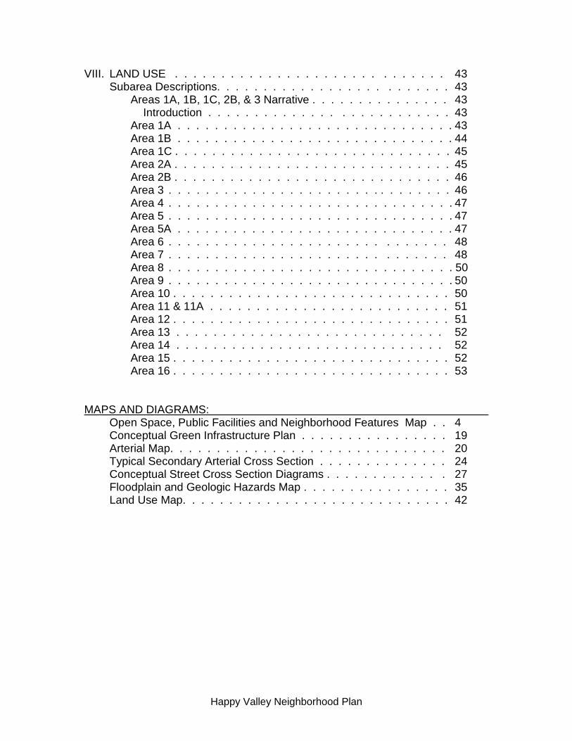
VIII. LAND USE . . . . . . . . . . . . . . . . . . . . . . . . . . . . . 43 Subarea Descriptions. . . . . . . . . . . . . . . . . . . . . . . . . 43 Areas 1A, 1B, 1C, 2B, & 3 Narrative . . . . . . . . . . . . . . . 43 Introduction . . . . . . . . . . . . . . . . . . . . . . . . . . 43 Area 1A . . . . . . . . . . . . . . . . . . . . . . . . . . . . . . 43 Area 1B . . . . . . . . . . . . . . . . . . . . . . . . . . . . . . 44 Area 1C . . . . . . . . . . . . . . . . . . . . . . . . . . . . . . 45 Area 2A . . . . . . . . . . . . . . . . . . . . . . . . . . . . . . 45 Area 2B . . . . . . . . . . . . . . . . . . . . . . . . . . . . . . 46 Area 3 . . . . . . . . . . . . . . . . . . . . . . . . . . . . . . . 46 Area 4 . . . . . . . . . . . . . . . . . . . . . . . . . . . . . . . 47 Area 5 . . . . . . . . . . . . . . . . . . . . . . . . . . . . . . . 47 Area 5A . . . . . . . . . . . . . . . . . . . . . . . . . . . . . . 47 Area 6 . . . . . . . . . . . . . . . . . . . . . . . . . . . . . . 48 Area 7 . . . . . . . . . . . . . . . . . . . . . . . . . . . . . . 48 Area 8 . . . . . . . . . . . . . . . . . . . . . . . . . . . . . . . 50 Area 9 . . . . . . . . . . . . . . . . . . . . . . . . . . . . . . . 50 Area 10 . . . . . . . . . . . . . . . . . . . . . . . . . . . . . . 50 Area 11 & 11A . . . . . . . . . . . . . . . . . . . . . . . . . . 51 Area 12 . . . . . . . . . . . . . . . . . . . . . . . . . . . . . . 51 Area 13 . . . . . . . . . . . . . . . . . . . . . . . . . . . . . 52 Area 14 . . . . . . . . . . . . . . . . . . . . . . . . . . . . . 52 Area 15 . . . . . . . . . . . . . . . . . . . . . . . . . . . . . . 52 Area 16 . . . . . . . . . . . . . . . . . . . . . . . . . . . . . . 53 MAPS AND DIAGRAMS: Open Space, Public Facilities and Neighborhood Features Map . . 4 Conceptual Green Infrastructure Plan . . . . . . . . . . . . . . . . 19 Arterial Map. . . . . . . . . . . . . . . . . . . . . . . . . . . . . . 20 Typical Secondary Arterial Cross Section . . . . . . . . . . . . . . 24 Conceptual Street Cross Section Diagrams . . . . . . . . . . . . . 27 Floodplain and Geologic Hazards Map . . . . . . . . . . . . . . . . 35 Land Use Map. . . . . . . . . . . . . . . . . . . . . . . . . . . . . 42
Happy Valley Neighborhood Plan

[1]
HAPPY VALLEY NEIGHBORHOOD PLAN
I. COMPREHENSIVE PLAN AND NEIGHBORHOOD GOALS AND POLICIES
The 1995 Bellingham Comprehensive Plan and neighborhood input from the Happy Valley Plan update process are the core elements in creating the Happy Valley Neighborhood Plan. Comprehensive Plan goals and policies are labeled as they appear in the Comp Plan, i.e., TG-9 refers to Transportation Goal 9 within the Comprehensive Plan. Happy Valley Goals and Policies developed during the Neighborhood Plan update process are labeled with the letters “HV.” Land use decisions that affect the Happy Valley Neighborhood will be based on the goals and policies outlined in the Comprehensive Plan and Happy Valley Neighborhood Plan. II. NEIGHBORHOOD CHARACTER The Happy Valley Neighborhood encompasses 627 acres. It is bordered by Interstate 5 to the east, Old Fairhaven Parkway to the south, an irregular line from 14th to 20th Streets to the west, and Bill McDonald Parkway to the north. Early residents in Happy Valley settled on small platted lots near Fairhaven and larger “garden tracts” throughout the rest of the valley. Many early residents of the neighborhood worked in the Fairhaven Cedar Mill and Salmon Cannery. A streetcar line connected Happy Valley to Fairhaven’s waterfront along Harris Avenue. In 1903, the towns of Fairhaven and New Whatcom merged, creating Bellingham. Improvements in Happy Valley did not occur until the Happy Valley Improvement Club was formed in 1929. Their first job was to improve streets and create trails. The neighborhood grew primarily as a single-family residential area. Small grocery stores, other neighborhood-oriented businesses, dairy and chicken farms, horse farms, a small lumber mill, a brewery, and other small commercial enterprises were sprinkled throughout the neighborhood. With continued growth of Western Washington University (WWU), Happy Valley became a popular location for student housing. Since the late 1960’s, increasing numbers of apartments directed toward student housing have been built, infilling amongst and replacing single family housing. The highest densities of apartments have been built in the north end of the neighborhood, closest to WWU. In the 1970’s and 1980’s improvements were added in Happy Valley through federally funded Community Development Block Grants. Projects included street improvements, construction of a new playground at Larrabee elementary school, new sidewalks, purchase of land for open space (now a part of the Connelly Creek Nature Area), and housing rehabilitation.
Happy Valley Neighborhood – January 1, 2011

[2]
By 1980, Happy Valley was a community that reflected a mix of development styles and patterns. The following is an excerpt from the 1980 Happy Valley Neighborhood Plan. It characterized the neighborhood in a way that is as recognizable today as it was in 1980:
The large variety of living styles available in Happy Valley, and the diversity of the people attracted to them, is part of the character of Happy Valley. The views of Sehome Hill, Chuckanut Mountain and Bellingham Bay, the rural open space, the 1890 [Fairhaven] village, and now modern apartments compose the visual background. The still inadequate streets on which pedestrians, bikers and cars compete as they wind their way through the neighborhood also belong to the valley. Padden Creek and its tributaries, the marsh and cedar grove, the animals—wild and domesticated—are, along with the Bellingham (Sehome) Mall and Western Washington University, important elements of the neighborhood. The charter members of the Civic Improvement Club [formed in 1929, the group’s first project was to grade and gravel the streets] working beside apartment dwelling college students to plan for Happy Valley contribute to this neighborhood’s special and unique character.
How is the Happy Valley Neighborhood different now than in the two previous decades? To put it in context, the population of Bellingham has grown from 45,794 in 1980, to 52,179 in 1990, to an estimated 62,000 in 1998. The rate of growth in Bellingham between 1990 and 1998 has been approximately 19% compared to 14% growth of the previous decade. Bellingham Happy Valley Year | Population Growth Rate | Population Growth Rate 1980 45,794 n/a 3,380 n/a 1990 52,179 14% 4,600 36% 1998 62,000 19% 5,740 25% In comparison, the number of people residing in the valley and the number of housing units grew at a significantly greater rate than the City as a whole between 1980 and 1990. Happy Valley’s population in 1980 was approximately 3,380 according to census numbers supplied by the federal User Defined Areas Program (note: this program uses census tracts that do not exactly mimic neighborhood boundaries). In 1990 the population was approximately 4,600. The most recent census conducted April of 2000 will provide detailed population statistics by 2001. Based on the average number of persons per household in Bellingham in 1990 (2.33) and the total number of dwelling units in Happy Valley for 1998 (2,465), Happy Valley’s 1998 population is approximately 5,740. The estimated valley population grew by approximately 25% between 1990 and 1998. This growth rate is considerably less than Happy Valley’s growth in the 1980’s (36%). Growth trends can also be tracked by the number of new housing units in a neighborhood. Statistics available between 1984 and 1998 show that single family units increased from 605 in 1984 to 633 in 1998. During the same time, the number of multi-family units (an apartment or duplex) grew from 1,068 to 1,729.
Happy Valley Neighborhood Plan

[3]
Total Dwelling Units in Happy Valley Year Single-Family Multi-Family 1984 605 1,068 1998 633 1,729 Net Increase 28 661
Development within and outside the neighborhood has affected Happy Valley. Impacts associated with increasing population and urban development include increased traffic and stormwater runoff, additional noise from I-5, elevated crime rates, and the growth of Western Washington University. Pockets of quiet, undeveloped areas remain. You can still find owls, deer, and great blue herons, see horses grazing or walk to a community garden. You can stroll through wetlands, forests, or meadows, enjoy vistas of the Chuckanut Mountains or Bellingham Bay, or look for fish in Padden Creek. You can visit with neighborhood children, college students and retirees. Happy Valley is like a quilt, made up of many different pieces. Residents would like to see that complex pattern retained in the coming decades. Neighborhood Vision Statement In the year 2020 the Happy Valley Neighborhood will be…
a human scale residential neighborhood which maintains its stability and diversity by
preserving and enhancing wildlife habitat; controlling density, light and noise; emphasizing open space and gardens; prioritizing efficient transportation options; and cultivating community opportunities.
Happy Valley Neighborhood contains some of the highest density housing in the City as well as vestiges of the City’s original rural character. This vision statement recognizes the value of rural spaces and reflects the desire of many residents to retain and enhance the qualities described above. Neighbors want to achieve an integrated and livable neighborhood with natural amenities, a healthy transportation system, and a secure community.
Click here to view the Happy Valley Open Space, Public Facilities and Neighborhood Features Map
Happy Valley Neighborhood Plan

[4]
III. NATURAL AREAS, PARKS, AND TRAILS A. Natural Areas
Happy Valley is a low-lying area located at the foot of Sehome, Samish, and South Hills. Its shallow topography and glacial soils provide the right conditions for poor drainage and wetlands. Wetlands in Happy Valley comprise the largest tracts of natural areas, with forested areas found primarily along the Connelly and Padden Creek corridors. Meadows and large lots contribute to the natural areas, particularly in the eastern and southern sections of the neighborhood. The largest public natural area in Happy Valley is Connelly Creek Nature Area established to preserve Connelly Creek, its associated wetlands and the wildlife habitat they provide. The area is largely forested supplemented by wet meadow habitat. Much of the area is within the 100-year floodplain. Connelly Creek Nature Area serves multiple functions. In addition to serving as a wildlife habitat corridor, it contains a regional stormwater detention facility. This natural area also affords children access to outdoors-environmental learning close to neighborhood schools. It provides space for passive recreation with trails and opportunities to experience nature.
There is a total of 34.4 acres of natural open space in Happy Valley, most of which is
the Connelly Creek Nature Area. Natural areas have been acquired by the Parks and Recreation Department or preserved during subdivision development through private dedications or conservation easements. Dedications and easements on private property are usually where wetlands and streams occur. For example, the Bellingham Cohousing project on Donovan Avenue granted a conservation easement on 2.7 acres of wetlands and streams for preservation and enhancement.
A newer form of open space is the outcome of stormwater detention and treatment
requirements for most new development. Although bioswales, wetponds, and detention ponds are not usable open space or completely natural areas, their design can mimic natural systems. In fact, detention ponds are increasingly being integrated as aesthetic amenities into the design of residential developments.
HV GOAL-1: Provide, maintain, and enhance natural open space in the neighborhood.
Following passage of the 1990 Greenway Levy, the City has acquired and enhanced
trail and creek corridors, natural areas, and other forms of public open space. Expansion of the Connelly Creek Nature Area is an example of the greenway network on which the City is building. It serves as the backbone of a north/south trail and creek corridor in Happy Valley. The Connelly Creek Nature Area is linked to the Old Fairhaven Parkway Greenway located along Padden Creek north of Old Fairhaven Parkway via the newer Happy Valley Park. These public amenities provide the neighborhood with places to recreate and contemplate.
Happy Valley Neighborhood Plan
[5]
HV POLICY-1: Create neighborhood greenbelts and habitat corridors through a variety of means such as planting native plants in undeveloped rights-of-way, connecting open space tracts and natural areas, and establishing a neighborhood tree planting program including street trees.1 (See HVP-8, 32)
B. Parks
In 1980, there were no developed parks in Happy Valley. Neighborhood schools provided the only developed public play areas for residents. School grounds continue to play a major role in meeting important recreational needs. Happy Valley Elementary, Larrabee Elementary, and Sehome High Schools together provide about 15 acres of playgrounds and play fields, serving the neighborhood when school is not in session. Outside the neighborhood, but nearby, Sehome Arboretum and Western Washington University play fields to the north and Fairhaven Park to the south offer space for similar passive and active recreational opportunities. A new park was added to the neighborhood in 1998 when the Parks Department installed play equipment on a portion of a nearly 2-acre parcel on the south side of Donovan Avenue. This area has been designated as Happy Valley Park. The park straddles Connelly Creek and abuts Padden Creek to the south. Another park site is needed to serve the neighborhood, but a location has not been determined. A central location in Area 5 to serve this medium density residential area is highly desirable. Converting the remaining land on the west side of the new fire station should be considered.
HV POLICY-2: Acquire and develop another neighborhood park. Include features such as picnic shelter and grassy play area.
A locally developed piece of open space is located on Lenora Court between Knox and Mill Avenues. When the City Council decided not to sell this 25’ x 100’ area as a surplus lot, it was retained for public use with an agreement that the neighbors would maintain it. The immediate neighborhood residents use the lot as a play area. There are no plans or funding identified for further improvements. This parcel could be officially designated and managed as a City park.
HV POLICY-3: Explore the feasibility of and priority for applying city and neighborhood resources to improve the city property near Lenora and Knox as a safe and usable play area.
Though they are not formal parks, two well-established gardens play an important role in the character of the neighborhood. The 7.5-acre privately owned Joe’s Garden on Taylor Avenue and 32nd Street has been in operation as a commercial vegetable garden since the 1930’s and was a farm before that. Joe’s Garden is located directly north of the Connelly Creek Nature Area and widely considered to be a regional asset. If Joe’s Garden is redeveloped as a non-agricultural use, Connelly Creek should be daylighted for fisheries enhancement.
1 CDG-3, 21, 22
Happy Valley Neighborhood Plan
[6]
Similarly, the 0.84 acre Sven Hoyt Community Garden, leased by the City on the west side of 32nd Street, enables individuals to rent garden space while the neighborhood enjoys the open space. The neighborhood has also identified the unimproved section of Larrabee Avenue at 21st Street as a desired location for a community garden.
HV POLICY-4: Explore options to preserve Joe’s Garden as a neighborhood garden in perpetuity. HV POLICY-5: Increase and permanently acquire community garden space in the neighborhood, including the Sven Hoyt Community Garden on 32nd Street and the Larrabee Avenue right-of-way east of 21st Street.
C. Trails
There are over 1.5 miles of trails in the Happy Valley Neighborhood, most of which appear on the Open Space Map (Pg. 4). The trail system in the Connelly Creek Nature Area serves as the main stem of a network of trails in the neighborhood. Trails have been developed by the Parks Department and neighborhood volunteers. A pedestrian or cyclist can travel the entire length of the neighborhood between the parkways using this main trail through the nature area, past Joe’s Garden and behind Sehome High School, with only a few short roadway connections. Another north/south trail connects Bill McDonald Parkway and Douglas Avenue in the 23rd Street right-of-way. This trail and a smaller connector trail between 22nd and 23rd Streets were constructed by WWU in conjunction with development of their regional stormwater facility south of Bill McDonald Parkway. These trails offer a convenient pedestrian link from the northern part of the neighborhood to WWU. There is an east/west trail extending from 32nd Street to approximately 28th Street along the McKenzie Street right-of-way. Just outside the neighborhood, pedestrians can travel east/west on the Interurban Trail south of Old Fairhaven Parkway between 24th Street and Fairhaven Park.
HV POLICY-6: Implement the trail additions and improvements recommended in the Connelly Creek Trail Master Plan. HV POLICY-7: Work with the City Parks and Recreation Department and neighborhood to identify areas for trails and trail links that allow people to walk and bicycle safely from residential areas to the Connelly Creek Nature Area, commercial areas in Fairhaven, WWU, and Sehome High School.
The neighborhood has identified undeveloped rights-of-way as potential locations for trails and greenways. Because much of the western portion of the neighborhood has no trails or open space, developing rights-of-way for such uses could provide these needed amenities.
HV POLICY-8: Develop a plan for using undeveloped rights-of-way as trail corridors and natural areas. (See HVP-1, 32)
Happy Valley Neighborhood Plan

[7]
D. Sensitive Areas
Wetlands, streams, floodplains, and steep slopes are considered environmentally sensitive areas. Steep slopes occur in Happy Valley in the northwest portion of the neighborhood, on the southeast corner of the Sehome High School property west of 32nd Street, and immediately adjacent to the neighborhood west of Interstate 5. Slope stability and erosion are the main concerns when building on steep slopes; therefore care should be taken to determine suitability of building in these areas.
Wetlands are sensitive areas that have multiple functions such as storage and
treatment of stormwater runoff. Due to urban growth, Happy Valley reflects the national trend of wetland loss while simultaneously experiencing a rapid increase in impervious surfaces. Together, these have caused flow rates in Connelly and Padden Creeks, and their tributaries, to either be “flashy” (too much at once) or not enough in the dry season. These factors have profound negative effects on the resident fish and wildlife populations and have increased the potential for flooding.
Wetlands have another very important function. They serve as wildlife habitat and
natural areas. According to the Draft City of Bellingham Wildlife and Habitat Assessment (1995) the Connelly Creek Nature Area is an important wildlife area. It forms the only functional wildlife habitat corridor from Sehome Hill to the Padden Creek corridor.
HV POLICY-9: Wetlands should continue to be preserved, acquired, and enhanced in order to protect the many functions they serve, including wildlife habitat.
There are multiple needs in the Padden Creek system to enhance fish migration.
Foremost is the need to daylight the creek between 17th and 22nd Streets where it is currently diverted into a 2,200-foot long tunnel. The tunnel, built in 1898, would remain in place for flood control purposes. A feasibility analysis to daylight the stream and bypass the tunnel is being conducted jointly by the City and a citizen group and will be completed in 2001. If the Happy Valley Detention Facility becomes a fish migration blockage, strategies to allow fish passage should be explored and applied.
HV POLICY-10: The tunnel and other blockages to fish passage on Padden and
Connelly Creeks should be targeted for correction as financial resources become available. If daylighting Padden Creek occurs, strict adherence to stream setbacks and floodplain regulations are necessary for new development to protect resources and prevent flood damage.
Salmon habitat has become a key consideration in land use decisions, particularly
after the March 1999 listing of the Chinook salmon under the Endangered Species Act (ESA). As mentioned previously, clearing forested land and adding impervious surfaces can be damaging to fish habitat. The stormwater runoff from the impervious surfaces also contributes to water quality problems.
Happy Valley Neighborhood Plan

[8]
HV POLICY-11: Potential impacts from stormwater on fish habitat and populations shall be mitigated when development occurs, using best management practices. Identify sources of poor water quality, especially fecal coliform and heavy metals, and implement methods to reduce these discharges.
Salmonid species utilizing Padden Creek include steelhead, cutthroat trout, chinook,
coho, and chum salmon. Efforts to restore fish populations and habitat within Connelly and Padden Creeks have largely been accomplished by volunteers and school groups. These efforts, in addition to egg boxes and planting young salmon, have paid off with a large return of chum and coho salmon to Padden Creek in 1998 and 1999.
HV POLICY-12: Restore and enhance Padden and Connelly Creeks by planting native vegetation along their corridors, increasing development setbacks, and preserving adjacent wetlands.
Taylor Creek (a.k.a. Burns Creek) is a neighborhood creek that neighbors have an interest in daylighting. It flows only for a short distance in an open conveyance, from Bill McDonald Parkway to Taylor Avenue and thereafter in piping for about 4,000’ to Padden Creek. Daylighting Taylor Creek where it is still undeveloped, from the culvert in Taylor Avenue to Douglas Avenue, may create creek habitat and a sense of open space that would be beneficial to the neighborhood.
HV POLICY-13: The feasibility and benefits of daylighting Taylor Creek downstream to Douglas Avenue should be considered for analysis in a partnership with WWU, the City, Happy Valley Neighborhood, and volunteer groups.
E. Conceptual Green Infrastructure Plan
The Conceptual Green Infrastructure Plan is a compilation of suggestions from the neighborhood that build on existing city plans. It shows opportunities for adding street trees and other natural amenities to the Happy Valley neighborhood. Some of the recommended features are on private property while others are in the public domain. Therefore, as funding becomes available for green infrastructure projects, coordination with property owners and city staff will be required. The Happy Valley neighborhood proposes to further refine the Conceptual Green Infrastructure Plan, in cooperation with volunteers, WWU students and the City. Certain aspects of the Green Infrastructure Plan may be incorporated into the Happy Valley Neighborhood Plan through the neighborhood plan amendment process following public review.
HV POLICY-14: Further develop the Conceptual Green Infrastructure Plan in regards to “Trees and Forests” and “Natural Drainage System”.
Happy Valley Neighborhood Plan

[9]
Conceptual Green Infrastructure Plan Introduction The Happy Valley Neighborhood supports improvements to the existing neighborhood, as well as site planning and new building, that are consistent with the neighborhood’s natural topography, soils and vegetation. Happy Valley (HV) residents desire a green community created through the restoration and maintenance of trees and forests. This amendment provides goals and policies that will assure steady progress toward the achievement of a range of important services and amenities for the neighborhood, including the filtering of pollutants form the air and water, the creation of mores shade and additional windbreaks, a slowing of the movement of stormwater, the control of erosion, the provision of additional wildlife habitat and the enhancement of property values. The goals and policies will also facilitate proactive responses by the neighborhood and the City to problems and opportunities that may arise. HV Neighborhood Goals for Trees and Forests
1. Provide tools and resources in order for citizens to assess, plan and implement specific actions to protect, preserve, enhance, and restore neighborhood trees and forests;
2. Increase investment in trees and forests to enable Happy Valley neighbors to restore and maintain a healthy ecosystem and neighborhood;
3. Heighten public awareness in the Happy Valley Neighborhood of the interdependence between ecosystems and the community;
4. Identify sources for Happy Valley neighbors, and then provide technical tools, information and financial assistance to the neighborhood to assess existing conditions and ecological issues related to trees and forests;
5. Educate private landowner, renters, business owners in the Happy Valley Neighborhood and public officials about the ecological importance of trees on their property and trees in the larger landscape of Happy Valley;
6. Make technical assistance available through the Happy Valley Neighborhood Association to help restore and maintain trees and forest;
7. Identify sources for the Happy Valley Neighborhood Association, and then offer financial assistance, support or incentive to help resort and maintain trees and forests;
8. Plan for ecosystem restoration to support trees and forests on a large enough scale to support the ecological linkages between different sections of the neighborhood, natural areas, public facilities, watershed and other neighborhoods. Making connections between the Sehome Hill Arboretum, Connelly Creek Nature Area, along Padden Creek, and with the South Neighborhood and Fairhaven Park area, has been identified in the Greenways Plan. (Reference to the Connelly Creek Forest Management Plan Draft 4/2010);
Happy Valley Neighborhood Plan

[10]
9. The Happy Valley Neighborhood Association should focus tree management and restoration strategies to maintain the capacity of ecosystems to provide ecological services for humans and non-humans, including plants, fish and wildlife;
10. Encourage public workers, professional arborists, landscapers and citizens to manage, protect, and promote trees and forests in the neighborhood. Promote voluntary efforts that encourage collaboration among agencies, landowners, and organizations rather than adversarial actions;
11. Encourage open, inclusive and transparent decision-making in the planning and implementation of major decisions that involve the ecosystem, including ecosystem restoration and maintenance efforts, such as the process of day lighting Padden Creek;
12. Considering that the monitoring of ecological conditions is essential to working toward sustainable ecosystems and communities, then the Happy Valley Neighborhood Association should promote a “civic science” approach to ecosystem research that respects local knowledge seeks community participation, and provides data accessibility.
HV Neighborhood Policies for Trees and Forests
Community Forest
Definition: Urban Tree Canopy (UTC) is the layer of leaves, branches and stems of trees that cover the ground when viewed from above. Background: Community Forestry Efforts – An urban forest is a collection of trees in a neighborhood. These trees enhance many economic and natural system functions in our community including: the increase of the aesthetic appeal of the neighborhood, the provision of shade, the filtering of pollutants from the air and water, service as windbreaks, the slowing of the movement of stormwater, the control of erosion, the sequestration of carbon, the provision of wildlife habitat and the enhancement of property values. Happy Valley neighbors place a high value in the preservation and development of urban forests. Urban forestry within the Happy Valley Neighborhood will be focused on the following areas: HVTF Policy 1A – Volunteers from the neighborhood shall be encouraged to help with the development of landscaping plans for publicly owned lands, and along some rights-of-ways, excluding minor projects. (ex. Fairhaven Parkway, entrances to the neighborhood etc.) HVTF Policy 1B – Volunteers from the Happy Valley Neighborhood should be available to assist private residential property owners, schools, churches and businesses with the development of landscaping plans. HVTF Policy 1C – The goal for tree canopy in the neighborhood as a percentage of the total area of the neighborhood should be 40%. Achievement of this overall goal should come through the following sub-goals assigned to basic land use zones.
Happy Valley Neighborhood Plan

[11]
Average tree cover counting all zones 40% Residential single zones 50% Residential multi zones 25% Commercial zones 15% Public zones – police/fire stations, schools, library, developed parks 15-20% Public zones – passive parks, open space 70-80% This calculation shall assume a certain tree canopy size after a 15 year period for newly planted trees. Street Trees
Definition: Street trees provide shade and visual unity to neighborhoods, beautify the streetscape, slow traffic, provide wildlife habitat, and provide green linkages between larger open space and forested areas. The City of Bellingham Parks and Recreation Department has established a list of approved street tree species. Street trees add great value to a neighborhood. The U.S. Department of Agriculture has noted that businesses flourish, people linger and shop longer, apartments and office space rent more quickly, tenants stay longer, property values increase, and new business and industry are attracted to areas where trees have a strong presence. Background: The Happy Valley Neighborhood has an active street tree planting program with a goal of planting a minimum of 100 trees annually. In this program, property owners are encouraged to be involved in the planting and are instructed in the care and maintenance of the trees. Trees are maintained by the abutting property owner and when on public land, by the appropriate City department. Highly traveled arterials and collector roads that are in immediate need of new plantings are:
1. 32nd Street
2. Donovan Avenue
3. Harris Avenue
4. 21st Street
5. Old Fairhaven Parkway Planting Circles and Parking Strips
Background: Planting Circles – These are traffic calming devices installed in the middle of the intersection to slow the movement of traffic. They are often landscaped with trees and other plants. These planting circles are constructed by the Department of Public Works and maintained by the neighborhood. Under appropriate circumstances these areas could use natural drainage methods to treat surface water. Where need is established, the Happy Valley Neighborhood Association (HVNA) should support the maintenance of planting circles by organizing neighborhood work parties.
Happy Valley Neighborhood Plan

[12]
Background: Parking Strips – These are that portion of the street right-of-way lying between the constructed curb, or the edge of the roadway, and the property line, exclusive of the sidewalk. Parking strips can support trees, shrubs, and understory plants. These are also areas for natural drainage treatment facilities such as rain gardens. HVTF Policy 2A – Augment the number of street trees in the neighborhood by increased planting in public areas, such as traffic circles and parking strips, and on private property. HVTF Policy 2B – Maintenance of street trees should include the following; providing a watering system during the four driest months of the summer in the first three years of planting. Dead trees should be replaced by trees of equal or larger caliper. HVTF Policy 2C – A street tree plan for the HV Neighborhood will be prepared by the HVNA by 2012. Trees in Riparian Areas
Background: Trees and Forests along Riparian areas – The HVNA should continue to strengthen partnership with Bellingham Parks and Recreation, the Greenways program, and Nooksack Salmon Enhancement Association to plant and maintain trees along Connelly and Padden creeks. There are a number of "ghost" streams in the neighborhood that should be considered for day lighting. These include a portion of Padden Creek and Taylor Creek. When neighborhood streams that are underground get day lighted, the Happy Valley Neighborhood should work in partnership with the City and property owners to plant and maintain the trees to establish new riparian buffers. HVTF Policy 3 - Increase the width and density of forest buffers along streams, wetlands and greenways through voluntary actions initiated by the Happy Valley Neighborhood Association. HVTF Policy 4 - Promote tree planting on private and public land located on or adjacent to streams or wetlands. Heritage Trees
Definition: Heritage Trees – These are trees that have been identified as having particular value to the community due to their size, age, rarity, uniqueness of species, beauty or historic significance. Categories for Heritage Trees include:
• Specimen: A tree of exceptional size, form, or rarity.
• Historic: A tree recognized by virtue of its age, its association with or contribution to a historic structure or district, or its association with a noted person or historic event.
• Landmark: Trees that are landmarks of a community because of their size, shape, or position.
Happy Valley Neighborhood Plan

[13]
• Collection: A grouping of trees in a notable grove, avenue, or other planting. HVTF Policy 5 - HVNA can actively support the identification, management and maintenance of Heritage Trees in the HV neighborhood. HVTF Policy 6 - HVNA should develop a program for identifying public areas and sites that have the space to host Heritage Trees of the future and also collaborate with voluntary landowners to establish the Heritage Trees of the future. The HVNA should inventory and maintain a list of Heritage Trees. Suggested selection criteria include one or more of the following: trees that are in a healthy growing condition; have an 18" or greater diameter at breast height; are of distinctive size, shape, location, species, or age; have a documented association with a historical figure, property, or event; or provide a significant benefit for wildlife habitat, such as nesting or feeding. HVTF Policy 7 – The HVNA should Identify and manage specific Heritage Trees and adopt a stewardship plan to preserve and protect them. Invasive Plants
Definition: Invasive plants are non-native plants that spread and/or damage native plant communities. Some invasive plants are “noxious weeds” listed on the Whatcom County Noxious Weed List. Because of their aggressive growth and lack of natural enemies in the state, these invasive species can be highly destructive, competitive, and/or difficult to control. These exotic species can degrade native plant and animal habitat, damage recreational opportunities, clog waterways, lower land values, create erosion problems and fire hazards, and poison humans and other animals. HVTF Policy 8 – HVNA should work to disseminate information to neighbors to help them assess, monitor, identify and contain or eradicate invasive plants. Neighborhood work parties should be organized to remove larger areas of the invasive plants. HVNA should work with City of Bellingham to control and/or eradicate invasive species, as identified on the Whatcom County Noxious Weed List. HVTF Policy 9 –The HVNA should work with the City of Bellingham to implement an invasive plant removal strategy. Other HV Neighborhood Tree and Forest Goals HVTF Policy 10 - The HVNA should work with WADOT to enhance the buffer between I-5 and residential areas through extensive plantings. HVTF Policy 11 - The HVNA should seek consistent annual funding and resources to support tree and forest management activities in the neighborhood.
Happy Valley Neighborhood Plan

[14]
Happy Valley Neighborhood Tree Canopy Plan Surveyed October 2008 GIS/Lidar Data Sarah Rose
Land Use Area
General Use Type
Area in Square Feet
Area in sq.ft. under tree canopy
Percentage of and use area under tree canopy
Target percentage by 2029
Percentage in increase needed to reach target
1A residential 2,557,143 614,423 24% 25% 1% 1B commercial 100,487 29,685 30% 15% 0% 1C res/multi/instit 154,410 29,304 19% 25% 6% 2A public 1,950,907 539,411 28% 15-20% 0% 2B public/instit 404,473 79,486 20% 15-20% 0-5% 3 residential 2,119,474 456,748 22% 25% 3% 4 commercial 1,807,406 217,898 12% 15% 3% 5 residential 6,852,414 1,894,919 28% 50% 22% 6 public 358,665 38,391 11% 15-20% 4-9% 7 residential 5,271,663 1,734,154 33% 50% 18% 8 public 98,929 5,616 6% 15-20% 9-14% 9 residential 2,057,228 495,857 24% 50% 26% 10 commercial 348,926 61,190 18% 15% 3% 11 public 1,121,124 859,563 77% 70-80% 3% 11A public 634,517 257,046 41% 70-80% 29-39% 12 residential 179,779 57,267 32% 50% 18% 13 public 48,067 2,120 4% 15-20% 11-16% 14 commercial 26,726 575 2% 15% 13% 15 residential 1,205,675 346,086 29% 50% 21% 16 public 26,309 2,426 9% 15-20% 6-11% TOTAL
27,324,321
7,723,164
28%
Happy Valley Neighborhood Plan

[15]
Happy Valley Neighborhood Plan Amendment: Natural Drainage Systems The Happy Valley Neighborhood should improve environmental stewardship in the neighborhood and promote the implementation of Low Impact Development (LID) and Best Management Practices (BMP) as strategies that can manage stormwater, reducing problems of flooding, controlling water quantity and improving water quality. The following goals and policies are intended to help people improve and contribute to the neighborhood environment with LID and BMP strategies on both public and private land. Definition: Low Impact Development (LID) is a stormwater management strategy, used in both residential and commercial settings, that emphasizes conservation and the use of existing natural site features as well as distributed, small scale stormwater controls to more closely mimic natural hydrological patterns.
HV Goals to Promote Natural Drainage Strategies
1. Encourage use of educational resources from the City of Bellingham (COB), WA Dept. of Ecology (DOE), and the Environmental Protection Agency’s National Pollutant Discharge Elimination System (NPDES) by private landowners, renters, business owners, and public officials about the ecological importance of using LID and BMP on public and private property
2. The Happy Valley Neighborhood Association (HVNA) should seek financial assistance, grant, support, and incentives for LID and BMP strategies in the HV Neighborhood.
3. Through HVNA Committee actions, enhance and strengthen partnerships and advance communication between trained public workers, property owners and citizen volunteers with regard to maintenance, management, and work to change stormwater impacts in the neighborhood, particularly on public lands
4. The HVNA should support implementation of scientific monitoring of the neighborhood’s stormwater systems as part of the work being done to achieve sustainable ecosystems and a healthy community. HVNA committees should make available to neighbors the annual 'Urban Streams Monitoring' reports, the City's National Pollution Discharge Elimination System (NPDES) and Total Maximum Daily Load (TMDL) studies.
5. The HVNA should promote and support a "civic science" approach to ecosystem research that respects local knowledge, seeks community participation, and provides accessibility to data and monitoring information, as made available by the City of Bellingham.
HV Policies to Promote Natural Drainage Functions
The Happy Valley Neighborhood supports the creation of a stormwater basin plan for the Padden Creek watershed. The plan should include an evaluation of flooding, water quantity, and water quality problems. The process used to create the stormwater basin plan should provide for significant citizen involvement.
Happy Valley Neighborhood Plan
[16]
HVND Policy 1 – The Happy Valley Neighborhood Association should give input annually to the City of Bellingham (COB) in order to communicate prioritization of potential improvements to the COB stormwater infrastructure.
Private property owners can effectively assist and support small scale, distributed stormwater controls and use of the natural hydrological patterns on their own property.
HVND Policy 2 - HV neighbors should be encouraged to make LID and BMP improvements on their own property and be encouraged to identify potential sites in the neighborhood that could be improved, repaired, or enhanced with the use of these strategies.
HVND Policy 3 – Any new construction, repairs, extensions, or changes to existing stormwater systems and impervious surfaces should implement LID and BMP principles where feasible, or as required by City Stormwater Code, Stormwater Pollution Prevention Plan (SWPPP), Puget Sound Partnership Low Impact Development Technical Manual, and Department of Ecology Stormwater Manual for Western Washington. Options for systems may include, but are not limited to:
1. Bio-retention Areas (rain gardens) – a shallow depression or basin that utilizes compost amended soils and vegetation to capture and treat stormwater runoff from impervious surfaces such as roads, parking areas, and roofs. Bio-retention is an integrated stormwater management practice that uses chemical, biological, and physical properties of plants, microbes, and soils to remove or retain, pollutants from stormwater. It is possible for volunteers and/or property owners to construct small rain gardens on private property.
2. Bio-retention cells – a shallow depressions with a designed planting soil mix and a variety of plant material, including trees, shrubs, grasses and/or other herbaceous plants. Bio-retention cells may or may not have an under-drain and are not designed as a water conveyance system.
3. Bio-retention Swales – incorporate the same design features as bio-retention cells; however, bio-retention swales are designed as part of a conveyance system and have relatively gentle side slopes and flow paths. They are generally less than 12 inches deep. There are several vegetated ditches along streets in Happy Valley that serve as bio-swales, which were built decades ago.
4. Bio-retention / Detention – a design that uses vegetative barriers arranged in hedgerows across a slope to disperse, infiltrate, and treat stormwater.
5. Wet Ponds – a constructed stormwater retention basin that has a permanent pool (micro-pool). Runoff from each rain event is retained and treated in the pool primarily through settling and biological uptake mechanisms.
6. Constructed or Pocket Wetland – a constructed basin that has a permanent pool of water throughout the year (or at least through the wet season). They differ from wet ponds primarily in being shallower and having greater vegetation coverage.
Happy Valley Neighborhood Plan

[17]
7. Infiltration Trench – an excavated trench filled with stone aggregate used to capture and allow infiltration of stormwater runoff into the surrounding soils from the bottom and sides of the trench.
8. Permeable Paving – Open graded concrete or hot-mix asphalt pavement, aggregate or plastic pavers, or plastic grid systems used to accommodate pedestrian, bicycle, and vehicle traffic while allowing infiltration, treatment and storage of stormwater.
For more information on planning and implementation of Low Impact Development (LID) and Best Management Practices (BMP), refer to the following sources:
a. Environmental Protection Agency’s National Pollutant Discharge Elimination System (NPDES) cfpub.epa.gov/npdes
b. City of Bellingham Stormwater Code www.cob.org/documents/pw/storm/stormwater-mgmt-program.pdf
c. Stormwater Pollution Prevention Plan (SWPPP) www.dot.ca.gov/hq/construc/.../SWPPP_Prep_Manual_3_03.pdf
d. Puget Sound Partnership Low Impact Development Technical Manual www.psp.wa.gov/downloads/LID/LID_manual2005.pdf
e. Department of Ecology Stormwater Manual for Western Washington http://www.ecy.wa.gov/programs/wq/stormwater/manual.html
Click here to view the Happy Valley Conceptual Green Infrastructure Plan Map
Click here to view the Happy Valley Arterial Routes Map
Happy Valley Neighborhood Plan

[18]
IV. CIRCULATION HV GOAL-2: Happy Valley Neighborhood will preserve its residential character and enhance its quality by discouraging through traffic and automobile usage on residential streets and encouraging a development pattern that is pedestrian, bicycle, and transit friendly.2 A. Interstate Highway 5 (I-5)
Noise generated by vehicles on Interstate Highway 5 (I-5) is an irritant to residents of the Happy Valley Neighborhood. Additional berming and buffer plantings of dense vegetation are encouraged west of I-5 and on private property to help minimize noise intrusion without bouncing noise into adjacent neighborhoods.3
HV POLICY-15: Mitigate noise generated by vehicles on Interstate-5.
If I-5 is widened, an audiological survey of noise generated from I-5 should be done to determine if noise walls or berms would minimize impacts on the neighborhood without damaging adjacent neighborhoods. If so, such walls should be installed, depending on the availability of State funding.
B. Arterials
Note: The Happy Valley Neighborhood Plan is a part of the Bellingham Comprehensive Plan. The Transportation Chapter of the Bellingham Comprehensive Plan will be updated to be consistent with the Happy Valley Neighborhood Plan, reflecting any changes in arterial classifications. The 1995 Bellingham Comprehensive Plan generated the following list of existing and projected deficiencies and should be used to guide future land use planning and prioritize project funding.
1999 - Existing Arterial Deficiencies
The Old Fairhaven Parkway intersections at 32nd Street and the southbound I-5 ramp are currently operating at or below the adopted level of service (LOS) standard. The close spacing of these intersections on Old Fairhaven Parkway reduces the operational capacity and safety. Signalization may be required. 2000 – 2015 Projected Arterial Deficiencies
The Comprehensive Plan includes the following list of findings derived from transportation modeling conducted by the Public Works Department. The modeling was based on projected population growth between 1995 and 2015.
Year 2000
(a) 21st Street, Harris to Bill McDonald Parkway. This link will operate below LOS E due to on-street parking and lane configuration along the route. Unless mitigated by widening and removal of on-street parking, this section will continue to operate at a lower level of service.
2 TG-2 3 LUG-16
Happy Valley Neighborhood Plan
[19]
(b) Old Fairhaven Parkway intersections at 24th, 30th, 32nd, and S/B I-5
Ramp. Due to the proximity of 30th, 32nd, and the southbound I-5 off ramp, management of these intersections becomes complex. Signalization efforts can easily be nullified because of the closeness of the intersections. Some of these intersections may have to operate at a lower LOS.
Year 2015 – The following street segments may have to operate at less than the
adopted levels of service.
(a) Bill McDonald Parkway, Samish Way to 21st Street.
(b) 21st Street, Old Fairhaven Parkway to Elwood Avenue (W. College Way).
(c) Harris Street, 14th to 21st Streets.
(d) Old Fairhaven Parkway, I-5 to 12th Street.
(e) Old Fairhaven Parkway intersections at 21st, 24th, 30th, 32nd Streets, and the south bound I-5 off ramp.
(f) 24th and 25th Streets between Bill McDonald Parkway and Old Fairhaven Parkway.
Because WWU contributes a significant share of neighborhood traffic, its participation in funding street improvements is needed. The Samish Way overpass reconstruction has relieved congestion at Bill McDonald Parkway and Samish Way. Bill McDonald Parkway should remain WWU’s designated primary entrance as outlined in the Circulation Section of the WWU Neighborhood Plan.
HV POLICY-16: WWU will contribute toward those street improvements that accommodate pedestrian, bike, bus, and other alternative modes of transportation generated by the university. (See HVP-31, 38-40, 46, 47)
Old Fairhaven Parkway is the only principal arterial in the area and borders Happy Valley on the south. Noise generated by vehicles on Old Fairhaven Parkway is an irritant to residents of the south side of the Happy Valley Neighborhood. Additional berming and buffer plantings of dense vegetation are encouraged on the extra wide right-of-way north of the Parkway and on private property to help minimize noise intrusion without reflecting noise into adjacent areas.
HV POLICY-17: Mitigate noise generated by vehicles on Old Fairhaven Parkway. Implement measures if they would minimize impacts on the neighborhood without damaging adjacent areas.
Bill McDonald Parkway is a secondary arterial that borders the neighborhood on the north between the freeway and 21st Street. Along the neighborhood’s east side, 32nd Street and Fielding Avenue/36th Street are secondary arterials. Except for 36th Street, all of these arterials have been improved with sidewalks and bike lanes and provide excellent vehicle, pedestrian and bicycle circulation around the neighborhood. Between Sehome Village and I-5, 36th Street functions as a frontage road.
Happy Valley Neighborhood Plan
[20]
HV POLICY-18: The section of Bill McDonald Parkway from 23rd to 25th Street should be studied to improve pedestrian and bicycle crossings.4
The middle of the neighborhood is connected to Old Fairhaven Parkway from the south by 20th, 22nd, and 24th Streets, and to Bill McDonald Parkway from the north by 21st and 25th Streets. 21ST Street Issues Summary:
The neighborhood’s main concerns about 21st Street revolved around 1) previous plans to extend it to Old Fairhaven Parkway and, 2) its potential use as a cross Sehome Hill link to the Central Business District. Happy Valley’s internal traffic relies on 21st Street as a convenient means to travel in, out, and within the neighborhood. This street is also part of the citywide arterial network. Issue #1: 21st Street Connection to Old Fairhaven Parkway Background: Connecting 21st Street directly to Old Fairhaven Parkway appears to be the greatest transportation issue among Happy Valley residents. The idea of this connection appeared as a policy directive in the 1980 Happy Valley Neighborhood Plan and has been very controversial in the neighborhood ever since. Neighborhood residents’ concerns include:
• Connecting 21st to Old Fairhaven Parkway would significantly increase traffic on the street and divide the neighborhood.
• Any significant increase in traffic would degrade the environment for pedestrians, bicyclists, and nearby residents.
In the early 1990s, the City Council removed the proposed connection from the City’s Six Year Street Improvement Program but not the Comprehensive Plan. City Council added language to the 1995 Comprehensive Plan calling for a review of alternatives to a direct link between 21st and Old Fairhaven Parkway.
HV POLICY-19: 21st Street shall not be directly connected to Old Fairhaven Parkway. Between Bill McDonald Parkway and Donovan Avenue, 21st Street should be designed and improved as a secondary arterial. 5 HV POLICY-20: Any indirect connection between 21st Street and Old Fairhaven Parkway shall be through one of, or a combination of, Donovan, Harris, 20th, 22nd, or 24th. The new alignment shall be designed and constructed as a secondary arterial that will address impacts from major development in Area 4 of the South Neighborhood. Appropriate traffic calming will be considered for 20th, 22nd, and 24th to slow traffic entering the neighborhood.
Decisions on roadway connections to Old Fairhaven Parkway should be based on and include considerations to address impacts from major development in Area 4 of the South Neighborhood.
4 HVP-30 5 TG-4, 17
Happy Valley Neighborhood Plan

[21]
Issue #2: 21st Street as a Cross Hill (Sehome) Connector Background: Neighborhood residents assert that a realignment of 21st Street north of Bill McDonald Parkway will make this a more convenient route to downtown and result in more traffic through Happy Valley.
HV POLICY-21: Development of this north/south arterial shall be intended primarily to facilitate traffic both internal to the Happy Valley Neighborhood, and between the south half of WWU’s campus and Old Fairhaven Parkway.6 It should not be designed to function as a main connection between Old Fairhaven Parkway and downtown.
A redesigned intersection of 21st Street at Bill McDonald Parkway recommended by WWU is the result of work by the Campus Infrastructure Development - Predesign Task Force. The traffic signal at the intersection makes the proposed design function safely for vehicles, pedestrians, and bikes. These improvements will not make this route any more efficient as a connection to downtown. To further reinforce the above policies, pedestrian-oriented improvements and traffic calming strategies should be considered for 21st Street to influence traffic to stay within the posted speed limits.7 These could include curb bulbs, setback sidewalks, street trees, and bike lanes.
HV POLICY-22: Whenever improvements are considered for 21st Street, the City should use the Bicycle-Pedestrian Advisory Committee and involve neighborhood residents in examining how changes to the 21st Street corridor could improve bicycle and pedestrian safety and calm traffic, while providing for balanced vehicular circulation needs.
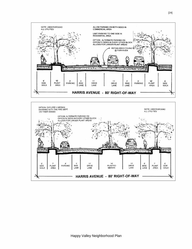
Diagram: Typical Secondary Arterial Cross Section
6 TG-4, 17 7 CDP-63
Happy Valley Neighborhood Plan

[22]
Other Arterials In recognition of their function as collector arterials, improvements to sections of Douglas Avenue, 24th, 25th Street, and the route over the ridge via Taylor Avenue, 20thStreet, and Knox Avenue are likely needed to meet collector street standards and ensure safe and efficient traffic movement.
HV POLICY-23: Portions of 14th, 21st, 24th, Harris, Donovan, Knox/20th/Taylor, 25th, 32nd, and Douglas/30th/Taylor are designated as neighborhood collector arterials and should be improved to appropriate standards.8
The arterial designation was removed from 24th Street between Douglas and Harris Avenues in 2001 to reduce volume and calm traffic adjacent to Happy Valley Elementary School. This street should be enhanced as a safe school route. If 24th Street south of Old Fairhaven Parkway is developed as the primary connector route for any significant new development to the south, signalization of the intersection at 24th and Old Fairhaven Parkway shall be required subject to meeting state traffic warrants. Also, traffic calming measures should be implemented all along 24th Street north of Harris Avenue and enhanced in the vicinity of Happy Valley Elementary School. Through traffic on 24th north of Harris Avenue should be evaluated in light of the factors outlined above and in Section C. Neighborhood Streets.
HV POLICY-24: If a major development south of Old Fairhaven Parkway requires a new or improved intersection along the parkway, the intersection should be signalized subject to meeting traffic signal warrants. If 24th Street is declassified as an arterial street north of Donovan, then traffic calming measures should be implemented at the 24th Street/Donovan Avenue intersection.
Two other important arterial access routes to the northern blocks of Happy Valley are the 25th Street access to Bill McDonald Parkway and the Douglas/30th/Taylor Avenue connection to 32nd Street. They function primarily to carry traffic in and out of the neighborhood rather than through it. Taylor Avenue narrows to one lane where Connelly Creek is culverted near 30th. This is not seen to be a problem at this time. Between 21st and 25th Streets, Douglas Avenue functions as a collector for most of the residential streets in Area 1A. These streets are largely developed with high-density multi-family apartments. Douglas Avenue also provides access to the neighborhood commercial zone, Area 1B, on the north side of Douglas between 22nd Street and the alley east of 23rd Street. Due to the anticipated amount of vehicular and pedestrian activity on this arterial, its design is important to ensure that Area 1B thrives as an attractive, pedestrian friendly, neighborhood center. The streetscape should readily indicate to drivers that this is an area of greater pedestrian activity and more caution is needed. Traffic calming may be required to manage high traffic volumes at low speeds, and ensure the safety of pedestrians and bicyclists.
8 CDP-67
Happy Valley Neighborhood Plan

[23]
HV POLICY-25: The cross section of the extra wide right-of-way within Douglas Avenue between 21st and 25th Streets should be aligned to include a greenway on the south side. (See HVP-8) Stormwater facilities should be included and designed as natural features with associated native plantings.
32nd Street is bordered by agricultural and low density residential land, which is steadily being converted to more intense commercial and apartment developments at the north end. In 1985, the street was widened to 40 feet just north of Joe’s Garden and 34 feet south to Old Fairhaven Parkway. Between Fielding Avenue and Bill McDonald Parkway, 32nd Street was realigned and constructed in 1997 to eliminate capacity problems associated with Fielding Avenue.
HV POLICY-26: Analyze the 32nd Street and southbound I-5 ramp intersections on Old Fairhaven Parkway with a goal of reducing turning conflicts.
There are turning conflicts associated with the 32nd Street and southbound I-5 ramp intersections on Old Fairhaven Parkway. The neighborhood believes that these have contributed to increased traffic on local residential streets as a means of avoiding these difficult intersections. Ways of minimizing or eliminating this conflict should be analyzed. The following concerns should be addressed in the evaluation of these intersections:
1. Through arterial traffic on 32nd to Old Fairhaven Parkway should not be
reduced or eliminated.
2. 30th Street between Donovan and Old Fairhaven Parkway should be improved to enhance the safety of pedestrians and bicyclists.
The following street cross-sections are intended to illustrate the Conceptual Green Infrastructure Plan in Section III.E. These cross sections are preliminary concepts and include elements that should be considered in the final design of neighborhood streets and arterials. Final designs should include the green space as shown, or equivalent, to enhance the stormwater quality functions, wildlife habitat, public safety, and visual appeal of right-of-way corridors.
Happy Valley Neighborhood Plan
[24]
Happy Valley Neighborhood Plan

[25]
Happy Valley Neighborhood Plan

[26]
Happy Valley Neighborhood Plan
[27]
C. Neighborhood Streets Except for the Parkways bordering Happy Valley to the north and south, there are few fully improved streets in the neighborhood. While conditions vary, most of the residential streets need improvement. The few sidewalks are in generally poor condition, and most of the paths built by the residents in the 1930’s have been destroyed without replacement during new development. Open ditches along most of the very narrow streets leave no room for pedestrians or bicyclists.9 Pedestrian routes have been improved along 24th Street and parts of Donovan, 20th and 18th Streets leading to the elementary schools. In 1978, overlays were made on many of the streets for maintenance purposes.
HV POLICY-27: In low density areas, street improvements should focus on improving pedestrian and bicycle safety.10 HV POLICY-28: In the high-density and public zones in the north and northeast portions of the neighborhood, non-arterial streets should include parking on both sides to help provide for the higher parking demand. Street cross sections may be increased to accommodate angled parking. Curbs, gutters, setback sidewalks, and street trees should be provided on both sides of the street and include lighting. HV POLICY-29: Distinguish Knox Avenue as the border between the high and medium density zones through use of landscaping and aligning the improved street on the north side of the right-of-way.
Currently, 24th Street is a two-lane roadway with open drainage ditches and a sidewalk on one side. The drainage ditches provide a valuable water quality function. The adjacent land use is primarily residential and ranges from older single family homes to new cluster housing and two-story apartments. Due to the location of Happy Valley Elementary School on 24th Street, traffic on this route should be better managed by de-emphasizing it as a through street and enhancing it as a safe school route.
HV POLICY-30: Enhance 24th Street as a safe school route and avoid any connection through to Bill McDonald Parkway.11 If possible, the ditches along 24th should remain open with sidewalks and bike lanes outside of these ditches. The design of 24th north of Harris should readily indicate to drivers that this is an area of greater pedestrian activity and more caution is needed.
Many students are bused to Happy Valley Elementary School from other parts of south Bellingham, thereby generating a significant number of school bus trips along 24th Street. Young neighborhood children walk along 24th to and from the school. The WWU campus and the high school at the northern end of the corridor are also major generators of vehicle, bicycle and pedestrian activity. Additional pedestrian
9 HP-30 10 TG-20 11 CDP-72, TG-4
Happy Valley Neighborhood Plan

[28]
and bicycle traffic uses 24th Street because it leads into the Interurban Trail on the south side of Old Fairhaven Parkway. In order to create a safe environment and to accommodate the needs of the various corridor users, improvements are proposed for 24th/25th Streets from Bill McDonald Parkway to Old Fairhaven Parkway. The proposed cross section should provide sufficient pavement width for one moving traffic lane and a bike lane in each direction on the arterial sections. Setback sidewalks should be located on both sides of the street in the multi-family zone and may be limited to one side in single-family zones. Bike lanes should not be provided in the non-arterial portions of 24th between Douglas and Knox in order to narrow the road for traffic calming purposes. The street design would separate pedestrian and vehicle travel, provide a safer street for automobile and bus traffic, and be designed to be compatible with adjacent property owners. Many residents favor the visual appeal of open ditches because of the rural character they represent. Visual character should be considered along with water quality functions when this street is upgraded as a safe school route. As there may not be sufficient room to include the ditches in the existing right-of-way width, other ways to achieve a more natural appearance through soft engineering techniques should be considered. This can include landscaping and other amenities provided at the option of abutting property owners – possibly as part of a 24th Street LID.
D. Parking
Overcrowded on-street parking continues to negatively effect the residents of Happy Valley. This parking problem is caused by a number of factors, including:
1. WWU commuter students parking in the neighborhood.
2. Increasing numbers of automobiles per dwelling unit, especially in Area 1.
3. Sehome High School students parking off-campus.
4. Lack of streets with sufficient width to accommodate on-street parking.
5. Lack of neighborhood services increases the need for personal transportation to jobs and commercial services.
6. Establishment of Residential Parking Zones in the Sehome and South Hill Neighborhoods may have increased parking problems in Happy Valley, especially within and just south of Areas 1 & 3.
HV POLICY-31: The City, Happy Valley Neighborhood, WWU, and Bellingham School District should consider establishing a Residential Parking Zone (RPZ) south of campus in concert with improved transit service, and promotion of pedestrian and bicycle traffic. (See also HVP-16, 27, 37-40, 43, 46, 47)
E. Unimproved Rights-of-Way
Vacating undeveloped rights-of-way should only be considered after carefully evaluating the request to determine if the vacation is in the public interest. These areas can serve a multi-purpose role as pedestrian/bicycle/view corridors, stormwater treatment facilities, and open space.
Happy Valley Neighborhood Plan

[29]
HV POLICY-32: Unimproved rights-of-way should not be vacated, unless in the public interest. (See HVP-1, 8)
F. Pedestrian Circulation
North/south routes proposed for special attention to pedestrian needs are 14th, 16th, and 24th Streets, and 32nd Street north of Taylor Avenue. East/west routes are Harris and portions of Taylor and Douglas Streets. Safe pedestrian crossings are needed on Old Fairhaven Parkway to allow access to the Interurban Trail, 28th Street Trail, Parkway apartment complexes and retirement homes, and Fairhaven Park. Safe pedestrian crossings of Bill McDonald Parkway also need to be considered. Off-Street pedestrian routes include Connelly Creek and the 31st Street right-of-way, with connections to Sehome High School, Happy Valley Elementary School, 32nd, and 24th Streets wherever possible. Also, the 23rd Street open space corridor north of Douglas Avenue should be further developed as a pedestrian and bicycle link between the Area 1B neighborhood center and WWU. These corridors are to be preserved as development occurs. Padden Creek will be a major trail corridor. (See Page 7 for more trail information) The Taylor Street Stairway west of 20th Street and its continuation for one-half block east of 21st Street is a major walkway for high school and university students coming into the neighborhood. It also leads from the neighborhood down to Bellingham Bay and Boulevard Park. Similar pedestrian links should also be improved along Bennett, Douglas, and Knox Avenues between 20th and 21st Street. The current lack of sidewalks and bike lanes in Areas 1A, 1B, and 1C is attributed to the past practice of allowing developers to forego improvement in lieu of signing No Protest Local Improvement Districts (LIDs). The intent was to allow developers to make street and sidewalk improvements at a later date when a more continuous development pattern evolved and longer sidewalk segments could be completed at one time. This approach has proven ineffective in providing the necessary pedestrian infrastructure. Difficulties of acting on No Protest LIDs have been compounded by more stringent and costly stormwater treatment and retention requirements that have recently been adopted. The City should develop a funding mechanism to cover the additional costs of stormwater quality facilities while forming LIDs for necessary street improvements in front of developed properties. Meanwhile, any new development should be required to improve all abutting street frontages to prescribed standards.
HV POLICY-33: Act on existing No Protest LIDs and initiate new LIDs along targeted pedestrian corridors to provide necessary infrastructure including streets, sidewalks, bike lanes, and trails. Create a funding mechanism as needed to pay for the additional costs associated with stormwater quality management.12
12 TP-12
Happy Valley Neighborhood Plan

[30]
HV POLICY-34: Pedestrian and bicycle routes should lead to neighborhood schools, recreation areas, shopping districts, and other neighborhoods using existing right-of-way and open space networks. Street trees, setback sidewalks, and bicycle lanes should be required on all new or reconstructed arterials in Happy Valley taking into account existing mature vegetation or terrain.13 HV POLICY-35: Arterial streets should be enhanced with pedestrian facilities such as sidewalks, planting strips, street trees, bulbed intersections, and other items that contribute to pedestrian safety, encourage pedestrian activity, create visual interest, and slow traffic. Larger street trees should be planted where overhead utilities are not present or where a significant view would not be blocked. These trees would form a canopy over the street and create more visual interest.
G. Bicycle Circulation
Either recreational or commuter bicycle routes should be included with the pedestrian ways mentioned above, except where the right-of-way is too steep. Bicycle access improvements consisting of simple lane striping have been completed on Bill McDonald Parkway, and additional room for bikes has been improved along 21st and 32nd Streets, and Donovan Avenue. Connections along the 30th Street right-of-way between Taylor Avenue, Sehome High School, and WWU’s Arboretum Drive have been completed.
HV POLICY-36: Encourage greater use of bicycles by providing enhanced non-motorized routes and facilities such as bike lanes, sidewalks and trails as outlined in the related policies herein. Establish bike routes based on connectivity, safety and bicyclists’ visual enjoyment of the route.14 (Contact the Public Works Department for the most up to date Pedestrian-Bicycle Facilities Map.)
Several projects are longer-range in nature. They include further developing the Padden Creek trail corridor, and linking the Interurban Trail to 24th Street and Bill McDonald Parkway. The Pedestrian/Bicycle Advisory Committee recommends construction of an east/west connector through the Connelly Creek Nature Area from Mill Avenue and 27th Street to the current north/south multi-use trail. Similarly, 32nd Street should be connected to the multi-use trail, possibly through the Mill Street connector previously listed. The location of such connections should take into consideration the potential impacts to wetlands and creeks in this area.
H. Safe School Routes
City and School District representatives frequently work together to identify safe school routes for elementary and middle schools throughout the community. Safe
13 CDG-9, TG-3, TP-46, 56 14 CDG-9, TG-3, TP-46
Happy Valley Neighborhood Plan

[31]
school routes for Larrabee and Happy Valley Elementary Schools are shown on the Arterial Map on page 12. These routes are subject to change due to street improvements and where students live within the neighborhood. (Contact the Public Works Department or School District for the most up to date safe school routes.)
I. Transit
Transit serves all the major arterials and provides connectivity between WWU, Fairhaven, Sehome Village and downtown. Route alterations that better serve the high-density areas and innovative methods to increase ridership should be studied and implemented.15 (See HVP-16, 31, 46, 47)
HV POLICY-37: Develop needed transportation services and facilities that are designed to support alternatives to single occupancy auto use. Encourage developers to incorporate bus shelters into new developments and maintain them. HV POLICY-38: Encourage WWU to develop and enhance transit facilities and street access as identified in the 2001 WWU Institutional Master Plan. HV POLICY-39: Encourage WTA to increase the number of transit trips serving WWU. HV POLICY-40: Encourage WWU and the Bellingham School District to provide students, faculty, and staff with annual bus passes to encourage greater use of the transit system and reduce the need to build costly parking lots.
New developments should include transit stops or shelters whenever feasible. Bus stops and shelters should be clean, attractive and convenient to use.16
Click here to view the Happy Valley Floodplain and Geologic Hazard Map
15 TG-9, 14, 16, 25, 28; TP-2, TP-4, 341 16 TP-6
Happy Valley Neighborhood Plan

[32]
UTILITIES A. Drainage and Stormwater Padden Creek is the major natural drainage system for the Happy Valley neighborhood. Padden Creek accommodates drainage from the 2,600-acre Padden Creek Watershed (excluding Lake Padden). Happy Valley lies completely within the watershed and constitutes 27 percent of the total collection area. Consequently, this area has a major influence on the health of the Padden/ Connelly Creek system. Water comes partly from Lake Padden, where the outlet is controlled to regulate flow. It also comes from a trunk line draining the southern portion of the WWU campus, from Connelly Creek, and from surface runoff into the various drainages. Connelly Creek is a sub-basin of the Padden Creek Watershed. It is the main tributary to Padden Creek and drains the eastern portion of the neighborhood, including Sehome High School, Sehome Village and other businesses north of the neighborhood as well as development east of I-5. In 1982, the City constructed the Happy Valley Detention Facility on Connelly Creek (located in the Connelly Creek Nature Area). It was built to help alleviate flooding in Padden Creek by storing and attenuating high flows. Citywide floodplain mapping completed in 1982 revealed large portions of the neighborhood at risk from a 100-year flood, including most of the Connelly Creek Nature Area (see Floodplain map). “Floodplain” is synonymous with “100-year floodplain” and refers to land area susceptible to flooding from stream derived waters with a one percent chance of being equaled or exceeded in any given year. New development must comply with floodplain regulations in the floodplain, as well as the floodway. Soils with low permeability contribute to drainage problems as do the loss of wetlands and the increase in impervious surfaces. Historically, Happy Valley has had drainage problems and flooding. Several comprehensive studies have been performed on the drainage systems and their results should be considered for any development in the neighborhood. The studies include the City of Bellingham Comprehensive Drainage Plan (1973), the Flood Insurance Study (FEMA, 1982), and the City of Bellingham Watershed Master Plan (1995). The 1973 Bellingham Comprehensive Drainage Plan recommends retaining natural channels where possible and using underground pipes where necessary.17 Natural streams are less costly than buried culverts, are valued by the residents, and should be retained, reclaimed, and enhanced. Deep ditches along streets that pose a hazard to pedestrians and drivers should also be addressed.
HV POLICY–41: Identify specific areas in the neighborhood where drainage improvements are needed and find a funding source for them. Natural drainages such as Mill Creek west of Connelly Creek should be retained wherever possible, recognizing their stormwater treatment functions and importance to the neighborhood.
17 CFG-14
Happy Valley Neighborhood Plan

[33]
The myriad problems associated with stormwater runoff into natural stream channels are the basis for statewide stormwater regulations. Management of the quality and quantity of stormwater is addressed through the design of stormwater facilities such as bioswales, wetponds, detention ponds, and underground vaults. An analysis should be undertaken to determine where additional stormwater facilities might be developed in existing rights-of-way. As new best management practices emerge, the City should enact regulations to apply them.
HV POLICY-42: Adopt new strategies that improve the way stormwater is managed and reduce impervious surfaces as a preventive measure. Identify lands that may be jointly purchased and developed for storm-water treatment purposes.18
B. Sanitary Sewer The sanitary sewer systems serving the neighborhood are in fair to good condition and continue to provide the necessary capacities for future growth in this area of Bellingham. The 1998 Bellingham Wastewater Conveyance Plan has identified no facilities within the neighborhood that require future removal and upsizing. The current sewer replacement program will be used to systematically remove any additional stormwater inflow sources and help minimize ground water infiltration in the older sanitary sewer mains west of 20th Street. Growth within the neighborhood will require main extensions to unserved areas. Several cases of raw residential sewage flowing into Padden Creek have been discovered and corrected, but high fecal coliform counts indicate that unacceptable levels of pollution from domestic or nonpoint source still exist. The City and Whatcom County Health Department should work together to find these sources and correct them. C. Water Bellingham’s South Pressure Zone serves the neighborhood with domestic water and fire capacities through a system of transmission mains and lateral pipes dating back to 1920. The systems are in good condition. The current water replacement program has identified several mains that may require replacement in the next 10 to 15 years. The 1993 Bellingham Comprehensive Water Plan did not identify any new trunk lines or reservoir upgrades for this neighborhood. Growth in the neighborhood can be accommodated by main extensions to undeveloped lots or areas.
VI. PUBLIC FACILITIES A. Western Washington University (WWU) WWU is an asset to the City that is surrounded by generally healthy and stable neighborhoods. The considerable recreational, cultural, and educational resources of the University are within walking distance of much of Happy Valley.
18 CFP-37
Happy Valley Neighborhood Plan

[34]
HV GOAL-3: WWU should make every effort to use its existing campus to accommodate future development or expand toward or in the CBD.
A review and evaluation of potential campus expansion areas was conducted in Happy Valley as part of the update of this plan. Based on this review, it was determined that:
1. the Institutional General Use Type will be applied to the Physical Plant property (Area 2B) upon adoption of the WWU Institutional Master Plan,
2. the block west of the Physical Plant may be rezoned to Institutional if certain conditions are met (see Area 1C), and
3. the potential for Institutional expansion in Area 1A will be evaluated in an alternatives analysis process (see Area 1A).
HV POLICY-43: Encourage the formation of a public-private partnership including WWU, the State, the City, adjacent neighborhoods, and private developers, organized by WWU. This group should meet regularly to discuss development in the area, including WWU and City proposals, spearheading of infrastructure construction, influencing the State Legislature, and supporting the community.19
HV POLICY-44: University owned and maintained housing and open space, including recreational fields (excluding stadiums), are encouraged to locate in Areas 1A, 1C, and 2B if the location, design, and identified impacts are adequately addressed.
HV POLICY-45: Off-campus parking that is not directly supporting an adjacent allowed use shall not be located in Happy Valley.
HV POLICY-46: WWU shall help mitigate the negative impacts on Happy Valley
residents resulting from WWU uses in Happy Valley. WWU is encouraged to seek funding for traffic calming, and pedestrian and bike improvements to streets that are identified as primary gateways or traffic corridors to campus. (See HVP-16, 30, 31, 37-40, 47)
HV POLICY-47: Encourage WWU to adopt measures to mitigate impacts on the
Happy Valley Neighborhood as enrollment increases, including:
a) Siting of off campus facilities in appropriate areas, including downtown.
b) Adopting regulations aimed at reducing the number of cars students bring to town.
c) Investing more in and promoting use of transit and other alternative forms of transportation.
d) Increasing the WWU shuttle service in Happy Valley.
e) Constructing on campus parking garages to make more efficient use of land devoted to surface parking.
19 CDG-23
Happy Valley Neighborhood Plan
[35]
f) Constructing more on-campus housing and other facilities.
g) Offering year round classes.
h) Sharing athletic fields with the City. (See HVP-16, 30, 31, 37-40, 46) B. Schools
Larrabee and Happy Valley Elementary Schools serve most of the city south and east of Happy Valley, as well as the neighborhood itself. Older Happy Valley students attend Fairhaven Middle School and Sehome High School. Numerous private schools and educational day care centers are also located within the neighborhood. The Bellingham School District is considering the closure of Larrabee School to build a larger school once a site is located on the south side of the city. In the meantime, a large number of children attending Happy Valley Elementary are bused to school from neighborhoods east of I-5 and south of Old Fairhaven Parkway. The Bellingham School District and City should continue to work together to improve use of neighborhood schools as community centers and to make facilities available for year-round recreation for neighborhood youth. HV GOAL-4: Urge the School District to keep neighborhood schools open. HV GOAL-5: Use neighborhood schools as community centers for youth and
community oriented activities. HV POLICY-48: Encourage the preservation of smaller neighborhood school
buildings. Because Larrabee Elementary is already publicly owned, it should remain in public use if it closes.
HV POLICY-49: Disabled accessibility upgrades should be made to
neighborhood schools so they may better serve community functions. C. Fire Protection The old 1927 fire station built on the southwest corner of 14th Street and Harris Avenue has been replaced by a new station on the east half of the block bound by Harris and McKenzie Avenues, and 15th and 16th Streets. The new station will provide expanded service capability to the South Hill, South, Edgemoor, Fairhaven, and Happy Valley neighborhoods. It will also support fire and emergency medical services throughout the city and in nearby unincorporated Whatcom County. One full-time active fire engine, crew of three fire fighters, and backup equipment appropriate to the Fire Department’s constantly changing distribution of resources are expected to be maintained on-site.
Happy Valley Neighborhood Plan

[36]
VII. DESIGN CRITERIA A. ALL DEVELOPMENT HV GOAL-6: Promote safety by designing for community interaction that fosters
mutual concern and support in a stable, diverse neighborhood context. HV POLICY-50: Developers should incorporate appropriate Crime Prevention
Through Environmental Design (CPTED) standards and guidelines in all residential multi, commercial, and public building projects.20
B. GOALS AND POLICIES FOR RESIDENTIAL DEVELOPMENT The following residential goals and policies apply to residential development in the Happy Valley Neighborhood. These goals and policies and citywide residential design guidelines (once adopted) shall be addressed in development proposals.
HV GOAL- 7: Enhance and retain the neighborhood’s character by preserving Happy Valley building scale and type, historical features, and natural amenities.
HV POLICY-51: Encourage the use of architectural styles and details that are similar to, or enhance, the existing neighborhood.21
HV POLICY-52: Provide opportunities for owner-occupied housing in single-family zones by encouraging accessory dwelling units.
HV POLICY-53: Encourage development of a variety of housing types and densities to support a diverse residential population. These housing types should include single-family and multi-family residences at a variety of densities, and affordable housing for families and individuals.
HV POLICY-54: Parking should not dominate the Happy Valley landscape. In addition to the Residential-Multi Design Guidelines dealing with parking, limit large areas of additional parking (beyond the number required under the Land Use Code) by allowing such parking to be developed on street.
C. NEIGHBORHOOD COMMERCIAL AND MIXED-USE CRITERIA These guidelines apply to neighborhood commercial zones and to eating establishments when located in a Residential Multi Zone. HV POLICY-55: Allow pedestrian oriented commercial and retail developments
in designated areas that would enliven the streetscape.22
20 CPTED principals of natural surveillance, natural access control, territorial reinforcement, and maintenance can be used to minimize the potential for crime in new developments. Well designed buildings, parking lots, garages, sidewalks, and open courtyards and appropriate lighting can be encouraged in new developments. (CFP-29) 21 CDG-37, 38
Happy Valley Neighborhood Plan

[37]
High-density multifamily and nonresidential uses can be desirable if they are integrated into the existing neighborhood fabric. Areas 1B and 14 are Neighborhood Commercial zones and shall be designed as neighborhood centers. These centers should be developed with a mix of uses, including commercial on the ground floor and residential on upper floors in order to provide a built-in clientele for neighborhood businesses, additional ridership for public transit, and eyes on public streets and open spaces for security and a sense of community ownership. Commercial uses in Areas 1B and 14 are allowed only as part of a mixed-use (commercial-residential) development. Neighborhood Commercial uses are intended to: • provide services and be a destination for neighborhood residents, not the city as
a whole,
• discourage use of the automobile,
• promote pedestrian activity,
• add diversity to the built environment,
• encourage redevelopment,
• provide traffic calming through increased activity adjacent to the street,
• foster a greater sense of community and neighborhood identity by creating more social opportunities, and
• enhance neighborhood character. HV POLICY-56: Nonresidential development in Residential and Neighborhood
Commercial zones should be designed with commercial uses at street level and residential uses on upper floors to promote compatibility with adjacent residential uses and to display a mixed-use character.23
To minimize the impacts of commercial development on the surrounding neighborhood, the design criteria in the Happy Valley zoning table section of the Land Use and Development Code shall be incorporated into the planned contract and building permit review process when part of a mixed-use (commercial-residential) development.
Click here to view the Happy Valley Land Use Map
22 LUP-106, 107, 108, 109, and 112 23 CDG-41-43
Happy Valley Neighborhood Plan

[38]
VIII. SUBAREA DESCRIPTIONS AND LAND USE DESIGNATIONS Areas 1A, 1B, 1C, 2B & 3 Narrative This section contains an introduction to the specific design and development criteria for the five subareas listed above and in the Happy Valley zoning section of the Land Use and Development Code. Note that the criteria applicable to the WWU Physical Plant (Area 2B) and the block west of the Physical Plant (Area 1C) are also included in the WWU Institutional Master Plan (IMP). The reader interested in a complete review of the type and manner of institutional development that can occur in these areas should consult the IMP. Introduction The five subareas include approximately 160-acres located south and east of Western Washington University. They include many densely developed apartment complexes, a neighborhood commercial zone, Sehome High School and WWU’s Physical Plant. Areas 1A, 1B, 1C & 3 were rezoned to high-density multifamily residential in 1982. Many multifamily residential buildings have been built since that time. Few single-family residences were preserved during this development. There are no commercial services or activities offered in these subareas as of 2001. Update Note: WWU purchased the block contained in Area 1C, and the zoning was changed to Institutional in 2010.
New development in the last two decades has most often been designed under the minimum standards of Bellingham’s Land Use Development Ordinance. No protest agreements for Local Improvement Districts (LIDs) often accompanied these projects, allowing developers to forgo construction of street and pedestrian improvements until such time that adjacent properties developed. This practice has resulted in the development of few pedestrian amenities such as sidewalks, street trees and street lights in one of the most densely developed areas of Bellingham.
The new designations of these subareas are intended to create a more functional urban environment. Design criteria in the Land Use and Development Code will set the tone for a livable area that also preserves the underlying density and maintains the character of the neighborhood. Area 1A Area 1A is among the most densely developed residential areas in the city. Based on City building permit and Whatcom County Assessor records, Staff estimates that there are 910 total dwelling units in Area 1A, 1B, and 1C. Approximately 21 single-family homes remained in 2000, less than half owner occupied. Staff calculated in 2000 that 400-500 additional dwelling units could be developed on vacant and underutilized lands. Given its proximity to WWU, this area is an important source of housing for the city and for the university. Areas 1A, 1B, and 1C housed approximately 627 students (9% of students living off campus) in the fall of 1998 (WWU statistics), or approximately 34% of the residents of this area (assuming 2 people per dwelling unit).
Happy Valley Neighborhood Plan
[39]
WWU has identified Area 1A as one of the areas that should be considered in an alternatives analysis for future campus expansion. However, campus expansion into Area 1A will not be allowed unless:
1. WWU establishes, in an adopted institutional master plan, a need for additional land beyond the current campus boundaries to accommodate projected growth.
2. Area 1A has been selected in an alternatives analysis as an area appropriate for campus expansion. (See the WWU Institutional Master Plan for more information on the alternative analysis process.)
Residential multi-multiple development standards and the design criteria shall be administered through the planned contract process. The design criteria in the Land Use and Development Code shall be used in conjunction with the citywide multi-family design guidelines once they are adopted. Applications for planned development and design review should be processed together. All new non-residential uses and residential expansions shall require a planned contract. See Areas 1A, 1B, 1C, 2B & 3 Design and Development Criteria in the Happy Valley Neighborhood zoning section of the Land Use Code for specific details for Area 1A. ____________________________________________________________________ AREA 1A LAND USE DESIGNATION: MULTIFAMILY RESIDENTIAL, HIGH DENSITY ______________________________________________________________________ Area 1B Area 1B provides opportunities for a small neighborhood center allowing for small-scale neighborhood commercial uses in conjunction with high-density housing. The opportunity to develop small commercial activities within walking distance of residential and nearby office uses is intended to encourage pedestrian activity and decrease automobile traffic in and out of the general area. Care should be taken to preserve the residential character and enhance pedestrian use, thereby creating greater social interaction in this area.24 This subarea is centrally located in order to be convenient for pedestrians and bicyclists. Also, it is adjacent to the 23rd Street open space corridor through which a trail connects with the WWU campus. The design criteria in herein (Section VII) and in the Happy Valley Neighborhood zoning section of the Land Use and Development Code were formulated to create a neighborhood center that would evolve into a cohesive mixed-use (commercial-residential) environment. Physical design objectives include circulation planning for pedestrians, bicycles, and vehicles; site and building design criteria; and protection and integration of natural systems and amenities. Ground floor uses that front Douglas Avenue shall be limited to commercial or residential uses as listed in the Happy Valley zoning section of the Land Use Code. When commercial uses are part of a development, residential uses shall be provided in conjunction with commercial
24 LUG –4, 6, 10, 12, 27
Happy Valley Neighborhood Plan

[40]
uses at a minimum ratio as stated in the Happy Valley zoning section of the Land Use Code. Mixed-use (commercial-residential) objectives are intended to: 1) ensure that a high-density residential presence remains within proximity to WWU, 2) prevent encroachment pressures from WWU and high density residential uses from spilling over into the residential areas to the south, and 3) provide some commercial uses to decrease the need to drive to services outside of the neighborhood. This zone shall use neighborhood commercial development standards along with the design criteria in the Land Use and Development Code and shall be administered through the planned contract process. All new commercial uses and residential expansions shall require a planned contract. See Areas 1A, 1B, 1C, 2B & 3 Design and Development Criteria in the Happy Valley Neighborhood zoning section of the Land Use and Development Code for specific requirements applicable to Area 1B. AREA 1B LAND USE DESIGNATION: COMMERCIAL ______________________________________________________________________ Area 1C Area 1C consists of the block west of the WWU Physical Plant bounded by 25th Street, (vacated) 26th Street, and Taylor and Douglas Avenues. It was originally designated for high density residential development as a part of Area 1A. WWU now owns the property and it was rezoned to Institutional in 2010, to allow University support services. Permitted uses should be limited to student activities, residential, or non-industrial support uses as defined in the Institutional Master Plan (see WWU IMP, District 22) See Areas 1A, 1B, 1C, 2B & 3 Design and Development Criteria in the Happy Valley Neighborhood zoning section of the Land Use and Development Code for specific requirements applicable to Area 1C. AREA 1C LAND USE DESIGNATION: INSTITUTIONAL ______________________________________________________________________ Area 2A Sehome High School occupies this publicly owned land. The 41-acre site has approximately 11.35 acres of play fields and tennis courts. The undeveloped open space tracts along the east side of Sehome High School (approximately 9.5 acres) should be retained to the greatest extent possible as a wildlife habitat corridor between the Sehome Hill Arboretum and Connelly Creek Nature Area.
Happy Valley Neighborhood Plan
[41]
______________________________________________________________________ AREA 2A LAND USE DESIGNATION: PUBLIC ______________________________________________________________________ Area 2B Western Washington University’s (WWU) Physical Plant occupies this 8.2-acre site. The abutting Taylor Avenue right-of-way may be vacated to allow WWU to expand the Physical Plant uses on the north side away from existing residential areas. Access to the Puget Sound Energy substation on the northeast side of Area 2B should be continued via an access easement across WWU’s property. Steep slopes along the east side of Area 2B should remain undeveloped as a wooded backdrop and open space buffer to the residential zones to the east and also as habitat corridor between Sehome Hill and Connelly Creek Nature Area. Note: See the WWU Institutional Master Plan (IMP) for a complete listing of use restrictions, design criteria, and performance standards that apply to institutional development in this area. ______________________________________________________________________ AREA 2B LAND USE DESIGNATION: PUBLIC/ INSTITUTIONAL ______________________________________________________________________ Area 3 This area near WWU and Bill McDonald Parkway is designated for high-density multi-family development. Eight single-family residences remained as of 2000. Hillside development limitations exist in some areas. Access to properties south of Ferry Avenue should be restricted to platted alleys in order to retain the undeveloped Nash Avenue and 31st Street rights-of-way as open space tracts. Residential multi-multiple development standards and the design criteria in the Happy Valley Neighborhood zoning section of the Land Use and Development Code shall be administered through the planned contract process. The design criteria in the Happy Valley zoning section of the code shall be used in conjunction with the citywide multi-family design guidelines once they are adopted. Applications for planned development and design review should be processed together. All new non-residential uses and residential expansions shall require a planned contract. See Areas 1A, 1B, 1C, 2B & 3 Design and Development Criteria in the Happy Valley Neighborhood zoning section of the Land Use and Development Code for specific requirements applicable to Area 3. ______________________________________________________________________ AREA 3 LAND USE DESIGNATION: MULTIFAMILY RESIDENTIAL, HIGH DENSITY ______________________________________________________________________
Happy Valley Neighborhood Plan

[42]
Area 4 The Sehome Village Shopping Center occupies most of this area. The 32nd Street extension to Bill McDonald Parkway was completed in 1997. The design criteria in the Happy Valley zoning section of the Land Use and Development Code should be applied to any new development or redevelopment in Area 4:25 ______________________________________________________________________ AREA 4 LAND USE DESIGNATION: COMMERCIAL ______________________________________________________________________ Area 5 This is an area of old plats and 2,500 square foot lots. It contains a mixture of old and new homes, duplexes, and several apartments allowed as conditional uses or built during the earlier periods of multifamily zoning. Community Development Block Grants have been used extensively to improve the quality of older housing stock in this area. These grants are available through the city for qualified property owners to help finance property improvements. The previous duplex zoning for this subarea was changed to single-family residential in 2001 to encourage new development that is oriented toward owner occupancy. See the Happy Valley Neighborhood zoning regulations in the Land Use and Development Code for special development regulations applicable to Area 5. The minimum lot size in this subarea may be reduced for the blocks bound by Donovan Avenue, Happy Court, 24th Street, and the alley east of 22nd Street. This two-block area is uncharacteristic of the rest of Area 5 in that it was platted with shallow lots with dimensions of 25 feet wide by 80 feet deep. Most of these lots have been consolidated and developed, several with duplexes. Some opportunities for single-family residential infill remain.26 Development of the steeper lands along the northern edge of Happy Valley raises concerns about slope stability and drainage (see Map, P. 4). The City should consider acquiring these wooded hillsides and preserving them for wildlife habitat and to enhance the visual backdrop of the residential valley.27 However, if new development occurs in these areas, a current topographic survey should be provided with building permit applications to ensure these areas are sensitively developed. Park or Housing Opportunity Site West of the New Fire Station
The property west of the new Happy Valley Fire Station and east of 15th Street, between Harris and McKenzie Avenues, formerly held nineteen units of World War II Veteran’s housing. These units were privately owned and served as a source of low-cost housing until the City acquired the property in 1999. Two options exist for this property:
25 CDP-7 26 LUP-55 27 CDG-3, 21, 22; LUP-113; HP-2, 3
Happy Valley Neighborhood Plan
[43]
Residential development shall only be for permanent affordable housing, preferably with owner occupancy.28 Development should consolidate usable space and break up the visual bulk of buildings. Architectural details should be similar to the older homes of the Happy Valley Neighborhood with porches and entries in the front and parking in the rear. A stormwater retention facility shared with the adjacent fire station may be located on this site. Due to the absence of a centrally located public space on the west side of Happy Valley, this site could also serve as a public park. If this occurs, an alternate site within Happy Valley should be studied to accommodate affordable housing. Whether the property is used for housing or a park, adjacent underutilized rights-of-way should be used to provide additional open space and parking. Establishing a residential parking zone adjacent to the high-density residential zone in the northeast of this area should be researched in response to area residents’ interest. An emphasis should be placed on upgrading Harris Avenue with street improvements and landscaping to establish it as a gateway between Fairhaven and the heart of the Happy Valley at 24th Street. See HV Policy-17 for a discussion of berming and buffering Old Fairhaven Parkway from the neighborhood. ______________________________________________________________________ AREA 5 LAND USE DESIGNATION: SINGLE FAMILY RESIDENTIAL, MEDIUM DENSITY ______________________________________________________________________ Area 5A This is an 1.19 acre area that is bounded by Wilson Avenue to the north, 20th Street to the east and Old Fairhaven Parkway to the south. The area was rezoned in 2010. The rezone effectively maintained the existing single family zoning and density (twelve dwelling units), but allowed houses to be clustered on smaller lots for purposes of consolidating open space on the south side of the area. The zoning table outlines special conditions and regulations concerning development and protection/enhancement for the south side of the property. On March 2, 2010, the City and the property owner signed a development agreement that indicates development and design standards to construct attached and detached single family residences. ______________________________________________________________________ AREA 5A LAND USE DESIGNATION: SINGLE FAMILY RESIDENTIAL, MEDIUM DENSITY ______________________________________________________________________
28 CDG-31, HP-8
Happy Valley Neighborhood Plan

[44]
Area 6 Happy Valley Elementary School and playground is located at this 24th Street property. The school is on a 7.45-acre site with the playground and play fields comprising a total of 2.4 acres. ______________________________________________________________________ AREA 6 LAND USE DESIGNATION: PUBLIC ______________________________________________________________________ Area 7 Much of the land in this area has never been platted. Lots vary from several acres down to approximately 20,000 square foot lots between 32nd Street and Interstate 5. Connelly Creek runs through the center of the valley. Lands adjacent to the creek contain cedars, spruce, and fir, open pasture, and marshes. Development is limited by wet soil and flooding. Large lots have allowed people to build homes close to 32nd Street and along the bluff on the west side of the valley, leaving the sensitive area in the middle undeveloped. The previous zoning was for a lot size of 20,000 square feet, with a cluster provision potentially allowing an average overall density of 10,000 square feet for new subdivisions. The 1997 Subdivision Ordinance replaced this cluster provision with a density bonus system whereby cluster subdivisions could increase density a maximum of fifty percent (50%) upon meeting certain bonus criteria. Therefore, the base density in this area has been increased to 15,000 square feet per lot, which allows a maximum average cluster density of 10,000 square feet of land per dwelling unit, the same as it was before 1997. The minimum lot size for cluster subdivisions should be 5,000 square feet to provide flexibility for open space dedication. New cluster subdivisions should be designed to be community oriented with main entries, windows, and porches oriented to the street so garages do not dominate the streetscape. Use of the cluster provision in this area has ensured permanent preservation of significant open space along Connelly Creek along with pedestrian access corridors, and has concentrated homes near existing infrastructure.29 The City created Connelly Creek Nature Area through a combination of cluster open space dedications and numerous property acquisitions along the creek. Dedication of additional cluster open space is recommended to enhance buffering along the creek and nature area, and to provide parks, playgrounds, and mid-block trail corridors. Cluster bonus criteria may include off-site dedications of open space, mid-block pedestrian easements, or enhancement of off-site pedestrian infrastructure. In order to avoid dysfunctional open space, owners of lots that do not abut the Connelly Creek Nature Area and have no other significant environmental constraint could contribute toward a park and open space fund in lieu of providing the required open space.
29 LUP-59, CDG-22
Happy Valley Neighborhood Plan
[45]
Undeveloped open space tracts along the east side of Sehome High School and WWU’s Physical Plant should be retained as a wildlife habitat and trail corridor between the Sehome Hill Arboretum and Connelly Creek Nature Area. (See HVP-1) New construction should provide an increased vegetative buffer along the freeway to help to act as a noise buffer between the freeway and residential uses. A berm should be built along the freeway as properties redevelop. Western Washington University (WWU) operates a compost facility adjacent to Area 2B on the north side of Douglas Avenue (Lot 1, Rehder Short Plat). WWU may continue to operate this facility as a permitted use as long as the use complies with the development regulations in the Happy Valley Neighborhood Area 7 zoning section of the Land use and Development Ordinance. ______________________________________________________________________ AREA 7 LAND USE DESIGNATION: SINGLE FAMILY RESIDENTIAL, LOW DENSITY ______________________________________________________________________ Area 8 Larrabee School looks over Happy Valley from this high point. The primary building, built in 1924, consists of attractive architecture and should be preserved and utilized for some other public use if talks of closing the school are realized. Alterations should be made to accommodate community events by providing an indoor public meeting space that is accessible per Americans with Disabilities Act (ADA) standards. Due to the absence of a park in Area 5, the approximately one acre playground on site serves a dual role as a recreation destination during non-school hours. Any new use for this property should retain and enhance a significant part of the playground for recreational purposes and any additional parking should be improved on street toward this purpose. ______________________________________________________________________ AREA 8 LAND USE DESIGNATION: PUBLIC ______________________________________________________________________ Area 9 The area south of Happy Valley Elementary School, approximately to the 27th Street right-of-way, and all the area south of Donovan and east of 24th Street is designated for single family residential at a higher density than the Connelly Creek valley. The minimum lot size for cluster subdivisions should be 5,000 square feet to provide flexibility for open space dedication. New cluster subdivisions should be designed to be community oriented with main entries, windows, and porches oriented to the street so garages do not dominate the streetscape. Flood hazards, the water table, and poor soils can cause significant problems for homeowners along Padden and Connelly Creeks. Lot sizes in this sensitive area
Happy Valley Neighborhood Plan

[46]
should be larger, or houses should be clustered away from the floodplain. Common wall clusters might be advantageous in this area to preserve as much open space as possible and provide housing at a reasonable cost.30 ______________________________________________________________________ AREA 9 LAND USE DESIGNATION: SINGLE FAMILY RESIDENTIAL, MEDIUM DENSITY ______________________________________________________________________ Area 10 This 3.65 acre property is bound by 30th Street, Cowgill Avenue, Old Fairhaven Parkway, and Interstate 5. A Planned Commercial area is south across Old Fairhaven Parkway in the South Neighborhood. The existing vacant Albertson’s Grocery Store with approximately 40,000 square feet of floor area was developed when the property was zoned Auto Commercial with no building size limits. The existing building is permitted to stay; however, redevelopment of the site shall comply with the design criteria in the Happy Valley Neighborhood zoning section of the Land Use and Development Code. ______________________________________________________________________ AREA 10 LAND USE DESIGNATION: COMMERCIAL ______________________________________________________________________ Areas 11 & 11A Area 11 includes the Connelly Creek Nature Area, extending from Taylor Avenue to Donovan Avenue. Area 11A includes Happy Valley Park between Donovan Avenue and Padden Creek, and the Old Fairhaven Parkway Greenway located along the southern bank of Padden Creek. In the last Happy Valley Neighborhood Plan, Area 11 was a 7-acre parcel purchased by the City in 1981 for construction of the Happy Valley Detention Facility on Connelly Creek. Located north of the Mill Avenue right-of-way, the detention facility was built by the City in 1982 to help alleviate flooding in Padden Creek by storing and attenuating high flows. In 1982, an additional 17 acres were acquired through a community development block grant. This created an expanded open space corridor along Connelly Creek south of Mill Avenue. Greenway levy funds have been used to increase this open space to 35.6 acres.31 _____________________________________________________________________ AREAS 11& 11A LAND USE DESIGNATION: PUBLIC ______________________________________________________________________
30 LUP-59, CDG-22 31 CDG-22
Happy Valley Neighborhood Plan
[47]
Area 12 All properties within this area are detached single-family residences with the exception of three vacant lots of 2,875 square feet each. Two of the vacant lots may require consolidation because they abut each other and are held by the same property owner. The existing housing stock is largely owner occupied and consists predominantly of well-maintained, Victorian homes dating back to the early 1900’s.32 The remaining lots should be developed in a manner compatible with the same period and character of the existing residences.33 Architectural details such as roof pitch, front porches, bay windows, and building articulation should be addressed. Parking should be developed in the rear of small lots to prevent garages and carports from becoming dominating features in the streetscape and maintain an attractive pedestrian environment. Otherwise, garages and carports should be set back from the front of residences. _____________________________________________________________________ AREA 12 LAND USE DESIGNATION: SINGLE FAMILY RESIDENTIAL, MEDIUM DENSITY ______________________________________________________________________ Area 13 This property is the site of the new Happy Valley Fire Station serving Happy Valley and surrounding neighborhoods. ______________________________________________________________________ AREA 13 LAND USE DESIGNATION: PUBLIC ______________________________________________________________________ Area 14 Two properties under separate ownership are located in this subarea. A neighborhood market, small restaurant, and an apartment occupy one property. A church and two apartments occupy the other property.
This subarea was created based on its potential to serve as the social hub of the Happy Valley Neighborhood. It is centrally located at the intersection of two arterials. The zoning requires future development to be reviewed through the planned contract process.
The primary intent of this designation is to establish an area that is a destination for local residents of the neighborhood, not the city as a whole.34
Ground floor uses that front Harris Avenue shall be limited to the commercial uses listed in the Happy Valley Neighborhood section of the Land Use and Development Code.
32 HP-2, 3 33 LUP-61 34 (LUG-26, 29, CDG-10, 27, 40-43, 46; CDP-5, 39, 40, 42, 50-60; TP-1, 2, 5, 6)
Happy Valley Neighborhood Plan

[48]
This area shall use Neighborhood Commercial development standards along with the design guidelines in the zoning section for Area 14 of the Land Use and Development Code and shall be administered through the planned process. All new commercial uses and residential expansions shall require a planned contract. ______________________________________________________________________ AREA 14 LAND USE DESIGNATION: COMMERCIAL ______________________________________________________________________ Area 15 This is an area of old plats consisting mainly of 25 and 40-foot wide lots at densities between 3,800 and 6,250 square feet. Whatcom County Assessor records indicated in 1999 that 103 single-family homes were located in this largely developed area. Most homes consist of post-1960 construction in good condition. The few remaining vacant properties are adjacent to the freeway. Connelly Creek runs through the northwest quarter of this subarea and Padden Creek parallels a short distance along the inside of the south boundary. No additional residential development should take place on properties through which these creeks flow. Significant vegetation should be retained where possible. The unimproved section of Wilson Avenue between 30th and 32nd Streets should be retained as open space. The trail connections that traverse northwest to Happy Valley Park and southwest to 28th Street and the Interurban Trail should be maintained and improved. The Padden Creek Bridge at 28th Street was completed in 2000. ______________________________________________________________________ AREA 15 LAND USE DESIGNATION: SINGLE FAMILY RESIDENTIAL, MEDIUM DENSITY ______________________________________________________________________ Area 16 Area 16 is the site of the old Happy Valley Fire Station. If the existing building on site is used as a public or private community center (or similar use), on-street parking and parking waivers may be approved in lieu of on-site parking in order to preserve and expand the field on the south side of the building for public recreation.
Reversion Should Area 16 cease to be owned by a public agency, the property shall immediately and without further action of the City Council be designated the same as the adjacent Area 5 until and unless the City Council, after recommendation by the Planning Commission, changes the classification system following standard change of classification procedures. If the zoning reverts to that of Area 5, the standard zoning regulations under that zone shall apply. The old fire station building could be designated a landmark building if
Happy Valley Neighborhood Plan

[49]
preservation is feasible. Such a designation would allow a broader range of uses as an Adaptive Use under the standard guidelines in the Bellingham Municipal Code. ______________________________________________________________________ AREA 16 LAND USE DESIGNATION: PUBLIC ______________________________________________________________________
Happy Valley Neighborhood Plan

[50]
APPENDIX A HAPPY VALLEY TREE CANOPY PLAN REFERENCES Principal Consultant: Curtis Miller ASLA, Landscape Architect, Miller Consulting Professional Resources: Chris Behee, GIS Specialist, City of Bellingham, Planning Department Barbara Davenport, Tree Keepers Member, York Neighborhood Stefan Freelan, GIS Specialist, Huxley College of the Environment, WWU John Hymas, President, Happy Valley Neighborhood Association James Luce, Arborist, TreeKeepers Member, City of Bellingham Jackie Lynch, Tree Keepers Member, Planner II, City of Bellingham, Planning Department Nolan Rundquist, City Arborist, City of Seattle, Department of Transportation Paul Hans Thompson, TreeKeepers Member and Owner of Arborea John Wesselink, Tree Keepers Member, Author “Exceptional Trees in Bellingham List” Internet Resources: Berger, Knute. “Is Seattle’s Urban Forest Really in Crisis?” Crosscut, News of the Great Nearby 6 Dec. 2007 <http://crosscut.com/2007/12/06/mossback/9597/ > Maco, Scott E. and E. Gregory McPherson. “Assessing Canopy Cover Over Streets and Sidewalks in Street Tree Populations”. Journal of Arboriculture 28(6): Nov 2002. <http://joa.isa-arbor.com/request.asp?JournalID=1&ArticleID=62&Type=2> United States Department of Agriculture/Research Programs/Urban Natural Resources Stewardship/Monitoring and Assessment of Urban Forests and Trees/Urban Tree Canopy Assessment <http://www.nrs.fs.fed.us/urban/utc/> American Forests. Setting Urban Tree Canopy <http://www.americanforests.org/resources/urbanforests/treedeficit.php> Maryland Department of Natural Resources, Forest Service Urban and Community Forestry. “Chesapeake Bay Urban Tree Canopy Goals”. 2006 <http://www.dnr.state.md.us/forests/programs/urban/urbantreecanopygoals.asp> City of Cambridge. Community Development Department. August 2005. “Cambridge Urban Forest Canopy Assessment”, <http://www.cambridgema.gov/cdd/et/climate/clim_cityinit/clim_cityinit_tree_canopy_rpt.pdf>
Happy Valley Neighborhood Plan

[51]
Methodology: The percentages determined in the Happy Valley Neighborhood Tree Canopy Plan were compiled using Global Information Systems (GIS) maps and USGS Lidar data. The goal of this project was to find a methodology that was both defensible and repeatable. These two goals are essential to the success of the HVNA Tree Canopy Plan, as the neighborhood association would like to examine these findings every five years to monitor growth and adherence to the plan. The processes that were used to determine these percentages can be summarized as follows: Methodology 1:
By analyzing a March 2008 (leaf off) aerial photo of Bellingham and a zoning layer of Bellingham, donated by the City of Bellingham GIS specialist Chris Behee, areas of canopy cover were hand selected by Sarah Rose. In some instances where the defined tree cover was vague, ground verification was used to determine a more accurate area. The area of tree canopy was then subtracted from the total area for a specified zone and a percentage was found. This method was used for Zone 3-Residential Multi and Zone 4-Commercial.
Methodology 2:
Results from Methodology 1 were compared with percentages obtained by subtracting the area of canopy above 10ft (determined by USGS Lidar data) from total land area for Zone 4 and Zone 3. The resulting percentage difference was 2% less than the findings in the first methodology.
Due to the constraints of the USGS Lidar image layer (see Appendix A), we determined that Methodology 1 is more accurate. However, that methodology has too much subjectivity to be repeatable with total consistency by another person in five years. For this reason, we chose to complete the data set percentages using the USGS Lidar data set at 7 feet rather than 10 feet. The resulting percentage difference from Methodology 1 was less than one percent. HAPPY VALLEY STORMWATER AND NATURAL DRANAGE PLAN REFERENCES Principal Consultant: Curtis Miller ASLA, Landscape Architect, Miller Consulting Professional Resources: Richard Snook, MLA Landscape Design, Blueprint Design Consultants, Inc. Mark Buehrer, PE 20/20 Engineering, Inc. Angela Nelson, Restoration Ecologist, 20/20 Engineering, Inc. Shannon Maris, LEED AP, Certified Sustainable Building Advisor, Light Source Design Bill Reilly, Stormwater Manager, City of Bellingham, Public Works
Happy Valley Neighborhood Plan

[52]
Jason Porter, Stormwater Utility Engineer, City of Bellingham, Public Works Bengt Miller, Surveyor, Miller Consulting Joyce Jimmerson, Master Composter/Recycler Program Manager, Washington State University: Whatcom Extension Cheryl Lavato-Niles, Extension Coordinator, Watershed Master, Washington State University Whatcom Extension Nancy Bonnickson, Scientific Lab Technician, Master Composter, Western Washington University Alan Danforth, Surveyor/ Engineer, Land Development Engineering & Surveying, Inc Internet Resources: Stormwater Permit Requirements & Stormwater Pollution Prevention Plan (SWPPP) City of Bellingham, Planning Division http://www.cob.org/web/bmcode.nsf/CityCode!OpenView&Start=1&Count=30&Expand=14.9#14.9 Bellingham Municipal Code 15.42 http://www.cob.org/web/bmcode.nsf/f6281a531e9ead4588257384007b2367/4e064fa30b2cd6b7882561d600583f86!OpenDocument Homeowners Rain Garden Network (2003-2008) Chicago, IL http://www.raingardennetwork.com 10,000 Rain Gardens (2008) 10,000 Rain Gardens initiative Kansas City, Kansas http://www.rainkc.com/index.cfm/fuseaction/gardenPlans.main/index.htm The Low Impact Development Technical Manual Puget Sound Partnership http://www.psp.wa.gov/documents.php Rain Gardens: a How-To Manual for Home Owners Wisconsin Department of Natural Resources DNR Publication PUB-WT-776 2003 http://clean-water.uwex.edu/pubs/pdf/home.rgmanual.pdf Stormwater Management Manual for Western Washington (2005 edition) Washington State Department of Ecology, NW Regional Office www.ecy.wa.gov/programs/wq/stormwater/manual.html WSU Rain Garden Handbook for Western Washington University Home Owners http://www.pierce.wsu.edu/Water_Quality/LID/Raingarden_handbook.pdf References: Hachmoller, (1989) The Benthic Macro invertebrate Community in Padden Creek, Summer 1988 (Master’s Thesis Western Washington University).
Happy Valley Neighborhood Plan
[53]
Homann, P. S., (2005) Water Quality: Basic Principles and Experimental Methods Huxley College of the Environment, Western Washington University Jull P., Satre S. J., and Colkitt G. R, (2001) Padden Creek Watershed Baseline Survey Bellingham, Washington: Applied ResearchNorthwest Matthews, R. A., (2006) Laboratory Guide to Stream Ecology Huxley College of the Environment, Western Washington University Uhlig, L. (1991) Comparison of Predator Prey Relationships between Stoneflies and Mayflies in Various Habitats of Padden Creek (Master’s Thesis Western Washington University) Vandersypen, LeMoine, and Matthews, (2002) Padden Creek Monitoring Project: Final Report (Senior Project Institute for Watershed Studies Huxley College of the Environment Western Washington University 2002). Washington State Department of Ecology, (2003) Padden Creek Pesticide Study (Publication Number 03-03-048) Olympia, Washington
Happy Valley Neighborhood Plan