Embed Size (px)
Citation preview

1Human Geography of Energy: Combining Remote Sensing and Social Science Approaches
Human Geography of Energy: Combining Remote Sensing and Social Science Approaches
March 2017 / KS-2017-WB02

About KAPSARC
Legal Notice
The King Abdullah Petroleum Studies and Research Center (KAPSARC) is a non-profit global institution dedicated to independent research into energy economics, policy, technology and the environment, across all types of energy. KAPSARC’s mandate is to advance the understanding of energy challenges and opportunities facing the world today and tomorrow, through unbiased, independent, and high-caliber research for the benefit of society. KAPSARC is located in Riyadh, Saudi Arabia.
© Copyright 2017 King Abdullah Petroleum Studies and Research Center (KAPSARC). No portion of this document may be reproduced or utilized without the proper attribution to KAPSARC.

3Human Geography of Energy: Combining Remote Sensing and Social Science Approaches 3
Human Geography of Energy describes a methodology that utilizes remote sensing and social science methods to answer research questions about energy use and energy development. To explore the potential of this approach, KAPSARC organized workshops in London and Boulder,
Colorado to work out whether technology and tools had matured sufficiently to execute such a program and deliver policy relevant insights that could not be achieved by alternate means.
Such a program would seek to bring together the right combination of remote sensing approaches to measure changes in land use/land cover, vegetation, population density and settlements.
Social science methods such as household surveys and interviews would be utilized when appropriate to corroborate, validate, or correlate with remote sensing data, so-called ‘ground-truthing,’ yielding more valuable insights than either of the approaches could achieve on its own.
Potential high-impact projects identified include:
• Measuring settlement growth and biomass usage in areas with little or no access to formal energy.
• Tracking the impact of energy development and consumption on communities.
• Validating data on stockpiles of coal in China and India, where reliable data are difficult to acquire.
Key Points

4Human Geography of Energy: Combining Remote Sensing and Social Science Approaches
Summary
A human geography of energy program would go beyond economic approaches and consider the variety of factors that
shape energy markets and policy through an understanding of the world, its people, communities and cultures; directly linking them to place and space. To accomplish this, we seek to combine earth observation with traditional social science methods such as household surveys and interviews to measure energy use and the impacts of energy development.
In preparing for this potential research program we reviewed literature on energy, remote sensing, and sociology and convened two workshops with experts from Europe and the United States on these topics. We concluded that this would be a fertile area of research to broaden beyond the scope of most existing scholarship in this space, focused on climate change.
Four remote sensing approaches were reviewed to appreciate their potential for applications in understanding energy use and development. After evaluating the merits and costs of each sensor, KAPSARC has identified four potential projects
that would utilize both multispectral and very high resolution optical imagery from commercial vendors:
Using remote sensing and surveys to measure settlement growth and biomass usage in areas with little or no access to energy.
Using remote sensing to measure floating lid tank and seaborne oil storage.
Using historical remotely sensed data to measure the impact of unconventional oil and gas development on communities.
Using remote sensing to validate data on stockpiles of coal in China and India, where reliable data are difficult to acquire.
Each project would use household survey data to validate, or ‘ground-truth,’ the imagery that is remotely collected through earth observation.
Blending remote sensing and survey data has the potential to produce several high impact research findings about energy access, transitions and physical impacts of energy policy.
5Human Geography of Energy: Combining Remote Sensing and Social Science Approaches
Background to the Workshop
KAPSARC’s Energy Workshop Series on the Human Geography of Energy (HGE) provides a platform for multidisciplinary discussions
on the variety of factors that shape energy markets and policy. More generally, the human geography approach studies the world, its people, communities and cultures; directly linking them to place and space. The HGE workshop series narrows this focus down to how sociological, political, economic, physical, virtual and infrastructure factors combine to shape energy policy and markets across and within specific geographies. This approach draws on a blend of modeling, qualitative, conceptual and field-based methods to obtain insight into complex phenomena. The workshop series will cover specific geographies, methodological innovations and
advances in this area, and then generally work on applying the concept of HGE to develop policy relevant insights.
In March 2016, KAPSARC hosted the inaugural workshop in this series to explore some applications of human geography in economic development, population dynamics and natural sciences. The workshop, held in London, initiated a dialogue among individuals in government, academia and private industry, among others. The second workshop was held in Boulder in June 2016. The workshops in this series serve to generate new ideas for research, facilitate collaboration and introduce the state of the art in remote sensing technologies.

6Human Geography of Energy: Combining Remote Sensing and Social Science Approaches
In our review of the literature, we were drawn to four principal remote sensing approaches that could be useful for shaping our research
on energy: nighttime lights, multispectral optical imaging, very high resolution optical imaging and synthetic aperture radar. We invited experts that have published studies in the last 18 months using these approaches to present their papers and brainstorm about how these approaches could be applied to our energy domain of interest. The following sections briefly describe these approaches and some of the applications that were identified during the workshop discussions.
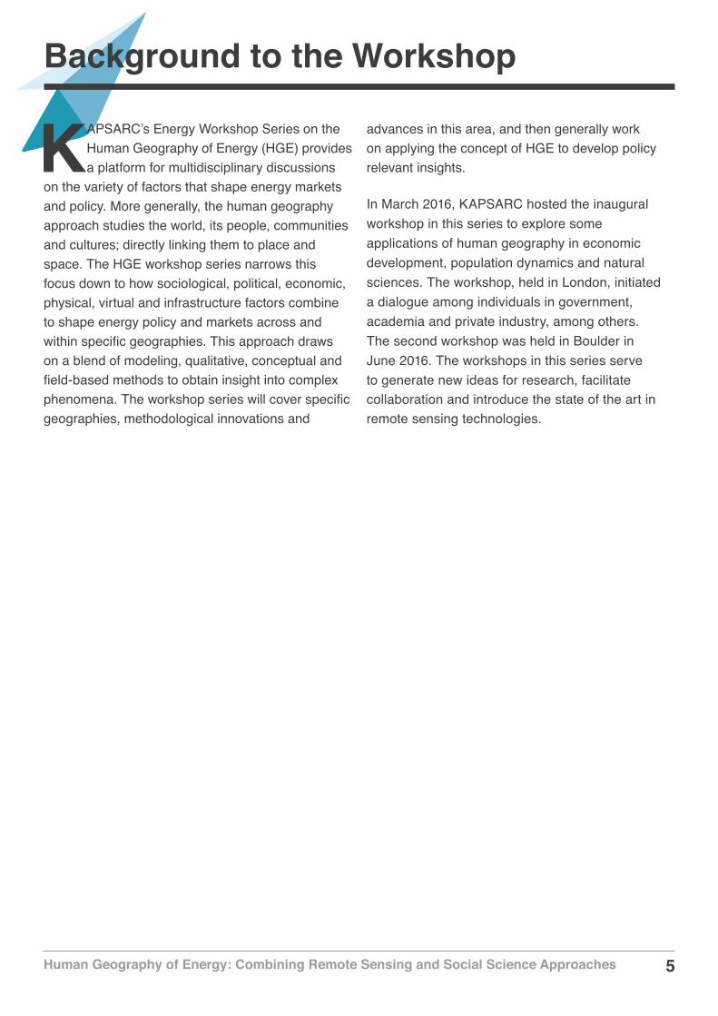
Nighttime lightsNighttime lights are an application of remote sensing that use space-borne assets to measure the brightness of lights at night across the earth. This data has been correlated with a number of measures such as gross domestic product, CO2 emissions and energy consumption. Two standard datasets are used for measuring nighttime lights. The first is the DMPS-OLS, which is considered to be low resolution with 30 arc-second grid. This data struggles to record dimmer lights and has saturation problems that limit analysis. The second dataset is VIIRS, which is considered to be high resolution with 15 arc-second grid. This data has a lower detection threshold, which allows it to record dimmer lights. The impact of this is that VIIRS tends to be more accurate than DMPS-OLS in poorer regions of the world, such as sub-Saharan Africa. Nighttime lights have strong potential applications in studying the intensity of economic and human activity in countries such as China and India with significant energy demand. Nighttime lights can be correlated with extracted spatial features about firm location by economic sector to estimate regional freight flows. This can provide
Remote Sensing Approaches
insight into the role of transport infrastructure in the freight flows of these countries. Figure 1 shows an illustrative example of nighttime lights over North Africa, the Mediterranean and the Levant in April and October 2012.
Multispectral optical imagingMultispectral optical imaging uses a remote sensing radiometer to measure different bands of electromagnetic radiation measured in pixels. Typical bands captured include the human visual spectrum of red, green and blue; an infrared band (usually near infrared, short-ware infrared and thermal), an ultraviolet band and a panchromatic band. The best example of this is Landsat 8, which collects and archives medium resolution (30-meter spatial resolution) multispectral image data with 11 bands.
Figure 2 provides an example of multispectral optical imaging. The Operational Land Imager (OLI) on the Landsat 8 satellite acquired this image of the burn scar on May 12. The false-color image combines shortwave infrared, near infrared and green light (OLI bands 7-5-3). Near- and short-wave infrared help penetrate clouds and smoke (white) to reveal the hot spots associated with active fires (red). With this combination, burned areas appear brown.
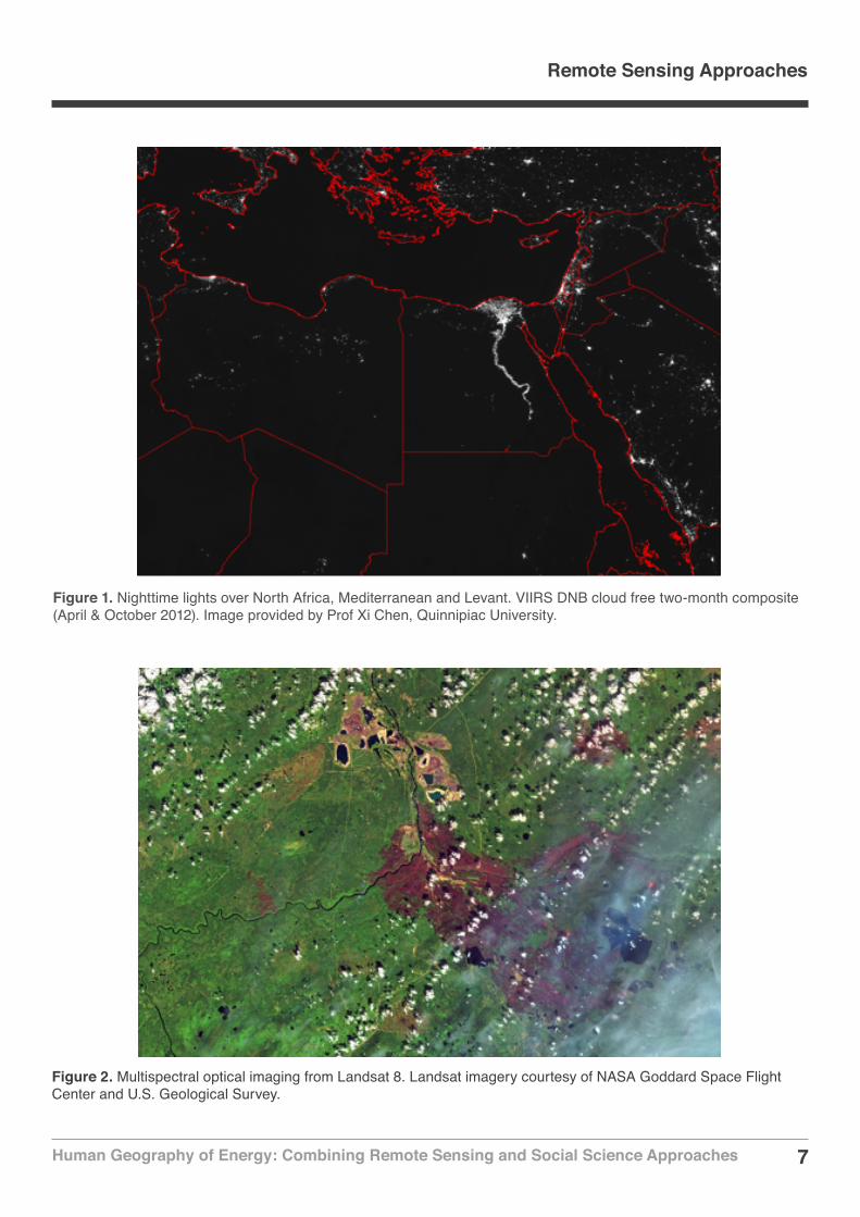
Very high resolution (VHR) optical imagingVHR uses an imaging spectrometer to measure hundreds of different bands of electromagnetic radiation. These are usually called hyperspectral or superspectral optical imaging platforms. The primary advantage of this imagery is the high level of resolution available.
7Human Geography of Energy: Combining Remote Sensing and Social Science Approaches
Figure 1. Nighttime lights over North Africa, Mediterranean and Levant. VIIRS DNB cloud free two-month composite (April & October 2012). Image provided by Prof Xi Chen, Quinnipiac University.
Figure 2. Multispectral optical imaging from Landsat 8. Landsat imagery courtesy of NASA Goddard Space Flight Center and U.S. Geological Survey.
Remote Sensing Approaches
8Human Geography of Energy: Combining Remote Sensing and Social Science Approaches
Remote Sensing Approaches
Figure 3 provides an example of VHR optical imaging for an offshore drilling rig near Kazakhstan in 2014. For instance, DigitalGlobe’s Worldview-3 is a superspectral satellite that can provide .31m resolution panchromatic imagery, 1.24m multispectral resolution and 3.7m short-wave infrared resolution.
Synthetic aperture radar (SAR)SAR imaging data provide information different from that of multispectral and hyperspectral optical imaging platforms operating in the visible and
infrared regions of the electromagnetic spectrum. SAR data consist of high-resolution reflected returns of radar-frequency energy from terrain. The radar returns from the terrain are mainly determined by the physical characteristics of the surface features (such as surface roughness, geometric structure and orientation), the electrical characteristics (dielectric constant, moisture content and conductivity) and the radar frequency of the sensor. There are several advantages that SAR provides over optical imaging that include:
All weather capability (small sensitivity of clouds, light rain).
Figure 3. Offshore drilling rig in Kazakhstan, Aug. 26, 2014; DigitalGlobe Worldview-3 Satellite image. Image provided by DigitalGlobe.

9Human Geography of Energy: Combining Remote Sensing and Social Science Approaches
Remote Sensing Approaches
Figure 4. TerraSAR-X based CO2 storage monitoring at In Salah, Algeria. Image provided by DLR e.V. 2010 and © Airbus DS Geo GmbH 2010.
Day and night operation (independence of sun illumination).
No effects of atmospheric constituents (multitemporal analysis).
Sensitivity to dielectric properties (water content, biomass, ice).
Sensitivity to surface roughness (ocean wind speed).
Accurate measurements of distance (interferometry).
Sensitivity to man-made objects.
Sensitivity to target structure (use of polarimetry).
Subsurface penetration.
One good example of using SAR imaging is using interferometric SAR (or InSAR) imaging to measure the environmental impacts of the Aquistore carbon capture storage site in Canada. In conjunction with tiltmeter data, remote sensing techniques such as InSAR and GPS have the potential to determine changes in subsurface fluid distribution, pressure changes and associated surface deformation. Baseline data has been collected over a 6.5 km2 area since November 2012. Figure 4 provides an example of SAR imaging, with TerraSAR-X based C02 storage monitoring in Algeria in 2010.
10Human Geography of Energy: Combining Remote Sensing and Social Science Approaches 10
Social Science Approaches
The value of using remote sensing is that it can provide unique insights over a wide geographic area without physically collecting
the data. The challenge of using remote sensing to understand issues of energy use and energy development is that remotely sensed data needs to be verified and validated with other measures to ensure its accuracy. This activity is called ground-truthing and usually requires painstaking survey work to be done to capture information about what is actually happening on the ground in the areas where the overhead sensors are collecting imagery and signals.
In the social sciences, this ground-truthing is usually done through household surveys, ethnographic observation or structured interviews. When these methods can be geospatially located, it is possible to correlate these measures with remotely sensed information. Correlating these data can yield greater
insights than either of these methods individually. When we find a high correlation between remote sensing data and measures recorded in a survey, then there is the potential for using remote sensing as a wide area measurement technique. This is essentially how the nighttime lights techniques have come to be used; as proxy measures for population density, economic development and carbon dioxide emissions.
In the last 18 months there have been several innovative remote sensing projects that were used to correlate (or corroborate) survey/interview-based indices. For example, a research team in Colombia was able to corroborate an intra-urban poverty index using land cover and texture metrics derived from very high resolution optical imaging. Another team in the United States was able to use remote sensing data to delineate slum and non-slum communities in a population survey in Utter Pradesh, India.

11Human Geography of Energy: Combining Remote Sensing and Social Science Approaches
Possible High-Impact Applications
After reviewing recent applications of remote sensing and social science approaches, there were several discussions of possible
applications to study energy use and energy development. The discussions were framed to identify applications that would be high-impact and novel, meaning that any insights through this research program should come from new approaches that would be immediately relevant to policymakers.
The most impactful application would be to combine remote sensing methods with household surveys to measure how biomass usage affects land use and vegetation in developing countries with high rates of energy poverty such as India and most countries in sub-Saharan Africa. Estimating the relationship between settlement growth, population density, charcoal production, land use and vegetation using remote sensing data, and validating this information using household surveys, could produce a model to support electrification planning efforts (perhaps through gas utilization) in these countries to slow or halt the negative environmental impacts of using biomass for energy.
Another impactful application would be to study how resource development impacts local communities where the resources are extracted. There are numerous communities in North America that have experienced shale oil/gas development in the last seven years. We are interested in how these communities have been affected using factors of human geography, how settlements grew/changed and what environmental impacts and land use changes occurred. As the technology for developing tight oil/gas continues to progress, more and more communities around the world will experience the
impacts of resource development. This research would provide valuable insights for policymakers in these communities and for operators that are seeking to develop these resources.
There is great promise for using remote sensing approaches to validate data about energy development in countries where access to data are challenging, such as studying coal logistics in China. When building national-level energy systems models in countries such as India and China, researchers are usually limited to official data that is released by the government only to be subsequently revised and reissued at a later date. We are interested in using remote sensing to: i) identify the current infrastructure that supports coal distribution systems, ii) estimate the size of coal stockpiles and the changes in volume over time and iii) determine where coal is sent when it is transported through the distribution network. This research would provide valuable ground truth to national-level energy systems models like KEM-China, and make the insights from these models more valuable to policymakers and analysts.
Related to measuring stockpiles of coal and logistics, is the need for more accurate and timely estimates of global oil inventories. As several recent news stories have illustrated, countries such as China and Russia appear to have been significantly understating the volumes of stored oil and gas, which can have considerable impact on commodity traders seeking to forecast consumption, storage and prices. Most oil inventories are stored in floating lid oil storage tanks or in seaborne shipping vessels that can be remotely sensed, analyzed and combined with additional datasets to provide a more comprehensive understanding of oil flows and global inventory.

12Human Geography of Energy: Combining Remote Sensing and Social Science Approaches
KAPSARC convened the workshops in March and June 2016 with some 35 experts to facilitate a discussion on
remote sensing and social science applications in energy. The workshops were held under a modified version of the Chatham House Rule wherein participants consented to be listed below. However, none of the content in this briefing can be attributed to any individual attendee.
List of Participants
London Workshop – March 23, 2016
Iqbal Adjali, Senior Research Fellow, KAPSARC
Sultan AlMorqi, Director of Advanced Sensors and Electronic Defense, King Abdulaziz City for Science and Technology
Kristian Andersen, Manager of Sales Engineering, DigitalGlobe
Magnus Andersson, Associate Professor, Malmo University
Allen Blocker, Senior Aerospace Adviser, Avian, LLC
Steven Byland, Senior Geospatial Liason, National Geospatial Intelligence Agency
Rejean Casaubon, Chief of Analysis and Modelling Division, Natural Resources Canada
Xi Chen, Assistant Professor, Quinnipiac University
Melanie Clift, Business Development Manager, Airbus
Rex Douglass, Postdoctoral Fellow, UC San Diego
Brian Efird, Program Director, KAPSARC
Andrew Ellis, Head of Global Energy Analytics Groups, IHS
About the Workshops
Alex Gow, Sales Engineer, DigitalGlobe
Rami Hazime, Senior Regional Sales Manager for EMEA, DigitalGlobe
Richard King, Research Fellow, Chatham House
Lise Lizenga, Director of EMEA Operations, Symkala
Daniel Mabrey, Research Fellow, KAPSARC
Carlo Pecori, Program Manager, University of New Haven
Michele Vittorio, Research Fellow, KAPSARC
Sonia Yeh, Adlerbertska Visiting Professor, Chalmers University of Technology
Boulder, Colorado Workshop – June 7, 2016
Iqbal Adjali, Senior Research Fellow, KAPSARC
Amar Amarnath, Research Fellow, KAPSARC
Kristian Andersen, Manager of Sales Engineering, DigitalGlobe
Magnus Andersson, Associate Professor, Malmo University
Magdalena Czarnogorska, Research Associate, Natural Resource Canada
Stephanie Eckman, Senior Survey Research Methodologist, RTI International
Brian Efird, Program Director, KAPSARC
Rami Hazime, Senior Regional Sales Manager for EMEA, DigitalGlobe
Johnny Heald, Managing Director, ORB International
13Human Geography of Energy: Combining Remote Sensing and Social Science Approaches
David Hobbs, Head of Research, KAPSARC
Sara Lechtenberg-Kasten, Research Fellow, KAPSARC
Daniel Mabrey, Research Fellow, KAPSARC
Jason Maddocks, Systems Engineer, Avian, LLC
Jake McKee, Researcher, Oak Ridge National Laboratories
David Peng, Chief Statistician, D3 Systems
Daniele Perissin, Assistant Professor, Purdue University
Jorge Quinchia, Geological Engineer, Universidad EAFIT
David Rae, Statistical Programmer, D3 Systems
Ram Sharma, Research Associate, Chiba University
Ronald Twongyirwe, Senior Lecturer, Mbarara University of Science and Technology
Peter Vining, Doctoral Student, New York University
Michele Vittorio, Research Fellow, KAPSARC
Qihao Weng, Director of the Center for Urban and Environmental Change, Indiana State University
Naizhuo Zhao, Research Associate, Texas Tech University
About the Workshop

14Human Geography of Energy: Combining Remote Sensing and Social Science Approaches
Michele Vittorio, is a research fellow at KAPSARC leading the efforts to create GIS and remote sensing capabilities in the Research department.
Michele Vittorio
About the Project
This research program seeks to combine remote sensing and social science methods to study energy development, energy use and inform energy policy. This is a novel research program that does not exist at the leading energy research centers in the world. The impact of this research program could yield new and significant insights in how energy is measured and studied. The research team has launched two pilot projects in 2017, with an eye toward expanding KAPSARC’s research into RS3 by the end of 2017 and into 2018. These projects blend remote sensing techniques with social science approaches to understand how energy use and energy development are affecting communities, cities and regions.
Daniel Mabrey
Brian Efird
Brian Efird is a senior research fellow and the program director for policy and decision science at KAPSARC, leading teams on the modeling of collective decision making processes (CDMPs), GIS applications to energy economics and policy, remote sensing and social science (RS3), China, and the Gulf Cooperation Council countries.
About the Team
Daniel Mabrey was formerly a research fellow at KAPSARC and led a team focused on Eastern Africa. He has returned to his position as an associate professor at the University of New Haven in CT, USA.

15Human Geography of Energy: Combining Remote Sensing and Social Science Approaches
Notes

16Human Geography of Energy: Combining Remote Sensing and Social Science Approaches
www.kapsarc.org