Embed Size (px)
Citation preview

Hurlock Comprehensive
Plan 2009

TOWN OF HURLOCK, MARYLAND – 2009 COMPREHENSIVE PLAN 1
Table of Contents
Introduction ....................................................................................................................... 5 Introduction ...................................................................................................................5 Legal Basis for Planning in Maryland............................................................................5
The State’s Twelve Visions for Guiding Future Growth.............................................5 1997 Priority Funding Areas Act................................................................................6
The Smart Growth Initiative...........................................................................................6 House Bill 1141 (Enacted during the 2006 Legislative Session)..............................7 Annexation Procedures.............................................................................................7 New Planning Elements ............................................................................................8
Hurlock’s Past and Its Future Vision ............................................................................... 10 Location.......................................................................................................................10 History .........................................................................................................................11 Community Participation .............................................................................................12 Future Vision ...............................................................................................................13 Goals and Objectives ..................................................................................................13 Conclusions.................................................................................................................14
Hurlock Today - Social, Economic and Housing Characteristics .................................... 16 Population and Demographics ....................................................................................16
Population Trends ...................................................................................................16 Age Composition.....................................................................................................18 Sex and Racial Composition ...................................................................................20 Education ................................................................................................................21 Employment and Labor Force Characteristics ........................................................22 Commuting to Work ................................................................................................24 Income and Poverty ................................................................................................24 Household Type ......................................................................................................26
Community Facilities....................................................................................................... 27 Introduction ................................................................................................................27
Water Systems........................................................................................................27 Groundwater Sources .............................................................................................27 Water Storage .........................................................................................................28 Water Summary ......................................................................................................28 Sewer Systems .......................................................................................................29 Sewer Summary......................................................................................................30 Other Community Facilities .....................................................................................30
Introduction .................................................................................................................34 Existing Land Uses .....................................................................................................37 Goals, Objectives and Policies....................................................................................40
Municipal Growth Element .............................................................................................. 43 Introduction .................................................................................................................43 Historic Growth Patterns .............................................................................................43 Development Capacity Analysis..................................................................................43 Population Projections ................................................................................................45 Future Land Use .........................................................................................................48 Current Town Boundaries ...........................................................................................48 Growth Areas ..............................................................................................................50 Growth Area Development Alternatives ......................................................................52
Urban Growth Boundary .........................................................................................53 Growth Area Summary................................................................................................55
TOWN OF HURLOCK, MARYLAND – 2009 COMPREHENSIVE PLAN 2
Growth Demands for Public Facilities .....................................................................56 Policies and Recommendations..................................................................................60
Water Resources Element .............................................................................................. 64 Introduction .................................................................................................................64 Water Systems............................................................................................................65
Groundwater Sources .............................................................................................65 Water Summary ......................................................................................................68
Wastewater Systems ..................................................................................................68 Wastewater Flows...................................................................................................68 Inflow & Infiltration...................................................................................................69 Septic Systems .......................................................................................................70 Wastewater Summary.............................................................................................70
Hypothetical Build-Out Scenario .................................................................................70 County Water and Sewer Master Plan....................................................................70 Stormwater Loading ................................................................................................71
Policies and Recommendations..................................................................................73 Transportation Element................................................................................................... 74
Introduction .................................................................................................................74 Goals and Objectives ..................................................................................................74
Roadway System ....................................................................................................75 Functional Classification of Streets .............................................................................75
Major Arterials: ........................................................................................................75 Major Collectors: .....................................................................................................75 Minor Collectors: .....................................................................................................76 Neighborhood Collectors:........................................................................................77 Local Streets, Cul-de-Sacs and Alleys: ...................................................................77
Levels of Service Standards .......................................................................................78 SHA’s When Main Street is a State Highway Guide ...................................................78 Highway Needs Inventory ...........................................................................................78 Alternative Transportation ...........................................................................................78 SHA Assistance Programs..........................................................................................81 Improvements Plan .....................................................................................................83
Short Range ............................................................................................................83 Intermediate Range.................................................................................................83 Long Range.............................................................................................................83 Parkway/Bypass......................................................................................................83 State and Local Responsibilities .............................................................................84 Financial Impact and Funding Mechanisms............................................................84
Policies and Recommendations..................................................................................84 Housing........................................................................................................................... 86
Introduction .................................................................................................................86 Goals and Objectives ..................................................................................................86 2006 House Bill 1160 ..................................................................................................87
Workforce Housing Grant Program Definitions and Standards...............................87 Workforce Housing Assessment .............................................................................87 Rental Housing........................................................................................................88 Homeownership Housing ........................................................................................88
Hurlock’s Workforce and Affordable Housing Needs ..................................................89 Policies and Implementation .......................................................................................89
Sensitive Areas ............................................................................................................... 91 Introduction .................................................................................................................91

TOWN OF HURLOCK, MARYLAND – 2009 COMPREHENSIVE PLAN 3
Goals and Objectives ..................................................................................................91 Natural and Environmental Features ..........................................................................91 Critical Areas...............................................................................................................93 Steep Slopes...............................................................................................................93 Culturally and Historically Sensitive Areas..................................................................94
Protection and Preservation Programs ...................................................................95 Policies and Recommendations..................................................................................95
Mineral Resources .......................................................................................................... 98 Introduction .................................................................................................................98 Goals and Objectives ..................................................................................................98 Mineral Resources ......................................................................................................98
Mining Industry in Dorchester County .....................................................................98 Wellhead Protection Areas......................................................................................99 Existing and Committed Development ....................................................................99
Conclusions.................................................................................................................99 Policies and Recommendations..................................................................................99
Plan Implementation ..................................................................................................... 102 Land Use Goals, Objectives and Policies .................................................................102 Municipal Growth Policies and Recommendations ...................................................103 Water Resources Policies and Recommendations ...................................................105 Transportation Policies and Recommendations........................................................106 Workforce Housing Policies and Recommendations ................................................107 Sensitive Areas Policies and Recommendations......................................................108 Funding Recommendations ......................................................................................109 Final Acknowledgements ..........................................................................................109
Appendix A: Waste Water Loading Model Spreadsheet .............................................. 124 Appendix B: Historic Preservation Programs............................................................... 126 Mayland Department of Planning Review Comments................................................... 129
List of Figures Figure 1: Location Map ................................................................................................10 Figure 2: Population Trends.........................................................................................16 Figure 3: Population Change by Age Group 1990-2000 ..............................................18 Figure 4: Population Ratio by Sex – Year 2000 ...........................................................20 Figure 5: Racial Composition – Year 2000 ..................................................................21 Figure 6: Hurlock Regional Employment Influence ......................................................35 Figure 7: Hurlock Population Projection (2010 – 2030) ...............................................46 Figure 8: Working Draft – Hurlock Area .......................................................................55 Figure 9: Transit Stops Within the Town of Hurlock.....................................................79 Figure 10: MUST Transit Fixed Routes..........................................................................80 Figure 11: State (SHA) Designated Neighborhoods ......................................................82 Figure 12: Affordable Housing by Household Size ........................................................88 Figure 13: Income Available for Homeownership Payments .........................................89
TOWN OF HURLOCK, MARYLAND – 2009 COMPREHENSIVE PLAN 4
List of Tables Table 1: Hurlock Population Trends 1970-2000...........................................................16 Table 2: Dorchester County Population Trends ...........................................................17 Table 3: Percent of Population by Age Cohort by Municipality 2000 ...........................19 Table 4: Educational Statistics 2000 ............................................................................22 Table 5: Industry & Employment Characteristics 2000 ................................................23 Table 6: Class of Worker 2000.....................................................................................23 Table 7: Commuting to Work Statistics 2000...............................................................24 Table 8: Household Income Characteristics 1999 .......................................................25 Table 9: Family Income Characteristics 2000 ..............................................................25 Table 10: Household Characteristics 1990-2000 ...........................................................26 Table 11: Well Pump Summary .....................................................................................27 Table 12: Existing Park Acreages - Hurlock, Maryland..................................................30 Table 13: Existing Land Uses and Acreages 2009 ........................................................38 Table 14: New Residential Building Permits Approved Since 2000...............................44 Table 15: Development Capacity Analysis.....................................................................47 Table 16: Growth Area Development Alternatives .........................................................53 Table 17: Growth Area Summary...................................................................................56 Table 18: Potential future Enrollment Increases ............................................................58 Table 19: Well Capacities and Estimated Potable Water Usage ...................................67 Table 20: Functional Classification of Streets ................................................................76 Table 21: Workforce Housing Grant Program Eligibility Standards ...............................87
TOWN OF HURLOCK, MARYLAND – 2009 COMPREHENSIVE PLAN 5
Introduction
Introduction Hurlock’s Comprehensive Plan looks at potential growth within the Town through the year 2030. Infrastructure, housing, growth and many other issues are discussed within this plan. The main purpose of this plan is to properly prepare for growth and other issues that the Town will encounter over the next twenty years.
Legal Basis for Planning in Maryland Article 66B of the Annotated Code of Maryland requires municipalities that maintain zoning authority over the jurisdiction to develop a comprehensive plan. This article also requires municipalities to address specific issues within their growth plans. 2006 House Bill 1141 further requires municipalities to address the impact projected growth will have on infrastructure, water resources, schools, libraries and public safety. Hurlock’s Comprehensive Growth Plan meets the necessary requirements under Article 66B and House Bill 1141, and further addresses workforce housing in order to be able to participate in the Workforce Housing Grant Program developed under House Bill 1160. The information below further discusses Maryland’s visions and requirements for growth as they relate to Hurlock.
The State’s Twelve Visions for Guiding Future Growth The following twelve “vision statements” are based on the 1992 Planning Act, and subsequent amendments thereto including most recently, Senate Bill 273 of the 2009 General Assembly. The visions, which take effect on October 1, 2009, are incorporated into this Comprehensive Plan as fundamental goals which will be achieved through a variety of objectives, policies, principles, recommendations, and implementation techniques. 1) Quality of life and sustainability: a high quality of life is achieved through universal
stewardship of the land, water, and air resulting in sustainable communities and protection of the environment;
(2) Public participation: citizens are active partners in the planning and implementation of community initiatives and are sensitive to their responsibilities in achieving community goals;
(3) Growth areas: growth is concentrated in existing population and business centers, growth areas adjacent to these centers, or strategically selected new centers;
(4) Community design: compact, mixed–use, walkable design consistent with existing community character and located near available or planned transit options is encouraged to ensure efficient use of land and transportation resources and preservation and enhancement of natural systems, open spaces, recreational areas, and historical, cultural, and archeological resources;
TOWN OF HURLOCK, MARYLAND – 2009 COMPREHENSIVE PLAN 6
(5) Infrastructure: growth areas have the water resources and infrastructure to accommodate population and business expansion in an orderly, efficient, and environmentally sustainable manner;
(6) Transportation: a well–maintained, multimodal transportation system facilitates the safe, convenient, affordable, and efficient movement of people, goods, and services within and between population and business centers;
(7) Housing: a range of housing densities, types, and sizes provides residential options for citizens of all ages and incomes;
(8) Economic development: economic development and natural resource–based businesses that promote employment opportunities for all income levels within the capacity of the State’s natural resources, public services, and public facilities are encouraged;
(9) Environmental protection: land and water resources, including the Chesapeake and coastal bays, are carefully managed to restore and maintain healthy air and water, natural systems, and living resources;
(10) Resource conservation: waterways, forests, agricultural areas, open space, natural systems, and scenic areas are conserved;
(11) Stewardship: government, business entities, and residents are responsible for the creation of sustainable communities by collaborating to balance efficient growth with resource protection; and
(12) Implementation: strategies, policies, programs, and funding for growth and development, resource conservation, Infrastructure, and transportation are integrated across the local, regional, state, and interstate levels to achieve these visions.
1997 Priority Funding Areas Act The 1997 Priority Funding Areas Act capitalizes on the influence of State expenditures on economic growth and development. This legislation directs State spending to Priority Funding Areas (PFA). PFAs are existing communities and places where local governments want State investment to support future growth. Growth-related projects covered by the legislation include most State programs that encourage or support growth and development such as highways, sewer and water construction, economic development assistance, and State leases or construction of new office facilities. The PFA legislation builds on the foundation created by the Visions that were adopted as State policy in the 1992 Economic Growth, Resource Protection and Planning Act and are articulated above as fundamental goals for the Town of Hurlock. Beginning October 1, 1998, the State of Maryland directed funding for projects that support growth to PFAs. Funding for projects in municipalities, other existing communities, industrial areas, and planned growth areas designated by counties receive priority State funding over other projects. PFAs are locations where the State and local government want to target their efforts to encourage and support economic development and new growth.
The Smart Growth Initiative
TOWN OF HURLOCK, MARYLAND – 2009 COMPREHENSIVE PLAN 7
In addition to the Priority Funding Areas Act, the 1997 General Assembly passed four other pieces of legislation and budget initiatives – Brownfields, Live Near Your Work, Job Creation Tax Credits, and Rural Legacy-known collectively as “Smart Growth”. Smart Growth directs the State to target programs and funding to support established communities and locally designated growth areas, and to protect rural areas. The Priority Funding Areas Act provides a geographic focus for the State’s investment in growth-related infrastructure. The remaining four components complement this geographic focus by targeting specific State resources to preserve land outside of PFAs, to encourage growth inside PFAs, and to ensure that existing communities continue to provide a high quality of life for their residents. Maryland has adopted the following principles of Smart Growth, which provide guidance for new development, infill development, and redevelopment:
- Mixed land uses; - Take advantage of compact building design; - Create housing opportunities and choices; - Create walkable communities; - Foster distinctive, attractive communities with a strong sense of place; - Preserve open space, farmland, natural beauty, and critical environmental areas; - Provide a variety of transportation options; - Strengthen and direct development to existing communities; - Make development decisions predictable, fair and cost effective; and - Encourage community and stakeholder collaboration in development decisions.
Although the 1997 Smart Growth initiative was significant in the State’s refusal to fund wasteful sprawl development, it is also only one component in the continuum of Maryland’s growth policy development.
House Bill 1141 (Enacted during the 2006 Legislative Session) During the 2006 Maryland Legislative Session, House Bill 1141 was enacted. This is a key planning related law having a direct effect on procedures for annexation and requiring new planning elements within Hurlock’s Comprehensive Plan.
Annexation Procedures There are two significant changes, with respect to annexation procedures, which affect the Town. The first change is dealing with “the five year rule” and the second change deals with “annexation plans”. The Five Year Rule There are two changes here. First, the rule would be applied solely based upon zoning. In the past, the five-year rule could be applied whenever a proposed new zoning classification was substantially different from the use envisioned “in the current and duly adopted master plan”. Secondly, the reference to the master plan is now gone and the issue becomes the degree of change from the current county zoning classification to the
TOWN OF HURLOCK, MARYLAND – 2009 COMPREHENSIVE PLAN 8
proposed municipal classification following the annexation. When the zoning change is from one residential zone to another, “substantially different” now is defined as a density change. The five-year rule will not kick in for a density change unless the proposed zoning is 50% denser. For example, if the current zoning permits 1 unit per acre, the new zoning can be subject to the five year rule if it permits anything more than 1.5 units per acre. As before, a municipality may obtain a waiver from the county to avoid the five-year wait until the new zoning classification applies. This change took effect on October 1, 2006. Annexation Plans An annexation plan is required that replaces the “outline” for the extension of services and public facilities prior to the public hearing for an annexation proposal. This section contains no additional language for the content of the annexation plan to be adopted, but does require it to be consistent with the municipal growth element for any annexations that begin after October 1, 2009. The Plan must be provided to the County and State (the Maryland Department of Planning) at least 30 days prior to the hearing. The requirement for an annexation plan and the requirement that it be provided to the Maryland Department of Planning took effect on October 1, 2006. The requirement for consistency with the Municipal Growth Element of the comprehensive plan takes effect no later than October 1, 2009 (unless extended for up to two six-month periods).
New Planning Elements The new legislation mentioned above requires two new elements (i.e. chapters) of local comprehensive plans. The first element, the Water Resources Plan Element, is required of all local governments (county and municipal) that exercise planning and zoning authority. The second element, the Municipal Growth Element, is required in municipal comprehensive plans only. Both elements are required to be incorporated into the Town’s Comprehensive plan no later than October 1, 2009 (unless extended for up to two six-month periods). The Water Resources Element This new planning element addresses the relationship of planned growth to water resources for both waste disposal and safe drinking water. It will be required of all county and municipal governments in the State. The element must identify drinking water and other water resources adequate for the needs of existing and future development proposed in the land use element of the comprehensive plan. It must also identify suitable receiving waters for both wastewater and storm water management to meet the needs of existing and projected development proposed in the land use element of the comprehensive plan. The Maryland Department of Natural Resources will provide available data to identify these resources. Resource issues expected to be addressed in these elements include water protection areas, groundwater resources, water quality standards and Total Maximum Daily Loads (TMDLs). The Municipal Growth Element
TOWN OF HURLOCK, MARYLAND – 2009 COMPREHENSIVE PLAN 9
This element requires a municipality to identify areas for future growth consistent with a long-range vision for its future. The growth element will be developed based on consideration of a comprehensive list of factors including population projections, an assessment of land capacity and needs and an assessment of infrastructure and sensitive areas. Completion of the element will guide future annexation proposals and plans after October 2009. Consultation with Dorchester County is required, and a joint agreement with the county is encouraged. 2009 Maryland General Assembly The 2009 legislative session saw several bills introduced by the Governor that became law. The Smart, Green and Growing initiative saw three key planning bills voted into law. These new laws will not affect this version of the Comprehensive Plan, but they will add new direction for future comprehensive plans. Also, beginning in 2010 municipalities will be required to track the progress of their comprehensive plan and development based on certain measures and indicators. Planning Commissioners and Boards of Appeals members will also be required to go through a training session to help orient them toward the rules and responsibilities of their position. Below is a brief summary of the three planning bills of the 2009 legislative session.
• Smart and Sustainable Growth Act of 2009 – A bill addressing the Terrapin Run decision and implementing a new standard of “consistency” governments must have between their comprehensive plans and development decisions.
• Smart Growth Measures and Markers – Allows the State to create “Smart
Growth” standards to measure local government’s Smart Growth process.
• Planning Visions – Creates several new State planning visions to help guide comprehensive planning and growth in Maryland.
Hurlock should work closely with the Maryland Department of Planning monitor the progress of these new laws and their affect on Hurlock.
TOWN OF HURLOCK, MARYLAND – 2009 COMPREHENSIVE PLAN 10
Hurlock’s Past and Its Future Vision
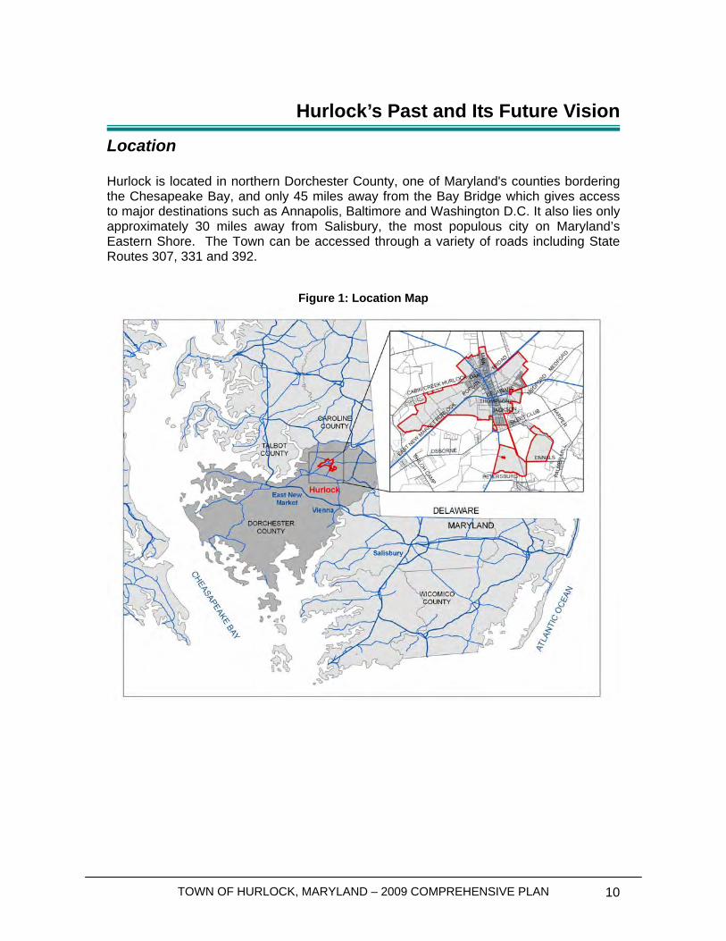
Location Hurlock is located in northern Dorchester County, one of Maryland's counties bordering the Chesapeake Bay, and only 45 miles away from the Bay Bridge which gives access to major destinations such as Annapolis, Baltimore and Washington D.C. It also lies only approximately 30 miles away from Salisbury, the most populous city on Maryland’s Eastern Shore. The Town can be accessed through a variety of roads including State Routes 307, 331 and 392.
Figure 1: Location Map
TOWN OF HURLOCK, MARYLAND – 2009 COMPREHENSIVE PLAN 11
History Sixty-six cents was all it took in 1801 to purchase about one acre of land upon which the first significant building in the Hurlock area was built. After the Delaware Railroad built a station in 1867, in what is now Hurlock, and John M. Hurlock built a storehouse and his residence close by, the Washington Chapel congregation in 1888 combined with two others to erect a new church within the Hurlock community - The Washington Methodist Church. But it was not until 1890, when the Baltimore, Chesapeake and Atlantic (BC&A) Railroad intersected the Delaware Railroad in Hurlock, that the Town really started to grow. Because of its excellent railroad facilities that carried passengers and products to major destinations, Hurlock became the industrial and commercial hub of the northern part of Dorchester County. It still holds that distinction, which is reflected in the Town's motto, "On track...since 1892." Hurlock is the home to several industries and businesses related to food and poultry products, trucking, and other manufacturing. In 1987 the fully serviced Industrial Park was established on ninety-seven acres owned by the Town. The entire Industrial Park was designated as a State Enterprise Zone in 1989, providing substantial tax incentives to new industries meeting certain qualifying criteria. Hurlock has maintained not only the industrial and commercial significance bestowed by its railroad presence, but also the community spirit first exhibited with the construction of the Washington Chapel. Hurlock has numerous churches representing a variety of denominations. The Hurlock Free Library, which is the oldest library on the Eastern Shore of Maryland and the second oldest in the State, originated in the Hurlock home of Henry Walworth in 1900. The community honored World War I veterans with a marble statue financed through local fund-raising events. Hurlock's community spirit is most evident at the Hurlock Fall Festival, now held on the first Saturday of October every year. Initiated during the Town's Centennial celebration in 1992, the Fall Festival offers a full day of events - a kick-off parade, crafts, flea markets, food, family activities, and train rides. There is also a train station that serves as the central location of the Hurlock Fall Festival. The Town owns the train station. The Town refurbished it with public and private funds in a design based on that of the first station built in Hurlock in 1867. The Town also owns two passenger cars that are used to provide train rides during the Fall Festival. Source: Hurlock Town’s website: http://www.hurlockmd.net/history.html
TOWN OF HURLOCK, MARYLAND – 2009 COMPREHENSIVE PLAN 12
Community Participation In order to develop a vision for Hurlock’s future, direct input from residents and businesses was sought out. In early 2009, the Town Council and Planning Commission met separately to discuss the comprehensive planning process and to start envisioning the future of Hurlock, as well as formulating goals and objectives. After discussions with the Town Council and Planning Commission, a community workshop was held solely to gain public input from residents, business owners and elected and appointed officials. The workshop was held prior to drafting the Comprehensive Plan so the provided input could be used to develop the future vision for the community. The workshop was held on March 4th, 2009, at the Town Hall and was attended by small number of residents, business owners, and Town Officials, which allowed in-depth exchanges about the Town’s issues. The participants’ input was then used to develop the “Future Vision” and “Goals and Objectives” sections below. A summary of the community workshop is also provided in this chapter. Public Workshop One of the main issues raised by the participants was the necessity to encourage employment opportunities close to Hurlock and bring back more life to Downtown. For instance, the lack of shopping opportunities in Town, particularly retail and groceries, was a concern repeatedly brought back into discussion during the workshop. Suggested strategies to attract businesses and people in Town included promoting industrial development and emphasizing the Town’s historic character to make it a prime tourist destination in Dorchester County. Hurlock indeed possesses a number of important historical features that could be renovated and advertised, such as a beautiful old train station and the library – which is the second oldest library in Maryland. For instance, converting one of Hurlock’s historic buildings into a museum could act as a pull factor for people to come and visit the Town. Residents also expressed the need to revitalize downtown and to improve the condition of streets and sidewalks which call for repair. It was agreed upon that Main Street, in particular, should be the main focus of façade improvements and economic development. Other ideas for improvement included developing new housing for Emergency and Medical Services (EMS) and public health departments, increasing the amount of youth facilities in Town (especially as the Town has been experiencing an aging population), and developing pedestrian and bicycle trails. A participant also pointed out that though the Town should provide affordable housing to its residents, upper scale growth should equally be encouraged. Finally, though Hurlock’s industry is not as thriving as it used to be, there was consensus that the Town should work on reestablishing itself as an industrial hub. Consequently, industrial and residential uses should be promoted above existing agricultural uses in order to promote economic activity in Town.
TOWN OF HURLOCK, MARYLAND – 2009 COMPREHENSIVE PLAN 13
Future Vision Hurlock has always been a typical Eastern Shore rural community: a vibrant community with a historical downtown business district and a wealth of natural resources. Development over the past few years has threatened the character of the community, made the future somewhat uncertain and has generated a sense of awareness to make Hurlock a better place for generations to come. However, Hurlock residents are proud of their community and believe the Town has the potential to develop again in a dynamic industrial center at the heart of Dorchester County. With well-established important industries such as Allen Family Foods and Hatchery (poultry industry) or Bloch and Guggenheimer, Inc. (producer of food condiments), a growing industrial park that offers various opportunities to new companies, and tax incentives, Hurlock hopes to attract new industries that would help stimulate economic renewal within Town. In parallel, the Town would like to go back to its traditional roots, emphasizing its identity as an industrial town blooming around the train tracks. Proposals to establish an excursion train between Hurlock and Preston will receive careful study to determine opportunities and challenges that need to be addressed. This effort should be encouraged to promote the Town’s future tourism potential by capitalizing on Hurlock’s history and heritage. The downtown area should be partially supported by residents living above the existing commercial buildings, creating a vibrant mixed-use community in Hurlock. New development and the downtown area should be connected via sidewalks and walking paths, while already existing sidewalks and streets downtown should be revitalized, as needed, for everyday pedestrian and vehicular use. The architecture in downtown Hurlock should be preserved and enhanced, but not in a manner that would take away from Hurlock’s uniqueness. Lastly, combining forces with historic neighboring towns such as Vienna could help build a stronger identity to the area and attract more visitors. A focus on parks and recreational facilities is also important for Hurlock. Residents have asked for additional recreational facilities, which are particularly important to attract and maintain a healthy young population within a Town with an aging population. The Town has recognized the need for improvements to the parks system, hence the development of a new park at the north of Main Street.
Goals and Objectives
1. Reestablish Hurlock’s traditional Town Center through encouraging mixed-use development downtown;
2. Promote the Town as an industrial hub to attract new industries and develop an economic strategic plan to meet this goal;
3. Make the Town a destination for visitors, by encouraging cultural activities and events such as the Fall Festival or the Hurlock Christmas Parade;
4. Support efforts to establish an “excursion train” that will promote tourism. 5. Direct future growth into the downtown community or within the existing Town
boundaries, either as infill growth or where vacancies exist in committed development;

TOWN OF HURLOCK, MARYLAND – 2009 COMPREHENSIVE PLAN 14
6. Create a plan to manage future annexations, especially to control sprawling residential growth;
7. Repair, maintain and develop park facilities to provide a wealth of recreational activities for the community;
8. Continue to seek environmentally friendly solutions to issues throughout the community;
9. Create viable, alternative modes of transportation by seeking out bike paths and creating a system of interconnected sidewalks;
10. Create an overall “smart growth” vision and approach to regulating development in the community;
11. Prohibit potentially harmful development that will affect sensitive areas, including Chesapeake Bay and the surrounding waterways;
12. Focus on preserving ecologically significant land surrounding the community, especially existing forested lands and wetland areas;
13. Ensure a variety of housing alternatives for all residents of Hurlock; 14. Provide a future growth pattern that has the least impact on water resources and
other community facilities; 15. Implement the polices and recommendations of this plan, through amending the
Town Code and enforcing existing regulations; 16. Develop a funding mechanism to assist in the implementation of this plan.
Conclusions Hurlock is a community with a wealth of resources that is very focused on improving the way of life in a manner that is sustainable for generations to come, while searching for economic revival through the promotion of industrial development. The community also recognizes its attraction and understands why tourism is important and new residents will continue to flock to the area. However, the community is also very aware of the need to sustain the quality of life in the community in order to maintain its character. This plan should act as one of several items helping focus the future vision of Hurlock over the next 20 years to maintain the high quality of life in Hurlock.

TOWN OF HURLOCK, MARYLAND – 2009 COMPREHENSIVE PLAN 15
This page was intentionally left blank
TOWN OF HURLOCK, MARYLAND – 2009 COMPREHENSIVE PLAN 16
Hurlock Today - Social, Economic and Housing Characteristics
Population and Demographics
Population Trends
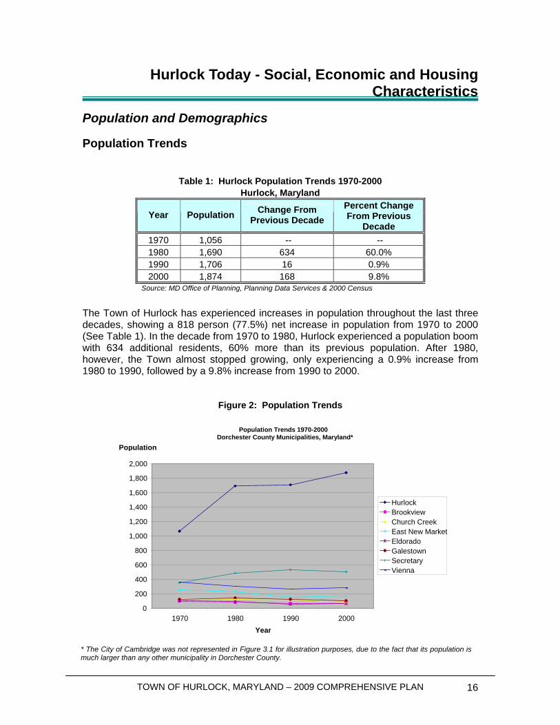
Table 1: Hurlock Population Trends 1970-2000 Hurlock, Maryland
Year Population Change From Previous Decade
Percent Change From Previous
Decade 1970 1,056 -- -- 1980 1,690 634 60.0% 1990 1,706 16 0.9% 2000 1,874 168 9.8%
Source: MD Office of Planning, Planning Data Services & 2000 Census
The Town of Hurlock has experienced increases in population throughout the last three decades, showing a 818 person (77.5%) net increase in population from 1970 to 2000 (See Table 1). In the decade from 1970 to 1980, Hurlock experienced a population boom with 634 additional residents, 60% more than its previous population. After 1980, however, the Town almost stopped growing, only experiencing a 0.9% increase from 1980 to 1990, followed by a 9.8% increase from 1990 to 2000.
Figure 2: Population Trends
Population Trends 1970-2000Dorchester County Municipalities, Maryland*
0
200 400 600 800
1,000 1,200 1,400 1,600 1,800 2,000
1970 1980 1990 2000Year
Hurlock Brookview Church Creek East New Market Eldorado Galestown Secretary Vienna
Population
* The City of Cambridge was not represented in Figure 3.1 for illustration purposes, due to the fact that its population is much larger than any other municipality in Dorchester County.
TOWN OF HURLOCK, MARYLAND – 2009 COMPREHENSIVE PLAN 17
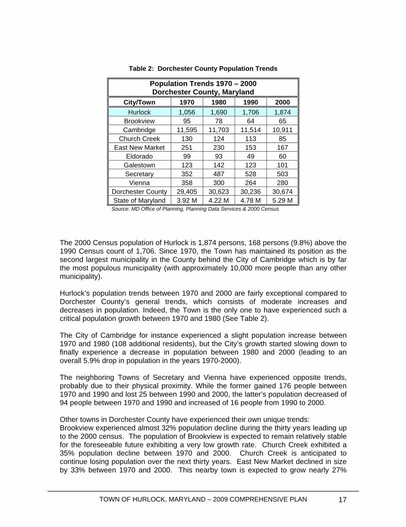
Table 2: Dorchester County Population Trends The 2000 Census population of Hurlock is 1,874 persons, 168 persons (9.8%) above the 1990 Census count of 1,706. Since 1970, the Town has maintained its position as the second largest municipality in the County behind the City of Cambridge which is by far the most populous municipality (with approximately 10,000 more people than any other municipality). Hurlock’s population trends between 1970 and 2000 are fairly exceptional compared to Dorchester County’s general trends, which consists of moderate increases and decreases in population. Indeed, the Town is the only one to have experienced such a critical population growth between 1970 and 1980 (See Table 2). The City of Cambridge for instance experienced a slight population increase between 1970 and 1980 (108 additional residents), but the City’s growth started slowing down to finally experience a decrease in population between 1980 and 2000 (leading to an overall 5.9% drop in population in the years 1970-2000). The neighboring Towns of Secretary and Vienna have experienced opposite trends, probably due to their physical proximity. While the former gained 176 people between 1970 and 1990 and lost 25 between 1990 and 2000, the latter’s population decreased of 94 people between 1970 and 1990 and increased of 16 people from 1990 to 2000. Other towns in Dorchester County have experienced their own unique trends: Brookview experienced almost 32% population decline during the thirty years leading up to the 2000 census. The population of Brookview is expected to remain relatively stable for the foreseeable future exhibiting a very low growth rate. Church Creek exhibited a 35% population decline between 1970 and 2000. Church Creek is anticipated to continue losing population over the next thirty years. East New Market declined in size by 33% between 1970 and 2000. This nearby town is expected to grow nearly 27%
Population Trends 1970 – 2000 Dorchester County, Maryland
City/Town 1970 1980 1990 2000 Hurlock 1,056 1,690 1,706 1,874
Brookview 95 78 64 65 Cambridge 11,595 11,703 11,514 10,911
Church Creek 130 124 113 85 East New Market 251 230 153 167
Eldorado 99 93 49 60 Galestown 123 142 123 101 Secretary 352 487 528 503
Vienna 358 300 264 280 Dorchester County 29,405 30,623 30,236 30,674 State of Maryland 3.92 M 4.22 M 4.78 M 5.29 M
Source: MD Office of Planning, Planning Data Services & 2000 Census
TOWN OF HURLOCK, MARYLAND – 2009 COMPREHENSIVE PLAN 18
(according to MDP projections) over the next thirty years. Eldorado has declined by 39% but is expected to begin a very slow but steady population increase that should remain stable into the future. Galestown declined 18% during the last thirty years and is expected to reverse that trend with 26% growth over the next thirty. These expectations reflect the anticipated implementation of County-wide smart growth/anti-sprawl policies.
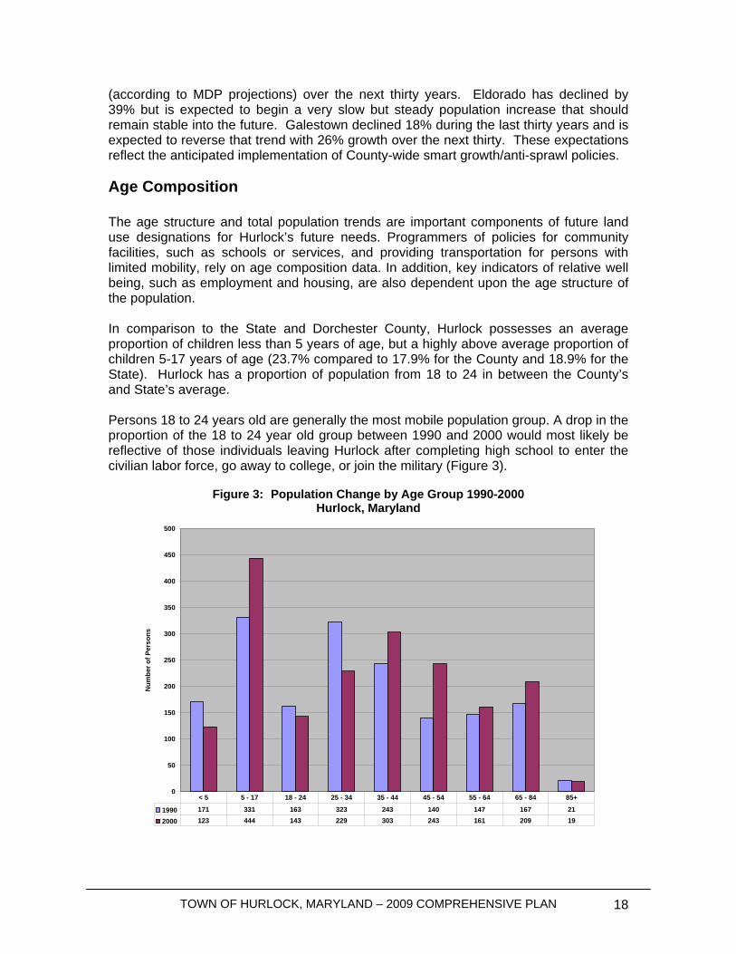
Age Composition The age structure and total population trends are important components of future land use designations for Hurlock’s future needs. Programmers of policies for community facilities, such as schools or services, and providing transportation for persons with limited mobility, rely on age composition data. In addition, key indicators of relative well being, such as employment and housing, are also dependent upon the age structure of the population. In comparison to the State and Dorchester County, Hurlock possesses an average proportion of children less than 5 years of age, but a highly above average proportion of children 5-17 years of age (23.7% compared to 17.9% for the County and 18.9% for the State). Hurlock has a proportion of population from 18 to 24 in between the County’s and State’s average. Persons 18 to 24 years old are generally the most mobile population group. A drop in the proportion of the 18 to 24 year old group between 1990 and 2000 would most likely be reflective of those individuals leaving Hurlock after completing high school to enter the civilian labor force, go away to college, or join the military (Figure 3).
Figure 3: Population Change by Age Group 1990-2000
Hurlock, Maryland
0
50
100
150
200
250
300
350
400
450
500
Num
ber o
f Per
sons
1990 171 331 163 323 243 140 147 167 212000 123 444 143 229 303 243 161 209 19
< 5 5 - 17 18 - 24 25 - 34 35 - 44 45 - 54 55 - 64 65 - 84 85+
TOWN OF HURLOCK, MARYLAND – 2009 COMPREHENSIVE PLAN 19
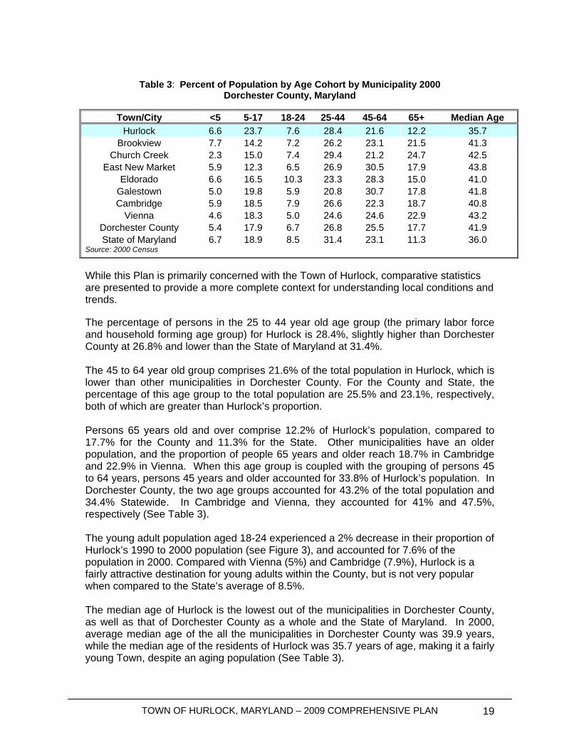
Table 3: Percent of Population by Age Cohort by Municipality 2000
Dorchester County, Maryland
While this Plan is primarily concerned with the Town of Hurlock, comparative statistics are presented to provide a more complete context for understanding local conditions and trends. The percentage of persons in the 25 to 44 year old age group (the primary labor force and household forming age group) for Hurlock is 28.4%, slightly higher than Dorchester County at 26.8% and lower than the State of Maryland at 31.4%. The 45 to 64 year old group comprises 21.6% of the total population in Hurlock, which is lower than other municipalities in Dorchester County. For the County and State, the percentage of this age group to the total population are 25.5% and 23.1%, respectively, both of which are greater than Hurlock’s proportion. Persons 65 years old and over comprise 12.2% of Hurlock’s population, compared to 17.7% for the County and 11.3% for the State. Other municipalities have an older population, and the proportion of people 65 years and older reach 18.7% in Cambridge and 22.9% in Vienna. When this age group is coupled with the grouping of persons 45 to 64 years, persons 45 years and older accounted for 33.8% of Hurlock’s population. In Dorchester County, the two age groups accounted for 43.2% of the total population and 34.4% Statewide. In Cambridge and Vienna, they accounted for 41% and 47.5%, respectively (See Table 3). The young adult population aged 18-24 experienced a 2% decrease in their proportion of Hurlock’s 1990 to 2000 population (see Figure 3), and accounted for 7.6% of the population in 2000. Compared with Vienna (5%) and Cambridge (7.9%), Hurlock is a fairly attractive destination for young adults within the County, but is not very popular when compared to the State’s average of 8.5%. The median age of Hurlock is the lowest out of the municipalities in Dorchester County, as well as that of Dorchester County as a whole and the State of Maryland. In 2000, average median age of the all the municipalities in Dorchester County was 39.9 years, while the median age of the residents of Hurlock was 35.7 years of age, making it a fairly young Town, despite an aging population (See Table 3).
Town/City <5 5-17 18-24 25-44 45-64 65+ Median Age Hurlock 6.6 23.7 7.6 28.4 21.6 12.2 35.7
Brookview 7.7 14.2 7.2 26.2 23.1 21.5 41.3 Church Creek 2.3 15.0 7.4 29.4 21.2 24.7 42.5
East New Market 5.9 12.3 6.5 26.9 30.5 17.9 43.8 Eldorado 6.6 16.5 10.3 23.3 28.3 15.0 41.0
Galestown 5.0 19.8 5.9 20.8 30.7 17.8 41.8 Cambridge 5.9 18.5 7.9 26.6 22.3 18.7 40.8
Vienna 4.6 18.3 5.0 24.6 24.6 22.9 43.2 Dorchester County 5.4 17.9 6.7 26.8 25.5 17.7 41.9 State of Maryland 6.7 18.9 8.5 31.4 23.1 11.3 36.0
Source: 2000 Census
TOWN OF HURLOCK, MARYLAND – 2009 COMPREHENSIVE PLAN 20
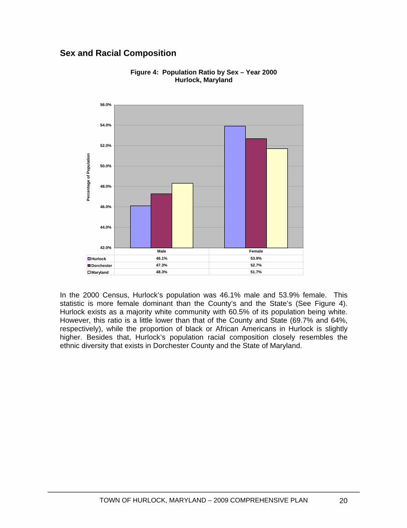
Sex and Racial Composition
Figure 4: Population Ratio by Sex – Year 2000 Hurlock, Maryland
In the 2000 Census, Hurlock’s population was 46.1% male and 53.9% female. This statistic is more female dominant than the County’s and the State’s (See Figure 4). Hurlock exists as a majority white community with 60.5% of its population being white. However, this ratio is a little lower than that of the County and State (69.7% and 64%, respectively), while the proportion of black or African Americans in Hurlock is slightly higher. Besides that, Hurlock’s population racial composition closely resembles the ethnic diversity that exists in Dorchester County and the State of Maryland.
42.0%
44.0%
46.0%
48.0%
50.0%
52.0%
54.0%
56.0%
Perc
enta
ge o
f Pop
ulat
ion
Hurlock 46.1% 53.9%
Dorchester 47.3% 52.7%
Maryland 48.3% 51.7%
Male Female
TOWN OF HURLOCK, MARYLAND – 2009 COMPREHENSIVE PLAN 21
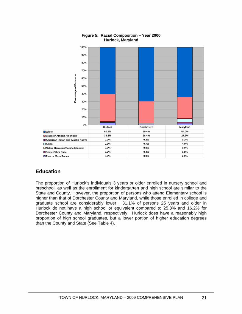
Figure 5: Racial Composition – Year 2000
Hurlock, Maryland
0%
10%
20%
30%
40%
50%
60%
70%
80%
90%
100%
Perc
enta
ge o
f Pop
ulat
ion
White 60.5% 69.4% 64.0%Black or African American 35.3% 28.4% 27.9%
American Indian and Alaska Native 0.2% 0.2% 0.3%Asian 0.9% 0.7% 4.0%
Native Hawaiian/Pacific Islander 0.0% 0.0% 0.0%Some Other Race 0.2% 0.4% 1.8%
Two or More Races 3.0% 0.9% 2.0%
Hurlock Dorchester Maryland
Education The proportion of Hurlock’s individuals 3 years or older enrolled in nursery school and preschool, as well as the enrollment for kindergarten and high school are similar to the State and County. However, the proportion of persons who attend Elementary school is higher than that of Dorchester County and Maryland, while those enrolled in college and graduate school are considerably lower. 31.1% of persons 25 years and older in Hurlock do not have a high school or equivalent compared to 25.8% and 16.2% for Dorchester County and Maryland, respectively. Hurlock does have a reasonably high proportion of high school graduates, but a lower portion of higher education degrees than the County and State (See Table 4).

TOWN OF HURLOCK, MARYLAND – 2009 COMPREHENSIVE PLAN 22
Table 4: Educational Statistics 2000
Hurlock, Maryland
Hurlock Dorchester Maryland SCHOOL ENROLLMENT Population 3 years and over enrolled in school 500 100% 7,043 1,475,484
nursery school, preschool 43 8.6% 7.2% 6.5%Kindergarten 22 4.4% 5.3% 5.1%Elementary school (grades 1-8) 266 53.2% 49.3% 43.5%High school (grades 9-12) 111 22.2% 23.8% 20.9%College or graduate school 58 11.6% 14.4% 24.0%EDUCATIONAL ATTAINMENT Population 25 years and over 1,176 100% 21,435 3,495,595Less than 9th grade 97 8.2% 9.1% 5.1%9th to 12th grade, no diploma 269 22.9% 16.7% 11.1%High school graduate (includes equivalency) 467 39.7% 42.1% 26.7%
Some college, no degree 199 16.9% 16.2% 20.3%Associate degree 36 3.1% 4.0% 5.3%Bachelor's degree 63 5.4% 6.8% 18.0%Graduate or professional degree 45 3.8% 5.2% 13.4%Source: 2000 Census
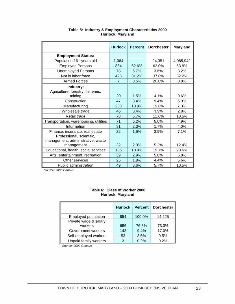
Employment and Labor Force Characteristics According to the 2000 Census, the Town of Hurlock has a civilian labor force of 1,364 persons over the age of 16. Approximately 78 persons of its labor force are unemployed creating a 5.7% unemployment rate; nearly double than that of the County’s and State’s respective unemployment rates of 3.6% and 3.2% (See Table 5). Hurlock’s main industry is by far in manufacturing, which employs almost 20% of the population. The rest of the labor force is mainly dedicated within Education, Health, and Social Services (10%), Retail Trade (5.7%), and Transportation, Warehousing and utilities (5.2%) employment sectors. Of the Town’s 854 workers, 76.8% are within the private wage and salary worker class which closely mirrors Dorchester County’s rate (See Table 6). On the other hand, the proportion of government workers in the County is almost double than that in Hurlock.
TOWN OF HURLOCK, MARYLAND – 2009 COMPREHENSIVE PLAN 23
Table 5: Industry & Employment Characteristics 2000 Hurlock, Maryland
Hurlock Percent Dorchester Maryland
Employment Status: Population 16+ years old 1,364 -- 24,351 4,085,942
Employed Persons 854 62.6% 62.0% 63.8% Unemployed Persons 78 5.7% 3.6% 3.2%
Not in labor force 425 31.2% 37.8% 32.2% Armed Forces 7 0.5% 20.0% 0.8%
Industry: Agriculture, forestry, fisheries,
mining 20 1.5% 4.1% 0.6% Construction 47 3.4% 9.4% 6.9%
Manufacturing 258 18.9% 19.6% 7.3% Wholesale trade 46 3.4% 3.9% 2.8%
Retail trade 78 5.7% 11.6% 10.5% Transportation, warehousing, utilities 71 5.2% 5.0% 4.9%
Information 31 2.3% 1.7% 4.0% Finance, insurance, real estate 22 1.6% 3.9% 7.1%
Professional, scientific, management, administrative, waste
management 32 2.3% 5.2% 12.4% Educational, health, social services 136 10.0% 19.7% 20.6%
Arts, entertainment, recreation 39 2.9% 5.8% 6.8% Other services 25 1.8% 4.4% 5.6%
Public administration 49 3.6% 5.7% 10.5% Source: 2000 Census
Table 6: Class of Worker 2000 Hurlock, Maryland
Hurlock Percent Dorchester
Employed population 854 100.0% 14,225 Private wage & salary
workers 656 76.8% 73.3% Government workers 142 9.4% 17.0%
Self-employed workers 53 3.5% 9.5% Unpaid family workers 3 0.2% 0.2%
Source: 2000 Census
TOWN OF HURLOCK, MARYLAND – 2009 COMPREHENSIVE PLAN 24
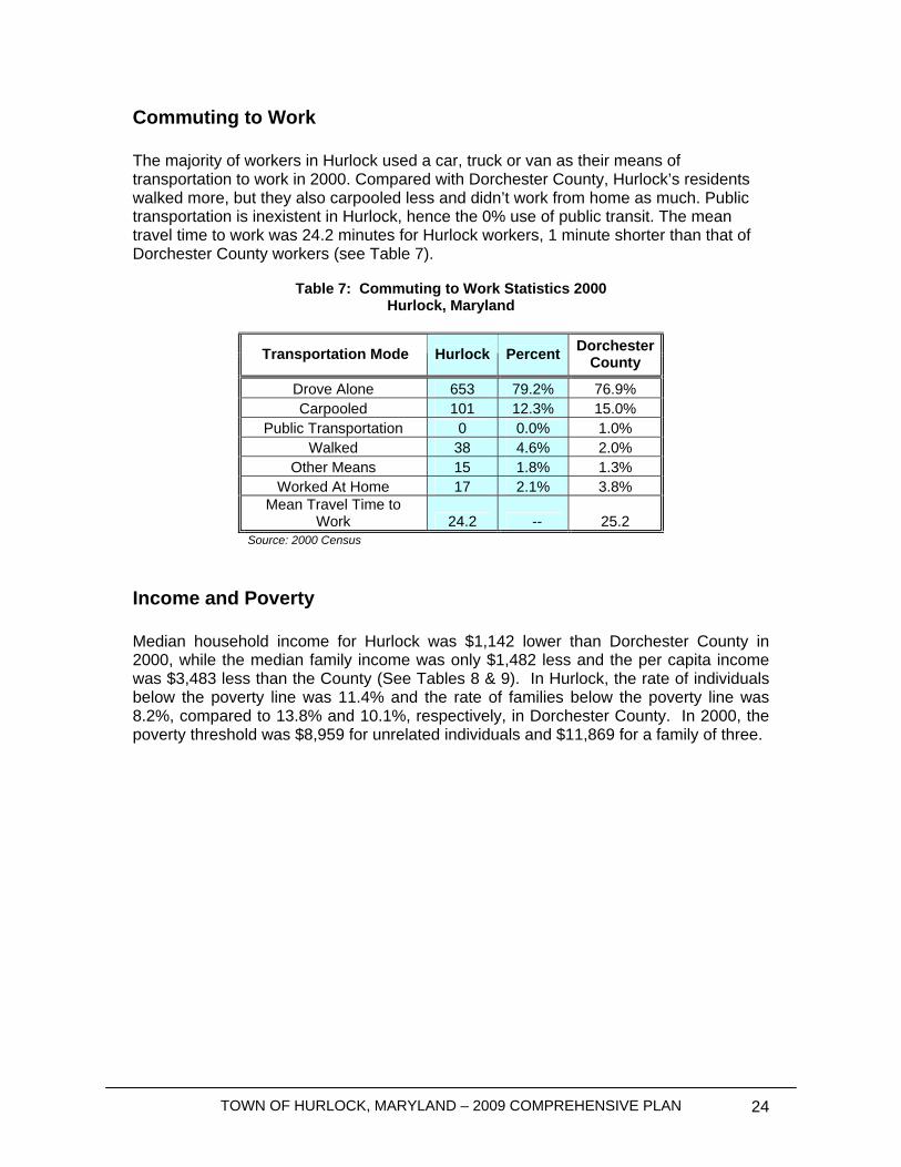
Commuting to Work The majority of workers in Hurlock used a car, truck or van as their means of transportation to work in 2000. Compared with Dorchester County, Hurlock’s residents walked more, but they also carpooled less and didn’t work from home as much. Public transportation is inexistent in Hurlock, hence the 0% use of public transit. The mean travel time to work was 24.2 minutes for Hurlock workers, 1 minute shorter than that of Dorchester County workers (see Table 7).
Table 7: Commuting to Work Statistics 2000 Hurlock, Maryland
Transportation Mode Hurlock Percent Dorchester County
Drove Alone 653 79.2% 76.9% Carpooled 101 12.3% 15.0%
Public Transportation 0 0.0% 1.0% Walked 38 4.6% 2.0%
Other Means 15 1.8% 1.3% Worked At Home 17 2.1% 3.8%
Mean Travel Time to Work 24.2 -- 25.2
Source: 2000 Census
Income and Poverty Median household income for Hurlock was $1,142 lower than Dorchester County in 2000, while the median family income was only $1,482 less and the per capita income was $3,483 less than the County (See Tables 8 & 9). In Hurlock, the rate of individuals below the poverty line was 11.4% and the rate of families below the poverty line was 8.2%, compared to 13.8% and 10.1%, respectively, in Dorchester County. In 2000, the poverty threshold was $8,959 for unrelated individuals and $11,869 for a family of three.

TOWN OF HURLOCK, MARYLAND – 2009 COMPREHENSIVE PLAN 25
Table 8: Household Income Characteristics 1999
Hurlock, Maryland
Hurlock Dorchester Count Percent Count Percent
Households 738 100.0% 12,712 100.0% Less than $10,000 84 11.4% 1,636 12.9% $10,000 to $14,999 62 8.4% 1,019 8.0% $15,000 to $24,999 148 20.1% 1,984 15.6% $25,000 to $34,999 94 12.7% 1,858 14.6% $35,000 to $49,999 142 19.2% 2,143 16.9% $50,000 to $74,999 125 16.9% 2,346 18.5% $75,000 to $99,999 59 8.0% 976 7.7%
$100,000 to $149,999 23 3.1% 445 3.5% $150,000 to $199,999 1 0.1% 124 1.0%
$200,000 or more 0 0.0% 181 1.4% Median household income
($) 32,935 (X) 34,077 (X) Source: 2000 U.S. Census
Table 9: Family Income Characteristics 2000 Hurlock, Maryland
Hurlock Percent Dorchester
Families 498 100% 8,584 Less than $10,000 33 6.6% 6.7% $10,000 to $14,999 21 4.2% 5.4% $15,000 to $24,999 93 18.7% 14.6% $25,000 to $34,999 70 14.1% 14.2% $35,000 to $49,999 120 24.1% 18.6% $50,000 to $74,999 99 19.9% 22.6% $75,000 to $99,999 51 10.2% 9.9%
$100,000 to $149,999 20 4.0% 5.0% $150,000 to $199,999 1 0.2% 1.4%
$200,000 or more 0 0.0% 1.7% Median family income $40,435 -- $41,917
Per capita income $15,446 -- $18,929 Source: 2000 Census
TOWN OF HURLOCK, MARYLAND – 2009 COMPREHENSIVE PLAN 26
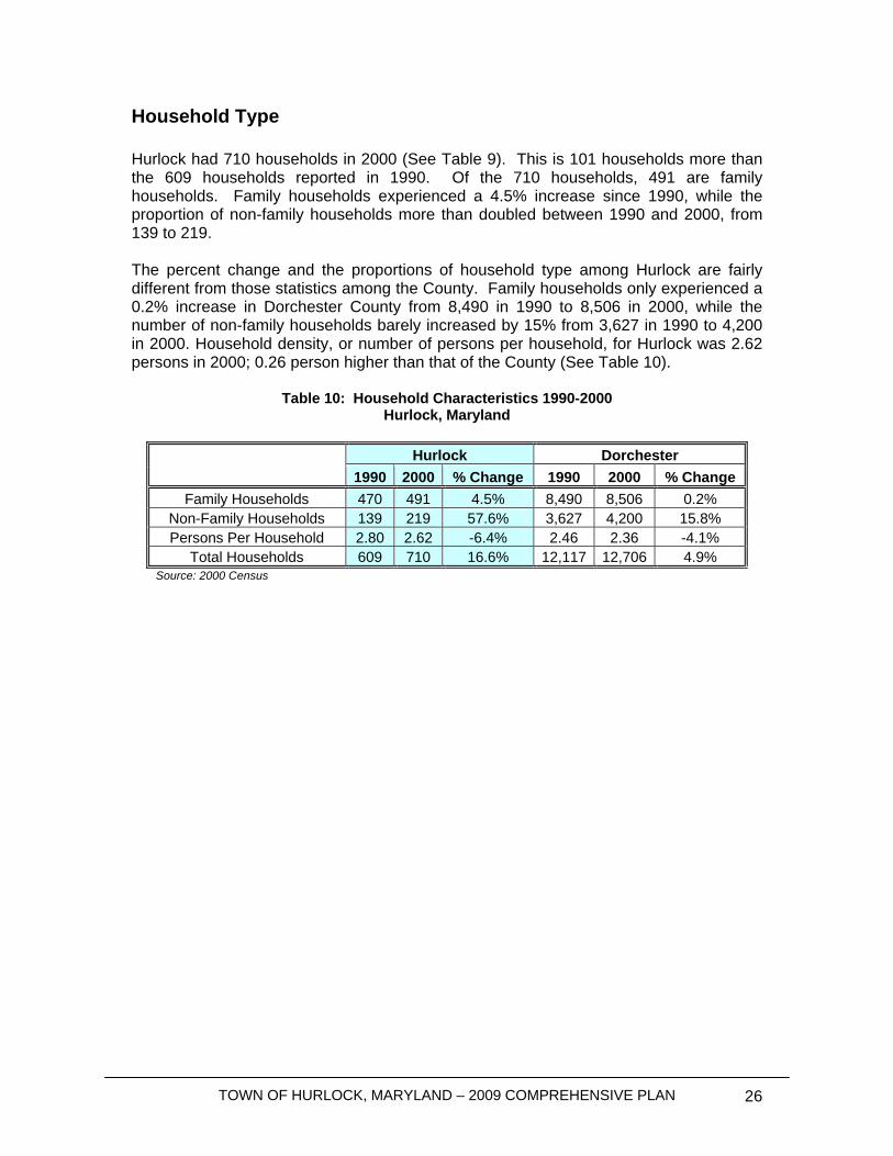
Household Type Hurlock had 710 households in 2000 (See Table 9). This is 101 households more than the 609 households reported in 1990. Of the 710 households, 491 are family households. Family households experienced a 4.5% increase since 1990, while the proportion of non-family households more than doubled between 1990 and 2000, from 139 to 219. The percent change and the proportions of household type among Hurlock are fairly different from those statistics among the County. Family households only experienced a 0.2% increase in Dorchester County from 8,490 in 1990 to 8,506 in 2000, while the number of non-family households barely increased by 15% from 3,627 in 1990 to 4,200 in 2000. Household density, or number of persons per household, for Hurlock was 2.62 persons in 2000; 0.26 person higher than that of the County (See Table 10).
Table 10: Household Characteristics 1990-2000 Hurlock, Maryland
Hurlock Dorchester
1990 2000 % Change 1990 2000 % Change Family Households 470 491 4.5% 8,490 8,506 0.2%
Non-Family Households 139 219 57.6% 3,627 4,200 15.8% Persons Per Household 2.80 2.62 -6.4% 2.46 2.36 -4.1%
Total Households 609 710 16.6% 12,117 12,706 4.9% Source: 2000 Census
TOWN OF HURLOCK, MARYLAND – 2009 COMPREHENSIVE PLAN 27
Community Facilities
Introduction
Water Systems
Groundwater Sources All of the potable water supplied by Hurlock used for industrial, commercial and residential purposes within the Town of Hurlock is secured from two aquifers, the Quaternary Aquifer and the Piney Point Aquifer. The Town is dependent upon water from the two aquifers for its continuing development and prosperity. In 2008, the Town published the “Annual Drinking Water Quality Report for 2007” stating there were no violations of EPA Maximum Contaminant Levels (MCL). The Town has established a Wellhead Protection Area to prevent source water contamination through regulating land use. The Town will evaluate the Wellhead Protection Area during project planning and assess potential problem areas and present solutions to prevent source water contamination.
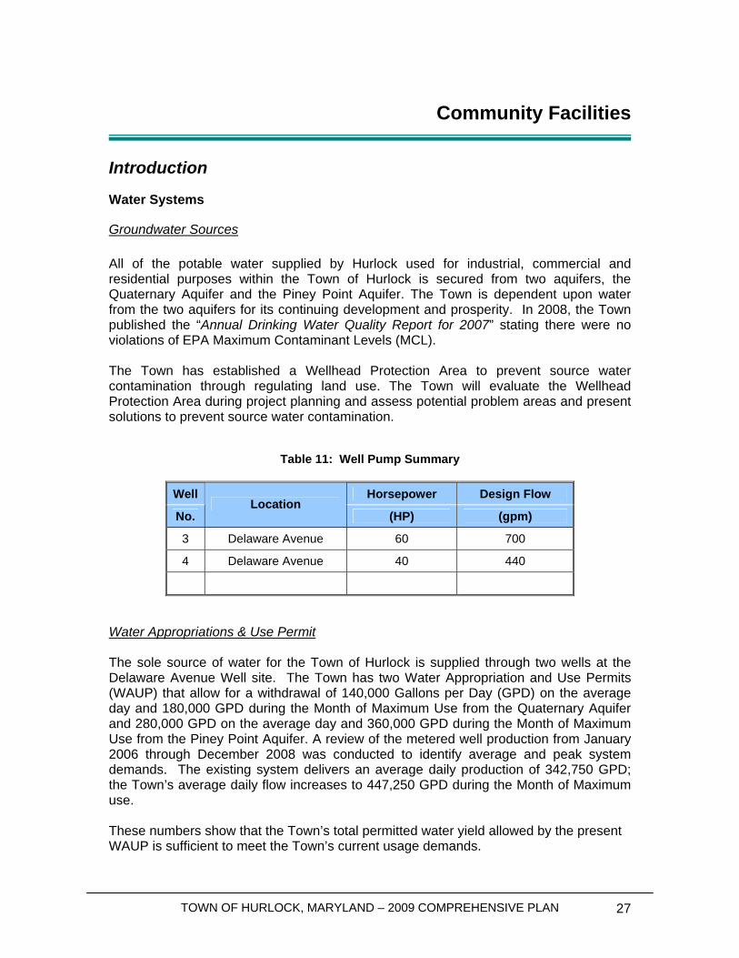
Table 11: Well Pump Summary
Well Horsepower Design Flow
No. Location
(HP) (gpm)
3 Delaware Avenue 60 700
4 Delaware Avenue 40 440
Water Appropriations & Use Permit The sole source of water for the Town of Hurlock is supplied through two wells at the Delaware Avenue Well site. The Town has two Water Appropriation and Use Permits (WAUP) that allow for a withdrawal of 140,000 Gallons per Day (GPD) on the average day and 180,000 GPD during the Month of Maximum Use from the Quaternary Aquifer and 280,000 GPD on the average day and 360,000 GPD during the Month of Maximum Use from the Piney Point Aquifer. A review of the metered well production from January 2006 through December 2008 was conducted to identify average and peak system demands. The existing system delivers an average daily production of 342,750 GPD; the Town’s average daily flow increases to 447,250 GPD during the Month of Maximum use. These numbers show that the Town’s total permitted water yield allowed by the present WAUP is sufficient to meet the Town’s current usage demands.
TOWN OF HURLOCK, MARYLAND – 2009 COMPREHENSIVE PLAN 28
Water Treatment Raw water from the wells is treated at the Delaware Avenue well site before entering into the distribution system. The water treatment process includes Chlorine Gas for disinfection, Lime for pH control and fluoride to prevent tooth decay before traveling through the distribution system.
Water Storage Recommended Standards for Water Works (2007) “Ten States Standards” require that finished water storage facilities have sufficient capacity to meet one day’s domestic usage plus fire flows. Where source water and water treatment facilities have back-up power, available capacity can supplement peak storage demands. The Town has one elevated storage tank, a 300,000 gallon elevated storage tank located on Pine Street. Finished water storage is provided within the water tower to equalize supply and demand over periods of high consumption and to furnish water for fire fighting and other emergencies. The elevated tower provides a system pressure of approximately 50 PSI. The domestic usage would be the average daily usage during the peak month, equal to 447,250 gallons. The fire flow storage required would be calculated based on 1500 GPM fire flow for 2 hours, which is equal to 180,000 gallons. Therefore, total storage required would be 627,250 gallons. The existing elevated storage tank provides a total storage of 300,000 gallons. Therefore, the tower alone is not large enough to supply one day’s water consumption to the system. If generators are added to the existing wells to supplement the storage offered by the elevated tank, sufficient storage capacity would be available to meet the “Ten States Standards” storage requirements. A generator has been designed for the wells and will be constructed as soon as funding is available. Distribution System The distribution system is comprised of over 18 miles of cast iron, ductile iron and polyvinylchloride (PVC) pipes varying in size from 2-inch to 10-inch diameter, with over 100 fire hydrants and metered services for larger customers. Residential customers do not have meters and are billed by fixture method rather than a direct usage. In some areas, the water system has undersized mains that inhibit fire flows and pressures and do not meet the minimum 6” main diameter for fire protection systems, per “Ten States Standards”. The Town is working on a computer water model to identify fire flow problem areas as a first step toward planning improvements.
Water Summary The Town currently has sufficient water supply capabilities to accommodate the current user demands. However, the addition of a generator at the existing Delaware Avenue well site would be needed to increase the available storage capacity to meet existing demands placed on the system.
TOWN OF HURLOCK, MARYLAND – 2009 COMPREHENSIVE PLAN 29
Sewer Systems Collection and Transmission The Town of Hurlock is served by a single sewerage collection system. A combination of gravity sewer collection and three sewage pumping stations convey the sewage to the Wastewater Treatment Plant (WWTP). The Town’s sanitary sewer collection system is comprised of 8 to 15 inch sewer mains with 175 manholes. The Town currently experiences inflow and infiltration (I&I) issues that cause the wastewater treatment plant to experience an increase in flows during periods of wet weather. Wastewater Treatment The Town of Hurlock completed construction of a Biological Nutrient Removal, BNR, wastewater treatment plant in 2006. The Town’s WWTP is located off Jones Village Road on the east side of Hurlock's corporate limits. The sewage is treated and discharged into Wrights Branch, a small tributary of Marshyhope Creek and the Nanticoke River. The WWTP has increased the Town’s capacity to 1.65 million gallons per day (MGD) Since the completion of BNR WWTP construction, the treatment plant has achieved Enhanced Nutrient Removal, ENR, levels of treatment. The treatment plant has been enhanced by the installation of additional chemical feed equipment to remove phosphorus. The accomplishment of ENR status allowed the Town to maintain capacity of 1.65 MGD of which an average of 1.178 MGD, or 62% of the plants rated capacity, was being used in 2007 and 2008. The existing stream discharge permit allows the Town to discharge 1.65 MGD into Wrights Branch throughout the year. In addition to a stream discharge, the Town still has the ability to spray irrigate from the original 120 acres of wastewater lagoons. The receiving lagoons are currently used to hold waste activated sludge from the treatment process and to hold decant and rainwater for disposal on the spray fields. In 2008, the Town only utilized the spray irrigation system during the summer months. The Town currently has two industrial users, Bloch & Guggenheimer, Inc. and Allen Family Foods, Inc. that discharge pretreated wastes into the sanitary sewer system. These facilities are closely monitored and individually permitted by the Town to ensure that the discharges from the industries fall within acceptable limits. These limits are determined by the capabilities of Hurlock’s existing WWTP. Nutrient Loads The Chesapeake Bay is considered to be an impaired body of water. Because of this impairment, and in the absence of a mathematical model for the Chesapeake Bay, the Tributary Strategy plans for the Chesapeake Watershed have become the goal to which cleanup efforts are proceeding. This strategy envisions ENR levels of treatment attained by all the major wastewater treatment plants in the State of Maryland. Currently, the Maryland Department of the Environment (MDE) is adding language to the discharge permits such that the annual mass of nitrogen and phosphorous will be limited at each of the major plants.
TOWN OF HURLOCK, MARYLAND – 2009 COMPREHENSIVE PLAN 30
The Town’s existing Effluent Discharge Permit limits the existing WWTP to a predetermined Total Maximum Daily Loading, TMDL. Maryland Department of the Environment requires that Total Nitrogen be limited to 4.0 mg/L, which equates to 20,101 lbs/yr and Total Phosphorus be limited to 0.3 mg/L, which equates to 1,508 lbs/yr. The existing ENR plant releases Nitrogen at 8,000 lbs/yr and Phosphorus at 420 lbs/yr. On-Site Septic Systems Currently there are no on-site septic systems in use within Town limits.
Sewer Summary The Town currently has sufficient sewer collection, transmission and treatment capabilities to accommodate the current user demands.
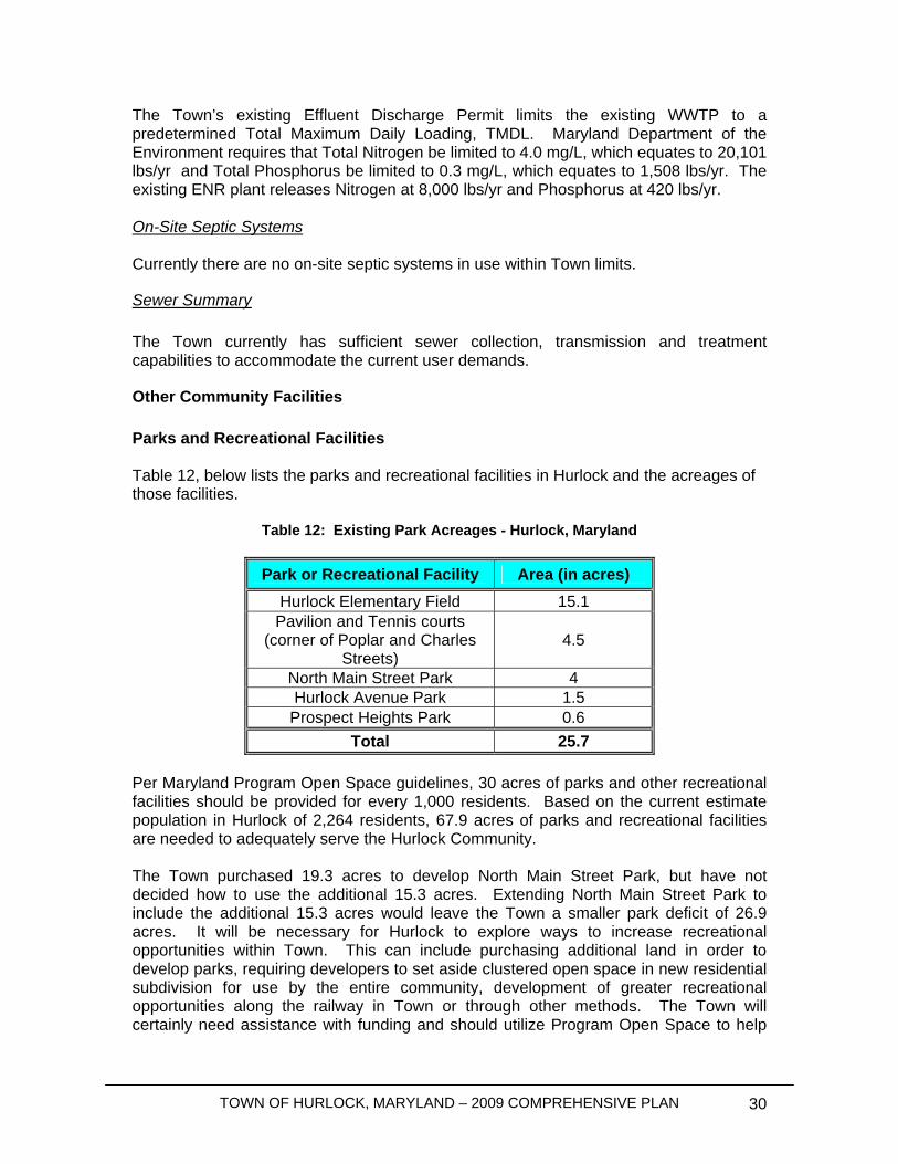
Other Community Facilities Parks and Recreational Facilities Table 12, below lists the parks and recreational facilities in Hurlock and the acreages of those facilities.
Table 12: Existing Park Acreages - Hurlock, Maryland
Park or Recreational Facility Area (in acres) Hurlock Elementary Field 15.1
Pavilion and Tennis courts (corner of Poplar and Charles
Streets) 4.5
North Main Street Park 4 Hurlock Avenue Park 1.5
Prospect Heights Park 0.6 Total 25.7
Per Maryland Program Open Space guidelines, 30 acres of parks and other recreational facilities should be provided for every 1,000 residents. Based on the current estimate population in Hurlock of 2,264 residents, 67.9 acres of parks and recreational facilities are needed to adequately serve the Hurlock Community. The Town purchased 19.3 acres to develop North Main Street Park, but have not decided how to use the additional 15.3 acres. Extending North Main Street Park to include the additional 15.3 acres would leave the Town a smaller park deficit of 26.9 acres. It will be necessary for Hurlock to explore ways to increase recreational opportunities within Town. This can include purchasing additional land in order to develop parks, requiring developers to set aside clustered open space in new residential subdivision for use by the entire community, development of greater recreational opportunities along the railway in Town or through other methods. The Town will certainly need assistance with funding and should utilize Program Open Space to help
TOWN OF HURLOCK, MARYLAND – 2009 COMPREHENSIVE PLAN 31
Hurlock fund a Parks Master Plan and further provide assistance for recreational development. The Town and Dorchester County work closely together to purchase, develop and maintain parks in and around Hurlock. Both departments have limited resources to maintain parks in residential subdivisions where maintenance is the responsibility of homeowner associations. The Town should work closely with the County on a overall strategy to develop park land for residents of Hurlock and the greater area. Additional residential growth will have a greater affect on already stretched park facilities. The additional affect that growth will have on the community and recommendations for mitigating growth impacts on park facilities will be discussed in greater depth throughout the Municipal Growth Element. Educational Facilities Hurlock Elementary School, and North Dorchester Middle and High School serve Hurlock and the surrounding area. As drawn, the current school district boundaries will serve everyone within the Town boundaries and the proposed growth areas as discussed later in the Municipal Growth Element. The affect future growth will potentially have on the school system is discussed in Chapter 6. Per the 2008 Dorchester County Public Schools Educational Facilities Master Plan, none of the schools serving Hurlock are over-capacity. However, Hurlock Elementary could exceed capacity if current growth trends continue. The County is planning to use portable classrooms, if necessary to provide adequate capacity for students, and while permanent facilities are renovated and/or expanded. As of the 2008 Master Plan, the County is planning to renovate Hurlock Elementary because of the age of the facility and overcrowding. North Dorchester High School may need a feasibility study to determine whether or not it should be replaced. The Town will work closely with the Dorchester County School Board to share growth information in order to help predict the need for school renovations and expansions where necessary. Public Transportation Delmarva Community Transit provides bus service on Route 8 through Hurlock. The bus picks up and drops off passengers at the Food Rite in Town six times during the day. Delmarva Community Transit (DCT) generally provides services to municipalities in Dorchester County; however, DCT is part of a larger cooperative public transportation system that provides passenger service to Caroline, Kent, Queen Anne’s and Talbot Counties. Fare is generally $1.00 for a ride anywhere on the system and $0.50 for senior citizens. More information about DCT and its routes can be found online at: http://www.dcsdct.org/dct.htm
TOWN OF HURLOCK, MARYLAND – 2009 COMPREHENSIVE PLAN 32
Public Health Services The Dorchester County Health Department (DCHD) is located in Cambridge and serves the entire County. The Health Department provides a variety of services, and education and outreach programs. Health services include medical, dental and mental health services, and are provided for a discounted (or free) rate based on a client’s income. The Health Department further emphasizes pediatric health and provides a variety of medical and educational services for Dorchester County children. Choptank Community Health System (CCHS) is a private, non-profit medical facility with an office on Collins Avenue in Hurlock. CCHS also provides medical, dental and other mental health services regardless of one’s ability to pay. Both CCHS and DCHD provide a wealth of medical services, and education and outreach programs to the citizens of Hurlock. More information about public health services in Hurlock can be found at the websites below: Choptank Community Health System - http://www.choptankhealth.org/ Dorchester County Health Department - http://www.dorchesterhealth.org/ Libraries Hurlock residents can utilize the Hurlock Branch of the Dorchester County Library System, located at 222 South Main Street. The Central Branch is located in Cambridge. The library also provides “bookmobile” services weekly to Hurlock Elementary School and the Delmarva Community Center. More information about library services can be found at: http://www.dorchesterlibrary.org/. Police Protection Hurlock currently has eight police officers on staff to serve the community. Per the International Association of Police Chiefs (IAPC), 2.5 officers are recommended for every 1,000 people. Based on current population estimates in Hurlock, the Town exceeds this standard. As the Town grows in size and population, more officers and equipment, and larger facilities may be necessary to accommodate a growing police force, as well as maintain existing levels of service. Fire Protection The Hurlock Volunteer Fire Company serves the Town and the surrounding area. The Fire Company has over 100 members, more than 70 of which are active firefighters. The Fire Company is fully equipped with three fire engines, a ladder truck, a tanker and several other fire apparatuses. The Fire Company also has an ambulance and is staffed continuously by paid County EMT personnel. The Fire Department is well-equipped to provide emergency services to the community for the existing population and committed growth planned for the Town.

TOWN OF HURLOCK, MARYLAND – 2009 COMPREHENSIVE PLAN 33
This page was intentionally left blank
TOWN OF HURLOCK, MARYLAND – 2009 COMPREHENSIVE PLAN 34
Land Use Element
Introduction Hurlock is a small, active community with a variety of different land uses scattered throughout the Town. Its distinct character can be directly attributed to Hurlock’s land use practices and historic growth patterns, which are particularly related to its strategic location at the intersection of two train tracks. The historic Downtown area includes a mix of residential, commercial, municipal and institutional uses. Various commercial uses exist throughout the Town, ranging from small retail activities to highway commercial businesses. Industrial uses are primarily concentrated along the railroad tracks and at the margin of Town. A large mix of housing options also exist within the Town, including large estate-style homes, modest single-family homes, townhouses and small apartment buildings.
Hurlock is also home to several industries and businesses related to food and poultry products, trucking, and other manufacturing. In 1987, the fully serviced Industrial Park was established on ninety-seven acres owned by the Town. The entire Industrial Park was designated as a State Enterprise Zone in 1989, providing substantial tax incentives to new industries meeting certain qualifying criteria. This tradition as a “business friendly” community is ongoing and reinforced by land use and transportation policies reflected in this Comprehensive Plan. The decision to promote modern and competitive industrial and commercial opportunities within Hurlock will help ensure that the community remains a viable and vibrant town that provides employment opportunities for residents as well as workers within commuting distance.
As an employment anchor, Hurlock provides jobs that help support an economic base that extends outward about fifteen miles to influence the towns of Easton, Cambridge, and Seaford, Delaware. The Towns of Secretary, East New Market, Preston and Federalsburg are only about five miles away, and Sharptown is also within an easy rural commute of about thirteen miles. The 2000 census count for census tract populations within about a fifteen mile radius of Hurlock was approximately 81,000. Given the variation in census tract boundaries, this is a somewhat crude estimate but nevertheless demonstrates that a large and probably diverse workforce is within a reasonable commuting distance of Hurlock. It is also reasonable to assume that this population has increased over the last nine years.
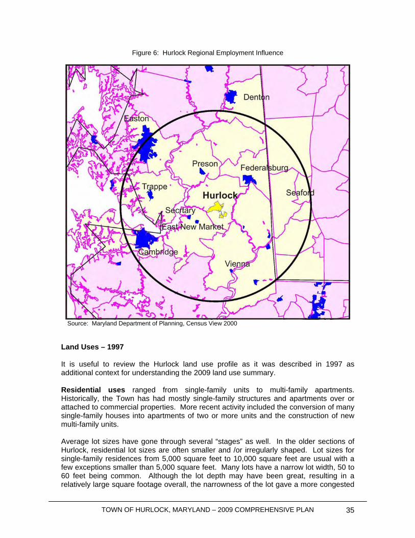
TOWN OF HURLOCK, MARYLAND – 2009 COMPREHENSIVE PLAN 35
Figure 6: Hurlock Regional Employment Influence
Source: Maryland Department of Planning, Census View 2000 Land Uses – 1997 It is useful to review the Hurlock land use profile as it was described in 1997 as additional context for understanding the 2009 land use summary. Residential uses ranged from single-family units to multi-family apartments. Historically, the Town has had mostly single-family structures and apartments over or attached to commercial properties. More recent activity included the conversion of many single-family houses into apartments of two or more units and the construction of new multi-family units. Average lot sizes have gone through several “stages” as well. In the older sections of Hurlock, residential lot sizes are often smaller and /or irregularly shaped. Lot sizes for single-family residences from 5,000 square feet to 10,000 square feet are usual with a few exceptions smaller than 5,000 square feet. Many lots have a narrow lot width, 50 to 60 feet being common. Although the lot depth may have been great, resulting in a relatively large square footage overall, the narrowness of the lot gave a more congested

TOWN OF HURLOCK, MARYLAND – 2009 COMPREHENSIVE PLAN 36
appearance and living space since houses are close together, despite the extensive rear yards. These subdivision practices predate widespread automobile ownership and provided space for large vegetable gardens and in some cases, a stable and shed or carriage house. More recent development patterns resulted in larger, more squarely shaped, lots over 10,000 square feet that reflected consumer’s changing demands and increasing affluence. In other cases, lot widths of 90 feet or more were obtained by combining several smaller lots. Upward trends in housing costs during the 1990’s combined with increasing utility costs made “affordable housing” an issue in many areas of the State. The inventory of older housing stock of in towns like Hurlock was targeted by investors for conversion into multiple rental units and new, smaller multi-family units with less land per dwelling unit were also produced. Commercial uses ranged form home offices to retail operations. Neighborhood stores provide the area with daily needs, such as food, gas and other convenience items. There are specialized businesses for antiques, arts and crafts, restaurants, groceries, hair care and hardware. These business establishments serve not only Hurlock, but some of the surrounding County as well. Most of the commercial properties are located along major roads, such as Route 331 (Main Street). Several of the businesses are in mixed use areas where residences exist next door or within the same building. Parking is a problem for many of the older commercial establishments where so much of the lot is covered by structures that off-street parking cannot be provided. It is speculated that some business is lost to other areas where greater choices and convenience draws consumers for larger items and large quantity purchases. Industrial uses are grouped around the rail lines and adjoining highways. Retaining industrial areas along rail corridors is important to the Town in providing an alternative mode of transportation to existing and future industries, as well as to the county and State in keeping rail usage sufficiently active to retain service on the lines. Industrial users are grouped into two categories, light and heavy. Heavy industries are those which use large amounts of water in processing, generate a large volume of sewerage, store raw or finished materials outside of buildings, create noise – either from processing/manufacturing, or form vehicles serving the site – generate odors or dust, and use or generate hazardous/toxic materials. They are types of industries that are the least compatible with residential areas. Light industries are those which have none of the heavy industrial characteristics noted above, or have them in such a small amount that they are not a nuisance to surrounding properties. Much of the industrially used land in Hurlock is of a heavy industrial nature. Food processing and food-related industries are the mainstay of the Town’s current industrial activity. The Maryland Department of the Environment (MDE) and the U.S. Environmental Protection Agency (EPA) require sewerage generators that generate a large amount of effluent to meet pretreatment standards before discharging into the Town’s sewerage system. The Town is committed to working with existing and new industries to meet regulatory requirements in the most cost-effective and efficient means available. The Town’s commitment to industrial growth is evidenced by the municipally-owned Hurlock Industrial Park. The Park can accommodate approximately 18 fully served lots for light
TOWN OF HURLOCK, MARYLAND – 2009 COMPREHENSIVE PLAN 37
industrial development. The Park has been designated as a State Enterprise Zone. As of 2007, the Town still owns two smaller lots and one larger site totaling 39 acres. Two corporate interests own 2 undeveloped parcels totaling 81 acres. The balance of the 188 acre Enterprise Zone is classified as “developed.” Public and semi-public uses included 404 acres, or nearly 24% of all land within Town. Public uses include publicly owned properties, such as the Town Hall, sewer and water systems including spray fields, the school, library, and post office. Semi-public uses include the volunteer fire company, churches, service and fraternal organizations and certain health care providers. Most of the public facilities are City, County or State owned and are related to providing direct services to the public. These uses are scattered throughout the community. The largest public use (360 acres) is the Town wastewater treatment operation which includes the lagoons and spray irrigations sites. Parks and open space areas account for a little under 1% of the total Town land area, or 14 acres. These are defined as those lands set aside fro active recreation, passive enjoyment, or environmental buffering. The county-owned property that is part of and adjacent to the school site is the largest area. It contains ball fields, multi-use areas and play equipment. County-owned tennis courts are adjacent to the school property. Two other sites are a passive park on Heights and Hurlock Avenues and a recreational area serving the Prospect Heights subdivision, both owned by the Town. Park/open space areas are neither extensive nor scattered throughout the community.
Existing Land Uses This section of the plan details the various land uses existing within the current (2009) Town boundaries. Proper land use practices will allow Hurlock to maintain its small-town character while properly managing growth. This plan will focus on maintaining the diversity and balance between residential, commercial and industrial uses while accommodating future growth. 2009 Land Uses The following table indicates the proportion of each land use as of March 2009. Descriptions of the different land use categories are also provided.

TOWN OF HURLOCK, MARYLAND – 2009 COMPREHENSIVE PLAN 38
Table 13: Existing Land Uses and Acreages 2009 Hurlock, Maryland
Land Use Area (in acres) Percent Agricultural 764.4 41.5% Industrial 405.9 22.0% Single-Family Residential 255.5 13.9% Undeveloped 144.2 7.8% Roads and Right-of-Ways 79.6 4.3% Institutional 52.0 2.8% Multi-Family Residential 51.7 2.8% Vacant 26.7 1.4% Recreational 23.7 1.3% Commercial 20.5 1.1% Municipal 9.7 0.5% Railroad 6.6 0.4% Mixed Use 0.9 0.05% Total 1,841.4 100%
Agricultural Agricultural land use areas comprise 41.5% of the Town’s area and consist of parcels that are currently being used for agriculture and farming. Industrial Industrial uses account for 22.0% of the total land area of Hurlock. They are mainly located along the Town’s boundaries to the southwest and to the east, as well as at the intersection of the two railroad tracks on the northeastern part of Town. The site to the southwest of Town consists of a 97 acre industrial park, divided into eight individual, occupied lots. A large residual lot is available for development and expansion of the Industrial Park. The larger industries and businesses within Hurlock today include Allen Family Foods and Hatchery (poultry industry), Bloch and Guggenheimer, Inc. (producer of food condiments) and Perdue Farms, Incorporated (poultry industry). Single-Family Residential Almost 14% of the Town’s land uses consist of single-family residential development. The majority of single-family homes in Hurlock are clustered into neighborhoods throughout the Town. Undeveloped This category includes forested lands and other similar uses or parcels that are undeveloped, but where development is possible. The development capacity analysis and map provided as part of the Municipal Growth Element further detail potential residential development on undeveloped and underdeveloped parcels.
TOWN OF HURLOCK, MARYLAND – 2009 COMPREHENSIVE PLAN 39
Roads and Right-of-Ways Roads and other rights-of-way are estimated based on subtracting the area of all land uses from the total area of the Town. Approximately 80 acres of land within Hurlock consist of streets and right-of-ways (ROW’s), including properties owned by active and former railroads. Institutional “Institutional” land uses include properties where churches, social clubs, schools and other similar developments exist. Hurlock’s institutional land uses include a variety of different institutions as discussed in the Community Facilities section and further indicated on the Community Facilities Map (Map 1). Currently, 2.8% of the existing land uses in Hurlock are considered to be institutional. Although the institutional uses are a small proportion of the existing land uses in Town, Hurlock Elementary School and Delmarva Community Services are two of the largest employers in the Town (both considered institutional uses). Multi-Family Residential About 2.8% of existing land use in Hurlock consists of “multi-family residential” development. Multi-family residential uses consist of properties where two or more attached units are in existence, such as duplexes, townhouses, and apartment units and complexes. The proportion of multi-family uses is expected to increase with future development. Recreational Hurlock residents have access to almost 24 acres of parks and recreational spaces. These facilities include the triangular Hurlock Avenue Park, the pavilion and tennis courts located at the corner of Poplar and Charles Streets, Prospect Heights Park (located in Prospect Heights Community along Harrison Ferry Road, to the eastern edge of Town), and the Hurlock Elementary Field which belongs to the school but is open to the public. A new four acre park, North Main Street Park, was recently created on a 19 acres parcel bought by the Town. The remaining 15 acres could potentially be developed into additional recreational space. Commercial Approximately 20 acres of property within the Town consists of commercial land uses. Hurlock’s commercial land uses are very diverse. Small retail activities, restaurants, professional businesses, highway commercial strips, hardware and supply stores co-exist throughout the Town. The Downtown area consists of primarily small retail and professional businesses. Municipal “Municipal” land uses are defined as those properties being used for municipal and/or government operations. Those properties considered to be municipal land uses in nature include Town Hall, the Town’s water tower, the U.S. Post Office, the Hurlock Volunteer Fire Department and other similar uses.
TOWN OF HURLOCK, MARYLAND – 2009 COMPREHENSIVE PLAN 40
Railroad This category designates parts of Town that were previously used to accommodate railroad or train activities, but that are no longer in use due to a shift in the Town’s economic activity. These sites are unique as they offer the potential for both inner-city redevelopment and historic preservation. Mixed Use Last, but not least, “Mixed Use” designates properties that combine a number of different uses, often combining commercial and residential purposes. In Hurlock, the 0.9 acre of mixed uses represents live/work spaces, or residential properties with ground floors turned into private businesses (i.e. barber shop). These help develop and maintain a community’s neighborhood character.
Goals, Objectives and Policies
1) Preserve the character of the community;
• Permit residential and commercial mixed uses in the Downtown area while maintaining its historic character;
• Promote well-designed transitions from agricultural uses to residential uses;
• Provide opportunities for variety and affordability in new residential growth to accommodate an increased workforce, focusing on developing jobs in the community as the main priority;
• Develop “Smart Growth” criteria for reviewing projects to guide future growth and to better incorporate future developments into the existing Town neighborhoods;
• Support small business in the Downtown area by providing flexibility in review standards. Moreover, separate uses that are most viable for economic redevelopment efforts Downtown and locate more intense uses along high traffic areas (“big-box” development);
• Determine uses that will be most appropriate for commercial development Downtown and in highway commercial areas;
• Work with the business community to identify viable means for helping to keep local business competitive;
2) Continue to promote industrial and business opportunities by actively
marketing remaining development opportunities in the Hurlock Industrial Park
• Coordinate with State and regional economic development organizations to maximize exposure and opportunities,
• Seek out State and Federal economic development funds and assistance to modernize and promote Hurlock’s economic infrastructure.

TOWN OF HURLOCK, MARYLAND – 2009 COMPREHENSIVE PLAN 41
3) Reestablish Hurlock’s traditional Town Center and encourage mixed-use development downtown;
• Promote pedestrian scale amenities, attractive and safe streets, and a
unifying theme to the district; • Adopt design guidelines for both new development and redevelopment of
existing properties to help create a specific “sense of place” for the Downtown;
• Create side and rear-yard parking areas, where possible, that include “green design” principles that maximize opportunities to improve management of rainfall runoff;
• Evaluate options for an urban street-tree program that includes drought resistant shade tree species as an alternative to Forest Conservation Programs (more suitable for rural development mitigation).
4) Encourage growth to occur within the existing Town boundaries, either as
infill on vacant lots or as redevelopment on marginal or underutilized sites, while balancing the benefit of growth in areas directly adjacent to the existing Town boundaries.
5) Make Hurlock a “destination” for visitors, by encouraging cultural activities
and events such as the Fall Festival and the Hurlock Christmas Parade;
6) Promote efforts to establish an “excursion train” that will stimulate tourism by promoting Hurlock’s history and heritage;
7) Encourage and ensure the development and availability of housing
options within Town, with an emphasis on affordability;
8) Maintain existing parks and recreational facilities and provide increased recreational opportunities and facilities for the growing community;
9) Review and refine the zoning code and other development regulations in
order to promote the Comprehensive Plan and the future vision of the citizens of Hurlock;
10) Identify areas for future growth that minimize environmental impacts, as
discussed in the Sensitive Areas element and other parts of the Plan.

TOWN OF HURLOCK, MARYLAND – 2009 COMPREHENSIVE PLAN 42
This page was intentionally left blank
TOWN OF HURLOCK, MARYLAND – 2009 COMPREHENSIVE PLAN 43
Municipal Growth Element
Introduction The Municipal Growth Element is a required element in Comprehensive Plans pursuant to the 2006 House Bill 1141, which projects and discusses the dynamics of growth within the existing community and surrounding areas. The Municipal Growth Element discussed herein is the first time many of these issues have been addressed by the Town.
Historic Growth Patterns Hurlock incorporated in 1893 and by 1908 had created, by franchise, the first central water system. The same year, a franchise was granted for electricity and by 1909 the Town had streetlights. Modern fire suppression began in 1923 and by the mid 1920 a well established central business district had been created. The first public sanitary sewer was built during the Great Depression as a Works Progress Administration project (in 1934). Hurlock purchased the privately operated water system in 1954 and in 1959 erected the Municipal Medical Center. Modernization continued during the 1960’s with work on schools and a post office. Other public services, such as the library, also benefited. The expansion of the waste water treatment plant in 1968 facilitated both major commercial and residential growth. The town’s population, which had remained nearly level for forty years increased by about 60% during the 1970’s, and in 1980 the town erected a new 300,000 gallon water tank (and well) the provided increased fire protection and enhanced public water service. The Industrial Park, located on the western side of town, was created in 1987, and only one building site remains undeveloped. That year was also noteworthy for a 500 acre annexation which nearly doubled the size of Hurlock. A new municipal spray irrigation wastewater system (along with 200 acres) was annexed into town during 1990. Residential growth continued on the northern and southern ends of town with intense commercial and industrial uses spreading in an east-west pattern. The town employs over 20 full and part-time workers including an eight member police force. One of the newest development projects consists of an “age restricted” three story multifamily structure at the south end of town. Potential plans have been discussed for an annexation and addition of a second building unit to expand the availability of affordable senior housing.
Development Capacity Analysis The Town of Hurlock and its consultants performed the development capacity analysis discussed below. This involved collecting, integrating and interpreting data to make it “fit” the Maryland Department of Planning’s (MDP) growth simulation model. The analysis
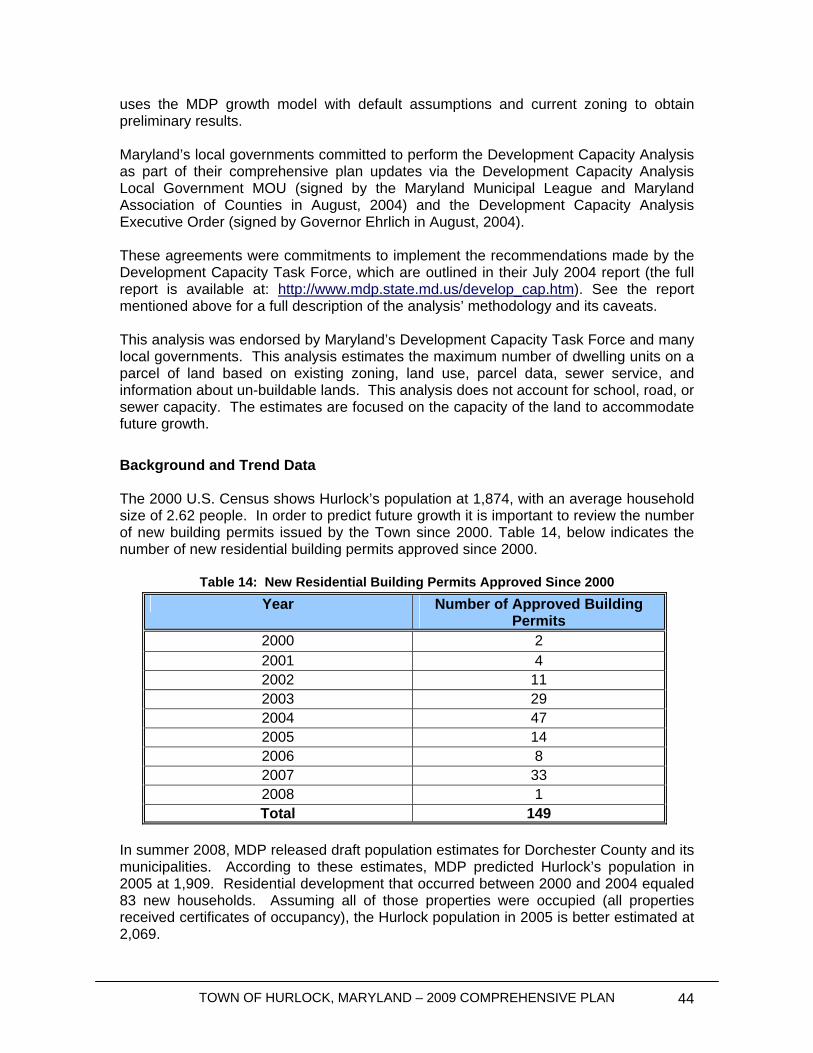
TOWN OF HURLOCK, MARYLAND – 2009 COMPREHENSIVE PLAN 44
uses the MDP growth model with default assumptions and current zoning to obtain preliminary results. Maryland’s local governments committed to perform the Development Capacity Analysis as part of their comprehensive plan updates via the Development Capacity Analysis Local Government MOU (signed by the Maryland Municipal League and Maryland Association of Counties in August, 2004) and the Development Capacity Analysis Executive Order (signed by Governor Ehrlich in August, 2004). These agreements were commitments to implement the recommendations made by the Development Capacity Task Force, which are outlined in their July 2004 report (the full report is available at: http://www.mdp.state.md.us/develop_cap.htm). See the report mentioned above for a full description of the analysis’ methodology and its caveats. This analysis was endorsed by Maryland’s Development Capacity Task Force and many local governments. This analysis estimates the maximum number of dwelling units on a parcel of land based on existing zoning, land use, parcel data, sewer service, and information about un-buildable lands. This analysis does not account for school, road, or sewer capacity. The estimates are focused on the capacity of the land to accommodate future growth. Background and Trend Data The 2000 U.S. Census shows Hurlock’s population at 1,874, with an average household size of 2.62 people. In order to predict future growth it is important to review the number of new building permits issued by the Town since 2000. Table 14, below indicates the number of new residential building permits approved since 2000.
Table 14: New Residential Building Permits Approved Since 2000
In summer 2008, MDP released draft population estimates for Dorchester County and its municipalities. According to these estimates, MDP predicted Hurlock’s population in 2005 at 1,909. Residential development that occurred between 2000 and 2004 equaled 83 new households. Assuming all of those properties were occupied (all properties received certificates of occupancy), the Hurlock population in 2005 is better estimated at 2,069.
Year Number of Approved Building Permits
2000 2 2001 4 2002 11 2003 29 2004 47 2005 14 2006 8 2007 33 2008 1 Total 149
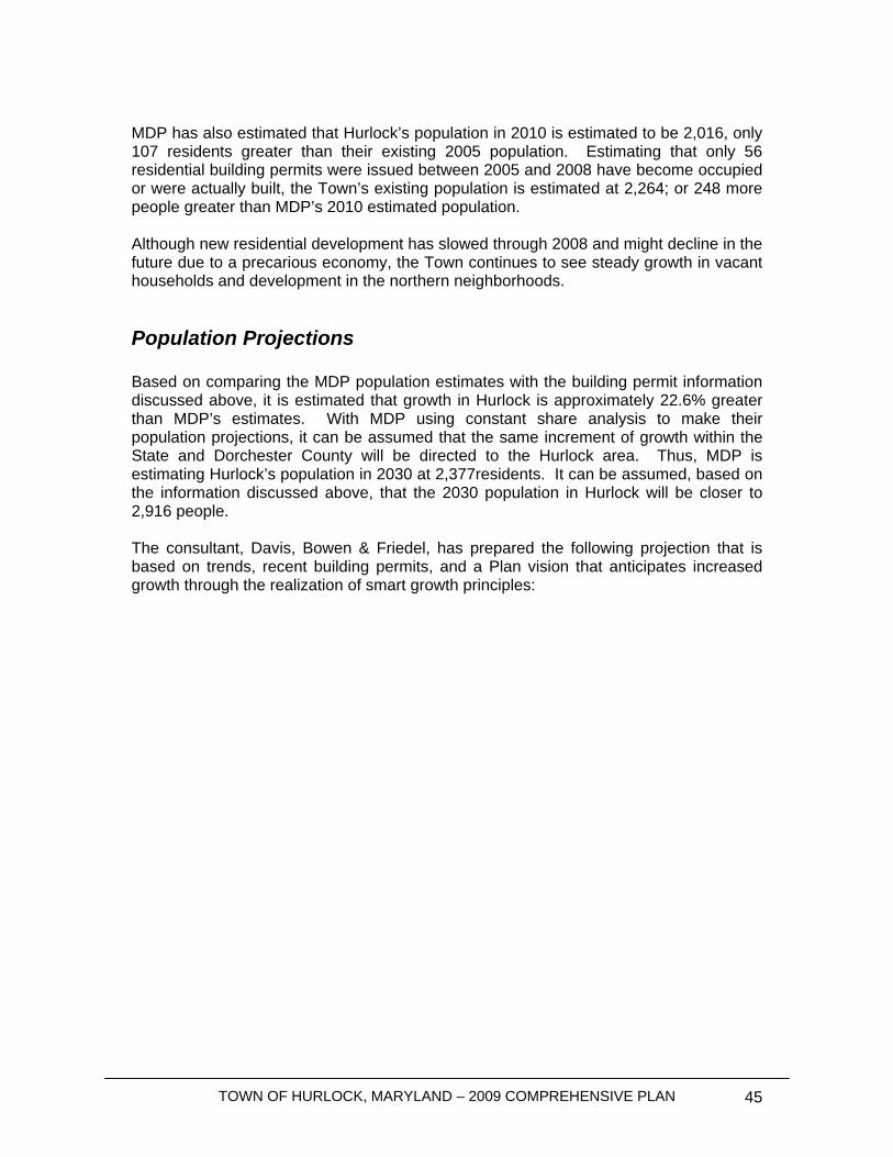
TOWN OF HURLOCK, MARYLAND – 2009 COMPREHENSIVE PLAN 45
MDP has also estimated that Hurlock’s population in 2010 is estimated to be 2,016, only 107 residents greater than their existing 2005 population. Estimating that only 56 residential building permits were issued between 2005 and 2008 have become occupied or were actually built, the Town’s existing population is estimated at 2,264; or 248 more people greater than MDP’s 2010 estimated population. Although new residential development has slowed through 2008 and might decline in the future due to a precarious economy, the Town continues to see steady growth in vacant households and development in the northern neighborhoods.
Population Projections Based on comparing the MDP population estimates with the building permit information discussed above, it is estimated that growth in Hurlock is approximately 22.6% greater than MDP’s estimates. With MDP using constant share analysis to make their population projections, it can be assumed that the same increment of growth within the State and Dorchester County will be directed to the Hurlock area. Thus, MDP is estimating Hurlock’s population in 2030 at 2,377residents. It can be assumed, based on the information discussed above, that the 2030 population in Hurlock will be closer to 2,916 people. The consultant, Davis, Bowen & Friedel, has prepared the following projection that is based on trends, recent building permits, and a Plan vision that anticipates increased growth through the realization of smart growth principles:
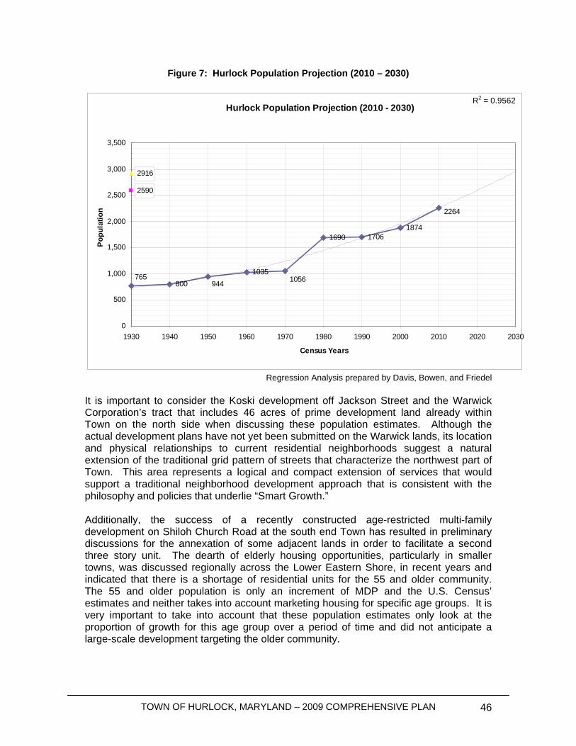
TOWN OF HURLOCK, MARYLAND – 2009 COMPREHENSIVE PLAN 46
Figure 7: Hurlock Population Projection (2010 – 2030)
Hurlock Population Projection (2010 - 2030)
8001035
1690 17061874
2590
2916
2264
1056944765
R2 = 0.9562
0
500
1,000
1,500
2,000
2,500
3,000
3,500
1930 1940 1950 1960 1970 1980 1990 2000 2010 2020 2030
Census Years
Pop
ulat
ion
Regression Analysis prepared by Davis, Bowen, and Friedel
It is important to consider the Koski development off Jackson Street and the Warwick Corporation’s tract that includes 46 acres of prime development land already within Town on the north side when discussing these population estimates. Although the actual development plans have not yet been submitted on the Warwick lands, its location and physical relationships to current residential neighborhoods suggest a natural extension of the traditional grid pattern of streets that characterize the northwest part of Town. This area represents a logical and compact extension of services that would support a traditional neighborhood development approach that is consistent with the philosophy and policies that underlie “Smart Growth.” Additionally, the success of a recently constructed age-restricted multi-family development on Shiloh Church Road at the south end Town has resulted in preliminary discussions for the annexation of some adjacent lands in order to facilitate a second three story unit. The dearth of elderly housing opportunities, particularly in smaller towns, was discussed regionally across the Lower Eastern Shore, in recent years and indicated that there is a shortage of residential units for the 55 and older community. The 55 and older population is only an increment of MDP and the U.S. Census’ estimates and neither takes into account marketing housing for specific age groups. It is very important to take into account that these population estimates only look at the proportion of growth for this age group over a period of time and did not anticipate a large-scale development targeting the older community.
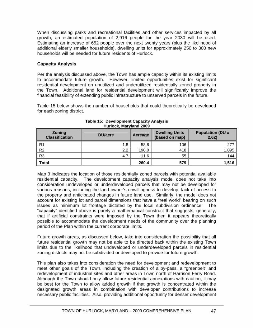
TOWN OF HURLOCK, MARYLAND – 2009 COMPREHENSIVE PLAN 47
When discussing parks and recreational facilities and other services impacted by all growth, an estimated population of 2,916 people for the year 2030 will be used. Estimating an increase of 652 people over the next twenty years (plus the likelihood of additional elderly smaller households), dwelling units for approximately 250 to 300 new households will be needed for future residents of Hurlock. Capacity Analysis Per the analysis discussed above, the Town has ample capacity within its existing limits to accommodate future growth. However, limited opportunities exist for significant residential development on unutilized and underutilized residentially zoned property in the Town. Additional land for residential development will significantly improve the financial feasibility of extending public infrastructure to unserved parcels in the future. Table 15 below shows the number of households that could theoretically be developed for each zoning district.
Table 15: Development Capacity Analysis Hurlock, Maryland 2009
Zoning Classification DU/acre Acreage Dwelling Units
(based on map) Population (DU x
2.62)
R1 1.8 58.8 106 277R2 2.2 190.0 418 1,095R3 4.7 11.6 55 144Total 260.4 579 1,516
Map 3 indicates the location of those residentially zoned parcels with potential available residential capacity. The development capacity analysis model does not take into consideration undeveloped or underdeveloped parcels that may not be developed for various reasons, including the land owner’s unwillingness to develop, lack of access to the property and anticipated changes in future land use. Similarly, the model does not account for existing lot and parcel dimensions that have a “real world” bearing on such issues as minimum lot frontage dictated by the local subdivision ordinance. The “capacity” identified above is purely a mathematical construct that suggests, generally, that if artificial constraints were imposed by the Town then it appears theoretically possible to accommodate the development needs of the community over the planning period of the Plan within the current corporate limits. Future growth areas, as discussed below, take into consideration the possibility that all future residential growth may not be able to be directed back within the existing Town limits due to the likelihood that undeveloped or underdeveloped parcels in residential zoning districts may not be subdivided or developed to provide for future growth. This plan also takes into consideration the need for development and redevelopment to meet other goals of the Town, including the creation of a by-pass, a “greenbelt” and redevelopment of industrial sites and other areas in Town north of Harrison Ferry Road. Although the Town should only allow future residential annexations with caution, it may be best for the Town to allow added growth if that growth is concentrated within the designated growth areas in combination with developer contributions to increase necessary public facilities. Also, providing additional opportunity for denser development
TOWN OF HURLOCK, MARYLAND – 2009 COMPREHENSIVE PLAN 48
of public water and sewer will reduce pressure for alternative large lot rural development in areas where sprawl has started to occur based on recent growth patterns. This fundamental principal of Smart Growth has been embraced by the Town of Hurlock and is reflected in the Comprehensive Plan. Acreage Demand for Future Development If future residential populations are strictly limited to available vacant land inventory, no additional acreage for residential development will be necessary over the 20-year outlook of this plan. The estimated 2030 population could be accommodated within unutilized and underutilized parcels, based on minimum lot sizes under an R-2 average density concept. However, the likelihood of such a development scenario is very low particularly so because many of these infill “opportunities” have existed since the early part of the twentieth century. It therefore seems more probable that they will continue to remain, for the most part, in their current state.
Future Land Use Future land uses are developed to assist the Town in shaping the future of the community to meet its needs and to plan future growth patterns. Future land uses for the areas within the existing City boundaries and growth areas are shown on Map 4. More specific information on the location of growth areas are shown on Map 5 and discussed further herein. The Town’s future land use map shows the vision of the residents of the community to promote infill growth, maintain a strong residential identity in the town core while promoting mixed use development nearby along the East New Market Road. The preponderance of new land uses however focus on and support the community’s vision as an ever stronger employment center for the region by identifying large tracts of land for industrial development. If significant job growth can be achieved, it may be necessary to revisit the discussion of population projections. It is entirely possible that the construction of an industrial park and new west side connector road, or “by-pass,” may result in a population “mini-boom” that is not accounted for in either the current population projection or the demand/capacity analysis of residential acreage. Hurlock chooses to adopt a positive attitude toward economic development and the resultant increase in local housing demand that can be anticipated from such events. Fortunately, the comprehensive planning process is an ongoing and continuing effort to balance vision with reality by ensuring the timely provision of necessary infrastructure as well as human “capacity” to absorb and manage growth. Accordingly, the six-year planning update cycle will afford opportunity to make mid-course corrections and fine tune both the Plan and the capital improvement process.
Current Town Boundaries
TOWN OF HURLOCK, MARYLAND – 2009 COMPREHENSIVE PLAN 49
Future land use designations provide for the logical extension of existing uses, fostering industrial development primarily south of East New Market Road plus additional industrial and mixed uses generally, on the west end. Future new residential areas are targeted toward the north (in the vicinity of a proposed regional in-Town park). Discussion will continue with Dorchester County to identify appropriate parcels for an “ultimate” greenbelt that may incorporate greenway and hiker/biker trail linkages to other “green infrastructure” planning that is ongoing on the Lower Eastern Shore. Below is a further discussion of land use designations for specific area in Hurlock. Downtown Hurlock Hurlock has a traditional 19th century downtown district that is both aesthetically pleasing and commercially viable. The Town should consider the affect development throughout the Town, positive or negative, will have in this area. Commercial uses that will detrimentally affect downtown business should be prohibited in other commercial areas. While the impact of more outlying commercial enterprises is not yet significant, it is important for the community to recognize the potential of a “downtown flight” by merchants to newer developments that might otherwise be zoned and permitted on the periphery. Careful consideration should be given to the nature, extent, and quality of mixed use development that may eventually change the west side. New residential development should be designed to create easy walking and biking access not just throughout the immediate neighborhoods but also create convenient, safe and attractive linkages to the downtown area. Most importantly, Hurlock’s “traditional” downtown should foster and maintain its traditional roots and encourage mixed uses where they appear to be economically viable. Opportunities for apartments above store fronts with new small scale highly landscaped rear yard parking areas should be both accommodated and promoted. This will help maintain downtown’s “sense of place” promote convenience and encourage pedestrian use into the evening hours. The Town may want to consider the creation of a limited overlay zone or Town Center Development District that has a mixture of development/redevelopment guidelines and standards while possibly relaxing other requirements and restrictions in the underlying zone(s) to facilitate creativity and private investment. This will increase the commercial activity for the downtown area and viability for the Town as a whole. Allowing residential development could potentially cause parking and traffic issues (depending on project scale and location) that will need to be studied prior to any significant planned expansion of residential uses. West side Infill The “west side infill” area of Town is located between Cabin Creek-Hurlock Road and Maryland Route 392. This wedge shaped area is already in town and is planned for additional residential, industrial, and mixed use residential/commercial development. As such, it is not specifically identified by color on Map-5 (which focuses on growth areas beyond the present corporate boundary). The discussion of regional access by truck and auto traffic spurred discussion of the need for a west side connector road and led to the ultimate long term vision for expanded growth and development in the large tracts it is envisioned to cross. The “wedge” is the conceptual keystone for the Town’s ultimate west side expansion. The area will link new growth areas with a new arterial connector (conceived as a median divided parkway) having controlled access into a series of “neighborhoods” that are in turn linked with one another by through local streets and
TOWN OF HURLOCK, MARYLAND – 2009 COMPREHENSIVE PLAN 50
pedestrian ways. The artful design of linked open spaces, greens, and visual buffers can ensure high quality built environments that are efficiently designed and retain a pleasing aesthetic that will attract workers, customers, and residents. The Town should perform an impact study to determine the impact of increased mixed uses on the downtown area and the consequences on parking and traffic. The study should also determine the wastewater treatment and drinking water capacity that would be needed to foster residential growth in this area. Corridor Plans Hurlock has several “corridors” that are significant in attracting people into downtown that should be emphasized. The following corridors should have well designed and implemented guidelines for architectural development, and for providing safe walking and biking paths:
• Maryland Route 331 – Academy Street to Main Street • Maryland Route 392 – along Delaware Avenue • Maryland Route 307 – following Poplar and Legion
The Town should work to create special guidelines for these corridors that provide for consistent growth patterns, uses and architectural standards. Also, since all of the roadways are under State jurisdiction, the Town should work with the State Highway Administration to ensure all State guidelines are being met with new and consistent local design standards. That outreach was already initiated during the preparation of the draft Plan and is anticipated to continue.
Growth Areas The annexation areas shown on the future land use map (Map 4) and described herein are based on areas most likely to request annexation and are in locations that best benefit the future of Hurlock consistent with its long-term vision for growth. These annexation areas have been designated with appropriately planned future land uses. The “planning area” indicated on the future land use map indicates areas that the Town may consider annexing into the Town to address its future growth needs. The proposed annexation areas should be reviewed when annexation requests are submitted and when the Comprehensive Plan is scheduled for review and revisions. Potential annexation parcels are few but relatively large. Accordingly, the Growth Area boundaries were designated to follow parcel boundaries and those parcels have been kept to a minimum. Growth Area 1 Growth Area 1 (GA1) is located to the northwest of the Town boundaries consisting of the balance of lands of the Warwick Corporation adjacent to the 46 acres already within Town. The parcel is generally bounded by Old Stage Coach Road and Waddells Corner Road to the north and Cabin Creek –Hurlock Road on the south (and indicated on Map 5 in brown). The current land use is agriculture, but the property owners have indicated a potential interest in future development. The Warwick Corporation also has adjacent

TOWN OF HURLOCK, MARYLAND – 2009 COMPREHENSIVE PLAN 51
land holdings already within Town in the wedge shaped area formed by Cabin Creek - Hurlock Road and East new market – Hurlock Road. The area has relatively few development constraints consisting primarily of limited wetlands that are generally found in conjunction with hydric soils in a forested area on the extreme west side of GA1. Habitats for rare or endangered species are not apparent, and GA1 is predominantly level open farmland. Steep slopes and streams (buffers) are not a concern in this area and do not prevent general site development. Since part of the Warwick farm is already in Town, and that 46 acre section is well placed for residential development, the balance of that parcel (452 acres) suggests itself as a priority for potential annexation. However, the current economic downturn may have placed many private developments on hold for an indeterminate time until demand and housing prices rebound. The “silver lining,” as such, in the current development market is that Hurlock has time to do careful and deliberate planning with regard to what, where, when, and how much development should occur as well as create the tools necessary to implement this Plan and the policies it recommends. GA1 is generalized as “immediate priority” (near term) that corresponds roughly to (current -15 year) time horizon. The limits are displayed on Map-5, Growth Areas. This Plan addresses primarily the immediate priority areas for growth and annexation. The “ultimate” scope of anticipated growth will be reviewed periodically and is subject to further refinement and revision. Growth Area 1 contains 452 acres which surrounds a significant portion (about 4,700 feet) of the proposed west side parkway or “by-pass” (14,000 + feet in total length) that is proposed in the Transportation Element. Since it is Town policy that new development pay for needed infrastructure, it has become clear that the cost to construct close to a mile of landscaped median divided highway will be considerable. That means that each developer along the designated route will need a very substantial project in order to ensure a pro forma that can absorb their portion of constructing their share of the new road. The added advantage to the Town of fewer and larger projects lies in the ability to review and approve fewer projects that can more easily be phased over time according to a master development concept. It is the Town’s intention to begin working with property owners within the Growth Area(s) to ensure an overall concept plan for mixed use development that will focus on the needs of both the Town and land owners in order to implement the general vision described herein. Growth Area 2 Growth Area 2 (GA2) is the 308 acre growth area recommended mainly for immediate (current -15 year priority) industrial development on the south and west sides. A little over 200 acres has been removed from immediate development priority and shifted into the “ultimate buildout” area as a result of comments received during the review process for the draft Plan. GA2 is also shown in brown and is labeled on Map-5. It is located adjacent to Town limits between East New Market Road and Shilo Church Road (in the vicinity of the Town’s waste water spray fields). A long term development priority area also intended for industrial uses is located just north of the spray fields. That area is mapped a lighter tan color as are the three parcels that were shifted out of “immediate growth priority.” This reduction in the development envelope is an accommodation to Dorchester County comments. However, Hurlock is concerned that sufficient land remain to ensure achieving the Town goal of remaining and expanding its role as a major regional employment center for Dorchester County and beyond. Similarly,
TOWN OF HURLOCK, MARYLAND – 2009 COMPREHENSIVE PLAN 52
proposed development projects should be of a scale that support the construction of that portion of the by-pass that transits the GA2 area. Water and waste water demands cannot be anticipated for GA2 at this time because no viable development proposals are currently under consideration. However, it is understood that all future development approvals, including preliminary subdivision and/or site plans, will be contingent upon available water and waste water treatment capacities, or planned upgrades and expansions of these systems that will provide the needed capacity on a timely basis to facilitate final inspections and occupancy permits. It is important that strong architectural and design guidelines be created for mixed use and industrial projects anticipated for the west side of Town and that they be implemented during the project review process. The west side “wedge” will have a significant impact on the character and livability of the downtown area. Thus, large scale industrial activity could potentially produce negative impacts by the very nature of the activities that are permitted. The Town may want to consider revisiting the question of impact standards regarding sound, vibration, glare, and general “visual” pollution that, if left unaddressed, could degrade the quality of life in residential areas. Many of these concerns can be relatively easily addressed through setbacks, visual screening, and security areas for storage of materials and finished products, especially if they are maintained within industrial buildings. The economic key to ensuring the success of new industrial development is adequate and timely provision of power, water, and waste handling capacity as well as convenient and safe commercial traffic routing. Recycling and cogeneration may be appropriate activities within GA2. The Town may also want to investigate the need for and suitability of this area for a small public service airfield.
Growth Area Development Alternatives Three residential development density scenarios were investigated that correspond to low, medium, and high density residential patterns contemplated by the Town’s current R-1, R-2, and R-3 zoning districts. Existing town zoning was used to analyze theoretical net dwelling unit production. GA1 total acreage was multiplied by average net realized densities for the various residential zones to gain a general understanding of theoretical potential equivalent dwelling unit (edu) production. Table 16 (below) suggests a large range of possible housing outcomes. Realistic development potential is a combination of housing types and densities, possibly clustered, to achieve open space and avoid hydric soils. That scenario is anticipated for the infill anticipated in the west side “wedge” that will link the two Growth Areas and extend existing newer residential areas on the west side of Town.
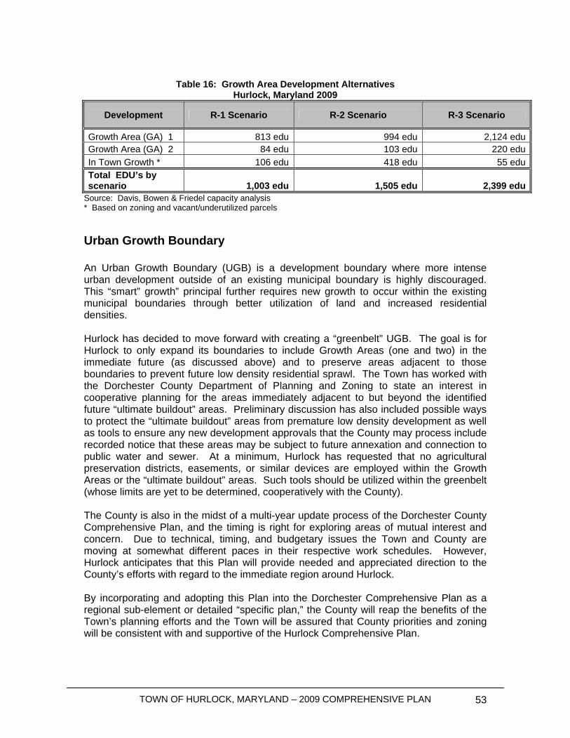
TOWN OF HURLOCK, MARYLAND – 2009 COMPREHENSIVE PLAN 53
Table 16: Growth Area Development Alternatives
Hurlock, Maryland 2009
Development R-1 Scenario R-2 Scenario R-3 Scenario
Growth Area (GA) 1 813 edu 994 edu 2,124 eduGrowth Area (GA) 2 84 edu 103 edu 220 eduIn Town Growth * 106 edu 418 edu 55 edu Total EDU’s by scenario 1,003 edu 1,505 edu 2,399 edu
Source: Davis, Bowen & Friedel capacity analysis * Based on zoning and vacant/underutilized parcels
Urban Growth Boundary An Urban Growth Boundary (UGB) is a development boundary where more intense urban development outside of an existing municipal boundary is highly discouraged. This “smart” growth” principal further requires new growth to occur within the existing municipal boundaries through better utilization of land and increased residential densities. Hurlock has decided to move forward with creating a “greenbelt” UGB. The goal is for Hurlock to only expand its boundaries to include Growth Areas (one and two) in the immediate future (as discussed above) and to preserve areas adjacent to those boundaries to prevent future low density residential sprawl. The Town has worked with the Dorchester County Department of Planning and Zoning to state an interest in cooperative planning for the areas immediately adjacent to but beyond the identified future “ultimate buildout” areas. Preliminary discussion has also included possible ways to protect the “ultimate buildout” areas from premature low density development as well as tools to ensure any new development approvals that the County may process include recorded notice that these areas may be subject to future annexation and connection to public water and sewer. At a minimum, Hurlock has requested that no agricultural preservation districts, easements, or similar devices are employed within the Growth Areas or the “ultimate buildout” areas. Such tools should be utilized within the greenbelt (whose limits are yet to be determined, cooperatively with the County). The County is also in the midst of a multi-year update process of the Dorchester County Comprehensive Plan, and the timing is right for exploring areas of mutual interest and concern. Due to technical, timing, and budgetary issues the Town and County are moving at somewhat different paces in their respective work schedules. However, Hurlock anticipates that this Plan will provide needed and appreciated direction to the County’s efforts with regard to the immediate region around Hurlock. By incorporating and adopting this Plan into the Dorchester Comprehensive Plan as a regional sub-element or detailed “specific plan,” the County will reap the benefits of the Town’s planning efforts and the Town will be assured that County priorities and zoning will be consistent with and supportive of the Hurlock Comprehensive Plan.
TOWN OF HURLOCK, MARYLAND – 2009 COMPREHENSIVE PLAN 54
This interjurisdictional coordination can focus on a consensus regarding a possible Urban Growth Boundary for the Town of Hurlock. At this point, it is premature to suggest specific parcels or breadth for inclusion in a mapped UGB. However, the Town agrees that, in principle, it is a good idea that should be pursued. The UGB could take the shape of a “greenbelt.” The UGB would remain beyond the outer edges of the long term development areas identified for “ultimate buildout.” Making the Greenbelt Work A greenbelt can not be successful without coordination of several groups, but most importantly, Dorchester County and the Town of Hurlock will need to work together to bring this project to fruition. Listed below are several steps that must be implemented to make this important project work:
• Dorchester County is considering revising the County’s zoning ordinance. Upon submittal of this Municipal Growth Element to the County for review, the Town should work with the County to make sure County zoning prohibits sprawl in the areas adjacent to the mapped Planning Area;
• Hurlock should not annex property beyond the Planning Area unless the property is being brought into the Town to ensure preservation;
• The Town should work closely with outside agencies’ preservation efforts to work to preserve lands within the general region;
Consistency with the County’s Comprehensive Plan Hurlock is working closely with Dorchester County in creating this 20-year outlook for the community. A major goal of the County’s plan is to direct future populations toward the County’s municipal population centers in order to control sprawl. When implemented, this policy could support the upward revision of the Hurlock population projection. The establishment of an Urban Growth Boundary is consistent with the County’s goals. Based on future residential growth areas, committed and approved development, and potential units that could be developed within the Town, approximately 900 to 2,000 dwelling units could ultimately be developed. Thus, it is vitally important for the Town and County to work together in finalizing the location and strategies for implementing the UGB in order to prevent growth beyond what the Town is capable of efficiently serving and beyond what the County is targeting for ultimate buildout in and around Hurlock. The working draft of the Dorchester Comprehensive Plan includes a map of the Hurlock Planning Area that documents the ongoing interjurisdictional cooperation and coordination enjoyed by the Town and County. The Greenbelt displayed in draft form is in general conformance with this Hurlock Comprehensive Plan and may be subject to some revision pending additional work by both Town and County. Priorities for annexation and growth within the two designated growth areas are further delineated into short term and long term concepts that reflect both Town vision and County policy (for promoting Smart Growth principles such as directing growth in rural areas to existing municipalities where public services are available). An excerpt from the draft County map is provided below:
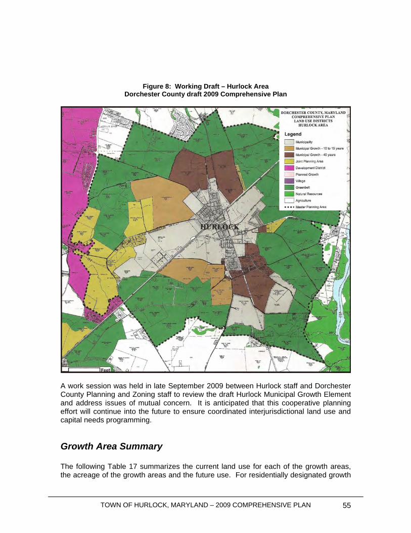
TOWN OF HURLOCK, MARYLAND – 2009 COMPREHENSIVE PLAN 55
Figure 8: Working Draft – Hurlock Area Dorchester County draft 2009 Comprehensive Plan
A work session was held in late September 2009 between Hurlock staff and Dorchester County Planning and Zoning staff to review the draft Hurlock Municipal Growth Element and address issues of mutual concern. It is anticipated that this cooperative planning effort will continue into the future to ensure coordinated interjurisdictional land use and capital needs programming.
Growth Area Summary The following Table 17 summarizes the current land use for each of the growth areas, the acreage of the growth areas and the future use. For residentially designated growth
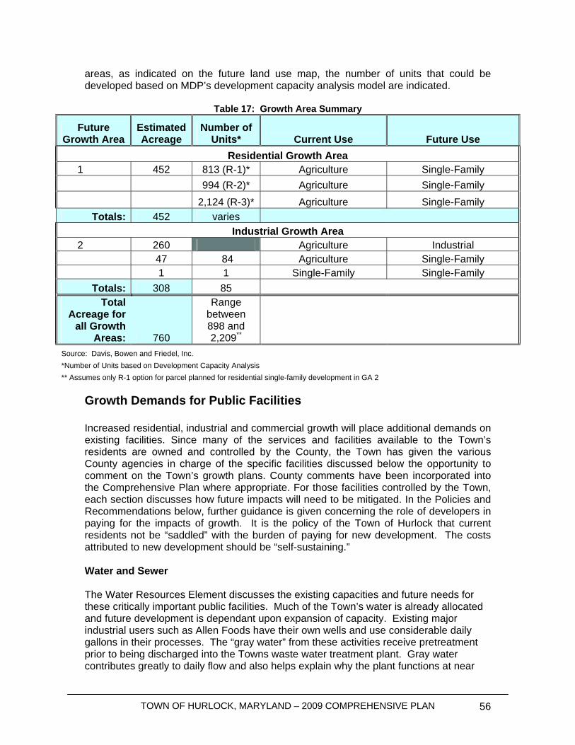
TOWN OF HURLOCK, MARYLAND – 2009 COMPREHENSIVE PLAN 56
areas, as indicated on the future land use map, the number of units that could be developed based on MDP’s development capacity analysis model are indicated.
Table 17: Growth Area Summary
Future Growth Area
Estimated Acreage
Number of Units* Current Use Future Use
Residential Growth Area 1 452 813 (R-1)* Agriculture Single-Family 994 (R-2)* Agriculture Single-Family 2,124 (R-3)* Agriculture Single-Family
Totals: 452 varies Industrial Growth Area
2 260 Agriculture Industrial 47 84 Agriculture Single-Family 1 1 Single-Family Single-Family
Totals: 308 85 Total
Acreage for all Growth
Areas: 760
Range between 898 and 2,209**
Source: Davis, Bowen and Friedel, Inc. *Number of Units based on Development Capacity Analysis ** Assumes only R-1 option for parcel planned for residential single-family development in GA 2
Growth Demands for Public Facilities Increased residential, industrial and commercial growth will place additional demands on existing facilities. Since many of the services and facilities available to the Town’s residents are owned and controlled by the County, the Town has given the various County agencies in charge of the specific facilities discussed below the opportunity to comment on the Town’s growth plans. County comments have been incorporated into the Comprehensive Plan where appropriate. For those facilities controlled by the Town, each section discusses how future impacts will need to be mitigated. In the Policies and Recommendations below, further guidance is given concerning the role of developers in paying for the impacts of growth. It is the policy of the Town of Hurlock that current residents not be “saddled” with the burden of paying for new development. The costs attributed to new development should be “self-sustaining.” Water and Sewer The Water Resources Element discusses the existing capacities and future needs for these critically important public facilities. Much of the Town’s water is already allocated and future development is dependant upon expansion of capacity. Existing major industrial users such as Allen Foods have their own wells and use considerable daily gallons in their processes. The “gray water” from these activities receive pretreatment prior to being discharged into the Towns waste water treatment plant. Gray water contributes greatly to daily flow and also helps explain why the plant functions at near
TOWN OF HURLOCK, MARYLAND – 2009 COMPREHENSIVE PLAN 57
ENR levels. Industrial flows contribute nearly no nitrogen or phosphorus and do not contain any heavy metals or similar contaminants. If future plant expansions increase discharge levels above those that MDE will approve, the Town’s two major spray irrigation areas (shown on the Future Land Use map as “municipal/agricultural” )will provide adequate disposal capacity. Accordingly, over the near term, growth induced demands will focus on expansion of potable water [which the Town is making its priority]. Parks and Recreation The State of Maryland and the Program Open Space goal is to provide 30 acres of park space for every 1,000 residents. With the Town receiving Program Open Space funds for its Comprehensive Parks and Recreation Plan and potential future requests for park improvements, it is important for the Town to adopt goals consistent with the program. The Town currently has a shortage of park facilities for the existing residents. The goal is to provide 68 acres of park space to meet the Program Open Space goal, where only 25 acres exist. If one includes passive open space set aside within existing subdivisions, the Town still has a deficit of approximately 42.5 acres. However, future populations will require an additional 62 acres of parks and recreational facilities to meet Program Open Space goals. While new subdivision development may be able to make up some of this deficit, residents’ proximity and access to parks needs to be considered. The Town should consider working with the developers to develop a larger park for the growing community, which could also serve potential development in the northern growth area. Since setting aside parks and recreational facilities within an approved subdivision or infill lot is not always feasible, or in the best interest of the Town, other strategies should be sought. For instance, a fee-in-lieu of park set aside space could be considered for park development. The Comprehensive Parks and Recreation plan should better detail the Town’s needs and properly plan for bringing those needs to fruition. This Plan recommends that a park facilities master plan be created that identifies Hurlock’s overall existing recreational inventory and future needs. The park facilities plan should specify future additions and individual park improvements and can become the basis for supporting Program Open Space acquisition and development requests. The main concern with existing public recreational and green space in Hurlock is to redevelop the inner-city parks so as to optimize their use. Currently, the existing park (and school) does have a number of facilities including playground (for the 2-5 and over 5 age groups), sports fields and picnic facilities, but an important amount of needed park space is left unaddressed. The Town should send out a Request for Proposals for the creation of a Comprehensive Parks and Recreation Plan in order to refine needs and set priorities for acquision and development. The goal is to optimize these spaces through landscape design, careful selection of activity spaces and amenities, and to create links between them in order to generate a sense of place, identity and connectivity to surrounding neighborhoods. Public Schools
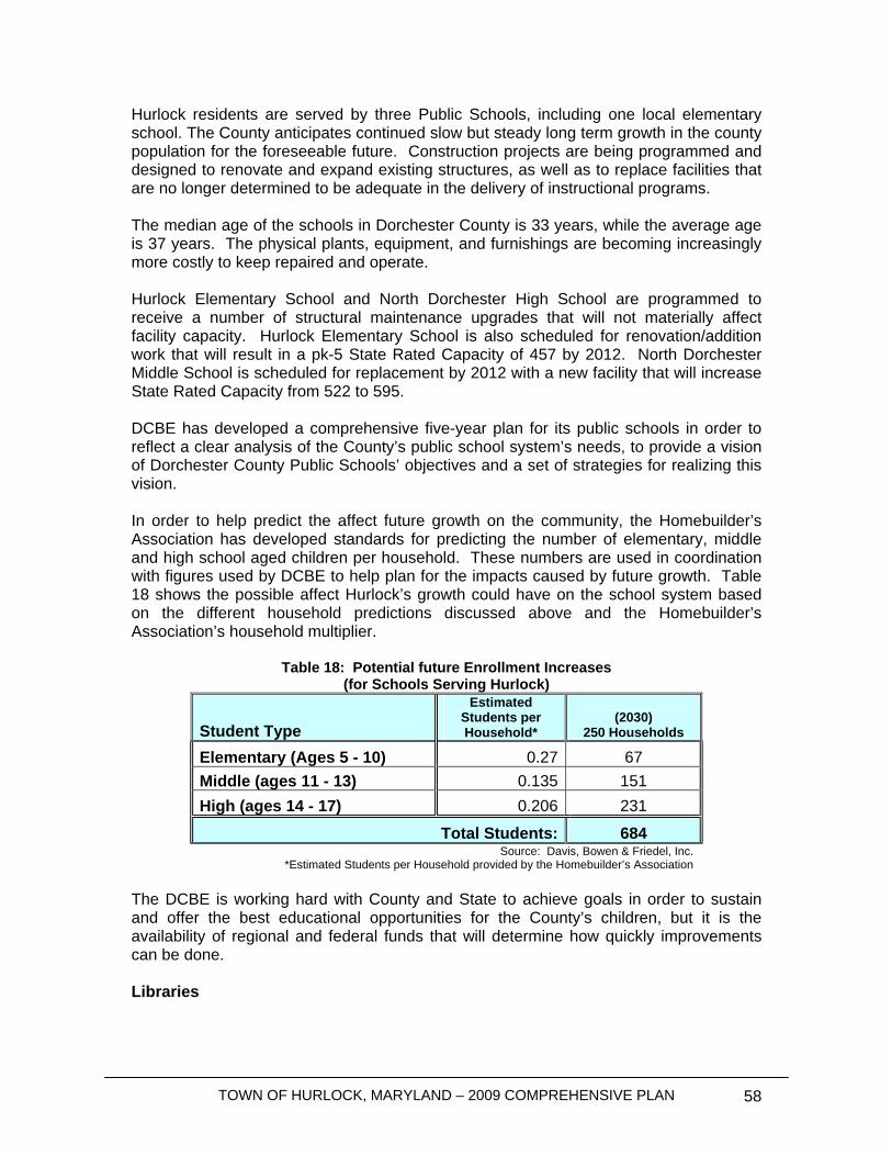
TOWN OF HURLOCK, MARYLAND – 2009 COMPREHENSIVE PLAN 58
Hurlock residents are served by three Public Schools, including one local elementary school. The County anticipates continued slow but steady long term growth in the county population for the foreseeable future. Construction projects are being programmed and designed to renovate and expand existing structures, as well as to replace facilities that are no longer determined to be adequate in the delivery of instructional programs. The median age of the schools in Dorchester County is 33 years, while the average age is 37 years. The physical plants, equipment, and furnishings are becoming increasingly more costly to keep repaired and operate. Hurlock Elementary School and North Dorchester High School are programmed to receive a number of structural maintenance upgrades that will not materially affect facility capacity. Hurlock Elementary School is also scheduled for renovation/addition work that will result in a pk-5 State Rated Capacity of 457 by 2012. North Dorchester Middle School is scheduled for replacement by 2012 with a new facility that will increase State Rated Capacity from 522 to 595. DCBE has developed a comprehensive five-year plan for its public schools in order to reflect a clear analysis of the County’s public school system’s needs, to provide a vision of Dorchester County Public Schools’ objectives and a set of strategies for realizing this vision. In order to help predict the affect future growth on the community, the Homebuilder’s Association has developed standards for predicting the number of elementary, middle and high school aged children per household. These numbers are used in coordination with figures used by DCBE to help plan for the impacts caused by future growth. Table 18 shows the possible affect Hurlock’s growth could have on the school system based on the different household predictions discussed above and the Homebuilder’s Association’s household multiplier.
Table 18: Potential future Enrollment Increases (for Schools Serving Hurlock)
Student Type
Estimated Students per Household*
(2030) 250 Households
Elementary (Ages 5 - 10) 0.27 67 Middle (ages 11 - 13) 0.135 151 High (ages 14 - 17) 0.206 231
Total Students: 684 Source: Davis, Bowen & Friedel, Inc.
*Estimated Students per Household provided by the Homebuilder’s Association The DCBE is working hard with County and State to achieve goals in order to sustain and offer the best educational opportunities for the County’s children, but it is the availability of regional and federal funds that will determine how quickly improvements can be done. Libraries
TOWN OF HURLOCK, MARYLAND – 2009 COMPREHENSIVE PLAN 59
The Town of Hurlock is home to the second oldest active library in the State of Maryland. The Hurlock Branch of the Dorchester County Public Library is located at 222 South Main Street. The library occupies the former post office building and has been deemed adequate for the current service population. As Hurlock and the north Dorchester County region grows, the County will continue to evaluate the adequacy of the facility and collection and make changes and improvements, as warranted. The American Library Association utilizes a generally accepted standard of 1,000 square feet per 10,000 residents. Economies of scale are realized as population and service area density increase (and reinforces the concepts underlying “smart growth.” Public Transportation MUST, a fixed route service, is a collaborative effort between Delmarva Community Transit in Dorchester County, USTAR in Kent, Caroline and Talbot Counties and Queen Anne’s County, County Ride. Special services are available for persons unable to use the regional fixed routes. No growth induced capacity impacts have been identified as a result of the projected growth during the “immediate” priority growth scenarios. More information is available in the Transportation Element. Public Health Hurlock is served by a family physician and a dentist, located in the medical center on Collins Avenue. For specialized services, residents need to travel to Cambridge, Easton, or Seaford, DE. Dorchester General and the Eastern Shore Hospital Center, both in Cambridge, are the closest larger medical facilities that provide inpatient services. No growth induced capacity issues have been identified to date.
No plans exist to expand medical services within Hurlock. However, additional practitioners may find a local market as population increases. The Town may wish to consider medical offices as an appropriate adaptive reuse in the downtown core, especially in the traffic corridors previously identified. Public Safety and Emergency Services Hurlock’s Police Department currently responds to police and emergency calls with adequate resources. Based on standards developed by the International Association of Police Chiefs (IAPC), 2.5 police officers are adequate to serve every 1,000 residents. Hurlock has a staff of eight police officers. The potential increase in population for the Town and Growth Area buildout could eventually require the recruitment of two additional officers based on IAPC standards, as well as additional space to accommodate the new employees. Residents would like to see additional foot and bike patrols throughout the Town. The Department should monitor future growth impacts by expanding infrastructure and mobilizing resources so as to answer the demand for public safety in the area accordingly. The Hurlock Area Fire Department has adequate resources and staffing to serve Hurlock currently and through the 2030 growth period. The Volunteer Fire Department will

TOWN OF HURLOCK, MARYLAND – 2009 COMPREHENSIVE PLAN 60
continue to evaluate its needs periodically to ensure response times and services do not decline.
Policies and Recommendations In order to meet the future growth needs of the Town and the goals, objectives and visions of the Town, the following policies should be considered to accommodate future growth: Intergovernmental Coordination
• Request Dorchester County to recognize the Town’s growth areas and amend the Water and Sewer Master Plan, as necessary to accommodate future growth;
• Request that Dorchester County recognizes the Town’s greenbelt development plans and make zoning changes, as necessary, to help the Town implement this Plan
• Work with Maryland Department of Planning to have growth areas placed into Priority Funding Areas;
• Work with Maryland environmental agencies to improve and upgrade awareness and implementation of programs and regulations designed to improve the health of the region and the Chesapeake Bay;
• Review growth over a six-year period and update the Comprehensive Plan as necessary.
Parks and Recreational Facilities
• Require developers to set aside open space as discussed herein to help reduce parks and recreational deficits;
• Require a mix of passive and active recreational spaces; • Begin looking for land to develop a large, regional park for the use of Hurlock
residents and the greater community. • Continue to work with Dorchester County Recreation and Parks Department
Public Safety
• Per IAPC standards, Hurlock may need to recruit two additional officers and the necessary resources to adequately provide services to the growing community. The Town should plan for the need for an increase in officers and the necessary equipment and space;
• The Police Department and the Town should determine the potential to provide increased foot and bike patrols;
• The Town should work with the Volunteer Fire Department to ensure adequate resources are available and that the Department is aware of potential future growth in the Town;
• Emergency Response staff should continue to coordinate with surrounding jurisdictions on emergency response and evacuation planning.
TOWN OF HURLOCK, MARYLAND – 2009 COMPREHENSIVE PLAN 61
Public School Policies
• Review the educational facilities master plan for schools, as it becomes available and use it to evaluate development proposals;
• Provide development information to Dorchester County Board of Education; Library
• Where possible, have developers contribute toward keeping the library downtown.
Land Use and Zoning
• Separate commercial uses allowed along MD 392 from those uses allowed downtown;
• Allow and encourage residential uses downtown after performing an impact study;
• Protect forested areas and begin developing a “greenbelt” urban growth boundary around the entire Town;
• Implement the historic area discussion and recommendations in the Sensitive Areas chapter;
• Implement the Historic Commission recommendations as suggested by the Maryland Department of Planning (i.e. architectural guidelines).
Corridor Plans
• Recognize the corridors discussed herein as special to the vitality of the Town; • Perform an architectural study in order to create a set of standards for each
corridor to be added into the zoning ordinance; “Greenbelt” Urban Development Boundary
• Work with Dorchester County to preserve areas beyond the Planning Area in agricultural use and very low density residential development with local focus on directing development into Town and into the 0-15 year priority area of the designated Growth Area.
• The Town should work with the County to help ensure County zoning prohibits sprawl and uncharacteristic redevelopment in areas adjacent to planned growth areas;
• Hurlock should not annex property in the greenbelt unless the property is being brought into the Town to ensure preservation;
• The Town should work closely with outside agency’s preservation efforts to work to preserve lands within future greenbelt districts;
• The Town should discuss suitable funding mechanisms with the County in order that the County can preserve future greenbelt areas;
• Hurlock should work to ensure desirable Industrial development locates within designated Industrial growth areas while minimizing potential environmental impacts associated with development.
• Hurlock should coordinate with Dorchester County to determine whether appropriate areas can (and should) be located beyond municipal boundaries to
TOWN OF HURLOCK, MARYLAND – 2009 COMPREHENSIVE PLAN 62
accommodate industrial uses that include unavoidable negative impacts associated with their processes that would be inappropriate to locate proximate to urbanized and residential areas. Potential examples of such uses might include: rendering plants, solid waste disposal sites, and certain other agricultural processing activities.

TOWN OF HURLOCK, MARYLAND – 2009 COMPREHENSIVE PLAN 63
This page was intentionally left blank
TOWN OF HURLOCK, MARYLAND – 2009 COMPREHENSIVE PLAN 64
Water Resources Element
Introduction In 2006, the Maryland Legislature required all counties and municipalities to examine their water resources when predicting future growth. The Water Resources Element requires municipalities to analyze current water supplies, wastewater treatment plant capacity, and point source and non-point source loadings. When looking at the future growth needs, the Town must address any shortcomings of water resources and either change future land use scenarios to eliminate problem areas or provide options to address any limitations. The following section examines Hurlock’s existing water resources in conjunction with the Town’s current development and projected future growth. Where necessary, improvements and alternatives to solve any water resource problems are discussed. Growth Assumptions In Chapter 6, the Municipal Growth Element established growth scenarios for the residential dwelling units in Hurlock, Maryland. Two scenarios will be evaluated for predicting growth: Evaluation of infill within the existing corporate limits and analysis of designated growth areas. Evaluation of infill involves identifying undeveloped lots within the existing corporate limits of the Town and estimating uses and potential demands based on zoning and lot size. The total potential future usage within the existing town boundary is estimated at 579 equivalent dwelling units (EDU’s) based on zoning and acreage. An EDU is equal to one residence assuming an average 2.62 people within the residence. Designated growth areas are areas outside the current corporate limits that would be most conducive to annexation due to serviceability, geographic proximity, and presence of community facilities. The two designated growth areas in Hurlock are described in the Municipal Growth Element. The total residential usage anticipated within the designated growth areas is estimated to range between 897 and 2,344 EDU’s. Additional capacity may be needed in order to accommodate future industrial/commercial growth as well as a range of potential infill development demands. The Town of Hurlock will evaluate the ability to provide water and sewer services to industrial and commercial users upon the users request. This Water Resource Element will evaluate the Town’s water supply, wastewater capacity, and source loading with respect to the growth projected in the infill build-out scenario of 579 EDU’s. The hypothetical ultimate build-out scenario would account for full infill and complete development of all designated growth areas resulting in an increase of between 1,476 and 2,923 EDUs. At this time it is highly improbable that the Town will experience this level of growth over the next 20 years.
TOWN OF HURLOCK, MARYLAND – 2009 COMPREHENSIVE PLAN 65
Water Systems
Groundwater Sources All of the potable water supplied by Hurlock used for industrial, commercial and residential purposes within the Town of Hurlock is secured from two aquifers, the Quaternary Aquifer and the Piney Point Aquifer. The Town has two wells, located on Delaware Avenue, to supply water to the public distribution system. The Town has established a Wellhead Protection Area to prevent source water contamination through regulating land use. The Town will evaluate the Wellhead Protection Area during project planning and assess potential problem areas and present solutions to prevent source water contamination. Well Production Between 2006 and 2008, the average daily flow was 342,730 gallons per day (GPD). This average is lower than the annual averages for the past six years. The peak month in 2007 was July with average daily usage of 490,613 gallons per day (GPD). Hurlock currently does not require meters for residential properties. Large industrial and commercial users are the only metered connections within the Town. The average daily flow for these metered users is approximately 59,979 GPD. For the purposes of this evaluation, the unmetered commercial and industrial connections will be considered equal to residential connections. Utilizing the average usage during the peak month and the Town’s current population of 2,264, the Town averages 497 GPD/EDU during the peak month. Applying the usage rate to the potential of 250 future residential infill connections, would result in an approximate increase in water demand of 124,250 GPD. Bringing the total water supply required within the distribution system to 614,863 GPD. With the largest producing well out of service, the Quaternary Well, the Piney Point Well would not be able to maintain the flow to provide water for the existing users during the Maximum Daily Flow as required within the Recommended Standards for Water Works. To allow for water production in times of power outages, a generator should be placed at the Delaware Well site. With existing demands, it is recommended that a backup well be constructed within the Quaternary aquifer to provide water during periods when wells are removed from the system for maintenance. The Average Daily Flow per resident is approximately 390 GPD/EDU with industrial and commercial usages. With the industrial and commercial usages removed from the overall flow, the daily water usage drops to 325 GPD/EDU. The Maryland Department of the Environment generally accepted water usage projection is 250 GPD/EDU. The higher than average usage could partially be attributed to large users that are not metered, such as the school. The Town of Hurlock should consider adding water meters to all commercial and residential connections to allow users to become more aware of the amount of water being used and to potentially reduce overall usage within the distribution system.
TOWN OF HURLOCK, MARYLAND – 2009 COMPREHENSIVE PLAN 66
Water Appropriations & Use Permit The sole source of water for the Town of Hurlock is supplied through two wells at the Delaware Avenue Well site. The Town has two Water Appropriation and Use Permits (WAUP) that allow for a withdrawal of 140,000 GPD on the average day and 180,000 GPD during the Month of Maximum Use from the Quaternary Aquifer and 280,000 GPD on the average day and 360,000 GPD during the Month of Maximum Use from the Piney Point Aquifer. These numbers show that the Town’s total permitted water yield allowed by the present WAUP is sufficient to meet the Town’s current usage demands. The Town is currently at 91% of the permitted threshold during the Month of Maximum Use and 82% of the annual Average Daily Flow; thus the Town should closely monitor water usage and begin procedures to increase the existing permits to prevent delays with infill development and future projects. The Town has the potential to increase the residential water usage by 124,250 GPD during the month of maximum use by 2030. The projected flow, would surpass the combined existing WAUP’s by over 74,863 GPD. An increase in the two WAUP’s would be needed to accommodate the projected future growth. In addition, Recommended Standards for Water Works (2007), “Ten States Standards”, requires that the total source capacity meet the peak demand with the largest well out of service. The Town’s largest well is the 700 GPM Quaternary well. With the Quaternary well out of service, the Piney Point well is capable of producing 633,600 gallons of water over a 24 hour period. Theoretically the Piney Point well is capable of producing enough water to supply the existing Town while the Quaternary well is out of service. Due to the extended run times, a backup well in the Quaternary aquifer is recommended to supplement the existing wells during periods when a well is out of service. Pumping test data was insufficient at the time of this study to confirm that existing wells could sustain capacity and the pumping hours to meet future demands. Further Hydro-Geological investigations would need to be performed to ensure that the well is capable of producing larger volumes of water without causing permanent drawdown to the aquifer or negative effects on nearby water users. Unfortunately, neither aquifer is individually permitted to produce the full quantity of water consumed by the Town during the existing Month of Maximum Use. The Town should consider adding additional wells or increasing the two existing WAUP’s to provide the Town with the ability to pull one average day’s water usage from either source. In the interim period, the Town should closely monitor water usage and well production as the Town continues to grow to ensure the WAUP requirements are being met.
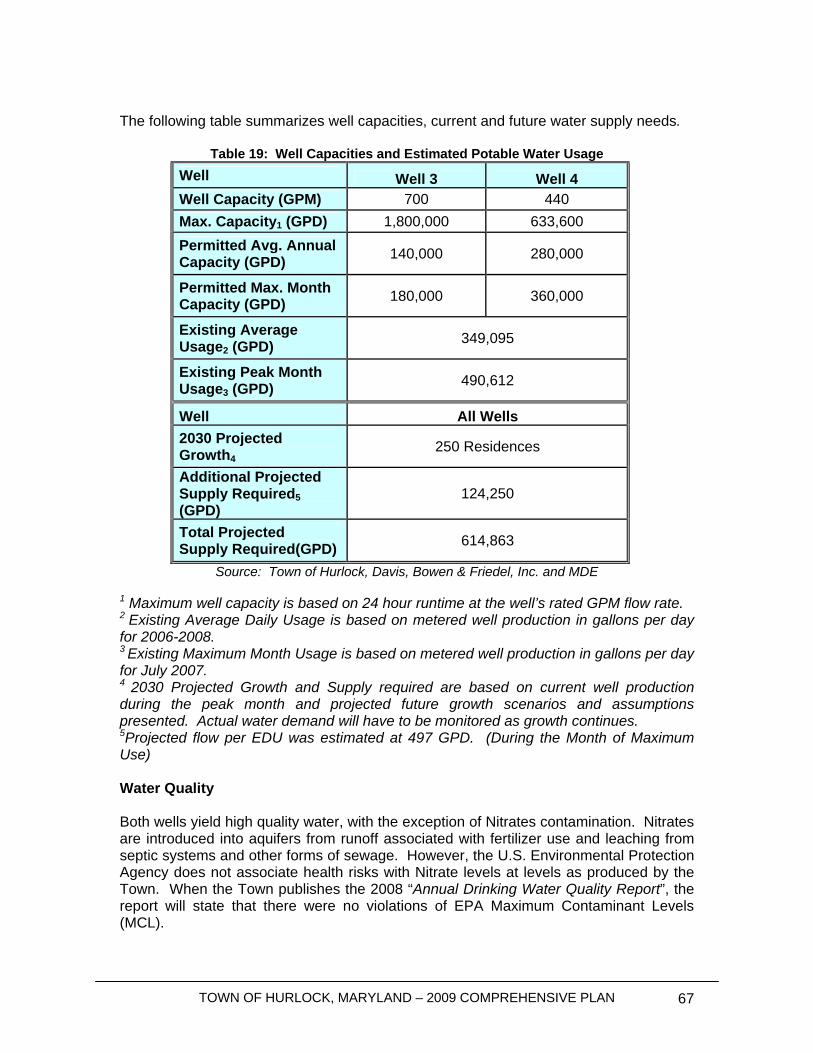
TOWN OF HURLOCK, MARYLAND – 2009 COMPREHENSIVE PLAN 67
The following table summarizes well capacities, current and future water supply needs.
Table 19: Well Capacities and Estimated Potable Water Usage Well Well 3 Well 4 Well Capacity (GPM) 700 440 Max. Capacity1 (GPD) 1,800,000 633,600 Permitted Avg. Annual Capacity (GPD) 140,000 280,000
Permitted Max. Month Capacity (GPD) 180,000 360,000
Existing Average Usage2 (GPD) 349,095
Existing Peak Month Usage3 (GPD) 490,612
Well All Wells 2030 Projected Growth4
250 Residences
Additional Projected Supply Required5 (GPD)
124,250
Total Projected Supply Required(GPD) 614,863
Source: Town of Hurlock, Davis, Bowen & Friedel, Inc. and MDE 1 Maximum well capacity is based on 24 hour runtime at the well’s rated GPM flow rate. 2 Existing Average Daily Usage is based on metered well production in gallons per day for 2006-2008. 3 Existing Maximum Month Usage is based on metered well production in gallons per day for July 2007. 4 2030 Projected Growth and Supply required are based on current well production during the peak month and projected future growth scenarios and assumptions presented. Actual water demand will have to be monitored as growth continues. 5Projected flow per EDU was estimated at 497 GPD. (During the Month of Maximum Use) Water Quality Both wells yield high quality water, with the exception of Nitrates contamination. Nitrates are introduced into aquifers from runoff associated with fertilizer use and leaching from septic systems and other forms of sewage. However, the U.S. Environmental Protection Agency does not associate health risks with Nitrate levels at levels as produced by the Town. When the Town publishes the 2008 “Annual Drinking Water Quality Report”, the report will state that there were no violations of EPA Maximum Contaminant Levels (MCL).

TOWN OF HURLOCK, MARYLAND – 2009 COMPREHENSIVE PLAN 68
Raw water from the wells is treated at the Delaware Avenue well site before entering into the distribution system. The water treatment process includes Chlorine Gas for disinfection, Soda Ash for pH control and fluoride to prevent tooth decay before entering the distribution system. Water Storage “Ten States Standards” require that finished water storage facilities have sufficient capacity to meet one day’s domestic usage plus fire flows. Where source water and water treatment facilities have back-up power, available capacity can supplement peak storage demands. Presently, without backup power, the Town does not have sufficient storage capacity to meet the average daily flow during the month of maximum use. Storage for the distribution system is currently provided by an elevated storage tank with a total storage of 300,000 gallons. The fire flow storage required would be calculated based on 1,500 GPM fire flow for 2 hours, which is equal to 180,000 gallons. Therefore, the total future storage required would be 794,863 gallons. The water supply and treatment systems can supplement an additional 1,394,400 gallons, if backup power is added to the Delaware Avenue well site with the wells operating 16 hours a day. Currently the Town has designed a back-up generator for the well site. If funding becomes available, a secondary power source would be constructed. Therefore, the tower, in addition to the additional storage offered by the water supply and treatment facilities, once back-up power is provided, would produce 1,394,400 gallons. It is recommended that the total elevated storage for the system not fall below 40% of the overall daily water demand. As the Town’s storage tank ages, the Town should reduce their reliance on the single storage source. Aging of the tank could cause extended periods of time when the tank may need to be taken out of service to provide maintenance. Once less than 50% of the overall storage is provided by the elevated storage tank, the Town should consider preparations to add additional above ground storage to the system.
Water Summary The Town does not currently have sufficient water supply capabilities to accommodate the current user demands during the Month of Maximum Use when the largest well is out of service. The Town should consider a backup well in the Quaternary aquifer to supplement the existing well field. To provide adequate storage capacity to meet the existing and future flows, the addition of a back-up generator at the existing Delaware Avenue well site will also be needed. The Town will need to closely monitor well production while performing hydro-geological testing and requesting an increase to the existing WAUP’s, to ensure that the individual WAUP’s requirements are not exceeded.
Wastewater Systems
Wastewater Flows The Town currently averages approximately 1.178 million gallons per day (MGD) of wastewater based on the Town’s wastewater treatment plant influent flow meter over a two year period from January 2007 through December 2008. There are 2,264 residents
TOWN OF HURLOCK, MARYLAND – 2009 COMPREHENSIVE PLAN 69
actively utilizing the sewer system, which equates to approximately 520 GPD per person served by the system. The high flow per capita is due to two large industrial users discharging into the sanitary sewer system. Allen’s Family Foods and B&G Foods account for approximately 70% of the Town’s wastewater flow. After removing these observed usages from the overall flow into the WWTP, the flow per capita is reduced to approximately 154 GPD/person. The treatment facility is currently permitted for 1.65 MGD which puts the existing WWTP flow at 72% of the rated capacity. Projected growth of 250 EDU’s, at an average of 400 GPD/EDU, will result in an approximate increase in wastewater flows of 100,000 GPD. This growth projection will bring the total average daily flow for the WWTP to 1,278,000 MGD or 78% of the plants rated capacity. During 2008, approximately 270,000 GPD of wastewater was diverted to the Town’s wastewater lagoons and discharged through the spray irrigation system. With 120 acres of lagoons and a WWTP capacity of 1.65 MGD, the facility is capable of handling the projected growth through 2030 and normal peak or wet weather flows. Wastewater Treatment Since the completion of BNR WWTP construction, the treatment plant has achieved Enhanced Nutrient Removal, ENR, levels of treatment. The treatment plant has been enhanced by the installation of additional chemical feed equipment to remove phosphorus. The existing stream discharge permit allows the Town to discharge 1.65 MGD into Wrights Branch throughout the year. In addition to a stream discharge, the Town has 120 acres of wastewater lagoons that gives the Town the option to discharge the treated effluent through the spray irrigation system. The receiving lagoons are currently used to hold waste activated sludge from the treatment process and to hold decant and rainwater for disposal on the spray fields. In 2008, the Town only utilized the spray irrigation system during the summer months. Nutrient Loads The Town owned and operated WWTP discharges into Wright’s Branch, a small tributary of the Nanticoke River. Under the Chesapeake Bay Tributary Strategy, the Town’s wastewater treatment plant is currently assigned annual Total Maximum Discharge Loading goal of 20,101 pounds per year for Total Nitrogen, which equates to 4.0 mg/L. Total Phosphorus has a goal of 1,508 pounds per year which equates to 0.3 mg/L. Due to the two large industries that discharge waste water through the sewerage system, the Town experiences a low nitrogen and phosphorous concentration at the WWTP. The Town also utilizes the spray irrigation system, further decreasing nitrogen and phosphorous levels discharged through the stream discharge. During 2008, the existing ENR plant averaged 890,000 GPD of stream discharge that released nitrogen at a rate of 2.66 mg/l or 7,206.6 lbs/yr and phosphorus at a rate of 0.13mg/l or 352.2 lbs/yr. By adding the increased flow to the existing stream discharge at the maximum allowable loading, in 2030, the WWTP is anticipated to release nitrogen at a rate of 8,424.24 lbs/yr and Phosphorus at 443.52 lbs/yr; well below the permitted thresholds.
Inflow & Infiltration Although the WWTP regularly meets its permitted capacity rating based on the average monthly flow, during periods of heavy precipitation, the WWTP can at times experience
TOWN OF HURLOCK, MARYLAND – 2009 COMPREHENSIVE PLAN 70
increased flows. During certain rain events, influent is diverted from the process train to the lagoons. The Town should perform an inflow and infiltration study to identify problem areas and subsequently prepare a plan to repair or replace any items deemed necessary.
Septic Systems Currently there are no on-site septic systems in use within Town limits. The Town requires all properties that are annexed into the Town to connect to the public water and sanitary sewer systems. No new septic systems are being anticipated for future growth areas.
Wastewater Summary The Town’s existing WWTP has sufficient capacity to treat wastewater flows generated by the current and future population. However, any future increases by Industrial users would need to be analyzed on a case by case basis to determine if the system is capable of handling the additional flows.
Hypothetical Build-Out Scenario The following build-out discussion takes into consideration the water needs and wastewater capacity needs the Town will have if all growth areas are completely developed. Please keep in mind that this scenario is not expected to happen within the 20 year planning period of this document. Hypothetically, up to 2,813 additional residential units are possible in the growth areas and including all undeveloped and underdeveloped parcels within the existing Town limits. It is estimated that the wastewater treatment system would receive an additional 1,032,804 gallons per day capacity and the Town’s wells would need to provide an additional 1,032,804 gallons per day. This would require upgrades to the wastewater treatment facilities and water supply and treatment facilities.
County Water and Sewer Master Plan Dorchester County is in the process of completing its Water Resources Element. Upon completion of the Water Resources Element, the County plans to work cooperatively with the municipalities to look at their designated growth areas. This information will be used to update the County’s Water and Sewer Master Plan and complete the update to its Comprehensive Plan. Hurlock will continue to work closely with the County on designating future water and sewer areas. The Town does not foresee any issues with amending the County Water and Sewer Master Plan, if necessary, since the Town and the County worked together to designate the Town’s future growth areas as seen on Map 5.
TOWN OF HURLOCK, MARYLAND – 2009 COMPREHENSIVE PLAN 71
Stormwater Loading As part of the Water Resources Element, the Maryland Department of Environment has provided a spreadsheet to estimate the affect future development and land use changes will have on non-point source nutrient runoff, open space and impervious space. The Town is to create different land use scenarios and use the spreadsheet to calculate the impact of each land use scenario. The Town should select the least impactful land use scenario to guide future development. The Town of Hurlock recognizes the importance of its natural resources and the need to preserve local tidal waterways and the Chesapeake Bay for future generations. However, the number of land use scenarios is very limited based on existing land uses, historic growth patterns and the vision of the residents in Hurlock. The Town will look to implement the vision of the Town while providing recommendation to reduce the impact of future development. This section also looks at TMDLs affecting Hurlock and high quality Tier II waterways within Dorchester County. This section will also discuss potential solutions to reduce nutrient runoff. Copies of the MDE Stormwater Analysis for each scenario discussed below are included in Appendix A. Future Land Uses Under the future land use scenario, the MDE analysis looks at build out within the existing Town boundaries (not including growth areas) based on the designated future land uses shown on Map 5. Based on the MDE analysis, nitrogen runoff will decrease 5,397 pounds per year and phosphorous runoff will decrease 149 per year. This can be directly attributed to decreasing the amount of agricultural land within the Town limits and the development of industrial uses. Growth Area Development Under the growth area development scenario, the future land use scenario above is combined with a comparison of existing and future land uses in Growth Areas 1 and 2. Areas within the ultimate growth boundary where future land uses have not been designated are not included with this analysis. Based on the MDE analysis, nitrogen runoff will decrease 10,983 pounds per year and phosphorous runoff will decrease 318 pounds per year. This can be directly attributed to decreasing the amount of agricultural land within the Town limits, planned development of industrial uses and connecting residential septic users onto the Town’s central sewer system. Non-Point Source Summary The Town’s future development plans will greatly decrease the amount of nitrogen and phosphorous entering the Lower Choptank River and Marshyhope Creek. The reduction of nitrogen and phosphorous under the Future Land Uses scenario will be fairly evenly split between the Lower Choptank River and Marshyhope Creek upon build out within
TOWN OF HURLOCK, MARYLAND – 2009 COMPREHENSIVE PLAN 72
the existing Town boundaries. However, reductions in nutrient runoff under the Growth Areas scenario will be realized only within the Lower Choptank River. Open Space and Impervious Surfaces Impervious spaces will increase based on development in both scenarios. Under the Future Land Use Scenario, impervious surfaces are expected to increase by 389 acres. Based on the Growth Areas Scenario, impervious spaces will increase by an estimated 800 acres. The Town should consider requiring pervious pavers or increasing required open space for future development to help decrease impervious areas. Total Maximum Daily Load (TMDLs) TMDLs have been developed by the U.S. Environmental Protection Agency (EPA) and the Maryland Department of the Environment (MDE) for portions of the Lower Choptank River and Marshyhope Creek. The TMDL sets limits in order to reduce fecal coliform and nutrients in areas designated by MDE as being impaired. The Lower Choptank TMDL looks to reduce impaired levels of fecal coliform in four Delaware streams leading into the Choptank. Jenkins Creek and Cummings Creek were also originally identified as areas considered to have impaired levels of fecal coliform, but were later removed from the list. The Town should continue to monitor streams in the Lower Choptank River watershed to help ensure non-point source runoff in the Town and its two growth areas do not adversely affect the waterway The Marshyhope Creek TMDL attempts to reduce impaired nutrient levels, including point source discharge from Hurlock’s WWTP and industrial users within the Town. The TMDL places nitrogen and phosphorous point source goals on the Town’s WWTP discharge permit. The Town should also closely monitor non-point source runoff in undeveloped areas on the east of Town and within the ultimate growth boundary area. For both waterways, the Town should consider requiring vegetated buffers along streams leading into the waterways as required under Critical Area law. Tier II Waterways Tier II waterways are considered to be waterways high in quality that require special protections. In Dorchester County, three waterways have been given Tier II status: Blinkhorn Creek, Skinners Run and Davis Millpond Branch. Hurlock is not within a subwatershed affecting these Tier II designated waterways. In the future, Hurlock should monitor future designations of Tier II waterways to ensure waterways affected by urban runoff or future development in the Town are recognized and measures to maintain high quality waterways are implemented. Stormwater Act of 2007 The Maryland Legislature is currently working to adopt new stormwater guidelines that will help reduce non-point source stormwater runoff and impervious surfaces. The exact details and regulations are still being modified at this point in time. The Town should monitor the progress of this Act in order to modify the Town’s development and construction standards.
TOWN OF HURLOCK, MARYLAND – 2009 COMPREHENSIVE PLAN 73
Policies and Recommendations • Potable Water
o Monitor well production to ensure water supply is below WAUP thresholds; o Future growth is expected to cause water usage levels to exceed permitted
thresholds. The Town should monitor water usage and request an increase to the permitted thresholds;
o Consider the addition of residential water meters to reduce water usage; o Install back-up wells to meet source redundancy requirements and increase
WAUP capacities for both aquifers. o Once less than 50% of the overall storage is provided by the elevated storage
tank, the Town should consider preparations to add additional above ground storage to the system.
o Adopt a wellhead protection and recharge areas protection ordinance to best ensure protection of the Town’s source water areas;
o The Town should educate residents and businesses on water conservation techniques in order to decrease the average gallons per day;
o The Town should review the water model and prepare a plan to provide system upgrades to produce adequate fire flows throughout the distribution system;
o The Town should monitor well production and prepare a well maintenance program to ensure wells operate efficiently;
o The Town should install a generator for the well to ensure adequate water production during power outages;
• Wastewater Treatment
o Perform an inflow and infiltration study to identify problem areas and subsequently repair or replace any items deemed necessary.
o Maintain and monitor point source nutrient discharge to ensure allowable levels are being met;
• Stormwater Treatment
o Consider implementing buffers as required under Critical Area law to help reduce non-point source nutrient loading;
o Encourage the use of pervious pavers where possible; o Require increased open space areas in areas slated for future development; o Review proposed land uses in the ultimate growth area as they are
designated and examine the affect of proposed development on non-point source runoff.
TOWN OF HURLOCK, MARYLAND – 2009 COMPREHENSIVE PLAN 74
Transportation Element
Introduction The movement of people and goods is an important aspect of all growth plans. The Transportation Element examines the existing transportation infrastructure and any deficiencies that may exist. Beyond streets and roads, this element also examines the pedestrian, bicycle and public transportation aspects of the entire transportation system. Next, the relationship between land use, future growth and necessary improvements to the transportation system will be examined. If necessary, improvements to the transportation system will be recommended and funding sources will be discussed. Hurlock hopes to realize its future vision for transportation needs in the Town – safe streets to walk, bike and drive.
Goals and Objectives
1. Connect future land uses with transportation development. 2. Encourage the development and use of alternative transportation methods.
• Provide alternative transportation modes for residents by improving pedestrian and bicycle facilities within the Town and along intra-city roadways;
• Encourage the use of public transportation by residents of the Town; • Continue to develop a sidewalk system to encourage more pedestrian
traffic and to reduce Vehicle Miles Traveled (VMTs). 3. Program funding for expected roadway improvements.
• Find public and private funding for building new roadways, maintaining existing roadways and for the creation of sidewalks and bikeways;
• Monitor the State’s Highway Needs Inventory and County plans for road construction;
4. Protect sensitive areas. • Implement access management strategies, where applicable, and
discourage street access for new development along Main Street; • Limit impervious surfaces where possible. • Utilize Greenways, where feasible, to connect with “hiker/biker” routes to
provide off road opportunities for combining recreation and transportation goals.
TOWN OF HURLOCK, MARYLAND – 2009 COMPREHENSIVE PLAN 75
Roadway System The Town of Hurlock can be accessed by three regional roadways: Maryland Routes 331, 307 and 392. These state highways intersect the Hurlock downtown area and provide ready access to Easton, Cambridge, Federalsburg, Salisbury and Seaford, Delaware. The classification of roadways discussed below better details the various roadways throughout the Town and their intended use. The future intensity of development for land uses discussed in this plan should be based on the functional classification of streets in Hurlock and a logical pattern for their extension into designated growth areas. Hurlock also prides itself of being a walk-able and bike-able community. The Planning Commission actively works with developers to set aside areas for paths, sidewalks and bike paths, where applicable. Bicycle parking is well established at the elementary, middle and high school sites. Additional parking will be incorporated into efforts to make the downtown more of a “destination” (which includes additional bicycle parking at Town and county-owned facilities like parks and offices. This commitment to improve and provide for more convenient bicycle usage will also look at potential designation of bicycle routes or improvement to existing paved “shoulders” along the existing State highways. Chesapeake Country Scenic Byway is a designated route that includes sections of Maryland 331 and 392 passing through Hurlock. Some signage exists that alerts drivers to “share the road” with pedestrians and bicyclists; however there are sections of roadway (especially along north Academy Street) where shoulders are very narrow.
Functional Classification of Streets The initial and most essential step in developing a balanced transportation plan that addresses future growth is the classification of the function of streets indicating the service they were designed to provide. Hurlock’s roadway system consists of a combination of “collectors” and local streets. Future land uses, including the type, density and intensity, should be focused based in coordination with the classification system – with more intense development and land uses concentrated along higher functioning streets. The reader is directed to the “Streets and Sidewalks” graphic at the end of this element for more detailed information. Major Arterials: For major inter-city and intra-city traffic movement with limited access to fronting properties. There are no roadways that expressly meet this definition. However, upon leaving Hurlock via a major collector, travelers find themselves on State highways that perform the function of inter-city movement with limited access to fronting properties. These are the highways previously identified under “Roadway System.” Major Collectors: Connect residential streets and minor collectors through or adjacent to more than one neighborhood and have continuity to arterials.
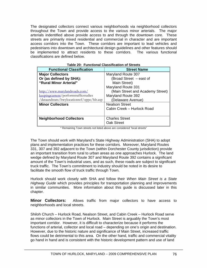
TOWN OF HURLOCK, MARYLAND – 2009 COMPREHENSIVE PLAN 76
The designated collectors connect various neighborhoods via neighborhood collectors throughout the Town and provide access to the various minor arterials. The major arterials indentified above provide access to and through the downtown core. These streets are primarily mixed residential and commercial in character and are important access corridors into the Town. These corridors are important to lead vehicles and pedestrians into downtown and architectural design guidelines and other features should be implemented to attract residents to these corridors. The various functional classifications are defined below.
Table 20: Functional Classification of Streets Functional Classification Street Name
Major Collectors Or (as defined by SHA): “Rural Minor Arterial” http://www.marylandroads.com/ keepingcurrent/performtrafficstudies /dataandstats/hwylocationref/oppe/hlr.asp
Maryland Route 307 (Broad Street – east of Main Street) Maryland Route 331 (Main Street and Academy Street) Maryland Route 392 (Delaware Avenue)
Minor Collectors Nealson Street Cabin Creek – Hurlock Road
Neighborhood Collectors Charles Street Oak Street
* Remaining Town streets not listed above are considered “local streets”
The Town should work with Maryland’s State Highway Administration (SHA) to adopt plans and implementation practices for these corridors. Moreover, Maryland Routes 331, 307 and 392 adjacent to the Town (within Dorchester County jurisdiction) provide an important transition from rural to urban areas as one approaches Hurlock. The land wedge defined by Maryland Route 307 and Maryland Route 392 contains a significant amount of the Town’s industrial uses, and as such, these roads are subject to significant truck traffic. The Town’s commitment to industry should be noted in its desire to facilitate the smooth flow of truck traffic through Town. Hurlock should work closely with SHA and follow their When Main Street is a State Highway Guide which provides principles for transportation planning and improvements in similar communities. More information about this guide is discussed later in this chapter. Minor Collectors: Allows traffic from major collectors to have access to neighborhoods and local streets. Shiloh Church – Hurlock Road, Nealson Street, and Cabin Creek – Hurlock Road serve as minor collectors in the Town of Hurlock. Main Street is arguably the Town’s most important corridor. However, it is difficult to characterize because it performs the functions of arterial, collector and local road – depending on one’s origin and destination. However, due to the historic nature and significance of Main Street, increased traffic flows could be detrimental to this area. On the other hand, traffic and commercial vitality go hand in hand and is consistent with the historic development pattern and use of land
TOWN OF HURLOCK, MARYLAND – 2009 COMPREHENSIVE PLAN 77
in the heart of Hurlock. Main Street will require special attention to ensure it continues to adequately serve its multiple purposes. The Main Street corridor should receive special attention to ensure a safe, attractive, and inviting character for pedestrians while enhancing its utility for vehicular traffic as the weight and size of commercial vehicles continues to increase. Academy Street is perhaps the biggest concern for the Town as it remains mostly undeveloped as one approaches downtown from the north. Academy is the logical primary access route for new residential traffic originating in the 10-15 years Growth Area. While the Growth Area should take maximum advantage for extension of existing neighborhood streets from existing west side residential areas, future collectors should direct primary traffic flows out to Academy. The Town should work with SHA to maintain the character of Academy Street by maintaining the existing road width, carefully limiting access along undeveloped portions of adjoining Growth Area land to help create a scenic corridor through proper landscaping and installation of wide sidewalks leading into the downtown core. Potential new development along MD 331 (north) and Academy should create an urban feel to the street cross-section in a manner that is consistent with and extends the character of established neighborhoods into the Growth Area. The Town will need to work with the County and SHA to maintain the architectural character of Main Street as new development occurs in this area. Neighborhood Collectors: Connects residential and local streets within a neighborhood to collector streets and to the arterial street network. Hurlock has a number of relatively short neighborhood collectors leading residents to the various residential communities around Hurlock. Truck traffic should be encouraged to stay on the major collector roads and arterials as much as possible Local Streets, Cul-de-Sacs and Alleys: Provides access to residences within a neighborhood, abutting properties, and the rear property line of abutting properties, respectively. The Town has an adequate system of arterials, collectors and local streets. If the need arises to create additional roads and access to new development, it is important to create roadways in a manner that channel future traffic within the Town to the appropriate arterials and collectors. New ingress and egress points along Main Street should be avoided unless other means of access to the property cannot be utilized. New local streets should be constructed to Town standards and inspected prior to being deeded over to Town ownership to ensure future maintenance issues do not create an undue burden on existing residents. Similarly, it is the Town’s policy that new roads needed to provide access to new development be sized in accordance with professional planning and engineering standards and that they be constructed through the use of private financial capital. Bonding should also be a requirement for the construction of new roads to ensure they are, in fact, built to Town standards (or can be brought up to those standards without the use of public monies). Bonding will also help ensure that new roads are completed once construction is begun. It is not in the Town’s interest to approve development that cannot be completed due to unforeseen business practices of economic downturn.
TOWN OF HURLOCK, MARYLAND – 2009 COMPREHENSIVE PLAN 78
Levels of Service Standards The ability for a roadway system to carry traffic can be measured quantitatively using Levels-of-Service (LOS) analysis. LOS reflects the analysis of a number of factors affecting the free flow of traffic, including: the degree of congestion, speed and travel time, traffic interruption, freedom to maneuver, safety, driving comfort and convenience. LOS calculations are generally accepted standards and are used in traffic impact analyses to determine the affects new developments have on roadways. LOS standards and future traffic impacts are directly related to land use. In other words, the actual proposed future use of land, including the intensity of the future land use, directly affects the LOS of adjacent roadways and intersections. Traffic impact studies are recommended for future development to ensure that the LOS does not fall below an acceptable level.
SHA’s When Main Street is a State Highway Guide SHA has developed a guide for “Main Street” Communities to work with SHA to develop corridor and street improvement plans. Hurlock has three State highways in the Town that are important corridors that provide significance in defining Hurlock’s character. The Town should work closely with SHA through the guidance of this award winning plan to implement the scenic corridors and improvements described herein. The guide can be viewed at: http://www.sha.state.md.us/businessWithSHA/projects/ohd/Mainstreet/MainStreet.pdf
Highway Needs Inventory The 2006 Highway Needs Inventory (HNI) for Dorchester County does not include any projects in the Hurlock area.
Alternative Transportation Pedestrian and Bicycle Paths Approximately 3.9 miles of sidewalks are located throughout the Town and help with local travel of citizens. A sidewalk location map (6a) is included at the end of this Element. The sidewalk system should also provide pedestrians convenient ways to walk downtown and provide children a safe way to travel to and from school. All sidewalks should eventually lead pedestrians to the downtown area. If necessary, street lighting should also be considered, depending on financial feasibility, to provide increased safety during hours of darkness. In order to provide interconnectivity for residents between residential neighborhoods and Downtown, the Town should determine where sidewalks are most appropriate. Sidewalks are lacking along Maryland Route 392, Poplar Street and residential neighborhoods on the north side of Hurlock.
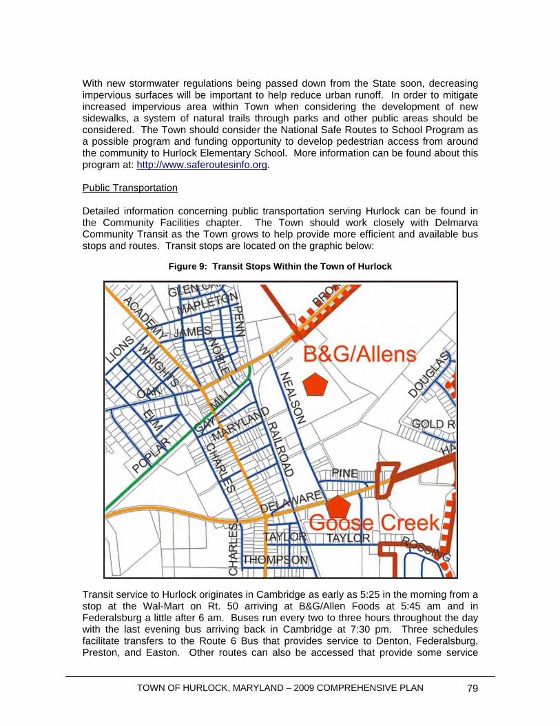
TOWN OF HURLOCK, MARYLAND – 2009 COMPREHENSIVE PLAN 79
With new stormwater regulations being passed down from the State soon, decreasing impervious surfaces will be important to help reduce urban runoff. In order to mitigate increased impervious area within Town when considering the development of new sidewalks, a system of natural trails through parks and other public areas should be considered. The Town should consider the National Safe Routes to School Program as a possible program and funding opportunity to develop pedestrian access from around the community to Hurlock Elementary School. More information can be found about this program at: http://www.saferoutesinfo.org. Public Transportation Detailed information concerning public transportation serving Hurlock can be found in the Community Facilities chapter. The Town should work closely with Delmarva Community Transit as the Town grows to help provide more efficient and available bus stops and routes. Transit stops are located on the graphic below:
Figure 9: Transit Stops Within the Town of Hurlock
Transit service to Hurlock originates in Cambridge as early as 5:25 in the morning from a stop at the Wal-Mart on Rt. 50 arriving at B&G/Allen Foods at 5:45 am and in Federalsburg a little after 6 am. Buses run every two to three hours throughout the day with the last evening bus arriving back in Cambridge at 7:30 pm. Three schedules facilitate transfers to the Route 6 Bus that provides service to Denton, Federalsburg, Preston, and Easton. Other routes can also be accessed that provide some service
TOWN OF HURLOCK, MARYLAND – 2009 COMPREHENSIVE PLAN 80
throughout the Upper Eastern Shore transit district. Careful trip planning is necessary, but busses can also be waved down by pedestrians between scheduled stops and some pickups can be arranged through advanced scheduling through the central office for handicapped and limited mobility patrons. Normal ticket price is $2/trip. Seniors, 60 and over, and persons with disabilities ride for $1. Regional schedules are available at: www.mustbus.info . The need for more efficient public transportation services has been raised by riders and by public health services. Clients at the Hospital or Health Department sometimes have to wait for very long periods of time before a Shore Transit bus can take them back home. The Public Health Department has developed a medical assistance program allowing clients covered by the federally-run Medicaid to be accompanied home after medical treatment. Riders must have an active Medical Assistance number. For local (in county) transportation, clients should call at least 24 hours in advance of the appointment to schedule a medical ride. However, more strategies need to be sought out as the current bus system is primarily designed to bring citizens to and from their work, but does not take into consideration other needs such as medical ones. Lack of appropriate and sufficiently convenient public transportation linking Hurlock to the surrounding region is a major concern for residents who sometimes do not have the reliable means to get to the grocery store, dry cleaners or school activities. Providing reliable transportation for these purposes should be considered in future agendas as it would help integrate the full range of regional services to the Hurlock community and solidify links within the Town, thus work as an incentive to limit growth outside Town. The following graphic shows the various routes in the regional system and provides a basis for understanding some of the transfer issues riders need to balance in order to make a long trip. Secure bicycle storage should be considered at scheduled bus stops.
Figure 10: MUST Transit Fixed Routes
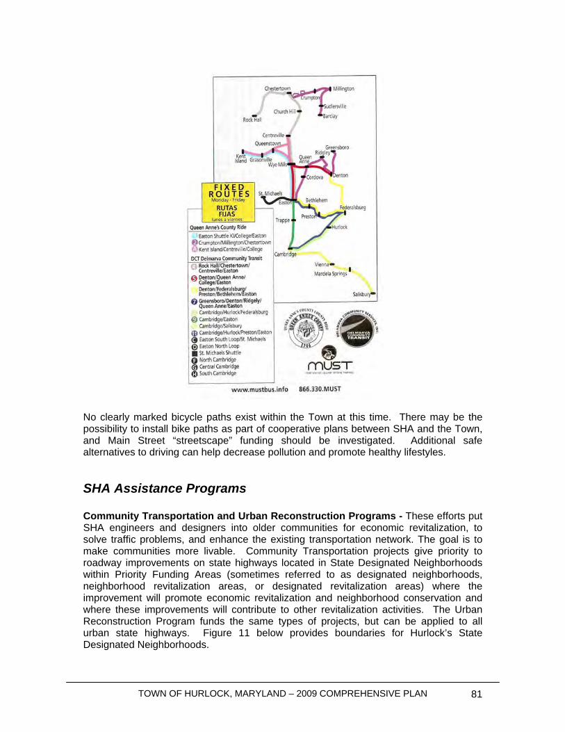
TOWN OF HURLOCK, MARYLAND – 2009 COMPREHENSIVE PLAN 81
No clearly marked bicycle paths exist within the Town at this time. There may be the possibility to install bike paths as part of cooperative plans between SHA and the Town, and Main Street “streetscape” funding should be investigated. Additional safe alternatives to driving can help decrease pollution and promote healthy lifestyles.
SHA Assistance Programs Community Transportation and Urban Reconstruction Programs - These efforts put SHA engineers and designers into older communities for economic revitalization, to solve traffic problems, and enhance the existing transportation network. The goal is to make communities more livable. Community Transportation projects give priority to roadway improvements on state highways located in State Designated Neighborhoods within Priority Funding Areas (sometimes referred to as designated neighborhoods, neighborhood revitalization areas, or designated revitalization areas) where the improvement will promote economic revitalization and neighborhood conservation and where these improvements will contribute to other revitalization activities. The Urban Reconstruction Program funds the same types of projects, but can be applied to all urban state highways. Figure 11 below provides boundaries for Hurlock’s State Designated Neighborhoods.
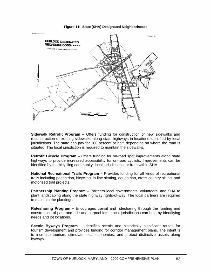
TOWN OF HURLOCK, MARYLAND – 2009 COMPREHENSIVE PLAN 82
Figure 11: State (SHA) Designated Neighborhoods
Sidewalk Retrofit Program – Offers funding for construction of new sidewalks and reconstruction of existing sidewalks along state highways in locations identified by local jurisdictions. The state can pay for 100 percent or half, depending on where the road is situated. The local jurisdiction is required to maintain the sidewalks. Retrofit Bicycle Program – Offers funding for on-road spot improvements along state highways to provide increased accessibility for on-road cyclists. Improvements can be identified by the bicycling community, local jurisdictions, or from within SHA. National Recreational Trails Program – Provides funding for all kinds of recreational trails including pedestrian, bicycling, in-line skating, equestrian, cross-country skiing, and motorized trail projects. Partnership Planting Program – Partners local governments, volunteers, and SHA to plant landscaping along the state highway rights-of-way. The local partners are required to maintain the plantings. Ridesharing Program – Encourages transit and ridesharing through the funding and construction of park and ride and carpool lots. Local jurisdictions can help by identifying needs and lot locations. Scenic Byways Program – Identifies scenic and historically significant routes for tourism development and provides funding for corridor management plans. The intent is to increase tourism, stimulate local economies, and protect distinctive assets along byways.
TOWN OF HURLOCK, MARYLAND – 2009 COMPREHENSIVE PLAN 83
Transportation Enhancement Program – Allows SHA to participate in non-traditional transportation projects such as bike paths, beautification, museums, and historic preservation of transportation structures. Projects can be sponsored by a State agency, a local government, a private non-profit agency, a community group, or an individual with local government as a co-sponsor. Local sponsors must provide 50 percent matching funds.
Improvements Plan
Short Range Hurlock does not program capital improvement funds as part of a regular schedule of maintenance due to funding limitations. The benefits of capital programming and budgeting should be reviewed to determine overall municipal public works needs as part of the financial planning that the Town engages in. The Town could benefit from planned phase funding of various municipal needs, particularly where capital costs need to be spread over several years of projected revenue.
Intermediate Range More improvements will be required within the Town over the next 5 to 15 years. While many of the local streets will likely maintain their integrity, collectors and arterials in the Town may need some more extensive repairs. The Town should monitor the integrity of the collector systems to ensure any necessary repairs are taken care of proactively; this includes capital improvements budgeting and seeking State funding assistance in advance of problems occurring. The State’s Highway Needs Inventory (HNI) provides a means for ensuring that Hurlock’s highway improvement needs are met. All development in designated future growth areas should be required to provide traffic impact statements for new development, indicating the increased impacts each development will create and further taking into consideration committed development. Any roadways which fall below the required LOS standards should be upgraded where possible at the developer’s expense. All transportation improvements should be discussed up front with the land owner/developer as part of the annexation process and should be explicitly written into the annexation agreement.
Long Range Over the next 30 years, the Town should continue to monitor the HNI and the integrity of existing roadways. Capital improvement programs should continue to focus on inevitable future maintenance so funding is available for repairs prior to a need for “emergency” repairs.
Parkway/Bypass The Municipal Growth Element proposes one major new arterial that will connect MD 331 south of Town) with MD 331 near the northern end of the Growth Area. This road is envisioned as a divided median parkway with access controls. It would provide primary
TOWN OF HURLOCK, MARYLAND – 2009 COMPREHENSIVE PLAN 84
access to both industrial and residential growth areas in the immediate to 15 year priority tier. The road is anticipated to be constructed as part of the site plan approval for new development projects in the Growth Area. As such, the planning commission shall only approve site plans that include relevant sections of the new road. The Town will engage in a design process to prepare specifications for the road including landscaping, acceleration lanes and access standards. A transportation impact fee may be created to ensure construction of the connecting link between Cabin Creek – Hurlock Road and East New Market Hurlock Road (within current Town limits) due to potential traffic issues in the downtown core if this critical link is not otherwise constructed. The specifics for how to implement the phased construction of the Parkway/Bypass may require additional detailed planning and should also include the cooperation of the SHA.
State and Local Responsibilities With the exception of state roadways, existing and future roadways within the corporate limits are the responsibility of the Town of Hurlock to inspect and maintain. The Town should work closely with the State to discuss any future improvements along roads under SHA jurisdiction. The Town should also discuss with the State any future development that will affect the LOS standards of roadways under state jurisdiction.
Financial Impact and Funding Mechanisms The Town should minimize financial impact by passing the financial burden of creating new infrastructure onto developers. The Town can creatively allow for upgrading existing streets and the development of new streets and infrastructure through properly executed public works agreements. For the continued maintenance of Town streets, the Town should forecast the budget to anticipate repairs for existing streets, curbs, and gutters based on best practices for age and use standards.
Policies and Recommendations The following policies and recommendations are being suggested to allow the Town to meet its transportation needs:
• Using SHA’s guide, work to create scenic gateways, streetscapes and other improvements along SHA roadways within the Town limits;
o Protect the character of the Designated Neighborhood area and State Highways in Hurlock’s Downtown.
o Work with property owners, Dorchester County and SHA to request scenic easements for property owners along Maryland Routes 331 and 392 entering into the Town of Hurlock. Create a landscaped gateway into the community;
TOWN OF HURLOCK, MARYLAND – 2009 COMPREHENSIVE PLAN 85
o Work with SHA to develop plans to help revitalize the Downtown area along State-controlled highways;
• Create a sidewalks plan in order to assess the most appropriate areas for pedestrian interconnectivity from residential neighborhoods where sidewalks do not currently exist, or are in disrepair, and Downtown, transit stops and employment centers;
• Coordinate the need for additional pedestrian and bicycle walks with the plans to connect the parks and recreation system;
• Require traffic impact analyses for residential subdivision/development of four lots or greater and for all new commercial development;
• Create provisions within developers’ agreements that require developers to pay for necessary street and sidewalk improvements, but to also seek reimbursement for the proportionate share of future development;
• Determine the likeliness repairs will be necessary and forecast the budget far enough in advance to make said repairs;
• Seek out grant money where applicable; • Periodically review the most recent Highway Needs Inventory for the County
to see if repairs are forecasted within Hurlock; o If necessary, communicate repair needs along roadways under SHA
control to be placed on the HNI report.

TOWN OF HURLOCK, MARYLAND – 2009 COMPREHENSIVE PLAN 86
Housing
Introduction Maryland House Bill 1160 of 2006 established the Workforce Housing Grant Program (WHGP) through the Department of Housing and Community Development. The WHGP was set up to create and preserve workforce housing units in local jurisdictions. In order for Hurlock to qualify for funds available through the WHGP, the Town must have adopted a Comprehensive Plan with a Workforce Housing Element that assesses workforce housing needs. The plan must also contain goals, objectives and policies to preserve or develop workforce housing. However, workforce housing only focuses on affordability for a certain segment of the population; specifically, the need for affordable housing for very low- and extremely low-income households is ignored. This element assesses the need for creating or preserving workforce housing and affordable housing for the lower income segments of the population in Hurlock and offers possible solutions to any affordable housing problems. Although it is possible that Hurlock may be able to solve housing affordability issues without participating in the WHGP, the Town is seeking eligibility for possible participation if program funds should become available. Goals and Objectives Recent studies have shown that focusing affordable housing programs around median income levels can cause a further shortage of housing for very low- and extremely low-income households. Hurlock has adopted the following goals and objectives to address affordable housing:
• Create new affordable housing units and preserve existing affordable housing units;
• Address housing abandonment; • Recognize the need for increased policies to develop affordable housing; • Address affordability needs through mandates placed on new residential
development; • Create a funding source in order to have matching grant funds if the WHGP is to
be utilized; • Recognize the need to address lower income households (below 50% of the
median household) without creating neighborhoods or pockets of poverty within the Town;
• Provide outreach programs with citizens in order to address NIMBY (“not-in-my-backyard”) issues and with housing developers to address income/profit feasibility issues.
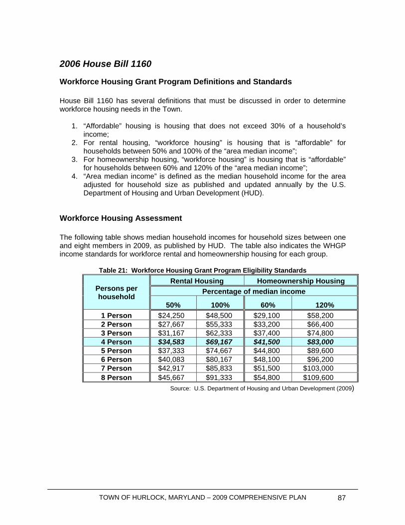
TOWN OF HURLOCK, MARYLAND – 2009 COMPREHENSIVE PLAN 87
2006 House Bill 1160
Workforce Housing Grant Program Definitions and Standards House Bill 1160 has several definitions that must be discussed in order to determine workforce housing needs in the Town.
1. “Affordable” housing is housing that does not exceed 30% of a household’s income;
2. For rental housing, “workforce housing” is housing that is “affordable” for households between 50% and 100% of the “area median income”;
3. For homeownership housing, “workforce housing” is housing that is “affordable” for households between 60% and 120% of the “area median income”;
4. “Area median income” is defined as the median household income for the area adjusted for household size as published and updated annually by the U.S. Department of Housing and Urban Development (HUD).
Workforce Housing Assessment The following table shows median household incomes for household sizes between one and eight members in 2009, as published by HUD. The table also indicates the WHGP income standards for workforce rental and homeownership housing for each group.
Table 21: Workforce Housing Grant Program Eligibility Standards Rental Housing Homeownership Housing
Percentage of median income
Persons per household
50% 100% 60% 120% 1 Person $24,250 $48,500 $29,100 $58,200 2 Person $27,667 $55,333 $33,200 $66,400 3 Person $31,167 $62,333 $37,400 $74,800 4 Person $34,583 $69,167 $41,500 $83,000 5 Person $37,333 $74,667 $44,800 $89,600 6 Person $40,083 $80,167 $48,100 $96,200 7 Person $42,917 $85,833 $51,500 $103,000 8 Person $45,667 $91,333 $54,800 $109,600
Source: U.S. Department of Housing and Urban Development (2009)

TOWN OF HURLOCK, MARYLAND – 2009 COMPREHENSIVE PLAN 88
Figure 12: Affordable Housing by Household Size
Source: Department of Housing and Urban Development (2009)
Rental Housing Figure 12 shows the range of WHGP eligible monthly rental payments based on the affordability definition discussed in House Bill 1160. In order for a rental unit to be eligible for WHGP funds, it must fall within the ranges shown within the chart above based on the annual area median income and the number of persons per household.
Homeownership Housing The following chart shows the range of WHGP eligible monthly payments based on the affordability definition discussed in House Bill 1160. Monthly payments must include mortgage payments, insurance and property tax in order to be a homeownership unit. Homeownership units that will be developed as part of the WHGP program should consider the cost of insurance and property tax when defining the cost of the unit itself.
Affordable Housing Unit Rental Range
$0
$500
$1,000
$1,500
$2,000
$2,500
Mon
thly
Rent
al Ra
nge
50% of Median Income $606.25 $691.67 $779.17$864.58 $933.33 $1,002. $1,072. $1,141.
100% of Medium Income $1,212. $1,383. $1,558. $1,729. $1,866. $2,004. $2,145. $2,283.
1 2 3 4 5 6 7 8

TOWN OF HURLOCK, MARYLAND – 2009 COMPREHENSIVE PLAN 89
Figure 13: Income Available for Homeownership Payments
Source: Department of Housing and Urban Development (2009)
Hurlock’s Workforce and Affordable Housing Needs According the Census and HUD statistics, the following is a summary of workforce and affordable housing needs in the Town of Hurlock:
• 11.4% of the Town’s population or 8.2% of Town’s Families, according to the U.S. Census, was below the poverty line in 1999;
• Creating and preserving affordable rental units is the best method of addressing lower-income households housing needs. Of the 710 occupied housing units (based on the 2000 U.S. Census), 33.2% of those units (236 units) were rental units.
• Only 10 rental units (4.1%) were vacant and available for rent as of the 2000 U.S. Census.
The “credit crunch” and lack of availability of flexible lending methods to assist those with substandard credit ratings or low-incomes has led to a need for more affordable housing and an increase in housing choices (rental and homeownership); Policies and Implementation Hurlock should consider workforce housing needs regardless of whether or not it will participate in the WHGP. The following policies should be evaluated in order to
TOWN OF HURLOCK, MARYLAND – 2009 COMPREHENSIVE PLAN 90
determine the need for a mix of affordable rental and homeownership units for WHGP eligible households and lower-income households:
• Consider an affordable housing trust fund that can be used to provide incentives for new residential development that will be developed affordably while addressing developers’ profitability and financial feasibility issues and/or provide matching funds in order to be able to participate in the WHGP;
• Consider revising the Town code to include the following affordable housing
strategies:
o Criteria to determine affordability for the Town and the proportion of rental and homeownership units that are needed to meet the needs of the community;
o Require large scale residential subdivision developments to review the Town’s affordable housing, rental and homeownership needs. Require a narrative from development applicants of how this project will help meet the Town’s housing needs;
o Encourage new residential development that will be sold or rented to include housing units that will be affordable;
o In the case that new residential development or minor subdivision development will not be sold or rented at workforce pricing, consider a payment in lieu of requiring unit set asides that will be deposited into the Town’s affordable housing fund;
o Create mixed-income communities to address issues that may develop if pockets of poverty are created within neighborhoods;
o Ensure all units remain affordable for the period of time discussed in House Bill 1160. Land covenants “running with the land” should be required that spell out the affordability rules in House Bill 1160 and require repayment of WHGP funds, if applicable.
• Consider a study on the need for handicapped and elderly housing needs in the
community and ways to address current and future issues in providing affordable housing to these groups;
• Provide education and outreach to local citizens and developers concerning the
need to address housing affordability and how the Town could address the potential worries of the citizens.
TOWN OF HURLOCK, MARYLAND – 2009 COMPREHENSIVE PLAN 91
Sensitive Areas
Introduction Hurlock is a rural community with many historic, cultural and environmental resources that need to be conserved and protected. This section looks to identify those important features, as well as provide recommendations for recognizing and preserving such areas. It is also important to provide education and outreach to residents of Hurlock so important resources can be recognized.
Goals and Objectives The following goals and objectives are meant to preserve the natural, cultural and historical resources of Hurlock and the need to balance future development and the need to recognize and preserve these resources.
1. Identify streams, wetlands and sensitive habitat areas in Hurlock and its proposed growth areas;
2. Identify and protect historically and culturally important areas within the Town; 3. Enforce State and local laws concerning protection and preservation of sensitive
areas discussed herein; 4. Develop additional policies and implement protections for sensitive areas.
Natural and Environmental Features Article 66B requires that every municipality have a Sensitive Areas element, which describes how the jurisdiction will protect the following sensitive areas:
• Streams, wetlands and their buffers; • 100-year floodplain • Habitats of rare, threatened and endangered species; • Steep slopes; and, • Agricultural and forest lands intended for resource protection or conservation.
Wetlands and Wetland Buffers Maps 9a and 9b indicate the presence of Maryland Department of Natural Resources and the National Wetlands Inventory wetland areas in the planning area. These maps should be used as a guide for the Town to ask property owners and developers to perform an investigation of wetlands on their properties. If wetland mitigation is not possible, a 25 foot vegetated buffer should be implemented between wetland areas and the proposed development. East of the existing Town boundaries, there is a section of non-tidal wetlands of Special State Concern (WSSC). Per State law, WSSC areas must remain basically untouched
TOWN OF HURLOCK, MARYLAND – 2009 COMPREHENSIVE PLAN 92
and a 100 foot buffer must be implemented between the wetland area and development. The State has a permitting and approval process required for development near WSSC: the review is very stringent and development is required to not affect water quality or wetland habitat. In the case mitigation is necessary, and is approved by the State, three acres of wetlands must be created for every one acre of WSSC removed. The Town should pay close attention to development within the adjacent WSSC area as indicated on Map 9a. Map 11 shows hydric and partially hydric soils in Hurlock and the vicinity. Sometimes the wetland inventories are not conclusive in identifying the location of all wetlands. Where hydric and partially hydric soils exist, the Town should require further investigation of the property to see if wetland areas exist prior to approving of development on those lands. Streams and Stream Buffers Wrights Branch and ‘Tributary A’ are two small waterways which lead from the east side of Hurlock and travel southwest into the Marshyhope Creek. Wrights Branch is used as a point of discharge for the Town’s wastewater treatment facility. In 2001, a TMDL was approved for phosphorous loading into the Marshyhope Creek. Point source and non-point source issues concerning nutrient loading are discussed in the Water Resources Element. There are also several streams on the western edge of Hurlock that lead into the Warwick River and Cabin Creek. Both the river and the creek lead into the Lower Choptank River, west of the existing Town limits. Although point source discharge from Hurlock is not an issue here, there are several Lower Choptank River TMDL’s, for portions in Dorchester and Talbot Counties, that affect the nutrient non-point source discharge. For purposes of this section, a 25 foot buffer should be implemented along all streams (none of which are located within a designated Critical Area). Buffered areas are indicated along all streams on Map 8. If the Town requires the buffers to be planted/vegetated, nutrient runoff can be reduced, furthering the goals of the Marshyhope Creek and Lower Choptank River TMDLs. The Town should use this section to recognize the affected waterways in and near Town, and to require the development of vegetated buffers along the indicated streams. Moreover, the provided wetland maps indicate the existence of forested palustrine wetlands. The Town should require existing vegetation to remain along the stream buffer areas. Lastly, where vegetated buffers are required, the Town should provide a list of native plant species to developers and require the submittal of detailed landscaping plans to ensure non-native species are not being used. 100-Year Floodplain Per the Federal Emergency Management Agency (FEMA) Flood Insurance Rate Map (FIRM) definitions, two areas within Hurlock are shown to be within the 100-year floodplain. Maryland Department of the Environment (MDE) requires special permitting for areas within the 100-year floodplain. State and Federal permitting rules are discussed within MDE’s State Model Floodplain Management Ordinance, which provides
TOWN OF HURLOCK, MARYLAND – 2009 COMPREHENSIVE PLAN 93
local jurisdictions with a model ordinance to ensure development within the 100-year floodplain is managed properly. Hurlock currently has adopted a Floodplain Ordinance to enforce development in flood prone areas, based on the State’s 2004 Model Floodplain Ordinance. The State is in the process of updating the floodplain ordinance and Hurlock will review the new model upon its completion and distribution. Habitats of Rare, Endangered or Threatened Species
1. Require that anyone proposing development activities must address protection of state and federally designated endangered species. The developer must determine through contact with the Town and the Maryland Department of Natural Resources (DNR) whether proposed activities will occur within or adjacent to identified endangered species habitats and whether the activities will affect the area;
2. If it is established that an activity will occur within or adjacent to an endangered
species habitat, the Town should require that the developer provide protection measures in the project design. A written environmental assessment including site design plans and a description of measures to be taken to protect the endangered species should be submitted to the Town as part of the development review process. The developer must work with DNR in establishing species/site-specific protection measures. Protection measures may include:
o Designation of protection areas around the essential habitat of the designated species. Development activities or other disturbances will be prohibited in the protection area, unless it can be shown that these activities or disturbances will not have or cause adverse impact on the habitat. The protection area designation will be made with input from DNR.
o Implementation of design strategies that work to protect the species and essential habitat. These strategies should include, but are not limited to, restrictions on siting of structures, use of cluster design, establishment of undisturbed open space areas, restrictive covenants, and restrictions on noise levels and timing of construction activities.
Critical Areas Maryland’s Critical Area law regulates growth near tidal waterways. There are no Critical Areas within Hurlock’s existing town boundaries or designated growth areas. If Hurlock eventually expands into Critical Areas along Marshyhope Creek or the Choptank River, the Town should review Maryland’s Critical Area ordinance and adopt a local ordinance as required. Steep Slopes Although there were not any of steep lands indentified in Hurlock, development is regulated on steep slopes wherever they occur in the Critical Area. This same type of
TOWN OF HURLOCK, MARYLAND – 2009 COMPREHENSIVE PLAN 94
land management practice should also be applied outside of the Critical Area. If a change in condition causes a steep slope to exist, the Town shall address it at that time. Culturally and Historically Sensitive Areas The Heart of Chesapeake Country Heritage Area Tourism Management Plan, dated June 2002, and as may be amended from time to time in the future, is hereby incorporated, by reference, in the Town of Hurlock Comprehensive Plan. Historic preservation involves the inventorying, research, restoration, and ongoing protection of sites and structures having significant state, local or national historic character. Continued historic and cultural resource preservation and enhancement through sensitive land use planning and other administrative means would provide Hurlock with a number of benefits including:
• Promotion of a strong sense of community pride for Town residents; • Community revitalization through the renovation or adaptive reuse of older
structures; • Increased property values and tax revenues as a result of renovation and
restoration; • Increased revenues generated from tourism.
According to the Maryland Historical Trust, there are currently several properties, structures, bridges and monuments within the Town that are of historic, cultural, or architectural significance. These structures, given proper concern and recognition, have the potential to serve as physical reminders of the history and heritage of our past. The Town has several community members serving on the recently formed Hurlock Economic Development Group (HEDG), whose goal is to promote the business, cultural and history of downtown Hurlock. It has been discussed and is recommended that an active historic and architectural preservation program be developed. Such a group as HEDG can help the Town spearhead organization of such a committee. It has been found that such a program could have beneficial social, economic and aesthetic impacts on the area. The development of a Historic Preservation Program for the Town should be the result of a cooperative effort between the public and the private sectors of the community. Future efforts should aim to identify, preserve and maintain potential historical features throughout the Town. The following programs and strategies are designed to facilitate achieving this Plan’s goal of preserving and enhancing the Town’s historic character. Inventory The Town should first develop standards for determining historic structures and sites. From these standards the Town should identify historic structures and sites within the corporate limits. Once sites are identified, there are a number of actions the Town can take to ensure that these cultural resources are preserved for future generations.
TOWN OF HURLOCK, MARYLAND – 2009 COMPREHENSIVE PLAN 95
Protection and Preservation Programs The Town is aware of the historic protection and preservation programs offered by federal and state agencies (see programs list in Appendix B). The Town is interested in preserving its cultural and historical resources, but would like the opportunity to work more closely with State agencies when properties are being considered for historic designations. The Town plans to take the lead on identifying historic and culturally sensitive areas and asking for assistance at the proper time. The Town also hopes to work more closely with State agencies concerning future plans to assess historical properties in the Town. 17 records were located for historically significant properties or monuments within the Town of Hurlock. The list of registered properties and additional information on each record can be found at: http://www.mdihp.net/cfm/act_advancesearch.cfm. Policies and Recommendations
• Encourage preservation of natural features and habitats in sensitive areas; • If development occurs, review all proposed development within the Sensitive
Species Project Review Area (SSPRA):
1. Town should require that developers provide protection measures in their project design;
2. Prior to the development of a new project, a written environmental assessment should be submitted to the Town as part of the development review process;
3. Use the SSPRA data layer (maintained by DNR) in the development review process to ensure that sensitive areas receive adequate attention and are not endangered by new construction projects.
• Review all development in areas where hydric soils exist to ensure wetland that
are not inventoried are not harmed; • Provide mechanisms for recognizing and maintaining historical properties:
1. Develop criteria and identify sites and properties of historical/archeological significance;
2. Regulate development and redevelopment on historically/archeologically significant properties;
3. Search for grant funding and incentives to maintain historic sites; 4. Promote educational and cultural opportunities to residents of the Town; 5. Identify sites based on criteria; 6. Consider utilizing programs to encourage preservation of sites, such as:
• Historical commission/committee; • Funding programs; • Tax incentives.

TOWN OF HURLOCK, MARYLAND – 2009 COMPREHENSIVE PLAN 96
• Open a dialogue with State agencies that assist community’s in their historic preservation efforts to best determine how Hurlock and each agency can work together to meet their mutual goals.

TOWN OF HURLOCK, MARYLAND – 2009 COMPREHENSIVE PLAN 97
This page was intentionally left blank
TOWN OF HURLOCK, MARYLAND – 2009 COMPREHENSIVE PLAN 98
Mineral Resources Introduction The Mineral Resource Element identifies lands that should be kept in their undeveloped state until it can be used to provide a continuous supply of minerals. To address possible mining land uses within the Town, the Town must devise a plan to balance mining activities with existing land uses, and after mining activity has ceased, to reintegrate the property into the fabric of the community. This chapter discusses the mineral resources available in Hurlock, the feasibility of mining those areas, and outlines policies and recommendations to regulate mining land uses within the Town. Goals and Objectives
• Maintain the residential character of the Town; • Protect groundwater resources; • Require existing land uses and proposed mining activities to be compatible; • Allow surface mining activities, where possible and if necessary; • Review updated reports concerning the mining of construction sand and gravel to
ensure mineral resources are not scarce; • Ensure parks and recreational facilities will not be affected by surface mining
activities. Mineral Resources The United States Geological Survey and the Maryland Geological Survey’s Lithogeographical Map of Near-Surface Rock types developed in 2001 indicates the Eastern Shore of Maryland consists of “unconsolidated sediments and soils of high porosity”. In Dorchester County and the Hurlock area, the Lithogeographical Map shows the available minerals consist of “quartz, silt, sand and gravel; weathered residuum from which iron and carbonate have been removed”. However, the Lithogeographical Map also details high-carbon soils existing in the southern and eastern areas of Dorchester County, particularly on the shorelines of the Chesapeake Bay and along the Nanticoke River, the latter which has a branch running a couple of miles east from Hurlock. High-carbon soils have the potential to be used as construction sand and gravel, which is the major mining industry on the Eastern Shore, where mining sites are currently in plentiful supply.
Mining Industry in Dorchester County In 2004, the Maryland Department of the Environment, in coordination with the United States Geological Survey, published a report titled “The Mineral Industry of Maryland.” The central lands of Dorchester County were identified as a major producing area of construction sand and gravel. Between 2002 and 2004, construction sand and gravel was mined at a consistent rate (between 11,800 and 12,700 metric tons). At the time of the report, the State had no plans to grant any new surface mining permits on the Eastern Shore. This point suggests that the surface mining industry in Maryland and its
TOWN OF HURLOCK, MARYLAND – 2009 COMPREHENSIVE PLAN 99
Eastern Shore provide an adequate supply of construction sand and gravel and that as of 2004 there has been no further demand for mining sites.
Wellhead Protection Areas The Town of Hurlock’s primary source of drinking water consists of two underground aquifers. The water is pumped from two wells, referred to as wells 3 and 4. Well number 3 pumps from the Pleistocene Aquifer and is approximately 110 feet deep. Well number 4 pumps from the Piney Point Aquifer and is approximately 480 feet deep. The Town uses gas chlorine for disinfection and add granulated soda ash for Ph adjustment. In an attempt to help protect Hurlock’s water supply, the Maryland Department of the Environment has established a Wellhead Protection Area around the pumping station that supplies the majority of the Town’s water (Annual Drinking Water Quality Report, 2007). Wellhead protection areas restrict land uses that may cause pollution of public drinking water wells. Contaminates are required to be inventoried and reduced/eliminated in these areas. While mining activities are not likely to occur in Hurlock’s Wellhead Protection Areas, all mining operations should be prohibited from this area. There are also small water systems located in and around Hurlock that should be considered. These small water systems provide water and drinking water to private establishments and should be treated and regulated similar to the Wellhead Protection Areas.
Existing and Committed Development High-carbon soils, which are the most feasible for surface mining of construction sand and gravel, exist around Hurlock, to the east of Town. However, those sites are also home to many sensitive areas discussed in Chapter Ten, such as some SSPRAs and a branch of the Nanticoke River. Therefore, if any mining activity is to be planned in the area, an environmental impact assessment should be conducted in order to mitigate adverse effects on natural resources and habitats. Conclusions The State has reported that throughout Maryland and its Eastern Shore the mining of construction sand and gravel has not increased and supplies of these minerals meet current demand. Within Hurlock’s planning area, there are a few locations where suitable minerals exist; however mining activities should be discouraged unless adequate demand for construction sand and gravel is presented and all environmental regulations are addressed. Policies and Recommendations The Town’s zoning ordinance should be amended to allow mining activities as a conditional use in non-residential districts and, at a minimum, require the following conditions if mining activities are approved:
• Show that mining activities are necessary due to a lack of available construction sand and gravel;
• Indicate the location and types of projects construction sand will be used for;
TOWN OF HURLOCK, MARYLAND – 2009 COMPREHENSIVE PLAN 100
• Conduct a study to ensure that the Pleistocene Aquifer and the Piney Point Aquifer will not be negatively impacted by mining activities;
• Mining activities should be compatible with surrounding land uses; • Require extensive setbacks, landscaping and buffering be provided where
necessary; • Require a timeline indicating when mineral supplies will be exhausted; • Conduct well testing to ensure that there is no adverse breaching of the confining
beds of underlying aquifers; • Require the owners, and subsequent owners of the land parcel used for mining
activities, to provide a plan for cleanup and site conversion into a compatible land use and to create an aesthetically pleasing site after mineral resources are exhausted;
• Operators of mining activities shall be fully responsible for all activities that damage roadways, infrastructure or other Town property;
• Determine which governmental entity will regulate and enforce this mining land use ordinance.

TOWN OF HURLOCK, MARYLAND – 2009 COMPREHENSIVE PLAN 101
This page was intentionally left blank

TOWN OF HURLOCK, MARYLAND – 2009 COMPREHENSIVE PLAN 102
Plan Implementation The “plan implementation” portion of this document is a summary of the policies and recommendations discussed in the Comprehensive Plan. The Plan is a guide for growth and controlled development. How well this guide is followed depends upon the implementation tools that are developed to put this Plan into action. Recommendations to implement the purposes of the Plan are interwoven within the various chapters, but the following section describes the main tools and steps with more specific emphasis. Land Use Goals, Objectives and Policies
Preserve the character of the community;
• Permit residential and commercial mixed uses in the Downtown area while maintaining its historic character;
• Promote well-designed transitions from agricultural uses to residential uses;
• Provide opportunities for variety and affordability in new residential growth to accommodate an increased workforce, focusing on developing jobs in the community as the main priority;
• Develop “Smart Growth” criteria for reviewing projects to guide future growth and to better incorporate future developments into the existing Town neighborhoods;
• Support small business in the Downtown area by providing flexibility in review standards. Moreover, separate uses that are most viable for economic redevelopment efforts Downtown and locate more intense uses along high traffic areas (“big-box” development);
• Determine uses that will be most appropriate for commercial development Downtown and in highway commercial areas;
• Work with the business community to identify viable means for helping to keep local business competitive;
Continue to promote industrial and business opportunities by actively marketing remaining development opportunities in the Hurlock Industrial Park
• Coordinate with State and regional economic development organizations
to maximize exposure and opportunities, • Seek out State and Federal economic development funds and assistance
to modernize and promote Hurlock’s economic infrastructure.
Reestablish Hurlock’s traditional Town Center and encourage mixed-use development downtown;
• Promote pedestrian scale amenities, attractive and safe streets, and a
unifying theme to the district; • Adopt design guidelines for both new development and redevelopment of
existing properties to help create a specific “sense of place” for the Downtown;
TOWN OF HURLOCK, MARYLAND – 2009 COMPREHENSIVE PLAN 103
• Create side and rear-yard parking areas, where possible, that include “green design” principles that maximize opportunities to improve management of rainfall runoff;
• Evaluate options for an urban street-tree program that includes drought resistant shade tree species as an alternative to Forest Conservation Programs (more suitable for rural development mitigation).
Municipal Growth Policies and Recommendations In order to meet the future growth needs of the Town and the goals, objectives and visions of the Town, the following policies should be considered to accommodate future growth: Intergovernmental Coordination
• Request Dorchester County to recognize the Town’s growth areas and amend the Water and Sewer Master Plan, as necessary to accommodate future growth;
• Request that Dorchester County recognizes the Town’s greenbelt development plans and make zoning changes, as necessary, to help the Town implement this Plan
• Work with Maryland Department of Planning to have growth areas placed into Priority Funding Areas;
• Work with Maryland environmental agencies to improve and upgrade awareness and implementation of programs and regulations designed to improve the health of the region and the Chesapeake Bay;
• Review growth over a six-year period and update the Comprehensive Plan as necessary.
Parks and Recreational Facilities
• Continue to require developers to set aside open space as discussed herein to help reduce parks and recreational deficits, where most efficient for the Town and the County to maintain these areas;
• Consider creating a parks and recreation fund to allow developers to pay a fee-in-lieu of providing open space within new subdivision to use toward the efforts of meeting the Town’s larger goals;
• Continue the cooperative relationship with the County in purchasing, developing and maintaining parks and recreational facilities in and around the Town;
• Work with the county and Program Open Space to create a Comprehensive Parks Master Plan;
• Require a mix of passive and active recreational spaces; • Begin looking for land to develop a large, regional park for the use of Hurlock
residents and the greater community. Public Safety
• Per IAPC standards, Hurlock may need to recruit two additional officers and the necessary resources to adequately provide services to the growing community. The Town should plan for the need for an increase in officers and the necessary equipment and space;
TOWN OF HURLOCK, MARYLAND – 2009 COMPREHENSIVE PLAN 104
• The Police Department and the Town should determine the potential to provide increased foot and bike patrols;
• The Town should work with the Volunteer Fire Department to ensure adequate resources are available and that the Department is aware of potential future growth in the Town;
• Emergency Response staff should continue to coordinate with surrounding jurisdictions on emergency response and evacuation planning.
Public School Policies
• Review the educational facilities master plan as new versions become available; • Provide development information to Dorchester County Board of Education.
Library
• Where possible, have developers contribute toward keeping the library centrally located and to provide services necessary to accommodate future populations.
Land Use and Zoning
• Separate commercial uses allowed along Maryland Route 392 from those uses allowed downtown;
• Allow and encourage residential uses Downtown after performing an impact study;
• Further study industrial uses that are allowed in the Town to determine which uses may be more suitable for urban and non-urban areas;
• Protect forested areas and begin developing a “greenbelt” urban growth boundary around the entire Town;
• Implement the historic area discussion and recommendations in the Sensitive Areas chapter;
• Implement the Historic Commission recommendations as suggested by the Maryland Department of Planning (i.e. architectural guidelines).
Corridor Plans
• Recognize the corridors discussed herein as special to the vitality of the Town; • Perform an architectural study in order to create a set of standards for each
corridor to be added into the zoning ordinance; “Greenbelt” Urban Development Boundary
• Work with Dorchester County to preserve areas beyond the Planning Area in agricultural use and very low density residential development with local focus on directing development into Town and into the 10-year priority area of the designated Growth Area.
• The Town should work with the County to help ensure County zoning prohibits sprawl and uncharacteristic redevelopment in areas adjacent to planned growth areas;
• Hurlock should not annex property in the greenbelt unless the property is being brought into the Town to ensure preservation;
TOWN OF HURLOCK, MARYLAND – 2009 COMPREHENSIVE PLAN 105
• The Town should work closely with outside agency’s preservation efforts to work to preserve lands within future greenbelt districts;
• The Town should discuss suitable funding mechanisms with the County in order that the County can preserve future greenbelt areas;
• Hurlock should work to ensure Industrial development locates within designated Industrial growth areas while minimizing potential environmental impacts associated with development.
Water Resources Policies and Recommendations • Potable Water
o Monitor well production to ensure water supply is below WAUP thresholds; o Future growth is expected to cause water usage levels to exceed permitted
thresholds. The Town should monitor water usage and request an increase to the permitted thresholds;
o Consider the addition of residential water meters to reduce water usage; o Install back-up wells to meet source redundancy requirements and increase
WAUP capacities for both aquifers. o Once less than 50% of the overall storage is provided by the elevated storage
tank, the Town should consider preparations to add additional above ground storage to the system.
o Adopt a wellhead protection and recharge areas protection ordinance to best ensure protection of the Town’s source water areas;
o The Town should educate residents and businesses on water conservation techniques in order to decrease the average gallons per day;
o The Town should review the water model and prepare a plan to provide system upgrades to produce adequate fire flows throughout the distribution system;
o The Town should monitor well production and prepare a well maintenance program to ensure wells operate efficiently;
o The Town should install a generator for the well to ensure adequate water production during power outages;
• Wastewater Treatment
o Perform an inflow and infiltration study to identify problem areas and subsequently repair or replace any items deemed necessary.
o Maintain and monitor point source nutrient discharge to ensure allowable levels are being met;
• Stormwater and Non-Point Source Loading
o Consider implementing buffers as required under Critical Area law to help reduce non-point source nutrient loading;
o Encourage the use of pervious pavers where possible; o Require increased open space areas in areas slated for future development; o Review proposed land uses in the ultimate growth area as they are
designated and examine the affect of proposed development on non-point source runoff;
o Use stormwater best management practices in order to limit non-point source runoff;
TOWN OF HURLOCK, MARYLAND – 2009 COMPREHENSIVE PLAN 106
o Periodically review potential future TMDL criteria for revisions to nitrogen and phosphorous limits to ensure the most current regulations are being followed.
o Implement the use of Environmentally Sensitive Design and/or Low-Impact Development standards to reduce unnecessary amount of impervious surfaces;
o Prepare new stormwater management guidelines and design standards for parking lots consistent with ESD and Low-Impact Development policies.
• Impervious surface
o Encourage the use of open space and pervious concrete to decrease impervious surface.
o Consider continued use of rolled curb sections in new subdivisions and consider limiting new sidewalks to one side of residential roads.
• Open Space and Forested Areas
o Use farmland preservation techniques to maintain existing agricultural lands and promote nutrient reduction measures in partnership with the County.
Transportation Policies and Recommendations • Require traffic impact analyses for residential subdivision/development of four lots or
greater and for all significant commercial development; o “Significant” commercial development(s) could easily involve single
parcels for infill or redevelopment that generate concerns (depending upon location). In such cases, number and location of curb cuts, off street parking, on-site circulation, and estimates of changes in traffic volumes on adjacent streets as a result of the project, and anticipated impacts on intersections identified by the Planning Commission should be addressed. An appropriately tailored traffic impact study should accompany tentative site plan submissions for projects that require site plan review and approval. Applicants should inquire with Town staff where any question exists regarding the need for a traffic analysis.
• Continue to cooperate and participate in meetings and planning studies. Also,
continue to provide growth and transportation information to Dorchester County as discussed in this plan;
• Prepare detailed planning studies focused on the designated growth areas to ensure
new roads are located where they make the most logical connections with existing roads;
• Determine, through further study, opportunities to improve existing traffic flows and
priorities for accessing new growth areas; • Create provisions within developers’ agreements that allow developers to pay for
necessary street and sidewalk improvements using a fee-in-lieu system;
TOWN OF HURLOCK, MARYLAND – 2009 COMPREHENSIVE PLAN 107
• Determine the likeliness repairs will be necessary and forecast the budget far enough in advance to ensure adequate funding is in place when repairs are needed;
• Seek out grant money where applicable;
• Using SHA’s guide, work to create scenic gateways, streetscapes and other improvements along SHA roadways within the Town limits;
o Protect the character of the Designated Neighborhood area and State Highways in Hurlock’s Downtown.
o Work with property owners, Dorchester County and SHA to request scenic easements for property owners along Maryland Routes 331 and 392 entering into the Town of Hurlock. Create a landscaped gateway into the community;
o Work with SHA to develop plans to help revitalize the Downtown area along State-controlled highways;
• Create a sidewalks plan in order to assess the most appropriate areas for
pedestrian interconnectivity from residential neighborhoods where sidewalks do not currently exist, or are in disrepair, and Downtown, transit stops and employment centers;
• Coordinate the need for additional pedestrian and bicycle walks with the plans to
connect the parks and recreation system; Workforce Housing Policies and Recommendations
• Develop an affordable housing trust fund that can be used to provide incentives for new residential development that will be developed affordably while addressing developers’ profitability and financial feasibility issues and/or provide matching funds in order to be able to participate in the WHGP;
• Revise the Town code to include the following affordable housing strategies:
o Develop criteria to determine affordability for the Town and the proportion of rental and homeownership units that are needed to meet the needs of the community;
o Require all residential subdivision developments to review the Town’s affordable housing, rental and homeownership needs. Require a narrative from development applicants of how this project will help meet the Town’s housing needs;
o Encourage new residential development that will be sold or rented to develop housing units that will be affordable;
o In the case that new residential development or minor subdivision development will not be sold or rented at workforce pricing, require a payment in lieu of requiring unit set asides that will be deposited into the Town’s affordable housing fund;
o Create mixed-income communities to address issues that may develop if pockets of poverty are created within neighborhoods;

TOWN OF HURLOCK, MARYLAND – 2009 COMPREHENSIVE PLAN 108
o Ensure all units remain affordable for the period of time discussed in House Bill 1160. Land covenants “running with the land” should be required that spell out the affordability rules in House Bill 1160 and require repayment of WHGP funds, if applicable.
• Perform a study on the need for handicapped and elderly housing needs in the
community and ways to address current and future issues in providing affordable housing to these groups;
• Provide education and outreach to local citizens and developers concerning the
need to address housing affordability and how the Town will address the worries of the citizens.
Sensitive Areas Policies and Recommendations
• Encourage preservation of natural features and habitats in sensitive areas; • If development occurs, review all proposed development within the SSPRA:
1. Town should require that developers provide protection measures in their project design;
2. Prior to the development of a new project, a written environmental assessment should be submitted to the Town as part of the development review process;
3. Review SSPRA areas as part of the development review process to ensure that sensitive areas receive adequate attention and are not endangered by new construction projects.
• Review all development in areas where hydric soils exist to ensure wetland that
are not inventoried are not harmed; • Provide mechanisms for recognizing and maintaining historical properties:
1. Develop criteria and identify sites and properties of historical/archeological significance;
2. Regulate development and redevelopment on historically/archeologically significant properties;
3. Search for grant funding and incentives to maintain historic sites; 4. Promote educational and cultural opportunities to residents of the Town; 5. Identify sites based on criteria; 6. Consider utilizing programs to encourage preservation of sites, such as:
• Historical commission/committee; • Funding programs; • Tax incentives.
• Open a dialogue with State agencies that assist community’s in their historic preservation efforts to best determine how Hurlock and each agency can work together to meet their mutual goals.
TOWN OF HURLOCK, MARYLAND – 2009 COMPREHENSIVE PLAN 109
Funding Recommendations
• Try to budget the plans, studies and infrastructure improvements discussed above into the general budget;
• Consider the benefits of capital project programming and multi-year budgets;
• Prioritize the necessary improvements and create a timeline for beginning work
on each project;
• Target specific projects where grant funding may be available;
• Seek financial assistance from interested developers in implementing this Plan.
Final Acknowledgements The Town of Hurlock would like to thank the planning and engineering staff with Davis, Bowen & Friedel, Inc., for providing technical assistance with this growth plan, Linda Nabb, the Town’s Zoning Administrator, Dorchester County’s Planning and Zoning staff, and the members of the Planning Commission who volunteered a lot of their time to assist with the planning process. The Town would also like to acknowledge Maryland Chesapeake and Coastal Program and the National Oceanic and Atmospheric Administration (NOAA) for providing financial assistance to this project. Lastly, the Town would like to thank the residents and business owners for participating in the various workshops and providing input. The Comprehensive Plan would not have been possible without the complete efforts of the community.

TOWN OF HURLOCK, MARYLAND – 2009 COMPREHENSIVE PLAN 110
Insert map 1

TOWN OF HURLOCK, MARYLAND – 2009 COMPREHENSIVE PLAN 111
Insert map 2

TOWN OF HURLOCK, MARYLAND – 2009 COMPREHENSIVE PLAN 112
Insert map 3

TOWN OF HURLOCK, MARYLAND – 2009 COMPREHENSIVE PLAN 113
Insert map 4

TOWN OF HURLOCK, MARYLAND – 2009 COMPREHENSIVE PLAN 114
Insert map 5

TOWN OF HURLOCK, MARYLAND – 2009 COMPREHENSIVE PLAN 115
Insert map 6

TOWN OF HURLOCK, MARYLAND – 2009 COMPREHENSIVE PLAN 116
Insert map 6a

TOWN OF HURLOCK, MARYLAND – 2009 COMPREHENSIVE PLAN 117
Insert map 7

TOWN OF HURLOCK, MARYLAND – 2009 COMPREHENSIVE PLAN 118
Insert map 8

TOWN OF HURLOCK, MARYLAND – 2009 COMPREHENSIVE PLAN 119
Insert map 9a

TOWN OF HURLOCK, MARYLAND – 2009 COMPREHENSIVE PLAN 120
Insert map 9b

TOWN OF HURLOCK, MARYLAND – 2009 COMPREHENSIVE PLAN 121
Insert map 10

TOWN OF HURLOCK, MARYLAND – 2009 COMPREHENSIVE PLAN 122
Insert map 11

TOWN OF HURLOCK, MARYLAND – 2009 COMPREHENSIVE PLAN 123
THIS PAGE WAS LEFT INTENTIONALLY BLANK
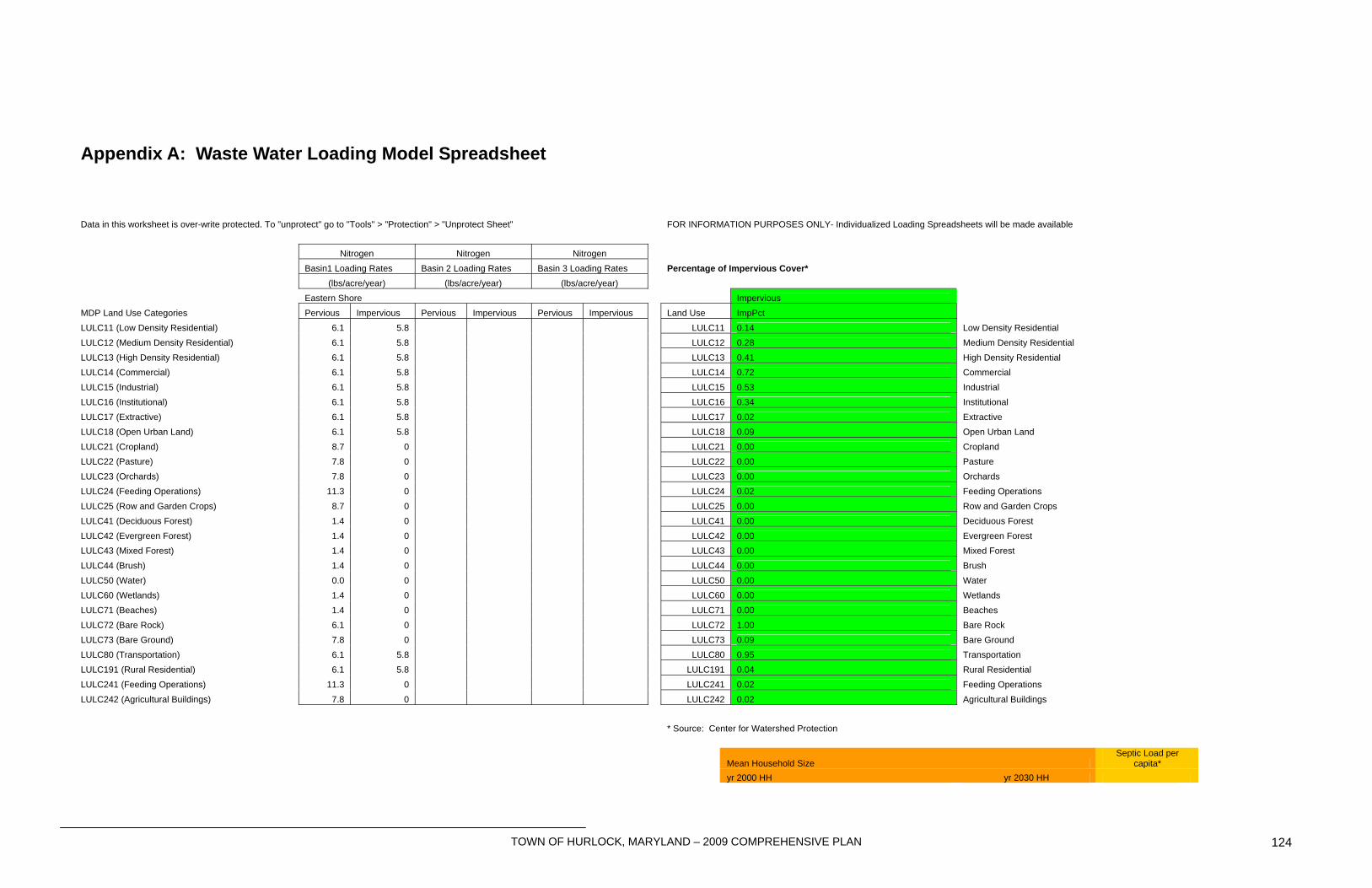
TOWN OF HURLOCK, MARYLAND – 2009 COMPREHENSIVE PLAN 124
Appendix A: Waste Water Loading Model Spreadsheet
Data in this worksheet is over-write protected. To "unprotect" go to "Tools" > "Protection" > "Unprotect Sheet" FOR INFORMATION PURPOSES ONLY- Individualized Loading Spreadsheets will be made available
Nitrogen Nitrogen Nitrogen Basin1 Loading Rates Basin 2 Loading Rates Basin 3 Loading Rates Percentage of Impervious Cover* (lbs/acre/year) (lbs/acre/year) (lbs/acre/year) Eastern Shore Impervious MDP Land Use Categories Pervious Impervious Pervious Impervious Pervious Impervious Land Use ImpPct LULC11 (Low Density Residential) 6.1 5.8 LULC11 0.14 Low Density Residential LULC12 (Medium Density Residential) 6.1 5.8 LULC12 0.28 Medium Density Residential LULC13 (High Density Residential) 6.1 5.8 LULC13 0.41 High Density Residential LULC14 (Commercial) 6.1 5.8 LULC14 0.72 Commercial LULC15 (Industrial) 6.1 5.8 LULC15 0.53 Industrial LULC16 (Institutional) 6.1 5.8 LULC16 0.34 Institutional LULC17 (Extractive) 6.1 5.8 LULC17 0.02 Extractive LULC18 (Open Urban Land) 6.1 5.8 LULC18 0.09 Open Urban Land LULC21 (Cropland) 8.7 0 LULC21 0.00 Cropland LULC22 (Pasture) 7.8 0 LULC22 0.00 Pasture LULC23 (Orchards) 7.8 0 LULC23 0.00 Orchards LULC24 (Feeding Operations) 11.3 0 LULC24 0.02 Feeding Operations LULC25 (Row and Garden Crops) 8.7 0 LULC25 0.00 Row and Garden Crops LULC41 (Deciduous Forest) 1.4 0 LULC41 0.00 Deciduous Forest LULC42 (Evergreen Forest) 1.4 0 LULC42 0.00 Evergreen Forest LULC43 (Mixed Forest) 1.4 0 LULC43 0.00 Mixed Forest LULC44 (Brush) 1.4 0 LULC44 0.00 Brush LULC50 (Water) 0.0 0 LULC50 0.00 Water LULC60 (Wetlands) 1.4 0 LULC60 0.00 Wetlands LULC71 (Beaches) 1.4 0 LULC71 0.00 Beaches LULC72 (Bare Rock) 6.1 0 LULC72 1.00 Bare Rock LULC73 (Bare Ground) 7.8 0 LULC73 0.09 Bare Ground LULC80 (Transportation) 6.1 5.8 LULC80 0.95 Transportation LULC191 (Rural Residential) 6.1 5.8 LULC191 0.04 Rural Residential LULC241 (Feeding Operations) 11.3 0 LULC241 0.02 Feeding Operations LULC242 (Agricultural Buildings) 7.8 0 LULC242 0.02 Agricultural Buildings * Source: Center for Watershed Protection
Mean Household Size Septic Load per
capita* yr 2000 HH yr 2030 HH
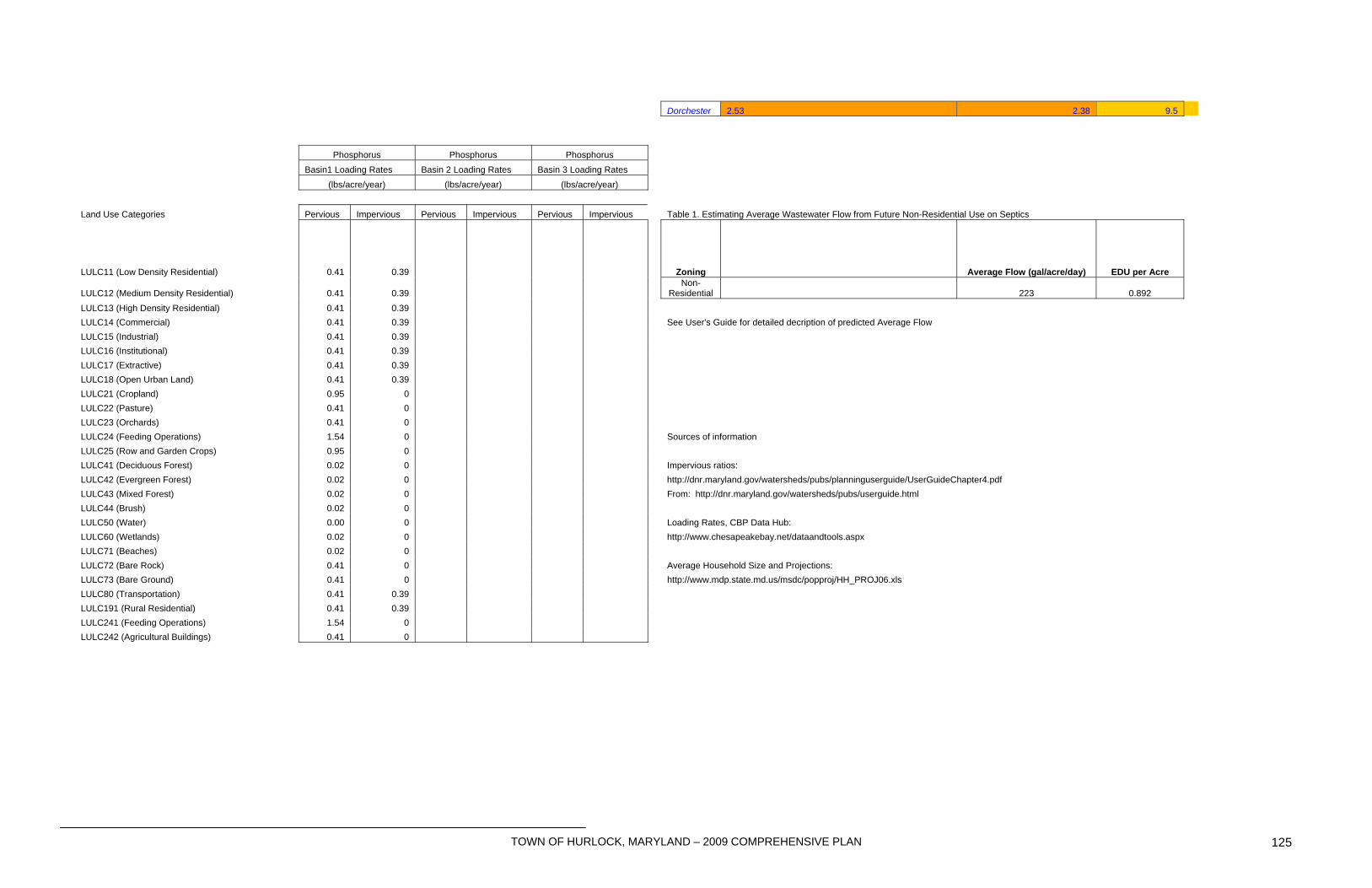
TOWN OF HURLOCK, MARYLAND – 2009 COMPREHENSIVE PLAN 125
Dorchester 2.53 2.38 9.5 Phosphorus Phosphorus Phosphorus Basin1 Loading Rates Basin 2 Loading Rates Basin 3 Loading Rates (lbs/acre/year) (lbs/acre/year) (lbs/acre/year) Land Use Categories Pervious Impervious Pervious Impervious Pervious Impervious Table 1. Estimating Average Wastewater Flow from Future Non-Residential Use on Septics
LULC11 (Low Density Residential) 0.41 0.39 Zoning Average Flow (gal/acre/day) EDU per Acre
LULC12 (Medium Density Residential) 0.41 0.39 Non-
Residential 223 0.892 LULC13 (High Density Residential) 0.41 0.39 LULC14 (Commercial) 0.41 0.39 See User's Guide for detailed decription of predicted Average Flow LULC15 (Industrial) 0.41 0.39 LULC16 (Institutional) 0.41 0.39 LULC17 (Extractive) 0.41 0.39 LULC18 (Open Urban Land) 0.41 0.39 LULC21 (Cropland) 0.95 0 LULC22 (Pasture) 0.41 0 LULC23 (Orchards) 0.41 0 LULC24 (Feeding Operations) 1.54 0 Sources of information LULC25 (Row and Garden Crops) 0.95 0 LULC41 (Deciduous Forest) 0.02 0 Impervious ratios: LULC42 (Evergreen Forest) 0.02 0 http://dnr.maryland.gov/watersheds/pubs/planninguserguide/UserGuideChapter4.pdf LULC43 (Mixed Forest) 0.02 0 From: http://dnr.maryland.gov/watersheds/pubs/userguide.html LULC44 (Brush) 0.02 0 LULC50 (Water) 0.00 0 Loading Rates, CBP Data Hub: LULC60 (Wetlands) 0.02 0 http://www.chesapeakebay.net/dataandtools.aspx LULC71 (Beaches) 0.02 0 LULC72 (Bare Rock) 0.41 0 Average Household Size and Projections: LULC73 (Bare Ground) 0.41 0 http://www.mdp.state.md.us/msdc/popproj/HH_PROJ06.xls LULC80 (Transportation) 0.41 0.39 LULC191 (Rural Residential) 0.41 0.39 LULC241 (Feeding Operations) 1.54 0 LULC242 (Agricultural Buildings) 0.41 0
TOWN OF HURLOCK, MARYLAND – 2009 COMPREHENSIVE PLAN 126
Appendix B: Historic Preservation Programs
A number of programs exist that provide assistance in protection or preservation, offer tax benefits, providing professional historical/architectural consulting, and so forth. More detailed information on programs including the National Historic Landmark, National Register of Historic Places, Conservation and Preservation Easements and Historic Overlay Districts can be found from various historic preservation organizations such as the Maryland Historical Trust, Maryland Association of Historic District Commissions and Preservation Maryland. National Register of Historic Places In 1966, the Historic Preservation Act established the National Register of Historic Places as the Federal Government’s official list of properties, including districts significant in American history and culture. In Maryland, the Register is administered by the Maryland Historical Trust. Some benefits resulting from a listing in the National Register include the following:
• National recognition of the value of historic properties individually and collectively to the Nation;
• Eligibility for Federal tax incentives and other preservation assistance; • Eligibility for a Maryland income tax benefit for the approved rehabilitation of
owner-occupied residential buildings; • Consideration in the planning for federally and state assisted projects.
Listing does not interfere with a private property owner’s rights to alter, manage or dispose of property. The Maryland Historical Trust (MHT) is an agency of the Maryland Department of Planning and the State Historic Preservation Office. The MHT surveys historic buildings, structures and archaeological sites to determine eligibility of being listed on the State register. As with being on the National Register of Historic Places, listing does not limit or regulate the property owner on what can or cannot be done with the property. In order to be considered for listing on the National Register or having an easement on the property to be accepted by the MHT, the site usually must first be listed on the Maryland Historical Trust Register. The MHT administers the following three programs related to research, survey and registration:
• Maryland Inventory of Historic Properties – a broad-based catalog of historic resources throughout the state. The inventory consists of written, photographic, cartographic and other graphic documentation of over 140,000 historic districts, buildings, structures and sites that serve as a physical record of Maryland history. The inventory is constantly expanding through contributions from the Trust’s Statewide Architectural Survey Program, which works with county and local governments and other institutions to identify and document historic resources. Listing in the inventory does not limit or regulate the property owner in what can or cannot be done with the property.
TOWN OF HURLOCK, MARYLAND – 2009 COMPREHENSIVE PLAN 127
• Maryland Register of Historic Places – consists of those Maryland resources listed in the National Register and those that the MHT Director determines are significant to the prehistory or history, upland and underwater archeology, architecture, engineering or culture of Maryland and therefore are eligible for listing in the National Register.
• National Register of Historic Places – recognizes districts, buildings, structures, objects and sites for the significance in American history, archeology, architecture, engineering, or culture, and identifies them as worthy of preservation. Listing in the National Register honors the property by recognizing its importance to its community, State, or to the Nation and confers a measure of protection from harm by Federal activities. Federal agencies whose projects affect a property listed in or determined eligible for the National Register must give the Advisory Council on Historic Preservation an opportunity to comment on the project and its effects on the property. Listing or eligibility for listing in the National Register is a prerequisite for receiving MHT capital grants, easement donation and eligibility for commercial and residential tax credits at the state and federal level.
The MHT administers Maryland state income tax credits for rehabilitation projects on both commercial and residential properties. The MHT also administers Federal rehabilitation tax credits for commercial properties in coordination with the National Park Service. In addition, the MHT offers non-capital grants that can be used for survey and inventory projects, design guidelines and technical assistance for creating and administering a local historic district. Maryland Historic Preservation Easement - A state-held historic preservation easement monitored by the MHT is an excellent means of perpetually preserving a historical structure and property for future generations. Such easements run with the land and transfer to future owners. The benefits for a property owner to donate his land to MHT may include income, estate, inheritance, gift and property tax benefits. In exchange, the owner gives the MHT the right to review and approve proposed alterations on the property. The MHT will only accept easements on properties it determines to be eligible for listing in the National Register. Local Historic Overlay Zone: A third, but separate, type of designation is the locally zoned historic district, which is an overlay on the existing zoning ordinance of a specified area. This district, legally allowed by Section 8.01 of Article 66B in the Annotated Code of Maryland is designed in order to maintain the visual character of the community. In 1995, the Maryland Legislature made changes to Article 66B relative to the local historic overlay zone. The main purpose of local historic area zoning is now: 1. to safeguard the heritage of Hurlock by preserving the sites, structures, or districts
therein which reflect elements of cultural, social, economic, political, archaeological, or architectural history;
2. to stabilize or improve property values of such sites, structure, or districts; 3. to foster civic beauty; 4. to strengthen the local economy;
TOWN OF HURLOCK, MARYLAND – 2009 COMPREHENSIVE PLAN 128
5. to promote the preservation and appreciation of sites, structures, and districts for the education and welfare of the residents of Hurlock.
Adaptive Re-Use - The Town should adopt zoning provisions that promote the adaptive reuse of historic structures for public and private uses including, but not limited to, bed and breakfast establishments, craft/gift shops, museums, studio space for artisans and other similar uses, when such uses minimize exterior structural alterations. Support Owners - The Town should encourage through the use of various incentives the preservation of historic structures. Include tax incentives for major structural or exterior renovation or the donation of protective historic easements. Local Historic Districts. The Town may, through the use of various incentives, encourage the establishment of local historic districts in the Town. Incentives may include tax incentives and recognition through the awarding of plaques. Development Proposal Review. The Zoning Ordinance and Subdivision Regulations for the Town should require developers to identify cemeteries/burial grounds/archaeological sites/historical structures on a property prior to any disturbance of the site and support archaeological and historical research through preservation of significant sites.
TOWN OF HURLOCK, MARYLAND – 2009 COMPREHENSIVE PLAN 129
Maryland Department of Planning Review Comments
Draft 2009 Hurlock Comprehensive Plan September 18, 2009 The Visions Maryland’s Planning Act of 1992 and subsequent legislation in 2000 requires that the eight Visions be included and implemented through the Comprehensive Plan. Overall, the Town did a good job of incorporating the Visions into meaningful Plan goals, policies, and recommendations, rather than simply listing the visions with no further elaboration. However, please note that SB 273/HB294, which passed during the 2009 session of the Maryland General Assembly replaces the State’s existing eight visions with twelve new visions. The effective date of this legislation is October 1, 2009. Although not required yet, we have amended the Plan to include the twelve visions at this time. They appear to address issues already covered by the Plan. Hurlock will review the visions and the Plan in the course of its ongoing planning program and make such changes when and where warranted. Chapter One: Introduction • Page 5: Under the 2009 Maryland General Assembly section, the Plan states that the 2009 legislation was introduced by the Maryland Department of Planning (MDP). The Smart, Green, and Growing legislation was an Administration package submitted by the Governor, not MDP. Also, in this same section, training sessions are also required of Board of Appeals members, not just Planning Commission members. Revised. Chapter Two: Past and Future Vision The MDP has no review comments for this chapter. Chapter Three: Hurlock Today Page 14: Table 3.2 indicates that the 1970 population of Hurlock is 1,065, while the previous page (within Table 3.1) shows this population at 1,056. Corrected. Chapter Four: Community Facilities Page 28: Within the Public Transportation section, it is recommended that a reference be made to the Transportation Element, as is done within the MGE. Recommendation noted.
TOWN OF HURLOCK, MARYLAND – 2009 COMPREHENSIVE PLAN 130
Chapter Five: Land Use Within the discussion of “Existing Land Uses” (pages 34-37) there exists an apparent disconnect to the Plan’s Existing Land Use Map. The map indicates a land use designation of “Vacant”; however, this designation is not discussed within the Land Use Element. Furthermore, it is unclear what the difference is between “Vacant” and “Undeveloped” land use designations, both of which are shown on the Existing Land Use Map. Also, the Existing Land Use Map and the Future Land Use Map show a specific land use designation, entitled “Municipal/Agricultural”, but this land use designation is not described within the text of the Comprehensive Plan, nor is it reflected within Table 5.1: Existing Land “Municipal/Agricultural” is municipally-owned agricultural land that is set aside for future spray irrigation of municipal wastewater discharges. Vacant and Undeveloped are descriptors based on unbuilt lands independent of designated land use and correspond to data included with the Department of Assessment and Taxation. It seems a more realistic description of land (as it is actually used at present). Uses and Acreages 2009. As with the difference between “Vacant” and “Undeveloped”, it is unclear as to the distinction between “Agricultural” and “Municipal Agricultural”. This is addressed above. Page 38: The final bullet on this page references an urban street-tree program “as an alternative to the Forest Conservation Program, however, the Sensitive Areas Element does not address the Forest Conservation Act (as it should), and therefore, this objective seems to lack context. As a part of the Sensitive Areas Element there should be discussion of the Forest Conservation Program and how it is administered within the Town. The Forest Conservation Act is administered on behalf of the Town of Hurlock by the Department of Natural Resources. There are no “sensitive forests” in the Town of Hurlock. Chapter Six: Municipal Growth Element (MGE)
Population Projections and Household Capacity In general, the social, economic, and housing data presented in the draft Plan are U. S. Bureau of the Census based. These data are comparable to data MDP maintains. MDP has produced population projections for Dorchester County municipalities, for planning purposes, and the Department generally recommends incorporating these MDP projections in the MGE. However, the draft Plan makes a valid argument that the MDP projections, in the short term, have underestimated the recent development activity in the Town. As a result the MDP population projection for the outlying years, are considered low. The Plan offers its own projection series that is substantially higher than the Department’s series of projections for Hurlock. These projections are presented in Table 1, below.
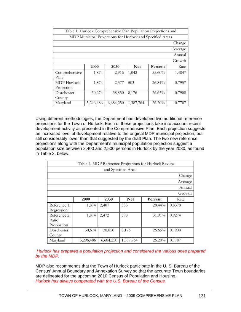
TOWN OF HURLOCK, MARYLAND – 2009 COMPREHENSIVE PLAN 131
Table 1. Hurlock Comprehensive Plan Population Projections and MDP Municipal Projections for Hurlock and Specified Areas
Change Average Annual
Growth 2000 2030 Net Percent Rate
Comprehensive Plan
1,874 2,916 1,042 55.60% 1.4847
MDP Hurlock Projection
1,874 2,377 503 26.84% 0.7957
Dorchester County
30,674 38,850 8,176 26.65% 0.7908
Maryland 5,296,486 6,684,250 1,387,764 26.20% 0.7787 Using different methodologies, the Department has developed two additional reference projections for the Town of Hurlock. Each of these projections take into account recent development activity as presented in the Comprehensive Plan. Each projection suggests an increased level of development relative to the original MDP municipal projection, but still considerably lower than that suggested by the draft Plan. The two new reference projections along with the Department’s municipal population projection suggest a population size between 2,400 and 2,500 persons in Hurlock by the year 2030, as found in Table 2, below.
Table 2. MDP Reference Projections for Hurlock Review and Specified Areas
Change Average Annual
Growth 2000 2030 Net Percent Rate
Reference 1. Regression
1,874 2,407 533 28.44% 0.8378
Reference 2. Ratio Proportion
1,874 2,472 598 31.91% 0.9274
Dorchester County
30,674 38,850 8,176 26.65% 0.7908
Maryland 5,296,486 6,684,250 1,387,764 26.20% 0.7787 Hurlock has prepared a population projection and considered the various ones prepared by the MDP. MDP also recommends that the Town of Hurlock participate in the U. S. Bureau of the Census’ Annual Boundary and Annexation Survey so that the accurate Town boundaries are delineated for the upcoming 2010 Census of Population and Housing. Hurlock has always cooperated with the U.S. Bureau of the Census.

TOWN OF HURLOCK, MARYLAND – 2009 COMPREHENSIVE PLAN 132
Development Capacity Analysis / Growth and Annexation Plan
MDP commends the Town on incorporating a development capacity analysis into their Municipal Growth Element; however, the development capacity methodology is unclear. The draft Plan indicates that MDP’s growth model was used to run the capacity analysis for the Town’s consultant; however MDP does not recall working with the consultant on completing this analysis. The Plan does not say the MDP prepared the capacity analysis. It indicates that MDP’s methodology was used. Local knowledge was also factored into the analysis, and Hurlock is satisfied with the results. Hurlock wishes to point out that MDP’s methodology, while perhaps appropriate at Statewide scales of analysis or possibly even county-wide, does not recognize the reality of Hurlock’s Subdivision Ordinance requirements nor the reality of existing development patterns and historical landowner decisions. Accordingly, only larger tracts of vacant land that lend themselves to larger scale development are suitable for analysis by MDP’s methodology. The Development Capacity states that there is enough capacity to support 604 dwelling units (1,538 persons) within the Town boundaries. The Town’s projected growth of 250-300 dwelling units can easily be accommodated within the corporate limits. Noted. Page 45: Even though the Town recognizes that the projected growth may be accommodated in the corporate limits it has chosen to designate nearly 1,000 acres of residential growth, with a potential of over 4,140 dwelling units as “an immediate growth priority”. While the Town has attempted to take a phased approach with the growth areas, the fact that both Growth Area 1 and Growth Area 2 are eligible for annexation within the 20 year horizon of this Plan may create an imbalance between land supply and population demand. Only one parcel (containing about 452 acres – including wetlands and hydric soils) has been designated in Growth Area 1. The balance of that parcel is already within Town. Hurlock believes the designation of one parcel for potential annexation and residential development is very minimal, realistic, and generally conservative. The Plan clearly indicates that Growth Area 2 (which was reduced by the removal of four tracts) is designated primarily for industrial development (which does not support residential uses). A 47 acre parcel is included for potential annexation and residential development as a consequence of local knowledge (and is included to promote flexibility and potential future “consistency” requirements). However, discussion of specific densities or other development options on that parcel will be the subject of additional future attention by the Planning Commission. The growth area slated for consideration within 15 to 40 years is also a concern, given the 20 year horizon of this Plan (as an example, consider Table 6-4 which addresses increases in school enrollment to year 2030, a 20-year horizon). This would indicate these areas may also be considered for annexation within the horizon of this Plan. The Town may want to change this to be “beyond the 20 year horizon of this Plan” or state that these areas will not be considered for annexation within the Plan horizon. This area has been changed to “ultimate buildout” without time frame and without designated future land use. It is the Town’s intent that County development be limited to
TOWN OF HURLOCK, MARYLAND – 2009 COMPREHENSIVE PLAN 133
the extent practical in these areas, and that if it should occur that plats be noted prior to recordation that future property owners may be subject to future annexation and requirements to hook up to public water and sewer services. Further, it is the Town’s policy to notify the County of its desire that no agricultural districts or easements be created within the Town’s “ultimate buildout” areas.
Parks and Recreation
It may prove beneficial to discuss the County’s LPRP and that Plan’s relationship to the Town’s park needs. This may also be an appropriate place to discuss inter-jurisdictional coordination with the County and the Maryland Department of Natural Resources (e.g. POS funding) to meet the Town’s needs. The Town maintains a dialog with Dorchester County in furtherance of mutual application of POS funding. The Town intends to continue this close cooperation.
Public Schools
Page 54: The third paragraph of the Public Schools section states that the increased capacity (595) for North Dorchester Middle School is the official State Rated Capacity (SRC); however, this is not the case. That number (595) is considered the local school capacity. In accordance with the Public School Construction Program Administrative Procedures and Guidelines, the SRC of an existing school may change annually depending on room assignments and use. Public School Construction Program staff may project the SRC of a school during design, but the SRC is not determined formally until the building is complete, occupied and floor plans are reviewed and approved by MDP. Also, it is recommended, for consistency purposes, that the official SRC (705) for North Dorchester High School be included in the narrative. Noted. According to MDP’s School Projections, Dorchester County enrollments for grades K through 10th are expected to increase by 2,018. The Local Educational Agency (LEA) agreed to use MDPs school projections, yet the projections shown in the Educational Facilities Master Plan are out-dated. Page 54 of the Comprehensive Plan states “the County anticipates continued slow but steady long term growth in the county population for the foreseeable future”. MDP recommends that the Town and LEA work closely with MDP to ensure that up-to-date actual and projected enrollments are available and consistent. Noted. The Town has requested the most up to date EFMP from both agencies. As outlined in MDPs “Smart Growth, Community Planning and Public School Construction Models and Guidelines” Town officials are encouraged to begin working with their Local Educational Agency to adopt measures that examine: o “Land Banking” for school sites which are community-centered and sized to fit
that community. o Availability of public water and sewer services. o Priority Funding Area status of the potential sites. o Schools are located in close distance to potential parks, libraries, museums
and other public facilities that offer opportunities for co-location and shared use of school facilities.
TOWN OF HURLOCK, MARYLAND – 2009 COMPREHENSIVE PLAN 134
o The potential for joint use of parks, libraries, museums, community health centers, and other public uses.
Noted. However, Hurlock reminds MDP that Dorchester County Board of Education is the LEA and that Hurlock is in no position to direct the determinations of the LEA. The issues raised by MDP appear more appropriately to fall within the purview of LEA and MDP.
Public Safety and Emergency Services
Discussion about the provision of Emergency Medical Services (EMS) is warranted within this section of the MGE. The Plan states that Dorchester County provides EMS service and stations an EMS response unit at the Hurlock Area Fire Company. Hurlock is not aware of any inadequacies in service provision.
Urban Growth Boundary • Page 50: The fourth full paragraph within this section states the County will “incorporate and adopt” Hurlock’s Comprehensive Plan “as a regional sub-element”; however, MDP is unaware of any plans by the County to do so. If the Town is recommending that this occur, it is suggested that this paragraph be worded in such a manner to be construed as a “recommendation” in the context of inter-jurisdictional cooperation, and indeed, be carried over to the Policies and Recommendations section of this Element. Hurlock has already had this discussion with Dorchester County as part of its coordination on the MGE (and the WRE). Pages 50 and 51: These pages differ in terminology relating to an Urban Growth Boundary, versus an Urban Development Boundary. It is suggested, for clarity, that a universal term (and acronym) be used in relation to this concept. This has been addressed.
Priority Funding Areas (PFA) The Plan should include a current PFA map and the Town should be notified that State funding is generally limited to PFA areas meeting the requirements of the State Finance and Procurement Article, with some exceptions. PFA maps are prepared by MDP. When MDP drafted the original legislation establishing the concept, Hurlock was included, by definition. The Town’s boundaries have not changed. In the event future annexations occur, Hurlock will determine whether it is in the Town’s best interest to “designate” the annexed areas as PFA’s. If it does, Hurlock anticipates that MDP will prepare a new PFA map, as is its charge.
General MGE Comments:
Page 41: The third paragraph states that the “Town’s population, which had remained nearly level for forty years, increased by 65% during the 1970’s…”, however Table 3-1 of the draft Plan indicates a 60% change during that period. Revised to 60%.
TOWN OF HURLOCK, MARYLAND – 2009 COMPREHENSIVE PLAN 135
Page 42: This page starts by describing what a Development Capacity Analysis is; however the analysis is not presented until page 45, therefore, it may make sense to put these two discussions together. Since the analysis follows the description of what an analysis is intended to accomplish, Hurlock does not feel the time and expense of such an editorial change is warranted at this time. Perhaps the next update will provide a “better” structure. Page 44: The graph entitled Hurlock Population Projection (2010 – 2030) has an unidentified gray line. Furthermore, directly adjacent to the y-axis of the graph there is a yellow dot (followed by the number 2916) and a red dot (followed by the number 2590) which are not identified on the graph. The gray line is the linear regression curve generated by MS Excel. Similarly, the “dots” and numbers are automatically generated and placed by this program where data points fall between interstical tic marks not directly referenced to the Y axis. This provides exact detail with regard to the data point(s) being mapped by the graph. The reviewer is directed to consult with staff in MDP’s data division who may be more familiar with standardized data analysis and presentation protocols. Page 53: Table 6-3, Growth Area Summary, there is an error in the “Estimated Acreage” column, the acreage for Industrial Growth Area is indicated as 268, however, it is suspected that this figure should be 686 acres. The correct figure is 308 acres. The Table has been corrected to correspond with the data tables associated with Growth Area 2 (industrial). Page 58: Within the Library section of the MGE, the recommendation to “have developers contribute toward keeping the library centrally located” does not seem clear, in that, nowhere within the Plan is there discussion which would result in such a recommendation. Furthermore, it is unclear as to how a developer would make such a contribution “toward keeping the library centrally located”; please clarify this recommendation (which is also found within the Implementation Element). Since the residential growth areas are not “centrally located” but in the northwest area next to the current corporate limits, it seems reasonable to express concern that potential future residential development in that area, particularly a larger scale project, not generate political demand for relocating the current centrally located library. That is of particular potential concern since MDP’s models and guidelines suggest that new public infrastructure (such as schools, libraries, fire halls, etc.) should be provided though “land banking” which is only feasible as part of large scale development. Clearly, Hurlock does not with that to occur, and these statements will provide future planning commissions with appropriate development review guidance. The developer’s contribution could be financial, i.e., provide funds to expand the existing library in its existing central location…for the benefit of all Hurlock residents. Page 58: Within the Land Use and Zoning section, it is unclear (in the context of industrial uses) what is meant by “determine which uses may be more suitable for urban and non-urban areas”, in that within the discussion on page 49, dealing with Growth Area 2, there is no text which gives this recommendation any context. In rural areas (such as Dorchester County, Hurlock, and the Eastern Shore generally), certain common industrial uses generate impacts that are not generally suitable in locations proximate to residential and commercial land uses. Rendering plants and certain agricultural processing facilities readily come to mind. The people of Hurlock
TOWN OF HURLOCK, MARYLAND – 2009 COMPREHENSIVE PLAN 136
understand the meanings attached to the language included in the Plan and can draw suitable guidance when reviewing the Zoning Ordinance. • Page 58: Within the Greenbelt section, first bullet, there is a reference to a “10-year priority area of the designated growth area”, while elsewhere in the Plan there is discussion of a “current to 15-year” and a “15 to 40-year” growth area. Noted. The Plan references the “0-15 year” area that corresponds to the “immediate priority” growth area(s). There exists within the Town two “functional” County enclaves (functional in that only a “flag stem” of County land connects the County proper to these areas surrounded by Municipal land). It is recommended, at a minimum, some discussion is merited as to the circumstances that resulted in these enclaves. However, it appears (by reviewing the maps) that the Town does not intend to cure this circumstance, and it is suggested that consideration be given to bring these functional enclaves into the Town, or otherwise address why this should not be done. There always exist reasons why particular decisions were made in the past the way they were. It is sufficient to show these areas as they are. If future conditions warrant some new course of action, opportunity exists to amend the Plan, including the Municipal Growth Element, and then proceed with appropriate annexation(s). In considering the proposed growth areas, and specifically reviewing the Growth Areas Map, it is unclear as to the intent of the “Potential Water and Sewer Areas”. If these areas are not specifically intended to be within a growth area, as seems to be shown on the Growth Area Map, this would ultimately create a County enclave, which is not permitted by State Law. The Town does not desire to imply annexation is likely or will be pursued against the wishes of residents in these areas. The purpose of this designation is to indicate that future annexation is possible. This designation was given because Town services, especially sewer, may be needed in these areas for existing developed small parcels with on-site sewerage disposal problems and a small potential senior affordable senior housing project. Further, a “potential water and sewer area” does not in and of itself create a County enclave. Only a completed annexation action that would entirely surround the referenced County area would do that. Such an annexation is not likely to be proposed nor would it be very likely to withstand the scrutiny that would undoubtedly follow. To further confuse the issue, in reviewing the Future Land Use Map, this “Potential Water and Sewer Area” is shown as a “Single-Family Residential” land use designation, which would imply this area is intended for incorporation into the Town. Please clarify the distinction between “Potential Water and Sewer Areas” as they relate to growth areas. An area that may require water and sewer due to health reasons but has no wish to be annexed nor represents an area that Hurlock has any wish otherwise to force into annexation, ergo, plan as a “growth area.” Such circumstances are not unique to Hurlock. Within the Capacity Analysis section of the MGE, the very first sentence states, “[p]er the analysis discussed above, the Town has ample capacity within its existing limits to accommodate future growth”. However, the Town proposes a future (immediate growth

TOWN OF HURLOCK, MARYLAND – 2009 COMPREHENSIVE PLAN 137
priority) growth area of 935 acres for residential growth, with a potential range of an additional 1,586 to over 4,140 residential dwelling units. The Plan includes an immediate growth priority growth area of 452 acres, some of which includes hydric soils and wetland. MDP suggests that the proposed residential growth area is far beyond that which can be reasonably supported by the Town. One of the principle purposes of HB1141, and more specifically the development of a MGE, is for the municipality to plan for, and provide, a rational nexus between the amount of anticipated growth, the size of proposed growth areas and the ability to accommodate such growth (to include the provision of, and funding for, required services and infrastructure). MDP would suggest that the Plan’s anticipated increase of 250 residential dwelling units during the planning horizon, in relation to the proposed growth areas (able to accommodate in excess of 4,140 dwelling units) may cause Hurlock to become “over-bounded”, thus causing an undesirable, sprawl-like, effect on the Town. Using a more moderate approach to contain and direct growth, by reducing the size of the proposed growth areas, will help to meet the goals of the Town, as stated on pages 10 and 11 of the draft Plan. MDP suggests that the growth areas be reduced to ensure that residential sprawl is minimized, and that a more detailed accounting of the water and wastewater needs for the Town, as a result of the proposed increase in residential and industrial growth, be presented. The foregoing comments are moot. The one parcel identified for residential growth is required to be developed in order to accomplish the goal of providing for and facilitating the financial feasibility of constructing the “by-pass” and connecting certain other parcels designated for mixed use and industrial development with needed highway access (which the State Highway Administration has stated support for but an unwillingness to help fund or construct). Notwithstanding the Department’s concerns outlined above, with respect to the size of the residential growth area, it is unclear as to the potential magnitude of additional residential units realized by the conversion of land currently within the Town’s municipal limits, from an Agricultural to Mixed Use land use designation. It seems reasonable to assume that the proposed conversion of several hundred acres of agriculture land to mixed use would further satisfy projected growth, within the current municipal boundaries, thereby bringing further question as to the appropriateness of the proposed size of the growth areas. At a minimum, the MGE should present some description as to the type and scale of uses that are anticipated within the Mixed Use designated lands, and an analysis of the impacts associated with the conversion of such a large area from an Agricultural to a Mixed Use land use designation. Extensive files are available in the Hurlock town office that may be reviewed for a detailed understanding of the locations and uses proposed for development within the area described above. To the extent that many of these investment-backed plans and expectations are dependent upon a resurgence of the national, State, and regional economies it is not reasonable to make too detailed a prediction concerning what and when development might occur. The Comprehensive Plan is viewed as a general guide that is comprehensive in nature and balances many sometimes competing interests, concerns and policies. In that regard, Hurlock considers the current level of detail contained in the Plan satisfactory to provide appropriate guidance with regard to future zoning and development review and approval processes. Within the MGE, there is a proposed 686-acre Industrial Growth Area. While it is correct to assert, as is done in the Plan, that there is not a “capacity analysis” for non-residential
TOWN OF HURLOCK, MARYLAND – 2009 COMPREHENSIVE PLAN 138
uses, MDP would suggest that there should be some discussion, within the MGE, about the status of the existing lands designated as Industrial. It seems relevant to analyze how much of this industrial land within the Town is underutilized or undeveloped, historic industrial growth rate (to make reasonable projections as to how long it would take to accommodate future industrial growth), and other measures of adequacy of existing industrial land, to reasonably account for an approximate increase of 170% of industrially designated land as an “immediate growth priority”. The Plan includes 308 acres of designated priority industrial development land. Those lands are included in several parcels that follow the intended route of the “by-pass.” Without significant development of these non-residential lands, the by-pass can not and will not be realized. The Town of Hurlock does not entertain that as a reasonable or viable option. Until a specific non-residential use is proposed, no specific water or wastewater demand can be analyzed or projected. Accordingly, a “capacity analysis” is both impractical and unwarranted. The analysis of required services and infrastructure within the MGE, with respect to the potential impacts of future growth, seems to be inadequate. As an example, the analysis of impacts to Public Schools only discusses impacts associated with 250 households, while the projected potential growth in the “immediate growth priority” area is up to 4,140 households. On the one hand, a growth of 250 households appears potentially possible but only market demand will determine whether these households will ever be constructed. In the event that a viable development proposal is received for review, Hurlock will continue to coordinate with the LEA and provide appropriate development approval and permit issuance statistics that will assist in evaluating the adequacy of public schools. Another example where MDP suggests that the future impacts are not adequately addressed is with respect to fire protection. It seems reasonable to assume (especially if some generalized analysis were performed) that creating an additional 686 acres of industrial uses (notwithstanding infill and redevelopment of existing industrial land use areas) would place a significant burden on water supply and storage requirements for fire protection, beyond that of a commensurate amount of residential growth area (due to building code and fire code sprinkler requirements). Industrial developments often have unique and specialized fire fighting requirements based on chemicals and/or production processes employed. Where such impacts suggest themselves (in the initial site plan review process), standard practice dictates that appropriate demands and requirements are placed upon the private interests to ensure adequate public protection. Similarly, fire insurance requirements are very specific with regard to potential dangerous or hazardous materials and processes. If the Hurlock Area Fire Department would potentially require specialized training or equipment to augment that which would be required to be permanently placed on-site (at the owner’s expense), then those issues will be visited during the site plan review process. Such detail is not within the normal scope of a Comprehensive Plan, especially when no information is available concerning what those emergency or public safety issues might be. HB1141 requires that an analysis be performed, in the context of the ability to provide for (and fund) “public services and infrastructure needed to accommodate growth within the proposed municipal growth areas” (Article 66B 3.05(a)(4)(x)(5)). Actually, what that sections “requires” is that a municipality include “consideration” of six categories of public services and infrastructure that may be “needed” within “growth
TOWN OF HURLOCK, MARYLAND – 2009 COMPREHENSIVE PLAN 139
areas” when preparing their Municipal Growth Elements. The Hurlock Plan and its MGE have considered these public services and infrastructure issues. If and when specific services and infrastructure may be impacted by future development, specific coordination with the agencies and organizations responsible for provision of such services will occur. At this time, it is not possible to put a timeframe on potential future needs for capacity expansion in any of these services. (Ergo, the use of 0-15 year “immediate priority” to describe, very roughly, the time frame for growth and development.) That is particularly true for schools, libraries, and recreation facilities which require specific numbers over specific timeframes to facilitate appropriate capital programming and budgeting. HB1141 did not intend for municipalities to set arbitrary and artificially goals for public facility expansions based on theoretical and potential development scenarios that are as much dependent upon market forces and private sector decisions as they are upon various potential zoning scenarios (i.e. R-1, R-2, R-3). To the extent that the time frame for the Plan is a “twenty year” horizon, Hurlock has agreed that any arbitrary time horizon is as good as any other, and that since the Town’s comprehensive planning program is an ongoing process and since Article 66B requires a six-year comprehensive review of the Plan, the Town has ample opportunity to adjust, amend, and fine tune such statements, findings, and policies as may be appropriate to ensure a Comprehensive Plan that meets the needs of the Town and is consistent with the Annotated Code of Maryland. Restated, if a growth area has the potential for 4,140 dwelling units, an analysis as to how to accommodate services and infrastructure for 4,140 dwelling units must be provided. Or, if it is anticipated that an additional 686 acres of Industrial uses would accommodate “x” million square feet of building space, an analysis as to the potential impacts to needed services and infrastructure must be provided. Article 66B does not employ the terms “must” or “analysis.” Rather, consistent with Legislative intent, it employs the term “consider.” Additionally, in consideration of the greatly reduced land areas in both GA1 and GA2, and the primary purpose for their designation, the need for and feasibility of providing transportation infrastructure to promote has been abundantly met. In light of the information put forth in the Future Vision and the Goals and Objectives of the draft Plan (page 10), the analysis of the Town’s public water and wastewater capacities within the Community Facilities Element (pages 25-27), discussion within the Water Resources Element, and the focus of the Plan to encourage infill and a traditional growth pattern, it appears that the growth area for Hurlock is overly expansive. The Growth Area has been greatly reduced in size and scope. It now includes only two residential parcels. That appears very reasonable from the Town’s perspective. It is suggested that some analysis of Town staffing requirements (personnel and office space) be provided. As an example, is there an expectation for the need for new or expanded Town offices, additional staffing, or additional public works equipment should an additional 1,586 to 4,130 dwelling units come to fruition, as is proposed within the “immediate growth area”? Town space and staffing is sufficient to meet the Town’s needs for the foreseeable future. If work loads increased significantly (and commensurate increases in operating budgets are possible), then a Plan amendment may be warranted (if the Town were to seek State funding for an expansion of the Town office). The Town does not realistically anticipate more than new dwelling units over the next ten years. The population projection for the next ten years would result in a range of new dwelling units of between
TOWN OF HURLOCK, MARYLAND – 2009 COMPREHENSIVE PLAN 140
125 and 142 (depending on assumed household sizes of 2.6 (recent census) and 2.3 (suggested decrease in future household size). MDP has indicated its belief that even that projection is high. Accordingly, if MDP is correct, then the projected impact on Town services (and all public services and infrastructure needs) will be small. Chapter Seven: Water Resources Element (WRE)
The Town of Hurlock has met the majority of the WRE requirements of HB1141; however, the WRE is incomplete. By addressing the following comments, the WRE will conform to the requirements of HB1141. The most important comments to address are in bold. The WRE does not yet effectively address the following purposes of the law and/or State guidance, as follows:
This statement is unclear and potentially confusing. Which of the comments apply specifically to Article 66B? Which statements reflect MDP’s desires? It appears that only the “bold” comments allege a deficiency at law. Lacking specific comment to the contrary from MDE, it appears that Art. 66B, section 3.05(a)(4)(vi)(3) has been satisfied. Future revisions can address any specific concerns in meeting Article 66B requirements. Identify suitable receiving waters and land areas to meet the stormwater management and wastewater treatment and disposal needs of existing and future development proposed in the Land Use Element of the Plan, considering available data provided by MDE (Section 1.03(iii), Article 66B). The Town and its consultant have coordinated with MDE and utilized the “data provided” to develop the WRE in this Plan. The “suitable receiving waters” are those that are available and have been analyzed (and are the basis for existing NPDES discharge permits). If MDP has additional information to the contrary that the discharge waters are not suitable, then Hurlock hopes that information will be shared with the Town. The Town has also mapped Municipal/Agricultural lands it owns and uses for spray irrigation of treated wastewater. The MDE determined that industrial pretreatment of industrial discharges has resulted in such high quality wastewater that the existing treatment plant is operating at ENR treatment levels and “well below the permitted thresholds. Stormwater management is a function of overland sheet flow, and some flooding potential does exist in relation to unusually intense rainfall events. The Town is aware of certain “problem areas” and is seeking funding assistance to address these concerns. Since they are not issue of “future development” concern but rather current active issues, they are more appropriately addressed outside the Comprehensive Planning process. Clearly, it is the Town’s expectations that existing deficiencies will be addressed and corrected within the near future. Accordingly, the only policy change that has a bearing upon stormwater management is the new stormwater management manual prepared by MDE and anticipated to be adopted by Dorchester County (which provides stormwater management review for Hurlock). For each watershed, calculate the total forecasted nutrient load, which includes nutrient loads from current and future WWTP discharge, septic tanks, and stormwater runoff (MDP M&G 26, p. 13). See Appendix A. This is an analysis more appropriately prepared by the County and then shared with each municipality in each respective watershed. This will ensure consistency in the numbers and coordination in policies. Hurlock will include information that is made available by MDE and Dorchester County.
TOWN OF HURLOCK, MARYLAND – 2009 COMPREHENSIVE PLAN 141
Does the WRE describe the alternative future development options for which nonpoint source and point source loading estimates were performed? Does the WRE make general findings for alternative land use options (MDP M&G 26, pp. 39-40)? See Appendix A Does the WRE show or refer to the boundaries of relevant areas used for planning, including current water and sewer service areas (MDP M&G 26, pp. 27)? Yes
Comments on the water demand analysis include: The Plan uses multiple water planning figures to estimate future demand such as 497 GPD/EDU and 390 GPD/EDU. The WRE should pick one water planning figure and be consistent throughout the Plan. Due to a lack of water meters and the comingling and cotreatment of residential and very high industrial wastewater flows, the Plan uses an average of 400 GPD/EDU for the projected 250 EDU’s. 497 GPD is the flow for the month of highest use. As with all “capacity” discussions, there are a number of operative definitions, and it is important to understand which standard and condition is under discussion. The Plan does not state whether there are any private wells in the Town. Please add this information to the WRE. If wells exist, please note whether there are any plans to connect any failing wells to the public water system and the capacity needed to serve them. The Plan could then discuss whether they are susceptible to pollution and whether these might be included in future source water protection plans. The only private wells are for industrial purposes. They are not failing and do not affect municipal supplies for residential and commercial users. The wells are adequate for their purposes and are regulated by MDE. Please clarify whether the 250 residences in Table 7.1 (p. 64) represent infill development within the Town. They are the projected number of EDU’s anticipated during the planning horizon and may reflect a combination of infill and new growth area development.
Comments on the proposed methods for protecting the Town’s source water include: The WRE states that the Town has established a Wellhead Protection Area to prevent source water contamination (p. 62). Correct
Comments on the sewer demand analysis include: The Plan states that Inflow and Infiltration (I&I) is a problem for the WWTP during periods of wet weather (p. 26). Please clarify whether the sewer demand figures include demand from Inflow and Infiltration (I&I) (p. 66). Page 66 states that the existing WWTP is “capable of handling the projected growth through 2030 and normal peak or wet weather flows.” To the extent that I/I is an issue during wet weather peaks, it appears that these conditions have been factored into the analysis.
TOWN OF HURLOCK, MARYLAND – 2009 COMPREHENSIVE PLAN 142
Current and projected sewer demand figures are discussed in the text of the WRE (p. 66). It would be helpful to the reader to also include tables with the sewer demand data. Noted. Will be added to future WRE updates.
Comments on identifying suitable receiving waters include:
The WRE should make reference to the point source loading projections in Appendix A. Noted. Will be added to future WRE updates. The Plan does not yet include a combined point source and non-point source pollution table. Please add this to the Plan. This will be considered and may be amended into the Plan or provided as part of a future WRE element update. The Town does not interpret this as a requirement of Article 66B. • The Plan does not yet discuss the suitability of the receiving waters. Since a nutrient TMDL has been set for the Marshyhope Creek, the WRE should discuss the suitability of the creek in the context of the TMDL. Please add this discussion to the Plan. To the extent that the analysis demonstrates that the WWTP achieves ENR treatment levels and is projected to be adequate to treat projected growth, even during wet weather peaks and is meeting its NPDES permit limitations (set for Marshyhope Creek); it is concluded that whatever receiving waters (Marshyhope Creek and their TMDL limits) must be adequate and “suitable” to be utilized as the point of discharge and as “receiving waters.” MDE has made those determinations, and Hurlock is unsure what else can or should be said. The WRE should evaluate the forecasted pollution impacts (point and non-point source pollution combined). In this evaluation, at least two land use plan options (including growth areas) should be evaluated to determine which land use plan would have the least impact on receiving waters. Hurlock will work with MDE to determine whether a land use option that has development occurring in Dorchester County on individual well and septic has merit and should be considered as an option to the growth scenario described in the Plan. Such an option would seem to satisfy the “requirement” for evaluation of more than one land use option. If MDE concurs, then such an analysis can be added to a future update of the WRE element based on guidance and information supplied by MDE.
General WRE Comments The Plan does not yet include maps of the water and sewer service areas. Please add these maps to the Plan. This appears to be a desire of the MDP and not a requirement in the annotated code. Such maps are included in the Dorchester County Comprehensive Water and Sewer Plan. They should be directly referred to as the official service area maps. Those are the maps that should and will be updated, as needed, to ensure consistency with the Hurlock Comprehensive Plan and to avoid potential confusion and inconsistency. Any question concerning the location, extent, or limits of an existing or planned service area are resolved by referral to the Water and Sewer Plan.
TOWN OF HURLOCK, MARYLAND – 2009 COMPREHENSIVE PLAN 143
Page 67: Within the Hypothetical Build-Out Scenario section, the WRE states, “[h]ypothetically, 2,628 additional residential units are possible in the growth areas and including all undeveloped and underdeveloped parcels within the existing Town limits”. This statement does not seem accurate when considering the MGE Table 6-3, which indicates that (for just the growth areas) there is a potential for over 4,140 residential units. Please address this apparent inconsistency. Actually, given the reduced acreage in the Growth Area, the theoretical maximum buildout under an R-1 scenario would be 813 edu of new growth area development plus 604 infill edu’s. The total theoretical potential is thus 1,417 (although as has been pointed out, 604 infill edu’s is highly unlikely as a practical matter). Nevertheless, the WRE has used the 604 edu figure for the analysis to remain on the conservative side of the demand capacity estimate. Future water and sewer amendments will be evaluated against the goals and objectives and the text of the Plan versus the Future Land Use Map. The draft Plan text seems out of sync with the Future Land Use Map, in that the Town’s new growth area(s) and the Town’s infill and redevelopment potential project a buildout that is greater than a 50 year expectation of growth. This has been radically downsized. In light of the current available land for development within the Town’s corporate limits, the absence of an allocation process, inaccurate water usage figures, incomplete commercial and industrial demands, and an imbalance between proposed supply and expected demand, the potential expansion of the Hurlock Water and Sewer Service Areas create growth patterns that challenge conformance with the State’s Smart Growth principles or visions. Reality is often different than theory, particularly when “theory” attempts to encompass all possible conditions and treat them equally. Clearly, regional differences and jurisdictional differences matter when it comes to satisfying such a standard. However, Article 66B provides sufficient flexibility to help ensure compliance by the Town of Hurlock, even in terms of how some might choose to interpret “smart growth principles or visions.” Hurlock believes that more compact growth patterns on public water and sewer within PFA’s (such as the Town of Hurlock), is preferable and more consistent with “smart growth principles or visions” than the alternative, i.e., low density sprawl on individual well and septic systems. Further, courts have clearly held that it is better to provide too much rather than too little opportunity [thereby avoiding charges of limiting competition and fostering “windfalls and wipeouts.”] Convenient as it would be to have tight and accurate figures that reflect actual demands for land and services; and as convenient it would be if Hurlock could afford installing universal water meters and the staff and revenue stream needed to support a water reading and billing program; and, as much as Hurlock would appreciate State funding assistance for the construction of new roads and access highways, the Town believes this current version of the Hurlock Comprehensive Plan provides a reasonable and realistic policy for growth management that achieves the various goals and objectives of the Town and its residents. As better information becomes available in the future, then the Plan can be revised to incorporate and reflect that better information. The consideration of installing water meters for “public use awareness” (efforts towards conservation?) should be secondary to the Town’s concern to monitor and regulate the system for water loss and accurate billing needs. The water supply appears to be adequate to meet the projected demands, however, system inadequacies will likely be

TOWN OF HURLOCK, MARYLAND – 2009 COMPREHENSIVE PLAN 144
exacerbated, and provision of services will be less cost effective, absent a reduced service/growth area. The service/growth area has been radically downsized. The Town should institute an allocation process to better monitor the use and future planning needs for its water and sewer capacities. A capacity allocation plan will be prepared in compliance with State law when allocated capacity reaches 80% of permitted capacity. This will provide sufficient “lead time” to plan for realistic expansion(s) with sufficient information regarding how the expanded capacity will be funded. Detailed funding decisions will require executive decisions by the Mayor and Council (with a view toward ensuring that new development will pay 100% of the cost needed to service that growth. Existing residents have no desire, nor any obligation to subsidize new growth and development). For years the Town has monitored the impact of proposed development upon the water and sewer services before approval is given and will continue to do so. Chapter Eight: Transportation Page 72: Within the Functional Classification of Streets section, there are no identified Rural Minor Arterials; however, Maryland State Highway’s 2008 Highway Location Reference defines MD 307, MD 331 or MD 392 as Rural Minor Arterial in the Hurlock area. Please check the following link for the highway information in Dorchester County: http://www.marylandroads.com/keepingcurrent/performtrafficstudies/dataandstats/hwylocationref/oppe/hlr.asp The semantics of a State perspective versus a local perspective with regard to roadway classification will receive further attention and consideration. The comment has been incorporated into the Transportation Element. Page 75: Within the Levels of Service Standards section, it is suggested the Plan address what Level Of Service (LOS) the Town would consider as an acceptable level (and perhaps discuss the means to ensure such LOS is maintained). In general, LOS “D” is commonly used by municipalities in Maryland; however, the Town may want to identify certain roads and/or intersections targeted for a higher LOS. Local roads function fairly well. “Congestion” and LOS issues more appropriately belong to the capacity and performance characteristics of the State roads in the Hurlock area. As such, Hurlock coordinates with the SHA, which has responsibility to maintain and improve these “rural minor arterials.” Page 75: Within the Pedestrian and Bicycle Paths section, there is a reference to a “Sidewalk Location Map (6a)” that does not appear within the Plan. It is included with the other Plan maps at the back of the Plan. Page 80: Within the Intermediate Range section, the second sentence states “[w]hile many of the local streets will likely maintain their integrity, collectors and arterials, in the Town…” (emphasis added), however, earlier within the Transportation Element there is a statement that the Town does not have any arterial classified roads. This issue is further complicated, in that the Transportation Map indicates three “Major Arterials” within the Town, while the Transportation Element (page 72) states that “[t]here are no roadways that expressly meet this definition” (that is, “Major Arterials”). Perhaps the Transportation Map incorrectly identifies Major Collectors as Major Arterials.
TOWN OF HURLOCK, MARYLAND – 2009 COMPREHENSIVE PLAN 145
This will receive further attention to ensure consistent nomenclature. Major Collectors will be relabeled as Rural Minor Arterials. The Town should include a transportation policy that requires roadway improvements in new development areas to be well interconnected and form logical extensions of the existing type of roadway patterns. That is the Town’s intent. MDP suggests the Town consider developing a pedestrian and bicycle access plan instead of “a sidewalks plan” that targets only pedestrians. Creation of the pedestrian and bicycle plan will help the Town to seek and obtain state and federal pedestrian/bicycle facility funding sources. The Town will take this suggestion under advisement pending a viable fund source to prepare the requisite “pedestrian and bicycle access plan.” Chapter Nine: Housing Page 85: Figure 9-1, it is recommended that a description be added to indicate what the x-axis of the figure represents (e.g. “persons per household”). While the reviewer is correct, that the numbers 1 through 8 refers to increasing household size, the comment might be better directed to the Department of Housing and Urban Development , the source of the data in question. Page 86: Figure 9-2, it is recommended that a description be added to indicate what the x-axis of the figure represents (e.g. “persons per household”). While the reviewer is correct, that the numbers 1 through 8 refers to increasing household size, the comment might be better directed to the Department of Housing and Urban Development, the source of the data in question. Page 86: The Plan states that “[a]ccording to Census and HUD statistics, the following is a summary of workforce and affordable housing needs in the Town of Hurlock”, and is followed by four bullets. It seems that, indeed, the first three bullets are summaries of statistics, and these three bullets address “workforce and affordable housing needs”. However, it appears that the fourth bullet is not well placed within this section, as it is not a statistically based conclusion, but more of a programmatic issue, perhaps best discussed elsewhere within this Element. Comment noted and the Plan has been amended. Chapter Ten: Sensitive Areas Page 89: Within the Natural and Environmental Features section, the Plan correctly indicates, “Article 66B requires that every municipality have a Sensitive Areas Element, which describes how the jurisdiction will protect… agricultural and forest lands intended for resource protection or conservation”, however, it does not appear that the Sensitive Area Element addresses this issue. That is because the Town of Hurlock does not encompass “agricultural and forest lands intended for resource protection or conservation.” The Town’s agricultural parcels are utilized for agricultural purposes to the degree that plant uptake of sprayed wastewater is part of the Town’s wastewater treatment process, which has merely a secondary emphasis on “resource protection or conservation.” Privately owned agricultural lands within the Growth Area are intended to be developed when economically feasible (and
TOWN OF HURLOCK, MARYLAND – 2009 COMPREHENSIVE PLAN 146
not “protected or conserved”). Accordingly, that phrase in Article 66B does not apply to the Town of Hurlock and is more appropriately addressed at a larger regional scale by Dorchester County. Page 89: Within the Wetlands and Wetland Buffers section, the first paragraph of this section states “[i]f wetland mitigation is not possible, a 25-foot vegetated buffer should be implemented…”. This statement seems out of place, in that there is no discussion of State wetland law requirements of ordinal consideration of “avoidance, minimization and mitigation”, and regardless of this order of protecting wetlands, a 25-foot buffer is already required whether “mitigation is not possible” or is possible. It is suggested that this section be expanded upon and clarified. Comment noted and will be considered in due course. Page 91: Within the Habitat of Rare, Endangered or Threatened Species section, it may be appropriate to discuss the two large Sensitive Species Project Review Areas (SSPRA’s) independently, as one SSPRA is located within the center of Hurlock (highly developed) and the other SSPRA is on the very edge Hurlock is very interested in knowing who mapped these areas, what they represent, and what relevant habitat might exist there besides sidewalks and parking lots. Perhaps MDP could provide detail and a useful description of the issues. of the Town limits (relatively undeveloped). Given the differences between the location and circumstance of these SSPRA’s, it may be appropriate to discuss and/or recommend different consideration or processes in reviewing and approving development activity within and proximate to these two distinct areas. Hurlock has no information on the areas referenced by the comment. Perhaps MDP could provide a detailed and useful description of the areas and issues. The Town of Hurlock is located within the Heart of Chesapeake Country Heritage Area. As such, the Plan should discuss the Heritage Area Program in general and its effect upon Hurlock, and must add the following specific statement to this Comprehensive Plan: The language has been added.
The Heart of Chesapeake Country Heritage Area Tourism Management Plan, dated June 2002, and as may be amended from time to time in the future, is hereby incorporated, by reference, in the Town of Hurlock Comprehensive Plan.
The Sensitive Areas Element should briefly discuss the Forest Conservation Program and how this program is administered in the Town, especially in that elsewhere is the Plan the use of urban street trees is discussed as an alternative to the Forest Conservation Program. This has already been addressed and explained: The Department of Natural Resources, not Hurlock, administers the Forest Conservation Program. Hurlock has considered the adoption of a street tree program in lieu of forest conservation requirements, but has decided not to do so. Chapter Eleven: Mineral Resources Page 96: Within the Wellhead Protection Areas section of the Mineral Resources Element there is a statement that “[t]here are also small water systems located in and around Hurlock that should be considered” (emphasis added), however, there does not
TOWN OF HURLOCK, MARYLAND – 2009 COMPREHENSIVE PLAN 147
appear to be any discussion within the Water Resources Element about these small water systems (ownership or magnitude). The statement refers to industrial wells (that provide wash water to Allan Foods and other processing facilities.) Those flows increase the average EDU flow to the treatment plant and contribute to the wastewater treatment plant’s ability to meet ENR standards. This has been adequately addressed in the WRE. Chapter Twelve: Plan Implementation Page 102: Within the Potable Water section, it is unclear what is meant by “[a]dopt a well head protection and excellent recharge areas protection ordinance…” (emphasis added). This phrase is also found within the WRE, on page 70. The editorial comment in the review draft has been removed. Page 106: The first funding recommendation suggests that the Town “[t]ry to budget the plans, studies and infrastructure improvements discussed above into the general budget”. While a laudable goal, it is recommended that dedicated funding sources (such as enterprise funds) be used for infrastructure improvements, and therefore, perhaps greater specificity is warranted. A small town like Hurlock is limited in its financial capacity to implement “dedicated funding sources” that would produce sufficient revenues to be of practical value while simultaneously representing an affordable means of generating said revenue. Specific suggestions would be welcomed by staff to provide a basis for further review.
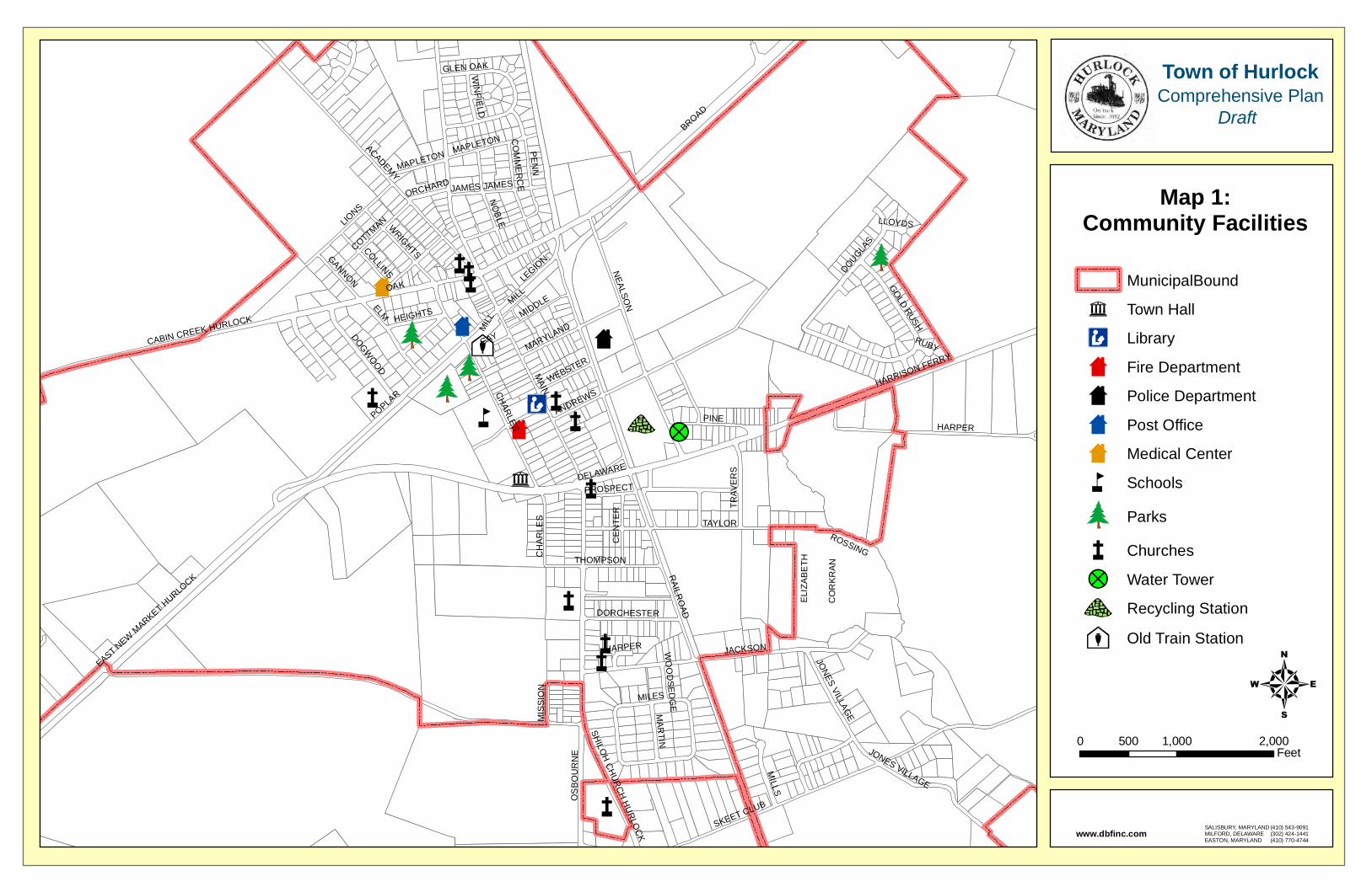
²̧
43 !?
æ
æ
ææ
ææ
æ
æ
ææ
æ
òñðòñð
òñð
òñð
å
×
× ×
×
×Æc
ñ
MAIN
BROAD
DELAWARE
RAILR
OAD
OAK
POPLAR
JACKSON
SKEET CLUB
ACADEMY
NEALSO
NELM
TAYLOR
PENN
MILL
CHARLES HARPER
WRIGHTS
LIONS
NO
BLE
PINE
HARRISON FERRY
LEGIO
N
CABIN CREEK HURLOCK
MILLS
MILES
EAST NEW M
ARKET HURLO
CKO
SB
OU
RN
E
GAYDOGWOOD
COTTMAN
THOMPSON
JONES VILLAGE
COLLINS
TRAV
ER
S
MIDDLE
CO
MM
ERC
E
CE
NTE
R
DOUGLAS
ROSSING
MAR
TIN
GOLD RUSH
GLEN OAK
GANNON
DORCHESTER
ELI
ZAB
ETH
HEIGHTS
CO
RK
RA
N
SHILOH
CHURCH HURLO
CK
WEBSTER
MIS
SIO
N
MARYLAND
MAPLETON
ANDREWS
WIN
FIELD
JAMES
PROSPECT
ORCHARD
RUBY
WO
OD
SEDG
E
LLOYDS
JONES VILLAGE
HARPER
MIL
L
CH
AR
LES
MAPLETON
JAMES
SALISBURY, MARYLANDMILFORD, DELAWAREEASTON, MARYLAND
(410) 543-9091(302) 424-1441(410) 770-4744
www.dbfinc.com
MunicipalBound
ñ Town Hall
Æc Library
× Fire Department
× Police Department
× Post Office
× Medical Center
å Schools
òñð Parks
æ Churches
!? Water Tower
43 Recycling Station
²̧ Old Train Station
Map 1:Community Facilities
40 1,000 2,000500
Feet
Town of HurlockComprehensive Plan
Draft
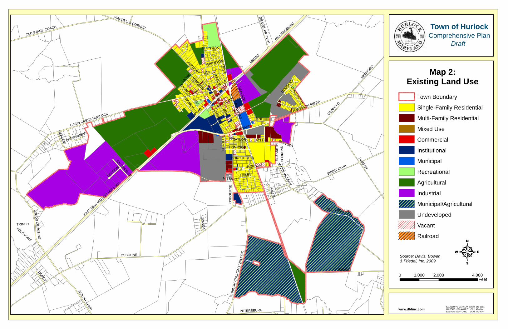
MAIN
OSBORNE
ENNALS
HARPER
SKEET CLUB
BROAD
DELAWARE
RAILR
OAD
OAK
CABIN CREEK HURLOCK
EAST NEW M
ARKET HURLOCK
POPLAR
JACKSON
HARRISON FERRY
ACADEMY
SHILOH CAMP
NEALSO
N
OLD STAGE COACH
SHIL
OH
CH
UR
CH
HU
RLO
CK
ELM
LOR
DS C
RO
SSIN
G
TAYLOR
MEDFORD
JONES VILLAGE
PENN
WADDELLS CORNER
MILL
CHARLES
WRIGHTS
LIONS N
OBLE
PETERSBURG
PINE
WILLIAMSBURG
LEG
ION
MILLS
OS
BO
UR
NE
MILES
GAY
DOGWOOD
GR
AVEL BRAN
CH
THOMPSON
MEAD
OW
COREY
DIVISION
WAN
DA
DOUGLAS
ROSSING
ENTERPRISE
GOLD RUSH
GLEN OAK
GANNON
DORCHESTER
TRINITY
ELI
ZAB
ETH
CO
RK
RA
N
ARROWHEAD
MISSION
MARYLAND
MAPLETON
SOLOMONS
JAMES
CH
AR
LES
JONES VILLAG
E
TAYLOR
MEDFORD
Town Boundary
Single-Family Residential
Multi-Family Residential
Mixed Use
Commercial
Institutional
Municipal
Recreational
Agricultural
Industrial
Municipal/Agricultural
Undeveloped
Vacant
Railroad
Map 2:Existing Land Use
40 2,000 4,0001,000
Feet
Town of HurlockComprehensive Plan
Draft
SALISBURY, MARYLANDMILFORD, DELAWAREEASTON, MARYLAND
(410) 543-9091(302) 424-1441(410) 770-4744
www.dbfinc.com
Source: Davis, Bowen& Friedel, Inc. 2009

156
83
101
31
26
25
21
20
7
16
14
5
4
3
3
4
9
3
2 2
2
3
2
3
2
1
2
1
2
1 2
20
2
1
2
2
2
1
2
1
2
1
1
1
2
2
2
2
2
1
22
22
2
1
2
1
2
11
1
1
1
111
1
11
111
MAIN
OSBORNE
ENNALS
HARPER
SKEET CLUB
BROAD
DELAWARE
RAILR
OAD
CABIN CREEK HURLOCK
EAST NEW M
ARKET HURLOCK
OAK
POPLAR
JACKSON
HARRISON FERRY
OLD STAGE COACH
ACADEMY
SHILOH CAMP
NEALSO
N
WADDELLS CORNER
SHIL
OH
CH
UR
CH
HU
RLO
CK
MEDFORD
ELM
LOR
DS C
RO
SSIN
G
TAYLOR
WILLIAMSBURG
JONES VILLAGE
PENN
MILL
CHARLES
LIONS
PINE
PETERSBURG
GR
AVEL BRAN
CH
PALM
ER M
ILL
MILLS
OS
BO
UR
NE
MILES
GAY
THOMPSON
MEAD
OW
COREY
DIVISION
WAN
DA
DOUGLAS
ROSSING
ENTERPRISE
GOLD RUSH
GLEN OAK
DORCHESTER
TRINITY
ARROWHEAD
MISSION
MAPLETON
SOLOMONS
MEDFORD
Map 3:Development Capacity
Analysis
40 5,1002,550
Feet
Town of HurlockComprehensive Plan
Draft
SALISBURY, MARYLANDMILFORD, DELAWAREEASTON, MARYLAND
(410) 543-9091(302) 424-1441(410) 770-4744
www.dbfinc.com
Source: Davis, Bowen& Friedel, Inc. 2009
Developable Land
Town Boundary
Non-Residential Districts
R-1
R-2
R-3
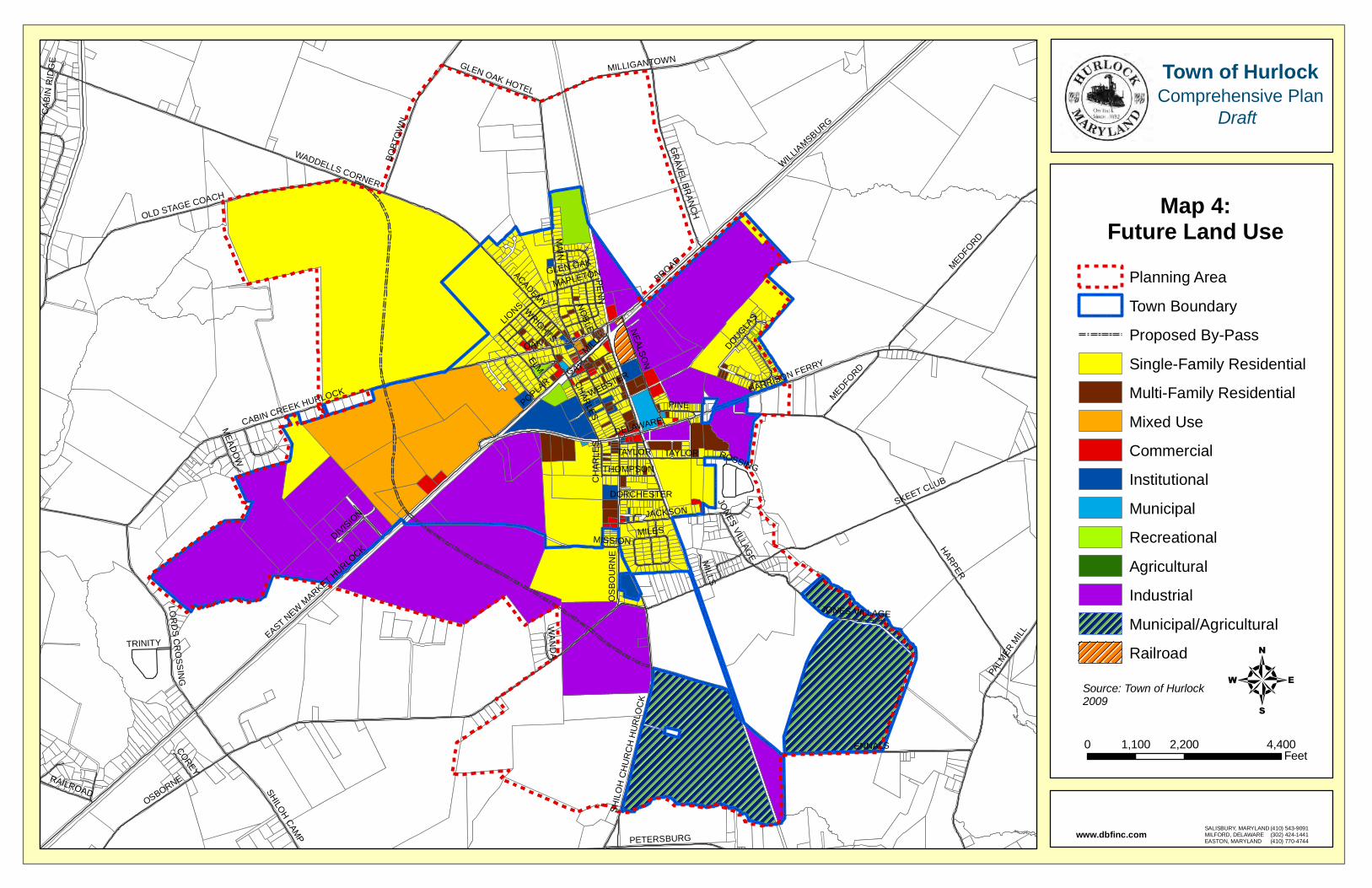
MAIN
OSBORNE
HARPER
ENNALS
SKEET CLUB
BROAD MEDFORD
DELAWARE
WADDELLS CORNER
CABIN CREEK HURLOCK
EAST NEW M
ARKET HURLOCK
WILLIAMSBURG
PALM
ER M
ILL
HARRISON FERRY
OAK
BOBT
OW
NPOPLA
R
OLD STAGE COACH
MILLIGANTOWN
JACKSON
ACADEMY
GR
AVEL BRAN
CH
SHILOH CAMP
NEALSO
N
SHIL
OH
CH
UR
CH
HU
RLO
CK
ELM
LOR
DS C
RO
SSIN
G
TAYLOR
GLEN OAK HOTEL
JONES VILLAGE
PENN
MILL
CHARLES
WRIGHTS
LIONS N
OBLE
PETERSBURG
PINE
RAILROAD
MILLS
OS
BO
UR
NE
MILES
CAB
IN R
IDG
E
GAY
THOMPSON
MEAD
OW
COREY
DIVISION
WAN
DA
DOUGLAS
ROSSING
GLEN OAK
DORCHESTER
TRINITY
WEBSTER
MISSION
MAPLETON
CH
AR
LES
JONES VILLAG
E
MEDFORD
TAYLOR
Planning Area
Town Boundary
Proposed By-Pass
Single-Family Residential
Multi-Family Residential
Mixed Use
Commercial
Institutional
Municipal
Recreational
Agricultural
Industrial
Municipal/Agricultural
Railroad
Map 4:Future Land Use
40 2,200 4,4001,100
Feet
Town of HurlockComprehensive Plan
Draft
SALISBURY, MARYLANDMILFORD, DELAWAREEASTON, MARYLAND
(410) 543-9091(302) 424-1441(410) 770-4744
www.dbfinc.com
Source: Town of Hurlock2009
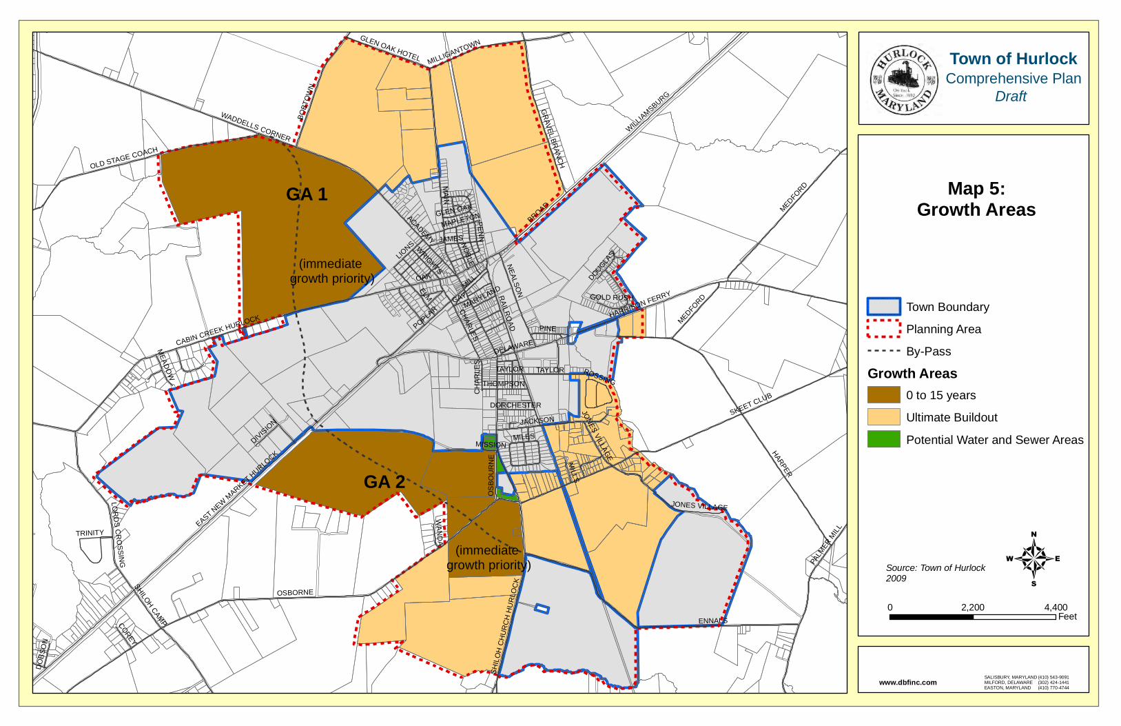
MAIN
OSBORNE
HARPER
ENNALS
SKEET CLUB
BROAD
DELAWARE
WADDELLS CORNER
MEDFORD
RAILR
OAD
CABIN CREEK HURLOCK
EAST NEW M
ARKET HURLO
CK
WILLIAMSBURG
HARRISON FERRY
OAK
POPLAR
PALM
ER M
ILL
OLD STAGE COACH
JACKSON
BOBT
OW
N
ACADEMY
NEALSO
N
GR
AVEL BRAN
CH
SHIL
OH
CH
UR
CH
HU
RLO
CK
MILLIGANTOWN
SHILOH CAMP
ELM
LOR
DS C
RO
SSING
TAYLOR
GLEN OAK HOTEL
JONES VILLAGE
PENN
MILL
CHARLES
WRIGHTS
LIONS N
OBLE
PINE
MILLS
OS
BO
UR
NE
MILES
GAY
THOMPSON
MEAD
OW
COREY
DIVISION
WAN
DA
DOUGLAS
ROSSING
GOLD RUSH
GLEN OAK
DO
BSO
N
DORCHESTER
TRINITY
MISSION
MARYLAND
MAPLETON
JAMES
TAYLOR
JONES VILLAGE
CH
AR
LES
MEDFORD
Town Boundary
Planning Area
By-Pass
Growth Areas0 to 15 years
Ultimate Buildout
Potential Water and Sewer Areas
Map 5:Growth Areas
40 4,4002,200
Feet
Town of HurlockComprehensive Plan
Draft
SALISBURY, MARYLANDMILFORD, DELAWAREEASTON, MARYLAND
(410) 543-9091(302) 424-1441(410) 770-4744
www.dbfinc.com
Source: Town of Hurlock2009
GA 1
GA 2
(immediate growth priority)
(immediate growth priority)

MAIN
OSBORNE
HARPER
ENNALS
SKEET CLUB
BROAD
DELAWARE
WADDELLS CORNER
CABIN CREEK HURLOCK
EAST NEW M
ARKET HURLO
CK
WILLIAMSBURG
MEDFORD
OAK
HARRISON FERRY
POPLAR
OLD STAGE COACH
JACKSON
BOBT
OW
N
PALM
ER M
ILL
ACADEMY
NEALSO
N
GR
AVEL BRAN
CH
SHIL
OH
CH
UR
CH
HU
RLO
CKSHILOH CAM
P
ELM
LOR
DS C
RO
SSING
TAYLOR
MILLIGANTOWNGLEN OAK HOTEL
JONES VILLAGE
PENN
MILL
CHARLES
WRIGHTS
LIONS N
OBLE
PINE
MILLS
OS
BO
UR
NE
MILES
GAY
THOMPSON
MEAD
OW
COREY
DIVISION
WAN
DA
DOUGLAS
RAILR
OAD
ROSSING
GOLD RUSH
GLEN OAK
DO
BSO
N
DORCHESTER
TRINITY
MISSION
MARYLAND
MAPLETON
JAMES
JONES VILLAGE
CH
AR
LES
MEDFORD
TAYLOR
Town Boundary
Planning Area
Local Streets
Collector
Major Arterials
Proposed Road
Map 6:Transportation
40 2,100 4,2001,050
Feet
Town of HurlockComprehensive Plan
Draft
SALISBURY, MARYLANDMILFORD, DELAWAREEASTON, MARYLAND
(410) 543-9091(302) 424-1441(410) 770-4744
www.dbfinc.com
Source: Federal Highway Functional Classification for Dorchester County, Maryland - Department of Transportation and State Highway Administration 2004May 18, 2009
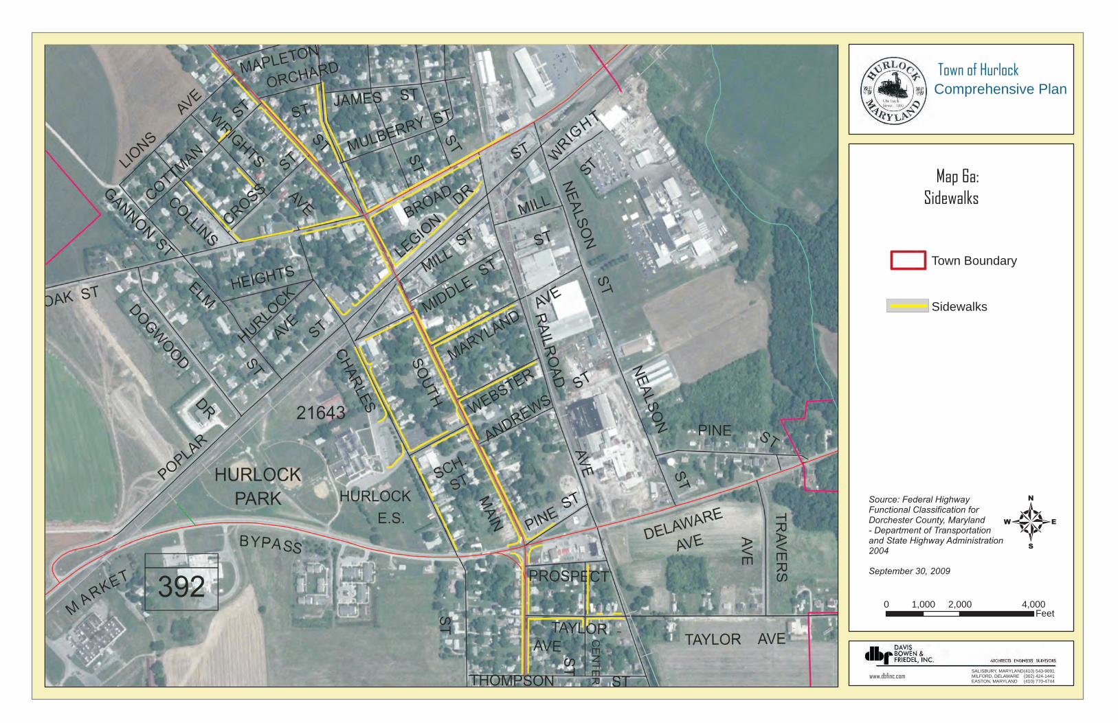
Town Boundary
Sidewalks
Map 6a:Sidewalks
40 2,000 4,0001,000
Feet
Town of HurlockComprehensive Plan
SALISBURY, MARYLANDMILFORD, DELAWAREEASTON, MARYLAND
(410) 543-9091(302) 424-1441(410) 770-4744
www.dbfinc.com
Source: Federal Highway Functional Classification for Dorchester County, Maryland - Department of Transportation and State Highway Administration 2004
September 30, 2009
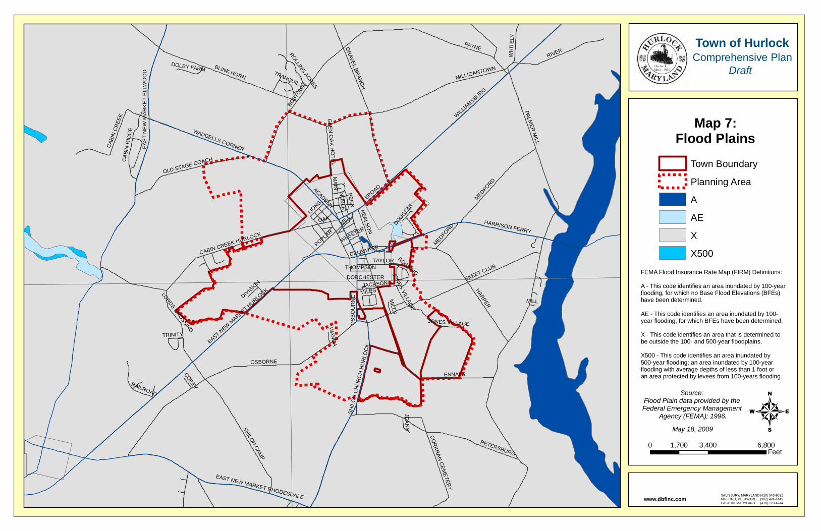
PALMER
MILL
OSBORNE
MAIN
PAYNE
HARPER
ENNALS
BOBT
OWN
WILLIAMSBURG
SKEET CLUB
RIVER
PETERSBURG
MILLIGANTOWNBLINK HORN
SHILOH CAMP
MEDFORD
HARRISON FERRY
GR
AVEL BRAN
CH
EAST NEW M
ARKET HURLO
CK
CABIN CREEK HURLOCK
BROAD
DELAWARE
WADDELLS CORNER
SHIL
OH
CH
UR
CH
HU
RLO
CK
EA
ST
NE
W M
AR
KE
T E
LLW
OO
D
OAK
POPLAR
OLD STAGE COACH
CAB
IN C
REE
K
EAST NEW MARKET RHODESDALE
JACKSON
WH
ITE
LYACADEMY
CAB
IN R
IDG
E
NEALSO
N
RAILROAD
LORDS CROSSING
TAYLOR
GLEN
OA
K HO
TEL
JONES VILLAGE
CO
RKR
AN C
EMETER
Y
PENN
MILLLIO
NS
NO
BLE
ROLLING ACRES
JEA
NS
TRANQUIL
DOLBY FARM
MILLS
OS
BO
UR
NE
MILES
THOMPSON
COREY
DIVISION
WAN
DA
DOUGLAS
ROSSINGDORCHESTER
TRINITY
WEBSTER
JONES VILLAGE
MEDFORD
MILL
Town Boundary
Planning Area
A
AE
X
X500
Map 7:Flood Plains
40 3,400 6,8001,700
Feet
Town of HurlockComprehensive Plan
Draft
SALISBURY, MARYLANDMILFORD, DELAWAREEASTON, MARYLAND
(410) 543-9091(302) 424-1441(410) 770-4744
www.dbfinc.com
FEMA Flood Insurance Rate Map (FIRM) Definitions:
A - This code identifies an area inundated by 100-year flooding, for which no Base Flood Elevations (BFEs) have been determined.
AE - This code identifies an area inundated by 100-year flooding, for which BFEs have been determined.
X - This code identifies an area that is determined tobe outside the 100- and 500-year floodplains.
X500 - This code identifies an area inundated by 500-year flooding; an area inundated by 100-year flooding with average depths of less than 1 foot or an area protected by levees from 100-years flooding.
Source: Flood Plain data provided by the Federal Emergency Management
Agency (FEMA); 1996.May 18, 2009
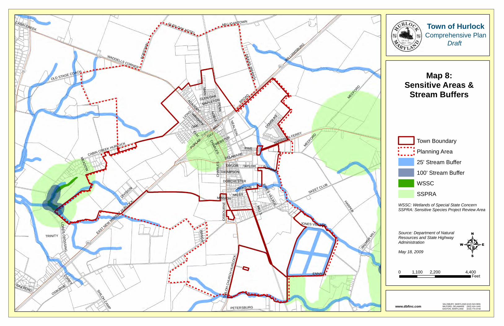
MAIN
OSBORNE
HARPER
ENNALS
SKEET CLUB
BROAD MEDFORD
DELAWARE
WADDELLS CORNER
CABIN CREEK HURLOCK
EAST NEW M
ARKET HURLO
CK
WILLIAMSBURG
PALM
ER M
ILL
HARRISON FERRY
OAK
BOBT
OW
NPOPLA
R
OLD STAGE COACH
MILLIGANTOWN
JACKSON
ACADEMY
GR
AVEL BRAN
CH
SHILOH CAMP
NEALSO
N
SHIL
OH
CH
UR
CH
HU
RLO
CK
ELM
LOR
DS C
RO
SSING
TAYLOR
GLEN OAK HOTEL
JONES VILLAGE
PENN
MILL
CHARLES
WRIGHTS
LIONS
PETERSBURG
NO
BLE
PINE
RAILROAD
MILLS
OS
BO
UR
NE
MILES
GAY
THOMPSON
MEAD
OW
COREY
DIVISION
WAN
DA
DOUGLAS
ROSSING
GLEN OAK
DORCHESTER
TRINITY
WEBSTER
MISSION
MAPLETON
CABIN CREEK
JONES VILLAGE
CH
AR
LES
MEDFORD
TAYLOR
UV392
UV331
UV307
UV16
Poplar
Town Boundary
Planning Area
25' Stream Buffer
100' Stream Buffer
WSSC
SSPRA
Map 8:Sensitive Areas &
Stream Buffers
40 2,200 4,4001,100
Feet
Town of HurlockComprehensive Plan
Draft
SALISBURY, MARYLANDMILFORD, DELAWAREEASTON, MARYLAND
(410) 543-9091(302) 424-1441(410) 770-4744
www.dbfinc.com
Source: Department of NaturalResources and State HighwayAdministrationMay 18, 2009
WSSC: Wetlands of Special State ConcernSSPRA: Sensitive Species Project Review Area
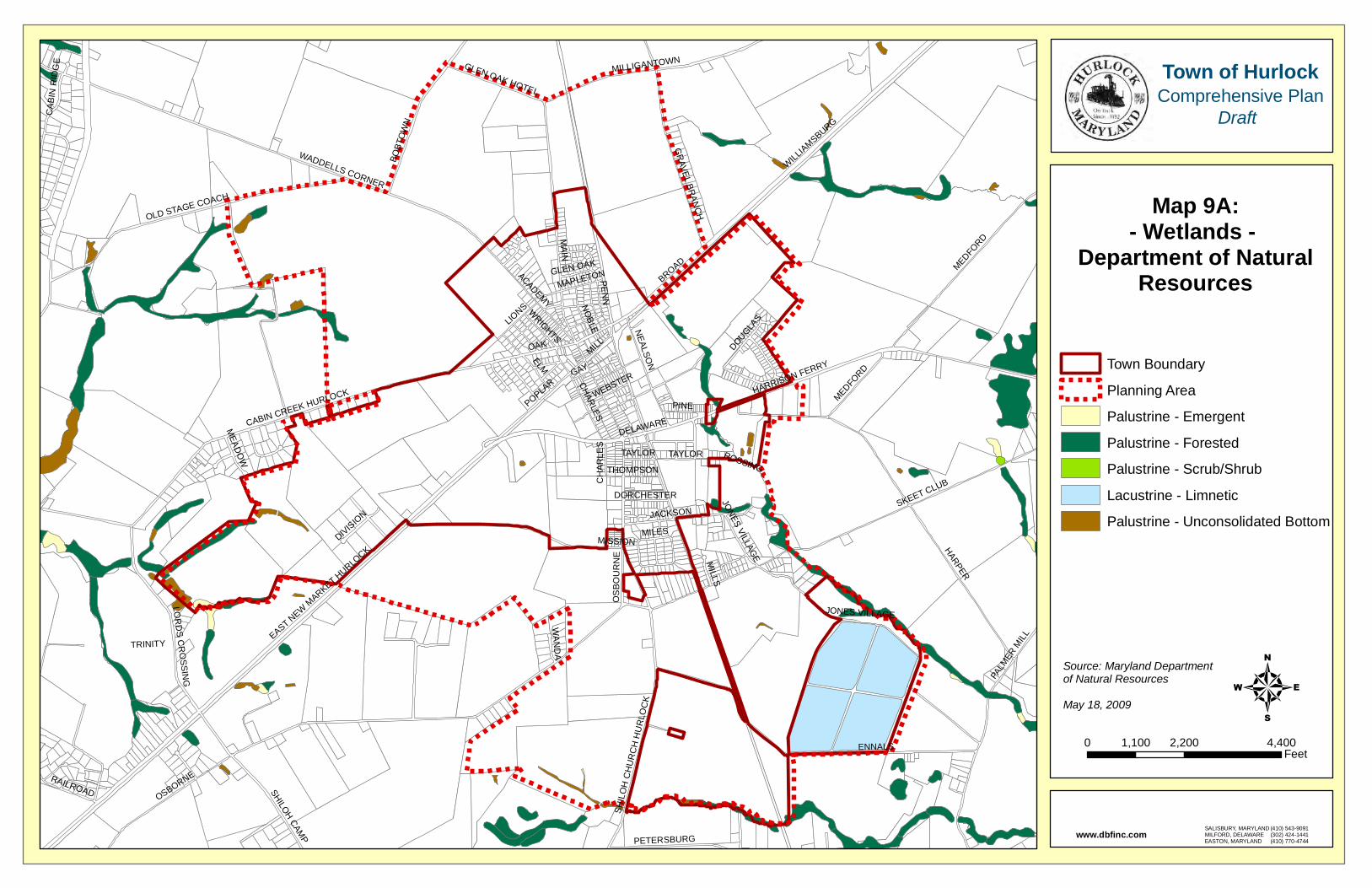
MAIN
OSBORNE
HARPER
ENNALS
SKEET CLUB
BROAD
DELAWARE
WADDELLS CORNER
MEDFORD
CABIN CREEK HURLOCK
EAST NEW M
ARKET HURLO
CK
WILLIAMSBURG
HARRISON FERRY
PALM
ER M
ILL
OAK
BOBT
OW
NPOPLA
R
OLD STAGE COACH
MILLIGANTOWN
JACKSON
ACADEMY
GR
AVEL BRAN
CH
SHILOH CAMP
NEALSO
N
SHIL
OH
CH
UR
CH
HU
RLO
CK
ELM
LOR
DS C
RO
SSING
TAYLOR
GLEN OAK HOTEL
JONES VILLAGE
PENN
MILL
CHARLES
WRIGHTS
LIONS N
OBLE
PINE
PETERSBURG
CAB
IN R
IDG
E
RAILROAD
MILLS
OS
BO
UR
NE
MILES
GAY
THOMPSON
MEAD
OW
DIVISION
WAN
DA
DOUGLAS
ROSSING
GLEN OAK
DORCHESTER
TRINITY
WEBSTER
MISSION
MAPLETON
CH
AR
LES
MEDFORD
TAYLOR
JONES VILLAGE
Town Boundary
Planning Area
Palustrine - Emergent
Palustrine - Forested
Palustrine - Scrub/Shrub
Lacustrine - Limnetic
Palustrine - Unconsolidated Bottom
Map 9A:- Wetlands -
Department of NaturalResources
40 2,200 4,4001,100
Feet
Town of HurlockComprehensive Plan
Draft
SALISBURY, MARYLANDMILFORD, DELAWAREEASTON, MARYLAND
(410) 543-9091(302) 424-1441(410) 770-4744
www.dbfinc.com
Source: Maryland Departmentof Natural ResourcesMay 18, 2009
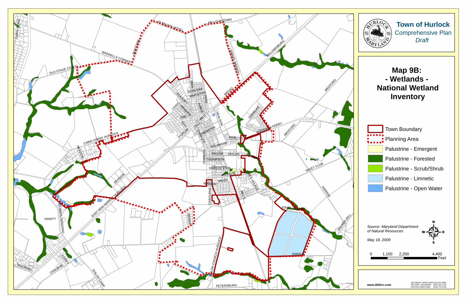
MAIN
OSBORNE
HARPER
ENNALS
SKEET CLUB
BROAD
DELAWARE
WADDELLS CORNER
MEDFORD
CABIN CREEK HURLOCK
EAST NEW M
ARKET HURLO
CK
WILLIAMSBURG
HARRISON FERRY
PALM
ER M
ILL
OAK
POPLAR
BOBT
OW
N
OLD STAGE COACH
JACKSON
MILLIGANTOWN
ACADEMY
SHILOH CAMP
GR
AVEL BRAN
CH
NEALSO
N
SHIL
OH
CH
UR
CH
HU
RLO
CK
ELM
LOR
DS C
RO
SSING
TAYLOR
GLEN OAK HOTEL
JONES VILLAGE
PENN
MILL
CHARLES
PETERSBURGW
RIGHTS
LIONS N
OBLE
PINE
CAB
IN R
IDG
E
RAILROAD
MILLS
OS
BO
UR
NE
MILES
GAY
THOMPSON
MEAD
OW
COREY
DIVISION
WAN
DA
DOUGLAS
ROSSING
GLEN OAK
DORCHESTER
TRINITY
WEBSTER
MISSION
MAPLETON
CH
AR
LES
JONES VILLAGE
MEDFORD
TAYLOR
Town Boundary
Planning Area
Palustrine - Emergent
Palustrine - Forested
Palustrine - Scrub/Shrub
Palustrine - Limnetic
Palustrine - Open Water
Map 9B: - Wetlands -
National WetlandInventory
40 2,200 4,4001,100
Feet
Town of HurlockComprehensive Plan
Draft
SALISBURY, MARYLANDMILFORD, DELAWAREEASTON, MARYLAND
(410) 543-9091(302) 424-1441(410) 770-4744
www.dbfinc.com
Source: Maryland Departmentof Natural ResourcesMay 18, 2009
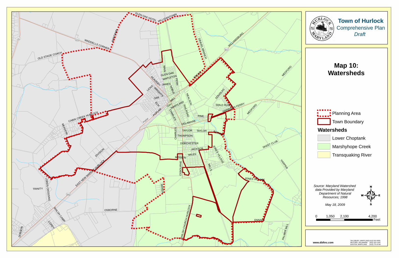
MAIN
OSBORNE
HARPER
ENNALS
SKEET CLUB
BROAD
DELAWARE
WADDELLS CORNER
CABIN CREEK HURLOCK
EAST NEW M
ARKET HURLO
CK
MEDFORD
WILLIAMSBURG
OAK
HARRISON FERRY
POPLAR
OLD STAGE COACH
JACKSON
BOBT
OW
N
PALM
ER M
ILL
ACADEMY
NEALSO
N
GR
AVEL BRAN
CH
SHIL
OH
CH
UR
CH
HU
RLO
CKSHILOH CAM
P
ELM
LOR
DS C
RO
SSING
TAYLOR
MILLIGANTOWNGLEN OAK HOTEL
JONES VILLAGE
PENN
MILL
CHARLES
WRIGHTS
LIONS N
OBLE
PINE
MILLS
OS
BO
UR
NE
MILES
GAY
THOMPSON
MEAD
OW
COREY
DIVISION
WAN
DA
DOUGLAS
RAILR
OAD
ROSSING
GOLD RUSH
GLEN OAK
DO
BSO
N
DORCHESTER
TRINITY
MISSION
MARYLAND
MAPLETON
JAMES
JONES VILLAGE
CH
AR
LES
MEDFORD
TAYLOR
UV392
UV331
UV307
UV16
Poplar
Planning Area
Town Boundary
WatershedsLower Choptank
Marshyhope Creek
Transquaking River
Map 10:Watersheds
40 2,100 4,2001,050
Feet
Town of HurlockComprehensive Plan
Draft
SALISBURY, MARYLANDMILFORD, DELAWAREEASTON, MARYLAND
(410) 543-9091(302) 424-1441(410) 770-4744
www.dbfinc.com
Source: Maryland Watershed data Provided by Maryland
Department of NaturalResources; 1998
May 18, 2009
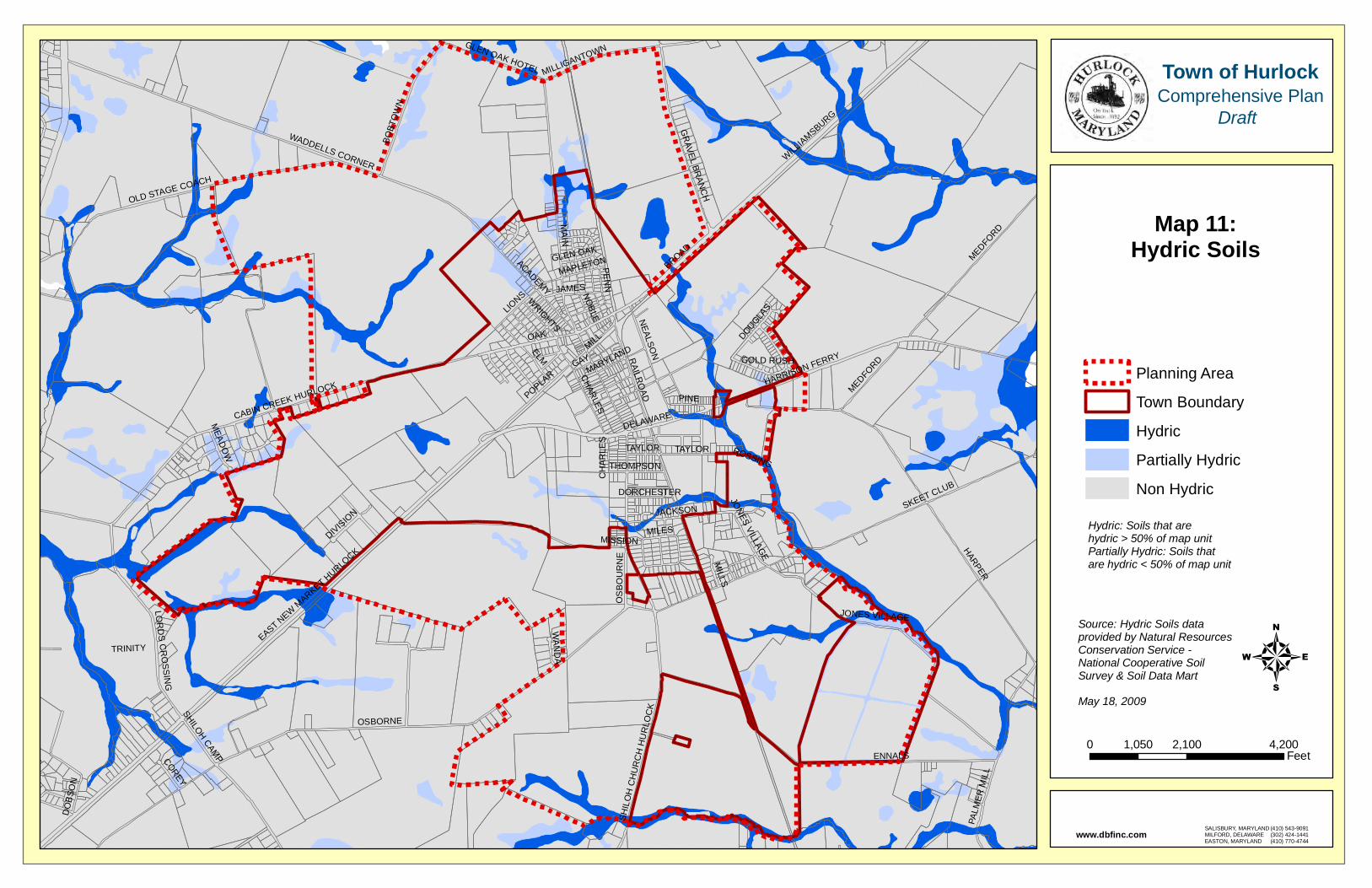
MAIN
OSBORNE
HARPER
ENNALS
SKEET CLUB
BROAD
DELAWARE
WADDELLS CORNER
CABIN CREEK HURLOCK
EAST NEW M
ARKET HURLO
CK
MEDFORD
WILLIAMSBURG
OAK
HARRISON FERRY
POPLAR
OLD STAGE COACH
JACKSON
PALM
ER M
ILL
BOBT
OW
N
ACADEMY
NEALSO
N
SHILOH CAMP
SHIL
OH
CH
UR
CH
HU
RLO
CK
GR
AVEL BRAN
CH
ELM
LOR
DS C
RO
SSING
TAYLOR
MILLIGANTOWNGLEN OAK HOTEL
JONES VILLAGE
PENN
MILL
CHARLES
WRIGHTS
LIONS N
OBLE
PINE
MILLS
OS
BO
UR
NE
MILES
GAY
THOMPSON
MEAD
OW
COREY
DIVISION
WAN
DA
DOUGLAS
ROSSING
RAILR
OAD
GOLD RUSH
GLEN OAK
DO
BSO
N
DORCHESTER
TRINITY
MISSION
MARYLAND
MAPLETON
JAMES
JONES VILLAGE
CH
AR
LES
MEDFORD
TAYLOR
Planning Area
Town Boundary
Hydric
Partially Hydric
Non Hydric
Map 11:Hydric Soils
40 2,100 4,2001,050
Feet
Town of HurlockComprehensive Plan
Draft
SALISBURY, MARYLANDMILFORD, DELAWAREEASTON, MARYLAND
(410) 543-9091(302) 424-1441(410) 770-4744
www.dbfinc.com
Source: Hydric Soils data provided by Natural Resources Conservation Service - National Cooperative Soil Survey & Soil Data MartMay 18, 2009
Hydric: Soils that are hydric > 50% of map unitPartially Hydric: Soils that are hydric < 50% of map unit