Embed Size (px)
Citation preview

IV. Environmental Setting, Impacts and Mitigation Measures
Marina Center Mixed Use Development Project IV.I-1 ESA / 205513 Draft Environmental Impact Report November 2008
I. Land Use and Planning
Environmental Setting
Project Site Land Uses As described in Chapter III, Project Description, the project site is 43 acres of primarily vacant brownfield in the incorporated City of Eureka. The project site is located in the coastal zone and is within an area identified in the Eureka General Plan as the Westside Industrial Area. The project site is comprised of eleven assessor parcels. The project would require an amendment to the adopted Local Coastal Program. Under the adopted Land Use Plan, the general plan portion of the Local Coastal Program, the project site has three different general plan Land Use designations: Light Industrial (LI), Highway Service Commercial (HSC), and Public/Quasi-Public (PQP). The Local Coastal Program is discussed in more detail in the Regulatory Framework section below.
The portion of the site designated LI is located along the west line of Broadway to a depth of about 165 feet from approximately Fourth Street north to Waterfront Drive and then eastward to A Street between Waterfront Drive and Second Street. The portion of the site designated HSC is located west of Broadway to a depth of about 165 feet roughly between Sixth and Seventh Streets. The remainder of the property is designated PQP.
Table IV.I-1, below, includes a list of the assessor parcel numbers with the existing and proposed general plan and zoning designations.
Surrounding Land Uses Surrounding uses of land counter-clockwise around the project site include:
• To the north and northwest along Waterfront Drive are privately owned industrial uses, such as warehouses and commercial fish processing operations in one- to two-story structures with outdoor storage of fishing equipment. There is also a small restaurant northeast of the corner of Commercial Street and Waterfront Drive.
• The waterfront property to the northwest of the project site is the City’s Small Boat Basin which is comprised of marine-oriented recreation and municipal uses, including the City owned three-story marina building, known as the Wharfinger Building, and its adjacent public marina comprised of 140 boat slips, boat launching ramps, and surface parking.
• Directly to the west of the project site are a number of vacant parcels owned by the City of Eureka Redevelopment Agency.
• Southwest of the project site west of Waterfront Drive and south of the City/Redevelopment-owned parcels is the privately owned Humboldt Bay Industrial Park. The Schneider Dock is part of this property.
• The Schmidbauer Lumber Co. lumber mill is south of the project site on the south side of Washington Drive west of Koster Street. The mill site includes a large mill building that is wood-sided and approximately three stories tall. Numerous smaller buildings, log decks and milled wood storage areas also occupy the site.

IV. Environmental Setting, Impacts and Mitigation Measures I. Land Use and Planning
Marina Center Mixed Use Development Project IV.I-2 ESA / 205513 Draft Environmental Impact Report November 2008
TABLE IV.I-1 EXISTING AND PROPOSED ZONING AND
LAND USE DESIGNATIONS BY ASSESSOR PARCEL NUMBER
APN Property Owner
Existing Zoning (Implementation Plan)
Existing General Plan (Land Use Plan)
Proposed Zoning (Implementation Plan)
Proposed General Plan (Land Use Plan)
001-014-002 CUE VI LLC Limited Industrial (ML) Light Industrial (LI) no change no change
003-021-009 CUE VI LLC
Limited Industrial (ML), Public (P)
Light Industrial (LI), Public/Quasi-Public (PQP)
Limited Industrial (ML) Commercial Waterfront (CW) Office Residential (OR) Service Commercial (CS)
Light Industrial (LI) Waterfront Commercial (WC) Professional Office (PO) General Service Commercial (GSC)
003-031-003 CUE VI LLC Limited Industrial (ML) Light Industrial (LI) Office Residential (OR) Professional Office
(PO)
003-031-007 Andrew Rosaia INC Limited Industrial (ML) Light Industrial (LI) Office Residential (OR) Professional Office
(PO)
003-031-008 CUE VI LLC
Limited Industrial (ML), Public (P)
Light Industrial (LI), Public/Quasi-Public (PQP)
Conservation Water District (WC) Service Commercial (CS) Office Residential (OR)
Water - Conservation (WC) General Service Commercial (GSC) Professional Office (PO)
003-031-012 CUE VI LLC Limited Industrial (ML) Light Industrial (LI) Office Residential (OR) Professional Office
(PO)
003-031-013 CUE VI LLC Limited Industrial (ML) Light Industrial (LI) Office Residential (OR) Professional Office
(PO)
003-041-005 CUE VI LLC
Service Commercial (CS)
Highway Service Commercial (HSC) no change no change
003-041-006 CUE VI LLC
Service Commercial (CS)
Highway Service Commercial (HSC) no change no change
003-041-007 CUE VI LLC Public (P) Public/Quasi-Public
(PQP)
Conservation Water District (WC) Service Commercial (CS)
Water - Conservation (WC) General Service Commercial (GCS)
003-051-001 CUE VI LLC Public (P) Public/Quasi-Public
(PQP) Conservation Water District (WC)
Water - Conservation (WC)
• Immediately to the south between the project site and Washington Street east of Koster Street are one-story and one-and-one-half-story corrugated metal clad light industrial warehouse buildings with related storage and equipment yards.
• South of the light industrial warehouse buildings on the south side of Washington Street and east of Koster Street is a large State of California office complex, and farther south is a mixture of light industrial uses.
• To the southeast and east of the project site along Broadway are a variety of commercial uses that include motels, used car sales lots, automotive repair, retail sales, and restaurants.

IV. Environmental Setting, Impacts and Mitigation Measures I. Land Use and Planning
Marina Center Mixed Use Development Project IV.I-3 ESA / 205513 Draft Environmental Impact Report November 2008
• East of Broadway and south of Seventh Street is the Clark District, one of the City’s oldest residential neighborhoods, which is known for late 19th century and early 20th century homes, interspersed with newer apartment buildings.
• To the east of the project site along Seventh, Sixth, and Fifth Streets is also a mixture of commercial uses similar in scale and intensity to those along Broadway.
• Along Fourth, Third, and Second Streets to the east are a combination of light industrial and commercial uses that include, among other uses, distribution warehouses, a local micro-brewery, recycling center, over-head door installer, contractors yard, and furniture store.
The coastal zone boundary follows the center line of Broadway north to Third Street then east along the centerline of Third Street; consequently all property west of Broadway and north of Third Street is located in the coastal zone. References to the general plan for properties in the coastal zone are to the Land Use Plan portion of the Local Coastal Program.
The adopted general plan land use designations and zoning for properties surrounding the project site include, counter-clockwise (see also Figures IV.I-1 and IV.I-2):
• North of Waterfront Drive and east of Commercial Street the general plan designation is Core-Coastal Dependent Industrial (C-CDI) with a corresponding zoning of Coastal Dependent Industrial (MC);
• The existing restaurant northeast of the intersection of Commercial Street with Waterfront Drive has a general plan designation of Core-Waterfront Commercial (C-WFC) with a corresponding zoning of Waterfront Commercial (CW);
• North and west of Waterfront Drive between Waterfront Drive and the bay and from Commercial Street to Del Norte Street, excluding the Small Boat Basin, the area has a general plan designation of Coastal Dependent Industrial (CDI) with a corresponding zoning of Coastal Dependent Industrial (MC);
• The City’s Small Boat Basin has a general plan designation of Waterfront Commercial (WFC) with a corresponding zoning of Waterfront Commercial (CW);
• South of Washington Street between Waterfront Drive and Koster Street the general plan designation is General Industrial (MG) with a corresponding zoning of General Industrial (MG);
• East of Koster Street from about 180 feet north of Washington Street south to Fourteenth Street, excluding property fronting on Broadway the general plan designation is Light Industrial (LI) with a corresponding zoning of Limited Industrial (ML);
• The Broadway corridor south of Washington Street has a general plan designation of General Service Commercial (GSC) with a corresponding zoning of Service Commercial (CS);
• The Seventh and Sixth Street corridor east of Broadway has a general plan designation of Automotive Service Commercial (ASC) with a corresponding zoning of Service Commercial (CS); and

HSC
HSC
ASC
HDRGSC
CDIWFC
GI
LI
LI
EXISTING LAND USE MAP
LEGENDASC AUTOMOTIVE SERVICES COMMERCIALCDI COASTAL DEPENDANT INDUSTRIALC-CDI CORE COASTAL - DEVELOPMENT INDUSTRIALGSC GENERAL SERVICES COMMERCIALHSC HIGHWAY SERVICE COMMERCIALHDR HIGH DENSITY RESIDENTIALGI GENERAL INDUSTRIALPO PROFESSIONAL OFFICELI LIGHT INDUSTRIALWFC WATER FRONT COMMERCIALPQP PUBLIC/QUASI PUBLIC
LAND USE DESIGNATIONBOUNDARY LINE
WFC
CDI
LI
LI
HSC
PQP
HSC
HSC
HSC
ASC
HDRGSC
CDIWFC
GI
HSC
WFC
PROPOSED LAND USE MAP
LEGENDASC AUTOMOTIVE SERVICES COMMERCIALCDI COASTAL DEPENDANT INDUSTRIALC-CDI CORE COASTAL - DEVELOPMENT INDUSTRIALGSC GENERAL SERVICES COMMERCIALHSC HIGHWAY SERVICE COMMERCIALHDR HIGH DENSITY RESIDENTIALGI GENERAL INDUSTRIALPO PROFESSIONAL OFFICELI LIGHT INDUSTRIALWC WATER CONSERVATIONWFC WATER FRONT COMMERCIAL
LAND USE DESIGNATIONBOUNDARY LINE
LI
PO
GSC
WC
WFC
CDI
LI
LI
HSC
SITE DATA
RETAIL/ SERVICEBUILDING AREA = 285,500 SFPARKING REQ = 942 SPACES (3.3/1000)
NURSERIES/ GARDEN/ FURNITUREBUILDING AREA = 28,000 SFPARKING REQ = 56 SPACES (2/1000)
OFFICEBUILDING AREA = 104,000 SFPARKING REQ = 343 SPACES (3.3/1000)
RESTAURANT BUILDING AREA = 14,000 SFPARKING REQ = 70 SPACES (5/1000)
MULTI FAMILY TOTAL UNITS = 72,000 SF (40 UNITS)
TOTAL ALT. UNITS = 72,000 SF (54 UNITS)PARKING REQ = 54 SPACES (1/UNIT)
MUSEUMBUILDING AREA = 12,500 SFPARKING REQ = 22 SPACES (1.7/1000)
INDUSTRIALBUILDING AREA = 70,000 SFPARKING REQ = 98 SPACES (1.4/1000)
TOTAL DEVELOPMENT = 558,000 SFEXCLUDING GARDEN CENTER
TOTAL MINIMUM REQUIRED PARKING BY THE CITYW/ ALT. 54 UNITS RESIDENTIAL = 1,585 SPACES
TOTAL PROVIDED PARKINGON SITE = 1,585 SPACES
RIGHT OF WAY = 1.35 AC (4TH STREET EXTENSION AND ACCESS FROM 6TH STREET)
TOTAL DEVELOPED SITE AREA = 29.01 AC EXCLUDING 50’/ 100’ BUFFER AREA AND WETLAND WITH BUFFER
SOUTHWEST CORNER OF THE SITE. (13.59 AC)
UNDEVELOPED WETLANDAND BUFFER AROUND = 10.77 AC
50’ AND 100 ‘ BUFFER = 2.55 AC
CONSERVATION WATER
Marina Center Mixed-Use Project EIR . 205513
Figure IV.I-1 Existing and Proposed
Land Use Designation Maps
Existing Land Use Designations
Proposed Land Use Designations
SOURCE: Baysinger Partners Architecture PC, 2008
N NO SCALE
IV.I-4

HSC
HSC
MCCW
MG
CW
MC
ML
ML
CSP
EXISTING ZONING DISTRICT MAP
LEGENDCS SERVICE COMMERCIALCW WATERFRONT COMMERCIALMC COASTAL DEPENDENT INDUSTRIAL MG GENERAL INDUSTRIALML LIMITED INDUSTRIALNR NATURAL RESOURCESOR OFFICE & MULTI- FAMILY RESIDENTIALP PUBLIC
ZONING DISTRICT BOUNDARY LINE
PROJECT AREABOUNDARY LINE
ML
ML
CS
Figure IV.I-2Existing and Proposed
Zoning District Maps
Existing Zoning Designations
Proposed Zoning Designations
CONSERVATION WATER
Marina Center Mixed-Use Project EIR . 205513 SOURCE: Baysinger Partners Architecture PC, 2008
N NO SCALE
IV.I-5
IV. Environmental Setting, Impacts and Mitigation Measures I. Land Use and Planning
Marina Center Mixed Use Development Project IV.I-6 ESA / 205513 Draft Environmental Impact Report November 2008
• The Broadway corridor north of Washington Street to Fourth Street, and the Fifth and Fourth Street corridor have a general plan designation of Highway Service Commercial (HSC) with a corresponding zoning of Service Commercial (CS);
• From north of Fourth Street to Waterfront Drive from about 165 feet west of Broadway east to about C Street the area has a general plan designation of Light Industrial (LI) with a corresponding zoning of Limited Industrial (ML).
Proposed Land Use Changes The proposed Marina Center project would develop light industrial uses between the northerly extension of the west line of Broadway to A Street and between Second Street and Waterfront Drive. This area already supports such uses and no change to the land use designation or zoning is proposed in this area. The existing general plan designation of Light Industrial (LI) with a corresponding zoning of Limited Industrial (ML) would remain.
The proposed Marina Center project would develop a one-story retail store, a two-story museum, and two two-story buildings containing retail space on the ground floor with residential units on the second floor west of the northerly extension of the west line of Broadway to the proposed Fourth Street extension and between Waterfront Drive and the proposed Second Street extension. This area would have a general plan designation of Waterfront Commercial (WFC) with a corresponding zoning of Waterfront Commercial (CW).
The proposed Marina Center project would develop a series of connected buildings ranging from one story to five stories, all having retail space on the ground floor with offices above, a four-story structure containing retail space on the ground floor and multi-family residential (which may include condominiums) on upper floors, and a four-level parking structure west of Broadway, south and east of the proposed Second Street extension and north of the proposed Fourth Street extension. The proposed general plan designation would be Professional Office (PO) with a corresponding zoning of Office and Multi-Family Residential (OR). The project would require an amendment to Appendix B of the General Plan Policy Document to add the Professional Office land use designation to the matrix of plan designations within the coastal zone.
The proposed Marina Center project would develop four large anchor retail spaces and three smaller retail or restaurant spaces south of the proposed Fourth Street extension to the south property line and between the eastern edge of the proposed wetland restoration area and the west line of Broadway. The proposed general plan designation would be General Service Commercial (GSC) with a corresponding zoning of Service Commercial (CS). A portion of this area located west of Broadway to a depth of about 165 feet roughly between Sixth and Seventh Streets currently has a general plan designation of Highway Service Commercial (HSC) and a corresponding zoning of Service Commercial; the project would not change the general plan designation.
The proposed wetland restoration area would have a general plan designation of Water - Conservation (WC) with a corresponding zoning of Conservation Water (WC).

IV. Environmental Setting, Impacts and Mitigation Measures I. Land Use and Planning
Marina Center Mixed Use Development Project IV.I-7 ESA / 205513 Draft Environmental Impact Report November 2008
Environmental Analysis
Significance Criteria For the purposes of this EIR, implementation of the proposed project would have a significant effect on land use and planning if, based on Appendix G of the CEQA Guidelines, it would:
1. Physically divide an established community;
2. Conflict with any applicable land use plan, policy, or regulation of an agency with jurisdiction over the project (including, but not limited to the general plan, specific plan, local coastal program, or zoning ordinance) adopted for the purpose of avoiding or mitigating an environmental effect; or
3. Conflict with any applicable habitat conservation plan or natural community conservation plan.
Regulatory Framework The following standards and regulations govern land use and planning and are used to measure impacts.
California Coastal Act The entirety of the project site is located within the California Coastal Zone as defined in the California Coastal Act (Public Resources Code Section 30000 et seq.). Section 30001.5 of the Coastal Act sets forth the basic goals of the Act:
• Protect, maintain, and, where feasible, enhance and restore the overall quality of the coastal zone environment and its natural and artificial resources.
• Assure orderly, balanced utilization and conservation of coastal zone resources taking into account the social and economic needs of the people of the state.
• Maximize public access to and along the coast and maximize public recreational opportunities in the coastal zone consistent with sound resources conservation principles and constitutionally protected rights of private property owners.
• Assure priority for coastal-dependent and coastal-related development over other development on the coast.
• Encourage state and local initiatives and cooperation in preparing procedures to implement coordinated planning and development for mutually beneficial uses, including educational uses, in the coastal zone.
City of Eureka Adopted General Plan California Government Code Section 65300 requires that every city adopt a comprehensive, long-term general plan. The general plan must cover a local jurisdiction’s entire planning area and address the broad range of issues associated with the city’s development.

IV. Environmental Setting, Impacts and Mitigation Measures I. Land Use and Planning
Marina Center Mixed Use Development Project IV.I-8 ESA / 205513 Draft Environmental Impact Report November 2008
The City of Eureka’s adopted General Plan formalizes a long-term vision for the physical evolution of Eureka and outlines the policies, standards, and programs that guide day-to-day decisions concerning Eureka’s development. The Policy Document of the General Plan contains statements of goals, policies, standards, implementation programs, and quantified objectives that constitute the formal policy of the City of Eureka for land use, development, and environmental quality. The Policy Document is divided into nine sections: Land Use and Community Design; Housing; Transportation and Circulation; Public Facilities and Services; Recreational and Cultural Resources; Natural Resources; Health and Safety; Administration & Implementation, and Historic Preservation.
In addition to policies and programs related directly to specific types of development or particular areas of the city, the adopted General Plan includes the City’s policy commitment to promoting an overall land use and development pattern that follows fundamental principles of good planning. In particular, the adopted General Plan commits the City to the following:
• Promotion of neighborhood infill development over sprawl.
• Emphasis on efficient use of public facilities and resources rather than wasteful practices.
• Cooperation with other agencies involved in development regulation in the region, rather than competition.
• Balancing of economic development needs and environmental protection needs.
The adopted General Plan includes the Westside Industrial Area Study. Eureka’s Westside Industrial Area is west of Downtown Eureka, along the city’s western waterfront and adjacent to the Eureka deep water ship channel; it contains most of Eureka’s industrial land and development. The Westside Industrial Area is bounded on the west by the outer reach of Humboldt Bay, on the north by the inner reach of Humboldt Bay, on the east by C Street and Broadway, and on the south by Del Norte Street. The area contains approximately 280 acres of land.
City of Eureka Adopted Local Coastal Program The Local Coastal Program is the foundational policy document for areas of the city located in the coastal zone. It establishes farsighted policy that forms the basis for and defines the framework by which the city’s physical and economic resources in the coastal zone are to be developed, managed, and used. The Local Coastal Program is divided into two components. The first component is the Land Use Plan, which is basically the General Plan for the coastal zone. It outlines the existing conditions, permitted uses, and policies needed to achieve the goals of the Coastal Act and includes the general plan map. The second component of the Local Coastal Program is the Implementation Plan, which includes zoning regulations and the zoning map for land in the coastal zone, and specific coastal zone ordinances necessary to implement the policies of the Land Use Plan.

IV. Environmental Setting, Impacts and Mitigation Measures I. Land Use and Planning
Marina Center Mixed Use Development Project IV.I-9 ESA / 205513 Draft Environmental Impact Report November 2008
In May 1984, the City of Eureka adopted its first Local Coastal Program in accordance with the California Coastal Act; the associated Implementation Plan was passed by the City Council on December 6, 1984. In the 1990s, the City of Eureka updated its Land Use Plan through a citywide General Plan update. The City determined that the most effective way to address the separate legal requirements of State General Plan law and the California Coastal Act was to combine the goals, policies, and programs addressing these requirements (i.e., non-coastal and coastal) into a single, unified document. In doing so, the City reviewed the land use maps and land use policies of the 1984 Local Coastal Program and determined which policies and programs should be incorporated into the updated citywide General Plan. The current City of Eureka Land Use Plan, as an integral component of the citywide General Plan for Eureka, was certified by the Coastal Commission on September 9, 1998, and adopted by the City Council on February 23, 1999.
In preparing the General Plan update, the City established citywide land use designations that essentially correspond with all of the Land Use Plan designations. The Coastal Act requires Local Coastal Program Land Use Plan designations to include more specificity than that required by State General Plan law, therefore, Table B-1 in Appendix B of the General Plan Policy Document shows the more detailed purpose description and use prescriptions for the Land Use Plan designations.
The standard of review for Land Use Plan amendments is found in Section 30512 of the Coastal Act. This section requires the Coastal Commission to certify a Land Use Plan amendment if it finds that the amendment meets the requirements of, and is in conformity with, the policies of Chapter 3 of the Coastal Act. Specifically, Section 30512(c) states:
(c) The Coastal Commission shall certify a land use plan, or any amendments thereto, if it finds that a land use plan meets the requirements of, and is in conformity with, the policies of Chapter 3 (commencing with Section 30200). Except as provided in paragraph (1) of subdivision (a), a decision to certify shall require a majority vote of the appointed membership of the Commission.
Paragraph (1) of subdivision (a) states:
No later than 60 days after a land use plan has been submitted to it, the commission shall, after public hearing and by majority vote of those members present, determine whether the land use plan, or a portion thereof applicable to an identifiable geographic area, raises no substantial issue as to conformity with the policies of Chapter 3 (commencing with Section 30200).
The Coastal Zoning regulations, which implement the policies of the Land Use Plan portion of the adopted Local Coastal Program, are codified in Chapter 156 of the Eureka Municipal Code (EMC) and are also referenced as Article 29, Part 1, Section 10-5.29 et. seq. of the zoning regulations of the City for the coastal zone.
Pursuant to Section 30513 of the Coastal Act, the Coastal Commission may only reject zoning ordinances or other implementing actions, as well as their amendments, on the grounds that they do not conform with, or are inadequate to carry out, the provisions of the certified Land Use Plan.

IV. Environmental Setting, Impacts and Mitigation Measures I. Land Use and Planning
Marina Center Mixed Use Development Project IV.I-10 ESA / 205513 Draft Environmental Impact Report November 2008
Eureka Redevelopment Plan In 2005, the Eureka City Council adopted the Redevelopment Plan and certified the Eureka Redevelopment Program EIR (PEIR), which evaluated the financial merging of three redevelopment areas1 as well as specific development plans for a number of near-term projects. The portion of the project site is referred to as the Balloon Track property in the PEIR (City of Eureka, 2005).
The project site is within the Eureka Tomorrow Redevelopment Plan Area, which is now financially merged into the Eureka Redevelopment Area. The merging of the redevelopment areas did not alter the goals and policies of the individual redevelopment plans. Therefore, the goal of the Eureka Tomorrow Redevelopment Plan to “revitalize Eureka’s core area by enhancing the waterfront for both industrial and recreational purposes, facilitating the development and redevelopment of the industrial areas, preserving and strengthening the residential areas and commercial areas, and improving public space and facilities” continues to apply to the redevelopment area (City of Eureka, 1996). Specific objectives include:
• To revitalize the Eureka waterfront and eliminate blighting influences;
• To eliminate physical deficiencies and stimulate redevelopment and development of the industrial areas; and
• To eliminate blighting influences and improve and strengthen residential neighborhoods and supporting commercial areas.
Waterfront Revitalization Program The Waterfront Revitalization Program assessed 32 projects designed to revitalize the waterfront. From that list, several projects were identified as high priority projects. The highest priority projects are those that enhance or improve commercial and recreational uses and tourism on the Eureka inner channel. This priority includes projects such as reconstructing dilapidated docks, developing a fisherman’s work area and retail fish market, rehabilitating the existing small boat basin, and constructing a public berthing facility in the Eureka Inner Channel (City of Eureka Harbor Commission, 1993).
Zoning Regulations The Zoning Regulations of the City of Eureka are found in Chapter 155 of the EMC and are adopted pursuant to the City Charter to protect the public health, safety, peace, comfort, convenience, prosperity and general welfare.
1 The three redevelopment areas were the Century III Neighborhood Development Program Phase I Urban Renewal
Plan (Century III Phase I), Century III Neighborhood Development Program Phase II Urban Renewal Plan (Century III Phase II), and Eureka Tomorrow Redevelopment Plan (Eureka Tomorrow).

IV. Environmental Setting, Impacts and Mitigation Measures I. Land Use and Planning
Marina Center Mixed Use Development Project IV.I-11 ESA / 205513 Draft Environmental Impact Report November 2008
Project Impacts
Impact I-1: Would the Marina Center project physically divide an established community?
For the purpose of this impact analysis, physically dividing an established community means the creation of barriers that prevent or hinder the existing flow of people or goods through an established community, or the placement of a development in such a manner that it physically separates one portion of an established community from the remainder of that community. Because infill development literally means developing vacant land in an existing community, it does have the potential to physically divide the community in which it is developed. Nevertheless, developers and communities are recognizing the opportunities presented by infill development, responding not only to demographic shifts but also to a growing awareness of the fiscal, environmental, and social costs of development focused disproportionately on the urban fringe.
“Smart Growth” Principles According to the Smart Growth Network (Smart Growth Online, 2008), in communities across the nation, there is a growing concern that current development patterns -- dominated by what some call “sprawl” -- are no longer in the long-term interest of cities, existing suburbs, small towns, rural communities, or wilderness areas. Though supportive of growth, communities are questioning the economic costs of abandoning infrastructure in the city, only to rebuild it farther out. They are questioning the social costs of the mismatch between new employment locations in the suburbs and the available work-force in the city. They are questioning the wisdom of abandoning “brownfields” in older communities, developing the open space and prime agricultural lands at the suburban fringe, and creating land use patterns that force people to drive long distances, polluting the region’s air.
Communities are focusing increasingly on infill development and turning to “Smart Growth” principles to facilitate development appropriate for that community. Smart growth recognizes connections between development and quality of life. It leverages new growth to improve the community. The features that distinguish smart growth in a community vary from place to place. In general, smart growth invests time, attention, and resources in restoring community and vitality to center cities and older suburbs. New smart growth is more town-centered, is transit- and pedestrian-oriented, and has a greater mix of housing, commercial, and retail uses. It also preserves open space and many other environmental amenities. By encouraging development in existing communities, communities benefit from a stronger tax base, closer proximity of a range of jobs and services, increased efficiency of already-developed land and infrastructure, and reduced development pressure in edge areas, thereby preserving more open space and, in some cases, strengthening rural communities.
Smart growth supports the integration of mixed land uses into communities as a critical component of achieving better places to live. With different types of uses located close to one another, alternatives to driving, such as walking or biking, once again become viable. Mixed land uses also provide a more diverse and sizable population and commercial base for supporting

IV. Environmental Setting, Impacts and Mitigation Measures I. Land Use and Planning
Marina Center Mixed Use Development Project IV.I-12 ESA / 205513 Draft Environmental Impact Report November 2008
viable public transit. Mixed uses can enhance the vitality and perceived security of an area by increasing the number and attitude of people on the street. Mixed uses help streets, public spaces, and pedestrian-oriented retail become places where people meet, attracting people back onto the street and helping to revitalize community life.
Another key component of smart growth is creating a walkable community that is a desirable place to live, work, learn, and play. The desirability comes from two factors. First, walkable communities locate within an easy and safe walk the goods (such as housing, offices, and retail) and services (such as transportation, schools, libraries) that a community resident or employee needs on a regular basis. Second, by definition, walkable communities make pedestrian activity possible, thus expanding transportation options and creating a streetscape that better serves a range of users -- pedestrians, bicyclists, transit riders, and automobiles. To foster walkability, communities must mix land uses and build compactly, and ensure safe and inviting pedestrian corridors.
Smart growth uses the term “open space” broadly to mean natural areas both in and surrounding localities that provide important community space, habitat for plants and animals, recreational opportunities, farm and ranch land (working lands), places of natural beauty and critical environmental areas (e.g., wetlands). Open space preservation supports smart growth goals by bolstering local economies, preserving critical environmental areas, improving a community’s quality of life, and guiding new growth into existing communities. The availability of open space also provides significant environmental quality and health benefits. Open space protects animal and plant habitat, places of natural beauty, and working lands by removing the development pressure and redirecting new growth to existing communities. Additionally, preservation of open space benefits the environment by combating air pollution, attenuating noise, controlling wind, providing erosion control, and moderating temperatures. Open space also protects surface and ground water resources by filtering trash, debris, and chemical pollutants before they enter a water system.
According to the Smart Growth Network, for a community to be successful in implementing smart growth, it must be embraced by the private sector. Only private capital markets can supply the large amounts of money needed to meet the growing demand for smart growth developments. If investors, bankers, developers, builders, and others do not earn a profit, few smart growth projects will be built.
Proposed Project’s Relationship to Surrounding Community The proposed Marina Center project embodies most of the major principles of smart growth, including infill of a brownfield in the city center using a mixture of land uses in a walkable environment adjacent to open space. In addition, rather than creating barriers to the flow of goods and people, the project would open access to the waterfront and create new links to the Downtown/Old Town area by extending Fourth and Second Streets through the project site.
The project site is unique in that it is vacant land that adjoins to two types of communities, industrial and commercial. Existing industrially developed properties of the Westside Industrial

IV. Environmental Setting, Impacts and Mitigation Measures I. Land Use and Planning
Marina Center Mixed Use Development Project IV.I-13 ESA / 205513 Draft Environmental Impact Report November 2008
Area border the project site to the northeast and south. The commercial community of the Fourth and Fifth Street and Broadway corridors adjoins the property to the east. The subject property currently physically divides the two industrial communities adjoining the property. The project would eliminate the physical division by creating a transition between the adjacent industrial and commercial communities by developing a mixture of land uses similar in scale and intensity to those on surrounding properties.
The Marina Center project would retain the existing industrially planned lands to the east of Broadway to A Street and between Waterfront Drive and Second Street. Therefore, there would be no division of the existing industrial community on the eastern end of the Westside Industrial Area.
The Marina Center project proposes office, residential, and small retail spaces along the proposed extensions of Second and Fourth Streets into the project site. These land uses would create an eastward expansion of similar existing commercial uses along the Fourth, Fifth, and Broadway corridors. The project therefore would not divide but would continue the commercial community into the project site.
South of the proposed Fourth Street extension, the Marina Center project would provide large anchor retail spaces of a similar scale to the industrial uses adjacent to the project site on the north side of Washington Street. In so doing, the project would not divide the existing industrial community on the southern end of the Westside Industrial Area.
Mitigation None recommended.
Finding of Significance The potential for the Marina Center project to physically divide an established community is a less-than-significant impact.
_________________________
Impact I-2: Would the Marina Center project conflict with any applicable land use plan, policy, or regulation of an agency with jurisdiction over the project (including, but not limited to the general plan, specific plan, local coastal program, or zoning ordinance) adopted for the purpose of avoiding or mitigating an environmental effect?
Consistency with California Coastal Act The project site contains wetland areas. As discussed in Chapter IV.D, Biological Resources, of this EIR, the proposed project must disturb existing wetlands in order to remediate the site. Pursuant to Coastal Act Section 30233, the diking, filling, or dredging of open coastal waters, wetlands, estuaries, and lakes shall be permitted where there is no feasible less environmentally damaging alternative, and where feasible mitigation measures have been provided to minimize adverse environmental effects, and shall be limited to the following:

IV. Environmental Setting, Impacts and Mitigation Measures I. Land Use and Planning
Marina Center Mixed Use Development Project IV.I-14 ESA / 205513 Draft Environmental Impact Report November 2008
(l) New or expanded port, energy, and coastal-dependent industrial facilities, including commercial fishing facilities.
(2) Maintaining existing, or restoring previously dredged, depths in existing navigational channels, turning basins, vessel berthing and mooring areas, and boat launching ramps.
(3) In open coastal waters, other than wetlands, including streams, estuaries, and lakes, new or expanded boating facilities and the placement of structural pilings for public recreational piers that provide public access and recreational opportunities.
(4) Incidental public service purposes, including but not limited to, burying cables and pipes or inspection of piers and maintenance of existing intake and outfall lines.
(5) Mineral extraction, including sand for restoring beaches, except in environmentally sensitive areas.
(6) Restoration purposes.
(7) Nature study, aquaculture, or similar resource dependent activities.
The filling of wetlands for the purpose of site remediation is not listed as one of the permissible purposes under Coastal Act Section 30233. Therefore, the project is not fully consistent with the Coastal Act. Notwithstanding, as discussed in Chapter IV.D, Biological Resources, the proposed restoration area would have a net positive effect on the quality of wetlands at the site; unlike the existing degraded and scattered wetlands, the restored wetlands would perform all the functions of a healthy wetland. In addition, the wetland preserve would increase the total quantity of wetlands on the site from 8.67 acres to 8.98 acres, thus replacing the wetlands at a ratio of slightly more than 1:1.
The California Legislature anticipated a situation such as this, in which strict adherence to the specific provisions of one section of the Coastal Act might impede attainment of the Act’s overall goals:
The Legislature further finds and recognizes that conflicts may occur between one or more policies of the division. The Legislature therefore declares that in carrying out the provisions of this division such conflicts be resolved in a manner which on balance is the most protective of significant coastal resources. In this context, the Legislature declares that broader policies which, for example, serve to concentrate development in close proximity to urban and employment centers may be more protective, overall, than specific wildlife habitat and other similar resource policies. (Public Resources Code Section 30007.5.)
Because the project would attain the overall objective of the Coastal Act to enhance and preserve coastal resources, the potential adverse environmental impact of the project’s non-compliance with Coastal Act Section 30233 is not significant. The physical effects of non-compliance with Coastal Act Section 30233 are discussed in Chapter IV.D, Biological Resources.

IV. Environmental Setting, Impacts and Mitigation Measures I. Land Use and Planning
Marina Center Mixed Use Development Project IV.I-15 ESA / 205513 Draft Environmental Impact Report November 2008
Consistency with City of Eureka Adopted General Plan and Land Use Plan Portion of the Certified Local Coastal Program According to The General Plan Guidelines published by the State Office of Planning and Research (OPR) a general rule for consistency determinations can be stated as follows: “An action, program, or project is consistent with the general plan if, considering all its aspects, it will further the objectives and policies of the general plan and not obstruct their attainment.” The Eureka General Plan Policy Document (Part I at page 17 and Part II at page 1) states:
In interpreting and thoroughly understanding the City’s overall land use and development philosophy, users of this Policy Document should understand that the goals, policies, and programs contained in Part II are as important, if not more so, than the Land Use Diagram itself. Accordingly, any review of individual development proposals must consider this Policy Document as a whole, rather than focusing solely on the Land Use Diagram or on particular policies and programs.
The City Council, as the legislative body of the City of Eureka, is ultimately responsible for determining whether an activity is consistent with the General Plan. Perfect conformity with a general plan is not required; instead, the City Council must balance various competing considerations and may find overall consistency with the plan despite minor inconsistencies with specific provisions. The City Council’s finding of a project’s consistency (or inconsistency) with the General Plan would not be reversed by a court if, based on the evidence before the City Council, a reasonable person could have reached the same conclusion (No Oil, Inc. v. City of Los Angeles (1987) 196 Cal.App.3d 223).
In Families Unafraid to Uphold Rural El Dorado County v. El Dorado County Board of Supervisors (1998) 62 Cal.App.4th 1332, the court held that “[The] nature of the policy and the nature of the inconsistency are critical factors to consider.” A project is clearly inconsistent when it conflicts with one or more specific, fundamental, and mandatory policies of the general plan (Families Unafraid, supra). However, any given project need not be in perfect conformity with each and every policy of the general plan if those policies are not relevant or leave the city or county room for interpretation (Sequoayah Hills Homeowners Association v. City of Oakland, (1998) 23 Cal. App 4th 704 (1993)).
Moreover, the potential inconsistencies with General Plan goals and policies do not themselves create a significant environmental impact under the thresholds established in CEQA Guidelines Appendix G. The land use goals and policies at issue are not necessarily “adopted for the purpose of avoiding or mitigating an environmental effect.” These policies are, instead, expressions of community planning and organization preferences, and the City of Eureka may modify these preferences without necessarily creating a significant adverse impact on the environment. The potential physical impacts of the project’s inconsistency with specific policies are discussed and analyzed in other sections of this EIR (e.g., Biological Resources, Air Quality, and Transportation).
To facilitate the City Council’s determination of the project’s consistency or inconsistency with adopted General Plan and the adopted Local Coastal Program, Table IV.I-2 provides a policy consistency analysis for all policies of the General Plan and Local Coastal Program.
IV. Environmental Setting, Impacts and Mitigation Measures I. Land Use and Planning
Marina Center Mixed Use Development Project IV.I-16 ESA / 205513 Draft Environmental Impact Report November 2008
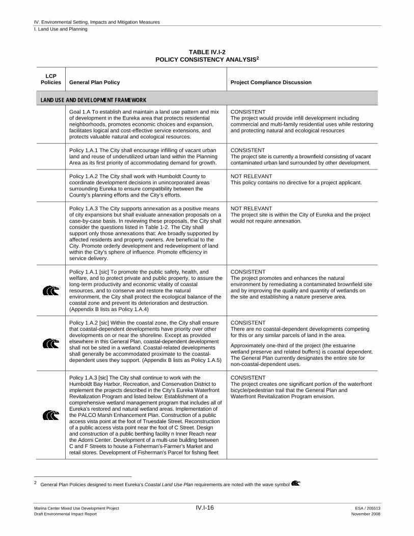
TABLE IV.I-2 POLICY CONSISTENCY ANALYSIS2
LCP Policies General Plan Policy Project Compliance Discussion
LAND USE AND DEVELOPMENT FRAMEWORK
Goal 1.A To establish and maintain a land use pattern and mix of development in the Eureka area that protects residential neighborhoods, promotes economic choices and expansion, facilitates logical and cost-effective service extensions, and protects valuable natural and ecological resources.
CONSISTENT The project would provide infill development including commercial and multi-family residential uses while restoring and protecting natural and ecological resources
Policy 1.A.1 The City shall encourage infilling of vacant urban land and reuse of underutilized urban land within the Planning Area as its first priority of accommodating demand for growth.
CONSISTENT The project site is currently a brownfield consisting of vacant contaminated urban land surrounded by other development.
Policy 1.A.2 The City shall work with Humboldt County to coordinate development decisions in unincorporated areas surrounding Eureka to ensure compatibility between the County’s planning efforts and the City’s efforts.
NOT RELEVANT This policy contains no directive for a project applicant.
Policy 1.A.3 The City supports annexation as a positive means of city expansions but shall evaluate annexation proposals on a case-by-case basis. In reviewing these proposals, the City shall consider the questions listed in Table 1-2. The City shall support only those annexations that: Are broadly supported by affected residents and property owners. Are beneficial to the City. Promote orderly development and redevelopment of land within the City’s sphere of influence. Promote efficiency in service delivery.
NOT RELEVANT The project site is within the City of Eureka and the project would not require annexation.
Policy 1.A.1 [sic] To promote the public safety, health, and welfare, and to protect private and public property, to assure the long-term productivity and economic vitality of coastal resources, and to conserve and restore the natural environment, the City shall protect the ecological balance of the coastal zone and prevent its deterioration and destruction. (Appendix B lists as Policy 1.A.4)
CONSISTENT The project promotes and enhances the natural environment by remediating a contaminated brownfield site and by improving the quality and quantity of wetlands on the site and establishing a nature preserve area.
Policy 1.A.2 [sic] Within the coastal zone, the City shall ensure that coastal-dependent developments have priority over other developments on or near the shoreline. Except as provided elsewhere in this General Plan, coastal-dependent development shall not be sited in a wetland. Coastal-related developments shall generally be accommodated proximate to the coastal-dependent uses they support. (Appendix B lists as Policy 1.A.5)
CONSISTENT There are no coastal-dependent developments competing for this or any similar parcels of land in the area.
Approximately one-third of the project (the estuarine wetland preserve and related buffers) is coastal dependent. The General Plan currently designates the entire site for non-coastal-dependent uses.
Policy 1.A.3 [sic] The City shall continue to work with the Humboldt Bay Harbor, Recreation, and Conservation District to implement the projects described in the City’s Eureka Waterfront Revitalization Program and listed below: Establishment of a comprehensive wetland management program that includes all of Eureka’s restored and natural wetland areas. Implementation of the PALCO Marsh Enhancement Plan. Construction of a public access vista point at the foot of Truesdale Street. Reconstruction of a public access vista point near the foot of C Street. Design and construction of a public berthing facility n Inner Reach near the Adorni Center. Development of a multi-use building between C and F Streets to house a Fisherman’s-Farmer’s Market and retail stores. Development of Fisherman’s Parcel for fishing fleet
CONSISTENT The project creates one significant portion of the waterfront bicycle/pedestrian trail that the General Plan and Waterfront Revitalization Program envision.
2 General Plan Policies designed to meet Eureka’s Coastal Land Use Plan requirements are noted with the wave symbol

IV. Environmental Setting, Impacts and Mitigation Measures I. Land Use and Planning
Marina Center Mixed Use Development Project IV.I-17 ESA / 205513 Draft Environmental Impact Report November 2008
TABLE IV.I-2 (Continued)
POLICY CONSISTENCY ANALYSIS
LCP Policies General Plan Policy Project Compliance Discussion
LAND USE AND DEVELOPMENT FRAMEWORK (cont.)
activities. Rehabilitation of the existing small boat basin, dredging and expansion of the Humboldt Yacht Club, and development of a fishing industry support facility. Completion of a waterfront bicycle/pedestrian trail from K Street to Del Norte Street. Development of a Wetland Mitigation Bank as a comprehensive tool for mitigating the loss of wetlands to development. Development of a facility for the Humboldt Bay Rowers Association near the Adorni Center. (Appendix B lists as Policy 1.A.6)
Core Area Concentrated Mixed-Use Core
Goal 1.B To create a compact, pedestrian-oriented, economically robust central Core Area that provides a clear geographic focus for attracting visitors and residents and for increasing private sector investment.
NOT RELEVANT The project site is not located in the area the General Plan defines as the “Core” of Eureka.
Policy 1.B.1 The City shall promote the development of a compact Core Area of concentrated commercial, residential, fishing-related, civic, cultural, and recreational activities by unifying parts of the three historical central “districts” (i.e., Old Town, Downtown, and the Waterfront).
NOT RELEVANT The project site is not located in the area the General Plan defines as the “Core” of Eureka.
Policy 1.B.2 The City shall actively encourage, support, and provide incentives, where feasible, for the types of development it prefers in the Core Area, including the following: Mixed-use projects. Housing in upper stories of buildings. Professional offices in upper stories of buildings. Projects that reinforce viable existing uses, such as fisheries. Projects that reinforce the identity of the Core Area.
NOT RELEVANT The project site is not located in the area the General Plan defines as the “Core” of Eureka.
Policy 1.B.3 The City shall promote development in areas immediately adjacent to the Core Area that support and complement Core Area uses.
NOT RELEVANT The project site is not located in the area the General Plan defines as the “Core” of Eureka.
Policy 1.B.4 The City shall promote the development of major public and private facilities that attract numerous patrons—such as a performing arts center, conference center, cinema, transit center, public market-within or directly adjacent to the Core Area where they have the maximum positive effect of the economic and social vitality of the Core Area. The City shall discourage development of these same uses outside the Core Area and directly adjacent areas.
NOT RELEVANT The project site is not located in the area the General Plan defines as the “Core” of Eureka.
Policy 1.B.5 The City shall promote the establishment and maintenance of pedestrian-oriented commercial uses such as retail stores, cafes, and restaurants along F Street and Second Street, particularly at the street level. The City shall encourage the establishment and maintenance of less pedestrian-oriented uses such as professional offices and multi-family residential uses on the upper floors of multi-story buildings.
NOT RELEVANT The project site is not located in the area the General Plan defines as the “Core” of Eureka.
Policy 1.B.6 The City shall explore the feasibility of closing Second Street between A and B Streets and locating a permanent public market or similar active public use (e.g., Pike Street Market in Seattle) adjacent to the proposed intermodal transportation center. This would provide a major public facility
NOT RELEVANT The project site is not located in the area the General Plan defines as the “Core” of Eureka.

IV. Environmental Setting, Impacts and Mitigation Measures I. Land Use and Planning
Marina Center Mixed Use Development Project IV.I-18 ESA / 205513 Draft Environmental Impact Report November 2008
TABLE IV.I-2 (Continued) POLICY CONSISTENCY ANALYSIS
LCP Policies General Plan Policy Project Compliance Discussion
LAND USE AND DEVELOPMENT FRAMEWORK (cont.) Concentrated Mixed-Use Core (cont.)
and visitor-oriented landmark at the west end of the retail section of the Second Street and create a line of demarcation between the Core Area and the light industrial area to the west.
Policy 1.B.7 The City shall attempt to maximize the effectiveness of public sector investment by concentrating on a limited number of strategically-located, mutually-reinforcing, highly-visible projects that will stimulate private-sector investment.
NOT RELEVANT The project site is not located in the area the General Plan defines as the “Core” of Eureka.
Policy 1.B.8 The City shall work with local banks to develop public sector-private sector funding programs for retrofit and rehabilitation of unreinforced masonry buildings in the Core Area.
NOT RELEVANT The project site is not located in the area the General Plan defines as the “Core” of Eureka.
Policy 1.B.9 The City shall encourage economic investment in buildings, ranging from modest signage improvements and new paint, to major façade improvements, remodels, and new buildings.
NOT RELEVANT The project site is not located in the area the General Plan defines as the “Core” of Eureka.
Policy 1.B.10 The City shall use unified landscaping and streetscape elements (i.e., streetlights, seating, signage, banners) to create a single Core Area identity and to unify the three historical central “districts” (i.e., Old Town, Downtown, and the Waterfront).
NOT RELEVANT The project site is not located in the area the General Plan defines as the “Core” of Eureka.
Policy 1.B.11 The City shall encourage and provide incentives, where feasible, for retrofit and rehabilitation of unreinforced masonry buildings in the Core Area that pose and earthquake risk.
NOT RELEVANT The project site is not located in the area the General Plan defines as the “Core” of Eureka.
Policy 1.B.12 The City shall discourage development at the western edge of the Core Area that could erode the economic viability of industrial uses in the adjacent light industrial area. This includes discouraging uses in the Core Area that would prompt significant increases in property values that would in turn lead to displacement of adjacent or nearby light industrial uses.
NOT RELEVANT The project site is not located in the area the General Plan defines as the “Core” of Eureka.
Policy 1.B.13 The City shall cooperate with Humboldt County in an effort to relocate the County’s Second and J Street facilities that are no longer appropriate for the Core Area. The sites should be redeveloped for visitor-accommodations and residential uses. The City shall consider providing incentives to the County where feasible and appropriate for such relocation.
NOT RELEVANT The project site is not located in the area the General Plan defines as the “Core” of Eureka.
Policy 1.B.14 The City shall encourage and provide incentives, where feasible, for the relocation of privately-owned industrial facilities that are no longer appropriate for the Core Area.
NOT RELEVANT The project site is not located in the area the General Plan defines as the “Core” of Eureka.
Policy 1.B.15 The City shall discourage the development or continued operation of facilities that promote the concentration of homeless or transients in the Core Area. The City supports the establishment of these facilities in the Eureka area outside of the Core Area.
NOT RELEVANT The project site is not located in the area the General Plan defines as the “Core” of Eureka.

IV. Environmental Setting, Impacts and Mitigation Measures I. Land Use and Planning
Marina Center Mixed Use Development Project IV.I-19 ESA / 205513 Draft Environmental Impact Report November 2008
TABLE IV.I-2 (Continued) POLICY CONSISTENCY ANALYSIS
LCP Policies General Plan Policy Project Compliance Discussion
LAND USE AND DEVELOPMENT FRAMEWORK (cont.) Arts and Culture
Goal 1.C To promote cultural arts within the Core Area that help to activate and economically revitalize the Core Area.
NOT RELEVANT The project site is not located in the area the General Plan defines as the “Core” of Eureka.
Policy 1.C.1 The Core Area shall be the City’s first choice in sitting or relocating new cultural facilities, museums, and performing or visual arts facilities. The City shall promote the development of a cultural arts/theater district within the Core Area that focuses primarily on the F Street Corridor.
NOT RELEVANT The project site is not located in the area the General Plan defines as the “Core” of Eureka.
Policy 1.C.2 The City shall provide leadership and support for creating a performing arts complex near the Eureka Theater and Carnegie Library.
NOT RELEVANT The project site is not located in the area the General Plan defines as the “Core” of Eureka.
Policy 1.C.3 The City shall participate in studies to determine the feasibility of renovation of other cultural facilities, such as the Ingomar Theater.
NOT RELEVANT The project site is not located in the area the General Plan defines as the “Core” of Eureka.
Policy 1.C.4 The City shall encourage the interim use of empty stores in the Core Area as temporary (phantom) art galleries.
NOT RELEVANT The project site is not located in the area the General Plan defines as the “Core” of Eureka.
Policy 1.C.5 The City shall support rehabilitation and conversion of vacant upper floors of buildings in the Core Area as artist live-work spaces.
NOT RELEVANT The project site is not located in the area the General Plan defines as the “Core” of Eureka.
Policy 1.C.6 The City shall develop an active program for providing public art.
NOT RELEVANT The project site is not located in the area the General Plan defines as the “Core” of Eureka.
Policy 1.C.7 The City shall encourage and assist in the development of murals to enliven blank walls in the Core Area.
NOT RELEVANT The project site is not located in the area the General Plan defines as the “Core” of Eureka.
Waterfront
Goal 1.D To revitalize the Core Area waterfront, enhancing coastal-related tourism and recreation, while maintaining the economic base and employment provided by the fishing industry.
NOT RELEVANT The project site is not located in the area the General Plan defines as the “Core” of Eureka.
Policy 1.D.1 The City shall retain the historic waterfront building scale, building form, and general character in waterfront revitalization and development as a means of creating a “Victorian Seaport” identity for the waterfront area. New buildings developed along the waterfront north of First Street/Waterfront Drive should not exceed three stories or 50 feet in height.
NOT RELEVANT The project site is not located in the area the General Plan defines as the “Core” of Eureka.
Policy 1.D.2 Except for safety reasons in industrial operations, the City shall ensure public access along the full length of the shoreline within the Core Area through development of multiple access points such as walkways, paths, docks, and piers.
NOT RELEVANT The project site is not located in the area the General Plan defines as the “Core” of Eureka.
Policy 1.D.3 The City shall promote the continued operation of existing fisheries-related industry throughout the Core Area waterfront.
NOT RELEVANT The project site is not located in the area the General Plan defines as the “Core” of Eureka.
IV. Environmental Setting, Impacts and Mitigation Measures I. Land Use and Planning
Marina Center Mixed Use Development Project IV.I-20 ESA / 205513 Draft Environmental Impact Report November 2008
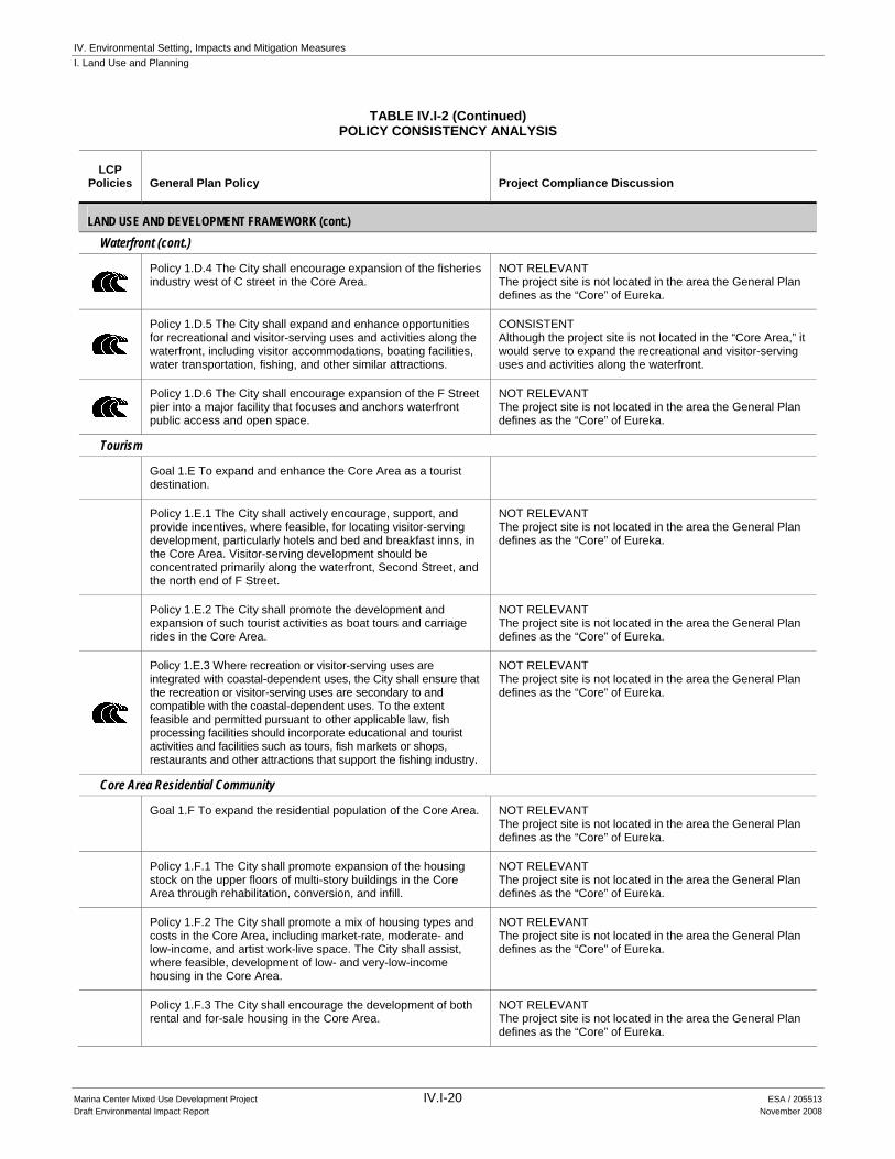
TABLE IV.I-2 (Continued) POLICY CONSISTENCY ANALYSIS
LCP Policies General Plan Policy Project Compliance Discussion
LAND USE AND DEVELOPMENT FRAMEWORK (cont.) Waterfront (cont.)
Policy 1.D.4 The City shall encourage expansion of the fisheries industry west of C street in the Core Area.
NOT RELEVANT The project site is not located in the area the General Plan defines as the “Core” of Eureka.
Policy 1.D.5 The City shall expand and enhance opportunities for recreational and visitor-serving uses and activities along the waterfront, including visitor accommodations, boating facilities, water transportation, fishing, and other similar attractions.
CONSISTENT Although the project site is not located in the “Core Area,” it would serve to expand the recreational and visitor-serving uses and activities along the waterfront.
Policy 1.D.6 The City shall encourage expansion of the F Street pier into a major facility that focuses and anchors waterfront public access and open space.
NOT RELEVANT The project site is not located in the area the General Plan defines as the “Core” of Eureka.
Tourism
Goal 1.E To expand and enhance the Core Area as a tourist destination.
Policy 1.E.1 The City shall actively encourage, support, and provide incentives, where feasible, for locating visitor-serving development, particularly hotels and bed and breakfast inns, in the Core Area. Visitor-serving development should be concentrated primarily along the waterfront, Second Street, and the north end of F Street.
NOT RELEVANT The project site is not located in the area the General Plan defines as the “Core” of Eureka.
Policy 1.E.2 The City shall promote the development and expansion of such tourist activities as boat tours and carriage rides in the Core Area.
NOT RELEVANT The project site is not located in the area the General Plan defines as the “Core” of Eureka.
Policy 1.E.3 Where recreation or visitor-serving uses are integrated with coastal-dependent uses, the City shall ensure that the recreation or visitor-serving uses are secondary to and compatible with the coastal-dependent uses. To the extent feasible and permitted pursuant to other applicable law, fish processing facilities should incorporate educational and tourist activities and facilities such as tours, fish markets or shops, restaurants and other attractions that support the fishing industry.
NOT RELEVANT The project site is not located in the area the General Plan defines as the “Core” of Eureka.
Core Area Residential Community
Goal 1.F To expand the residential population of the Core Area. NOT RELEVANT
The project site is not located in the area the General Plan defines as the “Core” of Eureka.
Policy 1.F.1 The City shall promote expansion of the housing stock on the upper floors of multi-story buildings in the Core Area through rehabilitation, conversion, and infill.
NOT RELEVANT The project site is not located in the area the General Plan defines as the “Core” of Eureka.
Policy 1.F.2 The City shall promote a mix of housing types and costs in the Core Area, including market-rate, moderate- and low-income, and artist work-live space. The City shall assist, where feasible, development of low- and very-low-income housing in the Core Area.
NOT RELEVANT The project site is not located in the area the General Plan defines as the “Core” of Eureka.
Policy 1.F.3 The City shall encourage the development of both rental and for-sale housing in the Core Area.
NOT RELEVANT The project site is not located in the area the General Plan defines as the “Core” of Eureka.

IV. Environmental Setting, Impacts and Mitigation Measures I. Land Use and Planning
Marina Center Mixed Use Development Project IV.I-21 ESA / 205513 Draft Environmental Impact Report November 2008
TABLE IV.I-2 (Continued) POLICY CONSISTENCY ANALYSIS
LCP Policies General Plan Policy Project Compliance Discussion
LAND USE AND DEVELOPMENT FRAMEWORK (cont.) Core Area Residential Community (cont.)
Policy 1.F.4 The City shall support development of residential-serving services in the Core Area, such as neighborhood markets.
NOT RELEVANT The project site is not located in the area the General Plan defines as the “Core” of Eureka.
Policy 1.F.5 To increase the feasibility of residential development in the Core Area, the City shall consider reducing parking requirements for the Core Area housing.
NOT RELEVANT The project site is not located in the area the General Plan defines as the “Core” of Eureka.
Core Public Open Space
Goal 1.G To create a system of usable public open space that is attractive, historically-sensitive, and well-maintained.
NOT RELEVANT The project site is not located in the area the General Plan defines as the “Core” of Eureka.
Policy 1.G.1 The City shall provide a coordinated and unified system of plazas, squares, parks, and public-ways (including street trees and streetscape) that promotes pedestrian vitality in the Core Area.
NOT RELEVANT The project site is not located in the area the General Plan defines as the “Core” of Eureka.
Policy 1.G.2 The City shall redesign and retrofit Gazebo and Clark Plazas to increase their usefulness and to reduce their associated social problems.
NOT RELEVANT The project site is not located in the area the General Plan defines as the “Core” of Eureka.
Policy 1.G.3 The City shall expand the public pier at the foot of F Street to enhance leisure and recreation opportunities within the Core Area.
NOT RELEVANT The project site is not located in the area the General Plan defines as the “Core” of Eureka.
View Corridors
Goal 1.H To maintain and expand views of the waterfront, inner harbor, and landmark buildings from public streets and other public spaces.
NOT RELEVANT The project site is not located in the area the General Plan defines as the “Core” of Eureka.
Policy 1.H.1 The City shall promote unobstructed view corridors to the waterfront from public streets and other public spaces through careful building siting and effective street tree maintenance.
NOT RELEVANT The project site is not located in the area the General Plan defines as the “Core” of Eureka.
Policy 1.H.2 The City shall create a gateway to the waterfront/inner harbor at the foot of F Street, defining the terminus of the street (e.g., flags, ships masts.).
NOT RELEVANT The project site is not located in the area the General Plan defines as the “Core” of Eureka.
Policy 1.H.3 The City shall maintain unobstructed views of the Carson Mansion along the entire length of Second Street through street tree pruning or removal as necessary.
NOT RELEVANT The project site is not located in the area the General Plan defines as the “Core” of Eureka.
Policy 1.H.4 The City shall establish landmark feature (e.g., buildings, sculptures) at the terminus of key Core Area streets, most importantly at the west end of Second Street (B Street) and at the foot of F Street.
NOT RELEVANT The project site is not located in the area the General Plan defines as the “Core” of Eureka.
Architectural/Landscape Character
Goal 1.I To maintain the distinctive architecture, historic character, and landscape quality within the Core Area.
NOT RELEVANT The project site is not located in the area the General Plan defines as the “Core” of Eureka.

IV. Environmental Setting, Impacts and Mitigation Measures I. Land Use and Planning
Marina Center Mixed Use Development Project IV.I-22 ESA / 205513 Draft Environmental Impact Report November 2008
TABLE IV.I-2 (Continued) POLICY CONSISTENCY ANALYSIS
LCP Policies General Plan Policy Project Compliance Discussion
LAND USE AND DEVELOPMENT FRAMEWORK (cont.) Architectural/Landscape Character (cont.)
Policy 1.I.1 The City shall ensure that structures of historic or architectural interest are preserved and, wherever feasible, rehabilitated to protect the variety and quality of older buildings in the Core Area. In cases where such structures might be used to better advantage in new surroundings, the City shall encourage relocation.
NOT RELEVANT The project site is not located in the area the General Plan defines as the “Core” of Eureka.
Policy 1.I.2 The City shall aggressively support façade improvements for buildings in the Core Area, including provision of incentives. F Street and Second Street should have the highest priority for façade improvements.
NOT RELEVANT The project site is not located in the area the General Plan defines as the “Core” of Eureka.
Policy 1.I.3 The City shall enhance the historic quality of major traffic thoroughfares, particularly F, Fourth, Fifth, Sixth, and Seventh Streets, by encouraging property owners to remove “slip-cover” (i.e., contemporary/remodeled) facades that have been placed over intact historic facades.
NOT RELEVANT The project site is not located in the area the General Plan defines as the “Core” of Eureka.
Policy 1.I.4 The City shall encourage property owners to maintain, enhance, and protect the existing character of historic buildings, with a particular emphasis on retaining or restoring original style, consistent with the Secretary of the Interior’s standards.
NOT RELEVANT The project site is not located in the area the General Plan defines as the “Core” of Eureka.
Policy 1.I.5 The City shall require that new buildings in the Core Area be compatible with the surrounding building scale, character, and materials. In no event shall a new building exceed 75 feet in height. The City shall require that facades on new buildings in the Core Area are a minimum of 18 to 20 feet tall, including decorative front cornices.
NOT RELEVANT The project site is not located in the area the General Plan defines as the “Core” of Eureka.
Policy 1.I.6 The City shall require that signs in the Core Area are appropriate to the pedestrian environment and to the scale and character of the buildings they serve.
NOT RELEVANT The project site is not located in the area the General Plan defines as the “Core” of Eureka.
Policy 1.I.7 The City shall maintain the basic scale and character of the traditional grid street pattern in the Core Area, including street dimensions and alignment, sidewalk width, curb lines, and parallel parking.
NOT RELEVANT The project site is not located in the area the General Plan defines as the “Core” of Eureka.
Policy 1.I.8 The City shall maintain the historic pattern of building siting in the Core Area by requiring that buildings be built to the street property and side lines, and by retaining the building scale and cadence created by historic parcel dimensions, even where lot consolidation is necessary to create economically viable development.
NOT RELEVANT The project site is not located in the area the General Plan defines as the “Core” of Eureka.
Policy 1.I.9 The City shall promote the creation of a strong and appealing retail environment by requiring the use of transparent commercial storefronts (i.e., windows and doors) and continuous and compatible building facades. Conversely, the City shall prohibit the creation of blank walls and discontinuity in building facades.
NOT RELEVANT The project site is not located in the area the General Plan defines as the “Core” of Eureka.
Policy 1.I.10 The City shall enhance the pedestrian environment through streetscape elements such as attractive planter boxes; comfortable seating that discourages domination by a single social group; attractive and functional lighting and street signs; attractive trash receptacles; clean, secure and convenient public restrooms; and convenient parking.
NOT RELEVANT The project site is not located in the area the General Plan defines as the “Core” of Eureka.

IV. Environmental Setting, Impacts and Mitigation Measures I. Land Use and Planning
Marina Center Mixed Use Development Project IV.I-23 ESA / 205513 Draft Environmental Impact Report November 2008
TABLE IV.I-2 (Continued) POLICY CONSISTENCY ANALYSIS
LCP Policies General Plan Policy Project Compliance Discussion
LAND USE AND DEVELOPMENT FRAMEWORK (cont.) Architectural/Landscape Character (cont.)
Policy 1.I.11 The City shall upgrade the visual and pedestrian amenity quality of Second Street through repair and renovation of existing street furniture, street lights, street signs and sidewalks; pruning of street trees, and where necessary, removal of street trees that are blocking views of the Carson Mansion; replacements of missing or damaged street trees; re-landscaping of planters and other planting areas; and other improvements within the public way.
NOT RELEVANT The project site is not located in the area the General Plan defines as the “Core” of Eureka.
Maintenance and Safety
Goal 1.J To create a safe, clean, and pedestrian-friendly Core Area.
NOT RELEVANT The project site is not located in the area the General Plan defines as the “Core” of Eureka.
Policy 1.J.1 The City shall provide a high level of maintenance to ensure that the Core Area is free of trash and litter.
NOT RELEVANT The project site is not located in the area the General Plan defines as the “Core” of Eureka.
Policy 1.J.2 The City shall work with property owners to ensure that rear entries to stores are attractive and alleys are well maintained. The City shall encourage consolidation of dumpster areas in alleys and shall require upgrading of the visual quality of dumpster enclosures.
NOT RELEVANT The project site is not located in the area the General Plan defines as the “Core” of Eureka.
Policy 1.J.3 The City shall ensure that street lighting supports a safe, well-lighted pedestrian environment for night use of the Core Area.
NOT RELEVANT The project site is not located in the area the General Plan defines as the “Core” of Eureka.
Policy 1.J.4 The City shall provide adequate and attractive trash receptacles on sidewalks.
NOT RELEVANT The project site is not located in the area the General Plan defines as the “Core” of Eureka.
Policy 1.J.5 The City shall remove or upgrade obsolete or dysfunctional poles, posts, and bicycle racks on sidewalks in the Core Area.
NOT RELEVANT The project site is not located in the area the General Plan defines as the “Core” of Eureka.
Policy 1.J.6 The City shall maintain and prune trees and landscaping in public rights-of-way, parks, and plazas to facilitate visibility and surveillance of public spaces in the interest of public safety.
NOT RELEVANT The project site is not located in the area the General Plan defines as the “Core” of Eureka.
Residential/Neighborhood Development
Goal 1.K To provide adequate land in a range of residential densities to accommodate the housing needs of all income groups expected to reside in Eureka.
CONSISTENT The project would add 54 multi-family housing units, including one-, two-, and three-bedroom units.
Policy 1.K.1 The residential environment of Eureka should be guided by the following neighborhood development principles: a. Neighborhoods should contain a diversity of housing types
to enable citizens from a wide range of economic levels and age groups to live within its boundaries.
b. Neighborhoods should have a center focus that combines commercial, civic, cultural and recreational uses.
CONSISTENT a. The project would add 54 multi-family housing units,
including one-, two-, and three-bedroom units spanning a wide price range.
b. The proposed project includes an open plaza surrounded by residences, widened sidewalks capable of accommodating street side cafes, retail

IV. Environmental Setting, Impacts and Mitigation Measures I. Land Use and Planning
Marina Center Mixed Use Development Project IV.I-24 ESA / 205513 Draft Environmental Impact Report November 2008
TABLE IV.I-2 (Continued) POLICY CONSISTENCY ANALYSIS
LCP Policies General Plan Policy Project Compliance Discussion
LAND USE AND DEVELOPMENT FRAMEWORK (cont.) Residential/Neighborhood Development (cont.)
c. Neighborhoods should contain an ample supply of specialized open space in the form of squares, greens and parks whose frequent use is encouraged through placement and design.
d. Public spaces should be designed to encourage the attention and presence of people at all hours of the day and night.
e. Streets, pedestrian paths, and bike paths should contribute to a system of fully-connected, interesting routes to all destinations. Their design should encourage pedestrian and bicycle use by being small and spatially defined by buildings, trees and lighting, and by discouraging high speed traffic.
f. Wherever feasible, the natural terrain, drainage and vegetation of the neighborhood should be preserved with superior examples contained within parks or greenbelts.
g. Neighborhood design should help conserve resources and minimize waste.
h. Neighborhoods should provide for the efficient use of water through the use of natural drainage, drought tolerant landscaping, and recycling.
i. New neighborhoods should be developed so that street orientation, the placement of buildings, and the use of shading should contribute to the energy efficiency of the neighborhood.
stores, offices, natural resource preserves, bike/pedestrian paths, and a museum. It therefore provides a residential neighborhood that contains outdoor recreation/natural resource areas as well as convenient commercial and cultural uses.
c. The proposed project would afford the residential units a convenient open space area in the wetland preserve and the associated bicycle/pedestrian pathway, in addition to its proximity to the public marina and boardwalk areas.
d. Public spaces such as the bicycle/pedestrian pathway, viewing areas, the children’s museum, and open plazas incorporated into the development would increase day and night populations using the project site.
e. The proposed bicycle/pedestrian path would connect with the envisioned bike path along the Old Town Boardwalk east of C street. This would integrate the project and the nature preserve area with other areas of the city.
The project would extend Fourth and Second Streets into the heart of the mixed use area and would connect these streets, along with bicycle and pedestrian access, to the pedestrian/bicycle path along Waterfront Drive near the existing boat basin.
The extensions of Fourth and Second Streets would intersect at an area with access and view corridors to the Bay and the pedestrian/bicycle path. At the northeast corner of this intersection, there would be a public plaza in the midst of buildings housing retail, office, and residential uses.
New signals on Broadway at Fourth, Fifth, and Seventh Streets would improve the connection between the project site and Eureka’s core by making it easier for pedestrians and bicycles to cross Highway 101, as well as for automobiles accessing the site from any direction.
f. Not relevant. The existing natural terrain is degraded and heavily impacted by years of industrial use. The drainage and vegetation in the area would be enhanced by restoration of estuarine wetlands in a nature preserve and by landscaping.
g. The project proposes to use green building materials (recycled, local and renewable), energy efficient design and other measures including LEED certification programs.
h. The proposed project would employ native vegetation for restoration of the wetland and would employ drought tolerant vegetation for other landscaping.
i. The project would implement environmentally friendly design, construction, and operational measures, including: Recycling of demolished structures; use of ‘green’ building materials; energy-efficient HVAC and lighting control systems; use of natural ventilation and day-lighting; and use of low-resource plumbing fixtures and other measures including LEED certification programs.

IV. Environmental Setting, Impacts and Mitigation Measures I. Land Use and Planning
Marina Center Mixed Use Development Project IV.I-25 ESA / 205513 Draft Environmental Impact Report November 2008
TABLE IV.I-2 (Continued) POLICY CONSISTENCY ANALYSIS
LCP Policies General Plan Policy Project Compliance Discussion
LAND USE AND DEVELOPMENT FRAMEWORK (cont.) Residential/Neighborhood Development (cont.)
Policy 1.K.2 The City shall promote the individuality and identity of each neighborhood while at the same time upgrading the overall environment through excellence of architecture, design, landscaping, retention of views and street furniture.
CONSISTENT The proposed project would employ high quality design for all of the buildings, landscaping, site design, and street furniture. The project would undergo design review as apart of the permitting process.
Policy 1.K.3 The City should encourage retention of neighborhood convenience shopping that is compatible with the overall circulation and land use pattern so as to provide convenience for residential areas.
NOT RELEVANT There currently is no neighborhood convenience shopping on the project site to retain.
Policy 1.K.4 The City shall ensure that infill development (either new or rehabilitated residential structures) is compatible with the overall established character of residential neighborhoods.
CONSISTENT As discussed in Chapter III, Project Description, the project design would be compatible with the overall established character of downtown/waterfront neighborhoods because it would draw from the site’s maritime and industrial heritage.
Policy 1.K.5 The City shall encourage higher residential densities at locations where convenient access and adequate facilities, including parks and open space, are readily available.
CONSISTENT The project would provide infill development including relatively high density multi-family residential uses. Public facilities are readily available in the area. The project also proposes to preserve open space within the project site and improve access to adjacent public facilities including the marina, boardwalk and Old Shopping District by extending the city’s street grid and by the creation of the bicycle/pedestrian path along Waterfront Drive.
Policy 1.K.6 The City shall encourage higher residential densities in the Core Area and in neighborhoods where existing and planned community facilities and utilities are designed to handle increased densities.
NOT RELEVANT Relates to the Core, rural and estate areas.
Policy 1.K.7 The City shall encourage rural and estate densities and planned unit developments in areas immediately adjacent to gulch greenways so as to preserve the openness and visual amenities of these valuable natural assets while reducing sprawl conditions and the cost of utilities, circulation, grading, and construction.
NOT RELEVANT Relates to the Core, rural and estate areas.
Commercial Development
Goal 1.L To ensure an adequate supply of commercial land for and promote the development of commercial uses to meet the present and future needs of Eureka residents and visitors and to maintain economic vitality.
CONSISTENT The project would develop new commercial uses intended to serve the Eureka’s present and future residents and visitors.
Policy 1.L.1 The City shall discourage new commercial development within the city that will adversely affect the economic vitality of the Core Area. This City shall also encourage Humboldt County to discourage such development in adjacent unincorporated areas.
CONSISTENT The proposed project could draw some customers away from Core Area businesses. It would, however, add residents, day-time workers, and visitors to an area within walking distance of the Core Area. It would ease pedestrian, bicycle, and automobile flow between the project site and the downtown core by adding traffic signals at busy intersections, constructing a multi-use path along the coast, and extending Fourth and Second Streets into

IV. Environmental Setting, Impacts and Mitigation Measures I. Land Use and Planning
Marina Center Mixed Use Development Project IV.I-26 ESA / 205513 Draft Environmental Impact Report November 2008
TABLE IV.I-2 (Continued) POLICY CONSISTENCY ANALYSIS
LCP Policies General Plan Policy Project Compliance Discussion
LAND USE AND DEVELOPMENT FRAMEWORK (cont.) Commercial Development (cont.)
the heart of the project site. This would effectively extend
the developed area of downtown Eureka westward, making the entirety of downtown Eureka more active.
Policy 1.L.2 The City shall promote high quality design, visual attractiveness, proper location, adequate sites, sufficient off-street parking, and a convenient circulation system for commercially-designated areas of the city.
CONSISTENT The proposed project would employ high quality design in all aspects of the project. The project would undergo design review as a part of the permitting process (see Section IV. O, Transportation for a detailed discussion).
Policy 1.L.3 The City shall discourage isolated and sprawling commercial activities along major roads and instead reinforce the vitality of the Core Area and existing community and neighborhood shopping areas.
CONSISTENT The proposed project would infill a vacant brownfield property along US 101 without creating an area of sprawling isolated commercial activity. The project would connect a multi-use development with the downtown area of Eureka.
Policy 1.L.4 The City shall encourage consolidation and upgrading of established commercial centers over the development of new shopping center within the Planning Area. The City shall also encourage Humboldt County to do likewise.
POTENTIALLY INCONSISTENT The proposed project would create a new commercial center.
Policy 1.L.5 The City shall support the continued vitality and upgrading of Henderson Center within its existing boundaries.
NOT RELEVANT Relates to the Henderson Center.
Policy 1.L.6 The City shall support the retention and upgrading of small neighborhood retail centers serving the immediate residential neighborhoods and provide for such uses in new residential development. These centers should be located and designed to serve neighborhood pedestrian trade and should not occupy more than one-quarter of the block on which they are located.
CONSISTENT The proposed project would incorporate spaces for street level neighborhood pedestrian-serving retail.
Policy 1.L.7 The City shall require major commercial development to consolidate and control access to avoid congestion, confusion, and traffic conflicts.
CONSISTENT See Section IV. O, Transportation for a detailed discussion.
Policy 1.L.8 The City shall require major commercial development projects to either be located in areas served by public transportation or in areas to which the existing public transportation service can be feasibly extended.
CONSISTENT Public transportation routes already travel along the perimeter of the site along Broadway and Washington streets. The project proposes recommissioning bus stops along this route to provide transit access to the site.
See Section IV. O, Transportation for a detailed discussion.
Policy 1.L.9 The City shall promote the location of community shopping developments in areas with access from an intersection of arterial streets and within areas of higher residential density.
CONSISTENT The project would be accessed by Second and Fourth Streets as well as Broadway and Washington and Waterfront Avenue. The project would include high density residential development on the project site.
Policy 1.L.10 The City shall work with property owners in deteriorated and deteriorating commercial areas to either rehabilitate their properties or convert them to productive uses that are consistent with this General Plan.
NOT RELEVANT This policy is directed toward existing commercial facilities or specific areas outside the project site.

IV. Environmental Setting, Impacts and Mitigation Measures I. Land Use and Planning
Marina Center Mixed Use Development Project IV.I-27 ESA / 205513 Draft Environmental Impact Report November 2008
TABLE IV.I-2 (Continued) POLICY CONSISTENCY ANALYSIS
LCP Policies General Plan Policy Project Compliance Discussion
LAND USE AND DEVELOPMENT FRAMEWORK (cont.) Commercial Development (cont.)
Policy 1.L.11 The City shall protect and, where feasible, upgrade facilities serving the commercial fishing and recreational boating industries. Existing commercial fishing and recreational boating space shall not be reduced unless the demand for those facilities no longer exists or adequate substitute space has been provided. New recreational boating facilities shall, to the maximum extent feasible, be designed and located so as not to interfere with the needs of the commercial fishing industry.
NOT RELEVANT This policy is directed toward existing commercial facilities.
Policy 1.L.12 The City shall promote the concentration of automobile-oriented retail development in the ASC-designated area at the west end of Sixth and Seventh Streets. In particular, the City will support the establishment and retention of auto dealerships in this area. The City shall also discourage the establishment of new dealerships outside of this area.
NOT RELEVANT This policy is directed toward specific areas outside the project site.
Policy 1.L.13 The City shall cooperate with Humboldt County to support the continued concentration of medical and related facilities and services in the Harrison Avenue Corridor. The City shall limit commercial development in the corridor to those uses directly dependent on or oriented to the patrons and staff of nearby hospitals and medical offices. The City shall also cooperate with the County to ensure that new projects in the corridor provide sufficient parking.
NOT RELEVANT This policy is directed toward specific areas outside the project site.
Policy 1.L.14 The City supports the redesignation and rezoning of the Lieber parcel in the northeast quadrant of the Elk River interchange on U.S. 101 for commercial, industrial, or mixed-use development if the project can meet the policies and requirements of the federal and state agencies that would have to approve the project.
NOT RELEVANT This policy is directed toward specific areas outside the project site.
Industrial Development
Goal 1.M To ensure an adequate supply of industrial land for and promote the development of industrial uses to meet the present and future needs of Eureka and to maintain economic vitality.
CONSISTENT The portion of the project site currently designated industrial would retain industrial uses.
Policy 1.M.1 The City shall protect industrially-designated land from pre-emption by residential, commercial, and other unrelated and incompatible uses.
CONSISTENT The proposed project would change some land designated light industrial to designations allowing for other uses.
Policy 1.M.2 The City shall promote development and upgrading of the Westside Industrial Area to accommodate industrial growth and the relocation of industry from unsuitable sites and areas.
POTENTIALLY INCONSISTENT The proposed project site is in the “Westside Industrial Area.” The project would involve developing a portion of the “Westside Industrial Area” for nonindustrial uses.
See Section IV.I, Land Use and Planning, for a detailed discussion.
Policy 1.M.3 The City shall support the retention of existing and establishment of new fishing facilities related uses in the area north of the railroad tracks between Commercial Street and C Street in the Core Area. The City shall encourage new development in the area that reinforces the essentially industrial character of the area and reduces potential land use conflicts and speculative inflation of land values.
NOT RELEVANT The project site is not located in the area the General Plan defines as the “Core” of Eureka.

IV. Environmental Setting, Impacts and Mitigation Measures I. Land Use and Planning
Marina Center Mixed Use Development Project IV.I-28 ESA / 205513 Draft Environmental Impact Report November 2008
TABLE IV.I-2 (Continued) POLICY CONSISTENCY ANALYSIS
LCP Policies General Plan Policy Project Compliance Discussion
LAND USE AND DEVELOPMENT FRAMEWORK (cont.) Industrial Development (cont.)
Policy 1.M.4 The City shall promote the development of a modern multiple-purpose dock a Dock B that would combine a cruise ship terminal with a break-bulk/container cargo terminal and fishing facilities.
NOT RELEVANT This policy is directed toward a specific area outside the project site.
Policy 1.M.5 If efforts to develop a multi-purpose terminal at Dock B are unsuccessful, the City will support the development of a non-coastal industrial park in the Dock B area, including the “balloon track” and the Wright-Schuchart site. In developing such an industrial park, the City would retain the Dock A area for possible long-term cargo terminal development.
POTENTIALLY INCONSISTENT The proposed project would not include plans for a non-coastal industrial park on the Balloon Track parcels. It would, however, dedicate one portion of the project site for light industrial uses (see Section IV.I, Land Use and Planning, for a detailed discussion).
Policy 1.M.6 The City shall consider developing an industrial park in the Hinge Area roughly defined by Broadway and C Streets, The focus of an industrial park in this area would be on making individual parcels and rehabilitated buildings available for small-scale industrial users.
NOT RELEVANT This policy is directed toward a specific area outside the project site.
Policy 1.M.7 The City shall encourage coastal-dependent industrial facilities to locate or expand within existing sites. Non-coastal-dependent uses located along the waterfront shall, if feasible, be relocated to other more appropriate areas within the city.
NOT RELEVANT. No coastal-dependent industrial facilities are seeking to locate or expand in the region.
Policy 1.M.8 The City shall require that new industrial and heavy commercial development projects have convenient and safe access to major transportation facilities (highways, railroads, waterfront facilities) to minimize unnecessary and disruptive traffic through residential and other sensitive sections of the city.
CONSISTENT The proposed project would provide the required access (see Section IV.O. Transportation, for further details).
Policy 1.M.9 The City shall prohibit new residential uses within or directly adjacent to industrial areas so as to avoid conflicts and the provision of unnecessary services and facilities.
CONSISTENT Residential uses in the project would not be located directly adjacent to industrial uses.
Policy 1.M.10 The City shall permit mixed industrial and commercial uses only when such uses are determined to be compatible or necessary for operations.
CONSISTENT The proposed project would mix industrial and commercial uses in a carefully planned and compatible development.
Policy 1.M.11 The City shall require that industrial development avoids or minimizes creating substantial pollution, noise, glare, odor, or other significant offensive activity that would contribute negatively to adjacent uses and other areas of the city.
CONSISTENT Industrial development on the project site would be light industrial specifically designed to be compatible with adjacent existing and proposed uses.
Policy 1.M.12 The City shall ensure that areas designated for industrial development be adequately served by utilities and facilities so as to promote consolidated development and reduce energy consumption.
CONSISTENT For the portions of the proposed project that would include industrial development, the project applicant would comply with all relevant requirements.
Policy 1.M.13 The City shall ensure that the streets and corners in industrial areas are sufficiently wide to easily accommodate truck traffic.
CONSISTENT See discussion for Policy 1.M.12
Policy 1.M.14 The City shall require that industrial development projects provide ample space for truck loading, parking, and maneuvering.
CONSISTENT See discussion for Policy 1.M.12

IV. Environmental Setting, Impacts and Mitigation Measures I. Land Use and Planning
Marina Center Mixed Use Development Project IV.I-29 ESA / 205513 Draft Environmental Impact Report November 2008
TABLE IV.I-2 (Continued) POLICY CONSISTENCY ANALYSIS
LCP Policies General Plan Policy Project Compliance Discussion
LAND USE AND DEVELOPMENT FRAMEWORK (cont.) Industrial Development (cont.)
Policy 1.M.15 The City shall treat exiting offices as permitted uses in the Light Industrial (LI) designation and shall allow their expansion within the boundaries of the same parcel, consistent with zoning standards.
CONSISTENT See discussion for Policy 1.M.12
Community Facilities
Goal 1.N To ensure an adequate supply of land for community facilities and services to meet the present and future needs of Eureka.
CONSISTENT The project would develop new commercial uses intended to serve Eureka’s present and future residents.
Schools
Policy 1.N.1 The City shall encourage the retention and upgrading of elementary school facilities to serve as the focal point of each neighborhood’s social, cultural, vocational and recreational, as well as educational activities. Wherever feasible, open-space, playgrounds, neighborhood parks, and other neighborhood-scale facilities should be located adjacent to elementary schools.
NOT RELEVANT This policy relates to the quality of school facilities.
Policy 1.N.2 The City shall work with local school districts to ensure that school sites are relatively free from external disturbing factors such as heavy traffic, excessive noise, offensive odors and incompatible land use.
NOT RELEVANT This policy relates to the location of school facilities. No school facilities are proposed as a part of the project.
Policy 1.N.3 The City shall work with local school districts to ensure that all new schools are centrally located within the neighborhoods they serve and that new schools are sited to be compatible with surrounding neighborhood land uses. The City shall promote the development of new schools according to the following principles: Elementary schools should be located close to the center of the residential areas served and away from arterial traffic routes so that children do not have to cross arterials. Junior high schools should have direct access to collector streets, be located near a concentration of dwelling units, and with pedestrian walkways to provide access to and from the residential area served. High schools should be centrally located so as to have direct arterial access while serving the total community.
NOT RELEVANT This policy relates to the location of school facilities. No school facilities are proposed as a part of the project.
Policy 1.N.4 The City shall work with local school districts to promote the concept of combined schools-parks whenever feasible (i.e., elementary school-neighborhood park, junior high school-community park, and high school-community park).
NOT RELEVANT This policy relates to the location of school facilities. No school facilities are proposed as a part of the project.
Policy 1.N.5 The City shall support the efforts of the school district to acquire new school sites.
NOT RELEVANT This policy relates to the location of school facilities. No school facilities are proposed as a part of the project.
Parks and Recreation
Policy 1.N.6 The City shall ensure that sufficient area is provided for parks and open-space in all of Eureka’s residential neighborhoods and shall plan for such uses as new residential development occurs.
CONSISTENT The proposed project would allocate sufficient area to parks and open space within the project site.

IV. Environmental Setting, Impacts and Mitigation Measures I. Land Use and Planning
Marina Center Mixed Use Development Project IV.I-30 ESA / 205513 Draft Environmental Impact Report November 2008
TABLE IV.I-2 (Continued) POLICY CONSISTENCY ANALYSIS
LCP Policies General Plan Policy Project Compliance Discussion
LAND USE AND DEVELOPMENT FRAMEWORK (cont.) Parks and Recreation (cont.)
Policy 1.N.7 The City shall encourage development of parks adjacent to school sites that contain facilities and equipment that enhance and are compatible with the residential character of neighborhoods.
NOT RELEVANT This policy relates to the location of parks relative to school sites.
Public and Quasi-Public Facilities
Policy 1.N.8 To reinforce downtown Eureka’s role as the regional center for government facilities and services, the City shall encourage and support consolidation of civic and governmental offices, services, and functions within the area designated Civic Government Center on the Land Use Diagram. This will provide a single, efficient, and readily accessible location for the public.
NOT RELEVANT This policy relates to the location of public facilities.
Policy 1.N.9 The City shall encourage the coordination of public and private facilities whenever beneficial and avoid unnecessary duplication.
NOT RELEVANT This policy relates to the location of public facilities.
Policy 1.N.10 The City shall strive to provide high quality public facilities, utilities, and services throughout the urbanized area of Eureka and shall ensure that such facilities, utilities, and services are compatible with surrounding development.
NOT RELEVANT This policy relates to the quality of public facilities.
Policy 1.N.11 In considering proposals for development of places of public assembly (e.g. meeting halls, places of worship), the City shall encourage the provision of direct access to an arterial street.
NOT RELEVANT This policy relates to the location of public facilities.
Policy 1.N.12 The City shall require that all public buildings comply with the requirements of the Americans with Disabilities Act (ADA).
NOT RELEVANT This policy relates to the quality of public facilities.
Policy 1.N.13 The City shall continue to support the efforts of the Humboldt County convention and Visitors Bureau to locate a community conference center within or at the edge of the Core Area.
NOT RELEVANT This policy relates to the location of public facilities.
Policy 1.N.14 The City shall promote the location of museums and regional cultural facilities within or adjacent to the Core Area.
NOT RELEVANT This policy relates to the location of public facilities.
Policy 1.N.15 The City shall work with other local, state, and federal agencies to locate governmental garages and corporation yards in heavy commercial or industrial areas. Such facilities should be adjacent to or very near an arterial street, but should not directly abut an arterial, since the ingress and egress of trucks and other equipment could slow usual arterial traffic. The yard site should also be large enough to meet reasonable future needs and be compatible with surrounding land uses. The City shall encourage Humboldt County to relocate its Second and “J” Street facilities to a more appropriate area.
NOT RELEVANT This policy relates to the location of public facilities.
Policy 1.N.16 The City shall ensure that fire stations are as compatible as feasible with neighboring land uses and that they relate to the City’s major street system in the following manner: With access to arterial streets, but not directly facing onto an
NOT RELEVANT This policy relates to the location of public facilities.

IV. Environmental Setting, Impacts and Mitigation Measures I. Land Use and Planning
Marina Center Mixed Use Development Project IV.I-31 ESA / 205513 Draft Environmental Impact Report November 2008
TABLE IV.I-2 (Continued) POLICY CONSISTENCY ANALYSIS
LCP Policies General Plan Policy Project Compliance Discussion
LAND USE AND DEVELOPMENT FRAMEWORK (cont.) Public and Quasi-Public Facilities (cont.)
arterial due to the difficulty and danger of entering traffic flow; Location near, but not at, major street intersections due to possible traffic back-up. Location on one-way streets should be avoided.
Medical Facilities
Policy 1.N.17 The City shall work with Humboldt county to encourage the consolidation and upgrading of medical facilities in the Harrison Avenue medical corridor consistent with high standards of design, an improved circulation system, joint use of facilities, and adequate parking facilities. In doing so, the City shall ensure the protection of the surrounding residential areas from excessive traffic, noise, and congestion.
NOT RELEVANT This policy relates to the quality and location of public facilities.
Policy 1.N.18 In considering proposals for development of new medical facilities and services, the City shall promote the following principles: Hospital and other acute care facilities should be located with access to arterial streets and should be served by public transportation. The actual site should include space for adequate parking and future expansion. Medical offices and laboratory facilities should be provided around hospital facilities and/or at the edges of commercial centers with direct arterial access. Convalescent hospitals, nursing homes and related services for the elderly should be located in multi-family areas of the city, preferably near major medical facilities and public transportation.
NOT RELEVANT This policy relates to the quality and location of public facilities.
Library Services
Policy 1.N.19 The City shall work with Humboldt County to ensure that City-County library facilities are available to help fulfill the general cultural, educational, informational, and recreational needs of the public and to allow room for expansion of service and community growth.
NOT RELEVANT This policy relates to the quality of public facilities.
Policy 1.N.20 The City shall work with Humboldt County to ensure that a branch library is sited in southern Eureka to serve the southern Eureka, Cutten, Pine Hill, and South Bay areas.
NOT RELEVANT This policy relates to the location of public facilities.
HOUSING Production of New Housing
Goal 1.A To provide adequate sites and promote the development of new housing to accommodate Eureka’s fair share housing allocation.
CONSISTENT The project would provide a mix of moderately sized one-, two-, and three-bedroom residential units that would accommodate a range of income levels.
Policy 1.A.1 The City shall promote and facilitate residential infill development on existing vacant residentially-zoned sites.
NOT RELEVANT This policy contains no project requirements or guidelines. The project site does not currently contain any residentially-zoned sites.
Policy 1.A.2 The City shall promote the expeditious residential development of existing vacant residentially-zoned lots owned by the City, the Redevelopment Agency, Caltrans, or other public agencies.
NOT RELEVANT This policy contains no project requirements or guidelines. The project site does not currently contain any residentially-zoned sites.

IV. Environmental Setting, Impacts and Mitigation Measures I. Land Use and Planning
Marina Center Mixed Use Development Project IV.I-32 ESA / 205513 Draft Environmental Impact Report November 2008
TABLE IV.I-2 (Continued) POLICY CONSISTENCY ANALYSIS
LCP Policies General Plan Policy Project Compliance Discussion
HOUSING (cont.) Production of New Housing (cont.)
Policy 1.A.3 The City shall promote and facilitate the development of small single family units on small lots where such development is compatible with the surrounding neighborhood.
NOT RELEVANT This policy contains no project requirements or guidelines.
Policy 1.A.4 The City shall, in conjunction with the General Plan update, consider redesignation and rezoning of existing vacant commercially-zoned lots for residential development.
NOT RELEVANT This policy contains no directive for a project applicant.
Policy 1.A.5 The City shall, in conjunction with the General Plan update, consider annexation of surrounding territory as a means of increasing residential development opportunities within Eureka’s city limits.
NOT RELEVANT This policy contains no directive for a project applicant.
Policy 1.A.6 The City shall promote and facilitate the conversion of larger single family homes to multi-family development in areas zoned for multi-family residential development.
NOT RELEVANT This policy contains no project requirements or guidelines.
Policy 1.A.7 The City shall promote and facilitate the development of second units on existing developed single family-zoned lots.
NOT RELEVANT This policy contains no project requirements or guidelines.
Policy 1.A.8 The City shall promote and facilitate higher density residential development (e.g., townhomes, apartments, condominiums, and single room occupancy units) in Downtown and Old Town.
NOT RELEVANT This policy contains no project requirements or guidelines. The project site is not within Downtown or Old Town Eureka.
Policy 1.A.9 The City shall promote and facilitate development of new upper-story multi-family residential units in Downtown and Old Town.
NOT RELEVANT This policy contains no project requirements or guidelines. The project site is not within Downtown or Old Town Eureka.
Policy 1.A.10 The City shall provide and promote the use of density bonuses for projects that include units reserved for lower-income households, as indicated in the fair share assessment analysis.
NOT RELEVANT The project applicant does not seek a density bonus.
Policy 1.A.11 In accordance with the requirements of state law, the City shall require, where feasible, the provision of units affordable to low- and moderate-income households or the payment of in-lieu fees in connection with new residential developments within the Coastal Zone.
POTENTIALLY INCONSISTENT The project applicant proposes market-rate housing only. However, the project would provide a mix of moderately sized one-, two-, and three-bedroom residential units that would accommodate a range of income levels.
Policy 1.A.12 The City shall, in adopting new regulations, consider the effects of new regulations on housing affordability.
NOT RELEVANT This policy contains no requirement for a proposed project.
Policy 1.A.13 The City shall support and help facilitate the creation of a non-profit housing development corporation to develop housing in the Eureka area.
NOT RELEVANT This policy contains no directive for a project applicant.
Policy 1.A.14 The City shall expedite the review and approval of all development that includes on-site residential units affordable to very low- and low-income households.
NOT RELEVANT The applicant is not proposing to provide residential units affordable to very low- and low-income households.
Policy 1.A.15 The City may reduce development and planning fees for development that includes on-site residential units affordable to very low- and low-income households.
NOT RELEVANT This policy contains no directive for a project applicant.

IV. Environmental Setting, Impacts and Mitigation Measures I. Land Use and Planning
Marina Center Mixed Use Development Project IV.I-33 ESA / 205513 Draft Environmental Impact Report November 2008
TABLE IV.I-2 (Continued) POLICY CONSISTENCY ANALYSIS
LCP Policies General Plan Policy Project Compliance Discussion
HOUSING (cont.) Production of New Housing (cont.)
Policy 1.A.16 The City may provide flexibility in development standards for development that includes on-site residential units affordable to very low- and low-income households, in terms of parking requirements, setbacks, lot coverage, and street widths.
NOT RELEVANT This policy provides no mandates or requirements for project applicants.
Policy 1.A.17 The City shall encourage the provision of affordable housing through the use of development agreements that provide incentives to developers in exchange for the provision of affordable housing.
NOT RELEVANT This policy provides no mandates or requirements for project applicants.
Policy 1.A.18 The City shall continue to pursue appropriate federal, state, and local funding for the development for housing for low- and moderate-income households.
NOT RELEVANT This policy contains no requirement for a proposed project.
Special Housing Needs
Goal 1.B To provide adequate facilities and services for the homeless, those in need of transitional housing, and others with special needs.
NOT RELEVANT This policy contains no project requirements or guidelines.
Policy 1.B.1 The City shall promote the development of housing that meets the needs of those with special housing needs, including the homeless, those needing transitional housing, households headed by single parents, large families, seniors, and disabled persons.
NOT RELEVANT This policy contains no project requirements or guidelines.
Policy 1.B.2 The City shall work to ensure homeless services are provided by Humboldt County to homeless persons within the community where they are living. The City shall work with Humboldt County and other cities in Humboldt County to seek non-local funding for these services.
NOT RELEVANT This policy contains no requirement for a proposed project.
Policy 1.B.3 The City shall promote the use of alternative living and ownership arrangements aimed at providing additional housing opportunities for special needs groups.
NOT RELEVANT This policy contains no project requirements or guidelines.
Housing Rehabilitation and Affordability Conservation
Goal 1.C To encourage the maintenance, improvement, and rehabilitation of the city’s existing housing stock and residential neighborhoods.
NOT RELEVANT This policy contains no project requirements or guidelines. There is no existing housing on the project site.
Policy 1.C.1 The City shall encourage private investment in older residential neighborhoods and private rehabilitation of housing.
NOT RELEVANT This policy contains no project requirements or guidelines. There is no existing housing on the project site.
Policy 1.C.2 The City shall continue to pursue appropriate federal, state, and local funding for the rehabilitation of housing for low- and moderate-income households.
NOT RELEVANT This policy contains no requirement for a proposed project.
Policy 1.C.3 The City shall assist in the relocation of residents who reside in mobilehome parks that are converting to another use, or assist residents in the purchase of mobilehome parks if the mobilehome park is converting to condominium ownership where Redevelopment Agency, state, or federal funds are used for the new use.
NOT RELEVANT This policy contains no project requirements or guidelines. There is no existing housing on the project site.

IV. Environmental Setting, Impacts and Mitigation Measures I. Land Use and Planning
Marina Center Mixed Use Development Project IV.I-34 ESA / 205513 Draft Environmental Impact Report November 2008
TABLE IV.I-2 (Continued) POLICY CONSISTENCY ANALYSIS
LCP Policies General Plan Policy Project Compliance Discussion
HOUSING (cont.) Housing Rehabilitation and Affordability Conservation (cont.)
Policy 1.C.4 In accordance with the requirements of state law, the City shall deny any request for the conversion or demolition of an existing residential dwelling unit located within the Coastal Zone occupied by a low- or moderate-income household unless provisions are made for replacement of that dwelling unit.
NOT RELEVANT This policy contains no project requirements or guidelines. There is no existing housing on the project site.
Policy 1.C.5 In accordance with the requirements of state law, the city shall deny any request for the conversion or demolition of any residential structure located within the Coastal Zone for development of a non-residential use which is not coastal dependent unless the City finds that the residential use is no longer feasible in that location. If the City makes this determination and authorizes the conversion or demolition of the residential structure, it shall require replacement of all dwelling units occupied by low- or moderate-income households in accordance with state law.
NOT RELEVANT This policy contains no project requirements or guidelines. There is no existing housing on the project site.
Policy 1.C.6 The City shall diligently pursue the elimination of overcrowded, unsafe, and unsanitary conditions.
NOT RELEVANT This policy contains no requirement for a proposed project.
Policy 1.C.7 The City shall continue to encourage property owners to declare illegal second units and to bring such units into conformance with applicable building and housing codes.
NOT RELEVANT This policy contains no requirement for a proposed project.
Equal Access
Goal 1.D To ensure equal housing opportunities for all persons in Eureka regardless of age, race, religion, sex, marital status, national origin, color, or other barriers that prevent choice in housing.
NOT RELEVANT The project would contribute to the City of Eureka achieving its fair share of regional housing needs through the provision of new housing. The project’s residential component would provide equal housing opportunities for all persons in Eureka.
Policy 1.D.1 The City shall promote housing opportunities for all persons regardless of race, religion, sex, marital status, national origin, color, and other barriers that prevent choice in housing.
NOT RELEVANT The project would contribute to the City of Eureka achieving its fair share of regional housing needs through the provision of new housing. The project’s residential component would provide equal housing opportunities for all persons in Eureka.
Energy Conservation
Goal 1.E To encourage and maintain energy efficiency in new and existing housing.
CONSISTENT The project applicant agrees to comply with state energy efficiency standards.
Policy 1.E.1 The City shall continue to promote energy conservation in the design of all new residential structures and shall promote incorporation of energy conservation and weatherization features in existing homes.
CONSISTENT The project applicant agrees to comply with state energy efficiency standards.
TRANSPORTATION AND CIRCULATION Streets and Highways
Goal 3.A To provide for the planning and development of the city’s roadway system, ensure safe and efficient movement of people and goods, and provide sufficient access to new development.
CONSISTENT The project would provide safe and sufficient access to the new development.

IV. Environmental Setting, Impacts and Mitigation Measures I. Land Use and Planning
Marina Center Mixed Use Development Project IV.I-35 ESA / 205513 Draft Environmental Impact Report November 2008
TABLE IV.I-2 (Continued) POLICY CONSISTENCY ANALYSIS
LCP Policies General Plan Policy Project Compliance Discussion
TRANSPORTATION AND CIRCULATION (cont.) Streets and Highways (cont.)
Policy 3.A.1 The City shall expand and maintain its streets and highway system according to the classifications shown in Table 3-1 and depicted in Figure 3-1.
NOT RELEVANT This policy provides no mandates or requirements for project applicants.
Policy 3.A.2 The City shall endeavor to manage its street and highway system so as to maintain Level of Service C operation on all roadway segments, except for any portion of U.S. 101, where Level of Service D shall be acceptable. For evaluation purposes, service levels shall be determined on the basis of midblock roadway planning capacities shown in Table 3-3 and the definitions of service levels shown in Table 3-4.
INCONSISTENT The project would result in a significant and unavoidable impact due to an unmitigable LOS E condition during the PM peak traffic hour at the intersection of Wabash Avenue and Koster Street.
Policy 3.A.3 The City shall require that all new and improved streets in Eureka be designed in accordance with the roadway cross-sections standards shown in Table 3-5.
CONSISTENT The proposed street improvements and extensions would comply with these standards.
Policy 3.A.4 The City shall employ methods approved by the California Vehicle Code and Traffic Manual to establish speed limits.
NOT RELEVANT This policy provides no mandates or requirements for project applicants.
Policy 3.A.5 The City shall continue to pursue all available options for funding new and improved street and highway facilities.
NOT RELEVANT This policy provides no mandates or requirements for project applicants.
Policy 3.A.6 The City shall require all new land development projects to contribute a fair share of the cost of any street and highway improvement that can be assigned to the traffic-generating attributes of the new or intensified uses. Any project that is expected to generate more than 50 trips per peak hour shall be required to submit a traffic analysis prior to approval. Any project that is anticipated to generate significant traffic impacts will be required to mitigate such impacts.
CONSISTENT The project applicant has submitted a traffic analysis for review and would pay their fair share of costs to street and highway improvements necessitated by the project related traffic. All project related traffic impacts would be mitigated to the extent feasible.
Policy 3.A.7 The City should improve the appearance of existing transportation right-of-way and incorporate high standards of aesthetic design when considering new transportation corridors, including streets, bikeways, walkways, and other related rights-of-way.
CONSISTENT The project includes landscaped pedestrian and multi-use paths. The project applicant agrees to comply with the requirements of this policy.
Policy 3.A.8 The City shall develop Waterfront Drive along Humboldt Bay from the Elk River Interchange to the vicinity of Eureka Slough, consistent with all other applicable General Plan and LCP policies.
CONSISTENT The project would improve Waterfront Drive along Humboldt Bay in accordance with General Plan and Local Coastal Plan policies.
Policy 3.A.9 The City shall require that streets developed in hilly and gulch greenway areas result in as little disruption of the natural topography as feasible. New roads should not be constructed in gulch greenway areas unless there is no feasible, less environmentally damaging alternative and the impacts can be adequately mitigated.
NOT RELEVANT The project site is not in a hilly or gulch greenway area.
Policy 3.A.10 The City shall work with the Humboldt County Association of Governments (HCAOG), Caltrans, and Humboldt County to continue reviewing options for long-term solutions to congestion on U.S. 101, including development of some type of higher order facility (e.g., freeway or expressway).
NOT RELEVANT This policy provides no mandates or requirements for project applicants.

IV. Environmental Setting, Impacts and Mitigation Measures I. Land Use and Planning
Marina Center Mixed Use Development Project IV.I-36 ESA / 205513 Draft Environmental Impact Report November 2008
TABLE IV.I-2 (Continued) POLICY CONSISTENCY ANALYSIS
LCP Policies General Plan Policy Project Compliance Discussion
TRANSPORTATION AND CIRCULATION (cont.) Streets and Highways (cont.)
Policy 3.A.11 The City shall require that new residential streets be developed to the minimum width consistent with safety and emergency access considerations and on-street parking needs.
CONSISTENT The proposed street improvements and extensions would comply with these standards.
Policy 3.A.12 The City shall endeavor to implement traffic controls to eliminate uncontrolled intersections that have created traffic conflicts and led to traffic accidents.
CONSISTENT The project would include new traffic controls (see Section IV.O, Transportation Mitigation Measures O-1a through O-1k)
Policy 3.A.13 The City shall require that all new structures constructed adjacent to expressways, arterial streets, and collector streets in the city be situated so as to conform with the sight distance requirements defined in the California Department of Transportation (Caltrans) Highway Design Manual. The City shall also ensure that new roadways are designed conform with the sight distance requirements in the Highway Design Manual.
CONSISTENT The project would include street extensions and improvements in accordance with these requirements.
Policy 3.A.14 The City shall require all new or intensified development projects to provide sufficient off-street parking supply so as to conserve the existing on-street supply, particularly in the commercial, medical services commercial, industrial, and higher density residential areas, except in the Core Area as specified under Goal 3.H in this document. In cases where off-street parking is required, the City will encourage joint-use parking arrangements.
CONSISTENT There would be adequate off-street parking capacity in except for some times in December.
Public Transit
Goal 3.B To provide coordinated transit service within Eureka and surrounding areas as an alternative to automobiles.
NOT RELEVANT This goal contains no directive for a project applicant.
Policy 3.B.1 The City will continue to fund and operate the Eureka Transit Service in a manner that responds to the needs of its primary markets—senior citizens, the economically disadvantaged, school-aged children, college students, and others determined to be transit-dependent—within the limitations of funding available to the City.
NOT RELEVANT This policy contains no directive for a project applicant.
Policy 3.B.2 The City shall work with the staff of Humboldt Transit Authority to maximize the coordination of the Eureka Transit Service and the Redwood Transit System operated by Humboldt County. Coordination shall be reviewed in terms of scheduling, fares, and in providing for a common transfer location in Eureka’s Core Area.
NOT RELEVANT This policy contains no directive for a project applicant.
Policy 3.B.3 The City shall work with the Humboldt Transit Authority to develop an intermodal transportation center between A and Commercial Streets, south of Waterfront Drive and the railroad tracks. The center would provide a central focal point for all transportation modes serving Humboldt County, including buses, cabs and limousines, railroad passenger service, bay excursion services, horse-drawn carriages, and possibly cruise ships and trolleys.
NOT RELEVANT This policy contains no directive for a project applicant.
Policy 3.B.4 The City supports continuation of Amtrak feeder3 service to Eureka and coordination of this feeder service with the Eureka Transit Service and the Redwood Transit System.
NOT RELEVANT This policy contains no directive for a project applicant.

IV. Environmental Setting, Impacts and Mitigation Measures I. Land Use and Planning
Marina Center Mixed Use Development Project IV.I-37 ESA / 205513 Draft Environmental Impact Report November 2008
TABLE IV.I-2 (Continued) POLICY CONSISTENCY ANALYSIS
LCP Policies General Plan Policy Project Compliance Discussion
TRANSPORTATION AND CIRCULATION (cont.) Public Transit (cont.)
Policy 3.B.5 Where appropriate, the City shall require new development to dedicate easements for and provide sheltered public stops for transit patron access.
CONSISTENT The project would include necessary bus stop reinstatement and/or improvements (see Section IV.O, Transportation Mitigation Measures O-7d).
Policy 3.B.6 The City shall pursue all available sources of funding for capital and operating costs of the Eureka Transit Service.
NOT RELEVANT This policy contains no directive for a project applicant.
Policy 3.B.7 The City shall work to broaden ridership of public transit to increase farebox revenue and decrease reliance on subsidies.
NOT RELEVANT This policy contains no directive for a project applicant.
Policy 3.B.8 The City shall work with Core Area employers to encourage their employees to use public transit, thereby reducing traffic congestion and parking demand in the Core Area.
NOT RELEVANT The project site is not within the Core Area.
Bicycle Transportation
Goal 3.C To encourage the use of the bicycle as an alternate, energy efficient mode of transportation within the city and to develop a system of bikeways and bicycle parking facilities which will safely and effectively serve those wishing to utilize bicycles for commute or recreational trips.
CONSISTENT The project would facilitate commute and recreational bike trips by including a new bikeway along Waterfront Drive and new bicycle parking facilities.
Policy 3.C.1 The City shall consider the needs of bicyclists in the design of all new or reconstructed streets, with particular attention to those streets designated as bikeways in this plan.
CONSISTENT The proposed street improvement and extension designs would comply with the measures identified in the Redevelopment Plan PEIR which consider the needs of bicyclists in street design (see Section IV.O, Transportation, Mitigation Measures O-7a though O-7e).
Policy 3.C.2 The City shall coordinate development of the bikeway system, as listed in Table 3-6 and shown in Figure 3-3, particularly Class II facilities which require striping, with the resurfacing program for city streets.
NOT RELEVANT This policy contains no directive for a project applicant.
Policy 3.C.3 The City will maintain designated bikeways and other local streets and bicycle parking facilities in a condition favorable to use by bicyclists.
NOT RELEVANT This policy contains no requirement for a proposed project.
Policy 3.C.4 The City shall promote the installation of secure bicycle racks in areas generating substantial bicycle traffic and at major public facilities. The City shall also require the installation of bicycle racks whenever a major traffic generator is developed.
CONSISTENT The project would include new bicycle parking facilities (see Section IV.O Transportation, Mitigation Measure O.7e)
Policy 3.C.5 The City shall ensure that development of bicycle facilities in the city is coordinated with the efforts by Humboldt County and Caltrans, where appropriate.
NOT RELEVANT This policy contains no project requirements or guidelines.
Policy 3.C.6 The City shall pursue development of a system of local bikeways that extends throughout the urban sections of the city and which is interconnected with regional bikeway system.
CONSISTENT The project’s proposed bikeway would connect with the soon-to-be-constructed trail along the Old Town Boardwalk east of C Street and thereby serve to extend the system of local bikeways.

IV. Environmental Setting, Impacts and Mitigation Measures I. Land Use and Planning
Marina Center Mixed Use Development Project IV.I-38 ESA / 205513 Draft Environmental Impact Report November 2008
TABLE IV.I-2 (Continued) POLICY CONSISTENCY ANALYSIS
LCP Policies General Plan Policy Project Compliance Discussion
TRANSPORTATION AND CIRCULATION (cont.) Bicycle Transportation (cont.)
Policy 3.C.7 The City shall require that bikeways, where feasible and desirable, are located on exclusive lanes that are physically separated from automobiles and which extend through major recreational facilities. When separate bikeway facilities cannot be provided, the bikeway should be designated with minimum improvements including bike lane striping and signing for both the cyclists’ and motorists’ protection. Bikeways should maximize the use of streets with low vehicular traffic levels.
CONSISTENT Assuming that existing bicycle land is retained along Broadway between Vigo Street and the Bay Mall driveway at Harris Street following re-striping as called for in Mitigation Measure O-8b.
Policy 3.C.8 The City shall ensure that storm sewer gratings are placed in such a way or modified so as to minimize danger to cyclists.
CONSISTENT The project would include onsite stormwater drainage lines that would be installed to convey stormwater from the site into the City’s stormwater system. Storm sewer gratings would be placed in accordance with City policy.
Pedestrian Transportation
Goal 3.D To encourage and facilitate walking throughout the city.
CONSISTENT The project plan would be at a density conducive to walking and would provide a safe and continuous system of sidewalks and pedestrian/biking paths.
Policy 3.D.1 The City shall provide for the extension of sidewalks, trails, and walking facilities throughout the city to allow for convenient and safe pedestrian movement.
CONSISTENT The project would provide a safe and continuous system of sidewalks and pedestrian/biking paths.
Policy 3.D.2 The City shall develop a bicycle/pedestrian trail along the waterfront extending from the I-255 Bridge to Del Norte Street. The trail should be developed according to a theme that recognizes and integrates the unique features of Eureka’s waterfront.
NOT RELEVANT The project proposes to develop a section of the Waterfront Drive multi-use path, which the City has proposed for installation north of Del Norte Street along Railroad Street and Waterfront Drive. The planned path would extend east along Waterfront Drive to meet up with the soon-to-be-constructed trail along the Old Town Boardwalk east of C Street.
Policy 3.D.3 The City shall ensure that pedestrian walkways are separated, safe, and protected from automobile traffic.
CONSISTENT The project would provide a safe and continuous system of sidewalks and pedestrian/biking paths.
Policy 3.D.4 The City shall promote the linkage of sidewalks and walkways with bike and pedestrian trails leading to and through outdoor recreational areas such as parks and schools, as well as commercial areas.
CONSISTENT The project would provide a safe and continuous system of sidewalks that would connect with the proposed bicycle/pedestrian trail.
Policy 3.D.5 The City shall coordinate with local school districts to assure that safe routes to schools are available to all students.
NOT RELEVANT This policy contains no project requirements or guidelines.
Goods Movement
Goal 3.E To ensure that goods can be moved to and from industrial and commercial sites in Eureka in a safe and efficient manner while ensuring that heavy trucks remain on freeways and major arterial streets except when accessing sites within the city.
CONSISTENT The project would not obstruct the movement of goods from industrial and commercial site.

IV. Environmental Setting, Impacts and Mitigation Measures I. Land Use and Planning
Marina Center Mixed Use Development Project IV.I-39 ESA / 205513 Draft Environmental Impact Report November 2008
TABLE IV.I-2 (Continued) POLICY CONSISTENCY ANALYSIS
LCP Policies General Plan Policy Project Compliance Discussion
TRANSPORTATION AND CIRCULATION (cont.) Goods Movement (cont.)
Policy 3.E.1 The City shall adopt a truck route system in accordance with provisions of the California Vehicle Code. The Truck route system shall designate those parts of the street system to which through truck movements shall be limited. The truck route system shall include all portions of Highway 101 and State Route 255. This policy shall not prohibit heavy trucks from using other streets when accessing specific sites within the city.
NOT RELEVANT This policy provides no mandates or requirements for project applicants.
Rail Transportation
Goal 3.F To support efforts of the north Coast Railroad to maintain and expand freight and passenger rail service between Eureka and service points to the south and east.
CONSISTENT The project applicant agrees to work with the North Coast Railroad Authority to maintain adequate right-of-way along the rail corridor in anticipation of future rail service through the site (see Section IV.O, Transportation. Mitigation Measures O-7a through O-7c).
Policy 3.F.1 The City shall support efforts of the North Coast Railroad to re-establish passenger rail service within Humboldt County and between Eureka and the San Francisco Bay Area.
CONSISTENT The project applicant agrees to work with the North Coast Railroad Authority to maintain adequate right-of-way along the rail corridor in anticipation of future rail service through the site (see Section IV.O, Transportation. Mitigation Measures O-7a through O-7c).
Policy 3.F.2 The City shall work with the railroad to determine if feasible locations for switching operations can be located outside the city, allowing the current balloon track area to be used for industrial or commercial development purposes.
NOT RELEVANT This policy provides no mandates or requirements for project applicants.
Water Transportation
Goal 3.G To support the water transportation needs of commercial fishing and recreational boating operations.
NOT RELEVANT This policy contains no project requirements or guidelines.
Policy 3.G.1 The City shall protect and, where feasible, upgrade facilities serving the commercial fishing and recreational boating industries. Existing commercial fishing and recreational boating space shall not be reduced unless the demand for those facilities no longer exists or adequate substitute space has been provided. Proposed recreational boating facilities shall, to the maximum extent feasible, be designed and located so as not to interfere with the needs of the commercial fishing industry.
NOT RELEVANT This policy contains no project requirements or guidelines.
Policy 3.G.2 The City shall limit new or expanded berthing facilities to sites at the Woodley Island Marina, the Eureka Small Boat Basin, or the Eureka Channel Inner Reach. Facilities supporting party- or charter-fishing boat operations shall be provided at these sites to meet demand for them.
NOT RELEVANT The project would not include new or expanded berthing facilities.
Policy 3.G.3 The City shall participate in the reconstruction for the Landing dock near the foot of C Street.
NOT RELEVANT The project site is not located near the foot of C Street.
Policy 3.G.4 The City shall participate in the design and construction of a public berthing facility in Inner Reach near the Adorni Center.
NOT RELEVANT The project site is not located near Adorni Center.

IV. Environmental Setting, Impacts and Mitigation Measures I. Land Use and Planning
Marina Center Mixed Use Development Project IV.I-40 ESA / 205513 Draft Environmental Impact Report November 2008
TABLE IV.I-2 (Continued) POLICY CONSISTENCY ANALYSIS
LCP Policies General Plan Policy Project Compliance Discussion
TRANSPORTATION AND CIRCULATION (cont.) Water Transportation (cont.)
Policy 3.G.5 The City shall participate in the development of Fisherman’s Parcel for fishing fleet activities.
NOT RELEVANT This policy contains no project requirements or guidelines.
Policy 3.G.6 The City shall participate in the rehabilitation of the existing small boat basin, dredging and expansion of the Humboldt Yacht Club, and development of a fishing industry support facility.
NOT RELEVANT This policy contains no directive for a project applicant.
Core Area Circulation and Parking
Goal 3.H To create a circulation and parking system that serves the diverse needs of the Core Area occupants and visitors.
NOT RELEVANT The project site is not within Eureka’s “Core Area”.
Policy 3.H.1 The City shall create distinctive “gateways” at E, F, and G Streets along the Fourth/Fifth Street corridor that signal entry into the Core Area and that include signs directing travelers into the central business district and tourism areas and dedicated turn lanes (developed within existing parking lanes). The City supports the continuation of three through traffic lanes on both Fourth and Fifth Streets.
NOT RELEVANT The project site is not within Eureka’s “Core Area”.
Policy 3.H.2 The City shall balance north-south travel needs through the Core Area (i.e., along E, F, and G Streets) with east-west travel needs by modifying traffic control devices (i.e., traffic signals and stop signs), working with Caltrans as necessary.
NOT RELEVANT The project site is not within Eureka’s “Core Area”.
Policy 3.H.3 The City shall work with Core Area business and property owners to develop a parking management program to balance the long and short-term parking needs of residents, employees, business patrons, and tourists.
NOT RELEVANT The project site is not within Eureka’s “Core Area”.
Policy 3.H.4 The City shall restripe public parking lots in the Core Area to improve circulation and parking efficiency.
NOT RELEVANT The project site is not within Eureka’s “Core Area”.
Policy 3.H.5 The City shall improve parking lot safety, where necessary, through improved lighting in lot and accessways and increasing visibility of parking areas through removing/pruning high shrubs, relocating dumpsters, and removing other obstacles to visibility and surveillance of lots.
NOT RELEVANT The project site is not within Eureka’s “Core Area”.
Policy 3.H.6 The City shall discourage the placement of parking lots along major commercial and high pedestrian-use street frontages in the interest of maintaining continuous building frontages along the primary commercial streets in the Core Area (i.e., F, Second, Fourth, and Fifth Streets).
NOT RELEVANT The project site is not within Eureka’s “Core Area”.
Policy 3.H.7 Except for proposed future parking structures, the City shall discourage parking lots located at street intersections throughout the Core Area.
NOT RELEVANT The project site is not within Eureka’s “Core Area”.
Policy 3.H.8 The City shall provide clear directional signs to major public parking areas (including sites designated for parking structures).
NOT RELEVANT The project site is not within Eureka’s “Core Area”.

IV. Environmental Setting, Impacts and Mitigation Measures I. Land Use and Planning
Marina Center Mixed Use Development Project IV.I-41 ESA / 205513 Draft Environmental Impact Report November 2008
TABLE IV.I-2 (Continued) POLICY CONSISTENCY ANALYSIS
LCP Policies General Plan Policy Project Compliance Discussion
PUBLIC FACILITIES AND SERVICES General Public Facilities and Services
Goal 4.A To ensure the effective and efficient provision of public facilities and services for existing and new development.
CONSISTENT This project would not result in a disruption to effective and efficient provision of public services and facilities to existing or proposed development.
Policy 4.A.1 The City shall provide high quality public facilities, utilities, and services throughout the urbanized area of Eureka and shall ensure that such facilities, utilities, and services are compatible with surrounding development.
CONSISTENT This project would not result in a disruption to effective and efficient provision of public services and facilities to existing or proposed development.
Policy 4.A.2 The City shall direct growth to those areas already served by public infrastructure and utilities.
CONSISTENT Although the project site is not currently served by all public infrastructure and utilities, if is considered infill development as the underused urban site contrasts with the established urban character of the project site vicinity.
Policy 4.A.3 The City shall require that all land designated for urban development be served by adequate water and other utilities necessary for health, safety, and welfare of citizens and property. Conversely, the City shall not provide urban utilities to areas that are not designated for urban development, particularly agricultural areas, wetland areas, forest lands, and areas with unsuitable topography.
NOT RELEVANT This policy provides no mandates or requirements for project applicants.
Policy 4.A.4 The City declares that existing public works facilities, including water, wastewater, stormwater, highway, and railroad facilities serving the Planning Area are essential to the economic and social well-being of the people and shall be maintained, enhanced, and restored to assure the orderly and balanced utilization and conservation of natural and human-created resources.
NOT RELEVANT This policy contains no requirements for a proposed project.
Policy 4.A.5 The City shall permit the formation or expansion of special districts where assessment for, and provision of, the services will not induce development inconsistent with this General Plan.
NOT RELEVANT The project does not include formation or expansion of a special district.
Policy 4.A.6 The City shall ensure that new or expanded public works facilities within the Coastal Zone will be designed and limited to accommodate needs generated by permitted uses and development consistent with the provisions of this General Plan.
CONSISTENT The project would require new connections to the City’s water and wastewater infrastructure. The project applicant agrees to and would be required to construct or finance any needed water system upgrades, including distribution, collection, and connection infrastructure in accordance with City of Eureka standards and adopted codes.
Policy 4.A.7 Within the coastal Zone, the City shall prohibit the extension of urban services (sewer and water) into areas with Open Space designations (i.e., Agricultural, Timberland, Natural Resources, Water—Development, and Water—Conservation), except that the water system intertie line in the southwestern part of the city shall be permitted to extend into these areas, provided no connections for private users shall be allowed.
NOT RELEVANT There is not Open Space designation currently on the project site.
Policy 4.A.8 The City shall promote undergrounding of overhead utility lines whenever feasible, particularly in recreational facilities, the Core Area, and new residential development.
NOT RELEVANT This policy provides no mandates or requirements for project applicants.

IV. Environmental Setting, Impacts and Mitigation Measures I. Land Use and Planning
Marina Center Mixed Use Development Project IV.I-42 ESA / 205513 Draft Environmental Impact Report November 2008
TABLE IV.I-2 (Continued) POLICY CONSISTENCY ANALYSIS
LCP Policies General Plan Policy Project Compliance Discussion
PUBLIC FACILITIES AND SERVICES (cont.) General Public Facilities and Services (cont.)
Policy 4.A.9 The City shall require the undergrounding of all new utility services.
CONSISTENT The project applicant agrees to comply with these requirements.
Policy 4.A.10 The City shall require that new development contribute its fair share to providing all public services and infrastructure, including schools, necessary to serve that development.
CONSISTENT The project applicant agrees to comply with these requirements.
Water Supply and Delivery
Goal 4.B To ensure the availability of an adequate and safe water supply and the maintenance of high quality water for residents of and visitors to Eureka.
CONSISTENT Based upon estimated water supply needs (see Section IV.Q, Utilities and Service Systems), the City’s water supply facilities would be capable of handling demands associated with the project.
Policy 4.B.1 To the extent feasible, within the Coastal Zone, the City shall preserve water system capacity needed for priority uses. These uses and their order of priority are as follows: Coastal-dependent uses; Essential public services; Basic industries vital to the economic health of the region, state or nation; Public recreation; Commercial recreation; and Visitor-serving uses.
NOT RELEVANT This policy contains no directive for a project applicant.
Policy 4.B.2 The City shall require proponents of new development to demonstrate the availability of a long-term, reliable water supply and adequate water supply infrastructure. The City shall require all new development within the city to connect to the City’s water system. New development shall be responsible for constructing or financing any water system upgrades necessary to serve the development.
CONSISTENT Pursuant to SB 610, a Water Supply Assessment (WSA) was prepared for the project. Based upon estimated water supply needs (see Section IV.Q, Utilities and Service Systems), the City’s water supply facilities would be capable of handling demands associated with the project.
Policy 4.B.3 Through its Capital Improvements Program, the City shall continue to conduct leak detection surveys and replace or repair existing water lines that are inadequate to serve existing development.
NOT RELEVANT This policy contains no requirement for a proposed project.
Policy 4.B.4 The City shall promote efficient water use and reduced water demand by requiring water-conserving design and equipment in new construction and encouraging retrofitting existing development with water-conserving devices.
CONSISTENT The project applicant agrees to and would be required to integrate water conservation measures such as water-efficient appliances and drought-tolerant landscaping into the project design.
Policy 4.B.5 The City shall identify all development within the city limits not currently served by the City’s water system with the intent of requiring connection to the system.
NOT RELEVANT This policy contains no requirement for a proposed project.
Wastewater Collection, Treatment, and Disposal
Goal 4.C To ensure adequate wastewater collection, treatment, and disposal.
CONSISTENT The project would be served by the Elk River Wastewater Treatment Plant which has demonstrated adequate capacity to collect, treat and dispose of wastewater generated by the project (see Section IV.Q, Utilities and Service Systems).

IV. Environmental Setting, Impacts and Mitigation Measures I. Land Use and Planning
Marina Center Mixed Use Development Project IV.I-43 ESA / 205513 Draft Environmental Impact Report November 2008
TABLE IV.I-2 (Continued) POLICY CONSISTENCY ANALYSIS
LCP Policies General Plan Policy Project Compliance Discussion
PUBLIC FACILITIES AND SERVICES (cont.) Wastewater Collection, Treatment, and Disposal (cont.)
Policy 4.C.1 The City shall promote efficient water use and reduced wastewater system demand by requiring water-conserving design and equipment in new construction and encouraging retrofitting with water-conserving devices.
CONSISTENT See discussion for Policy 4.B.4.
Policy 4.C.2 The City shall continue its efforts to detect and correct infiltration/inflow (I/I) in its wastewater collection system.
NOT RELEVANT This policy contains no requirement for a proposed project.
Policy 4.C.3 The City shall require pretreatment of commercial and industrial wastes prior to their entering the city collection and treatment system.
NOT RELEVANT This policy contains no project requirements or guidelines.
Policy 4.C.4 The City shall prohibit the development of new on-site sewage treatment and disposal systems within the city limits.
CONSISTENT The project would not require a new on-site sewage treatment and disposal system.
Policy 4.C.5 The City shall require all new development within the city limits to connect to the City wastewater treatment system.
CONSISTENT The project would connect to the City’s existing wastewater treatment system.
Policy 4.C.6 The City shall not allow extension of sewer service outside of the city limits, except in limited circumstances to resolve a public health hazard resulting from existing development, or where there is a substantial overriding public benefit.
NOT RELEVANT This policy contains no project requirements or guidelines.
Policy 4.C.7 The City shall identify all existing development not currently served by the City wastewater treatment system with the intent of requiring connection to the system.
NOT RELEVANT This policy contains no requirement for a proposed project.
Stormwater Drainage
Goal 4.D To collect and convey stormwater in a manner that least inconveniences the public, reduces or prevents potential water-related damage, and protects the environment.
CONSISTENT The project would include onsite stormwater drainage lines that would be installed to convey stormwater from the site into the City’s stormwater system. A stormwater pollution prevention plan (SWPPP) would be prepared and implemented along with measures for protection of water courses, dust control, management of stockpiles onsite, and material delivery and use during construction (see Section IV.H, Hydrology and Water Quality).
Policy 4.D.1 The City shall consider establishing an assessment district to fund citywide storm drainage improvements, including replacement, repair, or relocation of storm drain facilities.
NOT RELEVANT This policy contains no requirement for a proposed project.
Policy 4.D.2 The City shall encourage the use of natural stormwater drainage systems in a manner that preserves and enhances natural features.
CONSISTENT
Policy 4.D.3 The City shall support efforts to acquire land or obtain easements for drainage and other public uses of floodplains where it is desirable to maintain stream courses in a natural state.
NOT RELEVANT This policy contains no project requirements or guidelines.
Policy 4.D.4 The City shall consider recreational opportunities and aesthetics in the design of stormwater detention/retention and conveyance facilities.
NOT RELEVANT This policy provides no mandates or requirements for project applicants.

IV. Environmental Setting, Impacts and Mitigation Measures I. Land Use and Planning
Marina Center Mixed Use Development Project IV.I-44 ESA / 205513 Draft Environmental Impact Report November 2008
TABLE IV.I-2 (Continued) POLICY CONSISTENCY ANALYSIS
LCP Policies General Plan Policy Project Compliance Discussion
PUBLIC FACILITIES AND SERVICES (cont.) Stormwater Drainage (cont.)
Policy 4.D.5 The City shall promote sound soil conservation practices and carefully examine the impact of proposed urban developments with regard to water quality and effects on drainage courses.
CONSISTENT The project applicant would incorporate erosion and sediment control practices during project construction and operation. A stormwater pollution prevention plan would be prepared and implemented along with measures for protection of water courses, dust control, management of stockpiles onsite, and material delivery and use during construction (see Section IV.H, Hydrology and Water Quality).
Policy 4.D.6 The City shall improve the quality of runoff from urban and suburban development through use of appropriate and feasible mitigation measures including, but not limited to, artificial wetlands, grassy swales, infiltration/sedimentation basins, riparian setbacks, oil/grit separators, and other best management practices (BMPs).
CONSISTENT A stormwater pollution prevention plan would be prepared and implemented. The SWPPP would include project-specific measures for complying with construction and post-construction erosion and sediment control strategies along with other specified best management practices construction (see Section IV.H, Hydrology and Water Quality).
Policy 4.D.7 The City shall require new development that would increase storm drainage runoff in a 10-year storm event more than 1 cubic foot per section to provide retention/siltation basins to limit new runoff to prior-to-development flows.
CONSISTENT The project would include a drainage plan that would ensure that the increase in stormwater runoff would remain within 1 cubic feet per second (cfs). In the event the runoff exceeds 1 cfs, a drainage or sediment basin that would limit stormwater runoff to pre-project flows (see Section IV.Q, Utilities and Service Systems).
Policy 4.D.8 The City shall encourage new project designs that minimize drainage concentrations and impervious coverage and maintain, to the extent feasible, natural site drainage conditions.
CONSISTENT The project’s drainage plan shall be submitted to and approved by the City of Eureka, and recommendations from the City shall be adopted by the project applicant prior to issuance of a building permit.
Policy 4.D.9 The City shall require new projects that affect the quantity or quality of surface water runoff to allocate land as necessary for the purpose of detaining post-project flows and/or for the incorporation of mitigation measures for water quality impacts related to urban runoff.
CONSISTENT See discussion for Policy 4.D.6 and 4.D.7.
Policy 4.D.10 In the Martin Slough, drainage, the City shall cooperate with Humboldt County and affected landowners to minimize potential damage and economic loss arising from stormwater runoff, consistent with other policies of this General Plan.
NOT RELEVANT The project site is not located within the Martin Slough drainage.
Solid Waste Collection and Disposal
Goal 4.E To ensure the safe and efficient disposal or recycling of solid waste generated in Eureka.
CONSISTENT The project would provide the necessary services to ensure compliance with AB 939 state-mandated recycling and waste diversion law which requires a 50 percent waste diversion rate. The project would comply with the provisions of the City of Eureka’s 2008 Universal/Mandatory Collection Program Ordinance. (See Section IV. Q, Utilities and Services Systems, Mitigation Measures Q-7a through Q-7d.)

IV. Environmental Setting, Impacts and Mitigation Measures I. Land Use and Planning
Marina Center Mixed Use Development Project IV.I-45 ESA / 205513 Draft Environmental Impact Report November 2008
TABLE IV.I-2 (Continued) POLICY CONSISTENCY ANALYSIS
LCP Policies General Plan Policy Project Compliance Discussion
PUBLIC FACILITIES AND SERVICES (cont.) Solid Waste Collection and Disposal (cont.)
Policy 4.E.1 The City shall require solid waste collection in all urban and suburban development.
CONSISTENT See discussion for Goal 4.E.
Policy 4.E.2 The City shall promote maximum use of solid waste source reduction, recycling, composting, and environmentally-safe transformation of wastes.
CONSISTENT See discussion for Goal 4.E.
Policy 4.E.3 The City shall require that all new development complies with applicable provisions of the Humboldt County Integrated Waste Management Plan and the City’s Source Reduction and Recycling Plan.
CONSISTENT See discussion for Goal 4.E.
Policy 4.E.4 The City shall encourage the development of regional and community-based recycling facilities in heavy commercial and industrial areas.
NOT RELEVANT This policy contains no project requirements or guidelines.
Policy 4.E.5 The City shall encourage businesses to use recycled products in their manufacturing processes and consumers to buy recycled products.
NOT RELEVANT This policy provides no mandates or requirements for project applicants.
Law Enforcement
Goal 4.F To provide adequate police services to deter crime and to meet the growing demand for services associated with increasing population and commercial/industrial development in the city.
CONSISTENT The project would not result in a substantially increased demand for police services (see Section IV.M, Public Services).
Policy 4.F.1 Within the city’s overall budgetary constraints, the City shall strive to maintain a staffing ratio of 2.8 personnel per 1,000 residents (1.0 non-sworn and 1.8 sworn).
CONSISTENT The project would not result in an increased need for police services or personnel (see Section IV.M, Public Services).
Policy 4.F.2 The City Police Department shall strive to maintain an average response time of 3 minutes for calls for service critical life-threatening emergencies.
CONSISTENT The project would not disrupt the average City Police Department’s average response time nor result in an increased need for police services (see Section IV.M, Public Services).
Policy 4.F.3 Within the City’s overall budgetary constraints, the City shall provide police facilities (including substation space, patrol, and other vehicles, necessary equipment, and support personnel) sufficient to maintain the above service standard.
CONSISTENT The project would not substantially impact police services or require new police facilities (see Section IV.M, Public Services).
Policy 4.F.4 The City shall annually assess police facilities and equipment needs and develop strategies that, at a minimum, maintain the above standards.
NOT RELEVANT This policy contains no requirement for a proposed project.
Policy 4.F.5 The City shall consider public safety issues in all aspects of commercial and residential project design, including crime prevention through environmental design.
CONSISTENT The City may require that the project plans be reviewed by the Eureka Fire Department and the Eureka Police Department to ensure that the project would not adversely affect public safety issues.
Policy 4.F.6 The City shall continue to support creative approaches to crime prevention and problem solving through the Eureka Police Department’s Community Oriented Policing and Problem Solving strategies.
NOT RELEVANT This policy contains no requirement for a proposed project.

IV. Environmental Setting, Impacts and Mitigation Measures I. Land Use and Planning
Marina Center Mixed Use Development Project IV.I-46 ESA / 205513 Draft Environmental Impact Report November 2008
TABLE IV.I-2 (Continued) POLICY CONSISTENCY ANALYSIS
LCP Policies General Plan Policy Project Compliance Discussion
PUBLIC FACILITIES AND SERVICES (cont.) Fire Protection
Goal 4.G To protect residents of and visitors to Eureka from injury and loss of life and to protect property from fires.
CONSISTENT See discussion for Policy 4.F.5.
Policy 4.G.1 The City shall ensure that water main size, water flow, fire hydrant spacing, and other fire facilities meet City standards.
CONSISTENT See discussion for Policy 4.F.5.
Policy 4.G.2 The City Fire Department shall attempt to maintain an ISO (Insurance Service Organization) rating of 3.
NOT RELEVANT This policy contains no requirement for a proposed project.
Policy 4.G.3 The City Fire Department shall attempt to maintain an average response time of 3 minutes for all service calls, including emergency medical service (EMS) calls.
CONSISTENT The project would not disrupt the average City Fire Department’s average response time nor result in an increased need for police services (see Section IV.M, Public Services).
Policy 4.G.4 The City shall require new development to develop or fund fire protection facilities, personnel, and operations and maintenance that, at a minimum, maintains the above service level standards.
CONSISTENT The project would not result in an increased need for fire prevention services (see Section IV.M, Public Services).
Policy 4.G.5 The City shall identify key fire loss problems and design appropriate fire safety education programs to reduce fire incidents and losses.
NOT RELEVANT This policy contains no directive for a project applicant.
Policy 4.G.6 The City shall implement ordinances to control fire losses and fire protection costs through continued use of automatic fire detection, control, and suppression systems.
NOT RELEVANT This policy contains no directive for a project applicant.
Policy 4.G.7 The City shall cooperate with Humboldt Fire District No. 1 and the California Department of Forestry and Fire Protection (CDF) in providing adequate levels of fire protection services in the Planning Area.
NOT RELEVANT This policy contains no directive for a project applicant.
Policy 4.G.8 The City shall provide a dedicated training facility for the fire department that is designed appropriately to provide fire and life safety tactics education for firefighters in order to increase personnel safety, efficiency, and effectiveness.
NOT RELEVANT This policy contains no directive for a project applicant.
Policy 4.G.9 The City Fire Department shall annually inspect all residential rental units for compliance with fire safety requirements.
NOT RELEVANT This policy contains no directive for a project applicant.
Schools
Goal 4.H To provide for the educational needs of Eureka residents.
NOT RELEVANT This policy contains no project requirements or guidelines.
Policy 4.H.1 The City should continue to support local school districts in providing quality education facilities that will accommodate projected changes in student enrollment.
NOT RELEVANT This policy contains no requirement for a proposed project.
Policy 4.H.2 The City shall encourage the provision of social, recreational, and educational services that complement and enrich those provided by public and private educational facilities.
NOT RELEVANT This policy contains no requirement for a proposed project.

IV. Environmental Setting, Impacts and Mitigation Measures I. Land Use and Planning
Marina Center Mixed Use Development Project IV.I-47 ESA / 205513 Draft Environmental Impact Report November 2008
TABLE IV.I-2 (Continued) POLICY CONSISTENCY ANALYSIS
LCP Policies General Plan Policy Project Compliance Discussion
PUBLIC FACILITIES AND SERVICES (cont.) Schools (cont.)
Policy 4.H.3 The City shall work cooperatively with local school districts in monitoring housing, population, and school enrollment trends and in planning for future school facility needs, and shall assist the districts in identifying appropriate sites for new schools.
NOT RELEVANT This policy contains no requirement for a proposed project.
Policy 4.H.4 The City’s land use planning should be coordinated with the planning of school facilities and should involve local school districts in the early stages of the land use planning process.
NOT RELEVANT This policy contains no project requirements or guidelines.
Policy 4.H.5 The City should plan and approve residential uses in those areas that are most accessible to school sites in order to enhance neighborhoods, minimize transportation requirements and costs, and minimize safety problems.
CONSISTENT The project site is within the Eureka City Unified School District.
Policy 4.H.6 The City shall include schools among those public facilities and services that are considered an essential part of the infrastructure that should be in place as development occurs.
CONSISTENT The Eureka City Unified School District has adequate capacity to serve the proposed project. The project would not require new or physically altered facilities.
Policy 4.H.7 The City shall encourage school facility siting that establishes schools as focal points within the neighborhood and community.
NOT RELEVANT This policy contains no project requirements or guidelines.
Policy 4.H.8 The City shall encourage the location of schools in areas with safe pedestrian and bicycle access.
NOT RELEVANT This policy contains no project requirements or guidelines.
Policy 4.H.9 Whenever feasible, the City shall support and participate with local school districts in joint development of recreation areas, turf areas, and multi-purpose buildings.
NOT RELEVANT This policy contains no requirement for a proposed project.
Policy 4.H.10 The City shall support local school districts in using existing school facilities for non-school-related and child care activities.
NOT RELEVANT This policy contains no requirement for a proposed project.
Policy 4.H.11 The City should encourage use of schools as community centers to provide a range of services.
NOT RELEVANT This policy contains no requirement for a proposed project.
Policy 4.H.12 The City should require developers of new residential projects in the city to participate in providing sidewalks adjacent to arterials to ensure safe pedestrian/student travel to and from schools. The City should encourage Humboldt County to do likewise in unincorporated parts of the Planning Area.
CONSISTENT The project would provide a safe and continuous system of sidewalks.
Policy 4.H.13 The City should work with Humboldt County to provide streets and roads in the Planning Area that school buses can negotiate safely, including turn-around areas and safe passageways along embankments and grades.
CONSISTENT The project would comply with adopted policies, plans, or programs supporting alternative transportation including those regarding bus turnouts (see Section IV.O, Transportation, Impact O.7)

IV. Environmental Setting, Impacts and Mitigation Measures I. Land Use and Planning
Marina Center Mixed Use Development Project IV.I-48 ESA / 205513 Draft Environmental Impact Report November 2008
TABLE IV.I-2 (Continued) POLICY CONSISTENCY ANALYSIS
LCP Policies General Plan Policy Project Compliance Discussion
RECREATIONAL AND CULTURAL RESOURCES General Parks and Recreation
Goal 5.A To provide for park and recreational systems which include sufficient diversity of areas and facilities to effectively serve a population with varied characteristics, densities, needs and interests, consistent with protecting environmentally sensitive habitats.
CONSISTENT The proposed project would provide new recreational facilities, including a pedestrian and bicycle path adjacent to Waterfront Drive that would provide a recreational opportunity for the on-site population as well as the larger community. The project also would include the development of a wetland reserve that would indirectly provide some recreational facilities through construction of seating areas, interpretive signage and trails around the buffer area of the wetland preserve.
Policy 5.A.1 The City of Eureka will work with other park and recreation service providers to ensure the availability of a park and recreational system that includes sufficient diversity of areas and facilities to effectively serve the varied characteristics, densities, needs, and interests of Eureka residents and visitors. The City shall promote the development of parks according to the following principles: Neighborhood parks should be located within the residential areas of the city with direct access from a collector street and should include both active and passive recreational uses in order to serve as a multi-activity neighborhood recreational center. Community parks should provide for popular forms of recreation which require more space than would be available in the residential neighborhood park. Community parks should be designed to provide active and passive recreational for all age groups while being compatible with surrounding development. Community parks should have convenient access from arterial streets in order to serve the entire community. Trails should meander through residential neighborhoods and/or scenic areas. Trails should connect to community parks and schools, which should provide access points to the trails. Trails should not cross arterial streets frequently and should provide as many interesting vistas and view points as feasible. New parks and recreational facilities shall be developed to minimize impacts on environmentally sensitive areas such as wetlands and riparian habitat.
NOT RELEVANT This policy contains no requirement for a proposed project.
Policy 5.A.2 The City shall upgrade Eureka’s established park system as necessary to better serve the needs of the general public.
NOT RELEVANT This policy contains no requirement for a proposed project.
Policy 5.A.3 The City shall strive to achieve the open space and recreation standards shown in Table 5-1.
CONSISTENT The proposed project would not affect the existing ratio of 5.6 acres of community and neighborhood park space per 1,000 residents.
Coastal Recreation and Access
Goal 5.B To provide public open space and shoreline accessways throughout the Coastal Zone, consistent with protecting environmentally sensitive habitats and other coastal priority land uses.
CONSISTENT See discussion for Goal 5.A.
Policy 5.B.1 The City shall provide public open space and shoreline access through the Coastal Zone, particularly along the waterfront and First Street, through all of the following:
CONSISTENT See discussion for Goal 5.A.
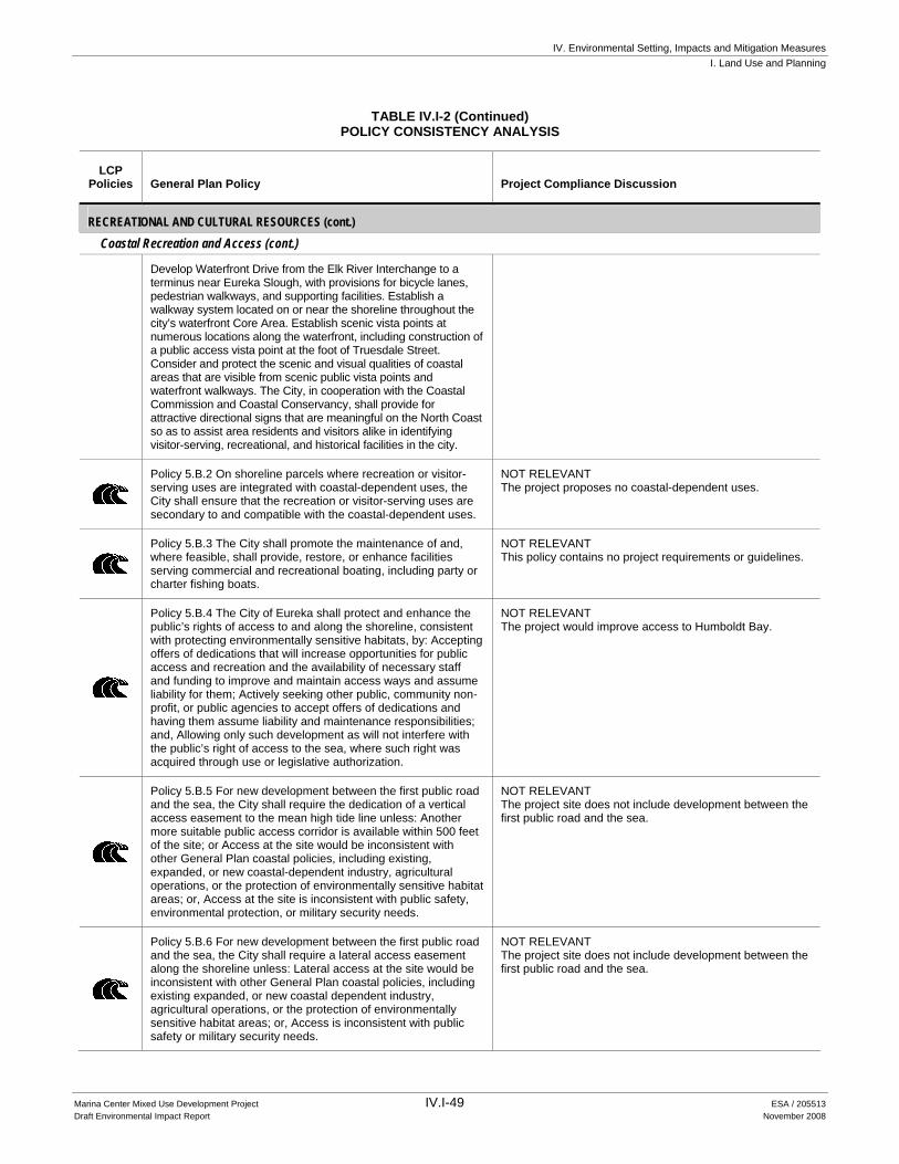
IV. Environmental Setting, Impacts and Mitigation Measures I. Land Use and Planning
Marina Center Mixed Use Development Project IV.I-49 ESA / 205513 Draft Environmental Impact Report November 2008
TABLE IV.I-2 (Continued) POLICY CONSISTENCY ANALYSIS
LCP Policies General Plan Policy Project Compliance Discussion
RECREATIONAL AND CULTURAL RESOURCES (cont.) Coastal Recreation and Access (cont.)
Develop Waterfront Drive from the Elk River Interchange to a terminus near Eureka Slough, with provisions for bicycle lanes, pedestrian walkways, and supporting facilities. Establish a walkway system located on or near the shoreline throughout the city’s waterfront Core Area. Establish scenic vista points at numerous locations along the waterfront, including construction of a public access vista point at the foot of Truesdale Street. Consider and protect the scenic and visual qualities of coastal areas that are visible from scenic public vista points and waterfront walkways. The City, in cooperation with the Coastal Commission and Coastal Conservancy, shall provide for attractive directional signs that are meaningful on the North Coast so as to assist area residents and visitors alike in identifying visitor-serving, recreational, and historical facilities in the city.
Policy 5.B.2 On shoreline parcels where recreation or visitor-serving uses are integrated with coastal-dependent uses, the City shall ensure that the recreation or visitor-serving uses are secondary to and compatible with the coastal-dependent uses.
NOT RELEVANT The project proposes no coastal-dependent uses.
Policy 5.B.3 The City shall promote the maintenance of and, where feasible, shall provide, restore, or enhance facilities serving commercial and recreational boating, including party or charter fishing boats.
NOT RELEVANT This policy contains no project requirements or guidelines.
Policy 5.B.4 The City of Eureka shall protect and enhance the public’s rights of access to and along the shoreline, consistent with protecting environmentally sensitive habitats, by: Accepting offers of dedications that will increase opportunities for public access and recreation and the availability of necessary staff and funding to improve and maintain access ways and assume liability for them; Actively seeking other public, community non-profit, or public agencies to accept offers of dedications and having them assume liability and maintenance responsibilities; and, Allowing only such development as will not interfere with the public’s right of access to the sea, where such right was acquired through use or legislative authorization.
NOT RELEVANT The project would improve access to Humboldt Bay.
Policy 5.B.5 For new development between the first public road and the sea, the City shall require the dedication of a vertical access easement to the mean high tide line unless: Another more suitable public access corridor is available within 500 feet of the site; or Access at the site would be inconsistent with other General Plan coastal policies, including existing, expanded, or new coastal-dependent industry, agricultural operations, or the protection of environmentally sensitive habitat areas; or, Access at the site is inconsistent with public safety, environmental protection, or military security needs.
NOT RELEVANT The project site does not include development between the first public road and the sea.
Policy 5.B.6 For new development between the first public road and the sea, the City shall require a lateral access easement along the shoreline unless: Lateral access at the site would be inconsistent with other General Plan coastal policies, including existing expanded, or new coastal dependent industry, agricultural operations, or the protection of environmentally sensitive habitat areas; or, Access is inconsistent with public safety or military security needs.
NOT RELEVANT The project site does not include development between the first public road and the sea.

IV. Environmental Setting, Impacts and Mitigation Measures I. Land Use and Planning
Marina Center Mixed Use Development Project IV.I-50 ESA / 205513 Draft Environmental Impact Report November 2008
TABLE IV.I-2 (Continued) POLICY CONSISTENCY ANALYSIS
LCP Policies General Plan Policy Project Compliance Discussion
RECREATIONAL AND CULTURAL RESOURCES (cont.) Coastal Recreation and Access (cont.)
Policy 5.B.7 The City shall establish a coordinated continuous public access system throughout its Coastal Zone, consisting of pedestrian walkways, nature walks, and bikeways with necessary support facilities, as described in Table 5-2 and shown in Figure 5-1.
CONSISTENT See discussion for Goal 5.A.
Policy 5.B.8 The City shall enforce the access standards and recommendations contained in the State Coastal Conservancy/Coastal Commission Report on Coastal Access (revised August 1980) as the criteria for improvement, maintenance, and management of accessways and supporting facilities proposed in this General Plan. Special attention in design and construction of accessways shall be given to minimizing maintenance requirements given the North Coast climate and to minimizing the possibilities of vandalism. Where public accessways or vista points are located near environmentally sensitive habitat areas, attractive barriers shall be provided to preclude disturbance of natural areas by off-road or all-terrain vehicles.
CONSISTENT The project would establish a buffer around the wetland preserve area that would be adequate to protect the resources of the habitat area and would incorporate attractively designed and strategically located barriers and informational signs to prevent intrusion into the wetland (see Section IV.D, Biological Resources Mitigation Measure D-3c.)
Policy 5.B.9 The City shall ensure that public access support facilities are distributed throughout the Eureka Coastal Zone. Off-street parking shall be provided in the waterfront area; however, it shall not be located immediately adjacent to the shoreline, unless there is no feasible alternative.
CONSISTENT The project would provide off-street parking in the waterfront area. The project would not propose parking immediately adjacent to the shoreline.
Policy 5.B.10 To the maximum extent feasible, the City shall ensure universal public access to the waterfront, including support facilities.
CONSISTENT The project would improve access to Humboldt Bay, the adjacent marina and boardwalk through the project’s extension of Fourth Street and creation of a pedestrian/biking path adjacent to Waterfront Drive.
Policy 5.B.11 The City shall participate in the development of a facility for the Humboldt Bay Rowers Association on the waterfront.
NOT RELEVANT This policy contains no project requirements or guidelines.
Table 5-2 COASTAL ZONE PUBLIC ACCESS
Recreation Services
Goal 5.C To ensure that a range of recreation services, activities, and programs are offered which provide a desirable quality of life for all citizens of Eureka.
NOT RELEVANT This policy contains no requirement for a proposed project.
Policy 5.C.1 The City shall consider the needs of all age groups, abilities, disabilities, and special interest groups in its park, recreation, and community services planning.
NOT RELEVANT This policy contains no requirement for a proposed project.
Policy 5.C.2 The City shall encourage and support agencies that actively provide recreation and community services programs and activities.
NOT RELEVANT This policy contains no requirement for a proposed project.
Policy 5.C.3 The City shall ensure that a mechanism is in place to provide opportunities for participation by economically disadvantaged families and individuals.
NOT RELEVANT This policy contains no requirement for a proposed project.

IV. Environmental Setting, Impacts and Mitigation Measures I. Land Use and Planning
Marina Center Mixed Use Development Project IV.I-51 ESA / 205513 Draft Environmental Impact Report November 2008
TABLE IV.I-2 (Continued) POLICY CONSISTENCY ANALYSIS
LCP Policies General Plan Policy Project Compliance Discussion
RECREATIONAL AND CULTURAL RESOURCES (cont.) Recreation Services (cont.)
Policy 5.C.4 The City shall provide supervision of park areas to protect the rights of the users of the parks and reduce vandalism and will work with law enforcement agencies to eliminate crime at parks and recreations facilities.
NOT RELEVANT This policy contains no requirement for a proposed project.
Policy 5.C.5 The City shall provide an ongoing emphasis on youth programs and services, especially those that provide positive educational and social influences for youth at risk for illegal, anti-social, or unhealthy behaviors.
NOT RELEVANT This policy contains no requirement for a proposed project.
Policy 5.C.6 The City shall ensure a wide range of services, activities, and programs reflecting the cultural diversity of the community.
NOT RELEVANT This policy contains no requirement for a proposed project.
Policy 5.C.7 The City shall ensure the provision of services and programs designed for physically and mentally challenged citizens, and make reasonable accommodations for the participation of such individuals in City programs.
NOT RELEVANT This policy contains no requirement for a proposed project.
Policy 5.C.8 The City shall provide opportunities for citizen input and participation in the planning of recreation and community services programs and activities.
NOT RELEVANT This policy contains no requirement for a proposed project.
Arts and Culture
Goal 5.D To promote development and programs that meet the artistic and cultural needs of the Eureka community.
NOT RELEVANT This policy contains no project requirements or guidelines.
Policy 5.D.1 the City shall establish the Core Area as the city’s and region’s focal point for entertainment, cultural, and community activities.
NOT RELEVANT The project site is not within the City’s “Core Area”.
Policy 5.D.2 The City shall continue to support the local arts community through its participation in the Cultural Arts Resource District, the Phantom Art Gallery program, and similar programs.
NOT RELEVANT This policy contains no requirement for a proposed project.
Policy 5.D.3 The City shall support efforts to establish a performing arts-theater center in the area bounded by Sixth and Seventh and E and F Streets.
NOT RELEVANT This policy relates to specific areas outside of the project site.
Policy 5.D.4 The City shall actively support the establishment of a community center in the downtown area to meet both the civic and cultural needs of the community.
NOT RELEVANT This policy contains no project requirements or guidelines.
Policy 5.D.5 The City shall encourage coordination among local arts and cultural groups and events to expand their appreciation by the community.
NOT RELEVANT This policy contains no requirement for a proposed project.
Policy 5.D.6 The City shall encourage the development of entertainment, recreational, and cultural activities for youth.
NOT RELEVANT This policy contains no requirement for a proposed project.
Historic Preservation
Goal 5.E To preserve and enhance the historical features of the Eureka area.
NOT RELEVANT There are no state or federally listed historical resources on the project site or in the immediate vicinity. The project site is not within a designated historic district.
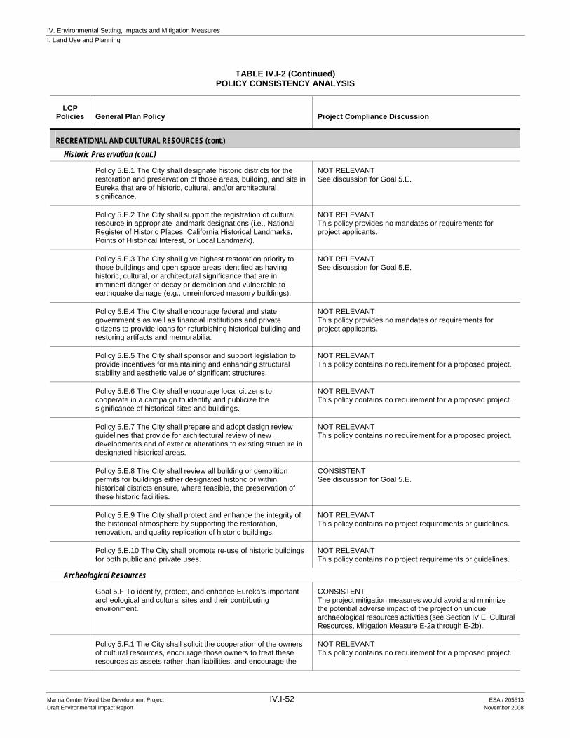
IV. Environmental Setting, Impacts and Mitigation Measures I. Land Use and Planning
Marina Center Mixed Use Development Project IV.I-52 ESA / 205513 Draft Environmental Impact Report November 2008
TABLE IV.I-2 (Continued) POLICY CONSISTENCY ANALYSIS
LCP Policies General Plan Policy Project Compliance Discussion
RECREATIONAL AND CULTURAL RESOURCES (cont.) Historic Preservation (cont.)
Policy 5.E.1 The City shall designate historic districts for the restoration and preservation of those areas, building, and site in Eureka that are of historic, cultural, and/or architectural significance.
NOT RELEVANT See discussion for Goal 5.E.
Policy 5.E.2 The City shall support the registration of cultural resource in appropriate landmark designations (i.e., National Register of Historic Places, California Historical Landmarks, Points of Historical Interest, or Local Landmark).
NOT RELEVANT This policy provides no mandates or requirements for project applicants.
Policy 5.E.3 The City shall give highest restoration priority to those buildings and open space areas identified as having historic, cultural, or architectural significance that are in imminent danger of decay or demolition and vulnerable to earthquake damage (e.g., unreinforced masonry buildings).
NOT RELEVANT See discussion for Goal 5.E.
Policy 5.E.4 The City shall encourage federal and state government s as well as financial institutions and private citizens to provide loans for refurbishing historical building and restoring artifacts and memorabilia.
NOT RELEVANT This policy provides no mandates or requirements for project applicants.
Policy 5.E.5 The City shall sponsor and support legislation to provide incentives for maintaining and enhancing structural stability and aesthetic value of significant structures.
NOT RELEVANT This policy contains no requirement for a proposed project.
Policy 5.E.6 The City shall encourage local citizens to cooperate in a campaign to identify and publicize the significance of historical sites and buildings.
NOT RELEVANT This policy contains no requirement for a proposed project.
Policy 5.E.7 The City shall prepare and adopt design review guidelines that provide for architectural review of new developments and of exterior alterations to existing structure in designated historical areas.
NOT RELEVANT This policy contains no requirement for a proposed project.
Policy 5.E.8 The City shall review all building or demolition permits for buildings either designated historic or within historical districts ensure, where feasible, the preservation of these historic facilities.
CONSISTENT See discussion for Goal 5.E.
Policy 5.E.9 The City shall protect and enhance the integrity of the historical atmosphere by supporting the restoration, renovation, and quality replication of historic buildings.
NOT RELEVANT This policy contains no project requirements or guidelines.
Policy 5.E.10 The City shall promote re-use of historic buildings for both public and private uses.
NOT RELEVANT This policy contains no project requirements or guidelines.
Archeological Resources
Goal 5.F To identify, protect, and enhance Eureka’s important archeological and cultural sites and their contributing environment.
CONSISTENT The project mitigation measures would avoid and minimize the potential adverse impact of the project on unique archaeological resources activities (see Section IV.E, Cultural Resources, Mitigation Measure E-2a through E-2b).
Policy 5.F.1 The City shall solicit the cooperation of the owners of cultural resources, encourage those owners to treat these resources as assets rather than liabilities, and encourage the
NOT RELEVANT This policy contains no requirement for a proposed project.

IV. Environmental Setting, Impacts and Mitigation Measures I. Land Use and Planning
Marina Center Mixed Use Development Project IV.I-53 ESA / 205513 Draft Environmental Impact Report November 2008
TABLE IV.I-2 (Continued) POLICY CONSISTENCY ANALYSIS
LCP Policies General Plan Policy Project Compliance Discussion
RECREATIONAL AND CULTURAL RESOURCES (cont.) Archeological Resources (cont.)
support of the general public for the preservation and enhancement of these resources.
Policy 5.F.2 The City shall solicit the views of the Native American Heritage Commission and/or the local Native American community in cases where development may result in disturbance to sites containing evidence of Native American activity and/or to sites of cultural importance.
CONSISTENT The project applicant agrees to arrange for a Native American representative to monitor coring activities (see Section IV.E, Cultural Resources, Mitigation Measure E-2a).
Policy 5.F.3 The City shall coordinate with Humboldt County to promote the preservation and maintenance of archaeological resources in the Planning Area.
CONSISTENT See discussion for Goal 5.F.
Policy 5.F.4 The City shall use, where feasible, incentive programs to assist private property owners in preserving and enhancing cultural resources.
NOT RELEVANT This policy contains no requirement for a proposed project.
Policy 5.F.5 The City shall require that discretionary development projects identify and protect from damage, destruction, and abuse, important historical, archaeological, and cultural sites and their contributing environment. Such assessments shall be incorporated into a citywide cultural resource data base.
CONSISTENT See discussion for Goal 5.F.
Policy 5.F.6 The City shall require that discretionary development projects are designed to avoid potential impacts to significant cultural resources whenever feasible. Unavoidable impacts, whenever feasible, shall be reduced to a less-than-significant level and/or shall be mitigated by extracting maximum recoverable data. Determinations of impacts, significance, and mitigation shall be made by qualified archaeological or historical consultants, depending on the type of resource in question.
CONSISTENT See discussion for Goal 5.F.
Policy 5.F.7 The City shall, within its power, maintain confidentiality regarding the locations of archaeological sites in order to preserve and protect these resources from vandalism and the unauthorized removal of artifacts.
NOT RELEVANT This policy contains no directive for a project applicant.
Policy 5.F.8 The City shall consider acquisition programs as a means of preserving significant cultural resources that are not suitable for private development. Organizations that could provide assistance in this area include, but are not limited to, the Archaeological Conservancy the Nature Conservancy.
NOT RELEVANT This policy contains no directive for a project applicant.
NATURAL RESOURCES Aquatic Resources and Marine, Wetland, and Riparian Habitat
Goal 6.A To protect and enhance the natural qualities of the Eureka area’s aquatic resources and to preserve the area’s valuable marine, wetland, and riparian habitat.
CONSISTENT The project would restore the quantity of wetlands on the site and would enhance the quality of Clark Slough and associated wetlands. See Section IV.D, Biological Resources, Impact D-3, and Table IV.D-2, Wetland Functions and Values to Result From Implementing the Wetlands Restoration /Mitigation Plan.
IV. Environmental Setting, Impacts and Mitigation Measures I. Land Use and Planning
Marina Center Mixed Use Development Project IV.I-54 ESA / 205513 Draft Environmental Impact Report November 2008
TABLE IV.I-2 (Continued) POLICY CONSISTENCY ANALYSIS
LCP Policies General Plan Policy Project Compliance Discussion
NATURAL RESOURCES (cont.) Aquatic Resources and Marine, Wetland, and Riparian Habitat (cont.)
Policy 6.A.1 The City shall maintain, enhance, and, where feasible, restore valuable aquatic resources, with special protection given to areas and species of special biological or economic significance. The City shall require that uses of the marine environment are carried out in the manner that will sustain the biological productivity of coastal waters and that will maintain health populations of all species of marine organisms adequate for long-term commercial, recreational, scientific, and educational purposes.
CONSISTENT The project would restore the quantity of wetlands on the site and would enhance the quality of Clark Slough and associated wetlands. See Section IV.D, Biological Resources, Impact D-3, and Table IV.D-2, Wetland Functions and Values to Result From Implementing the Wetlands Restoration /Mitigation Plan.
Policy 6.A.2 The City shall establish a comprehensive wetland management program that includes all of Eureka’s restored and natural wetland areas.
NOT RELEVANT This policy contains no requirement for a proposed project.
Policy 6.A.3 The City shall maintain and, where feasible, restore biological productivity and the quality of coastal waters, streams, wetlands, and estuaries appropriate to maintain optimum populations of aquatic organisms and for the protection of human health through, among other means, minimizing adverse effects of wastewater and stormwater discharges and entrainment, controlling the quantity and quality of runoff, preventing depletion of groundwater supplies and substantial interference with surface water flow, encouraging wastewater reclamation, maintaining natural vegetation buffer areas that protect riparian habitats, and minimizing alteration of natural streams.
CONSISTENT The project would maintain the quantity of wetlands on the site and would enhance the quality of Clark Slough and associated wetlands. See Section IV.D, Biological Resources, Impact discussion D-3, and Table IV.D-2, Wetland Functions and Values to Result From Implementing the Wetlands Restoration /Mitigation Plan. See also Mitigation Measures D-1a-D-1b. Additionally the project would implement Best Management Practices set forth in Section IV.H. Hydrology and Water Quality Impact discussion H-1 thru H-3 to minimize adverse effects of wastewater and stormwater discharges as well as entrainment, and otherwise controlling the quantity and quality of runoff.
Policy 6.A.4 The City shall require that channelizations or other substantial alterations that could significantly disrupt the habitat values of rivers and streams incorporate the best mitigation measures feasible. Such channelizations and alterations shall be limited to the following: Flood control projects where no other method for protecting existing structure in the floodplain is feasible and where such protection is necessary for public safety or to protect existing development; Developments where the primary function is the improvement of fish and wildlife habitat.
CONSISTENT The project would enhance the quality of Clark Slough and associated wetlands which in their current state are highly degraded and offer little habitat or biological value. See Section IV.D, Biological Resources, Impact discussion D-3, and Table IV.D-2, Wetland Functions and Values to Result From Implementing the Wetlands Restoration /Mitigation Plan. See also Mitigation Measures D-1a-D-1b.
Policy 6.A.5 The City shall permit revetments, breakwaters, groins, harbor channels, seawalls, cliff retaining walls, and other such construction that alters natural shoreline processes only when required to serve coastal-dependent uses or to protect existing structures or public beaches in danger from erosion.
NOT RELEVANT The project does not have any shoreline areas and therefore proposes no revetments, breakwaters, etc.
Policy 6.A.6 The City declares the following to be environmentally sensitive habitat areas within the Coastal Zone: Rivers, creeks, sloughs, gulches and associated riparian habitats, including but not limited to Eureka Slough, Fay Slough, Cut-Off Slough, Freshwater Slough, Cooper Slough, Second Slough, Third Slough, Martin Slough, Ryan Slough, Swain Slough, and Elk River. Wetlands and estuaries, including that portion of Humboldt Bay within the City’s jurisdiction, riparian areas, and vegetated dunes. Indian Island, Daby Island, and the Woodley Island wildlife area. Other unique habitat areas, such as waterbird rookeries, and habitat for all rare or endangered species on state or federal lists. Grazed or farmed wetlands (i.e., diked former tidelands).
NOT RELEVANT This policy contains no project requirements or guidelines.

IV. Environmental Setting, Impacts and Mitigation Measures I. Land Use and Planning
Marina Center Mixed Use Development Project IV.I-55 ESA / 205513 Draft Environmental Impact Report November 2008
TABLE IV.I-2 (Continued) POLICY CONSISTENCY ANALYSIS
LCP Policies General Plan Policy Project Compliance Discussion
NATURAL RESOURCES (cont.) Aquatic Resources and Marine, Wetland, and Riparian Habitat (cont.)
Policy 6.A.7 Within the Coastal Zone, the City shall ensure that environmentally sensitive habitat areas are protected against any significant disruption of habitat values, and that only uses dependent on such resources shall be allowed within such areas. The City shall require that development in areas adjacent to environmentally sensitive habitat areas be sited and designed to prevent impacts which would significantly degrade such areas, and be compatible with the continuance of such habitat areas.
CONSISTENT The proposed project would result in an improvement of wetland habitat values. It would involve creation of an estuarine wetland preserve, which would be entirely “dependent upon,” and sited within, a wetland area. Once restored, the wetland preserve area would constitute an environmentally sensitive habitat area.
As discussed in Section IV.D, Biological Resources, the associated development would be designed to prevent adverse impacts to the adjacent wetland area and would be compatible with the continuance of a healthy, functioning wetland within the Nature Reserve area.
See Section IV.D, Biological Resources, Impact discussion D-3 and associated Mitigation Measures.
Policy 6.A.8 Within the Coastal Zone, prior to approval of a development, the City shall require that all development on lots or parcels designated NR (Natural Resources) on the Land Use Diagram or within 250 feet of such designation, or development potentially affecting an environmentally sensitive habitat area, shall be found to be in conformity with the applicable habitat protection policies of the General Plan. All development plans, drainage plans, and grading plans submitted as part of an application shall show the precise location of the habitat(s) potentially affected by the proposed project and the manner in which they will be protected, enhanced or restored.
NOT RELEVANT The proposed project would not propose development on or near any lot or parcel currently designated NR.
Policy 6.A.9 The City shall permit the diking, filling, or dredging of open coastal waters, wetlands, or estuaries only under the following conditions: The diking, filling or dredging is for a permitted use in that resource area; There is no feasible, less environmentally damaging alternative; Feasible mitigation measures have been provided to minimize adverse environmental effects; The functional capacity of the resource area is maintained or enhanced.
CONSISTENT Creation of an estuarine wetland reserve, as proposed by the project, would provide significant water quality and habitat benefits to the coastal ecosystem, and create a net environmental improvement. As discussed in the Section IV.D, Biological Resources, the project would include feasible measures to minimize adverse environmental effects and maximize the resource value of the restored wetlands. The functional capacity of the wetlands would be enhanced as described in Section IV.D, Biological Resources, Impact discussion D-3.
Policy 6.A.10 The City shall support dredging and spoils disposal to avoid significant disruption to aquatic and wildlife habitats and water circulation.
NOT RELEVANT The project proposes no dredging or disposal of spoils.
Policy 6.A.11 The City shall require that diking, filling or dredging of a wetland or estuary maintain or enhance the functional capacity of these resources. Functional capacity means the ability of the wetland or estuary to be self-sustaining and to maintain natural species diversity. In order to establish that the functional capacity is being maintained, all of the following must be demonstrated. Presently-occurring plant and animal populations in the ecosystem will not be altered in a manner that would impair the long-term stability of the ecosystem, i.e., natural species diversity, abundance and composition are essentially unchanged as the result of the project; A species that is rare, threatened, or endangered will not be significantly adversely affected; and Consumptive (e.g.,
CONSISTENT The proposed project would enhance the functional capacity of the wetlands on the project. See Section IV.D, Biological Resources, Impact D-3, and Table IV.D-2, Wetland Functions and Values to Result From Implementing the Wetlands Restoration /Mitigation Plan. As discussed in Section IV.D, Biological Resources, Impact D-1, no special status species would be significantly adversely affected by the proposed project. Nonconsumptive values of the wetland/estuary ecosystem would be increased. There would be both better access to the wetland resource (bicycle/pedestrian path/extension of Fourth and Second Streets) and better protection for the wetland resource (buffers).

IV. Environmental Setting, Impacts and Mitigation Measures I. Land Use and Planning
Marina Center Mixed Use Development Project IV.I-56 ESA / 205513 Draft Environmental Impact Report November 2008
TABLE IV.I-2 (Continued) POLICY CONSISTENCY ANALYSIS
LCP Policies General Plan Policy Project Compliance Discussion
NATURAL RESOURCES (cont.) Aquatic Resources and Marine, Wetland, and Riparian Habitat (cont.)
fishing, aquaculture and hunting) or nonconsumptive (e.g., water quality and research opportunity) values of the wetland or estuary ecosystem will not be significantly reduced.
Policy 6.A.12 The City shall require that dredging, when consistent with the provisions of this General Plan or other adopted City regulations and where necessary for the maintenance of the tidal flow and continued viability of the wetland habitat or for flood control purposes, shall be subject to the following conditions: Dredging shall be prohibited in breeding and nursery areas and during periods of fish migration and spawning. Dredging shall be limited to the smallest area feasible. Designs for dredging and excavation projects shall include protective measures such as silt curtains, weirs, etc., to protect water quality in adjacent areas during construction by preventing the discharge of refuse, petroleum spills, and unnecessary dispersal of silt materials.
NOT RELEVANT The project proposes no dredging.
Policy 6.A.13 The City shall require that diking or filling of a wetland that is otherwise in accordance with the policies of this General Plan, shall, at a minimum, require the following mitigation measures: A detailed restoration plan shall be required as part of the project application for each specific restoration site. The restoration plan shall include provisions for purchase, if required, and restoration of an equivalent area of equal or greater biological productivity, and dedication of the land to a public agency or other method which permanently restricts the use of the site to habitat and open space purposes. The restoration site shall be purchased or otherwise made available prior to any permitted diking or filling. Areas adequate to maintain functional capacity shall be opened to tidal action or other sources of surface water shall be provided. This provision shall apply to diked or filled areas which themselves are not environmentally sensitive habitat areas, but would become so if, as part of a restoration program, they are opened to tidal action or provided other sources of surface water. All of the provisions for restoration, purchase (if necessary), and dedication described under item a. of this policy shall apply to any program or activity performed pursuant to this policy. Mitigation shall, to the maximum extent feasible, be of the same ty7pe as the wetland to be filled (i.e., freshwater marsh for freshwater marsh, saltwater marsh for saltwater marsh, etc.). Where no suitable private or public restoration or enhancement sites are available, an in-lieu fee may be required to be paid to an appropriate public agency for use in the restoration or enhancement of an area of equivalent productive value or surface area.
CONSISTENT The proposed project would provide the requisite restoration plan, conservation easements and/or other required mitigation. See Section IV.D, Biological Resources, Impact D-3.
Policy 6.A.14 Consistent with all other applicable policies of this General Plan, the City shall limit development or uses within wetlands that are neither farmed nor grazed, or within estuaries, to the following: Port facilities. Energy facilities. Coastal-dependent industrial facilities, including commercial fishing facilities. Maintenance of existing or restoration of previously dredged depths in navigation channels, turning basins, vessel berthing and mooring areas, and boat launching ramps. Incidental public service purposes which temporarily impact the resources of the area, such as burying cables or pipes,
POTENTIALLY INCONSISTENT The project proposes locating development on existing brownfield property that has scattered degraded wetlands. Although a portion of the project would involve restoration (a permissible use under 6.A.14.f.), some of the non-restoration development would be located in existing degraded wetlands. The General Plan currently designates the site as appropriate for non-coastal-dependent land uses (see Section IV.D, Biological Resources, for a detailed discussion).

IV. Environmental Setting, Impacts and Mitigation Measures I. Land Use and Planning
Marina Center Mixed Use Development Project IV.I-57 ESA / 205513 Draft Environmental Impact Report November 2008
TABLE IV.I-2 (Continued) POLICY CONSISTENCY ANALYSIS
LCP Policies General Plan Policy Project Compliance Discussion
NATURAL RESOURCES (cont.) Aquatic Resources and Marine, Wetland, and Riparian Habitat (cont.)
inspection of piers, and maintenance of existing intake and outfall lines. Restoration projects. Nature study, aquaculture, or similar resource-dependent activities. New or expanded boating facilities in estuaries, consistent with the demand for such facilities. Placement of structural piling for public recreational piers that provide public access and recreational opportunities.
Policy 6.A.15 The City shall limit uses and development in grazed or farmed wetlands to the following: Agricultural operations limited to accessory structures, apiaries, field and truck crops, livestock raising, greenhouses (provided they are not located on slab foundations and crops are grown in the existing soil on site), and orchards; Farm-related structures, including barns, sheds, and farmer-occupied housing, necessary for the performance of agricultural operations. Such structures may be located on an existing grazed or farmed wetland parcel only if no alternative upland location is available for such purpose and the structured are sited and designed to minimize adverse environmental effects on the farmed wetland. No more than one permanent residential structure per parcel shall be allowed. Restoration projects, including the PALCO on-site restoration and enhancement program. Nature study, aquaculture, and similar resource-dependent activities; and, Incidental public service purposes which may temporarily impact the resources of the area, such as burying cables or pipes.
NOT RELEVANT The project site contains no grazed or farmed wetlands. The project does not propose development in coastal waters, alteration of any stream or river, or placement of fill for repair or maintenance.
Policy 6.A.16 Consistent with all other applicable policies of this General Plan, the City shall limit uses within open coastal waters to the following: Port facilities. Energy facilities. Coastal-dependent industrial facilities, including commercial fishing facilities. Maintenance of existing or restoration of previously dredged depths in navigation channels, turning basins, vessel berthing and mooring areas, and boat launching ramps. Incidental public service purposes which temporarily impact the resources of the area, such as burying cables or pipes, inspection of piers, and maintenance of existing intake and outfall lines. Restoration projects. Nature study, aquaculture, or similar resource-dependent activities. New or expanded boating facilities. Placement of structural piling for public recreational piers that provide public access and recreational opportunities.
NOT RELEVANT See discussion for Policy 6.A.15.
Policy 6.A.17 The City shall require that any uses that involve substantial alterations of streams and rivers incorporate the best mitigation measures feasible and shall be limited to the following: Flood control projects where no other method for protecting existing structures in the flood plain is feasible and where such protection is necessary for public safety or to protect development. Development where the primary function if the improvement of fish and wildlife habitat.
NOT RELEVANT See discussion for Policy 6.A.15.
Policy 6.A.18 The City may permit new fill for repair and maintenance purposes on lands adjacent to the previously filled northern waterfront provided that it is consistent with other General Plan policies and where all of the following apply: Fill will be placed in previously filled areas which have been subject to erosion; Fill will not be placed beyond the existing bulkhead
NOT RELEVANT See discussion for Policy 6.A.15.

IV. Environmental Setting, Impacts and Mitigation Measures I. Land Use and Planning
Marina Center Mixed Use Development Project IV.I-58 ESA / 205513 Draft Environmental Impact Report November 2008
TABLE IV.I-2 (Continued) POLICY CONSISTENCY ANALYSIS
LCP Policies General Plan Policy Project Compliance Discussion
NATURAL RESOURCES (cont.) Aquatic Resources and Marine, Wetland, and Riparian Habitat (cont.)
line; Fill is necessary to protect existing development, coastal-dependent uses, or redeveloped areas from erosion; Fill will not interfere with commercial fishing activities and facilities; and Placement of the fill is consistent with the coastal public access policies of the General Plan.
Policy 6.A.19 The City shall require establishment of a buffer for permitted development adjacent to all environmentally sensitive areas. The minimum width of a buffer shall be 100 feet, unless the applicant for the development demonstrates on the basis of site specific information, the type and size of the proposed development, and/or proposed mitigation (such as planting of vegetation) that will achieve the purpose(s) of the buffer, that a smaller buffer will protect the resources of the habitat area. As necessary to protect the environmentally sensitive area, the City may require a buffer greater than 100 feet. The Buffer shall be measured horizontally from the edge of the environmental sensitive area nearest the proposed development to the edge of the development nearest to the environmentally sensitive area. Maps and supplemental information submitted as part of the application shall be used to specifically define these boundaries.
CONSISTENT The project proposes a buffer that would be adequate to protect the proposed wetland preserve area as described in Section IV.D, Biological Resources, Impact D-3.
Policy 6.A.20 To protect urban wetlands against physical intrusion, the City shall require that wetland buffer areas incorporate attractively designed and strategically located barriers and informational signs.
CONSISTENT As described in discussion of Impact D-3, the proposed buffer incorporates willows, blackberry bushes, slopes, signs, and other barriers to prevent intrusion into the wetland preserve.
Policy 6.A.21 The City shall require that all land use activities adjacent to gulch greenways be carried out in a manner that avoids vegetative removal below the break in slope (usually those areas with a slope of 20 percent or greater) and that does not alter natural land forms and drainage patterns.
NOT RELEVANT The project site is not adjacent to gulch greenways.
Policy 6.A.22 The City shall maintain Indian Island as a site for habitat, scientific research and education. Existing uses may be maintained but shall not be expanded, except that reburial of Native American remains shall be permitted as part of the mitigation for coastal-dependent industrial development elsewhere in the Planning area.
NOT RELEVANT The project site is not adjacent to Indian Island.
Policy 6.A.23 The City, in consultation with the Department of Fish and Game, Coastal Conservancy, Coastal Commission, Humboldt County, Humboldt Bay Harbor, Recreation, and conservation District, affected landowners, and other interested parties shall prepare a detailed, implementable wetlands management, restoration and enhancement program consistent with the provisions of this General Plan. The objectives of the program shall be to enhance the biological productivity of wetlands; to minimize or eliminate conflicts between wetlands and adjacent urban uses; to provide stable boundaries and buffers between urban and habitat areas; to provide restoration areas, including the City-owned lands on the Elk River Spit that may benefit from restoration and enhancement, to serve as mitigation in conjunction with future projects that may include wetland areas. Upon completion, the wetlands management and restoration program created by this policy shall be submitted to the Coastal Commission for review and approval.
NOT RELEVANT This policy provides no mandates or requirements for project applicants.

IV. Environmental Setting, Impacts and Mitigation Measures I. Land Use and Planning
Marina Center Mixed Use Development Project IV.I-59 ESA / 205513 Draft Environmental Impact Report November 2008
TABLE IV.I-2 (Continued) POLICY CONSISTENCY ANALYSIS
LCP Policies General Plan Policy Project Compliance Discussion
NATURAL RESOURCES (cont.) Aquatic Resources and Marine, Wetland, and Riparian Habitat (cont.)
Policy 6.A.24 Within the Coastal Zone, where there is a question regarding the boundary, buffer requirements, location, or current status of an environmentally sensitive area identified pursuant to the policies of this General Plan, the City shall require the applicant to provide the City with the following: Base map delineating topographic lines, adjacent roads, location of dikes, levees, of flood control channels and tide gates, as applicable; Vegetation map, including identification of species that may indicate the existence or non-existence of the sensitive environmental habitat area; Soils map delineating hydric and non-hydric soils; and Census of animal species that may indicate the existence or non-existence of the sensitive environmental habitat area. The City shall transmit the information provided by the applicant pursuant to this policy to the Department of Fish and Game for review and comment. Any comments and recommendations provided by the Department shall be immediately sent to the applicant for his or her response. The City shall make its decision concerning the boundary, location, or current status of the environmentally sensitive habitat area in question based on the substantial evidence in the record and shall adopt findings to support its actions.
CONSISTENT The project applicant will provide all requested documentation
Agricultural Preservation
Goal 6.B To protect agricultural lands for their resource, aesthetic, and economic values.
NOT RELEVANT There is no agricultural land on the project site.
Policy 6.B.1 The City shall not approve non-agricultural development on agricultural lands with Class I or Class II soils within the Planning Area.
NOT RELEVANT There is no agricultural land on the project site.
Policy 6.B.2 The City shall require the retention in agricultural use of agricultural lands within the Coastal Zone with soils other than Classes I or II in agricultural use, except under the following conditions: Continued or renewed agricultural use is demonstrated to be infeasible, Conversion to urban uses would locate development within, contiguous with, or in close proximity to, existing developed areas, or Farmed wetlands are proposed and funded through a wetland management and restoration program for restoration of resource-dependent activities.
NOT RELEVANT There is no agricultural land on the project site.
Policy 6.B.3 The City shall limit uses in grazed or farmed wetlands to the following: Agricultural operations (except for greenhouses on slab foundations). Farm-related structures (including barns, sheds, and farmer-occupied housing) necessary for the continuance of the agricultural operation. Such structures may be located on an existing grazed or farmed wetland parcel only if no alternative upland location is available for such purpose and the structures are sited and designed to minimize the adverse environmental effects on the farmed wetland. No more than one primary residential structure per parcel shall be allowed. Restoration and enhancement projects. Nature study, aquaculture, and similar resource-dependent activities. Incidental public service purposes which may temporarily impact the resources of the area, such as burying cable and pipes.
NOT RELEVANT There is no agricultural land on the project site.

IV. Environmental Setting, Impacts and Mitigation Measures I. Land Use and Planning
Marina Center Mixed Use Development Project IV.I-60 ESA / 205513 Draft Environmental Impact Report November 2008
TABLE IV.I-2 (Continued) POLICY CONSISTENCY ANALYSIS
LCP Policies General Plan Policy Project Compliance Discussion
NATURAL RESOURCES (cont.) Agricultural Preservation (cont.)
Policy 6.B.4 The City shall ensure that expansion of public services and public service facilities, which is otherwise consistent with the provisions of this General Plan, does not reduce agricultural viability through increased assessment costs.
NOT RELEVANT There is no agricultural land on the project site.
Policy 6.B.5 Consistent with the Coastal Act (California Resources Code Section 3025(a)), the City shall prohibit land division of existing agriculturally-designated land within the Coastal Zone, other than for leases for agricultural uses.
NOT RELEVANT There is no agricultural land on the project site.
Conservation of Open Space
Goal 6.C To support the continued protection of valuable open space resources in and around Eureka.
CONSISTENT The proposed project would protect coastal resources, enhance wetlands on the site and thereby create potential critical habitat in an area that currently affords no habitat values.
Policy. 6.C.1 The City shall preserve vital portions of open-space areas around and within the city in their natural state in order to insure their maintenance as wildlife and fish habitat areas, natural drainage areas, agricultural areas, and areas of passive recreation and outdoor education.
CONSISTENT The project site is considered vacant and underused urban land. As a contaminated brownfield site created from fill, it does not serve as a wildlife or fish habitat area, an effective natural drainage area, an agricultural area, or an area of passive recreation or outdoor education. Consequently, it is not the type of “vital portion” of open space the general plan encourages preserving.
Policy 6.C.2 The City shall protect critical habitat areas and preserve the ecosystem of existing natural areas within the city.
CONSISTENT The proposed project would protect coastal resources through the clean up of environmentally contaminated soils and, enhance wetlands on the site, thereby creating potential critical habitat in an area that currently affords no habitat values.
Policy 6.C.3 The City shall retain open-space needed to provide community and neighborhood identity, efficiency, and amenities; insulate conflicting land uses; and act as a noise barrier between noise-sensitive and excessive noise-generating uses.
CONSISTENT The proposed project would provide a buffer to insulate the wetland preserve area from potential conflicts created by surrounding land uses.
Policy 6.C.4 The City shall coordinate its open space planning, acquisition, and development efforts with those of Humboldt County and regional and state agencies.
NOT RELEVANT This provision contains no directive for a project proponent.
Policy 6.C.5 The City shall prepare and adopt a Gulch Greenway Preservation Plan that identifies and protects the vegetation and habitat in and the hydrologic capacity of Eureka’s gulch greenways. This plan shall include provisions for defining the boundaries of gulch greenways, as generally indicated in Figure 6-1, identifying the boundaries of all affected parcels lying wholely or partly within the gulch greenways, ensuring new development compatible with the environmental and public safety values of the gulch greenways, and restoring gulch vegetation and habitat as appropriate.
NOT RELEVANT This policy relates to a specific area outside the project site.

IV. Environmental Setting, Impacts and Mitigation Measures I. Land Use and Planning
Marina Center Mixed Use Development Project IV.I-61 ESA / 205513 Draft Environmental Impact Report November 2008
TABLE IV.I-2 (Continued) POLICY CONSISTENCY ANALYSIS
LCP Policies General Plan Policy Project Compliance Discussion
NATURAL RESOURCES (cont.) Conservation of Open Space (cont.)
Policy 6.C.6 The City shall permit private property owners adjacent to gulch areas to develop, where appropriate, by utilizing Planned Unit Development (PUD) concepts while ensuring that gulch slopes and bottoms are retained in their natural state and that development does not occur in areas subject to flooding or where slopes exceed 30 percent.
NOT RELEVANT This policy relates to a specific area outside the project site.
Policy 6.C.7 The City shall require that areas of unique historic and scenic quality and areas containing identified critical habitats to be preserved.
CONSISTENT The project site contains neither unique historic or scenic qualities nor identified critical habitat.
Policy 6.C.8 The City shall encourage multiple use of open-space resources consistent with other policies and standards of this General Plan.
CONSISTENT The project proposes use of the restored wetland as both a natural habitat site and an open space/passive recreational use asset.
Timber Resources
Goal 6.D To conserve the Eureka area’s timber resources, enhance the quality and diversity of forest ecosystems, reduce conflicts between forestry and other uses, and encourage a sustained yield of forest products.
NOT RELEVANT There are no timber resources on the project site.
Policy 6.D.1 The City shall work with Humboldt County and the California Department of Forestry and Fire Protection (CDF) to encourage the sustained productive use of timberland as a means of providing open space and conserving other natural resources.
NOT RELEVANT There are no timber resources on the project site.
Policy 6.D.2 The City shall work with Humboldt County and the California Department of Forestry and Fire Protection (CDF) to discourage development that conflicts with timberland management.
NOT RELEVANT There are no timber resources on the project site.
Policy 6.D.3 The City shall encourage and promote the productive use of wood waste generated in the Eureka area.
NOT RELEVANT There are no timber resources on the project site.
Air Quality—General
Goal 6.E To protect and improve air quality in the Eureka area. CONSISTENT This EIR provides the required project-level environmental review and identifies potential air quality impacts and mitigation measures to reduce these potential impacts (see Section IV. C, Air Quality).
Policy 6.E.1 The City shall cooperate with other agencies to develop a consistent and effective approach to air quality planning and management and to develop mitigation measures to minimize stationary and area sources emissions.
NOT RELEVANT This policy provides no mandates or requirements for project applicants.
Policy 6.E.2 The City shall support the North Coast Unified Air Quality Management District in its development of improved ambient air quality monitoring capabilities and the establishment of standards, thresholds, and rules to more adequately address the air quality impacts of new development.
NOT RELEVANT This policy provides no mandates or requirements for project applicants.

IV. Environmental Setting, Impacts and Mitigation Measures I. Land Use and Planning
Marina Center Mixed Use Development Project IV.I-62 ESA / 205513 Draft Environmental Impact Report November 2008
TABLE IV.I-2 (Continued) POLICY CONSISTENCY ANALYSIS
LCP Policies General Plan Policy Project Compliance Discussion
NATURAL RESOURCES (cont.) Air Quality—General (cont.)
Policy 6.E.3 The City shall require project-level environmental review to include identification of potential air quality impacts and designation of design and other appropriate mitigation measures or offset fees to reduce impacts. The City shall work with project proponents and other agencies in identifying, ensuring the implementation of, and monitoring the success of mitigation measures.
CONSISTENT This EIR provides the required project-level environmental review and identifies potential air quality impacts and mitigation measures to reduce these potential impacts (see Section IV. C, Air Quality).
Policy 6.E.4 The City shall submit development proposals to the North Coast Unified Air Quality Management District for review and comment in compliance with CEQA prior to consideration by the Planning Commission and /or City Council.
CONSISTENT The City will comply with this requirement.
Policy 6.E.5 In reviewing project applications with potential for creating air quality impacts, the City shall consider alternatives or amendments that reduce emissions of air pollutants.
CONSISTENT This EIR provides an analysis of four project alternatives that would substantially lessen impacts on air quality (see Chapter VI, Alternatives).
Air Quality—Transportation/Circulation
Goal 6.F To integrate air quality planning with the land use and transportation planning process.
NOT RELEVANT This policy contains no directive for a project applicant.
Policy 6.F.1 The City shall attempt to ensure smooth-flowing traffic conditions for major roadways through planning of traffic signals and traffic signal coordination, parallel roadways, and intra- and inter-neighborhood connections where significant reductions in overall emissions can be achieved.
CONSISTENT The project applicant agrees to develop and implement transportation management programs designed to reduce traffic congestion, and automobile use within and adjacent to the project site in order to reduce total mobile-source emissions (see Section IV.C, Air Quality).
Policy 6.F.2 The City shall continue and, where appropriate, expand the use of synchronized traffic signals to smooth traffic flow and thereby reduce pollutant emissions.
NOT RELEVANT This policy contains no directive for a project applicant.
Policy 6.F.3 The City shall encourage the use of alternative modes of transportation by incorporating public transit, bicycle and pedestrian modes in City transportation planning and by encouraging new development to provide adequate pedestrian and bikeway facilities.
CONSISTENT The project would promote alternative modes of transportation with the provision of pedestrian and bicycle pathways and facilities. The project also would include improved and reinstated bus stops in the project vicinity (see Section IV.O, Transportation)
Policy 6.F.4 The City shall consider instituting disincentives for single-occupant vehicle trips, including limitations in parking supply in areas where alternative transportation modes are available and other measures identified by the North Coast Unified Air Quality Management District.
NOT RELEVANT This policy contains no directive for a project applicant.
Policy 6.F.5 The City shall endeavor to secure adequate funding for transit services so that transit is a viable transportation alternative. New development shall pay its fair share of the cost of transit equipment and facilities required to serve new projects.
CONSISTENT The project applicant agrees to pay its fair share contribution for the installation of required improvements (see Section IV.O, Transportation, Mitigation Measure O-8a through O-8b).

IV. Environmental Setting, Impacts and Mitigation Measures I. Land Use and Planning
Marina Center Mixed Use Development Project IV.I-63 ESA / 205513 Draft Environmental Impact Report November 2008
TABLE IV.I-2 (Continued) POLICY CONSISTENCY ANALYSIS
LCP Policies General Plan Policy Project Compliance Discussion
HEALTH AND SAFETY Seismic Hazards
Goal 7.A To minimize loss of life, injury, and property damage due to seismic hazards.
CONSISTENT Project mitigation would minimize the potential of the project to expose people or structures to potential substantial adverse effects involving rupture of a known earthquake fault, strong seismic ground shaking, seismic-related ground failure (including liquefaction), and/or landslides (see Section IV.F, Geology, Soils and Seismicity, Mitigation Measure F-1a).
Policy 7.A.1 For all development in areas subject to seismic hazards (i.e., fault rupture, amplified seismic shaking, slope failure, subsidence, settlement, or other similar effects) which is otherwise consistent with the policies of this General Plan, the City shall, prior to project approval, require a geological report prepared by a registered geologist, a certified engineering geologist, or a registered engineer with expertise in seismic engineering. The report shall consider, describe, and analyze the following: Geologic conditions, including soil, sediment, and rock types and characteristics, in addition to structural features such as bedding, joints, and faults; Evidence of past or potential liquefaction conditions, or other types of ground failure, related to seismic shaking; Potential effects on the site because of fault rupture; and Any other information that might affect the proposed development, such as the information called for in Division of Mines and Geology Notes 44 and 49. The report shall recommend mitigation measures for any potential impacts and shall outline alternative solutions. The report shall express a professional opinion as to whether the project can be designed so that it will neither be subject to nor contribute to significant geological instability throughout the life span of the project.
CONSISTENT The project applicant agrees to prepare a site-specific, design level geotechnical report in accordance with these standards (see Section IV.F, Geology, Soils and Seismicity, Mitigation Measure F-1a).
Policy 7.A.2 The City shall work with Humboldt County to develop an emergency preparedness program so Eureka Area residents and visitors are not endangered by tsunami run-up and inundation.
NOT RELEVANT This policy contains no requirement for a proposed project.
Policy 7.A.3 The City shall require that new structures intended for human occupancy be designed and constructed to minimize risk to the safety of occupants.
CONSISTENT See discussion for Goal 7.A.
Policy 7.A.4 The City shall develop mechanisms to encourage and assist in the seismic retrofitting of buildings susceptible to damage during seismic events and to conduct the necessary work in a manner that is financially feasible to property owners and that can be conducted with minimum disruption to tenants. In particular, the City should consider the retrofit needs of the following types of structures: Unreinforced masonry buildings (URMs) Pre-1940 wood frame houses Tilt-up buildings Pre-mid 1970s concrete frame buildings Mobilehomes
NOT RELEVANT This policy pertains to existing structures.
Policy 7.A.5 The City should seek to give special structural consideration and flexibility to officially identified historically – and architecturally-significant structures.
NOT RELEVANT This policy pertains to existing structures.

IV. Environmental Setting, Impacts and Mitigation Measures I. Land Use and Planning
Marina Center Mixed Use Development Project IV.I-64 ESA / 205513 Draft Environmental Impact Report November 2008
TABLE IV.I-2 (Continued) POLICY CONSISTENCY ANALYSIS
LCP Policies General Plan Policy Project Compliance Discussion
HEALTH AND SAFETY Seismic Hazards (cont.)
Policy 7.A.6 The City shall require that all new parapets, signs, and other building ornamentation are constructed to withstand seismic shaking.
CONSISTENT The project applicant agrees to meet or exceed the requirements to address seismic hazards set in the most recent California Building Code see Section IV.F, Geology, Soils and Seismicity).
Policy 7.A.7 The City shall ensure that all unreinforced masonry buildings that are used for public purposes are modified to be earthquake safe, or if such a modification is not feasible, public use of the buildings be terminated.
NOT RELEVANT This policy pertains to existing structures.
Policy 7.A.8 The City shall work with Humboldt County and appropriate state and federal agencies to identify major emergency transportation corridors for use during seismic emergencies. In doing so, the City should ensure safe access routes to communication centers, hospitals, airports, staging areas, and fuel storage sites.
NOT RELEVANT This policy contains no project requirements or guidelines.
Policy 7.A.9 The City shall identify provisions for water supply and delivery and wastewater treatment and disposal in cases where services are interrupted as a result of damage caused by seismic activity.
NOT RELEVANT This policy contains no directive for a project applicant.
Policy 7.A.10 The City shall identify alternative sources of energy (i.e., electricity, natural gas) for use in cases where energy supplies are interrupted as a result of damage caused by seismic activity.
NOT RELEVANT This policy contains no directive for a project applicant.
Geological Hazards
Goal 7.B To minimize loss of life, injury, and property damage due to geological hazards.
CONSISTENT Project mitigation would minimize the potential of the project to expose people or structures to potential substantial adverse effects involving rupture of a known earthquake fault, strong seismic ground shaking, seismic-related ground failure (including liquefaction), and/or landslides (see Section IV.F, Geology, Soils and Seismicity, Mitigation Measure F-1a).
Policy 7.B.1 The City shall ensure new development is sited and designed consistent with limitations imposed by geologic hazards.
CONSISTENT See discussion for Goal 7.B.
Policy 7.B.2 The City shall ensure that development on or near the shoreline of Elk River, Humboldt Bay, and Eureka Slough neither contributes significantly to, nor is subject to, high risk of damage from shoreline erosion over the life span of the development.
CONSISTENT Project mitigation would avoid or minimize the potential for the project to substantially alter the existing drainage pattern of the site or area in a manner that would result in substantial erosion of siltation on- or off-site (see Section IV.H, Hydrology and Water Quality, Mitigation Measures H-3a through H-3b).
Policy 7.B.3 Within the Coastal Zone the City shall prohibit alteration of cliffs, bluff tops, and gulch faces or bases by excavation or other means except to protect existing structures. Permitted development shall not require the construction of protective devices that would substantially alter natural landforms.
CONSISTENT The project would not include alternation of cliffs, bluff tops or gulch faces or bases.

IV. Environmental Setting, Impacts and Mitigation Measures I. Land Use and Planning
Marina Center Mixed Use Development Project IV.I-65 ESA / 205513 Draft Environmental Impact Report November 2008
TABLE IV.I-2 (Continued) POLICY CONSISTENCY ANALYSIS
LCP Policies General Plan Policy Project Compliance Discussion
HEALTH AND SAFETY (cont.) Geological Hazards (cont.)
Policy 7.B.4 For all high density residential and other high occupancy development located in areas of significant liquefaction potential, the City shall, at the time project application, require a geology and soils report prepared by a registered geologist, professional civil engineer with expertise in soil mechanics or foundation engineering geologist, and shall consider, describe, and analyze the following: Geological conditions, including soil, sediment, and rock types and characteristics in addition to structural features, such as bedding, joint and faults; Evidence of past or potential liquefaction conditions, and the implications of such conditions for the proposed development; Potential effects of seismic forces resulting from a maximum credible earthquake; Any other factors that might affect the development. The report shall also detail mitigation measures for any potential impacts and outline alternative solutions. The report shall express a professional opinion as to whether the project can be designed so that it will neither be subject to nor contribute to significant geologic instability throughout the life-span of the project.
CONSISTENT The project applicant agrees to prepare a site-specific, design level geotechnical report in accordance with these standards (see Section IV.F, Geology, Soils and Seismicity, Mitigation Measure F-1a).
Policy 7.B.5 For all development proposed within areas subject to significant shoreline erosion, and which is otherwise consistent with the policies of this General Plan, the City shall, prior to project approval, require a geology and soils report prepared by a registered geologist, professional civil engineer with expertise in soil mechanics or foundation engineering, or by a certified engineering geologist, and shall consider, describe, and analyze the following: Site topography, extending the surveying work beyond the site as needed to depict unusual conditions that might affect the site; Historic, current and foreseeable shoreline erosion, including investigation of recorded land surveys and tax assessment records in addition to the use of historic maps and photographs where available and possible changes in shore configuration and sand transport; Geologic conditions, including soil, sediment and rock types and characteristics in addition to structural features, such as bedding, joint and faults; Impact of construction activity on the stability of the site adjacent area; Potential erodibility of site and mitigating measures to be used to ensure minimized erosion problems during and after construction; Effects of marine erosion an shoreline areas; Potential effects of seismic forces resulting from a maximum credible earthquake; Any other factors that might affect slope stability. The report shall evaluate the off-site impacts of development and the additional impacts that might occur due to the proposed development. The report shall also detail mitigation measures for any potential impacts and outline alternative solutions. The report shall express a professional opinion as to whether the project can be designed so that it will neither be subject to nor contribute to significant onsite or offsite geologic instability throughout the life-span of the project.
CONSISTENT See discussion for Policy 7.B.4.
Fire Safety
Goal 7.C To minimize the risk of loss of life, injury, and damage to property and watershed resources resulting from unwanted fires.
NOT RELEVANT These standards and goals are for the City of Eureka, rather than a project applicant.

IV. Environmental Setting, Impacts and Mitigation Measures I. Land Use and Planning
Marina Center Mixed Use Development Project IV.I-66 ESA / 205513 Draft Environmental Impact Report November 2008
TABLE IV.I-2 (Continued) POLICY CONSISTENCY ANALYSIS
LCP Policies General Plan Policy Project Compliance Discussion
HEALTH AND SAFETY (cont.) Fire Safety (cont.)
Policy 7.C.1 The City shall strengthen the ongoing fire safety review process in an effort to increase the safety of all structures from fires.
NOT RELEVANT These standards and goals are for the City of Eureka, rather than a project applicant.
Policy 7.C.2 The City shall locate and maintain fire stations according to fire service area standards and maintain the water supply system to provide the required water flow for fire fighting purposes.
NOT RELEVANT These standards and goals are for the City of Eureka, rather than a project applicant.
Flooding
Goal 7.D To minimize the risk of loss of life, injury, damage to property and economic and social dislocations resulting form flood hazards.
CONSISTENT The project does not propose development in flood hazard areas as designated on the FEMA (FIRM) maps. In addition, project mitigation measures would avoid or minimize the potential for the project to result in adverse impacts due to inundation of seiche, tsunami, or mudflow (see Section IV.H, Hydrology and Water Quality, Mitigation Measure H-10a through H-10c).
Policy 7.D.1 The City shall prohibit high density residential and other high occupancy development, including new hospitals, schools, residential development with a gross density of eight units per acre or more, office buildings 10,000 square feet in size or larger, or visitor-serving structural developments 5,000 square feet in size or larger, from locating in flood hazard areas, as designated on the Federal Emergency Management Agency Flood Insurance Rate Maps (FIRM), dated June 1, 1982, unless they are constructed with a finished foundation that extends above the 100-year flood level and meet all applicable drainage policies of this General Plan. Other development in flood hazard areas shall incorporate mitigation measures that minimize the potential for flood damage, including development siting and use of flood proofing techniques and materials, consistent with other land use plan policies.
NOT RELEVANT The project does not propose development in flood hazard areas as designated on the FEMA (FIRM) maps.
Hazardous Materials and Toxic Contamination
Goal 7.E To minimize the risk of loss of life, injury, serious illness, damage to property, and economic and social dislocations resulting from the past of future use, transport, treatment, and disposal of hazardous materials and hazardous materials wastes.
CONSISTENT Historical contamination issues that might arise after the RWQCB-approved site remediation has been completed would be addressed in the preparation of a soil and groundwater management contingency plan will be prepared for the property (see Section IV.G, Hazards and Hazardous Materials, Impact G-1).
Policy 7.E.1 The City shall ensure that the use and disposal of hazardous materials in the Eureka area complies with local, state, and federal safety standards.
CONSISTENT Future occupants and users of the project site, including light industrial users, would be required to comply with federal, state, and local regulations associated with the proper transport, use, storage, and disposal of hazardous materials and wastes. Consequently, significant impacts related to the transport, use, or storage of hazardous materials would not be anticipated.
Policy 7.E.2 The City shall discourage the development of residences or schools near known hazardous waste disposal or handling facilities. Conversely, the city shall discourage the development of hazardous waste disposal or handling facilities near residences or schools.
NOT RELEVANT The project site is not located near an active hazardous waste disposal or handling facility.

IV. Environmental Setting, Impacts and Mitigation Measures I. Land Use and Planning
Marina Center Mixed Use Development Project IV.I-67 ESA / 205513 Draft Environmental Impact Report November 2008
TABLE IV.I-2 (Continued) POLICY CONSISTENCY ANALYSIS
LCP Policies General Plan Policy Project Compliance Discussion
HEALTH AND SAFETY (cont.) Hazardous Materials and Toxic Contamination (cont.)
Policy 7.E.3 The City shall require secondary containment and periodic examination for all storage of toxic materials.
NOT RELEVANT The project would not include storage of toxic materials.
Policy 7.E.4 The City shall ensure that industrial facilities are constructed and operated in accordance with current safety and environmental protection standards.
CONSISTENT See discussion for Policy 7.E.1.
Policy 7.E.5 The City shall require that new industries that store and process hazardous materials provide a buffer zone between the installation and the property boundaries sufficient to protect public safety. The adequacy of the buffer zone shall be determined by the city.
CONSISTENT See discussion for Policy 7.E.1.
Policy 7.E.6 The City shall require that applications for discretionary development projects that will generate hazardous wastes or utilize hazardous materials include detailed information on hazardous waste reduction, recycling, and storage.
CONSISTENT Any contaminated soil, surface water, and groundwater encountered project construction would be characterized, managed, stockpiled and removed as required by the Regional Water Quality Control Board (see Section IV.G, Hazards and Hazardous Materials, Mitigation Measure G-1b).
Policy 7.E.7 The City shall require that any business that handles a hazardous material prepare a plan for emergency response to a release or threatened release of a hazardous material.
CONSISTENT The project applicant agrees to develop and implement an emergency response for the project site. All jobsite employees shall be trained to respond to any accidental releases.
Policy 7.E.8 The City shall encourage the State Department of Health Services and the California Highway Patrol to review permits for radioactive materials on a regular basis and to promulgate and enforce public safety standards for the use of these materials, including the placarding of transport vehicles.
NOT RELEVANT The project would not include a permit for radioactive materials.
Policy 7.E.9 The City shall identify sites that are inappropriate for hazardous material storage, maintenance, use, and disposal facilities due to potential impacts on adjacent land uses and the surrounding natural environment.
NOT RELEVANT This policy contains no project requirements or guidelines.
Policy 7.E.10 The City shall work with local fire protection and other agencies to ensure and adequate countywide response capability to hazardous materials emergencies.
NOT RELEVANT This policy contains no requirement for a proposed project.
Policy 7.E.11 The City shall work with owners of property affected by toxic contamination to identify cost-effective approaches to remediation of contaminated soils. In particular, the City shall focus its efforts on developing unified strategies to addressing cleanup of large areas (e.g., the Westside Industrial Area, the waterfront area) so as to reduce the unit cost of remediation.
CONSISTENT The project would include remediation of the brownfield project site to meet federal and state environmental cleanup and water quality standards.
Policy 7.E.12 The City shall work with the Regional water Quality Control Board and Humboldt County to identify and mitigate groundwater contamination caused by past disposal of toxic materials along the waterfront and in industrial areas.
NOT RELEVANT This policy contains no requirement for a proposed project.

IV. Environmental Setting, Impacts and Mitigation Measures I. Land Use and Planning
Marina Center Mixed Use Development Project IV.I-68 ESA / 205513 Draft Environmental Impact Report November 2008
TABLE IV.I-2 (Continued) POLICY CONSISTENCY ANALYSIS
LCP Policies General Plan Policy Project Compliance Discussion
HEALTH AND SAFETY (cont.) Emergency Response
Goal 7.F To ensure the maintenance of an Emergency Management Program to effectively prepare for, respond to, recover from, and mitigate the effects of natural or technological disasters.
NOT RELEVANT These standards and goals are for the City of Eureka rather than a project applicant.
Policy 7.F.1 The City shall systematically and regularly reviews all accident contingency plans which relate to Eureka.
NOT RELEVANT These standards and goals are for the City of Eureka rather than a project applicant.
Policy 7.F.2 The City shall work with Caltrans and Humboldt County to identify a less congested route through Eureka to be used for the transportation of heavy, as well as hazardous materials.
NOT RELEVANT These standards and goals are for the City of Eureka rather than a project applicant.
Policy 7.F.3 The City shall attempt to ensure that major access corridors be available and unobstructed in case of emergency or disaster.
NOT RELEVANT These standards and goals are for the City of Eureka rather than a project applicant.
Policy 7.F.4 The City shall cooperate with the Humboldt County, State Office of Emergency Services, and the Federal Emergency Management Agency in developing and operating a coordinated response program that best utilizes the resources of each agency in assisting citizens and visitors in coping with and responding to a major emergency or disaster.
NOT RELEVANT These standards and goals are for the City of Eureka rather than a project applicant.
Residential Noise Exposure
Goal 7.G To protect Eureka residents from the harmful and annoying effects of exposure to excessive noise.
CONSISTENT Project mitigation would reduce the potential for the project to expose persons to or generate noise levels in excess of standards established in the this general plan or noise ordinance, or relevant standards of other agencies (see Section IV.K, Noise).
Policy 7.G.1 The City shall prohibit new development of noise-sensitive uses where the noise level due to non-transportation noise sources will exceed the noise level standards of Table 7-1 as measured immediately within the property line of the new development, unless effective noise mitigation measures have been incorporated into the development design to achieve the standards specified in Table 7-1.
CONSISTENT Any residential, office, or museum buildings shall be built to California’s interior-noise insulation standard of 45 Ldn. Before building permits are issued, the project applicant shall be required to submit an acoustical analysis demonstrating that the buildings have been designed to limit interior noise to a CNEL (or Ldn) of 45 dBA.
Policy 7.G.2 The City shall require that noise created by new proposed non-transportation sources be mitigated so as not to exceed the noise level standards of Table 7-1 as measured immediately within the property line of lands designated for noise-sensitive uses, as listed in Table 7-1.
CONSISTENT The project would not include new non-transportation noise sources that would exceed these standards (see Section IV.K, Noise).
Policy 7.G.3 The City shall not subject existing dwellings and new single-family dwellings to the standards presented in Table 7-1. As a consequence, such dwellings may be constructed in areas where noise levels exceed these standards and it shall not be the responsibility of the City to ensure that such dwellings meet these standards or the noise standards imposed by lending agencies such as HUD, FHA and Cal Vet. If homes are located and constructed in accordance with the policies of this section, it is expected that the resulting exterior and interior noise levels will
CONSISTENT See discussion for Policy 7.G.2.

IV. Environmental Setting, Impacts and Mitigation Measures I. Land Use and Planning
Marina Center Mixed Use Development Project IV.I-69 ESA / 205513 Draft Environmental Impact Report November 2008
TABLE IV.I-2 (Continued) POLICY CONSISTENCY ANALYSIS
LCP Policies General Plan Policy Project Compliance Discussion
HEALTH AND SAFETY (cont.) Residential Noise Exposure (cont.)
conform to the HUD/FHA/Cal Vet noise standards. For the purposes of compliance with the provisions of this section, the City defines transportation noise sources as traffic on public roadways, railroad line operations, and aircraft in flight. Control of noise form these sources is preempted by federal and state regulations. Other noise sources are presumed to be subject to local regulations, such as a noise control ordinance. Non-transportation noise sources may include industrial operations, outdoor recreation facilities, HVAC units, and loading docks.
Policy 7.G.4 Where proposed non-residential land uses are likely to produce noise levels exceeding the performance standards of Table 7-1 at existing or planned noise-sensitive uses, the City shall require an acoustical analysis as part of the environmental review process so that noise mitigation may be included in the project design. The acoustical analysis shall meet the following requirements: It shall be the financial responsibility of the applicant. It shall be prepared by a qualified person experienced in the fields of environmental noise assessment and architectural acoustics. It shall include representative noise level measurements with sufficient sampling periods and locations to adequately describe local conditions and the predominant noise sources. It shall include estimates of existing and projected cumulative (20 years) noise levels in terms of Ldn or CNEL and /or the standards of Table 7-1, and compare those levels to the policies of this General Plan. It shall recommend appropriate mitigation to achieve compliance with the policies and standards of this General Plan, giving preference to proper site planning and design over mitigation measures which require the construction of noise barriers of structural modifications to buildings which contain noise-sensitive land uses. Where the noise source in question consists of intermittent single events, the report must address the effects of maximum noise levels in sleeping rooms in terms of possible sleep disturbance. It shall include estimates of noise exposure after the prescribed mitigation measures have been implemented. It shall describe a post-project assessment program which could be used to evaluate the effectiveness of the proposed mitigation measures.
CONSISTENT See discussion for Policy 7.G.2.
Policy 7.G.5 The City shall evaluate the general feasibility of proposed projects with respect to existing and future transportation noise levels shown in Figure 7-1.
CONSISTENT Considering the projected traffic noise levels in 2025 with the project in place, the project would be generally feasible according to the requirements in Figure 7-1 (see Section IV.K, Noise).
Policy 7.G.6 The City shall prohibit new development of noise-sensitive land uses in areas exposed to existing or projected levels of noise from transportation noise sources which exceed the levels specified in Table 7-2, unless the project design includes effective mitigation measures to reduce exterior noise and noise levels in interior spaces to the levels specified in Table 7-2.
CONSISTENT Project mitigation would ensure the proposed noise-sensitive land uses, including outdoor activity areas, residential, office, and museum uses, would not be exposed to noise from transportation in excess of the levels specified in Table 7-2 (see Section IV.K, Noise, Mitigation Measures K-1a through K-1b).
Policy 7.G.7 The City shall ensure that noise created by new transportation noise sources is mitigated so as not to exceed the levels specified in Table 7-2 at outdoor activity areas or interior spaces of existing noise-sensitive land uses.
CONSISTENT See discussion for Policy 7.G.6.

IV. Environmental Setting, Impacts and Mitigation Measures I. Land Use and Planning
Marina Center Mixed Use Development Project IV.I-70 ESA / 205513 Draft Environmental Impact Report November 2008
TABLE IV.I-2 (Continued) POLICY CONSISTENCY ANALYSIS
LCP Policies General Plan Policy Project Compliance Discussion
HEALTH AND SAFETY (cont.) Residential Noise Exposure (cont.)
Policy 7.G.8 New roadway improvement projects may be needed to accommodate development permitted according to the Land Use Diagram. As a result, existing noise sensitive uses may be exposed to increased noise levels due to increased roadway capacity and increase in travel speed, making it impractical to achieve the noise level standards contained Table 7-2. As an alternative to the standards in Table 7-2, the City will apply the following criteria to determine the significance of increases in noise related to improvement projects: Where existing traffic noise levels are less than 60 dB Ldn at the outdoor activity areas of noise-sensitive uses, a +5 dB Ldn increase in noise levels due to a roadway improvement project will be considered significant; and, Where existing traffic noise levels range between 60 and 65 dB Ldn at the outdoor activity areas of noise-sensitive uses, a +3 dB Ldn increase in noise levels due to a roadway improvement project will be considered significant; and Where existing traffic noise levels are greater than 65 dB Ldn at the outdoor activity areas of noise-sensitive uses, a +1.5 dB Ldn increase in noise levels due to a roadway improvement project will be considered significant.
CONSISTENT Project related traffic would only minimally increase noise levels (by 0.6 to 1.1 dBA) along the majority of roadway segments. Noise level projections indicate that noise increase from project traffic along Waterfront Drive would be approximately 5 dBA. However, there are no existing sensitive receptors in proximity to Waterfront Drive (the closest sensitive receptor, the existing Best Western, is more than 1000 feet from Waterfront Drive) (see Section IV.K, Noise, Impact K-3).
Noise Compatibility
Goal 7.H To protect the economic base of the city by preventing incompatible land uses from encroaching upon existing or planned noise-producing uses.
NOT RELEVANT This goal contains no project requirements or guidelines.
Policy 7.H.1 Where noise-sensitive land uses are proposed in areas exposed to existing or projected exterior noise levels exceeding the levels specified in Table 7-2 or the performance standards of Table7-1, an acoustical analysis shall be required as part of the environmental review process so that noise mitigation may be included in the project design.
CONSISTENT The project applicant agrees to submit an acoustical analysis demonstrating that outdoor activity spaces associated with sensitive uses do not exceed 60 dBA at the property line and that that the buildings have been designed to limit interior noise to a CNEL (or Ldn) of 45 dBA (see Section IV.K, Noise).
Policy 7.H.2 Where noise mitigation measures are required to achieve the standards of Tables 7-1 and 7-2, the emphasis of such measures shall be placed upon site planning and project design. The use of noise barriers shall be considered a means of achieving the noise standards only after all other practical design-related noise mitigation measures have been integrated into the project.
CONSISTENT Project mitigation would not require the use of permanent noise barriers (see Section IV.K, Noise).
ADMINISTRATION AND IMPLEMENTATION
Goal 8.A To provide for the ongoing administration and implementation of the General Plan.
NOT RELEVANT This policy contains no requirement for a proposed project.
Policy 8.A.1 The City shall annually review the General Plan Policy Document and revise it as deemed necessary.
NOT RELEVANT This policy contains no requirement for a proposed project.
Policy 8.A.2 The General Plan shall be amended no more than four times per year. Each amendment, however, may include multiple changes.
NOT RELEVANT This policy contains no requirement for a proposed project.

IV. Environmental Setting, Impacts and Mitigation Measures I. Land Use and Planning
Marina Center Mixed Use Development Project IV.I-71 ESA / 205513 Draft Environmental Impact Report November 2008
TABLE IV.I-2 (Continued) POLICY CONSISTENCY ANALYSIS
LCP Policies General Plan Policy Project Compliance Discussion
ADMINISTRATION AND IMPLEMENTATION (cont.)
Policy 8.A.3 The City shall conduct a major review of the General Plan, including the policy Document and Background Report, every 3 years and revise it as deemed necessary.
NOT RELEVANT This policy contains no requirement for a proposed project.
Policy 8.A.4 The City shall review and amend, as necessary, the Zoning Ordinance and Subdivision Ordinance to ensure consistency with the General Plan.
NOT RELEVANT This policy contains no requirement for a proposed project.
Consistency with Westside Industrial Area Study The Westside Industrial Area Study, which is included in the City’s adopted General Plan, summarizes the objectives of the Westside Industrial Area as:
• Retain existing base employment; • Expand base employment; • Maintain the fishing industry; • Expand port facilities and related industries; and • Maintain and increase sales tax revenues.
The study acknowledges that these are competing objectives to some extent, since successful pursuit of one objective may foreclose the possibility of achieving one or more of the other objectives. The study goes on to state that all of the objectives may be achievable to some degree within the Westside Industrial Area through a carefully balanced approach to development. The study acknowledges that it will be difficult, even under the best of circumstances, to achieve the objectives. However, the study recommends five strategic actions that would promote the objectives in the Westside Industrial Area. These are:
• Strategic changes in Local Coastal Program designations;
• Development of an industrial park;
• Promotion of commercial and light industrial uses through adaptive reuse of underutilized buildings in the “hinge area”;
• Creation of a wetland mitigation program to facilitate the development of properties containing wetland areas; and
• Preserving long-term port development opportunities.
Among the recommended strategic changes in Local Coastal Program designations is to redesignate the Balloon Track site from Public (P) to General Industrial (MG); the study states that this would facilitate development of an industrial park on the site. Also recommended is

IV. Environmental Setting, Impacts and Mitigation Measures I. Land Use and Planning
Marina Center Mixed Use Development Project IV.I-72 ESA / 205513 Draft Environmental Impact Report November 2008
tightening designations and corresponding zoning to limit commercial development in industrially designated areas.
With regard to the development of an industrial park, the study states:
The Westside Industrial Area has several advantages in competing for this kind of economic development. There are four obvious advantages that an industrial park in the Westside Industrial Area would have over other locations in Humboldt County:
• It is located at the center of the North Coast market;
• It is located in an enterprise zone which offers state tax and other benefits;
• It is located in a redevelopment project area within which the agency can use its funds to help businesses get started; and
• It has high amenity value due to it proximity to Humboldt Bay and its various marine-related uses, including the Small Boat Basin.
On the other hand, there is very limited vacant land for developing ready-to-build industrial sites in the Westside Industrial Area. The most obvious strategy for the City is to identify one large site that it can improve for industrial development. This would allow development of an integrated park with a full complement of improvements, including common design themes, entrances, and other amenities, all of which are helpful marketing an industrial park. There are also economies of scale to be realized if City efforts are concentrated on developing an industrial park on one large site. For example, the cost of toxic soil remediation can be written off over many acres thereby reducing the unit cost for remediation. According to the Urban Land Institute, the minimum size for an industrial park is generally 25 acres.
The only site in the Westside Industrial Area that meets this criteria is the “balloon track” parcels owned by Southern Pacific Railroad and North Coast Railroad, the adjacent Wright-Schuchart parcel, and other parcels landward of Dock B. Together these parcels total approximately 37 acres. The City of Eureka currently owns 14 acres of this land. Alternatively, the City could use a “scattered-site” approach in the Westside Industrial Area that would focus on improving various smaller sites for industrial development. This latter alternative could result in selected sites being brought on line in the event the balloon track site cannot be developed.
There are significant obstacles to be overcome before a competitive industrial park can be brought on-line in the Westside Industrial Area. The balloon track site has known toxic contamination, wetland areas to be avoided and perhaps even restored, and is a historic tideland area subject to mitigation fees.
The study states that another strategic action the City can take to achieve its objective in the Westside Industrial Area is to promote commercial and light industrial infill in the “hinge area.” The hinge area is the northeast corner of the Westside Industrial Area bounded by Fourth Street on the south, Humboldt Bay on the north, the Balloon Track site on the west, and Old Town on the east.

IV. Environmental Setting, Impacts and Mitigation Measures I. Land Use and Planning
Marina Center Mixed Use Development Project IV.I-73 ESA / 205513 Draft Environmental Impact Report November 2008
The recommendations of the Westside Industrial Area Study are echoed in the North Coast Leadership Roundtable’s February 8, 2000, Position and Recommendation Regarding Development of the ”Balloon Tract.” The North Coast Leadership Roundtable is a consortium of business, government and community leaders. As stated in their cover letter to Mayor Nancy Flemming dated March 14, 2000, the position of the North Coast Leadership Roundtable was the belief:
…that development of the Balloon Tract should maximize benefits to the County’s economy and encourage the development of businesses that provide good-paying jobs. We have concluded that to meet these goals, the following points be considered:
1. The Balloon Tract is not needed for coastal-dependent or coastal-related uses, and while preference should still be given to coastal-related businesses, general industrial or high-tech businesses should also be allowed.
2. A majority of the site should be used for industrial, light industrial or high-technology uses. Any potential industrial park should be designed with a maximum of flexibility to accommodate small and/or large potential uses.
3. Open space, green way or recreational facilities should be provided where appropriate for mitigation or where accessory to and compatible with the primary industrial use.
Our recommendations to the City of Eureka and all the affected and interested regulatory agencies and civic organizations include the following:
1. Remove the zoning provision that allow retail uses on industrial properties, and rezone the Balloon Tract to a “General Industrial” district to allow light industry and high-tech businesses on the site, and the adjoining waterfront parcels from a “Coastal Dependent” district to a “Coastal-Related district.
2. Work with the responsible party, Union Pacific, to pursue the clean up and/or mitigation of toxins on the Balloon Tract in a timely manner.
3. Take action to remove the Balloon Tract and all other upland properties from the jurisdiction of the State Lands Commission.
4. Create or support the creation of a publicly or private owned industrial park on the Balloon Tract, and identify, recruit and secure potential businesses for the park.
Although the proposed Marina Center project would be consistent with many of the recommendations and objectives of the Westside Industrial Area Study and the North Coast Leaders Roundtable calling for economic stability and growth, site remediation and infill development, it would not be consistent with the fundamental objective of developing the Balloon Track solely as an industrial park. The project proposes development of the Balloon Track portion of the project site with service commercial, waterfront commercial, office, multi-family residential, and water conservation uses. Further, the project inconsistency is not with a policy “adopted for the purpose of avoiding or mitigating an environmental effect.” Therefore, there is no significant effect under CEQA.

IV. Environmental Setting, Impacts and Mitigation Measures I. Land Use and Planning
Marina Center Mixed Use Development Project IV.I-74 ESA / 205513 Draft Environmental Impact Report November 2008
Consistency with Eureka Redevelopment Plan The goal of the Eureka Redevelopment Plan is to “revitalize Eureka’s core area by enhancing the waterfront for both industrial and recreational purposes, facilitating the development and redevelopment of the industrial areas, preserving and strengthening the residential areas and commercial areas, and improving public space and facilities” (City of Eureka, 1996). Specific objectives of the Eureka Tomorrow Redevelopment Plan include:
• To revitalize the Eureka waterfront and eliminate blighting influences;
• To eliminate physical deficiencies and stimulate redevelopment and development of the industrial areas; and
• To eliminate blighting influences and improve and strengthen residential neighborhoods and supporting commercial areas.
The Eureka Redevelopment Program EIR states that, upon merger of the redevelopment areas, the City of Eureka Redevelopment Agency would have improved financing opportunities for funding potential future projects that could include, for the Balloon Track, the following:
Upon transfer of the property from the [Northwest Pacific] Railroad to a private owner, the new owner will be required to initiate an amendment to the Local Coastal Program for a change in the property’s current zoning and general plan designation of “Public” in order to facilitate future development. Merging of the redevelopment areas will provide greater funding opportunities for the development of the property with uses consistent with the adopted Local Coastal Program.
The proposed project would contribute to achieving these goals by developing and creating a mixed use development on the project site. The project would strengthen the core commercial areas by adding destination retail tenants and increasing daytime and nighttime populations associated with office and residential uses and visitors attracted by recreational opportunities. These populations would have improved access to Eureka’s core area via the bicycle/pedestrian path and the proposed extensions of Fourth and Second Streets through the project site.
The project would also meet the specific objectives of the Redevelopment Plan, including revitalizing the waterfront and eliminating blighting influences, eliminating physical deficiencies and stimulating redevelopment and development of the industrial areas, and improving and strengthening residential neighborhoods and supporting commercial areas. The project would also remediate an existing brownfield, improve access to Humboldt Bay, create ecologically vibrant open space areas, and enhance recreational opportunities along the waterfront. Therefore, the project would be consistent with the Redevelopment Plan.
Consistency with the Waterfront Revitalization Program The Final Waterfront Revitalization Program Report (City of Eureka Harbor Commission, 1993) recommended that the City pursue certain projects that would best achieve the following priorities:
• Promotion of economic development;

IV. Environmental Setting, Impacts and Mitigation Measures I. Land Use and Planning
Marina Center Mixed Use Development Project IV.I-75 ESA / 205513 Draft Environmental Impact Report November 2008
• Promotion of tourism/recreation/coastal public access;
• Positive impact on the environment (i.e. restoring or enhancing various wildlife habitats, debris removal, vegetation maintenance, or drainage improvements);
• Low impact on City services and finances;
• Positive impact on traffic circulation (i.e. inclusion of additional parking, sidewalks, streets, trails, etc.); and
• Good urban design and aesthetics.
The proposed project would achieve these priorities by developing and creating an economically viable mixed use development on the project site. The project would increase recreation and coastal access through the creation of the wetland restoration area, which would also result in a positive impact on the environment.
Because the project would be infill development on a site where full City services are currently available, it would have less impact on such City services than if the project required construction of new public facilities.
The project would include parking facilities, sidewalks, and the proposed extension of Fourth and Second Streets through the project site. As discussed in Chapter IV.O, Transportation and Traffic, the project would include significant mitigation measures to improve existing and anticipated traffic impacts on city streets and Highway 101.
The Final Waterfront Revitalization Program Report identified the pedestrian/bicycle trail extension along the waterfront from K Street south and west to Del Norte Street as a high priority project. Portions of this trail have already been completed. The proposed project would construct a significant segment of the recreational trail along the western property frontage.
The design of the proposed Marina Center project would draw from the site’s maritime and industrial heritage, as well as from the contemporary influences of the Eureka waterfront, Old Town, and downtown areas. Thus the project would be consistent with the Waterfront Revitalization Program.
The Final Waterfront Revitalization Program Report included general support for rebuilding Dock B, which is City-owned and located across Waterfront Drive and the railroad tracks from the project site. The report recommended that the City lease Dock B “and adjacent uplands” to Humboldt Bay Harbor, Recreation, and Conservation District for development of a multi-purpose, publicly-owned dock. The recommendation was never adopted because such a project would have too high an impact on City services and human resources.
Consistency with Zoning Regulations and Coastal Zoning Regulations (Implementation Plan Portion of the Certified Local Coastal Program) The Zoning Regulations are adopted in accordance with the City Charter to protect the public health, safety, peace, comfort, convenience, prosperity, and general welfare. In addition to

IV. Environmental Setting, Impacts and Mitigation Measures I. Land Use and Planning
Marina Center Mixed Use Development Project IV.I-76 ESA / 205513 Draft Environmental Impact Report November 2008
specifying the regulations pertaining to specific zoning districts, the Zoning Regulations specify development standards including basic site, yard, bulk, useable open space, screening, and landscaping requirements.
The site plan for the proposed Marina Center project shows general compliance with the development standards for the uses specified within the zoning districts that would be adopted for each area of the project. Below is a discussion of the proposed zoning for the Marina Center project.
Limited Industrial (ML)
Proposed Land Uses. The proposed Marina Center project would develop light industrial uses between the northerly extension of the west line of Broadway to A Street and between Second Street and Waterfront Drive consistent with the existing Limited Industrial (ML) zoning. The purposes of the ML district include the following:
(1) To reserve appropriately located areas for industrial plants and related activities;
(2) To protect areas appropriate for industrial uses from intrusion by dwellings and other inharmonious uses;
(3) To protect residential and commercial properties and to protect nuisance-free, nonhazardous industrial uses from noise, odor, insect nuisance, dust, dirt, smoke, vibration, heat and cold, glare, truck and rail traffic, and other objectionable influences, and from fire, explosion, noxious fumes, radiation, and other hazards incidental to certain industrial uses;
(4) To provide opportunities for certain types of industrial plants to concentrate in mutually beneficial relationship with each other;
(5) To provide adequate space to meet the needs of modern industrial developments, including off-street parking and truck loading areas and landscaping;
(6) To provide sufficient open space around industrial structures to protect them from the hazard of fire and to minimize the impact of industrial plants on nearby residential and agricultural districts;
(7) To minimize traffic congestion and to avoid the overloading of utilities by preventing the construction of buildings of excessive size in relation to the amount of land around them;
(8) To provide locations for industries that can operate in close proximity to commercial and residential uses with minimum mutual adverse impacts; and,
(9) To protect light industrial and related uses from nuisances associated with heavy industrial uses.
Development Standards. The ML district requires a ten-foot front yard setback. The maximum basic Floor Area Ratio is 120 percent and the maximum height of main structures is 35 feet. Parking is calculated based on use; for the proposed project, requirements would likely range from one off-street parking space per 500 gross square feet of floor area for manufacturing uses to

IV. Environmental Setting, Impacts and Mitigation Measures I. Land Use and Planning
Marina Center Mixed Use Development Project IV.I-77 ESA / 205513 Draft Environmental Impact Report November 2008
one space per 1,000 gross square feet of floor area for warehouses. Landscaping is required in surface parking lots containing five or more parking spaces.
Waterfront Commercial (CW)
Proposed Land Uses. The Marina Center project would rezone the property west of the northerly extension of the west line of Broadway to the proposed Fourth Street extension and between Waterfront Drive and the proposed Second Street extension to Waterfront Commercial (CW). The purposes of the CW district include the following:
(1) To encourage, protect and maintain coastal-dependent and coastal-related uses;
(2) To encourage development of recreational and visitor-serving uses;
(3) To provide appropriately located areas for retail stores, offices, service establishments, amusement establishments, and wholesale businesses offering commodities and services required by residents of the city and its surrounding market area;
(4) To provide opportunities for retail stores, offices, service establishments, amusement establishments, and wholesale businesses to concentrate for the convenience of the public and in mutually beneficial relationships to each other;
(5) To provide space for community facilities and institutions that appropriately may be located in commercial areas;
(6) To provide adequate space to meet the needs of modern commercial development, including off-street parking and truck loading areas;
(7) To minimize traffic congestion and to avoid the overloading of utilities by preventing the construction of buildings of excessive size in relation to the amount of land around them;
(8) To protect commercial properties from noise, odor, dust, dirt, smoke, vibration, heat, glare, heavy truck traffic, and other objectionable influences incidental to industrial uses;
(9) To protect commercial properties from fire, explosion, noxious fumes, and other hazards;
(10) To encourage upgrading of the use of strategically located sites between the central business district and Humboldt Bay by creating an environment suitable for establishments catering to tourists; and
(11) To protect and maintain certain industrial uses that require waterfront locations.
Proposed uses in the area that would be zoned CW include retail, museum, and multi-family residential above the ground floor. The CW district principally allows the retail and museum as visitor-serving facilities. The proposed residential units located above the ground floor of commercial structures are conditionally permitted uses in the CW district. Therefore, the proposed uses would be consistent with the CW district use provisions.
Development Standards. The CW district allows zero property line setbacks. The maximum basic Floor Area Ratio is 250 percent and the maximum height of main structures is 100 feet. Parking is
IV. Environmental Setting, Impacts and Mitigation Measures I. Land Use and Planning
Marina Center Mixed Use Development Project IV.I-78 ESA / 205513 Draft Environmental Impact Report November 2008
calculated based on use; for the proposed project, requirements would include one off-street parking space per 300 gross square feet of floor area for retail uses, one space per 600 gross square feet of floor area plus one space for each two employees for museums, and one space for each multi-family dwelling unit. Landscaping is required in surface parking lots containing five or more parking spaces.
Office and Multi-Family Residential (OR)
Proposed Land Uses. The proposed Marina Center project would rezone the property west of Broadway, south and east of the proposed Second Street extension and north of the proposed Fourth Street extension, to Office and Multi-Family Residential (OR). The OR district is included in the Zoning Regulations to achieve the following purposes:
(1) To provide opportunities for offices of a semi-commercial character to locate outside commercial districts;
(2) To provide space for semi-public facilities and institutions which appropriately may be located in office and multi-family dwelling districts;
(3) To provide adequate space to meet the needs of modern offices, including the off-street parking of automobiles and, where appropriate, the off-street loading of trucks;
(4) To minimize traffic congestion and to avoid the overloading of utilities by preventing the construction of buildings of excessive size in relation to the amount of land around them;
(5) To protect offices and multi-family dwellings from noise, disturbance, traffic hazards, safety hazards, and other objectionable influences incidental to certain commercial uses; and
(6) To protect offices and multi-family dwellings from fire, explosion, noxious fumes, and other hazards.
The Marina Center project proposes retail, offices, and multi-family residential on upper floors in the area that would be zoned OR. The OR district principally permits offices and residential uses, and conditionally permits retail uses. Therefore, the proposed uses would be consistent with the OR district use provisions.
Development Standards: The OR district requires a ten-foot rear yard setback. The maximum basic Floor Area Ratio is 250 percent and the maximum height of main structures is 100 feet. Parking is calculated based on use; for the proposed project, requirements would include one off-street parking space per 300 gross square feet of floor area for offices and retail uses and one space for each multi-family dwelling unit. Landscaping is required in surface parking lots containing five or more parking spaces.
Service Commercial (CS)
Proposed Land Uses. The proposed Marina Center project would rezone the area south of the proposed Fourth Street extension to the south property line and between the wetland restoration area to about 165 feet west of Broadway to Service Commercial (CS). (The area west of

IV. Environmental Setting, Impacts and Mitigation Measures I. Land Use and Planning
Marina Center Mixed Use Development Project IV.I-79 ESA / 205513 Draft Environmental Impact Report November 2008
Broadway to a depth of 165 feet is already zoned CS.) The purposes of the CS district include the following:
(1) To provide appropriately located areas for retail stores, offices, service establishments, amusement establishments, and wholesale businesses offering commodities and services required by residents of the city and its surrounding market area;
(2) To provide opportunities for retail stores, offices, service establishments, amusement establishments, and wholesale businesses to concentrate for the convenience of the public and in a mutually beneficial relationship to each other;
(3) To provide space for community facilities and institutions that appropriately may be located in commercial areas;
(4) To provide adequate space to meet the needs of modern commercial development, including off-street parking and truck loading areas;
(5) To minimize traffic congestion and to avoid the overloading of utilities by preventing the construction of buildings of excessive size in relation to the amount of land around them;
(6) To protect commercial properties from fire, explosion, noxious fumes, and other hazards;
(7) To provide appropriately located areas for commercial uses having features that are incompatible with the purposes of the other commercial districts;
(8) To permit additional development in mixed commercial areas containing both retail stores and commercial services; and
(9) To allow a wider choice of location for certain industrial uses that do not have an adverse impact on commercial services.
The Marina Center project proposes retail and restaurant uses in the area to be zoned CS. The CS district principally permits retail uses and conditionally permits restaurants. Therefore, the proposed uses would be consistent with the CS district use provisions.
Development Standards. The CS district allows zero property line setbacks. The maximum basic Floor Area Ratio is 120 percent and the maximum height of main structures is 35 feet. Parking is calculated based on use; for the proposed project, requirements would include one off-street parking space per 300 gross square feet of floor area for retail uses and one off-street parking space per 200 gross square feet of floor area for restaurant uses. Landscaping is required in surface parking lots containing five or more parking spaces.
Conservation Water District (WC)
Proposed Land Uses. The proposed wetland restoration area would be rezoned to Conservation Water (WC). The purpose of the WC district is to protect, enhance and restore valuable fish, wildlife and sensitive habitat areas, and to provide for limited resource-dependent uses and public recreation in estuarine waters. The proposed passive recreation and resource restoration and enhancement are conditionally permitted uses of the WC district.

IV. Environmental Setting, Impacts and Mitigation Measures I. Land Use and Planning
Marina Center Mixed Use Development Project IV.I-80 ESA / 205513 Draft Environmental Impact Report November 2008
Development Standards. There are no development standards specified for the WC district.
Coastal Zoning Regulations
In addition to the regulations and standards described above, the proposed Marina Center project is subject to the environmental resource, natural hazards, visual resource, and public works standards found in the Coastal Zoning Regulations. The environmental resource standards mirror the Land Use Plan policies and Coastal Act regulations pertaining to protection of environmentally sensitive habitat areas. The resource protection standards are discussed in Chapter IV.D, Biological Resources, of this EIR.
The natural hazard standards are intended to minimize risks to life and property in areas of high geologic and flood hazard, assure stability and structural integrity, and neither create nor contribute significantly to erosion, geologic instability, or destruction of the site or surrounding area. The natural hazard standards require the preparation of geology and soils report for high density residential and other high occupancy development in areas of liquefaction. This requirement and others are discussed in Chapter IV.F, Geology, Soils, and Seismicity, of this EIR.
The visual resource standards are discussed in Chapter IV.A, Aesthetics, of this EIR, and the public works standards are discussed in Chapter IV.Q, Utilities and Service Systems, of this EIR.
The proposed Marina Center project would be consistent with the prescribed uses and development standards for the zone districts described above, and the project would be consistent with most of the additional standards of the Coastal Zoning Regulations with the noted exception of the resource standards (Policy 6.A.14, see Table IV.I-2). The potential significant impacts of the project’s inconsistency with the resource standards are discussed in Chapter IV.D, Biological Resources.
Mitigation None recommended.
Finding of Significance The potential for the Marina Center project to conflict with any applicable land use plan, policy, or regulation of an agency with jurisdiction over the project (including, but not limited to the general plan, specific plan, local coastal program, or zoning ordinance) adopted for the purpose of avoiding or mitigating an environmental effect is less-than-significant impact. Physical impacts resulting from the project’s potential inconsistency with specific policies are discussed and analyzed in other chapters of this EIR.
_________________________

IV. Environmental Setting, Impacts and Mitigation Measures I. Land Use and Planning
Marina Center Mixed Use Development Project IV.I-81 ESA / 205513 Draft Environmental Impact Report November 2008
Impact I-3: Would the Marina Center project conflict with any applicable habitat conservation plan or natural community conservation plan?
There is no adopted habitat conservation plan or natural community conservation plan that would apply to the project. Therefore, the proposed project would not conflict with any such plan.
Mitigation None recommended.
Finding The Marina Center project would have no impact in relation to any applicable habitat conservation plan or natural community conservation plan.
_________________________
Cumulative Impacts
Impact I-4: Would the Marina Center project, together with other developments in the immediate vicinity, result in any adverse cumulative land use impacts?
The proposed project is infill development in a brownfield surrounded by previously developed land. Development on the project site would increase the density of development in the area but would not create significant adverse environmental impacts that have not already been addressed in other sections of this EIR related to dividing an existing community; conflicting with an applicable land use plan, policy, or regulation adopted for the purpose of avoiding or mitigating an environmental effect; or conflicting with an applicable habitat conservation plan or natural community conservation plan. Cumulative projects in the area would similarly be infill projects. The proposed Marina Center project along with other cumulative infill projects would promote Eureka’s overarching goals of developing and revitalizing waterfront property within the city.
The proposed Marina Center project would include a Local Coastal Program amendment to change the Land Use Plan designation of approximately 38 acres from Public/Quasi Public to other non-public uses. Within the City of Eureka, about 522 acres of land are planned for public use, and of those approximately 171 acres are vacant; this estimate does not include underutilized but developed public lands. The conversion to non-public uses proposed by the project would represent less than 10 percent of the total public land inventory. If the city (or other public agency) should require new lands for public use beyond the existing inventory, the City Council as the legislative body of the City of Eureka could amend the General Plan for any lands required. If necessary – though a last resort – the City (and some other public agencies) could exert eminent domain to acquire lands needed for public purposes. Therefore, the cumulative effect of removing approximately 38 acres from the stock of 522 acres of lands planned for public uses is not significant.

IV. Environmental Setting, Impacts and Mitigation Measures I. Land Use and Planning
Marina Center Mixed Use Development Project IV.I-82 ESA / 205513 Draft Environmental Impact Report November 2008
Mitigation None recommended.
Finding of Significance The project would have less-than-significant impacts related to land use and would not make a cumulatively considerable contribution to cumulative land use impacts.
References – Land Use and Planning California Coastal Commission. Coastal Act, Chapter 3 Coastal Resource Planning and
Management Policies, amended January 2007.
CBRE Consulting, Inc. Eureka Balloon Track Retail Development Economic Impact and Urban Decay Analysis, November 2006.
City of Eureka. City of Eureka General Plan, adopted February 1997, amended through April 2008.
City of Eureka. Eureka Redevelopment Final Program EIR, prepared by Environmental Science Associates (ESA), January 10, 2005.
City of Eureka. Eureka Redevelopment Plan, 1996.
City of Eureka. Eureka Municipal Code, Adopted May 1966, amended through April 2008
City of Eureka. Westside Industrial Area Study, December 1993.
City of Eureka Harbor Commission. Eureka Waterfront Revitalization Program, June 1993.
City of Eureka Harbor Commission. Port of Humboldt Bay Harbor Revitalization Program, June 2003.
North Coast Leadership Roundtable. Position and Recommendations Regarding Development of the “Balloon Tract”, February 2000.
Smart Growth Online, A Service of the Smart Growth Network, http://www.smartgrowth.org, accessed September 2008.
State Office of Planning and Research (OPR). The General Plan Guidelines, 2003.