Embed Size (px)
Citation preview
i
LONGSHORE SEDIMENT TRANSPORT IN THE SWASH ZONE AT DESARU
BEACH
MARIAHTI BTE BERAHIM
A project report submitted in partial fulfilment of the
requirements for the award of the degree of
Master of Engineering (Civil – Hydraulics & Hydrology)
Faculty of Civil Engineering
Universiti Teknologi Malaysia
JANUARY 2014

iii
Specially dedicated to my beloved father, mother, sisters and brother

iv
ACKNOWLEDGEMENTS
First of all, I am grateful to Allah s.w.t. for all His guidance and blessing
through all the hardship encountered when completing this project.
I would like to express my sincere appreciation to my supervisor, Dr.
Mohamad Hidayat bin Jamal and Assoc. Prof. Dr. Mushairry bin Mustaffar who
helped me a lot in the progress of my project by giving me guidance, encouragement
and details explanation.
I would like to thank the Department of Irrigation and Drainage (DID)
Malaysia and Malaysian Meteorological Department for the data and valuable
information that have been used in this project.
Thanks also to Mr. Radzuan Sa’ari, Mr. Md Ridzuan Makhtar, Mr. Norasman
Othman and Mr. Suhaimi for the help in this project. I appreciate very much.
A very special thanks to Izyan, Ling and Suhaila who helped me regarding
this project.
And last but not least, thank you very much to my beloved family who
always encourage me and their loving bless.
v
ABSTRACT
This study examined the processes of longshore sediment transport in the
swash zone at Desaru beach, Johor. It focused the suitability of sediment trap on
sandy beach and beach profile’s survey to determine the direction of longshore
transport. Field measurements were carried out by using sediment trap, Global
Positioning System (GPS) kit and water level logger. Data collected are sediment
samples, beach profile and tides. Laboratory sediment analysis also conducted to
determine the size, density and porosity at the area. It was found that the sediment
trap is unsuitable to be used at Desaru beach. This could be due to highly turbulent
waves and sediment transport from the cross-shore direction that had fully covered
the trap with sediment. The beach profile survey shows that the direction of the
longshore transport is coming from northwest to southeast of the beach. From the
analysis of sediment samples, it was found that the sediment size ranges from 0.33
mm to 0.35 mm with median diameter of 0.34 mm. From the experiment, the average
porosity is approximately 0.43, whereas the average density is about 2635 kg/m3. As
conclusions, the sediment trap is unsuitable to be used at sandy Desaru beach. The
direction of the longshore transport is from northwest to southeast of the area during
Northeast monsoon.
vi
ABSTRAK
Kajian ini mengenai proses pengangkutan sedimen pesisiran pantai di dalam
zon swash di pantai Desaru, Johor. Ia memberi tumpuan untuk menguji kesesuaian
perangkap sedimen di pantai berpasir dan profil pantai diukur untuk menentukan
arah pengangkutan pesisiran pantai. Kajian dijalankan dengan menggunakan
perangkap sedimen, alat GPS dan pengukur kedalaman air. Data yang diambil adalah
sampel sedimen, profil pantai dan air pasang surut. Analisis sedimen dijalankan di
makmal untuk mengenal pasti saiz, ketumpatan dan keliangan sedimen di kawasan
kajian. Hasil kajian mendapati bahawa perangkap sedimen tidak sesuai digunakan di
pantai Desaru. Ini mungkin disebabkan oleh gelombang yang bergelora dan
pengangkutan sedimen dari arah merentasi pantai yang telah menimbus sepenuhnya
perangkap sedimen. Hasil keputusan juga menunjukkan bahawa arah pengangkutan
pesisiran pantai itu dari arah barat laut ke tenggara di kawasan kajian. Daripada
analisis sedimen mendapati bahawa saiz sedimen adalah daripada 0.33 mm ke 0.35
mm dengan diameter median ialah 0.34 mm. Hasil ujikaji yang dijalankan, keliangan
purata sedimen adalah kira-kira 0.43 manakala ketumpatan purata adalah kira-kira
2635 kg/m3. Kesimpulannya, perangkap sedimen tidak sesuai digunakan di pantai
berpasir. Arah pengangkutan pesisiran pantai adalah dari arah barat laut ke tenggara
di kawasan kajian semasa monsun timur laut.
vii
TABLE OF CONTENTS
CHAPTER TITLE PAGE
DECLARATION ii
DEDICATION iii
ACKNOWLEDGEMENTS iv
ABSTRACT v
ABSTRAK vi
TABLE OF CONTENTS vii
LIST OF TABLES x
LIST OF FIGURES xi
LIST OF ABBREVIATIONS xiv
LIST OF SYMBOLS
LIST OF APPENDICES
xv
xvii
1 INTRODUCTION 1
1.1 Introduction 1
1.2 Statement of Problem 2
1.3 Importance of the Study 3
1.4 Objective of the Study 4
1.5 Scope of the Study 4
2 LITERATURE REVIEW 5
2.1 General 5
2.2 Beach Sediment 6
2.3 Beach States 8
2.4 Wave Transformation 9
viii
2.4.1 Wave Refraction 10
2.4.2 Wave Diffraction 11
2.4.3 Wave Reflection
2.5 Sediment Transport
12
13
2.5.1 Longshore Sediment Transport 13
2.5.2 Cross-shore Sediment Transport 15
2.5.3 Sediment Transport Modes 15
2.6 Measurement of Longshore Sediment Transport 16
2.6.1 Tracers 16
2.6.2 Traps 17
2.6.3 Rates of Accumulation 17
2.7 Prediction of Longshore Sediment Transport Rates 18
2.7.1 CERC Formula 18
2.7.2 KAMPHUIS Formula 20
2.8 Swash Zone 21
2.8.1 Sediment Transport in the Swash Zone 22
2.9 Tides 25
2.9.1 Spring and Neap Tide 25
2.9.2 Tide Range 27
2.10 Beach Profile Change 28
2.10.1 Mechanisms Causing Beach Profile Change 30
2.10.2 Beach Measurement 31
3 METHODOLOGY 33
3.1 General 33
3.2 Sediment Trap 34
3.3 GPS Setup 37
3.4 Beach Profile Survey 39
3.5 Tidal Data Measurement 40
3.6 Sampling and Analysis of Samples 43
3.6.1 Sieve Analysis 43
3.6.2 Porosity Test 44
3.6.3 Density Test 45
ix
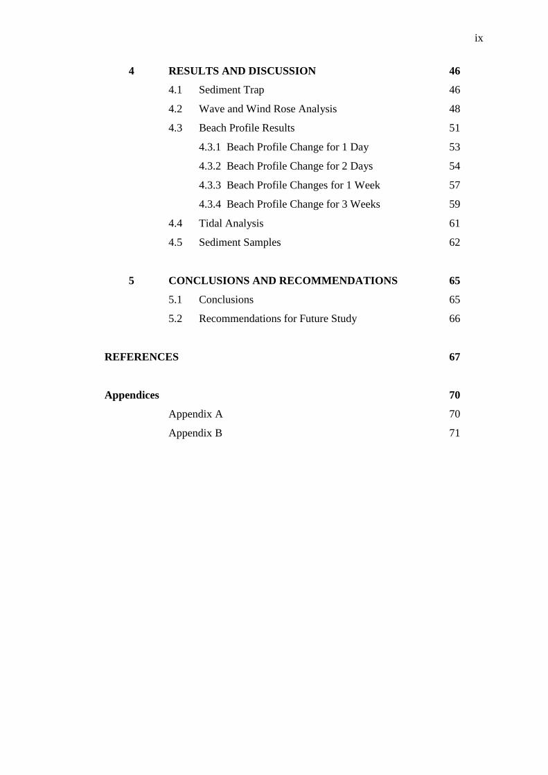
4 RESULTS AND DISCUSSION 46
4.1 Sediment Trap 46
4.2 Wave and Wind Rose Analysis 48
4.3 Beach Profile Results 51
4.3.1 Beach Profile Change for 1 Day 53
4.3.2 Beach Profile Change for 2 Days 54
4.3.3 Beach Profile Changes for 1 Week 57
4.3.4 Beach Profile Change for 3 Weeks 59
4.4 Tidal Analysis 61
4.5 Sediment Samples 62
5 CONCLUSIONS AND RECOMMENDATIONS 65
5.1 Conclusions 65
5.2 Recommendations for Future Study 66
REFERENCES 67
Appendices 70
Appendix A 70
Appendix B 71
x
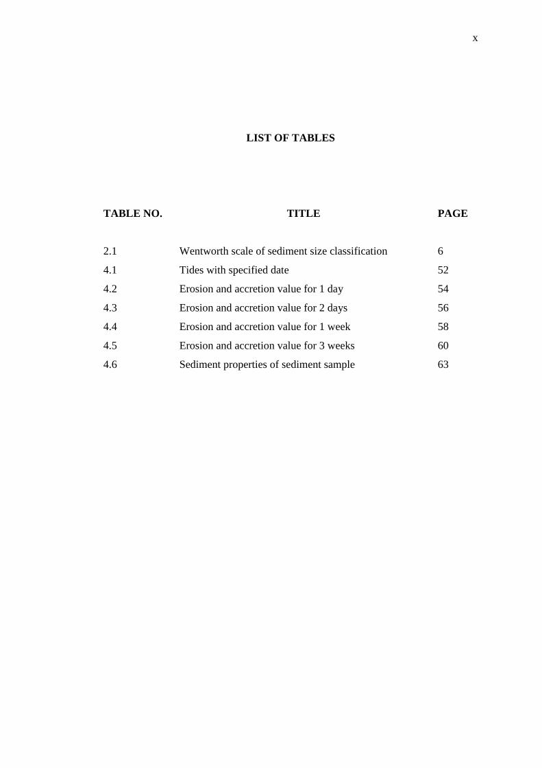
LIST OF TABLES
TABLE NO. TITLE PAGE
2.1 Wentworth scale of sediment size classification 6
4.1 Tides with specified date 52
4.2 Erosion and accretion value for 1 day 54
4.3 Erosion and accretion value for 2 days 56
4.4 Erosion and accretion value for 1 week 58
4.5 Erosion and accretion value for 3 weeks 60
4.6 Sediment properties of sediment sample 63
xi
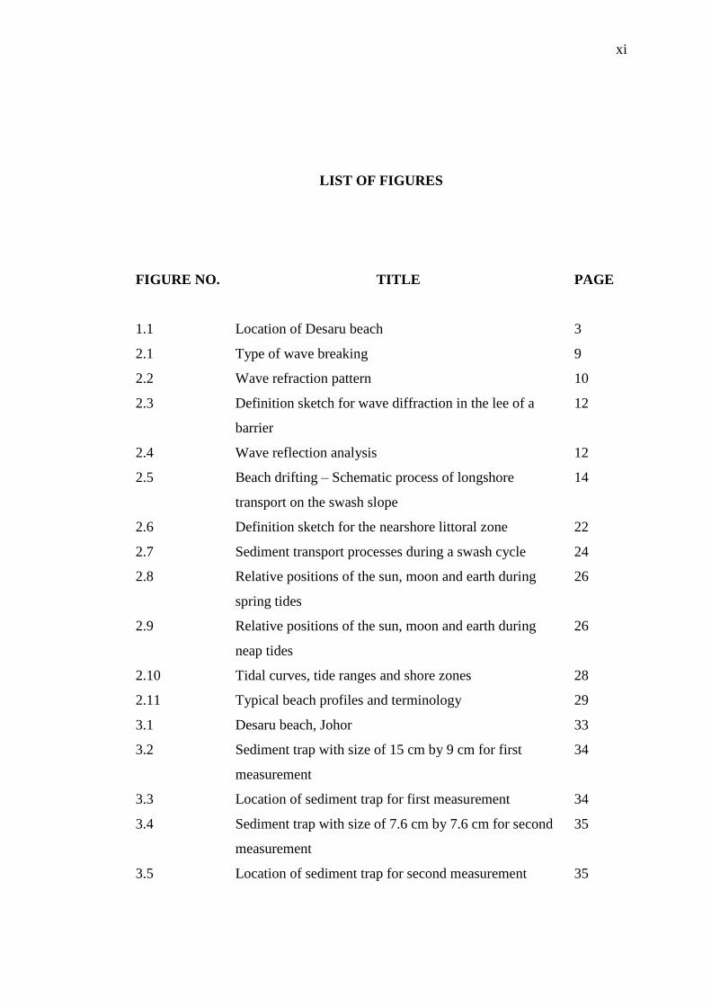
LIST OF FIGURES
FIGURE NO. TITLE PAGE
1.1 Location of Desaru beach 3
2.1 Type of wave breaking 9
2.2 Wave refraction pattern 10
2.3 Definition sketch for wave diffraction in the lee of a
barrier
12
2.4 Wave reflection analysis 12
2.5 Beach drifting – Schematic process of longshore
transport on the swash slope
14
2.6 Definition sketch for the nearshore littoral zone 22
2.7 Sediment transport processes during a swash cycle 24
2.8 Relative positions of the sun, moon and earth during
spring tides
26
2.9 Relative positions of the sun, moon and earth during
neap tides
26
2.10 Tidal curves, tide ranges and shore zones 28
2.11 Typical beach profiles and terminology 29
3.1 Desaru beach, Johor 33
3.2 Sediment trap with size of 15 cm by 9 cm for first
measurement
34
3.3 Location of sediment trap for first measurement 34
3.4 Sediment trap with size of 7.6 cm by 7.6 cm for second
measurement
35
3.5 Location of sediment trap for second measurement 35

xii
3.6
Sediment trap with size of 7.6 cm by 7.6 cm for third
measurement
36
3.7 Location of sediment trap for third measurement 36
3.8 Installation of sediment trap 36
3.9 Arrangement of sediment trap along the shore 37
3.10 RTK base receiver 38
3.11 RTK GPS setup 38
3.12 Beach survey location 39
3.13 Measurement of beach profile change by using RTK
rover receiver
40
3.14 Bench mark J4299 from JUPEM 40
3.15 Bench mark 5008J from Royal Malaysian Navy 41
3.16 Tide gauge at Jetty Tanjung Balau 41
3.17 Conversion from ACD to LSD 42
3.18 Beach profile (MSL is elevation of 0.41 m) 42
3.19 The equipment used to determine grain-size
classification
44
4.1 Observation of sediment trap 47
4.2 Sketch of wave effect to the sediment trap 48
4.3 Wave rose in October from 1984 to 2013 49
4.4 Wave rose in November from 1984 to 2013 49
4.5 Wind rose at station Mersing from 1968 to 2012 50
4.6 Beach profile change at location NW260 51
4.7 Beach profile change at location C0 52
4.8 Beach profile change at location SE290 52
4.9 Beach profile change for 1 day at location NW260 –
Profile 1
53
4.10 Beach profile change for 1 day at location C0 – Profile 2 53
4.11 Beach profile change for 1 day at location SE290 –
Profile 3
54
4.12 Beach profile change for 2 days at location NW260 –
Profile 4
55

xiii
4.13 Beach profile change for 2 days at location C0 – Profile
5
55
4.14 Beach profile change for 2 days at location SE290 –
Profile 6
56
4.15 Beach profile change for 1 week at location NW260 –
Profile 7
57
4.16 Beach profile change for 1 week at location C0 – Profile
8
58
4.17 Beach profile change for 1 week at location SE290 –
Profile 9
58
4.18 Beach profile change for 3 weeks at location NW260 –
Profile 10
59
4.19 Beach profile change for 3 weeks at location C0 –
Profile 11
60
4.20 Beach profile change for 3 weeks at location SE290 –
Profile 12
60
4.21 Tide data at Tanjung Balau, Johor 62
4.22 Grain size distribution of Sample A 63
4.23 Grain size distribution of Sample B 63
xiv
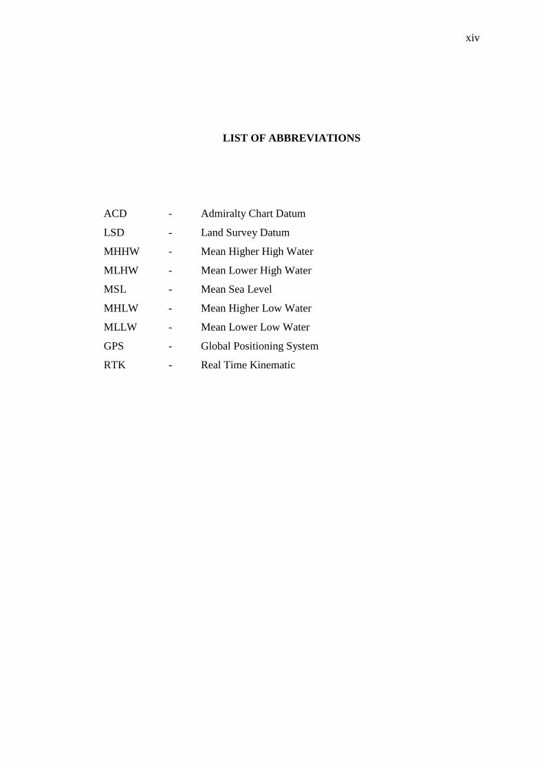
LIST OF ABBREVIATIONS
ACD - Admiralty Chart Datum
LSD - Land Survey Datum
MHHW - Mean Higher High Water
MLHW - Mean Lower High Water
MSL - Mean Sea Level
MHLW - Mean Higher Low Water
MLLW - Mean Lower Low Water
GPS - Global Positioning System
RTK - Real Time Kinematic
xv
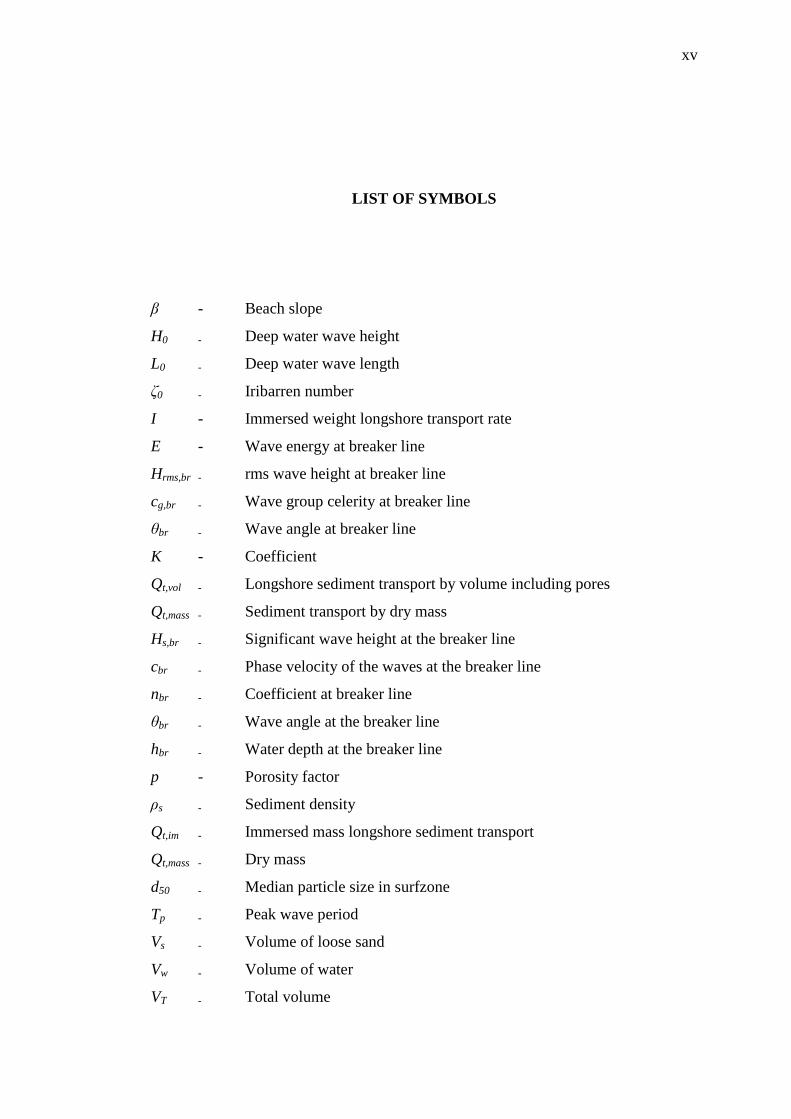
LIST OF SYMBOLS
β - Beach slope
H0 - Deep water wave height
L0 - Deep water wave length
ζ0 - Iribarren number
I - Immersed weight longshore transport rate
E - Wave energy at breaker line
Hrms,br - rms wave height at breaker line
cg,br - Wave group celerity at breaker line
θbr - Wave angle at breaker line
K - Coefficient
Qt,vol - Longshore sediment transport by volume including pores
Qt,mass - Sediment transport by dry mass
Hs,br - Significant wave height at the breaker line
cbr - Phase velocity of the waves at the breaker line
nbr - Coefficient at breaker line
θbr - Wave angle at the breaker line
hbr - Water depth at the breaker line
p - Porosity factor
ρs - Sediment density
Qt,im - Immersed mass longshore sediment transport
Qt,mass - Dry mass
d50 - Median particle size in surfzone
Tp - Peak wave period
Vs - Volume of loose sand
Vw - Volume of water
VT - Total volume

xvi
Vsw - Volume of sand and water
Ws - Weight of sand
n - Porosity
D50 - Median size of sediment distribution

xvii
LIST OF APPENDICES
APPENDIX TITLE PAGE
A Tide table at Tanjung Sedili, Johor 70
B Value above chart datum at Tanjung Balau 71

1
CHAPTER 1
INTRODUCTION
1.1 Introduction
The study of sediment transport processes is fundamental to the
understanding of coastal evolution, which is necessary for effective coastal
engineering design. Generally, sediment transport can be divided into longshore
sediment transport and cross-shore sediment transport. Longshore sediment transport
is primarily driven by an alongshore wave-induced current produced by waves
approaching at an angle to the shore, whereas cross-shore sediment transport is
considerably generated during storm (Won and In, 2008). Longshore transport plays
a large role in the evolution of shoreline. If there are slight changes in sediment
supply, wind direction or coastal influence, the formation and evolution of beach
profile will be effected. The present study is focused on the longshore sediment
transport.
The swash zone has been considered as an important role in shaping natural
beaches. Thus, the understanding of processes in this zone is very important for the
estimating of coastal erosion and accretion. Elfrink and Baldock (2002) stated that
littoral sediment transport often occurs in the swash zone as sediment concentrations
are often high in the swash zone. The swash zone is the most dynamic part of the
nearshore region and characterised by large flow velocities, high turbulence levels
and large suspended sediment concentrations (Elfrink and Baldock, 2002).

2
Beach monitoring provides a way of understanding beach dynamics and the
factors that influence the volumetric gains and losses along the coast (Morton et al.,
1993). Changes in cross-shore beach profiles are controlled by many factors, which
include waves, tidal flows and sediment characteristics (Karunarathna et al., 2012).
By measuring the dimensions of a particular beach repeatedly, the amounts of
erosion or accretion can be determined over the period of the surveys, as well as
some indications of where the material may be going. Details about the behaviour of
the particular beach can be provided when measured the beach profiles at the same
location over a period of time.
People utilise the coast for many purposes such as commercial fishing,
tourism and recreation. The coastal environment is dynamic and it is one of the most
rapidly changing physical environments on earth. Due to the strong link between
society and coastal changes, it is advisable that we understand this environment and
what causes it to change its state. Although natural processes are shaping the earth’s
natural coastal landscape, but these processes can give trouble to people that live
along the coasts, where their homes are built right on or near the beaches. This is
because of the process that carries sediments away from the shore can lead to
erosion. Therefore, we should make every effort to control this from happening.
1.2 Statement of Problem
Johor is one of the coastal states in Malaysia with the longest coastline facing
the South China Sea in the east, the Strait of Malacca in the west and the Strait of
Johor in the south. Coastal resources are the main source of income towards
industrialisation and economic development in Johor especially along the coastal
area. Tourism plays an important role in the state’s economy. In Johor, Desaru beach
is most popular beach and situated on the southeast coast of the district. It is located
approximately 88 kilometres east of Johor Bahru and very close to the developing
country, Singapore. Figure 1.1 shows the location of Desaru beach in Peninsular
Malaysia.
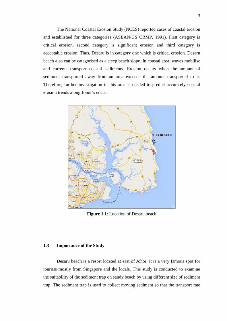
3
The National Coastal Erosion Study (NCES) reported cases of coastal erosion
and established for three categories (ASEAN/US CRMP, 1991). First category is
critical erosion, second category is significant erosion and third category is
acceptable erosion. Thus, Desaru is in category one which is critical erosion. Desaru
beach also can be categorised as a steep beach slope. In coastal area, waves mobilise
and currents transport coastal sediments. Erosion occurs when the amount of
sediment transported away from an area exceeds the amount transported to it.
Therefore, further investigation in this area is needed to predict accurately coastal
erosion trends along Johor’s coast.
Figure 1.1: Location of Desaru beach
1.3 Importance of the Study
Desaru beach is a resort located at east of Johor. It is a very famous spot for
tourists mostly from Singapore and the locals. This study is conducted to examine
the suitability of the sediment trap on sandy beach by using different size of sediment
trap. The sediment trap is used to collect moving sediment so that the transport rate

4
can be measured. The analysis of sample also is conducted in the laboratory to
determine the size, density and porosity of sediment at the area. Beach profile change
is measured to determine the erosion and accretion of the study area and also to
analyse the direction of longshore sediment transport. Thus, the coastal erosion
trends can be predicted at Desaru beach.
1.4 Objective of the Study
The objectives of the study are to:
1. Examine the suitability of sediment trap on sandy beach.
2. Analyse the sediment properties on the beach.
3. Analyse the direction of longshore transport by measuring beach profile.
1.5 Scope of the Study
Field work is conducted in order to achieve all the objectives of the study of
longshore sediment transport in the swash zone at Desaru beach. The scopes of this
study are:
1. Tide table is referred to determine the neap and spring in order to conduct
beach profile measurement and to install the sediment trap.
2. Sediment trap is used to examine the suitability of the trap on sandy beach
with different size and duration of study.
3. Analyse the sample to determine the grain size, porosity and density of the
sediment.
4. Wind and wave rose are obtained from Malaysian Meteorological Department
for analysis of the effect of wave to beach profile change.
67
REFERENCES
ASEAN/US CRMP (Association of Southeast Asian Nations/United States of
Coastal Resources Management Project). (1991). The Coastal Environment
Profile of South Johore, Malaysia. ICLARM Technical Report. 24:65.
Baba, Y. and Camenen, B. (2007). Importance of the Swash Longshore Sediment
Transport in Morphodynamics Models. Coastal Sediments ’07.
Bird, E. (2008). Coastal Geomorphology: An Introduction. (2nd
ed.) . England: John
Wiley & Sons Ltd.
CEM (Coastal Engineering Manual). (2002). Lonngshore Transport. Part III Chapter
2.
Davidson-Arnott, R. (2010). An Introduction to Coastal Processes and
Geomorphology. United States of America: Cambridge University Press.
Dean, R. G. and Dalrymple, R. A. (2004). Coastal Processes with Engineering
Applications. Cambridge, United Kingdom: Cambridge University Press.
Elfrink, B. and Baldock, T. (2002). Hydrodynamics and Sediment Transport in the
Swash Zone: A Review and Perspectives. Coastal Engineering. 45, 149-169.
FredsØe, J. and Deigaard, R. (1992). Mechanics of Coastal Sediment Transport.
Singapore: World Scientific Publishing Co. Pte. Ltd.
Horn, D. P. and Mason, T. (1994). Swash Zone Sediment Transport Modes. Marine
Geology. 120, 309-325.
Hughes, M. G., Masselink, G., Brander, R. W. (1997). Flow Velocity and Sediment
Transport in the Swash Zone of a Steep Beach. Marine Geology. 138, 91-103.
Husain, M. L., Yaakob, R., Shahbudin, S. (1995). Beach Erosion Variability during a
Northeast Monsoon: The Kuala Setiu Coastline, Terengganu, Malaysia. Journal
Science and Technology. 3(2), 337-348.
Kamphuis, J. W. (1991). Alongshore Sediment Transport Rate. Journal of Waterway,
Port, Coastal and Ocean Engineering. 117(6).
68
Karambas, T. V. (2006). Prediction of Sediment Trasnport in the Swash Zone by
Using a Nonlinear Wave Model. Continental Shelf Research.
Karunarathna, H., Horrillo-Caraballo, J. M., Ranasinghe, R., Short, A. D., Reeve, D.
E. (2012). An analysis of the Cross-Shore Beach Morphodynamics of a Sandy
and a Composite Gravel Beach. Marine Geology. 299-3012, 33-42.
Larson, M., Kubota, S., Erikson, Li. (2004). Swash Zone Sediment Transport and
Foreshore Evolution: Field Experiments and Mathematical Modeling. Marine
Geology. 212, 61-79.
Liu, Z. (2001). Sediment Transport. (3rd
ed.). Aalborg.
Morton, R. A., Leach, M. P., Paine, J. G., Cardoza, M. A. (1993). Monitoring Beach
Changes Using GPS Surveying Techniques. Journal of Coastal Research. 9(3),
702-720.
Pedrozo-Acuña, A., Simmonds, D. J., Otta, A. K., Chadwick, A. J. (2005). On the
Cross-Shore Profile Change of Gravel Beaches. Coastal Engineering. 53, 335-
347.
Pieterse, J. J. (2009). The Influence of an Ecobeach PEM on Beach Development.
Msc. Thesis. Technical University Delft.
Puleo, J. A., Beach, R. A., Holman, R. A., Allen, J. S. (2000). Swash Zone Sediment
Suspension and Transport and the Importance of Bore Generated Turbulence.
Journal of Geophysical Research. 105.
Reeve, D., Chadwick, A., Fleming, C. (2004). Coastal Engineering: Processes,
Theory and Design Practice. Oxon: Spon Press.
Rosati, J. D. and Kraus, N. C. (1988). Hydraulic Test of Streamer Sediment Trap.
Journal of Hydraulic Engineering. 14(12).
Shore Protection Manual (1984). Coastal Engineering Research Center. U.S. Army
Corps of Engineers.
Sorensen, R. M. (2006). Basic Coastal Engineering. (3rd
ed.). New York, USA:
Springer Science + Business Media.
Trim, L. K., She, K., Pope, D. J. (2002). Tidal Effects on Cross-shore Sediment
Transport on a Shingle Beach. Journal of Coastal Research. 36, 708-715.
Van Rijn, L. C. (2001). Longshore Sediment Transport. Report Z3054.20. Delft, The
Netherlands.
69
Van Wellen, E., Chadwick, A. J., Lee, M., Baily, B., Morfett, J. (1998). Evaluation
of Longshore Sediment Transport Models on Coarse Grained Beaches Using
Field Data: A Preliminary Investigation. Coastal Engineering. 2640 – 2653.
Wang, P., Davis, R. A., Jr., Kraus, N. C. (1998). Cross-Shore Distribution of
Sediment Texture Under Breaking Waves Along Low-Wave Energy Coasts.
Journal of Sedimentary Research. 68(3), 497-506.
Won, C. C. and In, H. K. (2008). Cross-Shore Change of Beach Profile in Two
Shapes of Beach Slopes Breakdown. Proceedings of the Eighteenth (2008)
International Offshore and Polar Engineering Conference. July 6-18, 2008.
Vancouver, Canada.
Wright, L. D. and Short, A. D. (1984). Morphodynamic Variability of Surf Zones
and Beaches: A Synthesis. Marine Geology. 56, 93-118.


![Longshore current and sediment transportufdcimages.uflib.ufl.edu/UF/00/09/77/43/00001/... · LISTOFFIGURES Figure DistributionofLongshoreVelocityandSediment TransportacrosstheSurfZone(afterZenkovitch[1])](https://img.pdfslide.net/doc/110x75/5eda5a5db3745412b5713394/longshore-current-and-sediment-listoffigures-figure-distributionoflongshorevelocityandsediment.jpg)


![Determination and control of longshore sediment transport ......Ocean Engineering ] (]]]]) ]]]–]]] Determination and control of longshore sediment transport: A case study H. Anıl](https://img.pdfslide.net/doc/110x75/5f82634ad60b4d1ba13f8f56/determination-and-control-of-longshore-sediment-transport-ocean-engineering.jpg)