Embed Size (px)
Citation preview
I610 Redhills Precinct
I610. Redhills Precinct
I610.1. Precinct Description
The Redhills Precinct is a new suburb forming a significant part of the north western extent of Auckland’s wider metropolitan area, approximately 18km northwest of Auckland’s CBD, 4.5km north west of Waitakere City, 3km south west of Whenuapai and adjacent to the suburb of Massey West. The Redhills Precinct encompasses some 600ha of land to the west of Fred Taylor Drive and the Westgate / Massey North Metropolitan Centre.
The precinct is bordered by Fred Taylor Drive and Don Buck Road to the east, Redhills Road to the south and west and Henwood Road to the north, with the exception of a small portion that extends north of Henwood Road, between the Ngongotepara Stream and Fred Taylor Drive up to the northern cadastral boundary of 132-140 Fred Taylor Drive (opposite Northside Drive).
The surrounding roads are on a ridgeline and the precinct is a natural amphitheatre shape within these ridgelines, interspersed with gullies and vegetated streams that ultimately drain to Brighams Creek and the Waitemata Harbour.
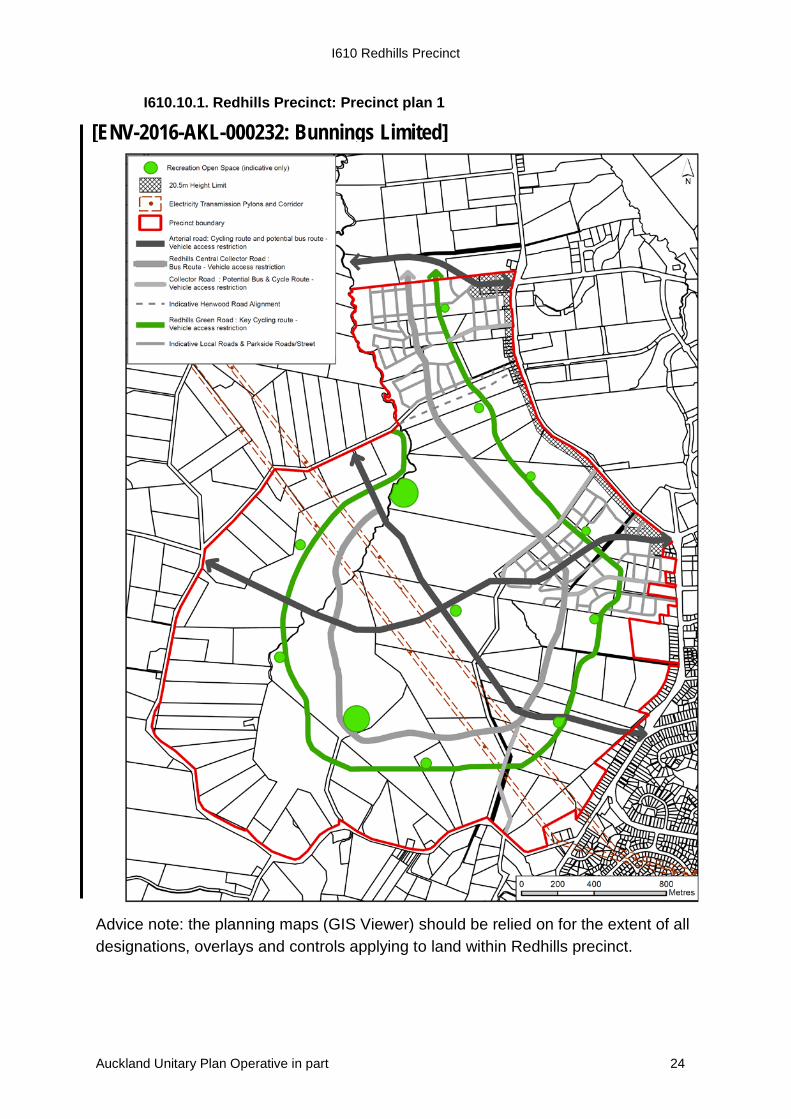
The purpose of the Redhills Precinct is to implement Redhills Precinct: Precinct plan 1 to ensure that the Precinct creates high quality residential development with a local centre established centrally within the precinct to provide a heart and focal point for the Redhills community. Strategic roading connections through the precinct, will provide connectivity east-west between Fred Taylor Drive and Nelson Road, and north-south between Royal Road and Future Urban Zone land to the north. This will facilitate direct strategic roading connections between on/off ramps of the northwestern motorway to rural communities and future urban areas to the north and west of Redhills. The strategic roading network intersects at the local centre, and will support the centre and enhance its use by passing traffic and public transport.
The Green Road circuit within the precinct provides a priority cycle and pedestrian route of high amenity, connecting recreational spaces within the precinct, including parks and stream corridors, and connections to commuter cycling routes. Collector roads are proposed to provide key transport connections through the precinct between arterial routes, which will provide for public transport routes through the residential area.
The Fred Taylor Drive interface is an important transition zone and gateway between the Redhills Precinct and the Massey North / Westgate Metropolitan Centre. The elevation of Fred Taylor Drive provides views eastwards to the Waitemata Harbour and is also within walking distance of the Massey North / Westgate Metropolitan Centre. These attributes, along with the appropriate treatment of Fred Taylor Drive, create a sense of place that potentially provides an attractive and suitable environment for intensive residential development.
An Additional Zone Height Control up to one street block depth enables greater building height providing a transition in building scale from the Business - Mixed Use Zone in Westgate Sub-precinct C to the rest of the Residential - Terrace Housing and Apartment Buildings zone on the Fred Taylor Drive edge. Limited neighbourhood convenience
Auckland Unitary Plan Operative in part 1
I610 Redhills Precinct
related commercial activities are provided for in the Additional Zone Height control area on the Fred Taylor Drive edge from Dunlop Road to Don Buck Road roundabout that complements the Business - Mixed Use zone in Westgate Sub-precinct C to the east.
The zoning of land within this precinct is Residential - Single House Zone, Residential - Mixed Housing Suburban Zone, Residential - Mixed Housing Urban Zone, Residential - Terrace Housing and Apartment Buildings Zone, Business - Local Centre Zone and Special Purpose School Zone. Refer to planning maps for the location and extent of the precinct.
I610.2. Objectives
Subdivision and development is undertaken in a coordinated manner that (1)implements the Redhills Precinct: Precinct plan 1 through emphasising the character of place and aiding legibility by the creation of focal points and nodes.
Subdivision and development achieves a well-connected, adaptable, safe, (2)attractive, healthy and pleasant environment for living and working with an emphasis on the importance of access to the public realm including parks, roads and the natural environment.
Subdivision and development is coordinated with the delivery of bulk (3)infrastructure required to service the precinct and its effects on the wider network, including transport, wastewater and water services.
Subdivision and development does not occur in advance of the availability of (4)reticulated public wastewater and water supply services and transport infrastructure, including the wider transport network.
Subdivision and development promotes more intensive development in proximity (5)to amenity features, the Massey North / Westgate Metropolitan Centre, Redhills Local Centre and key transport routes, and provides for a range of housing typologies.
Subdivision and development within the Local Centre creates a safe and (6)accessible environment for pedestrians, cyclists and public transport.
A safe, efficient and integrated transport system is established within the Redhills (7)Precinct that provides strategic roading connections, a choice of travel modes, encourages walking, cycling and use of public transport, and provides strong, legible connections to and through the precinct, whilst minimising crossings through natural features.
Activities within the precinct that support and do not undermine the function, (8)vitality and viability of the Massey North / Westgate Metropolitan Centre or Redhills Local Centre are provided for.
The intrinsic character of the precinct and its location in proximity to the Northwest (9)Wildlink is recognised and stream ecology and remnant vegetation is restored with opportunities created for natural wildlife corridors.
Auckland Unitary Plan Operative in part 2
I610 Redhills Precinct
Parks and open space corridors achieve an integrated, attractive and safe open (10)space network across the precinct that integrates stormwater management, and ecological and recreational functions, while enhancing the amenity of cyclists and pedestrians who will have access through these open space areas.
Stormwater runoff is managed to respect natural processes, minimise flood risk (11)and utilise implements water sensitive design.
The overlay, Auckland-wide and zone objectives apply in this precinct in addition to those specified above.
I610.3. Policies
Require that the design of any subdivision and development within the precinct (1)incorporates the following elements of the Redhills Precinct: Precinct plan 1:
the pattern, hierarchy and function of roads including links to the (a)Westgate/Massey North Metropolitan Centre, the motorway network and future busway and future links to Kumeu/Huapai;
pedestrian and cycle linkages; (b)
linkages within the precinct and to adjacent land; (c)
key intersections; (d)
riparian margins; (e)
open space areas; and (f)
key retail frontages. (g)
Ensure land uses within the Redhills Precinct are primarily residential along with a (2)supporting local centre and open spaces and provide a transition of residential density by:
enabling areas of high intensification within 800 metres / 10 minutes walk of (a)the Westgate / Massey North Metropolitan Centre, and the Redhills Local Centre, along arterial and collector roads, the Green Road, and at the interface of public open space areas;
providing lower/medium densities around the periphery of the precinct; (b)
allowing medium densities within the remaining residential areas; (c)
enabling appropriate and limited commercial activity along the Fred Taylor (d)Drive interface between Dunlop Road and the Don Buck roundabout up to one street block depth;
enabling a mix of commercial activity, community and residential activities (e)within the Redhills Local Centre.
Auckland Unitary Plan Operative in part 3
I610 Redhills Precinct
Enable the provision of low rise apartments up to six storeys along the Fred (3)Taylor Drive edge.
Enable an integrated road and transport system by guiding the design and layout (4)of subdivision to provide connectivity and the opportunity for a variety of travel modes, including:
Restricted access arterial roads providing strategic connections through the (a)Precinct that provide for cycling and public transport.
A central collector road with the principal function being the local movement of (b)people including design that accommodates public transport.
A visually distinct, high amenity road (the Green Road) providing a circuit (c)within the precinct that accommodates separated cycle infrastructure with restricted vehicle access along one side and connects parks / reserves and the freshwater network and terrestrial habitats.
Other collector roads identified on the Redhills Precinct: Precinct plan 1 that (d)provide for public transport and cycling as a priority.
Stream edge routes providing for: (e)
pedestrian and cycle paths along both sides of permanent streams and (i)one side of intermittent streams;
reserve edge roads along the northern and western sides of permanent (ii)and intermittent streams.
Local access roads that provide a low speed, cycle and pedestrian friendly (f)environment for the main residential areas.
Ensure stream and wetland crossings are, as far as practicable, perpendicular to (5)the stream and/or wetland to minimise freshwater habitat loss.
Require the internal road network to comply with a range of precinct specific road (6)cross-sections where applicable so to achieve an appropriate balance between traffic movement, safety, connection and sense of place.
Encourage pedestrian and cycle connectivity throughout the precinct, including (7)along the Green Road, stream network, and areas of open space in a manner that encourages movement within the precinct and toward the Local Centre and the Westgate / Massey North Metropolitan Centre.
Ensure the configuration of sites and dwellings creates a positive frontage to any (8)adjacent roads, parks and open spaces and encourages passive surveillance and enhances perceptions of safety.
Auckland Unitary Plan Operative in part 4
I610 Redhills Precinct
Ensure open space areas within the precinct are accessible by pedestrians and (9)cyclists and contribute to the character and amenity of the precinct by using existing elements of the natural landscape where practicable.
Provide for and encourage ecological corridors through the Redhills Precinct to (10)enhance natural linkages throughout the wider landscape (i.e. Northwest Wildlink), including riparian planting along waterways to:
maintain and enhance water quality and aquatic habitats; (a)
enhance existing native vegetation and wetland areas within the catchment; (b)and
reduce stream bank erosion. (c)
Maintain the existing catchment hydrology through management of stormwater (11)on-site and employing water sensitive design principles prior to the discharge of stormwater to existing gullies and watercourses.
Integrate the stormwater management network within the precinct with the (12)surrounding development and provide for other values such as movement, amenity, open space and ecological values.
Require subdivision and development to achieve a level of stormwater mitigation (13)that meets the requirements set out in E10 Stormwater management area Flow 1 and 2, through the use of a single device or combination of devices and generally accord with any relevant approved stormwater management plan.
Ensure subdivision and development within the Local Centre creates a low (14)speed, main street environment with active frontages to key public interfaces.
Ensure that the timing of development occurs in accordance with sequenced (15)transport network infrastructure upgrades to service development up to and not beyond the relevant dwelling thresholds.
The overlay, Auckland-wide and zone policies apply in this precinct in addition to those specified above.
I610.4. Activity table
The activity status in the overlay, zone and Auckland-wide provisions apply in this precinct unless otherwise specified below.
Note: the activity status for subdivision in E38 Subdivision – Urban apply to subdivision in this precinct and the specific provisions of Standards I610.6.4 below also apply. Where there is any conflict between the Auckland-wide and zone standards, and standards I610.6.3 and I610.6.4, then standards I610.6.3 and I610.6.4 take precedence.
Table I610.4.1 specifies the activity status of land use, development and the provision of wastewater disposal and water supply associated with subdivision activities in the Redhills Precinct Terrace Housing and Apartment Buildings zone adjacent to Fred Taylor
PC 4 (See modifications)
Auckland Unitary Plan Operative in part 5
I610 Redhills Precinct
Drive between Dunlop Road and the Don Buck Road roundabout pursuant to sections 9(3) and 11 of the Resource Management Act 1991.
[New text to be inserted]
PC 4 (See modifications)
Auckland Unitary Plan Operative in part 6
I610 Redhills Precinct
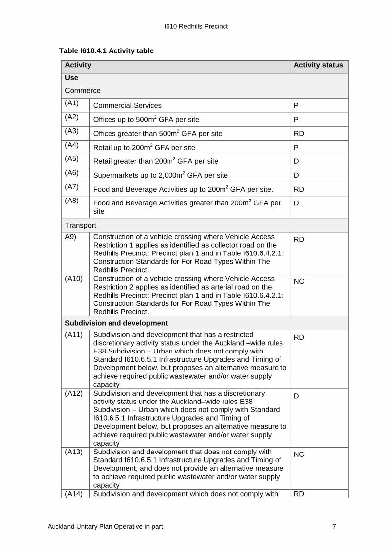
Table I610.4.1 Activity table
Activity Activity status Use
Commerce
(A1) Commercial Services P (A2) Offices up to 500m2 GFA per site P (A3) Offices greater than 500m2 GFA per site RD (A4) Retail up to 200m2 GFA per site P (A5) Retail greater than 200m2 GFA per site D (A6) Supermarkets up to 2,000m2 GFA per site D (A7) Food and Beverage Activities up to 200m2 GFA per site. RD (A8) Food and Beverage Activities greater than 200m2 GFA per
site D
Transport A9) Construction of a vehicle crossing where Vehicle Access
Restriction 1 applies as identified as collector road on the Redhills Precinct: Precinct plan 1 and in Table I610.6.4.2.1: Construction Standards for For Road Types Within The Redhills Precinct.
RD
(A10) Construction of a vehicle crossing where Vehicle Access Restriction 2 applies as identified as arterial road on the Redhills Precinct: Precinct plan 1 and in Table I610.6.4.2.1: Construction Standards for For Road Types Within The Redhills Precinct.
NC
Subdivision and development (A11) Subdivision and development that has a restricted
discretionary activity status under the Auckland –wide rules E38 Subdivision – Urban which does not comply with Standard I610.6.5.1 Infrastructure Upgrades and Timing of Development below, but proposes an alternative measure to achieve required public wastewater and/or water supply capacity
RD
(A12) Subdivision and development that has a discretionary activity status under the Auckland–wide rules E38 Subdivision – Urban which does not comply with Standard I610.6.5.1 Infrastructure Upgrades and Timing of Development below, but proposes an alternative measure to achieve required public wastewater and/or water supply capacity
D
(A13) Subdivision and development that does not comply with Standard I610.6.5.1 Infrastructure Upgrades and Timing of Development, and does not provide an alternative measure to achieve required public wastewater and/or water supply capacity
NC
(A14) Subdivision and development which does not comply with RD
Auckland Unitary Plan Operative in part 7
I610 Redhills Precinct
Standard I610.6.1 Infrastructure Upgrades and Timing of Development - Transport or I610.6.2 Infrastructure Upgrades and Location of Development- Transport but proposes alternative measures to achieve required transport access, capacity and safety
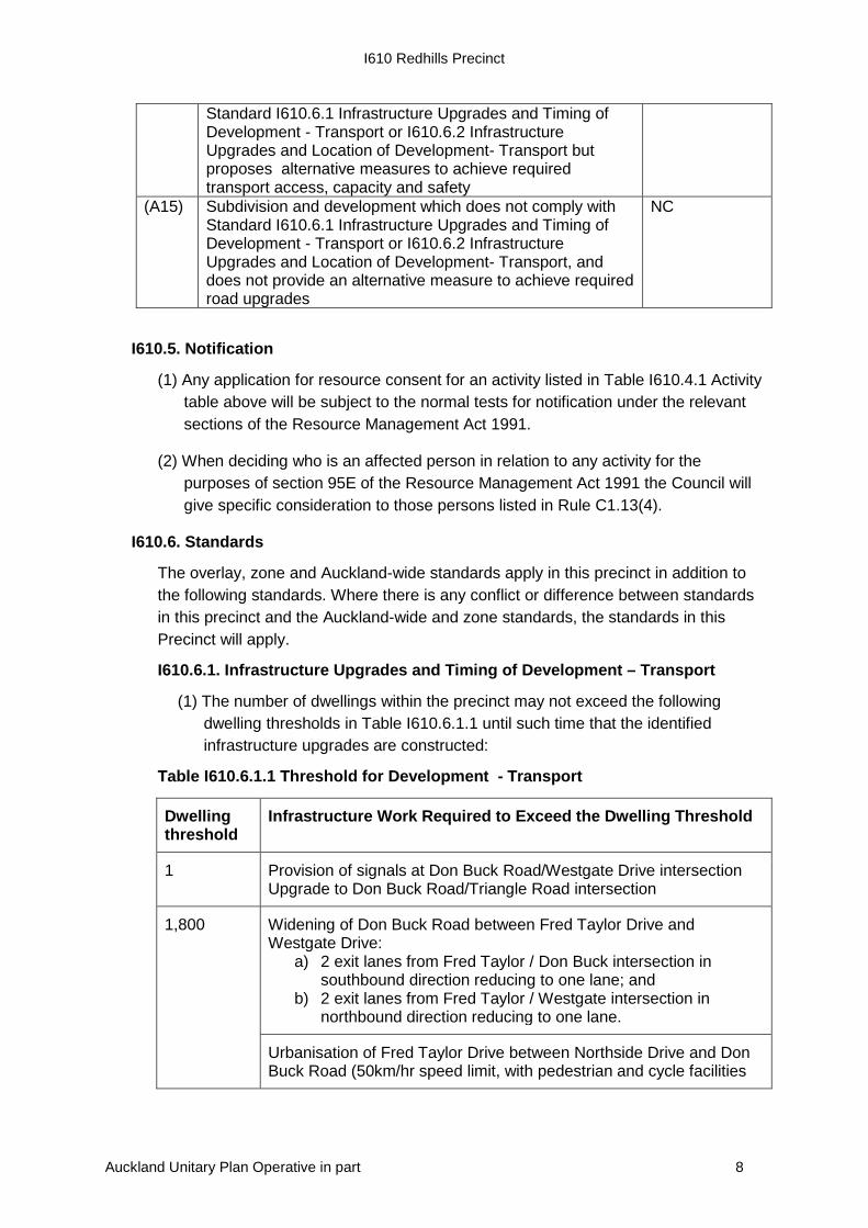
(A15) Subdivision and development which does not comply with Standard I610.6.1 Infrastructure Upgrades and Timing of Development - Transport or I610.6.2 Infrastructure Upgrades and Location of Development- Transport, and does not provide an alternative measure to achieve required road upgrades
NC
I610.5. Notification
Any application for resource consent for an activity listed in Table I610.4.1 Activity (1)table above will be subject to the normal tests for notification under the relevant sections of the Resource Management Act 1991.
When deciding who is an affected person in relation to any activity for the (2)purposes of section 95E of the Resource Management Act 1991 the Council will give specific consideration to those persons listed in Rule C1.13(4).
I610.6. Standards
The overlay, zone and Auckland-wide standards apply in this precinct in addition to the following standards. Where there is any conflict or difference between standards in this precinct and the Auckland-wide and zone standards, the standards in this Precinct will apply.
I610.6.1. Infrastructure Upgrades and Timing of Development – Transport
(1) The number of dwellings within the precinct may not exceed the following dwelling thresholds in Table I610.6.1.1 until such time that the identified infrastructure upgrades are constructed:
Table I610.6.1.1 Threshold for Development - Transport
Dwelling threshold
Infrastructure Work Required to Exceed the Dwelling Threshold
1 Provision of signals at Don Buck Road/Westgate Drive intersection Upgrade to Don Buck Road/Triangle Road intersection
1,800
Widening of Don Buck Road between Fred Taylor Drive and Westgate Drive:
a) 2 exit lanes from Fred Taylor / Don Buck intersection in southbound direction reducing to one lane; and
b) 2 exit lanes from Fred Taylor / Westgate intersection in northbound direction reducing to one lane.
Urbanisation of Fred Taylor Drive between Northside Drive and Don Buck Road (50km/hr speed limit, with pedestrian and cycle facilities
Auckland Unitary Plan Operative in part 8
I610 Redhills Precinct
along and across road)
Link from Redhills Centre to Redhills Road
3,600 Upgrade to Fred Taylor Drive/Don Buck Road intersection to signalised layout (with full pedestrian/cycle crossing facilities (either at 3600 households or when the link from Redhills is added to the intersection – whichever comes first))
Widening of Don Buck Road between Fred Taylor Drive and Westgate Drive: 2 lanes from Fred Taylor Drive to Westgate Drive, and 2 lanes between Westgate Drive and Fred Taylor Drive increasing to 3 approach lanes at the intersection in northbound direction
5,400 North-western busway and bus station at Massey North
Widening of full length of Fred Taylor Drive from Brigham Creek Road to Don Buck Road to two lanes in each direction with widening at intersections
Widening of Don Buck Road from Royal Road to Redhills Road to two lanes in each direction
Northside Drive East overbridge
(2) Notwithstanding I610.6.1 1 above, the dwelling thresholds shall be confirmed as part of any Traffic Impact Assessment required for subdivision and/or development within the precinct.
I610.6.2. Infrastructure Upgrades and Location of Development- Transport
(1) The infrastructure upgrades in Table I610.6.2.1 must be constructed or be proposed to be constructed at the time the trigger is met:
Table I610.6.2.1 Trigger for Development – Transport
Trigger
Infrastructure upgrade
In advance of development accessing the Northside Drive intersection
Fourth arm at Fred Taylor Drive/Northside Drive signalised intersection
When fourth arm to Dunlop Road is provided
Signalise Fred Taylor Drive/Dunlop Road intersection
In advance of development in Baker Lane area
Upgrade to Fred Taylor Drive/Baker Lane intersection
In advance of development in Kakano Road/Henwood Road area
Upgrade Fred Taylor Drive/Kakano Road/Henwood Road signalised intersection to incorporate fourth arm into signals
Auckland Unitary Plan Operative in part 9
I610 Redhills Precinct
I610.6.3. Standards for residential zones
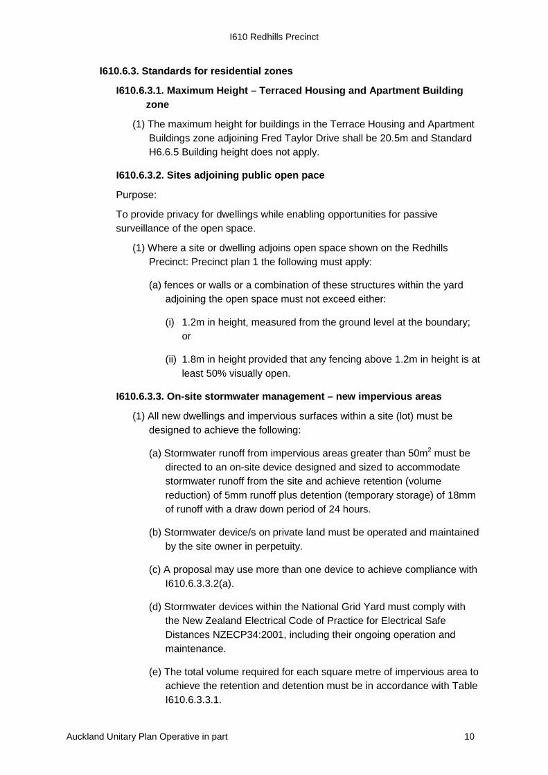
I610.6.3.1. Maximum Height – Terraced Housing and Apartment Building zone
(1) The maximum height for buildings in the Terrace Housing and Apartment Buildings zone adjoining Fred Taylor Drive shall be 20.5m and Standard H6.6.5 Building height does not apply.
I610.6.3.2. Sites adjoining public open pace
Purpose:
To provide privacy for dwellings while enabling opportunities for passive surveillance of the open space.
(1) Where a site or dwelling adjoins open space shown on the Redhills Precinct: Precinct plan 1 the following must apply:
(a) fences or walls or a combination of these structures within the yard adjoining the open space must not exceed either:
(i) 1.2m in height, measured from the ground level at the boundary; or
(ii) 1.8m in height provided that any fencing above 1.2m in height is at least 50% visually open.
I610.6.3.3. On-site stormwater management – new impervious areas
(1) All new dwellings and impervious surfaces within a site (lot) must be designed to achieve the following:
(a) Stormwater runoff from impervious areas greater than 50m2 must be directed to an on-site device designed and sized to accommodate stormwater runoff from the site and achieve retention (volume reduction) of 5mm runoff plus detention (temporary storage) of 18mm of runoff with a draw down period of 24 hours.
(b) Stormwater device/s on private land must be operated and maintained by the site owner in perpetuity.
(c) A proposal may use more than one device to achieve compliance with I610.6.3.3.2(a).
(d) Stormwater devices within the National Grid Yard must comply with the New Zealand Electrical Code of Practice for Electrical Safe Distances NZECP34:2001, including their ongoing operation and maintenance.
(e) The total volume required for each square metre of impervious area to achieve the retention and detention must be in accordance with Table I610.6.3.3.1.
Auckland Unitary Plan Operative in part 10
I610 Redhills Precinct
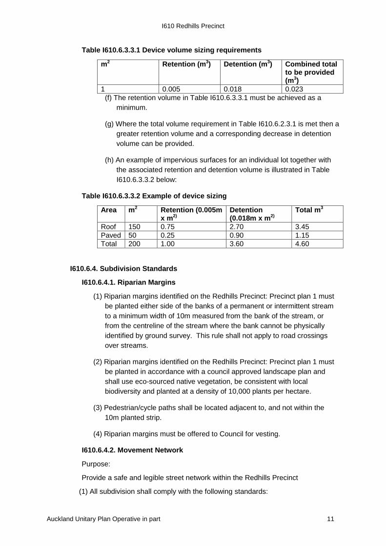
Table I610.6.3.3.1 Device volume sizing requirements
m2 Retention (m3) Detention (m3) Combined total to be provided (m3)
1 0.005 0.018 0.023 (f) The retention volume in Table I610.6.3.3.1 must be achieved as a
minimum.
(g) Where the total volume requirement in Table I610.6.2.3.1 is met then a greater retention volume and a corresponding decrease in detention volume can be provided.
(h) An example of impervious surfaces for an individual lot together with the associated retention and detention volume is illustrated in Table I610.6.3.3.2 below:
Table I610.6.3.3.2 Example of device sizing
Area m2 Retention (0.005m x m2)
Detention (0.018m x m2)
Total m3
Roof 150 0.75 2.70 3.45 Paved 50 0.25 0.90 1.15 Total 200 1.00 3.60 4.60
I610.6.4. Subdivision Standards
I610.6.4.1. Riparian Margins
(1) Riparian margins identified on the Redhills Precinct: Precinct plan 1 must be planted either side of the banks of a permanent or intermittent stream to a minimum width of 10m measured from the bank of the stream, or from the centreline of the stream where the bank cannot be physically identified by ground survey. This rule shall not apply to road crossings over streams.
(2) Riparian margins identified on the Redhills Precinct: Precinct plan 1 must be planted in accordance with a council approved landscape plan and shall use eco-sourced native vegetation, be consistent with local biodiversity and planted at a density of 10,000 plants per hectare.
(3) Pedestrian/cycle paths shall be located adjacent to, and not within the 10m planted strip.
(4) Riparian margins must be offered to Council for vesting.
I610.6.4.2. Movement Network
Purpose:
Provide a safe and legible street network within the Redhills Precinct
(1) All subdivision shall comply with the following standards:
Auckland Unitary Plan Operative in part 11
I610 Redhills Precinct
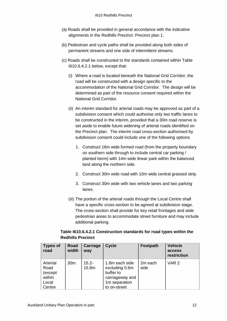
(a) Roads shall be provided in general accordance with the indicative alignments in the Redhills Precinct: Precinct plan 1.
(b) Pedestrian and cycle paths shall be provided along both sides of permanent streams and one side of intermittent streams.
(c) Roads shall be constructed to the standards contained within Table I610.6.4.2.1 below, except that:
(i) Where a road is located beneath the National Grid Corridor, the road will be constructed with a design specific to the accommodation of the National Grid Corridor. The design will be determined as part of the resource consent required within the National Grid Corridor.
(ii) An interim standard for arterial roads may be approved as part of a subdivision consent which could authorise only two traffic lanes to be constructed in the interim, provided that a 30m road reserve is set aside to enable future widening of arterial roads identified on the Precinct plan. The interim road cross-section authorised by subdivision consent could include one of the following options.
1. Construct 16m wide formed road (from the property boundary on southern side through to include central car parking / planted berm) with 14m wide linear park within the balanced land along the northern side.
2. Construct 30m wide road with 10m wide central grassed strip.
3. Construct 30m wide with two vehicle lanes and two parking lanes.
(iii) The portion of the arterial roads through the Local Centre shall have a specific cross-section to be agreed at subdivision stage. The cross-section shall provide for key retail frontages and wide pedestrian areas to accommodate street furniture and may include additional parking.
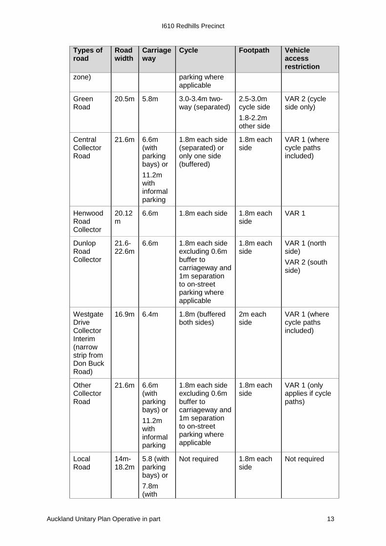
Table I610.6.4.2.1 Construction standards for road types within the Redhills Precinct
Types of road
Road width
Carriageway
Cycle Footpath Vehicle access restriction
Arterial Road (except within Local Centre
30m 15.2-15.8m
1.8m each side excluding 0.6m buffer to carriageway and 1m separation to on-street
2m each side
VAR 2
Auckland Unitary Plan Operative in part 12
I610 Redhills Precinct
Types of road
Road width
Carriageway
Cycle Footpath Vehicle access restriction
zone) parking where applicable
Green Road
20.5m 5.8m 3.0-3.4m two-way (separated)
2.5-3.0m cycle side 1.8-2.2m other side
VAR 2 (cycle side only)
Central Collector Road
21.6m 6.6m (with parking bays) or 11.2m with informal parking
1.8m each side (separated) or only one side (buffered)
1.8m each side
VAR 1 (where cycle paths included)
Henwood Road Collector
20.12m
6.6m 1.8m each side 1.8m each side
VAR 1
Dunlop Road Collector
21.6-22.6m
6.6m 1.8m each side excluding 0.6m buffer to carriageway and 1m separation to on-street parking where applicable
1.8m each side
VAR 1 (north side) VAR 2 (south side)
Westgate Drive Collector Interim (narrow strip from Don Buck Road)
16.9m 6.4m 1.8m (buffered both sides)
2m each side
VAR 1 (where cycle paths included)
Other Collector Road
21.6m 6.6m (with parking bays) or 11.2m with informal parking
1.8m each side excluding 0.6m buffer to carriageway and 1m separation to on-street parking where applicable
1.8m each side
VAR 1 (only applies if cycle paths)
Local Road
14m-18.2m
5.8 (with parking bays) or 7.8m (with
Not required 1.8m each side
Not required
Auckland Unitary Plan Operative in part 13

I610 Redhills Precinct
Types of road
Road width
Carriageway
Cycle Footpath Vehicle access restriction
informal parking)
Reserve Edge Road
14m 5.8 (with parking bays) or 7.8m (with informal parking)
Not required (shared within reserve)
1.8m on lot side
Not required
I610.6.5. Wastewater and water supply standards
I610.6.5.1. Infrastructure upgrades and timing of development
Purpose: Ensure that rate of development is aligned with infrastructure upgrades.
(1) The number of dwellings within the precinct may not exceed 5,400 dwellings until such time that:
(a) The ‘Northern Interceptor Stage 2’ (public wastewater infrastructure) has been constructed and is operational; and,
(b) The ‘North Harbour Water Main 2’ (public water supply) has been constructed and is operational.
Auckland Unitary Plan Operative in part 14
I610 Redhills Precinct
I610.7. Assessment – controlled activities
There are no controlled activities in this precinct.
I610.8. Assessment – restricted discretionary activities
I610.8.1. Matters of discretion
The council will restrict its discretion to all the following matters when assessing a restricted discretionary activity resource consent application, in addition to the matters specified for the relevant restricted discretionary activities in the Auckland wide or zone provisions:
(1) Offices greater than 500m2 GFA per site in the Residential - Terrace Housing and Apartment Buildings Zone on Fred Taylor Drive from Dunlop Road to the Don Buck roundabout:
(a) Intensity and scale.
(b) Centre vitality.
(c) Local housing.
(d) Design of parking, access and servicing.
(2) Food and beverage activities up to 200m2 GFA per site in the Residential - Terrace Housing and Apartment Buildings Zone on Fred Taylor Drive from Dunlop Road to the Don Buck roundabout:
(a) Local Housing.
(b) Centre vitality.
(c) Design of parking, access and servicing.
(3) Subdivision and development that does not comply with Standard I610.6.5.1 Infrastructure Upgrades and Timing of Development above, but proposes an alternative measure to achieve required public wastewater and/or water supply capacity:
(a) The availability of sufficient water and wastewater infrastructure to service proposed subdivision and/or development.
(4) On-site Stormwater management - new impervious areas unable to comply with I610.6.3.3 On-site stormwater management – new impervious areas.
(a) The matters listed in E10.8.1.
(5) Construction of a vehicle crossing where a Vehicle Access Restriction 1 applies as identified on the Redhills Precinct: Precinct plan 1 and/or in Table I610.6.4.2.1 Construction standards for road types within the Redhills Precinct.
(a) The Council will consider whether adverse effects on the transport network can be appropriately avoided or mitigated, with particular regard to the:
Auckland Unitary Plan Operative in part 15
I610 Redhills Precinct
(i) total number, location and design of vehicle crossings serving lots fronting the road with the vehicle access restriction;
(ii) ability for vehicles to safely manoeuvre to and from the site;
(iii) safety of road users including pedestrians and cyclists;
(iv) amenity effects of on-site manoeuvring areas and any landscaping proposed;
(v) effects of any fencing along the front boundary on maintaining open sight lines between vehicles using the access and the adjacent cycleway;
(vi) matters listed in clause E27.8.1(12) in E27 Transport.
(6) Subdivision listed as a restricted discretionary activity under Auckland–wide Rules E38 Subdivision – Urban.
(a) Consistency with the Redhills Precinct: Precinct plan 1.
(b) Provision for key roads and intersections identified on the Redhills Precinct: Precinct plan 1.
(c) Limitations on access for future lots adjoining restricted or limited access roads identified on the Redhills Precinct: Precinct plan 1.
(d) Pedestrian and cycle connectivity.
(e) Design of arterial road cross-sections connecting the Local Centre.
(f) The interface of subdivision and development with arterial roads within the Local Centre.
(g) The interface of subdivision and development with open space areas, including riparian margins.
(h) Location and accessibility of parks.
(i) Stormwater management.
(j) The design and layout of subdivision within the National Grid Corridor.
(7) Subdivision and development that does not comply with Standard 1610.6.1 Infrastructure Upgrades and Timing of Development - Transport or I610.6.2 Infrastructure Upgrades and Location of Development- Transport but proposes alternative measures to achieve required transport access, capacity and safety.
(a) Effects on the transport network.
(b) The likely trip generation of the subdivision and/or development and the effects of the quantum of that development on the safe and efficient functioning of the roading network.
Auckland Unitary Plan Operative in part 16
I610 Redhills Precinct
I610.8.2. Assessment criteria
The council will consider the relevant assessment criteria below for restricted discretionary activities, in addition to the assessment criteria specified for the relevant restricted discretionary activities in the overlay, Auckland wide or zone provisions:
(1) Offices greater than 500m2 GFA per site in the Residential - Terrace Housing and Apartment Buildings Zone on Fred Taylor Drive from Dunlop Road to the Don Buck roundabout.
(a) Intensity and scale
(i) Whether the intensity and scale of the activity, in particular, the number of people involved and traffic generated by the activity (including vehicle noise and lights), is compatible with the planning outcomes identified in the Unitary Plan for the surrounding area.
(b) Centre vitality
(i) Whether office activities:
1. have an adverse effect upon the function, role and amenity of the Westgate / Massey North town centre beyond those effects ordinarily associated with trade effects on trade competitors, having regard to the activity’s size, composition and characteristics and the Westgate / Massey North town centre’s ongoing ability to provide for the future needs of communities;
2. support the efficient and effective operation of public transport;
3. enable the convenient access of communities to commercial services.
(c) Local Housing
(i) Whether the proposal results in the intensification of the site, and provides for or supports local high density housing.
(d) Design of parking, access and servicing
(i) Whether surface parking will be softened with landscaping, including tree planting.
(ii) Whether vehicle ramps will not be visible from the street, will be minimal in length and integrated into the design of the building.
(iii) Whether vehicle crossings and accessways are designed to reduce vehicle speed, be visually attractive and clearly signal to both vehicles and pedestrians the presence of a crossing or accessway.
(iv) Whether a safe and convenient pedestrian environment with a good standard of amenity will be created within the site which:
1. Provides direct and well defined routes.
Auckland Unitary Plan Operative in part 17
I610 Redhills Precinct
2. Links car parking areas to building access points.
3. Incorporates pedestrian linkages to adjacent sites, streets and public open spaces (where appropriate).
(v) Whether pedestrian access between parking areas, building entrances/lobbies and the street provide universal access for people of all ages and physical abilities and provide a high level of pedestrian safety.
(vi) Whether ventilation and fumes from parking structures or other uses or activities will not be vented into the adjacent pedestrian environment at ground level.
(vii) Whether service lanes will be provided within urban blocks to allow access to the rear of buildings and to minimise gaps in the streetscape.
(viii) Whether suitable provisions are made for on-site rubbish storage and sorting of recyclable materials that is either inside the building or screened from the street or public open spaces and manages adverse effects on adjacent residentially zoned properties.
(ix) Whether it is appropriate, for a waste management plan to be provided either at the time of lodgement or by way of a consent condition and:
1. Include details of the vehicles to be used for rubbish collection to ensure any rubbish truck can satisfactorily enter and exit the site; and,
2. Provide clear management policies to cater for different waste management requirements of the tenancy.
(2) Food and beverage activities up to 200m2 GFA per site in the Residential - Terrace Housing and Apartment Buildings Zone on Fred Taylor Drive from Dunlop Road to the Don Buck roundabout.
(a) Local Housing
(i) Whether the proposal results in the intensification of the site, and provides for or supports local high density housing.
(b) Centre vitality
(i) Whether food and beverage activities:
1. have an adverse effect upon the function, role and amenity of the Westgate / Massey North town centre beyond those effects ordinarily associated with trade effects on trade competitors, having regard to the activity’s size, composition and characteristics and the Westgate / Massey North town centre’s ongoing ability to provide for the future needs of communities;
2. support the efficient and effective operation of public transport;
Auckland Unitary Plan Operative in part 18
I610 Redhills Precinct
3. enable the convenient access of communities to commercial services.
(c) Design of parking, access and servicing
(i) Whether surface parking will be softened with landscaping, including tree planting.
(ii) Whether vehicle ramps will not be visible from the street, will be minimal in length and integrated into the design of the building.
(iii) Whether vehicle crossings and accessways are designed to reduce vehicle speed, be visually attractive and clearly signal to both vehicles and pedestrians the presence of a crossing or accessway.
(iv) Whether a safe and convenient pedestrian environment with a good standard of amenity will be created within the site which:
1. provides direct and well defined routes;
2. links car parking areas to building access points; and
3. incorporates pedestrian linkages to adjacent sites, streets and public open spaces (where appropriate).
(v) Whether pedestrian access between parking areas, building entrances/lobbies and the street provide universal access for people of all ages and physical abilities and provide a high level of pedestrian safety.
(vi) Whether ventilation and fumes from parking structures or other uses or activities will not be vented into the adjacent pedestrian environment at ground level.
(vii) Whether service lanes will be provided within urban blocks to allow access to the rear of buildings and to minimise gaps in the streetscape.
(viii) Whether suitable provisions will be made for on-site rubbish storage and sorting of recyclable materials that is either inside the building or screened from the street or public open spaces and manages adverse effects on adjacent residentially zoned properties.
(3) Subdivision and development that does not comply with Standard I610.6.5.1 Infrastructure Upgrades and Timing of Development above, but proposes an alternative measure to achieve required public wastewater and/or water supply capacity.
(a) The Council will consider the following assessment criteria.
(i) Whether the location and capacity of infrastructure servicing will meet the needs of the numbers of dwellings that are to be served by that infrastructure.
Auckland Unitary Plan Operative in part 19
I610 Redhills Precinct
(ii) Whether the staging and design of development will align with the provision of infrastructure so that the capacity of the infrastructure is not exceeded.
(iii) Whether temporary wastewater or water supply capacity can be provided which does not undermine the long term solution.
(iv) Whether an alternative wastewater or water supply solution has been agreed with the infrastructure provider.
(v) Whether funding or other such measures have been agreed between the applicant and the service providers to achieve the required wastewater or water supply capacity.
(4) On-site Stormwater management - new impervious areas unable to comply with I610.6.3.3 On-site stormwater management – new impervious areas.
(a) The criteria/policies listed in E10.8.2.
(5) Construction of a vehicle crossing where a Vehicle Access Restriction 1 applies as identified on the Redhills Precinct: Precinct plan 1 and/or in Table I610.6.4.2.1 Construction standards for road types within the Redhills Precinct.
(a) The Council will restrict its discretion to the criteria set out in E27.8.2(12).
(6) Subdivision listed as a restricted discretionary activity under E38 Subdivision – Urban:
(a) Whether the structural elements of the Redhills Precinct: Precinct plan 1
(b) are incorporated into the subdivision design including:
(i) the pattern, hierarchy and function of roads;
(ii) pedestrian and cycle linkages;
(iii) linkages between sub-precincts and to adjacent land;
(iv) key intersections;
(v) riparian margins;
(vi) recreational and stormwater management open space areas; and
(vii) key retail frontages.
(c) Whether lots adjoining arterial roads or the separated cycle path on the Green Road are provided with a rear access or an alternative that limits the number of individual access points onto the arterial road. Pedestrian access should still be provided off the arterial / Green road.
(d) Whether lots adjoining collector roads with cycling are designed to minimise vehicle crossings that would conflict with cycle paths through methods such as utilising rear lanes, and/or combining vehicle crossings to minimise conflict points.
Auckland Unitary Plan Operative in part 20

I610 Redhills Precinct
(e) Whether roads accessing Fred Taylor Drive are minimised and located with a minimum separation of 100m.
(f) Whether applications maximise reserve edge road frontage to recreation reserves and along the northern and western side of riparian margins.
(g) Whether applications maximise pedestrian and cycle connectivity along the Green Road.
(h) Whether roads are generally to be constructed / upgraded in accordance with the relevant road cross-sections or where a new cross-section is proposed, whether the road is designed to achieve the purpose of the road with respect to function and amenity.
(i) Whether it is necessary for applications to incorporate traffic calming measures designed in accordance with current industry best practice.
(j) Whether arterial roads connecting the local centre are designed with traffic calming and provision for parking and amenity planting to create a low speed main street environment that is safe and attractive for public transport, pedestrians and cyclists.
(k) Whether subdivision within the Local Centre creates lots that facilitate an active frontage to the arterial roads and to the civic space.
(l) Whether subdivision that creates lots adjoining public open space (including recreation reserves and riparian/green corridors) is designed to encourage passive surveillance of reserve areas having regard to finished contours, retaining, fencing and landscaping.
(m) Whether parks will be accessible to pedestrians and cyclists and located to integrate with riparian margins and the Green Road where possible.
(n) Whether the approach to stormwater management for roads and future lots takes into account the recommendations of any relevant approved Stormwater Management Plan and provides sufficient space to achieve the hydrology mitigation requirements outlined in Standard I610.6.3.3 On-site stormwater management – new impervious areas.
Note: Consent Notices may be required on the titles of all new lots to ensure compliance with the onsite stormwater management requirements contained in Standard I610.6.3.3 On-site stormwater management – new impervious areas.
(o) For communal stormwater devices:
(i) the extent to which groundwater levels and groundwater mounding prevent groundwater infiltration;
Auckland Unitary Plan Operative in part 21
I610 Redhills Precinct
(ii) the extent to which the device can be accommodated within the stream corridors to allow efficient operation and maintenance, and appropriate amenity; and
(iii) whether the use of communal devices achieves the best practicable alternative to onsite management.
(7) Subdivision and development that does not comply with Standard I610.6.1 Infrastructure Upgrades and Timing of Development - Transport above.
(a) Whether additional subdivision and/or development has adverse effects on the efficiency of the operation and safety of the transport network.
(b) Whether or not there is a need for the infrastructure upgrade as a result of the additional subdivision and/or development.
(c) Whether other transport network upgrade works have been undertaken that mitigate the transport effects of the proposed subdivision and/or development.
(8) Subdivision and development which does not comply with Standard I610.6.1 Infrastructure Upgrades and Timing of Development - Transport or Standard I610.6.2 Infrastructure Upgrades and Location of Development - Transport but proposes alternative measures to achieve required transport access, capacity and safety, shall:
(a) demonstrate that all necessary infrastructure services external to the precinct are available, including bulk water, wastewater and road infrastructure, and can be connected in a timely and co-ordinated manner to service the precinct;
(b) demonstrate that sufficient evidence of capacity in the wastewater, water and roading networks exists;
(c) ensure that networks to the subdivision area can be supplied with (and connected to public system for) water and wastewater services and roading external to the precinct;
(d) demonstrate the extent to which any staging of subdivision will be required due to the co-ordination of the provision of infrastructure; and
(e) where public infrastructure is required to be extended, undertake the preparation of an infrastructure funding agreement or other such measure that must be agreed with all relevant service providers to ensure that the infrastructure required to service the subdivision can be funded and provided in a timely manner.
PC 4 (See modifications)
Auckland Unitary Plan Operative in part 22
I610 Redhills Precinct
I610.9. Special information requirements
An application for land modification, development and subdivision which adjoins a (1)permanent or intermittent stream must be accompanied by a riparian planting plan.
All applications for subdivision and/or development for fifteen or more (2)lots/dwellings must submit a Traffic Impact Assessment that confirms whether or not the infrastructure works identified in Table I610.6.1.1 and Table I610.6.2.1 will be triggered by the subdivision and/or development.
I610.10. Precinct plans
Auckland Unitary Plan Operative in part 23
I610 Redhills Precinct
I610.10.1. Redhills Precinct: Precinct plan 1
Advice note: the planning maps (GIS Viewer) should be relied on for the extent of all designations, overlays and controls applying to land within Redhills precinct.
[ENV-2016-AKL-000232: Bunnings Limited]
Auckland Unitary Plan Operative in part 24