Embed Size (px)
Citation preview

in Hydrologic Engineering Spring 2016
On March 22, 2016, World Water Day, the Obama Administration hosted the first-ever White House Water Summit to highlight ongoing innovation in the water resources profession; our profession. During the event, Senior Administration staff joined with water experts from across the nation, including those from the U.S. Army Corps of Engineers (USACE), to talk about a sustainable future where water resources are made available to all. To quote from the Summit's public affairs announcement, the summit attendees desire a future which is "one in which everyone has access to the safe, clean, and affordable water they need, when and where they need it". These are lofty goals for sure but certainly goals that everyone should be striving to achieve. Hasn't ASCE (American Society of Civil Engineers) year after year graded the Nation's water resources infrastructure as a "D" or "D+"? So it is important that our profession is beginning to get the attention it deserves as we attempt to raise the grade of our infrastructure and provide access to and protection from water.
Commitments from the Summit included both private and public efforts:
"Nearly $4 billion in private capital committed to investment in a broad range
Director's Comments
continued on page 2
By Christopher N. Dunn, P.E., D.WRE
Risk Management through Consequence Management By Woodrow Fields
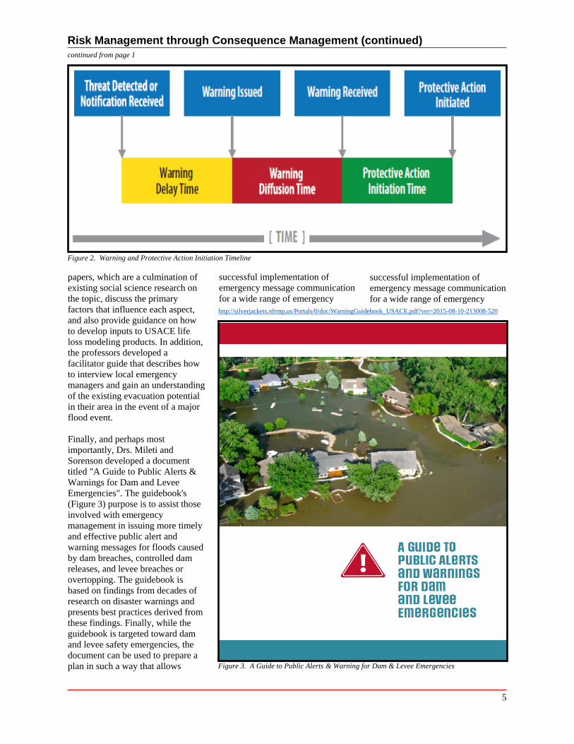
Dr. Dennis Mileti (Professor Emeritus of Sociology, University of Colorado at Boulder) and Dr. John Sorenson (Researcher Emeritus, Oak Ridge National Laboratory, Oak Ridge, TN), both renowned socials scientists in the areas of emergency warning and evacuation, wrote three white papers that cover the areas of warning issuance delay, warning diffusion, and protective action initiation delay (Figure 2). These
continued on page 5
In This Issue:
Director's Comments ........................ Page 1
Risk Management through Consequence Management ..................................... Page 1
FY 2016 PROSPECT Training Program ............................................ Page 4
The Benefits of Going Out in the Field .................................................. Page 6
Upper Susquehanna River CWMS Implementation ................................ Page 7
CEIWR-HEC Software .................. Page 10 HEC-GeoFDA ............................. Page 10
HEC-RAS 5.0 Release ................. Page 11 HEC-FIA 3.0 Release .................. Page 11
CEIWR-HEC Comings & Goings ............................................ Page 12
CEIWR-HEC Engineering/Software Technical Support to USACE ........ Page 13
Figure 1. Hurricane Katrina - People waiting to be rescued
Decisions within the USACE (U.S. Corps of Engineers) Dam and Levee Safety programs follow a risk -informed management process where life safety is held paramount. Understanding and making informed decisions related to life safety risk not only requires a clear understanding of the engineering aspects of USACE's flood defense infrastructure, but also the human aspects (Figure 1). To that end, USACE engaged with well-respected social scientists in the areas of warning and evacuation to better understand how flood warnings spread through a community and what causes an individual to delay their decision to take a protective action based on those warnings. This understanding will not only allow USACE to better assess the existing risk associated with USACE infrastructure and prioritize remediation investments accordingly, but also provide USACE with important insights regarding implementing or recommending efficient and effective risk reduction measures.
US Army Corps of Engineers Hydrologic Engineering Center
1
Director's Comments (continued)
of water-infrastructure projects nationwide. This includes $1.5 billion from Ultra Capital to finance decentralized and scalable water-management solutions, and $500 million from Sustainable Water to develop water reclamation and reuse systems.
More than $1 billion from the private sector over the next decade to conduct research and development into new technologies. This includes $500 million from GE to fuel innovation, expertise, and global capabilities in advanced water, wastewater, and reuse technologies.
A Presidential Memorandum and supporting Action Plan on building national capabilities for long-term drought resilience in the United States, including by setting drought resilience policy goals, directing specific drought resilience activities to be completed by the end of the year, and permanently establishing the National Drought Resilience Partnership as an interagency task force responsible for coordinating drought-resilience, response, and recovery efforts.
Nearly $35 million this year in Federal grants from the Environmental Protection Agency, the National Oceanic and Atmospheric Administration, the National Science Foundation, and the U.S. Department of
Agriculture to support cutting-edge water science;
The release of a new National Water Model that will dramatically enhance the Nation's river-forecasting capabilities by delivering forecasts for approximately 2.7 million locations, up from 4,000 locations today (a 700-fold increase in forecast density)."
USACE has been working on a number of activities that help address some of the commitments announced during the Summit and provided above. For example, Ms. Kathleen D. White (Institute for Water Resources, CEIWR-GR) and the teams within the Climate Preparedness and Resilience Community of Practice are conducting groundbreaking research on estimating possible future climates and hydrology. In addition, to address a Congressional request made through the Energy and Water Appropriations Act of 2016, USACE has prepared the Western Drought Contingency Actions Report. The intent of this report is to characterize droughts, especially those of 2015, and to discuss USACE's water management authorities and drought contingency planning. Another area that is being researched is the possibility of Forecasted Informed Reservoir Operations (FIRO). With FIRO, reservoirs would be operated differently than they are today. Today, due to USACE policy, USACE reservoirs are operated based
on the idea of water on the ground. However, if the FIRO research is fruitful, and USACE policy is rewritten, reservoirs may, in the future, be operated based on forecasted events. The Hydrologic Engineering Center (CEIWR-HEC), along with a host of others, is conducting research to see if FIRO could be used to re-operate the Coyote Valley Dam (Lake Mendocino) on the Russian River, California. The goal of the study is to see if forecasts of Atmospheric Rivers could be used along with a change in the reservoir's rule curve to re-operate the reservoir to provide increased water supply capabilities while still meeting the flood risk management and ecosystem purposes. Much more is to be done regarding the FIRO research before a decision will be made.
Also, as part of the White House Summit, the Assistant Secretary of the Army's office coordinated with USACE on the development and display of fact sheets on USACE water innovations and I am happy to report that a number of CEIWR-HEC tools were featured on these fact sheets. After all, one of CEIWR-HEC's goals has always been to move state-of-the-art procedures and techniques into the state-of-the-practice and therefore put innovation into the hands of the practitioner. The tools CEIWR -HEC creates are available to USACE and water resources professionals worldwide thus enabling the profession to use the innovation as soon as the software is available on the CEIWR-HEC website. Descriptions of the tools
continued on page 3
ADVANCES is an unofficial publication authorized under the provisions of AR 360-1 and published biannually by the U.S. Army Corps of Engineers, Institute for Water Resources, Hydrologic Engineering Center, 609 Second Street, Davis, CA 95616-4687. Telephone: (530) 756-1104; FAX: (530) 756-8250. Views and opinions expressed
US Army Corps in this publication are not necessarily those of the Department of the Army. of EngineersHydrologic Engineering Center Director: Water Resource Systems Chief: http://www.hec.usace.army.mil Christopher N. Dunn, P.E., D.WRE Lea G. Adams, P.E.
2
Director's Comments (continued)
CEIWR-HEC provided for the White House Summit, including some of their innovations, are provided in the following paragraphs.
CWMS (Corps Water Management System): CWMS provides USACE water managers with tools to achieve the full range of congressionally authorized purposes from USACE reservoirs which reduces flood risk and life loss, wards off droughts, supports navigation and hydropower, and enhances the environment. CWMS integrates real-time data acquisition, database storage, flow forecasting of watershed runoff (HEC-HMS), reservoir operations (HEC-ResSim), river profile modeling/ inundated area (HEC-RAS), consequence analysis (HEC-FIA), and information dissemination in a comprehensive suite of software that supports water management decision processes. The National CWMS Implementation Program is in its fourth year and by the end of FY2017 close to 100 CWMS watersheds will be implemented nationwide.
HEC-RAS (River Analysis System): CEIWR-HEC has released an update to the HEC-RAS engineering software, which allows the software to perform two-dimensional hydrodynamics along with integrated one- and two-dimensional modeling, and unsteady flow computations. The update also includes new capabilities for modeling the interaction with groundwater, as well as water-quality and sediment-transport modeling enhancements. The two-dimensional capabilities revolutionizes hydraulic modeling by allowing the user to determine the timing and direction of flow, which is important for evaluating environmental and stream stability issues, and critical to the study of consequences associated with possible dam and levee failure
scenarios. The RAS Mapper Tool provides mapping capabilities – inundation, velocity, and arrival time grids. An article on the HEC-RAS Version 5.0 release can be found on page 11 of this Newsletter and in the previous CEIWR-HEC Newsletter (Spring 2015) .
HEC-HMS (Hydrologic Modeling System): HEC-HMS includes numerous options for modeling many processes in the hydrologic cycle: snowmelt and accumulation; evaporation and transpiration; infiltration; overland flow; baseflow; channel routing; modeling watershed scale sediment transport; and forecasting features. The current version of HEC-HMS (Version 4.1) includes a new Monte Carlo simulation type that allows modelers to evaluate the uncertainty in model parameters. New capabilities under development for future versions includes integrated GIS (Geographic Information System) tools; two-dimensional overland flow and sediment transport capabilities; water quality techniques; and, improved optimization capabilities.
HEC-WAT (Watershed Analysis Tool): HEC-WAT is a new software tool that is using innovative software modeling and integration techniques. HEC-WAT is an integrated system of software, designed for interactive use in a multi-tasking environment to provide information for decision makers in support of water resource studies. This integrative approach supports analyses that meet the USACE requirements of performing water resources studies in a comprehensive, systems-based approach with risk analysis (Flood Risk Analysis (FRA) compute option). The software is the first tool to fully support USACE planning requirements and address the recommendations of the National Research Council's,
National Academy of Sciences 2000 Report, "Risk Analysis and Uncertainty in Flood Damage Reduction Studies". The software is being used nationwide for levee and dam evaluations, and planning and design studies. When CWMS models are directly imported into HEC-WAT, millions of dollars could be saved in model development, thus allowing the districts to meet the requirements of "3x3x3" by providing competent models quickly.
HEC-FIA (Flood Impact Analysis): The current version of HEC-FIA includes: estimating life loss potential with uncertainty for flood events; calculating consequences in real time; supporting the calculation of benefit to cost ratios with uncertainty; calculation of indirect economic impacts to support Regional Economic Development impacts; and, supporting calculations for the Other Social Effects account for feasibility studies. HEC-FIA is used to describe the life loss potential to support USACE's Dam and Levee Safety programs. The software can also support multiple structure inventories and provides the capability for defining Critical Infrastructure elements. An article on the Version 3.0 provisional release can found on page 11 of this Newsletter.
HEC-SSP (Statistical Software Package): The current version HEC-SSP (Version 2.0) includes computation of the peak flow frequency curve following guidance in Bulletin 17B, computation of volume frequency curves, and a coincident frequency analysis. More exciting is the impending release of Version 2.1 (scheduled for April 2016) which will include updates to the peak flow frequency curve, which includes the Expected Moments Algorithm, EMA, as discussed in
continued on page 4
3
Director's Comments (continued)
Bulletin 17C, and a balanced hydrograph tool that can be used for creating hypothetical hydrographs. Additional capabilities under development for future versions of HEC-SSP include a distribution fitting tool, which supports all the Monte Carlo analysis capabilities in other CEIWR-HEC software, and tools for combining multiple frequency curves.
Of course, CEIWR-HEC has had innovation in other software tools in
the last year as well. Software tools such as HEC-LifeSim and HEC-ResSim (Reservoir System Simulation) have certainly pushed the envelope as has HEC-DSS (CEIWR-HEC's data storage system). I can tell you that we are all looking forward to HEC-DSS Version 7. Mr. William Charley recently provided a Brown Bag at CEIWR-HEC and introduced the new capabilities available in HEC-DSS, and reviewed the various enhancements that will be
PROSPECT Training Program
available. CEIWR-HEC is hoping for an FY 2016 release of HEC-DSS Version 7.0 as well as HEC-LifeSim Version 1.0 and HEC-ResSim Version 3.3.
Chris Dunn, P.E., D.WRE Director
Current Program & FY2017 Proposed PROSPECT Training Program By Penni Baker
The PROSPECT (Proponent-Sponsored Engineer Corps Training) program for FY 2016 has been going strong with nine classes completed and two more to be taught (spaces are available):
352 Advanced 1D/2D Modeling with HEC-RAS (11-15 Jul 2016)
123 Flood Frequency Analysis (1-5 Aug 2016)
The table below provides the FY2017 Proposed PROSPECT training program for the Hydrologic Engineering Center. The PROSPECT training program is provided through the USACE Learning Center (ULC). The ULC
is located in Huntsville, Alabama and if you are interested in one or more of the courses, please let the training program lead in your District/Division know so they can report your interest to the ULC.
To register for our courses, please contact the appropriate party in your office or contact ULC, http:// ulc.usace.army.mil. Registration is handled by Training and Operations (CEHR-P-RG). Course descriptions are provided at the ULC site (http:// ulc.usace.army.mil/ CrsSchedule.aspx). A short description along with a course
agenda is also provided on CEIWR -HEC's web site (http:// www.hec.usace.army.mil/training/ course_list.html). To obtain enrollment information, please contact the USACE Learning Center. When doing so, please note the course number, name, date, and location, and contact:
USACE Learning Center 550 Sparkman Drive, NW Huntsville, AL 35816-3416 Phone: (256) 895-7401 FAX: (256) 895-7469
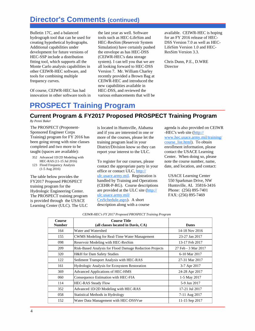
CEIWR-HEC's FY 2017 Proposed PROSPECT Training Program
Course Number
Course Title (all classes located in Davis, CA) Dates
164 Water and Watershed 14-18 Nov 2016
155 CWMS Modeling for Real-Time Water Management 23-27 Jan 2017
098 Reservoir Modeling with HEC-ResSim 13-17 Feb 2017
209 Risk-Based Analysis for Flood Damage Reduction Projects 27 Feb - 3 Mar 2017
320 H&H for Dam Safety Studies 6-10 Mar 2017
122 Sediment Transport Analysis with HEC-RAS 27-31 Mar 2017
161 Hydrologic Analysis for Ecosystem Restoration 3-7 Apr 2017
369 Advanced Applications of HEC-HMS 24-28 Apr 2017
060 Consequence Estimation with HEC-FIA 1-5 May 2017
114 HEC-RAS Steady Flow 5-9 Jun 2017
352 Advanced 1D/2D Modeling with HEC-RAS 17-21 Jul 2017
058 Statistical Methods in Hydrology 7-11 Aug 2017
152 Water Data Management with HEC-DSSVue 11-15 Sep 2017
4
Risk Management through Consequence Management (continued) continued from page 1
Figure 2. Warning and Protective Action Initiation Timeline
papers, which are a culmination of existing social science research on the topic, discuss the primary factors that influence each aspect, and also provide guidance on how to develop inputs to USACE life loss modeling products. In addition, the professors developed a facilitator guide that describes how to interview local emergency managers and gain an understanding of the existing evacuation potential in their area in the event of a major flood event.
Finally, and perhaps most importantly, Drs. Mileti and Sorenson developed a document titled "A Guide to Public Alerts & Warnings for Dam and Levee Emergencies". The guidebook's (Figure 3) purpose is to assist those involved with emergency management in issuing more timely and effective public alert and warning messages for floods caused by dam breaches, controlled dam releases, and levee breaches or overtopping. The guidebook is based on findings from decades of research on disaster warnings and presents best practices derived from these findings. Finally, while the guidebook is targeted toward dam and levee safety emergencies, the document can be used to prepare a plan in such a way that allows
successful implementation of successful implementation of emergency message communication emergency message communication for a wide range of emergency for a wide range of emergency http://silverjackets.nfrmp.us/Portals/0/doc/WarningGuidebook_USACE.pdf?ver=2015-08-10-213008-520
Figure 3. A Guide to Public Alerts & Warning for Dam & Levee Emergencies
5
The Benefits of Going Out in the FieldBy Jon Fenske, P.E.
If there is one piece of advice I could give to every young engineer working on water resources projects is the importance of getting out into the field and seeing the project you are working on first hand. The trip not only will assist in your understanding of model parameters, help visualize the project, but often will increase ones sense of ownership for a project. Field work takes your eyes away from the computer screen to the real world where you can see the impacts of model predictions. A brief description of a project I have been working on and the benefits of a field review are described below.
The Tooele Army Depot is located in north central Utah, adjacent to the Great Salt Lake. From 1942 to 1966, hazardous wastes produced by Depot activities were disposed in wastewater, which flowed through unlined ditches to spreading areas. These disposal practices led to groundwater contamination. This groundwater contamination has spread outside the Depot boundary and is viewed as a potential threat to limited potable water supplies in the Tooele Valley by local developers, farmers, and ranchers.
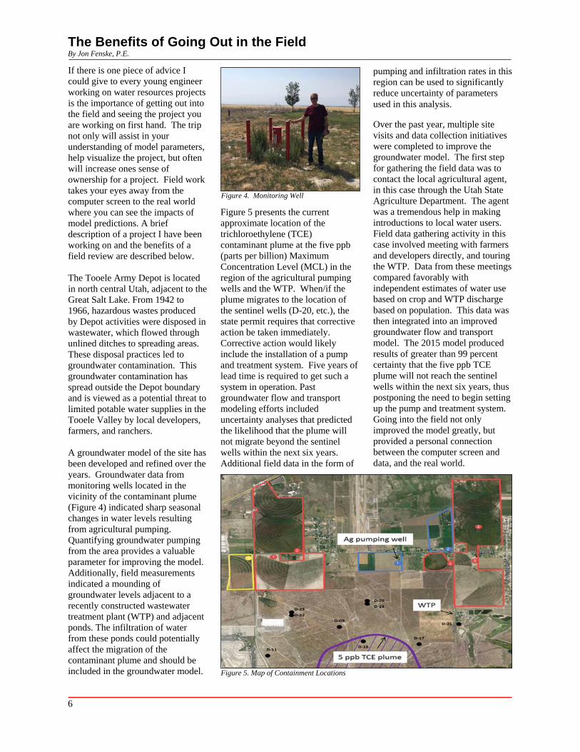
A groundwater model of the site has been developed and refined over the years. Groundwater data from monitoring wells located in the vicinity of the contaminant plume (Figure 4) indicated sharp seasonal changes in water levels resulting from agricultural pumping. Quantifying groundwater pumping from the area provides a valuable parameter for improving the model. Additionally, field measurements indicated a mounding of groundwater levels adjacent to a recently constructed wastewater treatment plant (WTP) and adjacent ponds. The infiltration of water from these ponds could potentially affect the migration of the contaminant plume and should be included in the groundwater model.
Figure 4. Monitoring Well
Figure 5 presents the current approximate location of the trichloroethylene (TCE) contaminant plume at the five ppb (parts per billion) Maximum Concentration Level (MCL) in the region of the agricultural pumping wells and the WTP. When/if the plume migrates to the location of the sentinel wells (D-20, etc.), the state permit requires that corrective action be taken immediately. Corrective action would likely include the installation of a pump and treatment system. Five years of lead time is required to get such a system in operation. Past groundwater flow and transport modeling efforts included uncertainty analyses that predicted the likelihood that the plume will not migrate beyond the sentinel wells within the next six years. Additional field data in the form of
pumping and infiltration rates in this region can be used to significantly reduce uncertainty of parameters used in this analysis.
Over the past year, multiple site visits and data collection initiatives were completed to improve the groundwater model. The first step for gathering the field data was to contact the local agricultural agent, in this case through the Utah State Agriculture Department. The agent was a tremendous help in making introductions to local water users. Field data gathering activity in this case involved meeting with farmers and developers directly, and touring the WTP. Data from these meetings compared favorably with independent estimates of water use based on crop and WTP discharge based on population. This data was then integrated into an improved groundwater flow and transport model. The 2015 model produced results of greater than 99 percent certainty that the five ppb TCE plume will not reach the sentinel wells within the next six years, thus postponing the need to begin setting up the pump and treatment system. Going into the field not only improved the model greatly, but provided a personal connection between the computer screen and data, and the real world.
Figure 5. Map of Containment Locations
6
Upper Susquehanna River CWMS ImplementationBy Michael Bartles, P.E.
The Hydrologic Engineering Center (CEIWR-HEC) has been actively engaged in the development and distribution of the Corps Water Management System (CWMS) software throughout the entire USACE field of operations. Additionally, CEIWR-HEC personnel assist USACE Districts and Divisions in the creation of the individual hydrologic (HEC-HMS, Hydrologic Modeling System), reservoir operation (HEC-ResSim, Reservoir System Simulation), hydraulic (HEC-RAS, River Analysis System), and consequence models (HEC-FIA, Flood Impact Analysis) that form the "backbone" of the CWMS software, along with the integration of the individual models within CWMS and the day to day operation of the CWMS forecasting system.
The Susquehanna River watershed is the second largest watershed east of the Mississippi River with a total contributing drainage area of approximately 27,500 square miles (sq mi). Originating within New York State and flowing through Pennsylvania and Maryland, the Susquehanna River flows in a southerly direction for approximately 630 miles before emptying into the Chesapeake Bay. Major tributaries to the Susquehanna River include the Chemung River, West Branch Susquehanna River, and the Juniata River.
The approximate 4.5 million residents living and working within the Susquehanna River watershed have been subjected to numerous flooding events within the recent past. Due to the watershed's large size, location relative to nearby moisture sources, and predominant weather patterns, flooding can occur year round within the Susquehanna River watershed. Stalled frontal systems, summer-time thunderstorms, tropical and extra-tropical storm systems, and rainfall-augmented snowmelt have
resulted in disastrous flooding events in March 1936, June 1972, January 1996, September 2004, June 2006, and September 2011, amongst others. Additionally, long term droughts have impacted the extremely productive industrial, commercial, municipal, and recreational operations distributed throughout the watershed. The U.S. Army Corps of Engineers (USACE), Baltimore District (CENAB) operates numerous multi-purpose dams, reservoirs, levee systems, and other projects throughout the Susquehanna River watershed to achieve flood control, recreation, water supply, and environmental benefits. The system -wide operation of these projects during future flood and drought conditions to achieve the maximum possible benefits is of utmost concern.
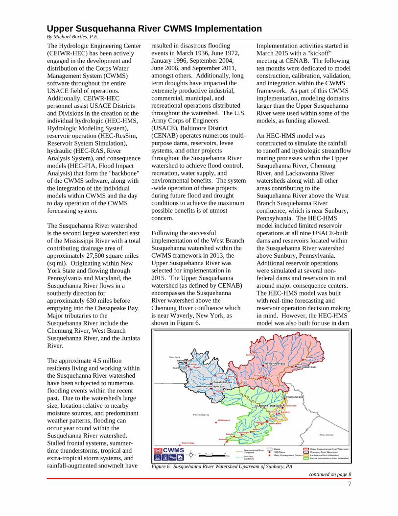
Following the successful implementation of the West Branch Susquehanna watershed within the CWMS framework in 2013, the Upper Susquehanna River was selected for implementation in 2015. The Upper Susquehanna watershed (as defined by CENAB) encompasses the Susquehanna River watershed above the Chemung River confluence which is near Waverly, New York, as shown in Figure 6.
Implementation activities started in March 2015 with a "kickoff" meeting at CENAB. The following ten months were dedicated to model construction, calibration, validation, and integration within the CWMS framework. As part of this CWMS implementation, modeling domains larger than the Upper Susquehanna River were used within some of the models, as funding allowed.
An HEC-HMS model was constructed to simulate the rainfall to runoff and hydrologic streamflow routing processes within the Upper Susquehanna River, Chemung River, and Lackawanna River watersheds along with all other areas contributing to the Susquehanna River above the West Branch Susquehanna River confluence, which is near Sunbury, Pennsylvania. The HEC-HMS model included limited reservoir operations at all nine USACE-built dams and reservoirs located within the Susquehanna River watershed above Sunbury, Pennsylvania. Additional reservoir operations were simulated at several non-federal dams and reservoirs in and around major consequence centers. The HEC-HMS model was built with real-time forecasting and reservoir operation decision making in mind. However, the HEC-HMS model was also built for use in dam
Figure 6. Susquehanna River Watershed Upstream of Sunbury, PA
continued on page 8
7
Upper Susquehanna River CWMS Implementation (continued) continued from page 7
and levee safety studies that are ongoing in addition to basin-wide flood risk management planning studies. Therefore, detailed model discretization was used in and around the numerous local flood protection systems consisting of levees, floodwalls, and other appurtenant features within the Susquehanna River watershed. Model discretization was coordinated with the reservoir simulation and hydraulic routing models. A total of 331 subbasin and 207 routing reach elements were used to estimate flow and reservoir stage hydrographs within the 11,300 square mile modeling domain.
An HEC-ResSim model was constructed for the four USACE-built dams and reservoirs located within the Upper Susquehanna River and Lackawanna River watersheds. Complex system-wide operations were built into the HEC-ResSim model to achieve the maximum possible benefits for population centers such as Binghamton, NY, Endicott, NY, and Johnson City, NY as well as the Scranton/Wilkes Barre, Pennsylvania metropolitan areas. Outputs from the HEC-HMS model were used as boundary conditions to simulate flood control, water supply, environmental, and recreation operations within the HEC-ResSim model. Similar to the HEC-HMS model, the HEC-ResSim model was constructed to achieve multiple modeling purposes including real-time forecasting, reservoir decision making, dam, and levee safety studies.
An HEC-RAS model was constructed to simulate the complex streamflow routing processes within approximately 220 miles of streams within the Upper Susquehanna River watershed. Five large federally-constructed levee systems at major population centers were included within the HEC-RAS modeling domain in addition to numerous non-federally constructed
levee systems. The construction of the HEC-RAS model was closely coordinated with the HEC-HMS and HEC-ResSim models to optimally use output from both models for real-time forecasting as well as ongoing dam and levee safety studies.
An HEC-FIA model was constructed to estimate economic consequences as well as project benefits for the Upper Susquehanna River watershed. The HEC-FIA model made use of the exact same model domain as the HEC-RAS model. An updated structure inventory was used to determine dam and levee system benefits during real-time forecasting operations.
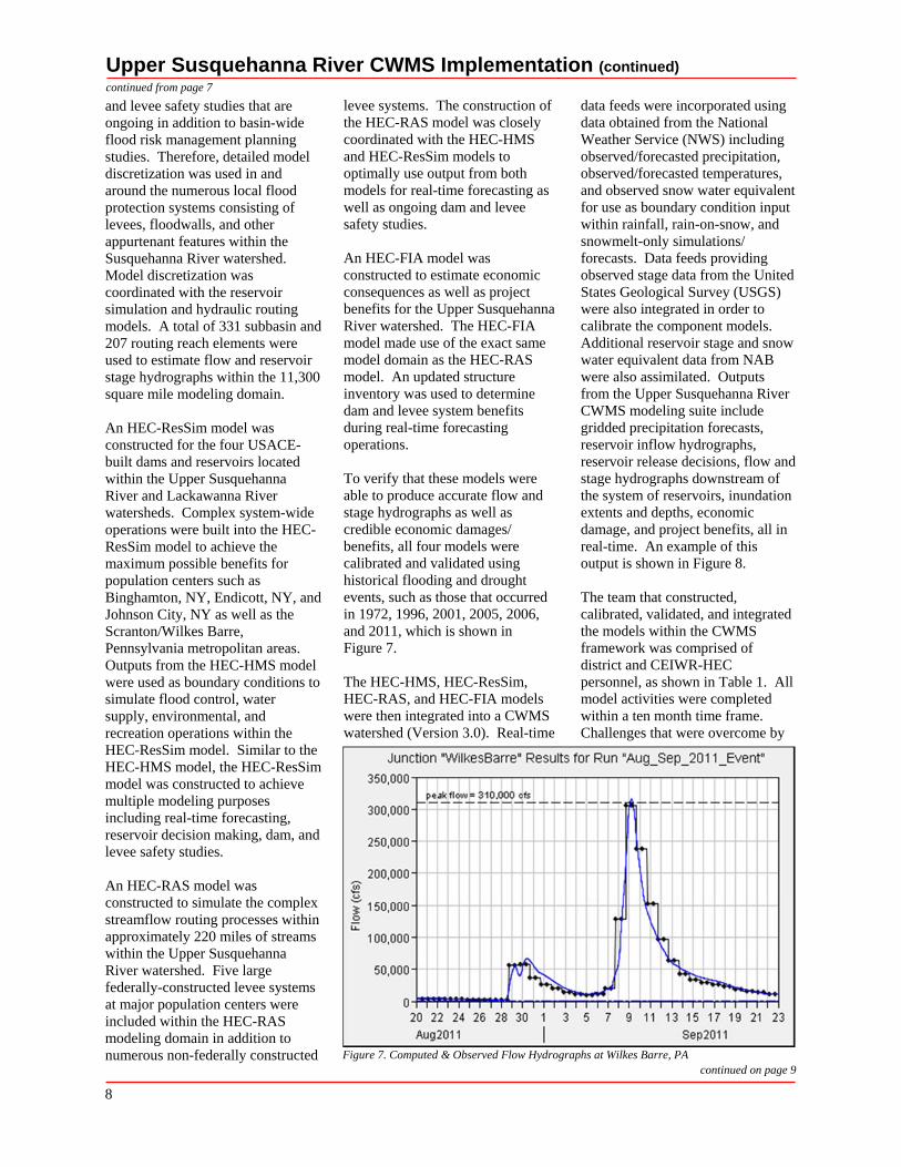
To verify that these models were able to produce accurate flow and stage hydrographs as well as credible economic damages/ benefits, all four models were calibrated and validated using historical flooding and drought events, such as those that occurred in 1972, 1996, 2001, 2005, 2006, and 2011, which is shown in Figure 7.
The HEC-HMS, HEC-ResSim, HEC-RAS, and HEC-FIA models were then integrated into a CWMS watershed (Version 3.0). Real-time
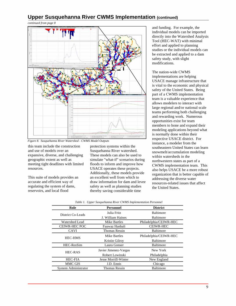
data feeds were incorporated using data obtained from the National Weather Service (NWS) including observed/forecasted precipitation, observed/forecasted temperatures, and observed snow water equivalent for use as boundary condition input within rainfall, rain-on-snow, and snowmelt-only simulations/ forecasts. Data feeds providing observed stage data from the United States Geological Survey (USGS) were also integrated in order to calibrate the component models. Additional reservoir stage and snow water equivalent data from NAB were also assimilated. Outputs from the Upper Susquehanna River CWMS modeling suite include gridded precipitation forecasts, reservoir inflow hydrographs, reservoir release decisions, flow and stage hydrographs downstream of the system of reservoirs, inundation extents and depths, economic damage, and project benefits, all in real-time. An example of this output is shown in Figure 8.
The team that constructed, calibrated, validated, and integrated the models within the CWMS framework was comprised of district and CEIWR-HEC personnel, as shown in Table 1. All model activities were completed within a ten month time frame. Challenges that were overcome by
Figure 7. Computed & Observed Flow Hydrographs at Wilkes Barre, PA continued on page 9
8
Upper Susquehanna River CWMS Implementation (continued) continued from page 8
Figure 8. Susquehanna River Watershed - CWMS Model Outputs
this team include the construction and use of models over an expansive, diverse, and challenging geographic extent as well as meeting tight deadlines with limited resources.
This suite of models provides an accurate and efficient way of regulating the system of dams, reservoirs, and local flood
protection systems within the Susquehanna River watershed. These models can also be used to simulate "what-if" scenarios during floods to inform and improve how USACE operates these projects. Additionally, these models provide an excellent well from which to draw information for dam and levee safety as well as planning studies thereby saving considerable time
and funding. For example, the individual models can be imported directly into the Watershed Analysis Tool (HEC-WAT) with minimal effort and applied to planning studies or the individual models can be extracted and applied to a dam safety study, with slight modifications.
The nation-wide CWMS implementations are helping USACE manage infrastructure that is vital to the economic and physical safety of the United States. Being part of a CWMS implementation team is a valuable experience that allows modelers to interact with large regional and/or national scale teams performing both challenging and rewarding work. Numerous opportunities exist for team members to hone and expand their modeling applications beyond what is normally done within their respective USACE district. For instance, a modeler from the southeastern United States can learn snowmelt/accumulation modeling within watersheds in the northwestern states as part of a CWMS implementation team. This also helps USACE be a more robust organization that is better capable of addressing the diverse water resources-related issues that affect the United States.
Table 1. Upper Susquehanna River CWMS Implementation Personnel
Role Personnel District
District Co-Leads Julia Fritz
J. William Haines Baltimore Baltimore
Watershed Lead CEIWR-HEC POC
Mike Bartles Fauwaz Hanbali
Philadelphia/CEIWR-HEC CEIWR-HEC
CAVI Thomas Ressin Baltimore
HEC-HMS
HEC-ResSim
Mike Bartles Kristin Gilroy Laura Gonser
Philadelphia/CEIWR-HEC Baltimore Baltimore
HEC-RAS
HEC-FIA MMC GIS
System Administrator
Javier Jimenez-Vargas Robert Lowinski
Jesse Morrill-Winter J.D. Ennis
Thomas Ressin
New York Philadelphia New England
Chicago Baltimore
9
HEC Software HEC-GeoFDA By William Lehman
The Hydrologic Engineering Center's (CEIWR-HEC) Flood Damage Reduction Analysis (HEC-FDA) software has been a significant tool for the USACE Flood Risk Management Community of Practice for many years. HEC-FDA was originally designed to work with riverine (one -dimensional) hydraulic data, but occasionally the complexity of the terrain and hydraulics of a study area require a two-dimensional analysis as well.
Mr. Kurt Keilman, Division Economist, South Pacific Division (CESPD), developed a method a number of years ago to utilize two-dimensional hydraulic data in HEC-FDA. Mr. Keilman worked with Mr. Jim O'Brien, developer of the commercial hydraulic analysis software FLO-2D (FLO-2D Software, Inc., Nutrioso, AZ), to create a tool to post-process FLO-2D hydraulic output into a file format that HEC-FDA could read. This tool was subsequently used by the Sacramento District (CESPK) to evaluate structure damage occurring
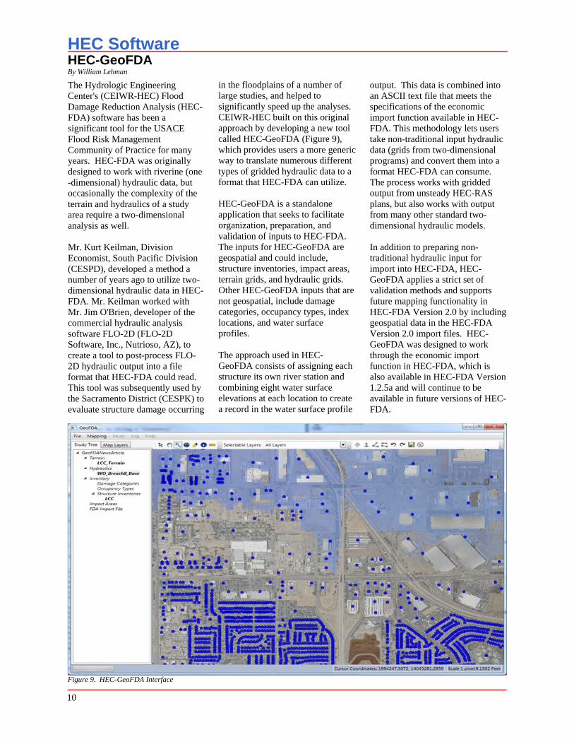
in the floodplains of a number of large studies, and helped to significantly speed up the analyses. CEIWR-HEC built on this original approach by developing a new tool called HEC-GeoFDA (Figure 9), which provides users a more generic way to translate numerous different types of gridded hydraulic data to a format that HEC-FDA can utilize.
HEC-GeoFDA is a standalone application that seeks to facilitate organization, preparation, and validation of inputs to HEC-FDA. The inputs for HEC-GeoFDA are geospatial and could include, structure inventories, impact areas, terrain grids, and hydraulic grids. Other HEC-GeoFDA inputs that are not geospatial, include damage categories, occupancy types, index locations, and water surface profiles.
The approach used in HEC-GeoFDA consists of assigning each structure its own river station and combining eight water surface elevations at each location to create a record in the water surface profile
output. This data is combined into an ASCII text file that meets the specifications of the economic import function available in HEC-FDA. This methodology lets users take non-traditional input hydraulic data (grids from two-dimensional programs) and convert them into a format HEC-FDA can consume. The process works with gridded output from unsteady HEC-RAS plans, but also works with output from many other standard two-dimensional hydraulic models.
In addition to preparing non-traditional hydraulic input for import into HEC-FDA, HEC-GeoFDA applies a strict set of validation methods and supports future mapping functionality in HEC-FDA Version 2.0 by including geospatial data in the HEC-FDA Version 2.0 import files. HEC-GeoFDA was designed to work through the economic import function in HEC-FDA, which is also available in HEC-FDA Version 1.2.5a and will continue to be available in future versions of HEC-FDA.
Figure 9. HEC-GeoFDA Interface
10
HEC-RAS (River Analysis System) Version 5.0 Release By Penni Baker
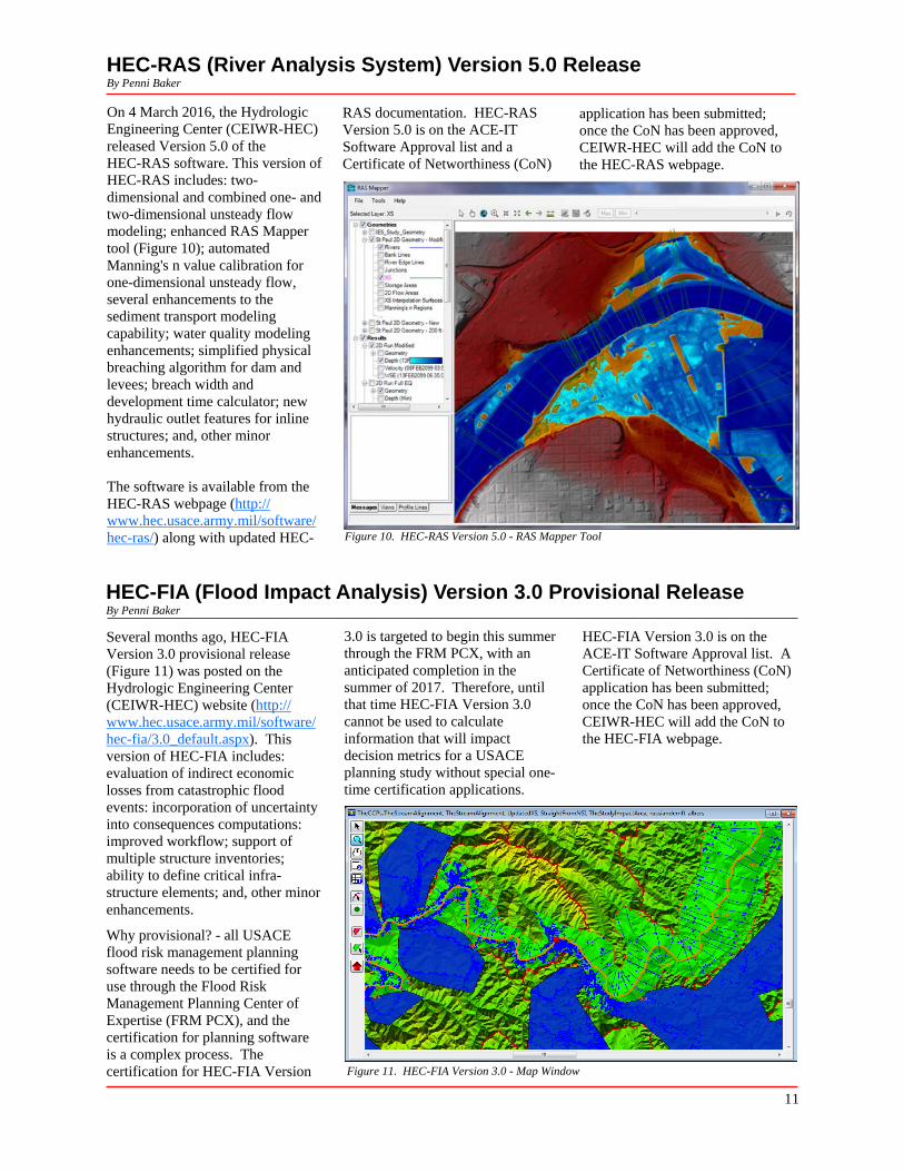
On 4 March 2016, the Hydrologic Engineering Center (CEIWR-HEC) released Version 5.0 of the HEC-RAS software. This version of HEC-RAS includes: two-dimensional and combined one- and two-dimensional unsteady flow modeling; enhanced RAS Mapper tool (Figure 10); automated Manning's n value calibration for one-dimensional unsteady flow, several enhancements to the sediment transport modeling capability; water quality modeling enhancements; simplified physical breaching algorithm for dam and levees; breach width and development time calculator; new hydraulic outlet features for inline structures; and, other minor enhancements.
The software is available from the HEC-RAS webpage (http:// www.hec.usace.army.mil/software/ hec-ras/) along with updated HEC-
RAS documentation. HEC-RAS application has been submitted; Version 5.0 is on the ACE-IT once the CoN has been approved, Software Approval list and a CEIWR-HEC will add the CoN to Certificate of Networthiness (CoN) the HEC-RAS webpage.
Figure 10. HEC-RAS Version 5.0 - RAS Mapper Tool
HEC-FIA (Flood Impact Analysis) Version 3.0 Provisional Release By Penni Baker
Several months ago, HEC-FIA Version 3.0 provisional release (Figure 11) was posted on the Hydrologic Engineering Center (CEIWR-HEC) website (http:// www.hec.usace.army.mil/software/ hec-fia/3.0_default.aspx). This version of HEC-FIA includes: evaluation of indirect economic losses from catastrophic flood events: incorporation of uncertainty into consequences computations: improved workflow; support of multiple structure inventories; ability to define critical infra-structure elements; and, other minor enhancements.
Why provisional? - all USACE flood risk management planning software needs to be certified for use through the Flood Risk Management Planning Center of Expertise (FRM PCX), and the certification for planning software is a complex process. The certification for HEC-FIA Version
3.0 is targeted to begin this summer through the FRM PCX, with an anticipated completion in the summer of 2017. Therefore, until that time HEC-FIA Version 3.0 cannot be used to calculate information that will impact decision metrics for a USACE planning study without special one-time certification applications.
HEC-FIA Version 3.0 is on the ACE-IT Software Approval list. A Certificate of Networthiness (CoN) application has been submitted; once the CoN has been approved, CEIWR-HEC will add the CoN to the HEC-FIA webpage.
Figure 11. HEC-FIA Version 3.0 - Map Window
11
CEIWR-HEC Comings & GoingsBy Diane Cuming
During the Hydrologic Engineering Center's (CEIWR-HEC) fifty years of existence (1964 – 2014) there have been approximately 175 permanent and part-time individuals employed by the Center. This number however does not include visiting scholars, volunteers, and DA Interns. For a small office with an average authorized space count of forty, CEIWR-HEC has had the luxury of a very small turnover rate. That said, CEIWR-HEC went through a relatively large retirement turnover from 1999 thru 2001. Now fifteen years later, the Center may be headed towards another turnover cycle. The following provides some details on individuals who have come and gone for various reasons since the beginning of 2015.
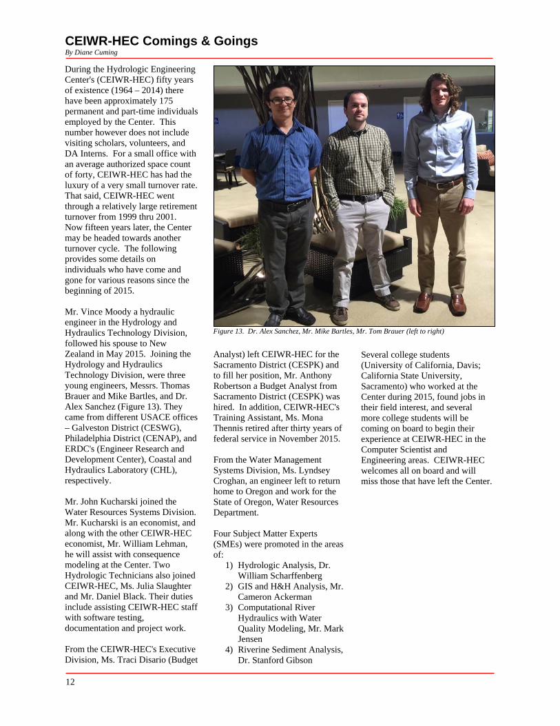
Mr. Vince Moody a hydraulic engineer in the Hydrology and Hydraulics Technology Division, followed his spouse to New Zealand in May 2015. Joining the Hydrology and Hydraulics Technology Division, were three young engineers, Messrs. Thomas Brauer and Mike Bartles, and Dr. Alex Sanchez (Figure 13). They came from different USACE offices – Galveston District (CESWG), Philadelphia District (CENAP), and ERDC's (Engineer Research and Development Center), Coastal and Hydraulics Laboratory (CHL), respectively.
Mr. John Kucharski joined the Water Resources Systems Division. Mr. Kucharski is an economist, and along with the other CEIWR-HEC economist, Mr. William Lehman, he will assist with consequence modeling at the Center. Two Hydrologic Technicians also joined CEIWR-HEC, Ms. Julia Slaughter and Mr. Daniel Black. Their duties include assisting CEIWR-HEC staff with software testing, documentation and project work.
From the CEIWR-HEC's Executive Division, Ms. Traci Disario (Budget
Figure 13. Dr. Alex Sanchez, Mr. Mike Bartles, Mr. Tom Brauer (left to right)
Analyst) left CEIWR-HEC for the Sacramento District (CESPK) and to fill her position, Mr. Anthony Robertson a Budget Analyst from Sacramento District (CESPK) was hired. In addition, CEIWR-HEC's Training Assistant, Ms. Mona Thennis retired after thirty years of federal service in November 2015.
From the Water Management Systems Division, Ms. Lyndsey Croghan, an engineer left to return home to Oregon and work for the State of Oregon, Water Resources Department.
Four Subject Matter Experts (SMEs) were promoted in the areas of:
1) Hydrologic Analysis, Dr. William Scharffenberg
2) GIS and H&H Analysis, Mr. Cameron Ackerman
3) Computational River Hydraulics with Water Quality Modeling, Mr. Mark Jensen
4) Riverine Sediment Analysis, Dr. Stanford Gibson
Several college students (University of California, Davis; California State University, Sacramento) who worked at the Center during 2015, found jobs in their field interest, and several more college students will be coming on board to begin their experience at CEIWR-HEC in the Computer Scientist and Engineering areas. CEIWR-HEC welcomes all on board and will miss those that have left the Center.
12
CEIWR-HEC Engineering/Software Technical Support to USACEBy Diane Cuming
The Hydrologic Engineering Center (CEIWR-HEC) is responsible for creating and maintaining various pieces of software that can be categorized in seven different engineering modeling areas:
1) River Hydraulics 2) Hydrologic Analysis 3) Hydrologic Statistical Analysis 4) Reservoir Systems 5) Data Storage 6) Flood Risk and Consequence
Analysis, and 7) Environmental Analysis
By assigning CEIWR-HEC software to one of these seven areas, CEIWR-HEC can provide engineering and technical support to U.S. Corps of Engineers (USACE). USACE offices can voluntary elect any of the areas and then purchase technical support. This engineering and technical support provides USACE offices with access to the CEIWR-HEC developers of individual pieces of software. Unfortunately, CEIWR-HEC is not funded to provide support to those outside of USACE, non-USACE individuals and organizations should search the Internet to locate a vendor that can provide support for the CEIWR-HEC software of interest.
For those new to CEIWR-HEC software an overview of each of the categories is discussed below.
1. River Hydraulics (HEC-RAS, HEC-GeoRAS, HEC-UNET, HEC-2, HEC-6). HEC-RAS (River Analysis System) is the most widely used river hydraulics model in USACE offices. The software is used in every USACE District office for studies ranging from risk
analysis to dam breach scenario simulation and is one of the main tools used by the Mapping, Modeling, and Consequences Center (MMC). HEC-RAS computes water surface profiles based on one and two-dimensional, rigid and mobile boundary, steady and unsteady flow principles. HEC -RAS Version 5.0, is the current version and is available from the CEIWR-HEC website. HEC-2 (Water surface Profiles), HEC-6 (Sediment Transport), and HEC-UNET (One-Dimensional Unsteady Flow Through a Full Network of Open Channels) are legacy software that provides steady-flow water surface profiles, sediment transport computations, and, unsteady flow analysis, respectively. Most, if not all of the legacy software's features have been superseded by the capabilities found in HEC-RAS. HEC-RAS Version 5.0 includes:two -dimensional modeling features, sediment transport and water quality capabilities which will continue to be developed and enhanced. RAS Mapper is a tool that is available in HEC-RAS Version 5.0, which provides the capability to handle large terrain data sets, for inundation mapping. For the future, Version 5.1 will continue with enhancements to the two-dimensional modeling features, support for extraction of geometric information from terrain datasets using the RAS Mapper Tool, and include uncertainty analysis capabilities.
2. Hydrologic Analysis (HEC-HMS, HEC-GeoHMS, HEC-1, HMR52). The Hydrologic Modeling System (HEC-HMS) is the most widely used precipitation-runoff program in USACE. Version 4.1 is the current version of HEC-HMS available from the CEIWR-HEC website and computes precipitation-runoff from all types of watersheds. The software can be applied to studies of water availability, urban drainage, flow forecasting, future
urbanization impact, reservoir spillway design, flood risk management reduction, floodplain regulation, systems operation, sediment transport, and water quality. In conjunction with the probable maximum storm generator software, HMR52 (Probable Maximum Storm - Eastern United States), HEC-HMS can be used to compute the probable maximum flood for project safety, spillway adequacy studies, and perform spatially distributed precipitation-runoff analysis and continuous simulation. HEC-GeoHMS is a GIS extension that can be used to rapidly develop HEC-HMS basin models from digital elevation models. The extension dramatically reduces staff time necessary to construct models, especially large or complex models. Also, Version 4.1 includes new forecasting capabilities and an uncertainty analysis option. Version 4.2 of HEC-HMS will be released in FY 2016 and will include new GIS capabilities (automatic subbasin delineation directly in the program), new forecasting features, new modeling capabilities (including an energy balance snowmelt method), and a HMR52 meteorologic model option directly within HEC-HMS.
3. Hydrologic Statistical Analysis (HEC-SSP, HEC-FFA, STATS). Version 2.0 of the Statistical Software Package, HEC-SSP, includes capabilities from the Flood Frequency Analysis (HEC-FFA) software and some of the capabilities available from the Statistical Analysis of Time-Series Data (STATS) software. HEC-SSP
continued on page 14
13
CEIWR-HEC Engineering/Software Technical Support to USACE (continued) continued from page 13
also plans to include capabilities found in the Regional Frequency Computation (REGFRQ) and Multiple Linear Regression Program (MLRP) software packages in a future version. The software can perform flood flow frequency analysis based on guidelines in Bulletin 17B, "Guidelines for Determining Flood Flow Frequency" (1982). Also, HEC-SSP contains tools for developing a generalized frequency analysis using other hydrologic data types, a volume frequency analysis on high and low flows, a duration analysis, a coincident frequency analysis, and a curve combination analysis. Flow-frequency is an integral part of USACE risk analysis and proper development of flow-frequency curves is an instrumental piece of the risk analysis procedure. Version 2.1 of HEC-SSP will be released in FY 2016 and will include a new Balanced Hydrograph analysis along with the Expected Moments Algorithm for computing flow frequency analyses.
4. Reservoir Systems (HEC-ResSim, HEC-ResFloodOpt, HEC-PRM, HEC-5, HEC-5Q). The HEC -ResSim (Reservoir System Simulation) software can simulate the operation of complex reservoirs and reservoir systems for both planning studies and real-time water management needs. Like the other engineering modeling software in the current generation of CEIWR-HEC products, HEC-ResSim provides a graphical user interface for model building, file management, program execution, and output displays. Version 3.1 is the current release of HEC-ResSim
and is available from the CEIWR-HEC website. The two other available reservoir-modeling programs are optimization tools. The Prescriptive Reservoir Model (HEC-ResPRM) software optimizes reservoir release decisions to maximize multiple system objectives, and is useful in developing operation rules to meet reservoir system goals. HEC-ResFloodOpt (Reservoir Flood Control Optimization) optimizes single-objective flood event operations. Both HEC-ResPRM and HEC-ResFloodOpt combine the physical system model from HEC-ResSim with a linear programming or mixed-integer programming optimization solver. HEC-5 (Simulation of Flood Control and Conservation Systems) is CEIWR-HEC's legacy reservoir simulation model and can determine reservoir releases for flood reduction, water supply, and electric energy demands. HEC-5 can simulate the operation of multiple-purpose reservoir systems using time intervals from minutes to months. A companion program, HEC 5Q (HEC-5, Water Quality Analysis), provides water quality analysis for reservoir and river systems.
5. Data Storage (HEC-DSS, HEC-DSSVue). HEC-DSS (Data Storage System) provides for the management of time series data used in studies and water management activities. Data may be entered, edited, tabulated, graphed, and exchanged between a variety of hydrologic engineering and planning analysis-modeling programs. In particular HEC-DSS plays a role in ensuring data is managed in a way that is efficient
for hydrologic, planning, and real time operations. For example, HEC -DSS is an integral part of the HEC-WAT (Watershed Analysis Tool) and CWMS (Corps Water Management System) pieces of software. The primary user interface for HEC-DSS is HEC-DSSVue, a Java-based graphical interface that is supported both on UNIX and Windows computers. The software plots and tabulates data in an HEC-DSS database file using simple mouse selections. Over sixty mathematical manipulation functions are available for operations on data sets within a HEC-DSS file, as well as data entry functions, and several utility and database maintenance functions. Data can be displayed from a selection of data set names or from spatially referenced locations with a map background. Common data stored in HEC-DSS include time series data, such as hourly or daily flow, stages, precipitation, elevation, and storage data; curve data, such as rating tables and frequency curves; gridded data, such as NexRad data; and a variety of other data types.
6. Flood Risk and Consequence Analysis (HEC-FDA, HEC-FIA). The Flood Impact Analysis (HEC-FIA) software was developed for the CWMS modernization project in the early 2000s. The current version of HEC-FIA is an improved GIS-enabled version, which is also used to support consequence estimates for USACE Dam and Levee Safety Risk Assessments. These improvements were made to assist the USACE Modeling Mapping and Consequences (MMC) in evaluating the risk associated with various failure scenarios for dams and levees. Some of the improvements were associated with modifying the capability to model warning issuance, adding the capability of using arrival time grids, duration grids, and depth x velocity grids. Improvements include the ability to
continued on page 15
14
CEIWR-HEC Engineering/Software Technical Support to USACE (continued) continued from page 14
use higher resolution data, such as parcel level inventories, to represent the structures within the floodplain. The Flood Damage Reduction Analysis (HEC-FDA) software provides the capability to perform an integrated hydrologic engineering and economic analysis during the formulation and evaluation of flood risk management plans. HEC-FDA is USACE's number one tool for the formulation and evaluation of flood risk management measures. The software is designed to assist study team members in using risk analysis flows are defined by the interest HEC-EFM applications. HEC-procedures for formulating and groups and presented in a common GeoEFM is an extension (ESRI evaluating flood risk management format, which provides a foundation ArcMap Version 9.3) that provides measures and analyzing the for resolving areas of conflict. three primary capabilities for users economics of flood risk Flows created in HEC-RPT are planning ecosystem restoration management projects. exported for analysis in other projects or water management
programs, including reservoir scenarios: 1) management of spatial simulations, river hydraulics, and data sets, 2) computation and ecosystem functions. HEC-EFM is comparisons of habitat areas, and 3) a planning tool that analyzes assessment of habitat connectivity. ecosystem response to changes in HEC-EFMSim performs river flow and stage. Using a continuous simulations (spatially combination of statistical and and temporally) of ecosystems. spatial features, HEC-EFM enables Applications of HEC-EFMSim can project teams to define existing be as simple as one community for ecologic conditions, highlight one location and as complex as the
7. Environmental Analysis (HEC- promising restoration sites, and rate user would like to simulate. The RPT, HEC-EFM, HEC-GeoEFM, alternatives according to their software is being designed to HEC-EFMSim). The Regime relative changes in ecosystem simulate ecosystems for large Prescription Tool (HEC-RPT), the aspects. HEC-EFM Plotter allows spatial areas and long time periods. Ecosystem Functions Model (HEC- users to display and assess the EFM), with its accessories for statistical analyses performed in statistical (HEC-EFM Plotter) and spatial analyses (HEC-GeoEFM), and new software known as HEC-EFMSim, comprise a suite of tools designed for use in ecosystem restoration projects, water allocation studies, and efforts to improve the ecological sustainability of land and water management practices. The purpose of HEC-RPT is to help interest groups reach consensus about how rivers should be managed. The software does this by plotting and comparing desired river flows from a range of perspectives (e.g., flood risk management, water supply, hydropower, navigation, and ecosystem maintenance). These
15

16