Embed Size (px)
Citation preview

A GEOLOGIC ROAD LOG OVER
CHINOOK, WHITE PASS, AND ELLENSBURG
By
Newel I P. Campbel I
INFORMATION CIRCULAR 54
TO YAKIMA HIGHWAYS
STATE OF WASHINGTON
DEPARTMENT OF NATURAL RESOURCES
DIVISION OF GEOLOGY AND EARTH RESOURCES
1975

STATE OF WASHINGTON
DEPARTMENT OF NATURAL RESOURCES
BERT L. COLE, Commissioner of Public Lands
DON LEE FRASER, Supervisor
DIVISION OF GEOLOGY AND EARTH RESOURCES
VAUGHN E. LIVINGSTON JR., State Geologist
INFORMATION CIRCULAR 54
A GEOLOGIC ROAD LOG OVER
CHINOOK, WHITE PASS, AND ELLENSBURG
TO YAKIMA HIGHWAYS
By
NEWELL P. CAMPBELL
1975
For ,ale by the Department of Natural Re,oun:M, Olympia, Washington, 98504 Price t 1.50


A GEOLOGIC ROAD LOG OVER
CHINOOK, WHITE PASS, AND ELLENSBURG
TO YAKIMA HIGHWAYS
By
Newel I P. Campbel I
INTRODUCTION
Many persons taking a motor trip in this picturesque area of Washington State will be interested in the
landscape along the highways . Particular interest may be shown in different rock formations , topography of
the lend, the meandering courses the rivers and streams take, the flat lands, mountains, and the canyons.
These four road logs were completed with the thought in mind that en explanation of the geology
would serve a useful purpose. Earth science teachers may take their students on field trips in the area and use
the road logs to point out particular geologic features, such cs faults, folds, or o ld volcanic cones . How bet
ter to explain en anticline then to i llustrate the definition with the view of Umtanum antic li ne.
These road logs were compiled through a series of field trips by Newell Campbell, an instructor of
geology ct Yakima Valley College. Each leg of the journey contains a map showing the highways used in that
leg. The topogrcphi c maps that cover that area ere also listed. Sketches end pictures portray the different
features end contribute to a better understcndi ng of the text.
A mileage column enables travelers to determine the distance between points, with an accumu lated
total at the end of each log. To allow for any differences in car odometers, many check points ere included.
Whenever possible creek crossings, campground names, end road junctions ere noted .
As you traverse the area end follow the text of the logs, you wi 11 notice many points of interest away
from the highway are indicated by a time, such as ••. "on your right ct 3:00. 11 This o'clock system is based
on the assumption that the hood of your car is always pointed at 12 o'clock.
II 12
7 6
5
2
3
4
For additional information on the geology of the area, please consult the sources included in the
reference list. For i nstance, more detail on the pictographs painted on the rocks in leg 4 may be found in
H. T. Cain (1960) .

2
LOCATION MAP SHOWING HIGHWAYS AND AREA COVERED

FOR EACH OF THE FOUR LEGS IN THE ROAD LOG
A 1,; E
.-~~ . .,, .. ,,, '\.,.,~ 6 .'!~l,',;:,,Y,..\:"'.--. 0 1>,..
Ellensburg to
. . [
U.S . 12 - 410 Junction vie 1- 82 Freeway
LEG II
LEG Ill
U.S. 12-410Junction LEG IV
3
30' R .q l

4
GEOLOGIC MAP TO ACCOMPANY ROAD LOG OVER CHINOOK
3(): R I? E
INTRUSIVE ROCKS METAMORPHIC ROCKS
w w z z w I rt~ I w u
T atoosh pluton 8 G 0 pre-Tatoosh intrusives :::; C) ... :::; 0
I Tdp I w Dacite porphry z
G w
I lbb I u Cowlitz chimneys w 0 z Bumping Lake breccia w w
8 ~ i Bumping Lake granite
I [ I pl!m l tndian Creek gneiss ~ and amphibolite ...
~ Rimrock Lake intrusions BASE MAP : U.S. Army Ma S..rvice

5
PASS, WHITE PASS, AND ELLENSBURG TO YAKIMA HIGHWAYS
CNU1'tCUWYt Ml
... ~ z .... Stream alluvium u ....
"' ~ Landslides
§] CI ear Fork Dacite
.... ~ Tumac Mountain Basalt SEDIMENTARY AND EXTRUSIVE ROCKS z ~
.... u Hogback Mountain basalt 0 ... .... "' z
G .... I Q,b I [fJ .... Ohanapecosh - ·Spiral Butte Andesite "post-Vantage" Yakima Basalt
u ~ w 0 z w Formation
IQRo J
.... Q2J Mount Rainier Andesite
u "pre-Vantage" Yakima Bosa It ~ Q
,<
IQTo I ~ G j::
~ Tieton Andesite Fifes Peak Formation "' Russe It Ranch w ... .... ~
.... I Formation z Z· .... Devi Is Horn Formation w "' .... u ~ u 0 0 0
~ C) Stevens Ridge Formation ~
~ E 11 ensburg Formation -0

AGE
c Q) u
J!
Upper
Q) C: Q) 0
.2 "' ·cu
a:
Lower
INFORMAL STRATIGRAPH IC CO LUMN OF SE DI MENTARY AND EXTRUS IVE FORMATIONS THAT CROP OUT ALONG HIGHWAYS IN THE
YAK IMA, WHITE PASS, AND CHINOOK PASS AREA
ROCK UNIT MEMBER AND BED THICKNESS CHARACTERISTICS (feet)
River and stream Most ly flood plain deposits. alluvium 0-200 Some alluvial fans .
Landslide Clay- to boulder-size debris. deposits 0-200 Moy inc lude some Pleistocene
slides.
Glacial 0-300 Inc ludes moraines, till, and
debris outwosh of volley glaciers .
Clear Fork Gray, fine-groined with long, Docite 50-300 thin columns. Abundant
quartz.
Tumoc Mountain Block olivine bosolt forms basalt flow 0-500(?) inter-canyon flows and includes
Tumoc Mountain cinder cone .
Hogback Dork gray basalt with olivine Mountain 200(?) phenocrysts . Flows ore thin basalt flow and vesicular •
Spiral Butte Light gray, platy ondesite Andesite 100-400 with associated yellow tuffs.
Includes Spira l Butte cone.
Mount Rainier Hypersthene and olivine ondesite Andesite 4,00o+ flows and re lated mud flows.
Tieton Dork gray hypersthene andesite Andesite porphyry wi th large plogioclose
100-500 phenocrysts. Well-developed colonnade and entobloture .
Unconformity
°'

Devi Is Horns Pyroclostics and some inter-pyroclostics 200+ bedded ondesite flows.
Upper
Upper port of Sequence of conglomerates and Ellerisburg sandstones with interbedded Formation basalt flows.
Q)
C Upper port of Ellensburg Formation Q) u 0 Ellensburg contains tuffs, conglomerates,
a: Formation and sandstones. 225- 275
Beverly Member
Beverly (Selah) Member contains coarse volconiclostic sediments .
Pomona Pomona flow hos flattened vesicles basal t and fan-shaped columns in entabloture flow
Unconformity
Lorge columns, weak platy parting,
Priest Ropi ds medium- to coarse-groined,
50-200 phenocrysts absent. Usually, Member only one flow present in area of
rood log.
Lorge lath- shaped plogioclase Rozo Basalt 90-110
phenocrysts and thick columns Member wi th platy porting perpendi cu lor
to column length.
Upper
Squaw Creek 10-20 White diotomite and some
Diotomite si ltstone.
All three flows contain large co lumns and Jorge plogioclose phenocrysts .
"' 0) C ... Sentinel Sentinel Gap flow contains
11 Post-Vantage 11 a. ... Gap V'l Q) irregular joints and mosses
Yakima c.O
Basa lt o E Flow of po lagoni te. E <II
-5~ Sand C
~ Hollow 220- 240 Sand Hollow flow hos on upper u.. and lower columnar zone.
(continued on next page) Flow '-I

Informal Stratigraphi c Co lumn - Continued 00
AGE ROCK UNIT MEMBER AND BED THICKNESS CHARACTERISTICS (feet)
Gingko Flow
Gingko flow contains abundant pillow pologonite.
"' In addition to the three named O> a, C flows, there ore ot I east two O> ...
other flows within the French-2 0 ..... a. ...
Vl a, man Springs Member. One, ce- c..!l O·- 0 >-" "' o E locally known os the Kelly I O ,B E a,
-:;; >- -5~ Ho I low flow, resembles the ~ C Roza, and probably lies between : ~ the Sand Hollow and Sentinel u.
Gap flows . Another flow called the Union Gap flow is probably younger than Sentinel Gap.
Vantage Fine to medium groined, light-gray,
10-100 friab le sandstone. Some cross-Sandstone bedding, some cloy and silt
interbeds.
Museum Contains sma II fe Ids par phenocrysts. Basalt 100 Vesicles similar to Rocky Coulee flow flow pipe vesicles.
a, 3 to 4 ft well-developed columns. C: a, Flattened vesicles in upper 25 ft. 0 0 Rocky Coulee ~ Basalt flow 200
Fine-groined and essentially nonparphyriti c.
" Pre-Vantage" Yakima
Fan- shaped joints in entoblature, Boso It Flow No. 11 75 cross joints in colonnade.
Flow No . 10 100-125 Fan-shaped columns in center
of flow.
Massive, resistant entoblature,
Flow No . 9 100-150 rounded cross jo ints in colonnade. Petrified wood at base.

11 Pre-Vantage 11 Flow No. 8 40-70 Thin, irregular jointing . Yakima Basalt
Flow No. 7 100-120 Hockly entobloture, cross joints
in co lonnode .
Coorse-groi ned, weathers reddish
Flow No. 6 50-200 brown, pronounced curved, platy porting.
Flow No. 5 50-150 Wide, irregular co lumns with
some opal at top. Platy port ing.
Flow No. 4 20-40 Scorio in upper 5 feet .
Lorge columns .
Flow No. 3 100-150 Pologonite at base. Wavy
columns, small plogioclose phenocrysts.
Flow No. 2 130-180 Curved columns. Thick hockly
colonnade.
Flow No. l 75+ Only top of flow exposed in Yakima Canyon. Wavy columns .
Unconformity
Middle Bethel Ridge Lava and mud f lows, volconi-focies elastic rocks- tuffs, ash, pumice,
Fifes Peak breccio. Thickness and litho logy Formation 5,000 varies from place to place depending
Lower Tieton on volcanic source. Inc ludes Tieton
foci es dike swarm. Subdivision into focies not a !ways possible.
(continued on next page)
'-0

0
lnfonnal Stratigraphic Column - Continued
ROCK UNIT MEMBER AND BED THICKNESS CHARACTERISTICS AGE
{feet)
Green, brown, ond violet Wi ldcot Creek volcaniclostic rocks-tuff
Q) Upper
sediments and pumice. May be part C:
Stevens of Stevens Ridge Formation. Q) u
Ridge 3,000± 0 O>
Formation 0 Ash flows and volcaniclastic rocks. Unnamed(?)
Light-colored sandstones ond Middle siltstones, quartz common .
Unconformity
Upper Volconiclastic rocks and lava Q)
flows. Volcanic breccias and C: Q)
Ohanapecosh 10,000± sandstones with i nterbedded
u 0 Formation
ondesite lavas and mud flows. w
Bose not exposed.
Unconformity
Russel Tona Ii te foci es Highly sheared argillite, groywacke, and greenstone with local pillow Ranch Arg i II i te foci es 9,00(}+-lavas and tonalite. Bose not c Formation Greenstone facies exposed. 0
:.:
Unconformity Gi I-
May be on intrusion. Mostly I ~ lndion Creek
amphibolite with pegmotite Q.
gneiss and Unknown dikes. High temperature omphibolite deformation. Bose not exposed.

~
Pleistocene
Early Pliocenelate Miocene
Late Miocene(?)
Middle Miocene
Early Miocene
Oligocene
Eocene
Pre-Triassic
INTRUSIVE ROCKS ALONG HIGHWAYS IN THE YAKIMA-WH ITE PASS- CHINOOK PASS AREA
Name
Rainier plugs and dikes
Tatoosh pluton
Daci te porphyry
Bumping Lake breccia
Bumping Lake granite
Rimrock Lake intrusives
Tieton dike swarm
Pre- Tatoosh intrusives
Cowlitz chimneys
Indian Creek gneiss and amphibolite
Characteristics
Ol ivine andesite plugs and radial dikes on Mount Rainier.
Diorite, granodiorite, and quartz monzonite porphyry in sil Is, dikes, and irregular intrusive bodies.
Medium gray dacite with bioti te phenocrysts.
Andesite embedded in a granite matrix. Weathers light gray.
Coarse-grained, quartz-rich, weathers light graybrown.
Includes Westfall Rocks, Goose Egg Mountain, and Kloochman Rock. Shattered andesite porphyry.
Hypersthene-augite andesite dikes.
Diabase and basalt dikes and sills along Cowlitz drainage.
Basaltic andesite and rhyolite plugs.
May not be an intrusion . High-temperature me tamorph i cs.


Mileage
LEG I
ROAD LOG: ELLENSBURG TO U. S. 12-410 JUNCTION
(VIA 1-82)
Topographic quadrangle maps covering the area:
Ellensburg, Kittitas, Wymer, Pomona, Selah,
Yakima West, Naches, and Tieton (7!-minute).
cumulative point to point
0.0 Start at the 1-82 exit from 1-90, south of Ell ensburg. Travel south on 1-82 toward Yakima .
2.0 2.0
l. l Traveling across the flood plain of the Yakima River-recent alluvium. Manashtash anticl ine at 12:00 formed in Yakima Basalt, with Ell ensburg Formation on the north flank.
3. l Thrall Road exit. 0.4
3.5
0.3
3.8
2.6
6.4 0.6
7.0
0 . 7
7.7
o. l
7.8
0 . 2
8.0
0 . 4
Overpass at the base of Vanderbi It grade. Yakima River canyon begins at 3:00. The Yakima River canyon between here and Selah represents a classic example of entrenched meanders. The Yakima River was meandering across a broad basalt pla in before the area was deformed into the series of east-west trending anti clinal ridges we see at present . The river maintained its course throughout the uplift, creating a narrow winding canyon in the basalt.
Traveling up the Vanderbilt grade; roadcuts in Ellensburg Formation of Pliocene age . A typica l outcrop of Ellensburg alluvium consists of sandstones and siltstones, composed of andesite and pyroclastic fragments with interbedded grovels of andesite and pumice. Crossbedding resulted from deposition or possible reworking by surface streams. Individual bedding cannot be traced for any distance. The sedimentary part of the Ellensburg Formation is thought to be a series of alluvial fans or lohors buil t eastward onto the basa lt from a higher volcanic area to the west . Part of the debris is interbedded with late Yakima Basalt flows that came from the east. Several vertebrate skeletons, including a fossil t urt le, were uncovered during the construction of these roadcuts.
Bench mark, e levation 2,206 feet. Cuts here ore riprapped with Yakima Basalt to prevent sl idi ng .
Slump in Ellensburg Formation on right, filled with basalt riprop. The sedimentary portion of the Ellensburg Formation is sti ll largely unconsolidated and often slumps during the spring runoff or ofter heavy rains. Air photos of this region show slumping along steep sidehills where the Ellensburg Formation is exposed . Undoubtedly, slumping wi II continue to occur in cuts along this highway for severa l years.
At 3:00 the white east-dipping bed is the Squaw Creek Diatomite, which separates the Frenchman Springs and Roza flows of the Yakima Basalt. The Squaw Creek here is about 30 feet thick and is part of the steeply dipping north limb of a small syncline .
Turn off to rest area and viewpoint . From the parking lot the Ellensburg Valley and Stuart Range are visible to the north. The Ellensburg Volley is a structural syncline partia lly fi lled with Quaternary alluvium and Ellensburg sediments. The Stuart Range is a batholi th composed of granodiorite of Late Cretaceous age .
Passing through a sma ll westward(?) plunging syncline visible in the roadcuts of the highway. The fold is formed in Vantage, Frenchman Springs, and Roza flows, with a core of EI lensburg Formation.
13
14
Vantage Sandstone
Mileoge
Frenchman Springs
Squaw Creek Diatomite
LOOKING WEST
Roza flow
100 0 100 200 FEET !!!!!!!!!!!!!lla;;;;;;;;;;Z!!!!!!!!!!!!!!!!!!!!!!!!!!l;;;;;;;;;;;;;;;;;;;;;;;;a;i
Vantage Sandstone
Frenchman Springs
MILEAGE 8.0-Syncline visible in roadcut. The fold is formed in Vantage.
cumulotive point to point
8.4
0 . 2
Vanderbilt Gap-summit of Manashtash Ridge; elevation 2,700 feet. The roadcut geology here is complex and open to interpretation. A large fault or faults have placed the preVantage Museum flow in contact with post-Vantage flows; the downthrown block is to the south and displacement is several hundred feet. The Roza beds are not overturned- a pil low- palagonite zone was created on the top of the Roza by the flow damming a stream that caused cold water to run over the hot lava. This feature has been seen in several
MI LEAGE 8.4- A large fault or faults have placed pre- Vantage Museum flow in contact with post- Vantage flows; the down thrown block is to the south.

Mileoge
cumulative point to Point
8.6
9.0
9.3
11. 9
other areas along the western edge of the Columbia plateau. One possible interpretation is shown in the sketch and photo.
0.4
Mount Rainier and Yakima River Canyon at 3:00. The old highway follows the antecedent river below on its path across the anticlinal ridges and synclinal valleys between Yakima and Ellensburg.
0.3
2.6
2.5
MILEAGE 9.3-Palagonite and large pillows in a Roza flow·, overlain by Ellensburg Formation.
Umtanum anticline at 2:00. The exact cause of folding is not yet known but folding may have been caused by compression due to uplift of the Cascade Range or downworping of the Columbia Basin or perhaps a combination of both. Since the anticlines become more tightly folded, in general, as one moves northward across the fold belt, uplift north or northwest of here may have provided the compression necessary to fold the basalt.
Palogonite and large pillows in a flow in the Roza overlain by Ellensburg Formation . Veins of green opal con be seen scattered throughout the roadcut. The opal was probably deposited by ground water in fractures caused by the fo lding of the basalt . The cause of the green color is not known.
Road junction (overpass). Good arrowhead and petrified wood col lecting at 3:00. The wood lies on the surface of the Rozo flow and may come either from the top of the Rozo or from flows making up Manastosh Ridge. The wood occurs as loose chunks and may hove been transported from the ridge onto the Roza .
15

16
Mileage
cumulative point to point
14.4 Roadcut in Roza Basalt Member. Good exposures of the Squaw Creek Diatomite in the roadcuts on either side of the road. Several mines {just out of sight to the east) were
0 . 3 worked in the 1930's, but little diatomite was ever produced from this area.
MILEAGE 14.4- Squaw Creek
Diatomite and overlying Roza flow .
14.7 Squaw Creek Diatomite in roadcut . Heading into the Umtanum-Squaw Creek syncline . 0.3
15. 0
0. 1
At 9:00 red interbed marks contact between Sentinel Gap flow and the underlying Sand Hollow flows of the Frenchman Springs Basalt Member, well-exposed on both sides of the road.
MILEAGE 15.0-Sentinel Gap flow
and underlying Sand Ho llow flow in
roadcut.
15. 1
0 .3
G inkgo flow- Sand Hollow flow contact in roadcut at 9:00. A 1- to 2- foot altered zone can be seen at the contact between the flows. Light gray to black I imbs of petrified wood and reddish- black obsidian have been dug from this contact, providing evidence that an interval of time occurred between flows - enough time to create a soil zone and grow vegetation on the Ginkgo flow before the Sand Hollow lava covered it.
/

MILEAGE 15.1-Contact between Ginkgo and
Sand Hollow flows.
Mileage
cumulative point to paint
15.4 Exposures of Vantage Sandstone in both roadcuts. The Vantage Sandstone Member con
0.2
15.6 0.2
15.8 1. 1
16. 9
0.7
tains quartz, feldspar, andesite, and tuff and shows typical stream cross-bedding and cut and fill structure. This sandstone is a marker used to divide the Yakima Basalt into "preVantage" and "post-Vantage" units .
Bridge over Squaw Creek; Vantage Sandstone at 2:00.
Roadcut in Ginkgo flow of the Frenchman Springs Basalt Member. Now heading out of the Umtanum-Squaw Creek syncline.
Vantage Sandstone at 12:00. Now climbing on the north flank of the Umtanum anticline. The earliest folding occurred after the last bosalt flows were laid down, but folding probably began while the upper part of the Ellensburg Formation was being deposited because we find Yakima Basalt pebbles in the alluvium . Increased uplift of the folds probably stopped deposition, or at least channeled the Ellensburg sediment into synclinal valleys. Some geologists believe that folding may still be going on at a reduced rate.
17.6 Museum flow in roadcut. North Umtanum Ridge. Elevation 2,315 feet.
17.9
0.3
Contact of Museum flow and underlying Rocky Coulee flow in roadcut. Opalized wood and white silica along contact at 9:00. The wood was probably buried in mud or soil and
0.9 thus protected from the heat of the Museum lava. Ground water later replaced the wood with silica .
17

18
Mileage
cumulative point to point
18.8
0.9
19.7
0.8
20.5 0. 1
20.6
0.9
Road dropping into Burbank Creek valley and the Rosa-Burbank Creek syncline. Geologically, as shown by the topography, this area was formed quite recently. The anticlines form the hills and the streams still occupy the synclinal valleys.
Crossing Burbank Creek. The northeast bridge abutment rests on Frenchman Springs and Vantage rocks. A large fault may exist along the south bank of Burbank Creek, which places Ellensburg sediments against Frenchman Springs, with the north block being upthrown. The fault is not visible anywhere along the highway, however.
Entering Yakima County.
Mile 20 sign posts. Roadcut in Ellensburg Formation contains several small reverse faults at 9:00, showing fault drag in the hanging wall . Most of the faults here are small and have only a few feet of displacement. Faulting almost always occurs along the crests of the anticlines where the amount of bending is the greatest . In the basalts, slippage along the bedding planes (or ioint surfaces) has allowed folding without much visible faulting, but where alluvium of the Ellensburg Formation is exposed at the fold crests, faulting is quite visible. The low angle reverse faults seen in these roadcuts may be due to a sort of pressure release as uniform layers of basalt and alluvium were compressed .
MILEAGE 20.6-- Roadcut in Ellensburg Formation contains several small reverse faults.
21 .5 Roadcut in Ellensburg Formation contains a reverse fault showing well-developed fault drag in the hanging wall . Just south of the fault in the same cut is a U-shaped syncline, formed
0. 1 in silts and clays of the Ellensburg Formation .
21.6 Summit South Umtanum Ridge. Elevation 2,265 feet. 0 . 6
MILEAGE 21.5-Roadcut in Ellensburg Formation.
Mileage
cumulative point lo point
22 . 2 Roadcut in Pomona basalt (lower flow, Saddle Mountains Member of Yakima Basalt) show0 . 5
22.7
0.4
23.1 0.3
23.4
0.2
23 . 6 1.0
24.6
0.3
24.9 2 . 0
26.9 0 . 5
27.4
0.8
28.2
0.2
ing distinctive vesicular structure .
Mount Adams at 2:00; Squaw Tit Butte at 12:00 composed of Ellensburg Formation sandstone capped by basalt conglomerate. A small east- west trending anticline in Pomona basalt lies direct ly under the ·butte; it will be drilled as a water source for the Yak ima Firing Center Military Reservation. The well will tap a ll uvium under the flow.
Mount Rainier at 1:00. Pomona flow in roadcut.
Selah Creek Bridge at 10:00 - North America's longest concrete span bridge. The roadway is 1,336 feet long and lies 322 feet above Selah Creek. The concrete arch that supports the roadway is 549 feet across at the widest point.
Fan- shaped columns that serve to identify the Pomona flow.
Selah Creek Bridge . Cliffs a t the top of the gorge are of the Pomona flow . The lower gorge is composed of post-Vantage Yakima Basalt (Roza flow). Pictographs along cliffs in canyon at 9:00.
Turn off to rest area .
Yakima Firing Range - Canyon Road turnoff.
Yakima Ridge at 10:00, An east-west trending anticline composed of post-Vantage Yakima Basalt and Ellensburg Formation. The north limb of the fold is composed of the Pomona flow (ridge top) capping sediments of the Beverly Member of the Ellensburg Formation.
Gravel pit at 3:00 was dug in alluvium from the flood plain of the Yakima River. The lower part of the pit penetrated gravels of the Ell ensburg Formation and, at a depth of 40 feet, the Pomona flow.
19

20
Mileage
cumulative point to point
28.4 Selah at 2:00. The hills west and northwest of the town are composed of Ellensburg sediments capped by basalt conglomerate- thought by some to represent the remains of an old pediment surface.
28.9
29 . 5
30. l
30.8
31. 1
0.5
0.6
0 . 6
0 . 7
White sandstones and cong lomerates of the Ellensburg Formation outcropping a t 9:00. Fossils of Hipparion (horse) were found in these gravels and help date the Ellensburg Formation at 10. 0 million years (Pliocene) .
East Selah Road turnoff.
At 12:00 the north- dipping flow at the ridge top (near powerline poles) is the Pomona basalt. The covered interval below is the Beverly Member. The Yakima River is antecedent here. As Yakima Ridge was upfolded, the river downcut at the same rate , cutting Selah Gap .
MILEAGE 30.8- Selah Gap cut by the Yakima River into the Yakima River anticline.
0.3
0.5
Entering Selah Gap . Flows of the Frenchman Springs are exposed at road and river level with a Priest Rapids flow outcropping about halfway up the sides of the gap . Pomona basalts cap the ridge crest. The Roza flow is probably missing here as it appears to pinch out about 1 mi le to the east.
Selah-Resthaven overpass . A well drilled at 9:00 on top of Yakima Ridge penetrated 535 feet of Roza and Frenchman Springs Basalts and bottomed in 10 feet of Vantage{?) Sandstone . The well flowed an estimated 200 gallons per minute from the 9-inch hole.
31 . 6 Yakima River Bridge. 0 . 3
31.9 Turn right onto U.S. 12 west toward Naches. 1.0

Mileage
cumulative point to Point
32.9
0.6
33.5 1.6
35.1
0.2
35. 3
0.6
35. 9 o. 1
36.0
2.0
38.0 1.2
39.2
0 . 2
39.4 0 . 3
39.7
0.4
40.1 0.8
16th Street overpass. Yakima at 9:00 is the center of one of the leading fruit producing regions of the U.S •• At 3:00, Yakima Ridge anticl ine has lower Yakima flows exposed at river level with Frenchman Springs and Priest Rapids flows on the cliffs above. Rocks here are south dipping as we have passed through the Yakima Ridge anticline. The city of Yakima lies on a broad syncline in Yakima Basalt that is filled with up to 1,500 feet of alluvium and Ellensburg sediments. Ahtanum Ridge to the south is another anticline in Yakima Basalt .
Driving along the Naches River. Hills at l 0:00 are composed of Ellensburg Formation overlying the Roza Basalt. At 12:00 the end of the Tieton Andesite is visible.
Well-developed columns in the Frenchman Springs flow are visible at 3:00. Columns are formed by cooling of the flow. The Roza(?) columns on top of the Frenchman Springs are large (3 to 5 feet diameter) and have a platy parting perpendicular to the column sides.
Painted Rocks at 10:00, so named because of the numerous pictographs found there (for more information on these, and other petroglyphs see Petroglyphs of Central Washington) (H . T. Cain, 1950) . The pointed rocks mark the farthe rest advance of the Tieton Andesi te , a Pleistocene flow that originated in the Goat Rocks to the west.
Crossing the Naches River at "Twin Bridges . "
Traveling on the Naches River flood plain. Tieton flow at 9:00. Note the pressure ridges and rough topography indi eating that the flow is much younger than the more smoothly weathered Yakima Basalt. On the right is the Ellensburg Formation composed of pumice and andesite sands and gravels. Clemon Mountain anticline at 12:00.
Selah Road - Gleed turnoff to north.
A stream terrace of the Naches River is visible at 3:00. This terrace is about 20 feet higher than the present flood plain and indicates the river has been downcutting to a limited extent since Pleistocene .
Eschbach Road turnoff.
The Tieton flow to the south is composed of about 70 percent groundmass (plagioclase and pyroxene) and 30 percent phenocrysts (plagioclase and augite) and is resting partly on Roza Basalt and partly on alluvium derived from the Ellensburg Formation. A well drilled through the Tieton flow hit alluvium {and good water) at 500-+ feet .
At 3:00 the Roza(?) flow is exposed at the base of the hillside. The Roza{?) flow is thinning rapidly here and ends a few miles to the west.
40. 9 Yakima City water treatment plant at 10:00. 0.4
41 .3 Contact between Roza(?) and underlying Frenchman Springs flows visible at 3:00. The 0.3 white layer of interflow sediment marks this contact.
41.6 Frenchman Springs flow exposed at 3:00 in the roadcut. Beyond this point to the west the extent of the Roza and Frenc~man Springs flows is unknown, but the Roza almost certainly
0. 6 ends within a few miles and the Frenchman Springs flows may also terminate.
42.2 Excellent exposures of the Ellensburg Formation visible in hills to the north. This is the type section for the Ellensburg Formation, first measured by G. 0. Smith in 1901. It consists of about 80 percent sand, silt, and clay and 20 percent gravel and conglomerate.
21

22
MI LEAGE 42.2- Type section of
Ellensburg Formation, east of Naches
Washington.
MILEAGE 42 . 2-Large pebbles of
pumice in c ross bedding in Ellensburg.
MILEAGE 42.2- Cross bedding in the
Ellensburg Formation, near Naches
Washington.

Mileage
cumulative point to point
44.4
45.2
46.1
47. 0
47.2
2.2 The sand and silt is made of pumice, ash, and quartz, while the gravel- size material is mostly tuff and andesite. The Ellensburg Formation here is part of an eroded alluvial fan derived from the erosion of explosive volcanoes that existed in the Cascade Range to the west. Some ports of the fan appear to be lahors that slid or flowed from the flanks of the volcanoes (see Schmincke, H. U. , 1967).
0 . 8
0.9
0.9
0.2
Entering Naches. Speed limit 45 m. p. h.
Leaving Naches.
Highway climbs onto a smal I stream terrace cut by the Naches River. At 3:00 east- dipping outcrops of the El lensburg Formation terminate against the basalt of the Clemon Mountain anticline , showing that the Ellensburg was deposited before folding occurred.
The canyon, eroded into C lemon Mountain at 3:00, shows sharp folding in the Yakima Basalt. The basalt is nearly vertical and may be overturned along this port of the fold. However, at 12:00 to 1 :00 the dip of the flows is 60° to 70° to the south, so if overturning does occur, it is only in a small area. The flow sequence of the Yakima Basalt here is unknown but is probably pre- Vantage in age .
MILEAGE 47.0- 0verturned anticline visible in the south flank of Clemen Mountain.
2.3
Slump at 9:00 in alluvium along the edge of the Tieton Andesite. The age of the slump dates back at least 20 years (1950's) and the movement has been only a foot or two per year. The cause of the slump is undercutting by the Naches River and water seepage from irrigation above.
49.5 White Pass - Chinook Pass Junction. Turn right on the Chinook Pass road (Highway 410) . Tieton Andesite at 9:00 continues up the Tieton River. At 3:00 Yakima Basa lts composing the south limb of the Clemon Mountain anticline are visib le.
23


Mileage
LEG II
ROAD LOG: U.S. 12- 410 JUNCTION TO U.S. 12-123 JUNCTION
(VIA CHINOOK PASS)
Topographic quadrangle maps covering the area:
Milk Canyon, Nile, Manastash, Cliffdell,
Old Scab Mountain (7!-minute); Bumping Lake
(15-minute); White River Park, Chinook Pass (7!
minute); and Packwood (15-minute).
cumulative point to paint
0. 0 U.S. 12- 4 l O Junction. Head west on Highway 410 toward Chinook Pass. 0 . 2
0.2
2.0
2.2
0.4
Traveling west along the Naches River. The canyon is cut in south-dipping Yakima Basalt. At 3:00 mountain sheep and elk often can be seen grazing near the highway. The high wire fences ore to keep these animals off the rood and out of the Yakima water supply (on left). At least two stream terrace levels con be seen across the river to the south indicating recent downcutting by the Naches River.
Sharp turn right. The large mass of rock across the river at 12:00 is o dike composed of hypersthene ondesite of upper Miocene age. This is one of hundreds of dikes radiating out from an old volcano (Tieton volcano) that existed on Bethel Ridge to the southwest (Swanson, 1966).
MILEAGE 2.2- Hypersthene andesite dike intruding Yakima Basalt along Naches River.
25

26
Mileage
cumulative point to point
2.6
3 . l
6.3
6.4
8.2
8.7
0.5
S-shoped turn in the river canyon is o possible entrenched meander cut in Yakima Basalt during the uplift of Clemon Mountain. Note stream grovels deposited on the inside of the meander.
3.2
Hummocky and disrupted material on the north side of the rood, for the next 2! miles, was caused by large-scale sliding of basalt and alluvium off the south flank of Clemon Moun• toin . Mud Lake (out of sight above road) is formed in o depression between slide blocks . Rotated blocks of Yakima Basalt are visible in several places along the roadway. The slide area appears to be stable at present and probably occurred during late Quaternary.
O. l
l.8
0.5
0 . 5
MILEAGE 3 . l-Hummocky and disrupted material on the north side of the rood was caused by large-scale sliding of basalt and alluvium off the south flank of Clemon Mountain.
Apple orchard at 3:00 is protected from elk damage by a high fence.
Yakima Basalt is now dipping toward the rood from both sides. Entering the Rattlesnake syncline .
Eagle Rock . The Hanging Trees-Rattlesnake Road turns left here. The "Hanging Tree" at this campground was used in filming the movie by the same name. Note synclinal dip of rocks on both sides of the highway.
Talus slopes at l :00 are visible above roadway at cliff base. Talus is composed of piles of rocks, broken by weathering, that accumulate on the bottom of steep slopes. In this case, the talus is fragments of Yakima Basalt that were broken by frost action.

Mileage
27
MILEAGE 9.2-Ellensburg sediments exposed in cliffs west of the Naches
River.
cumulative point to paint
9.2
0.5
9 . 7 1.0
10. 7 0.7
Ellensburg Formation exposed in cliffs at 10:00 in the center of the Rattlesnake syncline. At least 800 feet of Ellensburg, composed of coarse mudflows, conglomerates, and interbedded stream- deposited pumice, ash, and other volcaniclastic sediment, lies in the center of the fo Id.
Traveling along the strike of the Yakima Basalt on the north limb of the Rattlesnake syncline.
Tilted co lumns of the Yakima Basalt ore well exposed along the roadway at right. Dip here is 60° to the SW.
MILEAGE 10. 7- Steeply dipping Yakima Basalt along roadway.

28
Mileage
cumulative point to point
11.4 Yakima Basalt in the roadcut at 3:00. At 11:00, across the Naches River, is the contact
0.6
12. 0 0 . 1
12. 1 0.9
13. 0 0.3
13.3 0 . 1
13.4 0 . 6
14 . 0 o. 1
14. 1
0 . 2
14. 3 0 . 3
between the Ellensburg Formation and the Yakima Basalt along the edge of the synclinal limb. The axis of the fo ld here trends northwest- southeast.
Nile Creek- Rattlesnake Ranger Station turnoff at 9:00.
Vesicular basalt of one of the pre- Vantage Yakima flows outcropping at 3:00.
Cl iffs across the Naches River at 8:00-11 :00 are Yakima Basalt. At least 8 flows are exposed on th is 400-foot section.
MILEAGE 13.0-At least 8 flows of Yakima Basalt are exposed ·in this 400-foot section.
Clemen Mountain- Bald Mountain Lookout road at 3:00 .
Elk Ridge Lodge at 9:00.
Upper vesicular part of a Yakima flow exposed at 3:00. This is one of the lowest flows stratigraphically in the Yakima Basalt.
Approximate contact between Yakima Basa lt and underlying Fifes Peak Formation of Oligocene- Miocene age. The actual contact is covered here but has been shown to be unconformable in other places .
Poorly exposed outcrop at 3:00 is an andesite breccia in the Fifes Peak Formation.

29
Mileoge
cumulative point to point
14.6 Squaw Rock. 0 . 2
14.8
0.6
15.4
0.2
15.6 o. 1
15.7 0.7
16.4 0.1
16.5 0. 1
16.6 0. 1
16.7
Bridge across Naches River at 9:00. Cliffs at right are Fifes Peak andesite. The formation is of mostly brown or reddish-brown andesite and a few interbedded tuffs and breccias. Plagioclase phenocrysts make up about 25 percent of the rock, and pyroxene and plagioclase comprise most of the groundmass.
Volcanic breccia of the Fifes Peak Formation exposed in the roadcut at 1 :00. The breccia is subangular to angular, 1- to 3-inch diameter andesite fragments imbedded in a lightcolored tuffaceous matrix.
MILEAGE 15.4- Volcanic breccias of
the Fifes Peak Formation . Angular blocks
are andesite.
Well-developed columns exposed in the Fifes Peak andesite in roadcut at 3:00.
"The Pond," cafe and store, at 3:00. Rocks across the Naches River are all Fifes Peak andesites, which are more than 2,000 feet thick in this area.
Entering Snoqualmie National Forest.
Naches Ranger Station.
Approximate contact between Fifes Peak andesite and underlying Stevens Ridge Formation. The contact is covered at this point.
Outcrops of Stevens Ridge Formation exposed at 3:00 in the roadcut. The Stevens Ridge Formation (upper Oligocene) is composed of ash flows and volcanic breccias. In this area,
30
Mileoge
cumulative point to point
0.3
17 . 0 0.4
17.4
0.4
17.8 o. 1
17. 9 0 . 3
18.2 0 . 6
18.8 0.4
19.2 0. 1
the bulk of the rock is greenish breccias cut by dark green, fine-grained dikes. The breccias are highly altered and contain numerous sheer zones and pyrite .
Roadcut in Stevens Ridge Formation.
Quarry at 3:00 in Stevens Ridge Formation. Several fine- grained dikes and at least one fault are exposed in the cut. Pyrite is disseminated throughout the breccia. The Stevens Ridge Formation forms the core of an anticline here, exposed by erosion.
MILEAGE 17.4-Quarry in Stevens Ridge Formation. Fault{?) zone is visible in right side of photo.
Gold Run Cafe at 3:00.
Edgar Rock at 12:00, composed of Fifes Peak volcanics. It is thought to be part of an eroded Miocene volcano that contributed elastics of the Ellensburg Formation .
Pine Cone Cafe and service station at 9:00.
Edgar Rock at 9:00. Note the steep flow layering (35° to 40°) showing part of an old volcanic cone. The center of the cone must have existed just south of the road.
Approximate contact between the Stevens Ridge and Fifes Peak Formations.

MILEAGE 18.8- Edgar Rock, composed of Fifes Peak volcanics . The rocks a re steeply dipping to the right and indicate that Edgar Rock was once part of a high volcanic cone.
31
MILEAGE 19. 3- The steep dip of the volcanics is easily seen across river and the original cone may have exceeded l 0,000 feet in height.

32
MILEAGE 19.3-Dikes intruding volcanics of the Fifes Peak Formation at Cliffdell.
Mileoge
cumulative
19.3
19. 9
20.6
20 .9
point to point
0 . 6
0.7
0 . 3
Road and river pass through part of the old cone. Numerous flows, breccias, and mudflows crop out on both sides of the road . A group of dikes cut the volcanics vertically and were probably feeders from the magma below. The steep dip of the volcanics is easily seen across the river and the original cone may have exceeded 10,000 feet in height.
Entering Cliffdell . Speed limit is 35 mph.
Leaving Cliffdell.
Boulder Cave turnoff at 9:00. Boulder Cave was developed in rocks of the Yakima Basalt Formation, a series of lava flows and interflow sediments that were deposited in this area about 10 to 15 million years ago (late Miocene). The cave is much younger than the rocks in which it was formed and is probably less than 25,000 years old. Boulder Cave is not a "true" cave in terms of how caves are usually formed. Most caves are dissolved in limestone, from downward- flowing rainwater, or are formed as lava tubes. Boulder Cave was
0.1 created by Devil Creek as it downcut · into the Yakima Basalt. As the stream ·eroded through the first flow, it encountered a soft interflow layer of soil, gravel, and loose rock. The stream undercut the overlying basalt causing it to collapse into the canyon, partially damming the canyon and creating a cave. The same process can be seen taking place presently about 200 yards downstream from Boulder Cave. Undercutting by the stream may eventually collapse the overlying rock and create a second cave. The white stain coating parts of the cave walls is silica and calcite dissolved from the overlying rock by ground water seeping down into the cave (see illustration on next page).

IDEALIZED CROSS-SECTIONS SHOWING HOW BOULDER CAVE WAS FORMED BY UNDERCUTTING OF RES 1ST ANT BASALT.
33

34
MILEAGE 20.9- West entrance to Boulder Cave.
Mileage
cumulative point to point
21.0 o. 1
21.1
1.2
22.3 0.6
22.9 0 . 6
23.5 0 , 6
24.1 0. 1
24.2 0.2
24.4 0 . 2
24.6 0.2
24 . 8 0.6
Sheared and oxidized Yakima Basalt near the contact with underlying Fifes Peak Formation . The contact is not well exposed here, but it appears to be unconformable.
Yakima Basalt crops out along roadway at 3:00 for 1 mile . This area may represent a small syncline or the basalt may have filled in a low area in pre-Yakima topography. Dip here is 5° to 10° to the north .
Fan- shaped columns in cliffs 50 feet above roadway at 3:00 are in a pre-Vantage Yakima Basalt flow.
Sawmill Flat Campground at 9:00.
Crossing Milk Creek. Rock is still Yakima Basalt.
Road No. 197 heads northeast up the Little Naches River toward Raven's Roost Peak and Naches Pass .
Crossing the Little Naches River .
Outcropping of Yakima Basalt at 3:00; American River on the left.
A good exposure of a single flow in Yakima Basalt showing an upper entabulature and lower colonade at 10:00.
Ha lfway Flats Campground at left.

35
MI LEAGE 27.5-High ly altered breccia ash flow in Fifes Peak Fonnation.

36
Mileoge
cumulative point to point
25.4 Yakima Basalt exposed on both sides of road. 0.8
26.2 0.9
27.1 0.4
27.5 0.2
27.7 0.1
27 . 8 1.3
29 .1 0.8
29.9 0.8
30. 7 0.3
Indian Flat summer- home sites turnoff. The Fifes Peak andesite-Yokimo Basalt contact crosses road at this point but is not exposed anywhere along the highway.
Indian Flot Campground turnoff at 9 :00.
Roadcut is in a highly altered breccio-osh flow in Fifes Peak Formation.
Bumping Lake turnoff at 9:00. Blocks of Yakima Basalt at 3:00 are slide blocks from above roadway.
Slide blocks of Yakima Basalt are visible along roadway at right. Contact between Fifes Peak Formation and Yakima Basalt is just above the roadway.
Exposures of Fifes Peak flow breccias in roadcut. Several fine-grained dikes cut the breccias here .
Pine Needle Campground and summer-home sites turnoff.
Outcrops of Fifes Peak flow breccias and tuff in roadcuts.
MILEAGE 30.7-Fifes Peak flow breccias and tuff.

Mileage
cumulative point lo point
31.0 Approximate point of fartherest advance of val ley glaciers during the Pleistocene. Debris 0.9
31.9 0.2
32. l 0.6
32.7 0.1
32. 8
0. 7
33. 6
0.5
34.1 2.0
36.1 0 . 2
36.3 o. 1
36.4
l. 1
37.5
0 . 3
exposed in roadcut here is probably moraine.
At 12:00 Fifes Peak Mountairi is visible . Type location for the Fifes Peak Formation.
Crossing the American River. Fifes Peak andesite breccias exposed on the north side of the road.
Hells Crossing Campground at 3:00. Good view of Fifes Peak Mountain at l :00.
Crossing American River and entering Pleasant Valley. The flat- bottomed U-shape is due to scour by Pleistocene valley glaciers. Glacial debris covers the valley floor for next 5 miles .
Large trees are western larch {tamarack) and, the main source of lumber in Washington, Douglas fir . Large size seen here is due to higher rate of rainfall and good soil built on glacial moraine.
Pleasant Valley summer-home sites 900 feet on left.
Pleasant Valley Campground turnoff at 9:00.
Small outcrop of Fifes Peak Formation; here a banded, vesicular rhyolite .
Approximate contact between Fifes Peak Formation and a dacite porphyry intrusion related to the emplacement of the Bumping Lake granite of early Tertiary age . Most of this moraine-covered interval is probably underlain by dacite.
I'
~ \ '
'
MILEAGE 37.5- Dacite porphyry related to the Bumping Lake granite.
37

38
Mileage
cumulative paint to point
37.8 Crossing Union Creek. 0.4
38.2 0.2
38.4 0 . 3
38.7 0.4
39. 1 0.6
39.7 0.1
39.8 o. 1
39.9 1. 1
41.0 0 . 5
41.5 0.2
41.7
o. 1
41.8
0.2
42.0 0 . 7
42.7 o. 1
42.8
0.2
43.0 o. l
43. l
0.5
43.6
Dacite- Stephens Ridge contact exposed in roadcut at 3:00. Dark brown dikes intrude both rock units in this roadcut .
Crossing American River.
Quarry at 9:00 in dacite prophyry. The road at this point runs parallel to the contact; dacite on left, Stevens Ridge on right .
Green volcanic breccias of the Stevens Ridge Formation exposed in roadcut at 3:00. Note flow layering here .
Lodgepole Campground turnoff.
Crossing American River .
Exposures of Stevens Ridge flow breccias visible on both sides of the road.
Outcrops of the Stevens Ridge Formation in roadcuts. Green color is due to epidote and serpentine alteration. Pyrite veins up to l foot wide cut the breccia in this area.
Peak on skyline at 12:00 is Crown Point, composed of Stevens Ridge(?} rocks .
Morse Creek Road at 3:00 leads to the Gold Hill mining area . Gold Hil l was prospected in the early 1900's for gold but produced little ore. The deposits are small veins and disseminations of sulfides in the Stevens Ridge Formation . Most of the ore is pyrite with a little free gold; but sma l l amounts of chalcopyrite, chalcocite, sphalerite, galena, and bomite have been reported.
Crossing Morse Creek. Note limonite stain on rock indicating mineral emplacement. Hanging valley and waterfalls visible from bridge at 9:00. The hanging valley was cut by a smaller, tributary glacier, while the larger, lower va lley was eroded by a trunk glacier .
Gate along roadway is to keep traffic off highway during the winter when Chinook Pass is closed.
Glaciated valley of the south fork of the American River is visible at 10:00. Several hanging valleys join the south fork and can be seen from the roadway.
Peak at 12:00 is composed of diorite and Ohanapecosh volcanics . The rocks on the peak dip northeast. This is part of the east flank of the Chinook Pass anticline. The Chinook Pass highway crosses the fold approximately perpendicular to the fold axis.
Rocks in the roadcut at right are Stevens Ridge volcanics near the contact with Bumping Lake granite breccia.
Bumping Lake gran ite breccia exposed in the roadcut at 3:00. This may be a facies of the Bumping Lake granite. The breccia contains angular fragments of dark andesite (Fifes Peak?) in a granite matrix and may be equal in age to the Tatoosh pluton near Mount Rainier (upper Miocene) .
Traveling up the Rainier Fork of the American River. Contact between Bumping Lake granite breccia and Bumping Lake granite. The granite is well jointed and weathers

MI LEAGE 43.1-Close-up view of Bumping Lake granite breccia.
MILEAGE 43.6-Contact between Bumping Lake granite breccia and Bumping Lake granite .
39

40
Mileage
cumulative point to point
44.0
44. l
44.2
44.3
i4.6
i5.2
47 . 2
47.4
47 . 7
47.8
48.0
48.4
0.4 yellowish brown. Abbott (1953) believes the granite to be slightly older than the granite breccio.
0. l
0.1
0 . 1
0 . 3
0.6
2.0
0 . 2
0.3
o. 1
0 . 2
0.4
0.5
Good view of a hanging valley at 10:00. Many waterfalls in the Cascade Mountains ore the result of hanging volleys cut by alpine glaciation during the Pleistocene.
Good view of Chinook Pass ahead. Rocks from here to summit are Ohanapecosh volcanics intruded by dikes, si lls, and other small intrusive bodies of diorite and diorite prophyry . Note bent trees and avalanche scars above the roadway from 1 :00 to 3:00.
Diorite intrusion at 3:00. These intrusive bodies are related to and contain inclusions of the Tatoosh pluton. The diorite is usually fine grained and weathers dark gray.
Naches Peak at 10:00 just south of the Chinook Poss summit is composed of si lls and other small intrusive bodies of diorite . Yakima Peak (just north of the summit at 12:00) is composed of dikelike masses of diorite and Ohanopecosh volcanics . Since the diorite is more resistant to weathering, all of the peaks in this area are capped by diorite, while the low areas are mostly made up of Ohanopecosh volcanics.
Talus from diorite dikes and sills mask the Ohanapecosh Formation along the roadcuts at 3:00.
Outcrops of the Ohanapecosh Formation (Eocene). The Ohanapecosh Formation here consists mostly of gray and greenish gray volcanic breccias and related mudflows. The breccias are highly a ltered and occur in layers from 30 to 300 feet in thickness . Total thickness in the Mount Rainier area approaches 6,000 feet . Diorite dikes and sills cut the breccias at various places along the roadway. The Ohanapecosh Format ion was derived from either underwater or onshore sources . The material is almost oil pyroclastic in nature and at least part of the debris is thought to have been deposited in a quiet bay or large lake as subaqueous volcanic mudflows . Fiske and others (1973) believe that the south Cowl itz chimney may mark one of the sources of Ohanapecosh rocks .
Chinook Pass summit, elevation 5,500 feet. Cascade Crest Trail overpass and entrance to Mount Rainier National Park.
Glacial Lake Tipsoo is visible at 3:00 with Mount Rainier in the background . The upper cone of Rainier is composed of andesite flows and intermixed mudflows and breccias of Pleistocene age . The sharp peaks in fron t of Mount Rainier are port of the Cowlitz chimneys- Eocene volcanic plugs composed of ondesite and rhyolite . These plugs feed volcanoes which may hove contributed to the Ohanapecosh Formation.
Heading down Chinook Pass. Emmons Glacier is visible in the center of Mount Rainier. The rocks between here and the junction with Highway 123 are oil Ohonopecosh volconi cs and intrusions related to the Tatoosh pluton . At 2:00 a large granite intrusion can be seen formi ng Sunrise Ridge, a lso part of the Tatoosh pluton (upper Miocene).
Rocks of the Ohanapecosh Formation on right.
A small intrusion of diorite into Ohanapecosh vo lcanics is visible in the roadcut at 3:00. For more information on the geology of the Mount Rainier area see Fiske and others, 1963.
Glacia l striations visible near the roadway at 3:00. Glaciers must have covered most of the park during the Pleistocene.

MILEAGE 47.4- View of Mount Rainier with Lake Tipsoo in the foreground. The peak at the extreme right of the photo is one of the Cowlitz chimneys.
Mileage
cumulotive point to paint
48 . 9 1. 1
50.0 0.6
50.6
0.6
51.2 0 . 3
51.5
0.3
Several dior ite dikes and sills can be seen cutting the Ohanapecosh vo lcanics along the roadcut on the left.
Layered volcanics of the Ohonapecosh Formation visible a long the roadway. The Ohanapecosh here is made up of volcanic breccias and andesite flows .
Junction of Highways 410 and 123. Turn left (south) on Highway 123. Rocks here are of the Ohanapecosh Formation dipping 15° to 20° north and striking east-west. For the next 10 miles, the road follows the Ohonapecosh River and the rocks are Ohanapecosh volcanics, cut by numerous diorite dikes and sills . Glacia l debris and outwash cover the rocks in many places along the roadway.
Glacial outwash in the roadcut at 10:00.
Ohanapecosh Formation in the roadcut with several diorite sills intruding the volcanics here. Travel ing along the west limb of the Chinook Pass anticline- rocks dip west 25° to 35°.
41
51.8 1.4
53 . 2
Seymour Peak at 1 :00 is composed of a diorite intrusive body related to the Tatoosh pluton .
Tunnel in Ohanapecosh Formation. 1.2
54.4 0.1
54 . 5 0.2
54.7
1.9
Peak at 12:00 is composed of volcanic breccias capped by a diorite sill.
Crossing Deer Creek .
Cowlitz Chimneys at 12:00. These peaks ore vo lcanic plugs of andesite and rhyolite protruding above Ohanapecosh volcanics. They are Eocene in age and may have been the source for at least port of the Ohanapecosh lavas and breccias.

42
MILEAGE 48. 9-Diorite dikes and sills related to the Tatoosh pluton cut Ohanapecosh volcanic breccias.
43
MILEAGE 56.6-Rocks show glacial polish and striations. An alpine glacier moving down the valley during Pie istocene time caused the abrasions .
Mileage
cumulative point to point
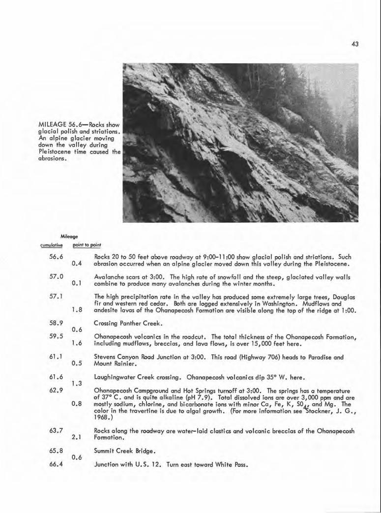
0.4 56.6 Rocks 20 to 50 feet above roadway at 9:00-11 :00 show glacial polish and striations. Such
abrasion occurred when an a lpine glacier moved down this valley during the Pleistocene.
57.0
57.1
58.9
59.5
61.1
61.6
62.9
63.7
65.8
66.4
o. 1
1.8
0.6
1.6
0.5
1.3
0.8
2.1
0.6
Avalanche scars at 3:00. The high rate of snowfall and the steep, glaciated valley walls combine to produce many avalanches during the winter months.
The high precipitation rate in the valley has produced some extremely large trees, Douglas fir and western red cedar. Both are logged extensively in Washington . Mudflows and andesite lavas of the Ohanapecosh Formation are visible along the top of the ridge at 1 :00.
Crossing Panther Creek.
Ohanapecosh volcanics in the roadcut. The total thickness of the Ohanapecosh Formation, including mudflows, breccias, and lava flows, is over 15,000 feet here.
Stevens Canyon Road Junction at 3:00. This road {Highway 706) heads to Paradise and Mount Rainier.
Laughingwater Creek crossing . Ohanapecosh volcanics dip 35° W. here.
Ohanapecosh Campground and Hot Springs turnoff at 3:00. The springs has a temperature of 37° C. and is quite alkaline {pH 7.9). Total dissolved ions are over 3,000 ppm and are mostly sodium, ch lorine, and bicarbonate ions with minor Ca, Fe, K, SO.d.! and Mg. The color in the travertine is due to algal growth. (For more information see 'Stockner, J. G., 1968.)
Rocks along the roadway are water-laid elastics and volcanic breccias of the Ohanapecosh Formation.
Summit Creek Bridge .
Junction with U.S. 12. Turn east toward White Pass.


Mileage
LEG Ill
ROAD LOG: U. S. 12- 123 JUNCTION TO U. S. 12- 410 JUNCTION
(VIA WHITE PASS}
Topographic quadrangle maps covering the area:
Packwood, White Pass (15- minute); Rimrock
Loke, Tieton Basin, Weddle Canyon, and Tieton
(7!-minute).
cumulotive point to paint
0 . 0
0.2
1.3
2.3
0.2
1. 1
1.0
0.4
Turn left (east) onto U.S. 12 toward White Pass. Rocks along the roadway ore water- laid elastics and volcanic breccias of the Ohanapecosh Formation. These rocks ore Eocene in age, and although mostly covered for the next few miles, are several 1,000 feet thick here. At least port of the Ohanapecosh consists of subaqueous volcanic mudflows deposited in a large lake or quiet arm of the sea. The debris is nearly al l pyroclastic and may have originated either as underwater eruptions or from an on- land source.
Glaciated surface on right.
Soda Springs Campground turnoff.
Pal isades rest area at 3:00. From the rest stop, across the canyon a Pleistocene lava flow known as the Clear Fork Dacite can be seen. The flow followed the Clear Fork River drainage . The vent for the flow was probably near the head of Coyote Creek to the south. Cooling and subsequent shrinkage of the lava produced well-developed columnar jointing that is visible across the canyon .
MILEAGE 2.3- Clear Fork Dacite flow showing co lumnar jointing at Palisades rest area.
45

46
MILEAGE 2.7- Steeply dipping Ohanapecosh volcanics and andesite sill(?). Mileoge
cumulative point to point
2.7 West-dipping, water-laid elastics of the Ohanapecosh Formation are visible in the roadcuts for l mile . Several andesite porphyry si lls can be seen intruding the sediments a long this portion of the highway. The rocks are cut by at least two faults along this section. l. l
3.8 0.4
4 . 2
0.3
4 .5
0 . l
4.6 0.1
4.7 0.1
4.8
l.2
6.0 0 . 6
6.6 0.4
Andesite si II(?) can be seen cutting the Ohanapecosh Formation at 9:00.
The Hogback Mountain olivine basalt flow is visible in the roadcut. This flow fills an old Pleistocene valley and, here, is essentia lly flat lying. Note the vesicu lar top caused by escaping gas bubbles .
Lava Creek Fa lls, at 3:00 across the Clear Fork River, falls of Lava Creek plunge into the C lear Fork River . After the Clear Fork River valley was fi lled with lava by the dacite flow, the river began to re-excavate the volley. The river incised its course along the contact between the valley flow and the older Ohonapecosh rocks . Lava Creek was not able to erode the valley flow at the some rote as the river and, as a result, it hos a some-what hongi ng-va lley appearance.
Columnar jointing in the Hogback Mounta in flow con be seen at 9:00 near the road ditch .
The contact between the Ohonapecosh Formation and the overlying Hogback Mountain flow is visible at 9:00, high in the roodcut.
Ohonopecosh Formation is visible on bath sides of the highway at rood level for l mile . Higher up, in cliffs above the roadway, the Hogback Mountain flow con be seen . The flow overrode a large resistant knob of Ohanapecosh volcanics here.
Bridge .
Andesite flows (si lls?) in the Ohonapecosh Formation.

MILEAGE 4.6-Columnar jointing in the Hogback Mountain flows.
Mileage
cumulative paint to point
7.0
0.3
7.3
o. l
7.4 0.8
8.2
0 . 1
8.3
0.8
Fault contact between the Russell Ranch(?) and Ohanapecosh Formations. The fault contact crosses the road along the west edge of the slide area. The east block is up, which places black carbonaceous shale of what is probably the Russell Ranch Formation against light- colored andesites of the Ohanapecosh Formation in the west block. The shales and the shear zone of the fault combine to make this a bad slide area.
Badly sheared and brecciated Russell Ranch Formation(?) exposed at 9:00. The Russell Ranch Formation consists of graywacke sandstones and interbedded argillites, slate, and andesite flows that reach a thickness of more than 9, 000 feet in the White Pass area. The graywacke (quartz, 60 percent; feldspor, 15 percent; mafics, 15 percent; and mica and opaques, 10 percent) is coarse grained and was deposited as a delta in a fresh- water environment. The Russell Ranch Formation is pre-Tertiary and strikes in a northerly direction. (For more information on this and the rest of the White Poss area see Ellingston, l 968.)
Loose slide material is Russell Ranch(?) sediments and ondesite that moved down off the mountain slope.
Good view of the Goat Racks at 2:00. The Goat Rocks ore composed of Cenozoic lavas and pyroclostics and related intrusions. Glacial erosion has cut through the volcanics exposing underlying Mesozoic and Paleozoic rocks in places. Glaciers in the Goat Racks are sti II active and have created much more rugged topography than is present in the rest of the Southern Cascades.
Russell Ranch Formation(?) is exposed in roadcuts. The Russell Ranch(?) is highly sheared and weathers easily. It usually forms a covered slope and is best exposed in roadcuts and stream gullies.
47
48
MILEAGE 8 . 2- Air photo of the Goat Rocks with Mount Adams in background.
Mileage
cumulative point to Point
9.1
0.6
9.7 0.1
9 . 8 0 . 8
l 0.6 0. l
l 0 . 7 l. l
11.8 0 . l
11.9 0. l
12.0
0.4
12.4 0 . 3
12.7 o. l
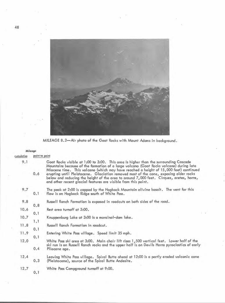
Goat Racks visible at l :00 to 3:00. This area is higher than the surrounding Cascade Mountains because of the formation of a large volcano (Goat Rocks volcano) during late Miocene time . This volcano (which may have reached a height of 15,000 feet) cont inued erupting until Pleistocene. G laciation removed most of the cone, exposing older rocks below and reducing the height of the area to around 7,000 feet. Cirques, aretes, horns, and other recent glacial features are visible from this point.
The peak at 2:00 is capped by the Hogback Mountain olivine basalt . The vent for this flow is on Hogback Ridge south of White Pass.
Russell Ranch Formation is exposed in roadcuts on both sides of the road.
Rest area turnoff at 3:00.
Knuppenburg Lake at 3:00 is a morainal -dam lake.
Russell Ranch Formation in roadcut.
Entering White Pass vi llage. Speed lim it 35 mph .
White Pass ski area at 3:00. Ma in chair lift rises 1,500 vertical feet. Lower half of the ski run is on Russell Ranch rocks and the upper half is on Devils Horns pyroclastics of early Pliocene age.
Leaving White Pass vi llage . Spiral Butte ahead at 12:00 is a partly eroded vo lcanic cone (Ple istocene), source of the Spiral Butte Andesite .
White Pass Campground turnoff at 9:00.

49
Mileage
cumulative point to point
12.8 Roadcut in Spiral Butte Andesite. The contact between the andesite and the older Russell
12.9
14.l
14.2
14.4
14 . 6
14.8
15.5
0. l
1.2
0.1
0 . 2
0 . 2
0 . 2
Ranch rocks is obscured .
Spiral Butte Andesite in roadcuts. The flow occupied valleys cut in an older Pliocene topography . This flow and other Pleistocene valley flows offer valuable clues in reconstructing Tertiary drainage potterns.
Dog Lake Campground turnoff.
Dog Lake at 9:00. The Spiral Butte cone on the skyline at l 0:00 . Dog Lake is glacial formed, probably a morainal-dam lake.
Bridge over Clear Creek.
Scenic view of Clear Creek Falls. Turn off at 3:00. The falls were created by water flowing over Spiral Butte Andesite onto softer Russell Ranch sediments below . Glaciation may have assisted in creating the falls. Looking downstream from the viewpoint one can see the glaciated U- shaped valley of Clear Creek with Clear Lake beyond. To the south, Pinegrass Mountain is capped by Tieton Andesite of the Pleistocene age.
MILEAGE 14. 6- View down Clear Creek (southwest) from Clear Creek Falls showing glacial U-shaped valley . Racks on either side of the valley are Spiral Butte Andesite; on skyline, Tieton Andesite .
0.7
1.5
Slide area (for the next 2 miles) along the south side of Spi ral Butte is caused by a platy porting in the andesite that makes up the cone . The direction of parting is parallel to the slope of the hil l (east- west strike, dip 50° S.), allowing the rock to shear downward toward the road. Snow melt water fills the fractures and helps trigger slides and avalanches.
Roadcuts still in Spiral Butte Andesite . At 3:00 can be seen Round Mountain (lookout visible on top), which is composed of Hogback Mountain o li vine basalt (Pleistocene) .

'
50
MILEAGE 14.8- Slide area along south side of Spi ra l Butte caused by platy parting in the andesite that makes up the cone .
Mileoge
cumulative paint to paint
17. 0 C lear lake at 1:00. Beyond on the skyline is Divide Ridge, composed of "pre- Vantage" flows of Yakima Basalt . The exact position of the flows in relation to the type section in Yakima Canyon is unknown. 0 .5
17.5
0.1
17. 6
0.2
17.8 1.2
19. 0 0.5
19. 5 0 . 2
19.7
0 . 2
19. 9 0.4
20.3 0. l
The fault visible in the gully at 12:00 on the left side of the road puts Spiral Butte Andesite against Indian Creek gneiss . The downthrown(?) east block has the oldest rocks (preTriassic) in the White Pass area preserved in it.
Indian Creek gneiss and amphibolite in roadcut. The rocks here are badly sheared and deformed by high- temperature metamorphism. Pegmatite dikes intrude the metamorphics in places.
Approximate contact of the Indian Creek rocks and the Russell Ranch Formation. Bedrock is covered by glacial moraine for the next mile .
Russell Ranch rocks exposed in roadcuts beneath the moraine cover .
Tieton Raad-Clear lake turnoff is at 3:00.
The small outcrop in the roadcut at 9 :00 marks the end of the Tumac Mountain olivine basalt flow. Tumac Mountain {out of sight to the northwest) is one of the youngest volcanic cones in the area , age post- Pleistocene.
Crossing Indian Creek.
Indian Creek Campground turnoff is at 3:00.

51
MILEAGE 17.5- Contact between Spiral Butte Andesite and Indian Creek gneiss. The oldest rocks in the White Pass area are preserved here.

52
Mileage
cumulative point lo point
20.4 Silver Beach Motel at 3:00. 0.4
20.8 o. 1
20.9 1.3
22.2 0.4
22.6 0.7
23 . 3 0.2
23.5 0.2
23.7
1.1
24.8
0.1
24.9 0.3
25.2 0.7
Tieton reservoir at 3:00. Roadcut in Russell Ranch Formation.
Russell Ronch groywockes and orgillites in roodcuts on both sides of the rood for 1 mile .
Rest area. Turnoff is at 3:00.
Divide Ridge at 1 :00 is composed of "pre-Vantage" Yakima Basalt. Fifteen flows ore exposed, having a thickness of more than 1,700 feet (Swanson, 1966).
Rimrock boot landing and store, turnoff at 3:00.
Roadcuts in Russell Ranch Formation.
Kloochmon Rock at 1 :30 is a small intrusive body composed of pyroxene- rich ondesite . It is associated with, and was intruded at the some time as, Goose Egg Mountain and Westfa II rocks (pre- Pliocene). At 9:00 in the rood cut, the greenstone foci es of the Russe II Ranch Formation con be seen.
Silver Cove Resort at 3:00. Kloochmon Rock and Goose Egg Mountain ore visible at 12:00-2:00. Due to their coarse-groined texture and lock of breccio and vesicules, these small intrusions were thought to hove cooled under cover; they do not feed any flows (Swanson, 1966).
Russell Ranch tonolite focies in the roodcut at 9:00 . Faults separate this focies from the rest of the Russell Ranch Formation.
Contact between Russell Ranch tonolite and the Westfall Rocks ondesite intrusion. The outer part of the intrusion is highly weother~d and contains steeply dipping radial joints.
MILEAGE 23.7-Kloochmon Rock
intrusion seen from the air.

MILEAGE 23 .7- Kloochman Rock intrusion to the left. Divide Ridge on skyline is made up of Yakima Basalt. Rimrock Lake is in foreground.
MILEAGE 26 . 2- Rimrock Dam, built between andesite intrusive bodies of Goose Egg Mountain and Westfall Rocks.
53

54
Mileage
cumulative point to point
25.9 Entering tunne l cut through andesite. Tieton Dam at 1:00 was built at this point because
o. l 26.0
0.2
26.2 o. l
26.3 0 . 1
26.4 0.3
26.7 0.1
26 . 8 0.6
27.4 0.2
27 . 6
0 . 8
the strength and resistance of the andesite made a better support than any of the surrounding volcanic and sedimentary rocks.
Leaving tunnel.
At 5:00 the face of Rimrock Dam is visible. This dam was built primarily for flood control in 1924 .
Andesite intrusions on both sides of the rood; Goose Egg Mountain at 3:00, Westfall Rocks at 9:00.
At 12:00 on the ridge ahead is a Pleistocene lava flow of olivine basalt. This flow originated from a vent to the northwest and moved down Wildcat Creek .
MILEAG E 26 ,4- Pleistocene lava flow of olivine basal t .
Crossing Wildcat Creek .
Glacial moraine in the roadcut at 9:00.
Exposures of Russe ll Ranch Formation(?) at 9:00 .
Wi Id cat Creek sediments can be seen road cuts at 9:00. Rocks are striking N. 80° W. and dipping 20° NE. The Wildcat Creek sediments are composed of about 1,000 feet of volcaniclastic rocks- tuffs, pumice, and ash. It was deposited in quiet water from erosion of nearby volcanoes . Fossils of horse and rhino have been used to date this formation as Oligocene- Miocene. (For more information on Wildcat Creek sediments see Swanson 's thesis, 1964. )

MILEAGE 27.6-Wildcat Creek sediments, deposited in quiet water from erosion of nearby volcanoes.
55
Mileage
cumulative
28.4
28.7
28.8
29.1
29.2
29 . 3
29.4
29.5
30.2
point to point
0.3
o. 1
0.3
0 . 1
0.1
o. 1
0 . 1
0 . 7
1.0
At 12:00 on the skyline is the Yakima Basa lt underlain by Miocene tuffs, breccias, and andesite flows of the Fifes Peak Formation.
Tieton River road at 3:00.
Soup Creek bridge. Glacial moraine exposed on both sides of the road. This marks the fartherest downstream advance of the Pleistocene valley glaciers.
Bethel Ridge road at 9:00. The area on both sides of the road is covered by landslide materia I of Quaternary age. The s lides have occurred in clay, ash, and other volcaniclastic rocks and can best be seen from higher up on the Bethel Ridge Road .
Tieton Ranger Station at 9:00.
Hause Creek Campground at 3:00.
Helicopter landing pad at 9 :00 is used for fire fighting by the forest service.
River Bend Campground . Turnoff is at 3:00.
Flow breccias of the Tieton volcano phase of the Fifes Peak Formation at 9:00. Angular fragments of andesite from 1 to 30 inches across is cemented in buff-colored pumice. These rocks are part of a Miocene vol cano called the Tieton volcano, which had a diameter of about 6 miles and a height of over 9,000 feet. The center of this cone was north of Trout Lodge on what is now Bethel Ridge. Although most of the pyroclastic cone has been eroded, over 3,000 feet of tuffs, breccias, and andesite flows sti ll remain.

56
MILEAGE 30. 2-Breccias of the Tieton volcano phase of the Fifes Peak Formation .
Mileage
cumulative point to point
31.2 Willows Campground turnoff at 3:00. 0 . 1
0 . 2 31.3
31.5
32. l
32.3
33.5
34.0
0.6
0.2
Quaternary landsl ide debris can be seen in the roadcut at 9:00.
Continuation of andesite flows and breccias of the old Tieton volcano. The breccia here dip southward 15° to 20°, on the south flank of the old cone. Andesite dikes cut the breccias in many places. (For more information on this area see Swanson, 1966.)
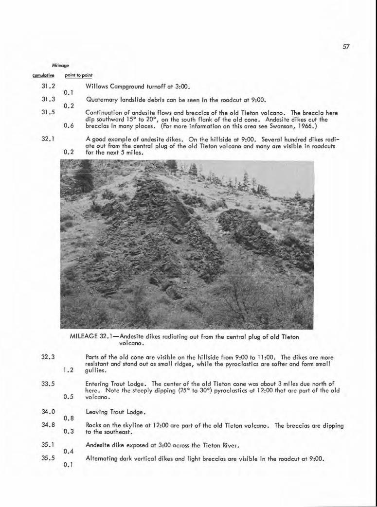
A good example of andesite dikes. On the hillside at 9:00. Several hundred dikes radiate out from the central plug of the o ld Tieton volcano and many are visib le in roadcuts for the next 5 miles.
MILEAGE 32. l - Andesite dikes radiating out from the central plug of o ld Tieton volcano .
1.2
0.5
0 . 8
Parts of the old cone are visible on the hi llside from 9:00 to 11 :00. The dikes are more resistant and stand out as small ridges, while the pyroclastics are softer and form small gu llies.
Entering Trout lodge. The center of the old Tieton cone was about 3 miles due north of here. Note the steeply dipping (25° to 30°) pyroclastics at 12:00 that are part of the old volcano.
leaving Trout lodge.
57
34.8 0 . 3
Rocks on the skyl ine at 12:00 are part of the old Tieton volcano. The breccias are dipping to the southeast.
35. 1 0.4
Andesite dike exposed at 3:00 across the Tieton River.
35. 5 o. l
Alternating dark vertical dikes and light breccias are visible in the roadcut at 9:00.

58
Mileoge
cumulotive point to point
35.6 0.4
36.0
0. 1
36 . 1 1.0
37. 1 o. 1
37. 2
0.1
37.3 0. 1
37.4 0 . 1
37.5 0 . 3
37. 8 0.3
Steeply dipping flows and pyroclastics again visible at 12:00 .
On the hillside at 9:00 is an excellent examp le of a dike striking northwest and dipping 75° SE. The thickness is about 20 feet . Composition of the dikes is plagioclase 25 percent, hypersthene 5 percent, clinopyroxene 10 percent, augite 5 percent, opoques 5 percent, other minerals 10 percent, and groundmass 40 percent.
MILEAGE 36. 0-Andesite dike, striking northwest and dipping 75° SE .
Continuation of pyroclastics and dikes of the old Tieton volcano.
Yakima Basalts cap the older Tieton volcano on skyline at 9:00 .
A remnant of another valley flow, the Tieton Andesite (Pleistocene) is visible ahead. The Tieton Andesite flowed down the Tieton River forcing the river to modify its channel somewhat. Notice the channel in older volcanics filled by the Tieton Andesite .
Approximate contact between the Yakima Basalt and the Fifes Peak-Tieton volcano phase is covered by a landslide at 9:00.
Palagonite of the Yakima Basalt is visible at 9:00 along the roadway.
Crossing the Tieton River. Yakima Basalt is visible on the left side of the road.
Good example of palogonite in the Yakima Basalt at 3:00 near the road .

59
Mileage
cumulative point to paint
38.1 Crossing the Tieton River.
38.5
38.9
40.0
41.0
41.3
41.9
43.0
0.4
0.4
1. 1
l.O
Windy Point Campground at 3:00.
Good columns in Yakima Basalt at road level at 11 :00. The columns can be compared with the columns of the Tieton Andesite farther down the road .
Entering the Oak Creek Wildlife Recreation Area . A block of Tieton Andesite is visible perched on the hill at 9:00. Yakima Basalt at 12:00. The Tieton flow originated from the Goat Rocks volcano and followed the Tieton gorge all the way to Yakima; only remnants of the original flow remain.
MILEAGE 40.0- Remnant of the Tieton Andesite, perched on side of the Tieton River canyon .
0.3
0.6
l. 1
0.5
Tieton Andesite is visible on both sides of the road . At 1 :00, notice the contact with Yakima Basalt along the old stream channel. The river appears to have downcut very little since Pleistocene time . The Tieton River is probably entrenched from here to the Chinook Pass junction.
Good columnar jointing in the Tieton Andesite at 3:00.
Ditch on the hillside at 1 :00 is for orchard irrigation in the upper Yakima Valley . There is now an absence of fir trees. The rain- shadow effect of the Cascade Range shows up well here.
Tieton Andesite at 12:00 shows a well-defined separation between the upper shattered entablature (caused by escaping gas) and the lower colonnade (caused by shrinkage due to cooling}. In general, the two parts of the flow are much better separated than in the Yakima Basalt.

60
MILEAGE 43.0-Tieton Andesite showing an upper entabulature and well-developed lower colonnade.
MI LEAGE 46 . 6- Tieton Andesite resting on "pre-Vantage" Yakima Basalt near the U. S. 12-410 Junction.

Mileage
cumulative point to point
43.5 An old channel in Yakima Basalt filled with Tieton Andesite is visible at 10:00.
44.0
44 . 4
44 . 6
44.7
46.2
46 . 5
46.6
0.5
0 .4
0.2
o. 1
1.5
0 . 3
o. l
More Tieton Andesite in contact with Yakima Basalt on the right side of the road . Excellent columns con be seen here.
Oak Creek bridge.
Oak Creek feed station at 9:00. Several thousand head of elk are fed here every winter by the Washington Department of Game. The high fence keeps game off the highway.
Tieton Andesite on the right and Yakima Basalt on the left side of the road . A good place to visually compare flow structures between the two lavas.
At 3:00 the Tieton Andesite rests on top of "pre-Vantage" Yakima Basalt. At 12:00 the south flank of the Clemon Mountain anticline is visible with steeply dipping (60°) Yakima Basalt forming the fold.
Crossing Naches River, leaving the Oak Creek Wildlife Recreation Area.
Stop . Chinook Pass- Yakima Junction . Turn right (east} toward Yakima on U.S. 12.
61


LEG IV
ROAD LOG: U.S. 12-410 JUNCTION TO EL LENSBURG
(VIA CANYON ROAD)
Topographic quadrangle maps covering the area:
Tieton, Naches, Selah, Pomona , Wymer, Kittitas,
and Ellensburg South (7!- minute).
63
Mileage
cumulative point to point
0.0
1.9
2. l
3 . 0
3.9
4.9
5 . 2
6.7
7.8
8. l
8.5
8 . 7
1.9
0.2
0.9
0.9
1.0
0 . 3
U. S. 12 and 410 Junction . Turn east onto U. S. 12 toward Yakima . Tieton Andesi te at 3:00, part of a Pleistocene intercanyon flow, continues up river. At 9:00, Yakima Basalts, comprising the south limb of the Clemon Mountain ant icline, are visible.
Slump at 3:00 in alluvium along the edge of the Tieton Andesite. The age of the slump dates back at least 20 years (l 950's), and the movement has been only a foot or two per year . The cause of the slump is undercutting by the Naches River and water seepage from orchard irrigation above.
The canyon, eroded into Clemon Mountain, at 9:00 shows sharp folding in the Yakima Basalt. The basalt is nearly vertical and may be overturned along this part of the fold. However, at 6:00 to 7 :00 the dip of the flows is 60° to 70° south . If overturning does occur, it is only in a small area. The flow sequence of the Yakima Basalt here is unknown but is probably "pre- Vantage" in age .
The highway drops off a small stream terrace cut by the Naches River. At 9:00 eastdipping outcrops of the Ellensburg Formation terminate against the basalt of the Clemon Mountain anticline, showing that the Ellensburg was deposited before uplifting occurred .
Entering Naches. Speed limit 45 mph.
Leaving Naches.
Excellent exposures of the Ellensburg Formation visible in hills to the north for next 2 miles. This is the type section for the Ellensburg Formation, first measured by G. 0. Smith in 1901. It consists of about 80 percent sand, sil t , and clay, and 20 percent gravel and conglomerate. The sand and silt is made up of pumice, ash, and quartz while the
l . 5 gravel- sized material is mostly tuff and andesite . The Ellensburg Formation here is part of an eroded alluvial fan derived from the erosion of explosive volcanoes that existed in the Cascade Range to the west. Some parts of the fan appear to be lahars that slid or flowed from the flanks of the volcanoes (see Schmincke, H. V., 1967).
l. l
0 . 3
0.4
0.2
0.8
Locust Lane turnoff at 9:00.
Frenchman Springs flow exposed at 9:00 in the roadcut. Behind this point (west) the extent of the Roza and Frenchman Springs flows is unknown, but the Roza almost certainly ends within a few miles and the Frenchman Springs flows may also terminate .
The contact between the Roza(?) and underlying Frenchman Springs flows is visible at 9:00 . The white layer of interflow sediment marks this contact .
Naches River water treatment plant at 3:00.
At 9 :00 the Roza(?) flow is exposed at the base of the hillside. The Roza flow thickens to the east but thins westward and ends in a few mi les .

64
MILEAGE 8. 1-Contact between the Rozo and underlying Frenchman Springs flow.
MILEAGE 9.5-Tieton Andesite visible as cliffs above Naches River.

65
Mileage
cumulative point to point
9.5 The Tieton Andesite flow to the south is composed of about 70 percent groundmass (plogioclase and pyroxene) and 30 percent phenocrysts (plagioclase and augite) and is resting partly on Roza basalt and partly on alluvium derived from the Ellensburg Formation. A well drilled through the Tieton flow hit alluvium (and good water) at 500+ feet.
0.6
1 O. I 0 . 2
10.3
o. 1
10.4
1.2
11.6 2 . 0
13.6 0. 1
13.7
0 . 6
14.3
2. 2
Eschbach Road turnoff at 9:00.
A stream terrace of the Naches River is visible at 9:00. This terrace is about 20 feet higher than the present flood plain and indicates that the river has been downcutting to a limited extent since Pleistocene .
Traveling on the Naches River flood plain . For next 3 miles the Tieton flow is at 3:00. Note the pressure ridges and rough topography indicating that the flow is much younger than the smoother weathered Yakima Basalt. On the right is the Ellensburg Formation composed of pumice and ondesite sands and gravels. Clemon Mountain anticline a t 6:00 .
Selah Road - Gleed turnoff.
Crossing Naches River at "Twin Bridges."
Painted Rocks at 3:00. This heritage site was set aside to preserve the pictographs that are painted on the rocks . Although partly vandalized, many of the figures are sti ll visible and consist mostly of sunbursts of red and white pigment . For more information on these figures and others in the Yakima area, see H. T. Cain (I 950) . The "painted rocks" mark the fartherest advance of the Tieton Andesite {Pleistocene) .
At 9:00, Yakima Ridge is composed of lower Yakima flows at the river level and Frenchman Springs and Priest Ropids flows in cliffs above . The extreme top of the ridge is capped by the Pomona flow with sandstones of the Beverly Member (lower Ellensburg Formation) underneath .
MILEAGE 14.3- Yakima Ridge, north of Yakima, showing flow sequence.

66
Mileage
cumulative point to point
16.5 Sixteenth Avenue overpass. City of Yakima is at 3:00. The Yakima area is a major producer of fruit including apples, pears, peaches, and grapes . Yakima County leads the nation in the production of mint and hops. At 9:00 the lowest flows, just above the river, may be pre-Vantage in age.
0.6
17.1
0.4
17.5 0.9
18.4
0.4
18.8 1. 1
19. 9 0.8
20.7
l.4
22. l 0.4
22.5 1.1
Selah Gap at 9:00 is a water gap cut by the antecedent Yakima River through Yakima Ridge. The top of the ridge is composed of Pomona flow. A well drilled on the top of the ridge penetrated the Roza and Frenchman Springs flows and hit the Vantage Sandstone(?} at 535 feet.
Take turnoff to Ellensburg onto 1-82.
Passing through Selah Gap. Rocks exposed in the roadcut at 3:00 are Frenchman Springs and Priest Rapids flows. Note palagonite in the south port of roadcut which is a part of a Frenchman Springs flow.
Selah at 1 0:00.
MILEAGE 18.4- Air photo of Selah Gap
and Yakima Ridge.
At 12:00 hills are composed of upper Ellensburg Formation-mostly pumice and andesite sands and gravels.
Clemon Mountain anticline on skyline at l 0:00. Hills in foreground are upper Ellensburg Formation capped by a more resistant basalt conglomerate. Some authors (Holmgren , 1967} believe the flat-topped hills to be part of an old pediment surface.
Turn off 1-82 onto Canyon- Firing Center Roads.
Stop sign. Turn left down Canyon Road.

67
Mileage
cumulative point to Point
23 . 6
24 .5
0 . 9
0.4
Pomona Tavern on left. Yakima Canyon at 12:00. Selah Butte at l :00. Dip slope on either side of Yakima Canyon is on the Pomona Flow. Squaw Tit Butte at 3:00 is composed of upper Ellensburg Formation capped by basalt conglomerate. The Selah Butte f low is visible on the skyl ine between the Yakima Canyon and Squaw Tit Butte. This flow is probably a wedge of Pomona flow duplicated by thrust faulting.
Roadcut in Pomona flow. Note the distinctive fan- shaped columns in the upper part of the flow.
MILEAGE 24 . 5- Pomona flow exposed
in roadcut south of Selah Creek.
MILEAGE 24.9- Selah Creek Bridge, looking east up Se lah Creek.

68
Mileoge
cumulative point to point
24.9
o. l
25.0
0.4
25.4
0.8
26.2
0.5
26 .7
Selah Creek Bridge at 3:00, North America 's longest concrete span bridge . The roadway is set on the Pomona flow while the covered slope below is the lower Ellensburg (or Beverly Member). The bases of the concrete arches rest in Roza Basalt. Selah Creek and Wenas Creek (to the south) have yielded artifacts of ancient man several thousand years old. For more information read C. N. Warren (1968) .
The old tunnel rood veers off to the right. Entering Yakima canyon, a series of entrenched meanders cut by the river across northeast- southwest trending anti clinol ridges and synclinal va lleys . The Pomona flow is at the top of each side of the canyon with Roza and Frenchman Springs flows visible at 11 :00 to 1 :00. Entering the Selah Butte anticline.
MILEAGE 25.4-Rozo flow visible as a dork band across the center of photo. Squaw Creek Diotomite, the white band, with Frenchman Springs flow below. Pomona flow on the skyline.
Old rood tunnel at 1 :00 cut in Rozo Basalt Member. At 10:00 the Rozo flow is visible as a dark bond running up the side of the canyon wall . Note the forge columns and platy cross joints. The white material underneath is the Squaw Creek Diotomite, well exposed in holes dug by hunters of petrified wood. The Frenchman Springs flow lies beneath this white bond.
Old rood tunnel on right. Museum Basalt Member exposed at 10:00 as a massive cliff former. Less resistant ledges underneath ore of the Rocky Coulee flow with flow No. 11 of the "pre- Vantage" flows visible just above the river level. (Flows beneath the Rocky Coulee hove not been given names but numbers ranging from the oldest,No. 1, to the youngest, No. 11.)
Brown talus float coming from a hole in the cliff face slightly above road level across river at 9:00 marks the remains of a forge vertical petrified log known as the "Gray Lady." Note other wood-digging sites between flows No. 9 and No. l O of the pre-Vantage

cumulative
Mileage
point to Point
0. 3 series. Rock debris at 3:00 is landslide material. Grayish- tan material is probably part of Ellensburg Formation or Vantage Sandstone. White material may be diatomite or caliche . Angular resistant blocks ore basalt. Slides may be Pleistocene in age. There has been no apparent movement during historic time.
POMONA BEVERLY ____ ' ROZA
MILEAGE 27.0-Photos showing flow sequence from No. 9 up through Pomona (Saddle Mountains Member of Yakima Basalt).
69

70
Mileage
cumulative point to paint
27.0
27.4
27.5
28.5
28.6
29 . 0
29.2
30.0
0.4
0. 1
1.0
0. 1
0.4
0 . 2
0.8
0.5
At 9:00 from bottom to top of canyon are exposed flows of Nos. 9, 10, 11 , Rocky Coulee, Museum, (break in slope), Frenchman Springs, and Roza. The Pomona flow is iust out of sight on the skyline . Rock shelters in these cliffs have yielded wooden arrows and reed matting from an ancient tribe. Caves were probably used for food storage.
Entering Kittitas County.
Ridge at 12:00 is capped by the Museum Basa It flow. Flows No. 6 through Rocky Coulee lie below. Near center of northwest-southeast trending Selah Butte anticline.
MILEAGE 27.5- Ridge is capped by Museum Basalt flow, with flows 6 through Rocky Coulee beneath.
Sharp curve right in deep roadcut. Roadcut is in flow No . 6. Flow No. 6 is about 100 feet thick with the lower 60 feet undulating columns and the upper 40 feet poorly developed, highly curved columns and ioints.
At 10:00 below the road is the lobe-shaped mass of a Pleistocene landslide. Slide may have temporarily dammed the Yakima River.
Roza Dam turnoff on left. Dam is built on flow No. 5 . This dam is used to divert water into the Roza Canal for irrigation use. Track-covered hill east of the dam is used for motorcycle hill climbs.
Toe of landslide at 9:00 across river.
Turnoff to public boat ramp and fishing site on left . Rocks at 12:00 are flows Nos. 10, 11 , Rocky Coulee, and Museum. Note massive nature of upper Museum flow on the skyline . At 9:00 in lower part of the hill is a fairly recent landslide . Scarp at its head is still vertical. Note hummocky appearance of slide surface .

MILEAGE 29 . 2- Toe of landslide across river.
MILEAGE 30.0- Flow No . 10 at bottom, with No. 11, Rocky Coulee, and Museum in sequence to top.
Mileage
cumulative point to Point
30. 5 0.2
30.7 0.3
Burbank Creek and Burbank Ranch road . Museum Basa It Member exposed at the Burbank Ranch sign and gate. Entering the Roza-Burbonk Creek syncline.
Frenchman Springs flows are exposed along the east side of the highway, Museum flow to the west across the Yakima River.
71

72
Mileage
cumulotive point to point
31.0
31.5
31.9
32 .5
32.6
33.6
0.5
0.4
Mount Baldy at 2:00. White cut on hillside is in Squaw Creek Diatomite. Many test ho les have been dug into the diatomite in this area but no diatomite has been commercially mined.
Weathered columns on hill above road at l :00 to 3:00 are in the Roza flow . Weathering he lps to show the platy cross joints that distinguish this flow. The Squaw Creek Diatomite forms the white covered interval underneath . The Museum flow is exposed in o large block on the hi ll side at l l :00. This block hos been down dropped by o north-south trending fault at 12:00. The fault and scarp are not well exposed from this viewpoint. Distinctive columns of the Roza flow on the skyline with white Squaw Creek Diatomite underneath. The Frenchman Springs Member is visible in the foreground.
MILEAGE 31.9-Distinctive columns of the Roza flow on the skyline with the white Squaw Creek Diatomite underneath. The Frenchman Springs is visible in the foreground.
0.6
o. 1
1.0
Roadcut at 3:00 is in the Frenchman Springs Basalt. Although it is difficult to distinguish between flows of the Frenchman Springs, the irregular joints and patches of pa lagonite here appear to be part of the Ginkgo flow.
Litter barre I on right. Camping turnoff on left.
Entering the northwest-southeast trending Umtanum anticline. The flow sequence on cliffs at l 0:00 to 12:00 is: Flow Nos. 8, 11, Rocky Coulee, and Museum flow (capping ridge). Flows dip southwest here.
Mount Baldy and the overturned Umtanum anticline at 12:00. The oldest flows in the canyon ore exposed in the center of the fold at road level. Flows Nos . 1 through 11 comprise

MILEAGE 32.6- Entering the northwest- southeast trending Umtanum anticl ine.
Mileage
cumulative
34.2
34.7
34.9
35.4
35.5
35.7
36.4
37.0
point to point
0 . 6 the fold here with the Rocky Coulee Member just visible at the ridge top. Flow No. 6 lies along the road level at 3:00. Flows dip north at 10:00. The fold is overturned to the north and faulted along the north limb. Fault may offset beds several hundred feet.
0.5
0.2
0.5
0.1
0.2
0.7
0.6
0.8
Passing by the oldest flows (Nos. l and 2) in the core of the Umtanum anticline at 3:00.
Sli ckensides and fault breccia from a thrust fault developed along the north limb of the fold at 2:00 .
Stream terrace gravels from the Yakima River visible at road level at 3:00 in the road cut. These gravels are probably equal in age with those visible across the river at mile 35.4.
Fishing access turnoff. The white band in the stream sediments exposed across the river at 10:00 is the Mazama ash fall (age 6,600 years), used to date many archeological sites in the area . Flows Nos. 5 and 10 exposed in cliffs above. At 6:00, an excellent view of the Umtanum anticline .
Entering Umtanum - Squaw Creek syncline .
Crossing Squaw Creek.
Wymer foot bridge across Yakima River at 10:00. Roadcut here is in Museum Basalt.
Deep steep-sided roadcut in the Museum flow. Vantage Sandstone exposed at the top of the cut.
73

74
MILEAGE 35.4-0verturned Umtanum anticline, looking east toward Mount Baldy.
MILEAGE 35.4-Mount Mazama ash visible in Yakima River alluvium.

Mileoge
cumulative pointto point
37. 8 0.6
38.4
0.8
G lenn's Drive In at 9:00. The cliffs behind the restaurant ore the Museum flow with Rocky Coulee and No . 11 flow exposed just above the river level.
MILEAGE 37.8- Museum flow at top, with Rocky Coulee and No . 11 flows underneath.
Lorge ancient entrenched meander curve here appears to have been partially cut off as the river deepened its channel. Note terrace-like flattening of the meander bottom east of the h ighwoy.
MILEAGE 38.4- Entrenched meanders
of the Yakima River canyon.
75

76
MILEAGE 39.2- South wall of Yakima Canyon , with Umtanum Creek below.
Mileage
cumulat ive point to point
39. 2 Umtanum Creek at 12:00. Cliffs on both sides of the creek are flows Nos . 9, 10, and 11
0 . 3
39.5
1. l
40 . 6
0 . 8
41.4
0.5
41.9 0 . 6
42.5 0 . 9
43.4 0.5
with overlying Rocky Coulee and Museum flows . The mouth of the creek was at one time a small village for an ancient tribe. Central Washington State College has recently excavated th is site .
Sharp turn right. Umtanum Creek foot bridge at 9:00. Petrified wood hunters have dug severa l holes (visible at l 0:00) between flows Nos. 9 and 10. The road cut is in flow No. 8.
Well-developed columns in flow No. 7 at 3:00 along roadway. Note undulating columns and cross joints characteristic of this flow. Across the river at 9:00 can be seen the effects of erosion caused by anima l tracks. Now in Manashtash anticline.
Sharp turn to right- entering the Manashtash spur (large entrenched meander). Rocks at 9:00-12:00 are flows Nos. 6 through 11, with Rocky Coulee and Museum flows higher on the ridge. Notice line of telephone poles cutting over ridge. Top pole will be visible from other side of the spur .
Flow No. 6 exposed in roadcut along right side of highway .
Tip of spur at 9:00 shows stone "stripes" caused by frost wedging.
Mi leage sign and windmi II on right .

MI LEAGE 40 . 6- Column of pre
Vantage flow No. 7 in Yakima Basalt.
Mileage
cumulative point to point
43.9
0.9
Having traveled all the way around the meander spur, now looking south across the narrowest point. Flows Nos. 6 and 9 exposed at 9:00 across the river . Note telephone pole at top of ridge at 10:00, the same telephone line that was visible at mi leage 41.4 .
MILEAGE 43.9-Flows Nos. 6 to 9 exposed across river.
77
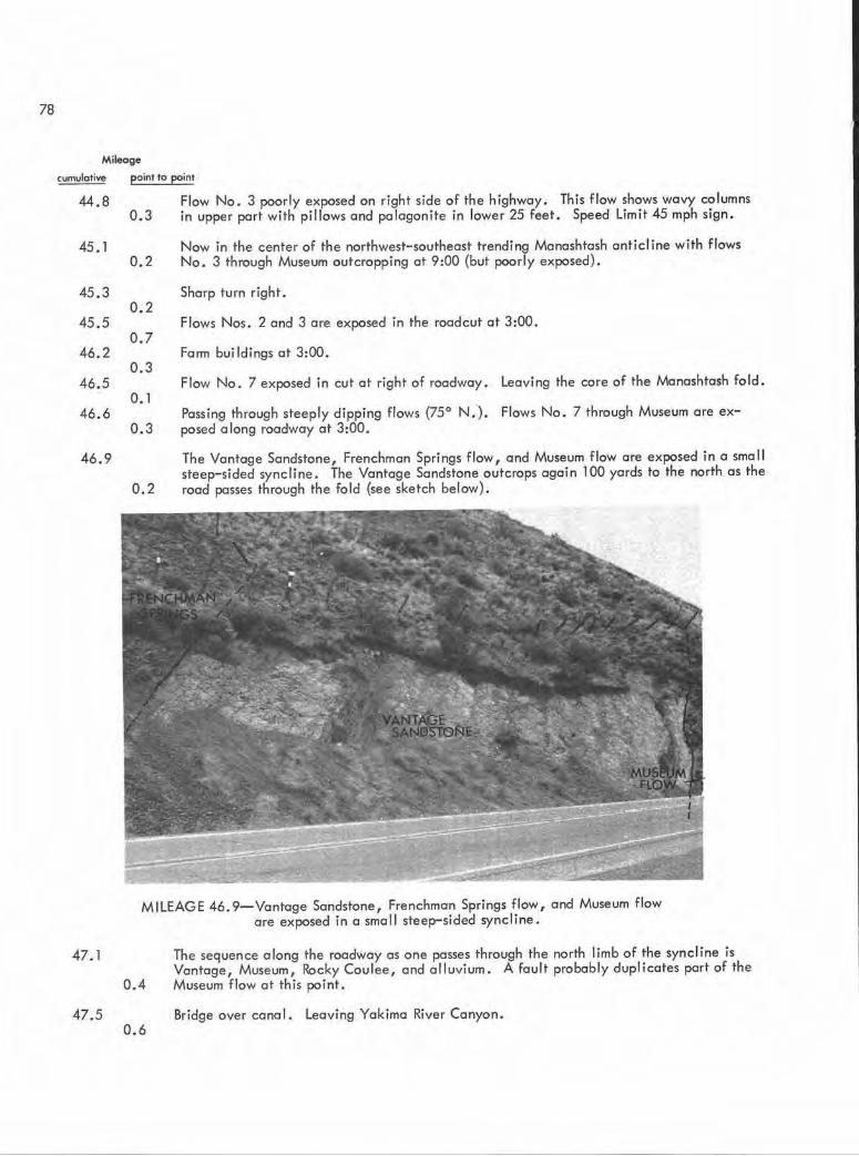
78
Mileage
cumulative point to point
44.8 Flow No. 3 poorly exposed on right side of the highway. This flow shows wavy columns in upper part with pillows and palagonite in lower 25 feet. Speed Limit 45 mph sign.
45. l
45.3
45.5
46.2
46.5
46.6
46 . 9
47.1
47.5
0.3
0.2
0.2
0.7
0.3
0. 1
0.3
0.2
Now in the center of the northwest-southeast trending Manashtash anticline with flows No. 3 through Museum outcropping at 9:00 (but poorly exposed).
Sharp turn right.
Flows Nos. 2 and 3 are exposed in the roadcut at 3:00.
Fann buildings at 3:00.
Flow No . 7 exposed in cut at right of roadway . Leaving the core of the Manashtash fold.
Passing through steeply dipping flows (75° N. ). Flows No. 7 through Museum are exposed a long roadway at 3:00.
The Vantage Sandstone, Frenchman Springs flow, and Museum flow are exposed in a smal l steep-sided syncline. The Vantage Sandstone outcrops again l 00 yards to the north as the road posses through the fold (see sketch below).
MILEAGE 46. 9-Vantage Sandstone, Frenchman Springs flow, and Museum flow are exposed in a small steep-sided syncline.
0.4
0.6
The sequence along the roadway as one passes through the north limb of the syncline is Vantage, Museum, Rocky Coulee, and alluvium. A fault probably duplicates port of the Museum flow at this point.
Bridge over canal. Leaving Yakima River Canyon.

79
NORTH SOUTH
MUSEUM FLOW ---+---VANTAGE SANDSTONE VANTAGE SANDSTONE
SQUAW CREEK DIATOMITE
FRENCHMAN\\ ROZ SPRINGS \ \FLOW,
\ \ \ \ \
\ \ \ \ \ \
\ \ \ \ \ \
FAULT?
I I
I I
I
SQUAW CREEK DIATOMITE
1 ROZA / / FRENCHMAN I I Elltt'SBURG / FLOW// SPRINGS
/ FORMATION I I / / I I
MILEAGE 47 . l-Looking east along roadcut of small syncline in Yakima Basalt.
Mileage
cumulative point to point
48. l Thrall Road at 3:00.
48.7
51.7
51.8
0.6
3.0
0.1
Traveling over the Yakima River flood plain. Clockum Ridge at l :00 to 3:00. Mount Stuart batholith exposed at 11 :00.
1-90 interchange.
Passing under 1-90 overpass. Entering Ellensburg.


SELECTED REFERENCES
Abbott, A. T., 1953, Geology of the northwest portion of the Mount Aix quadrangle,
Washington. University of Washington Ph.D. thesis, 256 p.
Becraft, G. E., 1950, Definition of the Tieton Andesite on lithology and structure:
Washington State University M.S. thesis, 26 p.
Ca in , H. T. , 1950, Petroglyf.)hS of central Washington: University of Washington Press,
Seattle, 57 p.
Diery, H. D., 1967, Stratigraphy and structure of Yakima Canyon between Roza Gap and
and Kitt itas Valley, central Washington: University of Washington Ph.D. thesis,
116 p.
Diery, H. D.; McKee, Bates, 1969, Stratigraphy of the Yakima Basalt in the type area:
Northwest Science, v . 43, no. 2, p . 47-64.
Ell ingson, J. A. , 1968, late Cenezoic volcanic geology of the White Pass- Goat Rocks
area, Cascade Mountains, Washington: Washington State University Ph.D. thesis,
112 p.
Fiske, R. S.; Hopson, C . A. ; Waters, A. C., 1963, Geology of Mount Rainier National
Park, Washington : U.S . Geological Survey Professional Paper 444, 93 p.
Ho lmgren, D. A., 1967, The Yakima-Ellensburg unconformity, central Washington: Uni
versity of Washington M.S . thesis, 69 p.
Mackin, J. H., A stratigraphic section in the Yakima Basa lt and the Ellensburg Formation
in south- central Washington: Washington Division of Mines and Geology Report of
Investigations 19, 45 p.
Schmincke, Hans- Ulrich, 1967, Graded lahars in the type section of the Ellensburg
Formation, south- central Washington: Journal of Sedimentary Petrology, v. 37,
no. 2, p. 438-448.
Schmincke , Hans-Ulrich, 1967, Stratigraphy and petrography of four upper Yakima Basalt
flows in south- central Washington: Geological Society of Ame rica Bulletin, v. 78,
no. 11 , p. 1385-1422.
Smi th, G . 0 ., 1901, Geology and water resources of a portion of Yakima County,
Washington: U.S. Geological Survey Water- Supply Paper 55, 68 p.
Stockner, J. G . , 1968, Algal growth and primary productivity in a thermal stream:
Fisheries Research Board of Canada Journal, v . 25, no . 10, p. 2037- 2058.
81

82
SELECTED REFERENCES-Continued
Swanson, D. A., 1964, The m;ddle and late Cenozoic volcanic rocks of the Tieton River
area, south- central Washington: Johns Hopkins University Ph.D . thesis, 334 p.
Swanson, D. A. , 1966, Tieton Volcano, a Miocene eruption center in the Southern Cas
cade Mountains, Washington: Geological Society of America Bull etin 77, no. 11,
p • l 293- l 314.
Warren, C . N . , 1968, The view from Wenas, a study in plateau prehistory: Idaho State
University Occasional Paper 24, 89 p.
Waters, A. C., 1955, Geomorphology of south-central Washington, illustrated by the
Yakima east quadrangle: Geological Society of America Bulletin, v . 66, no . 6,
p. 663-684 .