Embed Size (px)
Citation preview

IOSR Journal of Mechanical and Civil Engineering (IOSR-JMCE)
e-ISSN: 2278-1684,p-ISSN: 2320-334X, Volume 11, Issue 5 Ver. I (Sep- Oct. 2014), PP 01-08 www.iosrjournals.org
www.iosrjournals.org 1 | Page
Integrated Water Resources Management: A Case Study for
Barind Area, Bangladesh
Md. Tarikul Islam1, Prof. Dr. M. Monowar Hossain
2, Dr. AFM Afzal Hossain
3
1Senior Specialist, Institute of Water Modelling (IWM), Bangladesh 2Executive Director, Institute of Water Modelling (IWM), Bangladesh
3Deputy Executive Director (P&D), Institute of Water Modelling (IWM), Bangladesh
Abstract: The objective of this paper is to review the state of art on integrated water resources management
(IWRM) approaches for sustainable irrigation at the basin scale under semi-arid and arid climatic conditions,
with main emphasis in Barind area where Surface water irrigation has not been developed satisfactorily due to
its limited availability and undulated topography. As IWRM is an interdisciplinary approach and used for
different objectives, the main emphasis is given to IWRM approaches for sustainable irrigation and their
environmental aspects. In general integrated approaches in Bangladesh are scarce. Groundwater is the main
source of irrigation as well as for domestic and industrial purposes in Barind area. In recent years, lowering of
groundwater table is observed in some areas of the region. Lowering of groundwater table during dry months
creates problems in the operation of STWs and hand tubewells. In some places of Tanore Upazila, declining
trend of groundwater level also observed. In the next 25 years, food demand of the country is expected to increase by 29% which will require increased cropping intensity. In absence of major surface water diversion,
added pressure on groundwater will lead to further depletion of the sources. Rivers being recharged from
groundwater causing a major natural loss of groundwater through Mahananda and the Ganges river.
Reduction of surface water flows and lowering of groundwater table combined with climate change will
aggravate the existing water scarcity problem. All these have compounded the sustainable management of water
in this area. To overcome this complexity, an integrated water resources management (IWRM) is necessary.
Upazila wise potential resource as well as usable resource, present and future demand for expanded irrigation
coverage, number of DTW, surface water availability, impact of conserving surface water on kharies have been
assessed for the study area which is very important for IWRM.
Keywords: IWRM, Drought, Climate Change, Declining trend of Groundwater, Sustainable Irrigation, otential
Recharge
I. Introduction Integrated water resources management (IWRM) was defined by the Global Water Partnership (GWP,
2000) as ―a process which promotes the coordinated development and management of water, land and related
resources, in order to maximize the resultant economic and social welfare in an equitable manner without
compromising the sustainability of vital ecosystems.‖
Currently, one-third of the world’s population is living in countries and regions of water resources
limitation (Bates, et al., 2008). Because of limited water availability imposing strong restrictions on natural and
human systems, the management of water resources has become an urgent issue in semiarid and arid regions.
Generally, when the demand of water has reached the limits that the natural system can provide, water shortage can become a major obstacle to social and economic development for one region (Bronster et al., 2000; Li et al.,
2006). Therefore, these issues have forced planners to contemplate and propose ever more comprehensive,
complex, and ambitious plans for water resources systems in the semiarid and arid regions (Li et al., 2008).
Different studies have documented that groundwater level declined substantially during the last decade
causing threat to the sustainability of water use for irrigation in this region and impacting upon other sectors too
(Jahan et al. 2010). Due to lack of proper knowledge, indiscriminate installation of pumps and non-availability
of modern technologies, farmers inappropriately lift water without caring ground sources. These impacts upon
interlinked sources of water table which is declining alarmingly in many areas of Bangladesh. Although the
groundwater dominates the total irrigated area, its sustainability is at risk in terms of quantity in the northwest
region (Simonovic 1997; Shahid 2011). Frequent shortage of water in the region has had impacts that can be
ranged as economical, social and environmental (Takara and Ikebuchi, 1997; Sajjan et al. 2002; Dey et al.
2011). A recent study shows that groundwater level in some areas falls between 5-10 m in dry season and
most of the tubewells fail to lift sufficient water (Dey and Ali 2010). Researchers and policymakers are
advocating sustainable development as the best approach to today’s and future water problems (Loucks2000;
Cai X et al. 2001). With groundwater development, fluctuations will amplify; but as long as rainfall is managed
Integrated Water Resources Management: A Case Study for Barind Area, Bangladesh
www.iosrjournals.org 2 | Page
to recharge aquifers, and proactive water saving strategies are put in place, a steady and sustainable state can be
achieved (IWMI 2010). In mainstream irrigation thinking, groundwater recharge is considered as a by-product
of flow irrigation, but in today’s world, groundwater recharge needs to be understood on its first emergency for making groundwater sustainable integrating all possible options (IWMI 2010).
Hydrologic model was a useful tool for water resources management (Sahoo et al., 2006). Previously,
many lumped hydrologic models were developed to investigate watershed hydrology. With a low data
requirement, these lumped catchment models could reflect runoff dynamics and water balance in water resource
management systems. However, the lumped models assumed the study watershed as a spatially homogeneous
region, and the spatial heterogeneity of the climate variable and land surface was not considered (Bronster et al.,
2000).
Consequently, several distributed and semi-distributed hydrological models were developed in response to the
aforementioned challenges (Apul et al., 2005). For example, Refsgaard (1997) integrated MIKE SHE, MIKE 11,
MIKE 21, and DAISY to study the
environmental assessment in connection with the Gabcikovo hydropower scheme. Sahoo et
al. (2006) used the physically distributed
hydrological modeling system (MIKE SHE) to
study the watershed response to storm events
within the Manoa-Palolo stream system on the
island of Oahu, Hawaii. IWM (2005, 2006 and
2009) used the physically distributed
hydrological modeling system (MIKE SHE &
MIKE 11) for the assessment of potential
groundwater and surface water resources. The
primary advantage of the distributed
hydrological models was enabled to reflect the spatial variations for characteristics of
watershed (e.g., rainfall, topography, soil type,
and land use) (Refsgaard, 1997). However,
higher data requirement became a main
obstacle on extensively applying these models
to practical problems.
Both the Poverty Reduction Strategy (PRS)
and Millennium Development Goal (MDG) of
the Government of Bangladesh attached
priority to increase agricultural production. In
this backdrop, Barind Multipurpose Development Authority (BMDA) undertook a
programme entitled ―Groundwater Resources
Study and Decision Support System
Development of Rajshahi, Naogaon, Chapai
Nawabganj, Pabna, and Natore Districts and
also Remaining Districts (Except Thakurgaon,
Panchagarh, Dinajpur & Joypurhat Districts)
of Rajshahi Division Through Mathematical
Model Study for Barind Integrated Area
Development Project, Phase-III‖. Under this project, IWM (2012) carried out the study.
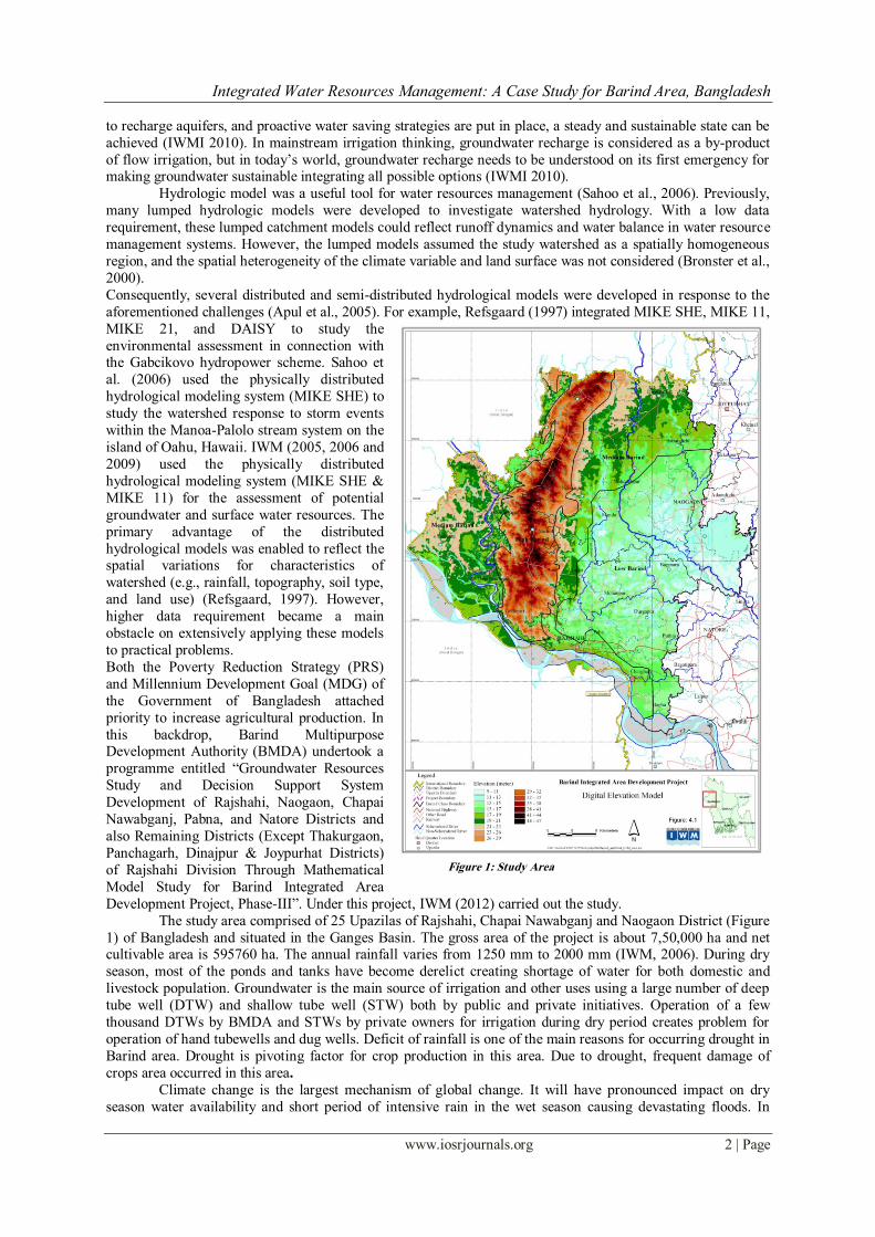
The study area comprised of 25 Upazilas of Rajshahi, Chapai Nawabganj and Naogaon District (Figure
1) of Bangladesh and situated in the Ganges Basin. The gross area of the project is about 7,50,000 ha and net cultivable area is 595760 ha. The annual rainfall varies from 1250 mm to 2000 mm (IWM, 2006). During dry
season, most of the ponds and tanks have become derelict creating shortage of water for both domestic and
livestock population. Groundwater is the main source of irrigation and other uses using a large number of deep
tube well (DTW) and shallow tube well (STW) both by public and private initiatives. Operation of a few
thousand DTWs by BMDA and STWs by private owners for irrigation during dry period creates problem for
operation of hand tubewells and dug wells. Deficit of rainfall is one of the main reasons for occurring drought in
Barind area. Drought is pivoting factor for crop production in this area. Due to drought, frequent damage of
crops area occurred in this area.
Climate change is the largest mechanism of global change. It will have pronounced impact on dry
season water availability and short period of intensive rain in the wet season causing devastating floods. In
Figure 1: Study Area
Integrated Water Resources Management: A Case Study for Barind Area, Bangladesh
www.iosrjournals.org 3 | Page
recent year, it has been observed that climate is becoming more variable with greater occurrence of extreme
events in this area. This will encourage the upstream countries to divert more surface water leaving a gloomy
picture of prolonged drought with dry wells at many places of the region. Reduction of surface water and lowering of groundwater table combined with climate change will aggravate the existing water scarcity problem.
1.1 Rational for Groundwater Use
Though surface water is available at the outfall of the Mohananda river into the Ganges and in the
Ganges River, large pumping plants are required for pumping water from the river. Moreover the water levels of
the rivers in some reaches go down beyond the suction limit of low lift pumps becoming the problems of
pumping from river. Moreover, the undulated topography of the area is not suitable for gravity irrigation.
However, pumping from the rivers and conserving water by small water control structures are being practiced
for limited surface water irrigation. Main dependence for irrigation is on ground water. Groundwater is being
extracted for irrigation mainly by DTW and STW. There are about 8,955 DTW and 97,669 STW in Barind area
(BADC, 2010). After development of groundwater, irrigation coverage and agricultural yield in the area has
significantly been increased as well as the cropping pattern has also been changed. Now a days Rabi cultivation
season is also known as main irrigation season. However, impact of groundwater use has not been well
monitored.
1.2 Policy Statement for Groundwater Use
The government policies that have direct relevance with use of groundwater are mainly the National
Water Policy (NWPo) and National Agricultural Policy (NAP). In the context of water use, the objectives of the
NWPo are to promote agricultural growth through development of groundwater along with surface water. The
main elements of Government policy for use of water are to (i) encourage and promote continued development
of minor irrigation without affecting drinking water supplies, (ii) encourage future groundwater development for
irrigation by both the public and the private sectors, (iii) improve resource utilization through conjunctive use of all forms of surface water and groundwater for irrigation, (iv) strengthen systems for monitoring water use,
water quality and groundwater recharge. (v) strengthen crop diversification programmes for efficient water
utilisation, (vi) develop and promote water management techniques to prevent wastage and generate efficiency
of water and energy use and (vii) produce skilled professionals for water management.
Recently Government has approved the Poverty Reduction Strategic Paper (PRSP) that provides the
guideline to achieve the Millennium Development Goals (MDG). In the PRSP, among others, due emphasis has
also been given on the rational and productive utilization of the water resources. The main elements of the
PRSP as stated in Policy Matrix which have relevance with the efficient and productive use of water includes,
among others (i) create additional irrigation facilities utilizing surface water resource where justified, (ii) ensure
conjunctive use of surface and groundwater in existing Command Area Development Projects, (iii) monitor
quality and quantity of groundwater on regular basis, (iv) augment surface water in rivers, creeks and khals by constructing barrage, rubber dam and water control structures and (v) promote community participation in
multipurpose use of water.
II. Approach and Methodology For sustainable management of scarce water resources and to mitigate the impact of drought, integrated
water resources management (IWRM) is needed applying technically based procedures to assess the hydrologic
and environmental consequences of different water resource management strategies. An attempt has been made
in this paper to evaluate the existing condition of groundwater and to assess the possible effects and impacts of
drought on groundwater in Barind area with focus on appropriate technologies for assessing hydrologic and environmental consequences of IWRM. Effective management strategy for sustainable use of groundwater
resources under complex situation also has been tried to illuminate in this paper.
The MIKE SHE model is a physical distributed hydrological modeling system covering the entire land
phase of the hydrological cycle (Abbott et al., 1986). The model consists of five modules: overland flow,
evapotranspiration, unsaturated flow, saturated flow and channel flow modules (DHI, 1999). The saturated flow
that is allowed for a fully three-dimensional (3D) way is described by the Darcy equation and solved by the
iterative implicit finite difference technique. 3D finite difference method is used to simulate the 3D saturated
flow in saturated porous media.
where Kxx, Kyy, and Kzz are the hydraulic conductivity along the x, y, and z directions. The h is the
hydraulic head, Q represents the source=sink terms, and S is the specific storage coefficient. The channel flow is
calculated by the one-dimensional simulation using the full dynamic Saint-Venant equations. The coupling
between MIKE SHE and MIKE 11 is made via river links.
Integrated Water Resources Management: A Case Study for Barind Area, Bangladesh
www.iosrjournals.org 4 | Page
In order to achieve the study objectives, IWM (2012) developed an integrated gw-sw model for the
study area. The models developed under this study are based on MIKE-11 (DHI, 1999) for the simulation of
flows in rivers, irrigation systems, channels and other water bodies and MIKE-SHE (DHI, 1999) for groundwater model. All the major river systems were included in surface water model while updated
topographic features, hydro-geological setting, aquifer properties, DEM, land use pattern, irrigation abstractions
were incorporated in groundwater model. Both the models were coupled through MIKE SHE and calibration as
well as validation was done. The validated model was used to simulate various options and to assess the
resources.
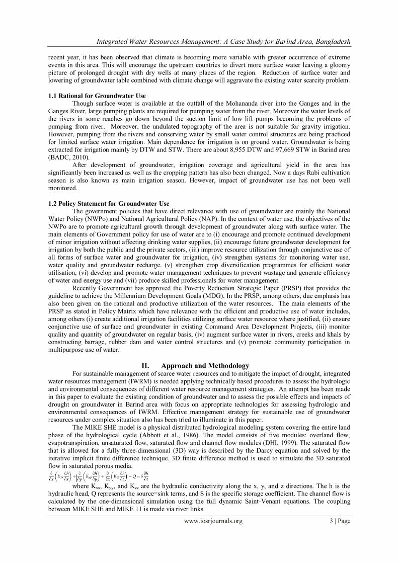
III. Results and Discussions Considering lithological variations and groundwater flow capacity, hydro-stratigraphic units of the
study area (upto 80 m depth) have been defined as Clay Top, Upper Aquifer, Clay Middle, Lower Aquifer and Clay Bottom (Figure 2). It reveals from the analysis that within the studied depth upper aquifer and lower
aquifer is interconnected and the clay middle is not continuous. In fact there is only one aquifer in the study
area. The main aquifer, in most of the area is either semi-confined or leaky. Recharge to the aquifer is
predominantly derived from deep percolation of rain and flood water. Lateral contributions from rivers comprise
only a small percentage 0.04% (MPO, 1987) of total potential recharge.
Analysis reveals that in high barind area,
specific yield varies from 0.01 to 0.06, while
in low barind area, it varies from 0.06 to 0.30.
Low specific yield will cause excessive draw-
down in tubewell for high abstraction rates. In
high Barind area, hydraulic conductivity varies from 10 m/day and 20 m/day whereas in low
barind area it varies from 40 m/day to 70
m/day. In high barind area, transmissivity is
lower than 1000 m2/day whereas in low barind
area it is higher than 1000 m2/day. Highly
transmissivity aquifer material indicates
excellent opportunity for sustainable
groundwater development in the area.
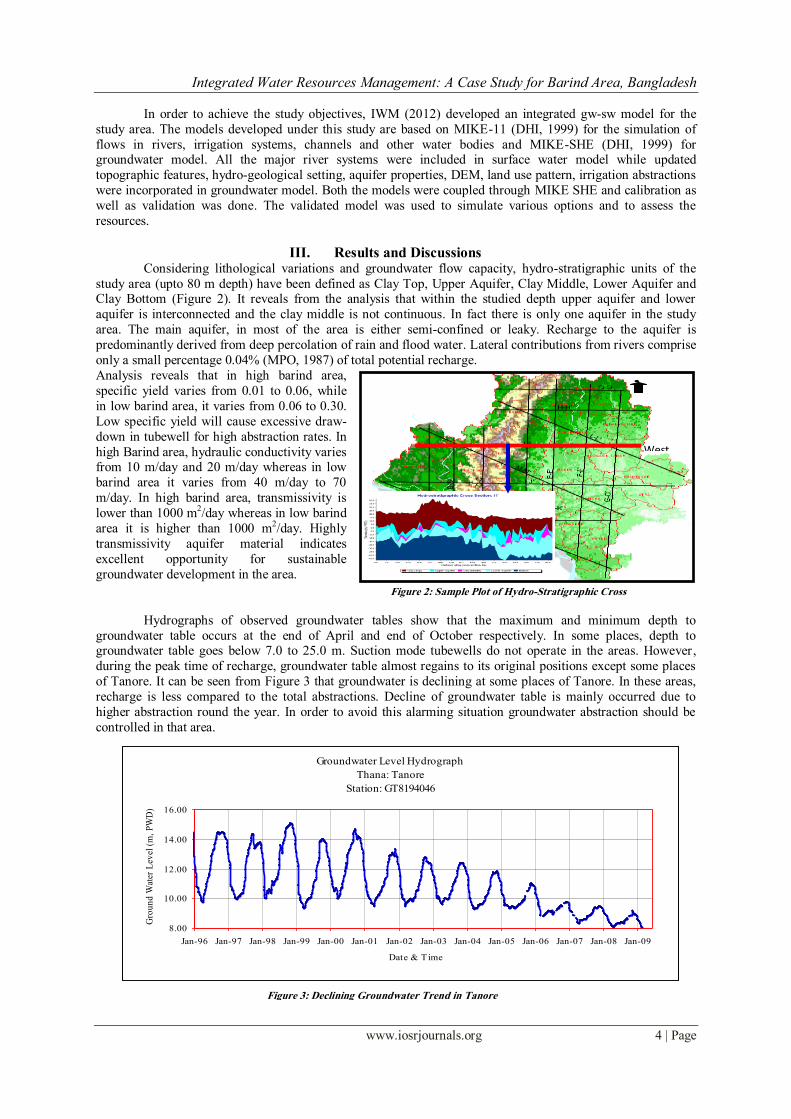
Hydrographs of observed groundwater tables show that the maximum and minimum depth to
groundwater table occurs at the end of April and end of October respectively. In some places, depth to groundwater table goes below 7.0 to 25.0 m. Suction mode tubewells do not operate in the areas. However,
during the peak time of recharge, groundwater table almost regains to its original positions except some places
of Tanore. It can be seen from Figure 3 that groundwater is declining at some places of Tanore. In these areas,
recharge is less compared to the total abstractions. Decline of groundwater table is mainly occurred due to
higher abstraction round the year. In order to avoid this alarming situation groundwater abstraction should be
controlled in that area.
N
West
to East
Figure 2: Sample Plot of Hydro-Stratigraphic Cross
Section
Figure 3: Declining Groundwater Trend in Tanore
Groundwater Level Hydrograph
Thana: Tanore
Station: GT8194046
8.00
10.00
12.00
14.00
16.00
Jan-96 Jan-97 Jan-98 Jan-99 Jan-00 Jan-01 Jan-02 Jan-03 Jan-04 Jan-05 Jan-06 Jan-07 Jan-08 Jan-09
Date & Time
Gro
un
d W
ater
Lev
el (
m,
PW
D)
Integrated Water Resources Management: A Case Study for Barind Area, Bangladesh
www.iosrjournals.org 5 | Page
The current water management plans are mostly based on existing knowledge and sparsely aims at
optimum use of precious resources. An improved understanding of the hydrologic processes that determine the
resource and movement of water in this region is critical to the development of effective strategies for sustainable development water management. The management strategy of groundwater resources depends on
the following aspects:
Assessment of availability and requirements of water resources;
Understanding the recharge mechanism;
Identification of scope for future irrigation expansion based on water availability;
Development of Groundwater Monitoring System;
Estimation required number of Deep Tubewell;
IWM (2012) carried out the groundwater model study for optimum utilization of available water
resources. For the study area, the Upazila wise estimated potential recharge, usable recharge which is 75% of
potential recharge, abstraction and remaining water is given in Table 1 (IWM, 2012).
Table 1: Upazilawise Groundwater Resources
SL No. District Upazila Potential Recharge (mm) Usable Recharge
(mm)
Requirement (mm)
in 2010
Remaining Water
(mm) in 2010
1
Naogaon
Atrai 611 458 407 51
2 Badalgachi 640 480 348 132
3 Dhamoirhat 599 449 535 -86
4 Mahadebpur 486 365 335 30
5 Manda 619 464 263 201
6 Patnitala 435 326 294 30
7 Porsha 396 297 152 145
8 Naogaon 635 476 394 82
9 Niamatpur 449 337 296 41
10 Raninagar 623 467 400 67
11 Sapahar 431 323 200 123
12
Rajshahi
Bagha 452 339 181 158
13 Bagmara 486 365 351 14
14 Charghat 498 374 352 22
15 Durgapur 570 428 401 27
16 Godagari 414 311 302 9
17 Mohonpur 415 311 281 30
18 Paba 547 410 289 121
19 Puthia 533 400 390 10
20 Tanore 330 248 294 -46
21
Chapai
Nawabganj
Bholahat 664 498 386 112
22 Gomastapur 438 329 256 73
23 Nachole 467 350 212 138
24 Nawabganj 590 443 158 285
25 Shibganj 498 374 294 80
It was estimated for the future scope of irrigation expansion based on water availability and
recommended optimum number of tubewell to be installed in future. The study (IWM, 2006) reveals that
although the area has groundwater potential, major part of the area, the groundwater table goes below the
suction limit which would be more vulnerable due to climate change. The area is suffering from surface water
shortage. The study (IWM, 2006) shows that, the area is loosing groundwater to the nearby river Ganges about
13Mm3 in each year. Some part of the area has already been found as groundwater resource constrained zone.
So, it is anticipated that situation might become worse in that area with the longer dry season due to the climate
change. However, in other areas of Bangladesh, effective management strategy for sustainable use of
groundwater resources needs to be developed considering the above aspects. Careful management can avoid
problems in over exploitation of resources and environmental degradation of this area.
3.1 Surface Water Availability
For the purpose of assessing surface water resources, discharge data were analyzed to estimate the flow
event for different return periods. Monthly available resources in the above rivers were also analyzed.
Conservation of these resources was considered by construction of rubber dam. For sustainability of river,
usable resource was taken as 70% of the available resources and remaining 30% as ―in-stream flow
requirement‖ in the river. Based on monthly crop water requirement (Boro-Aman) the scopes for surface water
based scheme were also estimated. Table 2 shows the scope of surface water development. It is observed that
some water resources are available in Atrai and Mohananda while very limited resource is available in Sib-
Barnai river.

Integrated Water Resources Management: A Case Study for Barind Area, Bangladesh
www.iosrjournals.org 6 | Page
Table 2: Scope of Surface Water Development
Location of Rubber Dam Month
Nov Dec Jan Feb Mar Apr
Atrai River, Ch 60.34 km, Atrai R.B
Monthly Available Water (million m3) 50.83 31.12 20.4 13.66 11.54 11.46
Monthly Water Requirement (m3) 0.127 0.065 0.258 0.21 0.251 0.18
SW development Area (km2) based on resources 400 478 79 65 46 64
Mohananda River, Ch 44.90 km, Nawabganj
Monthly Available Water (million m3) 313.16 235 193 136.66 99.69 70.4
Monthly Water Requirement (m3) 0.127 0.039 0.254 0.21 0.254 0.181
SW development Area (km2) based on resources 2466 6025 762 651 392 388
Sib-Barnai River, Ch 54.75 km, Pearpur
Monthly Available Water (million m3) 8.48 0.78 0.7 - - -
Monthly Water Requirement (m3) 0.131 0.039 0.258 0.21 0.258 0.18
SW development Area (km2) based on resources 65 20 3 - - -
3.2 Impact of Environmental Change on Groundwater
Environmental change compounds the challenges of sustainable groundwater management of this area
as it has significant impact on groundwater levels and recharge capacity as well as water demand. Following
issues related to global environmental change and its impact on groundwater resources have been discussed
below;
Climate Change
Climate change is strongly affecting many aspects of physical and biological systems, particularly
rainfall distributions and increases of temperature. In Bangladesh, recent studies indicate that there is an
increasing trend of temperature of about 10 C in May and 0.50 C in November during the 14 year period from
1985 to 1998 (Mirza, 2002). The temperature projection for the 21st century based on climatic models indicate
that in South Asia annual mean warming would be about 2.5 0 C (IPCC, 2007). The combination of shorter
duration but more intense rainfall (meaning more runoff and less infiltration) combined with increased
evapotranspiration and increased groundwater abstraction will lead to further groundwater depletion in this area.
Land use change
Land use and land cover change due to increasing population and urbanization is one of the largest mechanisms of global change. In northwest region of Bangladesh, growth of cities and rural settlement has been
increased rapidly due to development of infrastructures. Consequently land available for forest and agriculture
has been reduced. It is expected that further development of infrastructures will reduce the area of land available
for forest and agriculture by some 17 % (NWMP, 2001) over the next 25 years. This land use change will
reduce groundwater recharge area leading to groundwater depletion.
3.3 Exploration for Deeper Aquifer
After investigation of potential deeper aquifer, a DTW of 248 m depth was installed at a place where a
severe scare of drinking water was observed. Model result was also analyzed (Figure 6) for additional DTW in deeper aquifer in this area. The simulation results of first trial which is for addition 4 DTWs, shows that
groundwater level at Saidpur is goes further 24.3m from existing conditions. Though groundwater level almost
regains its original position but production cost would be higher considerably due to additional draw down. So it
would not be feasible to install four additional DTW. Model was simulated for another trial considering 2
additional DTWs in place of 4 with a spacing 2000m and observed that it will create additional 6.0m drawdown
and groundwater
Integrated Water Resources Management: A Case Study for Barind Area, Bangladesh
www.iosrjournals.org 7 | Page
level regain its original position. This option is quite feasible. But still it would be needed further detail
investigation to know the exact number of additional DTWs as well as resources in deeper aquifer.
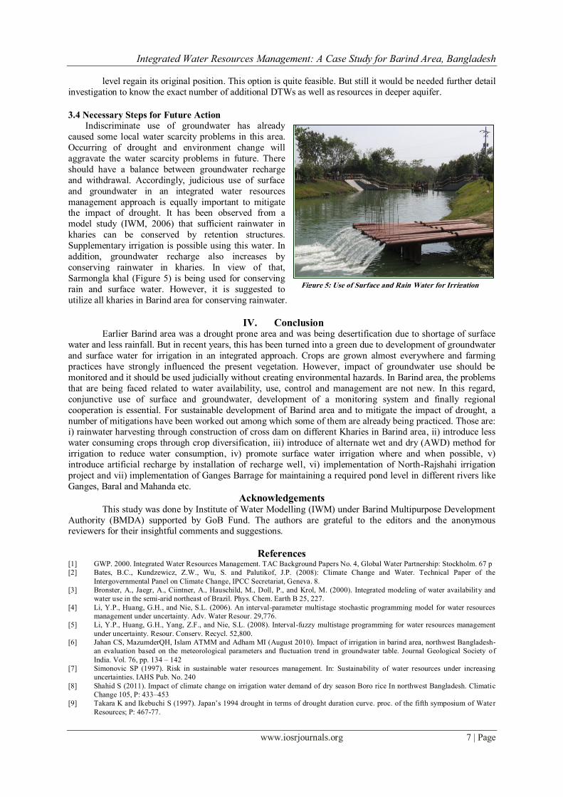
3.4 Necessary Steps for Future Action
Indiscriminate use of groundwater has already
caused some local water scarcity problems in this area.
Occurring of drought and environment change will
aggravate the water scarcity problems in future. There
should have a balance between groundwater recharge
and withdrawal. Accordingly, judicious use of surface
and groundwater in an integrated water resources
management approach is equally important to mitigate the impact of drought. It has been observed from a
model study (IWM, 2006) that sufficient rainwater in
kharies can be conserved by retention structures.
Supplementary irrigation is possible using this water. In
addition, groundwater recharge also increases by
conserving rainwater in kharies. In view of that,
Sarmongla khal (Figure 5) is being used for conserving
rain and surface water. However, it is suggested to
utilize all kharies in Barind area for conserving rainwater.
IV. Conclusion Earlier Barind area was a drought prone area and was being desertification due to shortage of surface
water and less rainfall. But in recent years, this has been turned into a green due to development of groundwater
and surface water for irrigation in an integrated approach. Crops are grown almost everywhere and farming
practices have strongly influenced the present vegetation. However, impact of groundwater use should be
monitored and it should be used judicially without creating environmental hazards. In Barind area, the problems
that are being faced related to water availability, use, control and management are not new. In this regard,
conjunctive use of surface and groundwater, development of a monitoring system and finally regional
cooperation is essential. For sustainable development of Barind area and to mitigate the impact of drought, a
number of mitigations have been worked out among which some of them are already being practiced. Those are: i) rainwater harvesting through construction of cross dam on different Kharies in Barind area, ii) introduce less
water consuming crops through crop diversification, iii) introduce of alternate wet and dry (AWD) method for
irrigation to reduce water consumption, iv) promote surface water irrigation where and when possible, v)
introduce artificial recharge by installation of recharge well, vi) implementation of North-Rajshahi irrigation
project and vii) implementation of Ganges Barrage for maintaining a required pond level in different rivers like
Ganges, Baral and Mahanda etc. Acknowledgements
This study was done by Institute of Water Modelling (IWM) under Barind Multipurpose Development
Authority (BMDA) supported by GoB Fund. The authors are grateful to the editors and the anonymous reviewers for their insightful comments and suggestions.
References [1] GWP. 2000. Integrated Water Resources Management. TAC Background Papers No. 4, Global Water Partnership: Stockholm. 67 p
[2] Bates, B.C., Kundzewicz, Z.W., Wu, S. and Palutikof, J.P. (2008): Climate Change and Water. Technical Paper of the
Intergovernmental Panel on Climate Change, IPCC Secretariat, Geneva. 8.
[3] Bronster, A., Jaegr, A., Ciintner, A., Hauschild, M., Doll, P., and Krol, M. (2000). Integrated modeling of water availability and
water use in the semi-arid northeast of Brazil. Phys. Chem. Earth B 25, 227.
[4] Li, Y.P., Huang, G.H., and Nie, S.L. (2006). An interval-parameter multistage stochastic programming model for water resources
management under uncertainty. Adv. Water Resour. 29,776.
[5] Li, Y.P., Huang, G.H., Yang, Z.F., and Nie, S.L. (2008). Interval-fuzzy multistage programming for water resources management
under uncertainty. Resour. Conserv. Recycl. 52,800.
[6] Jahan CS, MazumderQH, Islam ATMM and Adham MI (August 2010). Impact of irrigation in barind area, northwest Bangladesh-
an evaluation based on the meteorological parameters and fluctuation trend in groundwater table. Journal Geological Society of
India. Vol. 76, pp. 134 – 142
[7] Simonovic SP (1997). Risk in sustainable water resources management. In: Sustainability of water resources under increasing
uncertainties. IAHS Pub. No. 240
[8] Shahid S (2011). Impact of climate change on irrigation water demand of dry season Boro rice In northwest Bangladesh. Climatic
Change 105, P: 433–453
[9] Takara K and Ikebuchi S (1997). Japan’s 1994 drought in terms of drought duration curve. proc. of the fifth symposium of Water
Resources; P: 467-77.
Figure 5: Use of Surface and Rain Water for Irrigation
Integrated Water Resources Management: A Case Study for Barind Area, Bangladesh
www.iosrjournals.org 8 | Page
[10] Sajjan AK, Muhammed A Bhuiyan and Nepal C Dey (2002). Impact of 1994-95 drought in the northwest of Bangladesh through
questionnaire survey. In proc. of the 2nd annual paper meet of Ag. Eng. Division, Institution of Engineers, Bangladesh; P: 31-5
[11] Dey NC, Alam M S Sajjan A K, Bhuiyan M A, Ghose L, Ibaraki Y and Karim F (2011). Assessing environmental and health impact
of drought in the northwest Bangladesh. Journal of Environmental Science & Natural Resources. Vol. 4, No. 2, pp. 89-97
[12] Dey NC and Ali ARM M (2010). Changes in the use of safe water and water safety measures in WASH intervention areas of
Bangladesh: a midline assessment. BRAC-RED Working Paper 27
[13] Loucks D P (2000). Sustainable water resources management. Water International 25(1); P.3-11.
[14] Cai X, Daene C McKinney and Mark W Rosegrant (2001). Sustainability analysis for irrigation water management: concepts,
methodology, and application to the Aral Sea region: International Food Policy Research Institute, NY, USA, EPTD Discussion
Paper No. 86 CGW
[15] International Water Management Institute (IWMI) (2010). Water policy brief banking of groundwater in times of change. Issue 32.
www.iwmi.cgiar.org/Publications/Water_Policy_Briefs/PDF/WPB32.pdf)
[16] Sahoo, G.B., Ray, C., De Carlo, E.H. (2006). Calibration and validation of a physically distributed hydrological model, MIKE SHE,
to predict stream flow at high frequency in a flashy mountainous Hawaii stream. J. Hydrol. 327, 94.
[17] Apul, D., Gardner, K., and Eifhmy, T. (2005). Probabilistic modeling of one-dimensional water movement and leaching from
highway embankments containing secondary materials.Environ. Eng. Sci. 22, 156.
[18] Refsgaard, J.C. (1997). Parameterisation, calibration and validation of distributed hydrological models. J. Hydrol. 198, 69.
[19] IWM (2005). Groundwater Management and Zoning Study for repair and Rehabilitation of Deep Tubewell Project in Greater
Dinajpur District under Post Drought Agricultural Rehabilitation Programme, December 2005, Final Report, Volume 1.
[20] IWM (2006). Groundwater Resources Study for Deep Tube Well Installation Project in Barind Area, Final Report, Volume 1.
[21] IWM (2009). Groundwater Resource Study and Decision Support System Development of Thakurgaon, Panchagarh, Dinajpur and
Joypurhat Districts through Mathematical Model Study, Final Report, Volume-I.
[22] Institute of Water Modelling (IWM, 2012): Groundwater Resources Study and Decision Support System Development of Rajshahi,
Naogaon, Chapai Nawabganj, Pabna, and Natore Districts and also Remaining Districts (Except Thakurgaon, Panchagarh, Dinajpur
& Joypurhat Districts) of Rajshahi Division Through Mathematical Model Study for Barind Integrated Area Development Project,
Phase-III, Final Report, Volume-I.
[23] BADC (2008). Minor Irrigation Survey Report
[24] Abbott, M.B., Bathurst, J.C., Cunge, J.A., Ocinnell, P.E., and Rasmussen, J. (1986). An introduction to the European hydrological
system—systeme hydrologique Europeen, She. 2. Structure of a physically-based, distributed modeling system. J. Hydrol. 87, 61.
[25] DHI (1999). MIKE SHE User Manual- Hydrological Modelling System for Groundwater.
[26] DHI (1999). MIKE 11User Manual - a Modelling system for Rivers and Channels.
[27] Mirza, M.Q., 2002: Global warming and changes in the probability of occurrence of floods in Bangladesh and implications. Global
Environ. Chang., 12, 127-138
[28] IPCC, 2007: Climate Change 2007: The Scientific Basis. Contribution of Working Group II to the Assessment Report of the
Intergovernmental Panel on Climate Change [Houghton, J.T, et al. (eds)]
[29] WARPO, 2001: National Water Management Plan, Volume 2, Main Report.