Embed Size (px)
Citation preview
Interna tional Journal of Forest, Animal and Fisheries Research (IJFAF) [Vol-2, Issue-2, Mar-Apr, 2018]
https://dx.doi.org/10.22161/ijfaf.2.2.1 ISSN: 2456-8791
www.aipublications.com Page | 34
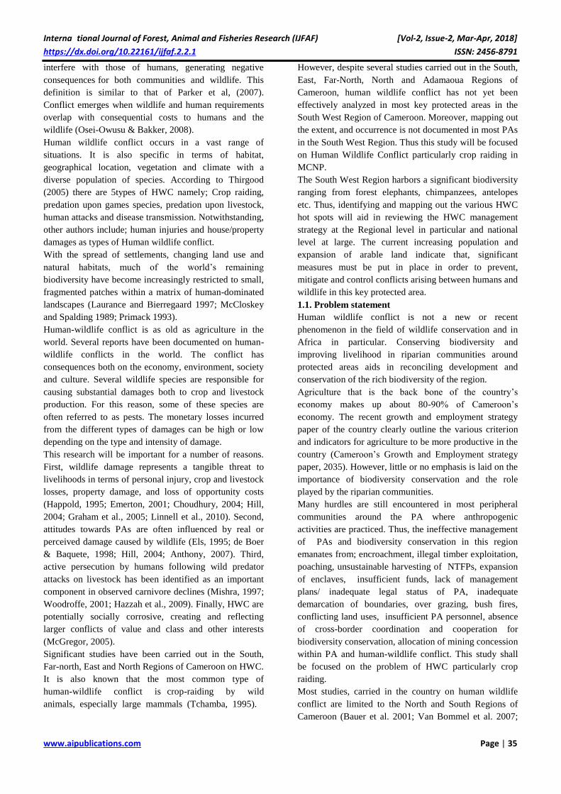
Human Wildlife Conflict: Causes, Consequences
and Management Strategies in Mount Cameroon
National Park South West Region, Cameroon Tangie Stanley Ndifor Attia1,*, Tchamba .N. Martin1, Tumenta Pricelia Forbuzie1, Tsi
Evaristus Angwafo1,2. Mvo Denis Chuo1
1Department of Forestry, Faculty of Agronomy and Agricultural Sciences (FASA), P. O. Box 222 Dschang, University of
Dschang, Cameroon 2Department of Fundamental Science Higher Technical Teacher Training College (H.T.T.T.C.) P.O. Box 39 Bambili
University of Bamenda – Cameroon
Abstract— Human Wildlife Conflict is as old as
agriculture in the world and in Africa in particular. The
main objective was to contribute to the sustainable
management of MCNP via mapping out the extent and
occurrence of human wildlife conflict. Questionnaire,
semi-structured interviews, and a focus group discussion
guide were used to determine local people’s perceptions
and to identify animals causing human wildlife conflict in
the four sample villages. The second method used was the
line transects method (tracts for instance; footpaths or
motor able roads) where bio-indicators of these species
causing conflicts were recorded and on foot. The
universal pacing method was used to estimate the area
damaged and quantity lost. GIS technique was used to
map out the spatial distribution of the conflict zones.
Results revealed that elephants represented an individual
percentage of 14.93 in terms of animal most involved in
human wildlife conflict specifically crop raiding. The
intensity of damage was higher cumulatively in rodents
more than elephants and other species with occurrence
from January to December with peaks being August and
March. Farms closer to the protected area recorded more
damage in monetary value. Cocoyam’s, cocoa, maize and
plantain/banana were the most affected in terms of
economic loss. Bomana village experienced 30% of
cocoa loss. Cocoa and banana had a strong correlation
coefficient of r= 0.8 in term of quantity damaged and
distance of the conflict area from the four villages
(Bomana, kotto1, kuke- kumbu and Ebie). Concerning the
local perception of animals involve in HWC, most
respondents (98.2%) recognized elephant as dangerous.
The spatial distribution of the conflict areas revealed a
high concentration of conflict in Bomana and kotto1
owing to the closeness (less than 3km) of the village to the
protected area. Thus, creating community awareness of
the importance of wildlife and the collaborative
participation of all stakeholders in management will
reduce encroachment into the park and minimize human
wildlife conflict around the peripheries.
Keywords— Crops Raided, Crops Raiders, Human
Wildlife Conflict, Perception, Protected Area,
Sustainable Management.
I. INTRODUCTION
Findings in the 21st century show that, humans have
greatly dominated the landscape, with every ecosystem on
the earth being influenced by human activities (Vitosuek
et al. 1997). About 40-50% of the earth’s surface , has
been transformed by humans with 10-15% allocated for
different land use types such as agriculture, irrigation or
urban development while an additional 6-8% has
undergone conversion to pasture ( Olson et al. 1998;
Vitosuek et al. 1997). This human disturbance has greatly
affected the Earth’s habitable land.
The human disturbance index indicates that almost three-
quarters of the Earth’s habitable land surface have been
disturbed by humans (Hannah et al. 1994; Hannah et al.
1995). Much of this anthropogenic impact is due to the
world’s burgeoning human population, which currently
stands at 7 billion and which the UN predicts to reach 8.9
billion by 2050 (UN, 2004). The resultant human
transformation of the global environment, as described
above, has been so striking that it has been defined by
some as a new geological epoch, termed the
‘anthropocene’ (Sanderson et al. 2002; Steffen and Tyson
2001). Human wildlife conflict is of major importance in
the world and Africa in particular.
Human wildlife conflict is a term which is most often
used by conservationists and is defined as; ‘When the
needs and behavior of wildlife impact negatively on the
goals of humans or when the goals of humans negatively
impact the needs of wildlife’ (WPC, 2003). According to
IUCN (2005) human wildlife conflict (HWC) is a
situation that occurs when the basic needs of wildlife
Interna tional Journal of Forest, Animal and Fisheries Research (IJFAF) [Vol-2, Issue-2, Mar-Apr, 2018]
https://dx.doi.org/10.22161/ijfaf.2.2.1 ISSN: 2456-8791
www.aipublications.com Page | 35
interfere with those of humans, generating negative
consequences for both communities and wildlife. This
definition is similar to that of Parker et al, (2007).
Conflict emerges when wildlife and human requirements
overlap with consequential costs to humans and the
wildlife (Osei-Owusu & Bakker, 2008).
Human wildlife conflict occurs in a vast range of
situations. It is also specific in terms of habitat,
geographical location, vegetation and climate with a
diverse population of species. According to Thirgood
(2005) there are 5types of HWC namely; Crop raiding,
predation upon games species, predation upon livestock,
human attacks and disease transmission. Notwithstanding,
other authors include; human injuries and house/property
damages as types of Human wildlife conflict.
With the spread of settlements, changing land use and
natural habitats, much of the world’s remaining
biodiversity have become increasingly restricted to small,
fragmented patches within a matrix of human-dominated
landscapes (Laurance and Bierregaard 1997; McCloskey
and Spalding 1989; Primack 1993).
Human-wildlife conflict is as old as agriculture in the
world. Several reports have been documented on human-
wildlife conflicts in the world. The conflict has
consequences both on the economy, environment, society
and culture. Several wildlife species are responsible for
causing substantial damages both to crop and livestock
production. For this reason, some of these species are
often referred to as pests. The monetary losses incurred
from the different types of damages can be high or low
depending on the type and intensity of damage.
This research will be important for a number of reasons.
First, wildlife damage represents a tangible threat to
livelihoods in terms of personal injury, crop and livestock
losses, property damage, and loss of opportunity costs
(Happold, 1995; Emerton, 2001; Choudhury, 2004; Hill,
2004; Graham et al., 2005; Linnell et al., 2010). Second,
attitudes towards PAs are often influenced by real or
perceived damage caused by wildlife (Els, 1995; de Boer
& Baquete, 1998; Hill, 2004; Anthony, 2007). Third,
active persecution by humans following wild predator
attacks on livestock has been identified as an important
component in observed carnivore declines (Mishra, 1997;
Woodroffe, 2001; Hazzah et al., 2009). Finally, HWC are
potentially socially corrosive, creating and reflecting
larger conflicts of value and class and other interests
(McGregor, 2005).
Significant studies have been carried out in the South,
Far-north, East and North Regions of Cameroon on HWC.
It is also known that the most common type of
human-wildlife conflict is crop-raiding by wild
animals, especially large mammals (Tchamba, 1995).
However, despite several studies carried out in the South,
East, Far-North, North and Adamaoua Regions of
Cameroon, human wildlife conflict has not yet been
effectively analyzed in most key protected areas in the
South West Region of Cameroon. Moreover, mapping out
the extent, and occurrence is not documented in most PAs
in the South West Region. Thus this study will be focused
on Human Wildlife Conflict particularly crop raiding in
MCNP.
The South West Region harbors a significant biodiversity
ranging from forest elephants, chimpanzees, antelopes
etc. Thus, identifying and mapping out the various HWC
hot spots will aid in reviewing the HWC management
strategy at the Regional level in particular and national
level at large. The current increasing population and
expansion of arable land indicate that, significant
measures must be put in place in order to prevent,
mitigate and control conflicts arising between humans and
wildlife in this key protected area.
1.1. Problem statement
Human wildlife conflict is not a new or recent
phenomenon in the field of wildlife conservation and in
Africa in particular. Conserving biodiversity and
improving livelihood in riparian communities around
protected areas aids in reconciling development and
conservation of the rich biodiversity of the region.
Agriculture that is the back bone of the country’s
economy makes up about 80-90% of Cameroon’s
economy. The recent growth and employment strategy
paper of the country clearly outline the various criterion
and indicators for agriculture to be more productive in the
country (Cameroon’s Growth and Employment strategy
paper, 2035). However, little or no emphasis is laid on the
importance of biodiversity conservation and the role
played by the riparian communities.
Many hurdles are still encountered in most peripheral
communities around the PA where anthropogenic
activities are practiced. Thus, the ineffective management
of PAs and biodiversity conservation in this region
emanates from; encroachment, illegal timber exploitation,
poaching, unsustainable harvesting of NTFPs, expansion
of enclaves, insufficient funds, lack of management
plans/ inadequate legal status of PA, inadequate
demarcation of boundaries, over grazing, bush fires,
conflicting land uses, insufficient PA personnel, absence
of cross-border coordination and cooperation for
biodiversity conservation, allocation of mining concession
within PA and human-wildlife conflict. This study shall
be focused on the problem of HWC particularly crop
raiding.
Most studies, carried in the country on human wildlife
conflict are limited to the North and South Regions of
Cameroon (Bauer et al. 2001; Van Bommel et al. 2007;
Interna tional Journal of Forest, Animal and Fisheries Research (IJFAF) [Vol-2, Issue-2, Mar-Apr, 2018]
https://dx.doi.org/10.22161/ijfaf.2.2.1 ISSN: 2456-8791
www.aipublications.com Page | 36
Bauer et al. 2010; Tumenta, 2012) With regards to
human-wildlife conflict in particular; animals are a major
threat around the villages closed to PA. In April 2013, it
was reported a man was killed by an elephant in his farm
closed to the KNP (MINFOF, 2013). This justifies the
investigation of the extent of HWC in this region.
In general, when animals raid crops or threaten human life
in local villages, the communities feel that their economy
and existence are undermined, especially since there is no
policy on compensation in the country. The animals that
are involved in crop damage, livestock attacks and human
injuries include; elephants, lions, buffaloes, monkeys and
many others. Thus, addressing the issue of Human
wildlife conflict (crop raiding) around the peripheries of
protected areas will aid in improving the livelihood of
communities around the area while conserving the rich
fauna and flora biodiversity of the PA.
1.2. Research question
1.2.1. Overall question
What is the extent of Human-wildlife conflict in Mount
Cameroon National Park, South West Region?
1.2.2. Secondary Questions:
- Which animals are involved in Human wildlife
conflict in mount Cameroon national park of the
South west region of Cameroon?
- What type of damage and quantities damaged do
these animals cause in this protected area?
- What is the spatial distribution of HWC and
what periods do these conflicts occur.
- What is the cost of most common techniques
practiced for mitigating and preventing this
conflict?
- What management strategies can be propose to
minimize this conflict?
1.3. Overall objective:
Contribute to the sustainable management of Mount
Cameroon national park in the South West Region of
Cameroon, via mapping out the extent and occurrence of
human wildlife conflicts.
1.3.1 Specific objectives
- Identify wildlife species involve in HWC in the
peripheral communities of the PA
- Evaluate the cost of HWC incurred through
crop raiding
- Establish a map showing the spatial distribution
of HWC-prone areas
- Determine the cost of most commonly practiced
techniques to minimize HWC in the PA
- Propose management strategies for mitigating
the conflict in MCNP
II. MATERIALS AND METHODS
2.1. Description of Study area:
2.1.1. Location:
According to Geospatial-Intelligence Agency, a member
of the Intelligence community of the United States of
America, and a Department of Defense (DoD) Combat
Support Agency, the South West Region is located at
Latitude : 5° 25' 00" N and Longitude : 9° 20' 00" E. The
Region is made up of six(6) divisions ; Fako, Koupé-
Manengouba, Lebialem, Manyu, Meme, and Ndian. The
study was carried out in one of the key protected areas in
the South West Region of Cameroon namely;
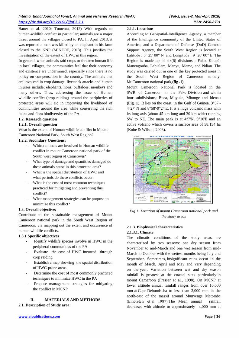
Mt.Cameroon national park,(fig .1).
Mount Cameroon National Park is located in the
SWR of Cameroon in the Fako Division and within
four subdivisions; Buea, Muyuka, Mbonge and Idenau
(Fig. 1). It lies on the coast, in the Gulf of Guinea, 3°57'-
4°27' N and 8°58'-9°24'E. It is a huge volcanic mass with
its long axis (about 45 km long and 30 km wide) running
SW to NE. The main peak is at 4°7'N, 9°10'E and an
active volcano which covers a surface area of 58.154 ha
(Kobe & Wilson, 2003).
Fig.1: Location of mount Cameroon national park and
the study areas
2.1.3. Biophysical characteristics
2.1.3.1. Climate
The climatic conditions of the study areas are
characterized by two seasons: one dry season from
November to mid-March and one wet season from mid-
March to October with the wettest months being July and
September. Sometimes, insignificant rains occur in the
month of March, April and May and vary depending
on the year. Variation between wet and dry season
rainfall is greatest at the coastal sites particularly in
mount Cameroon (Frasser et al., 1998), On MCNP at
lower altitude annual rainfall ranges from over 10,000
mm at Cape Debundscha to less than 2,000 mm in the
north-east of the massif around Munyenge Metombe
(Embretch et’al 1987).The Mean annual rainfall
decreases with altitude to approximately 4,000 mm at

Interna tional Journal of Forest, Animal and Fisheries Research (IJFAF) [Vol-2, Issue-2, Mar-Apr, 2018]
https://dx.doi.org/10.22161/ijfaf.2.2.1 ISSN: 2456-8791
www.aipublications.com Page | 37
1,000m and to less than 3,000 mm above 2,000m
(Payton,1993)
Fig.2: Rain chart of the area (source: CDC)
2.1.3.2. Relief and Topography
The PA is strongly dissected and rugged upland areas,
characterized by long, steep, irregular slopes, plateau,
lowlands and deeply incised seasonal streams, springs,
rivers and crater lakes. The terrains are characterized by
piles of granite boulders and horsts, basaltic rocks etc.
MCNP extends up to 4100m from sea level.
2.1.3.3. Geology and Soil
With respect to the geology of the study area, the soils are
rich in basalt and andesite in other parts it is mostly older
tertiary lava or composed of a mean texture of sandy clay
dominated by sand. Data assessing the suitability of the
soils of the region for the cultivation of oil palm identified
older sedimentary soils as well as volcanic soils as the
main soil types in this area with the north-east flanks of
the mountain comprising of metamorphic volcanic
formations. The soils are fertile with high levels of
nutrients and organic matter.
2.1.3.4. Hydrology
In MCNP, Watercourses from the PA drains into the
ocean and other rivers around the mountain. It is drained
principally by River idenau and its multiple tributaries.
2.1.3.5. Vegetation
The vegetation type varies slightly across the region. This
change favors the endemic status of some flag species in
the region. In West Africa, Mount Cameroon is
unique for having a relatively unbroken sequence of
natural vegetation from lowland evergreen forest
almost at sea level to sub-alpine prairies near its
summit (Acworth et al., 1996). Mount Cameroon is
known for its exceptional plant diversity and high number
of endemic species. Evidence of this richness is that over
2,300 species of plants in more than 800 genera and 210
families, 49 strictly endemic (only occurring on Mount
Cameroon) and 50 near endemic plant species (also
occurring in Bamenda Highlands, Oku, Kupe, Korup,
Obudu Plateau and Bioko) are found in the area. Cheek et
al. (1996) argued that almost all of the plant families
endemic to Tropical Africa: Huaceae, Medusandraceae,
Lepidobotryaceae, Octocknemataceae and
Hoplestigmataceae are found on Mount Cameroon and
the surrounding foothills.
At least 42 plant species and three genera are strictly
endemic and another 50 species are near-endemic to
Mount Cameroon (Cable and Cheek 1998, Cheek et al.
1994, WWF and IUCN 1994). The exceptional plant
species diversity of Mount Cameroon is a result of the
wide range of physical and climatic factors such as
volcanism, altitude, geology and rainfall (Tchouto, 1995).
The vegetation belts on the mountain have been classified
based on altitudinal variations.
2.1.3.6. Fauna
The protected area, is rich in fauna, although the mammal
fauna of the parks are fairly well documented. Also, other
groups such as insects (excluding butterflies) and
mollusks remain virtually unknown.
a) Mammals
The mammalian fauna is peculiar in this protected area of
the south west region. MCNP harbors wide variety
mammals with key mammals such as; chimpanzee, Press'
Guenon and the last isolated threatened population of
forest elephants (Loxodonta Africana) in the region with
an estimated population of 178 individuals (Ekobo, 2003).
2.1.4.0. Socio-economic characteristics
2.1.4.1. Human Population
The MCNP constitute a total number of 58 peripheral
villages with an estimated population of 72,000
inhabitants. There exist different ethnic groups in this key
protected area. The indigenes of this PA are; Bomboko’s,
Balandos, Bawerians and Bakolle’s. The population is
also made up of ethnic groups from the west and
northwest regions of Cameroon such as the Bamilike and
Mohghamo’s.
2.1.4.2. Local Institutions
The social organization of the villages in the protected
area is made of a chief, regent chief (traditional) and other
community-based structures. Chiefs are generally
educated and not always found in the village. They are
assisted by the regent chief who is permanently in the
village. The regent chief handles all the aspects of the
culture. Important decisions are usually taken in
consultation with the traditional council and regent chief.
Traditional societies constitute a major aspect of the
culture and tradition of the Bomboko and Bakweri people.
Most young males, in the traditional set-up, are usually
initiated into the “Malle” (elephant dance society), while
the females are initiated into Malova, Liengu. There is a
very strong solidarity and communication system between
members of the traditional societies. Annual and periodic
group come-together are organised, where members meet
to celebrate. The traditional societies play an important
0
5
10
15
20
25
30
Jan Feb Mar Apr May Jun Jul Aug Sep Oct Nov Dec
Avera
ge d
ay
s
Months
Rainfall Chart of the area (1963-1993)
Monthly…
Interna tional Journal of Forest, Animal and Fisheries Research (IJFAF) [Vol-2, Issue-2, Mar-Apr, 2018]
https://dx.doi.org/10.22161/ijfaf.2.2.1 ISSN: 2456-8791
www.aipublications.com Page | 38
role in law reinforcement and maintenance of peace and
order in the villages. Such societies could play a vital role
in re-enforcing park management rules. The common
language in this PA is Pidgin and English. Community
based institutions for the management of natural resources
also exists such as village Forest Management Committee
(VFMC) and other village development associations.
2.1.4.3. Agriculture
Subsistence farming and agro industrial farming, forms
the basis of the farming system in this PA. Both food
crops (cassava, plantains, bananas, cocoyams) and cash
crops (cocoa, coffee and oil palm) are produced.
Agriculture is presently the most important economic
activity carried out in the area, employing about 95% of
the population, while timber exploitation, hunting and
petty trading are also practised by some inhabitants. Farm
sizes range between 0.25 ha to more than 10 ha. Cocoa
farms in the Mt Cameroon area generate more significant
benefits for conservation and local livelihood than
commercial plantations, roughly 50 tree species are
commonly retained or planted in cocoa farms (Sarah et al,
2007)
Non-indigenous farmers own the largest farms and
account for most of the agricultural production of the
area. Market for farm produce is readily available by
middlemen, who buy at farm gates. In general, farming is
done using family labour and outside labour (part time
contractors). Cocoa Theobroma cacao , Coffee Coffea
robusta, Cocoyam’s, Cassava etc and, as well as fruit
trees, both planted and wild are continuously harvested.
2.2. Methods of data collection
2.2.0 .Research design
The research carried out was both qualitative (direct
observation, focus group discussion and pictorial
analysis) and quantitative (Semi- structured
questionnaires) as well as GIS methods in nature with the
application of descriptive methods. Cross sectional data
collection was used to isolate important variables.
2.2.1. Target population
The findings were made on 20households per 4villages in
the key protected areas. Focus group discussions were
held in each of the villages (Bomana, kotto2, kuke-
kumbu and Ebie). The Heads and chairpersons of the
various focus groups were equally consulted and included
in the study.
2.2.1.2. Sampling frame
The main objective of this study was to Map the extent of
HWC, its magnitude and its occurrence in Mount
Cameroon National Park in the South West Region of
Cameroon. The respondents of the study were farmers,
administrators etc. The administrators selected were at
Regional, Divisional, and Sub-Divisional and local village
council chairpersons of the selected villages. Selection of
the respondents was randomly conducted.
2.2.1.4. Sampling sites
Studying area
Pre-selection: A reconnaissance survey was carried out
in the PA in other to identify villages with anthropogenic
practices towards the PAs. Selections of the communities
were oriented towards communities with known HWC
based on information from residents and NGOs in the
area. Within each of the selected communities, the
area towards the PA with the highest concentration of
food crop gardens and/or cocoa plantations were pre-
selected. At least 3 approximate line transects were
established from each village through farmlands/
gardens/plantations towards the PA to observe crop
tenure, land tenure, farm practices, crop damages and
livestock depredation.
2.2.1.5. Sample size
Multistage random sampling was done to determine the
sample size of respondents affected (not a normal
distribution). The sampling size was 100 households from
five villages with distribution of 20households per five
villages namely; Bomana, Kotto(I), Kotto(2), Kuke-
kumbu and Ebie as they were found to be adjacent to the
Protected area. But the community of kotto(1) did not
accepted the investigation of the researcher therefore
rounding the number of villages down to 4villages that is;
Bomana, kotto2, Kuke-kumbu and Ebie.
2.3.0. Data collection technique
2.3.1. Collection techniques
This study was carried out in the Mount Cameroon
National Park in the South West Region of Cameroon
during a 6month duration period August 26- March 26.
To realize the objectives as mentioned above, secondary
data, primary data, and results analysis were carried out.
2.3.1.1. Secondary data
Secondary data was collected from the libraries of
DEPFOR of the University of Dschang, Mount Cameroon
National park, GIZ archives, WWF archives, Regional
delegation of MINFOF, MINADER and MINADT. The
use of search engines such as Google scholar was used to
search related concepts and literature reviews.
2.3.1.2. Primary data:
100 open and close ended questionnaires were distributed
to 4 villages ( Bomana, kotto1, kuke-kumbu and Ebie)
chosen from 12peripheral villages base on previous
complains and reports submitted to the authorities of the
MCNP by the cluster village president of village forest
management committee’s(VFMC). All questions were
administered in English because of the anglo-Saxon
nature of the Region and the targeted population in
particular. Interview guide survey was done with the
conservator of the PA, Regional Delegates of (MINFOF,
Interna tional Journal of Forest, Animal and Fisheries Research (IJFAF) [Vol-2, Issue-2, Mar-Apr, 2018]
https://dx.doi.org/10.22161/ijfaf.2.2.1 ISSN: 2456-8791
www.aipublications.com Page | 39
MINEPDED, MINADER, MINADT and MINPADT) and
NGO’s (WWF, GIZ and WCS) because they are directly
or indirectly involved with the conservation of Mount
Cameroon National Park. This survey was guided by the
following questions (see appendix 1). At the community
levels, the interviews we conducted with the aid of a
participatory relax appraisal method during focus group
discussion gatherings with the assistance of the village
head and VFMC. This information collected was mainly
primary data needed for further analysis.
2.3.1.2. Observation/direct assessment:
Direct observations were made in the four (4) peripheral
communities (villages) around the PA. With the aid of a
field guide given by the VFMC, at least three major farm
tracts (foot paths or motorable paths) were selected in
each village and used for damage assessment. Conflicts
(crop damage) were assessed and geographical
coordinates were recorded with the aid of a GPS of mark
Garmin 76csx. Tracks (transect lines) of length between
2-5km were placed at intervals of 200m from the village
to the PA and snap shots of the presence of animal indices
were taken with the use of a Samsung digital camera..
With the aid of a pacing method, damage lost was
estimated onsite. The surface area of the specific type of
conflict (crop raiding) was determined. The zones of
conflict were geo-referenced with a GPS of mark Garmin
76csx..The costs price of the different produce damaged
were estimated via a market survey prices in the
communities (villages).
2.4.0. Data analysis
After sorting and coding of the questionnaires from the 4
villages, the primary data collected from the villages,
were analyzed using statistical package for social science
(SPSS) Ver.17 and Microsoft excel. The dependent
variables identified were; incidence of HWC expressed as
the amount of crop destroyed or spatial surface area. The
independent variables included the different types of
wildlife species involve in crop raiding, month and season
of conflict, location of conflict etc. For crop raiding, the
sizes of the farms were measure with the aid of the pacing
method and the area damaged(x) was divided by the total
area of the farm (z) in other to determine the portion
damaged. Base on the cropping system, the quantity yield
from the estimated damage area was multiplied by the
cost price of the produce to obtain the overall quantity lost
as a result of HWC in that season. The spatial distribution
of HWC was determined from the coordinates obtained
with a GPS and analyzed using Arc view 10.0. The
analyzed data were summarized or presented in, figures
and tables to ease understanding and interpretation.
III. RESULTS AND DISCUSSION
3.1. Animals most involve in HWC in Mount
Cameroon National Park
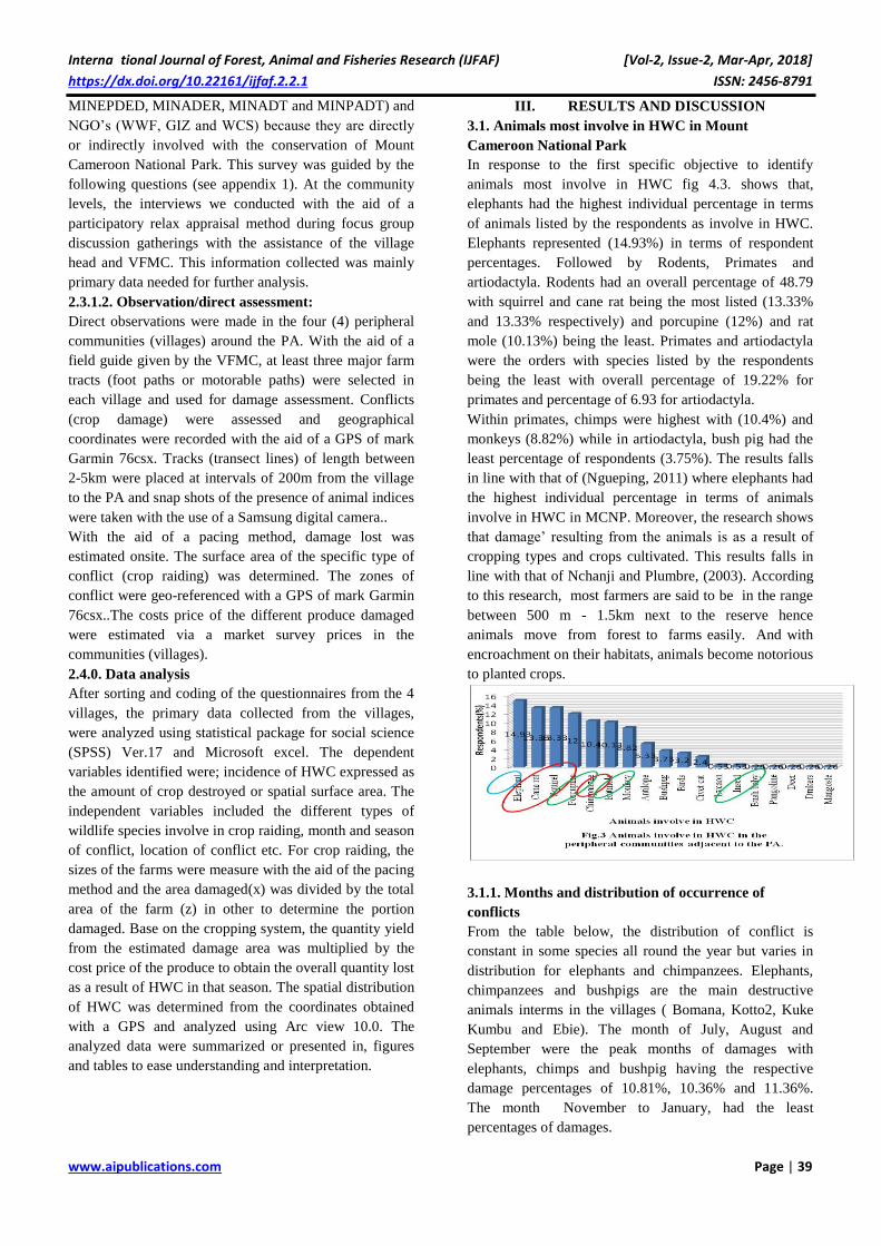
In response to the first specific objective to identify
animals most involve in HWC fig 4.3. shows that,
elephants had the highest individual percentage in terms
of animals listed by the respondents as involve in HWC.
Elephants represented (14.93%) in terms of respondent
percentages. Followed by Rodents, Primates and
artiodactyla. Rodents had an overall percentage of 48.79
with squirrel and cane rat being the most listed (13.33%
and 13.33% respectively) and porcupine (12%) and rat
mole (10.13%) being the least. Primates and artiodactyla
were the orders with species listed by the respondents
being the least with overall percentage of 19.22% for
primates and percentage of 6.93 for artiodactyla.
Within primates, chimps were highest with (10.4%) and
monkeys (8.82%) while in artiodactyla, bush pig had the
least percentage of respondents (3.75%). The results falls
in line with that of (Ngueping, 2011) where elephants had
the highest individual percentage in terms of animals
involve in HWC in MCNP. Moreover, the research shows
that damage’ resulting from the animals is as a result of
cropping types and crops cultivated. This results falls in
line with that of Nchanji and Plumbre, (2003). According
to this research, most farmers are said to be in the range
between 500 m - 1.5km next to the reserve hence
animals move from forest to farms easily. And with
encroachment on their habitats, animals become notorious
to planted crops.
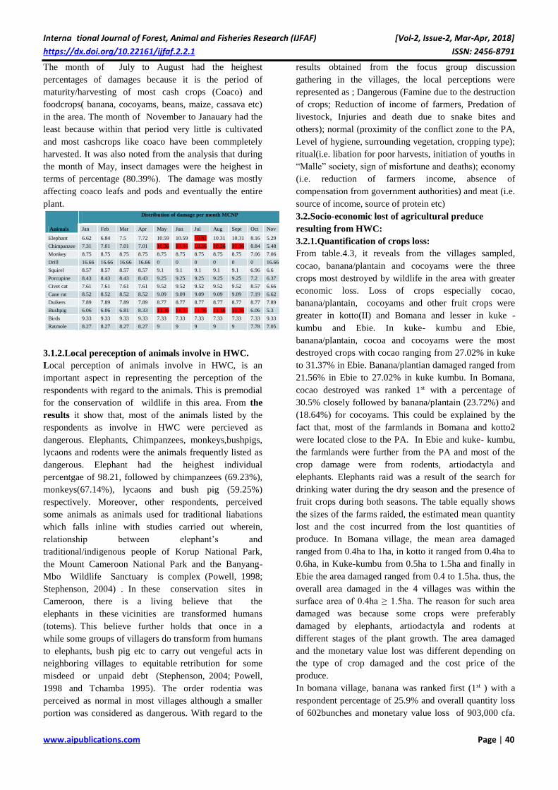
3.1.1. Months and distribution of occurrence of
conflicts
From the table below, the distribution of conflict is
constant in some species all round the year but varies in
distribution for elephants and chimpanzees. Elephants,
chimpanzees and bushpigs are the main destructive
animals interms in the villages ( Bomana, Kotto2, Kuke
Kumbu and Ebie). The month of July, August and
September were the peak months of damages with
elephants, chimps and bushpig having the respective
damage percentages of 10.81%, 10.36% and 11.36%.
The month November to January, had the least
percentages of damages.
Interna tional Journal of Forest, Animal and Fisheries Research (IJFAF) [Vol-2, Issue-2, Mar-Apr, 2018]
https://dx.doi.org/10.22161/ijfaf.2.2.1 ISSN: 2456-8791
www.aipublications.com Page | 40
The month of July to August had the heighest
percentages of damages because it is the period of
maturity/harvesting of most cash crops (Coaco) and
foodcrops( banana, cocoyams, beans, maize, cassava etc)
in the area. The month of November to Janauary had the
least because within that period very little is cultivated
and most cashcrops like coaco have been commpletely
harvested. It was also noted from the analysis that during
the month of May, insect damages were the heighest in
terms of percentage (80.39%). The damage was mostly
affecting coaco leafs and pods and eventually the entire
plant.
3.1.2.Local pereception of animals involve in HWC.
Local perception of animals involve in HWC, is an
important aspect in representing the perception of the
respondents with regard to the animals. This is premodial
for the conservation of wildlife in this area. From the
results it show that, most of the animals listed by the
respondents as involve in HWC were percieved as
dangerous. Elephants, Chimpanzees, monkeys,bushpigs,
lycaons and rodents were the animals frequently listed as
dangerous. Elephant had the heighest individual
percentgae of 98.21, followed by chimpanzees (69.23%),
monkeys(67.14%), lycaons and bush pig (59.25%)
respectively. Moreover, other respondents, perceived
some animals as animals used for traditional liabations
which falls inline with studies carried out wherein,
relationship between elephant’s and
traditional/indigenous people of Korup National Park,
the Mount Cameroon National Park and the Banyang-
Mbo Wildlife Sanctuary is complex (Powell, 1998;
Stephenson, 2004) . In these conservation sites in
Cameroon, there is a living believe that the
elephants in these vicinities are transformed humans
(totems). This believe further holds that once in a
while some groups of villagers do transform from humans
to elephants, bush pig etc to carry out vengeful acts in
neighboring villages to equitable retribution for some
misdeed or unpaid debt (Stephenson, 2004; Powell,
1998 and Tchamba 1995). The order rodentia was
perceived as normal in most villages although a smaller
portion was considered as dangerous. With regard to the
results obtained from the focus group discussion
gathering in the villages, the local perceptions were
represented as ; Dangerous (Famine due to the destruction
of crops; Reduction of income of farmers, Predation of
livestock, Injuries and death due to snake bites and
others); normal (proximity of the conflict zone to the PA,
Level of hygiene, surrounding vegetation, cropping type);
ritual(i.e. libation for poor harvests, initiation of youths in
“Malle” society, sign of misfortune and deaths); economy
(i.e. reduction of farmers income, absence of
compensation from government authorities) and meat (i.e.
source of income, source of protein etc)
3.2.Socio-economic lost of agricultural preduce
resulting from HWC:
3.2.1.Quantification of crops loss:
From table.4.3, it reveals from the villages sampled,
cocao, banana/plantain and cocoyams were the three
crops most destroyed by wildlife in the area with greater
economic loss. Loss of crops especially cocao,
banana/plantain, cocoyams and other fruit crops were
greater in kotto(II) and Bomana and lesser in kuke -
kumbu and Ebie. In kuke- kumbu and Ebie,
banana/plantain, cocoa and cocoyams were the most
destroyed crops with cocao ranging from 27.02% in kuke
to 31.37% in Ebie. Banana/plantian damaged ranged from
21.56% in Ebie to 27.02% in kuke kumbu. In Bomana,
cocao destroyed was ranked 1st with a percentage of
30.5% closely followed by banana/plantain (23.72%) and
(18.64%) for cocoyams. This could be explained by the
fact that, most of the farmlands in Bomana and kotto2
were located close to the PA. In Ebie and kuke- kumbu,
the farmlands were further from the PA and most of the
crop damage were from rodents, artiodactyla and
elephants. Elephants raid was a result of the search for
drinking water during the dry season and the presence of
fruit crops during both seasons. The table equally shows
the sizes of the farms raided, the estimated mean quantity
lost and the cost incurred from the lost quantities of
produce. In Bomana village, the mean area damaged
ranged from 0.4ha to 1ha, in kotto it ranged from 0.4ha to
0.6ha, in Kuke-kumbu from 0.5ha to 1.5ha and finally in
Ebie the area damaged ranged from 0.4 to 1.5ha. thus, the
overall area damaged in the 4 villages was within the
surface area of 0.4ha ≥ 1.5ha. The reason for such area
damaged was because some crops were preferably
damaged by elephants, artiodactyla and rodents at
different stages of the plant growth. The area damaged
and the monetary value lost was different depending on
the type of crop damaged and the cost price of the
produce.
In bomana village, banana was ranked first (1st ) with a
respondent percentage of 25.9% and overall quantity loss
of 602bunches and monetary value loss of 903,000 cfa.
Animals
Distribution of damage per month MCNP
Jan Feb Mar Apr May Jun Jul Aug Sept Oct Nov Dec
Elephant 6.62 6.84 7.5 7.72 10.59 10.59 10.81 10.31 10.31 8.16 5.29 5.07
Chimpanzee 7.31 7.01 7.01 7.01 10.36 10.36 10.36 10.36 10.36 8.84 5.48 5.48
Monkey 8.75 8.75 8.75 8.75 8.75 8.75 8.75 8.75 8.75 7.06 7.06 7.06
Drill 16.66 16.66 16.66 16.66 0 0 0 0 0 0 16.66 16.66
Squirel 8.57 8.57 8.57 8.57 9.1 9.1 9.1 9.1 9.1 6.96 6.6 6.6
Porcupine 8.43 8.43 8.43 8.43 9.25 9.25 9.25 9.25 9.25 7.2 6.37 6.37
Civet cat 7.61 7.61 7.61 7.61 9.52 9.52 9.52 9.52 9.52 8.57 6.66 6.66
Cane rat 8.52 8.52 8.52 8.52 9.09 9.09 9.09 9.09 9.09 7.19 6.62 6.62
Duikers 7.89 7.89 7.89 7.89 8.77 8.77 8.77 8.77 8.77 8.77 7.89 7.89
Bushpig 6.06 6.06 6.81 8.33 11.36 11.36 11.36 11.36 11.36 6.06 5.3 4.54
Birds 9.33 9.33 9.33 9.33 7.33 7.33 7.33 7.33 7.33 7.33 9.33 9.33
Ratmole 8.27 8.27 8.27 8.27 9 9 9 9 9 7.78 7.05 7.05
Interna tional Journal of Forest, Animal and Fisheries Research (IJFAF) [Vol-2, Issue-2, Mar-Apr, 2018]
https://dx.doi.org/10.22161/ijfaf.2.2.1 ISSN: 2456-8791
www.aipublications.com Page | 41
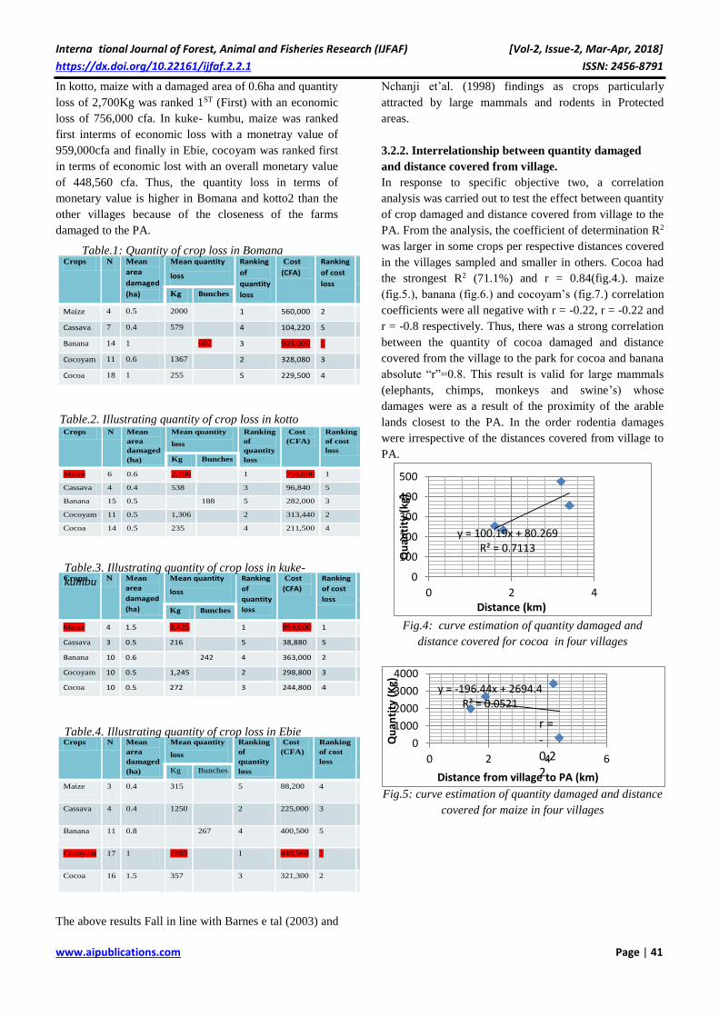
In kotto, maize with a damaged area of 0.6ha and quantity
loss of 2,700Kg was ranked 1ST (First) with an economic
loss of 756,000 cfa. In kuke- kumbu, maize was ranked
first interms of economic loss with a monetray value of
959,000cfa and finally in Ebie, cocoyam was ranked first
in terms of economic lost with an overall monetary value
of 448,560 cfa. Thus, the quantity loss in terms of
monetary value is higher in Bomana and kotto2 than the
other villages because of the closeness of the farms
damaged to the PA.
The above results Fall in line with Barnes e tal (2003) and
Nchanji et’al. (1998) findings as crops particularly
attracted by large mammals and rodents in Protected
areas.
3.2.2. Interrelationship between quantity damaged
and distance covered from village.
In response to specific objective two, a correlation
analysis was carried out to test the effect between quantity
of crop damaged and distance covered from village to the
PA. From the analysis, the coefficient of determination R2
was larger in some crops per respective distances covered
in the villages sampled and smaller in others. Cocoa had
the strongest R2 (71.1%) and r = 0.84(fig.4.). maize
(fig.5.), banana (fig.6.) and cocoyam’s (fig.7.) correlation
coefficients were all negative with r = -0.22, r = -0.22 and
r = -0.8 respectively. Thus, there was a strong correlation
between the quantity of cocoa damaged and distance
covered from the village to the park for cocoa and banana
absolute “r”=0.8. This result is valid for large mammals
(elephants, chimps, monkeys and swine’s) whose
damages were as a result of the proximity of the arable
lands closest to the PA. In the order rodentia damages
were irrespective of the distances covered from village to
PA.
Fig.4: curve estimation of quantity damaged and
distance covered for cocoa in four villages
Fig.5: curve estimation of quantity damaged and distance
covered for maize in four villages
Crops N Mean
area
damaged
(ha)
Mean quantity
loss
Ranking
of
quantity
loss
Cost
(CFA)
Ranking
of cost
loss
N
(%)
Kg Bunches
Maize 4 0.5 2000 1 560,000 2 7.4
Cassava 7 0.4 579 4 104,220 5 12.9
Banana 14 1 602 3 903,000 1 25.9
Cocoyam 11 0.6 1367 2 328,080 3 20.3
Cocoa 18 1 255 5 229,500 4 33.3
Crops N Mean
area
damaged
(ha)
Mean quantity
loss
Ranking
of
quantity
loss
Cost
(CFA)
Ranking
of cost
loss
N
(%)
Kg Bunches
Maize 6 0.6 2,700 1 756,000 1 12
Cassava 4 0.4 538 3 96,840 5 8
Banana 15 0.5 188 5 282,000 3 30
Cocoyam 11 0.5 1,306 2 313,440 2 22
Cocoa 14 0.5 235 4 211,500 4 28
Crops N Mean
area
damaged
(ha)
Mean quantity
loss
Ranking
of
quantity
loss
Cost
(CFA)
Ranking
of cost
loss
N
(%)
Kg Bunches
Maize 4 1.5 3,425 1 959,000 1 10.8
Cassava 3 0.5 216 5 38,880 5 8.1
Banana 10 0.6 242 4 363,000 2 27.0
Cocoyam 10 0.5 1,245 2 298,800 3 27
Cocoa 10 0.5 272 3 244,800 4 27
Crops N Mean
area
damaged
(ha)
Mean quantity
loss
Ranking
of
quantity
loss
Cost
(CFA)
Ranking
of cost
loss
N
(%)
Kg Bunches
Maize 3 0.4 315 5 88,200 4 5.8
Cassava 4 0.4 1250 2 225,000 3 7.8
Banana 11 0.8 267 4 400,500 5 21.5
Cocoyam 17 1 1869 1 448,560 1 33.3
Cocoa 16 1.5 357 3 321,300 2 31.3
y = 100.19x + 80.269R² = 0.7113
0
100
200
300
400
500
0 2 4
Qu
anti
ty (
kg)
Distance (km)
y = -196.44x + 2694.4R² = 0.0521
0
1000
2000
3000
4000
0 2 4 6
Qu
anti
ty (
Kg)
Distance from village to PA (km)
r = -0.22
Table.1: Quantity of crop loss in Bomana
Table.3. Illustrating quantity of crop loss in kuke-
kumbu
Table.4. Illustrating quantity of crop loss in Ebie
Table.2. Illustrating quantity of crop loss in kotto
Interna tional Journal of Forest, Animal and Fisheries Research (IJFAF) [Vol-2, Issue-2, Mar-Apr, 2018]
https://dx.doi.org/10.22161/ijfaf.2.2.1 ISSN: 2456-8791
www.aipublications.com Page | 42
Fig.6: curve estimation of quantity damaged and distance
covered for banana in four villages
Fig.7: curve estimation of quantity damaged and distance
covered for cocoyams in four villages
3.3. Establishing a map showing the spatial
distribution of conflict prone zones
In response to specific objective three which is to map out
the distribution of conflict prone zones, the location of the
prone zones were analyze for the four villages and with
the aid of field visits. Wild animal’s tracts emerging from
forests close to the Park boundaries enabled one to
observe that, elephants, swine, chimps and other animals
were using forest as a hiding place to damage
neighboring farms and source of drinking water (Chong
et al., 2005).
Base on the respondents, 99.6% of the conflicts where
located on farms and no other conflicts were recorded
around households. Cocoa had the highest percentage of
29 slightly followed by banana (26.1%) and cocoyam’s
(25.5%). The least was beans with overall percentage of
1.7%. Similarly, study at Banyang-Mbo, alongside a
previous crop raiding study by Nchanji and Lawson
(1998) showed that elephant damage and chimps were
concentrated on particular fields and villages due to
their location and surrounding vegetation.. Damages
from rodents were irrespective of the vegetation type or
hygienic conditions in the villages. Bomana and kotto2
had the highest number of conflict farms located closer to
the park due to their geographical location and the
demarcation of the boundary lines. Because of the rapid
increasing population in Ebie village, most farmlands tend
to be cultivated closer to the PA thus encouraging wildlife
conflict. The mapping analysis of the conflict zones
showed that most farmlands with recorded conflicts were
closer to the park and to a greater extent to the park
boundaries. In kuke kumbu and Ebie communities, most
conflict zones were located in already proposed FMU-
005B of the PA.
Fig.8. .Illustrating the spatial distribution of conflicts
zones in villages
(Geo-referenced Map adapted from GIZ )
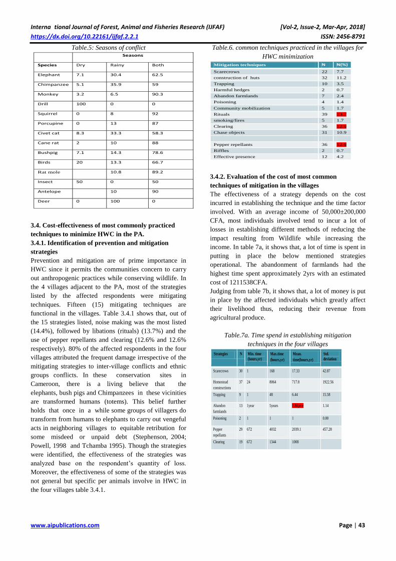
3.3.1. Seasons of conflict occurrence:
Mount Cameroon national park is noted with frequent rain
falls which makes it very difficult to clearly determine
rainy and dry seasons. Table 5 shows that, in general,
most conflict occurred in both seasons though rainy
season had the highest intensity of damage with rodentia
especially squirrel having the height overall respondent
percentage of 92, closely followed by antelopes with
90%. Rodents had the highest individual percentage
because of their rapid reproduction rate and the fact that
they are opportunistic feeders. Elephants and primates
were found in both seasons because of the presence of
crops especially in the harvesting or maturity periods of
the crops growth cycle. The scarcity of water up the
mountain (virgin forest and savannah) during dry seasons
is another factor which triggers elephants and some
primates such as chimps and drills to move down slope in
search for drinking water (Chong et al., 2005). Because of
the rich fertile volcanic soil and the presence of rainfall,
continues farming activities is encouraged in these
communities with crops such as banana, cocoa,
cocoyam’s, cassava and others cultivated. These cropping
activities tend to favor the wildlife whose range of
migration is not limited.
y = -50.576x + 437.57R² = 0.2074
0
100
200
300
400
500
600
0 2 4 6
Qu
anti
ty (
bu
nch
es)
Distance (km)
r = -0.20
y = -58.698x + 1440.4R² = 0.8923
1200
1250
1300
1350
1400
0 1 2 3 4
Qu
anti
ty (
Kg)
Distance (km)
r = -0.8
Interna tional Journal of Forest, Animal and Fisheries Research (IJFAF) [Vol-2, Issue-2, Mar-Apr, 2018]
https://dx.doi.org/10.22161/ijfaf.2.2.1 ISSN: 2456-8791
www.aipublications.com Page | 43
Table.5: Seasons of conflict
3.4. Cost-effectiveness of most commonly practiced
techniques to minimize HWC in the PA.
3.4.1. Identification of prevention and mitigation
strategies
Prevention and mitigation are of prime importance in
HWC since it permits the communities concern to carry
out anthropogenic practices while conserving wildlife. In
the 4 villages adjacent to the PA, most of the strategies
listed by the affected respondents were mitigating
techniques. Fifteen (15) mitigating techniques are
functional in the villages. Table 3.4.1 shows that, out of
the 15 strategies listed, noise making was the most listed
(14.4%), followed by libations (rituals) (13.7%) and the
use of pepper repellants and clearing (12.6% and 12.6%
respectively). 80% of the affected respondents in the four
villages attributed the frequent damage irrespective of the
mitigating strategies to inter-village conflicts and ethnic
groups conflicts. In these conservation sites in
Cameroon, there is a living believe that the
elephants, bush pigs and Chimpanzees in these vicinities
are transformed humans (totems). This belief further
holds that once in a while some groups of villagers do
transform from humans to elephants to carry out vengeful
acts in neighboring villages to equitable retribution for
some misdeed or unpaid debt (Stephenson, 2004;
Powell, 1998 and Tchamba 1995). Though the strategies
were identified, the effectiveness of the strategies was
analyzed base on the respondent’s quantity of loss.
Moreover, the effectiveness of some of the strategies was
not general but specific per animals involve in HWC in
the four villages table 3.4.1.
Table.6. common techniques practiced in the villages for
HWC minimization
3.4.2. Evaluation of the cost of most common
techniques of mitigation in the villages
The effectiveness of a strategy depends on the cost
incurred in establishing the technique and the time factor
involved. With an average income of 50,000±200,000
CFA, most individuals involved tend to incur a lot of
losses in establishing different methods of reducing the
impact resulting from Wildlife while increasing the
income. In table 7a, it shows that, a lot of time is spent in
putting in place the below mentioned strategies
operational. The abandonment of farmlands had the
highest time spent approximately 2yrs with an estimated
cost of 1211538CFA.
Judging from table 7b, it shows that, a lot of money is put
in place by the affected individuals which greatly affect
their livelihood thus, reducing their revenue from
agricultural produce.
Table.7a. Time spend in establishing mitigation
techniques in the four villages
Seasons
Species Dry Rainy Both
Elephant 7.1 30.4 62.5
Chimpanzee 5.1 35.9 59
Monkey 3.2 6.5 90.3
Drill 100 0 0
Squirrel 0 8 92
Porcupine 0 13 87
Civet cat 8.3 33.3 58.3
Cane rat 2 10 88
Bushpig 7.1 14.3 78.6
Birds 20 13.3 66.7
Rat mole
10.8 89.2
Insect 50 0 50
Antelope 10 90
Deer 0 100 0
Mitigation techniques N N(%)
Scarecrows 22 7.7
construction of huts 32 11.2
Trapping 10 3.5
Harmful hedges 2 0.7
Abandon farmlands 7 2.4
Poisoning 4 1.4
Community mobilization 5 1.7
Rituals 39 13.7
smoking/fires 5 1.7
Clearing 36 12.6
Chase objects 31 10.9
Pepper repellants 36 12.6
Riffles 2 0.7
Effective presence 12 4.2
Strategies N Min. time
(hours,yr) Max.time
(hours,yr)
Mean.
time(hours,yr)
Std.
deviation
Scarecrows 30 1 168 17.33 42.87
Homestead
constructions
37 24 8064 717.8 1922.56
Trapping 9 1 48 6.44 15.58
Abandon
farmlands
13 1year 5years 1.84year 1.14
Poisoning 2 1 1 1 0.00
Pepper
repellants
29 672 4032 2039.1 457.28
Clearing 19 672 1344 1008
Interna tional Journal of Forest, Animal and Fisheries Research (IJFAF) [Vol-2, Issue-2, Mar-Apr, 2018]
https://dx.doi.org/10.22161/ijfaf.2.2.1 ISSN: 2456-8791
www.aipublications.com Page | 44
Table.7.b. Cost incurred in minimizing HWC in the four
villages
The effectiveness of the techniques practiced in the
villages was subjective. Most techniques were not
effective for the entire wildlife causing HWC in these
villages. From table 8, techniques that were effective,
were not entirely effective for large mammals such as
elephants, chimpanzees and bush pigs. The hygienic
condition of most farms favored the effectives of the
strategy especially for rodents but not for large mammals.
Pepper repellants were not effective this resulted to the
“human animals” (totems) with ability to identify pepper
repellants and the fact that antelopes eat up leafs of the
pepper repellants cultivated in most areas of conflicts.
Techniques that was most effective in the areas though
had little percentages of respondents answered, had no
exception in terms of wildlife involve. For instance,
smoking or the use of fires, abandonment of conflict area
as strategies was overall effective in all of the villages
though had the least percentage of respondents
effectiveness (2.4% and 1.7% respectively)
Moreover, Nchanji (1998) reported that crop raiding is a
serious problem as crop raiding animals can have a
devastating impact on the standard of living of
peasants whose entire survival is dependent on
subsistence agriculture. He estimated that in situations
where farmers guarded their crops, the loss incurred was
30% and where there was no guarding at all, it was 98%.
In a similar study, Chambers, (1992), noted that in some
cases, there was severe food shortages, high food
prices, malnutrition and morbidity increased besides
the rural agricultural society becoming poorer and
poorer, with the majority of children not going to school.
In situations where farmers guarded their crops, the
children were most often forced to abscond from school
so as to guard the crops.
Table.8. Effectiveness of common techniques practiced by
respondents
3.5. Propose management strategies to minimize the
conflict.
Table.9a.Communities response to what measures should
be use to reduce crop raiding
From table.9a. above, 12key measures were suggested
and highly recommended by the riparian villages in order
to curb the intensity of crop raiding in the four villages.
Fencing of the PA (15.72%) represented the most
suggested measure to curb the intensity of crop raiding in
the communities followed by administrative killing
(15.28%) and compensation for agricultural losses
(14.48%). Monitoring the carrying capacity of invading
Strategies N Min.
cost
(CFAF)
Max.
cost
(CFAF)
Mean.
cost(CFAF)
Std.
deviation
Scarecrows 30 1,000 180,000 21,716.7 35191.4
Homestead
constructions
37 5,000 700,000 140,783.1 200933.8
Trapping 9 5,000 30,000 16,444.4 9988.8
Abandon
farmlands
13 750,000 230,000 1,211,538.4 544729.9
Poisoning 2 200,000 400,000 300,000 141421.3
Pepper
repellants
29 5,000 150,000 35,862 25180.38
Clearing 19 20,000 120,000 88,421
Mitigation techniques Effectiveness N
N
(%) Ranking Wildlife exceptions
Scarecrows Not effective 22 7.7
Construction of huts Not effective 32 11.2
Trapping Effective 10 3.5 3 Elephants, chimps,
Harmful hedges Not effective 2 0.7
Abandon farmlands Effective 7 2.4 4
Poisoning Effective 4 1.4 5
Community mobilization Not effective 5 1.7
Rituals/libations Not effective 39 13.7
smoking/fires Effective 5 1.7 6
Clearing Effective 36 12.6 1 Elephants, chimps,
Chase objects Effective 31 10.9 2
Elephants, chimps and bush
pigs,
Pepper repellants Effective 36 12.6 1 Rodents,
Riffles Effective 2 0.7 7 Rodents
Effective presence of
Humans Not effective 12 4.2 Rodents
Suggestion Frequency Percentages
Compensate for agricultural damages via alternative income
generating activities. 68 14.84
Buffer zones should be re-demarcated 36 7.8
Administrative killing of Elephant should be done by forest
rangers 70 15.28
Authorization to kill other large mammals should be executed
by VFMC 10 2.18
Authorization to trap rodents with high reproductive rate 50 10.91
Trans-location of large mammals 56 12.22
crops preferred by wildlife should be planted in the park 21 4.58
Limits of the PA should be fenced with barb wires. 72 15.72
Farmers should be supplied with chemicals to help clean their
farms 45 9.82
Foresters should determine and monitor the carrying capacity
of invading large mammals. 10 2.18
Non-indigenes should purchase land titles from village
heads(chiefs) 20 4.36
Interna tional Journal of Forest, Animal and Fisheries Research (IJFAF) [Vol-2, Issue-2, Mar-Apr, 2018]
https://dx.doi.org/10.22161/ijfaf.2.2.1 ISSN: 2456-8791
www.aipublications.com Page | 45
mammals (2.18%) was the least measure suggested and
recommended by the communities.
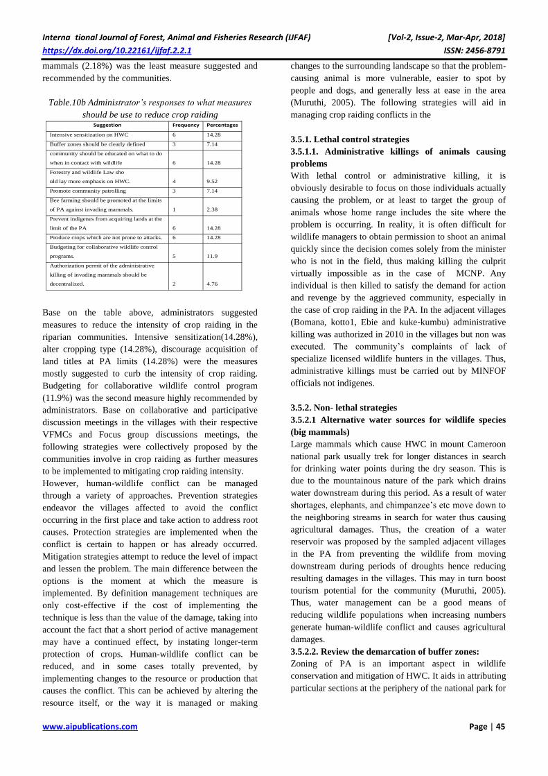
Table.10b Administrator’s responses to what measures
should be use to reduce crop raiding
Base on the table above, administrators suggested
measures to reduce the intensity of crop raiding in the
riparian communities. Intensive sensitization(14.28%),
alter cropping type (14.28%), discourage acquisition of
land titles at PA limits (14.28%) were the measures
mostly suggested to curb the intensity of crop raiding.
Budgeting for collaborative wildlife control program
(11.9%) was the second measure highly recommended by
administrators. Base on collaborative and participative
discussion meetings in the villages with their respective
VFMCs and Focus group discussions meetings, the
following strategies were collectively proposed by the
communities involve in crop raiding as further measures
to be implemented to mitigating crop raiding intensity.
However, human-wildlife conflict can be managed
through a variety of approaches. Prevention strategies
endeavor the villages affected to avoid the conflict
occurring in the first place and take action to address root
causes. Protection strategies are implemented when the
conflict is certain to happen or has already occurred.
Mitigation strategies attempt to reduce the level of impact
and lessen the problem. The main difference between the
options is the moment at which the measure is
implemented. By definition management techniques are
only cost-effective if the cost of implementing the
technique is less than the value of the damage, taking into
account the fact that a short period of active management
may have a continued effect, by instating longer-term
protection of crops. Human-wildlife conflict can be
reduced, and in some cases totally prevented, by
implementing changes to the resource or production that
causes the conflict. This can be achieved by altering the
resource itself, or the way it is managed or making
changes to the surrounding landscape so that the problem-
causing animal is more vulnerable, easier to spot by
people and dogs, and generally less at ease in the area
(Muruthi, 2005). The following strategies will aid in
managing crop raiding conflicts in the
3.5.1. Lethal control strategies
3.5.1.1. Administrative killings of animals causing
problems
With lethal control or administrative killing, it is
obviously desirable to focus on those individuals actually
causing the problem, or at least to target the group of
animals whose home range includes the site where the
problem is occurring. In reality, it is often difficult for
wildlife managers to obtain permission to shoot an animal
quickly since the decision comes solely from the minister
who is not in the field, thus making killing the culprit
virtually impossible as in the case of MCNP. Any
individual is then killed to satisfy the demand for action
and revenge by the aggrieved community, especially in
the case of crop raiding in the PA. In the adjacent villages
(Bomana, kotto1, Ebie and kuke-kumbu) administrative
killing was authorized in 2010 in the villages but non was
executed. The community’s complaints of lack of
specialize licensed wildlife hunters in the villages. Thus,
administrative killings must be carried out by MINFOF
officials not indigenes.
3.5.2. Non- lethal strategies
3.5.2.1 Alternative water sources for wildlife species
(big mammals)
Large mammals which cause HWC in mount Cameroon
national park usually trek for longer distances in search
for drinking water points during the dry season. This is
due to the mountainous nature of the park which drains
water downstream during this period. As a result of water
shortages, elephants, and chimpanzee’s etc move down to
the neighboring streams in search for water thus causing
agricultural damages. Thus, the creation of a water
reservoir was proposed by the sampled adjacent villages
in the PA from preventing the wildlife from moving
downstream during periods of droughts hence reducing
resulting damages in the villages. This may in turn boost
tourism potential for the community (Muruthi, 2005).
Thus, water management can be a good means of
reducing wildlife populations when increasing numbers
generate human-wildlife conflict and causes agricultural
damages.
3.5.2.2. Review the demarcation of buffer zones:
Zoning of PA is an important aspect in wildlife
conservation and mitigation of HWC. It aids in attributing
particular sections at the periphery of the national park for
Suggestion Frequency Percentages
Intensive sensitization on HWC 6 14.28
Buffer zones should be clearly defined 3 7.14
community should be educated on what to do
when in contact with wildlife 6 14.28
Forestry and wildlife Law sho
uld lay more emphasis on HWC. 4 9.52
Promote community patrolling 3 7.14
Bee farming should be promoted at the limits
of PA against invading mammals. 1 2.38
Prevent indigenes from acquiring lands at the
limit of the PA 6 14.28
Produce crops which are not prone to attacks. 6 14.28
Budgeting for collaborative wildlife control
programs. 5 11.9
Authorization permit of the administrative
killing of invading mammals should be
decentralized. 2 4.76

Interna tional Journal of Forest, Animal and Fisheries Research (IJFAF) [Vol-2, Issue-2, Mar-Apr, 2018]
https://dx.doi.org/10.22161/ijfaf.2.2.1 ISSN: 2456-8791
www.aipublications.com Page | 46
particular objectives. Conflict zones in Bomana, kotto2
and to a greater extent kuke-kumbu, are closest to the PA.
Thus, in the above villages, most of the farmlands are
located ≤100m from the PA boundary lines and the
village’s ≤ 3km from the village to the respective
boundary lines. Buffer zones in the above communities
should be re-addressed for the better management of
HWC in the area. Unpalatable crops should be cultivated
and bee farming established at the boundary lines of the
National park with respect to the adjacent villages. This
will prevent the animals from trespassing into individuals
farmlands. Zoning distance from the park to the nearest
anthropogenic activities should be 2km which is not the
case of the above mentioned communities. It is therefore a
preventive approach designed to alleviate human-wildlife
conflict by creating landscapes in which people and
wildlife can co-exist and have as little negative impact on
each other as possible (Muruthi, 2005)..
3.5.2.3. Olfactory deterrents
Some chemical compounds deter elephants effectively
either by generating an unpleasant or painful smell or by
simulating a targeted compound such as a hormone that
triggers fear can be use in the areas. Capsaicin resin
extracted from chilli peppers (Capsicum sp.), which
causes an extremely unpleasant irritation and burning, is
the most effective and widespread. Repellents based on
this resin have been used to alter behavior in a variety of
species, including bears, ungulates, dogs, and humans
(Bullard, 1985). Capsicum deterrent is employed under
different forms. Gingers plants will equally aid as
olfactory deterrents around the conflict zones. Chilli-
impregnated twine and burning balls of elephant dung
containing chilies registered some success in Zimbabwe
(Osborn and Parker, 2002, Parker and Osborn, 2006.
Thus, the implementation of chilies can be effective in the
mount Cameroon national park especially in farmlands
closer to the protected area.
3.5.2.3. Barriers of harmful hedges:
The planting of harmful hedges around farmlands such as
pepper and other exotic plants with thorns will aid in
mitigating the impact resulting from HWC on agricultural
produce and are cost-effective. In the Malian Gourma
they make up 32 percent of protective measures used, as
against 28 percent for moats (Maïga, 1999).
3.5.2.4. Establishment of compensation schemes
3.5.2.4.1. Insurance schemes
The insurance scheme is an innovative compensation
approach where farmers pay a premium for cover against
a defined risk, such as crop raiding. The premium can be
set at the true market rate or be subject to subsidy
provided by conservation organizations (Muruthi, 2005).
The method also requires an accurate assessment of the
cause of crop damage with the inclusion of the various
ministries MINADER, MINFOF, MINADT and
MINEPDED. Because it operates on a more local scale,
reports can be more easily verified with the aid of the
VFMC’s.
3.5.2.4.2. Enhance indirect compensation
Indirect compensation systems rely on giving out licenses
to exploit natural resources, through tourism, hunting or
collecting fuel wood, timber, NTFPs, fodder, etc should
be instituted in the management strategy of HWC in the
area. This type of compensation scheme, is also known as
the “settlement of rights” to use natural resources, which
appears to be a more practical solution than monetary
payment. Indeed, the benefits derived from the legitimate
use of natural resources influence the attitudes and
perceptions of rural residents (Sekhar, 1998).
CONCLUSION
The study revealed that, HWC (crop raiding) is a major
hurdle in mount Cameroon with elephants and rodents
being the most destructive wildlife in terms of crop
raiding . Maize, Banana , cocoyam were the most raided
followed by cocoa (cash crop).
Elephant, chimpanzees, monkeys, drills, squirrels,
porcupine, civet cats, cane rats, duikers, bush pig, birds,
rat mole, insect, bush baby, lycaon, pangoline, antelope
and deers were the animals involve in HWC and crop
raiding in particular. No damages were recorded in
livestock depredation and human damages in the various
communities.
The intensity of damage was higher in elephants and
rodents in the PA with occurrence from January to
December. Damages were observed from January to
March and from October to January with peaks being
August and March with large mammals like elephants and
chimps frequently observed close to the village in search
for drinking water in the nearby streams. Bomana and
kotto were closer to the PA that is less than 3km from the
PA thus, a shorter migration range for the animals to
move from the park to neighboring farms in the village
and destroy. For instance; duikers, antelope, civet cat,
bush fowl., bush pig, cane rat, chimpanzee, elephant,
monkeys., porcupine, and rat moles were frequently
noted in these conflict zones in search of water points
most especially during the dry seasons .
IV. RECOMMENDATIONS
4.1. To the local population
4.1.1. Community awareness
Awareness in HWC is an important management
approach which is not fully understood by most indigenes
in the villages adjacent to the PA. Thus, sensitization
campaigns should be carried out in schools, social groups
and village traditional council on cost-effective methods
Interna tional Journal of Forest, Animal and Fisheries Research (IJFAF) [Vol-2, Issue-2, Mar-Apr, 2018]
https://dx.doi.org/10.22161/ijfaf.2.2.1 ISSN: 2456-8791
www.aipublications.com Page | 47
of addressing human-wildlife conflict while benefiting
from their natural resources. Local approaches or
techniques should be vulgarized and enhance at the local
level for better management of wildlife causing conflicts.
Training should be directed towards the innovation of
new techniques at the local level. The indigenes should be
educated on the different types of wildlife species and
their behaviors. This approach will help the communities
to better interact with the wildlife and ameliorate their
negative attitudes towards wildlife as time passes-by
while portraying its economic value, aesthetic importance
and recreational advantages for touristic purposes.
To avoid heavy economic losses or high mitigating
investments, highly palatable seasonal crops such as
maize, ground nuts, and sweet potatoes should not be
grown near the forest edge. This is because these crops
seem more attractive to crop raiders than wild foods, thus
making them more attractive to wildlife. Farmers should
be encouraged to correctly time their crops when
planting such that by the time the food is finished in
the forest, the crops are already harvested since the
seasonality of fruiting and ripening of both wild and
domestic crops tend to occur at the same time. This is
influenced by seasonal patterns of rainfall, which are
similar for both wild and domestic plants.
4.2. To the government
4.2.1.1. National framework on HWC management
The law on forestry and wildlife should be review in
collaboration with other ministries such as MINADER,
MINEDEP and local communities adjacent to PAs, with
specific emphasis laid on HWC management. The Law
should give more room for protection of biodiversity in
collaboration with local population. Thus reviewing the
law and promoting environmental education and wildlife
awareness in the communities will aid in curbing the
effect resulting from the HWC.
4.2.1.2. Review land use planning
Majority of the lands attributed to the farmers are not well
mapped out by the necessary expertise from the ministry
of MINEPAT. Thus the proper allocation of land titles in
areas of cultivations in collaboration with forestry and
agricultural experts will go a greater mile in reducing the
effect of HWC in the livelihood of the indigenes. This
will aid in the sustainable management of the wildlife and
improve livelihood of the local communities.
4.3. To non-governmental organizations and the
MCNP
4.3.1.1. Implementation of co-monitoring management
program
This involves the participation of different stakeholders
and the monitoring of the intensity and magnitude of
HWC in the villages adjacent to the PA. As such, it is
advisable to use complete neutral personnel who
already knows the conflict zone and would act as a
mediator between the administration and the population
around the Park (Ekpe, 2011).
REFERENCES
[1] Anthony, B. (2007). The dual nature of parks:
attitudes of neighbouring communities towards
Kruger National Park, South Africa.
Environmental Conservation, Vol.34, No.3,
(September 2007), pp. 236'245, ISSN 0376'8929
[2] Bauer, H. and S. Kari. 2001. Assessment of the
human-predator conflict with thematic PRA around
Waza NP. PLA Notes 41: 9 – 13 Bauer, H., H. De
Iongh and E. Sogbohossou. 2010. Assessment and
mitigation of human-lion conflict in West and
Central Africa. J. Mamm. 74: 363 – 367.
[3] Choudhury, A. (2004). Human'elephant conflicts in
northeast India. Human Dimensions of Wildlife,
Vol.9, No.4, pp. 261'270, ISSN 1087'1209
[4] de Boer, W.F. & Baquete, D.S. (1998). Natural
resource use, crop damage and attitudes of rural
people in the vicinity of the Maputo Elephant
Reserve, Mozambique. Environmental
Conservation, Vol.25, No.3, (September 1998),
pp.208'218, ISSN 0376'8929.
[5] Els, H. (1995). Conflicts between man, agriculture,
and wildlife, In: Integrating people and wildlife for
a sustainable future, Bissonette, J.A. & Krausman,
P.R. (Eds.), pp. 355'359, The Wildlife Society, ISBN
0933564120, Bethesda, Maryland, USA.
[6] Else, J.G. (1991). Non - human primates as pests. in
:Box H, editor. Primate’s responses to
environmental change.London,U K: Chapman and
Hall. P.155- 165.
[7] Emerton, L. (2001). The nature of benefits and
the benefits of nature: why wildlife conservation
has not economically benefitted communities in
Africa, In: African wildlife & livelihoods: the
promise & performance of community conservation,
Hulme, D. & Murphree, M. (Eds.), pp. 208'226,
David Philip Publishers, ISBN 0325070598, Cape
Town, South Africa.
[8] FAO. 2005. Strategies to mitigate human-wildlife
conflict in Mozambique, by J Anderson & F. Pariela.
Report for the National Directorate of Forests and
Wildlife Mozambique.
[9] Graham, K.; Beckerman, A.P. & Thirgood, S.
(2005). Human–predator–prey conflict ecological
correlates, prey losses and patterns of
management. Biological Conservation, Vol.122,
No.2, (March 2005), pp. 159'171, ISSN 0006'3207
[10] Graham, K., A. P. Beckerman, and S. Thirgood.
2005. Human-predator-prey conflicts: ecological
Interna tional Journal of Forest, Animal and Fisheries Research (IJFAF) [Vol-2, Issue-2, Mar-Apr, 2018]
https://dx.doi.org/10.22161/ijfaf.2.2.1 ISSN: 2456-8791
www.aipublications.com Page | 48
correlates, prey losses and patterns of management.
Biological Conservation 122:159-171.
[11] Hannah, L., D. Lohse, C. Hutchinson, J. L. Carr, and
A. Lankerani. 1994. A preliminary inventory of
human disturbance of world ecosystems. Ambio
23:246-250.
[12] Hannah, L., J. L. Carr, and A. Lankerani. 1995.
Human disturbance and habitat: A biome-level
analysis of a global dataset. Biodiversity and
Conservation 4:128-155.
[13] Happold, D.C.D. (1995). The interaction between
humans and mammals in Africa in relation to
conservation: a review. Biodiversity and
Conservation, Vol.4, No.4, (June 1995), pp. 395'414,
ISSN 0960'3115
[14] Hazzah, L.,; Borgerhoff'Mulder, M., & Frank, L.
(2009). Lions and Warriors: Social factors
underlying declining African lion populations
and the effect of incentive' based management in
Kenya. Biological Conservation, Vol.142, No.11,
(November 2009), pp. 2428'2437, ISSN 0006'3207
[15] Hill, C. M. 1998. Conflicting attitudes towards
elephants around the Budongo Forest Reserve,
Uganda. Environmental Conservation 25:244-250.
[16] Hill, C.M. (1997) Crop raiding by wild animals:
The farmer’s perspective in an agricultural
community in western Uganda. International.
Journal .Pest Management 43:77-84
[17] Hill, C.M. (2004). Farmers' perspectives of
conflict at the wildlife' agriculture boundary:
some lessons learned from African subsistence
farmers. Human Dimensions of Wildlife, Vol.9,
No.4, pp. 279'286, ISSN 1087'1209
[18] Hill, C.M. (2004). Farmers' perspectives of
conflict at the wildlife'agriculture boundary: some
lessons learned from African subsistence farmers.
Human Dimensions of Wildlife, Vol.9, No.4, pp.
279'286, ISSN 1087'1209
[19] Hoare ,R.(1995) Options for the control of elephants
in conflicts with people. pachyderm 19:54- 63
[20] Hoare, R. E. 1999. Determinants of human-elephant
conflict in a land-use mosaic. Journal of Applied
Ecology 36:689-700.
[21] Hutton, J. M., and N. Leader-Williams. 2003.
Sustainable use and incentive-driven conservation:
realigning human and conservation interests. Oryx
37:215-226.
[22] International Union for the Conservation of Nature
(IUCN). 2005. Benefits beyond boundaries:
Proceedings of the Vth IUCN World Parks
Congress. Durban, South Africa, 1–17 September
2003. Gland, Switzerland & Cambridge, UK.
[23] Linkie.M, Y.dinata, (2007) patterns and
perceptions of wildlife crop raiding in and
around kerina seblat National park, sumata
[24] Linnell, J.D.C.; Rondeau, D.; Reed, D.H.; Williams,
R.; Altwegg, R.; Raxworthy, C.J.; Austin, J.D.;
Hanley, N.; Fritz, H.; Evans, D.M.; Gordon, I.J.;
Reyers, B.; Redpath, S. & Pettorelli, N. (2010).
Confronting the costs and conflicts associated
with biodiversity. Animal Conservation, Vol.13,
No.5, (October 2010), pp. 429'431, ISSN 1367'9430
[25] Madhusudan, M.D. 2003. Living amidst large
wildlife: livestock and crop depredation by large
mammals in the interior villages of Bhadra Tiger
Reserve, South India. Environmental Management,
31(4): 466–475.
[26] McCloskey, J. M., and H. Spalding. 1989. A
reconnaissance-level inventory of the amount of
wilderness remaining in the world. Ambio 18:221-
227.
[27] McGregor, J. (2005). Crocodile crimes: people
versus wildlife and the politics of postcolonial
conservation on Lake Kariba, Zimbabwe. Geoforum,
Vol.36, No.3, (May 2005), pp. 353'369, ISSN
0016'7185
[28] Mishra, C. (1997). Livestock depredation by large
carnivores in the Indian trans 'Himalaya: conflict
perceptions and conservation prospects.
Environmental Conservation, Vol.24, No.4,
(December 1997), pp. 338'343, ISSN 0376'8929
[29] Muruthi, P. 2005. Human wildlife conflicts: lessons
learned from AWF’s African heartlands. AWF
[30] Nchanji .A.C and Lawson D.P ( 1998) A survey
of elephants crop damage around the Banyang-
Mbo wildlife sanctuary 1993-1996 page 96
Cameroon Biodiversity Project and Wildlife
Conservation Society, Yaounde, Cameroon
[31] Ngueping.S, 2012. Human-elephant conflict
management within the mount Cameroon national
park university of Yaoundé 1: Unpublished masters
thesis.
[32] Olson, D. M., and E. Dinerstein. 1998. The Global
200: A Representation Approach to Conserving the
Earth's Most Biologically Valuable Ecoregions.
Conservation Biology 12:502-515.
[33] Osei-Owusu Y., Bakker L., 2008. Human–Wildlife
Conflict. FAO Elephant Technical Manual, 45 p.
[34] Parker G., Osborn F., Hoare R., and Niskanen L.,
2007. Human-Elephant Conflict Mitigation: A
Training Course for Community-Based Approaches
in Africa. Participant’s Manual.Elephant Pepper
Development Trust, Livingstone, Zambia and
IUCN/SSC AfESG, Nairobi, Kenya. 82 p.
Interna tional Journal of Forest, Animal and Fisheries Research (IJFAF) [Vol-2, Issue-2, Mar-Apr, 2018]
https://dx.doi.org/10.22161/ijfaf.2.2.1 ISSN: 2456-8791
www.aipublications.com Page | 49
[35] Sanderson, E. W., M. Jaiteh, M. A. Levy, K. H.
Redford, A. V. Wannebo, and G. Woolmer. 2002.
The Human Footprint and the Last of the Wild.
BioScience 52:891-904.
[36] Sekhar, N. U. 1998. Crop and livestock depredation
caused by wild animals in protected areas: the case
of Sariska Tiger Reserve, Rajasthan, India.
Environmental Conservation 25:160-171
[37] Tchamba, 1995. The problem elephants of Kaele: a
challenge for elephant conservation in Northern
Cameroon. Pachyderm 19: 26-31.
[38] Thirgood, S., R. Woodroffe, and A. Rabinowitz.
2005. The impact of human-wildlife conflict on
human lives and livelihoods. Pages 13-26 in R.
Woodroffe, S. Thirgood, and A. Rabinowitz, editors.
People and Wildlife: Conflict or Coexistence?
Cambridge University Press, Cambridge, U.K.
[39] Tumenta, P.N., H.H. De Iongh, P.J. Funston and
H.A. Udo de Haes. 2013. Livestock depredation and
mitigation methods practiced by resident and
nomadic pastoralists around Waza National Park,
Cameroon. Fauna and Flora International, Oryx,
0(0), 1–6. doi: 10.1017/S003060531100162.
[40] UN. 2004. The Global Population Review. The
United Nations Population Program, New York.
[41] Van Bommel, L., M.D.B. de Vaate, W.F. de Boer
and H.H. De Iongh. 2007. Factors affecting livestock
predation by lions in Cameroon. Afr. J. Ecol. 45:
490 – 498.