Embed Size (px)
Citation preview
1
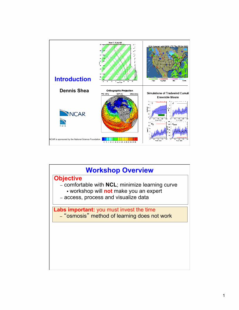
Introduction Dennis Shea
NCAR is sponsored by the National Science Foundation
Workshop Overview
Labs important: you must invest the time – “osmosis” method of learning does not work
Objective – comfortable with NCL; minimize learning curve
§ workshop will not make you an expert – access, process and visualize data
2
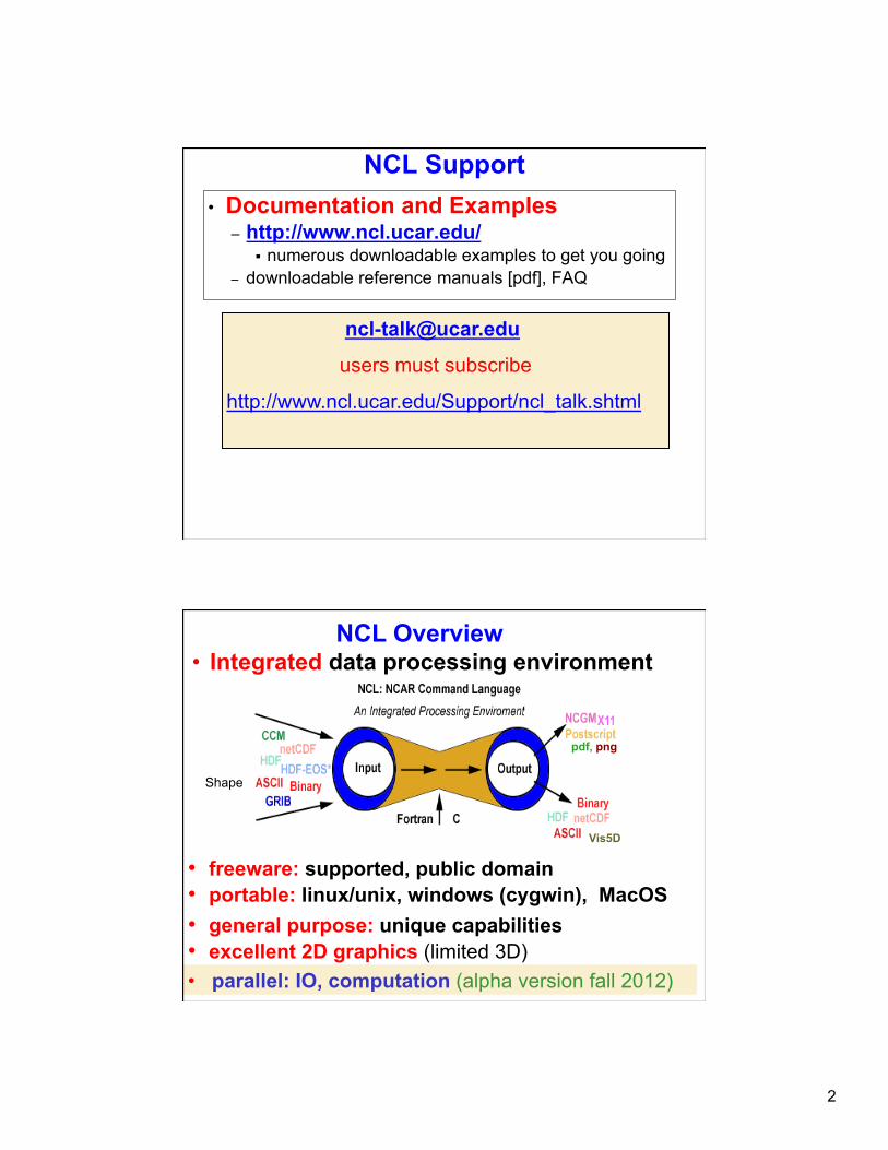
NCL Support • Documentation and Examples
– http://www.ncl.ucar.edu/ § numerous downloadable examples to get you going
– downloadable reference manuals [pdf], FAQ
users must subscribe
http://www.ncl.ucar.edu/Support/ncl_talk.shtml
pdf, png
Vis5D
NCL Overview
• portable: linux/unix, windows (cygwin), MacOS • general purpose: unique capabilities • excellent 2D graphics (limited 3D)
• freeware: supported, public domain
• Integrated data processing environment
Shape
• parallel: IO, computation (alpha version fall 2012)

3
Executing NCL: Interactive (1 of 3)
• Interactive Mode (Command line) – ncl [options][command-line-arguments] <return>
ncl> enter commands ncl> quit <return>
– can save (record) interactive commands ncl> record “file_name” ncl> …. enter commands … ncl> stop record
• Interactive environment – use for simple testing – can use ‘up/down arrow’ to recall previous lines – not as ‘friendly’ as (say) IDL, Matlab, ferret
– not good at error recovery
Running NCL: Batch (2 of 3) Recommended
• Batch Mode [ .ncl suffix is optional] – ncl [options][arguments] script.ncl
– ncl < script.ncl [also acceptable] – ncl [options][arguments] script.ncl >&! out – ncl [options][arguments] script.ncl >&! out &
§ appending "&" means put in background § note: the >&! & are csh and tcsh syntax
• NCL built for larger processing tasks – better accomplished via a script (recommended)
– use editor (vi, nedit, emacs, ..) to open/modify – enter/delete statements – run the script
4
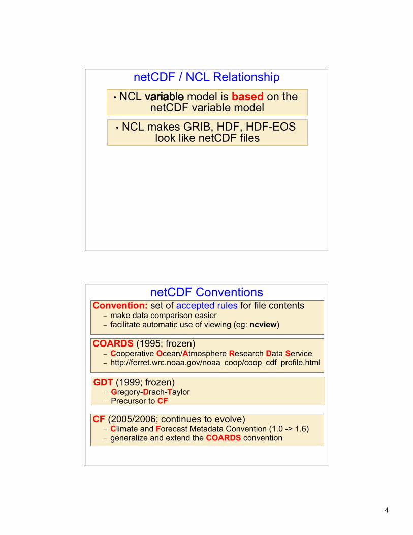
• NCL model is based on the netCDF variable model
• NCL makes GRIB, HDF, HDF-EOS look like netCDF files
netCDF / NCL Relationship
netCDF Conventions
COARDS (1995; frozen) – Cooperative Ocean/Atmosphere Research Data Service – http://ferret.wrc.noaa.gov/noaa_coop/coop_cdf_profile.html
CF (2005/2006; continues to evolve) – Climate and Forecast Metadata Convention (1.0 -> 1.6) – generalize and extend the COARDS convention
Convention: set of accepted rules for file contents – make data comparison easier – facilitate automatic use of viewing (eg: ncview)
GDT (1999; frozen) – Gregory-Drach-Taylor – Precursor to CF

5
Parts of netCDF file ncdump –h foo.nc (or ncl_filedump foo.nc)
DIMENSION SIZES & NAMES dimensions: lat = 64 lon = 128 time = 12
VARIABLES: Names , Types, Attributes, Coordinate Variables variables: float lat(lat) lat:long_name = "latitude" lat:units = "degrees_north" float lon(lon) lon:long_name = "longitude" lon:units = "degrees_east" double time(time) time:long_name = "time" time:units = ”hours_since …" float T(time, lat, lon) T:long_name = “Temperature” T:units = “degC" T:missing_value = 1.e+20f T:_FillValue = 1.e+20f
FILE ATTRIBUTES global attributes: title = “Temp: 1999” source = “NCAR” Conventions = ”CF-1.0”
exercise: ncl_filedump FOO.nc | less ncl_filedump FOO.grb | less
time=UNLIMITED (12 currently)
NCL/netCDF Variable Semantics double T(time, lat, lon) T: long_name = “Temperature” T: units = “degC" T: _FillValue = 1.e+20f
variable type – double (float, int, short,..) variable name – T named dimensions – time, lat, lon attributes – long_name, units, _FillValue
Donnees de desagregation produites par le Cerfacs float prr(time, y, x) prr:_FillValue = -9999.f ; CF prr:missing_value = -9999.f ; COARDS prr:long_name = "Liquid Precipitation" ; CF, COARDS prr:grid_mapping = "Lambert_Conformal" ; prr:units = "kg m-2 s-1" ; CF, COARDS prr:height = "surface" ; prr:coordinates = "lon lat" ; CF
6
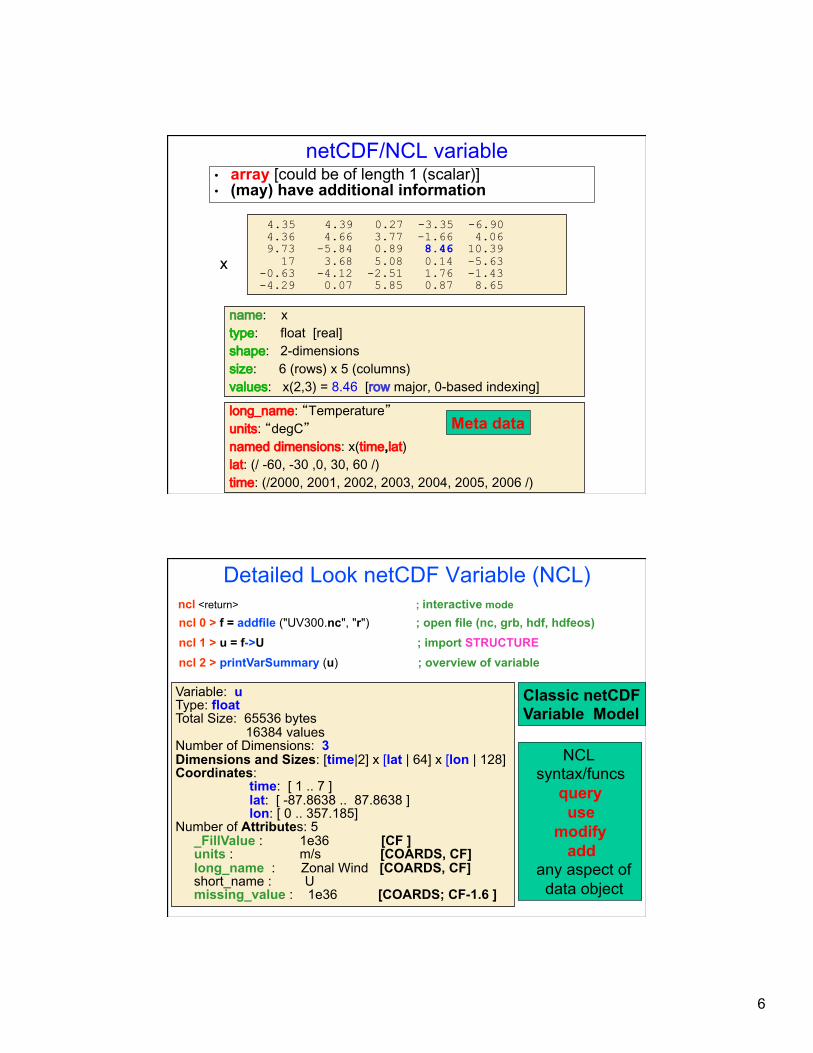
netCDF/NCL variable
long_name: “Temperature” units: “degC” named dimensions: x(time,lat) lat: (/ -60, -30 ,0, 30, 60 /) time: (/2000, 2001, 2002, 2003, 2004, 2005, 2006 /)
4.35 4.39 0.27 -3.35 -6.90 4.36 4.66 3.77 -1.66 4.06 9.73 -5.84 0.89 8.46 10.39 17 3.68 5.08 0.14 -5.63 -0.63 -4.12 -2.51 1.76 -1.43 -4.29 0.07 5.85 0.87 8.65
x
• array [could be of length 1 (scalar)] • (may) have additional information
name: x type: float [real] shape: 2-dimensions size: 6 (rows) x 5 (columns) values: x(2,3) = 8.46 [row major, 0-based indexing]
Meta data
Detailed Look netCDF Variable (NCL) ncl <return> ; interactive mode ncl 0 > f = addfile ("UV300.nc", "r") ; open file (nc, grb, hdf, hdfeos) ncl 1 > u = f->U ; import STRUCTURE ncl 2 > printVarSummary (u) ; overview of variable
Variable: u Type: float Total Size: 65536 bytes 16384 values Number of Dimensions: 3 Dimensions and Sizes: [time|2] x [lat | 64] x [lon | 128] Coordinates: time: [ 1 .. 7 ] lat: [ -87.8638 .. 87.8638 ] lon: [ 0 .. 357.185] Number of Attributes: 5 _FillValue : 1e36 [CF ] units : m/s [COARDS, CF] long_name : Zonal Wind [COARDS, CF] short_name : U missing_value : 1e36 [COARDS; CF-1.6 ]
Classic netCDF Variable Model
NCL syntax/funcs query use modify add any aspect of data object
7
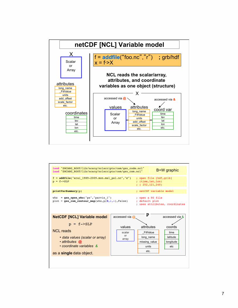
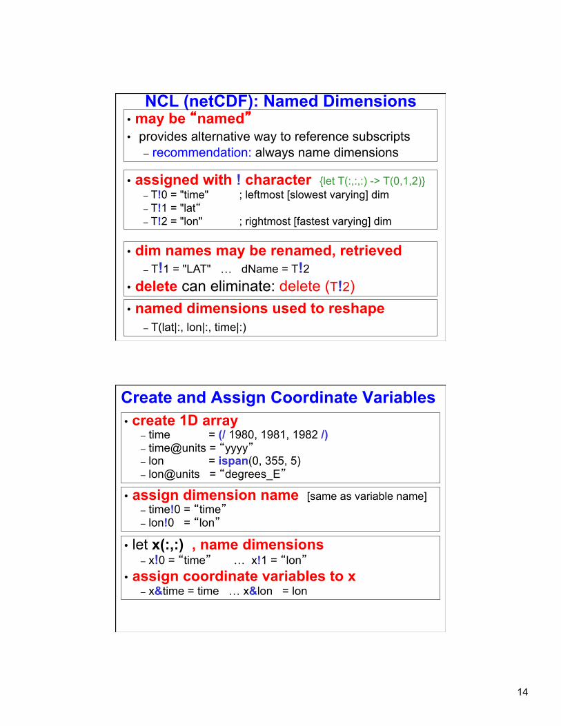
netCDF [NCL] Variable model
f = addfile(“foo.nc”,”r”) ; grb/hdf x = f->X
X Scalar
or Array
attributes long_name _FillValue
units add_offset
scale_factor etc. values
Scalar or
Array
attributes long_name _FillValue
units add_offset
scale_factor etc.
accessed via @ accessed via &
time lev lat lon etc.
coordinates time lev lat lon etc.
coord var
NCL reads the scalar/array, attributes, and coordinate
variables as one object (structure) X
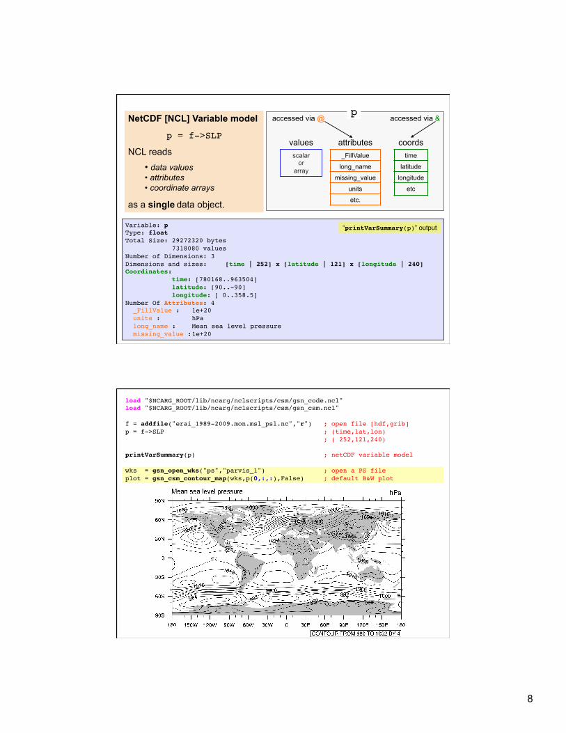
load "$NCARG_ROOT/lib/ncarg/nclscripts/csm/gsn_code.ncl" !load "$NCARG_ROOT/lib/ncarg/nclscripts/csm/gsn_csm.ncl" !!f = addfile("erai_1989-2009.mon.msl_psl.nc","r") ; open file [hdf,grib]!p = f->SLP ; (time,lat,lon)! ; ( 252,121,240)!!printVarSummary(p) ; netCDF variable model!!wks = gsn_open_wks("ps","parvis_1") ; open a PS file!plot = gsn_csm_contour_map(wks,p(0,:,:),False) ; default plot! ; uses attributes, coordinates!
B+W graphic
NetCDF [NCL] Variable model
p = f->SLP
NCL reads
• data values (scalar or array) • attributes @ • coordinate variables &
as a single data object.
scalar or
array
values attributes coords
p!accessed via @ accessed via &
_FillValue
long_name
missing_value
units
etc.
time
latitude
longitude
etc
8
NetCDF [NCL] Variable model
p = f->SLP
NCL reads
• data values • attributes • coordinate arrays
as a single data object.
scalar or
array
values attributes coords
p!accessed via @ accessed via &
_FillValue
long_name
missing_value
units
etc.
time
latitude
longitude
etc
Variable: p!Type: float!Total Size: 29272320 bytes! 7318080 values!Number of Dimensions: 3!Dimensions and sizes: ![time | 252] x [latitude | 121] x [longitude | 240]!Coordinates: ! time: [780168..963504]! latitude: [90..-90]! longitude: [ 0..358.5]!Number Of Attributes: 4! _FillValue : !1e+20! units : !hPa! long_name : !Mean sea level pressure! missing_value :!1e+20!
“printVarSummary(p)” output
load "$NCARG_ROOT/lib/ncarg/nclscripts/csm/gsn_code.ncl" !load "$NCARG_ROOT/lib/ncarg/nclscripts/csm/gsn_csm.ncl" !!f = addfile("erai_1989-2009.mon.msl_psl.nc","r") ; open file [hdf,grib]!p = f->SLP ; (time,lat,lon)! ; ( 252,121,240)!!printVarSummary(p) ; netCDF variable model!!wks = gsn_open_wks("ps","parvis_1") ; open a PS file!plot = gsn_csm_contour_map(wks,p(0,:,:),False) ; default B&W plot!
9
NCL Syntax Characters (subset) • = - assignment • ; - comment [can appear anywhere] • -> - use to (im/ex)port variables via addfile(s) function(s) • @ - access/create attributes • ! - access/create named dimension • & - access/create coordinate variable • {…} - coordinate subscripting • $ - enclose strings when (im/ex)port variables via addfile(s) • (/../) - array construction (variable); remove meta data • [/../] - list construction; [:] all elements of a list • : - array syntax • | - separator for named dimensions • \ - continue character [statement to span multiple lines] • :: - syntax for external shared objects (eg, fortran/C)
10
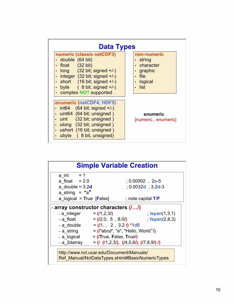
Data Types numeric (classic netCDF3) • double (64 bit) • float (32 bit) • long (32 bit; signed +/-) • integer (32 bit; signed +/-) • short (16 bit; signed +/-) • byte ( 8 bit, signed +/-) • complex NOT supported
non-numeric • string • character • graphic • file • logical • list
enumeric (netCDF4; HDF5) • int64 (64 bit; signed +/-) • uint64 (64 bit; unsigned ) • uint (32 bit; unsigned ) • ulong (32 bit; unsigned ) • ushort (16 bit; unsigned ) • ubyte ( 8 bit, unsigned)
snumeric [numeric , enumeric]
Simple Variable Creation a_int = 1 a_float = 2.0 ; 0.00002 , 2e-5 a_double = 3.2d ; 0.0032d , 3.2d-3 a_string = "a” a_logical = True [False] ; note capital T/F
• array constructor characters (/…/) – a_integer = (/1,2,3/) ; ispan(1,3,1) – a_float = (/2.0, 5 , 8.0/) ; fspan(2,8,3) – a_double = (/1. , 2 , 3.2 /) *1d5 – a_string = (/"abcd", "e", "Hello, World”/) – a_logical = (/True, False, True/) – a_2darray = (/ (/1,2,3/), (/4,5,6/), (/7,8,9/) /)
http://www.ncl.ucar.edu/Document/Manuals/Ref_Manual/NclDataTypes.shtml#BasicNumericTypes
11
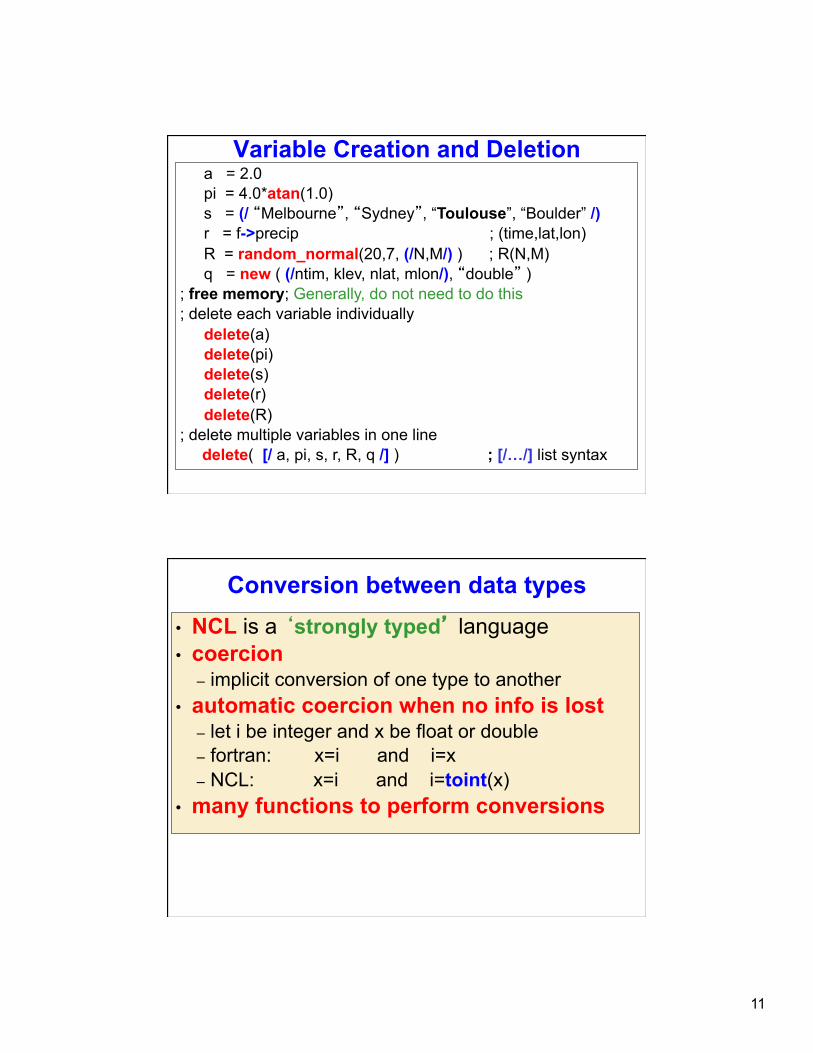
Variable Creation and Deletion a = 2.0 pi = 4.0*atan(1.0) s = (/ “Melbourne”, “Sydney”, “Toulouse”, “Boulder” /) r = f->precip ; (time,lat,lon) R = random_normal(20,7, (/N,M/) ) ; R(N,M) q = new ( (/ntim, klev, nlat, mlon/), “double” )
; free memory; Generally, do not need to do this ; delete each variable individually
delete(a) delete(pi) delete(s) delete(r) delete(R)
; delete multiple variables in one line delete( [/ a, pi, s, r, R, q /] ) ; [/…/] list syntax
Conversion between data types • NCL is a ‘strongly typed’ language • coercion
– implicit conversion of one type to another • automatic coercion when no info is lost
– let i be integer and x be float or double – fortran: x=i and i=x – NCL: x=i and i=toint(x)
• many functions to perform conversions
12
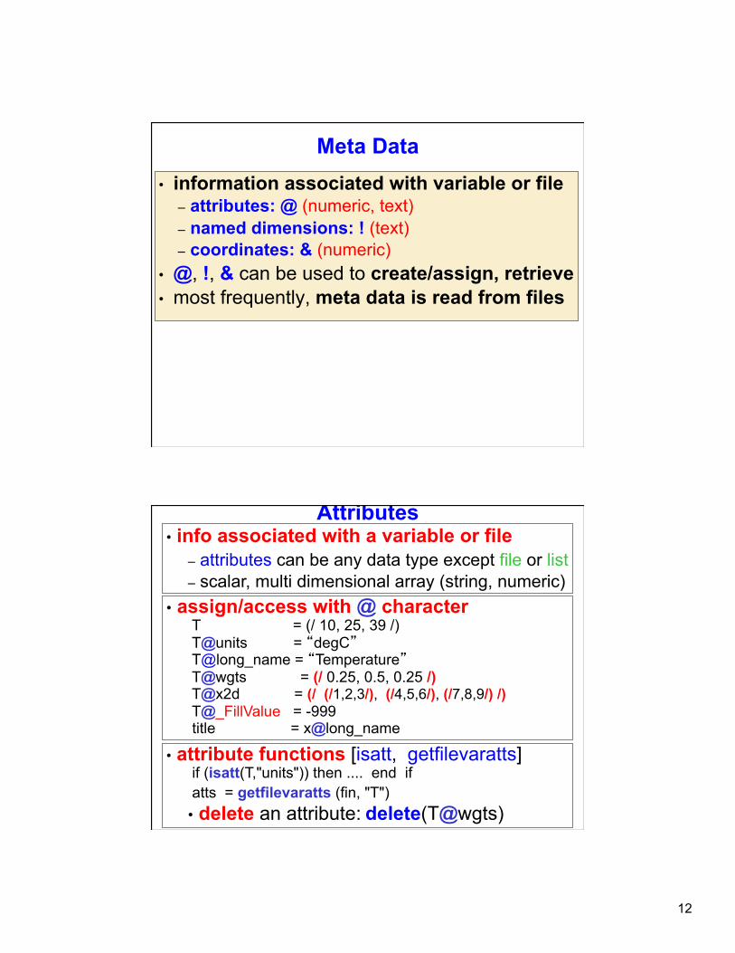
Meta Data • information associated with variable or file
– attributes: @ (numeric, text) – named dimensions: ! (text) – coordinates: & (numeric)
• @, !, & can be used to create/assign, retrieve • most frequently, meta data is read from files
Attributes
• assign/access with @ character T = (/ 10, 25, 39 /) T@units = “degC” T@long_name = “Temperature” T@wgts = (/ 0.25, 0.5, 0.25 /) T@x2d = (/ (/1,2,3/), (/4,5,6/), (/7,8,9/) /) T@_FillValue = -999 title = x@long_name
• attribute functions [isatt, getfilevaratts] if (isatt(T,"units")) then .... end if atts = getfilevaratts (fin, "T") • delete an attribute: delete(T@wgts)
• info associated with a variable or file – attributes can be any data type except file or list – scalar, multi dimensional array (string, numeric)
13
_FillValue attribute • Unidata & NCL reserved attribute; CF compliant
• netCDF Operators [NCO] & CDO: _FillValue attribute • ncview: recognizes missing_value attribute (COARDS)
– best to create netCDF files with both
• NCL: best to not use zero as a _FillValue – OK except when contouring [random bug]
• NCL functions recognize _FillValue – most functions will ignore for computations (eg, “avg”) – use built-in function “ismissing” to check for _FillValue – if (any (ismissing(T) )) then … end if
§ NOTE: if (any(T.eq.T@_FillValue)) will not work
Arrays
• row major Ø left dimension varies slowest; right varies fastest Ø dimension numbering left to right [0,1,..]
• subscripts Ø 0-based [ entire range for N values: 0,N-1 ]
Different language/tool ordering: • NCL/C/C++ : 0-based; left/right -> slowest/fastest • fortran, Matlab, R: 1-based; left/right -> fastest/slowest • IDL : 0-based; left/right -> fastest/slowest
Consider T(:,:,:) èT (0,1,2) left dimension is 0 middle dimension is 1 right dimension is 2
14
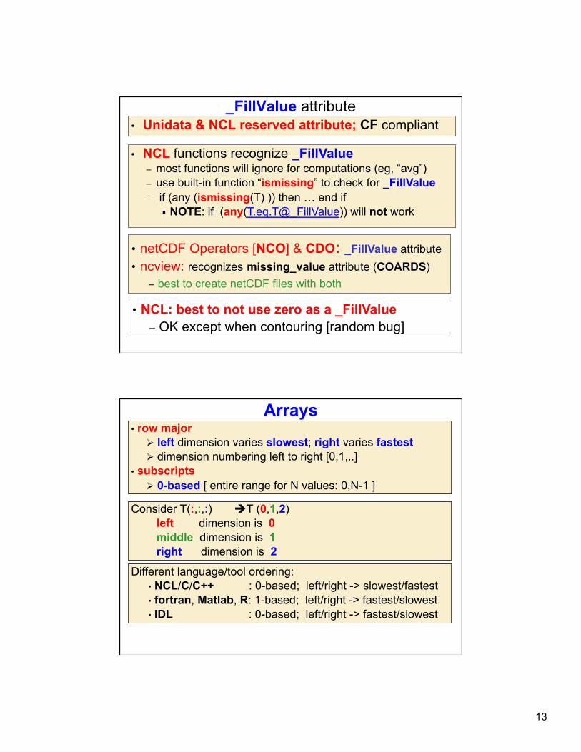
NCL (netCDF): Named Dimensions
• assigned with ! character {let T(:,:,:) -> T(0,1,2)} – T!0 = "time" ; leftmost [slowest varying] dim – T!1 = "lat“ – T!2 = "lon" ; rightmost [fastest varying] dim
• dim names may be renamed, retrieved – T!1 = "LAT" … dName = T!2
• delete can eliminate: delete (T!2)
• may be “named” • provides alternative way to reference subscripts
– recommendation: always name dimensions
• named dimensions used to reshape – T(lat|:, lon|:, time|:)
Create and Assign Coordinate Variables
• let x(:,:) , name dimensions – x!0 = “time” … x!1 = “lon”
• assign coordinate variables to x – x&time = time … x&lon = lon
• assign dimension name [same as variable name] – time!0 = “time” – lon!0 = “lon”
• create 1D array – time = (/ 1980, 1981, 1982 /) – time@units = “yyyy” – lon = ispan(0, 355, 5) – lon@units = “degrees_E”

15
netCDF/NCL: Coordinate Variable (CV) • CV: Coordinate Variable ( Unidata definition )
– one dimensional variable in which dimension name is the same as the variable name
– must be monotonically increasing or decreasing • Examples of CV
– lat(lat), longitude(longitude), plevel(plevel), time(time) • CV allow ‘natural’ coordinates via {…} syntax
– Q(time,plevel,lat,longitude) § CV: Q(:, {925:400}, {-20:60}, {130:280} ) § Index: Q(:, 3:10, 24:40, 42:75)
The following is not a coordinate variable: float xlat(nlat, mlon) ; two-dimensions xlat:units = "degrees_north” It is an array that contains coordinate information. Requires use of standard integer index values
Meta Data Syntax Review: Access/Change/Create/Delete
• @ attribute – u@long_name = "U" – lonName = u@long_name
• ! named dimensions – u!0 = "TIME" – tName = u!0
• & coordinate variable – u&lat = (/ -90., -85, .... , 85., 90. /) – latitude = u&lat
• $ substitute string – x = fin->$variable(n)$ … x = fin->$"T: p"$
16
netCDF [NCL] Variable model
f = addfile(“foo.nc”, “r”) ; grb/hdf x = f->X
X Scalar
or Array
attributes long_name _FillValue
units add_offset
scale_factor etc. values
Scalar or
Array
attributes long_name _FillValue
units add_offset
scale_factor etc.
accessed via @ accessed via &
time lev lat lon etc.
coordinates time lev lat lon etc.
coord var
NCL reads the scalar/array, attributes, and coordinate
variables as an object X
Variable Subscripting (1 of 3)
Standard Array Subscripting (Indexing) • ranges: start/end and [optional] stride • Index values separated by : • omitting start/end index implies default begin/end
Consider T(time,lat,lon) T è entire array [ don't use T(:,:,:) ] T(0,:,::5) è 1st time index, all lat, every 5th lon T(:3, ::-1, :50) è 1st 4 time indices, reverse, 1st 51 lon T(7:12,45,10:20) è 6 time indices, 46th value of lat,
10-20 indices of lon
Good programming: use variables to index: T(tstrt:tlast, : , ln1:ln2 ) è time index tstrt:tlast, all lat :, longitude index values ln1:ln2

17
Variable Subscripting (2 of 3)
Coordinate Variable Subscripting • only applies to coordinate variables (1D, mono) • same rules apply for ranges, strides, defaults • use curly brackets {…} • standard and coordinate subs can be mixed [if no reorder]
T(2:7,{-30:30},:) è six times, all lon, lat -30° to +30° (inclusive)
T(0,{-20},{-180:35:3}) è 1st time, lat nearest -20°, every 3rd lon between -180° and 35°
T(::12,{latS:latN},:) è all times/lon, lat latS to latN (inclusive)
T(8,{latS},{lonL:lonR:3})è 9th time, lat nearest latS, every 3rd lon between latL and lonR
Variable Subscripting (3 of 3)
Named Dimensions • only used for dimension reordering • indicated by | • dim names must be used for each subscript • named/coordinate subscripting can be mixed
Consider T(time,lat,lon) t = T(lat|:, lon|:, time|:) è makes t(lat,lon,time) t = T(time|:,{lon|90:120},{lat|-20:20}) è all times, 90-120° lon, -20-20° lat
18
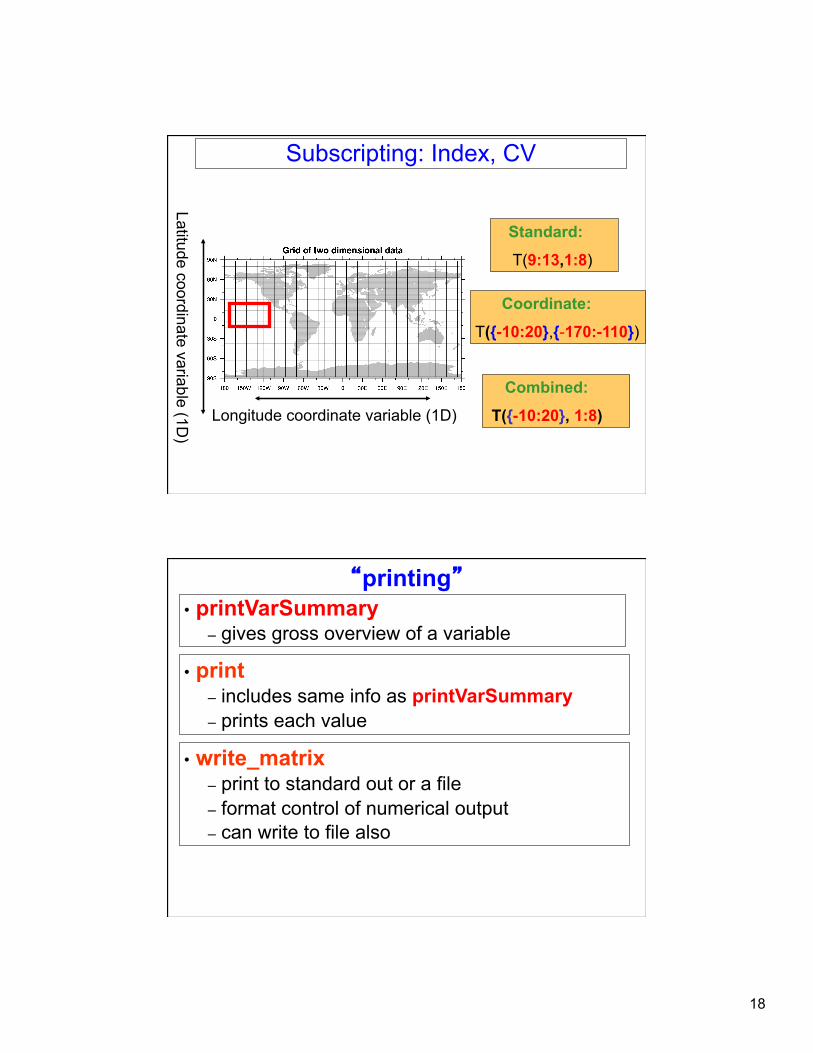
Longitude coordinate variable (1D)
Latitude coordinate variable (1D)
Subscripting: Index, CV
Standard:
T(9:13,1:8)
Coordinate:
T({-10:20},{-170:-110})
Combined:
T({-10:20}, 1:8)
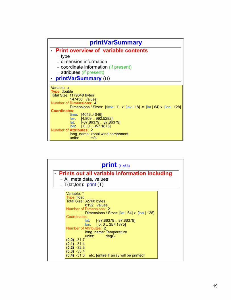
“printing” • printVarSummary
– gives gross overview of a variable
• print – includes same info as printVarSummary – prints each value
• write_matrix – print to standard out or a file – format control of numerical output – can write to file also
19
printVarSummary • Print overview of variable contents
– type – dimension information – coordinate information (if present) – attributes (if present)
• printVarSummary (u) Variable: u Type: double Total Size: 1179648 bytes 147456 values Number of Dimensions: 4 Dimensions / Sizes: [time | 1] x [lev | 18] x [lat | 64] x [lon | 128] Coordinates: time: [4046..4046] lev: [4.809 .. 992.5282] lat: [-87.86379 .. 87.86379] lon: [ 0. 0 .. 357.1875] Number of Attributes: 2 long_name: zonal wind component units: m/s
print (1 of 3)
Variable: T Type: float Total Size: 32768 bytes 8192 values Number of Dimensions: 2 Dimensions / Sizes: [lat | 64] x [lon | 128] Coordinates:
lat: [-87.86379 .. 87.86379] lon: [ 0. 0 .. 357.1875] Number of Attributes: 2 long_name: Temperature units: degC (0,0) -31.7 (0,1) -31.4 (0,2) -32.3 (0,3) -33.4 (0,4) -31.3 etc. [entire T array will be printed]
• Prints out all variable information including – All meta data, values – T(lat,lon): print (T)
20
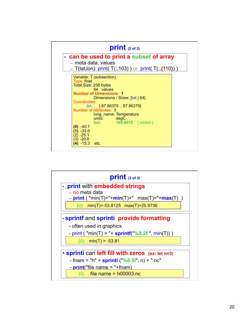
print (2 of 3)
Variable: T (subsection) Type: float Total Size: 256 bytes 64 values Number of Dimensions: 1 Dimensions / Sizes: [lat | 64] Coordinates:
lat: [-87.86379 .. 87.86379] Number of Attributes: 3 long_name: Temperature units: degC lon: 109.6875 [ added ] (0) -40.7 (1) -33.0 (2) -25.1 (3) -20.0 (4) -15.3 etc.
• can be used to print a subset of array – meta data, values – T(lat,lon): print( T(:,103) ) or print( T(:,{110}) )
print (3 of 3)
• print with embedded strings – no meta data – print ( "min(T)="+min(T)+" max(T)="+max(T) )
• sprintf and sprinti provide formatting - often used in graphics - print ( "min(T) = "+ sprintf("%5.2f ", min(T)) )
(0) min(T)=-53.8125 max(T)=25.9736
(0) min(T) = -53.81
• sprinti can left fill with zeros (ex: let n=3) - fnam = "h" + sprinti ("%0.5i", n) + ".nc" - print("file name = "+fnam)
(0) file name = h00003.nc