Embed Size (px)
Citation preview

INTRODUCTION (FV)
Since 2000 a team from Ghent University1 activelyinvestigates the occupation history of the valley ofthe river Potenza in the central part of the Italianregion Marche. Main objectives of this multi-dis-ciplinary archaeological research are the study ofsettlement change and of the evolution of complex-ity of society during the Picene (Iron Age), Romanand early Medieval periods (ca 1000 BC-1000 AD).During the first years of fieldwork most activitieswere concentrated on a diachronic approach of therural areas within this 80 km long valley betweenthe Apennines and the Adriatic Sea.2 In 2006 asecond phase of intensive fieldwork started, nowwith a clear emphasis on the Roman period andon the development in space and time of the fourRoman towns in the valley, their late Iron Ageprecursors and their systematically exploited hin-terland.3 Different aspects of Roman town forma-tion and of the impact of Romanisation and urban-isation on the Potenza valley landscape will bestudied, in close relation with the Central Italianbackground and developments between the 3rd
century BC and the end of Roman dominance.
In this report the PVS team wishes to presentthe main results of a wide range of field activitiesdeployed in the valley of the Potenza during 2007.4They were partly obtained thanks to intensivecollaboration with invited teams of geophysicaland topographical experts from the ArchaeologicalProspection Services of Southampton, the BritishSchool at Rome, the Katholieke Hogeschool Gentand the University of Ljubljana.5
As is reflected in the present report this year’sgeo-archaeological field investigations generallycentred on the lower and middle valley of the Po-tenza. All four towns located in these parts fromEast to West, namely Potentia, Ricina, Trea and Sep-tempeda, were systematically monitored from theair, with aerial photography missions in springand summer. In the lower valley, the coastal townof Potentia was the object of much attention. Sev-eral remote sensing operations were conductedhere and excavations, partly to control the surveyresults, started in a western part of the town area.Some of the preliminary results of these digs arealso presented here. Furthermore, a trial excavationwas initiated on an amphora production site inthe suburban area of the colony, on the territory
85
BABESCH 84 (2009), 85-110. doi: 10.2143/BAB.84.0.2041638.
Investigating the impact of Roman urbanisationon the landscape of the Potenza Valley: A Report on Fieldwork in 2007
F. Vermeulen, M. De Dapper, B. Music, P. Monsieur, H. Verreyke, F. Carboni, S. Dralans, G. Verhoeven, L. Verdonck, S. Hay, M. Sterry,
P. De Paepe, S. De Seranno
Abstract
This paper reports on a set of intensive interdisciplinary field operations by a Belgian team of Ghent Universityin 2007 in the Marche region of central Adriatic Italy. Most of the interventions, comprising geophysical prospec-tions, geomorphologic observations, aerial photography, surface artifact surveys, excavations, topographic sur-veys and pottery studies, aim at a better understanding of the developing Romanisation of this part of Picenumand the rapid urbanization of the area from the late Republic onwards. Quite spectacular are the results of com-bined remote sensing work on such towns as the coastal colony Potentia and the interior municipium Trea,with unusually detailed mapping of the majority of public and private town structures. In Potentia these intra-site and peri-urban surveys are now also being checked in the field with focused excavations on a town gate andan amphora workshop. Also important are original contributions towards a better comprehension of the town-landscape nexus, involving the discovery of roads, cemeteries, aqueducts and quarries discovered near the fourRoman cities. Finally new observations concerning the pre-Roman situation of centrally organized settlementand its links with the establishment of more Roman style towns, add much to the debate about the relativelylate urbanization of this Adriatic region.
1980-09_Babesch_07 24-08-2009 11:29 Pagina 85

of present day Potenza Picena.In the middle valley we focused our activities
on the two towns positioned on a diverticulum ofthe Via Flaminia, connecting Nocera Umbra withthe harbour town Ancona. Both Roman municipia,known as Trea and Septempeda, and the Iron Agehilltop site of Monte Pitino, located in an interme-diate position between the Roman towns, weresubjected to different degrees of surface survey. Inthis report we present the most important resultsfrom this first campaign of integrated geophysical,geomorphological and artefact surveys on thesethree sites that are crucial for understanding theevolution of grouped and complex settlements inthis part of the valley.
THE ROMAN COLONY OF POTENTIA AND ITSHINTERLAND
The colony of Potentia (founded in 184 BC) is sit-uated about 100m from the present Adriatic coaston a beach ridge near the original mouth of theriver Potenza, south of the modern town of PortoRecanati. Its valley bottom site is now mostly takenin by agricultural land, as the city was abandonedin early medieval times for locations on nearbyhilltops, where the towns of Potenza Picena and
Recanati developed. Through a combination ofsurveys by the PVS-team,6 involving extensiveaerial photography, studies of archive aerial pho-tographs and systematic intensive surface collec-tion survey, and punctual excavations undertakenin two areas by the Soprintendenza per i Beni Arche-ologici delle Marche,7 much is now known about thelayout of the town (fig. 1). The aerial photographshave predominantly revealed the road layout of thecolony and the evidence confirms that Potentia hasa regular street grid layout oriented on a NNW-SSE alignment. The wall, enclosing the circa 18 halarge rectangular town, has also been identified inmost areas and the position of at least three (north,south and west) gates is now known. Some inter-nal structures are visible in the aerial photographsand the excavations in the monumental centreunearthed a Republican temple complex boundedby a portico and surrounded by other buildings.Excavations in the vicinity of the temple complexrevealed shops fronting onto the decumanus max-imus and various other structures, some withmosaic flooring. The excavations indicated that thetown centre had been partly rebuilt in the late 3rd
and 4th century AD, while the intensive surface col-lection survey and study of materials confirmeda chronology dating from the Late Republican tothe Late Imperial period, with a gradual aban-donment from the 6th century onwards.
New topographic observations (FV, GV, SDS)
Previously8 we have demonstrated that activeaerial photography from a low flying aircraft, tak-ing oblique (digital) images, is one of the majorsurvey techniques being applied with success inthe Potenza valley. New material, from monitoringflights in 2007 over Potentia concerns a number oftraces, mostly crop marks, observed west and southof the ancient town area. In the central westernarea of the urban core, the much stressed growthof grass and crops during the period April-Julygave away a very clear and more than 100 m longtrace of the incoming decumanus maximus (fig. 2).Revealed from the air is an almost 10 m wide linearstrip of crop marks indicating the road bed, beforeand after entering the west gate (see further).Extra muros it displays a central darker feature to
86
Fig. 1. River mouth area in the lower Potenza valleyduring Roman times with integration of the mostimportant geo-archaeological data: the colony ofPotentia, the road network, suburban settlements andcemeteries and the Roman course of the river Potenza(ancient Flosis).
1980-09_Babesch_07 24-08-2009 11:29 Pagina 86

be interpreted as the drainage system, which lateron, at a considerable distance from the town wall,changes into a lateral ditch. Along this importantextra mural road, connecting the town with itscenturiatio system and ultimately along the Poten-za plain with the Via Flaminia, we remarked at leastthree probable traces of large funeral monuments.As is the case with the so-called ‘Toraccio’, a stillstanding opus caementicium core of a Roman funer-ary monument at several hundred meters west oftown, this new information clearly confirms thepresence in this area of a major cemetery, logicallybound to the outgoing road (fig. 1).
Immediately south of the urban centre, cropmarks in grain fields showed clearer than ever theposition of several ancient flood streams of theriver Potenza (fig. 3). As was demonstrated through
earlier geomorphologic research (Goethals et al.2006), they represent several phases of the Romanand post-Roman river bed. Some indications onthe 2007 photographs point towards the presenceof harbour facilities in this area, quite close to thesouthern gate of the town. If confirmed by furtherfieldwork we would have proof for the existenceof a harbour area at the river mouth in direct con-nection with one of the main entrances to the townand with the road leading towards an attestedstone bridge over the Potenza at Casa dell’Arco(fig. 1).
This river mouth area clearly delineates thesouthern edge of town, a phenomenon which isalso reflected in the micro-topography of the beachridge on which Potentia was erected. The geologyof the sandy beach ridge shows the presence oflocal gravel beds lying under a thin layer of allu-vial clay. To understand the exact topographic set-ting of the urban area we finalised during the 2007field season a detailed micro-topographic map ofthe site.9 This image (fig. 4) shows very clearly theconfiguration of the beach ridge on which the rec-tangular town plan was imposed. It is an oblong,almost oval area, only centrally connected to theslightly higher interior land of the Potenza plainwest of the city. Interesting is also the remarkablecentral depression, which as we know from ear-lier geophysical prospections coincides with thearea of the forum. The possible relationship ofother small anomalies in the beach ridge topog-raphy with archaeological structures needs to beinvestigated further.
Geophysical surveys on Potentia (SH, LV)
Magnetometer survey (SH)
Between the 6th and 15th September 2007, a mag-netic survey was undertaken by the ArchaeologicalProspection Services of Southampton (APSS) andThe British School at Rome.10 The survey aimed atlocating and mapping the remains of sub-surfacearchaeological features in the southern and easternparts of the town, which were the only remainingintra-mural areas still to be surveyed with thistechnique.11 For this survey, grids of 30 m by 30 mwere set out. They were orientated to ensure thatthe survey traverses crossed the line of potentialarchaeological features known from aerial photo-graphy at an angle of approximately 30 degrees.12
The results of the 2007 magnetometer surveywere successful in developing and expandingupon the information gleaned from the 2004-2005survey and extended our knowledge of the town’s
87
Fig. 2. Detailed aerial view from the north of the widelinear crop mark in grassland (upper left) and grain(right) of the decumanus maximus in the extramuralarea near the W-gate of Potentia.
Fig. 3. View from the northwest of the crop marks asso-ciated with Roman and post-Roman river beds of thePotenza at its ancient mouth, south of the colony.Some features are probably associated with harbourfacilities.
1980-09_Babesch_07 24-08-2009 11:29 Pagina 87

layout to the east of the railway line (fig. 5). The lay-out of the town clearly emerges from the surveyresults and a number of buildings, streets and openareas can be identified that in many instances addclarity to the findings from the previous season’swork (fig. 6).
Overall, the street layout in the eastern half ofthe town conforms to the grid system defined byaerial photographs and the magnetometer surveyof the western half of the town. The insulae locatedbetween the streets lack clarity with regard to thedefinition of individual buildings but some struc-tures can be seen. It is thought that the effect ofploughing and the presence of vast quantities ofbuilding material within the soil mask the detec-tion of buried structures. In some areas the mag-netometer survey has successfully confirmed thepresence of roads missing from the aerial photo-graphs. The southern edge of the town to the westof the railway clearly demonstrates the destructiveforces of the flooding river. This quadrant of thetown has simply been washed away and the floodline is clearly visible. This phenomenon can alsobe seen in the southeast corner of the survey asthe roads, buildings and general ‘noise’ or urbanremains stop abruptly in this area.
The presence of a linear positive anomaly (fig.6, m145 and m146) running parallel to one of thecardines appears to confirm the observation of awide ditch and bank that would have originallydemarcated the eastern extent of the primaryphase of the town dating to its initial constructionin 184 BC. This feature was supplanted, accord-ing to Livy, by the construction of the town wall
in 174 BC further to the east, thereby expandingthe urban area of the colony.13 The continuationof the town wall in the eastern part of the surveyarea is much more distinct than in the west. Thenorthern course of the circuit wall (fig. 6, m111 andm112) is marked by a strong positive anomalythat becomes wider to the west suggesting thatthis section of the wall may have been dismantled.The eastern course of the town wall (fig. 6, m113and m114) is clearly visible although the possible(but still unproven) east marine gate is not evidentin the results.
Perhaps the most pertinent discovery is the
88
Fig. 6. Interpretation of the magnetometer survey inPotentia.
Fig. 4. Digital elevation model of the microtopographyin the urban area of Potentia.
Fig. 5. Magnetometer results of three prospection cam-paigns in and around Potentia.
1980-09_Babesch_07 24-08-2009 11:29 Pagina 88

presence of a semicircular anomaly (fig. 6, m144)immediately east of the deserted farm buildingthat occupies some space in this eastern part oftown. The anomaly is presumed to be the trace ofa theatre or odeon. The potential natural synclineof the landscape may account for its position andslight distortion to the alignment of the rest of thetowns’ layout. Comparative evidence derives fromsites such as Herculaneum where the theatre clearlylies on slightly different orientation to the neigh-bouring streets. Measuring 30 m in length andabout 28 m wide, the Potentia theatre would be rel-atively compact in size, but Roman theatres andodeons vary in proportions, and the well knownodeon in Pompeii is just a little over these dimen-sions (de Vos 1988, 63).
Finally, a strange curvilinear anomaly in thenortheastern part of the city (fig. 6, m147) presentsan interesting dilemma. Usually, geophysical sur-vey results can reveal very little about the chronol-ogy of structures (Keay et al. 2000, 9). However, inthis instance it appears as though this featurepostdates the layout of the town since it does notrespect the alignment and appears to cut throughthe rigid orientation of the city grid.
Testing the georadar in Potentia (LV)
From 26 June until 14 July 2007, a ground-pen-etrating radar (GPR) survey was carried out bythe PVS-team on three zones of Potentia. The firstarea had been identified as the possible locationof the west gate of the colony on the basis of pre-vious magnetometer and resistance surveys andaerial photographs. The aim of the GPR surveywas to provide complementary information to themagnetometer and resistance surveys and to planthe excavation of the gate (see below). In the sec-
ond and the third area, respectively north and eastof the presumed forum square, relatively clearbuilding plans had been revealed by the magne-tometer survey and here again the aim was toobtain additional information, in particular on thedepth of the structures and the functions of thebuildings.
With GPR, a three-dimensional model of thearchaeological structures can be obtained. Thetechnique has been used to detect walls, floors,roads, ditches and voids. The instrument used atPotentia was the Sensors & Software pulse EKKOPRO with 250 and 500 MHz antennas. The detailson the survey methodology have been summarisedin table 1.
Like the resistance survey, the GPR was usedsuccessfully to map the decumanus maximus run-ning out of Potentia (fig. 7). Interestingly, the GPRimagery not only shows very clearly the east-westroad, but also a north-south structure with thesame characteristics, suggesting another possibleroad. The contrast between the soil and the remainsof the town wall and gate, however, later wellrevealed by the excavations (see below), was muchweaker and remained virtually undetected by theGPR.
In the area of the presumed bath complex, northof the forum, the GPR survey added little to theinformation known from the magnetometer survey,except for a few building traces west of the bathcomplex and clearer limits of the decumanus maxi-mus. The contrasts detected were very weak andit is remarkable that only the shallow depth slices(up to approximately 40 cm) revealed archaeolog-ical features. This can only partly be explained bythe poor conservation state of the remains (see themagnetometer survey). A high clay and moisturecontent of the soil may account for a high atten-
89
Table 1. Methodology of the GPR prospection at Potentia.
area excavation area NE area area near templeantenna frequency (MHz) 250 and 500 500 250 and 500traverse direction (parallel) NE-SW (250 MHz)
NW-SE (500 MHz)W-E SE-NW
operation mode odometer (automatic distance measuring)inline distance between traces 0.05 mcrossline distance between the profiles 0.5 m (250 MHz) and 0.25 m (500 MHz)sample interval within a trace 400 ps (250 MHz) and 200 ps (500 MHz)time window 100 ns (250 MHz) and 80 ns (500 MHz)number of stacked traces 8prospected surface 1200 m2 (250 MHz)
345 m2 (500 MHz)2500 m2 1140 m2 (250 MHz)
330 m2 (500 MHz)prospection time 4 days 5 days 3 days
1980-09_Babesch_07 24-08-2009 11:29 Pagina 89

uation of the energy and hence a low depth pen-etration.
In the third area (fig. 8), near the excavatedtemple complex, the GPR survey confirmed theresults from the magnetometer prospection andidentified some additional building structuressouth and southwest of the sanctuary. They areclosely related to the road running parallel to thewest of the Republican sanctuary and to the forumsquare presumed to lie to the west of it. That the500 MHz antenna was able to detect these featuresmay be explained by their proximity to the exca-vation trench. Often the area around a trench hasdried out, allowing for a better depth penetrationcompared to the rest of the site.
Excavations near the western gate of the city (FC,SD, FV, HV, PM)
In July 2007 a first excavation campaign was car-ried out by the Department of Archaeology ofGhent University on the legally protected part ofthe site of the Roman colony of Potentia (so-calledCasa Storani site).14 The investigated area consistsof a 20 m by 20 m trench, in a second phase ex-
tended eastward by a strip of about 5 m wide (figs.9, 10). After removing the circa 45 cm deep surfacelayer, manual stratigraphic excavations were con-ducted during a first period of three weeks. Duringthe full excavation period traditional and near-infrared aerial photographs were taken on a dailybasis with the use of a ‘Helikite’, a helium ballooncombined with a kite (see below).
The reasons for the excavations were partly totest the results from earlier survey interventions bythe PVS team, and thus contribute to methodolog-ical progress in this line of fieldwork. In particularthe intensive aerial photography monitoring, thestudy of archive aerial photographs, the artefactsurveys, the geophysical surveys with three meth-ods (magnetic, electric resistivity and GPR), thegeomorphologic auguring and micro-topograph-ical measurements had given clear indications forarchaeological structures connected with the west-ern gate and wall of the city in this area. Further-more, in order to obtain more details of the layoutof the entrance and defence facilities of the Romancolony, and comprehend its stratigraphic and chron-ologic complexity throughout the whole Romanera, it was decided that excavation work was
90
Fig. 7. GPR depth-slice of 50-60 cm, superimposed on the magnetometer data gathered by the ArchaeologicalProspection Services of Southampton and the British School at Rome. The excavation area is indicated in red.
1980-09_Babesch_07 24-08-2009 11:29 Pagina 90

needed. The excavation was, in fact, motivated bythe desire to verify not only the location of the citygate, but also to get a clearer picture of the sur-rounding area, where, on the basis of aerial pho-tographs, we could suppose a link between thewestern section of the city wall and a road, linedwith funerary monuments, leading into the townfrom the west. Further main aims were to establish
the existence of architectural remains and theirdegree of preservation, as potential factor for thedevelopment of an archaeological park, and to cre-ate the basis for a pottery reference typology of thefinds in Potentia.15
The large dimensions of the trench and thetenacious consistency of the soil, obviously notcultivated in recent years, regrettably allowed usonly to investigate the surface of the first archaeo-logical structures identified just below the removedvegetation layer. These structures were well definedand distinct.
The most recent activities consist of rectangularditches attributable to post-medieval agricultural
91
Fig. 8. Interpretation of the results of GPR survey nearthe temple in the central area of Potentia: 1. Series ofparallel rectangular buildings south of the forum, 2-3.buildings adjacent to the temple area. The limits of thesurvey area are indicated in black.
1980-09_Babesch_07 24-08-2009 11:29 Pagina 91

labouring (fig. 11) and a rectangular pit located inthe middle of the trench (US 5, 6). Still impossibleto date are some ditch-type structures (US 2, 44)filled with apparently sterile sandy silt, but theirrelationship with the Roman road system describedbelow and also partly visible on aerial photographs(fig. 2) is not wholly unlikely.
But, as is clearly visible on an aerial photo-graph taken shortly after the mechanical openingof the trench (fig. 10), the element occupying themost space within the excavation area, appearingalmost directly under the removed top soil, is atype of platform with a hardened surface (fig. 9,US 16), which extends in the form of an inverted‘L’, and apparently continues to the north of theexcavated area (fig. 10, 1 and 2). On the NW edge ofthis platform, a conglomerate structure of violetcoloured pozzolana ash, with caementa of stonesand brick, with a maximum thickness of 15 cm(width 2.70 m; length 1.70 m) and a NW-SE ori-entation, could be observed.
The extension of the trench to the west, corre-sponding to the area of the presumed town wall,revealed in the SE corner of the trench, what ap-pears to be the nucleus of the city wall (fig. 9, US34/35). It consists of a yellowish conglomerate ofbadly worn sandstone bonded with clay. In itscentre only one quasi intact worked (trapezoidal)block of sandstone remains (fig. 10, 4). The char-acteristics of the archaeological trace, and itsirregular profile, point to heavy spoliation. A pit,now filled by a layer of sandy silt, bears witnessto this activity. More or less, on the same align-ment of the wall nucleus, starting from the oppo-
site corner of the trench, a strip, approx. 3.2 mwide, composed of a yellowish sandy layer ofpresumably severely worn sandstone, can also beinterpreted as the remains of the town wall (fig.9, US 26). During this first campaign the remainsof the town wall were not excavated further. Aclear interruption of its trace, together with awidening of the spoliation trench in this area,indicates the presence here of an entrance withgate building (fig. 10, 3). It could already be deter-mined that the wall was cut by several tracespost-dating its construction: they are recent (tree?)pits (fig. 9, US 25, 29, 30) and an oval pit (fig. 9,US 28), with a burnt edge, typical of a small kiln.The excavation of this stratigraphical unit has not
92
Fig. 9. Plan of the major traces excavated so far in the W-gate area. Fig. 10. The excavation area as seen from above: 1.
road, 2. platform, 3. foundations of town wall and gate,4. remaining building block in spoliated wall/gate.
Fig. 11. Top layer of the Roman road ‘platform’ withtraces of sub-recent ploughing.
1980-09_Babesch_07 24-08-2009 11:29 Pagina 92
yet been completed and we are not able to deter-mine the exact dimensions or function of the pos-sible kiln at this moment. However, late Romanmaterial discovered in the unit, seems to point topossible remnants of production activity duringthe last phases of the town, on the remains of thetown wall that by then had already been spoliated.
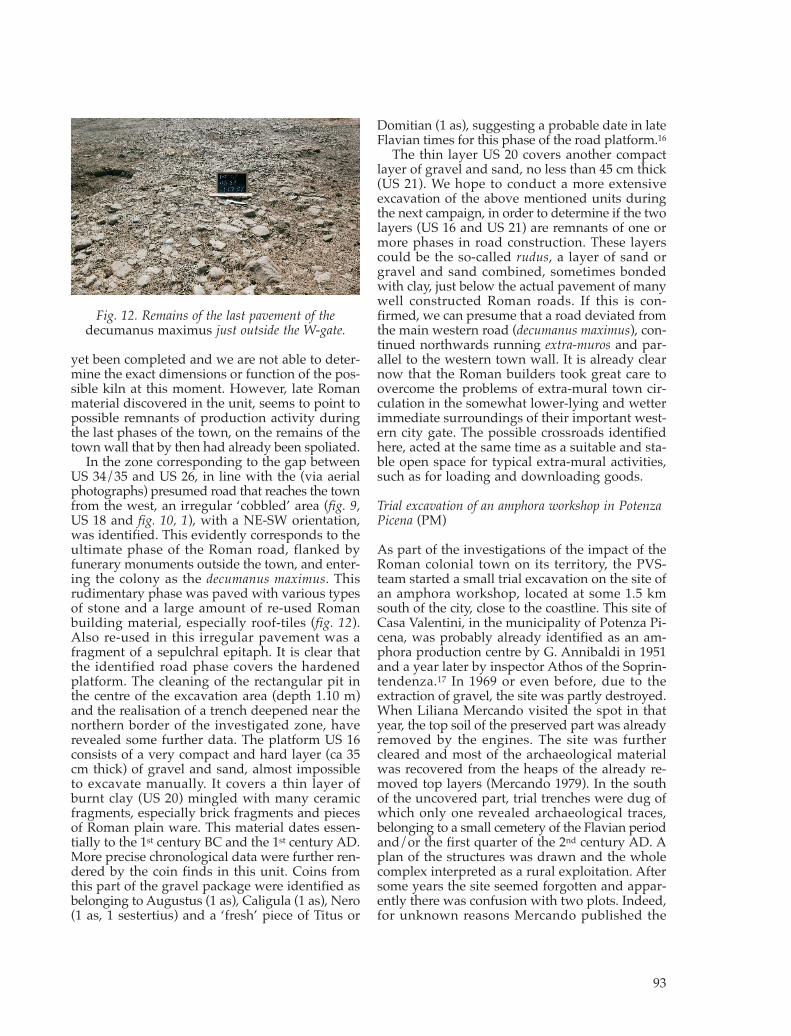
In the zone corresponding to the gap betweenUS 34/35 and US 26, in line with the (via aerialphotographs) presumed road that reaches the townfrom the west, an irregular ‘cobbled’ area (fig. 9,US 18 and fig. 10, 1), with a NE-SW orientation,was identified. This evidently corresponds to theultimate phase of the Roman road, flanked byfunerary monuments outside the town, and enter-ing the colony as the decumanus maximus. Thisrudimentary phase was paved with various typesof stone and a large amount of re-used Romanbuilding material, especially roof-tiles (fig. 12).Also re-used in this irregular pavement was afragment of a sepulchral epitaph. It is clear thatthe identified road phase covers the hardenedplatform. The cleaning of the rectangular pit inthe centre of the excavation area (depth 1.10 m)and the realisation of a trench deepened near thenorthern border of the investigated zone, haverevealed some further data. The platform US 16consists of a very compact and hard layer (ca 35cm thick) of gravel and sand, almost impossibleto excavate manually. It covers a thin layer ofburnt clay (US 20) mingled with many ceramicfragments, especially brick fragments and piecesof Roman plain ware. This material dates essen-tially to the 1st century BC and the 1st century AD.More precise chronological data were further ren-dered by the coin finds in this unit. Coins fromthis part of the gravel package were identified asbelonging to Augustus (1 as), Caligula (1 as), Nero(1 as, 1 sestertius) and a ‘fresh’ piece of Titus or
Domitian (1 as), suggesting a probable date in lateFlavian times for this phase of the road platform.16
The thin layer US 20 covers another compactlayer of gravel and sand, no less than 45 cm thick(US 21). We hope to conduct a more extensiveexcavation of the above mentioned units duringthe next campaign, in order to determine if the twolayers (US 16 and US 21) are remnants of one ormore phases in road construction. These layerscould be the so-called rudus, a layer of sand orgravel and sand combined, sometimes bondedwith clay, just below the actual pavement of manywell constructed Roman roads. If this is con-firmed, we can presume that a road deviated fromthe main western road (decumanus maximus), con-tinued northwards running extra-muros and par-allel to the western town wall. It is already clearnow that the Roman builders took great care toovercome the problems of extra-mural town cir-culation in the somewhat lower-lying and wetterimmediate surroundings of their important west-ern city gate. The possible crossroads identifiedhere, acted at the same time as a suitable and sta-ble open space for typical extra-mural activities,such as for loading and downloading goods.
Trial excavation of an amphora workshop in PotenzaPicena (PM)
As part of the investigations of the impact of theRoman colonial town on its territory, the PVS-team started a small trial excavation on the site ofan amphora workshop, located at some 1.5 kmsouth of the city, close to the coastline. This site ofCasa Valentini, in the municipality of Potenza Pi-cena, was probably already identified as an am-phora production centre by G. Annibaldi in 1951and a year later by inspector Athos of the Soprin-tendenza.17 In 1969 or even before, due to theextraction of gravel, the site was partly destroyed.When Liliana Mercando visited the spot in thatyear, the top soil of the preserved part was alreadyremoved by the engines. The site was furthercleared and most of the archaeological materialwas recovered from the heaps of the already re-moved top layers (Mercando 1979). In the southof the uncovered part, trial trenches were dug ofwhich only one revealed archaeological traces,belonging to a small cemetery of the Flavian periodand/or the first quarter of the 2nd century AD. Aplan of the structures was drawn and the wholecomplex interpreted as a rural exploitation. Aftersome years the site seemed forgotten and appar-ently there was confusion with two plots. Indeed,for unknown reasons Mercando published the
93
Fig. 12. Remains of the last pavement of thedecumanus maximus just outside the W-gate.
1980-09_Babesch_07 24-08-2009 11:29 Pagina 93

site as situated at Casa Marconi (km 333 on theSS Adriatica) instead of Casa Valentini, and didnot interpret, or at least discuss it, as an amphoraproduction site. In 2002 the site was noticed againduring the surveys of Ghent University and im-mediately interpreted again as an amphora pro-duction site. In the hope to get some more infor-mation about the workshop and to confront thiswith other production sites recognized during thePVS-surveys in the lower Potenza valley a smallexcavation was started.18 The main objectives ofthis dig were: the definitive identification of thesite as a workshop and the identification of thedifferent types of amphorae produced here, thedetermination of the stratigraphic context andchronology of the site, the determination of thenature of the structures or at least what is left ofthem and a good sampling of material for petro-graphic and chemical analysis. As the excavationon this site needs at least a second field campaign,we will not present the results with much detail.It suffices to summarize here the main observationsso far, in the three major zones of investigation:the northern profile near the waterfront (where themechanical destruction of the site ended; fig. 13),our trench 1 with the remains of Building 1 in theeastern part of the site (fig. 14) and trench 2 withthe younger Building 2 (fig. 15) and the later‘pressing stone’, covering or cutting older levelsof kiln debris and amphora wasters, and a wallof sandstone and tiles.
Thanks to our new fieldwork the site is now def-initely to be identified as an amphora productionsite. Four amphora types were produced here: a
transition of the Greco-Italic to the Lambogliatypes, Lamboglia 2, Dressel 6A and Dressel 6B.Stamps on different types give also some infor-mation about the producers of these amphorae(fig. 17). The stratigraphy and the structures of thesite are closely investigated and better under-stood, even if some problems remain to be solved.A valuable chronological framework for the sitecan also be presented. On the base of the relativechronology (stratigraphy and mode of wall con-structions) and the typo-chronology of the am-phorae and some other ceramics found here, wehave tried tentatively to present a first evaluationof the different occupations of the amphora pro-duction site of Casa Valentini (table 2).
There is no indication of production of otherceramics, such as tiles, common ware or lamps,only amphorae of the above mentioned types were
94
Fig. 13. Aerial view of the amphora workshop site inPotenza Picena during the trial excavation in 2007. Amajor part of the site is fully destroyed by gravelexploitation and is since long transformed in a lake.
Fig. 14. Trench 1 in Potenza Picena: general view ofwalls belonging to Building 1.
Fig. 15. Trench 2 in Potenza Picena: general view ofthe excavation of Building 2.
1980-09_Babesch_07 24-08-2009 11:29 Pagina 94
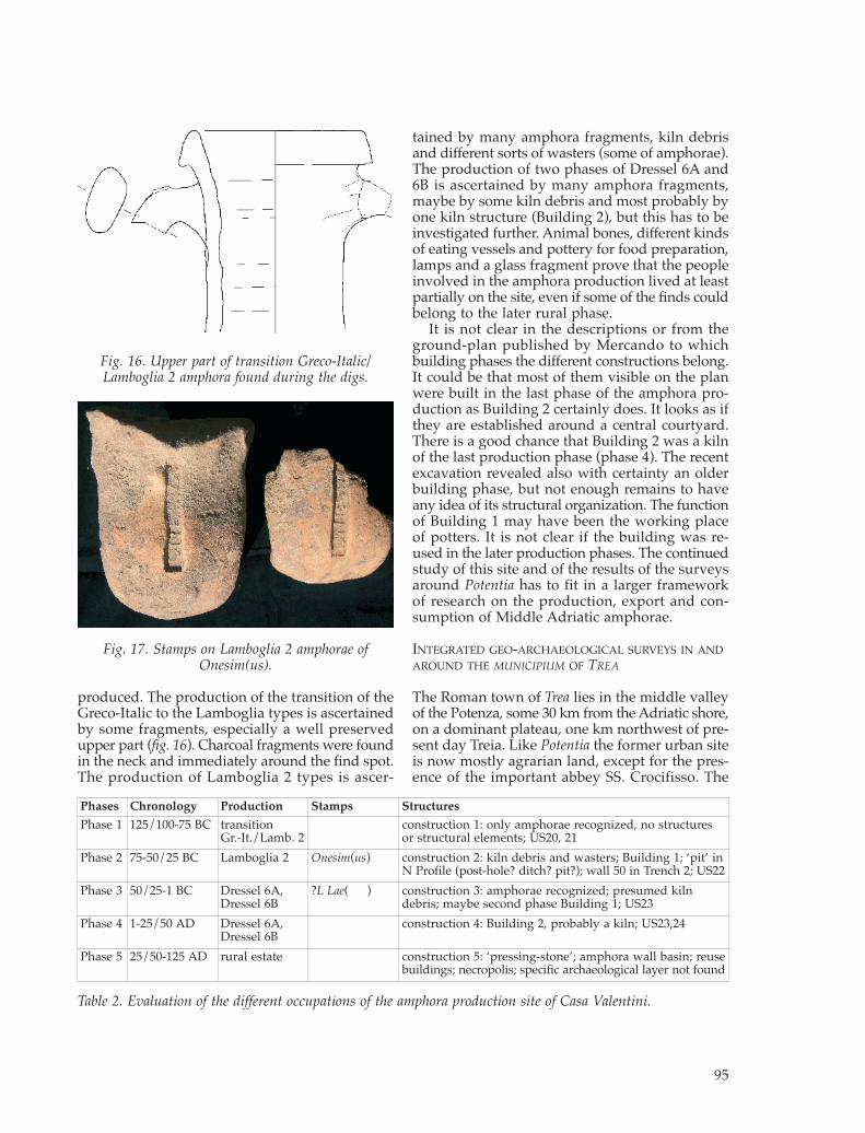
produced. The production of the transition of theGreco-Italic to the Lamboglia types is ascertainedby some fragments, especially a well preservedupper part (fig. 16). Charcoal fragments were foundin the neck and immediately around the find spot.The production of Lamboglia 2 types is ascer-
tained by many amphora fragments, kiln debrisand different sorts of wasters (some of amphorae).The production of two phases of Dressel 6A and6B is ascertained by many amphora fragments,maybe by some kiln debris and most probably byone kiln structure (Building 2), but this has to beinvestigated further. Animal bones, different kindsof eating vessels and pottery for food preparation,lamps and a glass fragment prove that the peopleinvolved in the amphora production lived at leastpartially on the site, even if some of the finds couldbelong to the later rural phase.
It is not clear in the descriptions or from theground-plan published by Mercando to whichbuilding phases the different constructions belong.It could be that most of them visible on the planwere built in the last phase of the amphora pro-duction as Building 2 certainly does. It looks as ifthey are established around a central courtyard.There is a good chance that Building 2 was a kilnof the last production phase (phase 4). The recentexcavation revealed also with certainty an olderbuilding phase, but not enough remains to haveany idea of its structural organization. The functionof Building 1 may have been the working placeof potters. It is not clear if the building was re-used in the later production phases. The continuedstudy of this site and of the results of the surveysaround Potentia has to fit in a larger frameworkof research on the production, export and con-sumption of Middle Adriatic amphorae.
INTEGRATED GEO-ARCHAEOLOGICAL SURVEYS IN ANDAROUND THE MUNICIPIUM OF TREA
The Roman town of Trea lies in the middle valleyof the Potenza, some 30 km from the Adriatic shore,on a dominant plateau, one km northwest of pre-sent day Treia. Like Potentia the former urban siteis now mostly agrarian land, except for the pres-ence of the important abbey SS. Crocifisso. The
95
Fig. 16. Upper part of transition Greco-Italic/Lamboglia 2 amphora found during the digs.
Fig. 17. Stamps on Lamboglia 2 amphorae ofOnesim(us).
Phases Chronology Production Stamps Structures Phase 1 125/100-75 BC transition
Gr.-It./Lamb. 2construction 1: only amphorae recognized, no structures or structural elements; US20, 21
Phase 2 75-50/25 BC Lamboglia 2 Onesim(us) construction 2: kiln debris and wasters; Building 1; ‘pit’ inN Profile (post-hole? ditch? pit?); wall 50 in Trench 2; US22
Phase 3 50/25-1 BC Dressel 6A,Dressel 6B
?L Lae( ) construction 3: amphorae recognized; presumed kilndebris; maybe second phase Building 1; US23
Phase 4 1-25/50 AD Dressel 6A,Dressel 6B
construction 4: Building 2, probably a kiln; US23,24
Phase 5 25/50-125 AD rural estate construction 5: ‘pressing-stone’; amphora wall basin; reusebuildings; necropolis; specific archaeological layer not found
Table 2. Evaluation of the different occupations of the amphora production site of Casa Valentini.
1980-09_Babesch_07 24-08-2009 11:30 Pagina 95

only remaining visible ruins are a small section ofthe city walls connected to the partly preservedwestern gate. According to the Itinerarium Antoninithe Roman city was located on the Via Flaminia perPicenum Anconam, a diverticulum from the mainRome-Rimini road, leading via Septempeda, Treaand Auximum towards Ancona, and its excellentposition in a fertile section of the Potenza valleyalso explains its development into a small butflourishing centre for the area. Possibly grown outof a pre-Roman settlement (see below) Trea becamea Roman municipium shortly after 49 BC19 andknew some continuity into the early Middle Ages,when the much decimated remaining habitationwas restructured in connection with an old ‘pieve’,to be located at the site of the SS. Crocefisso.
Notwithstanding the fact that Trea receivedgood scientific attention these last 30 years, infor-mation about the precise location, extent andurban organization of the Roman city remainedlong very limited and partly hypothetical (Vermeu-len 2004). Intensive aerial photography surveys,followed up by surface artefact prospections bythe PVS-team since 2003 have dramatically changedthis situation and we now have good informationon the exact location of the town area and wall,the organisation of the forum and the location ofa number of streets and insulae in the intra-muralarea.20 The purpose of the intensive 2007 campaignin this area was threefold: first we wanted to deepenknowledge of the intra-mural town structuresand confirm and refine the remote sensing dataobtained so far, in order to understand the internalurbanisation of this small city. Secondly we wantedto check the hypothesis that this town grew outof a pre-Roman core and thirdly we needed a bet-ter understanding of the suburban developmentsaround Trea and of the impact of the gradual urban-isation on landscape use by the Romans.21
Geophysical prospections on the intra-mural area ofTrea (BM)22
The geophysical research strategy was preparedcorresponding to the exceptionally evident cropmarks on aerial photography from April 2003(Vermeulen et al. 2005), followed by archaeologicalsurvey together with research design adaptationdeduced from several geophysical explorations insimilar natural environments on pedosequences ofgravel and sand (Music 1999). The basic geologyon the city site of Trea consists of quaternary (Pleis-tocene) alluvial fan deposits creating a terrace ofthe first order, composed mainly of poorly sortedsandy-gravel sediments deposited in the foothills
of the Apennine mountains.23 The geological sur-roundings consist of Tertiary, mainly clastic sedi-mentary rocks, some of which are plausible sourceareas for the sandstone and limestone buildingmaterials used on the site of Trea (see below). Briefon-site surface inspection of stone materials re-vealed sandstone as prevailing building material,with more limited numbers of limestone fragments.
Ultra shallow high resolution geophysics isdesigned for revealing small and shallow buriedtargets and is especially sensitive for high fre-quency lateral and vertical changes in the physicalproperties beneath the soil, which are normallythe result of intensive ploughing, consecutivedestruction of shallow buried architectural remainsas well as natural variations in top soil structureand texture. All of these parameters contribute tosoil homogeneity and anisotropy (Carr 1982). Geo-physical prospection is actually a ground basedremote sensing method and therefore signifi-cantly influenced by the top soil conditions. Thereis no unified processing flow for reducing back-ground noise and contrary enhancing ‘signal tonoise ratio’. The most creative research designmakes use of a multi-method approach (fig. 18)with application of several independent geophys-ical techniques (Music et al. 2007). The geophysi-cal prospections at Trea incorporated, therefore,the application of the resistivity method withTwinpole array (Geoscan RM15), the magneticmethod with caesium magnetometer (GeometricsG–858), measurements of the apparent magneticsusceptibility of soil and stone construction frag-ments (Kappameter KT–5) and the Ground Pene-trating Radar method using 200 and 400 MHzantennas (GSSI SIR3000). A profile separation of0.5 m was used for the magnetic and the GPRmethods, while resistivity measurements were
96
Fig. 18. Trea survey 2007: geophysical methods usedand their respective survey areas.
1980-09_Babesch_07 24-08-2009 11:30 Pagina 96

taken at a distance of 1 m between profiles. Sepa-ration between measuring points along the profilesfor magnetic survey was 0.15 m, for resistivityreadings 1 m and for GPR traces 0.04 m. The geo-physical field campaign was organized in Septem-ber 2007 when conditions for productive acquisi-tion for all of the used geophysical techniqueswere favourable. As the archaeological results de-rived from our multi-method approach are veryimportant, and the influence of the strategy cru-cial, we will first elaborate shortly on the distinctmethods applied here, before discussing some ofthe results.
The geoelectric resistivity method (fig. 19)
The geoelectrical mapping with twinpole array(Geoscan RM15) assures the high lateral resolutionand therefore suitability for the detection of highresistivity vertical structures also in the subsurfacemedium with low signal to noise ratio. The goodlateral resolution and therefore capability of dis-cerning vertical structures is a consequence ofintegrating resistivity values over a broad depthrange (Appel et al. 1997). On the other side, itspotential for differentiating features and boundariesat different depth is relatively weak. Anyhow, thequality of geophysical prospection results is nor-mally not significantly reduced with this deficien-cy because the Ground Probing Radar method(GPR) is more effective in resolving stratigraphicalsequences at shallow depths than any resistivityconfiguration. Advantage of the twinpole array isalso the relatively high depth of investigationcompared with the spacing of the mobile elec-trodes, which assures appropriate sensitivity tothe depth of approx. 1.5 m for a mobile probe sep-aration of only 0.5 m. In an environment withoptimal humidity of the soil, this resistivity methodclearly shows lateral changes in resistivity causedby shallow buried archaeological architecturalremains to the depth of 1.5 m, which in this par-ticular case can be considered as an optimal effec-tive depth of investigation. From the high qualityaerial photography of the Ghent team, it can beassumed, that the top part of architectural remainsappears shallow below the present day surface,which is then ‘level zero’ for geoelectrical remotesensing.
Although the weather conditions were gener-ally favourable for geophysical prospection, thebackground resistivity was not entirely homoge-neous due to the varying moisture content in thesoil during the measurements conducted on dif-ferent days. A few raining days affected measure-
ments to a lesser extent. Results show that the soilmoisture content, and hence the depth range andthe contrast in the results were not significantlyinfluenced by these circumstances (fig. 19). Impactof variable moisture content on resistance read-ings was successfully reduced by applying ade-quate data processing flow using Geoplot 3.0 soft-ware (Geoscan Research): e.g. edge matching,power function and histogram manipulation.Geoelectrical mapping was executed with a spac-ing of 0.5 m on a regular grid of 1 m covering intotal an area of 46.140 m2. The measured resis-tance values were interpolated using a bi-cubicspline-smoothing algorithm (Davis 1973) on aregular grid of 0.5 m.
The results from geoelectric mapping are pre-sented as the electrical resistance (R, Ω) and notas resistivity (ρ, Ωm). This is because at archaeo-logical sites, where the research substratum is het-erogeneous, only a qualitative analysis of theresults, based on the relative differences betweenthe measured resistance values are important. Thegeneral impression based on resistivity data canbe expressed also for estimation of the preserva-tion level of the architectural remains (Music et al.2007). It is evident, that modern intensive agricul-tural land use significantly blurs the resistivityresponse of some structures due to intensive plough-ing and consecutive significant wall destruction,associated with ruination material close to thesurface. Nevertheless, results are clear enough toenable reliable interpretation, especially in com-bination with the magnetic method.
The magnetic method (fig. 20)
Measurements of the magnetic susceptibility ofsoil, limestone and sandsone fragments revealedsignificant differences between the susceptibilityof building materials and the surrounding soil
97
Fig. 19. Results of the resistivity survey on Trea rep-resented in grey scales with histogram manipulation.
1980-09_Babesch_07 24-08-2009 11:30 Pagina 97

and much lesser distinction between buildingmaterial itself. Besides sandstone and limestonefragments, also bricks and tiles with much strongersusceptibility caused by thermoremanent magne-tization can be frequently encountered among thesurface material collection (table 3).
The magnetic method was used for revealingremains with an induced type of magnetizationgenerated by building materials made of stoneblocks on one side and objects with strong ther-moremanent magnetization, which is characteris-tic for architectural elements made of bricks, kilns,hearths and destruction layers with ceramic tileson the other side. Other geophysical methods donot reliably recognize these types of remains.
Measurements of the variations in the totalEarth’s magnetic field density in a (pseudo)gradi-ent mode (nT/m) are used much more frequentlyin magnetic prospecting for archaeological targets,than measurements such as of the total magneticfield using only one sensor (nT). The gradientmode is strictly speaking a high-pass filter; itamplifies the weak magnetic anomalies of smallstructures at shallow depths (signal) and elimi-nates long-wave anomalies that are a result of thegeological background (noise). The resolution inmeasuring the total field density of magnetometerGeometrics G–858 that was used in our researchis 0.1 nT/m, with an acquisition speed of 0.2 s. Thedistance between the magnetic profiles measured0.5 m, and readings of the magnetic field densitywere taken at 15 cm intervals in the direction of theprofiles. For a more reliable interpretation usingthe magnetic method, theoretical 2D archaeo-physical models were applied (e.g.: Eppelbaum etal. 2001, Music 1999, Music et al. 2007). These aregenerated on the basis of the on-site measuredvalues of the (pseudo gradient) magnetic fielddensity and on comparison with the calculated
magnetic anomalies for the presumed archaeo-physical model. The model variables comprise:the form of the presumed archaeological remains,their dimensions, depth and magnetic susceptibil-ity values of building material fragments measuredin the field (see table 3).
The natural environment is described by thethickness of top soil and its susceptibility, besidesthe presumed basic geology parameters, which inpseudo gradient operational mode do not signif-icantly affect results. Local Earth’s magnetic fieldintensity, declination and inclination were derivedfrom The International Geomagnetic ReferenceField (IGRF; http://www.iugg.org/IAGA/iaga_pages/pubs_prods/igrf.htm/). The same geome-try of anticipated archaeological features, top soiland basic geology was used to illustrate the dif-ferences in the shape and magnitude of magneticanomalies generated by different material. Con-sequences of similar sandstone and limestonesusceptibility are the similar shape, polarity andmagnitude of the calculated magnetic anomalies.Calculated magnetic anomaly generated by thesame shape of the object, but with magnetic sus-ceptibility typical for bricks, is significantly dif-ferent.
The Ground Penetrating Radar method (fig. 21)
GPR sounding was used to determine the depthand height of preservation and the mutual spatialrelationship of the architectural elements in twoareas where results from geo-electric mappingand magnetometry deemed it advantageous tocheck. This was a quite ambitious plan for firstyear testing of GPR possibilities in such archaeo-logical and natural contexts. However, the GPRmethod is the only technique among the geophys-ical methods within the Trea survey project, usedfor geophysical sounding. In favourable circum-stances it enables a 3D visualization as well asanalyses of the measurement results in a 3D envi-ronment. Areas 1 and 2 (fig. 18) were surveyedwith a 400 MHz antenna and the Area 1 also with
98
Fig. 20. Results of magnetic survey. Dynamic rangeof represented values of magnetic field density: -4nT/m, +4nT/m.
Soil (mean values)Topsoil/Surface Soil profile/Bottom Soil profile/Top0.68x10-3SI 0.37x10⁻³SI 0.57x10⁻³SI
Building material (mean values)Sandstone Limestone Bricks0.08x10-3SI 0.03x10⁻³SI 3.23x10⁻³SI
Table 3. Apparent magentic susceptibility values mea-sured by Kappameter KT-5 on soil and surface build-ing material fragments.
1980-09_Babesch_07 24-08-2009 11:30 Pagina 98

a 200 Mhz antenna. Much better results wereobtained by the 200 MHz antenna on Area 1. GPRechoes in general correspond to resistivity andmagnetic anomalies. The aim of GPR survey inArea 1 was to ascertain the assumption of a super-position of the eastern and the western parts ofthe town organisation (see below). On the timeslices are discernible faintly visible lines of differ-ent orientation on a greater depth, but it does notfully prove our expectations. Moreover, from 3DGPR visualization it can be deduced, that archi-tectural remains appear more or less at the samedepth.
Multi-method approach capabilities and archaeo-logical implications
Selection of the most suitable method is dictatedexclusively by an evaluation of the ‘signal to noiseratio’; and for a reliable method, this needs to belarge enough so that the difference between thetwo data sets demonstrates enough contrast tosecure successful prospecting. It is often difficultto define the ‘signal to noise ratio’ for each of thevarious methods; so archaeological prospectinghas adopted a multi-method approach for thedevelopment of efficient research strategies (Musicet al. 2007). Sometimes it is effective if results ofresistivity and magnetometry, for instance areoverlain and observed under gradual image trans-
parencies (fig. 22). It shows spatial correlationbetween different data sets and makes more reli-able interpretation possible.
In this way it is possible to visualize magneticand resistivity anomalies in a manner that archi-tectural elements and the urban organisation aremuch easier discernible. Some of these structuresclearly confirm the excellent aerial photographsand earlier interpretations by Frank Vermeulen,24
but often interesting details are now better visi-ble. The most evident features of relevance to theurbanization of Trea, as revealed in our interpre-tative mapping (figs. 23, 24) are the following:- the public open space or forum square, rectan-
gular in shape and with its central part pre-sumably (still) paved with stone slabs;
- a ‘capitoline’ temple on its eastern short side,with its still discernable stairway and internalsubdivisions;
99
Fig. 21. 3D visualization of GPR echoes at Area 1 inTrea. Archaeologically significant anomalies indicated.
Fig. 22. Combined results of resistivity and magneticsurvey in Trea. Overlaid images with gradual resistiv-ity transparency (in %).
1980-09_Babesch_07 24-08-2009 11:30 Pagina 99

100
Fig. 23. Interpretation of geophysical results of the Trea survey, presented on the topographic map and arectified oblique aerial photograph.
Fig. 24. Trea, 3D visualization of architectural remainsinterpreted on the basis of geophysical exploration.
1980-09_Babesch_07 24-08-2009 11:30 Pagina 100

- a large probably public building (basilica?) withthe bases of a colonnade on the short westernside of the forum, and also well visible nowtwo other (public?) buildings on either side;
- another public (?) building (market or macel-lum?) at the southern side of the forum;
- the forum is further flanked by a series of ob-long buildings (tabernae) along its northern andpartly also southern sides, preceded by a portico;
- several communicating streets were also iden-tified, displaying a complex and probably partlydiachronic street organisation;
- many building structures (e.g. houses and shops)outside the forum area, often oriented in strictrelationship with the streets;
- a number of strong magnetic anomalies withslight magnetic field polarity deviation is clearlydistinguishable on the magnetograms; theseanomalies are characteristic of archaeologicalremains with a thermoremanent type of magne-tization (TRM) which is the attribute of bricks,tiles, forges, kilns, furnaces, etc. Some clustersprobably indicate the presence of workshops,with activities that might have required hightemperatures of firing.
A more intensive integration of the geophysicalresults with the rectified imagery from oblique aer-ial photography monitoring of the site is awaitedbefore more definite and detailed interpretationsof the significant archaeological data are possible.They will also be integrated with results from arte-fact surveys on the site. It is however clear now
that remote sensing operations can seriously con-tribute to the understanding of the urbanisationscheme of this city site.
Artefact surveys and geo-archaeological observationsin and around Trea (FV, SD, MDD, PDP)
During the last ten days of September 2007 anintra-site artefact survey was carried out by thePVS team on the former urban area of Trea. Thearea chosen for the intensive survey was the zoneof the forum of the Roman town, an area of some140 x 90 m if we include the surrounding publicbuildings. The precise location of the forum hasbeen known since the aerial photography flightsover the town in 2003 and was confirmed by thegeophysical survey (see above). By concentratingthis artefact survey especially on the ancient built-up area around the forum square (fig. 25) we wishedto further characterize the type of structures, theirfunction and their chronology. The survey area wasnot ploughed but as vegetation had been mowedquite short before our fieldwork visibility for arte-fact recovery was reasonably good. The area wassubdivided into sixteen regular units (30 x 20 m),using the grids set out by the team of Ljubljana.Every unit was walked by a group of seven peo-ple (a mix of archaeologists and students) during30 minutes. Samples of datable ceramics andother diagnostic artefacts (building materials,glass,…) were collected in a systematic way.
We synthesize here the most important conclu-sions of this work. They are of special relevance to
101
Fig. 25. Location of the artefact survey units in the forum area of Trea.
1980-09_Babesch_07 24-08-2009 11:30 Pagina 101

the ulterior interpretation of the excellent remotesensing data in this crucial part of the Romantown, as the terrain of the forum is quite flat andhorizontal movement of artefacts and buildingmaterials ploughed to the surface should be quitelimited. In this way, and with the remotely senseddata in hand, we are able to link some of the sur-face observations to the actual situation of thearchaeological structures in situ.
In the zone of the ‘capitoline’ temple we foundlarge pieces of mortar, which could belong to apodium nucleus built of opus caementicium. Frag-ments of very big roof tiles, a few white marblecrustae and a fairly large amount of tesserae werealso detected, indicating the importance of thebuilding and its high quality. The most remark-able finds were a fragment of a small marble col-umn (fig. 26) and a piece of a marble slab withremains of an inscription.
The grids over the tabernae on the northernforum side produced many fragments of workedlimestone and sandstone, probably the main build-ing materials here, together with the rooftiles. Inseveral units, especially near the edge with theforum square, we collected fragments of pie-wedgeshaped bricks, which could indicate that the por-tico in front of the tabernae had brick columns. Agood amount of brick floor tiles seems indicativeof the predominant floor type in the shops. Fairlylarge numbers of marble crustae and tesserae provealso a certain quality of these centrally placed shops,while a concentration of fragmentary tubuli nearthe central shops of the north side might indicaterooms with hypocaustum. Many fragments of doliademonstrate food storage, while pieces of over-fired brick and burned sandstone, together withmetal slag, seem to confirm the proposition frommagnetic survey that several remnants of fur-naces are to be located here (see above).
The grids over the probable basilica and thebuildings on either side of it displayed an especiallyrich assemblage of building materials. Althoughlimestone, sandstone and mortars prevail, the findscomprise also huge numbers of marble crustae indifferent colours, many tesserae, pieces of hexag-onal floor tiles in brick and some fragments ofpainted stucco. Several small fragments of tubuliare possibly indicative of a heating system, espe-cially in the building south of the probable basilica.
Finally in the area of the buildings (mostly ta-bernae) south of the forum square a quite similarsituation was observed as around the northernshops. However in the most eastern zone here,where we located a possible macellum, specialfinds include many crustae, tesserae, some stuccoand a (leg) fragment of a high quality marble stat-uette. The pottery is also quite diversified here. Ingeneral, however, pottery finds over the wholeforum area are enough similar, including a widerange of fine wares (mostly thin walled ware, terrasigillata and African red slip ware) and coarsercategories (dolia, amphorae, cooking ware…),spread over the broad chronological range of thecity’s main occupation phases (1st century BC-5th
century A.D). Most pottery is Imperial and onlyvery few late Republican wares were picked up.The presence of protohistoric (Piceni) pottery inseveral grids is however of particular importancefor the origin of grouped settlement on the site.
To approach the interesting question whetherRoman Trea was preceded by an earlier form ofgrouped settlement we initiated the systematicsampling of surface materials on the ploughedfields to the west and south-west of the Romantown area (fig. 27). Parts of this extra-mural terri-tory were already surveyed by Umberto Mosca-telli (Università di Macerata) in the 1980s. Hisfindings were published in the Forma Italiae series(Moscatelli 1988). Our aim was to re-visit the siteslocated by Moscatelli and survey also some sur-rounding ploughed fields in order to get a clearerpicture of the chronology and extent of possiblesites in the area. Although Moscatelli located theRoman sites which he found on a map, he did notpoint out the total area surveyed so it was possiblethat we would be surveying fields already sur-veyed by him, but where according to his findingsno Roman material was present. We revisited atotal of three sites, and of these only one Romansite (UM 89) could be confirmed by our team. Theother two sites, both situated on the bottom of thesteep slope to the SW of Trea, revealed absolutelyno Roman pottery or building material, whileMoscatelli mentions the location of a Roman nec-
102
Fig. 26. Decorated fragment of a small column foundduring the intra-site survey on Trea.
1980-09_Babesch_07 24-08-2009 11:30 Pagina 102

ropolis (UM 88) in one area and a surface scatterof Roman pottery (UM 87) in the other. Althoughthis was discouraging we were able to locate atotal of twelve new sites of relevance here, pro-viding us with a much clearer picture of the pro-tohistoric and Roman landscape to the west andsouth-west of Trea. Five sites are clearly Romanand belong to different types of dispersed ruralfarms, the other concentrations pre-date theRoman expansion. For our specific questionnaireit is useful to elaborate mostly on the latter.
In the zone immediately west of Roman Trea alarge area with predominately protohistoric build-ing materials and pottery could be located. In totalsome six concentrations of protohistoric materialwere discovered: a cluster of three sites (07-WS/260, 261 and 263) immediately west of RomanTrea and another cluster of three (07-WS/257, 267and 269) further along the main road to the west.Although the exact date of the sites has still to beestablished, an allocation to Piceni settlementremains seems at the moment most likely. Thepattern suggests that we are confronted here with
several settlement nuclei, possibly forming onelarge settlement zone (or village). The maximumextent is also still hard to establish, as several fieldswere not surveyed yet and the area to the southof the road was inaccessible. At the moment thesurface data seem to indicate that a quite largeand elongated pre-Roman settlement area (some600 by 250 m; 15 ha) was located immediately tothe west of the Roman town. The exact definitionof the newly found sites and their relation to themain Roman settlement area are still to be studiedin the future. It is remarkable that the locations ofthese protohistoric surface scatters did almost notyield Roman material. The regular finding of proto-historic sherds in the area of the later Romantown could however mean that this settlementzone was even larger and that it extended evenfurther to the east, to a sector that later developedinto the core of the Roman municipium.
Some other extra-mural finds of Roman dateduring these surveys were just as interesting.Moscatelli had already put forward the theorythat the course of a Roman aqueduct was located
103
Fig. 27. Map of the preliminary survey results in the extra-mural area west of Trea.
1980-09_Babesch_07 24-08-2009 11:30 Pagina 103
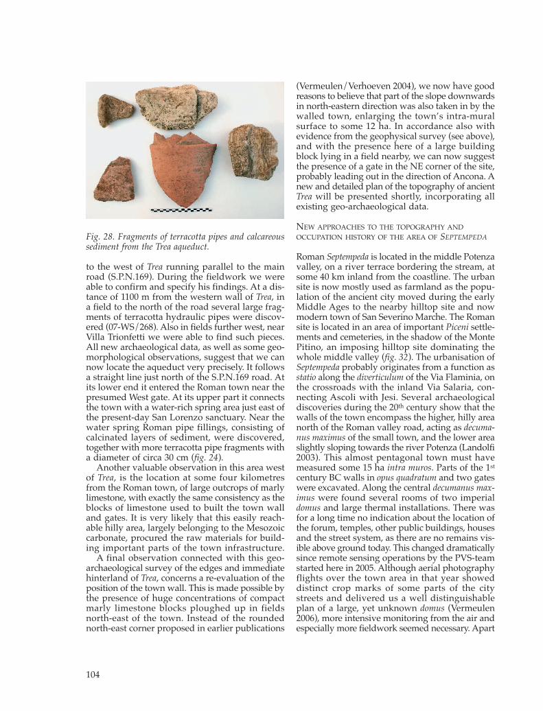
to the west of Trea running parallel to the mainroad (S.P.N.169). During the fieldwork we wereable to confirm and specify his findings. At a dis-tance of 1100 m from the western wall of Trea, ina field to the north of the road several large frag-ments of terracotta hydraulic pipes were discov-ered (07-WS/268). Also in fields further west, nearVilla Trionfetti we were able to find such pieces.All new archaeological data, as well as some geo-morphological observations, suggest that we cannow locate the aqueduct very precisely. It followsa straight line just north of the S.P.N.169 road. Atits lower end it entered the Roman town near thepresumed West gate. At its upper part it connectsthe town with a water-rich spring area just east ofthe present-day San Lorenzo sanctuary. Near thewater spring Roman pipe fillings, consisting ofcalcinated layers of sediment, were discovered,together with more terracotta pipe fragments witha diameter of circa 30 cm (fig. 24).
Another valuable observation in this area westof Trea, is the location at some four kilometresfrom the Roman town, of large outcrops of marlylimestone, with exactly the same consistency as theblocks of limestone used to built the town walland gates. It is very likely that this easily reach-able hilly area, largely belonging to the Mesozoiccarbonate, procured the raw materials for build-ing important parts of the town infrastructure.
A final observation connected with this geo-archaeological survey of the edges and immediatehinterland of Trea, concerns a re-evaluation of theposition of the town wall. This is made possible bythe presence of huge concentrations of compactmarly limestone blocks ploughed up in fieldsnorth-east of the town. Instead of the roundednorth-east corner proposed in earlier publications
(Vermeulen/Verhoeven 2004), we now have goodreasons to believe that part of the slope downwardsin north-eastern direction was also taken in by thewalled town, enlarging the town’s intra-muralsurface to some 12 ha. In accordance also withevidence from the geophysical survey (see above),and with the presence here of a large buildingblock lying in a field nearby, we can now suggestthe presence of a gate in the NE corner of the site,probably leading out in the direction of Ancona. Anew and detailed plan of the topography of ancientTrea will be presented shortly, incorporating allexisting geo-archaeological data.
NEW APPROACHES TO THE TOPOGRAPHY ANDOCCUPATION HISTORY OF THE AREA OF SEPTEMPEDA
Roman Septempeda is located in the middle Potenzavalley, on a river terrace bordering the stream, atsome 40 km inland from the coastline. The urbansite is now mostly used as farmland as the popu-lation of the ancient city moved during the earlyMiddle Ages to the nearby hilltop site and nowmodern town of San Severino Marche. The Romansite is located in an area of important Piceni settle-ments and cemeteries, in the shadow of the MontePitino, an imposing hilltop site dominating thewhole middle valley (fig. 32). The urbanisation ofSeptempeda probably originates from a function asstatio along the diverticulum of the Via Flaminia, onthe crossroads with the inland Via Salaria, con-necting Ascoli with Jesi. Several archaeologicaldiscoveries during the 20th century show that thewalls of the town encompass the higher, hilly areanorth of the Roman valley road, acting as decuma-nus maximus of the small town, and the lower areaslightly sloping towards the river Potenza (Landolfi2003). This almost pentagonal town must havemeasured some 15 ha intra muros. Parts of the 1st
century BC walls in opus quadratum and two gateswere excavated. Along the central decumanus max-imus were found several rooms of two imperialdomus and large thermal installations. There wasfor a long time no indication about the location ofthe forum, temples, other public buildings, housesand the street system, as there are no remains vis-ible above ground today. This changed dramaticallysince remote sensing operations by the PVS-teamstarted here in 2005. Although aerial photographyflights over the town area in that year showeddistinct crop marks of some parts of the citystreets and delivered us a well distinguishableplan of a large, yet unknown domus (Vermeulen2006), more intensive monitoring from the air andespecially more fieldwork seemed necessary. Apart
104
Fig. 28. Fragments of terracotta pipes and calcareoussediment from the Trea aqueduct.
1980-09_Babesch_07 24-08-2009 11:30 Pagina 104
from new surveys on the Roman town site itselfwe also decided to enlarge our vision to the sur-rounding territory, especially in order to under-stand the origins of this city and its crucial role inthe ‘Romanisation’ of the Picene heartland.
Septempeda revisited (FV, GV, MDD, PDP)
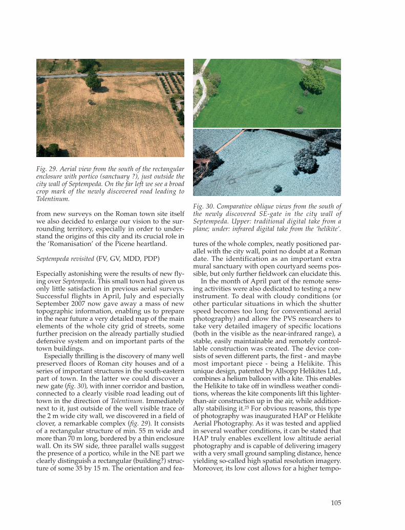
Especially astonishing were the results of new fly-ing over Septempeda. This small town had given usonly little satisfaction in previous aerial surveys.Successful flights in April, July and especiallySeptember 2007 now gave away a mass of newtopographic information, enabling us to preparein the near future a very detailed map of the mainelements of the whole city grid of streets, somefurther precision on the already partially studieddefensive system and on important parts of thetown buildings.
Especially thrilling is the discovery of many wellpreserved floors of Roman city houses and of aseries of important structures in the south-easternpart of town. In the latter we could discover anew gate (fig. 30), with inner corridor and bastion,connected to a clearly visible road leading out oftown in the direction of Tolentinum. Immediatelynext to it, just outside of the well visible trace ofthe 2 m wide city wall, we discovered in a field ofclover, a remarkable complex (fig. 29). It consistsof a rectangular structure of min. 55 m wide andmore than 70 m long, bordered by a thin enclosurewall. On its SW side, three parallel walls suggestthe presence of a portico, while in the NE part weclearly distinguish a rectangular (building?) struc-ture of some 35 by 15 m. The orientation and fea-
tures of the whole complex, neatly positioned par-allel with the city wall, point no doubt at a Romandate. The identification as an important extramural sanctuary with open courtyard seems pos-sible, but only further fieldwork can elucidate this.
In the month of April part of the remote sens-ing activities were also dedicated to testing a newinstrument. To deal with cloudy conditions (orother particular situations in which the shutterspeed becomes too long for conventional aerialphotography) and allow the PVS researchers totake very detailed imagery of specific locations(both in the visible as the near-infrared range), astable, easily maintainable and remotely control-lable construction was created. The device con-sists of seven different parts, the first - and maybemost important piece - being a Helikite. Thisunique design, patented by Allsopp Helikites Ltd.,combines a helium balloon with a kite. This enablesthe Helikite to take off in windless weather condi-tions, whereas the kite components lift this lighter-than-air construction up in the air, while addition-ally stabilising it.25 For obvious reasons, this typeof photography was inaugurated HAP or HelikiteAerial Photography. As it was tested and appliedin several weather conditions, it can be stated thatHAP truly enables excellent low altitude aerialphotography and is capable of delivering imagerywith a very small ground sampling distance, henceyielding so-called high spatial resolution imagery.Moreover, its low cost allows for a higher tempo-
105
Fig. 29. Aerial view from the south of the rectangularenclosure with portico (sanctuary ?), just outside thecity wall of Septempeda. On the far left we see a broadcrop mark of the newly discovered road leading toTolentinum.
Fig. 30. Comparative oblique views from the south ofthe newly discovered SE-gate in the city wall ofSeptempeda. Upper: traditional digital take from aplane; under: infrared digital take from the ‘helikite’.
1980-09_Babesch_07 24-08-2009 11:30 Pagina 105

ral resolution, as the platform can provide imageryfrom a certain archaeological interesting area atshort intervals. Besides detailed near-infraredimaging, HAP permits to take low altitude colourphotographs, used for mapping the on-going ex-cavations as well as reconnaissance purposes.
Making use of the Helikite aerial pictures weretaken over the full surface of the four Roman townsin the valley, and also over an important Iron Agesettlement (Montarice) which had procured com-plex crop marks in the past.26 Although the newtechnology needs to be further tested, comparingresults with the imagery obtained from more tra-ditional flights clearly demonstrates the addedvalue of this new approach. This can be well illus-trated with an example from Septempeda, wherepictures taken of the area of the newly found SEgate of the city, were compared (fig. 30). Althoughthe period and conditions of the two takes, onewith normal digital camera from an low flyingaircraft and one with an infrared camera mountedon the helikite, where quasi identical, comparisonshows that the latter visualises the structures ofcity wall and gate complex with much more detail.
Finally, several field days were spent for terrainobservations on and near Septempeda. These com-prised not only the necessary checks of the cropmark evidence, but we started also a geo-archaeo-logical campaign of locating the natural resourcesof great interest for the Roman town, especiallyfor the provisioning of building materials andwater. Connected with the former, we were ableto locate the most evident source area for water,in fact situated immediately north of the centralpart of the town, no doubt originally linked withthe thermal installations by way of an aqueduct.The discovery, immediately west of the urban area,of a site where sandstone was quarried in Antiquityto built the town wall, is equally worth mentioning.
The Monte Pitino Survey (MS)
Related with the work on Septempeda, a small andextensive survey was carried out in September onthe top and slopes of the hill of Monte Pitino (fig.31). The survey was designed to explore the extentof human occupation and activity in this place inthe protohistoric period and the possibility of con-tinuity into the Roman Republican period whentwo towns were constructed at the nearby sites ofTrea and Septempeda (fig. 32). A human presence isknown on this site from the Mesolithic period andthe area is particularly famous for two excavatedprotohistoric cemeteries that produced rich char-iot burials. Excavations on the summit have alsoproduced evidence of structures and ceramics fromthe protohistoric and Republican periods, but theseare poorly recorded (Lollini 1958). Although thereis no evidence for the Imperial period on the topof the hill, several Roman sites were located nearbyin the survey of Moscatelli (Moscatelli 1988). Thesummit was also the location for a 13th century cas-tle, which is likely to have had associated medievalsites.
Although the survey is only the start of moreintensive work here and the vegetation cover,mostly ranging from dense brambles and wood-land to thick grasses, clearly hinders such activities,some results could already be obtained (figs. 33,34). The new fieldwork has been successful inestablishing that during the later Iron Age period,perhaps 5th to 4th centuries, there was some form ofsettlement over the terraces and plateau that sur-rounds the summit of Monte Pitino and a modelof the terraces can be proposed (fig. 34). Medievalmaterial is overlying the earlier phases, so it is dif-ficult to estimate the density or type of habitation.However, the strong presence of tiles in the visiblematerial along with the assemblages that parallel
106
Fig. 31. View of Monte Pitino from the east.
Fig. 32. Location of Monte Pitino related to the Romantowns of Trea and Septempeda, and to the River system.
1980-09_Babesch_07 24-08-2009 11:30 Pagina 106

107
Fig. 34. Possible walls andterraces identified throughsurvey on the Monte Pitinodrawn on an aerial photo-graph. The medieval castlesite is well visible on the left.
Fig. 33. Survey results on the Monte Pitino on a combined DEM-aerialphoto mosaic.
1980-09_Babesch_07 24-08-2009 11:30 Pagina 107

the sites found through systematic field walkingin the Potenza Valley Survey (Boullart 2005) sug-gest a nucleated settlement rather than merely aplace of refuge. There is no evidence of any publicor monumental buildings, but their presence shouldnot be ruled out. The system of terrace walls isstriking, even today, and perhaps has some simi-larities with the ramparts found on the summit ofMonte Primo, an important protohistoric centrein the upper valley. There also appear to be a highquantity of dolia sherds across all the protohistoricareas within the terrace walls that must indicatea high degree of storage activity and perhaps somecontrol of agricultural activity, but further studyand comparison to other assemblages is needed tosupport this hypothesis. The presence of a fewfragments of vernice nera is indicative of the inte-gration of the site into wider networks and thenature of the preservation, largely from clearanceactivity, is likely to have biased the recovery ofmaterial against this finer material. Clearly it canbe understood from this survey that there was anucleation of settlement on top of Monte Pitinoover perhaps as much as 10 ha, an area only slight-ly smaller than the Roman towns of Trea andSeptempeda, although it is not possible to assessthe density of habitation.
The concentrations discovered in fields MPS008and MPS012 (fig. 33) as well as sites known fromthe survey of Moscatelli and excavation also showthat any settlement on Monte Pitino was not iso-lated, but part of a range of different sites. How-ever, more detailed survey of the surroundingfields and the hilltop itself is required to under-stand the nature of this integration: whether ruralsettlement was clustered around the hilltop andhow much the hilltop site was linked into localsocial and economic networks.
The presence of a Republican activity on top ofthe hill is confirmed by the material recovered fromMPS007(B) (fig. 33), this is a much smaller sitethan the protohistoric activity and its spatial sep-aration is striking. The structures that must haveexisted were impressive judging by the quality ofthe tegulae, but interpretation of the function ofthis site is not possible from the type of surveycarried out. Further analysis of the diagnosticsherds of dolia and amphora will hopefully allowbetter dating of this site, even so, there does notseem any material that is Augustan or later indate. Interestingly, no Republican material wasrecovered from within the system of terraces andit seems unlikely that this is due to preservation ifthe protohistoric material is so visible. This strong-ly suggests a link with the establishment of towns
at Trea and Septempeda and the current phase of thePotenza Valley Survey will surely lead to betterunderstanding of this change in settlement system.
NOTES
1 This research team of the Potenza Valley Survey project,under the direction of Frank Vermeulen (Departmentof Archaeology), is further called PVS-team.
2 For reports on this first phase of fieldwork see: BABesch76, 77, 78 and 80.
3 This second phase, programmed to last until 2011, wasmade possible thanks to substantial financial backingby the Belgian Science Policy - Interuniversity AttractionPoles (IAP), Phase VI, project ‘The Transition fromRepublic to Empire: The Impact of “Romanization” onCities and Countryside in Italy and the Provinces (2nd/1st century BC-2nd/3rd century AD)’, by the Fund forScientific Research - Flanders and by Ghent University.
4 They were made possible thanks to the excellent supportby the Soprintendenza per i Beni Archeologici delle Marche,institution which since the start of the Potenza ValleySurvey project has always given full backing. We wishto express our deep gratitude to Soprintendente Dr.Giuliano De Marinis and to the inspectors and respon-sible personnel of the concerned areas Dr. Edvige Per-cossi, Dr. Maria Cecilia Profumo, Dr. Mara Silvestrini,Dr. Maurizio Landolfi and arch. Ripari.
5 Many thanks go to all persons involved in the prepara-tion and execution of these geophysical and topographicinvestigations; apart from the co-authors of this reportwe especially thank Prof. Bozidar Slapsak and his colla-borators and students from the University of Ljubljana.
6 Vermeulen/Verhoeven 2004 and 2006; Vermeulen 2006.7 For a recent synthesis see: Percossi Serenelli 2001.8 Vermeulen/Boullart 2001; Vermeulen/Monsieur/Boullart
2002; Vermeulen et al. 2003; Vermeulen 2004; Vermeu-len/Verhoeven 2004; Vermeulen/Verhoeven/Semey2005; Vermeulen 2006.
9 To accomplish this topographical operation a Leica TCR1105 total station was used on site and data were pro-cessed with Star*net V6.0 (Starplus software). This re-sulted in three closed polygons and 21 base points, witha high planimetric accuracy level. In order to obtain sat-isfactory altimetric data, a differential levelling was car-ried out for the base points with a Topcon DT30 level.In order to record slight surface irregularities, the pointdensity is of high importance for the surveyor. Consider-ing the size of the area and the rather plane surface, a3D measurement was taken along a 5 m rectangulargrid by using the total station. Eventually the obtainedpoint cloud, which contains more then 8000 points, wasprocessed with the DTM component of Geopus andpresented as a triangulated irregular network (TIN).
10 Special thanks go to Prof. Andrew Wallace-Hadrill andProf. Simon Keay (BSR) for their support, and to DrMichael Walsh for the great collaboration in the field.
11 For the results of the earlier prospections on other sectorsof the town area, see: Vermeulen/Hay/Verhoeven 2006.
12 The magnetometer survey was undertaken using theBartington Grad601-2 Dual Array Twin Fluxgate Gradio-meter (fig. 13). Readings were taken at 0.5 m intervalsalong traverses every 1 m. The readings were recordedby the on board Grad-01Data Logger. The BartingtonGrad601-2 in some circumstances is able to detectburied features up to a depth of 3 m.
108
1980-09_Babesch_07 24-08-2009 11:30 Pagina 108

13 For a discussion of this hypothesis, and references, see:Vermeulen/Hay/Verhoeven 2006 and Vermeulen et al.2006, 230.
14 Our special thanks go to the municipality of PortoRecanati for their great help with logistics and to allstudents, archaeologists and collaborators of GhentUniversity who participated in the dig.
15 The methodology and first results of this ceramologicalwork, building further on the doctoral dissertation ofH. Verreyke, will be presented elsewhere.
16 We thank Dr. Johan Van Heesch for identifying the coins.17 Annibaldi 1953 and archive of the Soprintendenza per
I beni archeologici delle Marche.18 We warmly thank the Soprintendenza, and especially
Dott.ssa Maria Cecilia Profumo for scientific advice andpermits and the municipalities of Potenza Picena andPorto Recanati for permission and logistic support.Except for the author, the following persons took partin the excavations: Prof. Jeroen Poblome (KULeuven)and the members of the PVS team: Christine Braet,Lieven Verdonck, Sophie Dralans, Devi Taelman, DimitriVan Limbergen, Tina Bruyninckx, Eline Van Heymbeek,Liselot Lapon and Jeroen Verhegge.
19 Paci 1999. For a synthesis on sources and general archae-ological background see especially Moscatelli 1988.
20 For a recent synthesis of this work see: Vermeulen/Verhoeven 2004, Vermeulen 2004 and Vermeulen 2006,where also earlier work on Trea is summarized.
21 This new fieldwork campaign was facilitated thanks toimportant topographic work done during a field cam-paign in 2005 in collaboration with Prof. R. Goossens,Prof. A. De Wulf and Mr. D. Van Damme of the Depart-ment of Geography of Ghent University. The method-ological elaboration of a digital elevation model basedon oblique aerial photography and ground control willbe published elsewhere. We also thank the Municipalityof Treia and the owner and user of the main archaeo-logical area of the ancient town for permissions andsupport.
22 This research by the Department of Archaeology of the University of Ljubljana (Slovenia) was prepared by Bozidar Slapsak and Darja Grosman in associationwith Frank Vermeulen. Collaboration in the field wasobtained from archaeologist Jurij Soklic and studentsMatjaz Mori, Tonka Soba, Iztok Vrencur and LukaRozic.
23 Source: Geological map of Italy at scale 1:100.000.24 We refer to Vermeulen/Verhoeven 2004 for a more sub-
stantial description of the main structures visible onaerial photography.
25 The Helikite used is a 7 m3 model, enabling a lift ofaround 3.5 kg in windless conditions, increasing toeven 10 kg in 25 km/h wind. Furthermore, the systemconsist of a Dyneema tether with a large breaking strainof 270 kg, a dampened suspension for self-levelling andsecuring the camera-supporting cradle, a sturdy cradlemade from carbon, aluminium and three small servomotors, a video live link (Pro X2) which instantaneouslyshows on a small TFT monitor the scene as seen by theD50, a big game fishing reel and accompanying sea-fishing rod to manage the tractive forces and allow theHelikite’s ‘pilot’ to freely walk around and finally a 35Mhz remote control to wirelessly control the camerashutter and enable the steering of the camera by oper-ating the servo motors on the cradle.
26 We thank archaeologists Dimitri Van Limbergen andDevi Taelman for their precious help in the field.
BIBLIOGRAPHY
Appel E./J. Wilhelm/M. Waldhör 1997, ArchaeologicalProspection of Wall Remains using Geoelectrical meth-ods and GPR, Archaeological Prospection 4, 219-229.
Annibaldi G. 1953, The Roman West: Potenza Picena(Picenum, Macerata), Fasti Archaeologici 6, 362, n° 4719.
Boullart C. 2005, The settlement question of the central-Italian Iron Age Piceni Culture, in P.A.J. Attema/A.J.Nijboer/A. Zifferero (eds.), Papers in Italian archaeologyVI: Communities and Settlements from the Neolithic to theEarly Medieval Period. Proceedings of the 6th Conferenceof Italian Archaeology held at the University ofGroningen, Groningen Institute of Archaeology, TheNetherlands, April 15-17, 2003. Vol. 2 (BAR Int. Ser.S1452), Oxford, 729-738.
Carr C. 1982, Handbook on soil resistivity surveying, Centerfor American Archaeology (research series, volume 2),Evanston.
Davis J.C. 1973, Statistics and data analysis in geology, NewYork.
De Vos A./M. Vos 1988, Pompei Ercolano Stabia. Guide Arche-ologiche Laterza, Rome/Bari.
Eppelbaum L.V./B.E. Khesin/S.E. Itkis 2001, Prompt mag-netic investigations of archaeological remains in areasof infrastructure development: Israeli experience, Archae-ological prospection 8, 163–185.
Geoscan Research 1996a, Fluxgate Gradiometer: InstructionManual Version 1.2.
Geoscan Research 1996b, RM15 Resistance Meter: InstructionManual Version 2.4.
Goethals T./M. De Dapper/F. Vermeulen/D. Van Damme/K. Walraevens 2006, Application de méthodes de pro-spection à l’étude géo-archéologique de la plaine côtièredu fleuve Potenza (Les Marches, Italie), Belgeo 3, 339-361.
Hay S./E. Baldwin 2004, Potentia, Marche. Preliminary Geo-physical Survey Report September 2004 (Archaeologicalprospection Services of Southampton-The British Schoolat Rome 14), Southampton/Rome.
Hay S. 2005, Potentia, Marche. Preliminary Geophysical SurveyReport December 2005 (Archaeological prospection Ser-vices of Southampton-The British School at Rome 15),Southampton/Rome.
Keay S./M. Millett/S. Poppy/J. Robinson/J. Taylor/N. Ter-renato 2000, Falerii Novi: A New Survey of the WalledArea, BSR 68, 1-93.
Landolfi M. 2003, Il Museo Civico Archeologico di San Seve-rino Marche, San Severino Marche.
Lollini D.G. 1958, Notiziario. Scoperte e scavi preistorici inItalia durante il 1958, Marche, RScPreist 8, 204-205.
Mercando L. 1979, Marche. Rinvenimenti di insediamentirurali. Potenza Picena (Macerata), NSc 33, 281-296.
Mercando L. 1979, Marche. Rinvenimenti di insediamentirurali, NSc 33, 89-296.
Moscatelli U. 1988, Trea. Forma Italiae, Florence.Music B. 1999, Geophysical prospecting in Slovenia: an
overview with some observatons related to the naturalenvironment, Arheoloski vestnik 50, 349-405.
Music B./Horvat J. 2007, Nauportus - an Early Romantrading post at Dolge njive in Vrhnika, The results ofgeophysical prospecting using a variety of independentmethods, Arheoloski vestnik 58, 219-270.
Paci G. 1999, Indagini recenti e nuove conoscenze sulle cittàromane del territorio marchigiano, Annali della Facoltàdi Lettere e Filosofia. Università di Macerata, 32, 201-244.
Pecossi Serenelli E. (ed.) 2001, Potentia. Quando poi scese ilsilenzio… Rito e società in una colonia romana del Piceno
109
1980-09_Babesch_07 24-08-2009 11:30 Pagina 109

fra Repubblica et tardo Impero, Milan. Vermeulen F. 2004, Fotografia aerea finalizzata nelle
Marche Centrali: Une progetto integrato, ArcheologiaAerea. Studi di Aerotopografia Archeologica 1, 91-118.
Vermeulen F. 2006, Integrating aerial photography for thestudy of Roman towns in Italy: a case study from theAdriatic area, in S. Campana/M. Forte, From Space toPlace, 2nd International Conference on Remote Sensing inArchaeology (BAR International Series 1568), Oxford, 81-86.
Vermeulen F./C. Boullart 2001, The Potenza Valley Survey:preliminary report on field campaign 2000, BABesch 76,1-18.
Vermeulen F./M. De Dapper/Ph. Crombé/B.-M. De Vlieger/P. Monsieur/C. Boullart/T. Goethals/H. Verreyke/G.Verhoeven/I. Devriendt/G. Vanheddeghem/J. Semey2003, The Potenza Valley Survey: preliminary report onfield campaign 2002, BABesch 78, 71-106.
Vermeulen F./S. Hay/G. Verhoeven 2006, Potentia: anintegrated survey of a Roman colony on the Adriaticcoast, BSR 74, 203-236.
Vermeulen F./P. Monsieur/C. Boullart 2002, The PotenzaValley Survey: preliminary report on field campaign2001, BABesch 77, 49-71.
Vermeulen F./P. Monsieur/C. Boullart/H. Verreyke/G.Verhoeven/M. De Dapper/T. Goethals/R. Goosens/B.-M. De Vliegher 2005, The Potenza Valley Survey:Preliminary Report on Field Campaign 2003, BABesch80, 33-63.
Vermeulen F./G. Verhoeven 2004, The contribution of aer-ial photography and field survey to the study of urban-ization in the Potenza valley (Picenum), JRA 17, 57-82.
Vermeulen F/G. Verhoeven 2006, An Integrated Survey ofRoman Urbanization at Potentia, Central Italy, Journalof Field Archaeology 31, 395-410.
Vermeulen F./G. Verhoeven/J. Semey 2005, The integra-tion of Aerial Photography and GIS in the PotenzaValley Survey, in J. Bourgeois/M. Meganck (eds.),AP&A 2003. A Century of Information, Gent, 371-382.
Vermeulen F./H. Verreyke/G. Verhoeven/C. Boullart/P.Monsieur/P.D. Van den Bergh.S. Dralans.L. Verdonck2006, Catalogazione dei siti archeologici, in E. Percossi/G. Pignocchi/F. Vermeulen (eds.), I siti archeologici dellaVallata del Potenza: Conoscenza e tutela, Ancona, 101-220.
GHENT UNIVERSITY, DEPARTMENT OF ARCHAEOLOGYBLANDIJNBERG 2B-9000 [email protected]
110
1980-09_Babesch_07 24-08-2009 11:30 Pagina 110


![Urbanisation 06.06.09[1]](https://img.pdfslide.net/doc/110x75/55a11bbe1a28abc87f8b45de/urbanisation-0606091.jpg)