Embed Size (px)
Citation preview

JERICO Join European Research Infrastructure for Coastal Observation
A proposed EC-project in responce to the call CAPACITY – Research Infrastructures INFRA-2010-1.1.6
Research infrastructure for coastal research including for Integrated Coastal Zone Management
and Planning
Including Networking Activities, Trans-national access and/or service activities and Joint Research Activities
Contribution from Patrick Farcy and Jacques Legrand (Ifremer)
and Aurélien Carbonnière (ESF/Marine Board) - Lowestoft 2 June 2009

JERICO main focus as stated in the conclusions of Marinera ws at Les Embiez
1- The regional scale is the most appropriate one for coastal observatory definition and implementation2- Establish a Label with precise criteria (parameters, data quality, frequency, sampling scheme, data availability…)3- Sustain existing networks in compliance with Label criteria to secure long term series of data.4- Resources for routine operation (manpower and money) on sustained basis is a major issue. The Label should help observatory operators to collect funds from their national/regional authorities. The running costs on the long-term are often underestimated but are essential for the dimensioning of operational systems.5- Better use of R/V, fishing boats & ships of opportunity6- Consider the land/marine link, towards a better estimation/knowledge of river flows and fluxes (link with water catchment models activities).7- Develop a partnership strategy to operate the pool of Gliders in Europe (technical expertise for both vehicle and sensors, operational strategy).8- Real-time transmission of essential parameters in operational mode is a necessity 9- Equal consideration should be given to scientific, governmental (policy and directive driven) and commercial priorities to determine the broad base of user requirements for monitoring.10- Enhance cooperation between institutes in sharing observing systems deployment and operations.

- CZ: area of great challenges, of multiple interactions, of major importance in the frame of European policies.
- Focus is set on data availability and exchange: this is the baseline for future adequate environmental management policies
► there is a real need to better coordinate coastal observatories at the pan-European level! Bottom-up initiatives and top-down needs
Why this FOCUS on the COASTAL OBSERVATORIES?

Marine Core Services (DG ENT / GMES)
EMSO (ESFRI)
EURO ARGO (ESFRI)
EUROFLEETS (I3)
MY OCEAN
Oceanic modelling
Coastal modelling
National/regional activities/projects
Coastal and shelf seas continuous in situ measurements
Marine data thematic centers
SEADATANET (I3) standards and web portal
EMODNET (DG MARE)
WISE-Marine (DG ENV)
Marinera ws3: Towards a long-term and sustained European network of coastal observatories
EC umbrella (directives, policies, communications)
Fisheries data
Rivers discharges
Social/commercial activities

JERICO subjects to be considered in WPs Major items pointed during discussions at Les Embiez
About Governance and management
-Sustain a Pan-European FerryBox project; FerryBox systems = incentive to get an “EU green stamp”- Identify and implement the proper link with CPR.- Acquisition from fishing and research vessels should be encouraged;- Develop links between marine industry (instrumentation, sensors) and marine research through an Euro Forum for Coastal Technology.- MSFD and WFD implementation provide a frame for future activities but the assessment of a “good ecological status” raises both real scientific and financing questions. -Networking activities at the pan-European level is needed to improve the exchange of knowledge between operators about methodologies, technologies and data control (quality assurance) procedures; This is the back bone of JERICO.- Establish a better coordination for the design of observing systems at regional scale.- Projects should take into account the appropriate scale (local vs. regional) given the available (targeted) resources

JERICO subjects to be considered in WPs Items pointed during discussions at Les Embiez
About Data and technology
- Define the quality criteria for the data produced within JERICO.- Bio-fouling: use of FP5 project BRIMON developments for sensors protection- Develop auto-calibration methods- Sensors inter-calibration: develop protocols over the various regions (ROOS) and comparison with lab measurements from in situ samples.- In situ data needed for Calibration/Validation of satellites data.- Identify a dataset of “essential parameters” to be shared and freely available (co-funding by EU and Member States). (Cf Coastal GOOS parameters suite).- Whenever it is possible, the same instrument used in many places could allow better comparison of the data; EU research community should foster conditions to create a strong EU market in sensors technology. - Ensure interoperability (as far as possible) of the various components of the observatories.- Tighten the links between operators, industry and research community to improve the fitness of sensors/instruments specs to what is needed.
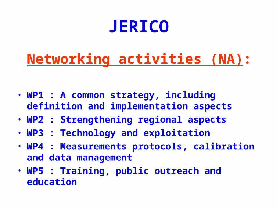
JERICO
Networking activities (NA):
• WP1 : A common strategy, including definition and implementation aspects
• WP2 : Strengthening regional aspects • WP3 : Technology and exploitation • WP4 : Measurements protocols, calibration and data
management• WP5 : Training, public outreach and education

JERICO• Transnational Access & Services Activities (TNA) :
– WP 6 : Databases and services freely available Methodology, technician exchange, training and upgrading
– WP 7 : Access for non partners or non European countries to reach the alliance – one call at mid term
• Joint Research Activities (JRA) :
– WP 8 : Research activities :• Adaptation of optical sensors to the coastal profiler, bio-
fouling • New developments : biological sensors, image
processing, …• Deployment and navigation strategy in schallow waters
for a school of gliders.• TBD

JERICO• WP 1 A common strategy
– WP 1.1 Rationale and definitions.– WP 1.2 Implementation– WP 1.3 Consolidation of regional contributions– WP 1.4 Prospective: how to answer
scientific/societal questions (new components,

JERICO• WP 2 Strenghtening regional activities
– WP 2.1 BOOS.– WP 2.2 NOOS– WP 2.3 IBI ROOS– WP 2.4 MOON– WP 2.5 Black Sea

JERICO• WP 3 Technology and exploitation
– WP 3.1 FerryBox : up to an european infra.– WP 3.2 Fixed platforms, CPR, coastal radars– WP 3.3 Gliders : partnership, expertise and demonstration
scheme– WP 3.4 New emerging coastal observing systems ( profilers, sea floor
observatories, ships of opportunity…)– WP 3.5 Exploiting the coastal obs system components. Methodology,
calibration, …
Note: the forum for coastal technology is moved to WP 0

JERICO• WP 4 Measurement protocoles, data
management and interface with modelling
– WP 4.1 Measurement protocoles and data format.– WP 4.2 Link with modelling activities– WP 4.3 Calibration procedures, standards, metrology– WP 4.4 Data exchange legal framework,

JERICO
• WP 5 Training, public outreach and education
– WPs to be defined

ProjectCoordinator
BoardGeneral Assembly
European Commission
Governing Bodies
Scientific Advisory Committee
Core user Group
JERICO Project Management
Project Office
Executive Bodies ProjectManager
TNA
NA
Forum for Coastal technology
JRA
Advisory bodies
wp 1 wp 2 wp 3 wp 4
wp 6 wp 7
wp 8
Executive committee
WP 5

JERICO Project Management Organization
WP 0 Board = Steering Committee + Science AC + CUG
– 5 senior managers choosen amongst the core partners (WP leaders)– CUG chair, SAC chair– 3 stakeholders (Coastal managers)
. Advisory bodies
- Core User Group (CUG), (National agencies, SAC chair, EEA, EMSA, …)- Science Advisory Committee (SAC)- Euro Forum for Coastal Technology (FCT)
Executive Committee (ExCom)– Project manager: (Ifremer as proposed)– Assisted by a PMO (Project Management Office) : x persons– WP Leaders (have driven the work content, preparation and schedule) ;
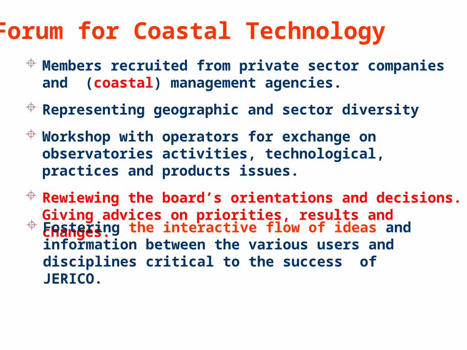
Members recruited from private sector companies and (coastal) management agencies.
Representing geographic and sector diversity
Workshop with operators for exchange on observatories activities, technological, practices and products issues.
Rewiewing the board’s orientations and decisions. Giving advices on priorities, results and changes.
Forum for Coastal Technology
Fostering the interactive flow of ideas and information between the various users and disciplines critical to the success of JERICO.

Collaborating institutions, companies, and organizations involved in the development and/or use of coastal sensor technologies.
Organized regionally or locally. Not necessarily reaching the quality standards but willing to join JERICO activities.
Alliance Members (second circle actors) TBDCapacity building WP 7
• Kept abreast of JERICO activities.
• Identify regional issues.
• Provide advice on technology foci
• Participate in JERICO wp 3.5 forum
activities.

ConsortiumJERICO PARTNERSHIP

Patrick Farcy - [email protected]
Jacques Legrand – [email protected]
Aurelien CarbonnièreMarine Board - ESF
Thank you!
MarinERA Website for PPTs
http://www.marinera.net/dissemination/infrastructure_workshops.html

C-GOOS - Phased Implementationafter Tom Malone EuroGOOS conference Brest
• Global Ocean Module Significant progress e.g., GODAE, Argo
• Coastal Module: Little Progress
Collaboration among regional programmes
Management of coastal data inefficient/ineffective
Lack of capacity to rapidly detect changes
Internationally accepted implementation plan

Near shoreProcesses
SpatiallySynoptic
Time Series
TransectsV-Profiles
High Res TSV-Profiles
AutonomousIn Situ
Sensing
Ship-BasedSurveys
SatellitesAircraft
HF Radar
GLOSSCoastal
LaboratoryNetworks
GOOS Coastal Moduleafter Tom Malone EuroGOOS conference Brest
AnalysisModeling
Data ManagementReal-Time
Delayed Mode
USERS

Coastal BackboneProvisional Common Variables as define by Coastal GOOS
after Tom Malone EuroGOOS conference Brest
PHYSICAL
Sea level, Temperature, Salinity, Currents, Surface waves, Bathymetry, Shoreline position (fluxes across defined sections)
CHEMICAL
Sediment grain size/organic content, Dissolved inorganic N-P-Si, Dissolved O2
BIOLOGICAL
Benthic biomass,Phytoplankton biomass, Attenuation of solar radiation
Fecal Indicators
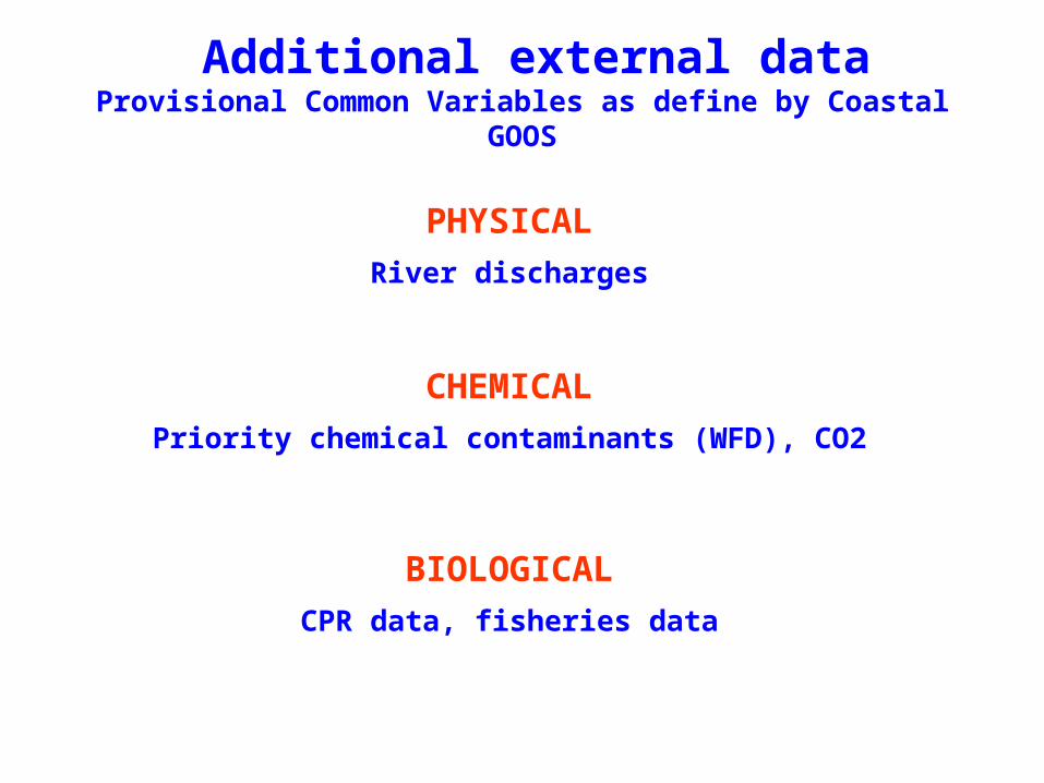
Additional external dataProvisional Common Variables as define by Coastal GOOS
PHYSICAL
River discharges
CHEMICAL
Priority chemical contaminants (WFD), CO2
BIOLOGICAL
CPR data, fisheries data