Embed Size (px)
Citation preview
Louisiana State UniversityLSU Digital Commons
LSU Master's Theses Graduate School
2005
Kingship, structures and access patterns on theRoyal Plaza at the ancient Maya city of Altun Ha,Belize: the construction of a Maya GISOlga A. YermakhanovaLouisiana State University and Agricultural and Mechanical College, [email protected]
Follow this and additional works at: https://digitalcommons.lsu.edu/gradschool_theses
Part of the Social and Behavioral Sciences Commons
This Thesis is brought to you for free and open access by the Graduate School at LSU Digital Commons. It has been accepted for inclusion in LSUMaster's Theses by an authorized graduate school editor of LSU Digital Commons. For more information, please contact [email protected].
Recommended CitationYermakhanova, Olga A., "Kingship, structures and access patterns on the Royal Plaza at the ancient Maya city of Altun Ha, Belize: theconstruction of a Maya GIS" (2005). LSU Master's Theses. 431.https://digitalcommons.lsu.edu/gradschool_theses/431
KINGSHIP, STRUCTURES AND ACCESS PATTERNS ON THE ROYAL PLAZA AT
THE ANCIENT MAYA CITY OF ALTUN HA, BELIZE: THE CONSTRUCTION OF A
MAYA GIS
A Thesis
Submitted to the Graduate Faculty of the Louisiana State University and
Agricultural and Mechanical College in partial fulfillment of the
requirements for the Degree of Master of Arts
in
The Department of Geography and Anthropology
by Olga A. Yermakhanova
Engineer (M. S.), Tashkent State Technical University, 1999 August 2005
ii
ACKNOWLEDGEMENTS
This work involved many disciplines and could not have been completed without the
help of so many people.
I would like to warmly thank my advisor Dr. Heather McKillop for her guidance and
support in the creation of the thesis from the very beginning, when she suggested Altun Ha
for the thesis, to the very end when she revised the final version. She was a great support not
only as an expert in Maya archaeology, but also a great help in bureaucratic questions
multiplied by my status of an international student. Thank you for bringing me back when I
was on the edge of panic so many times.
I would like to give a special thank to Hampton Peele who showed me the potential of
GIS software in architecture and taught me the basics of digitization.
I thank Farrel Jones for spending numerous hours, explaining the basics of Geomedia
to the amateur and patiently issuing one license by another because she kept changing PCs.
I want to say a special thanks to my husband who ‘lost’ his wife to a science for two
years, patiently printing the drafts and entertaining Vera, and to my parents who supported me
in all my crazy initiatives, and did not complain about seeing their first and only grandchild
only once in three years.
I would like to thank the faculty of the Department of Geography and Anthropology
and all my friends for a great support and worm atmosphere that surrounded me during my
study at LSU.
iii
TABLE OF CONTENTS
ACKNOWLEDGEMENTS…..…...…...…...…...…...…...…...…...…...…...…...…...…...…..ii LIST OF TABLES…..…...…...…...…...…...…...…...…...…...…...…...…...…...…...…........iv LIST OF FIGURES…..…...…...…...…...…...…...…...…...…...…...…...…...…...…...….......v ABSTRACT…..…...…...…...…...…...…...…...…...…...…...…...…...…...…...…...…...…...vii INTRODUCTION…..…...…...…...…...…...…...…...…...…...…...…...…...…...…...…...…..1 CHAPTER 1: ALTUN HA: 2900 + YEARS OF OCCUPATION…...…...…...…...…...…....4
Altun Ha Today…...…...…...…...…...…...…...…...…...…...…...…...…...…...….......4 Resources…...…...…...…...…...…...…...…...…...…...…...…...…...…...…...…...…...8 Occupation History…...…...…...…...…...…...…...…...…...…...…...…...…...…...…..9
CHAPTER 2: PLAZA B…...…...…...…...…...…...…...…...…...…...…...…...…...…...…....17 CHAPTER 3: RESIDENTIAL STRUCTURES…...…...…...…...…...…...…...…...…...…...23
Structure B3…...…...…...…...…...…...…...…...…...…...…...…...…...…...…...….....23 Structure B5…..…..…..…..…..…..…..…..…..…..…..…..…..…..…..…..…..…..…..30
CHAPTER 4: FUNERARY SHRINE…..…..…..…..…..…..…..…..…..…..…..…..…..……37 CHAPTER 5: CACHES AND BURIALS OF B4……………………………………………48
Burials………………………………………………………………………………...48 Caches………………………………………………………………………………...54 Artifact Assemblages in Tombs, Dedicatory Caches and Tomb Caches…..…………56 Conclusions on Structure B4………………………………………………………….64
CHAPTER 6: STRUCTURES WITH AMBIGUOUS FUNCTIONS…..…..…..…..…..…...68
Structure B2…………………………………………………………………………..68 Structure B1…………………………………………………………………………..69 Structure B6…………………………………………………………………………..70
SUMMARY AND CONCLUSIONS………………………………………………………...75 REFERENCES CITED...................…………………………………………………………..79 APPENDIX A: METHODS…………………………………………………………………..85 APPENDIX B: RELEVANT MATERIAL NOT INCLUDED IN
THE MAIN TEXT……………………………………………………………...98 VITA………………………………………………………………………………………...121
iv
LIST OF TABLES
Table 1.1 Time chart and zones A and B construction dates…………………………………10
Table 2.1 Azimuths of primary axes of structures of the Plaza B……………………………19
Table 3.1 Dimensions of non-ceremonial structures at Altun Ha…………………………….24
Table 5.1 Percentage of artifacts of in caches, tombs and tomb caches……………………...57
Table 5.2 Content of dedicatory caches of Plaza B…..………………………………………59
Table 5.3 Content of dedicatory caches of Plaza A…………………………………………..60
Table 5.4 Content of subfloor and wall caches of the tombs of B4…………………………..62
Table 5.5 Content of subfloor and wall caches of A6 and E1………………………………..63
Table B.1 Time spans of construction efforts of Plaza B4………………………………….105
Table B.2 Construction development at Altun Ha by 100 year periods…………………….106
Table B.3 Renewals of structures at Altun Ha by 100 year periods………………………...106
Table B.4 Time of initiation of construction at Altun Ha by zone………………………….107
Table B.5 Time of abandonment of Altun Ha structures by zone…………………………..107
Table B.6 Difference between types of artifacts placed in tomb caches and burials…………………………………………………………………………………..108
Table B.7 Difference between types of artifacts placed in dedicatory caches and burials…………………………………………………………………………...109
Table B.8 Difference between types of artifacts placed in dedicatory caches and subfloor and wall caches………………………………………………………...110
v
LIST OF FIGURES
Fig. 1.1 Map of the Maya area, showing the locations of Altun Ha and other sites, mentioned in the text………………………………………………………….5
Fig. 1.2 Map of Altun Ha with excavated structures and structures mentioned in the text (Zone K not included)…………………………………………………..7
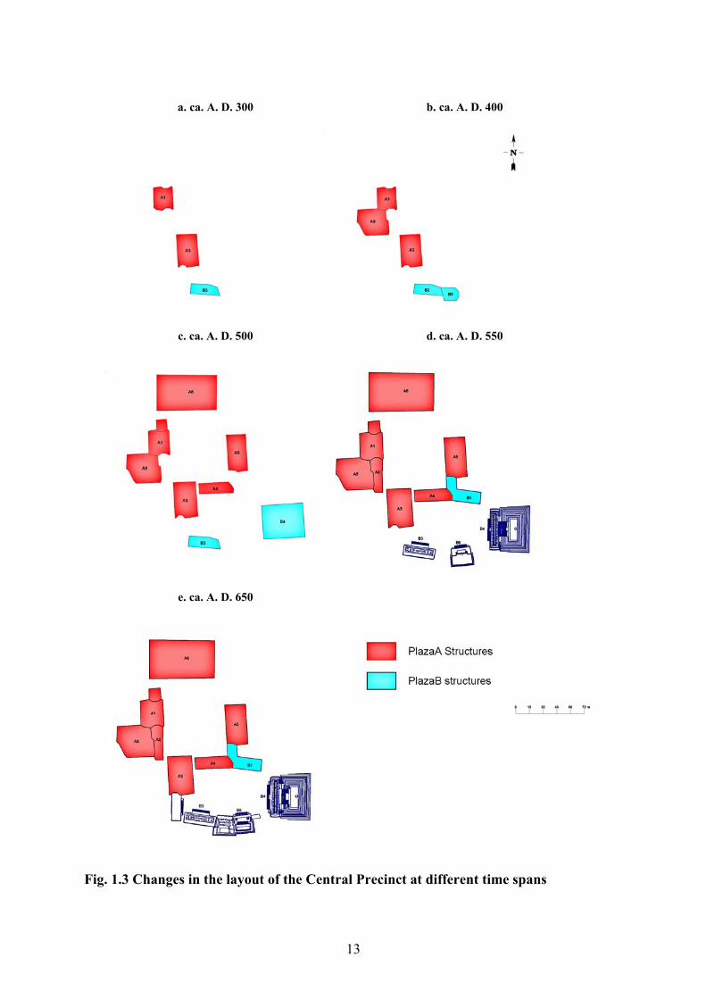
Fig. 1.3 Changes in the layout of the Central Precinct at different time spans…………………………………………………………………………...13
Fig. 2.1 Alignment of Plaza B structures……………………………………………………..19
Fig. 2.2 Access routes to Plaza B between A. D. 550-600…………………………………...20
Fig. 2.3 Access routes to Plaza B between A. D. 625-650…………………………………...20
Fig. 3.1 Length-to-width ratio of platforms of non-ceremonial structures at Altun Ha………………………………………………………………...………24
Fig. 3.2 Access nodes and scheme of access routes in B3……………………………………28
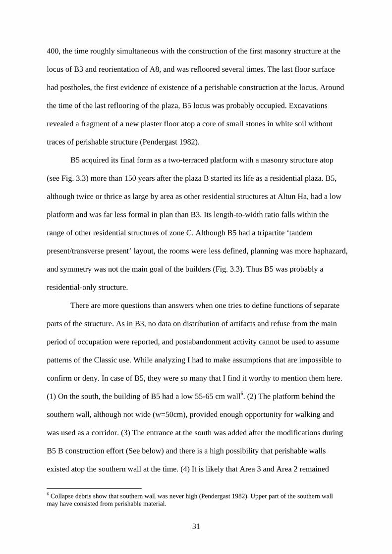
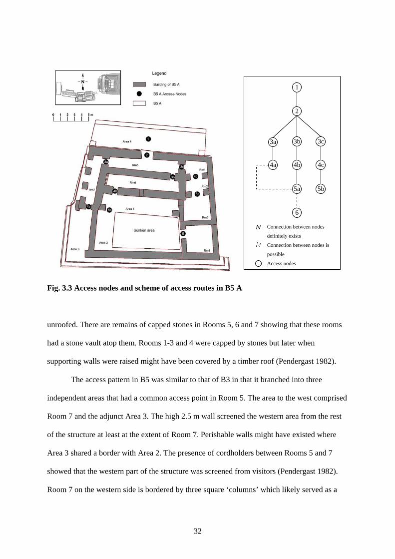
Fig. 3.3 Access nodes and scheme of access routes in B5 A…………………………………32
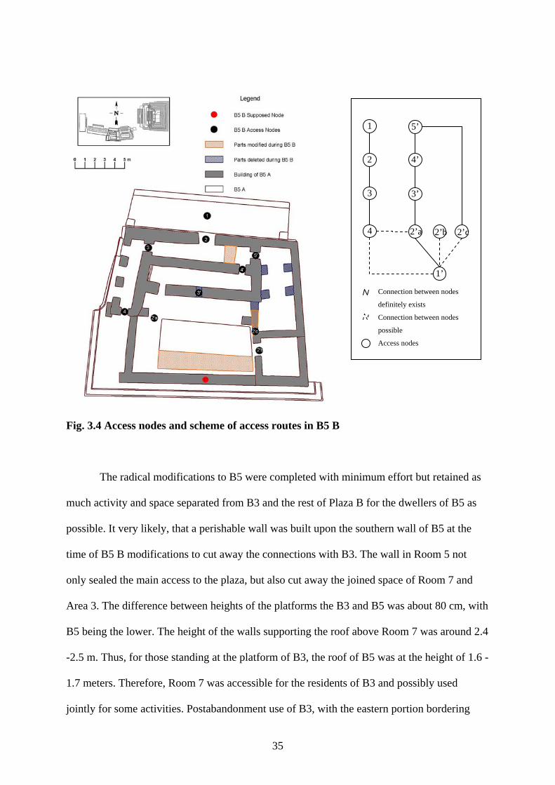
Fig. 3.4 Access nodes and scheme of access routes in B5 B…………………………………35
Fig. 4.1 The building of B4 2A……………………………………………………………….41
Fig. 4.2 Schemes of B4 access pattern at times of major modifications……………………...45
Fig. 4.3 Cross-pattern of the access routes of B4 and Wakah Chan.........................................46
Fig. 5.1 Placement of tombs of B4 in relation to construction effort………………….……..50
Fig. 5.2 Placement of tombs of B4 in relation to each other………………………………….52
Fig. 6.1 Platform B2…………………………………………………………………………..68
Fig. 6.2 Structure B6 1A……………………………………………………………………...70
Fig. 6.3 Structure B6 1B……………………………………………………………………...72
Fig. 6.4 Structure B6 1C, 1D and 1E…………………………………………………………73
Fig. A.1 Outlines of the Plaza B digitized from the base map of Altun Ha and detailed plans of structures……………………………………………………………….88
Fig. A.2 Entity – Relationship diagram of GIS of Plaza B…………………………………...93
Fig. B.1 Relationship among tables of PlazaB………………………………………………111
Fig. B.2 Graphic of abandonment of Altun Ha……………………………………………...112
vi
Fig. B.3 B4 2A………………………………………………………………………………113
Fig. B.4 B4 2B………………………………………………………………………………114
Fig. B.5 B4 2C………………………………………………………………………………115
Fig. B.6 B4 2D………………………………………………………………………………116
Fig. B.7 B4 2E……………………………………………………………………………….117
Fig. B.8 B4 2F……………………………………………………………………………….118
Fig. B.9 B4 2G………………………………………………………………………………119
Fig. B.10 B4 2H……………………………………………………………………………..120
vii
ABSTRACT
The GIS of Plaza B represents the application of GIS in the analysis of buildings. The
GIS contains information on six structures and recreates the development of the royal
residential plaza at the ancient Maya site of Altun Ha, in northern Belize.
Altun Ha is a small site with a long history of occupation, rich in architectural and
artifactual forms. The major site expansion and development started in the end of the Early
Classic (A. D. 400) with the emergence of the institution of kingship at the site. Two adjunct
plazas, A and B, formed the largest ceremonial –residential complex in the center of the site.
This thesis analyzed the layout of the residential plaza and the dynamics of change in
the access patterns within the structures. The study of the layout revealed that in spite of the
seeming informality, the layout of Plaza B was carefully planned. The access patterns and
shape of residential structures showed that one of them was used as a residential-
administrative building, and another most likely have been strictly residential. The
architecture of the plaza’s funerary shrine recreated stories from Maya mythology and
symbolized the connection between ancestors and descendants. The changes in the access
patterns within the structures of Plaza B, around A. D. 700, paralleled by the changes in tomb
and cache placement practices, supported the hypothesis about the change in the succession
line of the ruling family that led to the gradual degradation of the central power at Altun Ha
and eventual abandonment of the site.
The GIS of Plaza B proved to be an excellent information base and valuable tool for
data analysis. It allowed representation of the plaza structures as a complex of interconnected
dynamic entities. This unified representation, in turn, allowed formulation of the hypothesis
about social changes that triggered changes in architecture.
1
INTRODUCTION
Today archaeological study involves a complex scientific research that involves
analysis of great volumes of spatial and descriptive information. Due to the complexity, such
analysis can no longer be undertaken manually and, in fact, it is not. Geographic Information
Systems (GIS) that began their development in the 1960s as a response to the need for
automatic processing of land management data, proved to be the ideal environment for
conduction of spatial analysis and visual representation of the results.
The application of GIS in archaeology began in the 1970s. At first, GIS were used for
the analysis of artifact densities or patterns of site distribution within a region. In 1980, when
the new trend in archaeology started to treat the environment as “constructed and shaped by
social actions” which in turn were shaped by the environment, the true potential of GIS was
realized (Wheatley and Gillings 2002:9). By that time GIS became commercialized, and as a
result offered a wider range of functions, became more user friendly and cheaper. By the end
of the 1980s GIS were widely used by North American research archaeologists and cultural
resource managers. In the beginning of the 1990s, a series of conferences stimulated the
growth of interest among the European colleagues (Wheatley and Gillings 2002). Today it is
difficult to find an archaeological project that has not mentioned GIS among its tools.
GIS are used to complete many research goals. For example, Herbert Maschner (1996)
used it to predict the location of Tinglit sites in Alaska by analyzing the environmental
parameters of the known sites. Gary Lock and Trevor Harris (1996) re-examined the areas of
influence among forts at Danebury. The Ch'amak Pacha Archaeological Research Project uses
GIS to document excavations at Jiskairumoko site in Peru (Craig 2002). Selcuk University
created the GIS of the archaeological site under the modern city of Kelenderis in Turkey for
future use in conservation management, public presentation and further study (Erdi 2003). In
the Maya area, the “Electronic Atlas of Ancient Maya Sites” is being created by Clifford
2
Brown and Walter Witschey. It currently contains around 4,400 sites (http://mayagis.smv.org).
Jaime Awe and Holley Moyes used GIS for mapping and analysis of spatial distribution of the
artifacts in Actun Tunichil Muknal cave (Moyes 2002, Moyes and Awe 2000). Heather
McKillop investigated the sea-level rise at Wild Cane Cay through analysis of artifact
distribution and densities (McKillop 2002).
However, GIS not only allow representation and spatial analysis of data, but are also
an instrument for storage and retrieval of information. Its strength lies in the abilities to utilize
a variety of traditional databases, and to combine dynamically spatial and non-spatial
information from different sources without significant sacrifices of storage effectiveness.
Maya structures were complex objects. They embraced hundreds of elements,
constructed at different periods of time. In addition, they included caches and burials that are
very important in the analysis of a structure. Moreover, structures themselves were greatly
variable.
‘…when an executive committee of a Hindu temple comes to the sculptor Haripada Pal in Dhaka city. There are no plans and few words. They name a deity. They state a sum. The rest is entirely to Haripada.’
Glassie 2000:45 As Haripada, Maya created their houses and temples without a blueprint. Every
construction was unique, and a single idea found many representations.
Handling visual and non-visual information, GIS does not pose constrictions on the
type of information. It provides storage and analysis of a complete description of an entity.
The storage efficiency and flexibility gives GIS advantage in representation of architectural
entities comparing to the specialized architectural software.
GIS enjoys yet another important advantage for analysis of Classic Maya architecture.
Despite the variability every structure was a collaborative effort of many people in the
community and represented common cultural assumptions about what was right and what was
wrong.
3
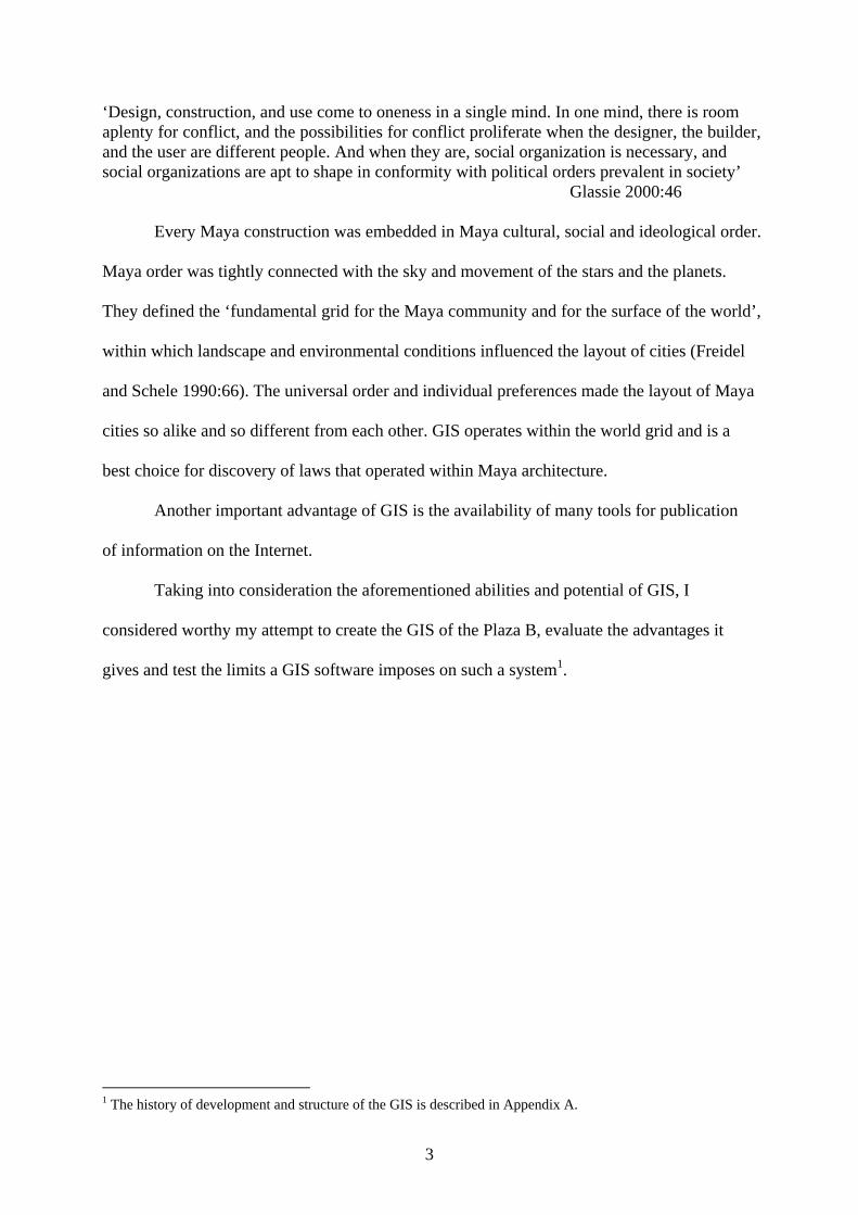
‘Design, construction, and use come to oneness in a single mind. In one mind, there is room aplenty for conflict, and the possibilities for conflict proliferate when the designer, the builder, and the user are different people. And when they are, social organization is necessary, and social organizations are apt to shape in conformity with political orders prevalent in society’
Glassie 2000:46 Every Maya construction was embedded in Maya cultural, social and ideological order.
Maya order was tightly connected with the sky and movement of the stars and the planets.
They defined the ‘fundamental grid for the Maya community and for the surface of the world’,
within which landscape and environmental conditions influenced the layout of cities (Freidel
and Schele 1990:66). The universal order and individual preferences made the layout of Maya
cities so alike and so different from each other. GIS operates within the world grid and is a
best choice for discovery of laws that operated within Maya architecture.
Another important advantage of GIS is the availability of many tools for publication
of information on the Internet.
Taking into consideration the aforementioned abilities and potential of GIS, I
considered worthy my attempt to create the GIS of the Plaza B, evaluate the advantages it
gives and test the limits a GIS software imposes on such a system1.
1 The history of development and structure of the GIS is described in Appendix A.
4
CHAPTER 1: ALTUN HA: 2900 + YEARS OF OCCUPATION
Altun Ha Today
Altun Ha is a small site located in northern Belize about 12 km west from the
Caribbean Sea coast, 40 km east from Rio Hondo, and north from the Belize River (Fig. 1.1),
both major navigable rivers providing access to the core area of Classic Maya civilization
(Heather McKillop, personal communication)1. Name “Altun Ha”, a Mayan translation for
“Rockstone Pond” (truncated from “Altun Hatun”), was given to site by its first excavator,
David Pendergast (1979).
Altun Ha is located on Eocene and Miocene limestone that is cross-cut by numerous
swamps. The zone of Paleozoic granite, an important source of raw material, lies west and
southwest of the site. Low-lying mangrove salt water lagoons extend to the coast. These
provide easy access to coastal resources (Heather McKillop, personal communication).
Chichiwate Creek to the north of the site and several natural ponds on the site provide
drinking water. The soil in the area is poorly suited for agriculture (Pendergast 1979).
Altun Ha is a major tourist attraction, famous because of the carved jade head of the
Sun God, Kinich Ahaw, found in the tomb of the Sun God in temple B42. The head is the
largest jade artifact found in the Maya region. Although commonly believed to be in Canada,
the jade head is housed in a vault in Belize Bank in Belize City. However, its image can be
found in the corner of every Belize banknote (Heather McKillop, personal communication).
The main attractions at Altun Ha are Plazas A and B, the natural path that leads south to the
clay-lined reservoir used by the ancient Maya and the modern tourist facilities
(http://www.belize-vacation.com/belize/altunha.htm).
The first mapping and excavation efforts were conducted at the site by David
Pendergast of the Royal Ontario Museum between 1964 and 1970.
1 Maya core area is a region comprising northern Peten, Guatemala and southern Campeche (Hammond 1982). 2 For illustration of the jade head of Kinich Ahaw see Pendergast (1982, Fig. 33: 56-58, Plate 19:280).
5
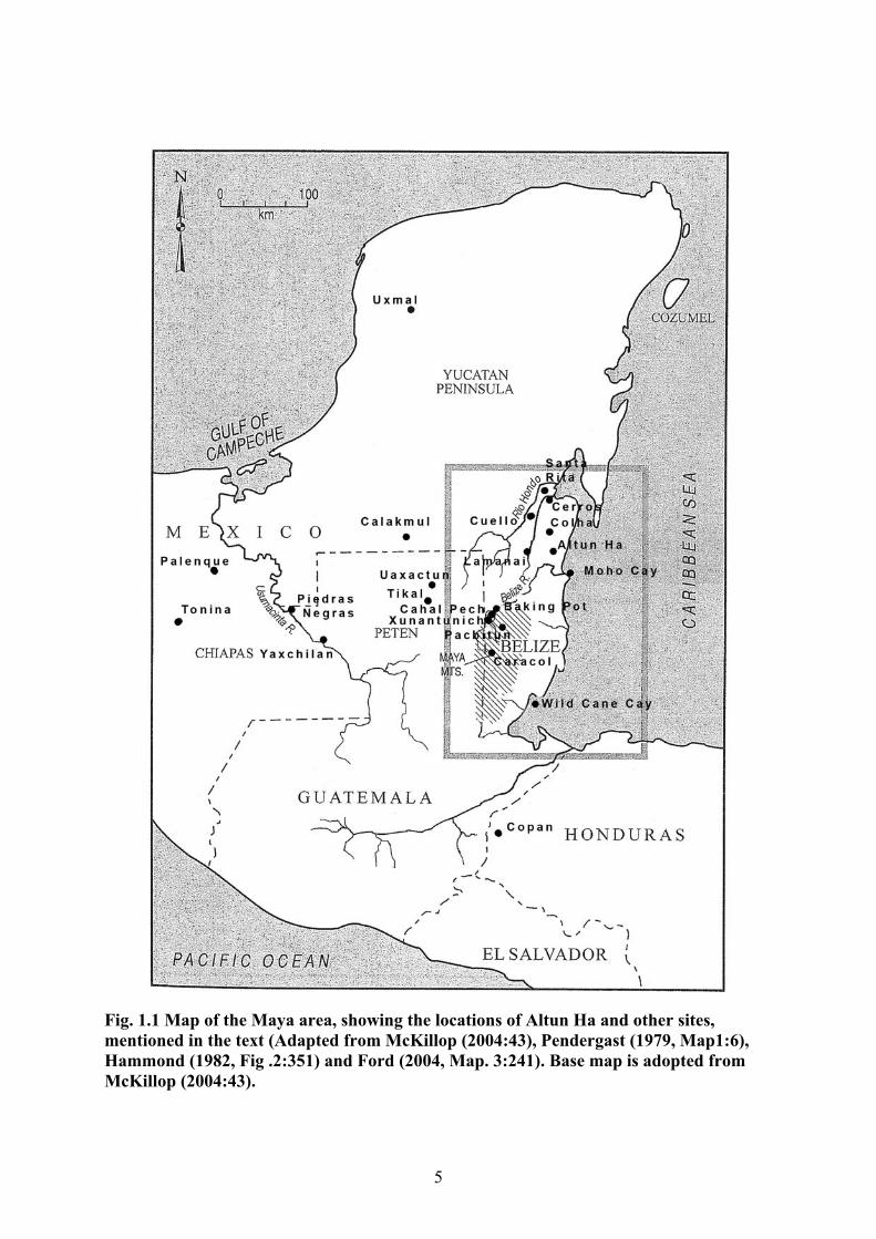
Fig. 1.1 Map of the Maya area, showing the locations of Altun Ha and other sites, mentioned in the text (Adapted from McKillop (2004:43), Pendergast (1979, Map1:6), Hammond (1982, Fig .2:351) and Ford (2004, Map. 3:241). Base map is adopted from McKillop (2004:43).
6
Substantial attention during the excavation was paid to keeping the structures intact
for further restoration of the site as a historical monument and place of tourist attraction. In
the following years, Joseph Palacio initiated the restoration work, later continued by Elizabeth
Graham. Major restoration works were conducted by Jaime Awe under the Tourism
Development Project in the beginning of the 21st century (Awe 2003 - LSU Maya
Archaeology Night talk).
Pendergast mapped the area of 2.33 km2 and located more than 500 structures
(Pendergast 1979, Map 2). Fifty seven structures were excavated. Prior to 1967, the site was
under private ownership by different owners some of whom did not allow mapping and
excavation. Another factor impeding mapping was differential accessibility to site areas due
to uneven vegetation cover and agricultural activity of local farmers. Thus Pendergast’s map
covered the central area of the site where occupation was the densest. Swamps have defined
the northern and southwestern borders of the map. Modern roads determined the south and
southeastern borders. Dense modern occupation and landowner’s prohibition established
limitations to the west.
Pendergast divided the site into thirteen zones and tested nine of them in different
proportions (Fig. 1.2). The central area of the site received the most attention with 89% of the
Plaza A and 83 % of the Plaza B tested. Intensive investigation also was conducted in zones C
(16%) and E (22 %). Both zones show elevated status of their inhabitants reflected in
architecture, burials and caches. The zone northeast of the Central Plaza was sampled in much
less detail due to the scattered nature of the neighborhood and limited access. The northeast
section is represented by two patio groups, including J1-J6 and K29-K35 that do not reflect
the pattern of development of this part of the site. Of these groups, K shows the elevated
status of its inhabitants and J was possibly the only non-elite dwelling represented in the
7
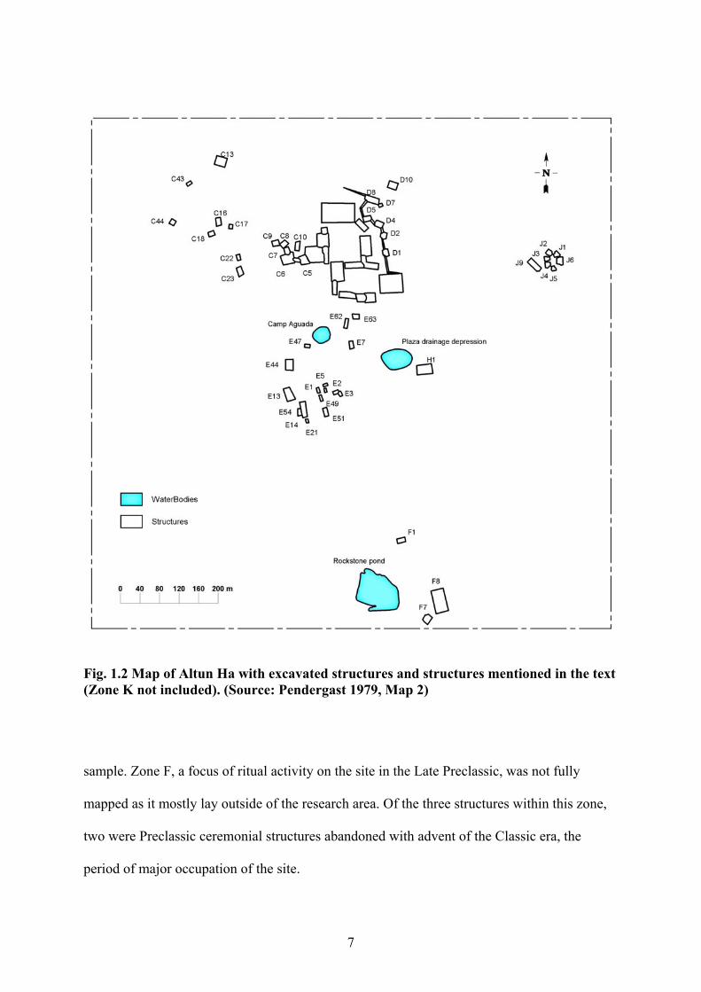
Fig. 1.2 Map of Altun Ha with excavated structures and structures mentioned in the text (Zone K not included). (Source: Pendergast 1979, Map 2)
sample. Zone F, a focus of ritual activity on the site in the Late Preclassic, was not fully
mapped as it mostly lay outside of the research area. Of the three structures within this zone,
two were Preclassic ceremonial structures abandoned with advent of the Classic era, the
period of major occupation of the site.
8
Resources
Altun Ha was dependent on the sea, as indicated by studies of the diet, agricultural
capacities of the land, and artifacts found at the site. From modern observations, the area at
Altun Ha is poorly suited for agriculture (Pendergast 1979). Water resources are scarce. The
main water source for the site center was the small pond south of the central plazas which
gave the site its name. The rest of water supply was artificial (Pendergast 1979). Living in the
area of slow drained lowlands which were difficult to cultivate by hand, dwellers of the site
had to support themselves with seafood (Fedick and Ford 1990). This is confirmed by bones
of sea turtle and manatee found in middens and burials confirm the fact (Pendergast 1979,
McKillop 1984). Carbon and nitrogen isotope analysis showed that ‘significant quantities of
high-quality fish and seafood’ remained a stable source of food throughout the history of the
site (White et al. 2001:388). Although, maize was the main source of carbohydrates, access to
it during the Classic period was variable with upper levels of Altun Ha society having a
privileged position. By the end of Terminal Classic (A. D. 850-900), most of the maize in the
diet of the inhabitants was replaced by other plants (White et al. 2001). These facts indicate
that due to poor soils maize might have been a luxury item in the Classic Altun Ha. If during
the Classic period, maize was imported then reduction in its quantity points to severed trade
connections.
The close connections of Altun Ha with the sea and coastal trade are supported by
presence of exotic objects found in burials and caches. They include a Tumbaga (gold-copper
alloy) pendant of the Coclé culture of central Panama, found in the Early Classic (A. D. 500)
cache and green Pachuca obsidian from Teotihuacán in the Early Classic (A. D. 250) tomb
(Pendergast 1970, 1990). Jade appeared in Altun Ha burials and caches as early as 400 B. C.
While most of the Altun Ha jade came from the traditional source - jade outcrops along
Motagua river, some of the samples that belong to the Maya Green group were more similar
9
in chemical composition to Costa-Rican jade. Moreover, analysis had shown that jade of the
Maya Green group was found prevalently on Belizean sites, including Cerros, Cuello, Santa
Rita and Altun Ha. This points to the existence of a stable connection between the two coasts
(Bishop et al. 1993, Bishop and Lange 1993). Quantities of jade from both sources, found in
elite and non-elite contexts, significantly increased in the Late Classic. Late Classic was also
the time of appearance of crystalline hematite in caches and burials of B4 pointing to the
establishment of connections with the Guatemalan highlands3. In the second half of Late
Classic (after A. D. 750) hematite disappeared from the ritual offerings of B4 and quantities
of jade decreased significantly.
Obsidian is rare in Preclassic ritual contexts. Its quantities increased during the Classic
period. However, in comparison with chert, obsidian was unpopular at least in burials and
caches of B4. Its most common forms were flakes and flake blades, whereas chert took the
rest of the available forms, including eccentrics, blades, projectile points and occasionally
flakes. Multiple outcrops of fine-quality were found on the site area that explains its
domination (Pendergast 1979). On the other hand, the source of the soft limestone that was
used in construction remains the problem, since no major quarry zone of soft limestone was
found on the site (Pendergast 1979). The increase in quantities of exotic material at Altun Ha
in the beginning of the Late Classic period corresponded with the establishment of coastal–
inland trade routes in southern Belize (McKillop 1996).
Occupation History
The following history of occupation is a short summary of the results of excavations
interpreted and published by David Pendergast (1979, 1982, 1990). The history of occupation
at the site started in the Middle Preclassic (ca. 900 B. C.) and stretched to the Early
Postclassic (ca A. D. 1200). 3 Pyrite and hematite are distributed throughout southern Maya Mountains. However, only pyrite is common there (Graham 1987). The lamina objects found in the caches and burials of B4 in great quantities were made of crystalline hematite.
10
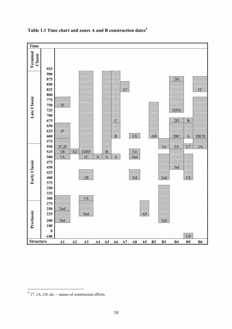
Table 1.1 Time chart and zones A and B construction dates4
Time
Ter
min
al
Cla
ssic
925 900 875 2H 850 825 A7 1E 800 775 750 1E 725 2EFG 700 675 C 2D B 650 625 1F 600 B U8 AB 2BC A 1BCD
Lat
e C
lass
ic
575 550 1C,D 1st 2A U7 1A 525 1B A2 1DEF B 1st 500 1A 1C A A A 2nd 475 450 3rd 425 400 1B 3rd 2nd U8 375 350 325
Ear
ly C
lass
ic
300 1A 275 250 2nd 225 2nd A9
200 3rd 3rd 100
0
Prec
lass
ic
-100 U9 Structure A1 A2 A3 A4 A5 A6 A7 A8 A9 B2 B3 B4 B5 B6
4 1st, 1A, U8, etc. – names of construction efforts.
11
The Period between A. D. 400 to A. D. 900 is the best represented period in the
archaeological record. Detailed histories of many excavated structures are available. The
information about the earliest period (900 B. C. – A. D. 400) is sketchy, since the area of the
site that has been most intensively studied by the project was either not occupied during that
period or subsequent occupations erased most of the earlier evidence5.
The earliest traces of occupation are found in the zone C. Two round platforms located
in the northwestern portion of the site aligned roughly along the north-south axis were
initiated in 900-800 B. C. C13 had traces of postholes and contained a large number of burials
of various ages and both sexes, concentrated in the northern part of the platform. C17, a round
platform, had traces of fire and did not contain any artifacts or burials (Pendergast 1982).
Large round platforms are found at various Preclassic Maya sites. Round structures at
Cahal Pech (700-350 B. C.) contained burials and caches and are thought to have served as
community ritual performance centers (Healy at al. 2004a). Excavations at Cuello showed
that circular and apsidal platforms, with domination of the latter, were the only form of
platforms present at the site between 900-400 B. C. and were used as residences (Hammond
and Gerhardt 1990). Apsidal and circular platforms with perishable buildings were the only
forms of platforms present at Blackman Eddy between 1000-900 B. C. (Garber at al. 2004).
On the other hand, a round structure was a principal structure of the Bedran group at Baking
Pot as late as A. D. 500-600 (Conlon and Powis 2004). However, most of the round structures
are characteristic of the Preclassic period. Rectangular platforms, first plastered, and later
faced with masonry, appeared around 900 B. C. at Cahal Pech, between 900-700 B. C. at
Blackman Eddy, and after 400 B. C. at Cuello (Garber at al. 2004; Hammond and Gerhardt
5 Only eight structures, including C13, C17, A1, A3, B3, B5, F7 and F8, are known from this thirteen-hundred-year period. Their construction histories include big gaps. Most of them (six out of eight) were ceremonial but unfortunately not contemporaneous with each other.
12
1990; Healy et al. 2004a). C13 and C17 are the only known unequivocal representatives of
Preclassic occupation at Altun Ha between 900 B. C. and A. D. 200.
During the Late Preclassic period, massive population increase and appearance of
public structures was documented at many Belizean sites (Hammond 1982; Pendergast 1981;
Freidel and Schele 1990; Ball and Taschek 2004; Healy et al. 2004a). The first large temple at
Altun Ha built around A. D. 200 was structure F8. F8 was a six-terraced platform with plain
stair-side outsets. A tomb placed in F8 about fifty years after the construction contained
exotic green Pachuca obsidian from Teotihuacan (Pendergast 1990). A century later the
construction of the Central Precinct (Plaza A and Plaza B) began. Major reflooring elevated
Plaza A by 1.31 m. Two major temples: A1 and A3, accompanied the first residence at the
spot of B3 (Fig. 1.3a). A3 held a unique offering, a carved limestone altar at the base of the
stairs. It depicted a person seating on the throne speaking to another individual, kneeling
before him (Pendergast 1979). Temples and altar are the first evidence of the institution of
kingship at Altun Ha.
By A. D. 400, the Central Precinct of Altun Ha featured two temples and residences
A8, B3 and B5 (Fig. 1.3b) in possible association with them. At that time they were not much
different from residences in other parts of the site. Within the following fifty years, first
platforms with masonry buildings were constructed above the old platforms A8 and B3,
pointing at the distinctive status of their residents. The stair-side outsets of A8 were
embellished with plaster masks, the first occurrence of the image of a Sun God at the site. The
earliest evidence of sculpted architectural decorations in Belize was found on B2 -2B at
Blackman Eddy around B. C. 700-350 making it the earliest plaster masks known (Garber et
al. 2004). At the end of Late Preclassic (B. C. 350 - A. D. 100), temples with masks, appeared
on many sites in Belize, including structure 5C-2nd at Cerros, structure N9-56 at Lamanai
13
a. ca. A. D. 300 b. ca. A. D. 400
c. ca. A. D. 500 d. ca. A. D. 550
e. ca. A. D. 650
Fig. 1.3 Changes in the layout of the Central Precinct at different time spans
14
and structure 350 in Cuello (A. D. 250) (Freidel and Schele1988, 1990; Hammond and
Gerhardt 1990; Pendergast 1982).
Temples with masks are considered to be a marker of institution of kingship (Freidel
and Schele 1988, 1990). The addition of plaster masks on the stair-side outsets of A3, the
existence of elite residences, and construction of temples indicate that at A. D. 450 the
developed institution of kingship existed at Altun Ha. It was powerful enough to organize
major public construction projects that transformed the face of Altun Ha within a short period
of two hundred years.
By A. D. 500, a major construction effort transformed Plaza A (Fig. 1.3c). Temples
bordered the plaza on four sides. Residential structures B3 and possible B5 were cut off the
plaza space by the platform of A4. Masks of the Sun God adorned the stair-side outsets of
residential structure A8 as a confirmation of the ruler’s association with the deity. However,
A8 wore the masks only for a short period of time, because the newly-constructed platform
A2 cut off the last residential structure from the sacred plaza space, destroying the frontal
entrance of A8. Plaza A became a rectangular patio bordered on all sides by temples. A8 re-
oriented south. It continued to serve as a residence until A. D. 750-800. At the rest of the site,
construction intensified, especially in the area around Central Precinct, confirming the status
of the plazas as the site center.
In fifty years after the completion of a major construction at Plaza A, the palace B3
was reconstructed. The shrine B6 was built. B6 and B3 formed the second southern border
behind the temples of the Plaza A (Fig. 1.3d). B4 was reconstructed in Lamanai fashion6
(Pendergast 1992), with a building atop the lower stairs. It kept the round altar at the summit.
B4 had mask of the Sun God on the stair block on the lower staircase, as it proclaimed the
identity of its new owner. B4 also housed a tomb of a Sun God. A giant carved jade head of
6 Lamanai is a Classic Maya site in northern Belize. See Chapter 4 for discussion of the relationship between B4 and similar structures at Lamanai.
15
the Sun God was interred with the individual who built this mausoleum. At some point, the
Sun God masks were removed from A3. Although, this event is not directly datable, it most
likely occurred at the time of construction of B4 or after the interment of the first tomb in it.
B4 since that time become a funerary shrine of the line of the Sun God.
Around the time of the ruler’s death (A. D. 600), the second palace B5 completed the
residential expansion of the ruling family, and most of the access routes through Plaza B on
the south were sealed (Fig. 1.3e). From now and onward, structures performed the established
functions for the rest of the period of occupation of Plaza B. This period also was
characterized by a construction boom at the rest of the site with especially rapid expansion in
zones C and E. (See Table B.2, B.3).
Wendy Ashmore (1992) has described the basic principles for reading Classic Maya
architectural patterns based on Classic Tikal. The basic principles were (1) strongly marked
north-south axis and (2) complementary paired functions for structures at the north and south
ends with celestial at the north and residential at the south. This pattern was repeated from
city to city. It was not identical however. In big cities with many ceremonial plazas like Tikal,
it was repeated from plaza group to plaza group and nested at a larger scale. For example, the
North and Central Acropoli formed a pair. Tombs and funerary shrines of the rulers were
concentrated in the North Acropolis. In the southern area a nine door building signifying the
underworld had later been turned into a residential acropolis associated with its northern
counterpart. In small cities, the whole city was thought as a single scheme. At Cerros, the first
temple was built at the northernmost point of the site, later concentrating the rest of the
temples. The residential area stretched southwest to southeast between the ceremonial center,
and the ballcourt defined the southernmost point (Freidel and Schele 1990, Fig.2.5:104). At
Yaxchilan, the pattern was modified to follow the river. However, a ceremonial plaza still
occupies the northernmost point with settlement northwest and south of it (Andrews 1975,
16
Fig.17:141-142). At Copan, the residential acropolis is adjacent to the Great Plaza from the
south (Freidel and Schele 1990, Fig. 8.9:321). At Altun Ha, like in Copan, the north–south
axis and duality were expressed through two adjunct plazas of the ceremonial center.
There was major reduction in construction in the Central Precinct of Altun Ha at A. D.
700. The patterns of modification and ritual offerings in B4 changed. Significant change
occurred in B5 (see below). On Plaza B, only B6 and B4 continued to be modified regularly.
To some degree, Plaza A was modified more extensively than Plaza B. Structure B5 was
abandoned within a century and Structure A8 within a century and a half. Construction of new
structures at the site sharply subsided. On the other hand, modifications in zone E reached a
peak at the eight and ninth centuries. (See Table B.2, B.3).
After A. D. 800, the gradual abandonment of the site began. The rate of abandonment
gradually increased throughout the ninth century. Zone E continued to thrive when most of
the structures of at the site were abandoned and after the last burial was interred in B4.
However the trend eventually engulfed it. By the beginning of the eleventh century the site
was completely abandoned (See Table B.4, Fig. B.2).
17
CHAPTER 2: PLAZA B
Plaza B was a residence of the ruling family of Altun Ha between A. D. 550-850, the
time of zenith and fall of the central power. Its structures carry the imprints of private and
public images of their inhabitants and traces of major changes that led to the fall of the ruling
dynasty.
The plan and location of Plaza B reflected the royal residential plazas found on other
Maya sites. Orientation of residential and ceremonial plazas sharing a border as well as their
location in relation to each other varied from site to site. Often they were aligned along the
north south axis, as plazas at Tikal, Xunantunich, Caracol or Copan, or east-west axis, as
plazas at Cahal Pech, Pacbitun, Buena Vista del Cayo, Baking Pot or Altun Ha.
Access to residential plazas was thoroughly fenced on all sides and channeled through
special routes by stairs, buildings and openings between structures. The most common
element of the border was the separation by elevation. For example, the residential structures
of the Central Acropolis at Tikal sat on a raised platform as did royal residences at
Xunantunich and Cahal Pech (Ball and Taschek 2004, Fig 12.2:193, Fig. 12.3:195; Harrison
2001, Fig. 3.2:76). A set of stairs usually connected the plazas. Often stairs led to the platform
with a ranged structure that served as a formal entrance and a screen, e.g. Caana palace in
Caracol (Chase and Chase 2001). Several rooms in such structures often acted as throughways,
while most of the rooms had only one door. The throughway rooms channeled the traffic,
entering and exiting the plaza. The one-door rooms were used for various administrative and
household purposes.
At Copan, the residential compounds lay below the level of the main plaza and lacked
ranged structures on the borders between two plazas (Andrews et al. 2003. Fig. 2.1:70, 3.2:
71).
18
Another type of separation was present at Pacbitun and Baking Pot (Healy et al. 2004b,
Fig 13.2:211; Willey et al. 1965, Fig. 177:302). At these sites, the change in elevation and a
ceremonial pyramidal structure saddling the border between the plazas acted as separators. In
both cases the ceremonial structures were oriented toward residential plazas and served as
funerary shrines.
Residential plazas combined multiple platforms with various masonry buildings and
platforms with perishable buildings as well as empty platforms. Elite residential groups
usually contained at least one administrative/residential structure, distinguished by its
prominent location and open central room. Many of such structures had formal tripartite
layout, including Caana at Caracol and House of the Scribes at Copan. Many residential
plazas, including Plaza II at Baking Pot, Bedran minor ceremonial center, Copan and Pacbitun,
included ancestral shrines, high pyramidal platforms defining one of plaza borders.
Plaza B at Altun Ha was located south of the ceremonial plaza. It included at least two
residential and two ceremonial structures. The difference in elevations between the last laid
floors of both plazas constituted 1.46 m, and access from one plaza to another required some
kind of a stairs which were not found during the excavations (Pendergast 1979, 1982).
Structures screened Plaza B on all sides both from ceremonial plaza and from the rest of
Altun Ha. The floor of Plaza B sloped to the southwest corner on the west and to the southeast
corner on the east, and areas between B4 and B6 and between B2 and B3 channeled the
rainwater to Camp Aguada on the southwest and to the shallow depression on the southeast
(Pendergast 1982, see also Fig. 1.2).
Plaza B did not have a single strictly defined entrance. Multiple narrow corridors
existed around the perimeter connecting inhabitants of the plaza with the rest of the site.
However, one formal entrance marked by two ceremonial structures existed on the eastern
side.
19
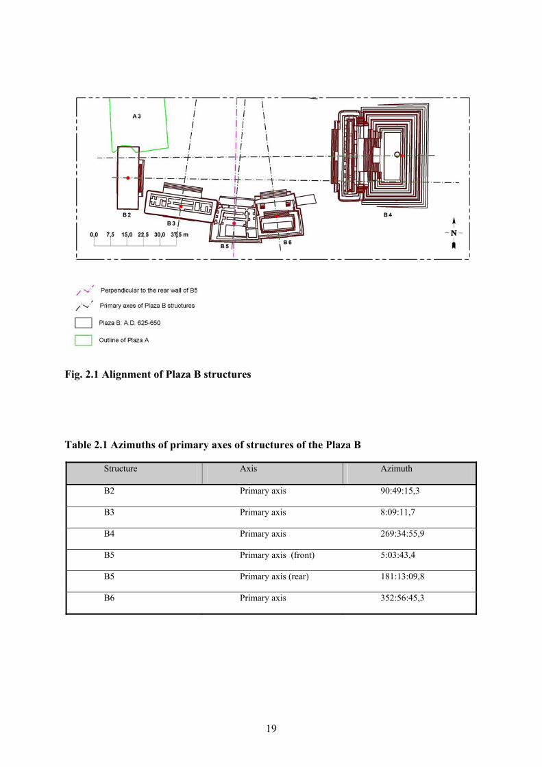
Fig. 2.1 Alignment of Plaza B structures
Table 2.1 Azimuths of primary axes of structures of the Plaza B
Structure Axis Azimuth
B2 Primary axis 90:49:15,3
B3 Primary axis 8:09:11,7
B4 Primary axis 269:34:55,9
B5 Primary axis (front) 5:03:43,4
B5 Primary axis (rear) 181:13:09,8
B6 Primary axis 352:56:45,3
20
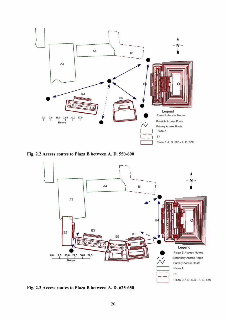
Fig. 2.2 Access routes to Plaza B between A. D. 550-600
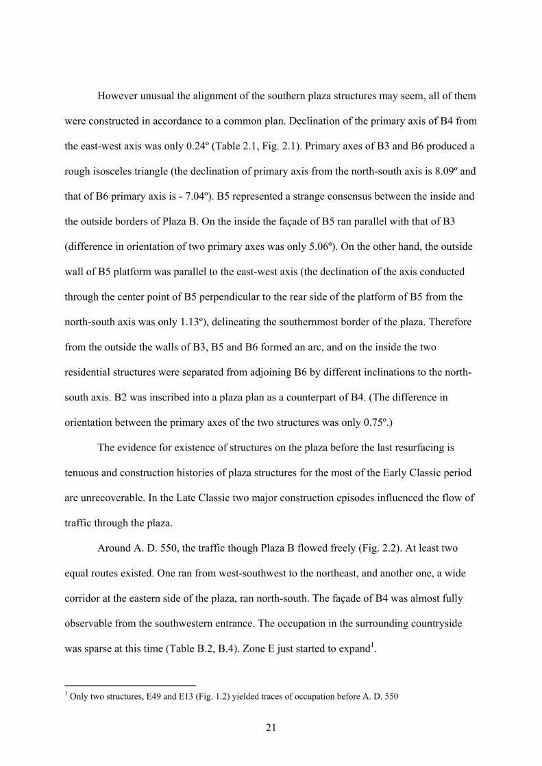
Fig. 2.3 Access routes to Plaza B between A. D. 625-650
21
However unusual the alignment of the southern plaza structures may seem, all of them
were constructed in accordance to a common plan. Declination of the primary axis of B4 from
the east-west axis was only 0.24º (Table 2.1, Fig. 2.1). Primary axes of B3 and B6 produced a
rough isosceles triangle (the declination of primary axis from the north-south axis is 8.09º and
that of B6 primary axis is - 7.04º). B5 represented a strange consensus between the inside and
the outside borders of Plaza B. On the inside the façade of B5 ran parallel with that of B3
(difference in orientation of two primary axes was only 5.06º). On the other hand, the outside
wall of B5 platform was parallel to the east-west axis (the declination of the axis conducted
through the center point of B5 perpendicular to the rear side of the platform of B5 from the
north-south axis was only 1.13º), delineating the southernmost border of the plaza. Therefore
from the outside the walls of B3, B5 and B6 formed an arc, and on the inside the two
residential structures were separated from adjoining B6 by different inclinations to the north-
south axis. B2 was inscribed into a plaza plan as a counterpart of B4. (The difference in
orientation between the primary axes of the two structures was only 0.75º.)
The evidence for existence of structures on the plaza before the last resurfacing is
tenuous and construction histories of plaza structures for the most of the Early Classic period
are unrecoverable. In the Late Classic two major construction episodes influenced the flow of
traffic through the plaza.
Around A. D. 550, the traffic though Plaza B flowed freely (Fig. 2.2). At least two
equal routes existed. One ran from west-southwest to the northeast, and another one, a wide
corridor at the eastern side of the plaza, ran north-south. The façade of B4 was almost fully
observable from the southwestern entrance. The occupation in the surrounding countryside
was sparse at this time (Table B.2, B.4). Zone E just started to expand1.
1 Only two structures, E49 and E13 (Fig. 1.2) yielded traces of occupation before A. D. 550
22
In the following 100 years, most of the area south and west of the plaza became
densely occupied. Occupants of Plaza B responded to this expansion by addition of four
structures that closed the plaza borders in the beginning of the seventh century (Fig. 2.3). B2
closed the southwest access. B5 sealed the south access if one existed before. Addition to B6
narrowed the way between B6 and B4 and made symmetrical the both sides of the eastern
route to the plaza.
From now on Plaza B had one main access route, the eastern end. Running north-south
along the eastern side of the plaza this route was not only the shortest way to get to the Plaza
A from the south, but also allowed one to pass Plaza B without disturbing its residents. This
route had two symmetrical formal entrances. B4 and B6 defined the southern entrance, and
B1 and B4 defined the northern one. Another entrance to the plaza was located on the west.
However, it was a narrow corridor, bordered on two sides by platforms of B3 and B2, and
probably was not used as intensively as the main entrance.
Plaza B acquired the characteristics of the residential plaza by the end of the seventh
century. Although it had not reached the formalization of the plazas found at Tikal or Cahal
Pech, Plaza B, exhibited all features of these royal residential plazas, including careful
planning, a formal entrance, channeled traffic and a private residential area.
23
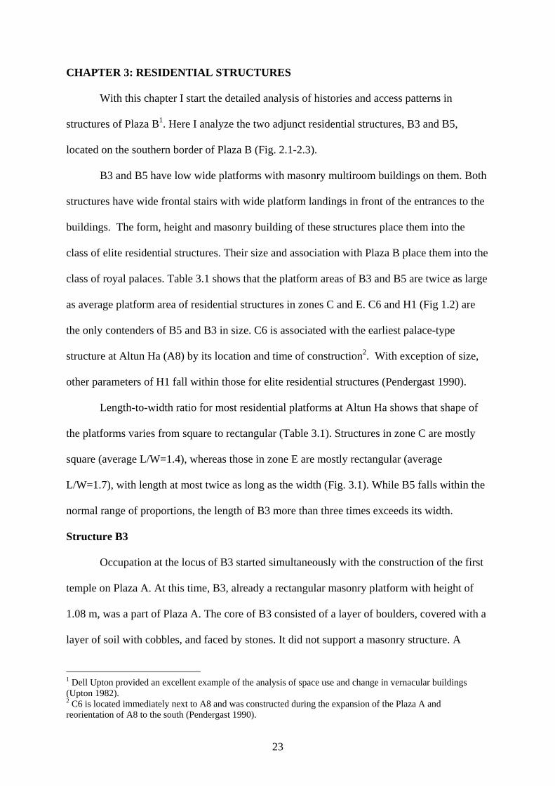
CHAPTER 3: RESIDENTIAL STRUCTURES
With this chapter I start the detailed analysis of histories and access patterns in
structures of Plaza B1. Here I analyze the two adjunct residential structures, B3 and B5,
located on the southern border of Plaza B (Fig. 2.1-2.3).
B3 and B5 have low wide platforms with masonry multiroom buildings on them. Both
structures have wide frontal stairs with wide platform landings in front of the entrances to the
buildings. The form, height and masonry building of these structures place them into the
class of elite residential structures. Their size and association with Plaza B place them into the
class of royal palaces. Table 3.1 shows that the platform areas of B3 and B5 are twice as large
as average platform area of residential structures in zones C and E. C6 and H1 (Fig 1.2) are
the only contenders of B5 and B3 in size. C6 is associated with the earliest palace-type
structure at Altun Ha (A8) by its location and time of construction2. With exception of size,
other parameters of H1 fall within those for elite residential structures (Pendergast 1990).
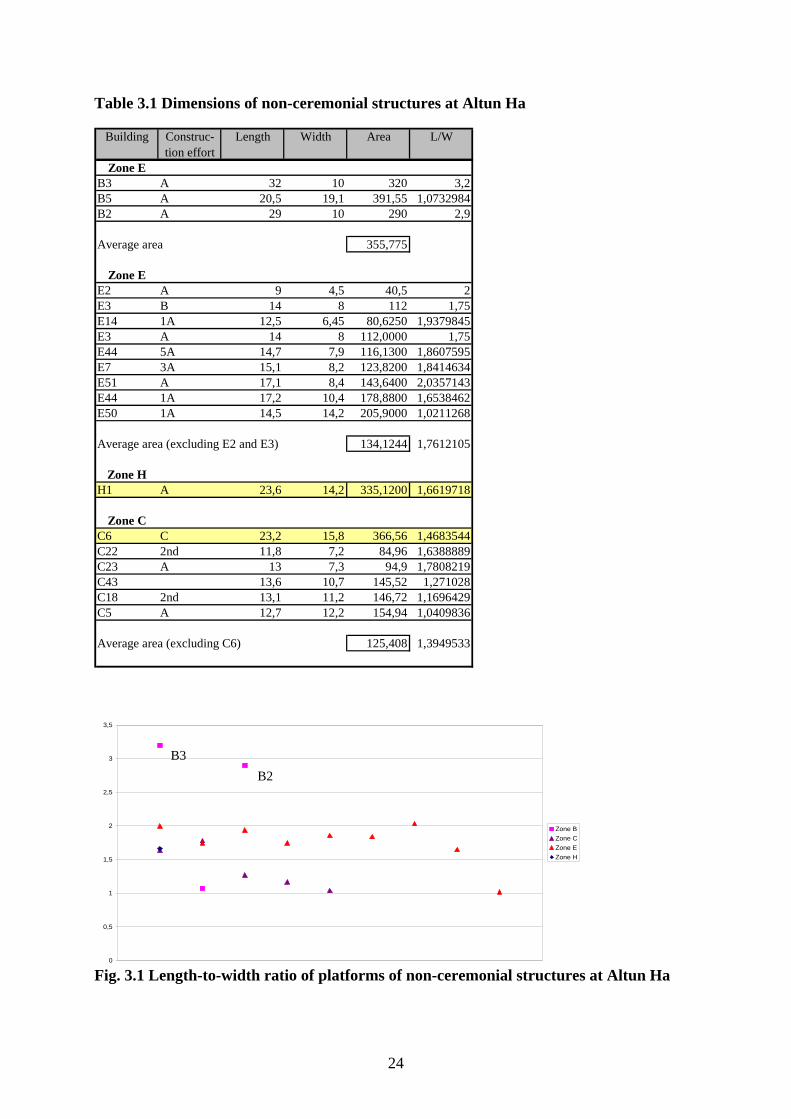
Length-to-width ratio for most residential platforms at Altun Ha shows that shape of
the platforms varies from square to rectangular (Table 3.1). Structures in zone C are mostly
square (average L/W=1.4), whereas those in zone E are mostly rectangular (average
L/W=1.7), with length at most twice as long as the width (Fig. 3.1). While B5 falls within the
normal range of proportions, the length of B3 more than three times exceeds its width.
Structure B3
Occupation at the locus of B3 started simultaneously with the construction of the first
temple on Plaza A. At this time, B3, already a rectangular masonry platform with height of
1.08 m, was a part of Plaza A. The core of B3 consisted of a layer of boulders, covered with a
layer of soil with cobbles, and faced by stones. It did not support a masonry structure. A
1 Dell Upton provided an excellent example of the analysis of space use and change in vernacular buildings (Upton 1982). 2 C6 is located immediately next to A8 and was constructed during the expansion of the Plaza A and reorientation of A8 to the south (Pendergast 1990).
24
Table 3.1 Dimensions of non-ceremonial structures at Altun Ha
Building Construc-tion effort
Length Width Area L/W
Zone EB3 A 32 10 320 3,2B5 A 20,5 19,1 391,55 1,0732984B2 A 29 10 290 2,9
Average area 355,775
Zone EE2 A 9 4,5 40,5 2E3 B 14 8 112 1,75E14 1A 12,5 6,45 80,6250 1,9379845E3 A 14 8 112,0000 1,75E44 5A 14,7 7,9 116,1300 1,8607595E7 3A 15,1 8,2 123,8200 1,8414634E51 A 17,1 8,4 143,6400 2,0357143E44 1A 17,2 10,4 178,8800 1,6538462E50 1A 14,5 14,2 205,9000 1,0211268
Average area (excluding E2 and E3) 134,1244 1,7612105
Zone HH1 A 23,6 14,2 335,1200 1,6619718
Zone CC6 C 23,2 15,8 366,56 1,4683544C22 2nd 11,8 7,2 84,96 1,6388889C23 A 13 7,3 94,9 1,7808219C43 13,6 10,7 145,52 1,271028C18 2nd 13,1 11,2 146,72 1,1696429C5 A 12,7 12,2 154,94 1,0409836
Average area (excluding C6) 125,408 1,3949533
0
0,5
1
1,5
2
2,5
3
3,5
Zone BZone CZone EZone H
Fig. 3.1 Length-to-width ratio of platforms of non-ceremonial structures at Altun Ha
B2 B3
25
posthole with remnants of a burnt wooden stub points at the existence of a perishable
structure atop.
The next modification of B3, 2nd came with major reflooring of the plaza around A. D.
400. The height of the new platform was only 76 cm. The platform had vertical walls. The
new rectangular platform of C13 that replaced the round structure around A. D. 450 also had
vertical walls. In contrast, the platform of B3 1A that has replaced the 2nd around A. D. 550
had an apron and basal mouldings, a common feature in B2, B6 and the building platform of
B4. B3 2nd and its contemporary A8 3rd were first non-ceremonial structures at the site
supporting masonry buildings (Pendergast 1982). A1-A8-A3 and B3 2nd demarcated the
southwestern border of the central plaza. (See Fig. 1.3b). Around the same period occupation
also started or resumed at the locus of B5 (see below).
The last construction effort expanded the platform and changed the orientation of the
primary axis of B3 by 7º so the structure started the formation of a second southern border
behind the temples of Plaza A that already acquired its final form. A new platform had a large
rear outset with different dimensions of apron and basal moulding (a feature repeated later in
B2). The platform of B3 carried a ‘tandem present/transverse present3’ symmetrical masonry
structure with tripartite layout of its eight rooms. It is difficult to say how many masonry
buildings at Altun Ha followed the symmetrical design since for the most of the buildings
only partial floor plans were available. However, only two of the excavated structures in
zones C, E and H had symmetrical plans. The variant with tandem room(s) and transverse
room(s) on one side was repeated more often.
Jessica Christie (2003) in her analysis of royal residences discovered that many
structures in prominent positions in royal compounds at Maya sites follow the same
3 Peter Harrison introduced classification of buildings according to the orientation of rooms after analysis if the buildings of the Central Acropolis in Tikal in 1971. He classified the rooms in these buildings into transverse rooms that ran perpendicular to the long axis of the building, and tandem rooms that were parallel to each other and run along long axis of the building. ‘Tandem present/transverse present’ structure is a structure that contains both tandem and transverse rooms (Christie 2003).
26
symmetrical tripartite layout, namely tandem room (rooms) flanked on both sides by
transverse room(s). This layout persists through the Preclassic, Classic and Postclassic periods.
Examples include the House of the Scribes at Copan (8 -2C), the Palace of the Governor at
Uxmal, structure L at Uaxactun, Codz Poop at Kabah, and structures at prominent positions in
the Central Acropolis at Tikal (Andrews 1975, Fig. 6:44, Fig. 6:45; Aveni and Hartung 1982,
Fig. 1.b:68; Christie 2003; Harrison 2004, Fig. 4.4: 104). Christie (2003) explains such
continuity by shared ideology of the Maya throughout the region. She connects the tripartite
layout of the palaces to the tripartite temple groups that signify the worlds of heaven, earth
and underworld. Tripartite palaces were sacred residences of kings whose blood made
‘Middleworld of earth …to flower and bear fruit’ (Freidel and Schele 1990). Their layout
conveyed this message to the public. Palaces carried both administrative and residential
functions. All rooms in the House of the Scribes at Copan were residential. An eastern side
room was used as a sleeping quarters, western side room as a wife’s residence and central
room as a head’s residence and administrative office (Christie 2003). Structure M7-35 at
Aguateca with an identical plan was also used as a residence-administrative structure with
side rooms functioning as storage and sleeping quarters (Inomata 2001). Formality in the
alignment and plan of the Palace of the Governor at Uxmal classifies it as a place of gathering
and ceremonies (Broda 1997, Kowalski 2003).
Often the central room in such structures featured a wide bench that sat opposite the
wide entrance so the one who sat on it saw everything happening in front of the structure and
was seen by many. Benches were thought to be the thrones. Thrones ‘seat a personage in a
symbolically elevated position at a higher level than those who are being received’ and set the
hierarchy of relationship between a visitor and host right from the beginning of the contact.
27
Thrones in prominent positions are present in many elite residential structures4 (Harrison
2001:78).
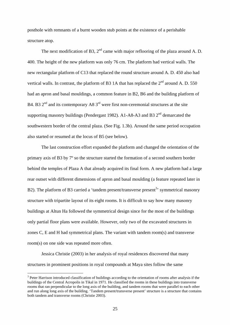
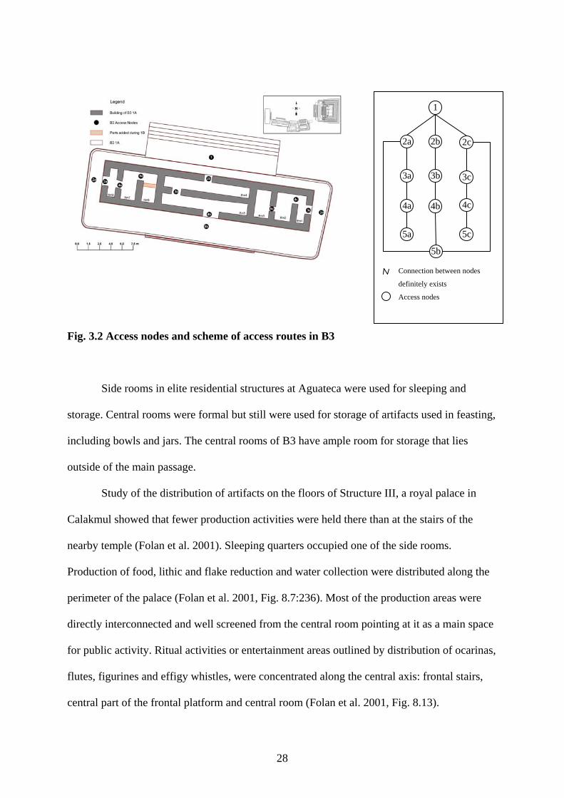
Unfortunately, layout and comparison to similar structures at other sites are our only
means of defining the functions of B3 since no record of artifact distribution except in
postabandonment period was found. Scheme of the access routes of B3 (Fig. 3.2) shows that
B3 had the perfectly symmetrical tripartite layout.
The space was divided into three separate parts that had no connection to each other
except at the initial levels. Each part had five levels with different degree of access. As the
level increased, the ease of degree of access to that level decreased. The side rooms had
separate entrances from those of the central rooms. They were screened from views of the
dwellers of Plaza B and from views of the site inhabitants. The innermost rooms were the
most difficult to reach. They were screened from entrances and as a consequence provided the
highest level of privacy. Most likely they were used for everyday household activities. Due to
the lack of light and fresh air (Pendergast 1982), Room 3 might have been used for storage.
Room 6, which also lacked the light and fresh air, had a small vent opening to Room 4 that
might have relieved the situation. Room 6 might have been used as sleeping quarters
(Pendergast 1982). Most of the Room 7 is observable from the entrance. Room 2, however, is
screened pointing at the different functions they carried.
The outside rooms (1 and 8) are twice as narrow as the rest of the side rooms. Having
a width of 1 m, they are not sufficient for an adult to stretch. They are unscreened from those
standing at the entrance and receive the most sunlight. They may have been used for different
household activities that required sunlight, for example, food production and stone tools
manufacture.
4 Thrones in elite residences were found at many Maya sites, including Aguateca (Inomata 2001), Tikal (Harrison 2001), Copan (Christie 2003), Tamarindito (Valdez 2001) and Caracol (Chase and Chase 2001).
28
Fig. 3.2 Access nodes and scheme of access routes in B3
Side rooms in elite residential structures at Aguateca were used for sleeping and
storage. Central rooms were formal but still were used for storage of artifacts used in feasting,
including bowls and jars. The central rooms of B3 have ample room for storage that lies
outside of the main passage.
Study of the distribution of artifacts on the floors of Structure III, a royal palace in
Calakmul showed that fewer production activities were held there than at the stairs of the
nearby temple (Folan et al. 2001). Sleeping quarters occupied one of the side rooms.
Production of food, lithic and flake reduction and water collection were distributed along the
perimeter of the palace (Folan et al. 2001, Fig. 8.7:236). Most of the production areas were
directly interconnected and well screened from the central room pointing at it as a main space
for public activity. Ritual activities or entertainment areas outlined by distribution of ocarinas,
flutes, figurines and effigy whistles, were concentrated along the central axis: frontal stairs,
central part of the frontal platform and central room (Folan et al. 2001, Fig. 8.13).
1
2a 2b 2c
3a 3b 3c
4a 4b 4c
5a
5b
5c
Connection between nodes
definitely exists
Access nodes
29
In B3 at Altun Ha, the spinewall dividing the central space screened the activities of
the rear side of the platform from activities happening on the frontal side. Thus frontal and
rear areas were designated to perform different functions. The rear area, although reachable
through the side routes, was screened from the side rooms. It would have been the most
private area of the structure had not it been open to the view of the rest of Altun Ha with the
closest dwellings, E62 and E 63, located within 40-50 m from B3 (Fig. 1.2). The slope at the
rear side of B3 was slight. Even a 2.5 m platform would not have been enough to screen the
rear side of B3. The frontal part of B3, with its broad landing, is more private because of the
restricted access to the Plaza B. From studies of residential houses of modern and ancient
Maya we know that internal patios of households bordered by residential and auxiliary
structures were used for different household activities. In some degree, Plaza B represented a
big patio bordered on all sides by structures, especially after A. D. 675 when B5 and B2
closed the southern and western borders and modifications to B6 strongly restricted the only
access on the southeast (it was narrowed from 16 to 6.5 meters). On the other hand, studies of
the palaces at Aguateca and Calakmul showed that the rear side of the palace was generally
use for household activities, food preparation and dining (Inomata 2001; Folan et al. 2001).
Ritual and administrative activities were conducted in the frontal part of the structures,
namely on the platform and in the central room. However, these structures differed from B3 in
that they had a wide frontal platform area (much wider than the rear one) and large central
room with a wide doorway. The rear of the palace at Aguateca was bounded by the wall. No
other residences were constructed nearby. Moreover, palace M7-35 at Aguateca was a
standalone structure with the frontal area facing a causeway (Inomata 2001, Fig 2.3:42,
2.4:44). The rear side of the palace at Calakmul where food preparation was conducted was
roofed and walled. The palace itself was located on the high platform that precluded any
30
observation of the activities on its top from the close distance (Folan et al. 2001, Fig. 8.2:228,
8.4:231, 8.6:233, 8.7:236).
The rear door of Room 4 of B3 was twice as wide as the door on the frontal side as
well as the available platform space that makes me think that the rear side of B3 may have
been used for public ceremonies. B3 does not have any stone benches. On the other hand,
benches were a frequent element at other Altun Ha residential structures and often served to
house burials. However, from paintings on burials, murals and lintels we know that wide
variety of thrones had been made of perishable materials (Harrison 2001). Thus the absence of
the throne at B3 does not mean that there was no throne but rather that it may have been
destroyed by time.
The domestic refuse that covered the floors in all rooms of B3 and formed a midden
along the platform edge was a sign of gradual breakdown of the power structure at Altun Ha
in the end of the Classic period and tells nothing about possible structure use (Pendergast
1982). Burials found in B3 were placed after the main occupants of the structure were gone
and pointed at the different ownership and use of structure at that time. Trashing was
especially extensive in the internal side rooms on the western side. The eastern and central
rooms were supposedly used for residence. Neighboring B5 was also occupied at this time.
The closeness of the two structures probably had an influence on the decision to use eastern
rooms as residence. No firm evidence exists about using B2 on the west as a residence.
Structure B5
B5 was a second residential structure of Plaza B5. The earliest traces of occupation,
floor surfaces, found at the locus of B5 were dated to 100 B. C. However, the existence of a
platform at this spot at this early time is ambiguous. The next episode of occupation consisted
of a floor surface with a rounded edge and a burial below it. The floor was laid around A. D.
5 For illustration of B5 see Pendergast (1982, Plate 4:271).
31
400, the time roughly simultaneous with the construction of the first masonry structure at the
locus of B3 and reorientation of A8, and was refloored several times. The last floor surface
had postholes, the first evidence of existence of a perishable construction at the locus. Around
the time of the last reflooring of the plaza, B5 locus was probably occupied. Excavations
revealed a fragment of a new plaster floor atop a core of small stones in white soil without
traces of perishable structure (Pendergast 1982).
B5 acquired its final form as a two-terraced platform with a masonry structure atop
(see Fig. 3.3) more than 150 years after the plaza B started its life as a residential plaza. B5,
although twice or thrice as large by area as other residential structures at Altun Ha, had a low
platform and was far less formal in plan than B3. Its length-to-width ratio falls within the
range of other residential structures of zone C. Although B5 had a tripartite ‘tandem
present/transverse present’ layout, the rooms were less defined, planning was more haphazard,
and symmetry was not the main goal of the builders (Fig. 3.3). Thus B5 was probably a
residential-only structure.
There are more questions than answers when one tries to define functions of separate
parts of the structure. As in B3, no data on distribution of artifacts and refuse from the main
period of occupation were reported, and postabandonment activity cannot be used to assume
patterns of the Classic use. While analyzing I had to make assumptions that are impossible to
confirm or deny. In case of B5, they were so many that I find it worthy to mention them here.
(1) On the south, the building of B5 had a low 55-65 cm wall6. (2) The platform behind the
southern wall, although not wide (w=50cm), provided enough opportunity for walking and
was used as a corridor. (3) The entrance at the south was added after the modifications during
B5 B construction effort (See below) and there is a high possibility that perishable walls
existed atop the southern wall at the time. (4) It is likely that Area 3 and Area 2 remained
6 Collapse debris show that southern wall was never high (Pendergast 1982). Upper part of the southern wall may have consisted from perishable material.
32
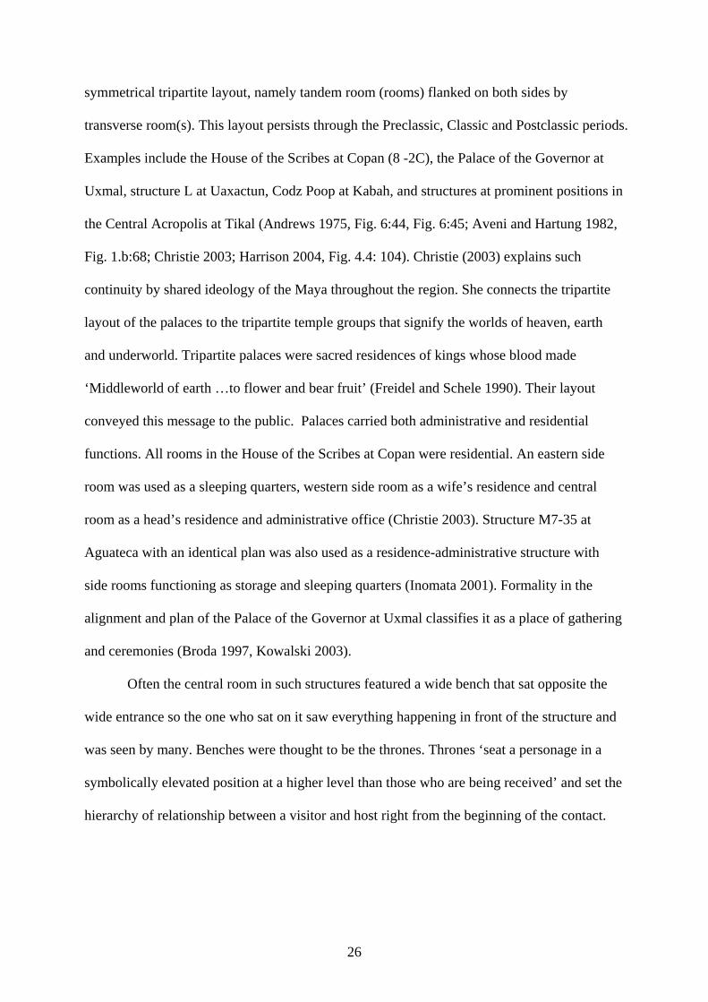
Fig. 3.3 Access nodes and scheme of access routes in B5 A
unroofed. There are remains of capped stones in Rooms 5, 6 and 7 showing that these rooms
had a stone vault atop them. Rooms 1-3 and 4 were capped by stones but later when
supporting walls were raised might have been covered by a timber roof (Pendergast 1982).
The access pattern in B5 was similar to that of B3 in that it branched into three
independent areas that had a common access point in Room 5. The area to the west comprised
Room 7 and the adjunct Area 3. The high 2.5 m wall screened the western area from the rest
of the structure at least at the extent of Room 7. Perishable walls might have existed where
Area 3 shared a border with Area 2. The presence of cordholders between Rooms 5 and 7
showed that the western part of the structure was screened from visitors (Pendergast 1982).
Room 7 on the western side is bordered by three square ‘columns’ which likely served as a
1
2
3a 3c 3b
4a 4c
5a 5b
6
Connection between nodes
definitely exists
Connection between nodes is
possible
Access nodes
4b
33
roof support. The width of the room was not enough (approximately 1.5 m) to be used as
sleeping quarters. It might have been used for storage and adjoining Area 3 for production
activities using the materials kept in the storage. The southern wall was high enough for the
one to climb upon. However, the wall was not high enough for one to hand some objects to a
person standing in Area 2.
Rooms 1-3 to the east could have been used for a variety of household activities. In
plan, they are similar to the side rooms of B3. However, Room 3, the farthest, largest and
most private of the three, was the most likely candidate for sleeping quarters. This function is
supported by a presence of a window for ventilation connecting Room 8 and Area 1
(Pendergast 1982).
Room 6, although was wide enough to serve for some activities, was likely used as a
corridor. Its entrances were located so that one who entered Room 6 had to walk across the
whole room in order to get to the other entrance. Room 6 with curtains on both entrances
double-screened Areas 1 and 2 from the entrance point. The southern wall, although low,
together with a 1.5 m platform was high enough to screen the activities in these areas from the
view of the site dwellers. Area 1 was covered with a roof and was shaded from sun and
protected from rain (Pendergast 1982). The purpose of the sunken area bordered by Areas 1
and 2 is unknown except that it held water at least at some periods of time7. I found no analog
to this feature in the literature.
The entrance and access to Room 4 were the most restricted (Pendergast 1982). A
sunken area with water was located immediately next to the entrance. Room 4 was large.
Most of it was unprotected from the views of those standing in Area 1 or 2. The association of
the sunken area with water and Room 4 may point to the ritual use of the both. Unfortunately
the room was not excavated during Pendergast’s project.
7 If the area was uncovered than sunken area was certainly filled with water during the rainy season.
34
The wide patio in front of the building (Area 4) was oriented inward. The plaza was
traditionally used for different household activities, at least for those appropriate to share with
visitors to the palace.
The single-effort modification to B5 changed access and circulation patterns within the
building (Fig. 3.4). The partition in Room 5 separated the structure into two unconnected
parts with opposite orientations. The western part, including Room 7, Area3 and Room 5a,
retained its orientation toward the Plaza B. The rest of the structure was sealed from the plaza
that necessitated the construction of the southern access. Study of a southern face of the
platform did not reveal any traces of an entrance. However, this absence does not preclude the
existence of a perishable ladder or steps (Pendergast 1982). Another argument for the
construction of a new entrance may be the partial filling of a sunken area. The area was
important enough to keep its form and the relationship between it and Room 4 entrance which
my opinion serves as confirmation to the ritual use of Room 4 and the sunken area. However,
the width of the filling was enough to provide the space for construction of a ladder on the
other side of the wall. The possible reason for keeping the wall intact might have been
screening of the private areas of B5 from outside activities. Areas 1 and 2 required no more
screening from the building entrance. The cutting of the central door in the southern wall of
Room 6 created the cul-de-sac in the western part of the room suitable for sleeping, assuming
the curtain was used to cover the old door. Room 5b was a throughway to the Room 8. The
modification of the Room 8 removed the inside walls pointing that its possible use may have
been changed from several distinct activities in B5 A made possible by partitions to some
common unified activity8.
8 A mass of refuse with average thickness of 55 cm had been spread in the Room 8 at some point between A. D. 725-750. The volume and nature of refuse suggest that it was not merely occupational but reminds those of in structure core (Pendergast 1982:27-28).
35
Fig. 3.4 Access nodes and scheme of access routes in B5 B
The radical modifications to B5 were completed with minimum effort but retained as
much activity and space separated from B3 and the rest of Plaza B for the dwellers of B5 as
possible. It very likely, that a perishable wall was built upon the southern wall of B5 at the
time of B5 B modifications to cut away the connections with B3. The wall in Room 5 not
only sealed the main access to the plaza, but also cut away the joined space of Room 7 and
Area 3. The difference between heights of the platforms the B3 and B5 was about 80 cm, with
B5 being the lower. The height of the walls supporting the roof above Room 7 was around 2.4
-2.5 m. Thus, for those standing at the platform of B3, the roof of B5 was at the height of 1.6 -
1.7 meters. Therefore, Room 7 was accessible for the residents of B3 and possibly used
jointly for some activities. Postabandonment use of B3, with the eastern portion bordering
4
3
2
1 5’
2’b
4’
3’
2’c 2’a
1’
Connection between nodes
definitely exists
Connection between nodes
possible
Access nodes
36
with B5 as a residence and western portion as a dump, indirectly supports this hypothesis.
Other indirect evidence of mutual use of Area 3 and Room 7 comes from B5. During the
postabandonment use, Room 5 was trashed more than other rooms of the structure. On the
other hand, Room 7 was not trashed at all (Pendergast 1982). Room 5 provided an entrance
form the plaza side to the Room 7 and evidently stopped being used as such when the shorter
access ‘platform of B3-Room 7’ was available.
The modifications of B5 B indirectly point at the split between the residents of two
structures between A. D. 675-700 (Pendergast 1982). This time coincides with the changes in
pattern of modifications of B4 and changes in the artifactual content of its tombs (see below).
The use of B5 after that event continued for a century at most. The structure was gradually
trashed and abandoned while the construction at the Plaza B was still underway that pinpoints
the residents of B3 as the authors of the late modifications of Plaza B and to the split and
further disposition of the residents of B5 from the plaza.
37
CHAPTER 4: FUNERARY SHRINE
Ancestors played active role in Maya society. They were main protagonists in the
creation of the world. They helped in mundane life and decided outcomes of battles (Freidel
et al. 1993). They defined a social position of a person in Maya society (McAnany 1995).
Maya generally buried their dead under floors of residential structures. Persons of
special importance had their own shrines. Ancestral shrines were found on many residential
plazas, both rich and poor. Some shrines were small low platforms in the middle of residential
plazas. For example, the modest platform in the middle of the Late Classic elite residential
patio at the site of Blue Creek capped an Early Classic tomb of a male with rich offerings
(Guderjan et al. 2003). Other shrines were tall pyramidal platforms. Some of them were
erected on empty spots, such as several of the Twin-Pyramid Complexes at Tikal. Others were
former ceremonial structures later turned into ancestral shrines as in case of B4 at Altun Ha or
Zopilote group at Cahal Pech (Healy et al. 2004a). David Cheetham (2004) considers funerary
temples as a mark of kingship institution. The transformation of temples, dedicated to the
Gods into places of entombment of rulers in the end of the Late Preclassic was a mark of
transformation of the rulers from mediators between Gods and people into divine beings,
Gods themselves.
Elite funerary shrines could form a part of a ceremonial group, be a standalone
structure, or form a part of residential plaza (Ashmore 1991; Cheetham 2004). When included
within residential plazas, these structures usually occupied eastern or northern side of the
plaza1.
Structure B4, a tallest ceremonial structure at Altun Ha stood on the eastern border of
Plaza B2 (Pendergast 1982). The first structure appeared at the spot around A. D. 500
1 For example, funerary shrine of Caana Palace in Caracol (Chase and Chase 2001) stood at the north side. Funerary shrines in Bedran Group (Conlon and Powis 2004), Pacbitun (Healy et al. 2004b) and Group II of Baking Pot (Willy et al. 2005) occupied the eastern borders of the plazas. 2 For illustration of B4 see Pendergast (1982, Plate 14, 15:277).
38
sometime before or at the time when Plaza A was acquiring its final shape. With height of
17-17.5 m it marked the southeastern corner of the Central Precinct and probably formed a
single complex with Plaza A (Fig. 1.3c). While little is known about the shape of the first
structure, it initiated the succession of round altars atop further modifications of B4, the
tradition constricted to B4 at Altun Ha and found nowhere outside of the site. The height of
the structure, the restricted space at its summit and the altar with traces of ritual activity
classified this structure as ceremonial. As a ceremonial structure, B4 was inscribed into Maya
sacred geography and followed its laws.
In Maya worldview, the world was alive and imbued with sacred energy. Although, it
was present everywhere, some entities, for example, mountains and caves, served as points of
concentration. When people constructed pyramidal platforms, they created artificial points of
concentration. Temple buildings atop of these platforms were portals. Opened by a ritual,
these portals established the connections between Gods and humans by means of which
humans served Gods and Gods protected them (Freidel and Schele 1990, Freidel et al. 1993).
Altars, found at many Classic Maya sites and in modern Maya villages, were another form of
portals. B4 was a variation of a more typical temple-on-the-platform variant with altar
replacing the temple.
Around A. D. 550, with renovation of B3 and erection of the new shrine of B6 to the
east of it, the complete reconstruction of B4 occurred. 2A reconstruction turned B4 into the
funerary shrine of the rulers of Altun Ha. It was the only time in the history of B4 when the
structure was rebuilt completely. The following construction efforts concentrated on the front
and the summit of the structure. The renovated B4 had a six-terraced platform (Fig B.3), like
that of F8, the earliest pyramidal funerary shrine at Altun Ha. The subsidiary platform at the
base of B4 that supported the two-chambered multidoor building encroached significantly on
Plaza B from the east.
39
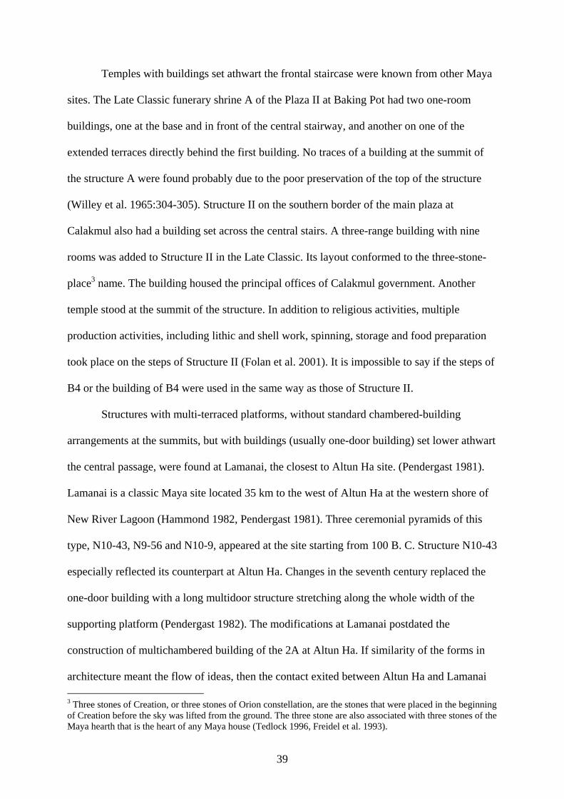
Temples with buildings set athwart the frontal staircase were known from other Maya
sites. The Late Classic funerary shrine A of the Plaza II at Baking Pot had two one-room
buildings, one at the base and in front of the central stairway, and another on one of the
extended terraces directly behind the first building. No traces of a building at the summit of
the structure A were found probably due to the poor preservation of the top of the structure
(Willey et al. 1965:304-305). Structure II on the southern border of the main plaza at
Calakmul also had a building set across the central stairs. A three-range building with nine
rooms was added to Structure II in the Late Classic. Its layout conformed to the three-stone-
place3 name. The building housed the principal offices of Calakmul government. Another
temple stood at the summit of the structure. In addition to religious activities, multiple
production activities, including lithic and shell work, spinning, storage and food preparation
took place on the steps of Structure II (Folan et al. 2001). It is impossible to say if the steps of
B4 or the building of B4 were used in the same way as those of Structure II.
Structures with multi-terraced platforms, without standard chambered-building
arrangements at the summits, but with buildings (usually one-door building) set lower athwart
the central passage, were found at Lamanai, the closest to Altun Ha site. (Pendergast 1981).
Lamanai is a classic Maya site located 35 km to the west of Altun Ha at the western shore of
New River Lagoon (Hammond 1982, Pendergast 1981). Three ceremonial pyramids of this
type, N10-43, N9-56 and N10-9, appeared at the site starting from 100 B. C. Structure N10-43
especially reflected its counterpart at Altun Ha. Changes in the seventh century replaced the
one-door building with a long multidoor structure stretching along the whole width of the
supporting platform (Pendergast 1982). The modifications at Lamanai postdated the
construction of multichambered building of the 2A at Altun Ha. If similarity of the forms in
architecture meant the flow of ideas, then the contact exited between Altun Ha and Lamanai 3 Three stones of Creation, or three stones of Orion constellation, are the stones that were placed in the beginning of Creation before the sky was lifted from the ground. The three stone are also associated with three stones of the Maya hearth that is the heart of any Maya house (Tedlock 1996, Freidel et al. 1993).
40
at least between A. D. 550-800, the time of formation and decline of a powerful ruling lineage
at Altun Ha.
In contrast to Altun Ha, Lamanai structures did not have a masonry altar. The
building at Lamanai sat on one of the lower terraces of the pyramidal platform, whereas at
Altun Ha the building occupied the separate platform (Pendergast 1981. Fig. 4:35, 5:35, 12:41,
13:41, 14:44).
At Lamanai, the structures occupied different locations. N10-43 formed the northern
border of a plaza which also had a ballcourt in the center. N10-9 was a standalone structure at
the southernmost point of the site. N9-56 formed the eastern border of the plaza just on the
edge of the waterfront (Pendergast 1981, Fig. 1:30). Neither N10-43 nor N10-9 contained
burials. N9-56 on the contrary, yielded two early Late Classic (A. D. 500-600) elite burials,
placed under the frontal stairs of the structure (Pendergast 1981, Fig.3:33). The different
locations and, presence of burials in one structure and absence of them in another, point at
different use of the structures at Lamanai. However both at Lamanai and Altun Ha, the
prominent Lamanai-type structure located on the eastern border of the residential plaza, was
used as a funerary shrine. Like B4, the structures at Lamanai experienced only frontal
modifications.
The small stair block on the lower staircase of B4 2A was adorned with a mask that
was similar to the masks of A3 and A8 (Pendergast 1982), possibly identifying the ‘owner’ of
the structure. Tomb of an important individual placed inside the new structure yielded another
sign, a giant carved jade head (d= 45.9 cm, h=14.9 cm) of the Sun God.
Before construction of the building, the builders dug a deep pit in the center of the
building platform. On the bottom of the pit were traces of charcoal. Later the pit was filled
with dark
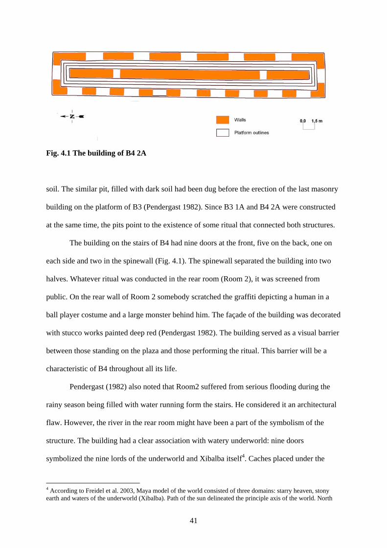
41
Fig. 4.1 The building of B4 2A
soil. The similar pit, filled with dark soil had been dug before the erection of the last masonry
building on the platform of B3 (Pendergast 1982). Since B3 1A and B4 2A were constructed
at the same time, the pits point to the existence of some ritual that connected both structures.
The building on the stairs of B4 had nine doors at the front, five on the back, one on
each side and two in the spinewall (Fig. 4.1). The spinewall separated the building into two
halves. Whatever ritual was conducted in the rear room (Room 2), it was screened from
public. On the rear wall of Room 2 somebody scratched the graffiti depicting a human in a
ball player costume and a large monster behind him. The façade of the building was decorated
with stucco works painted deep red (Pendergast 1982). The building served as a visual barrier
between those standing on the plaza and those performing the ritual. This barrier will be a
characteristic of B4 throughout all its life.
Pendergast (1982) also noted that Room2 suffered from serious flooding during the
rainy season being filled with water running form the stairs. He considered it an architectural
flaw. However, the river in the rear room might have been a part of the symbolism of the
structure. The building had a clear association with watery underworld: nine doors
symbolized the nine lords of the underworld and Xibalba itself4. Caches placed under the
4 According to Freidel et al. 2003, Maya model of the world consisted of three domains: starry heaven, stony earth and waters of the underworld (Xibalba). Path of the sun delineated the principle axis of the world. North
42
building before its construction contained ‘marine objects’, including jade, shell and pearls
(Table 5.2). The building got periodically flooded.
One of the central stories of Maya mythology is a story of Hero Twins who defeated
the Lords of the Underworld. In this story the Twins were called by the Nine Lords of Xibalba
to play a ball game. Although the Twins won, Lords of the Underworld killed them, grinded
their bones into flour and spilled it into a river, but on the fifth day the Twins appeared alive
in the waters of the river as a catfish. Next day they took a human form again. They returned
to Xibalban Lords again and through deception killed them, freeing the human world from
their evil power (Tedlock 1996). Building with nine-frontal doors, ballplayer on the wall, and
‘river’ in the rear room with five doors gives many coincidences to that story.
Although the frontal part of the building provided ample opportunity for the choice of
a route, the spinewall restricted this choice and re-routed one to the one of the side passages
of the structure. This pattern will be reinforced in almost all further modifications. After
entering into the one of the spinewall doors, one became invisible for the public and
reappeared only after walking half the length of the upper staircase (Pendergast 1982). It was
another feature that has remained unchanged throughout the life of the structure.
The upper staircase supported a massive central stair block, the place of rest of the
first Altun Ha ruler connected with the Sun God symbol. The stairs culminated to a wide
platform with a masonry altar atop.
The modifications of 2B left the shape of the structure untouched. However, the
access patterns and the embellishments were changed. Around A. D. 600, the new door, cut in
the center of the spinewall provided the straight, easily observable route to the top of the
structure (Fig. B.4). Addition of the new outsets and new central stair blocks, larger than the
was a ‘side of heaven’ (Freidel and Schele 1990) and North Star was the place where axis of Heaven passed. Heaven rotated around this axis. North-South and East-West axes crossed at the center forming the quincunx pattern: four points at the cardinal directions and one point in the center. The axis Wakah Chan (‘Six Sky’, ‘Raised-up-Sky’, World Tree of the Center) ran through the center and through all three worlds.
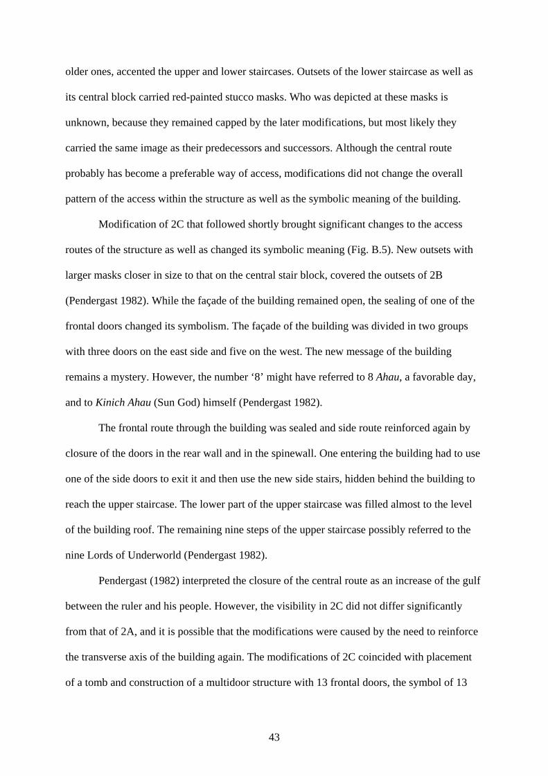
43
older ones, accented the upper and lower staircases. Outsets of the lower staircase as well as
its central block carried red-painted stucco masks. Who was depicted at these masks is
unknown, because they remained capped by the later modifications, but most likely they
carried the same image as their predecessors and successors. Although the central route
probably has become a preferable way of access, modifications did not change the overall
pattern of the access within the structure as well as the symbolic meaning of the building.
Modification of 2C that followed shortly brought significant changes to the access
routes of the structure as well as changed its symbolic meaning (Fig. B.5). New outsets with
larger masks closer in size to that on the central stair block, covered the outsets of 2B
(Pendergast 1982). While the façade of the building remained open, the sealing of one of the
frontal doors changed its symbolism. The façade of the building was divided in two groups
with three doors on the east side and five on the west. The new message of the building
remains a mystery. However, the number ‘8’ might have referred to 8 Ahau, a favorable day,
and to Kinich Ahau (Sun God) himself (Pendergast 1982).
The frontal route through the building was sealed and side route reinforced again by
closure of the doors in the rear wall and in the spinewall. One entering the building had to use
one of the side doors to exit it and then use the new side stairs, hidden behind the building to
reach the upper staircase. The lower part of the upper staircase was filled almost to the level
of the building roof. The remaining nine steps of the upper staircase possibly referred to the
nine Lords of Underworld (Pendergast 1982).
Pendergast (1982) interpreted the closure of the central route as an increase of the gulf
between the ruler and his people. However, the visibility in 2C did not differ significantly
from that of 2A, and it is possible that the modifications were caused by the need to reinforce
the transverse axis of the building again. The modifications of 2C coincided with placement
of a tomb and construction of a multidoor structure with 13 frontal doors, the symbol of 13
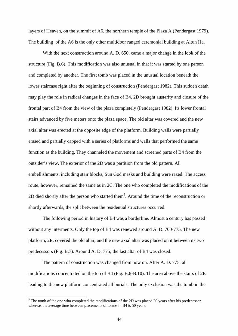
44
layers of Heaven, on the summit of A6, the northern temple of the Plaza A (Pendergast 1979).
The building of the A6 is the only other multidoor ranged ceremonial building at Altun Ha.
With the next construction around A. D. 650, came a major change in the look of the
structure (Fig. B.6). This modification was also unusual in that it was started by one person
and completed by another. The first tomb was placed in the unusual location beneath the
lower staircase right after the beginning of construction (Pendergast 1982). This sudden death
may play the role in radical changes in the face of B4. 2D brought austerity and closure of the
frontal part of B4 from the view of the plaza completely (Pendergast 1982). Its lower frontal
stairs advanced by five meters onto the plaza space. The old altar was covered and the new
axial altar was erected at the opposite edge of the platform. Building walls were partially
erased and partially capped with a series of platforms and walls that performed the same
function as the building. They channeled the movement and screened parts of B4 from the
outsider’s view. The exterior of the 2D was a partition from the old pattern. All
embellishments, including stair blocks, Sun God masks and building were razed. The access
route, however, remained the same as in 2C. The one who completed the modifications of the
2D died shortly after the person who started them5. Around the time of the reconstruction or
shortly afterwards, the split between the residential structures occurred.
The following period in history of B4 was a borderline. Almost a century has passed
without any interments. Only the top of B4 was renewed around A. D. 700-775. The new
platform, 2E, covered the old altar, and the new axial altar was placed on it between its two
predecessors (Fig. B.7). Around A. D. 775, the last altar of B4 was closed.
The pattern of construction was changed from now on. After A. D. 775, all
modifications concentrated on the top of B4 (Fig. B.8-B.10). The area above the stairs of 2E
leading to the new platform concentrated all burials. The only exclusion was the tomb in the
5 The tomb of the one who completed the modifications of the 2D was placed 20 years after his predecessor, whereas the average time between placements of tombs in B4 is 50 years.
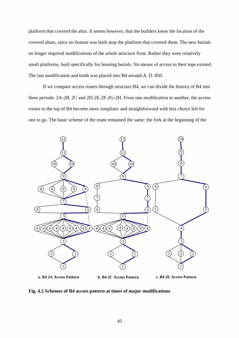
45
platform that covered the altar. It seems however, that the builders knew the location of the
covered altars, since no feature was built atop the platform that covered them. The new burials
no longer required modifications of the whole structure front. Rather they were relatively
small platforms, built specifically for housing burials. No means of access to their tops existed.
The last modification and tomb was placed into B4 around A. D. 850.
If we compare access routes through structure B4, we can divide the history of B4 into
three periods: 2A-2B, 2C and 2D-2E-2F-2G-2H. From one modification to another, the access
routes to the top of B4 become more simplistic and straightforward with less choice left for
one to go. The basic scheme of the route remained the same: the fork at the beginning of the
Fig. 4.2 Schemes of B4 access pattern at times of major modifications
1
2 2
3
4
5 5
7
8
6
9
10
c. B4 2E Access Pattern
6
2
1
2 2
3
4 4 4 4 4 4 4 4
5 6 6
8 8
9
10 10
7
11
12
b. B4 2C Access Pattern
7
1
2 2
3
4 4 4 4 4 4 4 4 4
5 6 6
8 8 8 8 8
9
10 10
7
11
12
a. B4 2A Access Pattern
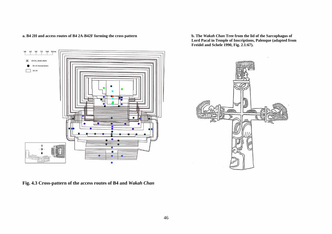
46
a. B4 2H and access routes of B4 2A-B42F forming the cross pattern b. The Wakah Chan Tree from the lid of the Sarcophagus of Lord Pacal in Temple of Inscriptions, Palenque (adapted from Freidel and Schele 1990, Fig. 2.1:67).
Fig. 4.3 Cross-pattern of the access routes of B4 and Wakah Chan
47
route, the large fork at the middle (in the building of 2A, 2B and 2C, or around the platform to
the side stairs in 2E, 2F, 2G, 2H) and then depending on the existence of the outset or platform
landing, fork or straight route to the altar.
The permanent elements of the route, fork on the lower stairs, large fork near the center
and straight route to the top, form a cross-like shape on the on the frontal stairs of B4 (Fig. 4.3).
The cross was a persistent image in Maya ideology. It was one of the forms of Wakah Chan, the
world tree. The Wakah Chan is represented on the sky by Milky Way (Freidel et al. 1993). The
cross on the stairs of B4 was oriented east-west. Milky Way is in its east-west position is a
Cosmic Monster, a canoe that ‘brings the Maize God to the place of three stones of creation so
that he can be reborn and create the new universe’ (Freidel et al. 1993:92). Stucco decoration on
the building of B4 2A bore K’an cross symbol that marks the spot of rebirth and creation (Freidel
et al. 1993).
On the other hand, the Wakah-Chan was also a source of life, a maize plant, the Maize
God himself. The Maize God was the central figure in Maya mythology, the First Father and the
father of the Hero Twins. According to the myth, the Maize god and his brother were killed by
the Lords of Xibalba, after suffering defeat in the ball game. The Hero Twins, his sons, killed the
Lords of Xibalba, exhumed the bones of their father and resurrected him.
‘This ever-changing reciprocity and tension between transformation and replacement – the child giving birth to a parent – between regeneration and sacrifice, between the king and his successor, lie at the heart of imagery of the Foliated Cross and the Myth of Maize God’.
Freidel et al. 1993:285
B4 as an ancestral shrine symbolized the close connection between fathers and sons,
between ancestors and descendants, between the dead and the living in Maya world (Freidel et al.
1993, Tedlock 1996).
48
CHAPTER 5: CACHES AND BURIALS OF B4
Burials
Function of a structure can be defined not only looking at its form but also looking at
the pattern of placement and content of burials and caches it contained. Alberto Ruz (1965) in
his overview of the Maya burials noted that Maya used all known ways of interring the dead,
including simple, cyst, tomb, chamber and vault burials, single and multiple; under houses, in
special structures, in caves, jars and chultuns, in cemeteries and in middens. Everything
depended on local customs, available material, space and function of a burial.
Altun Ha demonstrated a variety of them. In most residential structures burials were
simple, mixed in age and sex and varied in location, orientation, artifact content and quality
(Pendergast 1982, Pendergast 1990). Some structures, otherwise classified as residential, were
unusual in number of burials. For example, H1 had a very high concentration of burials for its
lifetime span and was classified as a residential–administrative structure. C10, otherwise
similar to residential structures, served as a children cemetery (Pendergast 1982). On the other
side were the enormous temples built especially for housing several lustrous burials, and
structures with burials as offerings.
Plaza B represented two extremes. On one hand were the simple burial under B6 and
the interments of the postabandonment period, on the other were the rich tombs of B4. A
significant time span separates the burials and the tombs making the comparison between
them impossible. Moreover, little information is available about the nature of occupation of
the structures that housed simple burials (Pendergast 1982).
All seven tombs of B4 represent a continuous 350-year record of burial practices that
started after A. D. 550, with the last resurfacing and remodeling of the plaza. Tombs are rare
at Altun Ha. The only other tombs at the site are found in structures A6 and E1. Structure E1,
49
a low platform that served as a funerary shrine housed the only female tomb found at the site
(Pendergast 1990:22).
Most of the tombs appeared at and after the time of major reconstruction of Plaza B.
All tombs were oriented north-south (with head of the interred to the south) and aligned
perpendicular to the building axis. All burials, except for B4/4, were axial.
The burials with similar orientation were found at other funerary shrines on other
Maya sites. For example, twelve simple and cist burials of the funerary shrine of Bedran
group lied perpendicular to the primary axis of the pyramid, with heads south in chronological
progression from the top (A. D. 650-700) to the bottom (A. D. 800-900) in frontal stairs of the
pyramid (Conlon and Powis 2004). Most of the burials of the funerary shrine of Plaza II at
Baking pot were extended and lied with heads south (Willey et al. 1965). The burial in
Zopilote at Cahal Pech housed an extended male burial placed axially head south under the
structure frontal stairs (Cheetham 2004).
The tomb in A1 1st C, placed around A. D. 500, was the first tomb at the site as well as
the first burial in the Central Precinct placed perpendicular to the building axis. All the
preceding interments in stairs the structures of plaza A were oriented east-west. The
appearance of the practice of tomb placement may serve as another evidence for emergence of
a new ruling power at Altun Ha. High quantity of interments (three) for a short period of 20
years points to the violence that accompanied the process. One of the possible causes of so
many deaths may have been participation in a war that provided the existing ruling dynasty its
prestige and riches. The first three tombs of B4 were the richest on the site in exotic goods,
especially in jade and pyrite.
There are two distinct periods of tomb placement at B4 that coincide with the change
in construction pattern of B4 occurred in the seventh century. The initial period, A. D. 550-
670, was a period of residential expansion, major modifications of B4 and rich tombs. The
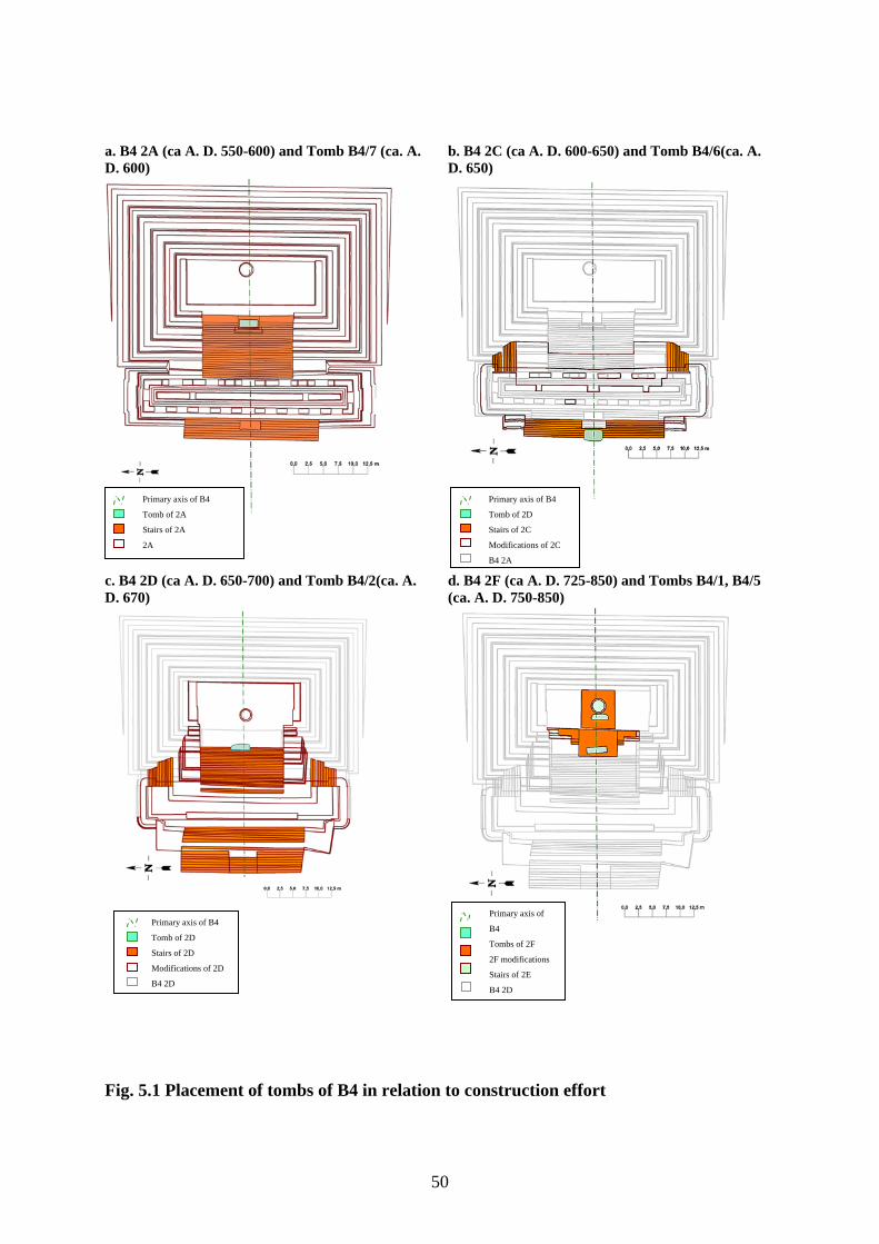
50
a. B4 2A (ca A. D. 550-600) and Tomb B4/7 (ca. A. D. 600)
b. B4 2C (ca A. D. 600-650) and Tomb B4/6(ca. A. D. 650)
c. B4 2D (ca A. D. 650-700) and Tomb B4/2(ca. A. D. 670)
d. B4 2F (ca A. D. 725-850) and Tombs B4/1, B4/5 (ca. A. D. 750-850)
Fig. 5.1 Placement of tombs of B4 in relation to construction effort
Primary axis of B4
Tomb of 2A
Stairs of 2A
2A
Primary axis of
B4
Tombs of 2F
2F modifications
Stairs of 2E
B4 2D
Primary axis of B4
Tomb of 2D
Stairs of 2D
Modifications of 2D
B4 2D
Primary axis of B4
Tomb of 2D
Stairs of 2C
Modifications of 2C
B4 2A
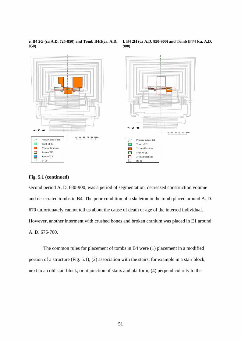
51
e. B4 2G (ca A.D. 725-850) and Tomb B4/3(ca. A.D. 850)
f. B4 2H (ca A.D. 850-900) and Tomb B4/4 (ca. A.D. 900)
Fig. 5.1 (continued)
second period A. D. 680-900, was a period of segmentation, decreased construction volume
and desecrated tombs in B4. The poor condition of a skeleton in the tomb placed around A. D.
670 unfortunately cannot tell us about the cause of death or age of the interred individual.
However, another interment with crushed bones and broken cranium was placed in E1 around
A. D. 675-700.
The common rules for placement of tombs in B4 were (1) placement in a modified
portion of a structure (Fig. 5.1), (2) association with the stairs, for example in a stair block,
next to an old stair block, or at junction of stairs and platform, (4) perpendicularity to the
Primary axis of B4
Tomb of 2H
2H modifications
Steps of 2E
2F modifications
B4 2F
Primary axis of B4
Tomb of 2G
2G modifications
Steps of 2E
Steps of 2 F
B4 2F
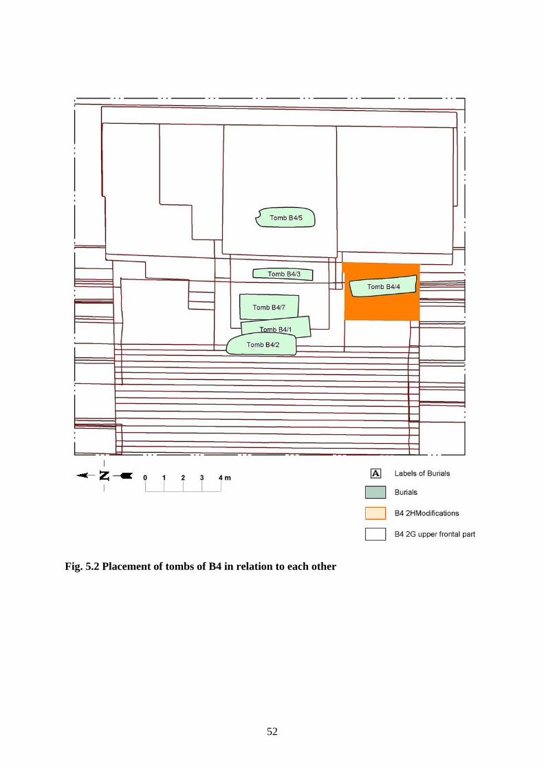
52
Fig. 5.2 Placement of tombs of B4 in relation to each other
53
building axis1 (north-south orientation with head south), (3) axial location, and (4) location in
the upper part of the structure (Fig. 5.1, 5.2).
The tombs followed most of the rules. However, there were exceptions. For example,
Tomb B4/2 of B4 2D (Fig. 5.1b) was located in the lower staircase of B4, next to the stair
block with Sun God masks on it. However, the tomb construction indicates that it was made
hastily because of the sudden death of the person (Pendergast 1982). The changes that
preceded the tomb placement were those of B4 2C. The works on 2D just started and did not
provide the space for the placement of a tomb. During B4 2C only the renovated lower
staircase of B4 provided the opportunity for the axial tomb placement. Another reason for
tomb location may have been the Sun God image, the deity associated with the ruler of Altun
Ha.
2E signalized the beginning of the new burial practices at B4. The tombs of the second
period (A. D 700–800) at the first glance seem to break the rule of association with the stairs.
The tombs, B4/1 (Fig. 5.1d), B4/3 (Fig. 5.1e) and B4/4 (Fig. 5.1f), were located in small
platform units. However, all platform units were placed above the stairs of 2E as if people that
presided over B4 tried to create their own sacred space2.
Tomb B4/4 (Fig. 5.1f) although violated the rule of axial placement was placed above
the stairs of the 2E and above the stairs leading to the platform of the 2F on the south side of
1 All tombs in B4 as well as all tombs on the site were oriented north-south with one exception. Tomb A5/1 in A6 B, placed in a stair block and oriented east-west, seemingly broke the tradition of north-south orientation for the tombs (Pendergast 1979). However, if we assume, that motivation for tomb orientation was not the cardinal direction but the building itself then the rule remains unbroken: all tombs are oriented perpendicular to the primary axis of the building. Tombs in Structure 2 of Bedran Group (Conlon and Powis 2004) were placed perpendicular to the primary axis; tombs in Zopilote at Cahal Pech (Cheetham 2004) were also placed perpendicular to the primary axis of the building in the frontal stairs. If we look at the image on the lid of the sarcophagus of king Pacal of Palenque we will see that Pacal is depicted lying at the base of the Wakah Chan perpendicular to it. The moment depicted on the lid is the moment of his death, the moment “he enters the road” to the otherworld (Freidel 1993:77. Fig. 2:12). If frontal stairs of a structure represented the stalk of Wakah Chan then kings were buried at the base of it and in the position depicted on the sarcophagus – perpendicular to the stalk. 2 2E marked a major change in construction patterns in B4. It also renewed the altar thus creating a new sacred space.
54
the platform of the 2F. The preference for the south side in orientation of the bodies seemed to
play a role in the choice of location for Tomb B4/4.
Another exception, Tomb B4/5, was special. Placed next to the new altar, it claimed
the sacred space for the new sequence of the tombs in B4.
Between A. D. 550-675 burials contained truly grand offerings. Unfortunately, they
cannot be compared with the offerings in later tombs and correlated with the subsidence of
construction volume because all later tombs were desecrated, and artifacts and most of the
bones were removed.
Caches
‘…places and things made by the gods during Creation were imbued with sacred force and an inner soul from the beginning of time. In contrast, places, buildings, and objects made by human beings had to have their inner souls put in them, during dedication ceremonies. As long as people used these objects this power was safe…but when an object was no longer to be used, this living force could become dangerous. It had to be contained or released in special termination rituals.’
Freidel et al. 1993:244
Dedicatory offerings brought the holy soul-force into buildings. They were necessary
for opening of portals to the Otherworld and establishment of the reciprocal connection
between people and the gods. The soul force in god-made objects, including people, animals
and mountains, flowed in body fluids, rain, lava, incense smoke and other liquids. The soul
force of a human-made structure was a ‘hard’ liquid, for example objects from the sea (shell,
bones of sea creatures, coral), obsidian, the frozen fluid of the earth, and jade, washed from
underground by rivers3. These soul-bringing substances were placed in caches at Altun Ha.
James Garber in his examination of material culture at Blackman Eddy demonstrated
how the practice of cache placement developed from the rituals of feasting. The earliest
caches (900-600 B. C.), depressions in bedrock, were filled with remains of feasting. Marine
and freshwater shells, lithic debitage, faunal remains, and later greenstone and smashed 3 Maya quarried only jade found in rivers (Harlow 1993). Water was also the environment associated with resurrection of the Hero Twins (Tedlock 1996), and Maize God (Freidel et al. 1993).
55
ceramics were placed in caches dedicated to the completion of a construction of a ceremonial
structure. In the Late Formative (700-350 B. C.) with change in the form of platform from
oval to rectangular the dedicatory axial caches with whole ceramic vessels appeared (Garber
et al. 2004).
In general, there are two types of dedicatory caches: those dedicated to the new
constructions and those dedicated to the end of use of a structure, or termination offerings. A
termination offering released a soul of the building that was no longer in use. Termination
offerings were often smashed and scattered, sometimes burned. I find similar description of
offerings given to Xibalban lords after their defeat by the Hero Twins:
‘the gifts you will receive will no longer be great …just griddles, just gourds, just brittle things broken in pieces’
Tedlock 1996:138
James Garber (1983) analyzing jade consumption at Cerros noted that jade objects
found in termination rituals were mostly broken pieces of worked jade, none of which was
reconstructable, whereas jade found in dedicatory caches was 100% intact. At Altun Ha
several termination offerings where found in the Central Precinct. Most of them were placed
around the altars of B4 before they were covered by successive modifications. Only one
termination offering was placed in the cache accurately placed in Platform 6 of the structure
A1 when the latter covered the nearby structure A2 and ended its use (Pendergast 1979). All
offerings contained smashed jade, mostly worked, and none of these pieces were
reconstructable.
Plaza B yielded 33 caches most of which concentrated in the structure B4. Cache RP
145 under the structure B5 predates the main period of occupation of the plaza by several
centuries. The only other cache outside of B4 was placed into B6. Although the cache falls
within the main period of occupation of the plaza, it has no analogues among other caches of
56
Plaza B. The cache contained obsidian and chert chips. Obsidian is generally absent from
other caches, or when present was combined with many other objects.
Caches of B4 constitute the rest of plaza B caches. They can be related to one of the
two categories: (1) dedicatory caches placed under or into a structure, when structure or
modification started, and (2) tomb caches, placed under floors or in walls of tombs or in the
immediate vicinity of the tombs. Pattern of cache placement followed the pattern of burial
placement in its location and content and defined the frontal passage of B4 as the most
important part of the structure.
Rich dedicatory caches were placed during all construction episodes before A. D. 670,
except for 2C. In spite of the significant changes in the building, B4 2C lacked dedicatory
caches. 2A and 2D were especially rich in caches. 2A contained three caches and 2D - five.
Offerings placed after A. D. 670 were very poor. Only two dedicatory offerings, a modest
offering to the altar (RP 209) and a cache (RP 188) that by its content was closer to subfloor
caches than to dedicatory ones, were placed during the further modifications. The changes of
practice of cache placement may also serve as a proof of major changes in the ruling family of
Altun Ha.
Artifact Assemblages in Tombs, Dedicatory Caches and Tomb Caches
The tombs of B44 contained the wider artifact assemblages than the caches of the
structure (Table 5.1). Personal items, including necklaces, anklets, perforated animal teeth,
bone beads and carved pins, obsidian and chert blades are completely absent from caches.
Differences between artifact assemblages in three types of offertory practices are substantial
(see Tables B.6, B.7, B.8). This shows that the Maya thought of caches, tomb offerings and
tomb caches as entities performing different functions and having different requirements.
Pearls and pottery were placed in dedicatory caches and tombs in approximately equal
4Other burials on the plaza B did not have associated artifacts.
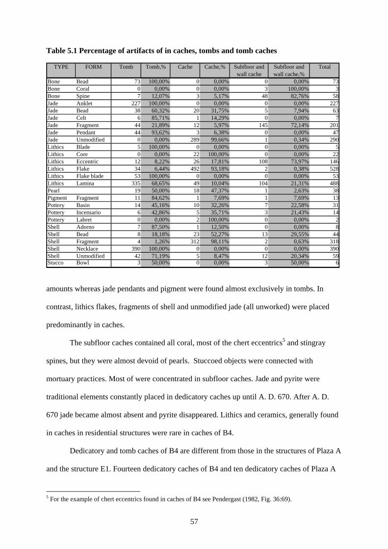
57
Table 5.1 Percentage of artifacts of in caches, tombs and tomb caches
TYPE FORM Tomb Tomb,% Cache Cache,% Subfloor and wall cache
Subfloor and wall cache,%
Total
Bone Bead 73 100,00% 0 0,00% 0 0,00% 73Bone Coral 0 0,00% 0 0,00% 3 100,00% 3Bone Spine 7 12,07% 3 5,17% 48 82,76% 58Jade Anklet 227 100,00% 0 0,00% 0 0,00% 227Jade Bead 38 60,32% 20 31,75% 5 7,94% 63Jade Celt 6 85,71% 1 14,29% 0 0,00% 7Jade Fragment 44 21,89% 12 5,97% 145 72,14% 201Jade Pendant 44 93,62% 3 6,38% 0 0,00% 47Jade Unmodified 0 0,00% 289 99,66% 1 0,34% 290Lithics Blade 5 100,00% 0 0,00% 0 0,00% 5Lithics Core 0 0,00% 22 100,00% 0 0,00% 22Lithics Eccentric 12 8,22% 26 17,81% 108 73,97% 146Lithics Flake 34 6,44% 492 93,18% 2 0,38% 528Lithics Flake blade 53 100,00% 0 0,00% 0 0,00% 53Lithics Lamina 335 68,65% 49 10,04% 104 21,31% 488Pearl 19 50,00% 18 47,37% 1 2,63% 38Pigment Fragment 11 84,62% 1 7,69% 1 7,69% 13Pottery Basin 14 45,16% 10 32,26% 7 22,58% 31Pottery Incensario 6 42,86% 5 35,71% 3 21,43% 14Pottery Labret 0 0,00% 2 100,00% 0 0,00% 2Shell Adorno 7 87,50% 1 12,50% 0 0,00% 8Shell Bead 8 18,18% 23 52,27% 13 29,55% 44Shell Fragment 4 1,26% 312 98,11% 2 0,63% 318Shell Necklace 390 100,00% 0 0,00% 0 0,00% 390Shell Unmodified 42 71,19% 5 8,47% 12 20,34% 59Stucco Bowl 3 50,00% 0 0,00% 3 50,00% 6
amounts whereas jade pendants and pigment were found almost exclusively in tombs. In
contrast, lithics flakes, fragments of shell and unmodified jade (all unworked) were placed
predominantly in caches.
The subfloor caches contained all coral, most of the chert eccentrics5 and stingray
spines, but they were almost devoid of pearls. Stuccoed objects were connected with
mortuary practices. Most of were concentrated in subfloor caches. Jade and pyrite were
traditional elements constantly placed in dedicatory caches up until A. D. 670. After A. D.
670 jade became almost absent and pyrite disappeared. Lithics and ceramics, generally found
in caches in residential structures were rare in caches of B4.
Dedicatory and tomb caches of B4 are different from those in the structures of Plaza A
and the structure E1. Fourteen dedicatory caches of B4 and ten dedicatory caches of Plaza A
5 For the example of chert eccentrics found in caches of B4 see Pendergast (1982, Fig. 36:69).
58
present the material for analysis of dedicatory caches. Nineteen tomb caches of B4, one
subfloor cache in A6-B and six tomb caches in structure E1 represent the range of artifacts
placed in tomb caches. All tomb caches fall within the one time span A. D. 550-900.
I classified the materials placed in caches into five categories6 by their association
with different aspects of Maya cosmology or stable combinations that were repeated from
cache to cache. Objects that I could not relate to any of the categories were stuccoed wooden
(?) bowl, pottery pendant and flint container with lid7.
Now if we look at the artifacts in the dedicatory caches of B4 (Table 5.2) we see that
marine objects, particularly jade and shell are dominant and present in almost every cache. A
combination of marine and portal objects8’ is also frequent and present in at least one cache of
every construction effort. Not a single cache contains a ‘chert eccentric-household pottery-
marine object’ combination. However, ‘household pottery - marine object’, or ‘chert
eccentrics – marine object - portal object’ combinations are present, but only under stairs.
This rule remains the same for the cache in B5 separated from B4 2nd by at least five centuries
and in B4 3rd that does not contain burials. Dedicatory caches of Plaza A differ from those of
Plaza B by much wider presence of household pottery and closer by content to the cache in
B5 that falls within the same time span (Table 5.3). ‘Chert eccentrics-household pottery’
combinations are avoided in these caches too.
Subfloor and wall caches appeared with introduction of tombs around A. D. 500.
Tomb caches of B4 are the most stylized in their content distinguishing the special position of
inhabitants of Plaza B.
The subfloor caches characterized the period before A. D. 700. They marked north,
south and center point of a tomb, plus additional caches may have been found in one of the
6 See legend to Table 5.2, 5.3, 5.4 or 5.5). 7 Also I initially grouped all the containers: stuccoed bowl, pottery containers and flint container into one group, I later realized that it will be too much assumption about the objects whose meaning and function is unknown to me. 8 Jade and hematite were often combined in caches.
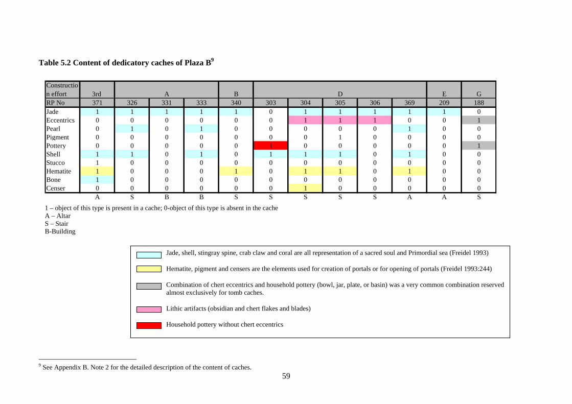
59
Table 5.2 Content of dedicatory caches of Plaza B9
Construction effort 3rd A B D E GRP No 371 326 331 333 340 303 304 305 306 369 209 188Jade 1 1 1 1 1 0 1 1 1 1 1 0Eccentrics 0 0 0 0 0 0 1 1 1 0 0 1Pearl 0 1 0 1 0 0 0 0 0 1 0 0Pigment 0 0 0 0 0 0 0 1 0 0 0 0Pottery 0 0 0 0 0 1 0 0 0 0 0 1Shell 1 1 0 1 0 1 1 1 0 1 0 0Stucco 1 0 0 0 0 0 0 0 0 0 0 0Hematite 1 0 0 0 1 0 1 1 0 1 0 0Bone 1 0 0 0 0 0 0 0 0 0 0 0Censer 0 0 0 0 0 0 1 0 0 0 0 0
A S B B S S S S S A A S
1 – object of this type is present in a cache; 0-object of this type is absent in the cache A – Altar S – Stair B-Building
9 See Appendix B. Note 2 for the detailed description of the content of caches.
Jade, shell, stingray spine, crab claw and coral are all representation of a sacred soul and Primordial sea (Freidel 1993)
Hematite, pigment and censers are the elements used for creation of portals or for opening of portals (Freidel 1993:244)
Combination of chert eccentrics and household pottery (bowl, jar, plate, or basin) was a very common combination reserved almost exclusively for tomb caches.
Lithic artifacts (obsidian and chert flakes and blades)
Household pottery without chert eccentrics
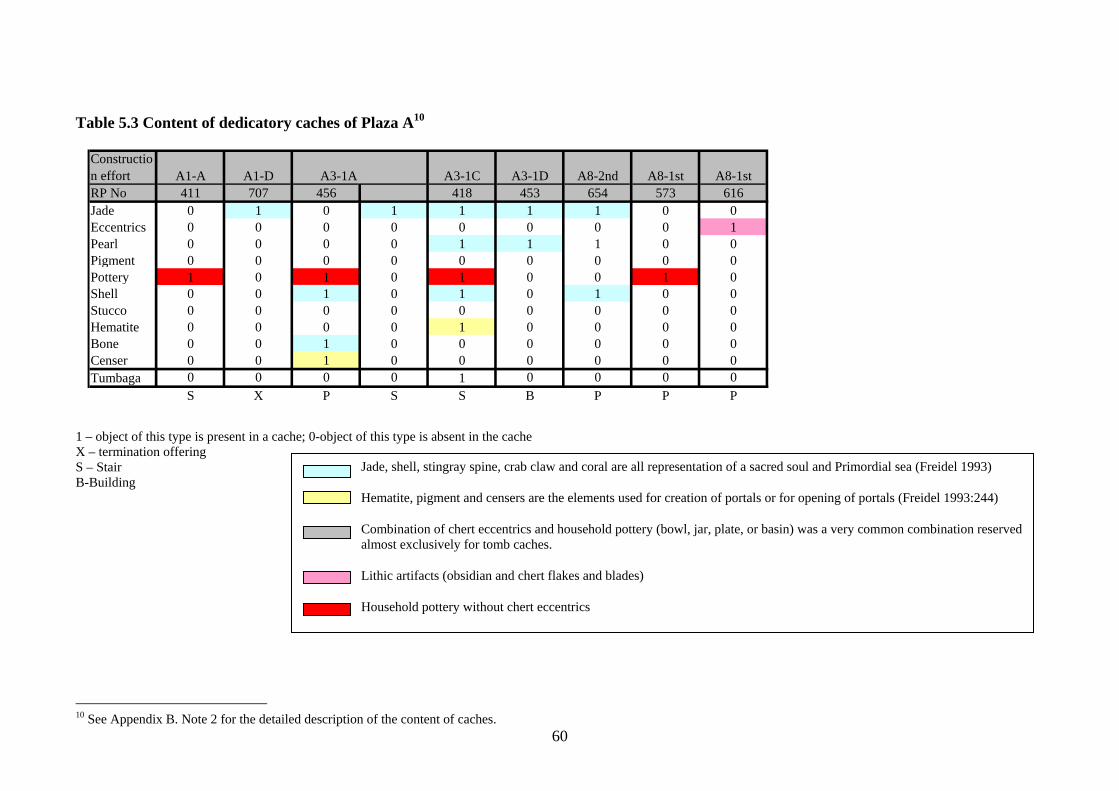
60
Table 5.3 Content of dedicatory caches of Plaza A10
Construction effort A1-A A1-D A3-1A A3-1C A3-1D A8-2nd A8-1st A8-1stRP No 411 707 456 418 453 654 573 616Jade 0 1 0 1 1 1 1 0 0Eccentrics 0 0 0 0 0 0 0 0 1Pearl 0 0 0 0 1 1 1 0 0Pigment 0 0 0 0 0 0 0 0 0Pottery 1 0 1 0 1 0 0 1 0Shell 0 0 1 0 1 0 1 0 0Stucco 0 0 0 0 0 0 0 0 0Hematite 0 0 0 0 1 0 0 0 0Bone 0 0 1 0 0 0 0 0 0Censer 0 0 1 0 0 0 0 0 0Tumbaga 0 0 0 0 1 0 0 0 0
S X P S S B P P P
1 – object of this type is present in a cache; 0-object of this type is absent in the cache X – termination offering S – Stair B-Building
10 See Appendix B. Note 2 for the detailed description of the content of caches.
Jade, shell, stingray spine, crab claw and coral are all representation of a sacred soul and Primordial sea (Freidel 1993)
Hematite, pigment and censers are the elements used for creation of portals or for opening of portals (Freidel 1993:244)
Combination of chert eccentrics and household pottery (bowl, jar, plate, or basin) was a very common combination reserved almost exclusively for tomb caches.
Lithic artifacts (obsidian and chert flakes and blades)
Household pottery without chert eccentrics
61
corners (Table 5.4). Comparing the tomb caches of B4 to those in E1, we find that rules were
different. Tombs of B4 2A and B2 2D contained only subfloor caches while caches placed in E1
were a mixture of wall and subfloor caches. Wall caches first appeared in B4 F. They replaced
the subfloor caches in 2G and 2H.
The artifact assemblages in dedicatory and tomb caches of B4 were very different. ‘Chert
eccentric – household pottery’ combination was present in at least one of the subfloor caches
related to the same tomb but never in the north cache (burial’s legs). No marine or portal
offerings were placed in the same cache11. With exception of cache RP 364-1, pottery was
always placed above the eccentrics. Caches containing jade on the other hand were never placed
at the south side of a tomb. In dedicatory caches of B4 2D, jade was combined with chert
eccentrics only once. The marine objects and portal objects were frequently combined in
dedicatory and tomb caches in A6, E1 and B4. In fact lamina of crystalline hematite was always
paired with some type of marine object (mostly jade). In only instance (RP 364-2), when
hematite object was placed in the subfloor cache alone, it was a sandstone backed pyrite mirror.
The combination of lithic eccentrics (obsidian and chert) and pottery vessels was found in
Classic caches in Tikal and Piedras Negras. This combination with rare inclusion of shell or jade
was placed only under stelae (in Tikal) and under columnar altars (in Piedras Negras). In Tikal
by the Late Classic the content of these caches become highly formalized. The caches contained
a certain number of eccentric flints and incised obsidian, and a pottery vessel. This distinguished
stelae caches from the caches placed in structures (Coe 1965).
In general, the quantities of chert eccentrics in B4 tomb caches (2, 8, 9, 10, 11, 12) were
different from the number of chert eccentrics placed in other types of caches (2, 5, 7, 9, 14, 18).
The only numbers that overlap are “9” and “2”. Both numbers relate to the function of the
11 Only one tomb cache at Altun Ha (RP No 38) combined chert eccentrics, household pottery and jade. However, tomb E1/3 was the only female tomb at Altun Ha.
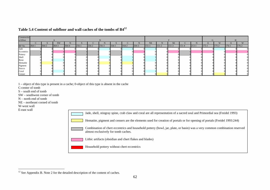
62
Table 5.4 Content of subfloor and wall caches of the tombs of B412
Construction Effort A D F G H
C S SW N S C N S C N NE N SE C N E W E WRP No 364-1 364-2 364-3 364-4 256-1 256-2 256-3 164-1 164-2 264-3 151-1 151-2 151-3 151-4 213-1 175-1 175-2 176-1 176-2Jade 0 0 0 0 0 0 1 0 1 0 1 0 0 0 0 0 1 0 0Eccentrics 1 0 1 1 1 1 0 1 0 1 0 0 1 1 1 1 0 1 1Pottery 1 0 0 0 1 1 0 1 1 0 0 0 0 1 0 0 0 0 0Shell 0 0 0 1 0 0 1 0 1 0 1 0 0 0 0 0 0 0 0Bone 0 0 1 0 0 0 0 0 1 0 1 0 0 0 0 0 0 0 0Hematite 0 1 0 0 0 0 1 0 1 0 0 0 0 0 0 0 0 0 0Pigment 0 0 0 0 0 0 0 0 1 0 0 0 0 0 0 0 0 0 0Stucco 1 0 1 1 0 0 0 0 0 0 0 0 0 0 0 0 0 0 0Coral 0 0 1 0 0 0 0 0 0 0 1 0 0 0 0 0 0 0 0Censer 0 0 0 0 0 0 0 0 0 0 0 1 0 0 0 0 1 0 0
1 – object of this type is present in a cache; 0-object of this type is absent in the cache C-center of tomb S – south end of tomb SW – southwest corner of tomb N – north end of tomb NE – northeast corned of tomb W-west wall E-east wall
12 See Appendix B. Note 2 for the detailed description of the content of caches.
Jade, shell, stingray spine, crab claw and coral are all representation of a sacred soul and Primordial sea (Freidel 1993)
Hematite, pigment and censers are the elements used for creation of portals or for opening of portals (Freidel 1993:244)
Combination of chert eccentrics and household pottery (bowl, jar, plate, or basin) was a very common combination reserved almost exclusively for tomb caches.
Lithic artifacts (obsidian and chert flakes and blades)
Household pottery without chert eccentrics
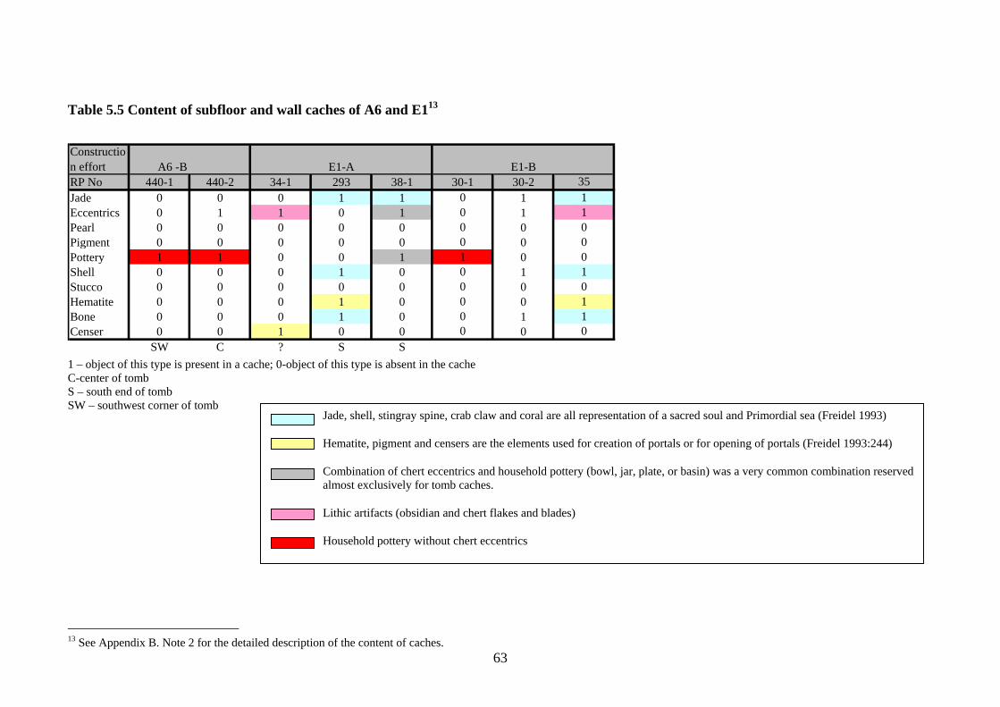
63
Table 5.5 Content of subfloor and wall caches of A6 and E113
Construction effort A6 -B E1-A E1-BRP No 440-1 440-2 34-1 293 38-1 30-1 30-2 35Jade 0 0 0 1 1 0 1 1Eccentrics 0 1 1 0 1 0 1 1Pearl 0 0 0 0 0 0 0 0Pigment 0 0 0 0 0 0 0 0Pottery 1 1 0 0 1 1 0 0Shell 0 0 0 1 0 0 1 1Stucco 0 0 0 0 0 0 0 0Hematite 0 0 0 1 0 0 0 1Bone 0 0 0 1 0 0 1 1Censer 0 0 1 0 0 0 0 0
SW C ? S S1 – object of this type is present in a cache; 0-object of this type is absent in the cache C-center of tomb S – south end of tomb SW – southwest corner of tomb
13 See Appendix B. Note 2 for the detailed description of the content of caches.
Jade, shell, stingray spine, crab claw and coral are all representation of a sacred soul and Primordial sea (Freidel 1993)
Hematite, pigment and censers are the elements used for creation of portals or for opening of portals (Freidel 1993:244)
Combination of chert eccentrics and household pottery (bowl, jar, plate, or basin) was a very common combination reserved almost exclusively for tomb caches.
Lithic artifacts (obsidian and chert flakes and blades)
Household pottery without chert eccentrics
64
structure: the confrontation of the Hero Twins (2) with the Lords of the Xibalba (9). In four out
of five caches, five flints were found in combination with watery objects.
Caches in A6 and E1 were less rich in offerings and very distinct in content from those in
B4. For example, caches of the Tomb A6/1 contained only pottery. Cache RP 38-1 in E1
combined lithics eccentrics and jade but contained no pottery.
There are too many factors that may influence the decision about cache or tomb
placement and content. These include location in a structure, type of structure, status, position
and sex of an interred. Customs prevalent during a particular time also influenced cache and
burial placement and content as well as lineage deities.
A pattern of tomb placement, including a placement of a tomb in a modified portion of a
structure oriented north-south, existed in B4. Artifact assemblages in tombs were more variable
than those in caches, due to the presence of many personal items and cloth ornaments that
adorned costumes of the interred.
While the content of caches was highly variable (Pendergast 1982), the analysis
discovered a number of stable combinations of artifacts. One of these combinations was the
placement of ‘chert eccentrics- household pottery’ combination only into tomb caches. That
made tomb caches similar to stelae caches in Tikal. In comparison to Tikal, the number of chert
eccentrics in the caches of B4 varied. However, the number of chert eccentrics in tomb caches
was different from number of chert eccentrics in dedicatory caches. Caches with ‘chert
eccentrics-household pottery’ combinations never contained jade and were never placed on the
northern side of a tomb.
Drastic changes in burial and cache placement practices also support the hypothesis of
major changes in the ruling family of Altun Ha around A. D. 700.
Conclusions on Structure B4
The renewal of the altar marked major shifts in function and appearance in the history of
B4. The first renewal of the altar marked the conversion of the structure into the elaborately
65
adorned funerary shrine housing rich tombs. Dedicatory caches to this construction contained
only marine objects. The next renewal of the altar brought a marked difference in appearance
and one deviation from patterns of mortuary practice. The Sun God masks, building and upper
stair block were removed and a tomb was placed in the lower stairs. This renovation also carried
the richest caches. Third renovation of the altar marked the change in construction patterns and
was so important that it was not accompanied by any tomb. This renovation was not marked by
any significant offerings as well as all modifications of the structure that followed.
Patricia McAnany (1995) showed that land was the most valuable resource for the Maya.
Rules on demarcation, division and inheritance of land plots were elaborate and meticulous.
Eligibility for inheritance was determined by abilities of a person to prove his/her relation to the
head of a family which owned the land. A house in the middle of a houseplot was closely
connected with land, and ancestors buried under the floors protected that land and stated the
validity of the ownership of the house residents. Burials under the floors of residential houses
were a widespread phenomenon throughout Maya area. In some cases, they were replaced by
ancestral shrines located in residential plazas. Ancestral shrines usually contained the remains of
important members of a lineage, as for example the shrine at K’axob or at Blue Creek (Guderjan
et al 2003, McAnany 1995). The right to call people buried in a funerary shrine or under the
floors of a house the ancestors, gave one the right to inherit the land, office and power of these
ancestors. The funerary shrine of B4 gave owner the right to rule over the human and material
resources of Altun Ha.
The altars, as well as temple buildings, were permanent portals that connected people to
the Otherworld (Freidel et al. 1993). The funerary shrines were the property of a family. If the
altar on the top of the funerary shrine B4 was a portal functioning only for the members of the
ruling family then succession of a member of another family or lineage in case of the absence of
66
a direct heir, would have required a reconstruction of the altar, or in other words construction of
a new portal14.
If altar of B4 was an indication of a break in the succession line, then history of Altun Ha
experienced at least three of them. The first ruling family at Altun Ha15 (Tombs 4/7, 4/6) was
possibly the one that reinforced the institution of kingship at the site. Under the emblem of the
Sun God they completed the major ceremonial construction at the site. Their tombs were rich
with exotic artifacts. The site started expanding rapidly. Death of the last ruler in A. D. 650 was
unexpected (Pendergast 1982).
The change in the appearance of B4 and renewal of the altar may point that the inheritor
was not a direct successor. At least he was not associated with the family deity, the Sun God.
However, he was an eligible heir who had enough power and respect to organize a large-scale
construction. By the time of his death, around A. D. 670, Plaza B expanded to include another
family. Due to poor preservation of his skeleton neither his age nor the nature of his death is
known (Pendergast 1982).
If B4 was a mausoleum for the heads of the ruling family then the next follower did not
belong to it. He had to renew the altar but for about a century the family he belonged to was not
able to claim B4 for themselves. Somewhere around the time of his succession the residents of
B5 built a partition that separated their residence from the plaza space as if they disagreed with
the transfer of power. The later covering of an altar around A. D. 725 and placement of tombs in
modest platforms that did not require the renovation of the whole staircase may also point to the
change of dynasties. The diminished scale of construction on B4 was reflected by slower growth
in other areas of the site (Tables B.2, B.4). However, the increased rate of modifications
everywhere at the site showed that Altun Ha has been far from abandonment (Tables B.3).
Rather the diminishing scale of construction on Plaza B and poor offerings can be explained by
inability of the new ruler to prove his right for the throne that resulted in slow degradation of the
14 Note that no altar was constructed above the old one. 15It is possible that not all rulers were buried in B4.
67
central power at Altun Ha. The coming of the new ruler may have been also complicated by the
disruption of trade connections that led to the reduction of quantities of jade and disappearance
of hematite, and probably to the reduction of maize consumption.
The desecration of all tombs placed after A. D. 750 in B4, one of the main arguments for
peasant revolt (Pendergast 1982), may have been done for ideological reasons. If the new ruler
was not able to prove his legitimacy then members of his kin had no right to rest in B4. Thus, the
tombs were opened and most of the bones and burial goods removed, and burials chambers were
cleaned by the fire.
With the weak central power and disrupted trade connections, maize production or
procurement subsided, and Altun Ha was gradually abandoned.
68
CHAPTER 6: STRUCTURES WITH AMBIGUOUS FUNCTIONS
Structure B2
B2 is a rectangular platform with the height of 2.5 m located on the western border of the
plaza (Fig. 6.1). B2 was built between A. D. 600 and A. D. 700 in a period of separation of
Plaza B from the Plaza A and the rest of Altun Ha (Fig. 1.3e). By its dimensions, B2 is closer
to B3 that distinguishes it from other residential structures at Altun Ha (See Table. 3.1, Fig.
3.1). The platform of B2 like that of B3 had large rear outsets and basal and apron moldings.
The similarity of form and adornments suggests the similarity of functions. However, no
traces of masonry building or traces of domestic activity on and around the platform were
found on B2. The absence of evidence of residential activity raises the question the existence
of even a perishable residence on the summit of B2 (Pendergast 1982).
Fig. 6.1 Platform B2
69
Empty platforms on plazas of palace complexes were present at other Maya sites. For
example, an empty broad two tiered inward-oriented platform, structure 10L-30, formed the
western border of Courtyard A of Group 10L-2 at Copan. The structure was important enough
to renew it periodically. Supposedly, the structure was used as platform for dances and rituals
conducted by families of Groups 10L-2 (Andrews et al. 2003).
Structure B2, like the structure 10-L30, may have been used for rituals too. However,
10L-30 took a central position on the eastern border of the courtyard. B2, while parallel to B4,
is tucked in the southwestern corner of the plaza, partly shielded by B3. Absence of domestic
refuse cannot serve as proof of non-residential use, because among the residential structures
of the Central Precinct trash middens corresponding to the Classic period of use were found
only around A8 (Pendergast 1979). On the other hand, the similarity between B2 and B3, the
distinctiveness of B2 among the other residential structures at Altun Ha, and the alignment of
B2 and B4 with their primary axes almost parallel, argues for residential, administrative, and
probably ritual functions of B2. The only certain function B2 performed was a restriction of
the south-southwestern access to the plaza for the inhabitants of the zones C, E and structure
A8.
Structure B1
Structure B1 demarcates the border between Plaza A and Plaza B. Although structure
A4 provided the separation between the plazas (Pendergast 1982), B1 was very important,
because it formalized the northern entry point of the eastern corridor through the plaza and
made it symmetrical to the southern entry point. B1 also served as a barrier and a screen from
the structures D1, D2, D4 and D5 that formed a single group northeast of Plaza B (Fig. 1.2).
Structure B1 remained unexcavated during the 1964-1970 field seasons, and detailed
plans of the structure were not available to me.
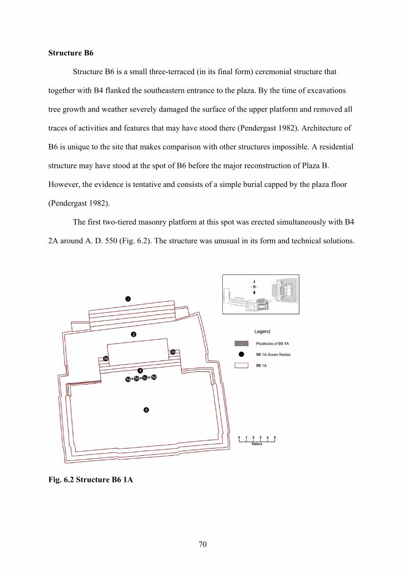
70
Structure B6
Structure B6 is a small three-terraced (in its final form) ceremonial structure that
together with B4 flanked the southeastern entrance to the plaza. By the time of excavations
tree growth and weather severely damaged the surface of the upper platform and removed all
traces of activities and features that may have stood there (Pendergast 1982). Architecture of
B6 is unique to the site that makes comparison with other structures impossible. A residential
structure may have stood at the spot of B6 before the major reconstruction of Plaza B.
However, the evidence is tentative and consists of a simple burial capped by the plaza floor
(Pendergast 1982).
The first two-tiered masonry platform at this spot was erected simultaneously with B4
2A around A. D. 550 (Fig. 6.2). The structure was unusual in its form and technical solutions.
Fig. 6.2 Structure B6 1A
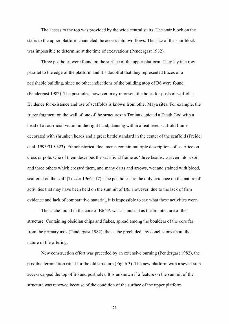
71
The access to the top was provided by the wide central stairs. The stair block on the
stairs to the upper platform channeled the access into two flows. The size of the stair block
was impossible to determine at the time of excavations (Pendergast 1982).
Three postholes were found on the surface of the upper platform. They lay in a row
parallel to the edge of the platform and it’s doubtful that they represented traces of a
perishable building, since no other indications of the building atop of B6 were found
(Pendergast 1982). The postholes, however, may represent the holes for posts of scaffolds.
Evidence for existence and use of scaffolds is known from other Maya sites. For example, the
frieze fragment on the wall of one of the structures in Tonina depicted a Death God with a
head of a sacrificial victim in the right hand, dancing within a feathered scaffold frame
decorated with shrunken heads and a great battle standard in the center of the scaffold (Freidel
et al. 1993:319-323). Ethnohistorical documents contain multiple descriptions of sacrifice on
cross or pole. One of them describes the sacrificial frame as ‘three beams…driven into a soil
and three others which crossed them, and many darts and arrows, wet and stained with blood,
scattered on the soil’ (Tozzer 1966:117). The postholes are the only evidence on the nature of
activities that may have been held on the summit of B6. However, due to the lack of firm
evidence and lack of comparative material, it is impossible to say what these activities were.
The cache found in the core of B6 2A was as unusual as the architecture of the
structure. Containing obsidian chips and flakes, spread among the boulders of the core far
from the primary axis (Pendergast 1982), the cache precluded any conclusions about the
nature of the offering.
New construction effort was preceded by an extensive burning (Pendergast 1982), the
possible termination ritual for the old structure (Fig. 6.3). The new platform with a seven-step
access capped the top of B6 and postholes. It is unknown if a feature on the summit of the
structure was renewed because of the condition of the surface of the upper platform
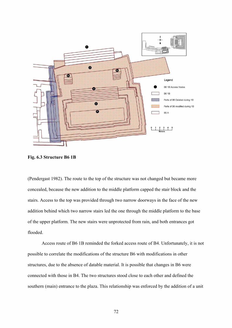
72
Fig. 6.3 Structure B6 1B
(Pendergast 1982). The route to the top of the structure was not changed but became more
concealed, because the new addition to the middle platform capped the stair block and the
stairs. Access to the top was provided through two narrow doorways in the face of the new
addition behind which two narrow stairs led the one through the middle platform to the base
of the upper platform. The new stairs were unprotected from rain, and both entrances got
flooded.
Access route of B6 1B reminded the forked access route of B4. Unfortunately, it is not
possible to correlate the modifications of the structure B6 with modifications in other
structures, due to the absence of datable material. It is possible that changes in B6 were
connected with those in B4. The two structures stood close to each other and defined the
southern (main) entrance to the plaza. This relationship was enforced by the addition of a unit
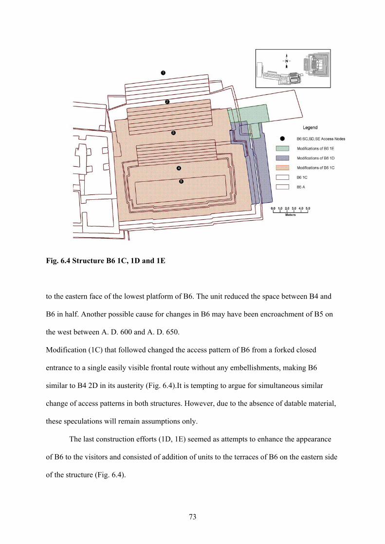
73
Fig. 6.4 Structure B6 1C, 1D and 1E
to the eastern face of the lowest platform of B6. The unit reduced the space between B4 and
B6 in half. Another possible cause for changes in B6 may have been encroachment of B5 on
the west between A. D. 600 and A. D. 650.
Modification (1C) that followed changed the access pattern of B6 from a forked closed
entrance to a single easily visible frontal route without any embellishments, making B6
similar to B4 2D in its austerity (Fig. 6.4).It is tempting to argue for simultaneous similar
change of access patterns in both structures. However, due to the absence of datable material,
these speculations will remain assumptions only.
The last construction efforts (1D, 1E) seemed as attempts to enhance the appearance
of B6 to the visitors and consisted of addition of units to the terraces of B6 on the eastern side
of the structure (Fig. 6.4).
74
The enigmatic nature of B6 is underlined by unusually rich offerings to the structure
left several centuries after Altun Ha was abandoned (Pendergast 1982). These offerings
underscored the sacred status of B6 in comparison to its big neighbor, B4 that by this time
was extensively trashed and left to the process of slow destruction.
The structures, discussed in this chapter cannot tell us much about the role they played
in lives of the inhabitants of Plaza B. However, they were important in delineation of the
plaza space.
75
SUMMARY AND CONCLUSIONS
In my thesis work, I created the GIS of the Plaza B, a royal residential plaza at the
Maya city of Altun Ha, Belize. While a number of specialized architectural software packages
exists today, I’ve chosen GIS software, because of the ability it offers in working with
different types of information and its orientation to the real world. The latter advantage is
especially important, because positions of celestial objects often defined layouts of Maya
cities.
The 2nd volume of the three-volume monograph “Excavations at Altun Ha, Belize,
1964-1970” by David Pendergast (1982) served as a source of material for the GIS. The GIS
of Plaza B included five structures of the plaza as well as information on artifacts in caches
and burials of the plaza. The GIS is based on a complex system of interconnected tables that
contain spatial and non-spatial data and a set of queries that represent the information1.
On the base of the created GIS, I analyzed access patterns on Plaza B and in its
structures. I started with a short overview of Altun Ha location, available resources and
excavation works conducted at the site. I also summarized the history of the development of
the site.
In the second chapter, I analyzed the layout of Plaza B and access patterns through the
plaza. I found that in spite of the seeming informality, the layout of Plaza B was carefully
planned. In its final form, Plaza B had defined residential and ceremonial areas, and a set of
access routes that provided privacy to the residents and a throughway for the inhabitants of
the site.
In the third chapter, I analyzed the access patterns in two adjoining residential
structures of the plaza, B3 and B5. I discovered that B3 due to its formal layout and openness
likely combined residential and administrative functions, whereas B5 had all characteristics of
1 I described the creation process and the internal structure of the created GIS, including the detailed description of tables and basic queries in Appendix A.
76
a typical residential structure. Analysis also showed that B3 and B5 were closely connected
and possibly used some areas for joined activities. At the end of the seventh century, the split
between B5 and B6 occurred. After the split, B3 stayed within the plaza, and B5 broke all
connections with the plaza residents.
In the fourth chapter, I provided the overview of the history of the royal ancestral
shrine, B4. I discovered that layout and elements of B4 were highly symbolic. The building of
B4 bore many references to the story of resurrection of the Hero Twins, main protagonists of
Maya mythology. The access patterns of B4 formed the Wakah-Chan, the symbol of the
Maize God, and symbolized the connection between ancestors and descendants.
The fifth chapter was the continuation of the previous chapter. Although it analyzed
the burials and caches of Plaza B, most of them were concentrated in B4. All burials in B4
were tomb burials, a rare occurrence at Altun Ha restricted mostly to the Central Precinct. The
analysis revealed patterns in tomb placement and cache contents. Tombs, dedicatory caches
and tomb caches differed drastically in artifact assemblages. While tombs included a wide
variety of artifacts, artifact assemblages in caches followed a distinctive pattern. The
combination of chert eccentrics with household pottery was the most frequent combination of
artifacts in tomb caches.
The pattern of tomb placement, the pattern of construction of B4 and the artifact
assemblages in caches pointed at a major change at Altun Ha around A. D. 700. This time
coincided with one of the renewals of the altar on B4. Since each renewal of the altar changed
the appearance of the structure, I suggested that the renewal of the altar was caused by a
change in the line of succession of the rulers. The last renewal was followed by decline in
construction, disappearance of exotic material from the caches and relaxation of requirements
to the tomb and cache placement. It was paralleled by the split between the residential
structures of the plaza and intensification of renovations everywhere at the site, and later to
77
the desecration of the tombs placed after A. D. 700. I concluded that a person who came to
power over the Altun Ha in the end of the seventh century due to his distant relationship or
absence of relationship to the lineage of the ruler could not prove his right and the right of his
lineage to the royal office that led to the gradual weakening of the central power at the site.
In the last chapter, I described the structures which remained enigmas. Structure B1
was not excavated by Pendergast, and I had no information on it. B2 did not yield any traces
of activities, and its form does not allow the conclusion about the functions of the structure.
B6 finds no analogs at Altun Ha and on other sites, and most of its construction efforts are not
directly datable. These structures, however, played an important role in formation of the plaza
appearance and traffic channeling.
The study of access patterns in the plaza structures helped to determine the functions
and symbolism of the structures. The history of development of the plaza structures, and
changes in burials and cache placement and content showed that the possible reason for the
gradual degradation of the central power at Altun Ha might have been the break in the
succession line.
GIS helped to see the plaza structures as a complex of interconnected dynamic entities.
Changes in one structure triggered a series of modifications in other structures that was
paralleled by changes in mortuary and offertory practices. This unified representation allowed
me to formulate the hypothesis about social changes that triggered changes in architecture. On
the other hand, the GIS helped me to discover the role of the funeral shrine of Plaza B as a
conduit between generations and a mythological place of resurrection of the dead ancestors.
While the work, I’ve done may be done without development of the GIS, some
aspects of this work that require superimposition of several building plans would have been
very difficult to perform manually. The other important advantage, the GIS provides is the
ability to recreate easily my analysis for verification or repudiation of the results, or to
78
conduct a new analysis in case of new discoveries. Unfortunately, some advantages of GIS,
including analysis of the alignment of the structures, or study of distribution of artifacts and
burials throughout the site, or investigation of key locations in residential structures on the
site remained unused due to the scale of this work, but they are promising directions for the
further study.
79
REFERENCES CITED Ashmore, W. 1992 Deciphring Maya Architectural Plans. In New Theories on the Ancient Maya.
eds. E. C. Danien and R. J. Sharer, pp. 173-184. Philadelphia:University of Pennsylvania.
Andrews, G. 1975 Maya Cities. Placemaking and Urbanization. Norman:University of Oklahoma
Press.
Andrews, E. W. V, J. L. Johnson, W. F. Doonan, G. E. Everson, K. E. Sampeck, and H. E. Starratt 2003 A Multipurpose Sturucture in the Late Classic Palace at Copan. In Maya
Palaces and Elite Residences: An Interdisciplinary Approach. 1 ed., eds. J. J. Christie, pp.291-314. Texas:University of Texas Press.
Aveni, A., and H. Hartung 1982 Precision in the Layout of Maya Architecture. In Ethnoastronomy and
Archaeoastronomy in the American Tropics, eds. A. Aveni and G. Urton, pp. 63-80. New York: Annals of the New York Academy of Sciences, Vol.385.
Ball, J. W., and J. T. Taschek 2004 Buenavista del Cayo. A short outline of Occupational and Cultural History at an
Upper Belize Valley Regal-Ritual Center. In The Ancient Maya of the Belize Valley: Half a Century of Archaeological Research, eds. J. F. Garber, pp.149-167. Gainesville:University Press of Florida.
Bishop, R. L., and F. W. Lange 1993 Sources of Maya and Central American Jadeitites. Data Bases and
Interpretations - A Summary. In Precolumbian Jade. New Geological and Cultural Interpretations, eds. F. W. Lange, pp. 125-130. Salt Lake City:University of Utah Press.
Bishop, R. L., E. V. Sayre, and J. Mishara 1993 Compositional and Structural Characterization of Maya and Costa Rican
Jadeites. In Precolumbian Jade. New Geological and Cultural Interpretations, eds. F. W. Lange, pp. 30-60. Salt Lake City:University of Utah Press.
Broda, J. 1997 Astronomy, Cosmovisión, and Ideology in Pre-Hispanic Mesoamerica. In
Stairways to the Stars. Eds. A. Aveni, pp. 81-146. New York:John Wiley and Sons.
Chase, A. F., and D. Z. Chase 2001 The Royal Court of Caracol, Belize: Its Palaces and People. In Royal Courts of
the Ancient Maya, vol. 2., eds. T. Inomata and S. D. Houston, pp. 102-137. Boulder:Westview Press.
80
Cheetham, D. 2004 The Role of Termnus Groups in Lowland Maya Site Planning. An Example
from Cahal Pech. In The Ancient Maya of the Belize Valley: Half a Century of Archaeological Research, eds. J. F. Garber, pp. 125-148. Gainesville:University Press of Florida.
Christie, J. 2003 The Tripartite Layout of Rooms in Maya Elite Residences: Symbolic Centering,
Ritual Mediating, and Historical Governing. In Maya Palaces and Elite Residences: An Interdisciplinary Approach. 1 ed., eds. J. J. Christie, pp. 291-314. Texas:University of Texas Press.
Coe, W. R. 1965 Caches and Offertory Practices of the Maya Lowlands. In Handbook of Middle
American Indians , Vol.2 : The Archaeology of Southern Mesoamerica. Part 1, eds. R. Wauchope and G. R. Willey, pp. 462-469. Austin:Univeristy of Texas Press.
Conlon, J. M., and T. G. Powis 2004 Major Center Identifiers at Plazuela Group Near the Ancient Maya Site of
Baking Pot. In The Ancient Maya of the Belize Valley: Half a Century of Archaeological Research, eds. J. F. Garber, pp. 70-85. Gainesville:University Press of Florida.
Craig, N. M. 2002 Recording Large-Scale Archaeological Excavations with GIS.
<http://www.esri.com/news/arcnews/spring02articles/recordinglarge.html>.
Erdi, A. 2003 Applications of Mapping and GIS at the Kelenderis Excavation Site.
<http://www.esri.com/news/arcnews/spring03articles/applications-of-mapping.html>.
Fedick, S. L., and A. Ford 1990 The prehistoric Agricultural Landscape of Central Maya Lowlands: An
examination of Local Variability in a Regional Context. World Archaeology, 22:18-33.
Folan, W. J., J. D. Gunn, and M. R. D. Carrasco 2001 Triadic Temples, Central Plazas, and Dynastic Palaces: A Diachronic Analysis
of the Royal Court Complex, Calakmul, Campeche, Mexico. In Royal Courts of the Ancient Maya, vol. 1., eds. T. Inomata and S. D. Houston, pp. 223-265. Boulder:Westview Press.
Ford, A. 2004 Integration among Communities, Centers and Regions. The Case from El Pilar.
In The Ancient Maya of the Belize Valley: Half a Century of Archaeological Research, eds. J. F. Garber, pp. 238-272. Gainesville:University Press of Florida.
81
Fox, J. W., G. W. Cook, and A. Demarest 1996 Constructing Maya Communities: Ethnography for Archaeology. Current
Anthropology, 37:811-830.
Freidel, D., and L. Schele 1988 Kingship in the Late Preclassic Maya Lowlands: the Instrucments and Places of
Ritual Power. American Antropologist, New Series, 90:547-567.
1990 A Forest of Kings. The Untold Story of the Ancient Maya. New York:William Morrow and Company.
Freidel, D., L. Schele, and J. Parker 1993 Maya Cosmos. Three Thousand Years on Shaman Pass. New York:William
Morrow and Company.
Garber, J. F. 1983 Patterns of Jade Consumtion and Disposal at Cerros, Northern Belize.American
Antiquity, 48:800-807.
Garber, J. F., M. K. Brown, J. J. Awe, and C. J. Hartman. 2004 Middle Formative Prehistory of the Central Belize Valley. An Examination of
Architecture, Material Culture and Sociopolitical Change at Blackman Eddy. In The Ancient Maya of the Belize Valley: Half a Century of Archaeological Research, eds. J. F. Garber, pp. 25-47. Gainesville:University Press of Florida.
Glassie, H. 2000 Vernacular Architecture. Bloomington:Indiana University Press.
Graham, E. 1987 Resource Diversity in Belize and Its Implications for Models of Lowland Trade.
American Antiquity. 52:753-767.
Guderjan, T. H., Lichtenshtein R., and C. C. Hanratty 2003 Elite Residences at Blue Creek, Belize. In Maya Palaces and Elite Residences:
An Interdisciplinary Approach. 1 ed., eds. J. J. Christie, pp.154-183. Texas:University of Texas Press.
Hammond, N. 1982 The Prehistory of Belize. Journal of Field Archaeology. 9:349-362.
Hammond, N., and Gerhardt J. C. 1990 Early Maya Architectural Innovation at Cuello, Belize. World Archaeology,
21:461-481.
Harlow, G. E. 1993 Middle American Jade: Geologic and Petrologic perspectives on Variability and
Source. In Precolumbian Jade. New Geological and Cultural Interpretations, eds. F. W. Lange, pp. 9-29. Salt Lake City:University of Utah Press.
82
Harrison, P. D. 2001 Thrones and Throne Structures in the Central Acropolis of Tikal as an
Expression of the Royal Court. In Royal Courts of the Ancient Maya, vol. 2., eds. T. Inomata and S. D. Houston, pp. 74-101. Boulder:Westview Press.
Healy, P., D. Cheetham, T. G. Powis, and J. Awe 2004a Cahal Pech: The Middle Formative Period. In The Ancient Maya of the Belize
Valley: Half a Century of Archaeological Research, eds. J. F. Garber, pp. 103-124. Gainesville:University Press of Florida.
Healy, P., J. Awe, and H. Helmut 2004b Defining Royal Maya Buirals. A Case from Pacbitun. In The Ancient Maya of
the Belize Valley: Half a Century of Archaeological Research, eds. J. F. Garber, pp. 228-237. Gainesville:University Press of Florida.
Inomata, T. 2001 King’s People: Calssic Maya Court. In Royal Courts of the Ancient Maya, vol.
1., eds. T. Inomata and S. D. Houston, pp. 27-53. Boulder:Westview Press.
Inomata, T., and D. Triadan 2003 Where Did Elites Live: Identifying Elite Residences at Aguateca, Guatemala. In
Maya Palaces and Elite Residences: An Interdisciplinary Approach. 1 ed., eds. J. J. Christie, pp. 154-183. Texas:University of Texas Press.
Kowalski, J. K. 2003 Evidences for the Functions and Meanings of Some Northern Maya Palaces. In
Maya Palaces and Elite Residences: An Interdisciplinary Approach. 1 ed., eds. J. J. Christie, pp. 204-252. Texas:University of Texas Press.
Lock, G. R., and T. M. Harris 1996 Danebury Revisited: An Englih Iron Age Hillfort in a Digital Landscape. In
Anthropology, Space and Geographic Information Systems (Spatial Information Systems), eds.H. D. G. Maschner and M. S. Aldenderfer, pp. 214-240. New York:Oxfrod University Press.
Maschner, H. D. G. 1996 The Politics of Settlement Choice on the Northwest Coast: Cognition, GIS and
Coastal Landscapes. In Anthropology, Space and Geographic Information Systems (Spatial Information Systems), eds. M. S. Aldenderfer and H. D. G. Maschner, pp. 175-189. New York:Oxfrod University Press.
McAnany, P. A. 1995 Living with the Ancestors. Kinship and Kingship in Ancient Maya Society,
Austin:University of Texas Press.
McKillop, H. I. 1984 Prehistoric Maya Reliance on Marine Resources: Analysis of a Midden from
Moho Cay, Belize. Journal of Field Archaeology. 11:25-35.
83
1996 Ancient Maya Trading Ports and the Integration of Long-Distance and Regional Economies. Wild Cane Cay in South-Coastal Belize. Ancient Mesoamerica, 7:49-2.
2002 Salt, White Gold of the Ancient Maya. Gainesville:University Press of Florida.
2004 The Ancient Maya: New Perspectives. Santa Barbara:ABC-CLIO.
Moyes, H. 2002 The use of GIS in the Spatial Analysis of an Archaeological Cave Site. Journal
of Cave and Karst Studies 64:9-16. <http://www.caves.org/pub/journal/PDF/V64/v64n1-Moyes.pdf>.
Moyes, H., and J. J. Awe 2000 Spatial Analysis of an Ancient Cave Site.
<http://www.esri.com/news/arcuser/1000/cave.html>.
Loten, H. S., and D. M. Pendergast 1984 A lexicon for Maya Arcitecture. Arch. Monogr. 8. Toronto:ROM.
Pendergast, D. M. 1970 Tumbaga Object from the Early Classic Period, Found at Altun Ha, British
Honduras (Belize). Science, New Series, 168:116-118.
1979 Excavations at Altun Ha, Belize, 1964-1970, vol.1. Toronto:ROM.
1981 Lamanai, Belize: Summary of Excavation Results, 1974-1980. In Field Reports: Excavation and Survey, Journal of Field Archaeology, 8:29-53.
1982 Excavations at Altun Ha, Belize, 1964-1970, vol.2. Toronto:ROM.
1990 Excavations at Altun Ha, Belize, 1964-1970, vol.3. Toronto:ROM.
1992 Noblesse Oblige: The Elites of Altun Ha and Lamanai, Belize. In Mesoamerican Elites: An Archaeological Assessment, eds. D. Z. Chase and A.F. Chase, pp. 61-79. Norman:University of Oklahoma Press.
Ruz, A. L. 1965 Tombs and Funerary Practices in the Maya Lowlands. In Handbook of Middle
American Indians, Vol. 2. Archaeology of Southern Mesoamerica, Part I, pp. 441-461, eds. R. Wachoupe and G. L. Willey. Austin:University of Texas Press.
Tedlock, D. 1996 Popol Vuh, The Mayan Book of the Dawn of Life. New York:Simon and
Shooster.
Tozzer, A. M. 1966 Landa’s Relación de Las Cosas de Yukatan. A Translation. New York:Kraus
Reprint.
84
Upton, D. 1982 Vernacular Domestic Architecture in Eighteenth Century Virginia. /Winterthur
Portfolio/Summer-fall. Republished in Dell Upton and John Vlach, eds., /Common Places/ 1986. Athens, GA: University of Georgia Press: pp. 315-335.
Valdez, H. A. 2001 Palaces and Thrones Tied to the Destiny of the Royal Courts in the Maya
Lowlands. In Royal Courts of the Ancient Maya, vol. 2., eds. T. Inomata and S. D. Houston, pp. 138-164. Boulder:Westview Press.
Willey, G. R., W. R. Bullard Jr., J. Glass, and J. C. Gifford 1965 Prehistoric Maya Settlements in the Belize Valley. Papers of the Peabody
Museum of Archaeology and Ethnology, vol. 54, Cambridge:Harvard University.
Wheatley, D., and M. Gillings 2002 Spatial Technology in Archaeology. The Archaeological Applications in GIS.
New York:Taylor and Frensis.
West, R. C. 1996 The Natural Regions of Middle America. In Handbook of Middle American
Indians, eds. R. West, pp. 363-383. Austin:University of Texas Press.
White, C. D., D. M. Pendergast, F. J. Longstaffe, and K. R. Law 2001 Social Complexity of Food Systems at Altun Ha, Belize; The Isotopic Evidence.
Latin American Antiquity, 12:371-393.

85
APENDIX A: METHODS
86
Once, Hampton Peele suggested the idea of creation of a GIS of the Maya site for the analysis
of the role of astronomy in the layout of Maya architecture. An additional benefit would be
the creation of the 3-D model of a Maya site. I liked the idea, however, I was more interested
in details of implementation of this project and in creation of a system that will be flexible
enough to allow not only the analysis of the layout, but also tracking the development of a
single structure as well as the representation of several structures together at any given period
of time. I also wanted to include the information about the objects that do not always have
spatial representation, such as artifacts in caches, but are vital for understanding of functions
of a structure and social status of their inhabitants.
My advisor, Dr. Heather McKillop suggested Altun Ha as a relatively small and well
documented site. The three-volume monograph ‘Excavations at Altun Ha, Belize 1964-1970’
by David Pendergast (1979-1990) provided material for the GIS1.
Digitization and Feature Composition
The process of development of the GIS of Plaza B involved several stages. These
included (1) digitization and feature composition, (2) georeferencing, (3) design and
population of the database, and (4) creation of queries for sorting and representation of the
material. I used Geomedia 5.1 Professional2, the software manufactured by Intergraph and
available to me at LSU under a license. Non-spatial data were added to the same ACCESS
database and linked to the spatial data both in ACCESS and Geomedia.
I started my work by scanning the building plans of Plaza B structure that were
published in the second volume of the monograph (Pendergast 1982). This collection
excludes structure B 1 located on the northeastern border of the Plaza B, since the structure
was not excavated by Pendergast. This structure was part of a final design of the plaza but
‘did not add materially to the separation between Groups B and A’ (Pendergast 1982:143). 1 I have to note that this monograph represents the processed results of excavations, and GIS, created on its base cannot be used for documentation of excavations without modification of the structure of the GIS. 2 Further referred as Geomedia.
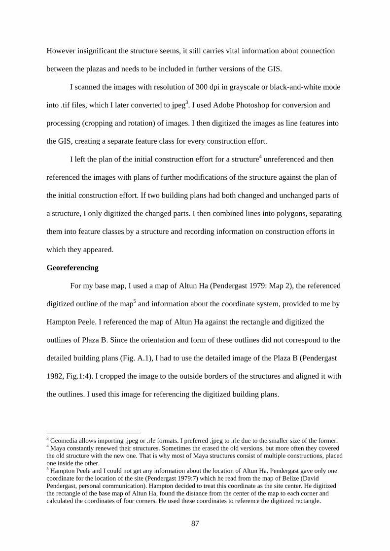
87
However insignificant the structure seems, it still carries vital information about connection
between the plazas and needs to be included in further versions of the GIS.
I scanned the images with resolution of 300 dpi in grayscale or black-and-white mode
into .tif files, which I later converted to jpeg3. I used Adobe Photoshop for conversion and
processing (cropping and rotation) of images. I then digitized the images as line features into
the GIS, creating a separate feature class for every construction effort.
I left the plan of the initial construction effort for a structure4 unreferenced and then
referenced the images with plans of further modifications of the structure against the plan of
the initial construction effort. If two building plans had both changed and unchanged parts of
a structure, I only digitized the changed parts. I then combined lines into polygons, separating
them into feature classes by a structure and recording information on construction efforts in
which they appeared.
Georeferencing
For my base map, I used a map of Altun Ha (Pendergast 1979: Map 2), the referenced
digitized outline of the map5 and information about the coordinate system, provided to me by
Hampton Peele. I referenced the map of Altun Ha against the rectangle and digitized the
outlines of Plaza B. Since the orientation and form of these outlines did not correspond to the
detailed building plans (Fig. A.1), I had to use the detailed image of the Plaza B (Pendergast
1982, Fig.1:4). I cropped the image to the outside borders of the structures and aligned it with
the outlines. I used this image for referencing the digitized building plans.
3 Geomedia allows importing .jpeg or .rle formats. I preferred .jpeg to .rle due to the smaller size of the former. 4 Maya constantly renewed their structures. Sometimes the erased the old versions, but more often they covered the old structure with the new one. That is why most of Maya structures consist of multiple constructions, placed one inside the other. 5 Hampton Peele and I could not get any information about the location of Altun Ha. Pendergast gave only one coordinate for the location of the site (Pendergast 1979:7) which he read from the map of Belize (David Pendergast, personal communication). Hampton decided to treat this coordinate as the site center. He digitized the rectangle of the base map of Altun Ha, found the distance from the center of the map to each corner and calculated the coordinates of four corners. He used these coordinates to reference the digitized rectangle.
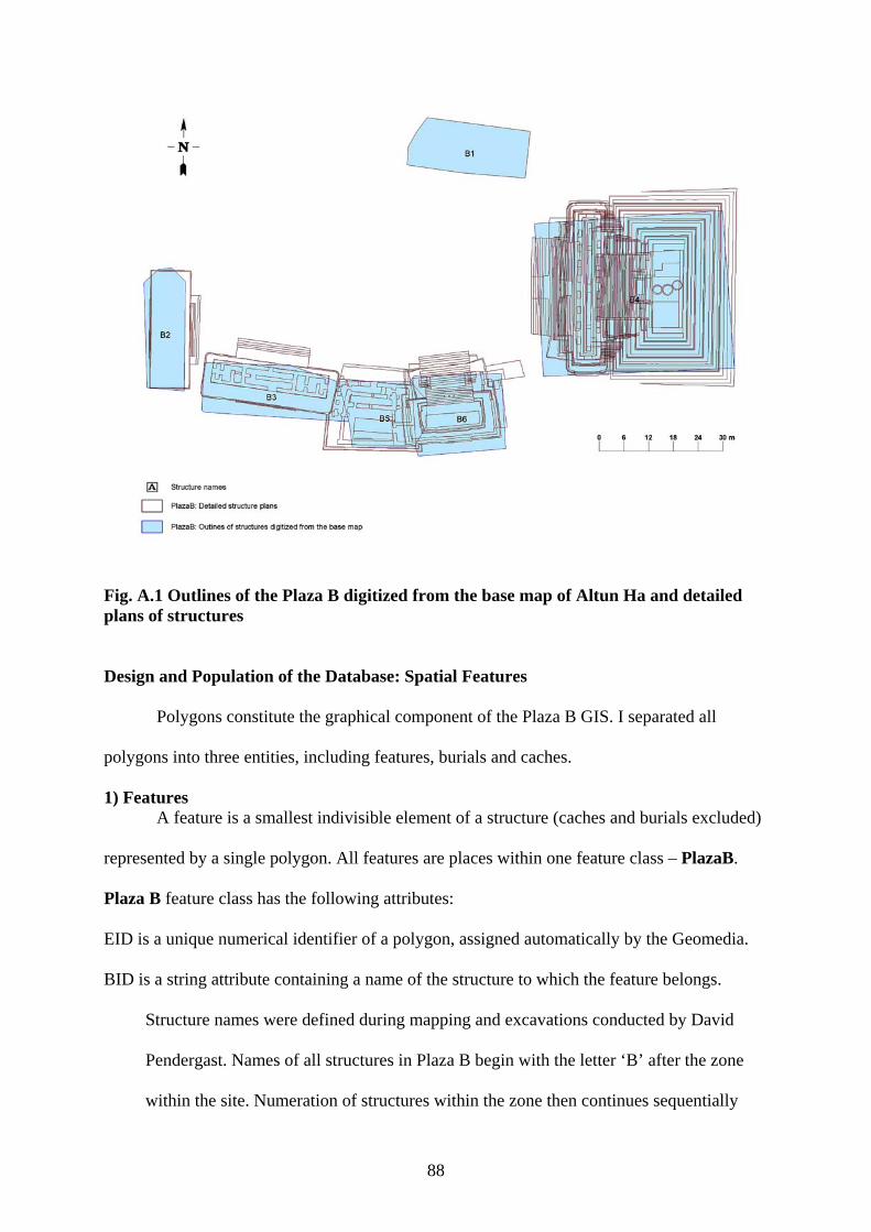
88
Fig. A.1 Outlines of the Plaza B digitized from the base map of Altun Ha and detailed plans of structures
Design and Population of the Database: Spatial Features
Polygons constitute the graphical component of the Plaza B GIS. I separated all
polygons into three entities, including features, burials and caches.
1) Features A feature is a smallest indivisible element of a structure (caches and burials excluded)
represented by a single polygon. All features are places within one feature class – PlazaB.
Plaza B feature class has the following attributes:
EID is a unique numerical identifier of a polygon, assigned automatically by the Geomedia.
BID is a string attribute containing a name of the structure to which the feature belongs.
Structure names were defined during mapping and excavations conducted by David
Pendergast. Names of all structures in Plaza B begin with the letter ‘B’ after the zone
within the site. Numeration of structures within the zone then continues sequentially
89
from ‘1’ to ‘6’. Although BID duplicates information in CEffort table (see below), I
keep it for easier update and modification of data, since Geomedia does not allow
modification of graphic data in a join query.
SID is a string attribute containing the name of a structure subcomponent. Subcomponent
combines elements that are repeated from structure to structure in the same combination,
such as stair with stair-side outsets or terraced platform.
REF is a string attribute containing the name of the subcomponent as it is referred in printed
sources (Pendergast 1982). It is less inclusive than SID. REF allows selection of groups
of elements of a structure and makes referencing between GIS and a printed source
easier. The relationship between SID and REF is described in Appendix, Note A.1.
TYPE is string attribute containing name of the element, such as step, basal moulding or
apron. Naming and classification into subcomponents was done in accordance with
name standards described in “A Lexicon for Maya Architecture” (Loten and Pendergast
1984).
B_ELEV is a numerical attribute containing the elevation of an element above the zero (plaza
floor in this case) level. B_ELEV also defines the order of elements as they are shown
on the screen with the lowest element being drawn first.
CONSTREFFRT is a string attribute that contains names of all construction efforts of a
structure as assigned by Pendergast (1982). Construction efforts were named
sequentially: 3rd, 2nd and 1st with 3rd being the earliest. Such numeration designated
major reconstructions of a structure. Letters ‘A’, ‘B’, ‘C’ (with ‘A’ being the earliest)
after the numbers 1, 2, 3, designated minor changes after major reconstructions.
Construction efforts that bear the same name were not necessarily conducted at the
same time. I used the naming system Pendergast (1982) has used, but I added ‘S’ at the
beginning of each construction effort.) The attribute CONSTREFFRT duplicates data
90
and is not used in any query. However, I kept it for verification of correctness of the
data when updating the database.
2) Burials Burials were grouped into a separate feature class Burials that has the following
attributes:
EID is a unique numerical identifier of a polygon, assigned automatically by Geomedia.
BID is a string attribute containing a name of the structure that contains the burial. BID
duplicates information in CEffort table (see below). I keep it for easier update and
modification of data, since Geomedia does not allow modification of graphic data in a
join query.
CID is a string attribute containing a name of the construction effort during which the burial
was placed. Although CID duplicates information in CEffort table (see below), I keep it
for easy update and modification of data, since Geomedia does not allow modification
of graphic data in a join query.
RPNO is a numerical attribute that contains a number assigned to artifacts in a burial if the
latter contains any. RP_NO equals 0 if burial contains no artifacts.
BR_RP is a numerical attribute that contains a subfloor or wall cache identifier for burials that
contain wall or subfloor caches6. BR_RP for a burial is equal 0. BR_RP is used in
references to the table Artifacts that contains the description of artifacts (see below).
REF is a string attribute containing the name of the burial as it is referred in printed sources
(Pendergast 1982).
TYPE is a string attribute containing the type of the burial, including tomb, burial or
dedicatory burial.
6 If a burial contains subfloor or wall caches, the RP number for artifacts in all of them and in the burial may be the same. For example, artifacts 364/1-364/10 were placed in a burial, 364-11 to 364-17 in a subfloor cache I, and 364/18 to 364/20 in a subfloor cache II. The caches may be represented graphically as different entities. I introduced BR_RP to provide a unique identifier for artifacts contained in these caches, e.g. subfloor cache I is numbered as 364-1, and subfloor cache II as 364-2 where RPNP is equal to 364 and BR_RP is equal to 1, 2 and 3.
91
PTIME is a numerical attribute containing the time of placement of a burial. If the time of
placement was impossible to determine, PTIME is equal to the average time of the
construction effort from table CEffort (see below).
B_ELEV is a numerical attribute containing the elevation of an element above the zero (plaza
floor in this case) level. B_ELEV also defines the order of elements as they are shown
on the screen, with lowest elements being drawn first.
3) Caches
Caches were grouped into a separate feature class Caches that has the following
attributes:
EID is a unique numerical identifier of a polygon, assigned automatically by the Geomedia.
BID is a string attribute containing a name of the structure that contains the cache. BID
duplicates information in CEffort table (see below). I keep it for easy update and
modification of data, since Geomedia does not allow modification of graphic data in a
join query.
CID is a string attribute containing a name of the construction effort during which the burial
was placed. Although CID duplicates information in CEffort table (see below). I keep it
for easy update and modification of data, since Geomedia does not allow modification
of graphic data in a join query.
RPNO is a numerical attribute that contains a number assigned to artifacts in a burial if the
latter contains any.
BR_RP is a numerical attribute that contains a subfloor or wall cache identifier (see above).
BR_RP for dedicatory caches is equal 0. RPNO and BR_RP provide a connection to the
table Artifacts that contains the description of artifacts (see below).
REF is a string attribute containing the name of the cache as it is referred in printed sources
(Pendergast 1982).
92
TYPE is a string attribute containing the type of the cache, such as, dedicatory, subfloor or
wall.
B_ELEV is a numerical attribute containing the elevation of an element above the zero (plaza
floor in this case) level. B_ELEV also defines the order of elements as they are shown
on the screen with the lowest element being drawn first.
Design and Population of the Database: Non-Spatial Features
The GIS of Plaza B contains entities that do not have a spatial component. They are
not represented by Geomedia. The relationship among spatial and non-spatial entities is
shown on the Fig. A.2. (See also Fig. B.1. for relationship among the tables of PlazaB
database.)
1) Construction Efforts Table CEffort contains the description of the construction efforts of all structures of
Plaza B. It contains the following fields:
ID is a unique numerical identifier of a polygon, assigned automatically by ACCESS.
BID is string attribute containing a name of the structure.
CID is a string attribute containing the name of a construction effort.
BTIME is a numerical attribute containing an estimated start time of construction7
ETIME is a numerical attribute containing an estimated end time of construction8
AVTIME is a numerical attribute that contains an average between ETIME and BTIME
which is taken as a time of construction and is used in queries.
7 The date of construction of a structure is not a single year but a span of time. BTIME is the beginning of a time span. 8 There are cases when several consequent construction efforts fall within one time span that means that their dates were impossible to determine. I divided the time span on a number of construction efforts and defined the beginning and end time by addition of a time span of a construction effort to the end time of a previous one. For example, for the structure B4, 2B and 2C were constructed between A. D. 600-A. D 675. Thus approximate time for construction of each modification was 75/2=37 years. Therefore, 2B was constructed between A. D. 600–A. D. 637 and 2C – between A. D. 638-A. D. 675. However, in some cases the placement of a burial helped to define the upper border of a time span. (See Table B.1 for the time spans of construction efforts.)
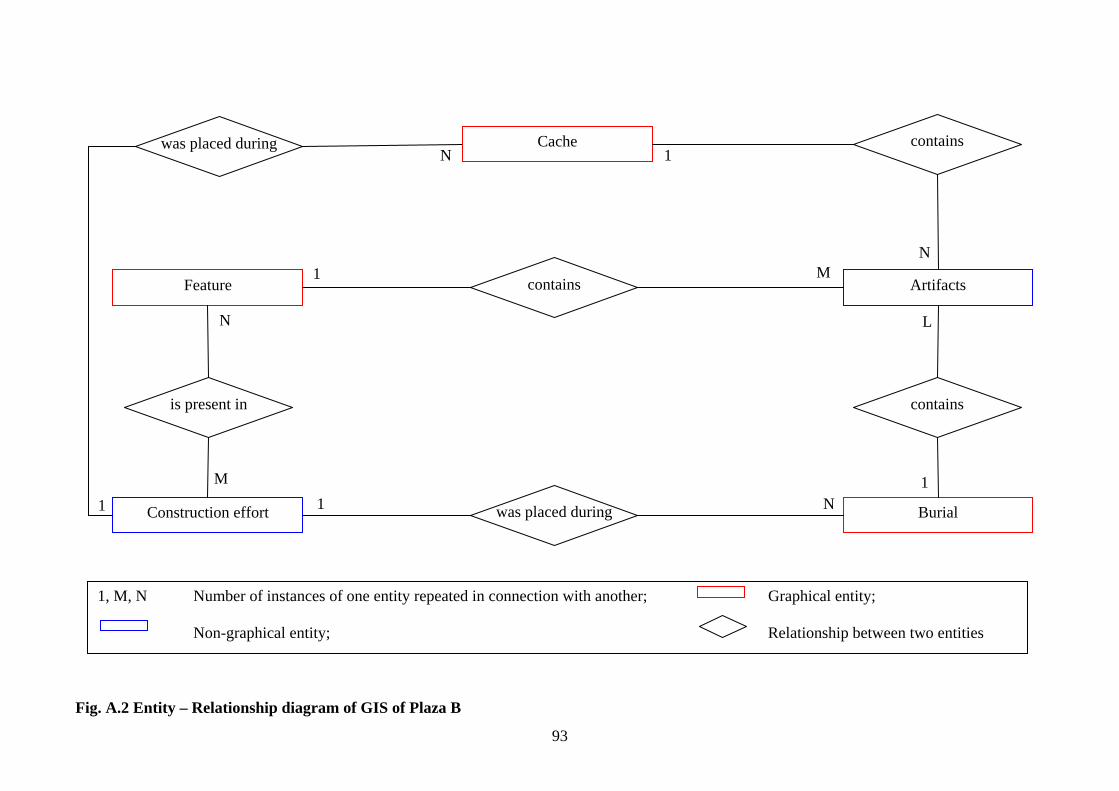
93
Fig. A.2 Entity – Relationship diagram of GIS of Plaza B
Construction effort
is present in
Feature
was placed during Cache contains
Artifacts
contains
Burial was placed during
contains 1 M
N
1 N
1
N
M
L
1 N1
1, M, N Number of instances of one entity repeated in connection with another; Graphical entity;
Non-graphical entity; Relationship between two entities
94
NEXTTIME is an attribute that contains the time of construction of the following construction
effort. I use it for selection of structures that were present on Plaza B at a certain period of
time (See Plaza B: Time Spans query).
Table Element_CEffort distributes features in time. It assigns each feature the time span it was
built or kept unchanged. It has the following attributes:
CID is a numerical attribute containing ID of the construction effort from the table CEffort
EID is a numerical attribute containing ID of he element from the table PlazaB.
2) Artifacts
Table Artifacts contains the description of artifacts found in burials, caches and features.
Artifacts do not have graphical representation. Sometimes a group of artifacts has the same RP
number and was described as one entry in the printed source, such as anklet consisting of nine
jade beads. Artifacts are described by following attributes:
AID is a numerical attribute containing a sequential number of an artifact as assigned by David
Pendergast. AID is that is unique within a particular burial or cache.
RPNO is a numerical attribute that contains a RP number of a burial or cache containing an
artifact (see above). RPNO links entries in the table Artifacts with entries in the tables
Burials and Caches.
BR_RP is a numerical attribute that contains a cache identifier (see above). BR_RP helps to
distinguish artifacts placed in different subfloor caches and between artifacts placed in
subfloor caches and burials. BR_RP links entries in the table Artifacts with entries in the
tables Burials and Caches.
TYPE is a string attribute containing the type of an artifact or a group of artifacts, e.g. pottery,
lithics, jade, shell etc.
FORM is a string attribute that contains the description of a form of an artifact or a group of
artifacts, such as pendant, projectile point, ring or jar.
DESC is text attribute containing additional information on artifacts or a group of artifacts, for
example the description of a form of a lithic eccentric or form of a bead.
95
MAT is a string attribute containing the description of material of an artifact or group of artifacts,
such as chert, albite, Spondulus sp., slipped (bowl).
QTY is a numerical attribute containing a quantity of artifacts in a group.
GIS has additional feature classes that contain information of access nodes, primary axes
of structures, layouts of other structures at Altun Ha and labeling information to all of them.
Queries
Since Geomedia does not automatically import connections between tables from
ACCESS, I re-created the joins among tables in Geomedia. Geomedia allows a pair of tables to
be joined by common attributes into a query. Features selected through queries are read-only.
In order to assign elements to construction efforts I created two queries. (1) Query
CEffort_Feature: Join joins tables CEffort and Element_CEffort, and (2) Query Plaza B:
Base Query that is based on CEffort_Feature query joins features in PlazaB feature class with
temporal information from the table CEffort. Most of the queries use this query as a base query.
Query Plaza B: Time Spans creates a set of functional attributes. Each functional
attribute represents a particular time span, e.g. A.D. 550-600, and contains information on what
elements of Plaza B structures were present at the particular time span. It assigns ‘1’ to all entries
in Plaza B: Base Query that are present during a particular time span, and ‘0’ to all others. The
functional attributes were created for A. D. 550-600, A. D. 600-637, A. D. 637-650, A. D. 650-
700, A. D. 700-750, A. D. 750-800, A. D. 800-850 and A. D. 850-900, the periods when at least
one structure on the Plaza B was changed.
Query PlazaB_Burials:Artifacts joins Burials feature class with Artifacts table. Query
PlazaB_Caches:Artifacts joins Caches feature class with Artifacts table. Other queries use
these join queries to sort information. Queries B2_Editable, B3_Editable, B4_Editable,
B5_Editable and B6_Editable are attribute queries of the PlazaB feature class. The geometry
and attributes of features depicted through these queries can be modified and deleted.
96
Queries named Plaza B: A.D. <year1>- <year2> are attribute queries that represent the
view of Plaza B between year1 and year2. They use functional attributes of Plaza B: Time
Spans query.
I found it easier to use ACCESS and EXCEL to work with artifacts because data on
artifacts do not include spatial information, and Geomedia has limitations on use of SQL9.
Data on GIS of Plaza B are located in ACCESS: PlazaB.mdb. GIS of plaza B also
contains some additional information, including canned and referenced map of Altun Ha in .jpg
formats and referenced rectangle of the map in Altunha_nad27_z16.dgn file. These data need to
be copied whenever the main database is copied.
Recommendations for Further Development
The main problems with use of this system will arise if one wants to update or modify
data, because Geomedia does not allow changing data in tables that do not contain graphic
elements. For example, the addition of a new element requires separate update of at least two
tables. Development of a user interface in ACCESS may help to ease the process of update of the
GIS database.
If the GIS is expanded to include the whole site, the creation of functional attributes
should be programmed. Altun Ha was occupied for more than 2000 years and quantity of
functional attributes that will represent Altun Ha at different time spans may increase by tens,
may be by hundreds depending, on research goals. Manual creation of so many functional
attributes is unfeasible. The creation of spatial queries that represent modifications of structures
from one construction effort to another is also programmable and is a good option in case of
expansion of the GIS.
The descriptive database also can be expanded. Information about feature groups,
including information about core and facing of a platform, may be included as a separate table.
Information about lining, capping, number of individuals, position, orientation, condition of
9 Structured Query Language (SQL) is a standard computer language for accessing and manipulating database systems (http://www.w3schools.com/sql/sql_intro.asp).
97
individual in a burial remains to be added for burials. Table Artifacts may be separated into
several tables by the type of an artifact if one wants to include detailed information on size, form
and decoration.
Visual information, including photographs and drawing may also be included into a
database. The 3-D model for analysis of visibility can be created using B_ELEV.
Finally, the most important direction is the publishing of the GIS on the Internet, so it can
be used for research and promotion of the site to wide audience.
There are certainly other options for development of t he GIS. I note only the most
obvious of them.
98
APPENDIX B: RELEVANT MATERIAL NOT INCLUDED IN THE MAIN TEXT
99
NOTES Note B.1: Relationship between SID and REF attributes of Plaza B Feature Class
SID and REF allow selection of separate structure blocks and easier reference between the GIS and printed source that is especially important for such complex buildings as B4. As a rule SID is larger or equal to REF. Structure may contain following parts: Altar
• altar (REF: altar, SID: altar) • altar facing(REF: altar, SID: altar)
Outset • outset (REF: outset, SID: stair or platform) • apron (REF: outset, SID: stair or platform) • subapron (REF: outset, SID: stair or platform) • basal molding (REF: outset, SID: stair or platform)
Platform: • platform (REF: platform, SID: platform) • terrace (REF: terrace, SID: platform) • apron (REF: terrace, SID: platform) • subapron (REF: terrace, SID: platform) • basal molding (REF: terrace, SID: platform) • outset (see above) • unit (REF: unit, SID: platform) • posthole (REF: none, SID: platform) • wall (REF: wall, SID: platform)
Stair • step (REF: stair, SID: stair) • outset, stair-side (see above) • stair block (REF: stair block, SID: stair)
Building • cord holder (REF: cord holder, SID: building) • roof (REF: none; SID: building) • wall (REF: none, SID: building) • wall stub (REF: none, SID: building) • spine wall (REF: none, SID: building) • unit (REF: unit or none, SID: building) • beam (REF: beam, SID: building) • vent opening (REF: vent opening, SID: building) • court (REF: court, SID: building)
Unit • unit (ref : unit or none, SID: unit, building, platform)
100
Note B.2: Content of caches
Subfloor caches B4 – A:
Tomb B4/7 (RP No 364) ♦ 364-1 (Midpoint, under the right head of the interred)
Bowl, pottery, slipped black Stuccoed object, bowl, wooden (?), green with red, white, pink
lines Eccentrics, chert (12)
♦ 364-2 (South, axial, above the head of the interment) Hematite, mirror
♦ 364-3 (Southwest corner) Bone, stingray vertebras and spine (27) Coral Eccentrics, chert (5) Lithics, flakes, chert (1) Stuccoed object, bowl, wooden(?), green with red and black lines
♦ 364-4 (beneath north wall) Eccentrics, chert (9) Shell, bead Stuccoed object, bowl, wooden (?), green with red and black lines
B4 –D: Tomb B4/6 (RP No 256)
♦ 256-1 (Axial, South, under the head and torso) Eccentrics, chert (11) Bowl, pottery, polychrome
♦ 256-2 (Axial, midpoint) Eccentrics, chert (8) Dish, pottery, unslipped
♦ 256-3 (Northeast corner) Jade, bead (3) Hematite, lamina (2) Shell, whole(4)/bead(2)
Tomb B4/2 (RP No 164) ♦ 164-1 (South, above the skull)
Jar, pottery, slipped orange Eccentrics, chert (10)
♦ 164-2 (Midpoint) Bone, stingray spine Jade, unmodified/bead Hematite, lamina (103) Pearl Pigment Bowl, slipped red Shell, whole(3)/pendant(3)/fragments/bead(2)
♦ 164-3 (Northeast corner) Eccentrics, chert (9)
101
B4-F: Tomb B4/1 (RP No 151)
♦ 151-1 (Northeast, outside the limits of the tomb) Shell, whole (5)/fragment Jade, unworked (?) Coral (2) Bone, crab claw (17)
♦ 151-2 (Wall, north face) Censers with ash, badly crushed (3)
♦ 151-3 (Southeast corner) Eccentrics, chert (2)
♦ 151-4 (Midpoint, east of southeast corner of the tomb) Eccentrics, chert (2) Jar, pottery, unslipped (2)
Tomb B4/5 (RP No 181) ♦ 213-1 (Axial, North)
Container with lid, chert Eccentrics, chert (2)
B4-G: Tomb B4/3 (RP No 175)
♦ 175-1 (Wall, East) Eccentrics, chert (5)
♦ 175-2 (West, wall) Jade, bead Censers (2)
Tomb B4/4 (RP No 176) ♦ 176-1 (Wall, east, outside of crypt)
Eccentrics, chert (14) ♦ 176-2 (North wall)
Eccentrics, chert (18) A6-B:
Tomb A6/1 (RP No 440) ♦ 440-1 (Southwest corner)
Bowl, polychrome (3) ♦ 440-2 (Midpoint, south side)
Bowl, polychrome E1-A:
Tomb E1/A (RP No 34) ♦ 34-1 (location not given)
Censer (2) Eccentrics, chert (21)
♦ 293 (South, outside of the crypt) Lamina (40) Jade, fragments, unworked (18)/lump Shell, pieces (8)/bead (3) Bone, stingray spine
Tomb E1/3 (RP No 38) ♦ 38-1 (South end )
Eccentrics, chert (20)
102
Dish, slipped black/unslipped Lithics, obsidian, flake blades (3) Jade, bead, half/inlay
E1-B Tomb E1/1 (RP No 30)
♦ 30-1 (Wall, location not given ) Jar, unslipped
♦ 30-2 (Wall, location not given ) Bowl, monochrome, unrecoverable (2)
♦ 35 (Axial, beneath torso) Eccentrics, chert (20) Shell, unmodified (6) Coral Jade pendant/bead Bone, stingray spine (8) Lithics, chert flake (9)/obsidian flake blade (3)/chert flake blade(9) Hematite
Dedicatory caches: Plaza B (postabandonment caches not included) B5 –Unit 9:
B5/1 (RP No 145): (Unknown) Pottery, dish, unslipped/slipped Jade, columnar object
B4 –3rd: B4/13 (RP No 371): (Altar)
Bone, stingray spine Jade, bead (6)/unmodified(20)/pendant Hematite (14) Pearl (13) Pigment Shell, whole(2)/bead(9)/fragment(35) Stucco object, form undetermined, orange, red and black
B4-2nd A B4/7 (RP No 326): (Stair)
Necklace, jade, shell, hematite pendant (21) Jade unmodified (5)/earplug flare (1)/bead (1) Pearl (2) Shell, bead
B4/8 (RP No 331): (Building) Group, jade, bead(4) and shell, bead(3) Group. Jade, unworked and shell, fragments (6)
B4/9(RP No 333): (Building) Shell, valve (2) Jade, bead/pendant Pearl
B4 –2nd D B4/3 (RP No 303): (Stair)
Pottery, labret (2) Pottery, dish, slipped red Shell, disk
103
B4/4(RP No 304): (Stair) Pottery, censers (5) Eccentrics, chert (5) Jade, fragments (16) Shell, fragments(4)/whole(3) Hematite (4)
B4/5 (RP No 305): (Stair) Eccentrics, chert (5) Shell, unmodified (269)/fragments(3) Jade unmodified(263) Hematite (28) Pigment
B4/6 (RP No 306): Stair Eccentrics, chert (7) Jade, bead
B4/12 (RP No 369): Altar Jade, bead (2) Shell, bead (2) Pearl (2) Lamina (2)
B4 –2nd E B4/10 (RP No 209): Altar
Jade, pendant B4 –2nd G
B4/2 (RP No 188): Platform Pottery, plate, black-on-red Pottery, basin, black-on-red Lithics, core, obsidian (22) Eccentrics, chert (9)
B6 –1 B4/13 (RP No 501): (in core)
Lithics, flakes and chips, obsidian (492)
Dedicatory caches: Plaza A (postabandonment caches not included) A1-A:
A1/1 (RP No 411): (Stair) Bowl, pottery, slipped orange Dish, pottery, unslipped
A1-D: A1/2 (RP No 707): (Platform, A2 termination ritual)
Jade, fragments (21) A3-1A:
A3/1 (RP No 497/1): (Stair) Miscellaneous stone, limestone, carved
A3-1B: A3/3 (RP No 456): (Axial, platform)
Pottery, vessel with lid, slipped orange Bone, turtle, plastron and carapace/stingray spine
104
Shell, whole/Red Jewel Box (21)/Dentalium antillarum (11) Coral (4)
A3-1C: A3/1 (RP No 418): (Stair)
Pottery, vessel with lid, limestone Jade, pendant (3), bead (7) Tumbaga, bead (1) Shell, bead (2) Hematite (5) Pearl (2)
A3-1D: A3/2 (RP No 453): (Building)
Pearl (2) Bead, jade(2)
A5-A A5/3 (RP No 374): (South of burial A-5/2)
Pottery, plate, unslipped/polychrome (2) Shell, bead/whole Jade, pendant/earplug flare Pearl Hematite Group, jade, bead (11)/shell, disk (6)
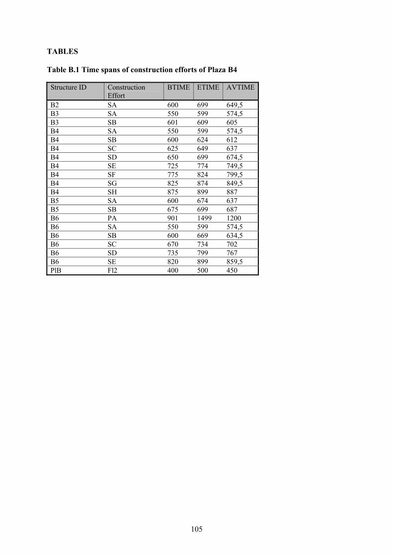
105
TABLES
Table B.1 Time spans of construction efforts of Plaza B4
Structure ID Construction Effort
BTIME ETIME AVTIME
B2 SA 600 699 649,5 B3 SA 550 599 574,5 B3 SB 601 609 605 B4 SA 550 599 574,5 B4 SB 600 624 612 B4 SC 625 649 637 B4 SD 650 699 674,5 B4 SE 725 774 749,5 B4 SF 775 824 799,5 B4 SG 825 874 849,5 B4 SH 875 899 887 B5 SA 600 674 637 B5 SB 675 699 687 B6 PA 901 1499 1200 B6 SA 550 599 574,5 B6 SB 600 669 634,5 B6 SC 670 734 702 B6 SD 735 799 767 B6 SE 820 899 859,5 PlB Fl2 400 500 450
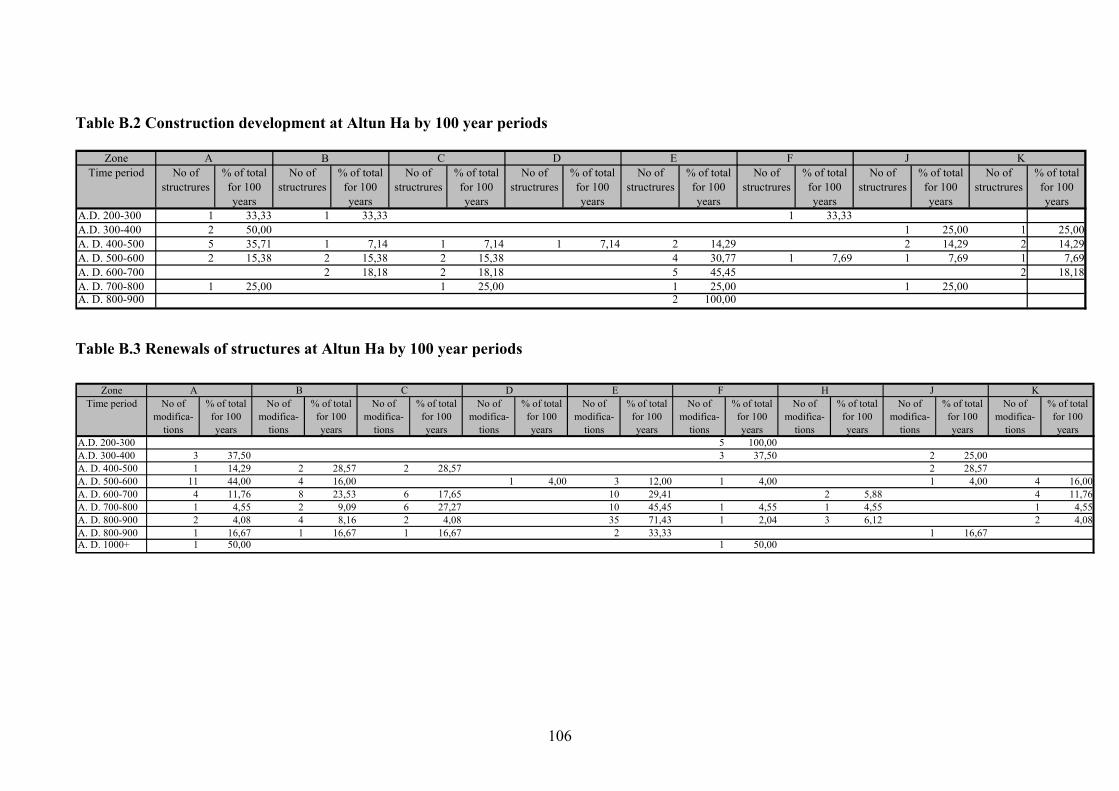
106
Table B.2 Construction development at Altun Ha by 100 year periods
Zone A B C D E F J KTime period No of
structrures% of total
for 100 years
No of structrures
% of total for 100 years
No of structrures
% of total for 100 years
No of structrures
% of total for 100 years
No of structrures
% of total for 100 years
No of structrures
% of total for 100 years
No of structrures
% of total for 100 years
No of structrures
% of total for 100 years
A.D. 200-300 1 33,33 1 33,33 1 33,33A.D. 300-400 2 50,00 1 25,00 1 25,00A. D. 400-500 5 35,71 1 7,14 1 7,14 1 7,14 2 14,29 2 14,29 2 14,29A. D. 500-600 2 15,38 2 15,38 2 15,38 4 30,77 1 7,69 1 7,69 1 7,69A. D. 600-700 2 18,18 2 18,18 5 45,45 2 18,18A. D. 700-800 1 25,00 1 25,00 1 25,00 1 25,00A. D. 800-900 2 100,00
Table B.3 Renewals of structures at Altun Ha by 100 year periods
Zone A B C D E F H J KTime period No of
modifica-tions
% of total for 100 years
No of modifica-
tions
% of total for 100 years
No of modifica-
tions
% of total for 100 years
No of modifica-
tions
% of total for 100 years
No of modifica-
tions
% of total for 100 years
No of modifica-
tions
% of total for 100 years
No of modifica-
tions
% of total for 100 years
No of modifica-
tions
% of total for 100 years
No of modifica-
tions
% of total for 100 years
A.D. 200-300 5 100,00A.D. 300-400 3 37,50 3 37,50 2 25,00A. D. 400-500 1 14,29 2 28,57 2 28,57 2 28,57A. D. 500-600 11 44,00 4 16,00 1 4,00 3 12,00 1 4,00 1 4,00 4 16,00A. D. 600-700 4 11,76 8 23,53 6 17,65 10 29,41 2 5,88 4 11,76A. D. 700-800 1 4,55 2 9,09 6 27,27 10 45,45 1 4,55 1 4,55 1 4,55A. D. 800-900 2 4,08 4 8,16 2 4,08 35 71,43 1 2,04 3 6,12 2 4,08A. D. 800-900 1 16,67 1 16,67 1 16,67 2 33,33 1 16,67A. D. 1000+ 1 50,00 1 50,00
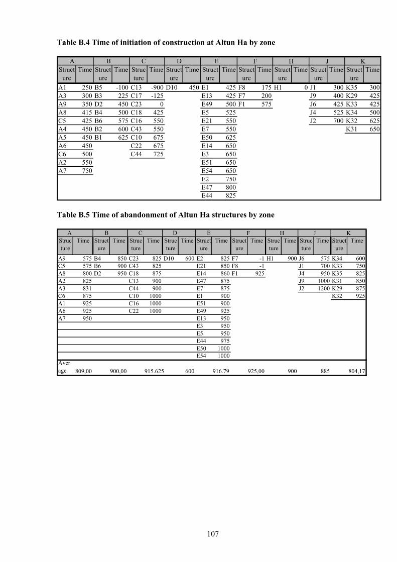
107
Table B.4 Time of initiation of construction at Altun Ha by zone
A B C D EStruct
ureTime Struct
ureTime Struc
tureTime Struct
ureTime Struct
ureTime Struct
ureTime Struct
ureTime Struct
ureTime Struct
ureTime
A1 250 B5 -100 C13 -900 D10 450 E1 425 F8 175 H1 0 J1 300 K35 300A3 300 B3 225 C17 -125 E13 425 F7 200 J9 400 K29 425A9 350 D2 450 C23 0 E49 500 F1 575 J6 425 K33 425A8 415 B4 500 C18 425 E5 525 J4 525 K34 500C5 425 B6 575 C16 550 E21 550 J2 700 K32 625A4 450 B2 600 C43 550 E7 550 K31 650A5 450 B1 625 C10 675 E50 625A6 450 C22 675 E14 650C6 500 C44 725 E3 650A2 550 E51 650A7 750 E54 650
E2 750E47 800E44 825
F H J K
Table B.5 Time of abandonment of Altun Ha structures by zone
A B C D EStructure
Time Structure
Time Structure
Time Structure
Time Structure
Time Structure
Time Structure
Time Structure
Time Structure
Time
A9 575 B4 850 C23 825 D10 600 E2 825 F7 -1 H1 900 J6 575 K34 600C5 575 B6 900 C43 825 E21 850 F8 -1 J1 700 K33 750A8 800 D2 950 C18 875 E14 860 F1 925 J4 950 K35 825A2 825 C13 900 E47 875 J9 1000 K31 850A3 831 C44 900 E7 875 J2 1200 K29 875C6 875 C10 1000 E1 900 K32 925A1 925 C16 1000 E51 900A6 925 C22 1000 E49 925A7 950 E13 950
E3 950E5 950E44 975E50 1000E54 1000
Average 809,00 900,00 915.625 600 916.79 925,00 900 885 804,17
F H J K
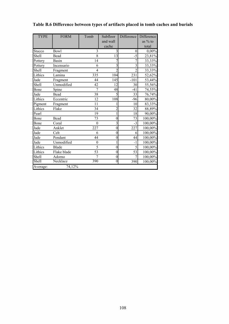
108
Table B.6 Difference between types of artifacts placed in tomb caches and burials
TYPE FORM Tomb Subfloor and wall
cache
Difference Difference as % to
totalStucco Bowl 3 3 0 0,00%Shell Bead 8 13 -5 23,81%Pottery Basin 14 7 7 33,33%Pottery Incensario 6 3 3 33,33%Shell Fragment 4 2 2 33,33%Lithics Lamina 335 104 231 52,62%Jade Fragment 44 145 -101 53,44%Shell Unmodified 42 12 30 55,56%Bone Spine 7 48 -41 74,55%Jade Bead 38 5 33 76,74%Lithics Eccentric 12 108 -96 80,00%Pigment Fragment 11 1 10 83,33%Lithics Flake 34 2 32 88,89%Pearl 19 1 18 90,00%Bone Bead 73 0 73 100,00%Bone Coral 0 3 -3 100,00%Jade Anklet 227 0 227 100,00%Jade Celt 6 0 6 100,00%Jade Pendant 44 0 44 100,00%Jade Unmodified 0 1 -1 100,00%Lithics Blade 5 0 5 100,00%Lithics Flake blade 53 0 53 100,00%Shell Adorno 7 0 7 100,00%Shell Necklace 390 0 390 100,00%Average: 74,12%
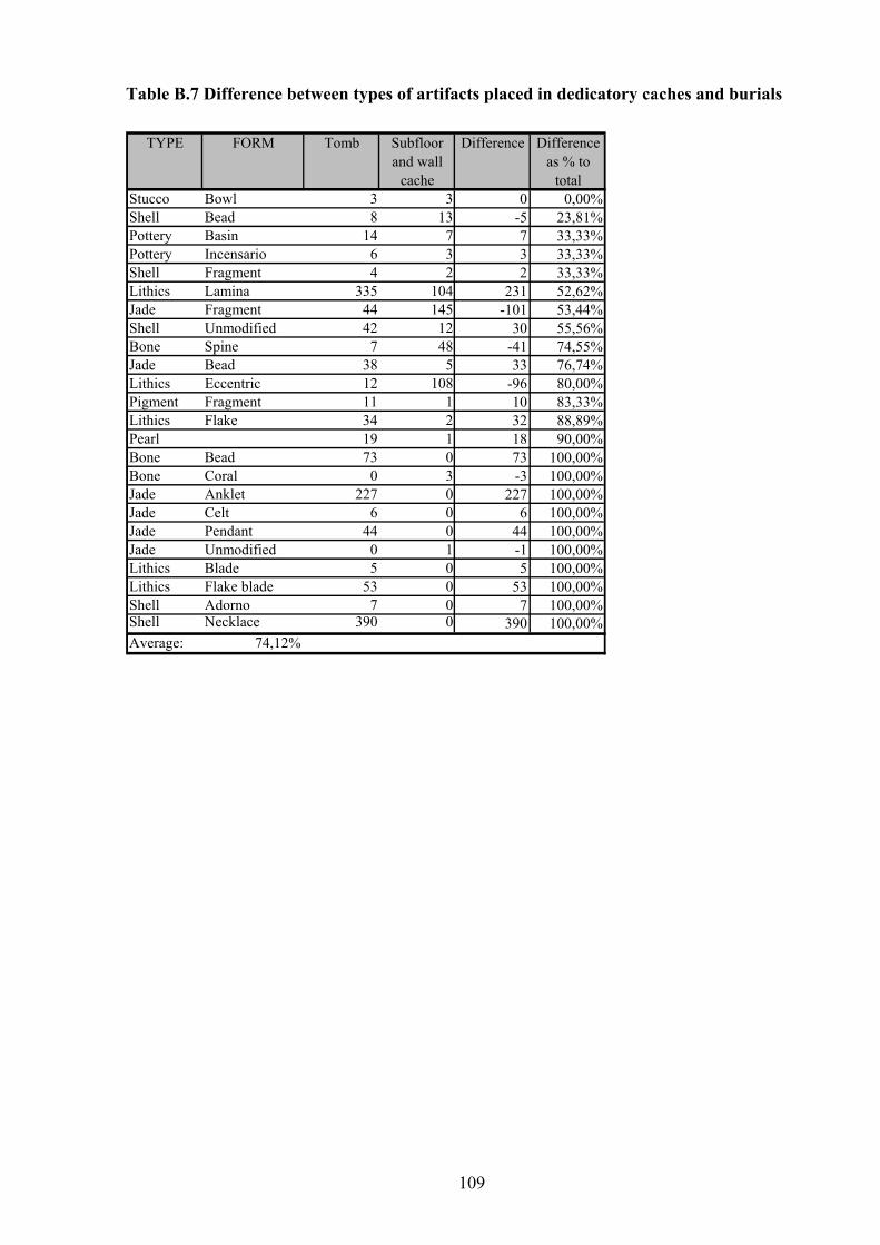
109
Table B.7 Difference between types of artifacts placed in dedicatory caches and burials
TYPE FORM Tomb Subfloor and wall
cache
Difference Difference as % to
totalStucco Bowl 3 3 0 0,00%Shell Bead 8 13 -5 23,81%Pottery Basin 14 7 7 33,33%Pottery Incensario 6 3 3 33,33%Shell Fragment 4 2 2 33,33%Lithics Lamina 335 104 231 52,62%Jade Fragment 44 145 -101 53,44%Shell Unmodified 42 12 30 55,56%Bone Spine 7 48 -41 74,55%Jade Bead 38 5 33 76,74%Lithics Eccentric 12 108 -96 80,00%Pigment Fragment 11 1 10 83,33%Lithics Flake 34 2 32 88,89%Pearl 19 1 18 90,00%Bone Bead 73 0 73 100,00%Bone Coral 0 3 -3 100,00%Jade Anklet 227 0 227 100,00%Jade Celt 6 0 6 100,00%Jade Pendant 44 0 44 100,00%Jade Unmodified 0 1 -1 100,00%Lithics Blade 5 0 5 100,00%Lithics Flake blade 53 0 53 100,00%Shell Adorno 7 0 7 100,00%Shell Necklace 390 0 390 100,00%Average: 74,12%
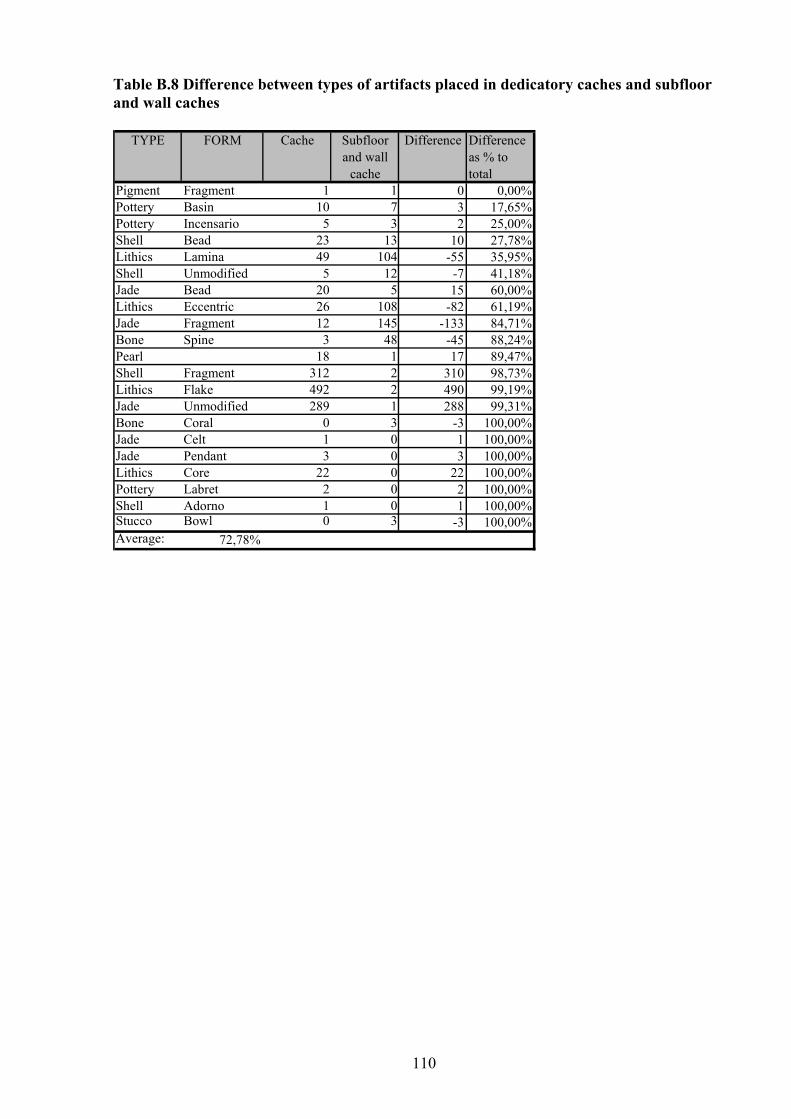
110
Table B.8 Difference between types of artifacts placed in dedicatory caches and subfloor and wall caches
TYPE FORM Cache Subfloor and wall
cache
Difference Difference as % to total
Pigment Fragment 1 1 0 0,00%Pottery Basin 10 7 3 17,65%Pottery Incensario 5 3 2 25,00%Shell Bead 23 13 10 27,78%Lithics Lamina 49 104 -55 35,95%Shell Unmodified 5 12 -7 41,18%Jade Bead 20 5 15 60,00%Lithics Eccentric 26 108 -82 61,19%Jade Fragment 12 145 -133 84,71%Bone Spine 3 48 -45 88,24%Pearl 18 1 17 89,47%Shell Fragment 312 2 310 98,73%Lithics Flake 492 2 490 99,19%Jade Unmodified 289 1 288 99,31%Bone Coral 0 3 -3 100,00%Jade Celt 1 0 1 100,00%Jade Pendant 3 0 3 100,00%Lithics Core 22 0 22 100,00%Pottery Labret 2 0 2 100,00%Shell Adorno 1 0 1 100,00%Stucco Bowl 0 3 -3 100,00%Average: 72,78%
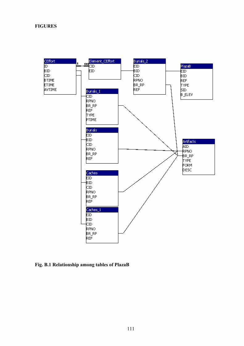
111
FIGURES
Fig. B.1 Relationship among tables of PlazaB
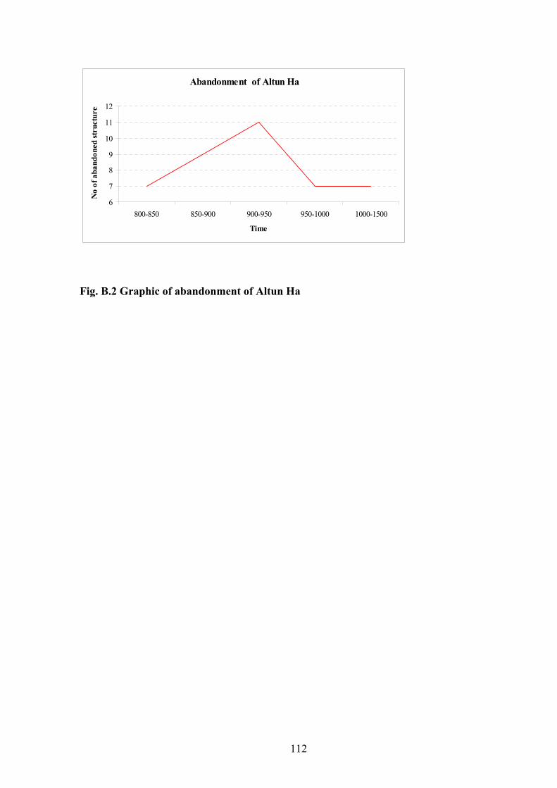
112
Abandonment of Altun Ha
6
7
8
9
10
11
12
800-850 850-900 900-950 950-1000 1000-1500
Time
No
of a
band
oned
stru
ctur
es
Fig. B.2 Graphic of abandonment of Altun Ha
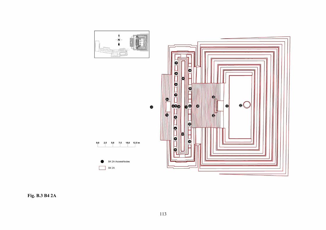
113
Fig. B.3 B4 2A
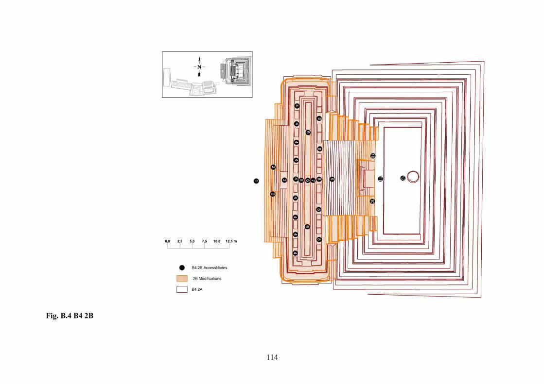
114
Fig. B.4 B4 2B
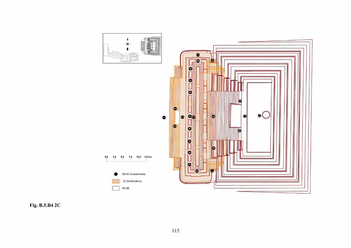
115
Fig. B.5.B4 2C
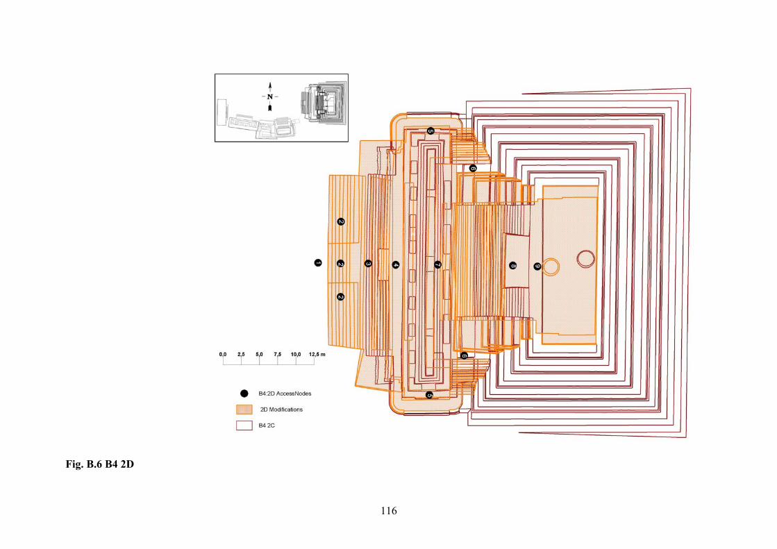
116
Fig. B.6 B4 2D
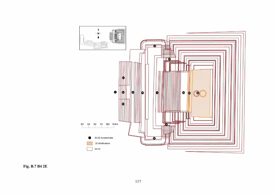
117
Fig. B.7 B4 2E
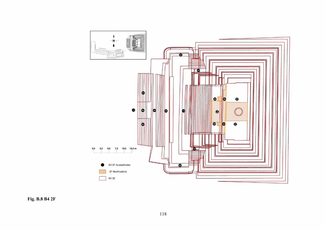
118
Fig. B.8 B4 2F
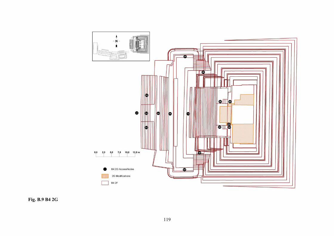
119
Fig. B.9 B4 2G
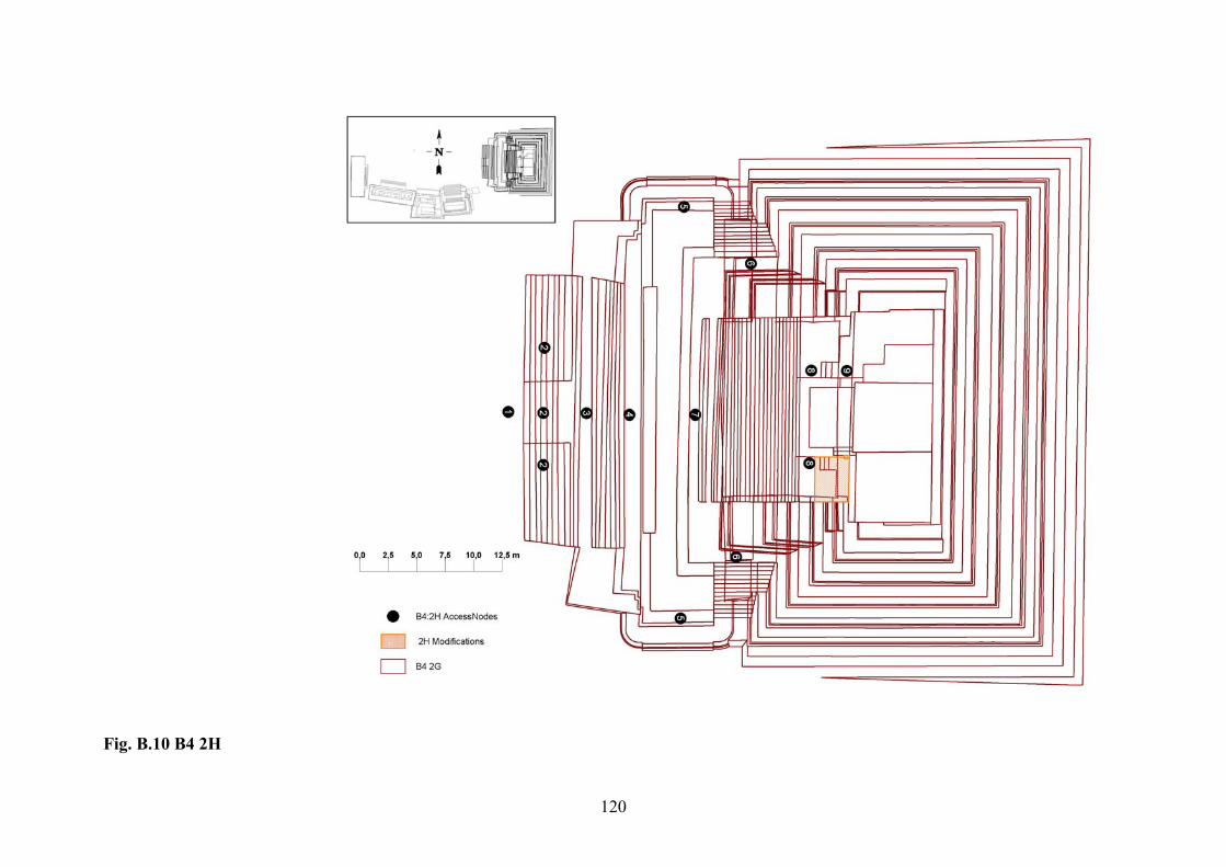
120
Fig. B.10 B4 2H
121
VITA
Olga Aleksandrovna Yermakhanova was born in Tashkent, Uzbekistan, in 1977. She
earned her first master’s degree in computer science in 1999. For two years, she worked as a
technical translator/interpreter on major construction and agricultural projects in the country.
From 2003 to 2005, she worked as a newsletter designer in the USAID’s project on natural
resource management in Central Asia.
From 2002, she started volunteering on different archaeological excavations and labs
in Mount Vernon, Virginia, Baton Rouge, Louisiana, and Hudson Meng, Nebraska. In 2002
she was accepted to the master’s program in anthropology at LSU, where she was introduced
to the GIS and Maya archaeology. Her thesis work was the creation of the GIS of the Plaza B
at Altun Ha. This works is only the beginning and in her doctoral dissertation, which she
hopes to start in several years. She is planning to expand the system to embrace the whole site
and publish it on the Internet for promotion of Maya archaeology to the wide public.