Embed Size (px)
Citation preview
KYC LANDSCAPE ARCHITECTUREPORTFOLIO 2015-2017 SELECTED WORKS
KEN YEE CHEW
[01] [02]
contact me
Bachelor of Landscape Architecture Candidate ‘19University of Guelph, Year 3
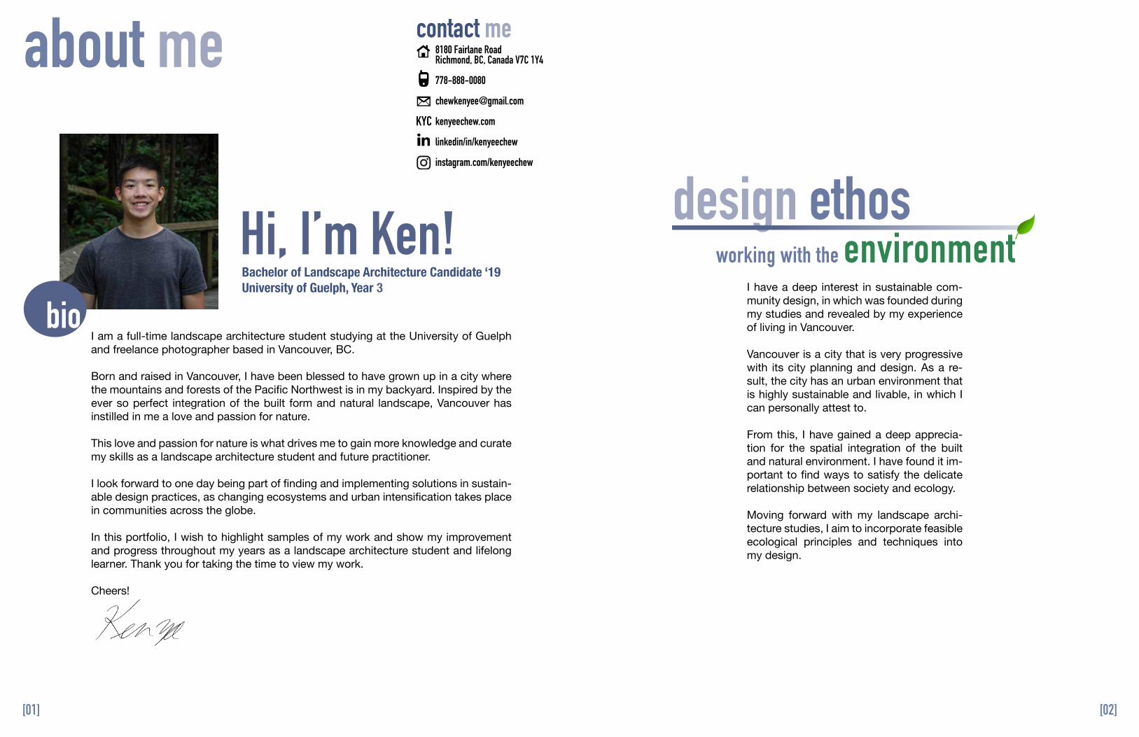
I am a full-time landscape architecture student studying at the University of Guelph and freelance photographer based in Vancouver, BC.
Born and raised in Vancouver, I have been blessed to have grown up in a city where the mountains and forests of the Pacific Northwest is in my backyard. Inspired by the ever so perfect integration of the built form and natural landscape, Vancouver has instilled in me a love and passion for nature.
This love and passion for nature is what drives me to gain more knowledge and curate my skills as a landscape architecture student and future practitioner.
I look forward to one day being part of finding and implementing solutions in sustain-able design practices, as changing ecosystems and urban intensification takes place in communities across the globe.
In this portfolio, I wish to highlight samples of my work and show my improvement and progress throughout my years as a landscape architecture student and lifelong learner. Thank you for taking the time to view my work.
Cheers!
I have a deep interest in sustainable com-munity design, in which was founded during my studies and revealed by my experience of living in Vancouver.
Vancouver is a city that is very progressive with its city planning and design. As a re-sult, the city has an urban environment that is highly sustainable and livable, in which I can personally attest to.
From this, I have gained a deep apprecia-tion for the spatial integration of the built and natural environment. I have found it im-portant to find ways to satisfy the delicate relationship between society and ecology.
Moving forward with my landscape archi-tecture studies, I aim to incorporate feasible ecological principles and techniques into my design.
about me
Hi, I’m Ken! design ethos
bio
working with the environment
8180 Fairlane RoadRichmond, BC, Canada V7C 1Y4
778-888-0080
kenyeechew.com
linkedin/in/kenyeechew
instagram.com/kenyeechew
KYC
[03] [04]
PublicistUniversity of Guelph Landscape Architecture Student SocietySeptember, 2016 - September, 2017
Landscape Designer & DraftspersonHeritage Design & Construction Management Inc. — Vancouver, BCMay 5, 2017 - September 4, 2017
Freelance PhotographerKen Yee Chew Photography — Vancouver, BCAugust, 2016 - Present
• Kept the student body informed on news and events through regular email updates and social media.• Rebranded the official facebook page and created the Instagram account @uofg_LASS.• Strengthened communication in the society by creating a strong social media presence.• Coordinated meetings with the executive team and contributed to the planning of society events.
• Produced two working construction sets for a light industrial warehouse & residential home.• Worked closely with the Principal building designer to calculate and review dimensions.• Completed a landscape design for the residential single detached house.• Created a website to enhance the digital presence for the company.
Landscape Construction LabourerJegard Landscape & Maintenance Inc. — Vancouver, BCJune 5, 2016 - June 30, 2017• Performed routine lawn and maintenance tasks.• Assisted with plant up and design.• Operated gardening and maintenance equipment safely.• Completed individual tasks in an efficient & timely manner.• Undertook large tree stump and root-ball removal projects.
• Travel and adventure photographer • Created and sold prints from personal web gallery• Worked on portrait photos for individual clients and photo assignments for organizations, most notably: Cultural
Regeneration Research Society and the University of Guelph Tennis Club.
Team Leader & English TeacherCulture Regeneration Research Society — Luocheng & Longzhou County, Guangxi, ChinaJuly, 2015 & 2016 • Travelled to Guangxi, China for two consecutive summers— 2015 & 2016.• Taught senior high students ages 16-17 basic conversational English for two week periods.• Developed personal relationships with each student in and outside class time.• Constructed a daily curriculum by preparing lesson plans, organizing activities and assigning homework.
extra curricularwork experience
volunteer work
skills & competencies
professional memberships
interests & activities
Construction WorkerMe2We/Free the Children — Sikirar, Narok County, Kenya August, 2014 • Assisted with the construction of a brick and mortar primary school classroom in Sikirar, Kenya for 3 weeks.• Interacted on a daily basis with local Massai and Kipsigi peoples by participating in local activities to better
understand the social, economic, and geopolitical issues affecting their communities.
Recreation AssistantRosewood Manor Senior Home — Richmond, BCSeptember, 2012 - November, 2014• Interacted with seniors on a one-to-one basis & assisted those primarily with speaking and motor impairments.• Provided emotional support for seniors who were alone.• Developed care and patience by assisting with errands and activities.• Additional duties included helping prepare & set up activities in the senior home.
SketchUpLightroomPhotoshop
Ontario Association of Landscape ArchitectsStudent Member
2016 - Present
Photography, fishing, hiking, outdoors, guitar, alto saxophone, ball hockey
AutoCAD
Architectural Conservancy of OntarioStudent Member
2016 - Present
IllustratorInDesignMS OfficeArcGIS
c u r r i c u l u m v i t a e
H A N D D R AW I N G S & D E TA I L S
SELECTED WORKS
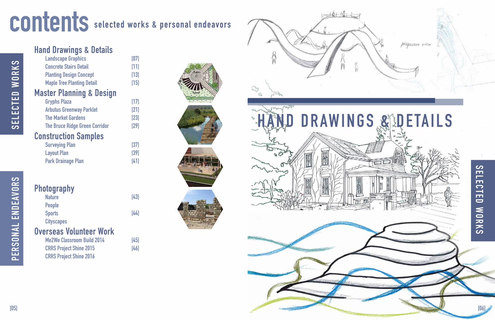
Hand Drawings & Details
selected works & personal endeavorscontents
Master Planning & Design
Construction Samples
Overseas Volunteer Work
Landscape GraphicsConcrete Stairs Detail Planting Design ConceptMaple Tree Planting Detail
Gryphs Plaza Arbutus Greenway ParkletThe Market GardensThe Bruce Ridge Green Corridor
Surveying PlanLayout Plan Park Drainage Plan
NaturePeopleSportsCityscapes
Photography
Me2We Classroom Build 2014CRRS Project Shine 2015CRRS Project Shine 2016
SELE
CTED
WOR
KS [07]
[11][13][15]
[17][21][23][29]
[37][39][41]
[43]
[44]
[45][46]
[05] [06]
PERS
ONAL
END
EAVO
RS
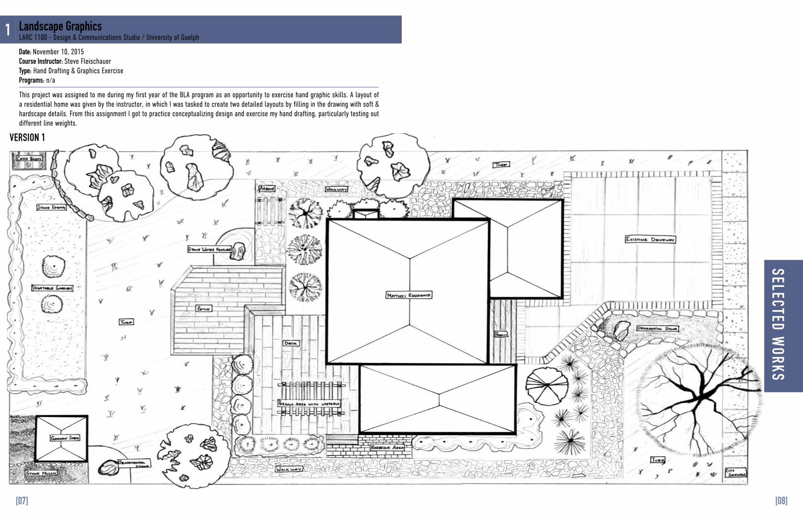
VERSION 1
1
This project was assigned to me during my first year of the BLA program as an opportunity to exercise hand graphic skills. A layout of a residential home was given by the instructor, in which I was tasked to create two detailed layouts by filling in the drawing with soft & hardscape details. From this assignment I got to practice conceptualizing design and exercise my hand drafting, particularly testing out different line weights.
Landscape GraphicsLARC 1100 - Design & Communications Studio / University of Guelph
Date: November 10, 2015Course Instructor: Steve FleischauerType: Hand Drafting & Graphics ExercisePrograms: n/a
SELECTED WORKS
[07] [08]
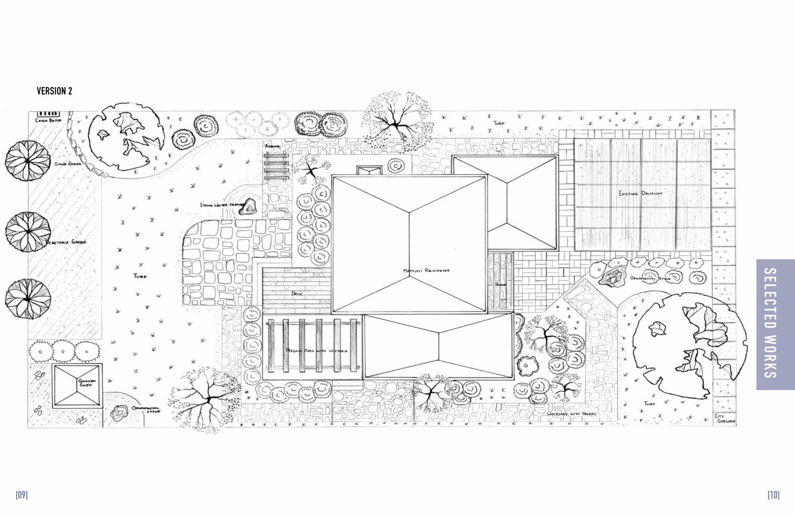
VERSION 2
SELECTED WORKS
[09] [10]
2
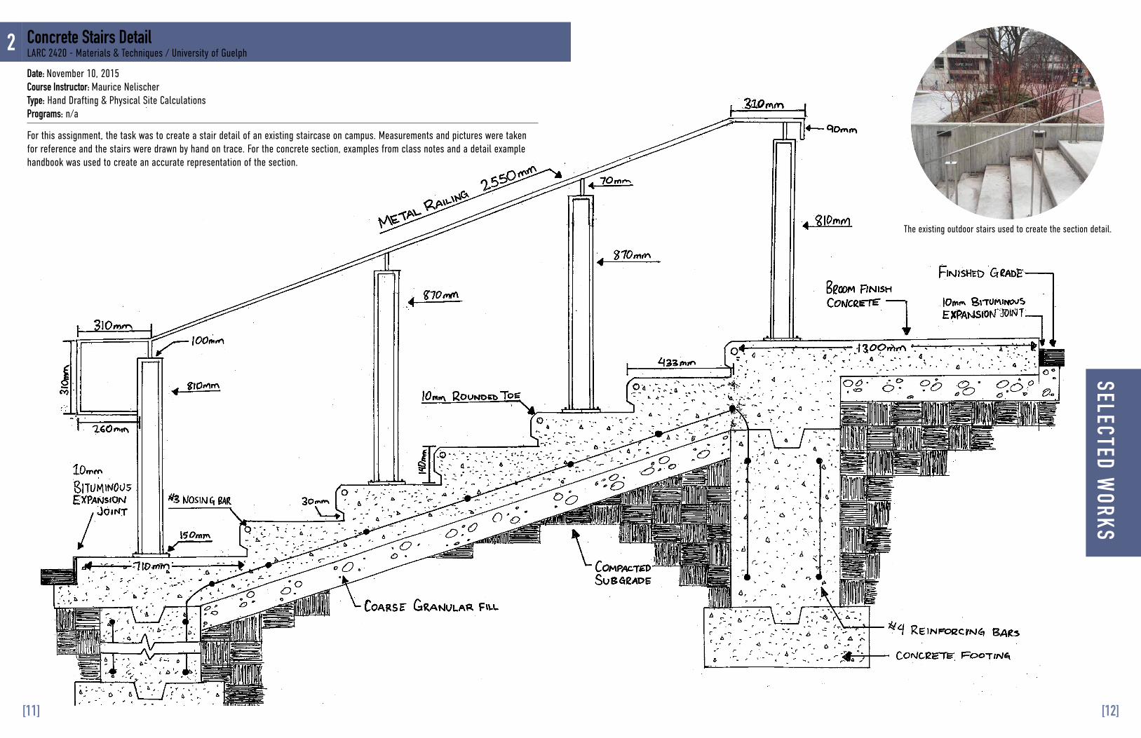
For this assignment, the task was to create a stair detail of an existing staircase on campus. Measurements and pictures were taken for reference and the stairs were drawn by hand on trace. For the concrete section, examples from class notes and a detail example handbook was used to create an accurate representation of the section.
The existing outdoor stairs used to create the section detail.
Date: November 10, 2015Course Instructor: Maurice NelischerType: Hand Drafting & Physical Site CalculationsPrograms: n/a
Concrete Stairs DetailLARC 2420 - Materials & Techniques / University of Guelph
SELECTED WORKS
[11] [12]
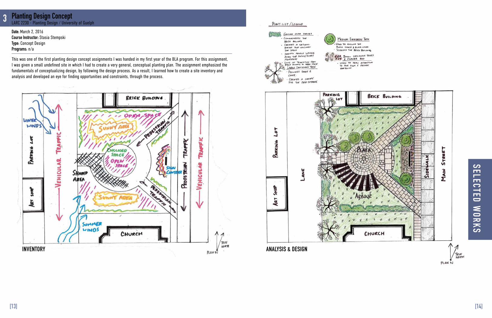
3
This was one of the first planting design concept assignments I was handed in my first year of the BLA program. For this assignment, I was given a small undefined site in which I had to create a very general, conceptual planting plan. The assignment emphasized the fundamentals of conceptualizing design, by following the design process. As a result, I learned how to create a site inventory and analysis and developed an eye for finding opportunities and constraints, through the process.
Date: March 2, 2016Course Instructor: Stasia StempskiType: Concept Design Programs: n/a
Planting Design ConceptLARC 2230 - Planting Design / University of Guelph
INVENTORY ANALYSIS & DESIGN
SELECTED WORKS
[13] [14]
M A S T E R P L A N N I N G & D E S I G N
SELECTED WORKS
4
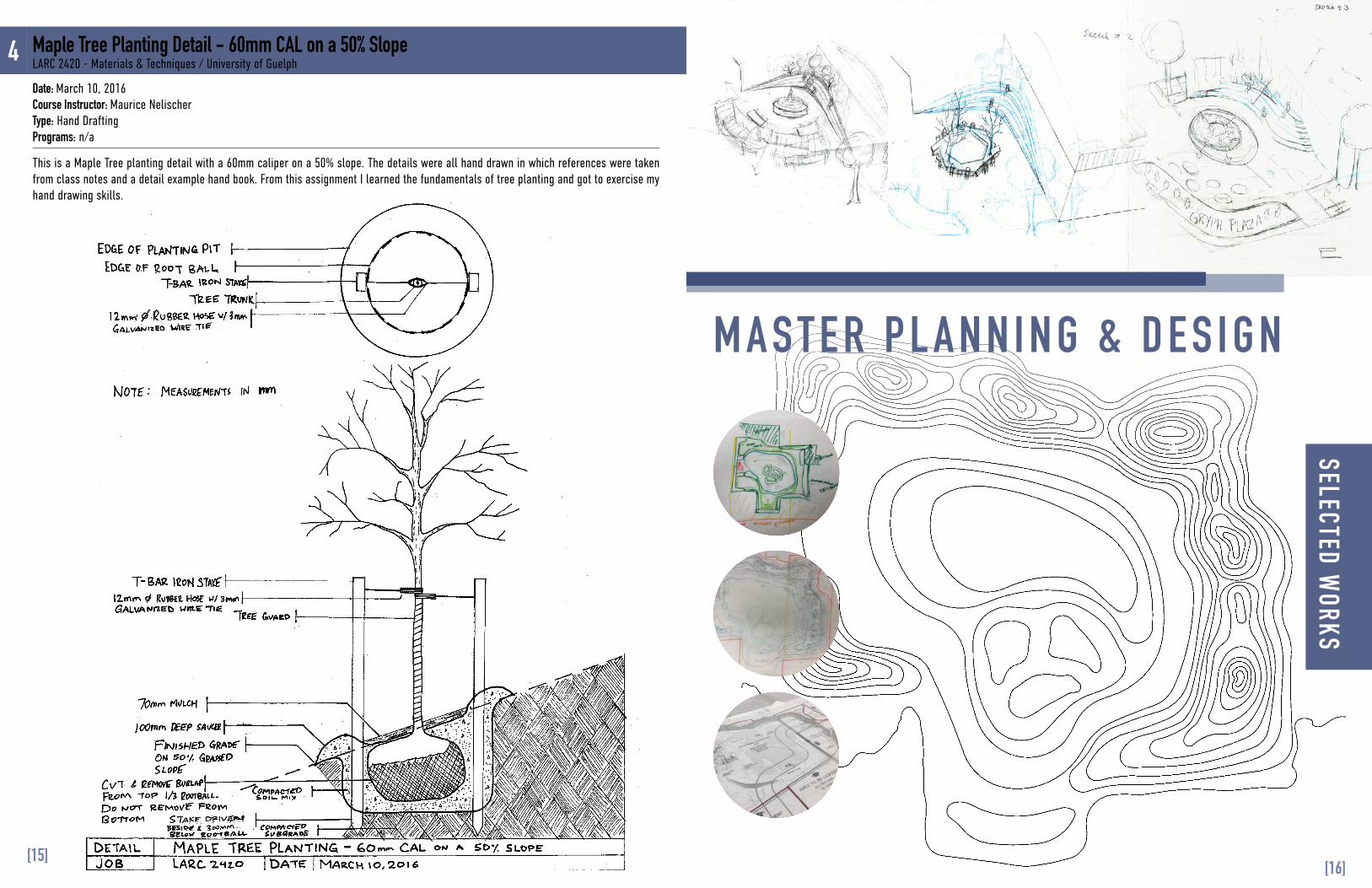
This is a Maple Tree planting detail with a 60mm caliper on a 50% slope. The details were all hand drawn in which references were taken from class notes and a detail example hand book. From this assignment I learned the fundamentals of tree planting and got to exercise my hand drawing skills.
Date: March 10, 2016Course Instructor: Maurice NelischerType: Hand DraftingPrograms: n/a
Maple Tree Planting Detail - 60mm CAL on a 50% SlopeLARC 2420 - Materials & Techniques / University of Guelph
[16][15]
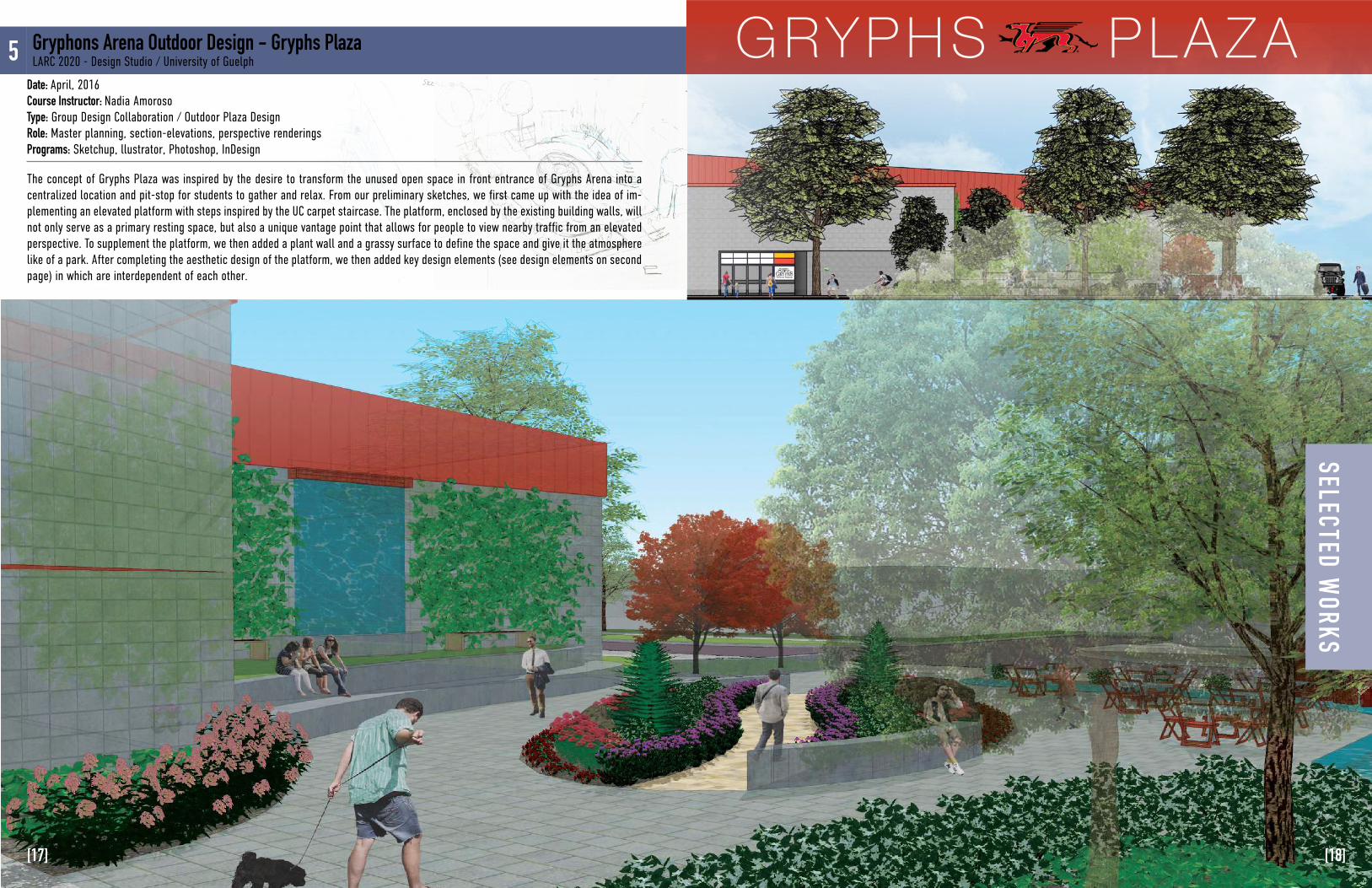
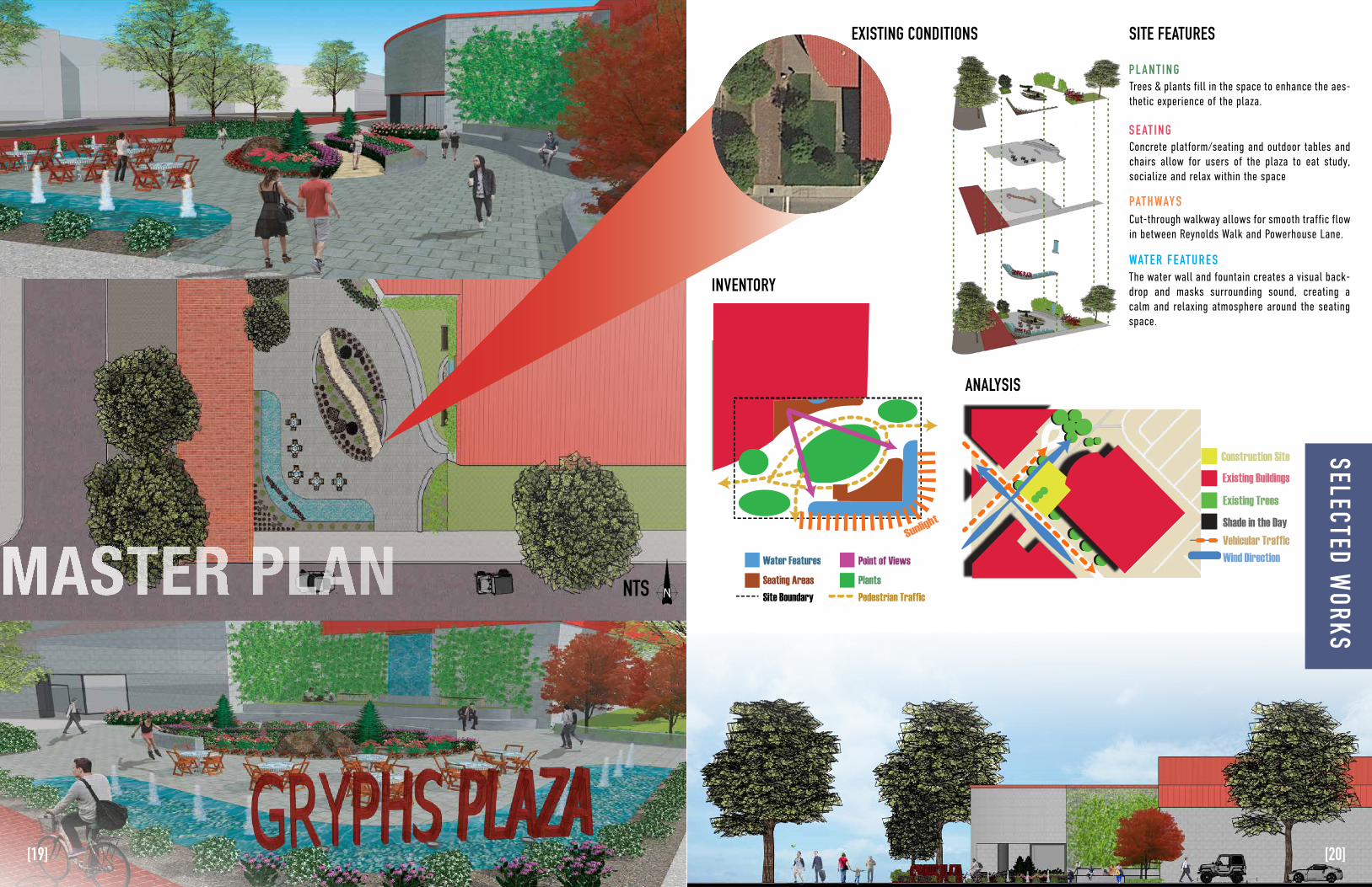
GRYPHS PLAZA5 Gryphons Arena Outdoor Design - Gryphs PlazaLARC 2020 - Design Studio / University of Guelph
The concept of Gryphs Plaza was inspired by the desire to transform the unused open space in front entrance of Gryphs Arena into a centralized location and pit-stop for students to gather and relax. From our preliminary sketches, we first came up with the idea of im-plementing an elevated platform with steps inspired by the UC carpet staircase. The platform, enclosed by the existing building walls, will not only serve as a primary resting space, but also a unique vantage point that allows for people to view nearby traffic from an elevated perspective. To supplement the platform, we then added a plant wall and a grassy surface to define the space and give it the atmosphere like of a park. After completing the aesthetic design of the platform, we then added key design elements (see design elements on second page) in which are interdependent of each other.
Date: April, 2016Course Instructor: Nadia AmorosoType: Group Design Collaboration / Outdoor Plaza DesignRole: Master planning, section-elevations, perspective renderingsPrograms: Sketchup, llustrator, Photoshop, InDesign
SELECTED WORKS
[18][17]
Construction SiteExisting Buildings
Existing Trees
Shade in the DayVehicular TrafficWind Direction
Sunlight
Water FeaturesSeating Areas
Pedestrian Traffic
Point of ViewsPlants
Site Boundary
GRYPHS PLA ZA
program goals
master plan
North-South Section-Elevation A-A’
5mPlan NorthTrue North
3D Model
B B’
0m
1:75• To create a plaza to serve as a gathering space
• Make the currently unused space aesthetically appealing to passersby
• To make the space more functional by creating a walkway and multiple seating areas
• Mask surrounding sound by adding in water features be side seating areas
• Create a raised platform to give users of the space seating from an elevated vantage point
Nestled in between the intersection of Reynolds Walk and Power-house Lane, Gryphs Plaza is the ideal location and focal point for passersby.
Because of a desire to create another outdoor public space like the existing Branion Plaza, Gryphs plaza will be a public space in which enhances the outdoors asthetic experience of students and patrons of the University of Guelph.
This is possible by improving current site conditions and accessibility through the creation of accomodating features like the cut-through walkway and on site seating.
The concept of Gryphs Plaza was inspired by the desire to transform the unused area into a centralized location and pit-stop for students to gather and relax. As shown by preliminary sketches, we first came up with the idea of implementing an elevat-ed platform with steps inspired by the UC carpet staircase. The platform, enclosed by the existing buidling walls, will not only serve as a primary resting space, but also a unique vantage point that allows for people to view nearby traffic from an elevated perspective. To suppliment the platform, we then added a plant wall and a grassy surface to define the space and give it the at-mosphere like of a park. After completing the asthetic design of the platform, we then added key design elements (see design elements on second page) in which are interdependent of each other.
concept development
Existing site conditions as shown from an aerial view, in comparison to the proposed master plan.
5m0m
1:75
Ken Yee Chew l Lowes Wu l Martin Hong
A’
A
MASTER PLAN
EXISTING CONDITIONS
INVENTORY
Trees & plants fill in the space to enhance the aes-thetic experience of the plaza.
P L A N T I N G
S E AT I N G
PAT H WAY S
WAT E R F E AT U R E S
Concrete platform/seating and outdoor tables and chairs allow for users of the plaza to eat study, socialize and relax within the space
Cut-through walkway allows for smooth traffic flow in between Reynolds Walk and Powerhouse Lane.
The water wall and fountain creates a visual back-drop and masks surrounding sound, creating a calm and relaxing atmosphere around the seating space.
ANALYSIS
SITE FEATURES
NTS
SELECTED WORKS
[19] [20]
MODELING
200m
50m
A X O N O M E T R I C 0m
DAY 1 DAY 4 DAY 6
6
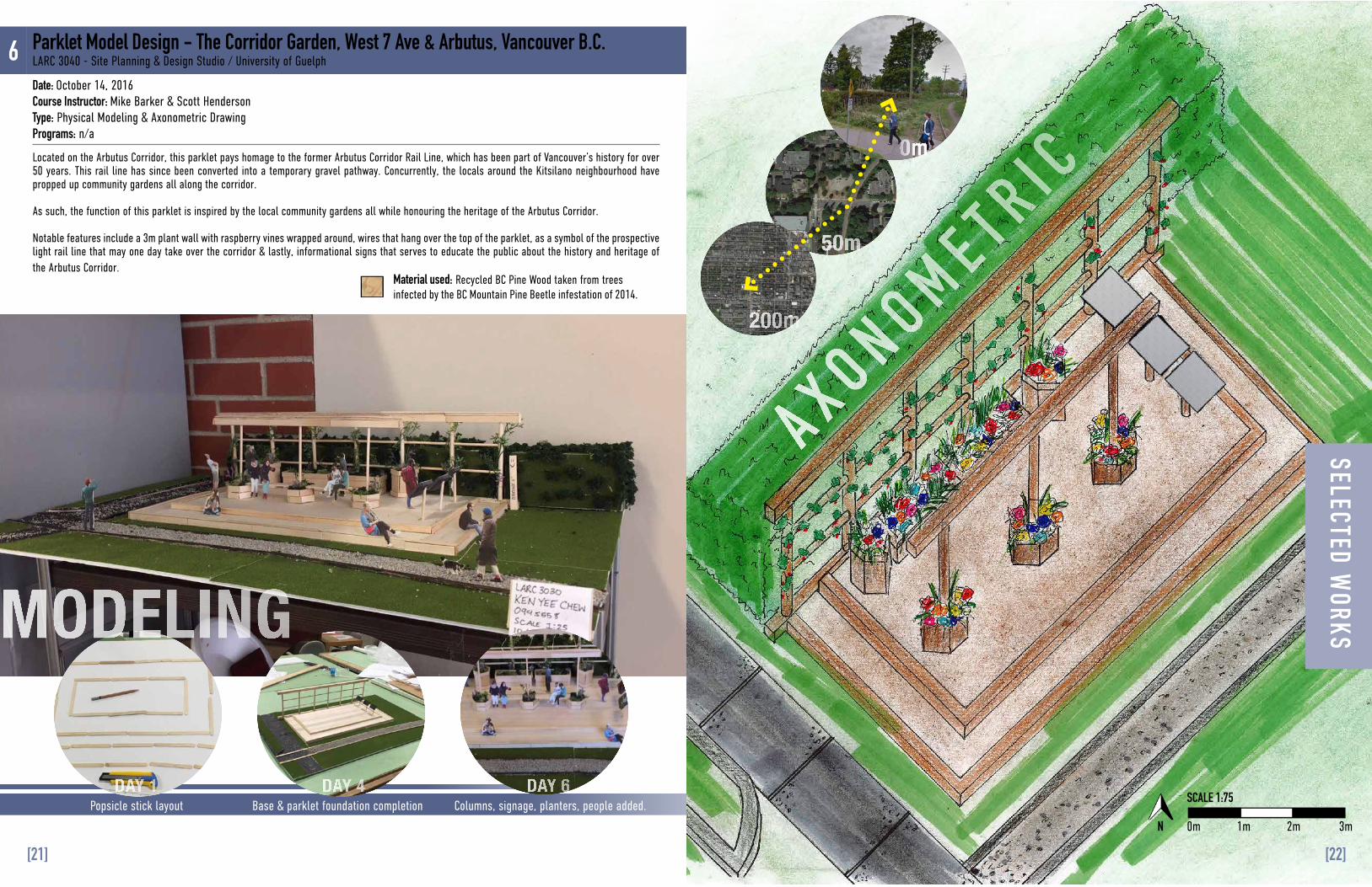
Located on the Arbutus Corridor, this parklet pays homage to the former Arbutus Corridor Rail Line, which has been part of Vancouver’s history for over 50 years. This rail line has since been converted into a temporary gravel pathway. Concurrently, the locals around the Kitsilano neighbourhood have propped up community gardens all along the corridor.
As such, the function of this parklet is inspired by the local community gardens all while honouring the heritage of the Arbutus Corridor.
Notable features include a 3m plant wall with raspberry vines wrapped around, wires that hang over the top of the parklet, as a symbol of the prospective light rail line that may one day take over the corridor & lastly, informational signs that serves to educate the public about the history and heritage of the Arbutus Corridor.
Material used: Recycled BC Pine Wood taken from trees infected by the BC Mountain Pine Beetle infestation of 2014.
Popsicle stick layout Base & parklet foundation completion Columns, signage, planters, people added.
0mN
SCALE 1:75
1m 2m 3m
Parklet Model Design - The Corridor Garden, West 7 Ave & Arbutus, Vancouver B.C.LARC 3040 - Site Planning & Design Studio / University of Guelph
Date: October 14, 2016Course Instructor: Mike Barker & Scott HendersonType: Physical Modeling & Axonometric DrawingPrograms: n/a
SELECTED WORKS
[22][21]
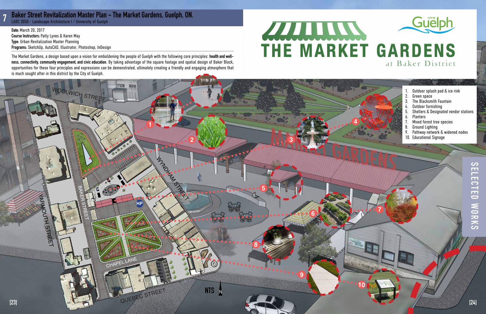
1. Outdoor splash pad & ice rink 2. Green space 3. The Blacksmith Fountain 4. Outdoor furnishing5. Shelters & Designated vendor stations6. Planters7. Mixed forest tree species8. Ground Lighting9. Pathway network & widened nodes10. Educational Signage
NTS
The Market Gardens, a design based upon a vision for emboldening the people of Guelph with the following core principles: health and well-ness, connectivity, community engagement, and civic education. By taking advantage of the square footage and spatial design of Baker Block, opportunities for these four principles and expressions can be demonstrated, ultimately creating a friendly and engaging atmosphere that is much sought after in this district by the City of Guelph.
7 Baker Street Revitalization Master Plan - The Market Gardens, Guelph, ON.LARC 3050 - Landscape Architecture I / University of Guelph
Date: March 20, 2017Course Instructors: Patty Lynes & Karen MayType: Urban Revitalization Master Planning Programs: SketchUp, AutoCAD, Illustrator, Photoshop, InDesign
WYNDHAM STREET
HP
CHAPEL LANE
BAKER STREET
QUEBEC STREET
YARMO
UTH STREET
WOOLWICH STREET
1
2 3
5
6
8
910
7
4
THE MARKET GARDENSa t B a k e r D i s t r i c t
THE MARKET GARDENS
SELECTED WORKS
[23] [24]
I N V E N T O R Y & A N A LY S I S D E S I G N D E V E L O P M E N T
HP
Quebec Street
Yarmouth Street
Wyndham Street
Woolwich Street
Chapel Lane
Baker Street (one way traffic)
Chapel Lane (one way traffic)
St. George’s
Square
Drain
age
Drainage
One way traffic
LEGENDSite BoundaryVegetationHigh Point
Building ZonesCommercialMixed-useInstitutional
EntryVehicular Pedestrian
Traffic CirculationVehicular
UtilitiesPower lineTransformerCatch basinManholeFire hydrant
ParkingPublic Private
PavingConcrete Asphalt
HP
BAKER STREET BLOCK - GRAPHIC ANALYSIS10 20 30 50
SCALE 1:1000
3
1
2
HP
Quebec Street
Yarmouth Street
Wyndham Street
Woolwich Street
Chapel Lane
Baker Street (one way traffic)
Chapel Lane (one way traffic)
St. George’s
Square
Drain
age
Drainage
One way traffic
LEGENDSite BoundaryVegetationHigh Point
Building ZonesCommercialMixed-useInstitutional
EntryVehicular Pedestrian
Traffic CirculationVehicular
UtilitiesPower lineTransformerCatch basinManholeFire hydrant
ParkingPublic Private
PavingConcrete Asphalt
HP
BAKER STREET BLOCK - GRAPHIC ANALYSIS10 20 30 50
SCALE 1:1000
3
1
2
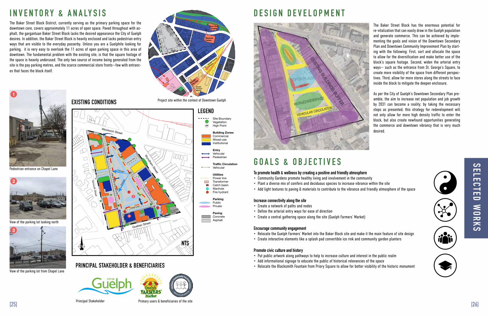
The Baker Street Block District, currently serving as the primary parking space for the downtown core, covers approximately 11 acres of open space. Paved throughout with as-phalt, the gargantuan Baker Street Block lacks the desired appearance the City of Guelph desires. In addition, the Baker Street Block is heavily enclosed and lacks pedestrian entry ways that are visible to the everyday passerby. Unless you are a Guelphite looking for parking, it is very easy to overlook the 11 acres of open parking space in this area of downtown. The fundamental problem with the existing site, is that the square footage of the space is heavily underused. The only two source of income being generated from the site is the pay parking metres, and the scarce commercial store fronts—few with entranc-es that faces the block itself.
The Baker Street Block has the enormous potential for re-vitalization that can easily draw in the Guelph population and generate commerce. This can be achieved by imple-menting the goals and vision of the Downtown Secondary Plan and Downtown Community Improvement Plan by start-ing with the following: First, sort and allocate the space to allow for the diversification and make better use of the block’s square footage. Second, widen the arterial entry ways— such as the entrance from St. George’s Square, to create more visibility of the space from different perspec-tives. Third, allow for more stores along the streets to face inside the block to mitigate the deepen enclosure.
As per the City of Guelph’s Downtown Secondary Plan pre-amble, the aim to increase net population and job growth by 2031 can become a reality; by taking the necessary steps as presented, this strategy for redevelopment will not only allow for more high density traffic to enter the block, but also create newfound opportunities generating the commerce and downtown vibrancy that is very much desired.
Guelph Central Transit HubInstitutional Land UseGovernment Land UseCommercial Land UseResidential Land UseMajor LandmarksGreenspace
Railway Line
Site Boundary
Pedestrian Connectivity
Sleeman Centre
River Run Centre
Basilica of Our Lady Immaculate
Guelph Civic Museum
Guelph
City Hall
Guelph Farmers’ Market
Guelph Central
Station
Speed River
SITE LOCATION PLAN & GRAPHIC ANALYSIS OF DOWNTOWN 50 100 150 250
SCALE 1:4000
To promote health & wellness by creating a positive and friendly atmosphere• Community Gardens promote healthy living and involvement in the community• Plant a diverse mix of conifers and deciduous species to increase vibrance within the site• Add light textures to paving & materials to contribute to the vibrance and friendly atmosphere of the space
Increase connectivity along the site• Create a network of paths and nodes• Define the arterial entry ways for ease of direction• Create a central gathering space along the site (Guelph Farmers’ Market)
Encourage community engagement• Relocate the Guelph Farmers’ Market into the Baker Block site and make it the main feature of site design• Create interactive elements like a splash pad convertible ice rink and community garden planters
Promote civic culture and history• Put public artwork along pathways to help to increase culture and interest in the public realm• Add informational signage to educate the public of historical relevancies of the space• Relocate the Blacksmith Fountain from Priory Square to allow for better visibility of the historic monument
G O A L S & O B J E C T I V E S
NTS
Pedestrian entrance on Chapel Lane
Project site within the context of Downtown Guelph
View of the parking lot looking north
View of the parking lot from Chapel Lane
Principal Stakeholder Primary users & beneficiaries of the site
1
2
3
1
23
EXISTING CONDITIONSLEGEND
PRINCIPAL STAKEHOLDER & BENEFICIARIES
SELECTED WORKS
[25] [26]
S O U T H S E C T I O N - E L E V AT I O N
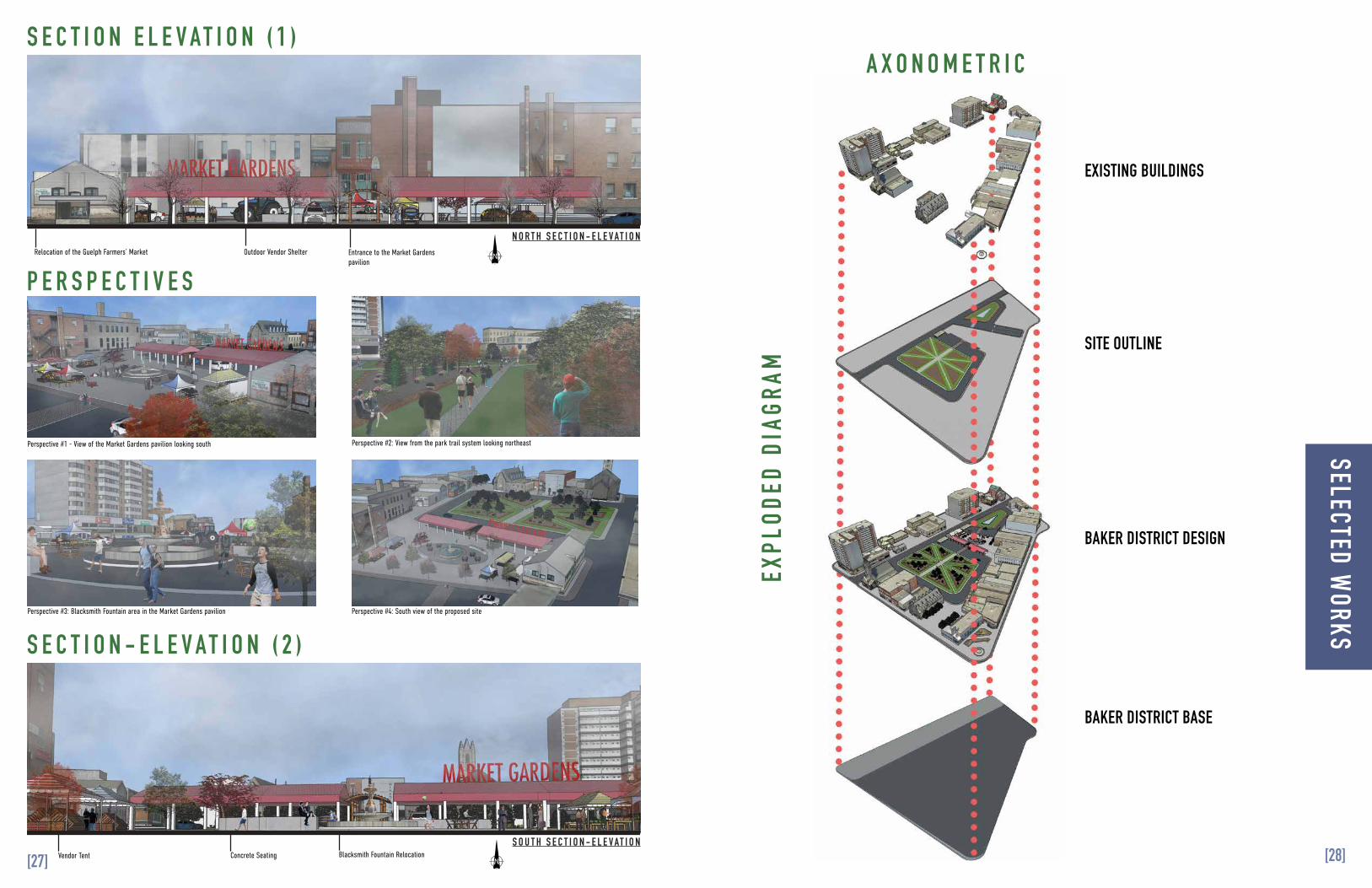
Relocation of the Guelph Farmers’ Market Outdoor Vendor Shelter Entrance to the Market Gardens pavilion
Vendor Tent Concrete Seating Blacksmith Fountain Relocation
Perspective #1 - View of the Market Gardens pavilion looking south Perspective #2: View from the park trail system looking northeast
Perspective #3: Blacksmith Fountain area in the Market Gardens pavilion Perspective #4: South view of the proposed site
N O R T H S E C T I O N - E L E V AT I O N
S O U T H S E C T I O N - E L E V AT I O N
Relocation of the Guelph Farmers’ Market Outdoor Vendor Shelter Entrance to the Market Gardens pavilion
Vendor Tent Concrete Seating Blacksmith Fountain Relocation
Perspective #1 - View of the Market Gardens pavilion looking south Perspective #2: View from the park trail system looking northeast
Perspective #3: Blacksmith Fountain area in the Market Gardens pavilion Perspective #4: South view of the proposed site
N O R T H S E C T I O N - E L E V AT I O N
S E C T I O N E L E V A T I O N ( 1 )A X O N O M E T R I C
EXPL
ODED
DIA
GRAM
P E R S P E C T I V E S
S E C T I O N - E L E V A T I O N ( 2 )
EXISTING BUILDINGS
SITE OUTLINE
BAKER DISTRICT DESIGN
BAKER DISTRICT BASE
SELECTED WORKS
[28][27]
VA N TA G E P O I N T A
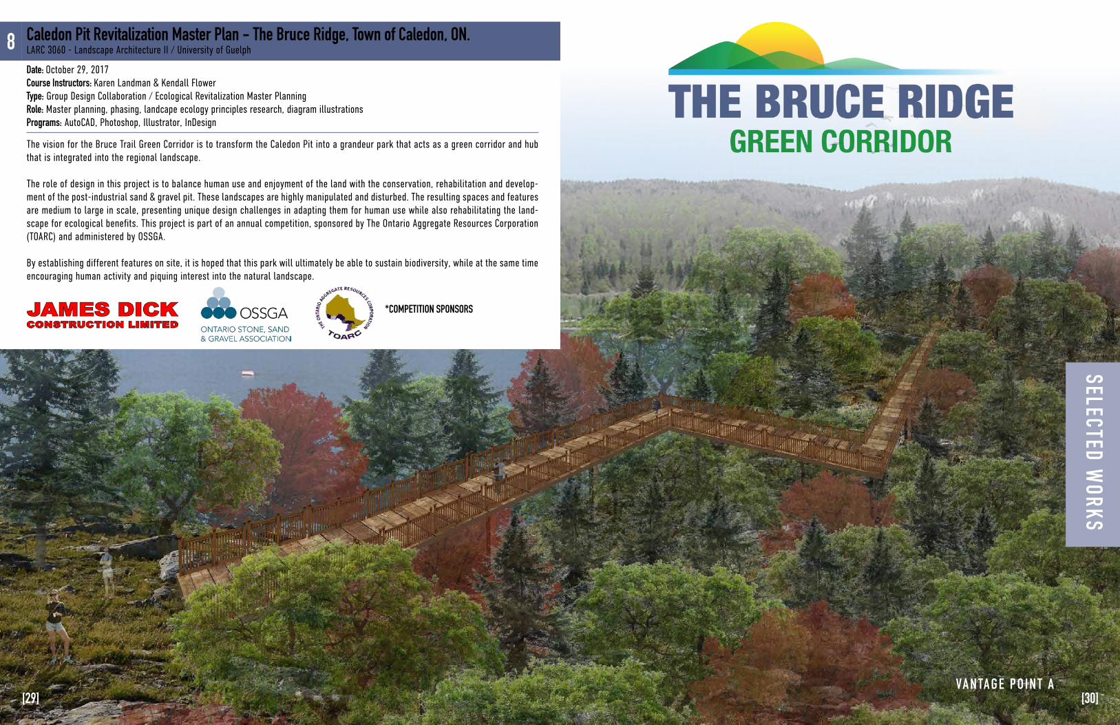
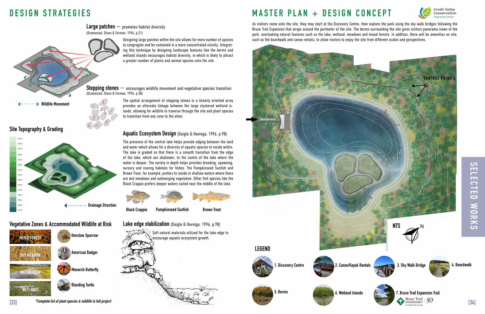
The vision for the Bruce Trail Green Corridor is to transform the Caledon Pit into a grandeur park that acts as a green corridor and hub that is integrated into the regional landscape.
The role of design in this project is to balance human use and enjoyment of the land with the conservation, rehabilitation and develop-ment of the post-industrial sand & gravel pit. These landscapes are highly manipulated and disturbed. The resulting spaces and features are medium to large in scale, presenting unique design challenges in adapting them for human use while also rehabilitating the land-scape for ecological benefits. This project is part of an annual competition, sponsored by The Ontario Aggregate Resources Corporation (TOARC) and administered by OSSGA.
By establishing different features on site, it is hoped that this park will ultimately be able to sustain biodiversity, while at the same time encouraging human activity and piquing interest into the natural landscape.
8 Caledon Pit Revitalization Master Plan - The Bruce Ridge, Town of Caledon, ON.LARC 3060 - Landscape Architecture II / University of Guelph
Date: October 29, 2017Course Instructors: Karen Landman & Kendall FlowerType: Group Design Collaboration / Ecological Revitalization Master Planning Role: Master planning, phasing, landcape ecology principles research, diagram illustrations Programs: AutoCAD, Photoshop, Illustrator, InDesign
*COMPETITION SPONSORS
SELECTED WORKS
[29] [30]
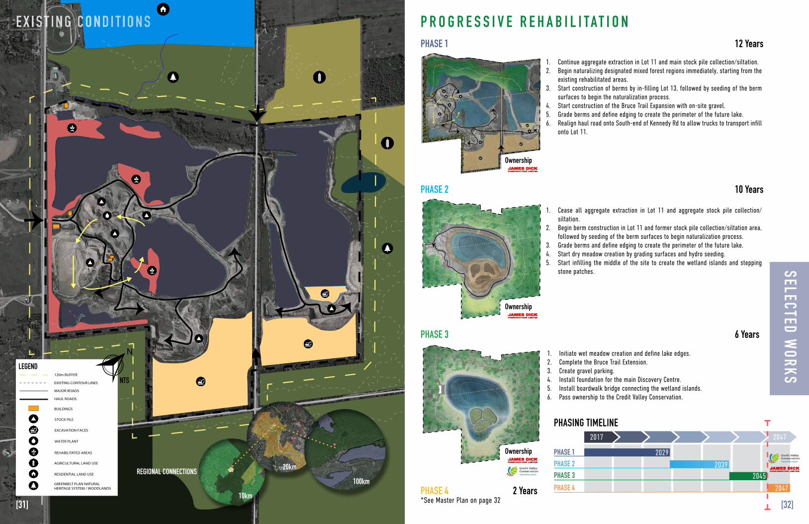
PHASE 1 12 Years
6 Years
2 Years
Ownership
Ownership
Ownership
10 YearsPHASE 2
PHASE 3
PHASE 4
1. Continue aggregate extraction in Lot 11 and main stock pile collection/siltation.2. Begin naturalizing designated mixed forest regions immediately, starting from the
existing rehabilitated areas.3. Start construction of berms by in-filling Lot 13, followed by seeding of the berm
surfaces to begin the naturalization process.4. Start construction of the Bruce Trail Expansion with on-site gravel.5. Grade berms and define edging to create the perimeter of the future lake.6. Realign haul road onto South-end of Kennedy Rd to allow trucks to transport infill
onto Lot 11.
1. Cease all aggregate extraction in Lot 11 and aggregate stock pile collection/siltation.
2. Begin berm construction in Lot 11 and former stock pile collection/siltation area, followed by seeding of the berm surfaces to begin naturalization process.
3. Grade berms and define edging to create the perimeter of the future lake.4. Start dry meadow creation by grading surfaces and hydro seeding. 5. Start infilling the middle of the site to create the wetland islands and stepping
stone patches.
1. Initiate wet meadow creation and define lake edges.2. Complete the Bruce Trail Extension. 3. Create gravel parking.4. Install foundation for the main Discovery Centre. 5. Install boardwalk bridge connecting the wetland islands.6. Pass ownership to the Credit Valley Conservation.
*See Master Plan on page 32
2017
2029
2039
2045
2047
2047
PHASE 1PHASE 2PHASE 3PHASE 4
PHASING TIMELINE
-PROJECT BOUNDARY- 120M BUFFER- ROADS- INTERNAL ROADS- REHABILITATION ZONE- STOCK PILEpd- BUILDINGS- POND- ENTRANCES- WETLAND- AGRICULTURE LAND- GREENBELT PLAN NATURAL HERITAGE SYSTEM-WOODLANDS-EXISTING CONTOURS
100 kmImage NOA A
Image NOA AImage Lands at / Copernicus
REHABILITATED AREAS
STOCK PILE
AGRICULTURAL LAND USE
GREENBELT PLAN NATURAL HERITAGE SYSTEM / WOODLANDS
WATER PLANT
RESIDENTIAL LAND USE
EXCAVATION FACES
PROJECT BOUNDARY
120m BUFFER
MAJOR ROADS
HAUL ROADS
BUILDINGS
EXISTING CONTOUR LINES
LABEL ON MAPEXISTING ENTRANCES
JAMES DICK READY MIX PLANT
EQUIPMENT STORAGE
SILTATION PONDS
LAFARGE AGGREGATES
EXISTING MAINTENANCE DEPOT
WARNOCK LAKE
GOLF COURSE
SECTION LINE A-A
EXISTING SURFACE WATER DRAINAGE
REGIONAL CONNECTIONS
LEGEND
NTS
10km
20km
100km
N
P R O G R E S S I V E R E H A B I L I T A T I O NE X I S T I N G C O N D I T I O N SSELECTED W
ORKS
[31] [32]
Main Entrance
Kenn
edy R
oad
1
2
3
4
6
7
5
VA N TA G E P O I N T A
N
Stepping stones — encourages wildlife movement and vegetative species transition(Dramastad, Olson & Forman, 1996, p.38)
D E S I G N S T R A T E G I E S
510 m
500 m
490 m
480 m
470 m
460 m
450 m
440 m
430 m
420 m
410 m
400 m
390 m
380 m
370 m
Large patches — promotes habitat diversity(Dramastad, Olson & Forman, 1996, p.21)
Site Topography & GradingAquatic Ecosystem Design (Daigle & Havinga, 1996, p.98)
510 m
500 m
490 m
480 m
470 m
460 m
450 m
440 m
430 m
420 m
410 m
400 m
390 m
380 m
370 m
510 m
500 m
490 m
480 m
470 m
460 m
450 m
440 m
430 m
420 m
410 m
400 m
390 m
380 m
370 m
Designing large patches within the site allows for more number of species to congregate and be contained in a more concentrated vicinity. Integrat-ing this technique by designing landscape features like the berms and wetland islands encourages habitat diversity, in which is likely to attract a greater number of plants and animal species onto the site.
As visitors come onto the site, they may start at the Discovery Centre, then explore the park using the sky walk bridges following the Bruce Trail Expansion that wraps around the perimeter of the site. The berms surrounding the site gives visitors panorama views of the park, overlooking natural features such as the lake, wetland, meadows and mixed forests. In addition, there will be amenities on site, such as the boardwalk and canoe rentals, to allow visitors to enjoy the site from different scales and perspectives.
The spatial arrangement of stepping stones in a linearly oriented array provides an alternate linkage between the large clustered wetland is-lands, allowing for wildlife to traverse through the site and plant species to transition from one zone to the other.
Wildlife Movement
Drainage Direction
The presence of the central lake helps provide edging between the land and water which allows for a diversity of aquatic species to reside within. The lake is graded so that there is a smooth transition from the edge of the lake, which are shallower, to the centre of the lake where the water is deeper. The variety in depth helps provides breeding, spawning, nursery and rearing habitats for fishes. The Pumpkinseed Sunfish and Brown Trout, for example, prefers to reside in shallow waters where there are wet meadows and submerging vegetation. Other fish species like the Black Crappie prefers deeper waters suited near the middle of the lake.
Soft natural materials utilized for the lake edge to encourage aquatic ecosystem growth.
Lake edge stabilization (Daigle & Havinga, 1996, p.98)Vegetative Zones & Accommodated Wildlife at Risk
MIXED FOREST
DRY MEADOW
WET MEADOW
WETLANDS
Pumpkinseed SunfishBlack Crappie
*Complete list of plant species & wildlife in full project
Henslow Sparrow
American Badger
Monarch Butterfly
Blanding Turtle
Brown Trout
M A S T E R P L A N + D E S I G N C O N C E P T
6. Wetland Islands 7. Bruce Trail Expansion Trail
4. Boardwalk2. Canoe/Kayak Rentals1. Discovery Centre 3. Sky Walk Bridge
5. Berms
LEGEND
NTS
SELECTED WORKS
[33] [34]
C O N S T R U C T I O N S A M P L E S
SELECTED WORKS
[36][35]
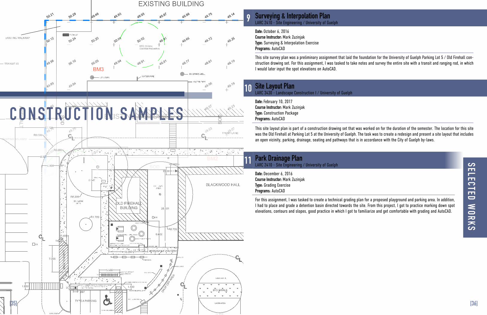
9
10
11
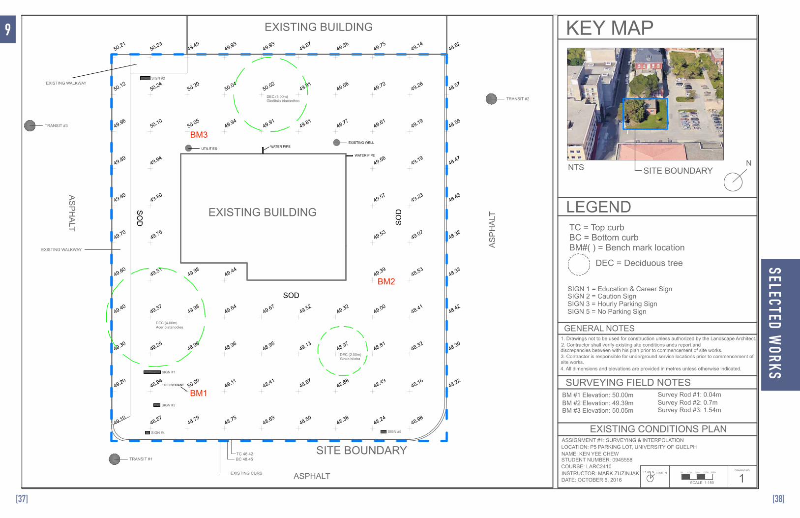
This site survey plan was a preliminary assignment that laid the foundation for the University of Guelph Parking Lot 5 / Old Firehall con-struction drawing set. For this assignment, I was tasked to take notes and survey the entire site with a transit and ranging rod, in which I would later input the spot elevations on AutoCAD.
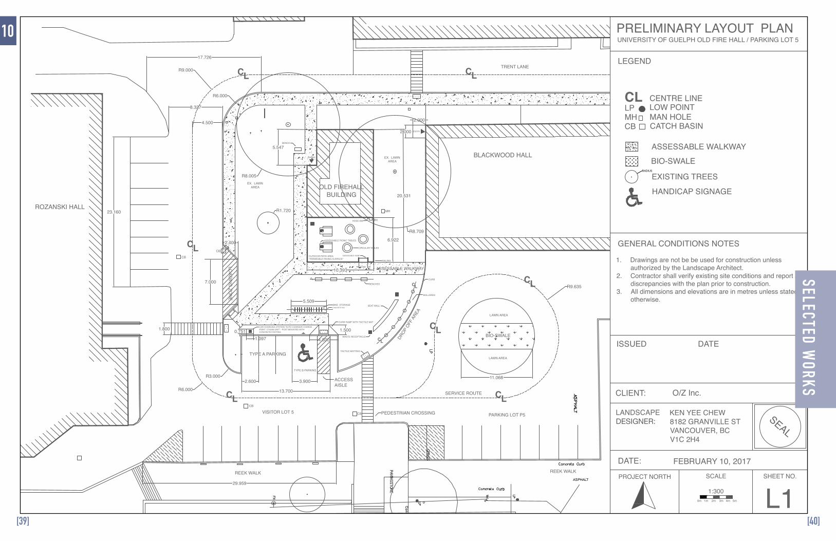
This site layout plan is part of a construction drawing set that was worked on for the duration of the semester. The location for this site was the Old Firehall at Parking Lot 5 at the University of Guelph. The task was to create a redesign and present a site layout that includes an open vicinity, parking, drainage, seating and pathways that is in accordance with the City of Guelph by-laws.
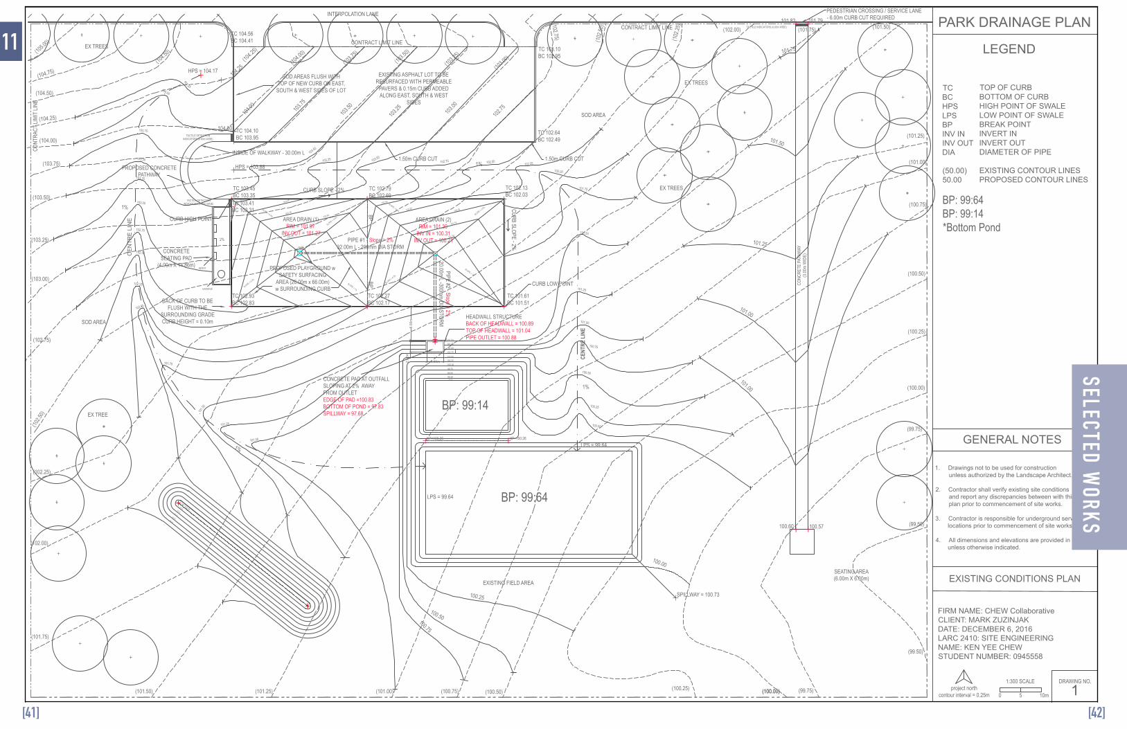
For this assignment, I was tasked to create a technical grading plan for a proposed playground and parking area. In addition, I had to place and grade a detention basin directed towards the site. From this project, I got to practice marking down spot elevations, contours and slopes, good practice in which I got to familiarize and get comfortable with grading and AutoCAD.
Surveying & Interpolation PlanLARC 2410 - Site Engineering / University of Guelph
Site Layout PlanLARC 3430 - Landscape Construction I / University of Guelph
Park Drainage PlanLARC 2410 - Site Engineering / University of Guelph
Date: October 6, 2016Course Instructor: Mark ZuzinjakType: Surveying & Interpolation ExercisePrograms: AutoCAD
Date: February 10, 2017Course Instructor: Mark Zuzinjak Type: Construction Package Programs: AutoCAD
Date: December 6, 2016Course Instructor: Mark ZuzinjakType: Grading ExercisePrograms: AutoCAD
ROZANSKI HALL
OLD FIREHALLBUILDING
BLACKWOOD HALL
TRENT LANE
PARKING LOT P5VISITOR LOT 5
REEK WALKREEK WALK
EX. LAWNAREA
BIO-SWALE
CL
CL
CL CL
CL
CL
CL
LOAD
ING
ZON
E
ASSESSABLE WALKWAY
CL
CL
CL
OUTDOOR PATIO AREA"PERMEABLE PAVING SURFACE"
CURB RAMP WITH TACTILE MAT
WASTE RECEPTACLE
BENCHES
ASSESSABLE PICNIC TABLES
HOSE-BIB
ASSESSABLE RAMP
CIRCULAR TABLES
RAILING
ENTRY
TACTILE MATTING
PEDESTRIAN CROSSING
SEAT WALL
CAR CHARGING STATION "AUTO CHARGER CHARGEPOINT CT4000 UNIT" - POST MOUNTED WITHCONCRETE FOOTING
ACCESSAISLE
LAWN AREA
LAWN AREA
CL CL
BIKE STORAGE
TYPE A PARKING
TYPE B PARKING
SERVICE ROUTE
EX. LAWNAREA
DROP
OFF A
REA
BOLLARDS
CURB
ENTRY
BENCH
11.0682.600 3.900
13.700
5.509
7.000
2.400
CONCRETE PAD
8.327
17.726
R9.000
6.922
1.36710.393
20.531
5.547
R3.000
R6.000
R9.635
2.000
2.000
1.800
4.500
1.5000.7511.097
23.160
29.959
R1.720
R8.005
R8.709
4.500
R6.000
CB
CB
CB
CB
MH
MH
PRELIMINARY LAYOUT PLAN
LEGEND
GENERAL CONDITIONS NOTES
PROJECT NORTH SCALE SHEET NO.
1:3000m 1m 2m 3m 4m 5m L1
CLIENT: O/Z Inc.
KEN YEE CHEW8182 GRANVILLE STVANCOUVER, BCV1C 2H4
DATE: FEBRUARY 10, 2017
ISSUED DATE
UNIVERSITY OF GUELPH OLD FIRE HALL / PARKING LOT 5
LPMHCB
SEAL
CENTRE LINELOW POINTMAN HOLECATCH BASIN
BIO-SWALE
EXISTING TREES
1. Drawings are not be be used for construction unlessauthorized by the Landscape Architect.
2. Contractor shall verify existing site conditions and report anydiscrepancies with the plan prior to construction.
3. All dimensions and elevations are in metres unless statedotherwise.
LANDSCAPEARCHITECT:
CL
ASSESSABLE WALKWAY
RADIUS
HANDICAP SIGNAGE
49.1048.87
48.7948.75
48.6348.50
48.3848.24
48.98
49.2048.94
50.0049.11
48.4148.87
48.6848.49
48.16
49.3049.25
48.9648.96
48.9549.13
48.9748.81
48.32
49.6049.31
49.9849.44
49.3948.53
49.7049.75
49.5349.07
49.8049.80
49.5749.23
49.8949.94
49.5649.19
49.9650.10
50.0549.94
49.9149.81
49.7749.61
49.19
50.1250.24
50.2050.04
50.0249.91
49.6649.72
49.26
50.2150.29
49.4949.93
49.9349.87
49.8649.75
49.14
49.4049.37
49.9849.64
49.6749.52
49.3249.00
48.41
48.22
48.30
48.33
48.38
48.43
48.47
48.56
48.57
48.62
48.42
BM1
BM2
BM3
DEC (4.00m)Acer platanodies
DEC (3.00m)Gleditsia triacanthos
DEC (2.00m)Ginko biloba
TRANSIT #1
TRANSIT #3
TRANSIT #2
EXISTING BUILDING
EXISTING BUILDING
SITE BOUNDARYTC 48.42BC 48.45
EXISTING CURB
SIGN #1
SIGN #3
SIGN #4
ASPHALTA
SP
HA
LT
SIGN #5
SIGN #2
EXISTING WELL
WATER PIPE
WATER PIPEUTILITIES
FIRE HYDRANTS
ODS
OD
SOD
AS
PH
ALT
EXISTING WALKWAY
EXISTING WALKWAY
KEY MAP
LEGEND
SITE BOUNDARY
TC = Top curbBC = Bottom curbBM#( ) = Bench mark location
DEC = Deciduous tree
SIGN 1 = Education & Career Sign
SIGN 3 = Hourly Parking Sign SIGN 2 = Caution Sign
SIGN 5 = No Parking Sign
EXISTING CONDITIONS PLAN
1. Drawings not to be used for construction unless authorized by the Landscape Architect.
3. Contractor is responsible for underground service locations prior to commencement of
2. Contractor shall verify existing site conditions ands report and discrepancies between with his plan prior to commencement of site works.
4. All dimensions and elevations are provided in metres unless otherwise indicated.site works.
ASSIGNMENT #1: SURVEYING & INTERPOLATIONLOCATION: P5 PARKING LOT, UNIVERSITY OF GUELPHNAME: KEN YEE CHEWSTUDENT NUMBER: 0945558COURSE: LARC2410INSTRUCTOR: MARK ZUZINJAK DATE: OCTOBER 6, 2016
N
GENERAL NOTES
SURVEYING FIELD NOTESBM #1 Elevation: 50.00mBM #2 Elevation: 49.39mBM #3 Elevation: 50.05m
Survey Rod #1: 0.04mSurvey Rod #2: 0.7mSurvey Rod #3: 1.54m
PLAN N
N
N
TRUE N 0m 0.75m 1.50m 2.25m 3.00m
1:150SCALE
DRAWING NO.
1
NTS
49.1048.87
48.7948.75
48.6348.50
48.3848.24
48.98
49.2048.94
50.0049.11
48.4148.87
48.6848.49
48.16
49.3049.25
48.9648.96
48.9549.13
48.9748.81
48.32
49.6049.31
49.9849.44
49.3948.53
49.7049.75
49.5349.07
49.8049.80
49.5749.23
49.8949.94
49.5649.19
49.9650.10
50.0549.94
49.9149.81
49.7749.61
49.19
50.1250.24
50.2050.04
50.0249.91
49.6649.72
49.26
50.2150.29
49.4949.93
49.9349.87
49.8649.75
49.14
49.4049.37
49.9849.64
49.6749.52
49.3249.00
48.41
48.22
48.30
48.33
48.38
48.43
48.47
48.56
48.57
48.62
48.42
BM1
BM2
BM3
DEC (4.00m)Acer platanodies
DEC (3.00m)Gleditsia triacanthos
DEC (2.00m)Ginko biloba
TRANSIT #1
TRANSIT #3
TRANSIT #2
EXISTING BUILDING
EXISTING BUILDING
SITE BOUNDARYTC 48.42BC 48.45
EXISTING CURB
SIGN #1
SIGN #3
SIGN #4
ASPHALT
AS
PH
ALT
SIGN #5
SIGN #2
EXISTING WELL
WATER PIPE
WATER PIPEUTILITIES
FIRE HYDRANT
SO
DSO
D
SOD
AS
PH
ALT
EXISTING WALKWAY
EXISTING WALKWAY
KEY MAP
LEGEND
SITE BOUNDARY
TC = Top curbBC = Bottom curbBM#( ) = Bench mark location
DEC = Deciduous tree
SIGN 1 = Education & Career Sign
SIGN 3 = Hourly Parking Sign SIGN 2 = Caution Sign
SIGN 5 = No Parking Sign
EXISTING CONDITIONS PLAN
1. Drawings not to be used for construction unless authorized by the Landscape Architect.
3. Contractor is responsible for underground service locations prior to commencement of
2. Contractor shall verify existing site conditions ands report and discrepancies between with his plan prior to commencement of site works.
4. All dimensions and elevations are provided in metres unless otherwise indicated.site works.
ASSIGNMENT #1: SURVEYING & INTERPOLATIONLOCATION: P5 PARKING LOT, UNIVERSITY OF GUELPHNAME: KEN YEE CHEWSTUDENT NUMBER: 0945558COURSE: LARC2410INSTRUCTOR: MARK ZUZINJAK DATE: OCTOBER 6, 2016
N
GENERAL NOTES
SURVEYING FIELD NOTESBM #1 Elevation: 50.00mBM #2 Elevation: 49.39mBM #3 Elevation: 50.05m
Survey Rod #1: 0.04mSurvey Rod #2: 0.7mSurvey Rod #3: 1.54m
PLAN N
N
N
TRUE N 0m 0.75m 1.50m 2.25m 3.00m
1:150SCALE
DRAWING NO.
1
NTS
9
[38][37]
SELECTED WORKS
10
ROZANSKI HALL
OLD FIREHALLBUILDING
BLACKWOOD HALL
TRENT LANE
PARKING LOT P5VISITOR LOT 5
REEK WALKREEK WALK
EX. LAWNAREA
BIO-SWALE
CL
CL
CL CL
CL
CL
CL
LOAD
ING
ZON
E
ASSESSABLE WALKWAY
CL
CL
CL
OUTDOOR PATIO AREA"PERMEABLE PAVING SURFACE"
CURB RAMP WITH TACTILE MAT
WASTE RECEPTACLE
BENCHES
ASSESSABLE PICNIC TABLES
HOSE-BIB
ASSESSABLE RAMP
CIRCULAR TABLES
RAILING
ENTRY
TACTILE MATTING
PEDESTRIAN CROSSING
SEAT WALL
CAR CHARGING STATION "AUTO CHARGER CHARGEPOINT CT4000 UNIT" - POST MOUNTED WITHCONCRETE FOOTING
ACCESSAISLE
LAWN AREA
LAWN AREA
CL CL
BIKE STORAGE
TYPE A PARKING
TYPE B PARKING
SERVICE ROUTE
EX. LAWNAREA
DROP
OFF A
REA
BOLLARDS
CURB
ENTRY
BENCH
11.0682.600 3.900
13.700
5.509
7.000
2.400
CONCRETE PAD
8.327
17.726
R9.000
6.922
1.36710.393
20.531
5.547
R3.000
R6.000
R9.635
2.000
2.000
1.800
4.500
1.5000.7511.097
23.160
29.959
R1.720
R8.005
R8.709
4.500
R6.000
CB
CB
CB
CB
MH
MH
PRELIMINARY LAYOUT PLAN
LEGEND
GENERAL CONDITIONS NOTES
PROJECT NORTH SCALE SHEET NO.
1:3000m 1m 2m 3m 4m 5m L1
CLIENT: O/Z Inc.
KEN YEE CHEW8182 GRANVILLE STVANCOUVER, BCV1C 2H4
DATE: FEBRUARY 10, 2017
ISSUED DATE
UNIVERSITY OF GUELPH OLD FIRE HALL / PARKING LOT 5
LPMHCB
SEAL
CENTRE LINELOW POINTMAN HOLECATCH BASIN
BIO-SWALE
EXISTING TREES
1. Drawings are not be be used for construction unlessauthorized by the Landscape Architect.
2. Contractor shall verify existing site conditions and report anydiscrepancies with the plan prior to construction.
3. All dimensions and elevations are in metres unless statedotherwise.
LANDSCAPEARCHITECT:
CL
ASSESSABLE WALKWAY
RADIUS
HANDICAP SIGNAGE
[40][39]
SELECTED WORKS
DESIGNER:
11
project northcontour interval = 0.25m
EXISTING ASPHALT LOT TO BERESURFACED WITH PERMEABLE
PAVERS & 0.15m CURB ADDEDALONG EAST, SOUTH & WEST
SIDES
PROPOSED CONCRETEPATHWAY
BACK OF CURB TO BEFLUSH WITH THE
SURROUNDING GRADECURB HEIGHT = 0.10m
PROPOSED PLAYGROUND wSAFETY SURFACING
AREA (26.00m x 66.00m)w SURROUNDING CURB
PIPE #2 - Slope = 2%20.00m L -300mm DIA STORM
CONCRETE PAD AT OUTFALLSLOPING AT 2% AWAYFROM OUTLETEDGE OF PAD =100.83BOTTOM OF POND = 97.83SPILLWAY = 97.68
HEADWALL STRUCTUREBACK OF HEADWALL = 100.89TOP OF HEADWALL = 101.04PIPE OUTLET = 100.88
AREA DRAIN (1)RIM = 101.97
INV OUT = 101.27
(100.50)
(101.25)
(101.50)(101.75)(102.00)
(102
.25)
(102
.50)(102.75)
(103.0
0)(103.5
0)
(103.7
5)
(104.0
0)(10
4.25)
(104.5
0)
(104.75)
(105.0
0)
(104.50)
(104.25)
(104.00)
(103.75)
(103.25)
(103.00)
(102.75)
(102.5
0)
SOD AREAS FLUSH WITHTOP OF NEW CURB ON EAST,
SOUTH & WEST SIDES OF LOT
SOD AREA
EXISTING FIELD AREA
SOD AREA
EX TREE
EX TREES
EX TREES
EX TREES
INTERPOLATION LANE
CONTRACT LIMIT LINECO
NTRA
CT LI
MIT
LINE
CONTRACT LIMIT LINE
1:300 SCALE
0 5 10m
AREA DRAIN (2)RIM = 101.30
INV IN = 100.31INV OUT = 100.21PIPE #1 - Slope = 2%
32.00m L - 200mm DIA STORM
CURB HIGH POINT
CURB LOW POINT
8.00
m
4.00m2.50
m
CURB SLOPE - 2%
CURB SLOPE - 2%
BPBP
INSIDE OF WALKWAY - 30.00m L
(103.50)
1.50m CURB CUT1.50m CURB CUT
(103.2
5)
PEDESTRIAN CROSSING / SERVICE LANE- 6.00m CURB CUT REQUIRED
(101.00)
(100.75)
(100.25)
(100.00)
(99.50)
(99.50)
(100.00)(100.25)(100.50)(100.75)(101.00)(101.25)(101.50)
(101.75)
(102.00)
(102.25)
(100.00) (99.75)
(99.75)
TC 104.10BC 103.95
TC 103.45BC 103.35
TC 102.79BC 102.69
TC 102.13BC 102.03
TC 101.61BC 101.51
TC 102.27BC 102.17
TC 102.93BC 102.83
TC 103.41BC 103.31
SLOPE = 1%
SLOPE = 1%
SLOPE = 3.5%
SLOPE = 6.8%
SLOPE = 4.3%
SLOPE = 6.8%
SLOPE = 3.5%
SLOPE = 4.3%
HPS = 104.17
SPILLWAY = 100.73
CE
NTR
E L
INE
HPS = 103.88
CENT
RE L
INE
1%
1%
LPS = 99.64
LPS = 99.64
BP: 99:64
BP: 99:141%
1%
104.25
104.25
104.00
104.00
2%
CONCRETESEATING PAD
(4.00m X 14.86m)
CONC
RETE
PAT
HWAY
(3.00
m W
IDE)
SEATING AREA(6.00m X 6.00m)
TACTILE DETECTIONINDICATORS (0.60m WIDE)
TACTILE DETECTIONINDICATORS (0.60m WIDE)
TACTILE INDICATORS (0.60m WIDE)
102.50
102.25102.00
101.75
101.50
2%
103.25
102.75
102.50
102.00
102.25
103.00
HP 103.45103.25
103.00102.75102.50
102.25
BENCH
104.00 103
.75
103.50
103.25 103
.00
102.75
99.75
100.25
100.75
99.50
100.50
100.00
99.1499.25
HP=100.26HP=100.26
100.00
101.79101.82
100.57100.60
103.75
GARBAGE
103.50
103.50
103.00103.25
102.75
TC 104.56BC 104.41
TC 102.64BC 102.49
TC 103.10BC 102.95
102.50102.25
102.00
101.25101.50
101.00
101.75
101.50
101.25
101.00
100.75
100.50
100.25
100.00
101.75
101.50
101.25
101.00
101.00
100.75
100.50
100.25
103.25
103.00
102.75
102.50
102.25
102.00
101.75
101.5
0
101.25
101.00
PARK DRAINAGE PLAN
TCBCHPSLPSBPINV ININV OUTDIA
(50.00)50.00
TOP OF CURBBOTTOM OF CURBHIGH POINT OF SWALELOW POINT OF SWALEBREAK POINTINVERT ININVERT OUTDIAMETER OF PIPE
EXISTING CONTOUR LINESPROPOSED CONTOUR LINES
FIRM NAME: CHEW CollaborativeCLIENT: MARK ZUZINJAKDATE: DECEMBER 6, 2016LARC 2410: SITE ENGINEERINGNAME: KEN YEE CHEWSTUDENT NUMBER: 0945558
1. Drawings not to be used for construction unless authorized by the Landscape Architect.
2. Contractor shall verify existing site conditions and report any discrepancies between with this plan prior to commencement of site works.
3. Contractor is responsible for underground service locations prior to commencement of site works.
4. All dimensions and elevations are provided in meters unless otherwise indicated.
GENERAL NOTES
EXISTING CONDITIONS PLAN
1DRAWING NO.
BP: 99:64BP: 99:14*Bottom Pond
LEGEND
[42][41]
SELECTED WORKS
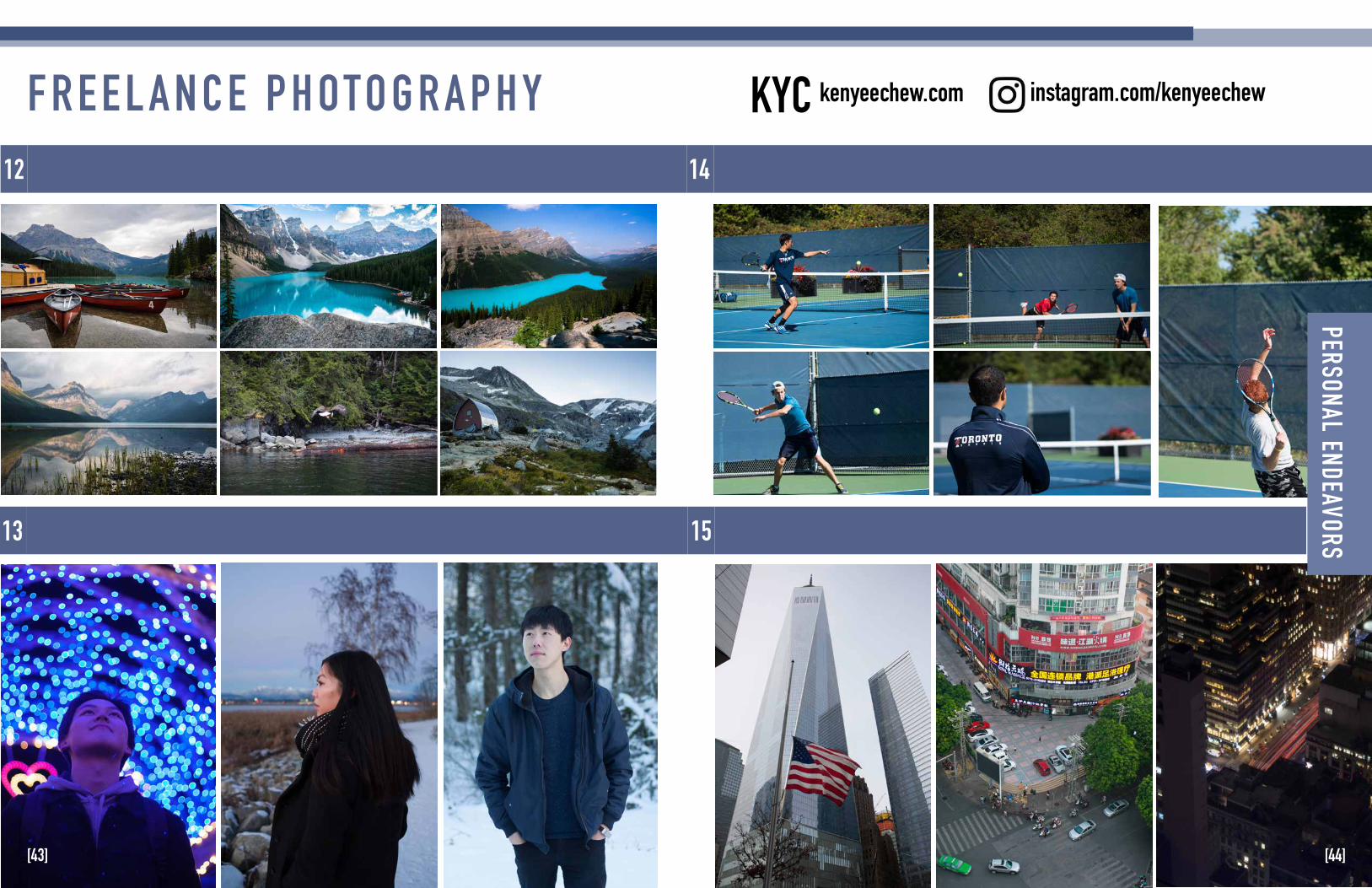
People
Sports
Cityscapes
Nature
13
14
15
F R E E L A N C E P H OTO G R A P H Y12
[43] [44]
PERSONAL ENDEAVORS
instagram.com/kenyeechewkenyeechew.comKYC
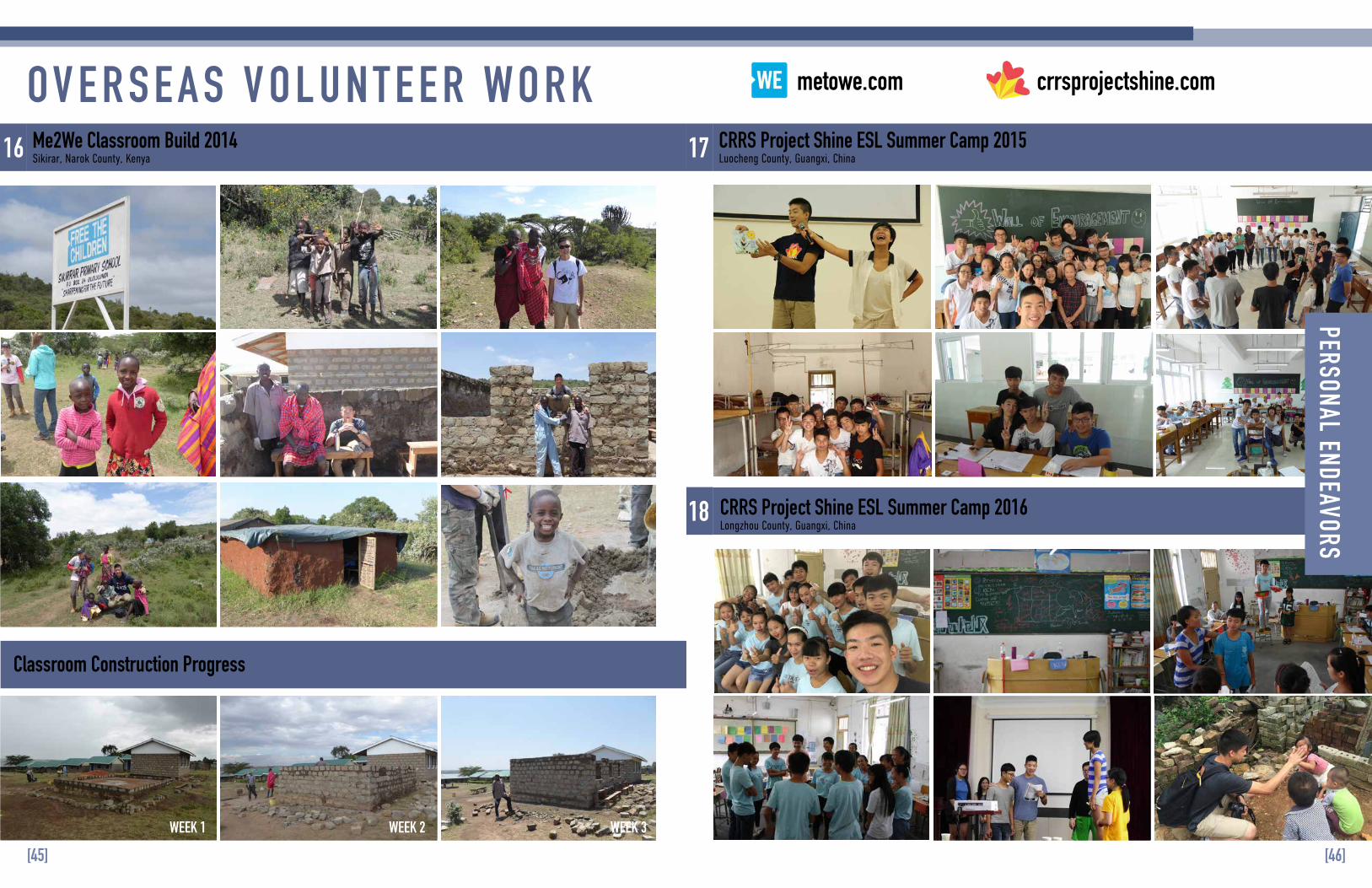
OV E R S E A S V O L U N T E E R WO R K16 17
18
Me2We Classroom Build 2014Sikirar, Narok County, Kenya
Classroom Construction Progress
CRRS Project Shine ESL Summer Camp 2015 Luocheng County, Guangxi, China
CRRS Project Shine ESL Summer Camp 2016 Longzhou County, Guangxi, China
WEEK 1 WEEK 2 WEEK 3
[46][45]
PERSONAL ENDEAVORS crrsprojectshine.commetowe.com