Embed Size (px)
Citation preview
The Descartes Systems Group Inc. | T SX : DSG | NAS DAQ : DSGX | 120 Randall Drive, Waterloo, Ontario, N2V 1C6, Canada
Toll Free 800.419.8495 | Int‘l 519.746.8110 | [email protected] | www.descartes.com
CONFIDENTIAL AND PROPRIETARY TO THE DESCARTES SYSTEMS GROUP INC. AND ITS AFFILIATES
Descartes® Route Planner™
17.09
November 2017
L N O S M A P E D I T O R U S E R ’ S G U I D E
L N O S M A P E D I T O R U S E R ’ S G U I D E
Descartes Route Planner 17.09
The Descartes Systems Group Inc. | T SX : DSG | NAS DAQ : DSGX | 120 Randall Drive, Waterloo, Ontario, N2V 1C6, Canada
Toll Free 800.419.8495 | Int‘l 519.746.8110 | [email protected] | www.descartes.com 2
CONFIDENTIAL AND PROPRIETARY TO THE DESCARTES SYSTEMS GROUP INC. AND ITS AFFILIATES
© 2017 The Descartes Systems Group Inc. All rights reserved.
Information in this document is subject to change without notice. The Descartes Systems Group Inc. and its affiliates and
subsidiaries (“Descartes”) make no warranties, express or implied, in respect of this document or its contents.
Complying with all applicable copyright laws is the responsibility of the user. Without limiting the rights under copyright, no
part of this document may be reproduced, stored in or introduced into a retrieval system, or transmitted in any form or by
any means (electronic, mechanical, photocopying, recording, or otherwise), or for any purpose, without the express written
permission of The Descartes Systems Group Inc..
Descartes may have patents, patent applications, trademarks, copyrights, or other intellectual property rights covering
subject matter in this document. Except as expressly provided in any written license agreement from Descartes, the
furnishing of this document does not give you any license to these patents, trademarks, copyrights, or other intellectual
property.
Descartes Route Planner, Descartes wGLN, Descartes Global Logistics Network (GLN), Descartes, the phrase “Helping
Customers Deliver,” and the Descartes logo are either registered trademarks or trademarks of Descartes and/or its affiliates
or subsidiaries.
Google Maps mapping service is a registered trademark of Google Inc.
HERE maps is a registered trademark of HERE North America, LLC.
The names of other actual companies and products mentioned herein may be the trademarks of their respective owners.
Descartes® Route Planner™
17.09
The Descartes Systems Group Inc.
120 Randall Drive
Waterloo, Ontario Canada, N2V 1C6
Phone: 519-746-8110
Internet: http://www.descartes.com
Customer Support
In North America: 1-877-786-9339
Outside North America: +800 -7866-3390
e-mail: [email protected]
L N O S M A P E D I T O R U S E R ’ S G U I D E
Descartes Route Planner 17.09
The Descartes Systems Group Inc. | T SX : DSG | NAS DAQ : DSGX | 120 Randall Drive, Waterloo, Ontario, N2V 1C6, Canada
Toll Free 800.419.8495 | Int‘l 519.746.8110 | [email protected] | www.descartes.com 3
CONFIDENTIAL AND PROPRIETARY TO THE DESCARTES SYSTEMS GROUP INC. AND ITS AFFILIATES
Table of Contents
Table of Contents ............................................................................................... 3
Welcome to LNOS Map Editor............................................................................ 4 Features............................................................................................................................................ 4
Known Issues.................................................................................................................................... 4
Browser Back/Next Buttons Not Working ....................................................................................... 4
Only Selected Map Edit Displays .................................................................................................... 4
‘Remember Me’ Option Not Working ............................................................................................. 4
Document Conventions ..................................................................................................................... 5
Using LNOS Map Editor ...................................................................................... 6 Map Display ...................................................................................................................................... 7
Map Navigation ................................................................................................................................. 7
Geocoding and Reverse Geocoding ................................................................................................... 8
Creating Map Edits .......................................................................................................................... 10
Configure Vehicle Criteria .................................................................................................................. 11
Modifying Map Edits ........................................................................................................................... 12
Delete Map Edits ............................................................................................................................. 14
Publish Map Edits from the UI ......................................................................................................... 14
Publish Map Edits through a REST API ............................................................................................ 16
Creating Map Edits for a Long Stretch of Road ................................................................................ 19
L N O S M A P E D I T O R U S E R ’ S G U I D E
Descartes Route Planner 17.09
The Descartes Systems Group Inc. | T SX : DSG | NAS DAQ : DSGX | 120 Randall Drive, Waterloo, Ontario, N2V 1C6, Canada
Toll Free 800.419.8495 | Int‘l 519.746.8110 | [email protected] | www.descartes.com 4
CONFIDENTIAL AND PROPRIETARY TO THE DESCARTES SYSTEMS GROUP INC. AND ITS AFFILIATES
Welcome to LNOS Map Editor
Features
LNOS Map Editor is a web-based tool for editing maps, such as adding road closures or changing road speeds. It is designed to work with LNOS Pathing Service, which provides a set of web services to support the Descartes® Route Planner™ application
in executing routing, scheduling and optimization functions.
Known Issues
Browser Back/Next Buttons Not Working
In the Edit page, using the browser’s Back or Next buttons will not navigate to the previous or next page in the browse history.
Only Selected Map Edit Displays
When displaying a map edit in detail, only the selected map edit is displayed on the map. Other map edits nearby and within the map viewing area are not displayed.
‘Remember Me’ Option Not Working
Currently, users will need to provide credentials regardless of whether or not the Remember Me checkbox is selected.
L N O S M A P E D I T O R U S E R ’ S G U I D E
Descartes Route Planner 17.09
The Descartes Systems Group Inc. | T SX : DSG | NAS DAQ : DSGX | 120 Randall Drive, Waterloo, Ontario, N2V 1C6, Canada
Toll Free 800.419.8495 | Int‘l 519.746.8110 | [email protected] | www.descartes.com 5
CONFIDENTIAL AND PROPRIETARY TO THE DESCARTES SYSTEMS GROUP INC. AND ITS AFFILIATES
Document Conventions
This document uses the following conventions:
• Names of windows, frames, dialogs, menus, list boxes, and lists begin with uppercase and are bolded. (Tools menu, Save button)
• Key combinations that you press appear in mixed case. If the keys are joined by a plus sign (+), press and hold the first key simultaneously with the remaining
keys (for example, CTRL+ALT+DEL).
• Text that you type appears in Courier New font. (Enter USERID in the login
field.)
• Cross-references to other documents, or to sections within the current document,
appear in underlined italics. (See Saving a File for details.)
• Italics are used for emphasis throughout this document.
Note— Information important to a particular task or function is introduced
with the note format and icon.
Tip— Information that may make completing a task easier, but isn’t essential to the task, is introduced with the tip format and icon.
Warning— This warning format indicates information that you need to pay particular attention to. Ignoring information presented as a warning could lead to damage and unexpected results. Disregarding information presented as
a warning may result in damage to your software or data.
L N O S M A P E D I T O R U S E R ’ S G U I D E
Descartes Route Planner 17.09
The Descartes Systems Group Inc. | T SX : DSG | NAS DAQ : DSGX | 120 Randall Drive, Waterloo, Ontario, N2V 1C6, Canada
Toll Free 800.419.8495 | Int‘l 519.746.8110 | [email protected] | www.descartes.com 6
CONFIDENTIAL AND PROPRIETARY TO THE DESCARTES SYSTEMS GROUP INC. AND ITS AFFILIATES
Using LNOS Map Editor
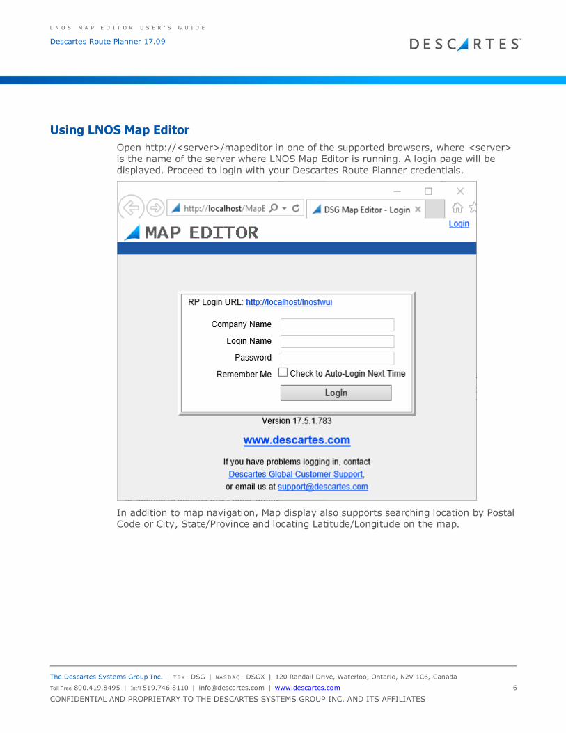
Open http://<server>/mapeditor in one of the supported browsers, where <server> is the name of the server where LNOS Map Editor is running. A login page will be
displayed. Proceed to login with your Descartes Route Planner credentials.
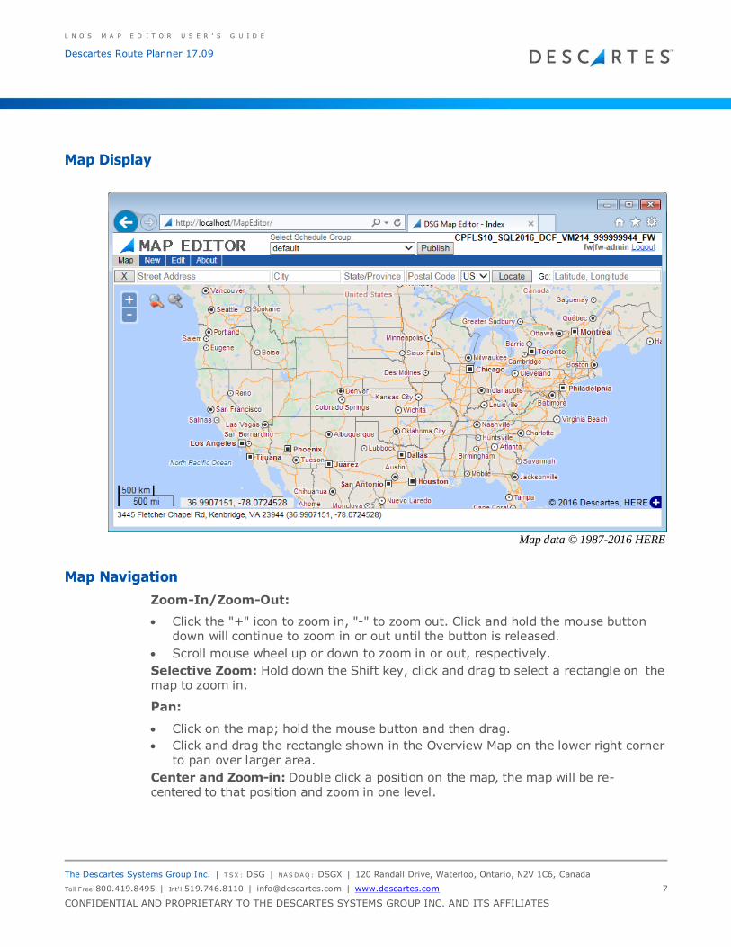
In addition to map navigation, Map display also supports searching location by Postal Code or City, State/Province and locating Latitude/Longitude on the map.
L N O S M A P E D I T O R U S E R ’ S G U I D E
Descartes Route Planner 17.09
The Descartes Systems Group Inc. | T SX : DSG | NAS DAQ : DSGX | 120 Randall Drive, Waterloo, Ontario, N2V 1C6, Canada
Toll Free 800.419.8495 | Int‘l 519.746.8110 | [email protected] | www.descartes.com 7
CONFIDENTIAL AND PROPRIETARY TO THE DESCARTES SYSTEMS GROUP INC. AND ITS AFFILIATES
Map Display
Map data © 1987-2016 HERE
Map Navigation
Zoom-In/Zoom-Out:
• Click the "+" icon to zoom in, "-" to zoom out. Click and hold the mouse button down will continue to zoom in or out until the button is released.
• Scroll mouse wheel up or down to zoom in or out, respectively.
Selective Zoom: Hold down the Shift key, click and drag to select a rectangle on the map to zoom in.
Pan:
• Click on the map; hold the mouse button and then drag.
• Click and drag the rectangle shown in the Overview Map on the lower right corner to pan over larger area.
Center and Zoom-in: Double click a position on the map, the map will be re- centered to that position and zoom in one level.
L N O S M A P E D I T O R U S E R ’ S G U I D E
Descartes Route Planner 17.09
The Descartes Systems Group Inc. | T SX : DSG | NAS DAQ : DSGX | 120 Randall Drive, Waterloo, Ontario, N2V 1C6, Canada
Toll Free 800.419.8495 | Int‘l 519.746.8110 | [email protected] | www.descartes.com 8
CONFIDENTIAL AND PROPRIETARY TO THE DESCARTES SYSTEMS GROUP INC. AND ITS AFFILIATES
Navigation History:
Changes to map display (zooming in, out, and panning) are recorded in the navigation history. Click the icon with red or green to traverse history backward or forward, respectively.
Geocoding and Reverse Geocoding
The Geocoding function is performed by Descartes Route Planner, thereby using the
same preference for geocoding provider and the licensed map coverage. Request for
geocoding will be submitted to the same Descartes Route Planner instance that was
used to authenticate the user.
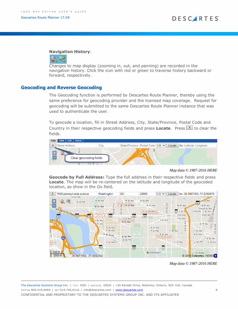
To geocode a location, fill in Street Address, City, State/Province, Postal Code and
Country in their respective geocoding fields and press Locate. Press to clear the
fields.
Map data © 1987-2016 HERE
Geocode by Full Address: Type the full address in their respective fields and press Locate. The map will be re-centered on the latitude and longitude of the geocoded location, as show in the Go field.
Map data © 1987-2016 HERE
L N O S M A P E D I T O R U S E R ’ S G U I D E
Descartes Route Planner 17.09
The Descartes Systems Group Inc. | T SX : DSG | NAS DAQ : DSGX | 120 Randall Drive, Waterloo, Ontario, N2V 1C6, Canada
Toll Free 800.419.8495 | Int‘l 519.746.8110 | [email protected] | www.descartes.com 9
CONFIDENTIAL AND PROPRIETARY TO THE DESCARTES SYSTEMS GROUP INC. AND ITS AFFILIATES
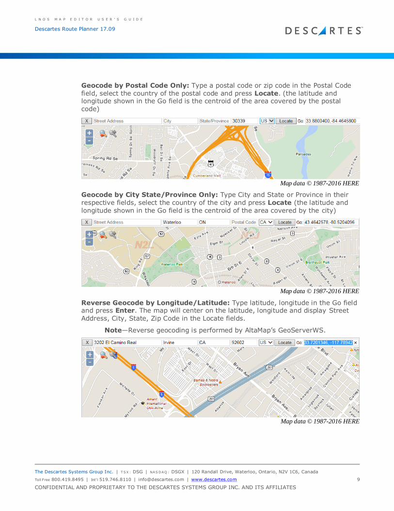
Geocode by Postal Code Only: Type a postal code or zip code in the Postal Code field, select the country of the postal code and press Locate. (the latitude and longitude shown in the Go field is the centroid of the area covered by the postal code)
Map data © 1987-2016 HERE
Geocode by City State/Province Only: Type City and State or Province in their respective fields, select the country of the city and press Locate (the latitude and longitude shown in the Go field is the centroid of the area covered by the city)
Map data © 1987-2016 HERE
Reverse Geocode by Longitude/Latitude: Type latitude, longitude in the Go field and press Enter. The map will center on the latitude, longitude and display Street
Address, City, State, Zip Code in the Locate fields.
Note—Reverse geocoding is performed by AltaMap’s GeoServerWS.
Map data © 1987-2016 HERE
L N O S M A P E D I T O R U S E R ’ S G U I D E
Descartes Route Planner 17.09
The Descartes Systems Group Inc. | T SX : DSG | NAS DAQ : DSGX | 120 Randall Drive, Waterloo, Ontario, N2V 1C6, Canada
Toll Free 800.419.8495 | Int‘l 519.746.8110 | [email protected] | www.descartes.com 10
CONFIDENTIAL AND PROPRIETARY TO THE DESCARTES SYSTEMS GROUP INC. AND ITS AFFILIATES
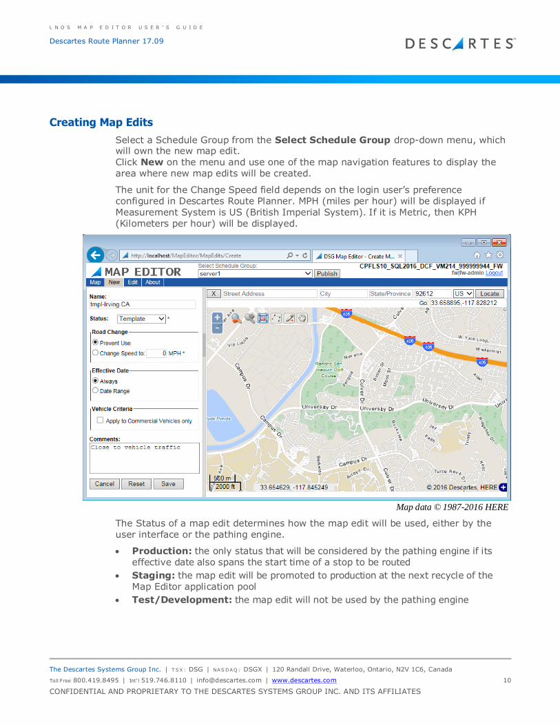
Creating Map Edits
Select a Schedule Group from the Select Schedule Group drop-down menu, which will own the new map edit.
Click New on the menu and use one of the map navigation features to display the area where new map edits will be created.
The unit for the Change Speed field depends on the login user’s preference configured in Descartes Route Planner. MPH (miles per hour) will be displayed if
Measurement System is US (British Imperial System). If it is Metric, then KPH (Kilometers per hour) will be displayed.
Map data © 1987-2016 HERE
The Status of a map edit determines how the map edit will be used, either by the user interface or the pathing engine.
• Production: the only status that will be considered by the pathing engine if its effective date also spans the start time of a stop to be routed
• Staging: the map edit will be promoted to production at the next recycle of the
Map Editor application pool
• Test/Development: the map edit will not be used by the pathing engine
L N O S M A P E D I T O R U S E R ’ S G U I D E
Descartes Route Planner 17.09
The Descartes Systems Group Inc. | T SX : DSG | NAS DAQ : DSGX | 120 Randall Drive, Waterloo, Ontario, N2V 1C6, Canada
Toll Free 800.419.8495 | Int‘l 519.746.8110 | [email protected] | www.descartes.com 11
CONFIDENTIAL AND PROPRIETARY TO THE DESCARTES SYSTEMS GROUP INC. AND ITS AFFILIATES
• Template: a template to store common settings, such as map display area, Road
Change, Effective Date, and Comments, from which to create new map edits .
To create a set of map edits in the same area having the same setting, change Status to Template to create a template first by doing the following:
1 Type in a descriptive name for the template. Choose a prefix so that all templates will be listed together.
2 Select Template from the Status dropdown list.
3 Set the Road Change and Effective Date and fill in the Comments field. Comments are optional but recommended.
4 Save the template.
Alternatively, new map edits can be created directly without deriving them from a common template.
Configure Vehicle Criteria
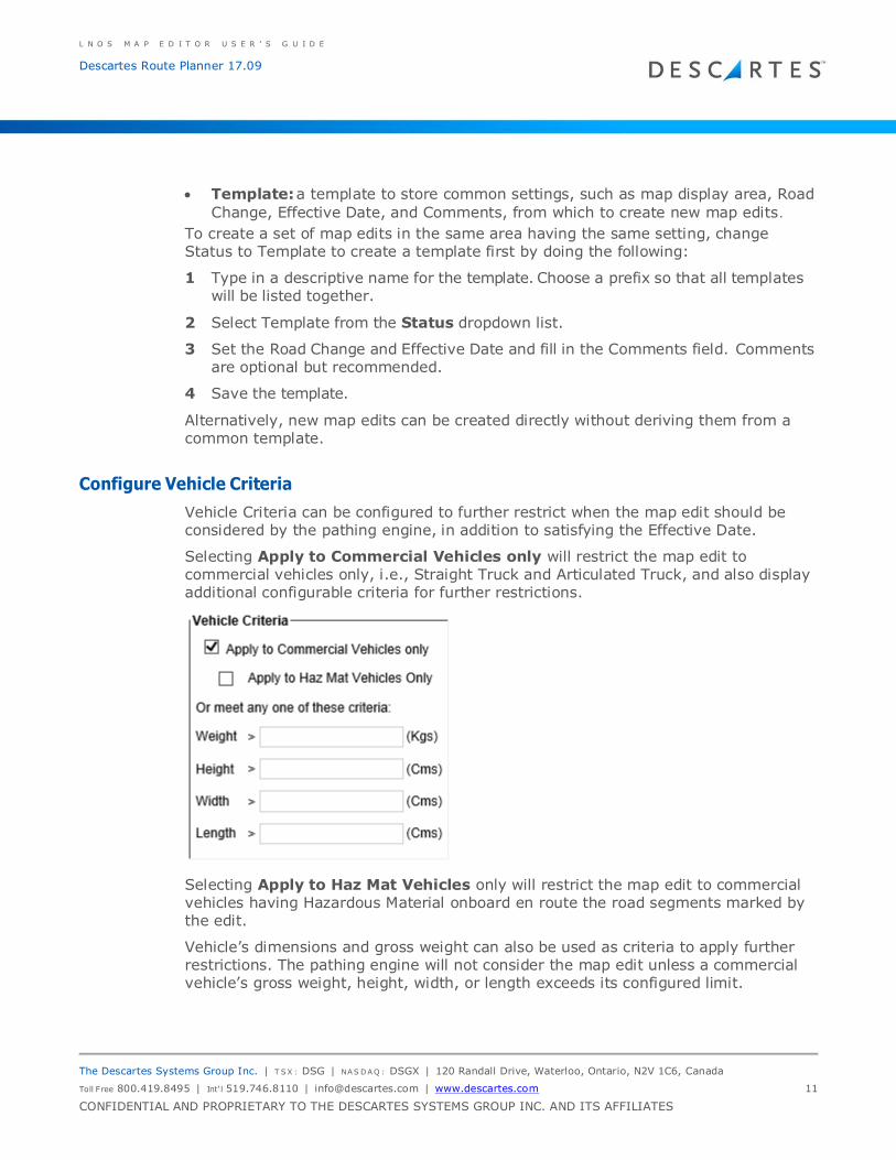
Vehicle Criteria can be configured to further restrict when the map edit should be considered by the pathing engine, in addition to satisfying the Effective Date.
Selecting Apply to Commercial Vehicles only will restrict the map edit to
commercial vehicles only, i.e., Straight Truck and Articulated Truck, and also display additional configurable criteria for further restrictions.
Selecting Apply to Haz Mat Vehicles only will restrict the map edit to commercial vehicles having Hazardous Material onboard en route the road segments marked by the edit.
Vehicle’s dimensions and gross weight can also be used as criteria to apply further restrictions. The pathing engine will not consider the map edit unless a commercial vehicle’s gross weight, height, width, or length exceeds its configured limit.
L N O S M A P E D I T O R U S E R ’ S G U I D E
Descartes Route Planner 17.09
The Descartes Systems Group Inc. | T SX : DSG | NAS DAQ : DSGX | 120 Randall Drive, Waterloo, Ontario, N2V 1C6, Canada
Toll Free 800.419.8495 | Int‘l 519.746.8110 | [email protected] | www.descartes.com 12
CONFIDENTIAL AND PROPRIETARY TO THE DESCARTES SYSTEMS GROUP INC. AND ITS AFFILIATES
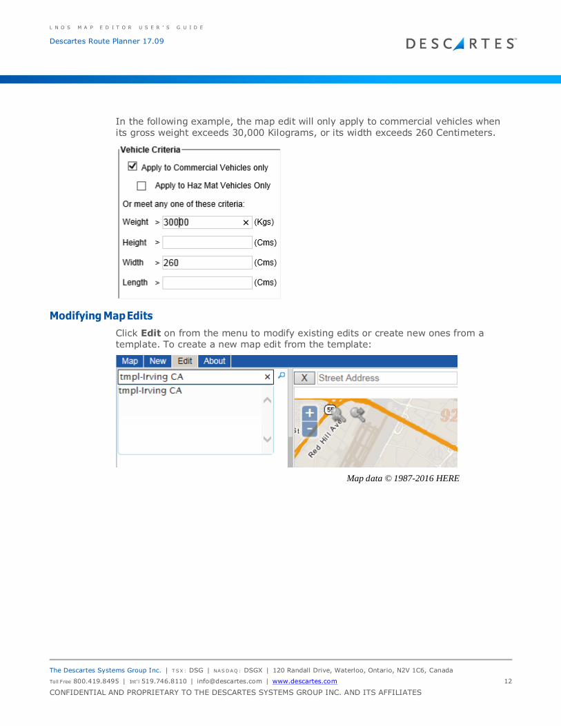
In the following example, the map edit will only apply to commercial vehicles when its gross weight exceeds 30,000 Kilograms, or its width exceeds 260 Centimeters.
Modifying Map Edits
Click Edit on from the menu to modify existing edits or create new ones from a template. To create a new map edit from the template:
Map data © 1987-2016 HERE
L N O S M A P E D I T O R U S E R ’ S G U I D E
Descartes Route Planner 17.09
The Descartes Systems Group Inc. | T SX : DSG | NAS DAQ : DSGX | 120 Randall Drive, Waterloo, Ontario, N2V 1C6, Canada
Toll Free 800.419.8495 | Int‘l 519.746.8110 | [email protected] | www.descartes.com 13
CONFIDENTIAL AND PROPRIETARY TO THE DESCARTES SYSTEMS GROUP INC. AND ITS AFFILIATES
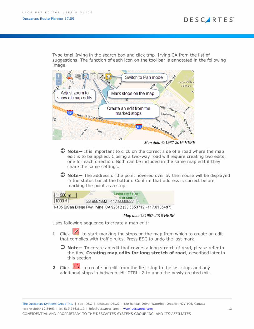
Type tmpl-Irving in the search box and click tmpl-Irving CA from the list of suggestions. The function of each icon on the tool bar is annotated in the following image.
Map data © 1987-2016 HERE
Note— It is important to click on the correct side of a road where the map edit is to be applied. Closing a two-way road will require creating two edits,
one for each direction. Both can be included in the same map edit if they share the same settings.
Note— The address of the point hovered over by the mouse will be displayed
in the status bar at the bottom. Confirm that address is correct before marking the point as a stop.
Map data © 1987-2016 HERE
Uses following sequence to create a map edit:
1 Click to start marking the stops on the map from which to create an edit that complies with traffic rules. Press ESC to undo the last mark.
Note— To create an edit that covers a long stretch of read, please refer to the tips, Creating map edits for long stretch of road, described later in this section.
2 Click to create an edit from the first stop to the last stop, and any additional stops in between. Hit CTRL+Z to undo the newly created edit.

L N O S M A P E D I T O R U S E R ’ S G U I D E
Descartes Route Planner 17.09
The Descartes Systems Group Inc. | T SX : DSG | NAS DAQ : DSGX | 120 Randall Drive, Waterloo, Ontario, N2V 1C6, Canada
Toll Free 800.419.8495 | Int‘l 519.746.8110 | [email protected] | www.descartes.com 14
CONFIDENTIAL AND PROPRIETARY TO THE DESCARTES SYSTEMS GROUP INC. AND ITS AFFILIATES
3 With the cursor still in crosshair shape, mark new stops on the map and repeat step #2 to create additional edits if necessary.
4 Choose a Status for the new map edit.
5 Choose Road Change, either Prevent Use or Change Speed.
6 Set effect Date, either Always or Select Date Range and set Start and End date.
7 Update the Comments field.
8 Click Save As and enter a descriptive name for this map edit when prompted.
Note— Click Save only when modifying the template itself and not creating
new map edit from it.
Delete Map Edits
Click the Delete button to delete the map edit.
Publish Map Edits from the UI
In order for LNOS Pathing Service (LPS) to download the latest Production map edits,
the edits must be published first. Map edits are grouped and published by Schedule
Group. For each selected Schedule Group, Map Editor will first promote all Staging
edits to Production and then notify LPS that an update is available for download.
Map data © 1987-2016 HERE
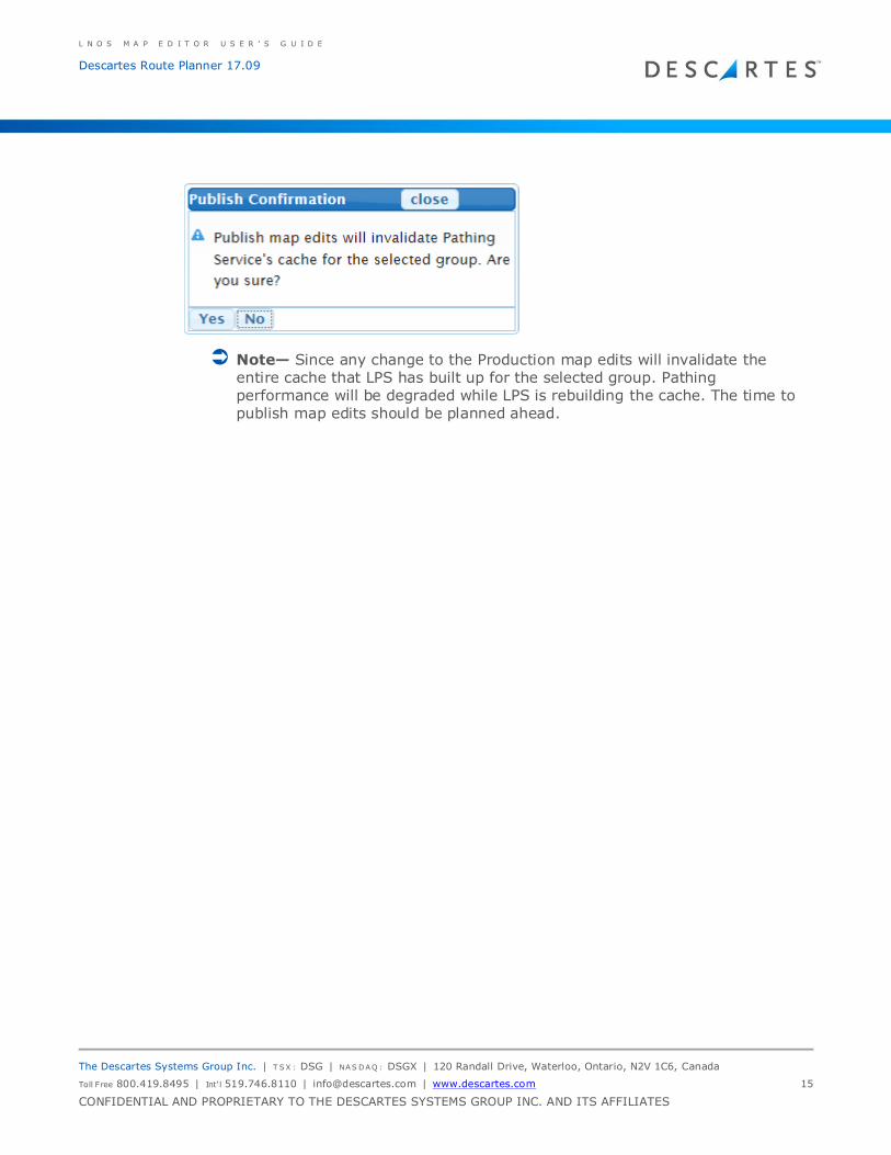
To publish, first select the Schedule Group you want to publish and click Publish.
The following confirmation dialog will ask you to confirm.
L N O S M A P E D I T O R U S E R ’ S G U I D E
Descartes Route Planner 17.09
The Descartes Systems Group Inc. | T SX : DSG | NAS DAQ : DSGX | 120 Randall Drive, Waterloo, Ontario, N2V 1C6, Canada
Toll Free 800.419.8495 | Int‘l 519.746.8110 | [email protected] | www.descartes.com 15
CONFIDENTIAL AND PROPRIETARY TO THE DESCARTES SYSTEMS GROUP INC. AND ITS AFFILIATES
Note— Since any change to the Production map edits will invalidate the entire cache that LPS has built up for the selected group. Pathing performance will be degraded while LPS is rebuilding the cache. The time to
publish map edits should be planned ahead.
L N O S M A P E D I T O R U S E R ’ S G U I D E
Descartes Route Planner 17.09
The Descartes Systems Group Inc. | T SX : DSG | NAS DAQ : DSGX | 120 Randall Drive, Waterloo, Ontario, N2V 1C6, Canada
Toll Free 800.419.8495 | Int‘l 519.746.8110 | [email protected] | www.descartes.com 16
CONFIDENTIAL AND PROPRIETARY TO THE DESCARTES SYSTEMS GROUP INC. AND ITS AFFILIATES
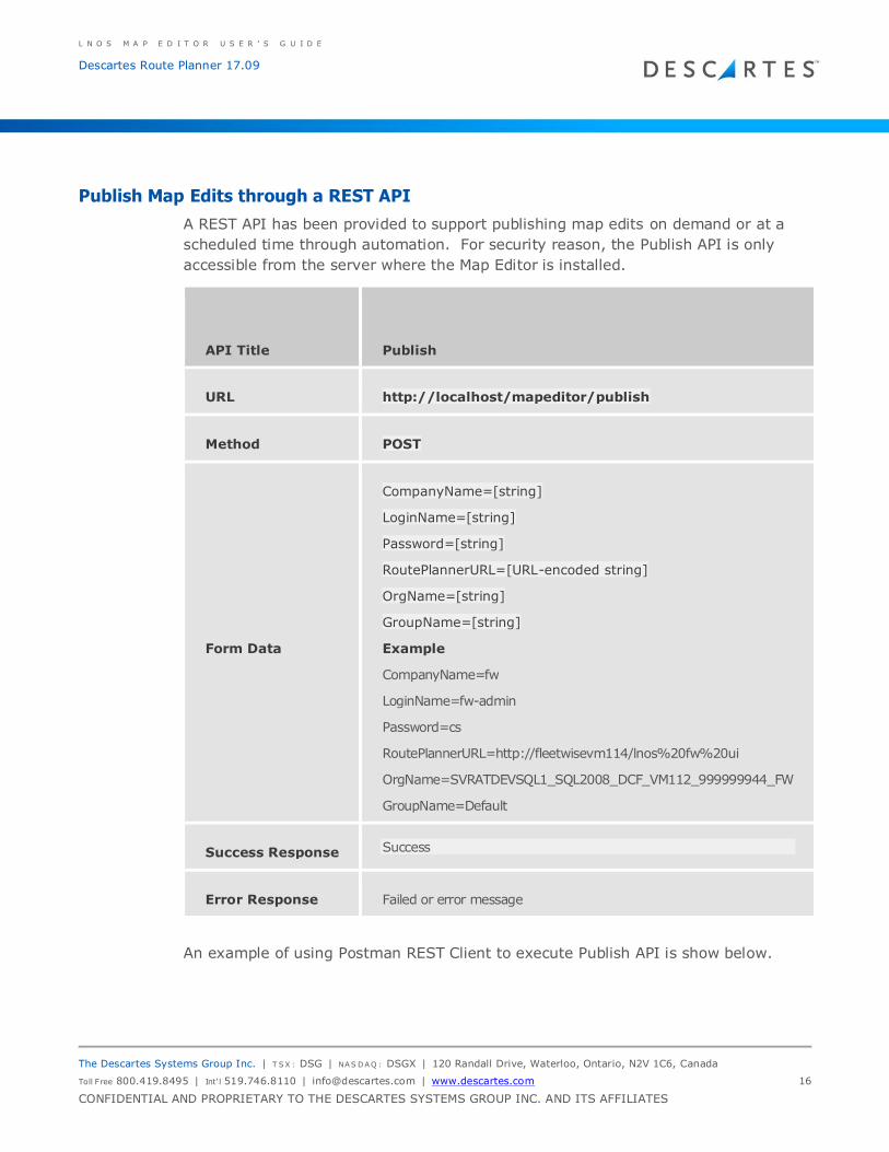
Publish Map Edits through a REST API
A REST API has been provided to support publishing map edits on demand or at a
scheduled time through automation. For security reason, the Publish API is only
accessible from the server where the Map Editor is installed.
API Title Publish
URL http://localhost/mapeditor/publish
Method POST
Form Data
CompanyName=[string]
LoginName=[string]
Password=[string]
RoutePlannerURL=[URL-encoded string]
OrgName=[string]
GroupName=[string]
Example
CompanyName=fw
LoginName=fw-admin
Password=cs
RoutePlannerURL=http://fleetwisevm114/lnos%20fw%20ui
OrgName=SVRATDEVSQL1_SQL2008_DCF_VM112_999999944_FW
GroupName=Default
Success Response Success
Error Response Failed or error message
An example of using Postman REST Client to execute Publish API is show below.
L N O S M A P E D I T O R U S E R ’ S G U I D E
Descartes Route Planner 17.09
The Descartes Systems Group Inc. | T SX : DSG | NAS DAQ : DSGX | 120 Randall Drive, Waterloo, Ontario, N2V 1C6, Canada
Toll Free 800.419.8495 | Int‘l 519.746.8110 | [email protected] | www.descartes.com 17
CONFIDENTIAL AND PROPRIETARY TO THE DESCARTES SYSTEMS GROUP INC. AND ITS AFFILIATES
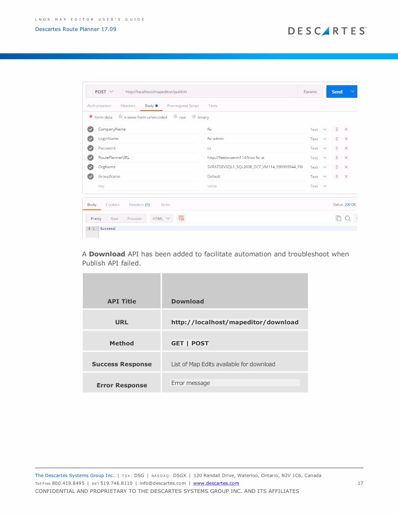
A Download API has been added to facilitate automation and troubleshoot when
Publish API failed.
API Title Download
URL http://localhost/mapeditor/download
Method GET | POST
Success Response List of Map Edits available for download
Error Response Error message
L N O S M A P E D I T O R U S E R ’ S G U I D E
Descartes Route Planner 17.09
The Descartes Systems Group Inc. | T SX : DSG | NAS DAQ : DSGX | 120 Randall Drive, Waterloo, Ontario, N2V 1C6, Canada
Toll Free 800.419.8495 | Int‘l 519.746.8110 | [email protected] | www.descartes.com 18
CONFIDENTIAL AND PROPRIETARY TO THE DESCARTES SYSTEMS GROUP INC. AND ITS AFFILIATES
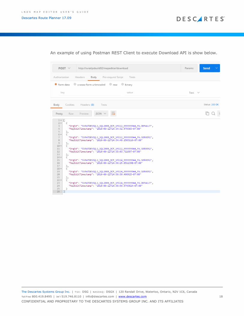
An example of using Postman REST Client to execute Download API is show below.
L N O S M A P E D I T O R U S E R ’ S G U I D E
Descartes Route Planner 17.09
The Descartes Systems Group Inc. | T SX : DSG | NAS DAQ : DSGX | 120 Randall Drive, Waterloo, Ontario, N2V 1C6, Canada
Toll Free 800.419.8495 | Int‘l 519.746.8110 | [email protected] | www.descartes.com 19
CONFIDENTIAL AND PROPRIETARY TO THE DESCARTES SYSTEMS GROUP INC. AND ITS AFFILIATES
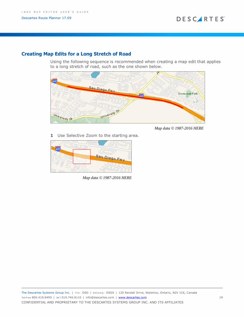
Creating Map Edits for a Long Stretch of Road
Using the following sequence is recommended when creating a map edit that applies to a long stretch of road, such as the one shown below.
Map data © 1987-2016 HERE
1 Use Selective Zoom to the starting area.
Map data © 1987-2016 HERE
L N O S M A P E D I T O R U S E R ’ S G U I D E
Descartes Route Planner 17.09
The Descartes Systems Group Inc. | T SX : DSG | NAS DAQ : DSGX | 120 Randall Drive, Waterloo, Ontario, N2V 1C6, Canada
Toll Free 800.419.8495 | Int‘l 519.746.8110 | [email protected] | www.descartes.com 20
CONFIDENTIAL AND PROPRIETARY TO THE DESCARTES SYSTEMS GROUP INC. AND ITS AFFILIATES
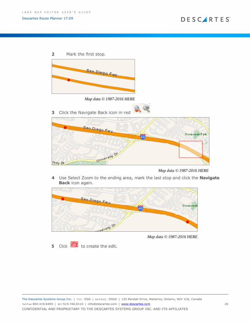
2 Mark the first stop.
Map data © 1987-2016 HERE
3 Click the Navigate Back icon in red
Map data © 1987-2016 HERE
4 Use Select Zoom to the ending area, mark the last stop and click the Navigate Back icon again.
Map data © 1987-2016 HERE
5 Click to create the edit.