Embed Size (px)
Citation preview

Lancaster’s Trails Vision, 2016
Prepared by the Montachusett Regional Planning Commission

2
EXECUTIVE SUMMARY
This report describes how Lancaster can use and enhance its infrastructure of trails to
significantly increase the quality of life for its citizens and visitors. It describes how the
infrastructure we have today came to be and also highlights the limitations of the current
infrastructure that prevent us from using it for much greater recreational, business-related, and
social benefit.
Section VI of this Lancaster’s Trails Vision provides summaries of the 10 most important sites
that contribute people’s enjoyment of the many kinds of trails that Lancaster has. Each site
location is shown with a map and other relevant pictures, as well as the basic design features of
the location. The 10 locations must be seen as parts of a whole, thus building the vision for a
future expansion in the network. Such an expansion involves connecting existing pathways with
places where people want to go. This can be achieved by: i) extending a path a short distance, or
making a short connection between two paths, so that more people could get to more places of
interest; ii) enhancing access over existing pathways so that people with young children in
strollers, senior citizens, or people with mobility impairments can get to points of interest; iii)
creating new recreational opportunities (e.g., fitness trails, blue trails); or increase educational
opportunities along the pathways; and iv) projects that involve developing new long pathways
that would increase the number of major “arteries” both within Lancaster as well as between
Lancaster and its neighboring towns, aiming to interconnect the different sites into a walkable
network.
In Section VII, an overview of the participatory consultations conducted with the public that
constitute the core of users from Lancaster’s trails, as well as local stakeholders and regional
players in an attempt to come up with an unified and comprehensive vision of the future network
of Lacaster’s Trail Vision that is as inclusive as possible. In the appendix it is possible to see a
complete and literary transcription of the public forum that was made in order to collect the
public input. Such a literary reproduction is important to assert that the voices were heard and
taken into consideration during this document’s preparation.
Finally, in section VIII a rough road map for the construction of the network, with some time
tables that can serve as parameters, as well as potential sources of funding from grants that can
address the costs of building new pathways and revamping the existing ones.
It is important to stress the fact that this document was prepared using the Groton’s Trails Vision
as a source of inspiration.

Table of Contents
EXECUTIVE SUMMARY ............................................................................................................ 2
I. INTRODUCTION ....................................................................................................................... 5
II. HOW THIS TRAILS VISION WILL BE USED ...................................................................... 6
A. By the Commonwealth of Massachusetts .............................................................................. 6
B. By Other Nearby Towns ......................................................................................................... 6
C. By the Town of Lancaster ...................................................................................................... 6
III. TRAIL USERS CONSIDERED IN THIS REPORT................................................................ 9
IV. BENEFITS OF OUTDOOR PATHWAYS ............................................................................ 10
V. TRAILS VISION COMMITTEE ............................................................................................ 12
A. Organizations Represented on the Committee ..................................................................... 12
B. Purpose, Vision, and Values ................................................................................................. 12
VI. EXISTING CONDITIONS IN LANCASTER’S TRAILS NETWORK ............................... 14
A. The Lancaster Trail System: A Treasure for Lancaster ....................................................... 14
1. Cook Conservation Area .................................................................................................. 16
2. Lancaster Town Forest ..................................................................................................... 17
3. Ballard Hill Conservation Area ........................................................................................ 18
4. Bolton Flats Wildlife Management Area .......................................................................... 19
5. Thayer Memorial Forest ................................................................................................... 20
6. Parker Family Forest ........................................................................................................ 21
7. Turner Pond Conservation Area ....................................................................................... 22
8. Eagle Ridge Conservation Area ....................................................................................... 23
9. Nathaniel Thayer Memorial Park ..................................................................................... 24
10. Atherton Bridge River Greenway ................................................................................... 25
B. Limitations of Current Trails Network..................................................................................... 26
VII. OVERVIEW OF PUBLIC INPUT COLLECTED FOR THIS VISION .............................. 27
A. Public Participation Workshop ............................................................................................. 27
B. Conclusions from the Workshop .......................................................................................... 29
VIII. ROAD MAP ......................................................................................................................... 30

4
A. Wayfinding ........................................................................................................................... 30
B. Road Bicyclist Pathways Based On “Complete Streets”...................................................... 33
C. Increase Connectedness of Trails Network .......................................................................... 36
D. Pathways along Major Roadways ........................................................................................ 39
E. Develop Blue Trails along River .......................................................................................... 40
F. Funding ................................................................................................................................. 41
Federal Resources .................................................................................................................. 41
State Resources ...................................................................................................................... 41
Non-profit Resources ............................................................................................................. 41
APPENDIX ................................................................................................................................... 42
A. Analysis of the Results Collected in the 11/10/2015 Public Workshop............................... 42
B. Further feedback from stakeholders involved with the Trail Vision discussions................. 46
C. Interpretation of the Results from the Workshop ................................................................. 47

5
I. INTRODUCTION
Throughout this report, we will use the terms “trail,” “path,” “pathway,” “sidewalk,” “dirt road,”
“rail trail,” and even “river trail” somewhat interchangeably. They are all considered part of the
pathway infrastructure that this Trails Vision for Lancaster seeks to expand and enhance to
improve the quality of life for all of Lancaster’s residents and visitors. The core of this report is with Sections VI, VI and VIII, with the first describing the existing sites
that are significant to Lancaster’s trail infrastructure and the second explaining how the public
participation occurred. In Section VIII, the next steps addressing the integration of the sites is
discussed by this Trails Vision report in order to come up with a ‘Road Map’ for the network
building. To lay the foundation for these projects, this report begins by describing the following:
How the Lancaster Trails Vision Committee believes this report can be used by the state,
the region, and the Town of Lancaster;
Who uses the trails in Lancaster;
What the benefits are to the Town of Lancaster and the region by enhancing our trails
infrastructure;
Who is on the Lancaster Trails Vision Committee and what the current committee’s
purpose, vision, and values are; and
The limitations in the current trails infrastructure.
It is the Lancaster’s Trails Vision Committee’s hope that this initial Trails Vision report will
serve to stimulate discussion and actions that will lead to the implementation of many of the
projects described herein. Our Lancaster’s Trails Vision is a long-range view of what is possible
and the benefits that could be achieved, but it will need to be updated every five years or so to
incorporate lessons learned along the way and to reassess priorities. As we move forward,
membership on the Lancaster’s Trails Vision Committee is expected to be dynamic as advocates
for the different projects come forward to take them from concept to completed infrastructural
enhancement. The Lancaster’s Trails Vision Committee believes this could be a sustainable
approach to enhancing the trails infrastructure for the benefit of all the residents, and visitors to
the Town of Lancaster.

6
II. HOW THIS TRAILS VISION WILL BE USED
A. By the Commonwealth of Massachusetts
The initiative for developing a Trails Vision for Lancaster was a request from the Montachusett
Regional Trails Coalition1 (MRTC) to each of its participating towns
2 to develop their Trails
Visions. The MRTC will integrate the Trails Visions from its participating towns into a regional
vision and implementation plan. The Trails Visions of all the active regional trail coalitions will
be integrated to provide an update to the current state-wide recreational trails vision,
“Commonwealth Connections”3. The goals of “Commonwealth Connections” have been used to
prioritize Recreational Trail Program grants that are administered by the Department of
Conservation and Recreation (DCR) and funded from the state’s alternative transportation funds.
The updated Commonwealth trails vision will seek increased state funding for trail projects at all
levels to help achieve the vision.
B. By Other Nearby Towns
Lancaster’s Trails Vision may help other nearby communities in developing their own Trails
Vision. Our Trails Vision may also stimulate greater interest in developing long-distance town-
to-town pathways with our neighboring towns. To the extent that parts of our Trails Vision are in
common with those of nearby communities, they are more likely to become part of the future
state-wide Trails Vision and thus give the projects a higher probability of being at least partially
funded with state resources. This document follows Groton’s Trail Vision goal of serving
adjacent communities into developing their visions.
C. By the Town of Lancaster
The development of this Lancaster’s Trails Vision uses ideas put forth for trail improvements in
the Lancaster Master Plan4, Lancaster’s Open Space and Recreation Plan
5, Lancaster Green Belt
1 The Montachusett Regional Trails Coalition (MRTC) began meeting in March 2012 through the cooperative
efforts of the Nashua River Watershed Association, the Montachusett Regional Planning Commission, and the
Leominster Trail Stewards. Mr. Dick O’Brien is the current Chairman of the MRTC. Al Futterman of the Nashua
River Watershed Association is the Co-Chairman. It is the first regional trail coalition to form in the
Commonwealth of Massachusetts but two others have very recently been formed (viz., North Quabbin and Pioneer
Valley) and another is in the formative stage (Westborough-Southborough-Northborough area). The MRTC’s
Mission is to “…enrich the lives and communities within its boundaries by advancing the development of diverse,
high quality trails and greenways.” The MRTC’s Core Values are to provide “…trails and greenways that promote
accessibility, healthy lifestyles, economic vitality, sustainable development, best practices, experiences in the
outdoors, appreciation for the outdoors, learning in the outdoors, and connectivity.” 2 The towns encompassed by the MRTC are Ashburnham, Ashby, Athol, Devens, Fitchburg, Gardner, Groton,
Harvard, Hubbardston, Lancaster, Leominster, Lunenburg, Petersham, Phillipston, Princeton, Royalston, Shirley,
Sterling, Templeton, Townsend, Westminster and Winchendon. Not all of these towns currently have representation
on the MRTC. 3 Department of Environmental Management, “Commonwealth Connections – A greenway vision for
Massachusetts,” 2001. 4 The Master Plan is prepared by the Planning Board.
http://www.ci.lancaster.ma.us/Pages/LancasterMA_CommDev/master 5 The Open Space and Recreation Plan is spearheaded by the Conservation Commission and its Open Space and
Recreation Commission. http://www.ci.lancaster.ma.us/Pages/LancasterMA_WebDocs/osrp

7
Vision Plan6 and the Groton Trail Vision Plan
7 as its baseline. Committee members added many
other ideas for projects that serve parts of the town and/or groups of users that have not been
specifically addressed before. Unlike either Plan, this Trails Vision also provides an initial
design and implementation plan for each project and provides an initial attempt at prioritizing the
projects. In addition to the aforementioned projects, this vision also relied on the conclusions
drafted from Lancaster’s Green Belt Plan, Connecting Communities - Along Our Trails from
MRTC, and Groton’s Trail Vision. Several of these projects have been dreamed about for many
years but they have not been previously assembled in one place and prioritized. By bringing all
the ideas together in one document, we believe it will be easier to take a comprehensive and
balanced approach toward growing and enhancing our trail network.
This Trails Vision describes a variety of projects that use and enhance Lancaster’s trails network
to improve the quality of life for all Lancaster residents. To this end, this Trails Vision provides
examples of short-term, mid-term, and long-term projects that serve the following needs:
Outdoor recreational opportunities of all types for all ages
Healthy and safe activities for residents of all levels of ability
Increase in connectedness between neighborhoods and points of interest (library,
religious facilities, cultural/historic sites, schools, post office, ball fields, parks, offices,
restaurants, town facilities, mass transportation nodes, etc.) via woods trails, field trails,
roadside paths, abandoned roads, and sidewalks.
Business growth via easier access and increased tourism, and
The projects in this Trails Vision have very different levels of feasibility. Some could be
relatively easy to do and some could be very difficult. A few might better be considered
conceptual since they are not specific as to what should be done but rather they illustrate an idea
with the aim of encouraging public discussion of exactly what could be implemented. The
projects in this report are intended to stimulate excitement about what the future of recreational
opportunities and transportation alternatives could look like in Lancaster and to provide an initial
set of priorities for the detailed studies and discussions that they will require to become more
than just ideas.
By developing Lancaster’s Trails Vision, we have started to lay out some directions our town can
take to enhance the great potential of our network of trails, waterways, pathways, and sidewalks.
As each project described in this Trails Vision is implemented, we believe the quality of life will
be significantly improved for a large number of Lancaster’s citizens. Some projects focus on
particular types of trail users and some projects support multiple trail users. We believe that as
each project is completed, we will all be very pleased with the new opportunities that will be
6The Lancaster Green Belt Vision Plan is prepared by the Planning Board.
https://drive.google.com/file/d/0B7ryAPZTjAOkeEMzVEFtbEN6RVU/edit?usp=sharing 7 The Groton Trail Vision Plan is prepared by the Trails Vision Committee.
http://www.townofgroton.org//DesktopModules/Bring2mind/DMX/Download.aspx?PortalId=0&EntryId=17861

8
provided.
Some of the projects to enhance the trails network may require considerable resources and so
will involve hard decisions. Other significant projects can be accomplished with minimal cost if
accompanied by a spirit of cooperation and a collective willingness to do them. The Trails Vision
identifies numerous projects having varying degrees of difficulty and benefits so that we can
begin a more systematic approach to tapping into the potential our exceptional trails
infrastructure holds. We will know that our Trails Vision is successful if we enjoy the benefits of
each successful project enough so that we want to continue to work and plan additional ones.

9
III. TRAIL USERS CONSIDERED IN THIS REPORT
The trails in Lancaster have many uses and people with many different interests use them.
The following list of potential users is certainly not complete, but it gives an idea of the many
uses for our trails have:
Bicyclists
Boaters (e.g., canoers, kayakers)
Commuters
Cross-country skiers
Equestrians
Exercisers (e.g., laps around tracks,
calisthenics; physical fitness)
Geocaching
Fishermen
Hikers
Hunters
Mobility-impaired individuals (e.g.,
wheelchairs, walkers, canes,
crutches)
Motorized wheelchair users
Mountain bikers
Nature observers (e.g., birdwatchers,
educational groups; scenic views;
geologic features)
People going to and from churches,
historical sites, recreational facilities,
retail stores, schools, town and
private offices
People walking their pets
People with children in strollers
Runners
Senior citizens
Skaters (e.g., roller skates, in-line
skates, ice skates)
Snowmobiles
Snowshoers
Swimmers (e.g., in pools, ponds,
lakes, and rivers)
Trailrunners
Walkers

10
IV. BENEFITS OF OUTDOOR PATHWAYS
The benefits of outdoor pathways are as varied as the interests of the people that use them. In
addition to the specific personal benefits that each user wishes to derive from the pathways, there
are community-wide benefits as well that include the following:
Health – The more that people can safely use non-motorized pathways, the more they will
benefit from increased exercise they will get and the reduced stress they will enjoy due to driving
less on our town’s busy and narrow roadways.
Cleaner air – The less that people use motorized vehicles, the cleaner the air will be for all.
Community connections – The more that people go from place to place using the non-
motorized pathways, the more likely they are to meet people they know and to make new
acquaintances. Over time, this can provide an increased sense of community and with it a sense
of safety, support and pride.
Educational opportunities – The Town of Lancaster is rich in history and natural diversity.
Improved signage or other means (e.g., pamphlets) to identify places of archaeologic and historic
interest, flora, fauna, geologic points of interest (e.g., drumlins, eskers, kettle holes) and
agricultural areas and activities can educate citizens and visitors alike about the things that make
Lancaster unique and thus worth living or visiting.
Business opportunities – An improved non-motorized infrastructure will attract people to live in
Lancaster and to come to Lancaster for leisure activities. There will be opportunities for
increased business in general due to more “eco-tourism” as well as for new businesses that
support the recreational interests of the trail users (e.g., hiking, biking, cross-country skiing,
snowshoeing, runners, and boaters).
These benefits and more are discussed in the following initiatives that have emerged in the past
decade:
The Massachusetts “Safe Routes to Schools” (SRTS) program8. In 1969, roughly 48% of
students bicycled or walked to school. Today only 13% of children do so. And travel to
school can account for up to 25% of all morning traffic. That’s why we work…to teach
and inspire children to start walking and bicycling more often to and from school,
improving their physical health, safety and community. The Massachusetts SRTS
program promotes healthy alternatives for children and parents in their travel to and from
school. It educates students, parents and community members on the value of walking
and bicycling for travel to and from school.
“Walkable Communities”9 – These are described as thriving, livable, sustainable places
that give their residents safe transportation choices and improved quality of life. They are
designed around the human foot, truly the only template that can lead to sustainability
8 http://www.commute.com/schools
9 http://www.walkable.org

11
and future community prosperity. Increased walkability also helps improve resource
responsibility, safety, physical fitness and social interaction.
The Massachusetts Department of Transportation’s (MassDOT’s) GreenDOT10
Policy –
One of the three primary objectives of the “GreenDOT Implementation Plan”11
is to
“Promote healthy transportation options of walking, bicycling, and public transit.”
Other important aspects of the Policy, Planning, and Design component of the GreenDOT
Implementation Plan are the guidelines offered by the “Complete Streets”12
concept. In
2009, MassDOT became the second New England state to adopt a Complete Streets
design policy. Complete Streets “…are designed and operated to enable safe access for
all users. People of all ages and abilities are able to safely move along and across streets
in a community, regardless of how they are traveling. Complete Streets make it easy to
cross the street, walk to shops, and bicycle to work.
The soon to be published Complete Streets study from MRPC and Lancaster, which
incorporates points of interest locations provided by the Lancaster Planning Department,
within the downtown area and a 1000 foot buffer was placed around those locations.
Data that was collected within the study area included traffic volume, speed and
classification counts, turning movement counts, sidewalks and related sign inventory as
well as public input. This study area mainly focuses on the walkability aspect of
Complete Streets, where residents and visitors might be the most likely to explore the
community on foot, bicycle, or wheelchair/walker. Based on the data collected, a
recommendations section was included. These recommendations are comprised of
sidewalk maintenance and connections, the materials used for the sidewalks, traffic
calming measures to address speed issues, lighting along Main Street, additional and
improved parking areas, connections to neighborhoods, and other options to complement
a Complete Streets municipality.
None of these initiatives can prescribe what Lancaster needs to improve its trail infrastructure for
the benefit of the quality of life for its citizens and visitors, and none of them tries to do so. They
simply offer a variety of approaches and guidelines that can be adopted by Lancaster as
appropriate. The broad acceptance of these initiatives throughout the country speaks to the need
and desire of communities to purposely build and sustain a greater number of healthy, safe, and
convenient non-vehicular transportation pathways to counter the emphasis we have all put on
motor vehicles to get us where we want to go. Lancaster will make its own decisions about how
it views the benefits of improved public pathways relative to their costs and to other important
quality of life issues. The Trails Vision Committee hopes that this report will help the citizens of
Lancaster make those decisions with a better vision of what is possible.
10
http://www.massdot.state.ma.us/GreenDOT.aspx 11
http://www.massdot.state.ma.us/Portals/0/docs/GreenDOT/finalImplementation/FinalGreenDOTImplementationPla
n12.12.12.pdf 12
http://www.smartgrowthamerica.org/complete-streets

12
V. TRAILS VISION COMMITTEE
A. Organizations Represented on the Committee
The MRPC solicited input from what we called the town “Stakeholders”. These individuals
represented various town boards and committees throughout town, including the Planning Board,
Trail and Bikeway Coalition, Conservation Commission, Council on Aging, Commission on
Disability, Historical Commission, Open Space and Recreation Committees, Town Forest
Committee, Thayer Field Campus Committee, Lancaster Land Trust, New England Forestry
Foundation, Mass Fish and Game, Nashua River Watershed Association, Friends of the Nashua
River and Public Works. These entities that comprise the Trails Vision Committee were vital in
the data gathering process.
B. Purpose, Vision, and Values
At its first meetings, the Trails Vision stakeholders discussed its purpose, vision and values.
Such guidelines coincide with the vision from the Lancaster Trail & Bike Way Coalition
regarding the promotion of walkability and bike riding within Lancaster open areas through new
trails and trail connection routes; while keeping up with the conservation of natural and cultural
assets. The Committee developed the following consensus statements:
Purpose
Help the Town of Lancaster – preserve and improve our quality of life by identifying
what we want and need for getting around town without motorized vehicles.
Support the regional trail plan – take advantage of Commonwealth funds, to the extent
available, by contributing to the region’s input to the state’s Trails Vision.
Create an initial implementation plan for our Trails Vision – identify basic resource
needs, set priorities (short, medium and long term), and suggest a timeline for possible
implementation.
Vision
Our vision for Lancaster’s trails is a safe and easy-to-use network of ways that will connect
people to each other, to places they want to go in town and in surrounding towns, and to the
unique natural, geological, and historical points of interest throughout our town.
Values
We believe that sustainable community support for improving the quality of paths in
Lancaster will develop through more complete understanding by the community of its
13
unique and substantial natural, historical, and geological features.
We believe increased and improved connectedness of our network of paths will provide
significantly improved health, recreational, business, and educational opportunities for
people of all ages and abilities.
We believe that Lancaster’s paths should promote accessibility, healthy lifestyles,
economic vitality, appreciation of our diverse biohabitat and history, education, and
connectivity with each other and the places we want to go.

14
VI. EXISTING CONDITIONS IN LANCASTER’S TRAILS NETWORK
A. The Lancaster Trail System: A Treasure for Lancaster
Lancaster has all the elements to become a quintessential rural New England community that
allows its population to enjoy all the outdoor features that come with this package, while at the
same time exercising and making use of the natural and cultural features that are available.
Throughout the research process for the making of this report, the inventory compiled ten major
trail sites for outdoor activities that, when interconnected, will constitute the Lancaster Trail
Network. These are the sites shown on the map next page:
1. Cook Conservation Area
2. Lancaster Town Forest
3. Ballard Hill Conservation Area
4. Bolton Flats Wildlife Management Area
5. Thayer Memorial Forest
6. Parker Family Forest
7. Turner Pond Conservation Area
8. Eagle Ridge Conservation Area
9. Nathaniel Thayer Memorial Park
10. Atherton Bridge River Greenway.

15

16
1. Cook Conservation Area
Area Name
Cook Conservation Area
with 3 sub-areas and 7
trails
Trail Location Lunenburg Road
Acreage 800 acres
Owner/Steward
Lancaster Conservation
Commission/Lancaster’s
Friends of the Nashua
River
Improved or Raw Improved
ADA Compliant No
Modes Hike, Bike, Horse, Ski, No
Motorized
Signage Entrance/Trails
Parking Yes

17
2. Lancaster Town Forest
Area Name Town Forest with 7 trails
Trail Location Brockelman Road
Acreage 441 acres
Owner/Steward Board of Selectmen/Town
Forest Committee
Improved or Raw Improved
ADA Compliant No
Modes Hike, Horse, Ski,
Snowmobiles, No ATVs
Signage Entrance
Parking Yes

18
3. Ballard Hill Conservation Area
Area Name Ballard Hill Conservation
Area with 2 trails
Trail Location Route 117 (Main Street)
Acreage 34 acres
Owner/Steward Lancaster Land Trust
Improved or Raw Improved
ADA Compliant No
Modes Hike, Horse, No Motorized
Signage Entrance
Parking Yes

19
4. Bolton Flats Wildlife Management Area
Area Name Bolton Flats with 2 trails
Trail Location Route 117 & Route 110
(Bolton)
Acreage 1,320 acres
Owner/Steward MA Fish & Game
Improved or Raw Improved
ADA Compliant No
Modes Hike, No Motorized
Signage Entrance
Parking Yes

20
5. Thayer Memorial Forest
Area Name Thayer Memorial Forest
with 6 trails
Trail Location Bull Hill Road
Acreage 100 acres
Owner/Steward New England Forestry
Foundation
Improved or Raw Improved
ADA Compliant No
Modes Hike, Horse, Ski, No
Motorized
Signage Entrance
Parking Yes – on road

21
6. Parker Family Forest
Area Name Parker Family Forest with
1 trail
Trail Location Goss Lane
Acreage 60 acres
Owner/Steward New England Forestry
Foundation
Improved or Raw Improved
ADA Compliant No
Modes Hike, Horse, Ski, No
Motorized
Signage Entrance
Parking Yes

22
7. Turner Pond Conservation Area
Area Name Turner Pond Conservation
Area with 1 trail
Trail Location Brian Road
Acreage 38+ acres
Owner/Steward Lancaster Land Trust
Improved or Raw Improved
ADA Compliant No
Modes Hike, Bike, Ski, no
motorized
Signage Entrance
Parking Yes – on road

23
8. Eagle Ridge Conservation Area
Area Name Eagle Ridge Conservation
Area with 1 trail
Trail Location Mary Catherine Drive
Acreage 75 acres
Owner/Steward Lancaster Conservation
Commission
Improved or Raw Improved
ADA Compliant No
Modes Hike, Snowshoe, Ski
Signage No
Parking
Yes – Sterling Rd., George
Hill Rd. and Mary
Catherine Dr.

24
9. Nathaniel Thayer Memorial Park
Source: www. http://thayerfield.org/about-us/
Area Name
Nathaniel Thayer
Memorial Park, and several
short trails
Trail Location Packard Street
Acreage 23 acres
Owner/Steward Board of Selectmen
Improved or Raw Improved
ADA Compliant No
Modes Hike, Ski, Snowshoe
Signage No
Parking Yes – Packard St.

25
10. Atherton Bridge River Greenway
Area Name Atherton Bridge River
Greenway with 1 trail
Trail Location Bolton Road
Acreage 18 acres
Owner/Steward Lancaster Conservation
Commission
Improved or Raw Improved
ADA Compliant No
Modes Hike, Snowshoe, Ski, No
Motorized
Signage No
Parking Yes – on road

26
B. Limitations of Current Trails Network
Lancaster’s Trails Network is extensive and well-utilized by many users. However, it has been
designed neither for any particular group of user(s) nor to accommodate all potential trail users.
In fact, few if any of the trails have actually been designed at all, but rather they have evolved
through a process driven mostly by user convenience. Over many, decades, equestrians, and
more recently snowmobilers and ATVs, used existing farm roads, driveways, etc., and also
created paths to get them wherever they wanted to go. If enough of these users had the same
destination, the path became commonly used and established. Unfortunately, this historic ad hoc
process, uninformed by more recent revelations of the fragility of rare and endangered species
habitats (streams, ponds, rivers, wetlands, upland nesting areas, etc.), erosion risks, potential
damage to historic and geologic sites (e.g., stone walls, historic/ancient building remnants,
eskers, etc.) has given us a trails network that lacks the following characteristics:
Sustainable – Trails should be designed to be easy and relatively inexpensive to maintain
over a long period of time. This requires sensitivity to the vegetation through which the
trail passes (e.g., mature woods, transitional woods, open fields, dense ground cover,
vines, bushes), the risk of erosion (which depends on the nature of the tread material and
the speed and volume of water that can be expected to go across and down the trail), and
the number and types of users (e.g., horses, bikes).
Accessible – Accessible trails are also sustainable trails, but they are additionally
designed so that a) in-line and cross-trail slopes are within prescribed ranges for
prescribed distances to allow mobility impaired individuals to traverse them on their own
or with assistance; and b) the tread is flat (according to specific guidelines) and firm.
They also have additional safety features (railings, edges, etc.) and signage (describing
obstacles, maximum slopes, etc.).
Provides Directional and Educational Signage – The Trails Committee hopes to put
trail markers on many of the trails to help users stay on the trails. Trailhead posts can also
be put on roadsides where trails intersect. However, there is not a single sign on any path
in Lancaster that points to a destination such as another trail or parcel, a road, a point of
interest (scenic, geologic, historic, businesses, buildings, parks, etc.) or a parking area.
Full Connectedness – Many of Lancaster’s trails connect to trails on other parcels, but
there are still a number of trails that are isolated, surrounded by private property. These
trail sites that are isolated from the rest of the town (e.g., Turner Pond Conservation Area
in the North) make the access to such places more challenging from a pedestrian-friendly
perspective. Plus, many of the larger groups of parcels are disconnected from each other
so that there are no continuous routes around or across town. Finally, while many
residents live within 0.5 miles of a trail or sidewalk, there are still many who do not.
Implementing the Lancaster Green Belt plan may be a way to connect large trail areas.
Safety – There are very few places to ride a road bike safely due to the narrow and/or
busy main roads. Several sidewalks end just before getting to popular destinations and so
people are forced to walk along narrow and/or busy roads.

27
VII. OVERVIEW OF PUBLIC INPUT COLLECTED FOR THIS VISION
A. Public Participation Workshop
The Montachusett Regional Planning Commission, in cooperation with the Lancaster
Community Development and Planning Office, conducted a public workshop to provide a
forum for the public’s input for the Lancaster Trail Vision. The purpose of this document is to
create a comprehensive eco-tourism planning tool for Lancaster. This tool will be a single
source of information for trail and bikeway visioning, planning and implementation. The
workshop’s intentions were to:
Look at Lancaster’s current trails/networks, proposed/potential trails, trail
connections and trail networks.
To hear from the public regarding the future of Lancaster trail developments
through questions such as “What would you like to see?”; “What should the town
focus on?”, and “What are the priorities?”
This process was preceded by an in depth meeting where public officials and stakeholders
created the context for the workshop. The workshop allowed participants to identify areas of
concern and priority, and offer their feelings of positive, negative and transitional areas in the
network. The MRPC staff created flyers that were distributed through the town departments, as
well as throughout the Town of Lancaster to make business owners and residents aware of the
event.
Picture 1: Participants of the workshop
Source: MRPC
The workshop occurred on November 10, 2015 in the Lancaster Community Center & Senior
Center. A total of 35 people attended the public workshop, which started with a presentation

28
from MRPC staff, where the project was explained, and the inventory of existing trails
displayed.
Next, the workshop proceeded with four tables working as discussion groups, with one member
acting as table moderator and note taker to record the responses. With approximately ten
participants at each table, the participants spoke about general feelings relating to the existing
trails in Lancaster and the Trail Network Vision.
Picture 2: Table with maps and flip charts for discussion
Source: MRPC
The participants were asked to discuss and answer to the following questions:
1. What types of recreational activities do you want to see related to
trails? Seasonal/holiday events, guided hikes, uses, etc.?
2. What are the trails best used for? What types of users or activities?
29
3. Where do you see or hear of people using trails? What are the most popular
trails? Why? What is the general feel of these trails?
4. What aspects of connecting trails to points of interest are important to you? What types
of points of interest should be incorporated?
5. How can we maintain the trails?
In the Appendix, it is possible to find a transcription of the discussions held at each table. The
transcriptions are exactly as was in the original discussions. Such a step is important to ensure
that the results from the public workshop were processed in its entirety.
B. Conclusions from the Workshop
After making a word count from all answers, it was easy to see that the favorite use for the
trails is for passive recreational activities such as hiking, followed by cross country skiing, dog
walking and biking. In terms of cultural and natural use of the trails, the favorites related to the
historic character of the area, followed by bird watching and photography.
The favorite spots ranked by the participants appear to be the Cook Conservation Area,
Nathaniel Thayer Memorial Park, Lancaster Town Forest, and the Ballard Hill Conservation
Area.
In terms of how to promote the shared use of the existing trails, improvements were suggested
about wayfinding (signaling) and regulation of uses allowed/forbidden in each location such as
motorized vehicles, bikes, hunting, etc.
Finally, the recommendations that address the future management and maintenance of the Trail
Network consisted of using the help of the local Scout groups, other local community groups
such as businesses and schools through volunteering and sponsorship (e.g., Adopt a Trail), as
well as the presence of the local police department.

30
VIII. ROAD MAP
Once all the input is collected and processed, it becomes possible to formulate the next steps to
provide the necessary actions that will kick start this vision of a trails network. Throughout this
process, the main locations to be included in the network were mentioned, followed by the
preferred modes of use and limitations or constraints that can be addressed to foster the network.
In addition to the local perspective, it is also possible to verify best practices in terms of trails
management from places like Western Massachusetts (via Amherst and the Norwottuck Trail),
Groton (via the literature from Groton Trail Vision) and New York State.
A. Wayfinding
An adequate Wayfinding System is greatly important, as it allows for people to navigate through
their desired destinations with the guidance of visual signals, as well as communicating about the
nature of a trail, possible restrictions to using modes, convergence between different uses, etc. In
order to assess examples of wayfinding signals for trails in Massachusetts.
The following are a variety of types of signs that could be tailored for use on Lancaster’s Trails:
Mountain bike
trails
Historical sign
Multi-trail sign
Equestrian trail
Handicapped
accessible
sign/activities
No mountain bikes
Geological
education sign
Bicycling and XC
skiing trail
Point of interest
sign
Directional signs
Caution sign
Courtesy sign

31

32
Design
It is helpful if signs are small, distinctive and consistent from parcel to parcel (and even
town to town) because they will not need to be read each time they are seen and they will
seem less obtrusive.
Challenges
Costs are significant for the number of signs that might be needed for the Town of
Lancaster
What is helpful and reassuring to one person using a trail may be clutter on billboard
advertising to another. A difficult balance must be achieved between
information/education, safety and aesthetics.

33
B. Road Bicyclist Pathways Based On “Complete Streets”
“Complete Streets is a transportation policy and design approach that requires streets to be
planned, designed, operated, and maintained to enable safe, convenient and comfortable travel
and access for users of all ages and abilities regardless of their mode of transportation. Complete
Streets allow for safe travel by those walking, bicycling, riding automobiles….”13
The photo below shows a wide shoulder marked clearly with the white stripe that can be used by
bicycles. The road was reduced to one lane in each direction for motorized vehicles by the
addition of the wide shoulder and the median strip. Note the curb protection/visibility for the
pedestrian crossing in the median strip, which allows pedestrians to cross the road one lane at a
time if necessary.
The photo below shows a bicycle lane clearly marked with a border line and a bicycle symbol.
The road width has been reduced from two lanes to one lane for motorized vehicles by the
combination of the bicycle lane and the marked median strip. In addition, no parking is permitted
on the side with the bicycle lane.
13
Wikipedia, http://en.wikipedia.org/wiki/Complete_streets

34
In addition to markings on the roadways, road signs such as those shown below, can also notify
drivers of motorized vehicles that the road is a bike route. These signs will also serve to
concentrate bicyclists on the bike routes thereby increasing the number and visibility, which will
improve their overall safety.
Design
The specific design elements of Complete Streets vary based on context, but for bicycles they
may include:
Traffic calming measures to lower speeds of automobiles and define the edges of
automobile travel lanes
Elimination of free-flow right-turn lanes, angled and face-out parking
Protected or dedicated bicycle lanes, with appropriate markings and signage
Wide paved shoulders.

35
Challenges
Since many bicyclists cover long distances, bike routes that Lancaster designs need to be
coordinated with Lancaster’s neighboring towns. It is hoped that the neighboring towns will also
develop bike routes of their own, but which roads each town identifies as bike routes really
becomes a regional issue because the increase in bicycle traffic along particular routes in one
town will obviously create more traffic on the streets in neighboring towns to which they
connect. Complete Streets design concepts should also be considered in Lancaster Center.
Roadway changes can be very expensive. But there are financial impacts of reduced exercise,
increased motor vehicle use, more accidents, building more parking areas, having fewer business
visits due to inconveniences in getting to them, and becoming a town that is not as appealing to
people searching for a place to live because it does not allow them to walk and bike safely to
places they want to go. A more balanced approach to accommodating both bicyclists and
motorized vehicles in Lancaster is certainly possible and we believe it would enhance our town
in many ways.

36
C. Increase Connectedness of Trails Network
While some areas of Lancaster have many miles of continuous connected trails, other trails are
disconnected from those nearby. In some cases, these gaps are short as measured by distance, but
they are large in terms of limiting the usefulness of the trails for getting from one place to
another. There are some cases where even a short disconnected trail or group of trails may still
be very popular because of a particular point of interest to which the trail leads, but generally a
trail that is disconnected will not be used by many people and it will thus require more work to
maintain it. Another benefit of a more connected network is that it reduces the amount of
traveling by motorized vehicle that is required to get people to where they want to go.
In order to address the lack of continuity between trail sites, the Town of Lancaster has already
been stepping in to fill such gaps, as the recent new connections that were created can attest:
New Trail Connections
1) Bolton Flats → Harvard → Oxbow Wildlife Refuge (Harvard)
2) Thayer Memorial Forest → Town Forest → Devonshire → Ballard Hill → over Nashua
River → Cook CA (Greenbelt)
3) Parker Family Forest → Winsor CA → Rowlandson Rock -- done
4) Eagle Ridge → Rowlandson Rock
5) Rowlandson Rock → Thayer Memorial Forest
6) Town Forest → Moreira → Wekepeke → Bartlett Pond
7) Trail extensions over the Atherton and Ponakin Bridges
8) New Hilltop Road parcels → Eagle Ridge CA
9) From Lancaster → Bolton Flats WMA → Bolton Loop Trail (Bolton)
10) From Lancaster → Lastella parcels (Sterling)
The map on next page, developed for the Lancaster Open Space and Recreation Plan, shows,
among other features, the extension of walking pathways and/or sidewalks within Lancaster’s
boundaries delineated by a pink outline. By comparing this map with the Lancaster’s Formal
Trail Inventory Map from page 15, it is possible to foresee where the connection between the
trails can be built, sometimes by simply expanding and/or enhancing the preexisting sidewalk
network.

37

38
Design
Expand trail network by making new connections within existing trails in Lancaster when
opportunities arise through purchase of land or easements.
Expand trail connections with Lancaster’s neighboring towns when opportunities arise
through purchase or easements.
Connect sidewalks to trails wherever possible.
Challenges
The gaps in the trails network are private property parcels. Some property owners may be
unaware of the value of their property for improving the trails network. Other owners
may not want their property to be purchased or used by the public regardless of its value
to the public. Attitudes will change over time, so communications regarding the needs for
public trails with private property owners should be sustained over long periods even if
they do not occur frequently.
Opportunities for purchasing land or easements cannot be planned and may last only
briefly due to personal time constraints that the buyer may have. Funds must be built up
and reserved so that they can be used rapidly if needed.
There will always be limited funds available for land or easement purchases, so the gaps
need to be considered in their totality and then prioritized to get the most value out of the
money that is available when opportunities arise. Selecting one purchase over another can
be very difficult when most all potential opportunities only arise once in a lifetime, and
then are not available again for another lifetime, but funds must be used strategically to
get the most value from them.

39
D. Pathways along Major Roadways
Some of the major roads in Lancaster would be very attractive and useful pathways for
pedestrians, bicyclists and equestrians, but they cannot be used safely as they are too narrow,
often having no shoulder at all, and they have many blind corners. There are no realistic
solutions for making any of these roads safe for non-motorized use in the foreseeable future, but
a vision where the Town of Lancaster has found a way to give non-motorized travel a more
balanced position with respect to motorized travel is a powerful one. Therefore ideas like
widening of Rt. 117 and/or bike lanes on Rt. 10 are worth being brought up. It may be a long
time away, but it is a goal that is worthwhile to keep in mind should an opportunity to redesign
any of these roads ever arise.

40
E. Develop Blue Trails along River
This project would develop trails on the Nashua River both within Lancaster and connecting to
Pepperell, Shirley, Townsend, Groton and Ayer with maybe expanding it up until the existing
Nashua River Rail Trail up north. Maps could be developed to show the river in sufficient detail
to aid in navigation and to identify points of interest along the river.
Rest/picnic areas could be developed at intervals on the riverbanks, and intersections with land
trails could be developed so that a combined canoe and hike could be planned.
Design
Maps of the river could be developed for download and distribution.
Signage could be designed and installed on trees or posts at strategic locations along the
rivers.
Rest areas with rustic benches could be created in public parcels along the rivers. Places
to park boats could be created on the riverbanks where land trails come close to the river
so that people could combine their boating with a hike on land.
More put-in and take-out spots.
Challenges
Permission from the landowners would be required to develop rest areas and install
signage.

F. Funding
Federal Resources
Surface Transportation Program (STP) - Provides flexible funding that may be used by
states and localities for projects to preserve and improve the conditions and performance
on any Federal-aid highway, as well as for projects on any public road, pedestrian and
bicycle infrastructure, and transit capital projects.
Congestion Mitigation and Air Quality Improvement Program (CMAQ) - Provides
federal funding for states to support projects and programs intended to improve air
quality and reduce traffic congestion.
State Resources
Transportation Alternatives Program (TAP) - Provides funding for a variety of
transportation project types, including construction, planning and design of on-road and
off-road trail facilities for pedestrians, bicyclists and other non-motorized forms of
transportation (including sidewalks, bicycle infrastructure, pedestrian and bicycle signals,
traffic calming techniques, lighting and other safety-related infrastructure, and
transportation related projects) to achieve compliance with the Americans with
Disabilities Act of 1990.
Chapter 90 – Entitles municipalities to full reimbursement for capital improvement
projects for highway construction, preservation and improvement that create or extend
the life of capital facilities. The funds can be used for maintaining, repairing, improving
or constructing town and county ways and bridges that qualify under the State Aid
Highway Guidelines issued by the Public Works Commission. Items eligible for Chapter
90 funding include roadways, sidewalks, right-of-way acquisition, shoulders, landscaping
and tree planting, roadside drainage, street lighting and traffic control devices.
Department of Conservation and Recreation (DCR) Trails Grant - The Recreational
Trails Program provides reimbursement grants up to $100,000, based on need, breadth
and reach of the trail project. Grants are awarded for a variety of trail protection,
construction and stewardship projects throughout Massachusetts.
Non-profit Resources
MassBike - The Massachusetts Bicycle Coalition (MassBike) promotes a bicycle-friendly
environment and encourages bicycling for fun, fitness and transportation. - See more
at:http://massbike.org/aboutus/mission/#sthash.glGQB

APPENDIX
A. Analysis of the Results Collected in the 11/10/2015 Public Workshop
Table 1 answer analysis:
5. How can we maintain the trails?
Town organizations (Boy/Girl Scouts)
Community Service (schools)
Sponsorship (Businesses)
Police Present
4. What aspects of connecting trails to points
of interest are important to you? What types
of points of interest should be incorporated?
Drumlin to center of Town
Fishing destination
Sightseeing
Town beach
Paths to walk to school
Trails to shopping (Walmart)
Connecting to go longer
Well marked
3. Where do you see or hear of people
using trails? What are the most popular
trails? Why? What is the general feel of
these trails?
Cook
Blood Town Forest
Dexter Drumlin (add to Map)
2. What are the trails best used for? What
types of users or activities?
(Prioritized on 1)
Photography
Educational
Hiking
Cross country ski
History
Percentage for motorized vehicles
1.What types of recreational activities do you
want to see related to trails?
Seasonal/Holiday events, guided hikes, uses,
etc.
Photography
Educational
Hiking
Cross country ski
History
Cycling
Fishing
Family
Elder activities
Dog walking (off or on leash)
Organized hikes or runs
Dog sleds
Decompressing
Trail running
Camping

Table 2 answer analysis:
5. How can we maintain the trails?
Contact info – each area/trail
Trail steward
Compost area – Cook Conservation
Eagle Scout/Community service
Volunteer coordinator
4. What aspects of connecting trails to
points of interest are important to you?
What types of points of interest should be
incorporated?
Historical markers (Eagle project?)
Cook Conservation
Well
Shoes hawk
Mark historic roads
Geological
Slate
Cross state
3. Where do you see or hear of people using
trails? What are the most popular trails?
Why? What is the general feel of these
trails?
Scouts – Hiking
Cross country skiers
Families
Hunters
Thayer
Blood Forest
Cook Conservation (bridge needs
maintenance)
Ballard Hill
2. What are the trails best used for? What
types of users or activities?
Hikes – Scouts Camping – Blood
Forest
Biking
ATV-motorcycles
Dog walkers
Families
1.What types of recreational activities do you
want to see related to trails?
Seasonal/holiday events, guided hikes, uses,
etc.
Biking trails
Measured hikes to historical sites
Limited range hikes
Cultural hikes – historical
Warning signs for hunting
ATV-only? Unipurpose

Table 3 answer analysis:
1. What types of recreational activities do you want to see related to trails?
Seasonal/holiday events, guided hikes, uses, etc.
Birding
Historical
Multi-use, ability, ADA, rail-trail (W. Boylston)
Dog friendly
Longer trails
Winter friendly
No hunting
Signage
Trail etiquette
3. Where do you see or hear of people using trails? What are the most popular trails? Why?
What is the general feel of these trails?
Cook – beauty, terrain, dogs, horses
Town Forest
2. What are the trails best used for? What types of users or activities?
Birding
Skiing/shoeing
Hiking
Horses
Dogs – off leash
No motorized (separate?)
Mountain bikes (separate)
Connect to rail trails
Water trail + access

Table 4 answer analysis:
5. How can we maintain the trails?
Trail association w/ schedule
Clean up day
Commitment from Town for trash
pickup
Adopt a trail
Local businesses to support (sponsor)
Sheriff’s Dept. work crews
Snowmobile clubs
4. What aspects of connecting trails to
points of interest are important to you?
What types of points of interest should be
incorporated?
Resting places
Access
Parking
Loops for variety!
Points of interest with interpretative
signs
Better trail markers
Maps
Distance markers
Cell phone access on trails
Safe, well maintained parking
North/South connector
Connect Ballard Hill to Cook
3. Where do you see or hear of people using
trails? What are the most popular trails?
Why? What is the general feel of these
trails?
Cook
Parking, scenery (river), width,
easy to walk, geocaching, history,
clear, good variety of wildlife,
loop… diversity
Town Forest
Needs work
Trail markers
Beaver dam
Thayer - Memorial Cemetery
Hidden gem – 2 mile
Arboretum – trees
Thayer Campus
Memorial Park
Easy access, short, flat
Trails are all under-utilized!!!
2. What are the trails best used for? What
types of users or activities?
Cross country skiing
Mountain biking
Horseback riding (?)
Hunting (?)
1.What types of recreational activities do you
want to see related to trails?
Seasonal/holiday events, guided hikes, uses,
etc.
Snowmobiles ok in winter (Thayer
Memorial)
Snowshoe
Dog walking trails
Object to trails w/ motorized vehicles
Specific trails for motorized…
Possible grooming with club
(snowmobile)
Guided hike with history
Bird watching
Benches for resting… Eagle project?

B. Further feedback from stakeholders involved with the Trail Vision discussions
Besides the conversations held at the November 10 workshop, MRPC and the Town of Lancaster
have also kept an open line of communications with other stakeholders about the Trails Vision.
Such conversations have not only helped to give shape to the workshop, but also complemented
the overall visioning. Some of these additional inputs are as follows:
1. We would like to see the historic Ponakin and Atherton bridges (spanning the Nashua River)
included in the trail planning as pedestrian walkways.
Both of these bridges have SIGNIFICANT structural designs and have been on the National
Register for decades. Both are in dire need of refurbishment as well.
We have files of information on them here in the Lancaster Historical Commission office.
2. We would like to have ALL TRAILS include appropriate interpretive signage denoting
special features of the land, historic structures (some no longer extant), and historic site events.
3. In addition to trail planning for forested and outlying areas, we would like to see walking
trails developed for our three historic villages (North, Center and South) as well as for our
historic "Old Common" Area. These village trails could easily include a number of historical
markers and signs ALREADY in place just connect the dots).
It would be good if these trails could be "distance measured" for those interested in walking for
health and fitness. Further, it would be good to have crosswalks painted on the roadways for
safety.”
“We are interested in snow shoe walks, dog walks, nature walks, moonlight walks and owl
prowl.”
“I've always been drawn to history walks, and most especially ghost walks, if we have any
haunted history around here? Always wanted to try snowshoeing. And of course nature walks /
owl prowls are always excellent.”
“Did anyone else mention the possibility of haunted history walks?”
“Maybe if we can get any confirmation of the stories about Blood Town Forest that could be a
good one. I still swear I heard screaming in the distance the first day we walked through there.
Suppose it could have been an American Marten, but it didn't sound like the one I've heard.”

C. Interpretation of the Results from the Workshop
Questions 1 and 2 were combined, as both addressed the preferred uses for the Lancaster trails.
The word cloud is built by counting each of the words entries, taking in to consideration the
frequency that they were mentioned (thus weighing in the participants priorities). Therefore, the
word cloud illustrates how the trails are used most often is:
Figure 1 – Word cloud from questions 1 and 2 combined

Questions 3 and 4 were combined, as they provide geographical links to the participants
preferences on the existing Lancaster trails. In other words, the cloud illustrates what the most
popular trails are and how they function:
Figure 2 – Word cloud from questions 3 and 4 combined
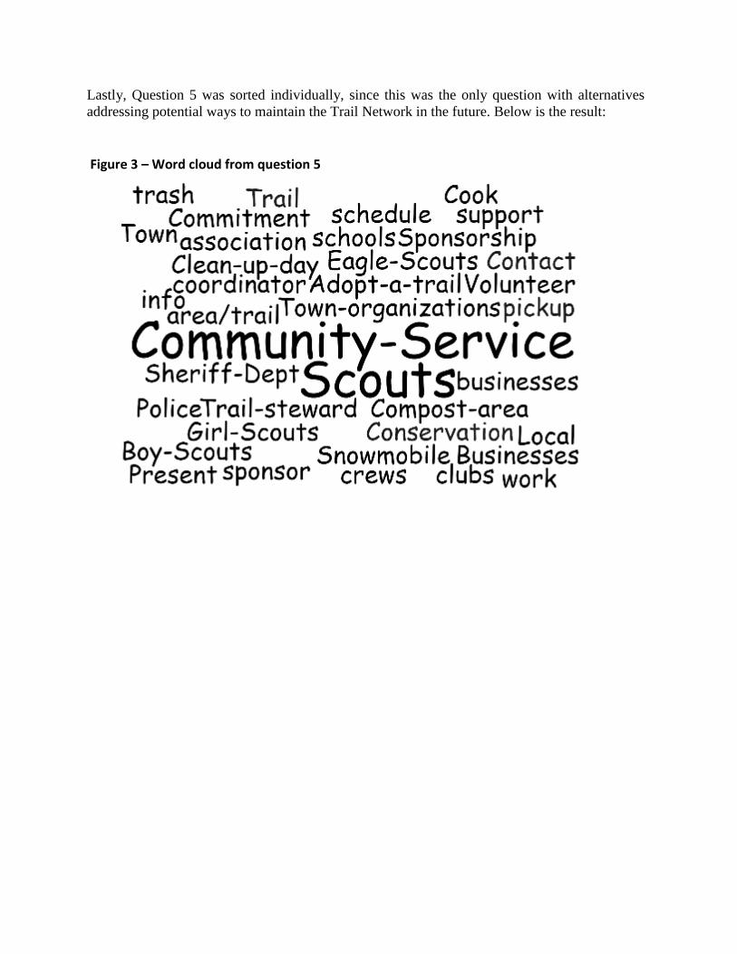
Lastly, Question 5 was sorted individually, since this was the only question with alternatives
addressing potential ways to maintain the Trail Network in the future. Below is the result:
Figure 3 – Word cloud from question 5


