Embed Size (px)
Citation preview
Unit 2, Activity 1: Exploring Terrain
Landscape Images Explained
Illinois Mathematics and Science Academy® S 4

1
The Deadvlei, often referred to as the “Dead Marsh” is located in Namibia. This stretch of land includes large, red sand dunes similar to those on Mars. Over 900 years ago, the land in this area became so dry that the trees were
unable to decompose.
Source: https://www.flickr.com/photos/fotos_medem/34079985777
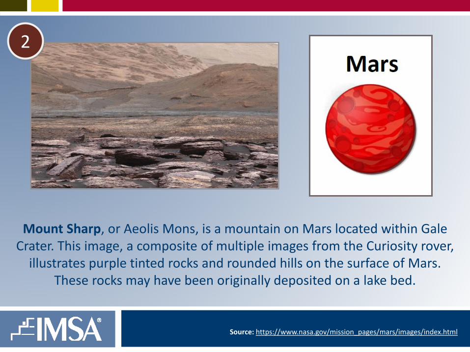
Mount Sharp, or Aeolis Mons, is a mountain on Mars located within Gale Crater. This image, a composite of multiple images from the Curiosity rover,
illustrates purple tinted rocks and rounded hills on the surface of Mars. These rocks may have been originally deposited on a lake bed.
Source: https://www.nasa.gov/mission_pages/mars/images/index.html
2

Marble Canyon, a section of the Colorado River canyon in northern Arizona, marks the beginning of the Grand Canyon. These beautiful rock deposits are
made of sand deposits that have calcified vertically and horizontally over time. This canyon provide scientists a geological snapshot in time.
Source: http://www.atlasobscura.com/places/wave-rock
3

4
The Haughton Impact Crater is located in northern Canada. One of Earth’s northernmost impact craters, this permafrost-covered location serves as one of the most popular sites for Mars space exploration. Currently, the
Mars Institute and Mars Society are using this site to simulate missions and conduct emergency scenarios for the crew.
Source: http://www.atlasobscura.com/places/haughton-impact-crater
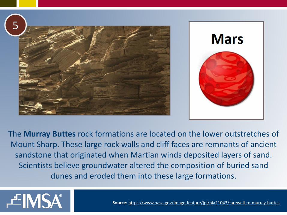
The Murray Buttes rock formations are located on the lower outstretches of Mount Sharp. These large rock walls and cliff faces are remnants of ancient
sandstone that originated when Martian winds deposited layers of sand. Scientists believe groundwater altered the composition of buried sand
dunes and eroded them into these large formations.
Source: https://www.nasa.gov/image-feature/jpl/pia21043/farewell-to-murray-buttes
5
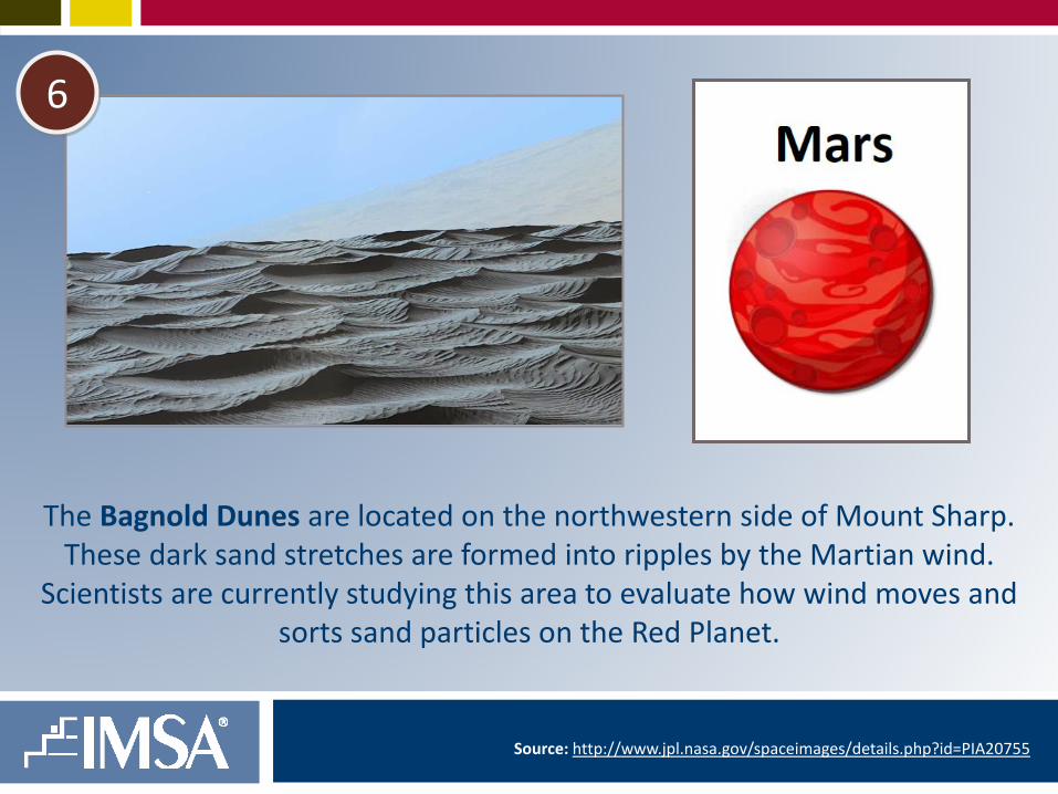
The Bagnold Dunes are located on the northwestern side of Mount Sharp. These dark sand stretches are formed into ripples by the Martian wind.
Scientists are currently studying this area to evaluate how wind moves and sorts sand particles on the Red Planet.
Source: http://www.jpl.nasa.gov/spaceimages/details.php?id=PIA20755
6

The Gale Crater formed approximately 3.5 billion years ago when a large meteor hit Mars. Covered in sand, pebbles and larger rocks, this area also
contains minerals that are byproducts of water. On August 5, 2012 the Mars Science Laboratory rover, Curiosity, landed on a mountain inside of this crater.
Source: http://mars.nasa.gov/multimedia/images/?ImageID=7812&s=2
7
8
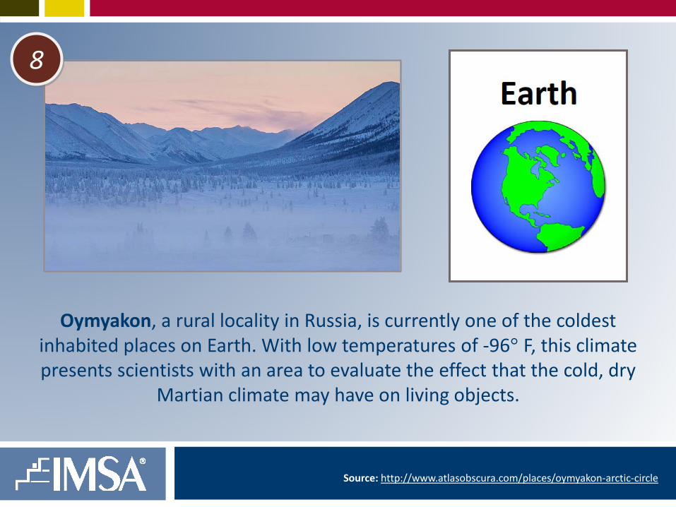
Oymyakon, a rural locality in Russia, is currently one of the coldest inhabited places on Earth. With low temperatures of -96° F, this climate presents scientists with an area to evaluate the effect that the cold, dry
Martian climate may have on living objects.
Source: http://www.atlasobscura.com/places/oymyakon-arctic-circle

9
Ellesmere Island, located in Canada, is recorded as the tenth largest landmass on earth. Similar to the poles on Mars, large portions of this land are covered in ice. In 2006, NASA engineers ventured to this location to test
boring holes into the polar caps in search of subsurface water.
Source: https://www.britannica.com/place/Ellesmere-Island

The Planum Boreum is the frozen plain that extends over the Martian North Pole. Home to an ice cap several miles thick, the water ice and dust contained
in this area illustrate how the Martian climate has changed over time.
Source: http://astronomynow.com/wp-content/uploads/2016/05/Mars_north_pole_1280x960.jpg
10

This impact crater, located in the Sirenum Foassae region, was recently created when a meteor collided with Mars. Containing a sharp rim with steep inner slopes and gullies, the dark-toned streaks that descend the slopes may
indicate the appearance and disappearance of water.
Source: https://www.nasa.gov/mission_pages/mars/images/index.html
11

12
Death Valley, located in California, is considered to be the lowest, hottest and driest site in North America. With temperatures rising to 134° F, this barren
climate doesn’t accurately resemble the average climate on Mars, but contains sand and rock that can be used to study microbial life. This location also served
as the testing site of NASA’s Curiosity rover prior to its journey to Mars.
Source: https://www.britannica.com/place/Death-Valley

13
The terrain in Krafla, Iceland consists of volcanic craters, thermal plumes and ashen lava fields. This site will serve as the European Mars Analog
Research Station (Euro-MARS), where scientists will observe living conditions in a Mars-like environment.
Source: http://www.atlasobscura.com/places/krafla

14
The Nili Patera is located within the Syrtis Major Planum on Mars. This caldera is a large depression caused by the collapse of land once a volcano
erupts and it’s magma chamber has emptied. This image shows a dark, rippled sand dune overlying bright-toned rock. The basaltic sand found on
Mars is similar to that found in Hawaii.
Source: https://www.nasa.gov/content/active-dune-field-on-mars

15
Cape Verde, a noted landmark on the outer walls of the Victoria Crater, displays the rocky cliffs, sand, and layers of rock that cover the Martian surface. This false-color image was taken by NASA’s Opportunity rover.
Through to have been an ancient sand dune field, this landform is teaching scientists about how rocks in this area have been modified over time.
Source: https://www.nasa.gov/multimedia/imagegallery/image_feature_961.html
16
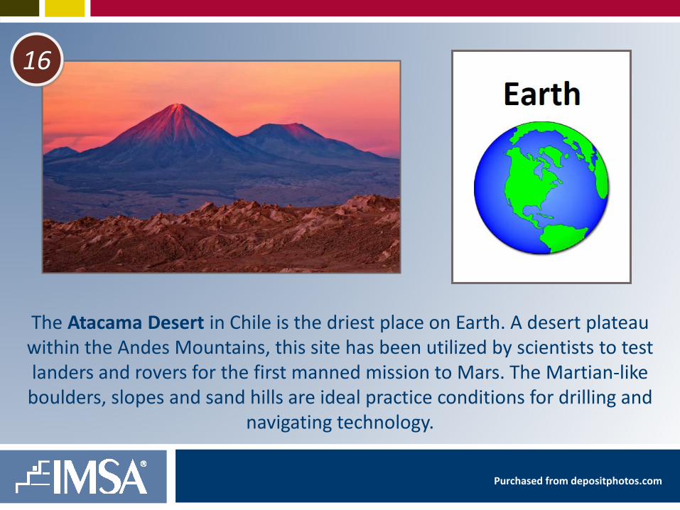
The Atacama Desert in Chile is the driest place on Earth. A desert plateau within the Andes Mountains, this site has been utilized by scientists to test landers and rovers for the first manned mission to Mars. The Martian-like boulders, slopes and sand hills are ideal practice conditions for drilling and
navigating technology.
Purchased from depositphotos.com
17
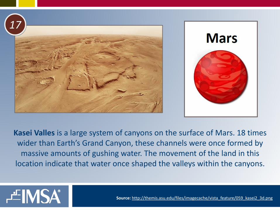
Kasei Valles is a large system of canyons on the surface of Mars. 18 times wider than Earth’s Grand Canyon, these channels were once formed by massive amounts of gushing water. The movement of the land in this
location indicate that water once shaped the valleys within the canyons.
Source: http://themis.asu.edu/files/imagecache/vista_feature/059_kasei2_3d.png

18
Marathon Valley, situated on the western rim of Endeavour Crater, consists of sweeping plains, small craters and red sand. Scientists believe the plains
on Mars once served as either the location of volcanic flows or site of abundant quantities of water, such as an ocean.
Source: https://www.nasa.gov/sites/default/files/thumbnails/image/pia19151.jpg

19
The McMurdo Dry Valleys in Antarctica served as the location of NASA’s 2009 IceBite Project. A frozen desert covered in thick layers of permafrost, this Martian-like location was used by researchers to test ice-penetrating drills to simulate the process that would be used to search for water on
Mars’ North Pole.
Source: https://commons.wikimedia.org/wiki/File:Landsat7_dry_valley_lrg.jpg

20
Ascension Island, located in Saint Helena, was once known for it’s Mars-like dry climate and lack of fresh water. Deemed inhabitable, scientist Joseph Dalton
Hooker once shipped trees to this site in hope that they would capture rain and therefore make the soil more fertile. It worked. Mars researchers are now studying
this artificial ecosystem in their plan to terraform and colonize the Red Planet.
Source: https://upload.wikimedia.org/wikipedia/commons/9/93/Ascension_Island_Lava_fields.jpg