Embed Size (px)
Citation preview
Maddington Enquiry-by-Design Workshop
Outcomes Report
28 - 30 July 2004City of Gosnells, WA

This outcomes report is Number 12 in a series of papers which test or supplement the Western Australian Planning Commission's Liveable Neighbourhoods trial policy. The papers are:
Working Paper No. 1: Karratha Enquiry-by-Design workshop May 1999Working Paper No. 2: Kalgoorlie-Boulder Enquiry-by-Design workshop March 2000Working Paper No. 3: Esperance Enquiry-by-Design workshop June 2000Working Paper No. 4: Armadale Enquiry-by-Design workshop May 2000Working Paper No. 5: Mirrabooka Enquiry-by-Design workshop January 2001Working Paper No. 6: Claremont Enquiry-by-Design workshop March 2001Working Paper No. 7: Two Rocks Enquiry-by-Design workshop December2001Working Paper No. 8: Bassendean Enquiry-by-Design workshop May 2002Working Paper No. 9: Butler-Brighton Enquiry-by-Design workshop July 2002Working Paper No. 10: Kelmscott Enquiry-by-Design workshop June 2003Working Paper N0 11: Coolbellup Enquiry-by-Design workshop September 2003
This outcomes report should be read in conjunction with the Maddington Enquiry-by-Design Briefing Report dated July 2003.
This outcomes report and the associated briefing report are available for viewing on the internet at:
http://www.wapc.wa.gov.auhttp://www.gosnells.wa.gov.au
Papers may be viewed at the Department for Planning and Infrastructure’s head office library at:Albert Facey House469 Wellington Street, Perth, WA 6000Phone: (08) 9264 7777, Fax: (08) 9264 7566Email: address, Internet: address, TTY: (08) 9264 7535, Infoline: 1800 626 477
Enquiries regarding this outcomes report should be directed to:
Ms Jennifer Pidgeon, City of GosnellsPhone: (08) 9411 2444, email: [email protected], or
Revitalisation and Urban Design Projects Directorate at the Department for Planning and Infrastructure.
Disclaimer: This working paper summarises the outcomes of an Enquiry-by-Design workshop undertaken to test the applicability of the Liveable Neighbourhoods trial policy in the context of an existing urban area and to investigate characteristics of traditionally planned mixed use town centres. Any representation, statement, opinion or advice expressed or implied in this publication is made in this light and on the basis that the Government, its employees and agents are not liable for any damage or loss whatsoever that may occur as a result of action taken or not taken (as the case may be) in respect of any representation, statement, opinion or advice referred to herein.
Copyright: State of Western AustraliaPublished by the Western Australian Planning CommissionAlbert Facey House, 469 Wellington Street, Perth, WA, 6000
Published: September 2004
ISBN:
2

Contents
1. Executive summary 42. Introduction 73. Initial consultation and briefings 84. Key issues and challenges 95. Urban design principles 106. Regional role 117. Workshop outcomes 12
7.1 Town centre structure scenarios 137.2 Precinct details 167.3 The railway station 197.4 The road network 217.5 Landscape and built form character 227.6 Accommodating density 257.7 Community needs 277.8 A reality check 28
8. Implementation 29
Appendix – List of attendees 41Appendix – Glossary 42
Page
3

1. Executive summaryThe Maddington Enquiry-by-Design workshop was an opportunity to explore the revitalisation of the Maddington regional centre to improve its performance and appearance, to allow it to better function as the heart of the Maddington community, and deliver a better worker and residential catchment for the Maddington railway station. The workshop was a non-bindingevent that allowed a range of suggestions to be freely canvassed and tested.
The workshop process incorporated community consultation through the participation of a broad range of community and stakeholder representatives who provided feedback at the workshop presentation sessions.
The workshop was also an opportunity to apply the principles of best-practice sustainable urban design - to encourage ideas about how to allow Maddington to better adapt to the changes it may face in future years.
Outcomes from the workshop included:
• A better understanding of Maddington’s role as a regional centre in the context of the ‘network city’ plan promoted by the WAPC.
• Options for upgrading the Maddington railway station to become an integrated transport interchange.
• Extension of Blackburn Road to the railway station to create a direct link from the shopping centre to the station.
• A new town square on Attfield Street to provide an identifiable community space in the heart of Maddington.
• A new pedestrian bridge across the River Canning to encourage patronage of the town centre by the students at the TAFE on the southern side of the river.
• A recommendation to use traffic signals, rather than roundabouts, to allow a greater choice of movement, and to create a safer pedestrian environment.
• Consolidation of the Albany Highway commercial strip.
• Redevelopment of the City of Gosnells depot site and adjacent land for a mixed-use and high quality commercial precinct next to the station
• Intensification of the residential areas within walking distance of the railway station.
• Intensification of commercial and residential uses in the town centre area around the existing shopping centre.
4

Executive summary• Recommendations to guide future growth of the shopping centre to ensure better integration of the shopping centre with the surrounding
area.
• Extensions of Burslem Drive, Blackburn Road, Herbert Street, and Orr Street to create a more comprehensive and permeable framework for the town centre.
• Introduction of a median to Albany Highway to help ‘tame the beast’.
• Recommendations for a more responsive subdivision of the Maddington Homestead land to establish higher levels of pedestrian amenity between the Maddington town centre and the Canning River.
• Improved access to the Canning River parkland.
• Suggestions on how to achieve a better and more land efficient interface between residential and industrial development.
• Landscape and built form themes to ensure that future development and public works help to strengthen Maddington's sense of place.
• A demonstration of how higher density residential development can compliment, rather than diminish, the local character.
• Identification of a need for better public places that can contribute to more engagement within the community.
• Preliminary testing of the key potential projects to see whether they are realistic from a financial and marketing perspective.
Additionally, the workshop explored implementation issues such as:• What happens next after the Enquiry-by-Design workshop.
• The need for an implementation plan.
• What are the roles and responsibilities of the key stakeholders.
• What are the key projects and who is responsible for implementation.
• The timing and priority of projects.
• Implications for the statutory planning process.
5

Executive summaryN
Consolidated workshop outcomes plan
Key opportunities1. Improvements to the railway station to deliver better transit
integration2. Extension of Blackburn Road from the shopping centre to the
railway station3. Intensification of commercial uses on Albany Highway4. Creation of a new town square5. Consolidation of the shopping centre in a way that promotes
better pedestrian connections to the surrounding areas6. Streetscape enhancements7. An appropriate development interface with the Canning River 8. Improved pedestrian connection to unite the TAFE and the
Maddington town centre9. Consolidation of residential development in areas within
walking distance of the railway station10. Redevelopment of the Council Depot site11. Redevelopment of the southern portion of the industrial area.12. Modifications to intersections to provide greater choice for
local traffic movement and a safer pedestrian environment.
5
7
6
9
4
3
12
8
1110
9
129
Legend
Single residential
Medium density residentialCommunity useRetailCommercialBulky goods retailIndustrialParkSignificant vegetation
6

2. IntroductionWhat is an Enquiry-by-Design workshop?
An Enquiry-by-Design workshop is a non-binding consensus building approach to planning complex projects. Designers, planners, engineers, representatives of regulatory agencies, centre owners and business operators, community members and elected officials are invited to work together to establish principles and draw plans as part of an investigative process as to how future development may occur in a given place.
An Enquiry-by-Design workshop provides an interactive forum to discuss and debate ideas. It offers the unique advantage of a ‘live' environment, which provides immediate feedback to a ‘Technical Group’ of planners and designers from a Consultation Group consisting of key stakeholders (see Appendix – List of attendees). This increases the awareness and understanding of the issues and potential solutions by all parties and creates a greater sense of ownership of the outcomes and the process.
The Maddington Enquiry-by-Design workshop was held at 70 Attfield Street in Maddington and was sponsored by:
• The Western Australian Planning Commission/Department for Planning and Infrastructure• The City of Gosnells• Public Transport Authority• Landcorp
Day Time Program
Day 1Wednesday 28 July 2004
10.00am -1.00pm1.00pm – 5.00pm
Workshop Technical Group site tour and briefingIntroduction and briefing presentations
Day 2Thursday 29 July 2004
9.00am – 5.00pm5.00pm – 7.00pm
Workshop Technical Group design sessionsInterim design review
Day 3 Friday 30 July 2004
9.00am – 5.00pm5.00pm – 7.00pm
Workshop Technical Group design sessionsFinal design review
Workshop program
Note: Bold type indicates sessions attended by both the Technical Group and the Consultation Group.
7

3. Initial consultation and briefingsWorkshop briefings
At the start of the Maddington Enquiry-by-Design workshop, a series of briefing presentations provided background information to the participants. The briefings included:
No Briefing topic Presenter
1 Principles of Sustainable Urban Design, and Planning Principles for Activity Centres David Patman, DPI
2 Planning Principles for Transit Oriented Development Marion Thompson, DPI
3 The Maddington Kenwick Sustainable Communities Partnership Brian Curtis, DPI
4 Regional and Local Planning Context (Statutory/Policy Planning) Ray Haeren/Simon Wilkes, City of Gosnells
5 Transport Planning Overview and Issues, including Public Transport and non-motorised modes
Barrow Emerson, Sinclair Knight Merz
6 Operational Requirements and Design Principles for the Redeveloped Rail Station Michael Leach. PTA
7 Demographics and Economic Development John Syme, Syme Marmion
8 Social and Community Development Issues Jennifer Pidgeon, City of Gosnells
9 Active Projects in Maddington Kenwick Jennifer Pidgeon, City of Gosnells
Briefing reportWhere available prior to the workshop, the briefings were compiled into a Briefing Report that provided workshop participants with background information about Maddington, its context and the emerging issues.
8

4. Key issues and challengesKey issues
Analysis undertaken during and prior to the Maddington Enquiry-by-Design workshop (on-site observation, statistical review and community feedback) identified a number of key issues in regard to the Maddington town centre. These included:
Social issues:• Can the PTA’s “Building Better Stations” upgrade of the Maddington railway station better perform a role as an integrated transit
interchange and catalyse a revitalisation of the broader Maddington town centre precinct?
• How can the revitalisation of the Maddington town centre and station precinct best meet the needs, aspirations and self-image of the local community?
• Can Maddington better perform its designated role as a regional activity centre in the context of the ‘Network City’ concept?
• How can the social values and the sense of community ownership of the Canning River be improved?
Environmental issues:• How can the Maddington railway station be better integrated with the other elements within the Maddington town centre precinct such
as the commercial, retail, TAFE, recreational, residential, and industrial land?
• How can the demands of a range of transport modes (trains, buses, cars, cycles and pedestrians) and transport needs (regional and local movements) be balanced in the Maddington town centre?
• How can the Maddington town centre be improved to provide a stronger sense of safety and personal security?
• What is the best interface between the industrial uses and the potential redevelopment areas to attract new higher-density residential development (to improve patronage public transport and local services)?
Economic issues:• How can incremental change of land use be managed to minimise land use conflicts and maintain an attractive investment climate?
• What sort of development is required to best increase public transport patronage, and which is realistically achievable?
• What implementation mechanisms (such as structure planning, rezoning, funding sources, and project management) are required to encourage or allow redevelopment to occur?
• What partnerships and agreements need to be forged within Government to ensure a more integrated approach to the delivery of urban revitalisation?
9

5. Urban design principlesUrban design principles
The Maddington Enquiry-by-Design workshop was undertaken with a set of clearly-defined best-practice urban design principles to guide the participants whilst they were designing, drawing and debating scenarios. These principles include:
Sustainability: Ensuring that places can be supported in terms of community, economic, and environmental outcomes.
Permeability: Making places accessible by providing people with choices on how to get where they want and need to go.
Variety: Increasing the choice of activities (living, working, shopping, learning, and playing) for people to do in any given place.
Legibility: Creating places that are understandable.
Robustness: Ensuring that places can change their uses over time.
Appropriateness: Creating buildings that look as if they do what they are expected to do, and are compatible with their surroundings.
Richness: Providing sufficient detail to make places more interesting.
Personalisation: Allowing people to feel as if they belong to their urban environment.
Consultation: Allowing the people who use and have responsibility for a place, to have a say in how that place is designed.
Integration: Ensuring that all the components of a place work together as a whole.
10

6. Regional role Regional analysis
Although Maddington is classified as a regional centre, anecdotal evidence suggests that it remains something of a secret beyond its immediate catchment. The development of the ‘network city’concept for the planning of the Perth metropolitan region creates an opportunity for Maddington to strengthen its role as more regionally significant centre of activity for more people.
The ‘network city’ creates a structure for the metropolitan region based on mobility corridors and activity corridors. Mobility corridors include freeways and limited access highways that allow rapid and unfettered vehicle movement. Activity corridors, on the other hand, use urban arterial roads to connect activity centres; provide a route for direct higher-frequency public transport services to connect those centres; and provide a context for higher densities of development to allow more people to live and work close to the centres and public transport.
In the ‘network city’, Maddington lies close to two mobility corridors but, more importantly, it lies strategically at the meeting point of two activity corridors – one based on Albany Highway and the other based on Warton Road/Olga Road/Kelvin Road.
15
7
6
9
43
2
8
86
77
81
2
N
Olga R
d
Warton Rd
Kelvin
Rd
Roe Highway
Tonkin Highway
Albany Highway
Key elements of Maddington’s regional significance1. Albany Highway activity corridor2. Warton/Olga/Kelvin/Road activity corridor3. Roe Highway mobility corridor 4. Tonkin Highway mobility corridor5. Maddington town centre6. Local and district activity centres along the activity corridors7. Significant commercial and employment areas within the activity corridors8. Significant recreational destinations along the activity corridors9. Tertiary education facilities within the activity corridors
Regional context plan with activity corridors
11

7. Workshop outcomes Workshop outcomes
During the workshop, the participants developed a range of ideas for the revitalisation of the Maddington town centre and station precinct. Many of these ideas are summarised on the plan below, and explained in greater detail in the following sections. Out of the design testing, a clear vision emerged: Maddington should ultimately mature and grow into a more sustainable mixed use town.
Key opportunities1. Improvements to the railway station to deliver better transit integration2. Extension of Blackburn Road from the shopping centre to the railway
station3. Intensification of commercial uses on Albany Highway4. Creation of a new town square5. Consolidation of the shopping centre in a way that promotes better
pedestrian connections to the surrounding areas6. Streetscape enhancements7. An appropriate development interface with the Canning River 8. Improved pedestrian connection to unite the TAFE and the Maddington
town centre9. Consolidation of residential development in areas within walking
distance of the railway station10. Redevelopment of the Council Depot site11. Redevelopment of the southern portion of the industrial area.12. Modifications to intersections to provide greater choice for local traffic
movement and a safer pedestrian environment.
N
Consolidated workshop outcomes plan
5
7
69
4
3
12
8
1110
9
129
Legend
Single residential
Medium density residentialCommunity useRetailCommercialBulky goods retailIndustrialParkSignificant vegetation
12
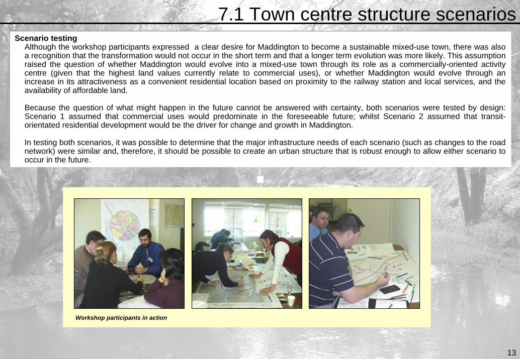
7.1 Town centre structure scenarios Scenario testing
Although the workshop participants expressed a clear desire for Maddington to become a sustainable mixed-use town, there was also a recognition that the transformation would not occur in the short term and that a longer term evolution was more likely. This assumption raised the question of whether Maddington would evolve into a mixed-use town through its role as a commercially-oriented activity centre (given that the highest land values currently relate to commercial uses), or whether Maddington would evolve through an increase in its attractiveness as a convenient residential location based on proximity to the railway station and local services, and the availability of affordable land.
Because the question of what might happen in the future cannot be answered with certainty, both scenarios were tested by design:Scenario 1 assumed that commercial uses would predominate in the foreseeable future; whilst Scenario 2 assumed that transit-orientated residential development would be the driver for change and growth in Maddington.
In testing both scenarios, it was possible to determine that the major infrastructure needs of each scenario (such as changes to the road network) were similar and, therefore, it should be possible to create an urban structure that is robust enough to allow either scenario to occur in the future.
Workshop participants in action
13
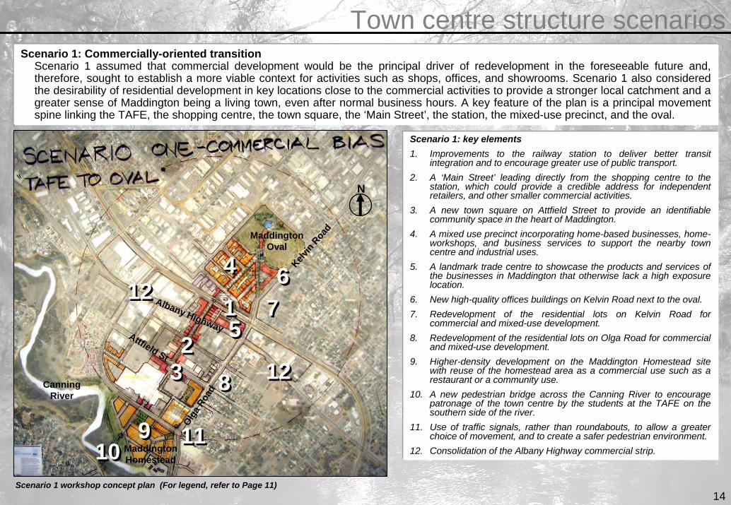
Town centre structure scenarios Scenario 1: Commercially-oriented transition
Scenario 1 assumed that commercial development would be the principal driver of redevelopment in the foreseeable future and, therefore, sought to establish a more viable context for activities such as shops, offices, and showrooms. Scenario 1 also considered the desirability of residential development in key locations close to the commercial activities to provide a stronger local catchment and a greater sense of Maddington being a living town, even after normal business hours. A key feature of the plan is a principal movement spine linking the TAFE, the shopping centre, the town square, the ‘Main Street’, the station, the mixed-use precinct, and the oval.
99
88
7766
1111
22
44
55
1010
11
33
1212
1212
Scenario 1: key elements1. Improvements to the railway station to deliver better transit
integration and to encourage greater use of public transport.2. A ‘Main Street’ leading directly from the shopping centre to the
station, which could provide a credible address for independent retailers, and other smaller commercial activities.
3. A new town square on Attfield Street to provide an identifiable community space in the heart of Maddington.
4. A mixed use precinct incorporating home-based businesses, home-workshops, and business services to support the nearby town centre and industrial uses.
5. A landmark trade centre to showcase the products and services ofthe businesses in Maddington that otherwise lack a high exposurelocation.
6. New high-quality offices buildings on Kelvin Road next to the oval. 7. Redevelopment of the residential lots on Kelvin Road for
commercial and mixed-use development. 8. Redevelopment of the residential lots on Olga Road for commercial
and mixed-use development.9. Higher-density development on the Maddington Homestead site
with reuse of the homestead area as a commercial use such as a restaurant or a community use.
10. A new pedestrian bridge across the Canning River to encourage patronage of the town centre by the students at the TAFE on the southern side of the river.
11. Use of traffic signals, rather than roundabouts, to allow a greater choice of movement, and to create a safer pedestrian environment.
12. Consolidation of the Albany Highway commercial strip.
N
Attfield St
Kelvin
Road
Olga R
oad
Maddington Homestead
Maddington Oval
Albany Highway
Canning River
Scenario 1 workshop concept plan (For legend, refer to Page 11)14

Town centre structure scenarios Scenario 2: Transit-oriented residential transition
Scenario 1 assumed that residential development would drive redevelopment of the Maddington town centre and station precinct. The Scenario 1 plan sought to either create or identify areas where redevelopment for residential uses, at a higher than average density, would be more likely to occur, for example: close to key destinations such as the railway station and the shopping centre; close to areas of high amenity such as the Canning River; or in areas with large lots that could readily support redevelopment.
Scenario 2: key elements1. Improvements to the railway station to deliver better transit integration.2. Redevelopment of the industrial land adjacent to the railway station for small-
lot medium density residential development.3. Redevelopment of some of the industrial land for home workshop development
to create a transitional use between the industrial area and a new residential area next to the station.
4. Higher-density development on the Homestead site. 5. A new pedestrian bridge across the Canning River to enable a stronger
relationship between the TAFE and potential student accommodation within the town centre.
6. A ‘Main Street’ leading directly to the station to provide a more direct pedestrian route to the railway station for town centre residents.
7. Redevelopment of the single storey commercial uses in the town centre for 3-4 storey mixed use development with apartments above ground floor commercial uses.
8. Incremental redevelopment of the residential lots to the east of Kelvin Road and Olga Road for medium density residential development.
9. Use of traffic signals, rather than roundabouts, to allow a greater choice of movement, and to create a safer pedestrian environment.
99
88
7766
22
4455
11
33
88
N
Attfield St
Kelvin R
oad
Olga R
oad
Maddington Homestead
Maddington Oval
Albany Highway
Canning River
Scenario 2 workshop concept plan (For legend, refer to Page 11)

7.2 Precinct details Shopping centre precinct
The shopping centre currently has a poor relationship with the surrounding town centre area because most of the shopping activities are hidden within the building, whilst the centre is surrounded by a moat of car-parking that discourages walking between the centre and the surrounding area. If Maddington is to mature into a mixed-use town it is essential that the shopping centre grows to a pattern that creates better opportunities for integration of the centre with the broader town centre. The workshop explored how this might occur.
Shopping centre precinct: key elements for better integration1. Relocation of Woolworths to the western end of the centre to better
balance the centre, including the addition of highly attractive shaded parking at either roof or basement level.
2. Conversion of Woolworths into a smaller supermarket (or mini major) and specialty shops on a new mall with an entrance addressing the Olga Road business precinct.
3. Integration of the Olga Road Business precinct with a rationalisation of the car-parking into a landscaped parking boulevard to provide a new address to the centre, and a more credible business presence for the tenants of the Olga Road business precinct.
4. Boulevard landscape treatment of Attfield Street.5. New stand-alone commercial buildings on Attfield Street to sleeve-in the
blank walls of the centre, and reduce the visual blight of the car-parking.6. Creation of a new town square opposite the Attfield Road/Blackburn
Road intersection, which announces the route to the centre’s front door.7. Future commercial or mixed-use development at the corner of Attfield
Street and Olga Street.8. Potential to create a new pedestrian link from the new Olga Street entry
to Dellavanzo Street through redevelopment to a higher density of two lots on Olga Street.
9. Creation of a new external plaza at the Burslem Drive entry to create an attractive entry experience and to provide an additional context for tenancies to trade after normal business hours.
10. Establishment or reinforcement of key axes to set up a legible framework for the future growth of the town centre as a whole.
9977
66
22
44
5511
33
88
1010 1010
1010
1010
1010
N
Attfield St
Kelv
in R
oad
Olga R
oad
Maddington Homestead
Albany Highway
Canning River
Railway Station
Blac
kbur
n Ro
ad
Burslem Drive
DellavanzoStreet
Workshop concept plan for improving the shopping centre/town centre interface (For legend, refer to Page 11) 16

Precinct detailsThe homestead precinct
It was recognised during the workshop that appropriate development of the Maddington Homestead site could make an early contribution to achieving early revitalisation outcomes in the Maddington town centre area. A good development outcome would not only deliver more high quality housing choice, but could also help to deliver the workshop objectives. Therefore, the plan below was produced during the workshop to identify and illustrate how the subdivision and development of the land would best protect the broader workshop objectives of turning the Maddington central area into a robust, vibrant and attractive mixed-use town centre.
Maddington Homestead site: key elements1. Cottage lots with rear lane vehicle access to
ensure a more pedestrian friendly environment on Olga Road and Burslem Drive.
2. Local park with a retained portion of the orchard to create an attractive and historically relevant entry to the development.
3. Frontage road to the Canning River parkland to create a sense of public ‘ownership’ of the parkland and to provide the opportunity for passive surveillance.
4. Key movement spine from the Maddington oval to the TAFE.
5. New pedestrian bridge across the river.6. Maddington Homestead.
6
2
4
5
1
3
11 N
Olga Road
Maddington HomesteadCanning
River
Burslem Drive
Workshop concept plan for the Maddington Homestead site (For legend, refer to Page 11)17

Precinct detailsThe residential/ industrial interface
One of the key impediments to achieving residential intensification close to the Maddington railway station is the proximity of the industrial area. The conventional approach of using landscape buffers as an interface is space consumptive and doesn’t necessarily achieve visual separation or effective noise reduction. However, there is an opportunity for a more urban interface by using home workshops.
The home workshop is a development type with a longer than average lot that accommodates a house at one end and a workshop at the other end – suitable for a sole trader or small business operator. Home workshop lots placed in the transition area between residential and industrial areas allow the end of the lot with the house to address a residential street, whilst the end of the lot with the workshop can face the street in the industrial area and trade with a credible business address.
Diagrammatic section of a home-workshop as an industrial/residential transition18

7.3 The railway station The station
A key driver of the Enquiry-by-Design workshop is the desire to achieve a more effective, attractive, and integrated transit interchange at the Maddington railway station. An improved railway station is more likely to increase patronage of both the railway and bus network because of the improved convenience and the greater perception of safety.
Furthermore, as has been demonstrated at Armadale and Bassendean, significant investment by the State Government in local public infrastructure such as the railway stations has led to a new-found confidence in the private sector to reinvest in the future of those places.
The Public Transport Authority has budgeted for an upgrade of the station in the next financial year.
The potential to improve the railway station precinct was investigated in a holistic manner during the Enquiry-by-Design workshop. A large group of participants simultaneously looked at the potential improvements to the road network, the railway and bus operational requirements, and the potential to catalyse redevelopment of the surrounding land uses in the future.
Key findings of the group included:
• A preference for the bus stands to be located on the western side of the railway station, whether as part of a road loop or a ‘dogbone’ bus interchange.
• The potential to trade off The Strand reserve in exchange for a widening of the Sampson Street reserve adjacent to the station.
• Relocation of the station entrance to the Blackburn Road end of the platform.
• Alternative park and ride locations to the east of the station and along the northern extension of Sampson Street.
• The potential to improve the station precinct with the purchase of adjacent land. Original workshop concepts
Road loop bus interchange on the western side of the station
‘Dogbone’ bus interchange
N
N
Albany Highway
Bus dogbone
Railway station
Bla
ckbu
rn R
oad
Albany Highway
Railway station
Bla
ckbu
rn R
oad
Sampson Street
Kelvin R
oad
Kelvin Road
19

The railway station The railway station
Immediately after the Enquiry-by-Design workshop the presented concepts were further refined to create a more workable transit interchange and to address some of the issues that were raised during the community feedback session. These comments included the need to achieve better integration of the City of Gosnells depot site and the railway station, and the ability to have a fall back position if the Blackburn Road extension could not be achieved in the near future. The revised station concepts are illustrated below.
1. Dogbone bus interchange2. Park and ride area accessed by extending Pratt Court to Kelvin Road3. Land exchange – The Strand reserve for a widening of part of Sampson Street4. Redevelopment of the City of Gosnells depot site5. Development frontage to Kelvin Road
1. Bus interchange incorporated into the Park and ride area, and accessed by extending Pratt Court to Kelvin Road
2. Retention of The Strand as a pedestrian access route to the railway station3. Redevelopment of the City of Gosnells depot site4. Development frontage to Kelvin Road
Railway station scenario B Railway station scenario A
N N
24
53
1 13
42
Redevelopment of the Council depot site
Redevelopment of the Council depot site
20

7.4 The road network The road network
The current road network constrains the ability of the Maddington town centre to mature as a mixed-use town centre because of low levels of permeability, and a limited ability to make turning movements. The Enquiry-by-Design workshop identified a range of potential improvements to the road network in the town centre, including the insertion of new streets and improvements to key intersections, which are illustrated below.
Improvements to the road network: key elements1. Extension of Blackburn Street to the east of Albany Highway with
a signalised intersection on Albany Highway.2. Extension of Burslem Drive to the east of Albany Highway, with a
signalised intersection on Albany Highway, to create a ring road in conjunction with the portion of Sampson Street that runs parallel to the railway reserve.
3. Introduction of a median to Albany Highway to facilitate safer crossing for pedestrians and right-turns for vehicles, and to create a setting for landscape improvements.
4. Signalised intersections on Olga Street at Burslem Drive and Attfield Street to allow safer pedestrian movement to the town centre.
5. Removal of The Strand as a trade-off for a widening of Sampson Street to the west of the station.
6. Reconnection of the two portions of Sampson Street.7. Extension of Herbert Street to Albany Highway.8. Extension of Orr Street to Herbert Street.9. Boulevard treatment to Blackburn Street.10. Avoidance of roundabouts within the town centre to provide
greater pedestrian safety.
N
Attfield StK
elvin Road
Olga R
oad
Albany Highway Railway Station
Blac
kbur
n Ro
ad
Burs
lem D
rive
Orr StreetHerb
ert S
treet
Sampson Street
The
Stra
nd
Road network plan 21

7.5 Landscape and built form character Landscape influences
Analysis undertaken at the workshop identified a number of existing landscape attributes that contribute towards a unique and identifiable character to Maddington. The landscape influences included the Canning River and its riparian vegetation, open meadows, orchards, Eucalypts, and the ubiquitous presence of the hills in the background.
Precedents for planting themes in the public domainRather than importing new landscape themes into Maddington, the opportunity exists to draw inspiration from the existing landscape. This could be achieved by:
1. Introducing Eucalyptus trees along new and existing streets to create elegant avenues.
2. Use of vines for screen planting and shade structures in parkland.
3. Conversion of drainage lines into living streams to introduce linear natural landscapes into the urban environment and help improve the quality of water entering the Canning River.
Landscape theme precedents
22

Landscape and built form character Landscape themes
It was recognised from the landscape analysis that the vision for Maddington was not just about land use and buildings. If Maddington is to mature as a recognisable place, then any redevelopment needs to be complimented by appropriate landscape treatments in the public domain, and by better access and a more effective use of the existing natural environment.
Key elements of the landscape themes1. Different indigenous street tree planting themes for the
core town centre area and the surrounding residential areas.
2. Conversion of the drainage lines into living streams to increase local amenity, increase biodiversity, and improve water quality.
3. Median planting along Albany Highway to create a boulevard appearance.
4. Plaza spaces at key locations such as a the entrances to the shopping centre and adjacent to the railway station.
5. Special paving treatment to the principal movement spine and associated areas such as plazas.
6. Improved access paths to the Canning River parkland, including the replacement of the underpass with an at-grade crossing.
7. Car parking at the access points to the Canning River parkland.
8. Retention of parts of the vineyard and orchard as a reminder of the landscape heritage.
9. Enhancement of the oval and training oval.
10. Introduction of pocket parks to accommodate strategic stands of indigenous trees.
9
87
6
2
4
5
101
31
47
6
6 8
N
Scenario 2 workshop concept plan 23

Landscape and built form character Landscape and built form character
Whilst some of Maddington’s sense of place can be derived from the landscape, a significant contribution can come from the built form. With careful attention to the design of new buildings, the character established by the older buildings can be evoked to provide a sense of continuity with the past. The City of Gosnells can provide guidance on the character of new buildings through design guidelines.
Key elements of the landscape themesTraditional Residential• Low scale
• Single residential , often associated with orchards and vineyards
• Prominent use of verandas and pitched roofs
• Eclectic material choice
Recent Residential• Low scale
• Single & grouped dwellings
• Prominent use of verandas & pitched roofs
• Eclectic choice of materials (brick and tile are dominant)
Examples of sketches from design guideline documents to provide owners, builders and developers with direction in achieving local character.
24

7.6 Accommodating density
Why should higher density residential have to look like this?
Accommodating densityHigher residential densities are an essential component of a sustainable city in order to encourage economic vitality, provide more choice in lifestyle for different people, improve the effectiveness of public transport, and to avoid the pitfalls of urban sprawl. There is often considerable community resistance to increased residential densities; this concern, which is entirely understandable, often relates to the poor quality and presentation of many existing high and medium density residential developments.
However, higher residential density needn't be a second rate development type and there are many examples of how a higher residential can be achieved whilst maintaining or enhancing the character of the neighbourhood.
Why can’t higher density residential development look like this?
25

Accommodating density Different forms of higher residential density
Higher residential density can be achieved in different and attractive ways. Some of the development types that might be applicable to Maddington were demonstrated during the workshop, and are illustrated below.
Examples of higher residential development1. The apartment house – a group of three
apartments in a building that looks like a large family house. Depending on the lot size, the apartment house can achieve a residential density of up to 60 dwellings per hectare (R60).
2. The terraced cottage – a narrow frontage terraced house with a garage to a right-of-way at the rear. Depending on the lot size, the terraced cottage can also achieve a residential density of up to 60 dwellings per hectare (R60).
3. Mixed use development - apartments located above ground floor commercial uses to maximise the efficiency of urban land and create places that remain populated at all hours of the day and night.
1. Apartment house
2. Terraced cottages
Combination of terraced cottages and apartment houses with rear lane access
3. Examples of mixed-use buildings
26

7.7 Community needs Community places
Engagement between community members is an integral part of a sustainable urban environment, and leads to a sense of belonging to a community for local residents, and a sense of welcome for visitors. Currently, community interaction happens informally in places that tend to be private or not conducive as meeting places – at home, fast food outlets, the food court, the oval or at the railway station. None of these places, other than perhaps the oval, holds much symbolic significance as a valued place that belongs to the community.
Current meeting places
The Enquiry-by-Design workshop identified a range of alternative places that could allow for a greater interaction between members of the Maddington community and lead to a greater sense of belonging. These alternatives included:
• Making more use of the Maddington Primary School as a community focal point.
• Creating a new town square as a symbolic heart to the town – an outdoor living room for the whole of the community.
• Creating meeting places (outdoor rooms) through the reconfiguration of existing parkland.
• Making greater use of other formal meeting places such as places of worship.
Options for interaction in Maddington
27

7.8 A reality check A reality check
Although a principal aim of the Enquiry-by-Design workshop is to develop a range of potential place-based improvements in a non-binding and interactive arena, it is important to temper the enthusiasm of the participants with a reasoned approach to implementation. An acid test of whether an idea will come to fruition is its ability to be funded. Therefore, some of the key potential projects that emerged during the Maddington Enquiry-by-Design process were briefly tested to see whether there was any prospect of them being achieved from a financial and marketing perspective.
The findings of the initial financial testing are summarised below.
Project 5: DHW and City of Gosnells site on Attfield RoadCouncil 8,453m2 41%Landstart 12,142m2 59%CostsLand Assembly $4.5mSite Preparation $0.5mTOTAL COSTS $5.0mLand SalesCommercial $4.3mResidential 1 $0.9mResidential 2 $3.0mTOTAL REVENUE $8.2mNET $3.2mJV Profit: Council $1.3m
Landstart $1.9m
Project 1: Transit interchange and Blackburn Street extension Land Assembly $9.0mRoad Works $1.5mStation/Bus Interchange $5.0mExtras $0.5mTOTAL COSTS $16.0m
Bus Station Land $4.0mLand Sales $6.0mPTA Budget $3.0mTOTAL REVENUE $13.0mNET ($3.0m)
SummaryAn initial investigation of some of the projects at the workshop indicated that the projects were not unrealistic. In some cases the projects delivered a profit, and in other cases, the cost to Government is of an order of magnitude that could be reasonably expected for the provision of necessary urban infrastructure.
28

8. ImplementationImplementation
The Maddington Enquiry-by-Design workshop considered:
• What happens next after the Enquiry-by-Design workshop.• The need for an implementation plan.• What the roles and responsibilities of the key stakeholders are.• What the key projects are and who is responsible for implementation.• The timing and priority of projects.• Implications for the statutory planning process.
What happens next?The Enquiry-by-Design process is a non-binding process: the outcomes will require further consideration and consensus from stakeholders and the community to reach a set of preferred and negotiated positions. Furthermore, the Enquiry-by-Design process creates expectations that need to be followed up to sustain momentum and support.
Whilst a number of community members were able to participate in the workshop by being a part of the consultation group, it is important that the outcomes are communicated to the wider community in Maddington, and in those other areas that look to the town centre for their shopping and other needs, and that opportunities are provided to review and comment on the outcomes. It is alsoimportant that the town centre proposals are placed within the visioning process now being undertaken for the wider Maddington-Kenwick Partnership project.
All of those involved in the Workshop, including the community members, need to continue to work together to communicate the outcomes to the wider community, and to take the further steps needed to make the vision for Maddington a reality.
Following the Enquiry-by-Design workshop, this outcomes report will be forwarded to participants to provide a record of the workshop proceedings, and to provide the basis for public consultation with the broader community. The diagram on the following page illustrates the anticipated next steps.
2929

ImplementationMaddington town centre enquiry-by- design workshop
Preparation and release of workshop outcomes report
Community consultation process: public displays, meetings, advertising, group forums etc.
Consideration by partners of consultation responses and revision of proposals where required
Preparation and initiation of statutory planning changes required to support town centre proposals, including town centre structure plan
Commence first stage of public domain changes and improvements
Develop draft implementation plan for key town centre projects
28 – 30 JULY 2004
REPORT RELEASE : LATE SEPTEMBER 2004
OCT/ NOV 2004
DEC 2004/ JAN 2005
FEB – JUNE 2005
JULY 2005 ONWARDS
What happens next: Key implementation steps
Community engagementThe community consultation process may include:
• Making the outcomes report widely available through public libraries, the internet, and at other key locations where the community can access it easily.
• Providing the outcomes report directly to key community groups, stakeholders and agencies.
• Displaying the main outcome drawings at key locations, including the Maddington shopping centre, supported by material that summarises and clearly conveys the main workshop issues, objectives and outcomes.
• General invitations to comment through newspaper advertisements, notices, letters and a page dedicated to the project on the Council and Partnership web-sites.
• Open public information and discussion forums.
• Small group discussions on specific proposals and areas of interest and concern.
A broad approach to community engagement provides a greater opportunity to reach a representative cross section of the community, including groups who may find it difficult to participate through conventional ‘formal’ consultation processes.
30

ImplementationAn implementation plan
Because the outcomes of the Maddington Enquiry-by-Design workshop are complex and inter-related, with input required from a broad range of stakeholders, one of the first steps in the post-workshop process is to prepare an implementation plan. The implementation plan should cover the community consultation process; identify roles and responsibilities; determine funding sources; obtain commitments from stakeholders; set priorities; conduct marketing; and creating a workable project management framework
Roles and responsibilitiesImplementing a complex project such as the revitalisation of the Maddington town centre requires the input and cooperation of a wide range of stakeholders. This section identifies the main players and their expected roles in the process of developing and implementing the town centre proposals .
City of Gosnells• Develop and manage, with other partnership members, the post-workshop consultation process.
• Consider public domain workshop outcomes that are within the area of responsibility of the City, to identify capacity for funding of improvement works, and timing/staging of proposals.
• Consider statutory planning issues and implications, and initiate and progress any TPS amendments needed to promote and facilitate key workshop outcomes.
• Consider the outcomes of the consultation process and reflect them in a structure plan for the Maddington town centre.
• Process development applications for proposals that may flow from the workshop outcomes.
• Consider the appointment or nomination of a ‘place manager’ to deal with all Council-related aspects of town centre projects.
Department for Planning and Infrastructure• Work with the City of Gosnells and other partnership members to develop and implement a consultation process for the workshop
outcomes.
• Provide ongoing advice to the City of Gosnells and other partners on the progression and implementation of workshop outcomes.
• Provide advice to the WA Planning Commission and the Minister for Planning and Infrastructure on statutory planning issues and proposed amendments.
31

ImplementationWestern Australian Planning Commission• Receive, consider and adopt a ‘Structure Plan/Centre Plan’ for the Maddington town centre, based upon the workshop outcomes and
associated community consultation.
• Process any town planning scheme amendments arising from the workshop outcomes.
• Initiate and progress complementary Metropolitan Region Scheme Amendments where required.
• Determine land subdivisions/amalgamations and relevant development applications.
Public Transport Authority• Consider the implications of the workshop outcomes for design development of the rail station redevelopment.
• Prepare a station design and make it available for public information and comment.
Main Roads Western Australia• Review pre-workshop Albany Highway and related road designs in the context of the workshop outcomes and revise as necessary.
• Develop a staging program for implementation of Albany Highway works, in consultation with the City of Gosnells and other partnership members as relevant, including detailed cost breakdowns for each stage.
• Work with the City of Gosnells to identify and secure funding sources to implement key road network outcomes.
Landcorp• Continue to work with the City of Gosnells to investigate options for the relocation of existing Council depot functions, including possible
acquisition by Landcorp of the existing depot site.
• Develop a concept plan for the depot site redevelopment, based on TOD principles, in consultation with other partnership members.
• Consider and recommend redevelopment process options for the depot site, e.g. public demonstration project, JV, RFP with guidelines, etc.
• Consider other opportunities for Landcorp involvement in town centre projects, e.g. extension of the depot site project to establish a mixed use ‘buffer’ area.
32

ImplementationDepartment of Housing and Works• Investigate and develop a concept for a JV with the City of Gosnells for mixed use/residential development on existing DHW/City of
Gosnells landholdings in Attfield Street.
• Consider other opportunities for the DHW to participate in town centre development projects, e.g. depot site redevelopment.
Other State Agencies• Coordinated and timely delivery of necessary service modifications and extensions.
Property Owners and Business Operators• Consider the implications of workshop outcomes for own properties and/or business operations.
• Engage with the process and reflect the outcomes in forward planning.
• Integrate own proposals with public infrastructure : timing and staging.
• Cooperate in marketing and promotion initiatives to develop and deliver a coordinated focus on Maddington as a business location.
• Undertake property maintenance and upgrades to support public domain works and improved presentation of the town centre.
The Community• Participate, interact and debate in both the formal consultation process and through informal opportunities.
• Inform the process with local community perspectives, to help ensure equity and inclusiveness of the outcomes.
• Contribute to ongoing design development with ideas, local culture and heritage knowledge, and through opportunities for public/community art.
• Add value to physical outcomes by ongoing participation and community building, in formal and informal groups.
33

ImplementationKey project packages
The principal outcomes from the Maddington Enquiry-by-Design workshop were grouped into ten discreet packages. The extent of the project packages relate to their ability to be implemented with a relative degree of independence and a relatively small group of stakeholders. Breaking the workshop outcomes down in to discreet packages allows a greater degree of freedom to deliver projectssooner where possible.
N
Key project packages1. Railway station redevelopment, bus-rail interchange and Blackburn
Street extension
2. Highway commercial crossroads
3. City of Gosnells depot site
4. Attfield Street
5. Department of Housing and Works/ City of Gosnells site
6. Blackburn Street
7. Albany Highway
8. Industrial ‘buffer’ developments
9. Canning River Valley Park
10. Maddington shopping centre
Key project packages plan 34

ImplementationImplementation framework for the key project packages
The following table provides an overview of the actions required to pursue the workshop outcome project packages, and the stakeholders who are responsible in part for the project delivery.
PROJECT RESPONSIBILITIES ACTIONS
1. Railway station redevelopment: bus-rail interchange, park-n-ride and Blackburn Street extension
PTA Rail division: Station redevelopmentPTA Rail and Bus divisions : Bus-rail interchange development Main Roads WA: Albany Highway modifications (with City of Gosnells)City of Gosnells: Blackburn Street extension (with MRWA)PTA/Landcorp/WAPC/City of Gosnells: Land acquisitionPrivate owners: Possible joint venture
Further development/agreement by partnership members on workshopoutcomes for station precinct, including bus-rail interchange and park-n-ride options and implications.Clarification of Blackburn Street extension proposal – full traffic/turning functions, or buses and pedestrians only with limited turns at Albany Highway.Develop concept plan/feasibility for bus-rail interchange/park-n-ride/commercial development.Initiate discussions with private owners over possible land acquisition or JV for commercial elements of station precinct redevelopment.Progress design of station redevelopment project to reflect workshop outcomes and post-workshop refinement of precinct proposals.
2. Highway commercial at the crossroads
Private owners: Respond to public domain improvements and enhanced development opportunities.City of Gosnells: Ensure supportive planning framework.
Further development and testing of development opportunities for sites, including possible JV for commercial elements of station precinct redevelopment.Open discussions with current owners over station/precinct plans and opportunities for involvement of existing owners.
3. City of Gosnells depot site City of Gosnells:Landcorp:WAPC:
Identify alternate site/s for Depot relocation.Develop a timeline for relocation project.Develop a detailed concept plan for the Depot site’s redevelopment, including further investigation of potential to include adjacent lands within the ovals and industrial areas.Undertake necessary zoning changes: TPS and MRS.Determine process for redevelopment: demonstration project undertaken by public agency (Landcorp, or Landcorp/ City of Gosnells JV ?) or RFP process with clear use and design guidance; or a combination of the two ?
4. Attfield Street City of Gosnells: Streetscape improvementsPrivate owners especially Metro Centre: appropriate development response
Develop detailed streetscape improvement designs and costings, in consultation with adjacent landowners.Consider capacity for inclusion of project in Council budgets, including timing.Develop design guidelines for adjacent development sites that reinforce streetscape objectives.Consider options for securing funding contribution to streetscape works from private owners.
35

Implementation5. Department of Housing and
Works/City of Gosnells sitesDepartment of Housing and Works: Land acquisition/joint venture developmentCity of Gosnells: Land acquisition/joint venture development
Develop concept design for joint sites, including new road link between Blackburn Street and Herbert Street and existing privately-owned sites fronting Albany Highway.Undertake detailed feasibility for joint venture project, including acquisition of privately-owned land, or JV between DHW, City of Gosnells and private owners.Determine process for redevelopment:’ demonstration’ project undertaken by public agency or RFP process with clear use and design guidance; or a combination of the two
6. Blackburn Street City of Gosnells: Streetscape improvementsPrivate owners: Development response
Develop detailed streetscape improvement designs and costings, in consultation with adjacent landowners.Consider capacity for inclusion of project in Council budgets, including timing.Develop design guidelines for adjacent development sites that reinforce streetscape objectives.Consider options for securing funding contribution to streetscape works from private owners.
7. Albany Highway improvements Main Roads WA: Design and funding of improvements (with City of GosnellsCity of Gosnells: Design and funding of improvements (with MRWA)Private owners: Consider access requirements/work with MRWA and City of Gosnells on design of improvements.
Review MRWA pre-workshop designs in light of workshop outcomes and revise as necessary.Divide designs into ‘packages’, develop and assign costings, and develop staging plan for improvements to reflect priorities for town centre change and development.
8. Industrial ‘buffer’ developments City of Gosnells: PlanningLandcorp: Land acquisition and developmentWAPC: Planning Private owners: Consider Joint Venture arrangement with public agency
Undertake more detailed study of existing land use and ownership patterns.Consider opportunities for extension of depot project to include part/all of ‘buffer’ area.Develop concept plan based on mixed use principles, to maximise TOD potential and effectiveness as buffer to industrial area.Determine process for redevelopment : Progressive acquisition by public agencyUndertake necessary zoning changes : TPS and MRS.
9. Canning River Valley Park City of Gosnells: WAPC:EPA: Waters and Rivers:Riparian owners:
Ensure that final design for riverside residential development reflects workshop outcomes for river valley area.Develop detailed design concepts for Park, including enhanced public access to river and new pedestrian link to TAFE site.Investigate and clarify cultural/Aboriginal heritage implications of ‘Park’proposals with relevant agencies.Discuss Park proposals with DEP/clarify need for environmental clearances/approvals.
36

Implementation10. Maddington shopping centre Centre owners: Respond to public domain changes
and improvementsCity of Gosnells: Planning framework and public domain improvements
Open dialogue with centre owners over workshop outcomes and possible centres responses.Consider and progress any necessary changes to statutory planing framework to promote/facilitate centre-related workshop outcomes.Consider options for securing funding contribution to streetscape/public domain works from centre owners.
Public redevelopment agencyIt became clear during the workshop that urban revitalisation is a complex endeavour that involves a number of government agencies, none of which are singularly equipped to deliver holistic revitalisation outcomes. Given that many of the issues faced are not unique to Maddington and that redevelopment authorities are an expensive and localised tool, it begs the question whether there needs to be a broader public redevelopment agency, and whether this could be best achieved by revisiting Landcorp’s charter to equip it to undertake revitalisation work and deliver social and environmental benefits in addition to financial benefits to Government.
Timing and prioritiesViewing the workshop outcomes according to whether they are likely to be started and/or achieved in the short, medium or long term helps to prioritise action and make the best use of resources.
Short Term Actions and Initiatives: First 1-2 Years• Proposals that are already funded and programmed to start within the next 1-2 years.
• Proposals that can be implemented within the existing statutory planning framework and powers.
• Minor capital works proposals or programmes achievable with limited new funding or the redirection of existing funds.
• The initiation of critical statutory planning changes and other processes that will take time.
• Actions and projects that would normally be seen as long term, but which if implemented sooner, will unlock other major opportunities.
Projects identified through the workshop process that may be included in this category include:
• Rail station redevelopment.• Blackburn Street extension.• Albany Highway improvements, first stage.• DHW/City of Gosnells Attfield Street properties JV redevelopment.
37

ImplementationMedium Term Actions and Initiatives: 2-5 Years• Initiatives/projects where significant new or additional funding has to be identified and secured.
• More significant capital works or community programmes that need to go through extended scoping and design stages.
• Projects that require further consultation and negotiation (i.e. beyond that already planned for the period following the Enquiry-by-Design).
• Projects that require significant changes to the statutory planning framework (ideally, these have been identified as early as possible, and initiated in the short term phase).
Projects identified through the workshop process that may be included in this category include:
• Blackburn and Attfield Street streetscape improvements.• Depot site redevelopment.• Blackburn and Attfield Street streetscape improvements.• Albany Highway improvements, second stage.• Maddington shopping centre changes.• River Valley Park, first stage.
Long Term Actions and Initiatives: 5 Years +• Major unfunded and/or unprogrammed or previously unconsidered actions and initiatives that will need to be included in long term
planning and budgeting.
• Actions that logically come later in the sequence of actions or are conditional on the successful completion of earlier actions.
Projects identified through the workshop process that may be included in this category include:
• Industrial area redevelopment/depot site expansion.• Canning River Valley Park, second stage.• Long term road network changes.
38

ImplementationStatutory planning framework
Following the workshop, the outcomes were reviewed to identify the possible need for changes to the existing statutory planning provisions for the area that would assist in promoting and facilitating the more important projects identified through the workshop process.
As a result of this review, some specific statutory planning-related actions and changes are recommended for further consideration by the City of Gosnells:
• Progression of the current TPS Amendment No. 21, to promote improved urban structure and increased residential densities within the walkable catchment of the rail station and the town centre.
• Rezoning of the existing Council depot site to permit medium/high density residential and mixed use development.
• Consideration of zoning options for industrial areas adjoining the depot site, to promote/facilitate the establishment of a light-industrial/mixed use commercial buffer.
• Replacement of the existing zonings covering the town centre’s main retail and commercial areas with a single ‘Regional Centre’ zone that acknowledges the centre’s role and status, and maximises flexibility in land use while maintaining amenity and service.
• Support for the ‘Regional Centre’ zone through an appropriate framework for planning decision-making that includes:
• A precinct-based centre Structure Plan developed and adopted by the City of Gosnells and endorsed by the WAPC.
• Planning policies for the centre as a whole and for precincts within the centre.
• Precinct-based design guidelines to direct the built-form of the centre.
39

Appendix: List of invited attendeesWorkshop FacilitatorMalcolm Mackay Mackay Urbandesign
Workshop Technical Group
City of GosnellsRay Haeren Director Sustainability and Planning Brad Harris Manager Technical Services Maureen Hegarty Manager City PlanningJennifer Pidgeon Project Coordinator Maddington Kenwick Karen Rössel Manager Policy and StrategySimon Wilkes Coordinator Strategic Planning
Department for Planning and InfrastructureBrian Curtis Director of Revitalisation and Urban Design ProjectsChris Hair Senior Urban DesignerDave Patman Coordinator Revitalisation Projects Kevin Smith Manager Route DevelopmentTerry Tay Project Officer Marion Thompson Coordinator Urban Design Projects
LandCorpLouise Ainsworth Business Manager OperationsCaroline Au Project ManagerElliot Crain Project Manager Barbara Gadowski Senior Project Manager
Department of Housing and WorksDavid McLoughlin Urban Designer
Public Transport Authority/ TransperthGary Merrit Service Development Manager
Main Roads WABassam Abu Shamleh Project Development Coordinator Jackie Wood Graduate EngineerCraig Wooldridge Project Development Manager
Appointed consultantsRob Anson Rob Anson ArchitectsBarrow Emerson Sinclair Knight MerzPaul Conti Time Conti SheffieldSteve Marmion Syme Marmion and CoEmmerson Richardson Sinclair Knight MerzRachel Seal Hames SharleyJohn Syme Syme Marmion and CoSteve Thorne Design Urban
Workshop Consultation Group
City of GosnellsWayne Barret CouncillorJulie Brown JP CouncillorRod Croft CouncillorDave Griffiths CouncillorRon Hoffman CouncillorSusan Iwanyk CouncillorCarol Matison CouncillorRon Mitchell CouncillorPatricia Morris AM JP MayorSue Moss CouncillorOlwen Searle JP CouncillorPauline Wainwright CouncillorRoss Wells Paul White
Government Agency representativesRichard Elliott Department of Housing and WorksMichael Leach Public Transport AuthorityIan Robson Public Transport AuthorityKerry Simpson Public Transport AuthorityPhil Slater LandCorp
Community Group representativesRay Arthur St Luke’s Catholic ChurchAngela Babb Maddington CentroWarner Baxter ResidentPuru Chettri The Smith FamilyMei Lin Clark ResidentCathy DeMarco ResidentSidney Hodgkiss LJ Hooker ThornlieMarylin Horgan Perth ACCFay Ibraham ResidentHelen Jackson Mission AustraliaJulie Jackson ResidentTony Laurence Maddington Junior Football ClubMaxwell Lowth ResidentHope Mann ResidentJoe Mann ResidentTom Maras ResidentJohn McEvoy Maddington Junior Football ClubIan McNamara ResidentVicky McNamara Resident
40

List of invited attendees Workshop Consultation Group (continued)
Community Group representativesChad Parham Trans First National Real EstateJudith McNulty Resident Jean Richards ResidentAlbert Reich ResidentSharon Reid South East Metropolitan District PoliceJeanne-Marie Thomasz Mission AustraliaArthur Smythe Police and Citizens Youth CentreBill Todd South East Metropolitan District Police Janice Walsh Resident
41

Appendix: GlossaryGlossary of terms and abbreviations
DHW: Department of Housing and WorksDPI: Department for Planning and InfrastructureEPA: Environmental Protection AuthorityJV: Joint VentureMRS: Metropolitan Region SchemeMRWA: Main Roads Department of Western AustraliaRFP: Request for proposalsTOD: Transit orientated developmentTPS: Town Planning SchemeWAPC: Western Australian Planning Commission
42