Embed Size (px)
Citation preview
Manual on the Basic Set of Environment Statistics of the FDES 2013
Marine Water Quality Statistics
(Topics 1.3.3 Marine Water Quality of the Basic Set of Environment Statistics of the FDES 2013)
Elaborated by the Environment Statistics Section
of the United Nations Statistics Division,
in collaboration with the
Expert Group on Environment Statistics
Version 1.0
19 May 2020
Methodology sheet of the Basic Set of Environment Statistics of the FDES: https://unstats.un.org/unsd/envstats/fdes/manual_bses.cshtml
https://unstats.un.org/unsd/envstats/fdes.cshtml
1
Acknowledgement
The Manual on the Basic Set of Environment Statistics consists of a series of methodology sheets for the collection or
compilation of all environment statistics embedded in the FDES 2013. The work on the Manual of the Basic Set of
Environment Statistics is being coordinated by UNSD and is being carried out in a collaborative way with the Expert
Group on Environment Statistics and other thematic experts from specialized agencies.
This methodology sheet offers detailed and in-depth methodological guidance including definitions, classifications,
statistical methods for collection and/or compilation, dissemination and main uses of the sets of statistics on Marine
Water Quality Statistics. These aspects are provided by the standards and guidelines established by the lead agencies
in the field: UNEP, OIC-UNESCO and WMO which ensures that the methodology sheets utilize established
international best practices. In addition, the sheet contains updates of terminology, definitions, tiers, references and
classifications which will be taken into account in future revisions of the FDES 2013.
This methodology sheet was drafted by Jillian Campbell (UNEP) with contributions from Rachel Kosse, Heidi Savelli
and Chris Cox (UNEP). The draft was reviewed by UNSD, Adam Tipper and Olia Glade (Statistics New Zealand), Roberta
Pignatelli (European Environment Agency), Janet Geoghagen-Martin (Jamaica) and Anjali Kisoensingh (Suriname). The
finalization and dissemination of the methodology sheet was undertaken by UNSD.
2
Contents 1. Statistics in Topic 1.3.3 Marine Water Quality ..................................................................... 3
2. Introduction/Relevance ........................................................................................................ 5
3. Definitions and description of the statistics ......................................................................... 9
4. International sources and recommendations .................................................................... 19
4A. Classifications and groupings ........................................................................................... 19
4B. Reference to international statistical recommendations, frameworks and standards ... 22
4C. Sources of global and regional environment statistics and indicators series .................. 22
5. Data collection and sources of data ................................................................................... 25
6. Uses and dissemination ...................................................................................................... 28
6A. Potential presentation/dissemination formats ............................................................... 28
6B. SEEA accounts/tables that use these statistics ................................................................ 33
6C. Commonly used indicators that incorporate these statistics .......................................... 33
6D. SDG indicators that incorporate these statistics ............................................................. 35
3
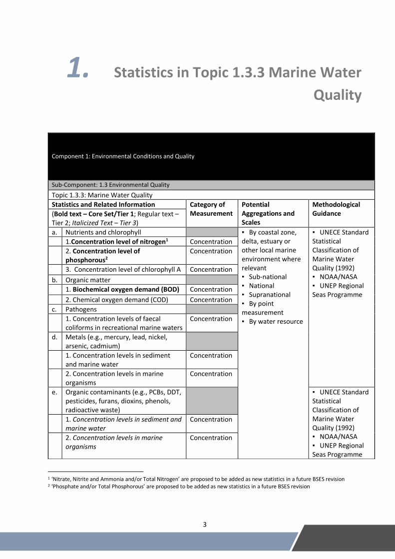
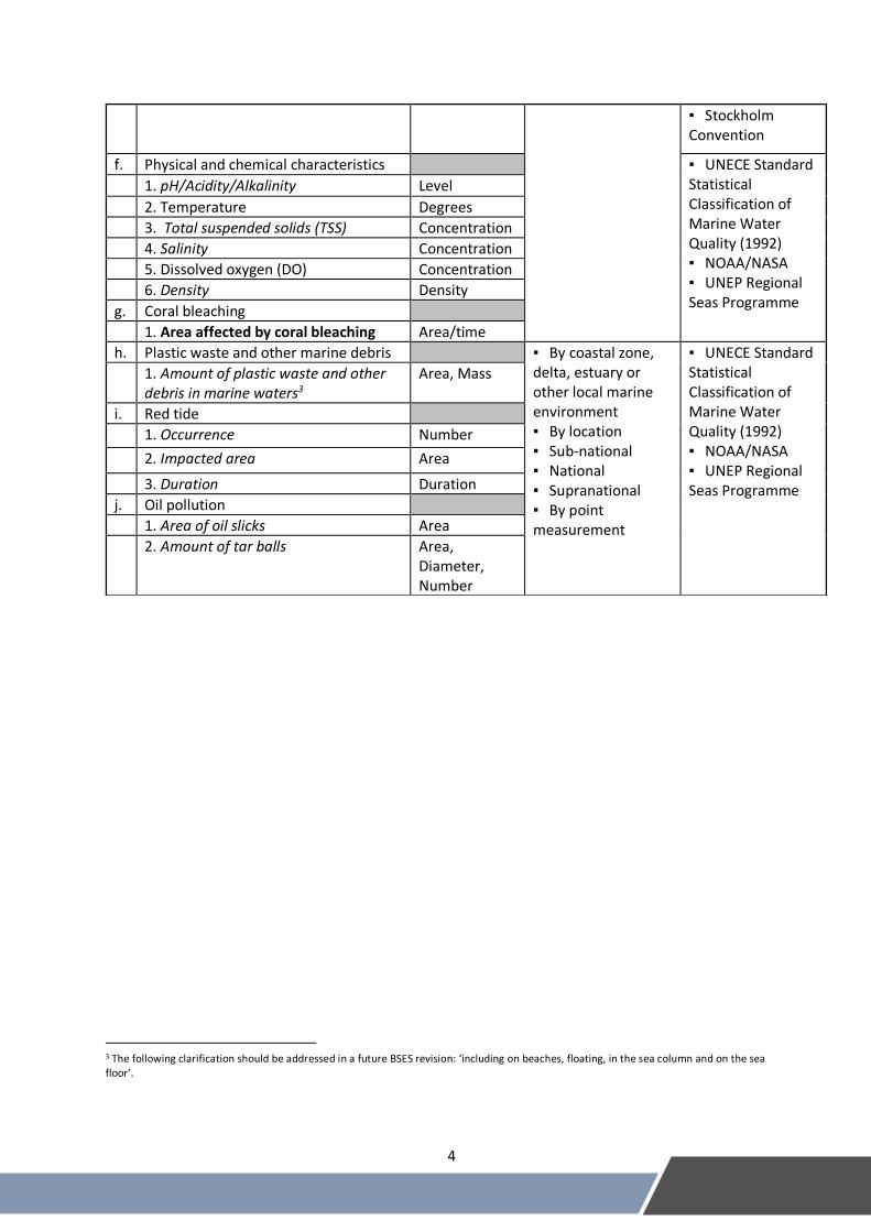
1. Statistics in Topic 1.3.3 Marine Water
Quality
1 ‘Nitrate, Nitrite and Ammonia and/or Total Nitrogen’ are proposed to be added as new statistics in a future BSES revision 2 ‘Phosphate and/or Total Phosphorous’ are proposed to be added as new statistics in a future BSES revision
Component 1: Environmental Conditions and Quality
Sub-Component: 1.3 Environmental Quality
Topic 1.3.3: Marine Water Quality
Statistics and Related Information Category of Measurement
Potential Aggregations and Scales
Methodological Guidance (Bold text – Core Set/Tier 1; Regular text –
Tier 2; Italicized Text – Tier 3)
a. Nutrients and chlorophyll
▪ By coastal zone, delta, estuary or other local marine environment where relevant ▪ Sub-national ▪ National ▪ Supranational ▪ By point measurement ▪ By water resource
▪ UNECE Standard Statistical Classification of Marine Water Quality (1992) ▪ NOAA/NASA ▪ UNEP Regional Seas Programme
1.Concentration level of nitrogen1 Concentration
2. Concentration level of phosphorous2
Concentration
3. Concentration level of chlorophyll A Concentration
b. Organic matter
1. Biochemical oxygen demand (BOD) Concentration
2. Chemical oxygen demand (COD) Concentration
c. Pathogens
1. Concentration levels of faecal coliforms in recreational marine waters
Concentration
d. Metals (e.g., mercury, lead, nickel, arsenic, cadmium)
1. Concentration levels in sediment and marine water
Concentration
2. Concentration levels in marine organisms
Concentration
e. Organic contaminants (e.g., PCBs, DDT, pesticides, furans, dioxins, phenols, radioactive waste)
▪ UNECE Standard Statistical Classification of Marine Water Quality (1992) ▪ NOAA/NASA ▪ UNEP Regional Seas Programme
1. Concentration levels in sediment and marine water
Concentration
2. Concentration levels in marine organisms
Concentration
4
3 The following clarification should be addressed in a future BSES revision: ‘including on beaches, floating, in the sea column and on the sea floor’.
▪ Stockholm Convention
f. Physical and chemical characteristics
▪ UNECE Standard Statistical Classification of Marine Water Quality (1992) ▪ NOAA/NASA ▪ UNEP Regional Seas Programme
1. pH/Acidity/Alkalinity Level
2. Temperature Degrees
3. Total suspended solids (TSS) Concentration
4. Salinity Concentration
5. Dissolved oxygen (DO) Concentration
6. Density Density
g. Coral bleaching
1. Area affected by coral bleaching Area/time
h. Plastic waste and other marine debris
▪ By coastal zone, delta, estuary or other local marine environment ▪ By location ▪ Sub-national ▪ National ▪ Supranational ▪ By point measurement
▪ UNECE Standard Statistical Classification of Marine Water Quality (1992) ▪ NOAA/NASA ▪ UNEP Regional Seas Programme
1. Amount of plastic waste and other debris in marine waters3
Area, Mass
i. Red tide
1. Occurrence Number
2. Impacted area Area
3. Duration Duration
j. Oil pollution
1. Area of oil slicks Area
2. Amount of tar balls Area, Diameter, Number
5
2. Introduction/Relevance
Oceans cover more than two-thirds of the planet and have a critical role in maintaining the planet’s climate and
health, including sustaining marine biodiversity and ecosystems. Oceans and seas are interlinked water bodies,
composed of marine (pelagic – located in the water column and benthic – on the bottom)4 and coastal ecosystems.
Marine ecosystems are defined as ‘complexes of living organisms in the ocean environment’5; coastal ecosystems are
‘areas where land and water join to create an environment with a distinct structure, diversity, and flow of energy’.6
To protect marine ecosystems and ensure their abilities to sustain life, marine water quality is of the utmost
importance.
Oceans and their ecosystems play many essential roles in supporting all life and specifically benefiting human
populations. Marine ecosystems provide: regulatory services such as carbon sequestration, water purification and
coastal protection; provisioning services such as food sources through fish, shellfish and seaweed, and health
products including minerals and algae; and cultural services in the form of recreation, beauty products and intellectual
gain. To ensure the sustainable supply of these services, marine water quality must be protected from harmful effects
of pollution. The threats of pollution have the potential to disrupt marine ecosystems by physically displacing or
harming marine life, chemically altering the system and biologically upsetting individual organisms as well as the
system.
Key facts:
• The ocean covers three quarters of Earth’s surface, contains 97% of Earth’s water, represent 99% of the living
space on the planet by volume.
• More than four billion people depend on seafood as a source of protein.7
• Globally, the market value of marine and coastal resources and industries is estimated at $3 trillion per year
or about 5 per cent of global GDP.
• Oceans absorb about 30 per cent of carbon dioxide produced by humans, buffering the impacts of global
warming.8
• The ocean influences climate including earth's surface temperature, by transporting of heat from the tropics
to polar regions.
Clearly, human populations rely heavily on oceans and this makes it essential to address current threats including:
• As much as 80% of the 270 billion m3 of municipal wastewater produced annually is discharged untreated.
• 184.5 billion kg of fertilizers were consumed in 2013 and approximately 80% of nutrients in fertilizer run-off
to rivers, lakes, oceans and other natural ecosystems or– i.e. only 20% of nutrients are used by the
agricultural area of application.
4 There is no internationally standardized classification of marine ecosystems. 5 Encyclopedia Britannica: https://www.britannica.com/science/marine-ecosystem (accessed 10 March 2020) 6 The Environmental Literacy Council: https://enviroliteracy.org/water/coastal-areas/ (accessed 10 March 2020) 7 FAO (2014). The State of World Fisheries and Aquaculture, http://www.fao.org/3/i9540en/i9540en.pdf (accessed 10 March 2020) 8 UN Environment (2019). Goal 14: Life below Water https://www.unenvironment.org/explore-topics/sustainable-development-goals/why-do-sustainable-development-goals-matter/goal-14 (accessed 10 March 2020)
6
• Between 5-13 million tonnes of plastic leak into the ocean every year.9 This plastic adds to the plastic which
has already accumulated in oceans.
• 16% of large marine ecosystems are at high risk of eutrophication.
In 2003, the United Nations High-Level Committee on Programmes approved the creation of an Oceans and Coastal
Areas Network, subsequently named "UN-Oceans"10 which is composed of the relevant programmes, entities and
specialized agencies of the UN system and the secretariats of the relevant international conventions, including the
International Seabed Authority and the Convention on Biological Diversity. The network seeks to enhance the
coordination, coherence and effectiveness of the competent organizations. It facilitates inter-agency information
exchange, including sharing of experiences, best practices, tools and methodologies and lessons learned in ocean-
related matters. UN-Oceans has met on an annual basis since 2005.
Two significant threats to marine water quality are delineated under SDG indicator 14.1.1: coastal eutrophication and
marine litter. To ensure marine water quality, it is necessary to monitor coastal eutrophication and marine litter.
Understanding the location, composition and specific threats of marine pollution is essential to ensuring marine water
quality. To gain this understanding, monitoring is necessary to build statistical knowledge on existing marine pollution.
Statistics on marine water quality can assist in policy formation by providing evidence for the harmful effects of
pollution.
The Global Manual on Ocean Statistics11 supports tracking progress toward SDG 14 including specific information for
indicators 14.1.1 “Index of Coastal Eutrophication (ICEP) and marine litter,” 14.2.1 “Proportion of national exclusive
economic zones managed using ecosystem-based approaches,” and 14.5.1 “Coverage of protected areas in relation
to marine areas.” This support is provided with a review of existing resources, a guide to implementing methods, a
description of the role at the national level and more details on each indicator as necessary. The guide also formulates
the path from national implementation to global monitoring for SDG 14.
A framework for monitoring coastal eutrophication has been developed from the expert workshop on marine
pollution indicators.12 The framework describes how to examine coastal eutrophication as sub-indicators (of SDG
14.2.1) in order to thoroughly identify and understand the source of nutrients. The sub-indicators are specified to
data sources, level of reporting and partners to work toward building statistical data.
Monitoring guidelines specific to marine litter have been established in the GESAMP Report 201913 including
explanations on how to categorize marine litter leading to data requirements and study design recommendations.
These explanations are elaborated by location of marine litter including shorelines, sea surface and water column,
seafloor, marine biota and particular considerations for microplastics. Furthermore, the guidelines describe the
characterization of plastic litter based on its composition. Lastly, recommendations develop the information into
actionable statistical methods.
9 UN Environment (2019). Goal 14: Life below Water https://www.unenvironment.org/explore-topics (accessed 10 March 2020) 10 UN-OCEANS: http://www.unoceans.org/about/en/#c267982 (accessed 10 March 2020) 11 UN Environment (2018). Global Manual on Ocean Statistics. Towards a definition of indicator methodologies. Nairobi (Kenya): U N Environment. 46 pp. plus four appendices. https://uneplive.unep.org/media/docs/statistics/egm/global_manual_on_ocean_statistics_towards_a_definition_of_indicator_methodologies.pdf (accessed 10 March 2020) 12 UN Environment (2019). Expert Workshop on Marine Pollution Indicators under Sustainable Development Goal Target 14.1. https://uneplive.unep.org/media/docs/statistics/egm/egm_ocean_sdg_14_1_meeting%20notes.pdf (accessed 10 March 2020) 13 GESAMP (2019). Guidelines or the monitoring and assessment of plastic litter and microplastics in the ocean (Kershaw P.J., Turra A. and Galgani F. editors), (IMO/FAO/UNESCO-IOC/UNIDO/WMO/IAEA/UN/UNEP/UNDP/ISA Joint Group of Experts on the Scientific Aspects of Marine Environmental Protection). Rep. Stud. GESAMP No. 99, 130p https://environmentlive.unep.org/media/docs/marine_plastics/une_science_dvision_gesamp_reports.pdf (accessed 10 March 2020)
7
The Regional Seas Programme strives to address the increasing degradation of global oceans and coastal areas
through coordinated sustainable management at the regional level through engaging neighbouring countries in
actions to protect the shared marine environment.14 The Programme covers 22 indicators, including some that
overlap with indicators under SDG 14.15 These indicators differ in that no Regional Seas indicators overlap with SDG
targets: 14.616, 14.717, 14.b18, or 14.c19. These gaps are acknowledged in a report mapping out the connections
between the Regional Seas Indicators, the Aichi Biodiversity Indicators and the SDG Indicators. The report assures
that the lack of coherence will be noted for any development of new indicators.20
Marine water quality statistics need to be improved by forming a greater link between water quality monitoring in
general and marine water quality, increasing in situ monitoring, increased use of remote sensing and citizen science
and establishing a greater understanding of uncertainties of modelled marine water quality data. Water quality is
monitored in lakes, rivers and other freshwater bodies, but there is a missing link between freshwater quality data
and marine water quality status. These freshwater bodies eventually connect to the oceans in various ways and
therefore their water quality can inform marine water quality. Currently, the greatest link formed is on the basis of
land-based models for marine water quality data, but these models require more in situ monitoring. With increased
in situ monitoring, marine water quality data can be improved with comparisons between modelled river basin water
quality levels and actual results both at the river basin and at various dispersion points. Increased in situ monitoring
can provide more data for certain water quality statistics, such as nutrient loading, that can only be measured through
in situ monitoring. Additionally, data from remote sensing and citizen science can add more value to water quality
monitoring. Remote sensing can be used to monitor chlorophyll A, algal blooms and turbidity and there is the
possibility of using remote sensing for plastic pollution. This can provide additional information on water quality (for
example, algal blooming and chlorophyll A are directly related to eutrophication). There are experiences where citizen
science has been used to collect data on pH and nutrient loading, in this regard there is a need for more research to
establish how this information could be used by national statistical systems (NSSs).
NSSs have a significant role in marine water quality statistics that specifically centres on gathering data at the country
level. National statistical offices (NSOs) coordinate the NSS and often support turning raw in situ data into statistics
and indicators. Additionally, the NSO can pull together data collected by universities and partners. Many
organizations, especially UN offices, include mandates of building capacities at the country-level to monitor data
development. This capacity building seeks to build country-level knowledge and practices using methodologies and
guidelines for marine water quality monitoring.
14 UN Environment (2019). Regional Seas Programme. https://sustainabledevelopment.un.org/partnership/?p=7399 (accessed 10 March 2020) 15 UN Environment (2016). Regional Seas Assessments and Indicators for the Sustainable Development Goals (SDGs). https://wedocs.unep.org/bitstream/handle/20.500.11822/10933/wbrs18_3_rs_assessment_indicators.pdf?sequence=1&%3BisAllowed= (accessed 10 March 2020) 16 SDG 14.6 reads: “By 2020, prohibit certain forms of fisheries subsidies which contribute to overcapacity and overfishing, eliminate subsidies that contribute to illegal, unreported and unregulated fishing and refrain from introducing new such subsidies, recognizing that appropriate and effective special and differential treatment for developing and least developed countries should be an integral part of the World Trade Organization fisheries subsidies negotiation” 17 SDG 14.7 reads: “by 2030, increase the economic benefits to small island developing States and least developed countries from the sustainable use of marine resources, including through sustainable management of fisheries, aquaculture and tourism” 18 SDG 14.b reads: “provide access for small-scale artisanal fishers to marine resources and markets” 19 SDG 14.c reads: “enhance the conservation and sustainable use of oceans and their resources by implementing international law as reflected in the United Nations Convention on the Law of the Sea, which provides the legal framework for the conservation and sustainable use of oceans and their resources” 20 UN Environment (2016). Regional Seas Assessments and Indicators for the Sustainable Development Goals (SDGs). https://wedocs.unep.org/bitstream/handle/20.500.11822/10933/wbrs18_3_rs_assessment_indicators.pdf?sequence=1&%3BisAllowed= (accessed 10 March 2020)
8
This topic covers national, regional and international statistics production processes. National exclusive economic
zones (EEZ) which define the jurisdictions and monitoring for coastal eutrophication is particularly important due to
the proximity to runoff sources and the sources of nutrient pollution. According to the UN Law of the Sea21 (1982)
EEZs are determined as 200 nautical miles extent beyond the countries’ territorial waters (12 nautical miles along the
coastline). Within EEZs, countries carry out various economic activities (fisheries, energy, infrastructure development)
but allow free movement of foreign vessels.22 Regionally, the Regional Seas Programme described above coordinates
data collection and monitoring for the 22 indicators.23 Internationally, monitoring is focused on marine litter and
ocean acidification. Forms of global monitoring include remote sensing of marine litter, chlorophyll A and red tides
and in situ monitoring programs that span countries and regions including beach clean-ups coordinated by
international organizations.24 Related methodology guidelines cover fisheries25, fresh water quality26, sea-level rise,
and marine biodiversity.27 Other UN sources providing statistics on oceans include: Food and Agriculture Organization
of the United Nations (FAO), UN-Water and World Health Organization and United Nations Children’s Fund Joint
Monitoring Programme for Water Supply and Sanitation (WHO/UNICEF-JMP). FAO provides statistics on fisheries
including: statistics on global catch, fleet and employment by country; data on stock status and bio-ecological
statistics of aquatic species and economic trends such as fish prices, market studies and trend analysis.28 UN-Water
goals include developing methodologies and tools to monitor SDG 629 global indicators, enhance capacities at the
country-level to monitor and aggregate country data to report global progress in SDG 6.30 WHO/UNICEF-JMP globally
reports the status of water supply and sanitation sector by countries to support improved monitoring.31
21 United Nations Convention on the Law of the Sea: https://www.un.org/Depts/los/convention_agreements/texts/unclos/unclos_e.pdf (accessed 10 March 2020) 22 Encyclopedia Britannica: https://www.britannica.com/topic/Law-of-the-Sea#ref913546 (accessed 10 March 2020) 23 UN Environment (2019). Regional Seas Programme. https://sustainabledevelopment.un.org/partnership/?p=7399 (accessed 10 March 2020) 24 Ocean Conservancy (2019). Trash Information and Data for Education and Solutions (TIDES) https://www.coastalcleanupdata.org/ (accessed 10 March 2020) International Pellet Watch (2019). Global Monitoring of POPs Using Beached Plastic Resin Pellets http://www.pelletwatch.org/ (accessed 10 March 2020) 25 FAO (2002). Sample-based Fishery Surveys: A Technical Handbook. http://www.fao.org/3/a-y2790e.pdf and FAO (2002). Fisheries Inventory: Method and Guidelines. http://www.fao.org/fishery/docs/DOCUMENT/FIGIS_FIRMS/Method_Guidelines/FisheriesInventoryGuidelines.pdf (accessed 10 March 2020) 26 UN-Water (2017). Step-by-Step Monitoring Methodology for Indicator 6.4.2 http://www.unwater.org/app/uploads/2017/05/Step-by-step-methodology-6-4-2_Revision-2017-01-19_Final-1.pdf (accessed 10 March 2020) 27 Walters, M. and Scholes, R.J. (2017) The GEO Handbook on Biodiversity Observation Networks. dx.doi.org/10.1007/978-3-319-27288-7_6
(accessed 10 March 2020) 28 FAO (2019). Fisheries. http://www.fao.org/fisheries/en/ (accessed 10 March 2020) 29 SDG 6 reads: Ensure availability and sustainable management of water and sanitation for all 30 UN-Water (2019). Monitor and Report. http://www.unwater.org/what-we-do/monitor-and-report/ (accessed 10 March 2020) 31 WHO/UNICEF JMP (2019). WASH Data. https://washdata.org/data (accessed 10 March 2020)
9
3. Definitions and description of the
statistics
Marine water quality describes the status of ocean water and is often specific to a certain location. This water quality
can be discussed throughout the water column, on shorelines and as it impacts marine biota. It is specific to marine
environments meaning that the water is saline and within oceans as opposed to freshwater quality.
Marine water quality is measured in a variety of ways. Typically, measurement for marine water quality centres on
defining the presence or absence of key marine pollutants.
Marine pollution includes all harmful substances negatively impacting marine water quality and resulting in such
deleterious effects as harm to living resources, hazards to human health, hindrance to marine activities including
fishing, impairment of quality for use of seawater, and reduction of amenities.
The monitoring of marine pollution focuses on SDG indicator 14.1.1 including coastal eutrophication and marine litter.
Statistics for monitoring these forms of pollution are defined by composition, location, size and other
characterizations.
Marine litter is defined as any persistent, manufactured or processed solid material discarded, disposed of or
abandoned in the marine and coastal environment.32 Plastics specifically make up a significant portion of marine litter
and are described as ‘synthetic polymers with thermo-plastic or thermo-set properties (synthesized from
hydrocarbon or biomass raw materials), elastomers (e.g. butyl rubber), material fibres, monofilament lines, coatings
and ropes’33 by the GESAMP Report 2019. Furthermore, plastics can be described as two types including:
‘thermoplastics (capable of being deformed by heating), which include polyethylene, polypropylene and polystyrene;
and, thermoset (non-deformable), which include polyurethane, paints and epoxy resins.’
Marine plastic litter is divided into categories based on size first and then various characteristics to assist in identifying
the types and sources of litter (Table 3.1). Common descriptors include: mega-litter, macro-litter, meso-litter, micro-
litter (specifically known as microplastics) and nano-litter.
Table 3.1: Categorization of Marine Plastic litter (as per the GESAMP)
Descriptor Relative size
Common size divisions
Measurement units
References Alternative options
Key impacts34
Mega Very large > 1 m Metres GESAMP Entanglement
32 Global Programme of Action for the Protection of the Marine Environment from Land-based Activities, adopted in Washington DC, 1995 33 GESAMP (2019). Guidelines or the monitoring and assessment of plastic litter and microplastics in the ocean (Kershaw P.J., Turra A. and Galgani F. editors), (IMO/FAO/UNESCO-IOC/UNIDO/WMO/IAEA/UN/UNEP/UNDP/ISA Joint Group of Experts on the Scientific Aspects of Marine Environmental Protection). Rep. Stud. GESAMP No. 99, 130p https://environmentlive.unep.org/media/docs/marine_plastics/une_science_dvision_gesamp_reports.pdf (accessed 10 March 2020) 34 UN Environment (2017). Marine Litter Socio Economic Study. https://wedocs.unep.org/bitstream/handle/20.500.11822/26014/Marinelitter_socioeco_study.pdf?sequence=1&isAllowed=y (accessed 10 March 2020)
10
Macro Large 25 – 1000 mm
Metres Centimetres Millimetres
MSFD 25 – 50 mm Ingestion, transfer of chemicals, entanglement
Meso Medium 5 – 25 mm
Centimetres Millimetres
MSFD < 25 mm 1 – 25 mm
Ingestion, transfer of chemicals
Micro Small < 5 mm Millimetres Microns
NOWPAP MSFD
1 – 5 mm < 1 mm > 330 µm
Uptake via absorption, ventilation and/or ingestion; transfer of chemicals
Nano Extremely small
< 1 µm Nanometres < 100 nm Uptake via absorption, ventilation and/or ingestion; transfer of chemicals
Microplastics can further be divided into primary and secondary. Primary microplastics are intentionally produced for
a specific function while secondary microplastics are the result of degradation of larger objects. In addition to this
division, microplastics can be described by their shape and colour.
Coastal eutrophication occurs following an imbalance in nutrient concentration of a particular area. This imbalance
can have many causes, but it is commonly due to human-generated pollution flowing from rivers into the ocean. The
development of SDG Indicator 14.1.1 recognised the importance of coastal eutrophication for this reason.
Eutrophication has various sources but results from wastewater or an over-application of fertilizers. Runoff from the
fields carries nutrients that make up most of the fertilizers into rivers and waterways that lead to the ocean.
Eutrophication is associated with hypoxia or a lack of oxygen in the water which makes the marine environment
unliveable resulting into fish mortality and deaths in marine species. Furthermore, eutrophication can lead to excess
carbon dioxide in the water, which lowers pH level generating ocean acidification.
Statistics on coastal eutrophication focus on the amount of nitrogen (N) forms (Nitrate, Nitrite and Ammonia) and
phosphorus (P) in the water, but also include various other factors that contribute to eutrophication. Data sources
include satellite-based products, globally modelled data, in situ data collected, national modelling and citizen science
products. The level of reporting varies based on the source and type of data, but generally include river basins or
satellite resolutions.
Ocean acidification and warming are results of increased carbon emissions from human activities. The harmful
impacts of increased emissions on oceans are twofold. The ocean has a high capacity for absorbing CO2, so the higher
emissions mean more CO2 in the ocean. As a result of increased CO2 levels, the pH is lowered, making the ocean more
acidic. The negative effects of ocean acidification include: coral bleaching, inability to fix shells in crustaceans due to
lowered calcium carbonate levels, disruption in food chains as a result of species extinction from shell destruction
and weakened metabolic processes in some species due to lower pH levels.35 Secondly, the increased CO2 levels raise
the temperatures of oceans because oceans absorb most of the excess heat from greenhouse gas emissions. Harmful
impacts of raised temperature levels include coral bleaching, loss of breeding grounds for marine species, more
extreme weather events, deoxygenation and sea-level rise.36
35 UNDP (2017). Ocean Acidification – what it means and how to stop it. https://www.undp.org/content/undp/en/home/blog/2017/3/14/Ocean-Acidification-What-it-means-and-how-to-stop-it.html (accessed 10 March 2020) 36 IUCN (2019). Ocean Warming. https://www.iucn.org/resources/issues-briefs/ocean-warming (accessed 10 March 2020)
11
3A. Nutrients and chlorophyll (FDES 1.3.3.a)
Concentration level of nitrogen (FDES 1.3.3.a.1)
The amount of nitrogen and phosphate concentrations relative to the amount of silica in river basins has a direct
impact on coastal ecosystems. It is proposed that the concentration of nitrogen is measured in mg/L.
Remark:
There are multiple forms of nitrogen measurement including total nitrogen, dissolved inorganic nitrogen and
atmospheric nitrogen deposition. These various forms of measurement differ in that total nitrogen measures all of
the nitrogen present; dissolved inorganic nitrogen is the sum of nitrite, nitrate and ammonia; atmospheric nitrogen
deposition indicates the amount of nitrogen entering the ocean from surrounding air and river total nitrogen is the
total nitrogen from river sources.
Concentration level of phosphorus (FDES 1.3.3.a.2)
It is proposed that the concentration of phosphorus is measured in mg/L.
Remark:
• Similar to nitrogen measurements, there are other forms of monitoring phosphorus including total
phosphorus, dissolved inorganic phosphorous and river total phosphate. They differ in that total phosphorus
measures all of the phosphorus present, dissolved inorganic phosphorus is a measurement of phosphate and
the total phosphorus from river sources.
Concentration level of chlorophyll A (FDES 1.3.3.a.3)
The amount of chlorophyll A is applied as a concentration to indicate phytoplankton productivity. This is used as a
proxy indicator for eutrophication under SDG indicator 14.1.1. The Regional Seas Programmes also employs
chlorophyll A concentration as an indicator for eutrophication with the ability to use remote sensing to measure
chlorophyll A concentrations as one of the main advantages since it allows for high temporal and spatial coverage
and low technology and resource capacity requirements.37
Remarks:
• Chlorophyll A is typically measured in milligrams of chlorophyll per cubic metre of seawater in a time period.
• The eutrophication status category resulting from measuring chlorophyll A levels varies based on a country-
basis.
• Seasonal local phytoplankton growth can impact the results of measuring. It is recommended to monitor
chlorophyll A levels during the growing season.
• Chlorophyll A concentration is an essential part of understanding eutrophication and therefore it is
recommended to monitor and report on the levels in all countries.
• Chlorophyll A is a proxy for eutrophication but does not indicate harmful algal blooms. Harmful algal blooms
result in red tides, which are mentioned under FDES 1.3.3.i.
37 GESAMP (2019). Guidelines or the monitoring and assessment of plastic litter and microplastics in the ocean (Kershaw P.J., Turra A. and Galgani F. editors), (IMO/FAO/UNESCO-IOC/UNIDO/WMO/IAEA/UN/UNEP/UNDP/ISA Joint Group of Experts on the Scientific Aspects of Marine Environmental Protection). Rep. Stud. GESAMP No. 99, 130p https://uneplive.unep.org/media/docs/statistics/egm/global_manual_on_ocean_statistics_towards_a_definition_of_indicator_methodologies.pdf (accessed 10 March 2020)
12
• Phytoplankton plays a key part in the food chain and not all leads to eutrophication; only after a nutrient
ratio of 42 carbon: 8.5 hydrogen: 57 oxygen: 7 nitrogen: 1 phosphorus is disrupted does the system become
imbalanced.38
3B. Organic matter (FDES 1.3.3.b)
Biochemical oxygen demand (BOD) (FDES 1.3.3.b.1)
BOD is a measurement of dissolved oxygen required by organisms for the aerobic decomposition of organic matter
present in water.39
BOD refers to the amount of oxygen in water over a period of five days to understand the oxygen levels over time
and determine the impact of decaying matter in an ecosystem. This measure shows how much oxygen is needed by
bacteria to break down organic matter.40
Remarks:
• BOD is most relevant in waters rich in organic matter
• BOD is specific to the amount of oxygen consumed by microbial oxidation41
• BOD does not measure the oxygen-consuming potential of cellulose, but it is measured in the COD test
discussed below42
Chemical oxygen demand (COD) (FDES 1.3.3.b.2)
COD measures the potential of water to consume oxygen during the oxidation of inorganic chemicals and
decomposition of organic matter.43
Remarks:
• BOD and COD do not measure the same types of oxygen consumption.
• COD does not measure the oxygen-consuming potential associated with specific dissolved organic
compounds.44
3A3. Pathogens (FDES 1.3.3.c)
Pathogens are micro-organisms that can cause disease in other organisms. They may be present in sewage, run-off
from animal farms, swimming pools, contaminated shellfish and so forth.45
38 WHO (1999). Toxic Cyanobacteria in Water: A guide to their public health consequences, monitoring and management. https://www.who.int/water_sanitation_health/resourcesquality/toxcyanchap8.pdf?ua=1 (accessed 10 March 2020) 39 UNSD Glossary of Environment Statistics: https://unstats.un.org/unsd/environmentgl/gesform.asp?getitem=159 40 Water Education Foundation. (2019). Biochemical Oxygen Demand. https://www.watereducation.org/aquapedia-background/biochemical-oxygen-demand (accessed 10 March 2020) 41 The Laboratory People. (2009). COD or Chemical Oxygen Demand https://camblab.info/wp/index.php/272/ (accessed 10 March 2020) 42 The Laboratory People. (2009). COD or Chemical Oxygen Demand https://camblab.info/wp/index.php/272/ (accessed 10 March 2020) 43 The Laboratory People. (2009). COD or Chemical Oxygen Demand https://camblab.info/wp/index.php/272/ (accessed 10 March 2020) 44 The Laboratory People. (2009). COD or Chemical Oxygen Demand https://camblab.info/wp/index.php/272/ (accessed 10 March 2020) 45 UNSD Glossary of Environment Statistics: https://unstats.un.org/unsd/environmentgl/gesform.asp?getitem=872
13
Concentration levels of faecal coliforms in recreational marine waters (FDES 1.3.3.c.1)
Levels of faecal coliforms are reported in concentrations of the number of colonies per a 100 mL sample. This is
measured by taking a sample and pumping it through a membrane filter before incubating it to allow the colonies to
grow and become coloured with the dye, so a count can be retrieved from the sample.46 There is currently a focus to
collect more data on faecal coliform concentrations moving forward to better understand marine water quality.
Remarks:
• To determine guidelines for concentrations in recreational water, experts selected key studies delineating
the health impacts and then completed a risk assessment to understand the connection between the health
impacts and concentration levels. This approach was employed to ensure a progressive set of guidelines and
to create the ability for local authorities to assess their level of risk and remain within standards according
to that risk.
• The guideline values for recreation in coastal waters are based on a percentile approach, expressing the
values in terms of the 95th percentile of numbers of colonies per 100 ml to represent the risk based on
exposure conditions. There are various ways to calculate the percentile and individual authorities determine
the best approach for their purposes. The percentile quantities show a number of illness cases per number
of exposures. For example, one value is 40 colonies per 100 ml and this represents a probability of less than
one illness case in every 100 exposures.47
3A4. Metals (FDES 1.3.3.d)
Concentration levels in sediment and marine water (FDES 1.3.3.d.1)
Measuring the concentration levels of metals such as lead or mercury in sediment and marine water takes several
forms including gravimetric, volumetric, colorimetric, nuclear and Atomic Absorption Spectrometer (AAS) analysis
techniques. The last of these is popular for its speed, sensitivity, simplicity and ability to analyse complex mixtures.48
Preparing for the AAS analysis involves: preparing samples – for sediment samples, they are dried to a constant mass,
then weighed and digested before being cooled and diluted to finally filter them, sent for AAS analysis and recover
the amount of heavy metals present; for marine water, the samples are filtered, preserved and stored at a cool
temperature before AAS analysis.49
Remarks:
• Due to the many methods, it is important to coordinate best practices and share knowledge regarding which
method is best suitable to particular areas.
• Concentrations are often reported in micrograms or nanograms per ml.
46 Oram, B. (2014). Why fecal coliform testing is important – e. coli? Water Research Center. https://www.water-research.net/index.php/e-coli-in-water (accessed 10 March 2020) 47 WHO (2003). Guidelines for Safe Recreational Water Environments. ISBN: 92 4 154580 1 https://www.who.int/water_sanitation_health/bathing/srwg1.pdf (accessed 10 March 2020) 48 Biney, C. et al. (2019). Review of Heavy Metals. http://www.fao.org/3/v3640e/V3640E04.htm (accessed 10 March 2020) 49 Chakraborty, S. and Owens, G. (2014) Metal distributions in seawater, sediment and marine benthic macroalgae from the South Australian coastline. Int. J. Environ. Sci. Technol. 11:1259–1270 DOI 10.1007/s13762-013-0310-4 http://www.bioline.org.br/pdf?st14123 (accessed 10 March 2020)
14
Concentration levels in marine organisms (FDES 1.3.3.d.2)
Similar methodologies used for the concentration levels of metals in sediments and marine water can be applied for
the concentration levels of metals in marine organisms. The main difference involves preparing the sample because
the media is different as flesh instead of water or sediment. A particular threat to marine organisms comes from bio-
accumulation within the food chain. A species higher in the food chain that consumes smaller organisms will ingest
the concentrations of metals within each smaller organism it consumes along with the concentrations it is exposed
to in the environment. This is especially threatening to human populations because these species are most often
consumed in human diets.
Remarks:
• Concentrations are reported in mg/g.
• The WHO provides guidelines of acceptable limits of metals found in foods that vary by metal type and are
between 0.05 and 2 mg/g.50
3A5. Organic contaminants (FDES 1.3.3.e)
Concentration levels in sediment and marine water (FDES 1.3.3.e.1)
Methods for finding concentration levels of organic contaminants in sediment and marine water include: various
forms of chromatography, mass spectrometry, separatory funnel liquid-liquid extraction, Soxhlet extraction,
ultrasonic extraction and clean-ups (using various solutions).51 Each of these methods involve a way to separate the
organic contaminants from the sample in order to determine concentration.
Remarks:
• The concentration of organic contaminants in sediments is reported as nanograms per gram of the dry
weight of the sediment.52
• The concentration of organic contaminants in marine water is reported as nanograms per litre of sample.53
• Organic contaminants include a wide variety of specific pollutants including polychlorinated biphenyls
(PCBs), dichlorodiphenyltrichloroethane (DDT), hexachlorocyclohexane (HCH), lindane and more54 and have
varying harmful impacts including carcinogenic impacts, endocrine-disrupting effects and many other harms
that destabilize the ecosystem.
50 Adebayo IA (2017). Determination of Heavy Metals in Water, Fish and Sediment from Ureje Water Reservoir. J Environ Anal Toxicol 7: 486. Doi: 10.4172/2161-0525.1000486 https://www.omicsonline.org/open-access/determination-of-heavy-metals-in-water-fish-and-sediment-from-urejewater-reservoir-2161-0525-1000486.php?aid=91799 (accessed 10 March 2020) 51 UN Environment. (2009). Guidelines for the Collection, Preparation and Analysis of Organic Contaminants in Environmental Samples. http://www.cep.unep.org/publications-and-resources/technical-reports/Coastal%20Monitoring%20Manual-en.pdf/download (accessed 10 March 2020) 52 Carvalho, F. et al. (2009). Organic Contaminants in the Marine Environment of Manila Bay, Philippines. Environmental Contamination and Toxicology. Vol 57. Issue 2. Pp 348-358 https://doi.org/10.1007/s00244-008-9271-x (accessed 10 March 2020) 53 Loos, R., Tavazzi, S., Mariani, G., Suurkuusk, G., Paracchini, B., & Umlauf, G. (2017). Analysis of emerging organic contaminants in water, fish and suspended particulate matter (SPM) in the Joint Danube Survey using solid-phase extraction followed by UHPLC-MS-MS and GC-MS analysis. The Science of the total environment, 607-608, 1201–1212. doi:10.1016/j.scitotenv.2017.07.039 https://www.ncbi.nlm.nih.gov/pmc/articles/PMC5600344/ (accessed 10 March 2020) 54 IPEN (2018). Ocean Pollutants Guide: Toxic Threats to Human Health and Marine Life. https://ipen.org/sites/default/files/documents/ipen-ocean-pollutants-v2_1-en-web.pdf (accessed 10 March 2020)
15
Concentration levels in marine organisms (FDES 1.3.3.e.2)
Methods for finding concentration levels of organic contaminants in marine organisms are similar to those for finding
the concentration levels in sediments and marine water. Therefore, they also include: various forms of
chromatography, mass spectrometry, separatory funnel liquid-liquid extraction, Soxhlet extraction, ultrasonic
extraction and clean-ups (using various solutions).55
Remarks:
• The concentration or organic contaminants in marine organisms is reported as nanograms per gram.
• Similar to as stated above, this type of pollutant is highly harmful to marine life.
3A6. Physical and chemical characteristics (FDES 1.3.3.f)
pH/acidity/alkalinity (FDES 1.3.3.f.1)
Value of pH measures the acidity or alkalinity of a liquid. A pH value in the range of 0 to 7 indicates acidity, a pH value
in the range of 7 to 14 indicates alkalinity, and a pH value of 7 signifies neutrality.56 The pH/acidity/alkalinity of the
ocean informs the stability of the water chemistry and therefore the stability of the ocean ecosystem. The ocean is a
balanced state of a dilute solution of sodium bicarbonate in a saltwater background, this causes seawater to be weakly
buffered with respect to changes in the hydrogen ion.57 However, an increase in atmospheric carbon dioxide causes
a disturbance in this balance and ultimately results in ocean acidification. Therefore, monitoring of the
pH/acidity/alkalinity in the ocean is essential to understanding these disturbances.
Remarks:
• Measurement of ocean pH has developed over the years with various approaches including using buffer
solutions and a pH cell or using indicator dyes.
• SDG 14.3.1 “Average marine acidity (pH) measured at agreed suite of representative sampling stations” is
measured in this statistic. IOC-UNESCO is the custodian agency for this indicator and it focuses on four
measurable parameters: pH (the concentration of hydrogen ions on a logarithmic scale), CT (total dissolved
inorganic carbon), pCO2 (carbon dioxide partial pressure), and AT (total alkalinity).58
Temperature (FDES 1.3.3.f.2)
The temperature of the ocean explains vital information about the state of the marine ecosystem. It shares basic
information such as the state of the water (ice, water, vapour), but also shares more complex fluctuations such as the
water’s movement because cold water is denser than warm water, so it sinks, the amount of dissolvable gases in the
water (cold water holds more) and the productivity of marine life (warmer water increases productivity).59
55 UN Environment (2009). Guidelines for the Collection, Preparation and Analysis of Organic Contaminants in Environmental Samples. http://www.cep.unep.org/publications-and-resources/technical-reports/Coastal%20Monitoring%20Manual-en.pdf/download (accessed 10 March 2020) 56 UNSD Glossary of Environment Statistics: https://unstats.un.org/unsd/environmentgl/gesform.asp?getitem=890 57 Waldbusser, G. et al. (2010). Ocean Acidification. Oregon State University. (http://blogs.oregonstate.edu/smile/files/2016/02/OceanAcidification_revised.pdf (accessed 10 March 2020) 58 IOC-UNESCO (2018). Indicator Methodology for 14.3.1. http://ioc-unesco.org/components/com_oe/oe.php?task=download&id=39900&version=1.0&lang=1&format=1 (accessed 10 March 2020) 59 Science Learning Hub (2019). Ocean Temperature. https://www.sciencelearn.org.nz/resources/707-ocean-temperature (accessed 10 March 2020)
16
Remark:
• The sea surface temperature of the ocean is measured with satellites, but deeper waters are often measured
with mooring techniques.60
Total suspended solids (TSS) (FDES 1.3.3.f.3)
TSS is a measure of the total suspended solids in water bodies. It is determined through various tests.61 It can be
measured from a sample using the dry weight of suspended particles captured by a filter. It also can be measured
using remote sensing technology.
Remark:
• TSS provides a perspective on water turbidity and light penetration in water. This can contribute to
understanding interferences with marine life and disturbances in the water.
Salinity (FDES 1.3.3.f.4)
Salinity is the salt content of environmental media.62 It is measured as the total amount of dissolved salts in water,
expressed in parts per thousand.63
Remark:
• The salinity of the ocean impacts the water density and hence global water circulation, the solubility of gases
and the stability of marine life.
Dissolved oxygen (DO) (FDES 1.3.3.f.5)
DO measures the amount of oxygen available in the water. This can show decreases in oxygen levels which can trigger
hypoxia leading to eutrophication following the excess of oxygen-consuming organisms that results from increased
nutrient levels.
Density (FDES 1.3.3.f.6)
Ocean density is impacted by the temperature and salinity, but also impacts the temperature because it causes
currents that circulate heat throughout the ocean.64 The density is reported in kilograms per volume (in metres cubed)
and varies in terms of the temperature and salinity.
Remarks:
• High salinity makes water denser as a result of more salt packed into the water.
• High temperature makes water less dense because as the water heats, the molecules spread out, decreasing
density.65
60 NASA (2019). Sea Surface Temperature. https://podaac.jpl.nasa.gov/SeaSurfaceTemperature (accessed 10 March 2020) 61 OECD (2007). Total Suspended Solids. https://stats.oecd.org/glossary/detail.asp?ID=7219 (accessed 10 March 2020) 62 UNSD Environmental Glossary: https://unstats.un.org/unsd/environmentgl/gesform.asp?getitem=995 (accessed 10 March 2020) 63 NOAA (2019). Salinity. https://oceanservice.noaa.gov/education/kits/estuaries/media/supp_estuar10c_salinity.html (accessed 10 March 2020) 64 Science Learning Hub (2019). Ocean Density. https://www.sciencelearn.org.nz/resources/687-ocean-density (accessed 10 March 2020) 65 Science Learning Hub (2019). Ocean Density. https://www.sciencelearn.org.nz/resources/687-ocean-density (accessed 10 March 2020)
17
3A7. Coral bleaching (FDES 1.3.3.g)
Area affected by coral bleaching (FDES 1.3.3.g.1)
A measure of the square kilometres of bleached corals. Corals are formed of symbiotic plant and animal organisms.
Rising temperatures caused by global warming are the biggest cause of coral bleaching.66
Remark:
• Bleaching results from ‘expelling’ the plant component of the coral, which subjects the corals to stress and
increased mortality.67
3A8. Plastic waste and other marine debris (FDES 1.3.3.h)
Amount of plastic waste and other debris in marine waters (FDES 1.3.3.h.1)
The amount of plastic waste and other debris in marine waters is measured specific to locations including: shorelines,
sea surface and water column, seafloor, marine biota and particular considerations for microplastics. The statistics to
match the monitoring location include: plastic debris washed on beaches, plastic debris in the water column, plastic
debris on the seafloor and plastic ingested by biota.
Remarks:
• Citizen science can play a role in methods for monitoring marine plastic litter (discussed further in section
5).
• Due to various methods based on size, location and feasibility, it is vital to cater the monitoring approach to
the desired information. However, it is often reasonable to execute multiple methods within one monitoring
approach (for example, when monitoring by boat, visual observation and net towing can be used at the same
time).
• The GESAMP Report 201968 elaborates monitoring of marine plastic litter in greater detail than the existing
FDES statistics.
3A9. Red tide (FDES 1.3.3.i)
Occurrence (FDES 1.3.3.i.1)
Also known as harmful algal blooms (HAB), red tide is measured by the number of occurrences based on reported
incidences.69
66 Name of institution? https://ocean.si.edu/ocean-life/invertebrates/corals-and-coral-reefs (accessed 10 March 2020) 67 NOAA, What is coral bleaching? https://oceanservice.noaa.gov/facts/coral_bleach.html (accessed 10 March 2020) 68 GESAMP (2019). Guidelines or the monitoring and assessment of plastic litter and microplastics in the ocean (Kershaw P.J., Turra A. and Galgani F. editors), (IMO/FAO/UNESCO-IOC/UNIDO/WMO/IAEA/UN/UNEP/UNDP/ISA Joint Group of Experts on the Scientific Aspects of Marine Environmental Protection). Rep. Stud. GESAMP No. 99, 130p https://environmentlive.unep.org/media/docs/marine_plastics/une_science_dvision_gesamp_reports.pdf (accessed 10 March 2020) 69 NOAA (2019). Red Tide. https://oceanservice.noaa.gov/facts/redtide.html (accessed 10 March 2020)
18
Remarks:
• There is no methodology developed for early warning and detection.70
• Red tides can be measured using remote sensing technology.
Impacted area (FDES 1.3.3.i.2)
The area in which the red tide was experienced, measured in square kilometres.
Remarks:
• Since methodologies are undeveloped, ensuring that the area experiencing red tide is adequately catalogued
remains a challenge.
• Red tides can be measured using remote sensing technology.
Duration (FDES 1.3.3.i.3)
The amount of time and persistence of the red tide event.
3A10. Oil pollution (FDES 1.3.3.j)
Area of oil slicks (FDES 1.3.3.j.1)
The amount of ocean surface covered by an oil spill measured in square kilometres. Remote sensing including satellite
data is an effective means to measure this area.
Amount of tar balls (FDES 1.3.3.j.2)
The number of tar balls resulting from a single oil spill, measured by count.
Remark:
• Tar balls are important to measure to understand their behaviour, they are persistent in the marine
environment and can travel hundreds of miles, meaning that they are a major issue in terms of marine
pollution.71
70 Lam, I. H. Y. and Hodgkiss, I. J. (2001). A real time measurement system for red tide studies. 10.1109/OCEANS.2001.968276 https://ieeexplore.ieee.org/document/968276 (accessed 10 March 2020) 71 NOAA (2019). Tarballs. https://response.restoration.noaa.gov/oil-and-chemical-spills/oil-spills/resources/tarballs.html (accessed 10 March 2020)
19
4. International sources and
recommendations
4A. Classifications and groupings
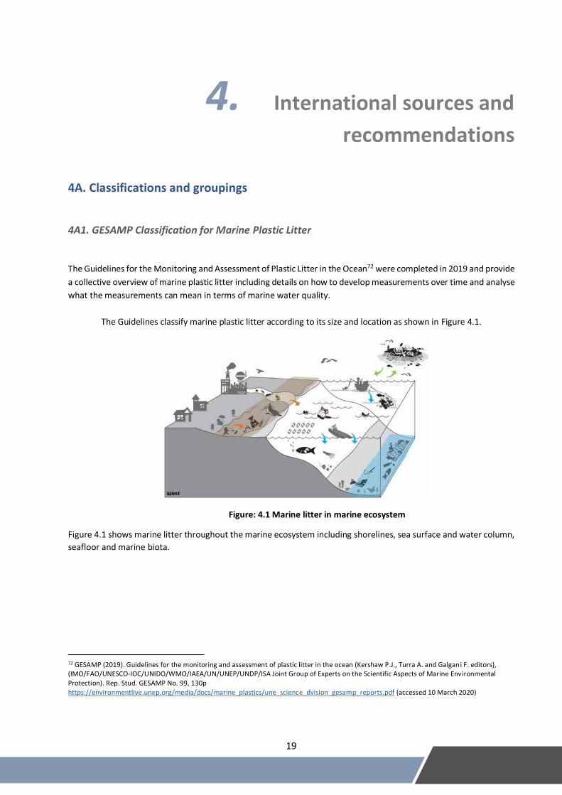
4A1. GESAMP Classification for Marine Plastic Litter
The Guidelines for the Monitoring and Assessment of Plastic Litter in the Ocean72 were completed in 2019 and provide
a collective overview of marine plastic litter including details on how to develop measurements over time and analyse
what the measurements can mean in terms of marine water quality.
The Guidelines classify marine plastic litter according to its size and location as shown in Figure 4.1.
Figure: 4.1 Marine litter in marine ecosystem
Figure 4.1 shows marine litter throughout the marine ecosystem including shorelines, sea surface and water column,
seafloor and marine biota.
72 GESAMP (2019). Guidelines for the monitoring and assessment of plastic litter in the ocean (Kershaw P.J., Turra A. and Galgani F. editors), (IMO/FAO/UNESCO-IOC/UNIDO/WMO/IAEA/UN/UNEP/UNDP/ISA Joint Group of Experts on the Scientific Aspects of Marine Environmental Protection). Rep. Stud. GESAMP No. 99, 130p https://environmentlive.unep.org/media/docs/marine_plastics/une_science_dvision_gesamp_reports.pdf (accessed 10 March 2020)
20
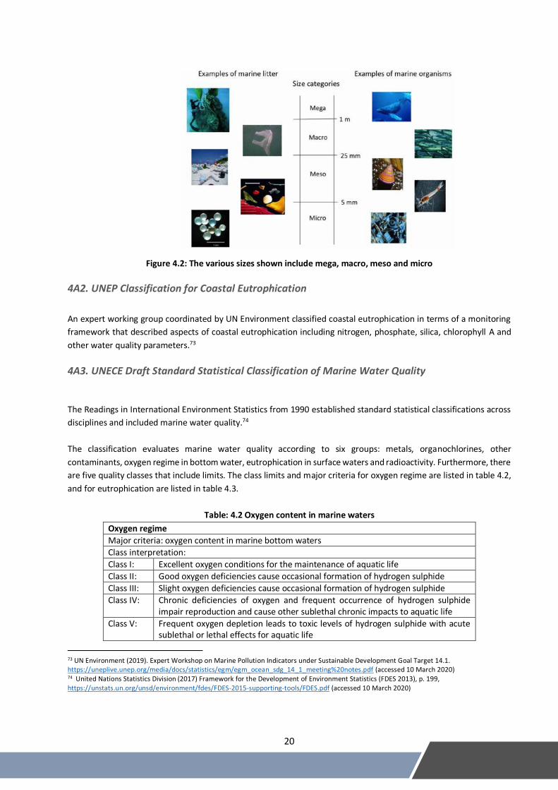
Figure 4.2: The various sizes shown include mega, macro, meso and micro
4A2. UNEP Classification for Coastal Eutrophication
An expert working group coordinated by UN Environment classified coastal eutrophication in terms of a monitoring
framework that described aspects of coastal eutrophication including nitrogen, phosphate, silica, chlorophyll A and
other water quality parameters.73
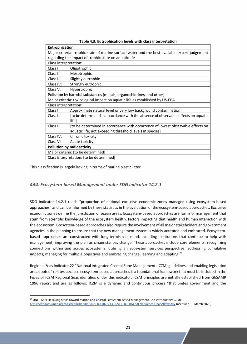
4A3. UNECE Draft Standard Statistical Classification of Marine Water Quality
The Readings in International Environment Statistics from 1990 established standard statistical classifications across
disciplines and included marine water quality.74
The classification evaluates marine water quality according to six groups: metals, organochlorines, other
contaminants, oxygen regime in bottom water, eutrophication in surface waters and radioactivity. Furthermore, there
are five quality classes that include limits. The class limits and major criteria for oxygen regime are listed in table 4.2,
and for eutrophication are listed in table 4.3.
Table: 4.2 Oxygen content in marine waters
Oxygen regime
Major criteria: oxygen content in marine bottom waters
Class interpretation:
Class I: Excellent oxygen conditions for the maintenance of aquatic life
Class II: Good oxygen deficiencies cause occasional formation of hydrogen sulphide
Class III: Slight oxygen deficiencies cause occasional formation of hydrogen sulphide
Class IV: Chronic deficiencies of oxygen and frequent occurrence of hydrogen sulphide impair reproduction and cause other sublethal chronic impacts to aquatic life
Class V: Frequent oxygen depletion leads to toxic levels of hydrogen sulphide with acute sublethal or lethal effects for aquatic life
73 UN Environment (2019). Expert Workshop on Marine Pollution Indicators under Sustainable Development Goal Target 14.1. https://uneplive.unep.org/media/docs/statistics/egm/egm_ocean_sdg_14_1_meeting%20notes.pdf (accessed 10 March 2020) 74 United Nations Statistics Division (2017) Framework for the Development of Environment Statistics (FDES 2013), p. 199, https://unstats.un.org/unsd/environment/fdes/FDES-2015-supporting-tools/FDES.pdf (accessed 10 March 2020)
21
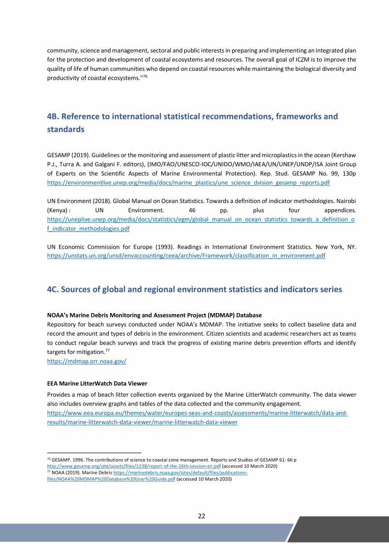
Table 4.3: Eutrophication levels with class interpretation
Eutrophication
Major criteria: trophic state of marine surface water and the best available expert judgement regarding the impact of trophic state on aquatic life
Class interpretation:
Class I: Oligotrophic
Class II: Mesotrophic
Class III: Slightly eutrophic
Class IV: Strongly eutrophic
Class V: Hypertrophic
Pollution by harmful substances (metals, organochlorines, and other)
Major criteria: toxicological impact on aquatic life as established by US-EPA Class interpretation:
Class I: Approximate natural level or very low background contamination
Class II: [to be determined in accordance with the absence of observable effects on aquatic life]
Class III: [to be determined in accordance with occurrence of lowest observable effects on aquatic life, not exceeding threshold levels in species]
Class IV: Chronic toxicity
Class V; Acute toxicity
Pollution by radioactivity
Major criteria: [to be determined]
Class interpretation: [to be determined]
This classification is largely lacking in terms of marine plastic litter.
4A4. Ecosystem-based Management under SDG indicator 14.2.1
SDG indicator 14.2.1 reads “proportion of national exclusive economic zones managed using ecosystem-based
approaches” and can be informed by these statistics in the evaluation of the ecosystem-based approaches. Exclusive
economic zones define the jurisdiction of ocean areas. Ecosystem-based approaches are forms of management that
stem from scientific knowledge of the ecosystem health, factors impacting that health and human interaction with
the ecosystem. Ecosystem-based approaches also require the involvement of all major stakeholders and government
agencies in the planning to ensure that the new management system is widely accepted and embraced. Ecosystem-
based approaches are constructed with long-termism in mind, including institutions that continue to help with
management, improving the plan as circumstances change. These approaches include core elements: recognizing
connections within and across ecosystems; utilizing an ecosystem services perspective; addressing cumulative
impacts; managing for multiple objectives and embracing change, learning and adapting.75
Regional Seas indicator 22 “National Integrated Coastal Zone Management (ICZM) guidelines and enabling legislation
are adopted” relates because ecosystem-based approaches is a foundational framework that must be included in the
types of ICZM Regional Seas identifies under this indicator. ICZM principles are initially established from GESAMP
1996 report and are as follows: ICZM is a dynamic and continuous process “that unites government and the
75 UNEP (2011): Taking Steps toward Marine and Coastal Ecosystem-Based Management - An Introductory Guide https://wedocs.unep.org/bitstream/handle/20.500.11822/13322/GLOCIEBM.pdf?sequence=1&isAllowed=y (accessed 10 March 2020)
22
community, science and management, sectoral and public interests in preparing and implementing an integrated plan
for the protection and development of coastal ecosystems and resources. The overall goal of ICZM is to improve the
quality of life of human communities who depend on coastal resources while maintaining the biological diversity and
productivity of coastal ecosystems.”76
4B. Reference to international statistical recommendations, frameworks and
standards
GESAMP (2019). Guidelines or the monitoring and assessment of plastic litter and microplastics in the ocean (Kershaw
P.J., Turra A. and Galgani F. editors), (IMO/FAO/UNESCO-IOC/UNIDO/WMO/IAEA/UN/UNEP/UNDP/ISA Joint Group
of Experts on the Scientific Aspects of Marine Environmental Protection). Rep. Stud. GESAMP No. 99, 130p
https://environmentlive.unep.org/media/docs/marine_plastics/une_science_dvision_gesamp_reports.pdf
UN Environment (2018). Global Manual on Ocean Statistics. Towards a definition of indicator methodologies. Nairobi
(Kenya) : UN Environment. 46 pp. plus four appendices.
https://uneplive.unep.org/media/docs/statistics/egm/global_manual_on_ocean_statistics_towards_a_definition_o
f_indicator_methodologies.pdf
UN Economic Commission for Europe (1993). Readings in International Environment Statistics. New York, NY.
https://unstats.un.org/unsd/envaccounting/ceea/archive/Framework/classification_in_environment.pdf
4C. Sources of global and regional environment statistics and indicators series
NOAA’s Marine Debris Monitoring and Assessment Project (MDMAP) Database
Repository for beach surveys conducted under NOAA’s MDMAP. The initiative seeks to collect baseline data and
record the amount and types of debris in the environment. Citizen scientists and academic researchers act as teams
to conduct regular beach surveys and track the progress of existing marine debris prevention efforts and identify
targets for mitigation.77
https://mdmap.orr.noaa.gov/
EEA Marine LitterWatch Data Viewer
Provides a map of beach litter collection events organized by the Marine LitterWatch community. The data viewer
also includes overview graphs and tables of the data collected and the community engagement.
https://www.eea.europa.eu/themes/water/europes-seas-and-coasts/assessments/marine-litterwatch/data-and-
results/marine-litterwatch-data-viewer/marine-litterwatch-data-viewer
76 GESAMP. 1996. The contributions of science to coastal zone management. Reports and Studies of GESAMP 61: 66 p http://www.gesamp.org/site/assets/files/1238/report-of-the-26th-session-en.pdf (accessed 10 March 2020) 77 NOAA (2019). Marine Debris https://marinedebris.noaa.gov/sites/default/files/publications-files/NOAA%20MDMAP%20Database%20User%20Guide.pdf (accessed 10 March 2020)

23
Australian Marine Debris Database
Allows volunteers and organizations performing beach clean-ups to also collect data on their findings. Encourages a
consistent methodology in order to collate the information into a standardized national database on marine debris.
Includes more than 7 million pieces of data to provide an overview of what amount and types of marine debris are
found on beaches throughout Australia.
http://amdi.tangaroablue.org/
Ocean Conservancy TIDES – Trash Information and Data for Education and Solutions
Map of beach clean-up data from throughout the world. Includes over 200 million pounds of trash removed, 40,000
locations and 30 million participants.
https://www.coastalcleanupdata.org/
International Pellet Watch
Global monitoring of persistent organic pollutants (POPs) using beached plastic resin pellets. The monitoring program
is volunteer-based and designed to monitor the pollution status of the ocean.
http://www.pelletwatch.org/
Two Decades of Monitoring in Marine Debris Ingestion in Loggerhead Sea Turtle, Caretta caretta, From the Western
Mediterranean, Domenech, et al. 2018
This academic paper catalogued data for marine debris ingestion in loggerhead sea turtles over the last two decades.
https://doi.org/10.1016/j.envpol.2018.10.047
Global Distribution, Composition and Abundance of Marine Litter
This book describes marine litter in terms of location, concentration, density, source and flux.
https://link.springer.com/chapter/10.1007/978-3-319-16510-3_2
Plastic Waste Inputs from Land into the Ocean, Jambeck, et al. 2015
This paper links worldwide data on solid waste, population density and economic status to estimate the mass of land-
based plastic waste entering the ocean.
https://www.iswa.org/fileadmin/user_upload/Calendar_2011_03_AMERICANA/Science-2015-Jambeck-768-
71__2_.pdf
Sources and Pathways of Microplastics to Habitats, Browne, 2015
This paper reviews the current knowledge regarding sources and pathways of microplastics, assesses the terminology
and gives recommendations for future work.
https://link.springer.com/chapter/10.1007/978-3-319-16510-3_9
Detection and Monitoring of Marine Pollution Using Remote Sensing Technologies, Sidrah, et al. 2018
This paper overview the role of satellite remote sensing for detecting and monitoring marine pollution including
plastic and nutrient pollution.
https://www.intechopen.com/chapter/pdf-download/64603
24
Plastic Accumulation in the Mediterranean Sea, Cozar, et al. 2015
This academic paper provides data on the plastic pollution in the Mediterranean Sea using sampling methods.
https://doi.pangaea.de/10.1594/PANGAEA.842054
Harmful Algae Event Database (HAEDAT) IOC – ICES – PICES
Built within the International Oceanographic Data and Information Exchange (IODE) of the Intergovernmental
Oceanographic Commission (IOC) of UNESCO and in cooperation with World Register of Marine Species (WoRMS),
International Council for the Exploration of the Sea (ICES), the North Pacific Marine Science Organization (PICES),
International Atomic Energy Agency (IAEA) and International Society for the Study of Harmful Algae (ISSHA), HAEDAT
is a meta database containing records of harmful algal events based on annual national reports by ICES and PICES
member states.
http://haedat.iode.org/
Interactive Map of Eutrophication and Hypoxia, World Resources Institute
This map includes 762 coastal areas impacted by eutrophication and/or hypoxia, 479 sites identified as experiencing
hypoxia with 55 sites that are improving from hypoxia and 228 sites experiencing other symptoms of eutrophication
(including algal blooms, species loss and impacts to coral reef assemblages).
https://www.wri.org/our-work/project/eutrophication-and-hypoxia/interactive-map-eutrophication-hypoxia
25
5. Data collection and sources of data
Scope of Statistics
Marine ecosystems throughout oceans worldwide, spanning each of the five major gyres: the North and South Pacific
Subtropical Gyres, the North and South Atlantic Subtropical Gyres, and the Indian Ocean Subtropical Gyre.78
Statistical Unit
Marine water quality data is typically expressed in terms of concentration, but occasionally is measured as area.
Measurement Unit
Category Parameter Unit
a. Nutrients and chlorophyll
Nitrogen Milligrams (mg) per litre (l)
Phosphorous Milligrams (mg) per litre (l)
Chlorophyll A Milligrams (mg) per litre (l)
b. Organic matter Biochemical oxygen demand Mg of oxygen consumed per l
Chemical oxygen demand Mg of oxygen consumed per l
c. Pathogens Faecal coliform levels Number of colonies per 100 ml
d. Metals Metals in sediment and marine water Mg or micrograms (µg) per ml/mg Metals in marine organisms Mg or µg per gram (g)
e. Organic contaminants
Persistent Organic Pollutants in sediment and marine water
Nanograms (ng) per l/g
Persistent Organic Pollutants in marine organisms
Ng per g
f. Physical and chemical characteristics
pH/Acidity/Alkalinity Number on pH scale
Temperature Degrees Celsius
Total suspended solids Parts per million (ppm)
Salinity Practical Salinity Unit*
Dissolved oxygen Ppm
Density Kilograms (kg) per meters cubed (m3)
g. Coral bleaching Area km2
h. Plastic waste Mass Tons
i. Red tide Occurrence Number
Impacted area Square kilometres (km2)
Duration Time (minutes/hours) j. Oil pollution Area of oil slicks km2
Amount of tar balls Number, weight (g)
* a unit based on the properties of sea water conductivity. It is equivalent to per thousand or to g/kg.79
Sources and Institutions
Data providing insight to marine water quality comes from various sources including:
78 NOAA (2019). What is a gyre? https://oceanservice.noaa.gov/facts/gyre.html (accessed 10 March 2020) 79 CATDS Salinity Expert Center (2019). Definition and units. http://www.salinityremotesensing.ifremer.fr/sea-surface-salinity/definition-and-units (accessed 10 March 2020)
26
• Sampling of water, sediment and biota
• Land-based monitoring
• Beach clean-ups
• Remote sensing
Currently there is no harmonized location for data at the global level or at most national levels. Regionally, the
Regional Seas Programmes80 serves to coordinate institutions and experts in a way to improve available data.
Data Collection
This process currently is specific to each individual study, but the Guidelines for the Monitoring and Assessment of
Plastic Litter in the Ocean81 and the Global Manual on Ocean Statistics82 move toward a global process to data
collection to improve harmonization.
In current practices, marine water quality data originates from national monitoring programs, academic research and
research institutions. Methods of collection include sampling water, sediments and marine biota; land-based
monitoring; beach clean-ups and remote sensing data.
There are three main forms of monitoring currently in practice and under development for building statistics on
marine water quality. These include land-based monitoring, in situ monitoring and remote sensing. Firstly, land-based
monitoring is a practice that considers various land use and population statistics including amount of fertilizer use,
population density, socioeconomic status, precipitation and others to estimate the generation of nutrient loads
entering rivers from these land-based sources. The result is an estimate of the amount of nutrient pollution entering
the ocean as runoff from a specific river, therefore the estimate is valid only for a specific river basin. Secondly, in situ
monitoring can bolster the land-based monitoring by ground-truthing the results. More in situ statistics are required
to validate the results of the land-based monitoring. In situ monitoring can build a base of understanding for the
amounts of nutrient pollution in certain parts of the ocean. Lastly, remote sensing can be used to monitor certain
indicators of nutrient pollution. Remote sensing is best for monitoring chlorophyll A concentrations and red tides
(harmful algal blooms). The chlorophyll A concentration does not directly indicate the amount of nutrient pollution
present, rather it shows eutrophication and phytoplankton activity.
Considering marine litter specifically, there are various methods of measurement. For plastic debris on shorelines,
beach clean-ups are common in two forms, rapid assessment surveys and routine monitoring. For both of these types,
there is potential to incorporate citizen science. For the seas surface and water column, measurement is performed
by boat using various sampling strategies based on the size of the plastic litter targeted. Net tows are common for
micro-plastics and meso-plastics and visual observations are common for macro-plastics and mega-plastics. Aerial
spotting and remote sensing can be used to survey for floating macro-plastics and mega-plastics. For the seafloor, the
monitoring strategies also differ by the size of the litter with diving surveys, trawling and remotely operated vehicles
as options for macro-plastics and sampling sediments used for micro-plastics.
80 UN Environment (2019). Regional Seas Programmes. https://www.unenvironment.org/explore-topics/oceans-seas/what-we-do/working-regional-seas/regional-seas-programmes (accessed 10 March 2020) 81 GESAMP (2019). Guidelines or the monitoring and assessment of plastic litter and microplastics in the ocean (Kershaw P.J., Turra A. and Galgani F. editors), (IMO/FAO/UNESCO-IOC/UNIDO/WMO/IAEA/UN/UNEP/UNDP/ISA Joint Group of Experts on the Scientific Aspects of Marine Environmental Protection). Rep. Stud. GESAMP No. 99, 130p https://environmentlive.unep.org/media/docs/marine_plastics/une_science_dvision_gesamp_reports.pdf (accessed 10 March 2020) 82 UN Environment (2018). Global Manual on Ocean Statistics. Towards a definition of indicator methodologies. Nairobi (Kenya): U N Environment. 46 pp. plus four appendices. https://uneplive.unep.org/media/docs/statistics/egm/global_manual_on_ocean_statistics_towards_a_definition_of_indicator_methodologies.pdf (accessed 10 March 2020)
27
Aggregation
Current efforts to aggregate data rely on modelling of marine pollution. While models can provide certain insights,
the accuracy of the data can be improved.
Aggregation suffers from disparate methods and wide variance in the locations of monitoring. The ocean can vary
significantly from place to place, so using models to estimate differences between locations is not as viable as typical
monitoring processes. Moving forward, the recent methodologies will improve coherence, which will improve the
ability to aggregate data.
28
6. Uses and dissemination
6A. Potential presentation/dissemination formats
Maps
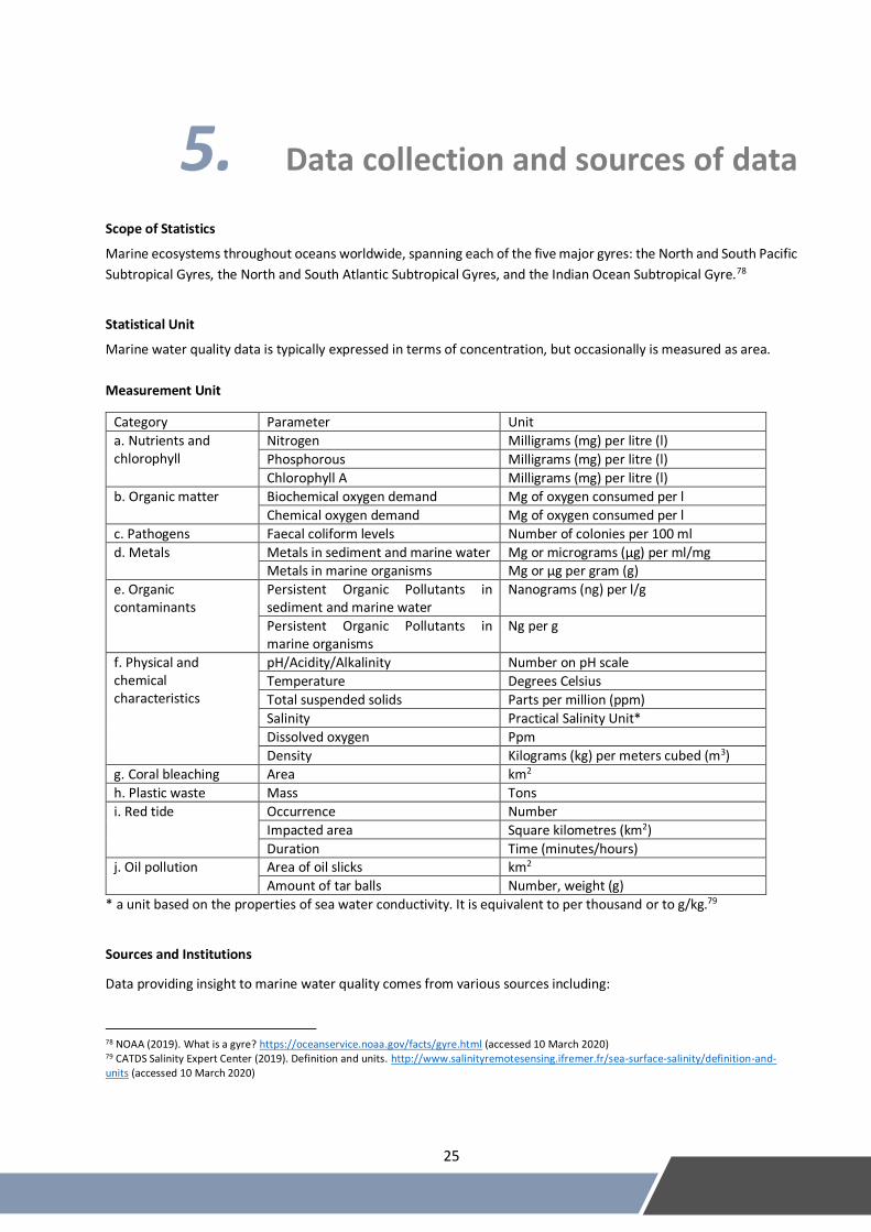
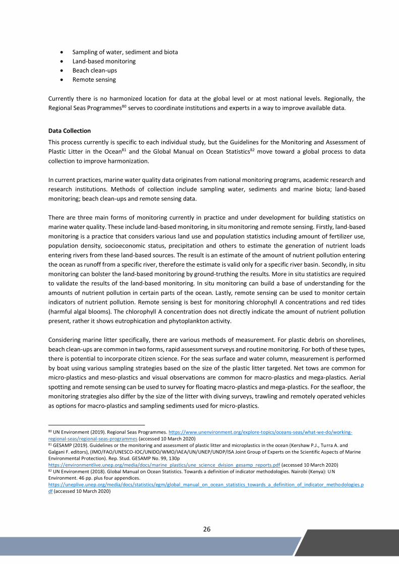
Often visual representation of marine water quality is shown with maps. Examples include maps of beach clean-ups,
maps showing the movement of marine plastic litter, maps showing coastal eutrophication and pollution hotspots on
maps.
Figure 6.1 Worldwide Beach Clean-ups
Source: TIDES, https://www.coastalcleanupdata.org/ Figure 6.2 PCBs in Plastic Pellets
Source: International Pellet Watch, http://www.pelletwatch.org/maps/map-1.html
29
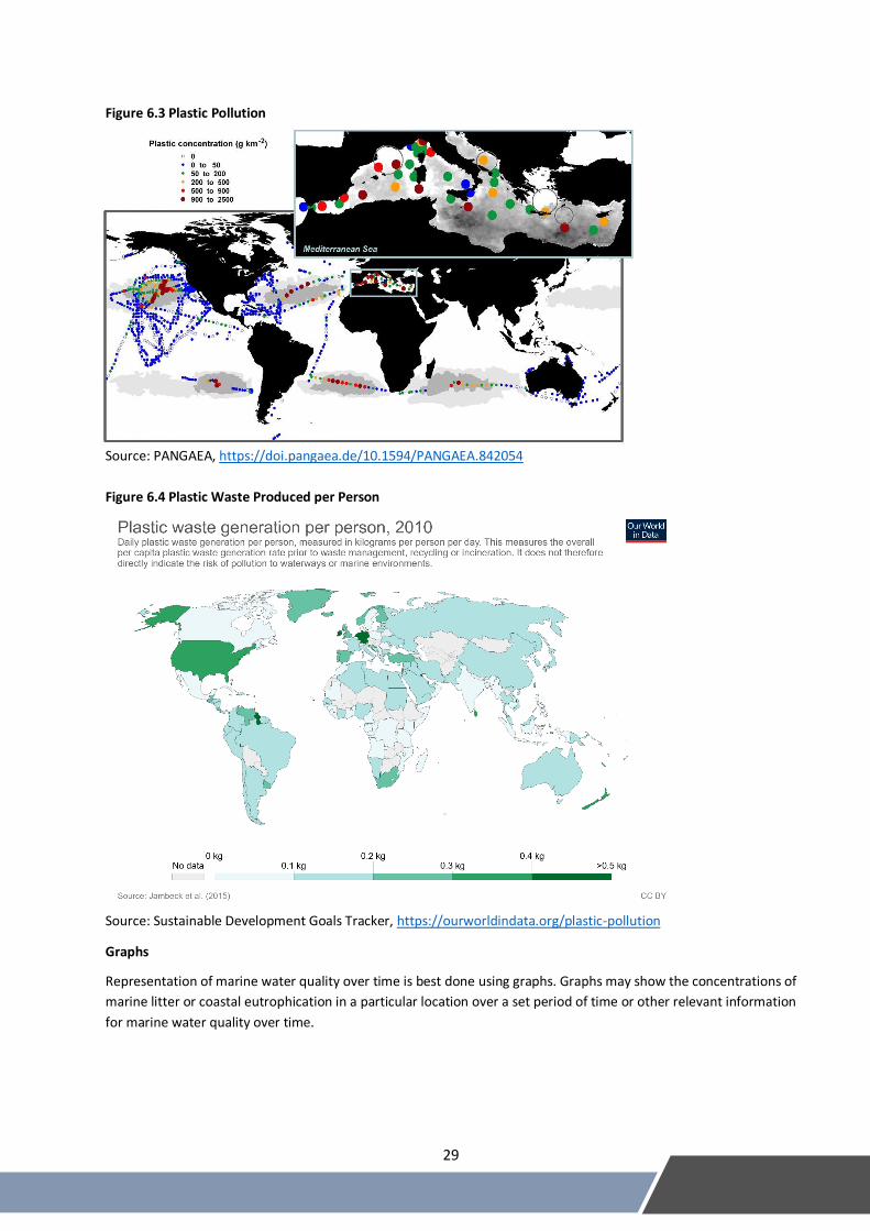
Figure 6.3 Plastic Pollution
Source: PANGAEA, https://doi.pangaea.de/10.1594/PANGAEA.842054
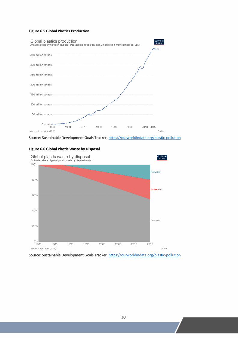
Figure 6.4 Plastic Waste Produced per Person
Source: Sustainable Development Goals Tracker, https://ourworldindata.org/plastic-pollution
Graphs
Representation of marine water quality over time is best done using graphs. Graphs may show the concentrations of
marine litter or coastal eutrophication in a particular location over a set period of time or other relevant information
for marine water quality over time.
30
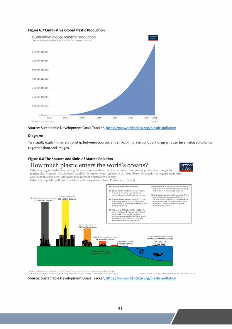
Figure 6.5 Global Plastics Production
Source: Sustainable Development Goals Tracker, https://ourworldindata.org/plastic-pollution
Figure 6.6 Global Plastic Waste by Disposal
Source: Sustainable Development Goals Tracker, https://ourworldindata.org/plastic-pollution
31
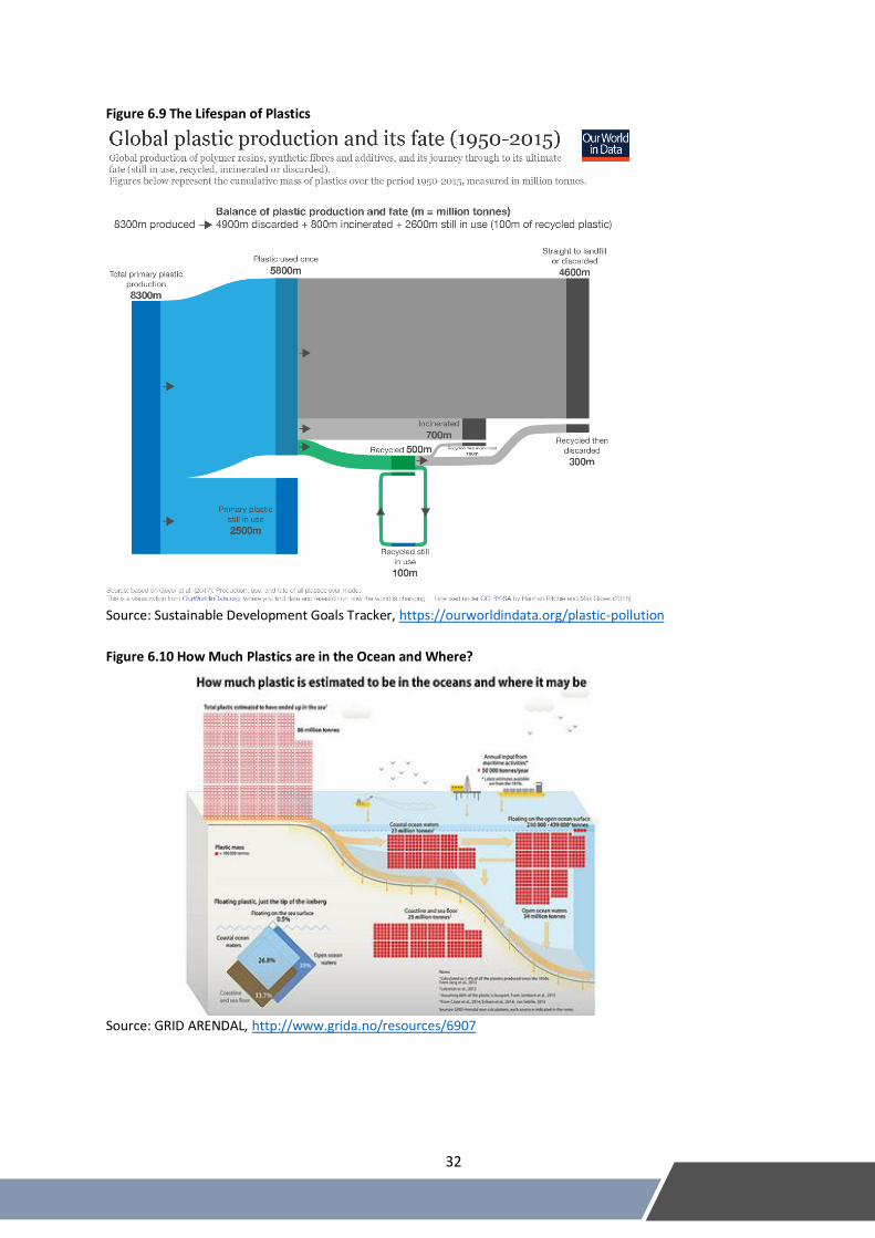
Figure 6.7 Cumulative Global Plastic Production
Source: Sustainable Development Goals Tracker, https://ourworldindata.org/plastic-pollution
Diagrams
To visually explain the relationship between sources and sinks of marine pollution, diagrams can be employed to bring
together data and images.
Figure 6.8 The Sources and Sinks of Marine Pollution
Source: Sustainable Development Goals Tracker, https://ourworldindata.org/plastic-pollution
32
Figure 6.9 The Lifespan of Plastics
Source: Sustainable Development Goals Tracker, https://ourworldindata.org/plastic-pollution
Figure 6.10 How Much Plastics are in the Ocean and Where?
Source: GRID ARENDAL, http://www.grida.no/resources/6907
33
6B. SEEA accounts/tables that use these statistics
SEEA Central Framework83 includes ‘Water emissions account’ in which several of the above definitions are listed,
e.g., BOD/COD, Suspended solids, Nitrogen and Phosphorus and which trace their movements through economic
sectors to the environment (in this case – the ocean). SEEA Experimental Ecosystem Accounting84 includes a water
quality aspect in the condition account (with opening and closing condition), where coastal and marine ecosystems
are introduced as specific types.
6C. Commonly used indicators that incorporate these statistics
Statistics on bathing water quality are routinely produced, for example by UK’s DEFRA.85 Examples of many other
topics, such as heavy metals, chlorophyll A, total nitrogen and phosphorus etc., can be accessed on the Marine
Information System for Europe.86
Regional Seas indicators:87
1. Chlorophyll A concentration as an indicator of phytoplankton biomass
2. Trends for selected priority chemicals including POPs and heavy metals
3. Quantification and classification of beach litter items
4. Annual mean sea surface temperature (25 m below the surface)
5. Fish catches within EEZs (tonnes) – total capture production
6. Application of risk assessment to account for pollution and biodiversity impacts
7. Destruction of habitat due to aquaculture
8. Length of coastal modification and km2 of coastal reclamation
9. Locations and frequency of algal blooms reported
10. Concentration status of selected pollutant contamination in biota and sediments and temporal
trends and number of hotspots (for targeting pollution hotspots)
11. Aragonite saturation, pH and alkalinity (for ocean acidification)
12. FAO stock status: % stocks overfished compared to MSY
13. Marine trophic index
14. Distribution of Red List Index species
15. Trends in critical habitat extent and condition
16. % national action plans ratified/operational
17. % coastal urban population connected to sewage facilities, % of waste water facilities complying
with adequate standards, % of untreated waste water
18. % port waste reception facilities available, incentives to reduce land-based sources, amount of
recycled waste on land (%)
19. % national adaptation plans in place, sector based national adaptation plans
83 United Nations, European Commission, Food and Agriculture Organization of the United Nations, International Monetary Fund, Organisation for Economic Co-operation and Development and World Bank (2014) System of Environmental-Economic Accounting 2012: Central Framework. Studies in Methods, Series F, No. 109. Sales No. 12.XVII.12, https://unstats.un.org/unsd/envaccounting/seeaRev/SEEA_CF_Final_en.pdf (accessed 10 March 2020) 84 UNSD, et al. (2017). SEEA Experimental Ecosystem Accounting: https://seea.un.org/sites/seea.un.org/files/seea_eea_final_en_1.pdf (accessed 10 March 2020) 85 Bathing water quality statistics: https://www.gov.uk/government/statistics/bathing-water-quality-statistics (accessed 10 March 2020) 86 Marine Information System for Europe https://water.europa.eu/marine/data/indicator-catalogue (accessed 10 March 2020) 87 UN Environment (2016). Regional Seas Core Indicators Set. https://wedocs.unep.org/bitstream/handle/20.500.11822/11078/wbrs18_inf9_rs_indicators.pdf?sequence=1&%3BisAllowed= (accessed 10 March 2020)
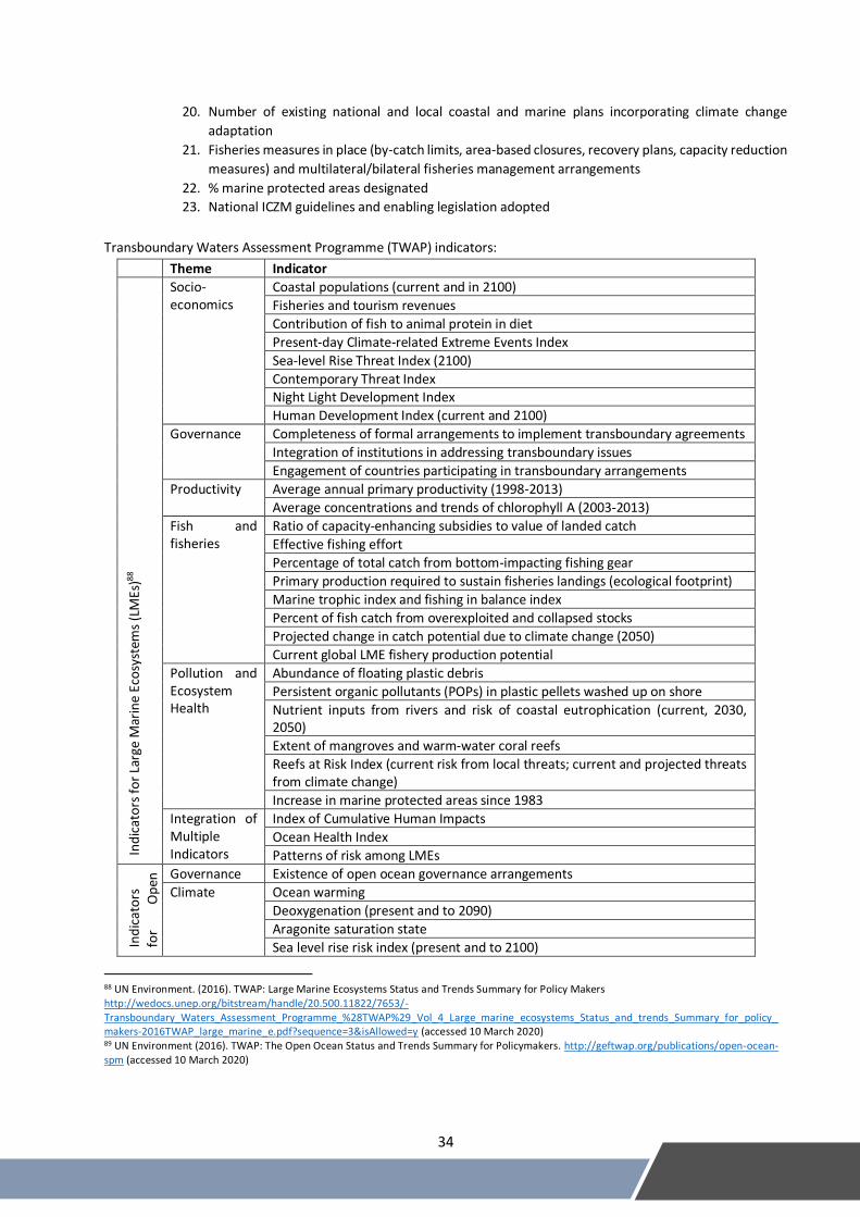
34
20. Number of existing national and local coastal and marine plans incorporating climate change
adaptation
21. Fisheries measures in place (by-catch limits, area-based closures, recovery plans, capacity reduction
measures) and multilateral/bilateral fisheries management arrangements
22. % marine protected areas designated
23. National ICZM guidelines and enabling legislation adopted
Transboundary Waters Assessment Programme (TWAP) indicators:
Theme Indicator
Ind
icat
ors
fo
r La
rge
Mar
ine
Eco
syst
ems
(LM
Es)
88
Socio-economics
Coastal populations (current and in 2100)
Fisheries and tourism revenues
Contribution of fish to animal protein in diet
Present-day Climate-related Extreme Events Index
Sea-level Rise Threat Index (2100)
Contemporary Threat Index Night Light Development Index
Human Development Index (current and 2100)
Governance Completeness of formal arrangements to implement transboundary agreements
Integration of institutions in addressing transboundary issues
Engagement of countries participating in transboundary arrangements
Productivity Average annual primary productivity (1998-2013)
Average concentrations and trends of chlorophyll A (2003-2013)
Fish and fisheries
Ratio of capacity-enhancing subsidies to value of landed catch
Effective fishing effort
Percentage of total catch from bottom-impacting fishing gear
Primary production required to sustain fisheries landings (ecological footprint)
Marine trophic index and fishing in balance index
Percent of fish catch from overexploited and collapsed stocks
Projected change in catch potential due to climate change (2050)
Current global LME fishery production potential
Pollution and Ecosystem Health
Abundance of floating plastic debris
Persistent organic pollutants (POPs) in plastic pellets washed up on shore
Nutrient inputs from rivers and risk of coastal eutrophication (current, 2030, 2050)
Extent of mangroves and warm-water coral reefs
Reefs at Risk Index (current risk from local threats; current and projected threats from climate change)
Increase in marine protected areas since 1983
Integration of Multiple Indicators
Index of Cumulative Human Impacts
Ocean Health Index
Patterns of risk among LMEs
Ind
icat
ors
fo
r O
pen
O
cean
89
Governance Existence of open ocean governance arrangements
Climate Ocean warming
Deoxygenation (present and to 2090)
Aragonite saturation state
Sea level rise risk index (present and to 2100)
88 UN Environment. (2016). TWAP: Large Marine Ecosystems Status and Trends Summary for Policy Makers http://wedocs.unep.org/bitstream/handle/20.500.11822/7653/-Transboundary_Waters_Assessment_Programme_%28TWAP%29_Vol_4_Large_marine_ecosystems_Status_and_trends_Summary_for_policy_makers-2016TWAP_large_marine_e.pdf?sequence=3&isAllowed=y (accessed 10 March 2020) 89 UN Environment (2016). TWAP: The Open Ocean Status and Trends Summary for Policymakers. http://geftwap.org/publications/open-ocean-spm (accessed 10 March 2020)
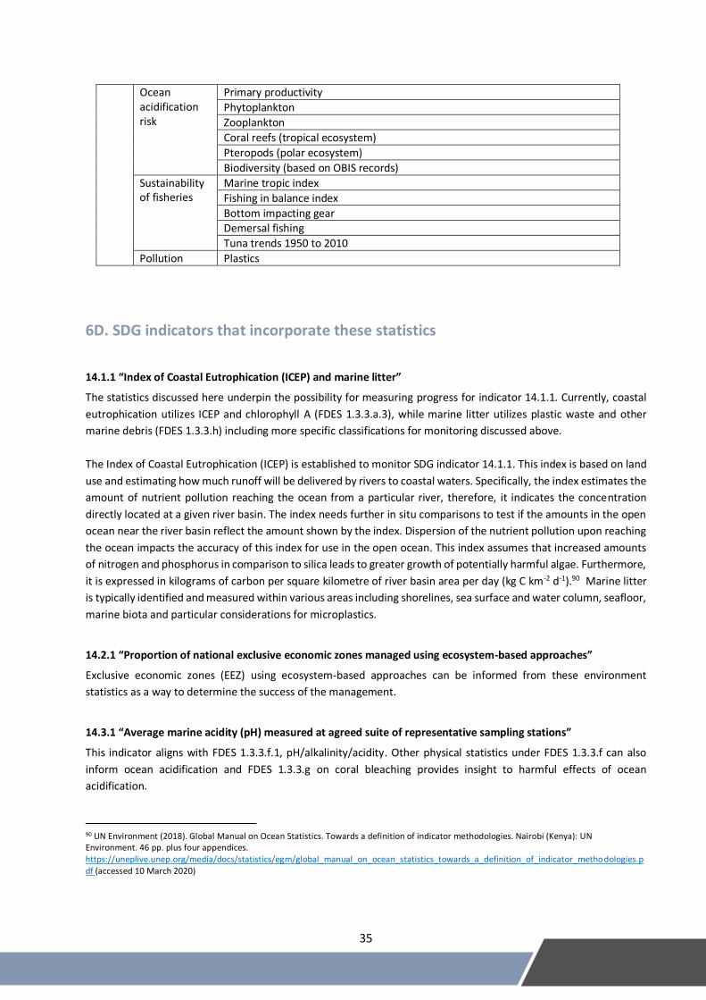
35
Ocean acidification risk
Primary productivity
Phytoplankton
Zooplankton
Coral reefs (tropical ecosystem)
Pteropods (polar ecosystem)
Biodiversity (based on OBIS records)
Sustainability of fisheries
Marine tropic index
Fishing in balance index
Bottom impacting gear Demersal fishing
Tuna trends 1950 to 2010
Pollution Plastics
6D. SDG indicators that incorporate these statistics
14.1.1 “Index of Coastal Eutrophication (ICEP) and marine litter”
The statistics discussed here underpin the possibility for measuring progress for indicator 14.1.1. Currently, coastal
eutrophication utilizes ICEP and chlorophyll A (FDES 1.3.3.a.3), while marine litter utilizes plastic waste and other
marine debris (FDES 1.3.3.h) including more specific classifications for monitoring discussed above.
The Index of Coastal Eutrophication (ICEP) is established to monitor SDG indicator 14.1.1. This index is based on land
use and estimating how much runoff will be delivered by rivers to coastal waters. Specifically, the index estimates the
amount of nutrient pollution reaching the ocean from a particular river, therefore, it indicates the concentration
directly located at a given river basin. The index needs further in situ comparisons to test if the amounts in the open
ocean near the river basin reflect the amount shown by the index. Dispersion of the nutrient pollution upon reaching
the ocean impacts the accuracy of this index for use in the open ocean. This index assumes that increased amounts
of nitrogen and phosphorus in comparison to silica leads to greater growth of potentially harmful algae. Furthermore,
it is expressed in kilograms of carbon per square kilometre of river basin area per day (kg C km-2 d-1).90 Marine litter
is typically identified and measured within various areas including shorelines, sea surface and water column, seafloor,
marine biota and particular considerations for microplastics.
14.2.1 “Proportion of national exclusive economic zones managed using ecosystem-based approaches”
Exclusive economic zones (EEZ) using ecosystem-based approaches can be informed from these environment
statistics as a way to determine the success of the management.
14.3.1 “Average marine acidity (pH) measured at agreed suite of representative sampling stations”
This indicator aligns with FDES 1.3.3.f.1, pH/alkalinity/acidity. Other physical statistics under FDES 1.3.3.f can also
inform ocean acidification and FDES 1.3.3.g on coral bleaching provides insight to harmful effects of ocean
acidification.
90 UN Environment (2018). Global Manual on Ocean Statistics. Towards a definition of indicator methodologies. Nairobi (Kenya): UN Environment. 46 pp. plus four appendices. https://uneplive.unep.org/media/docs/statistics/egm/global_manual_on_ocean_statistics_towards_a_definition_of_indicator_methodologies.pdf (accessed 10 March 2020)
36
14.4.1 “Proportion of fish stocks within biologically sustainable levels”
Physical characteristics under FDES 1.3.3.f can inform the liveability of ocean habitats and therefore can provide
information for the viability of fish stocks. Furthermore, all the statistics, but in particular, FDES 1.3.3.a on nutrients,
FDES 1.3.3.i on red tides and FDES 1.3.3.j on oil pollution can build knowledge toward the viability of fish stocks.
14.5.1 “Coverage of protected areas in relation to marine areas.”
The environment statistics can serve to identify hotspots or problem areas that need to be prioritized as a protected
area.
37
F D E S
Manual on the Basic Set of Environment Statistics
2020