Embed Size (px)
Citation preview
SOUTH WESTERN RIVER BASIN DISTRICT
MARINE MORPHOLOGY
NATIONAL METHODOLOGY REPORT
South Western River Basin District Project Office
5 Eastgate Avenue
Little Island
Cork
Job Nr: B1537400 June 2008
South Western River Basin District Marine Morphology Programme of Measures Study south
western i
Revision Control Table
User is Responsible for Checking the Revision Status of this Document
J McKenna
Rev
A
B
J McKenna
No part of this document may be re-produced or transmitted in any form or stored in
any retrieval system of any nature, without the written permission of SWRBD Project
m c e , as Copyright Holder, except as agreed for use on this specific project.
Date
April 2008
June 2008
Description of Changes
NIA - First Issue
Updated following Marine Morphology Steering Group Review and Approval
Signed:
For & On Behalf of SWRBD Project Office
Prepared BY
K Garry
J Massey
J Barlow
K Garry
-
Checked by
C Farrell
C Farrell
Approved by
South Western River Basin District Marine Morphology Programme of Measures Study
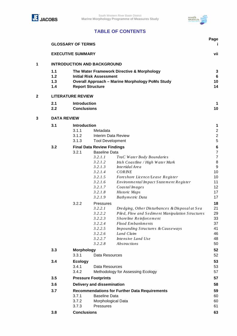
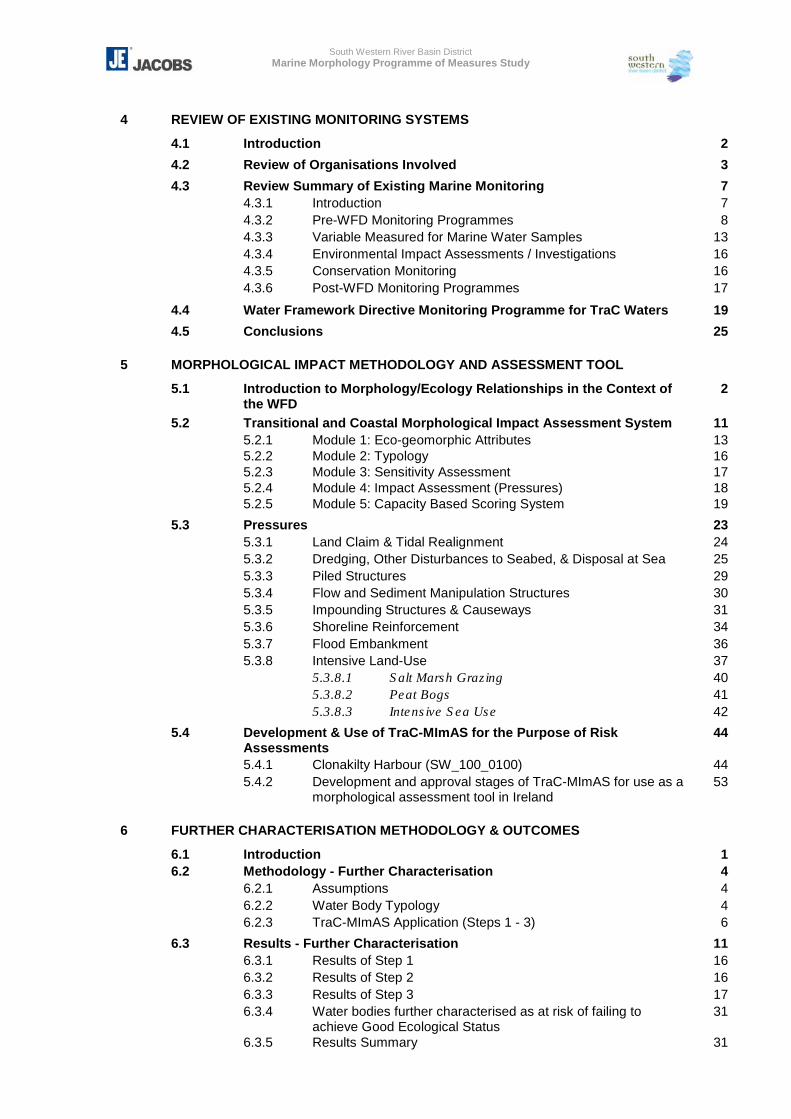
TABLE OF CONTENTS Page GLOSSARY OF TERMS i EXECUTIVE SUMMARY vii 1 INTRODUCTION AND BACKGROUND
1.1 The Water Framework Directive & Morphology 3 1.2 Initial Risk Assessment 6 1.3 Overall Approach – Marine Morphology PoMs Study 10 1.4 Report Structure 14 2 LITERATURE REVIEW
2.1 Introduction 1 2.2 Conclusions 10 3 DATA REVIEW
3.1 Introduction 1 3.1.1 Metadata 2 3.1.2 Interim Data Review 2 3.1.3 Tool Development 5
3.2 Final Data Review Findings 6 3.2.1 Baseline Data 7 3.2.1.1 TraC Water Body Boundaries 7 3.2.1.2 Irish Coastline / High Water Mark 8 3.2.1.3 Intertidal Area 9 3.2.1.4 CORINE 10 3.2.1.5 Foreshore Licence/Lease Register 10 3.2.1.6 Environmental Impact Statement Register 11 3.2.1.7 Coastal Images 12 3.2.1.8 Historic Maps 17 3.2.1.9 Bathymetric Data 17
3.2.2 Pressures 18 3.2.2.1 Dredging, Other Disturbances & Disposal at Sea 21 3.2.2.2 Piled, Flow and Sediment Manipulation Structures 29 3.2.2.3 Shoreline Reinforcement 33 3.2.2.4 Flood Embankments 37 3.2.2.5 Impounding Structures & Causeways 41 3.2.2.6 Land Claim 46 3.2.2.7 Intensive Land Use 48 3.2.2.8 Abstractions 50
3.3 Morphology 52 3.3.1 Data Resources 52
3.4 Ecology 53 3.4.1 Data Resources 53 3.4.2 Methodology for Assessing Ecology 57
3.5 Pressure Footprints 57
3.6 Delivery and dissemination 58
3.7 Recommendations for Further Data Requirements 59 3.7.1 Baseline Data 60 3.7.2 Morphological Data 60 3.7.3 Pressures 61
3.8 Conclusions 63
South Western River Basin District Marine Morphology Programme of Measures Study
4 REVIEW OF EXISTING MONITORING SYSTEMS
4.1 Introduction 2
4.2 Review of Organisations Involved 3
4.3 Review Summary of Existing Marine Monitoring 7 4.3.1 Introduction 7 4.3.2 Pre-WFD Monitoring Programmes 8 4.3.3 Variable Measured for Marine Water Samples 13 4.3.4 Environmental Impact Assessments / Investigations 16 4.3.5 Conservation Monitoring 16 4.3.6 Post-WFD Monitoring Programmes 17
4.4 Water Framework Directive Monitoring Programme for TraC Waters 19
4.5 Conclusions 25 5 MORPHOLOGICAL IMPACT METHODOLOGY AND ASSESSMENT TOOL
5.1 Introduction to Morphology/Ecology Relationships in the Context of the WFD
2
5.2 Transitional and Coastal Morphological Impact Assessment System 11 5.2.1 Module 1: Eco-geomorphic Attributes 13 5.2.2 Module 2: Typology 16 5.2.3 Module 3: Sensitivity Assessment 17 5.2.4 Module 4: Impact Assessment (Pressures) 18 5.2.5 Module 5: Capacity Based Scoring System 19
5.3 Pressures 23 5.3.1 Land Claim & Tidal Realignment 24 5.3.2 Dredging, Other Disturbances to Seabed, & Disposal at Sea 25 5.3.3 Piled Structures 29 5.3.4 Flow and Sediment Manipulation Structures 30 5.3.5 Impounding Structures & Causeways 31 5.3.6 Shoreline Reinforcement 34 5.3.7 Flood Embankment 36 5.3.8 Intensive Land-Use 37 5.3.8.1 Salt Marsh Grazing 40 5.3.8.2 Peat Bogs 41 5.3.8.3 Intensive Sea Use 42
5.4 Development & Use of TraC-MImAS for the Purpose of Risk Assessments
44
5.4.1 Clonakilty Harbour (SW_100_0100) 44 5.4.2 Development and approval stages of TraC-MImAS for use as a
morphological assessment tool in Ireland 53
6 FURTHER CHARACTERISATION METHODOLOGY & OUTCOMES
6.1 Introduction 1 6.2 Methodology - Further Characterisation 4 6.2.1 Assumptions 4 6.2.2 Water Body Typology 4 6.2.3 TraC-MImAS Application (Steps 1 - 3) 6
6.3 Results - Further Characterisation 11 6.3.1 Results of Step 1 16 6.3.2 Results of Step 2 16 6.3.3 Results of Step 3 17 6.3.4 Water bodies further characterised as at risk of failing to
achieve Good Ecological Status 31
6.3.5 Results Summary 31
South Western River Basin District Marine Morphology Programme of Measures Study
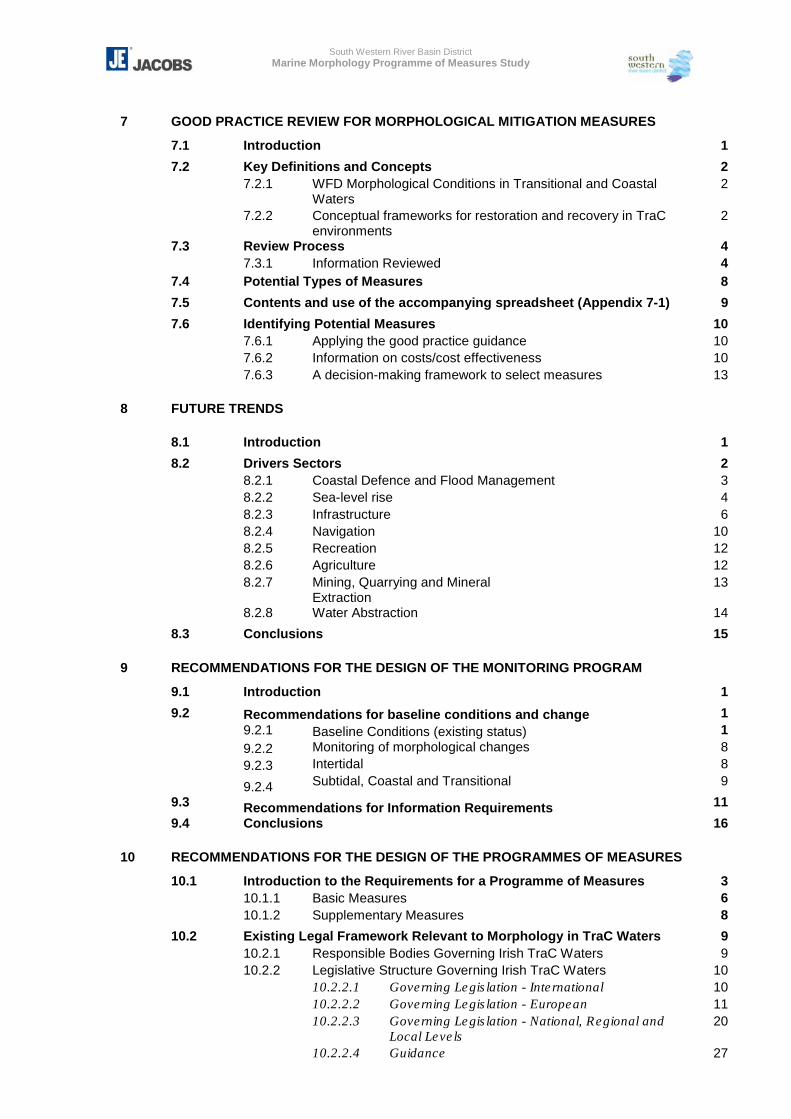
7 GOOD PRACTICE REVIEW FOR MORPHOLOGICAL MITIGATION MEASURES
7.1 Introduction 1
7.2 Key Definitions and Concepts 2 7.2.1 WFD Morphological Conditions in Transitional and Coastal
Waters 2
7.2.2 Conceptual frameworks for restoration and recovery in TraC environments
2
7.3 Review Process 4 7.3.1 Information Reviewed 4 7.4 Potential Types of Measures 8
7.5 Contents and use of the accompanying spreadsheet (Appendix 7-1) 9
7.6 Identifying Potential Measures 10 7.6.1 Applying the good practice guidance 10 7.6.2 Information on costs/cost effectiveness 10 7.6.3 A decision-making framework to select measures 13 8 FUTURE TRENDS
8.1 Introduction 1
8.2 Drivers Sectors 2 8.2.1 Coastal Defence and Flood Management 3 8.2.2 Sea-level rise 4 8.2.3 Infrastructure 6 8.2.4 Navigation 10 8.2.5 Recreation 12 8.2.6 Agriculture 12 8.2.7 Mining, Quarrying and Mineral
Extraction 13
8.2.8 Water Abstraction 14
8.3 Conclusions 15 9 RECOMMENDATIONS FOR THE DESIGN OF THE MONITORING PROGRAM
9.1 Introduction 1
9.2 Recommendations for baseline conditions and change 1 9.2.1 Baseline Conditions (existing status) 1 9.2.2 Monitoring of morphological changes 8 9.2.3 Intertidal 8 9.2.4 Subtidal, Coastal and Transitional 9
9.3 Recommendations for Information Requirements 11
9.4 Conclusions 16 10 RECOMMENDATIONS FOR THE DESIGN OF THE PROGRAMMES OF MEASURES
10.1 Introduction to the Requirements for a Programme of Measures 3 10.1.1 Basic Measures 6 10.1.2 Supplementary Measures 8
10.2 Existing Legal Framework Relevant to Morphology in TraC Waters 9 10.2.1 Responsible Bodies Governing Irish TraC Waters 9 10.2.2 Legislative Structure Governing Irish TraC Waters 10 10.2.2.1 Governing Legislation - International 10 10.2.2.2 Governing Legislation - European 11 10.2.2.3 Governing Legislation - National, Regional and
Local Levels 20
10.2.2.4 Guidance 27
South Western River Basin District Marine Morphology Programme of Measures Study
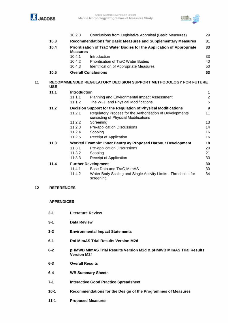
10.2.3 Conclusions from Legislative Appraisal (Basic Measures) 29
10.3 Recommendations for Basic Measures and Supplementary Measures 31
10.4 Prioritisation of TraC Water Bodies for the Application of Appropriate Measures
33
10.4.1 Introduction 33 10.4.2 Prioritisation of TraC Water Bodies 40 10.4.3 Identification of Appropriate Measures 50
10.5 Overall Conclusions 63 11 RECOMMMENDED REGULATORY DECISION SUPPORT METHODOLOGY FOR FUTURE
USE 11.1 Introduction 1 11.1.1 Planning and Environmental Impact Assessment 2 11.1.2 The WFD and Physical Modifications 5
11.2 Decision Support for the Regulation of Physical Modifications 9 11.2.1 Regulatory Process for the Authorisation of Developments
consisting of Physical Modifications 11
11.2.2 Screening 13 11.2.3 Pre-application Discussions 14 11.2.4 Scoping 16 11.2.5 Receipt of Application 16
11.3 Worked Example: Inner Bantry ay Proposed Harbour Development 18 11.3.1 Pre-application Discussions 20 11.3.2 Scoping 21 11.3.3 Receipt of Application 30
11.4 Further Development 30 11.4.1 Base Data and TraC-MImAS 30 11.4.2 Water Body Scaling and Single Activity Limits - Thresholds for
screening 34
12 REFERENCES
APPENDICES
2-1 Literature Review 3-1 Data Review 3-2 Environmental Impact Statements 6-1 RoI MImAS Trial Results Version M2d 6-2 pHMWB MImAS Trial Results Version M2d & pHMWB MImAS Trial Results
Version M2f 6-3 Overall Results 6-4 WB Summary Sheets 7-1 Interactive Good Practice Spreadsheet 10-1 Recommendations for the Design of the Programmes of Measures 11-1 Proposed Measures
South Western River Basin District Marine Morphology Programme of Measures Study
Glossary i June 2008
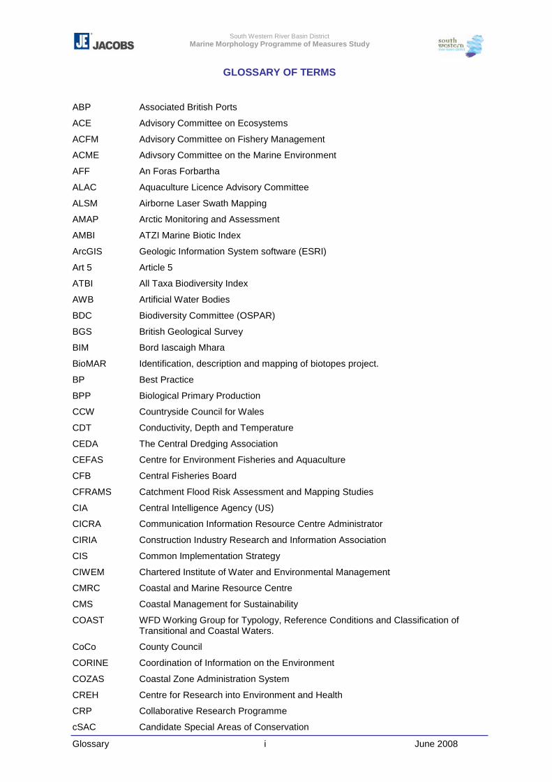
GLOSSARY OF TERMS
ABP Associated British Ports
ACE Advisory Committee on Ecosystems
ACFM Advisory Committee on Fishery Management
ACME Adivsory Committee on the Marine Environment
AFF An Foras Forbartha
ALAC Aquaculture Licence Advisory Committee
ALSM Airborne Laser Swath Mapping
AMAP Arctic Monitoring and Assessment
AMBI ATZI Marine Biotic Index
ArcGIS Geologic Information System software (ESRI)
Art 5 Article 5
ATBI All Taxa Biodiversity Index
AWB Artificial Water Bodies
BDC Biodiversity Committee (OSPAR)
BGS British Geological Survey
BIM Bord Iascaigh Mhara
BioMAR Identification, description and mapping of biotopes project.
BP Best Practice
BPP Biological Primary Production
CCW Countryside Council for Wales
CDT Conductivity, Depth and Temperature
CEDA The Central Dredging Association
CEFAS Centre for Environment Fisheries and Aquaculture
CFB Central Fisheries Board
CFRAMS Catchment Flood Risk Assessment and Mapping Studies
CIA Central Intelligence Agency (US)
CICRA Communication Information Resource Centre Administrator
CIRIA Construction Industry Research and Information Association
CIS Common Implementation Strategy
CIWEM Chartered Institute of Water and Environmental Management
CMRC Coastal and Marine Resource Centre
CMS Coastal Management for Sustainability
COAST WFD Working Group for Typology, Reference Conditions and Classification of Transitional and Coastal Waters.
CoCo County Council
CORINE Coordination of Information on the Environment
COZAS Coastal Zone Administration System
CREH Centre for Research into Environment and Health
CRP Collaborative Research Programme
cSAC Candidate Special Areas of Conservation
South Western River Basin District Marine Morphology Programme of Measures Study
Glossary ii June 2008
CSO Central Statistics Office
DAFF Department of Agriculture, Fisheries and Food
DARD Department for Agriculture and Rural Development
DCENR Department of Communications, Energy and Natural Resources
DCMNR Department of Communications, Marine and Natural Resources
DEFRA Department for Environment, Food and Rural Affairs
DEHLG Department of Environment, Heritage and Local Government
DoM Department of Marine
DoT Department of Transport
DPSIR Driver, Pressure, State, Impact, Response
EA Environment Agency
EC European Commission
EcoServe Ecological Consultancy Services Ltd
EEA European Environment Agency
EEZ European Economic Zone
EHS Environment Heritage Service (NI)
EIA Environmental Impact Assessment
EIHA Working Group (OSPAR) on the Environmental Impact of Human Activities
EIS Environmental Impact Statement
ENFO Information on the Environment
EMS Environmental Management System
EPA Environmental Protection Agency
EQS Environmental Quality Standards
ERBD Eastern River Basin District
ERDF European Regional Development Fund
ERI Environmental Research Institute
ERU Environmental Research Unit
ESB Electricity Supply Board
ESPO European Sea Ports Organisation
ESRI Environmental Systems Research Institute, Inc
EU European Union
EU INTERREG EU funded programme that helps Europe’s regions form partnerships to work together on common projects.
EUNIS European Nature Information Centre
EUROSION European study into coastal erosion at a European scale
FAO Food and Agriculture Organisation (United Nations)
FCS Favourable Conservation Status
FRC Fisheries Research Centre
FTT Fish Task Team
FW Fresh water
GD Guidance Document
GEBCO General Bathymetric Chart of the Oceans
South Western River Basin District Marine Morphology Programme of Measures Study
Glossary iii June 2008
GEP Good Ecological Potential
GES Good Ecological Status
GIS Geographic Information System
GNP Gross National Productivity
GSI Geological Survey of Ireland
HabMap HABitat MAPping for conservation and management of the Southern Irish Sea
HELCOM Helsinki Commission
HES High Ecological Status
HGES High or Good Ecological Status
HMWB Heavily Modified Water Bodies
HWM High Water Mark
IADC International Association of Dredging Companies
IC WFD Impacts and Pressure Working Group
ICES International Committee for the Exploration of the Seas
ICZM Integrated Coastal Zone Management
IEC International Electrotechnical Commission
IFIS Integrated Fisheries Information System
IHO International Hydrographic Office
ILU Intensive Land Use
IM Investigative Monitoring
IMAGIN Irish Sea Marine Aggregates Initiative
IMDO Irish Maritime Development Office
IMPRESS WFD Impacts and Pressure Working Group
INFOMAR INtegrated mapping FOr the sustainable development of Ireland’s MArine Resource
INSPIRE Infrastructure for Spatial Information in the European Community, EU Directive 2007/2/EC
INSS Irish National Seafloor Survey
IOSEA Irish Offshore Strategic Environmental Assessment
IPCC Intergovernmental Panel on Climate Change
IPPC Integrated Pollution Prevention and Control
ISO International Standards Organisation
JMG Joint Monitoring Group (OSPAR)
JNCC Joint Nature Conservation Committee (UK)
LA Local Authority
LGCSB Local Government Computer Service Board
LiDAR Light Detection And Ranging
LNG Liquid Natural Gas
LWM Low Water Mark
MarLIN UK Marine Biological Association’s Marine Life Information Network
MASH Working Group (OSPAR) on Marine Protected Areas, Species and Habitats
MBA Marine Biological Association
MBITT Marine Benthic Invertebrate Task Team
South Western River Basin District Marine Morphology Programme of Measures Study
Glossary iv June 2008
MCLs Morphological Condition Limits
MEP Maximum Ecological Potential
MESH Marine Environmental Seabed Habitats
MI Marine Institute
MIDA Marine Irish Digital Atlas
MImAS Morphological Impact Assessment System
MLCs Morphological Condition Limits
MLVC Marine Licence Vetting Committee
MMDST Marine Morphology Decision Support Tool
MNCR Marine Nature Conservation Review
MTT Marine Task Team
NBIRBRD Neagh Bann International River Basin District
NBN National Biodiversity Network (UK)
NDP National Development Plan
NEMP National Environmental Monitoring Programme
NHA Natural Heritage Area
NI Northern Ireland
NIMA US National Imagery and Mapping Agency
NOAA National Oceanic and Atmospheric Administration
NPWS National Parks and Wildlife Service
NRA National Roads Authority
NSS National Spatial Strategy
NS-Share North-South Share
NWIRBD North Western International River Basin District
OECD The Organisation for Economic Co-operation and Development
OM Operational Monitoring
OPW Office of Public Works
OSi Ordnance Survey Ireland
OSPAR Oslo and Paris Convention
OSPARCOM Oslo and Paris Commissions
PAD Petroleum Affairs Division
PDF Portable Document Format
PIANC Permanent International Association of Navigation Congress
PIP Petroleum Information Programme
pNHA Proposed Natural Heritage Area
PoMS Programme of Measures and Standards
PoMs Programme of Measures
PPP Proposed Plans and Programmes
PRB Pilot River Basin
PROCLAN WFD Working Group for Best Practices in river basin planning
PTT Plant Task Team
RA Risk Assessment
South Western River Basin District Marine Morphology Programme of Measures Study
Glossary v June 2008
R & D Research and Development
RBD River Basin District
RBMP River Basin Management Plan
RBMS River Basin Management Strategy
REFCOND WFD Reference Conditions in inland waters working group
REPS Rural Environmental Protection Scheme
ROI Republic of Ireland
RPII Radiological Protection Institute of Ireland
PSPB Royal Society for the Protection of Birds
SAC Special Area of Conservation
SAHFOS Sir Alister Hardy Foundation for Oceanic Sciences
SBS Sea Bed Sediment
SDT Secchi disc transparency
SEA Strategic Environmental Assessment
SEABED Working Group (OSPAR) on the impact on the seabed
SensMap Sensitivity and mapping of inshore marine biotopes in the southern Irish Sea
SEPA Scottish Environmental Protection Agency
SERBD South Eastern River Basin District
SFPA Sea-Fisheries Protection Authority
SGSOBS Study Group on Ecological Quality Objectives for Sensitive and for Opportunities Benthos Species
ShIRBD Shannon International River Basin District
SIAM Synergies in Assessment and Monitoring
SM Surveillance Monitoring
SNH Scottish Natural Heritage
SnapMap Oblique coastal helicopter survey image viewer (DCENR)
SNIFFER Scotland and Northern Ireland Forum For Environmental Research
SPA Special Protection Area
SSSI Special Site of Scientific Interest
SWMI Significant Water Management Issues
SWRBD South Western River Basin District
TCD Trinity College Dublin
ToR Terms of Reference
TraC Transitional and Coastal
TraC-MImAS Transitional and Coastal Morphological Impact Assessment System
UCC University College Cork
UCD University College Dublin
UK United Kingdom
UKTAG United Kingdom Technical Advisory Group
UNCLOS United Nations Convention on Law Of the Sea
UNCSD United Nations Commission on Sustainable Development
UNESCO United Nations Educational. Scientific and Cultural Organisation
South Western River Basin District Marine Morphology Programme of Measures Study
Glossary vi June 2008
US United States of America
USGS United States Geological Survey
WASA Wave and Storm in the Northern Atlantic group
WATECO WFD Economic Analysis Working Group
WB Water Body
WFD Water Framework Directive
WG Working Group
WGICZM Working Group (ICES) on Integrated Coastal Zone Management
WGMDM Working Group (ICES) on Marine Data Management
WRBD Western River Basin District
XML Extensible Markup Language
South Western River Basin District Marine Morphology Programme of Measures Study
Executive Summary vii June 2008
EXECUTIVE SUMMARY
The Marine Morphology Programme of Measures and Standards (PoMS) Study aims to
provide a protocol to apply in the further characterisation and risk appraisal for morphology
in transitional and coastal (TraC) waters, the outcomes of which will contribute to the
development of a tool aimed at supporting the assessment and management of morphology
in these water bodies.
The objectives of the study are as follows:
� Establish the relationship between morphology characteristics and biological status;
� Identify what level of morphological pressure is sustainable within a water body;
� Establish which morphological indicators should be included in TraC monitoring
programmes;
� Identify water bodies where morphology restoration measures are required (linked to
HMWB designation process);
� Identify the available buffer (or capacity) of water bodies in order to prioritise action
levels;
� Prioritise morphology pressures; and
� Develop a decision support tool for regulators to assess the potential impact of future
developments on individual water bodies (i.e. to prioritise activities and establish a
tiered assessment system).
This study involves all 309 TraC water bodies within the Republic of Ireland (RoI), but was
undertaken in parallel to the North-South Share (NS-Share) project to ensure compatibility
of methodologies between Northern Ireland (NI) and the RoI.
The hydromorphological quality elements defined by Annex V of the WFD must be taken
into account when assigning surface water bodies to high ecological status. For other status
classes, the hydromorphological elements are required to have ‘conditions consistent with
the achievement of the values specified for the biological quality elements’ (WFD, Annex
V).
Member States are only required to report on hydromorphology for those water bodies
designated as ‘High Status’. For these water bodies it is assumed the European
Commission will require information on the normative definitions, for example the structure
of the water body’s intertidal zone indicates little or no human impacts. It is important to
note that the impact assessment tool used in this study can only indicate the likely risk to
the WFD quality elements; monitoring results are required to quantify these risks.
South Western River Basin District Marine Morphology Programme of Measures Study
Executive Summary viii June 2008
The initial risk assessments completed across Europe have shown that hydromorphology is
one of the most significant pressures operating in surface waters and therefore contributing
to the failure to achieve WFD objectives.
The Irish initial risk assessments completed in 2005 concluded that 35% of transitional
(estuarine) water bodies, and 18% of coastal water bodies within the RoI were ‘at risk’ or
‘probably at risk’ of failing to meet the WFD objective of ‘Good’ Status due to physical
alteration. The Marine Morphology Study further characterises these risks by researching
the relationship between morphology and ecology and further defining the pressures on
morphology.
Literature Review
An initial step in achieving the objectives of the Marine Morphology study was to undertake
a Literature Review. This review concluded that the most common, and in most cases
necessary, approach to assessing and reporting the impact of morphological pressures on
ecology involves a mixture of qualitative and quantitative assessments, and although it is
clear that many anthropogenic activities which result in pressures to morphology have
some impact on ecology there are limited quantitative data throughout Europe describing
the relationships between morphological conditions and ecological health.
The lack of sufficient criteria and thresholds available to assess the risk of a water body
failing to meet Good Status is being investigated by the UK-Ireland Marine Task Team.
However, the progression of this work in relation to morphology, at the time of writing has
yet to result in formal classification tools (criteria or thresholds).
The conclusions drawn by the Literature Review led to consideration of the Scottish
Environment Protection Agency’s (SEPA) Transitional and Coastal Morphological Impact
Assessment System (TraC-MImAS) for the purpose of further characterisation of TraC
morphological pressures and as a decision support tool for the future regulation of TraC
water bodies in the RoI.
Data Review
In preparation for the use of the TraC-MImAS tool, where possible, a series of national
marine morphology pressure datasets were created as shapefiles in a Geographic
Information System (GIS). Various restrictions associated with data licence agreements
were experienced throughout this process. This included the limited availability of
orthophotos, coverage of which was essential to the creation of new pressure footprints.
South Western River Basin District Marine Morphology Programme of Measures Study
Executive Summary ix June 2008
However, the data was developed to the best scale and detail possible given the limitations
experienced, to provide a comprehensive and consistent dataset for Ireland.
The confirmation of an ‘end user’ of such a tool was fundamental to the licence agreements
and data requests required for this study. However, notwithstanding support from the
Marine Morphology Steering Group an appropriate end user for this tool has not as yet
been identified. As a temporary alternative, to ensure the progress of this study, the
SWRBD, and Cork County Council, were identified as substitute end users. The SWRBD,
and Cork County Council, have no function to hold or use such a tool for the purpose of
regulation and are intended only as a temporary ‘end user’ until an appropriate assessment
or regulatory body is identified.
Existing Monitoring
A review of existing European and national monitoring programmes was undertaken with
the aim to determine if these programmes are of benefit to the assessment of
morphological conditions within TraC waters.
There are two main requirements for marine morphology data under the WFD
- to determine the ecological status of a water body, and
- to detect change that may affect this status.
In order to assess these requirements, a morphological baseline is needed and
investigative monitoring relating pressures to morphology must be collected. It is important
to note that changes in morphology can be triggered by natural changes in TraC waters
and this should be considered in the collection and interpretation of monitoring results.
Monitoring for both baseline and change of morphology is a difficult process. Natural
morphological change occurs over long periods and must therefore be monitored and
reported as time series data. The morphological quality elements prescribed by the WFD
have yet to be formally adopted within a classification system. The difficultly in classifying
these elements has been demonstrated by the ‘Metrics’ project initiated by UK and Ireland
Marine Task Team.
There are few national monitoring programmes specifically associated with morphological
conditions. Monitoring has predominately been aimed at water quality and associated with
the compliance of bathing and shellfish water legislation. In addition to this, protected areas
require monitoring of their biological and environmental quality; but this assessment is
generally infrequent and, with the exception of saltmarsh and benthic monitoring, is not of
particular relevance.
South Western River Basin District Marine Morphology Programme of Measures Study
Executive Summary x June 2008
Morphological Impact Assessment
The link between morphology and ecology is relatively well established in fluvial
environments. However, there is less documented information and scientific research
linking morphology to ecology in marine environments. In the context of the WFD, there is a
need to understand how changes in the morphological quality elements (resulting from
pressures) result in alteration to biological elements, causing them to be disturbed from the
reference condition and leading to deterioration in quality status. It is acknowledged that
there are currently gaps in understanding many of these linkages, particularly at the water
body scale. Future monitoring has the potential to increase understanding of these
relationships (together with physico-chemical elements).
Although a review of recent seabed mapping projects (MarLIN and SensMap), and
development of links between habitat and species in marine environments, show that there
are sound theoretical bases for assuming that changes to morphology brought about by
pressures will have resulting impacts on ecological and biological features, the absence of
suitably detailed baseline data to use these methods now for the WFD means that the first
round of river basin planning will need to rely on tools which focus on general links between
morphology and ecology.
In order to be able to estimate and report on the risk posed by morphological alterations to
the ecological status of TraC water bodies, morphological impact assessment tools were
investigated. Firstly the Marine Morphology study investigated the use of marine ‘Metrics’
which were being developed by the UK Environment Agency in association with the
Scotland and Northern Ireland Forum for Environmental Research (SNIFFER) as part of a
project to develop hydromorphological reference conditions and a draft classification
scheme for TraC waters. This project was focused on defining only high status and the
boundary between high/good, and emphasised that the biological classification scheme
should incorporate metrics that are sensitive to hydromorphological changes. The threshold
limits proposed by this study were largely based on expert judgement due to considerable
limitations in current understanding and availability of data.
In determining a suitable framework which could facilitate the development of
environmental standards for TraC waters within the time scales required of the first river
basin planning cycle, the UK Technical Advisory Group (UKTAG) reviewed both these
Metrics and the River Morphological Impact Assessment (MImAS) tool being applied in
Scotland. UKTAG concluded that the framework currently being developed for the Metrics
would require further development within a more structured framework to allow
environmental standards to be developed and approved. Following a request from UKTAG
South Western River Basin District Marine Morphology Programme of Measures Study
Executive Summary xi June 2008
to determine if the MImAS framework could be successfully adopted for TraC waters, it was
confirmed that the scientific principles underpinning MImAS were transferable to TraC
waters. Therefore work on a draft TraC-MImAS tool commenced.
Participation in the UKTAG TraC Morphology Steering Group and the TraC-MImAS
Technical Panel Ireland (RoI and Northern Ireland Marine Morphology PoMS teams)
supported the development of TraC-MImAS.
The TraC-MImAS tool was developed with the intention to help regulators determine
whether changes to the morphology of TraC waters could pose a risk to ecology, and
thereby identify those proposals that could:
� Threaten the aim of achieving ‘good ecological status’; or
� Result in a deterioration in ecological status
The TraC-MImAS tool is not intended to provide a detailed assessment of ecological status,
but rather provide a means of identifying where ecological conditions are likely to be
impaired through impacts to morphology, i.e. it is based on the assumption that an
assessment of impacts on ecologically relevant features and processes can be used to
protect morphology and ecology.
The tool uses a concept of ‘system capacity’ (allowable morphological change) to measure
impacts to morphological conditions, assuming that pristine TraC waters have a measure of
assimilative ‘capacity’, which can be degraded by anthropogenic activities. SEPA have
defined ‘system capacity’ as:
A measure of the ability of the water environment to absorb morphological alterations. The
likelihood (or risk) that morphological and ecological conditions are degraded will increase
as system capacity is consumed. This concept does not infer that degradation of the
environment is acceptable; rather it assumes that there is a degree to which minor
changes can be tolerated by the system.
TraC-MImAS is underpinned by a series of assumptions:
1 A TraC water body has some capacity to accommodate morphological change without
changes to its ecological status.
2 There is a relationship between the extent of morphological alteration and the impact
on ecological status.
3 The response of a water body’s morphology to an engineering activity or other
pressure is predictable for that type of water body.
South Western River Basin District Marine Morphology Programme of Measures Study
Executive Summary xii June 2008
4 The response of the ecology to morphological change is predictable and depends on
the sensitivity of the ecology of the water body.
TraC-MImAS comprises 5 modules which combine to estimate the existing system capacity
of a water body as a percentage.
Module 1: Eco-geomorphic attributes
Module 2: Typology
Module 3: Sensitivity assessment
Module 4: Impact assessment
Module 5: Capacity based scoring system
Each module can be updated independently thereby facilitating future development of this
tool.
The eco-geomorphic attributes of Module 1 were chosen for their role in the direct or
indirect support of ecological communities and the supporting processes needed to create
and maintain the physical environment on which ecological communities depend and
relevance to the morphological quality elements specified by Annex V of the WFD.
The function of TraC-MImAS is heavily reliant on the typology of water bodies, a point
which was highlighted by the UK and Ireland Marine Task Team. It was agreed that the
function of this tool would benefit greatly from the further improvement of this module
(through further field assessments).
The sensitivity considered by Module 3 combines both the estimated morphological and
ecological sensitivity of each TraC water body type. It is based on the likelihood that an
eco-geomorphic attribute and its supported ecology will change in response to an applied
pressure.
Module 4 forms a distinction between the intensity and extent of the likely impact of a
pressure but indicating the likelihood that a pressure will impact an eco-geomorphic
attribute, and whether these impacts are likely to be contained within the vicinity of a
pressure footprint or be pervasive.
In the absence of Environmental Standards for morphology, TraC-MImAS uses
Morphological Condition Limits (MCLs) to help quantify the potential risk that a new
morphological alteration could impair achievement of the ecological objectives of the WFD.
SEPA define the MCLs as “thresholds of alteration to morphological conditions beyond
South Western River Basin District Marine Morphology Programme of Measures Study
Executive Summary xiii June 2008
which there is a risk that the ecological status objectives of the WFD could be threatened”.
MCLs are expressed in terms of % capacity of a water body, and are defined for 3 TraC
zones: Hydrodynamic; Intertidal; and Subtidal.
As with the thresholds investigated as part of the marine ‘Metrics’ study, the MCLs were
largely based on expert judgement due to considerable limitations in current understanding
and availability of data.
The UK and Ireland Marine Task Team agreed the following points in relation to the use of
TraC-MImAS:
� The group was comfortable that the principles and approach underpinning TraC-MImAS
are logical and reasonable.
� TraC-MImAS is suitable to support the three purposes defined by SEPA:
- Regulatory risk assessments.
- Identification of high status conditions for morphology.
- Contribute to surrogate classification assessments for the other ecological status
boundaries (but not to be used in isolation).
� The condition limits proposed are set at an acceptable level for incorporation into the
UKTAG Environmental Standards report; however, these values should be reviewed
and refined where possible.
The further development of the typology module of this tool was a key recommendation.
With regard to the further development of the MCLs, further field assessments including
investigative monitoring are required to refine the association between these values and
morphological and ecological status class.
Working with SEPA, TraC-MImAS trials were undertaken in Ireland to assist in its
development process. The purpose of the trials was to test the appropriateness of the
MCLs and the also the framework within which MImAS may be applied to support
regulation.
TraC-MImAS was updated on completion of both these trials and an external technical
review undertaken by Anton Edwards of Metoc Environmental Consultants.
TraC-MImAS expresses the risk of a water body failing WFD objectives by indicating the
potential ecological status class that may be achieved based on the water body type and
pressure extents identified. For example, a result of ‘Good’ indicates that this water body is
potentially at risk of failing to achieve high morphological status and in turn high ecological
South Western River Basin District Marine Morphology Programme of Measures Study
Executive Summary xiv June 2008
status. It is important to note that the results of this study are wholly based on the detailed
risk assessment undertaken for the purpose of further characterising TraC waters, and any
reference to status class boundaries is wholly based on this risk assessment and has not
been verified by field assessments or reference to biological classification. The formal
classification of morphological status for TraC water bodies in Ireland is outside the scope
of the Marine Morphology Study.
Following endorsement by the both the Marine Morphology Steering Group and Marine
Task Team, TraC-MImAS (version M2f (final)) was applied to Irish TraC water bodies for
the purpose of further characterising the risk associated with anthropogenic physical
alterations.
Further Characterisation
Of the 309 TraC water bodies, 122 were prioritised for further characterisation using TraC-
MImAS. This prioritisation was based on a number of assumptions agreed with the Marine
Morphology Steering Group. In addition, TraC-MImAS was also applied to a further fourteen
water bodies following a request from the EPA.
Further characterisation of pressures on TraC water bodies concluded that the NWRBD
and WRBD contain the least percentage coverage of morphological pressure footprints
identified. Also, with the exception of ‘low impact dredging’ (maintenance) and ‘other
disturbances to seabed’, morphological pressures are generally most extensive within
transitional water bodies. This was an expected result as many of Ireland’s urban/industrial
areas as well as sensitive coastlines are concentrated within the transitional water bodies.
Low impact dredging and other disturbances to seabed are significant pressures within all
River Basin Districts (RBDs). Low impact dredging is of most significance within the
Shannon and South Western RBDs, where this pressure was identified as associated with
the maintenance of both shipping navigation channels and drainage channels. The
pressure ‘other disturbances to seabed’ combining the footprints of shellfish dredging, ferry
channels, marine cables and pipelines, and areas zoned for wind farm development is
dominated by areas designated for shellfish dredging. Licensed shellfish areas noted by
this assessment occupy approximately 17 % of the TraC water body area. It should be
noted that the detailed assessment of the impact of aquaculture practices is outside the
scope of this study and the areas identified as shellfish dredging areas are not necessarily
the “worked” area.
South Western River Basin District Marine Morphology Programme of Measures Study
Executive Summary xv June 2008
Shannon International River Basin District (ShIRBD)
The ShIRBD exhibits the most extensive shoreline and areal pressure footprints. However,
the areal pressures are primarily associated with low impact dredging and other
disturbances to seabed; the latter of which requires further assessment of aquaculture
areas to confirm pressure extents. Nearly 14% of this river basin district’s shoreline is
embanked, which is 11% greater than any other RBD. This extensive network of
embankments within the ShIRBD is heavily concentrated on the following water bodies:
- Cashen
- Fergus Estuary
- Maigue Estuary
- Upper Shannon Estuary
Eastern River Basin District (ERBD)
The ERBD is also subject to extensive shoreline pressure footprints, with nearly 13% of its
entire shoreline reinforced. Also, approximately 38% of the ERBD TraC water body area is
subject to pressures such as low impact dredging (maintenance dredging), land claim and
other disturbances to seabed. The latter pressure consists of footprints for shellfish
dredging, vessel movements, and marine cables and pipelines; shellfish dredging was
identified as the most significant of the three. Over 1% of this RBD’s coast has been
reclaimed, a significant proportion of which is in the Dublin area.
Neagh-Bann River Basin District (NBRBD)
The most significant pressure footprints identified for the NBRBD TraC water bodies are
those associated with other disturbances to seabed, low impact dredging and
embankments. Of those embankments identified all features were concentrated within the
Glyde and Ballymascanlan Estuaries.
South Western River Basin District (SWRBD)
A significant proportion of the SWRBD’s TraC water body area has been identified as
impacted by shellfish dredging, which is a component of the pressure ‘other disturbances to
seabed’. Second only to the ShIRBD, over 6% of this RBD’s total water body area is subject
low impact dredging. The majority of the high impact shoreline reinforcement identified is
concentrated on the transitional water bodies.
South Eastern River Basin District (SERBD)
Second only to the ERBD, a significant portion of the SERBD’s shoreline is subject to high
impact shoreline reinforcement. The other significant pressures identified for this RBD are
low impact dredging and other disturbances to seabed.
South Western River Basin District Marine Morphology Programme of Measures Study
Executive Summary xvi June 2008
Western River Basin District (WRBD)
The most significant pressure on the WRBD TraC water bodies is that associated with
shellfish dredging, with over 25% of its area designated as the pressure ‘other disturbances
to seabed’. Low impact dredging also contributes to the morphological pressures within this
district, whereas footprints for all other pressures are minimal.
North Western River Basin District (NWRBD)
Limited pressure footprints were identified for this RBD as a whole, with the most extensive
pressures of low impact dredging and ‘other disturbances to seabed’ present in
approximately 5% and 10% of the TraC water body area respectively. Although the results
indicate that pressure footprints are limited for the RBD overall, the concentration of
embankments within the following water bodies has significant impact on their potential to
achieve GES:
- Blanket Nook Lough
- Foyle and Faughan Estuaries
- Inch Lough
- Swilly Estuary
Further characterisation of the pressures on the morphology of Irish TraC water bodies has
concluded that 12% of transitional water bodies, and 2% of coastal water bodies within the
Republic of Ireland are likely to be at risk of failing to meet the WFD objective of good
ecological status. At this stage of assessment, prior to confirmation via monitoring and
formal classification, 12% of transitional and 10% of coastal water bodies indicate the ability
to achieve high ecological status.
Good Practice Review
Existing information relating to good practice measures for activities involving
hydromorphological alterations to TraC waters has been collated within an interactive
database to aid decisions which aim to identify appropriate measures.
Measures relating to morphology in TraC waters will be those that seek to prevent
deterioration, maintain status/quality, or ‘restore’ conditions, related to:
� Depth variation
� Structure and substrate of the subtidal bed
� Structure of the intertidal zone
The hydrological elements are strongly connected with these and include the direction of
dominant currents, the degree of wave exposure, and the amount of freshwater flow in
estuaries.
South Western River Basin District Marine Morphology Programme of Measures Study
Executive Summary xvii June 2008
There is potential for the recommended good practice measures themselves to result in
direct or indirect changes to morphological conditions; for example the use of training walls
to reduce the frequency of dredging operations in estuaries (to promote self-scouring) may
impact on all three of the morphological elements listed above.
The measures reviewed can be classified as:
� General good environmental practice and management plans
� Mitigation measures
� Restoration measures
� Natural recovery (which should not be discounted as an option)
Detailed information on these measures, including theory and case studies, is included in
the database appended and the reference links within.
In reviewing generic ‘Good Practice’, it is important to emphasise that mitigation measures
that have proven successful in one location may not be directly applicable in other
environments. Most good practice guidance emphasises the need for site-specific
investigations and design in the context of a wider strategy (in this case the strategic scale
is led by the RBMP).
Various economic-based research reports of relevance to morphology were identified,
summaries and reference links to which are provided in the database. These include the
development of a methodology to assess disproportionate costs, a database for benchmark
costs and guidance on applying cost-effectiveness methodology, and a scoping report with
specific focus on economic impacts in TraC waters. The latter concludes that the financial
and economic implications for sectors operating in TraC waters could be significant.
Costing of individual measures is difficult for a number of reasons. Specific examples
include: the lack of available and up to date data (often information is confidential and
related to contracts); the geographical scale of implementation required; site specific details
and the necessary costs of feasibility and design; and the associated costs of legislative or
other mechanisms to implement the measures.
Measures which might be achievable at minimum cost typically include: the development or
application of codes of good practice; better enforcement of (often existing) local regulation;
some zoning initiatives; and various research initiatives. Potential measures involving
anticipated moderate costs include: some research initiatives; required modifications
South Western River Basin District Marine Morphology Programme of Measures Study
Executive Summary xviii June 2008
(whether to plant, gear or working methods); and/or certain types of constraints imposed on
activities by regulatory bodies. Depending on specific details, measures prohibiting certain
activities or working methods (e.g. certain dredging techniques) may be shown to be
disproportionately costly, particularly if the full range of consequential costs is considered in
the analysis.
Future Trends
The WFD presents a need to analyse not only existing pressures on water bodies, but also
those that may influence the achievement of the WFD objectives by 2015.
The main overarching trends likely to affect marine morphology are climate change and
associated sea level rise, and the effect these have on coastal areas, causing increased
flood risk and the need for coastal protection.
The uncertainties of climate change make it difficult to predict with any accuracy, the
coastal protection or other measures that might be associated with sea level rise / increase
in storm surges or possible impact of freshwater shortages that could affect Ireland in the
future.
Additional pressures, linked to climate change, include the possibility of water demands
exceeding supply in some areas, resulting in the need for water abstraction and potentially
desalination, to meet requirements. The possibility of these water shortages could change
agricultural patterns and could place more pressure on coastal areas by increasing the
need for expansion of fisheries and aquaculture industries to meet growing demands.
Pressures from ports and coastal population centres are also likely to develop in coastal
areas and estuaries. Ireland is reliant on sea transport for much of its trade; therefore it is
considered that all major Irish ports are likely to expand in the near future together with the
addition of new facilities to distribute and augment national capacity. Ports often expand by
land claim or require additional shoreline reinforcement and flow modification structures to
operate. Ports are responsible for safe navigation, which will involve continued or more
intensive (for larger vessels) dredging of channels and berths, and the dumping of this
material at sea whenever re-use is not appropriate.
Marine energy generation is also likely to increase in the near future. Oil and Gas
exploration licencing is currently being rolled out in Ireland with the National Energy Policy
highlighting the need for safeguarding Ireland’s energy supplies. Also within the energy
policy are drivers to increase the amount of renewable energy production, and marine
South Western River Basin District Marine Morphology Programme of Measures Study
Executive Summary xix June 2008
technologies (wind, wave and current) are likely to increase in the near future. The
expansion of these industries will also result in increased requirements for subsea pipelines
and cables.
Coastal and marine recreation are also important sectors which are likely to increase,
resulting in an increase of coastal structures and facilites, such as marinas.
Finally, there have been programmes undertaken to assess the offshore agregates
available to Ireland. As terrestrial sources become scarcer or more expensive, there is a
possibility that marine aggregate industries may develop further in Ireland.
Ireland is likely to see an increase in the demand for coastal resources in the future, which
will in turn increase the potential for coastal pressures. The recognition of these issues
within each RBMP area will help contribute to the appropriate management of these
pressures.
Recommendations for the design of the monitoring programme
For the purpose of the WFD, the EPA proposed to combine existing marine monitoring
programmes into a strategic sampling programme. This monitoring programme has been
scoped, proposed and costed by the Marine Institute and EPA; however, this did not
include specific monitoring for marine morphology.
Following a review of existing and planned monitoring programmes, it is proposed to adapt
and record morphological monitoring surrogates to existing programmes to assist in the
monitoring of baseline conditions and the detection of changes.
Using the eco-geomorphic attributes considered in TraC-MImAS, details of the following are
provided:
� Relevant parameter/s currently monitored (or potentially available via surrogate
methods).
� Frequency and spatial extent of this data.
� The associated ecological observations from such monitoring.
� Recommendations for additional monitoring measures.
In summary, recommendations made for the design of a monitoring programme include:
� An increased, focused network of tidal gauges and current metering.
� A central repository for data collected by various studies such as those undertaken for
EIAs and foreshore licence applications. These can provide useful sources of
South Western River Basin District Marine Morphology Programme of Measures Study
Executive Summary xx June 2008
information relating to the investigative monitoring of change associated with physical
alterations. Also, this repository should include co-ordination with the INFOMAR
programme and Special Areas of Conservation (SAC) baseline surveys to help build
seabed sediment maps and bathymetry data for Ireland.
� Expansion of existing and proposed hydrometric monitoring downstream to TraC
waters.
� Addition of salinity measurements at WFD monitoring sites.
� Co-ordination with flood monitoring to be undertaken for the purposes of meeting
Floods Directive requirements.
� Co-ordination of the frequency of Ordnance Survey Ireland orthophotography and
LiDAR data, and ground-truthing of data.
� Supplement current sediment monitoring with particle size analysis to ensure
consistency.
It is essential for the monitoring of marine morphology, that a reliable baseline against
which to make assessments and assess future development proposals is collected. There
are a number of programmes already underway, (the most notable being INFOMAR), that
can provide this information. However, they will not be complete until towards the end of
this first river basin planning cycle.
As a result, it is proposed that records from a number of national survey and monitoring
programmes be used to assess potential marine morphological changes until such time as
this baseline is available.
Once this baseline is available it will be possible to investigate morphological changes that
have caused ecological deterioration.
The execution of a detailed morphological monitoring programme and / or the adequate
consideration of the morphology quality elements within existing programmes will assist in
the achievement of the following requirements identified throughout the study:
Further definition of the relationship between morphology and ecology
In addition to seagrass and benthic monitoring to be carried out as part of the WFD
monitoring programme, investigative monitoring of the impact of the identified pressures on
morphological conditions is required. In the absence of a formal classification system the
eco-geomorphic attributes recorded by this study should be considered.
South Western River Basin District Marine Morphology Programme of Measures Study
Executive Summary xxi June 2008
The improvement of the typology module of TraC-MImAS is fundamental to the overall
refinement of this tool. Monitoring of baseline conditions would contribute to the refinement
of water body ‘types’. The assessment of this can facilitate the division of water bodies into
various sub-types to reflect the appropriate baseline conditions. Potential for further
development may involve the possibility increasing the sensitivity of a water type if, for
example, a large portion of its area is associated with saltmarsh i.e. the capacity of the
water body is likely to be absorbed quicker due to the sensitivity [and conservation status]
of saltmarsh habitats
Further development of TraC-MImAS as a regulatory support tool
To assist in the implementation of the recommendations proposed for Ireland’s regulatory
framework, additional monitoring and appraisal of the pressures should be undertaken to
develop adequate baseline information on the morphology of TraC water bodies as well as
evidence-based thresholds for the consideration of risk (refinement of Morphological
Condition Limits).
Recommendations for the design of the programme of measures
The WFD requires the setting of objectives for all water bodies; compliance with standards
and objectives set for protected areas; and the implementation of cost effective programme
of measures to meet those objectives.
The term ‘measure’ can refer to both the physical actions required to achieve objectives
e.g. good practice, as well as the mechanisms required to recommend and / or enforce
these actions, i.e. existing and future decision and evaluation processes in place to assess
physical modifications with the aim of protecting morphology and ecology. The ‘physical
actions’ should consist primarily of supplementary measures whereas mechanisms can be
addressed by either supplementary or new basic measures.
With regard to the existing mechanisms (legal framework) governing Irish TraC waters it is
important to note that following the general elections held in May 2007 various
responsibilities relating to coastal waters were transferred between government
departments. Responsibilities are currently split between the Department of Environmental,
Heritage and Local government (DEHLG), the Department of Agriculture Fisheries and
Food (DAFF), and the Department of Communications, Energy and Natural Resources
(DCENR) [and Local Authorities in relation to planning].
Following on from an appraisal of good practice (supplementary) measures, the
requirement for new basic measures for the control of physical modifications, and other
South Western River Basin District Marine Morphology Programme of Measures Study
Executive Summary xxii June 2008
supplementary measures, such as the improvement of guidance to enhance the ability of
these mechanisms to protect, restore and improve status, was reviewed.
Within the existing legislative framework concerning TraC waters, it is considered that
morphology can be adequately assessed at a project or strategic level. However, it is
concluded that at present there is not adequate scope for morphology to be highlighted as a
potentially significant environmental aspect or interaction i.e. for morphology to act as a
‘trigger’ for further environmental assessment.
Where good and high status exists, there is a priority to maintain these through the control
of existing operations and future development. The Marine Morphology Study and TraC-
MImAS tool can help determine the available capacity of the water bodies to further
morphological change, and support the control of proposals within the existing legislative
structure to prevent deterioration of status. Morphology can be affected on a wider spatial
scale than Local Authority and RMBP or even national boundaries, and will therefore
benefit from Integrated Coastal Zone Management and effective assessment of strategic
and cumulative effects to ensure preservation of status.
Where there are existing pressures causing a water body to be at risk of reaching its
required morphological status, restoration may be required. Restoration measures should
be compared with current good practice and against technical feasibility and excessive
costs. Once selected, the measures should be assessed through the current legislative
mechanisms, which should now include morphological assessment.
Recommendations outlined include measures which are generic to TraC waters and
primarily involve increasing morphology related assessment within the existing basic
measures (mechanisms). On confirmation of the roles and responsibilities of governing
bodies, the detailed aspects of these recommendations can be appropriately prioritised by
further reviewing the current gaps identified with regard to feasibility and cost effectiveness
parameters. Prior to this it is considered that the specific inclusion of morphology and /
or ecological status as a significant environmental factor / interaction in national guidance
documents for existing mechanisms is a cost effective method of increasing the
appropriate awareness of these aspects relating to the achievement of WFD objectives.
The appropriate consideration of the recommendations relating to existing and new
basic and supplementary measures is fundamental to the effective application of the
methods recommended by this study for water body prioritisation and identification of
appropriate measures.
South Western River Basin District Marine Morphology Programme of Measures Study
Executive Summary xxiii June 2008
Recommended regulatory decision support methodology for future use
The deliverables of the Marine Morphology PoMs Study and the current version of TraC-
MImAS can help support Ireland’s existing regulatory process for the assessment of WFD
compliance relating to physical modifications.
The regulatory process for the authorisation of developments concerning physical
modifications is summarised by the steps below:
Screening
This phase involves a review of the mandatory and discretionary provisions set out in
legislation to determine if an Environmental Impact Statement (EIS) is required. Gaps in the
current framework for such a process have been identified, and the following
recommendations are made:
� Specific reference should be made within National EIS Guidance for the consideration
of RBMPs, and associated objectives and programmes of measures.
� An addition should be made to the EIA Regulations for the Protected Areas provided in
Annex IV of the WFD as a trigger for the assessment of significant environmental
effects for sub-threshold developments.
� An addition should be made to the EIA Regulations for High Status water bodies as a
trigger for the assessment of significant environmental effects for sub-threshold
developments.
Pre-application discussions
The aim of these discussions should be to minimise the number of applications received by
consent authorities that are either rejected for being incomplete, require amendment, or are
refused for not meeting the relevant assessment criteria; whilst also creating an opportunity
to promote Good Practice. The outputs from pre-application discussions should help
regulators determine if more detailed regulatory assessments will be required, and if
deteriorations in status will require management by considering an exemption on the basis
of benefits to human health, human safety or sustainable development (Article 4 (7)).
Within this study recommendations are made for formal, consistent requests from the
consent authority for information associated with RBMPs and morphology to be discussed
at pre-application discussions. For example this formal request/agenda should require the
applicant to come prepared with information relating to the proximity of Registered
Protected Areas, High Status water bodies and existing pressures on morphological
condition.
South Western River Basin District Marine Morphology Programme of Measures Study
Executive Summary xxiv June 2008
Scoping
Scoping is the process through which the key issues specific to the proposed project or
receiving environment that are likely to be of significance during the Environmental Impact
Assessment (EIA), are identified. It is recommended that this process be extended to sub-
threshold developments.
Receipt and review of application
Following on from the pre-application discussions, the scope of the environmental report
should adequately consider morphology where relevant. For the purpose of assessing
compliance with the WFD in relation to morphology the following can be considered when
reviewing submitted applications:
a) Potential risk to a Protected Area.
b) Likely threat to WFD objectives (TraC-MImAS).
c) Sufficient consideration of mitigation measures (Good Practice).
As demonstrated here, the deliverables of this study and the TraC-MImAS tool can help
support Ireland’s existing regulatory process for the assessment of WFD compliance
relating to physical modifications. However, there are opportunities to refine this process
through improvement to both the base data and the assessment tool.
Further development
The overall framework of TraC-MImAS is considered a valid basis on which to undertake
further research and development work to provide validation of the professional judgement
values and/or assumptions applied in the tool. This is the long term intention of SEPA for
TraC-MImAS, and work has already commenced for the Rivers-MImAS tool.
River-MImAS, developed within the database software, Oracle, is supported in SEPA by an
internal Regulation Method which defines the steps necessary to authorise an engineering
activity, as well as an Operational Guide which provides SEPA staff with detailed
information on the use of the rivers tool. This structured methodology aims to reduce the
time required for expert judgement, by guiding staff towards screening out low risk
proposals that are unlikely to threaten WFD objectives. Before such a formal regulatory
procedure can be documented for use in Ireland, further technical development of TraC-
MImAS, in addition to confirmation of regulatory roles and responsibilities are required.
Research and development of TraC-MImAS for this purpose is continuing within SEPA,
therefore it is strongly recommended that Ireland continue liaisons with this agency during
this process.
South Western River Basin District Marine Morphology Programme of Measures Study
Executive Summary xxv June 2008
The following is a summary of information provided within the Marine Morphology Study
which can facilitate both the use and refinement of TraC-MImAS:
� Recommendations are made on how Irish monitoring programmes can help increase
confidence in the underlying assumption of TraC-MImAS, i.e. an assessment of impacts
on ecologically relevant features and processes can be used to protect morphology and
ecology.
� The methods and information type and quality required for the assessment of both
existing and proposed developments using TraC-MImAS are outlined.
� Recommendations for potential improvements to each of the five TraC-MImAS
modules, the most prominent being that of the Typology Module are documented. To
ensure a good level of confidence in the use of TraC-MImAS for regulation, a high level
of confidence is firstly required in water body extents and typology.
Further field trials, monitoring results, and professional judgement across Ireland and also
the UK will all benefit the refinement of the TraC-MImAS tool as well as the quality of
information required for its use (e.g. refined water body typology and delineation). However,
due to the nature of estuarine and coastal water bodies, TraC-MImAS, or any similar tool
developed, has limited capabilities for the assessment of site specific conditions. Therefore,
further development should be focused at refining this tool for its continued use in
supporting regulation with the aim of formalising a national, non-sectoral, regulatory
framework which TraC-MlmAS can support.
South Western River Basin District Marine Morphology Programme of Measures Study
Chapter 1 1 June 2008
1 INTRODUCTION AND BACKGROUND
On behalf of the Department of Environment, Heritage and Local Government (DEHLG),
Cork County Council was appointed the lead authority for the South Western River Basin
District (SWRBD).
Jacobs, working in association with Mott MacDonald-Pettit and RPS Consulting Engineers,
have been appointed by Cork County Council to prepare a River Basin Management Plan
(RBMP), including a Programme of Measures (PoMs) for the SWRBD.
The SWRBD was assigned specific Programme of Measures and Standards (PoMS)
studies for completion on a national basis, one of which is ‘Marine Morphology’. The aim of
the Marine Morphology task is to provide a protocol to apply in the further characterisation
and risk appraisal for all transitional and coastal water bodies in Ireland.
Steering Group
A Steering Group was set up to facilitate the Marine Morphology study within the Republic
of Ireland. This Steering Group was chaired by the Department of Agriculture, Fisheries,
and Food (DAFF) (and formerly of the Department of the Communication, Marine and
Natural Resources (DCMNR)), and comprised representatives from the Environmental
Protection Agency (EPA), Marine Institute (MI), National Parks and Wildlife Services
(NPWS), Cork County Council, and the North-South Share Marine Morphology task team.
To ensure a harmonised approach to marine morphology throughout Ireland, work
undertaken has been consistent with that being carried out within Northern Ireland.
The project Steering Group consisted of the following individuals:
� Department of Agricultural, Fisheries and Food – Mr. Dick McKeever (Chairperson,
2006 – 2008)
� Cork County Council – Mr. Sean O’Breasail (Chairperson, 2008)
� National Parks and Wildlife Service – Dr. Elizabeth Sides
� Environmental Protection Agency – Dr. Shane O’Boyle
� Marine Institute – Dr. Francis O’Beirn
� RPS Consulting Engineers (NS-Share) – Helen Nutt
Both the EPA and Marine Institute were members of the UK and Ireland WFD Marine Task
Team; which provided useful guidance throughout this study.
South Western River Basin District Marine Morphology Programme of Measures Study
Chapter 1 2 June 2008
Acknowledgements
Jacobs wish to acknowledge the valuable contribution from the individuals list above and
those organisations represented (including Robert Wilkes of the EPA). Jacobs would also
thank the South West River Basin District project office for providing, and facilitating,
access to various data resources.
The Scottish Environment Protection Agency have provide valued guidance to Ireland’s
morphology studies for which Jacobs would like to express their gratitude.
South Western River Basin District Marine Morphology Programme of Measures Study
Chapter 1 3 June 2008
1.1 The Water Framework Directive & Morphology
The fundamental aim of EC Directive 2000/60/EC, the Water Framework Directive (WFD),
is to maintain high ecological status (HES) of waters where it exists, prevent any
deterioration in the existing ecological status of waters and achieve at least ‘good’ status for
all waters by 2015.
Annex V of the Directive describes the quality elements that must be used for the
classification of ecological status/potential for all surface water categories, and sub-divides
these quality elements into the following three groups:
1. Biological elements.
2. Hydro-morphological elements supporting the biological elements.
3. Chemical and physio-chemical elements supporting the biological elements.
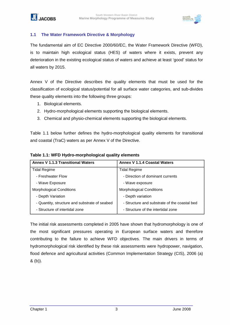
Table 1.1 below further defines the hydro-morphological quality elements for transitional
and coastal (TraC) waters as per Annex V of the Directive.
Table 1.1: WFD Hydro-morphological quality elements
Annex V 1.1.3 Transitional Waters Annex V 1.1.4 Coastal Waters Tidal Regime Tidal Regime
- Freshwater Flow - Direction of dominant currents - Wave Exposure - Wave exposure
Morphological Conditions Morphological Conditions - Depth Variation - Depth variation - Quantity, structure and substrate of seabed - Structure and substrate of the coastal bed - Structure of intertidal zone - Structure of the intertidal zone
The initial risk assessments completed in 2005 have shown that hydromorphology is one of
the most significant pressures operating in European surface waters and therefore
contributing to the failure to achieve WFD objectives. The main drivers in terms of
hydromorphological risk identified by these risk assessments were hydropower, navigation,
flood defence and agricultural activities (Common Implementation Strategy (CIS), 2006 (a)
& (b)).
South Western River Basin District Marine Morphology Programme of Measures Study
Chapter 1 4 June 2008
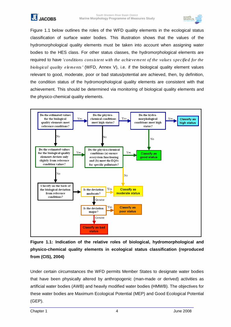
Figure 1.1 below outlines the roles of the WFD quality elements in the ecological status
classification of surface water bodies. This illustration shows that the values of the
hydromorphological quality elements must be taken into account when assigning water
bodies to the HES class. For other status classes, the hydromorphological elements are
required to have ‘conditions consistent with the achievement of the values specified for the
biological quality elements’ (WFD, Annex V), i.e. if the biological quality element values
relevant to good, moderate, poor or bad status/potential are achieved, then, by definition,
the condition status of the hydromorphological quality elements are consistent with that
achievement. This should be determined via monitoring of biological quality elements and
the physico-chemical quality elements.
Figure 1.1: Indication of the relative roles of biological, hydromorphological and
physico-chemical quality elements in ecological status classification (reproduced
from (CIS), 2004)
Under certain circumstances the WFD permits Member States to designate water bodies
that have been physically altered by anthropogenic (man-made or derived) activities as
artificial water bodies (AWB) and heavily modified water bodies (HMWB). The objectives for
these water bodies are Maximum Ecological Potential (MEP) and Good Ecological Potential
(GEP).
South Western River Basin District Marine Morphology Programme of Measures Study
Chapter 1 5 June 2008
A HMWB is defined as
“a body of surface water which as a result of physical alterations by human activity is
substantially changed in character, as designated by the Member Stated in accordance
with the provisions of Annex II” (Article 2(9))
An AWB is defined as
“a body of surface water created by human activity” (Article 2(8))
Article 4(3) of the WFD provides for the designation of a water body as HMWB when:
� the changes to the hydromorphological characteristics of that body which would be
necessary for achieving good ecological status (GES) would have significant adverse
effects on specified uses [such as navigation or flood protection] (Art (4)(a)).
� the beneficial objectives served by the artificial or modified characteristics of the water
body cannot, for reasons of technical feasibility or disproportionate costs, reasonably be
achieved by other means, which are a significantly better environmental option (Art
(4)(b)).
The Directive then requires that such designation and the reasons for this be specifically
mentioned in the River Basin Management Plans (RBMP) and reviewed every 6 years.
The concept of a HMWB was created to allow for the continuation of specified uses such as
navigation which provide valuable social and economic benefits (but at the same time to
allow for mitigation measures to improve water quality) (CIS 2003). Ireland’s AWBs and
HMWBs are assessed within a separate PoMS study. However, those identified as TraC
HMWBs are included in this document. The WFD objectives in dealing with
hydromorphology pressures are focused on prevention, restoration, and mitigation. The
approach for dealing with hydromorphology pressures on the water environment (past and
new developments) can be summarised as follows (CIS, 2006 (a):
Prevention:
For new developments there is a need to first prevent deterioration of water body
‘status’, and where this is not possible, mitigation measures should be applied
(Article 4(7)).
Restoration:
Where a physical modification has already taken place, actions should first be
considered to restore the water body with the aim to achieve GES.
Mitigation:
Where restoration is not possible, mitigation measures should be investigated with
the aim to meet GEP.
South Western River Basin District Marine Morphology Programme of Measures Study
Chapter 1 6 June 2008
1.2 Initial Risk Assessment
In accordance with Article 5 and Annex II of the WFD, an initial risk assessment was
undertaken across Ireland and reported to the European Commission (EC) in March 2005.
The purpose of this risk assessment was to assess the susceptibility of surface water status
to the pressures identified and also to determine the likelihood of water bodies failing to
meet the Article 4 environmental quality objectives. This risk assessment included the
identification and assessment of a number of anthropogenic pressures that have the
potential to impact on the morphological quality elements:
� Dredging
� Disposal of dredge spoil
� Coastal defence
� Flood protection
� Embankments
� Built structures
- Ports/Harbours
- Urbanisation
- Industrial/Power station intakes
� Intensive land use (ILU) (transitional water bodies only)
Each TraC water body was assigned a risk category based on the proportion of the water
body altered by human activities. The initial risk assessments were based on screening or
semi-quantitative assessments; therefore, to help reflect confidence in the assessments a
four-category risk scheme was adopted. Where information was either lacking or of low
confidence, the water body was assigned to either the ‘probably at risk’ or ‘probably not a
risk’ category.
1a – at risk
1b – probably at risk
2a – probably not at risk
2b – not at risk
Results
The initial risk assessments concluded that 35% of transitional water bodies, and 18% of
coastal water bodies within the Republic of Ireland (RoI) were ‘at risk’ or ‘probably at risk’ of
failing to meet the WFD objective of Good Status due to physical alteration.
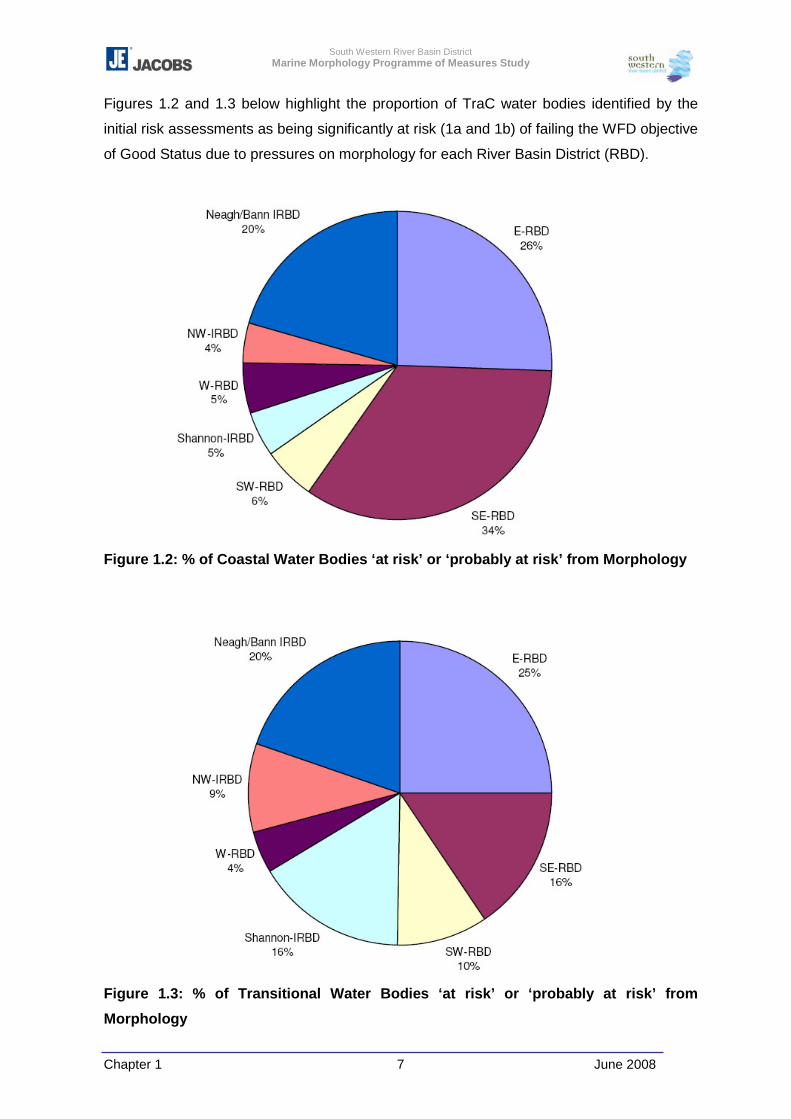
South Western River Basin District Marine Morphology Programme of Measures Study
Chapter 1 7 June 2008
Figures 1.2 and 1.3 below highlight the proportion of TraC water bodies identified by the
initial risk assessments as being significantly at risk (1a and 1b) of failing the WFD objective
of Good Status due to pressures on morphology for each River Basin District (RBD).
Figure 1.2: % of Coastal Water Bodies ‘at risk’ or ‘probably at risk’ from Morphology
Figure 1.3: % of Transitional Water Bodies ‘at risk’ or ‘probably at risk’ from
Morphology
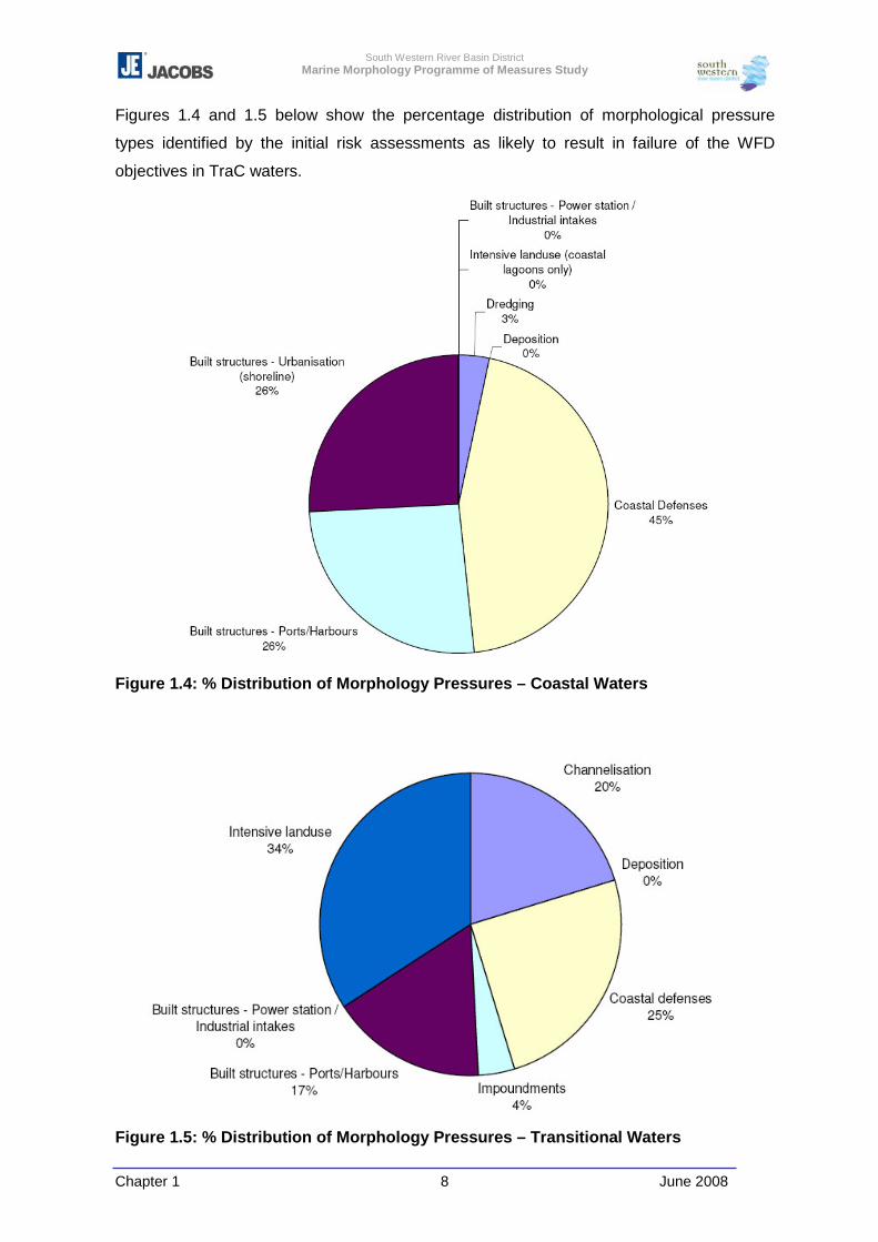
South Western River Basin District Marine Morphology Programme of Measures Study
Chapter 1 8 June 2008
Figures 1.4 and 1.5 below show the percentage distribution of morphological pressure
types identified by the initial risk assessments as likely to result in failure of the WFD
objectives in TraC waters.
Figure 1.4: % Distribution of Morphology Pressures – Coastal Waters
Figure 1.5: % Distribution of Morphology Pressures – Transitional Waters
South Western River Basin District Marine Morphology Programme of Measures Study
Chapter 1 9 June 2008
Transitional waters were identified as being most at risk from ILU, channelisation; and
coastal defences, whereas the risk to coastal waters was found to be attributed to the
physical pressures including coastal defence, ports/harbours and urbanisation.
Conclusions of Initial Risk Assessment
Annex II of the WFD requires that further characterisation shall, where relevant, be carried
out for those bodies identified as being at risk of failing the environmental quality objectives
in order to optimise the design of both the monitoring programmes and the PoMs.
As the initial characterisation was based on screening or semi-quantitative assessments, it
was concluded that surface waters would require more detailed assessments in order to re-
characterise risk so as to report a two-category risk scheme, and then facilitate the
development of tools for the management of these water bodies.
South Western River Basin District Marine Morphology Programme of Measures Study
Chapter 1 10 June 2008
1.3 Overall Approach – Marine Morphology PoMs Study
The Marine Morphology PoMs Study aims to provide a protocol to apply in the further
characterisation and risk appraisal for morphology in TraC waters, the outcomes of which
will contribute to the development of a tool aimed at supporting the assessment and
management of morphology in these water bodies.
The objectives of the study are as follows:
� Establish the relationship between morphology characteristics and biological status;
� Identify what level of morphological pressure is “sustainable” within a water body;
� Establish which morphological indicators should be included in TraC monitoring
programmes;
� Identify water bodies where morphology restoration measures are required (linked to
HMWB designation process);
� Identify the available buffer (or capacity) of water bodies in order to prioritise action
levels;
� Prioritise morphology pressures; and
� Develop a decision support tool for regulators to assess the potential impact of future
developments on individual water bodies (i.e. to prioritise activities and establish a
tiered assessment system).
This study involves all TraC water bodies within the RoI, but was undertaken in parallel to
the North-South Share (NS-Share) project to ensure compatibility of methodologies
between Northern Ireland (NI) and the RoI.
The Marine Morphology study involves a total of 309 water bodies; 113 coastal water
bodies (4 of which border with NI - Portstewart Bay, Mourne Coast, Lough Foyle and
Carlingford Lough) and 196 transitional water bodies (4 of which border with NI - Foyle and
Faughan Estuaries, Newry Estuary, Carlingford Lagoons and Shilities Loughs) within the
RoI.
Figures 1.6 below illustrates the water bodies ‘typed’ as transitional or coastal for the
purpose of the WFD. The risk categories assigned to each of these water bodies are shown
in Figure 1.7.
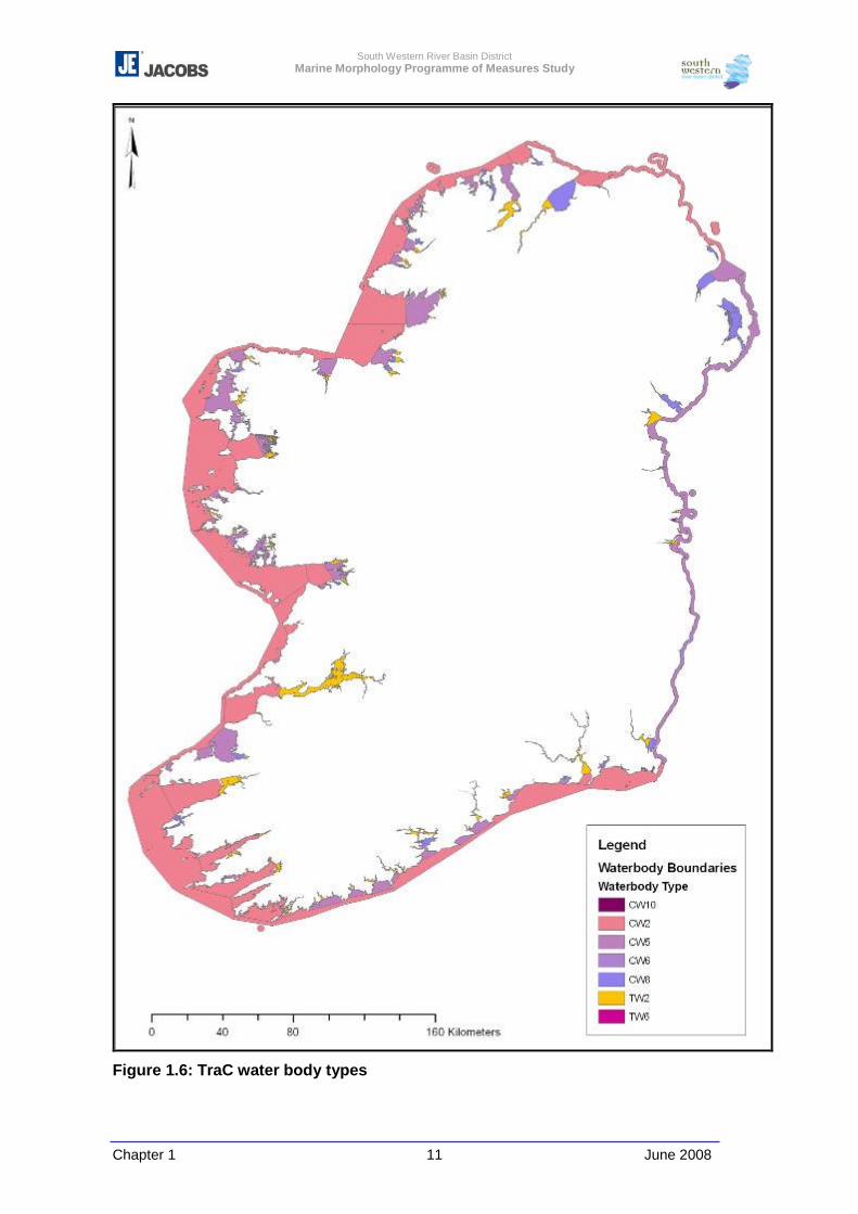
South Western River Basin District Marine Morphology Programme of Measures Study
Chapter 1 11 June 2008
Figure 1.6: TraC water body types
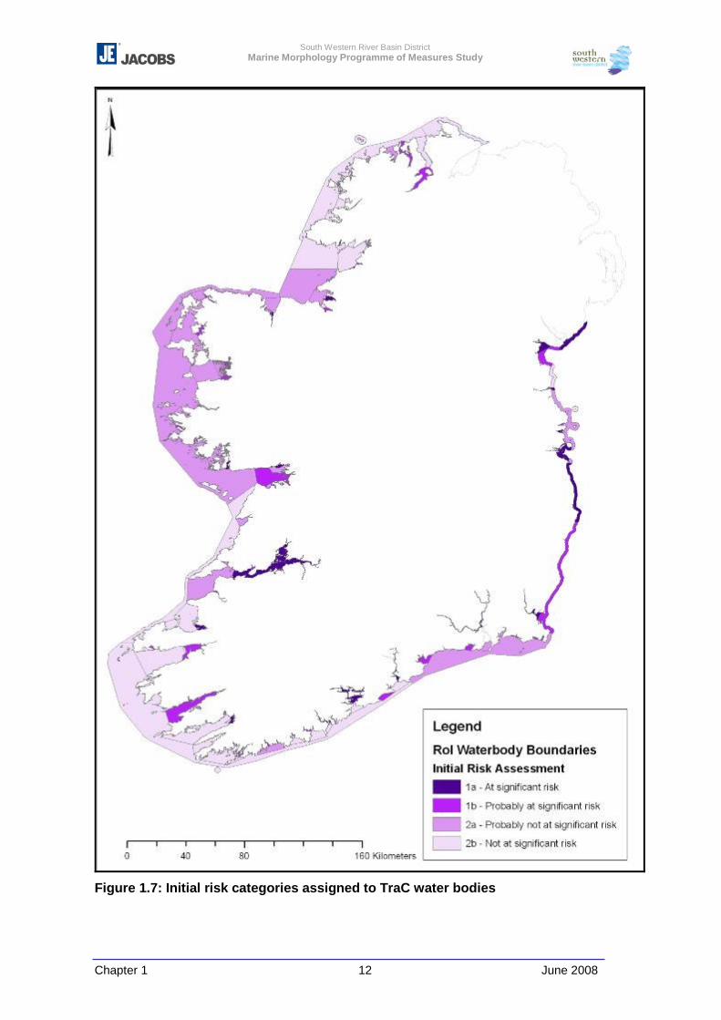
South Western River Basin District Marine Morphology Programme of Measures Study
Chapter 1 12 June 2008
Figure 1.7: Initial risk categories assigned to TraC water bodies
South Western River Basin District Marine Morphology Programme of Measures Study
Chapter 1 13 June 2008
Following on from the initial risk assessments; the further characterisation and risk
appraisal of morphology in TraC waters are proposed to investigate the uncertainty
concerning the designation of water bodies at risk of failing to meet good status. The
designation of risk categories should be based on the relationship between a pressure and
the impact on the morphological attributes of a water body; therefore, it was proposed to
investigate this relationship using scientific methods, historical data and also the results of
the monitoring programme.
The Marine Morphology Study was progressed under the following tasks:
� Literature Review
� Data Review / Data gaps
� Review of Monitoring Systems
� Improve Definition of Pressures on Receptors
� Assess Ecological Impacts of Pressures
� Develop Assessment Tool
� Prepare Final Report on National Methodology
South Western River Basin District Marine Morphology Programme of Measures Study
Chapter 1 14 June 2008
1.4 Report Structure
The following is a summary of the work undertaken to meet the objectives set out in section
1.3 above. A key aim of this study was to further characterise the risk to the morphology of
TraC waters. The classification of TraC water bodies, however, was outside the scope of
this study.
Chapter 2 provides a brief summary of the Literature Review undertaken on
commencement of this study. This review is documented in full in Appendix 2-1.
Chapter 3 summarises the initial Data Review undertaken on commencement of this study
(Appendix 3-1). The data findings on completion of a final data review are then detailed by
outlining the pressures identified for assessment and the methods used to further
characterise these pressures. Recommendations for further data requirements and
improvements are then made.
Chapter 4 summarises the existing monitoring systems for Irish TraC waters and their
relevance to the monitoring of morphological attributes.
Chapter 5 outlines the approach taken by this study to assess the potential impact of
identified pressures on morphological attributes. The current understanding of the
relationship between morphology and ecology in the context of the WFD is outlined and the
Morphological Impact Assessment System (MImAS), developed by the SEPA, is introduced
by including reference to Irish trials undertaken during the development of this system. To
outline how MImAS and the deliverables of this study can be used for the purpose of further
characterising risk an example using the transitional water body Clonakilty Harbour
(SW_100_0100) is provided.
Chapter 6 sets out the method applied to further characterise the risk of TraC water bodies
failing to meet the WFD objectives and summarises results for each water body assessed.
MImAS assessment was focused on 122 TraC water bodies identified by this study as
those which required further characterisation in relation to morphology, for example those
water bodies characterised as ‘probably at risk’ or ‘probably not at risk’ in the initial risk
assessments. For those water bodies further characterised as at risk, Water Body
Summary Sheets detailing the physical characteristics, ecology and pressures identified
were produced and are provided in Appendix 6-4.
South Western River Basin District Marine Morphology Programme of Measures Study
Chapter 1 15 June 2008
Chapter 7 brings together existing information on ‘good practice measures’ for activities
which involve hydromorphological alterations to TraC waters. The accompanying interactive
spreadsheet (Appendix 7-1) guides the user to sources of information which can aid
decisions for identifying measures that aim to prevent deterioration in ecological status for
new developments, or to identify measures to address existing modifications that will
enable a water body to achieve its environmental objective under the WFD.
Chapter 8 documents a review of potential future pressures on the morphology of Irish TraC
waters. This projection of future risks to the achievement of the WFD objectives is not site
specific, but provides a qualitative assessment of the main drivers potentially affecting Irish
TraC waters.
Chapter 9 follows on from Chapter 4 by outlining recommendations for future monitoring of
morphology in Irish TraC waters.
Chapter 10 collates the information set out in the previous chapters to develop appropriate
recommendations for the design of programmes of measures relating to morphology with
the aim of achieving the WFD objectives by 2015. To identify the existing basic measures
governing Irish transitional and coastal water bodies a summary of a review of relevant
legislation is outlined. Methods for the prioritisation of TraC water bodies suitable for the
assessment of appropriate measures are then recommended. Recommendations made in
this chapter are generic and are not outlined specifically for each prioritised water body.
Appendix 11-1 tabulates a summary of proposed measures identified as relevant for marine
morphology. This appendix should be read in conjunction with both Chapters 10 and 11.
Chapter 11 outlines how the deliverables of the Marine Morphology PoMs Study can assist
the regulation of future physical modifications of Ireland’s TraC waters with the aim of
achieving WFD objectives. An example, in the form of a proposed harbour development, is
provided to demonstrate how MImAS, in conjunction with the deliverables of this study, can
be used as a regulatory decision support tool.
South Western River Basin District Marine Morphology Programme of Measures Study
Chapter 2 June 2008 1
2 LITERATURE REVIEW
2.1 Introduction
An initial step in achieving the objectives of the Marine Morphology study was to complete a
Literature Review. This review aimed to investigate and report on relevant approaches
under development for the assessment of anthropogenic activities and morphology, identify
current research underway into the relationship between morphology and ecology, and
identify the availability and applicability of any literature and guidance for the development
of an appropriate assessment methodology for the purpose of the WFD. This Literature
Review is outlined in full in Appendix 2-1 and details all references reviewed for the purpose
of this report. This chapter aims to summarise the findings of this Literature Review, and
where relevant references to chapters within this review are provided.
The Literature Review has concluded that the most common, and in most cases necessary,
approach to assessing and reporting the impact of morphological pressures on ecology
involves a mixture of qualitative and quantitative assessments (Chapter 7 of Appendix 2-1).
Although it is clear that many anthropogenic activities which result in pressures to
morphology have some impact on ecology, it was concluded that there is limited
quantitative data throughout Europe describing the relationships between morphological
conditions and ecological health (Chapter 8 of Appendix 2-1). This is reflected by the
recognition of the CIS Hydromorphology Group recognise that “in many cases knowledge is
insufficient to assess or model precisely the impacts of hydromorphological alterations on
the biological quality elements” and “mitigating measure involving physical modifications”
(CIS, 2006 (b)).
The three projects identified as potentially providing the most useful information for
developing a protocol for further characterisation and risk appraisal were the Joint Nature
Conservation Committee’s (JNCC) ‘Irish Sea Pilot’, the United Kingdom (UK) Marine
Biological Association’s Marine Life Information Network (MarLIN) project, and an European
Union (EU) Interreg project titled ‘Sensitivity and Mapping of Inshore Marine Biotopes in the
Southern Irish Sea’ (SensMap); all of which are introduced in chapter 4 of the Literature
Review. All three projects required the input of very detailed information on the type and
extent of habitats (including species), which is currently unavailable for Ireland. However,
the overall approach used by these projects matched that being progressed by this study,
i.e. the Source, Pathway, Receptor model, or as defined by the CIS working group
IMPRESS; the DPSIR framework (Driver, Pressure, State, Impact, Response). This overall
approach was carried forward to the development and application of MImAS which is
discussed further below and in Chapter 5 of this report.
South Western River Basin District Marine Morphology Programme of Measures Study
Chapter 2 June 2008 2
At present there are no quantitative environmental standards available to assess the
ecological impacts of alterations to the morphology of TraC waters, and where regulation
exists, decisions are principally made on a case by case basis, using a combination of field
data and expert judgement. However, from a review of the projects noted above, the
Literature Review identified environmental factors that can potentially be used to assess the
sensitivity of marine species. Those factors of most relevance to morphology (and
hydromorphology) include:
� Substratum loss
� Smothering
� Suspended sediment
� Desiccation
� Changes in emergence regime
� Changes in water flow rate
� Changes in wave exposure
� Physical disturbance/abrasion
� Displacement
In assessing sensitivity both MarLIN and SensMap concluded that the effects of an activity
and resultant changes in morphological [and other] factors are site specific and cannot be
generalised. Therefore, to enable some form of generic assessment of the sensitivity of
coastal ecology to various pressures both projects used ‘benchmarks’ in order to report
sensitivity to a ‘specified change in an environmental factor’.
Following direction from the DEHLG, the Marine Morphology Study is being applied
nationally. On completion of the Literature Review, it was concluded that the extent of
information required for the assessment methods outlined by the studies researched is not
available nationally for Irish TraC waters at present. Therefore, the assessment of risk to
water bodies in Ireland requires a generic method that can be applied nationally but can
also be used to focus assessment where site specific assessments are required.
The conclusions drawn by the Literature Review led to the consideration of the Transitional
and Coastal Morphological Impact Assessment System (TraC-MImAS) for use in the
Marine Morphology study. This tool was being developed by the Scottish Environmental
Protection Agency (SEPA) and the United Kingdom Technical Advisory Group (UKTAG) in
response to the absence of suitable data to empirically derive standards for morphological
conditions. As reported in Annex I of the Literature Review (Appendix 2-1), TraC-MImAS
was developed with the intention to assist regulators in determining if changes to
morphology could pose a risk to ecology, and thereby identify those proposals that could
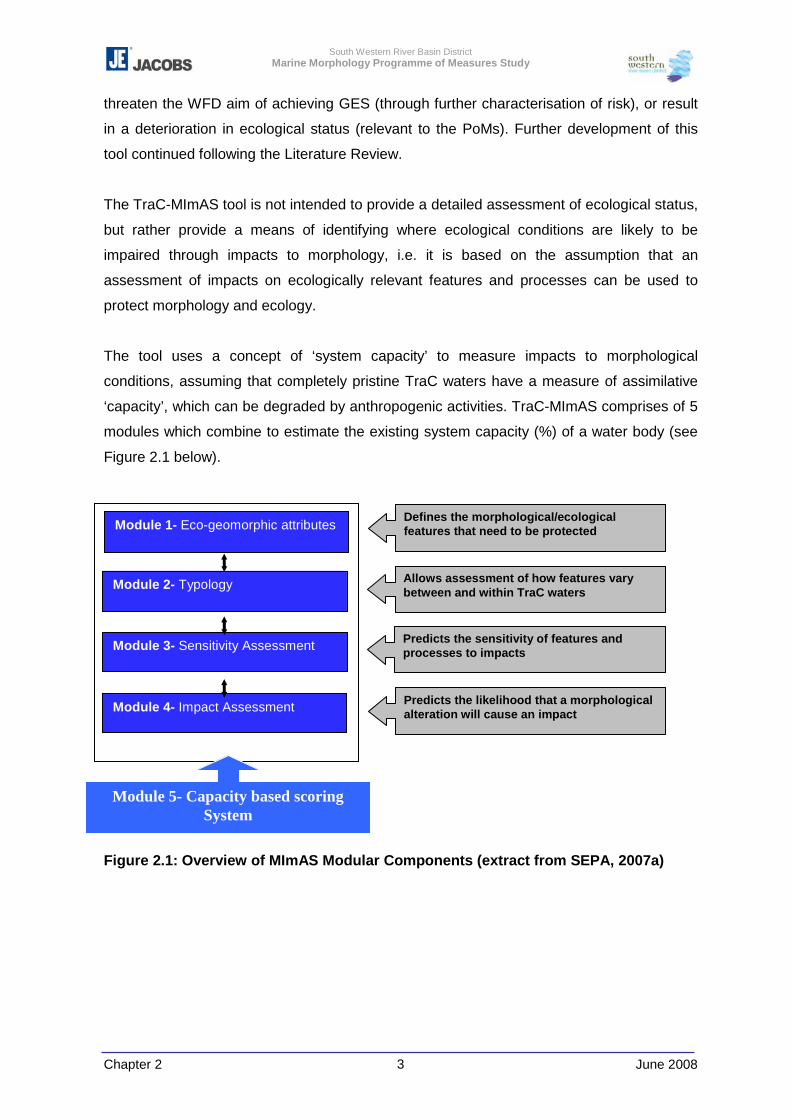
South Western River Basin District Marine Morphology Programme of Measures Study
Chapter 2 June 2008 3
threaten the WFD aim of achieving GES (through further characterisation of risk), or result
in a deterioration in ecological status (relevant to the PoMs). Further development of this
tool continued following the Literature Review.
The TraC-MImAS tool is not intended to provide a detailed assessment of ecological status,
but rather provide a means of identifying where ecological conditions are likely to be
impaired through impacts to morphology, i.e. it is based on the assumption that an
assessment of impacts on ecologically relevant features and processes can be used to
protect morphology and ecology.
The tool uses a concept of ‘system capacity’ to measure impacts to morphological
conditions, assuming that completely pristine TraC waters have a measure of assimilative
‘capacity’, which can be degraded by anthropogenic activities. TraC-MImAS comprises of 5
modules which combine to estimate the existing system capacity (%) of a water body (see
Figure 2.1 below).
Figure 2.1: Overview of MImAS Modular Components (extract from SEPA, 2007a)
Module 5- Capacity based scoring System
Module 1- Eco-geomorphic attributes Defines the morphological/ecological features that need to be protected
Module 2- Typology
Module 3- Sensitivity Assessment
Module 4- Impact Assessment
Allows assessment of how features vary between and within TraC waters
Predicts the sensitivity of features and processes to impacts
Predicts the likelihood that a morphological alteration will cause an impact
South Western River Basin District Marine Morphology Programme of Measures Study
Chapter 2 June 2008 4
TraC-MImAS is considered suitable as both a generic and focused assessment tool which
can be applied nationally to assist further characterisation and risk appraisal. The use of
TraC-MImAS for specific assessments however would benefit greatly from the incorporation
of monitoring results.
The pressures considered by TraC-MImAS were reviewed throughout the development of
this tool. An addition to the original scope of these pressures was requested by Ireland
(SWRBD and NS-Share Marine Morphology teams) via the UKTAG Technical Panel to
represent aquaculture activities. This resulted in the pressure type ‘Other Disturbances to
Seabed’. Table 2.1 below outlines the full suite of pressures that can be assessed within
TraC-MImAS and that have received approval from the Marine Morphology Steering Group.
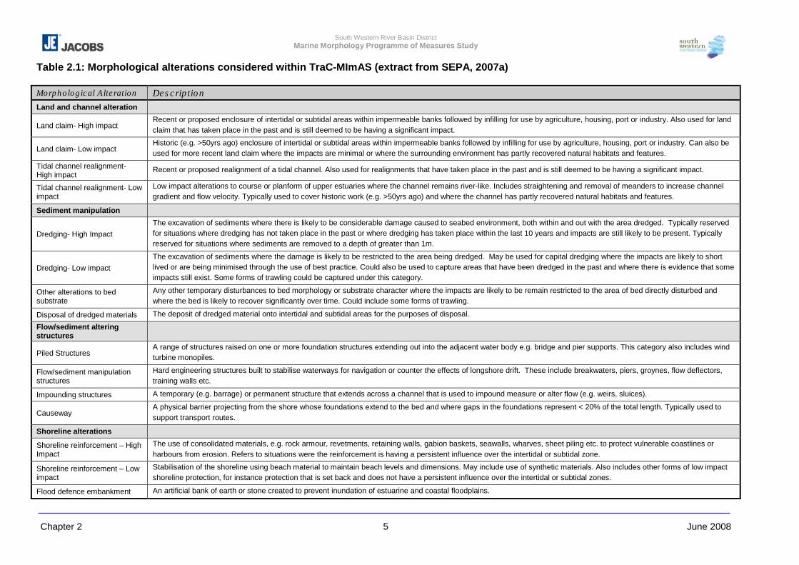
South Western River Basin District Marine Morphology Programme of Measures Study
Chapter 2 June 2008 5
Table 2.1: Morphological alterations considered within TraC-MImAS (extract from SEPA, 2007a) Morphological Alteration Description Land and channel alteration
Land claim- High impact Recent or proposed enclosure of intertidal or subtidal areas within impermeable banks followed by infilling for use by agriculture, housing, port or industry. Also used for land claim that has taken place in the past and is still deemed to be having a significant impact.
Land claim- Low impact Historic (e.g. >50yrs ago) enclosure of intertidal or subtidal areas within impermeable banks followed by infilling for use by agriculture, housing, port or industry. Can also be used for more recent land claim where the impacts are minimal or where the surrounding environment has partly recovered natural habitats and features.
Tidal channel realignment- High impact
Recent or proposed realignment of a tidal channel. Also used for realignments that have taken place in the past and is still deemed to be having a significant impact.
Tidal channel realignment- Low impact
Low impact alterations to course or planform of upper estuaries where the channel remains river-like. Includes straightening and removal of meanders to increase channel gradient and flow velocity. Typically used to cover historic work (e.g. >50yrs ago) and where the channel has partly recovered natural habitats and features.
Sediment manipulation
Dredging- High Impact The excavation of sediments where there is likely to be considerable damage caused to seabed environment, both within and out with the area dredged. Typically reserved for situations where dredging has not taken place in the past or where dredging has taken place within the last 10 years and impacts are still likely to be present. Typically reserved for situations where sediments are removed to a depth of greater than 1m.
Dredging- Low impact The excavation of sediments where the damage is likely to be restricted to the area being dredged. May be used for capital dredging where the impacts are likely to short lived or are being minimised through the use of best practice. Could also be used to capture areas that have been dredged in the past and where there is evidence that some impacts still exist. Some forms of trawling could be captured under this category.
Other alterations to bed substrate
Any other temporary disturbances to bed morphology or substrate character where the impacts are likely to be remain restricted to the area of bed directly disturbed and where the bed is likely to recover significantly over time. Could include some forms of trawling.
Disposal of dredged materials The deposit of dredged material onto intertidal and subtidal areas for the purposes of disposal.
Flow/sediment altering structures
Piled Structures A range of structures raised on one or more foundation structures extending out into the adjacent water body e.g. bridge and pier supports. This category also includes wind turbine monopiles.
Flow/sediment manipulation structures
Hard engineering structures built to stabilise waterways for navigation or counter the effects of longshore drift. These include breakwaters, piers, groynes, flow deflectors, training walls etc.
Impounding structures A temporary (e.g. barrage) or permanent structure that extends across a channel that is used to impound measure or alter flow (e.g. weirs, sluices).
Causeway A physical barrier projecting from the shore whose foundations extend to the bed and where gaps in the foundations represent < 20% of the total length. Typically used to support transport routes.
Shoreline alterations
Shoreline reinforcement – High Impact
The use of consolidated materials, e.g. rock armour, revetments, retaining walls, gabion baskets, seawalls, wharves, sheet piling etc. to protect vulnerable coastlines or harbours from erosion. Refers to situations were the reinforcement is having a persistent influence over the intertidal or subtidal zone.
Shoreline reinforcement – Low impact
Stabilisation of the shoreline using beach material to maintain beach levels and dimensions. May include use of synthetic materials. Also includes other forms of low impact shoreline protection, for instance protection that is set back and does not have a persistent influence over the intertidal or subtidal zones.
Flood defence embankment An artificial bank of earth or stone created to prevent inundation of estuarine and coastal floodplains.
South Western River Basin District Marine Morphology Programme of Measures Study
Chapter 2 6 June 2008
As noted throughout the Literature Review and reflected by this study, the study
Steering Group, and the UKTAG; the results of the WFD monitoring programmes are
fundamental to the further development of such assessment tools. The WFD required
monitoring programmes for all surface (and ground) waters to be in place by
December 2006, the results of which would assist the further characterisation of
water bodies as well as focus the classification of these waters.
The UK & Ireland Marine Task Team have progressed the work outlined in Section
4.11 of the appended Literature Review (Appendix 2-1) to develop classification tools
for TraC waters. However, this work is still outstanding for those tools relevant to
hydromorphology classification. In Ireland, both the Environmental Protection Agency
(EPA) and the Marine Institute (MI) were identified as the responsible bodies for the
WFD monitoring programmes in TraC waters. However, the regulatory system for
coastal development and activities in Ireland has changed slightly from that
documented in the Literature Review. Following the general elections held in May
2007 various responsibilities relating to coastal waters were transferred between
government departments. This resulted in the formation of the new DAFF (formerly
the Department of Agriculture and Food, transferred under S.I No. 705/2007) to
which certain functions of the former DCMNR under the Foreshore Acts (1933 –
1998) have been transferred. The DCMNR is now altered to the Department of
Communications, Energy and Natural Resources (DCENR) (S.I No 706/2007).
Ireland’s regulatory system for coastal development and activities is discussed
further in Chapter 11 of this report.
The Literature Review further investigated the pressures assessed in the initial risk
assessments (as set out in Section 1.2 of this report), and noted that the assessment
of aquaculture as a pressure was outside the scope of the Marine Morphology Study
(following direction from the DEHLG a specific PoMS study was not progressed).
A review of existing coastal mathematical models (primarily hydrodynamic and water
quality) and existing transitional water models (hydrodynamic/ water quality/
nutrients/ ecological) was undertaken as part of the Literature Review to help identify
any relevance and potential use / benefit relevant to the assessment of marine
morphology. Questionnaires were issued to organisations known or thought to have
been involved in the development and application of relevant models covering TraC
waters. The full database of models collected is shown in Appendix IV of the
Literature Review (Appendix 2-1). Using the information provided by the
South Western River Basin District Marine Morphology Programme of Measures Study
Chapter 2 7 June 2008
questionnaires, water body codes were assigned to each model. Table 2.2 below is
an extract of the marine model database showing the coverage of models across
RBDs in Ireland. The details of these models should prove useful to the classification
of TraC water bodies.
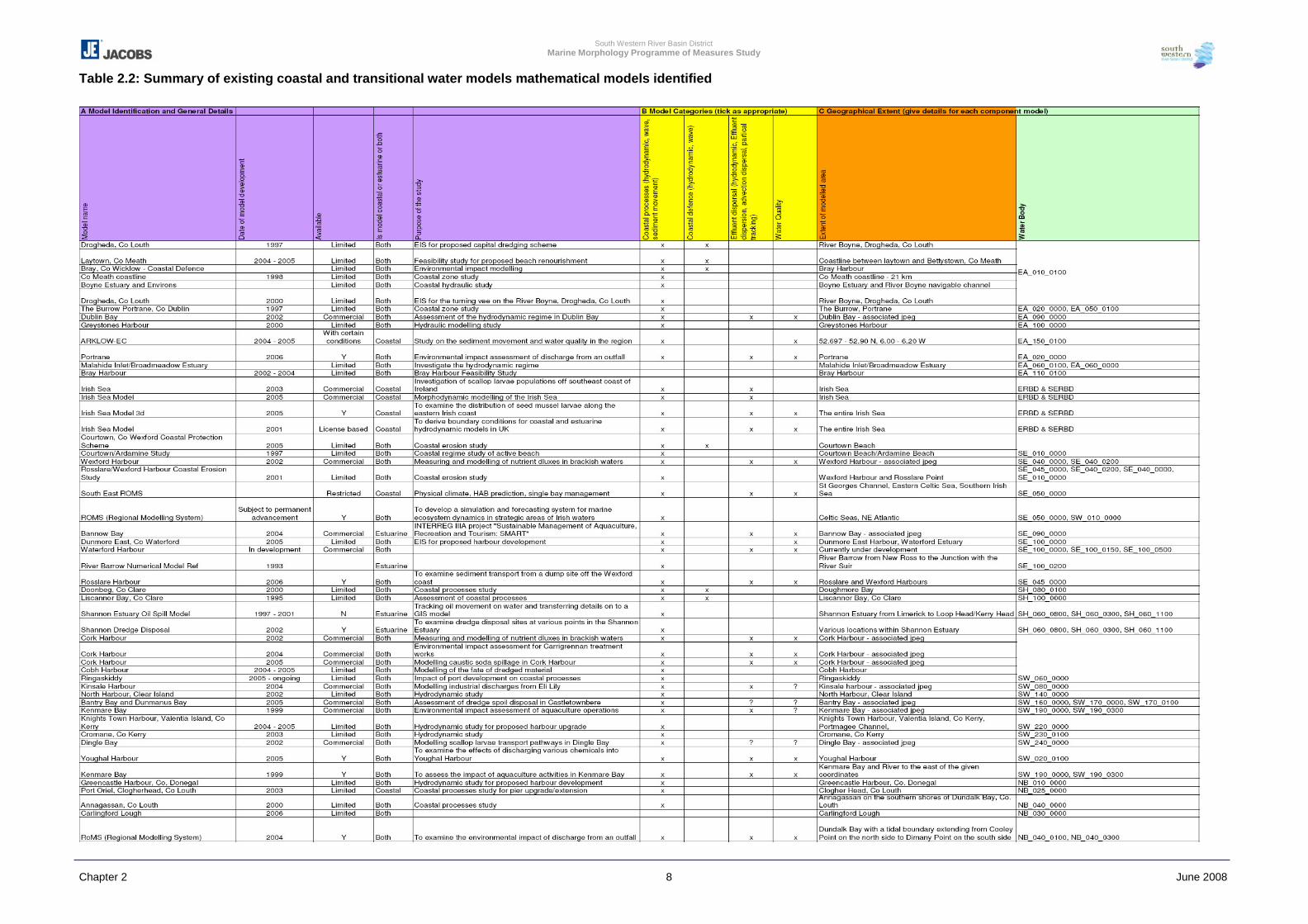
South Western River Basin District Marine Morphology Programme of Measures Study
Chapter 2 8 June 2008
Table 2.2: Summary of existing coastal and transitional water models mathematical models identified
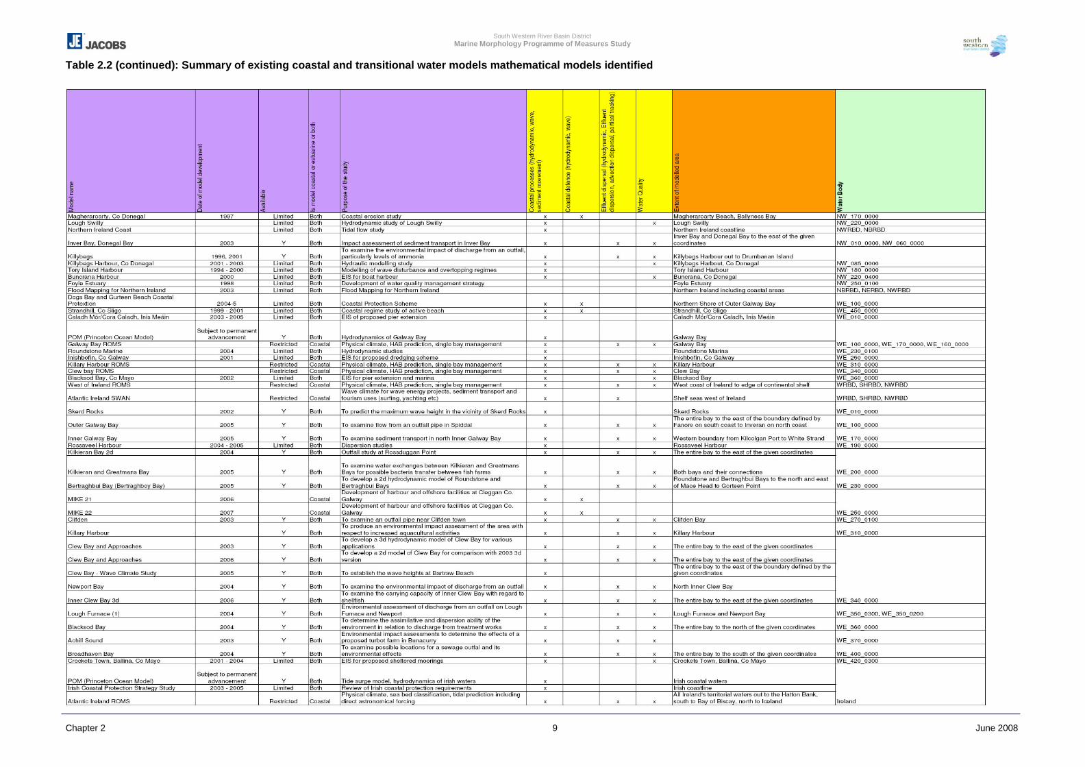
South Western River Basin District Marine Morphology Programme of Measures Study
Chapter 2 9 June 2008
Table 2.2 (continued): Summary of existing coastal and transitional water models mathematical models identified
South Western River Basin District Marine Morphology Programme of Measures Study
Chapter 2 June 2008 10
2.2 Conclusions
As noted above, a key conclusion of the Literature Review was that the most common
approach to assessing and reporting the impact of morphological pressures involves a
mixture of qualitative and quantitative assessments. This approach allows for the flexibility
required to assess the site specific nature of TraC water bodies.
The lack of sufficient criteria and thresholds available to assess the risk of a water body
failing to meet Good Status was evident. At the time of writing of the Literature Review it
was concluded that this issue was being addressed by the UK-Ireland Marine Task Team.
However, the progression of this work in relation to morphology, at the time of writing this
final report, has yet to result in formal classification tools (criteria or thresholds).
South Western River Basin District Marine Morphology Programme of Measures Study
Chapter 3 June 2008 1
3 DATA REVIEW
This section summarises the initial Data Review undertaken on commencement of this
study (Appendix 3-1), outlines the final data findings and information collated. This section
also details the method of data assessment and interpretation to assess morphological
pressures and finally, makes recommendations for further data requirements
3.1 Introduction
An assessment tool was to be developed to allow systematic assessment of future marine
morphological impacts on ecological status (/ potential). The tool should allow site specific
assessment of proposals taking account of the existing quality status and pressures on the
water body. The tool brings together all the work undertaken under the initial reviews within
a structured decision-making framework based on analysis of risks and established
pressure – impact relationships.
Due to issues of data ownership and the ownership of the developed tool (as detailed in this
section), a finalised data store tool could not be developed and sourcing data for the
assessments was hindered. However, despite these issues, a national coverage of marine
pressures on the TraC morphology was created as shapefiles in a Geographic Information
System (GIS) and provided together with an impact assessment tool, as identified in
Chapter 2 and 5. These pressure shapefiles, with associated metadata, will be passed
under data licence agreements to Cork County Council, the co-ordinating authority for the
SWRBD at project completion. Many of these datasets were under constraints and
restrictions in relation to assessment and dissemination. Therefore, all GIS outputs of this
study will be passed to Cork County Council as the ‘data holder’. A data catalogue of the
incoming information was created to log data providers (who would be contacted in the
event of any changes in the data or its status) and any licensing agreements or constraints.
This information was also included in the metadata of each of the finalised layers, outlining
the organisations from which permission should be obtained to change or use the data as
required and from where updates may be generated. Data identified in Chapter 2 that was
inaccessible was also recorded.
This information was collated and analysed using GIS in order to create pressure datasets.
These areas and types of pressures were then used to carry out the impact assessment as
outlined in Chapters 5 and 6. The following sections outline how these layers were created
using the best available data to create a national coverage.
South Western River Basin District Marine Morphology Programme of Measures Study
Chapter 3 June 2008 2
3.1.1 Metadata
Metadata is the structured recording of information about databases and GIS datasets.
During the project, a detailed metadata catalogue was maintained of the incoming data
including its sources, restrictions of use, owners, coverage, etc. This will be provided along
with all the data to Cork County Council at the project close. Throughout the process care
was taken to ensure that the data was licensed for use to the project, and able to be
interpreted, processed as necessary and passed to Cork County Council.
Data was collected, collated and developed with reference to ‘Guidance on Information
Management and Data Interchange between River Basin Management Systems and
National Organisations’ reports (EPA, 2002).
In order to ensure the quality of the project and that results can be duplicated and any
shortfalls recorded, detailed metadata of the final pressures was recorded within the
shapefiles. The EPA issued a metadata style sheet of information required for each shape
file. This pro forma includes information on the sources, restrictions, processes,
organisations and individuals responsible for generating the data, as well as information on
the extents and projection which is automatically calculated by ArcGIS. In addition,
information fields required under the International Standards Organisation (ISO)
19115:2003 (and ISO/IEC 11179: 2004) were completed, in order to ensure all metadata
that may be required for reporting to Europe or future reporting under the Infrastructure for
Spatial Information in the European Community, EU Directive 2007/2/EC (INSPIRE)
programme are included (INSPIRE, 2007). For each of the final pressure layers delivered
with this project, full metadata has been recorded and stored as an xml file as outlined in
the standards. In addition, the methods for the development of the pressure layers and
source data are summarised below. Detailed methodologies will be passed to the SWRBD
with the final morphological pressure layers.
3.1.2 Interim Data Review
The initial risk assessment undertaken as part of the Article 5 Characterisation identified
gaps in the availability of quantitative information relating to the morphology of TraC waters.
To address these gaps an interim Data Review was undertaken in 2005/2006 to:
� research both national and local datasets;
� include an assessment of the reliability of the data currently available;
� include studies currently underway or due to be commissioned during the life of this
project, and
� summarise the data to be requested for inclusion in this Marine Morphology study
South Western River Basin District Marine Morphology Programme of Measures Study
Chapter 3 June 2008 3
The interim Data Review is outlined in full in Appendix 3-1.
This interim Data Review outlined a proposal for the development of a Decision Support
Tool, the data elements of which would act as a spatially referenced ‘data store’ tool. This
‘tool’ was intended to assist the end user in the regulation of coastal proposals with regard
to the requirements of the WFD and morphology, i.e. determine whether morphological
alterations could threaten the aim of achieving WFD objectives, or result in a deterioration
of ecological status (for example from high to good status).
It was envisaged that compilation of this tool would involve the development of a database
to hold all attribute data and information collected. This information would then be geo-
referenced and displayed spatially using GIS software (ESRI ArcGIS).
It was initially proposed, and agreed with the Marine Morphology Steering Group, that the
end users for such a tool should be the Marine Institute, EPA, the former DCMNR, or a
combination of all three bodies, and as highlighted by the interim Data Review; confirmation
of this ‘end user’ was fundamental to the licence agreements and data requests required for
this study. However, notwithstanding support from the Marine Morphology Steering Group
an appropriate end user for this tool was not identified. As a temporary alternative, to
ensure the progress of this study, the SWRBD, and Cork County Council, were identified as
substitute end users. The SWRBD, and Cork County Council, have no function to hold or
use such a tool for the purpose of regulation and are intended only to temporarily act as the
‘end user’ until an appropriate assessment or regulatory body is identified. However,
confirmation of an alternative end user has not transpired during the term of this study.
In the absence of an appropriate end user all formal data requests were issued via the
SWRBD. Therefore, prior to the dissemination and/or editing of data resulting from this
study permission must be sought from the data originators. To facilitate the future
movement of data required for the assessment of morphology within TraC water bodies, it
was proposed that only those datasets required for the further characterisation of pressures
will be held by Cork County Council for dissemination to the ultimately identified end user.
Therefore, a data store tool containing details of morphology and biology as well as that for
pressures was not generated for temporary hosting by the SWRBD as it is considered that
the future end user of this tool will inevitably hold more detailed data to that available to this
study. Also, compliance with licence agreements for many datasets will require this data to
be requested [and edited where necessary] again under the new terms for the ultimate end
user. This report, therefore, recommends the structure of an appropriate Decision Support
South Western River Basin District Marine Morphology Programme of Measures Study
Chapter 3 June 2008 4
Tool and summarises the data identified as useful to both the assessment and regulation of
coastal development/activities using such a tool.
The data regenerated by this project for the pressures identified will be passed to Cork
County Council together with methods of generation and metadata. This data can be
uploaded into the EPA National WFD ‘schema’ by Cork County Council, as appropriate.
The EPA National WFD schema is a national database of WFD data to which data can be
uploaded by relevant authorities to ensure all regulatory parties involved in national and
local government have access to the same data, and that this is as up to date as possible.
The pressures data has been created in a format compatible with this database.
This uncertainty caused significant delays in data acquisition, and prevented access to
several key datasets identified in the interim data review. Data such as the ongoing work on
coastal flood management zones (GIS, mapping and LiDAR (Light Detection and
Ranging)), Ordnance Survey (OS) maps, the Skipper series hydrographic charts and a
number of other national resources were unable to be accessed by this study, despite
numerous attempts. The purchasing of additional licences was not possible.
As much of the work in updating the existing information structures within the former
DCMNR was underway at the time of dissolution, many of the sources of information that
were to eventually be made available electronically are only available in paper form.
Despite a concerted research effort on behalf of this project, not all of this information could
be accessed or summarised. For example, the Coastal Engineering Division of the former
DCMNR has a drawing archive of coastal structures, bridges etc. Whilst the project was
eventually granted permission to access this extensive, restricted in-situ archive, the nature
of the resource meant it was not practical for assessment for a national study. Where
possible, these data sources have been identified in the interim data review and in following
sections so that specific studies or future development appraisals can identify these
resources.
The sources used to assess the morphological pressures on water bodies in Ireland are
outlined in this chapter. Information on source datasets has been provided for each of the
pressure types together with background information. The data collated, full data catalogue
and derived information will be provided to Cork County Council at the project end where it
will remain until such time as a suitable data owner can be identified.
South Western River Basin District Marine Morphology Programme of Measures Study
Chapter 3 June 2008 5
3.1.3 Tool Development
The tool structure developed is divided into two components as noted previously:
1. Data Store GIS: this holds and displays the collated data to assist regulators in
decision-making. The functionality of this tool can be summarised as follows:
� The user will assess the information provided by an applicant for a proposed
development/activity e.g. foreshore licence or dumping at sea application. It is
envisaged that future applications will be accompanied by digital information that
can be used to update the data store.
� The user can then view and query the data relating to existing pressures within GIS.
Future development of this tool will benefit greatly from WFD monitoring results.
2. Morphological Impact Assessment: The data store GIS provides baseline data which
a regulator can interpret using expert judgement to make a decision. This second
function however, uses generic assessments of potential changes to the morphological
features attributed to each water body type to estimate the risks to ecology. The future
development of this function will also benefit from WFD monitoring results as well as the
outputs of research projects such as INFOMAR (the Integrated Mapping For the
Sustainable Development of Ireland’s MARine Resource); a joint venture between the
Geological Survey of Ireland (GSI) and the Marine Institute.
The combination of the above elements will inform the further characterisation of TraC
waters and provide a suitable approach to assist coastal managers and regulators in
assessing the potential impact of future developments on individual water bodies.
Following the identification of relevant datasets and key organisations within the interim
Data Review, data requests were issued to all RBD, relevant public institutions, academia
and various consultancies. The main categories of information requested for this study were
Pressures (anthropogenic activities), State (morphological conditions), and Receptors
(WFD biological quality elements: phytoplankton, macroalgae, benthic invertebrates and
fish (transitional only)).
Sections 3.2 and 3.3 below outline the data reviewed, requested, collated and edited as
part of the Marine Morphology study. In summarising this data, Section 3.4 confirms the
identified data gaps associated with the assessment and regulation of morphological
alterations and outlines the key recommendations for further data requirements to fully
develop an appropriate Decision Support Tool.
South Western River Basin District Marine Morphology Programme of Measures Study
Chapter 3 June 2008 6
3.2 Final Data Review Findings
One conclusion from the interim Data Review can be carried forward to the findings of this
final Data Review – that is that the existence and availability of information in suitable
formats relating to the pressures on, and the attributes of, morphology in Irish TraC waters
is very limited. For example, many resources relating to coastal structures exist in non-
spatial or paper format, such as foreshore licence records and plans of infrastructure
extents. On meeting with the former DCMNR to discuss such issues, the Marine
Morphology study was informed of a national project which planned to digitise such
information held by the department creating a GIS based data store. However, on the
transfer of the former DCMNRs’ functions following the General Elections in 2007 it is
unclear how this is being progressed. Through continued communications with the bodies
involved it appears that the situation is still to be resolved at the time of writing.
A significant restriction to data acquisition for this study centred on the uncertainty
expressed by data originators relating to the final use of the data requested. The
identification of the SWRBD (Cork County Council) as end user assisted this process;
however, difficulties were experienced throughout the study. This data acquisition process
was further hampered and delayed by the dissolution of the DCMNR, which lead to
uncertainty of data ownership of government marine data, and an inability of former marine
departments to release the information until the issue was resolved. A number of marine
data and GIS programmes, were stalled or ceased altogether. Several of these data
consolidation projects were initiated to assist the implementation of the WFD, its daughter
directives and ‘Sea Change’ programmes. The urgent need for a responsible body,
preferably a governmental department, agency or agent to take ownership of this process
was reiterated by the Steering Group.
In order to ensure consistency, all data was assessed in Irish National Grid (TM65)
projection as defined by the water body boundaries and this information was included in the
metadata. For some datasets small spatial shifts in the conversions were noted and in
general could be corrected by the ArcGIS projection tools. However, some data with
WGS84 projections noted a marked and consistent shift. This was eventually tracked to a
small error in the automatic re-projection calculation. The error was reported to ESRI who
were able to correct the problem. All datasets created were subject to spatial and attribute
quality assessments and the information included in the metadata.
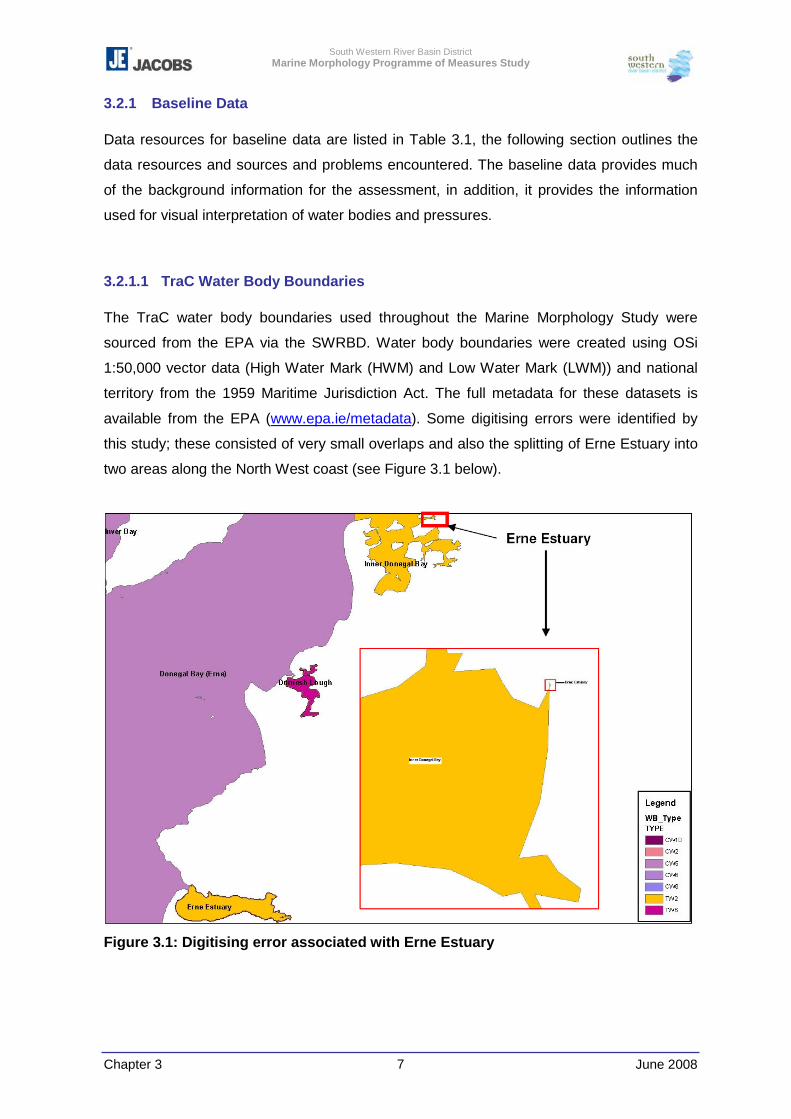
South Western River Basin District Marine Morphology Programme of Measures Study
Chapter 3 June 2008 7
3.2.1 Baseline Data
Data resources for baseline data are listed in Table 3.1, the following section outlines the
data resources and sources and problems encountered. The baseline data provides much
of the background information for the assessment, in addition, it provides the information
used for visual interpretation of water bodies and pressures.
3.2.1.1 TraC Water Body Boundaries
The TraC water body boundaries used throughout the Marine Morphology Study were
sourced from the EPA via the SWRBD. Water body boundaries were created using OSi
1:50,000 vector data (High Water Mark (HWM) and Low Water Mark (LWM)) and national
territory from the 1959 Maritime Jurisdiction Act. The full metadata for these datasets is
available from the EPA (www.epa.ie/metadata). Some digitising errors were identified by
this study; these consisted of very small overlaps and also the splitting of Erne Estuary into
two areas along the North West coast (see Figure 3.1 below).
Figure 3.1: Digitising error associated with Erne Estuary
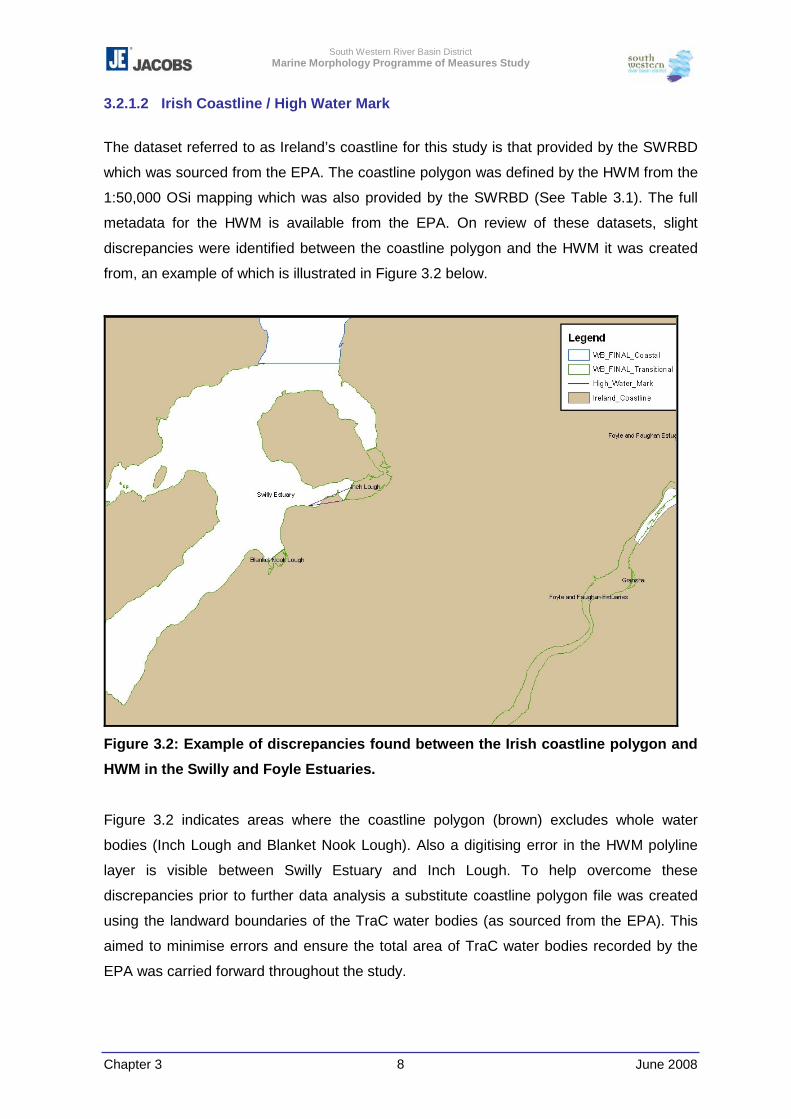
South Western River Basin District Marine Morphology Programme of Measures Study
Chapter 3 June 2008 8
3.2.1.2 Irish Coastline / High Water Mark
The dataset referred to as Ireland’s coastline for this study is that provided by the SWRBD
which was sourced from the EPA. The coastline polygon was defined by the HWM from the
1:50,000 OSi mapping which was also provided by the SWRBD (See Table 3.1). The full
metadata for the HWM is available from the EPA. On review of these datasets, slight
discrepancies were identified between the coastline polygon and the HWM it was created
from, an example of which is illustrated in Figure 3.2 below.
Figure 3.2: Example of discrepancies found between the Irish coastline polygon and
HWM in the Swilly and Foyle Estuaries.
Figure 3.2 indicates areas where the coastline polygon (brown) excludes whole water
bodies (Inch Lough and Blanket Nook Lough). Also a digitising error in the HWM polyline
layer is visible between Swilly Estuary and Inch Lough. To help overcome these
discrepancies prior to further data analysis a substitute coastline polygon file was created
using the landward boundaries of the TraC water bodies (as sourced from the EPA). This
aimed to minimise errors and ensure the total area of TraC water bodies recorded by the
EPA was carried forward throughout the study.
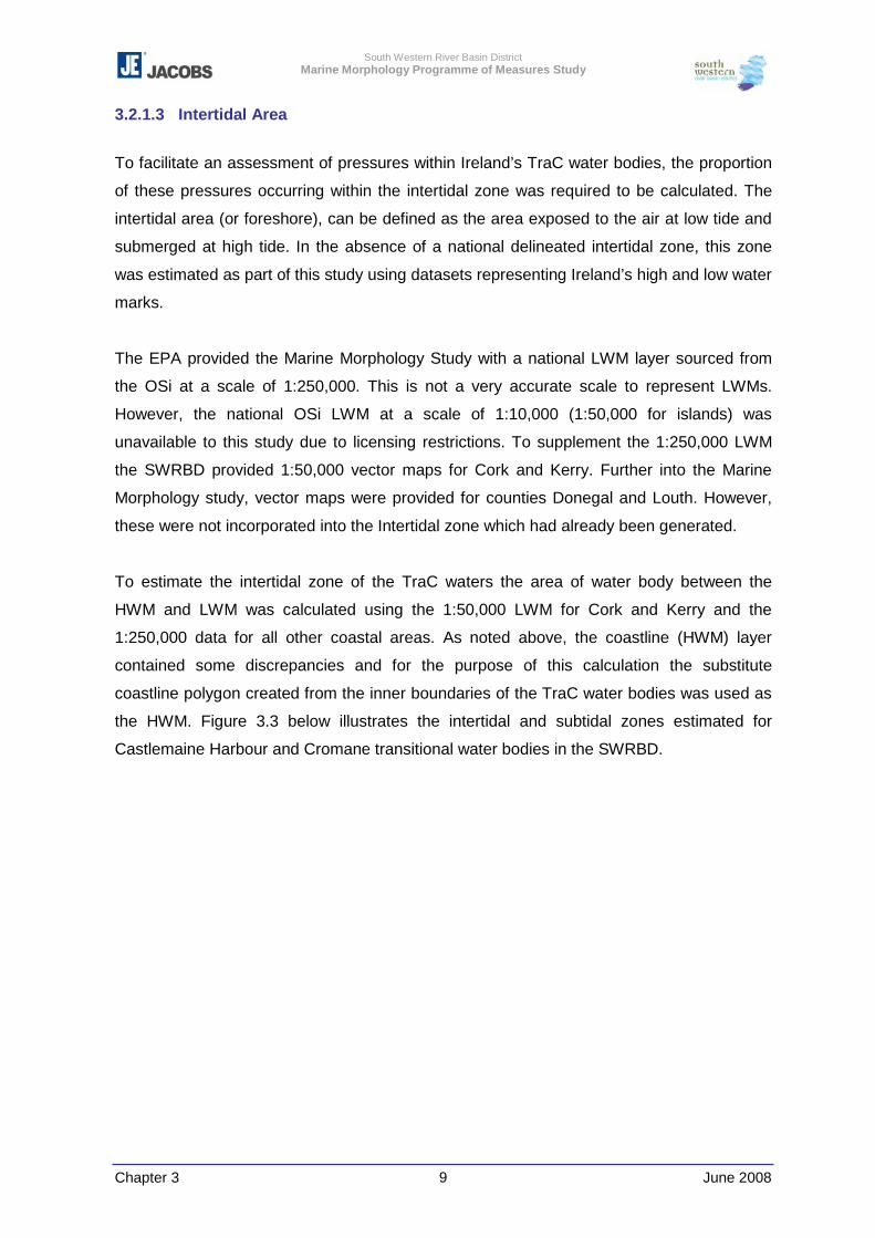
South Western River Basin District Marine Morphology Programme of Measures Study
Chapter 3 June 2008 9
3.2.1.3 Intertidal Area
To facilitate an assessment of pressures within Ireland’s TraC water bodies, the proportion
of these pressures occurring within the intertidal zone was required to be calculated. The
intertidal area (or foreshore), can be defined as the area exposed to the air at low tide and
submerged at high tide. In the absence of a national delineated intertidal zone, this zone
was estimated as part of this study using datasets representing Ireland’s high and low water
marks.
The EPA provided the Marine Morphology Study with a national LWM layer sourced from
the OSi at a scale of 1:250,000. This is not a very accurate scale to represent LWMs.
However, the national OSi LWM at a scale of 1:10,000 (1:50,000 for islands) was
unavailable to this study due to licensing restrictions. To supplement the 1:250,000 LWM
the SWRBD provided 1:50,000 vector maps for Cork and Kerry. Further into the Marine
Morphology study, vector maps were provided for counties Donegal and Louth. However,
these were not incorporated into the Intertidal zone which had already been generated.
To estimate the intertidal zone of the TraC waters the area of water body between the
HWM and LWM was calculated using the 1:50,000 LWM for Cork and Kerry and the
1:250,000 data for all other coastal areas. As noted above, the coastline (HWM) layer
contained some discrepancies and for the purpose of this calculation the substitute
coastline polygon created from the inner boundaries of the TraC water bodies was used as
the HWM. Figure 3.3 below illustrates the intertidal and subtidal zones estimated for
Castlemaine Harbour and Cromane transitional water bodies in the SWRBD.
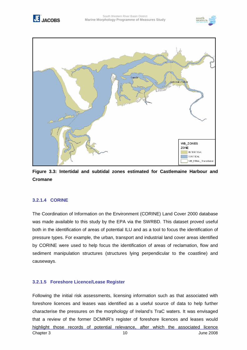
South Western River Basin District Marine Morphology Programme of Measures Study
Chapter 3 June 2008 10
Figure 3.3: Intertidal and subtidal zones estimated for Castlemaine Harbour and
Cromane
3.2.1.4 CORINE
The Coordination of Information on the Environment (CORINE) Land Cover 2000 database
was made available to this study by the EPA via the SWRBD. This dataset proved useful
both in the identification of areas of potential ILU and as a tool to focus the identification of
pressure types. For example, the urban, transport and industrial land cover areas identified
by CORINE were used to help focus the identification of areas of reclamation, flow and
sediment manipulation structures (structures lying perpendicular to the coastline) and
causeways.
3.2.1.5 Foreshore Licence/Lease Register
Following the initial risk assessments, licensing information such as that associated with
foreshore licences and leases was identified as a useful source of data to help further
characterise the pressures on the morphology of Ireland’s TraC waters. It was envisaged
that a review of the former DCMNR’s register of foreshore licences and leases would
highlight those records of potential relevance, after which the associated licence

South Western River Basin District Marine Morphology Programme of Measures Study
Chapter 3 June 2008 11
documents, which are held in paper format in the former DCMNR’s Coastal Division offices,
would then be reviewed in detail. However, following a successful meeting with the former
DCMNR and the Marine Institute, the former DCMNR Coastal Zone Management Division
relocated from Dublin to Clonakility, Cork at which time all files were unavailable to external
bodies. Following this relocation, the transfer of responsibilities of the former DCMNR under
the Foreshore Acts had yet to be confirmed, further restricting access to these documents.
To progress with the information available to the Marine Morphology study; a spreadsheet
listing deeds relating to foreshore licences and leases issued under the Foreshore Acts
(1933 – 1998) for the years 1933 – 2005 and prior legislation was downloaded from the
former DCMNR website. This information was then converted to an ESRI compatible
shapefile which was then used to help focus the review of existing data and orthophotos for
additional pressures.
Each record within the register was assigned a pressure ‘type’ based on the descriptive
information supplied in the register, and following a map search those records associated
with pressures types relevant to this study were assigned a water body code. This register
did not provide very detailed location information for the activities/developments, and water
body codes were only assigned to 1236 of the 1984 records.
No coordinates were provided with the register therefore to display these records in ArcMap
they were attributed to centroids of the water bodies and a new shapefile displaying these
licence records as points was created. It should be noted that details of the extent of
pressures e.g. area dredged are not provided with the foreshore register.
3.2.1.6 Environmental Impact Statement Register
As part of the Literature Review, Environmental Impact Statements (EIS) identified as
relevant to the pressure types assessed by this study where obtained from ENFO, Ireland’s
public information service on environmental matters (see Appendix 3-2). As with the
foreshore licence/lease records pressure ‘types’ and water body codes were assigned to
each EIS record. These records were then attributed to centroids of the water bodies to
create a shapefile displaying the EISs as points in ArcMap. A dataset of relevant marine
EIS areas was provided by the Marine Institute as ArcGIS polygons.
South Western River Basin District Marine Morphology Programme of Measures Study
Chapter 3 June 2008 12
3.2.1.7 Coastal Images
Georeferenced images of Ireland’s coast were required to facilitate the assessment and,
where necessary, digitising of pressure extents (footprints).
National infra-red coastal images sourced from the National Coastline Survey of Ireland
(Marine Institute / Compass Informatics / Enterprise Ireland, 1998 - 2002) were received
from the Marine Institute. However, these images, with the exception of Dunmanus and
Bantry Bays, are not georeferenced and require the use of the project’s map viewer to
interrogate the images. The Marine Institute plan to georeference all images, which on
completion will provide an invaluable resource to the outputs of this study.
Orthophotos were requested from each RBD via the SWRBD, and over 30,000 orthophotos
where received (inland and coastal coverage). Using numeric grids provided by the OSi via
the SWRBD, those images required for assessment were identified and retrieved from this
large database of images.
Not all images received were georeferenced, and overall coverage varied across the coast
with counties Kerry, Cork, Waterford and Dublin having substantial coverage (see Table
3.1). No orthophotos were received from the South Eastern RBD (SERBD), and although
some coastal locations were covered by images provided by the Eastern and South
Western RBDs, the majority of the coastline remained uncovered.
Figures 3.4 - 3.9(b) below illustrate the coverage of orthophotos made available to this
study for each RBD.
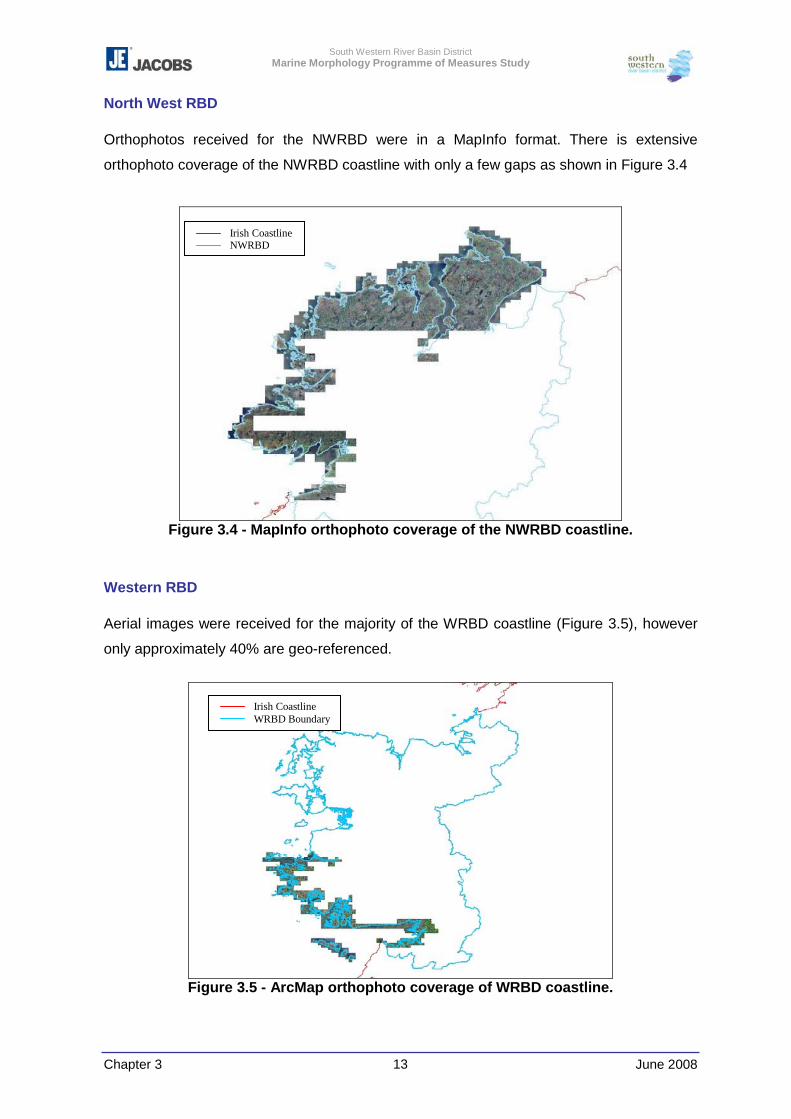
South Western River Basin District Marine Morphology Programme of Measures Study
Chapter 3 June 2008 13
North West RBD
Orthophotos received for the NWRBD were in a MapInfo format. There is extensive
orthophoto coverage of the NWRBD coastline with only a few gaps as shown in Figure 3.4
Figure 3.4 - MapInfo orthophoto coverage of the NWRBD coastline.
Western RBD
Aerial images were received for the majority of the WRBD coastline (Figure 3.5), however
only approximately 40% are geo-referenced.
Figure 3.5 - ArcMap orthophoto coverage of WRBD coastline.
Irish Coastline NWRBD
Irish Coastline WRBD Boundary
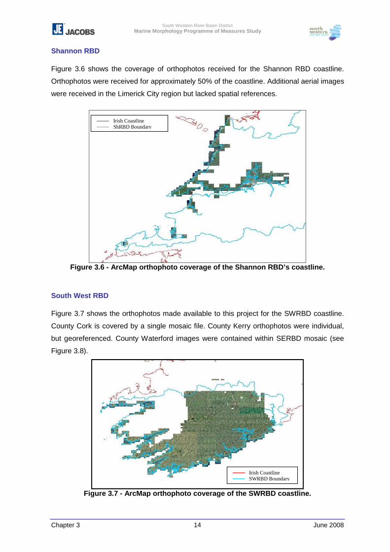
South Western River Basin District Marine Morphology Programme of Measures Study
Chapter 3 June 2008 14
Shannon RBD
Figure 3.6 shows the coverage of orthophotos received for the Shannon RBD coastline.
Orthophotos were received for approximately 50% of the coastline. Additional aerial images
were received in the Limerick City region but lacked spatial references.
Figure 3.6 - ArcMap orthophoto coverage of the Shannon RBD’s coastline.
South West RBD
Figure 3.7 shows the orthophotos made available to this project for the SWRBD coastline.
County Cork is covered by a single mosaic file. County Kerry orthophotos were individual,
but georeferenced. County Waterford images were contained within SERBD mosaic (see
Figure 3.8).
Figure 3.7 - ArcMap orthophoto coverage of the SWRBD coastline.
Irish Coastline ShRBD Boundary
Irish Coastline SWRBD Boundary
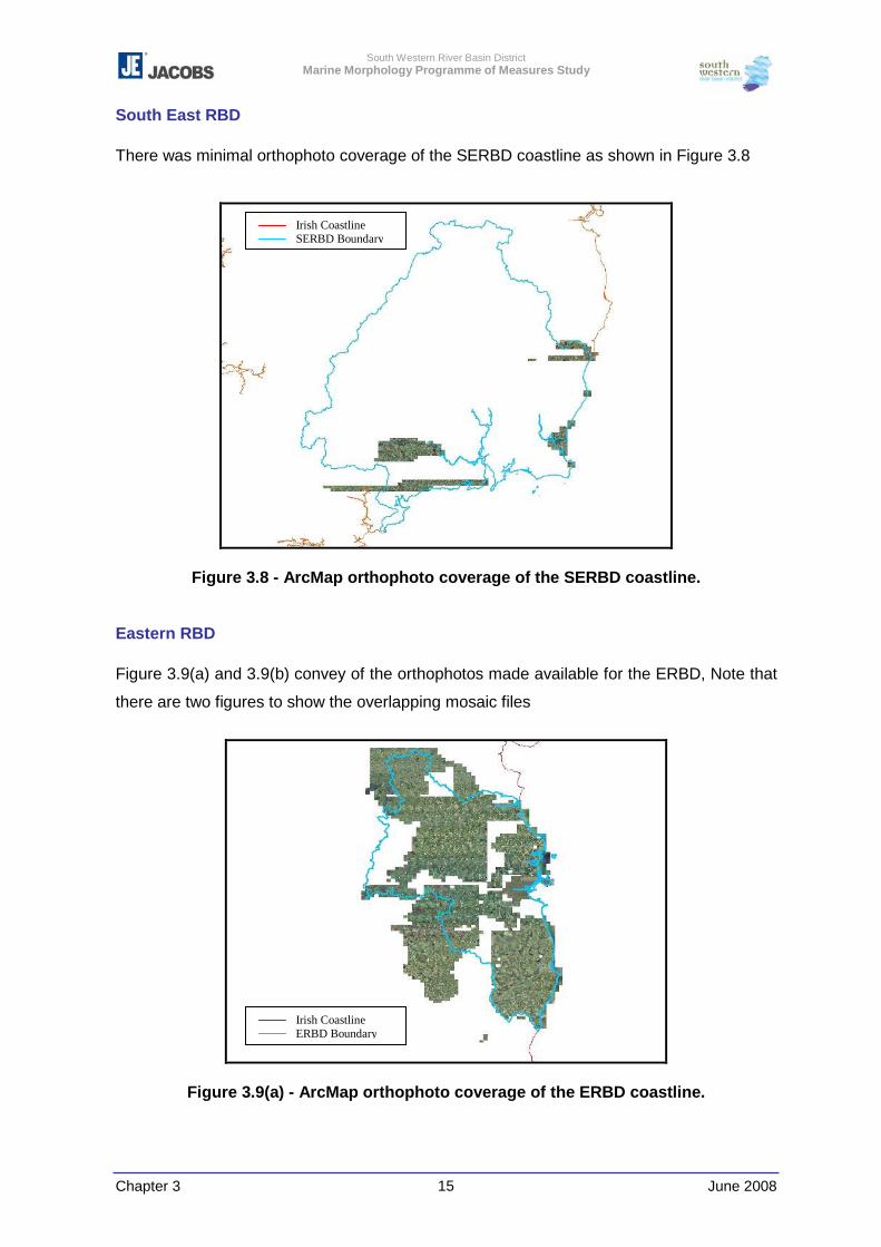
South Western River Basin District Marine Morphology Programme of Measures Study
Chapter 3 June 2008 15
South East RBD
There was minimal orthophoto coverage of the SERBD coastline as shown in Figure 3.8
Figure 3.8 - ArcMap orthophoto coverage of the SERBD coastline.
Eastern RBD
Figure 3.9(a) and 3.9(b) convey of the orthophotos made available for the ERBD, Note that
there are two figures to show the overlapping mosaic files
Figure 3.9(a) - ArcMap orthophoto coverage of the ERBD coastline.
Irish Coastline SERBD Boundary
Irish Coastline ERBD Boundary
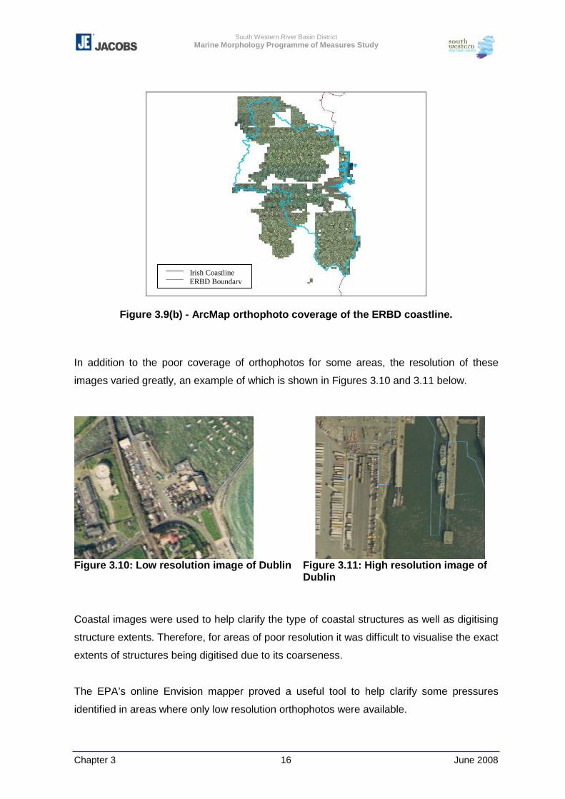
South Western River Basin District Marine Morphology Programme of Measures Study
Chapter 3 June 2008 16
Figure 3.9(b) - ArcMap orthophoto coverage of the ERBD coastline.
In addition to the poor coverage of orthophotos for some areas, the resolution of these
images varied greatly, an example of which is shown in Figures 3.10 and 3.11 below.
Figure 3.10: Low resolution image of Dublin Figure 3.11: High resolution image of
Dublin
Coastal images were used to help clarify the type of coastal structures as well as digitising
structure extents. Therefore, for areas of poor resolution it was difficult to visualise the exact
extents of structures being digitised due to its coarseness.
The EPA’s online Envision mapper proved a useful tool to help clarify some pressures
identified in areas where only low resolution orthophotos were available.
Irish Coastline ERBD Boundary
South Western River Basin District Marine Morphology Programme of Measures Study
Chapter 3 June 2008 17
Oblique images produced by the former DCMNR Coastal Helicopter Survey (SnapMap
Project) were made available for review for this study. On receipt, all photographic images
were copyright 2004 DCMNR. These images proved very useful to the identification and
assessment of all the pressures types.
3.2.1.8 Historic Maps
Historical maps of Ireland were requested for use by the Marine Morphology study to assist
with the identification and assessment of coastal reclamation. Focusing on urban and
industrial areas and where foreshore licences/leases and EISs indicate reclamation,
available orthophotos were overlaid with historic maps to search for coastal land alterations.
Cork County Council provided a mosaic of georeferenced historic maps for Cork and part of
Kerry generated from 6” maps (early 1900’s) for use by this study. All local authorities hold
historical maps for their particular area. However, for the most part these maps were not
available georeferenced for use by this study.
National georeferenced historic maps are available for Ireland from the OSi, and can be
viewed at OSi’s online Historical Mapping Archive (http://www.irishhistoricmaps.ie/historic/)
for a daily, weekly, monthly or yearly fee. These maps however, are only available for
download in PDF (Portable Document Format).
An alternative source of historic maps was identified as georeferenced bedrock maps
available from the GSI. These are 6” to one mile maps dated between 1860 and 1910.
More than 2500 historic maps were obtained for assessment of Ireland’s coast. These
maps were georeferenced to 1:750,000 scale and were used by permission of the GSI. As
with the orthophotos, numeric grids were used to identify and retrieve the images from the
large database received. This dataset was comprehensive, though there were some
localised areas with incomplete coverage, where specific tiles were not available. Unlike the
orthophotos the coverage was nearly national. However, in order to carry out the
assessments, both ortho-photographs and historic maps were required, as detailed below.
3.2.1.9 Bathymetric Data
Limited bathymetric information was available to this project. After extensive review and
identification of possible resources, it was established that this is due to the limited
availability of bathymetric data for Ireland. Hydrographic Charts have been electronically
digitised on a world wide basis in recent years. Raster charts (georeferenced pictures) for
Ireland are available, and are were licensed to the former DCMNR. However, with the re-
affiliation of governmental department responsibilities, the ownership of this licence
South Western River Basin District Marine Morphology Programme of Measures Study
Chapter 3 June 2008 18
remained in question for much of the project and was ultimately unavailable. The vectorised
charts were being prepared by organisations such as SeaZone (a commercial subsidiary of
the UK Hydrographic Office) which had prepared draft GIS data for areas of Irelands waters
in 2006 and were used under licence by the former DCMNR for projects such as the Irish
Offshore Strategic Environmental Assessment (SEA) (Petroleum Affairs Division (PAD),
2006). Neither of these organisations was able to provide even draft copies of this
information due to ongoing licence negotiation with Ireland.
The bathymetry used for the initial typology was of insufficient coverage and resolution for
further analysis. Based on the 1997 GEBCO (General Bathymetric Chart of the Oceans)
bathymetry, this dataset does not cover the inshore areas. Localised information was
available from a number of studies such as the NPWS surveys of Special Areas of
Conservation (SACs) and some of the marine models but this was inconsistent on a
national basis. Chapter 4 identifies the future survey programmes designed to provide this
information. The results of these programmes may influence the future characterisation
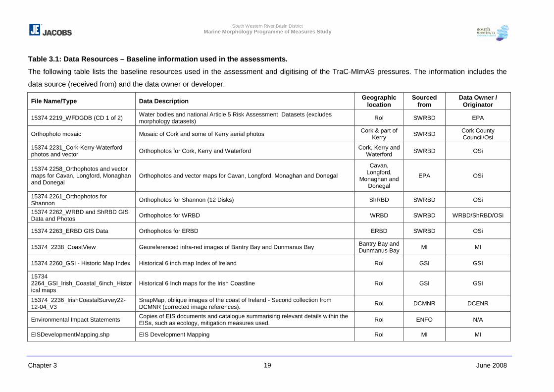
South Western River Basin District Marine Morphology Programme of Measures Study
Chapter 3 June 2008 19
Table 3.1: Data Resources – Baseline information used in the assessments.
The following table lists the baseline resources used in the assessment and digitising of the TraC-MImAS pressures. The information includes the
data source (received from) and the data owner or developer.
File Name/Type Data Description Geographic location
Sourced from
Data Owner / Originator
15374 2219_WFDGDB (CD 1 of 2) Water bodies and national Article 5 Risk Assessment Datasets (excludes morphology datasets) RoI SWRBD EPA
Orthophoto mosaic Mosaic of Cork and some of Kerry aerial photos Cork & part of Kerry SWRBD Cork County
Council/Osi
15374 2231_Cork-Kerry-Waterford photos and vector Orthophotos for Cork, Kerry and Waterford Cork, Kerry and
Waterford SWRBD OSi
15374 2258_Orthophotos and vector maps for Cavan, Longford, Monaghan and Donegal
Orthophotos and vector maps for Cavan, Longford, Monaghan and Donegal
Cavan, Longford,
Monaghan and Donegal
EPA OSi
15374 2261_Orthophotos for Shannon Orthophotos for Shannon (12 Disks) ShRBD SWRBD OSi
15374 2262_WRBD and ShRBD GIS Data and Photos Orthophotos for WRBD WRBD SWRBD WRBD/ShRBD/OSi
15374 2263_ERBD GIS Data Orthophotos for ERBD ERBD SWRBD OSi
15374_2238_CoastView Georeferenced infra-red images of Bantry Bay and Dunmanus Bay Bantry Bay and Dunmanus Bay MI MI
15374 2260_GSI - Historic Map Index Historical 6 inch map Index of Ireland RoI GSI GSI
15734 2264_GSI_Irish_Coastal_6inch_Historical maps
Historical 6 Inch maps for the Irish Coastline RoI GSI GSI
15374_2236_IrishCoastalSurvey22-12-04_V3
SnapMap, oblique images of the coast of Ireland - Second collection from DCMNR (corrected image references). RoI DCMNR DCENR
Environmental Impact Statements Copies of EIS documents and catalogue summarising relevant details within the EISs, such as ecology, mitigation measures used. RoI ENFO N/A
EISDevelopmentMapping.shp EIS Development Mapping RoI MI MI
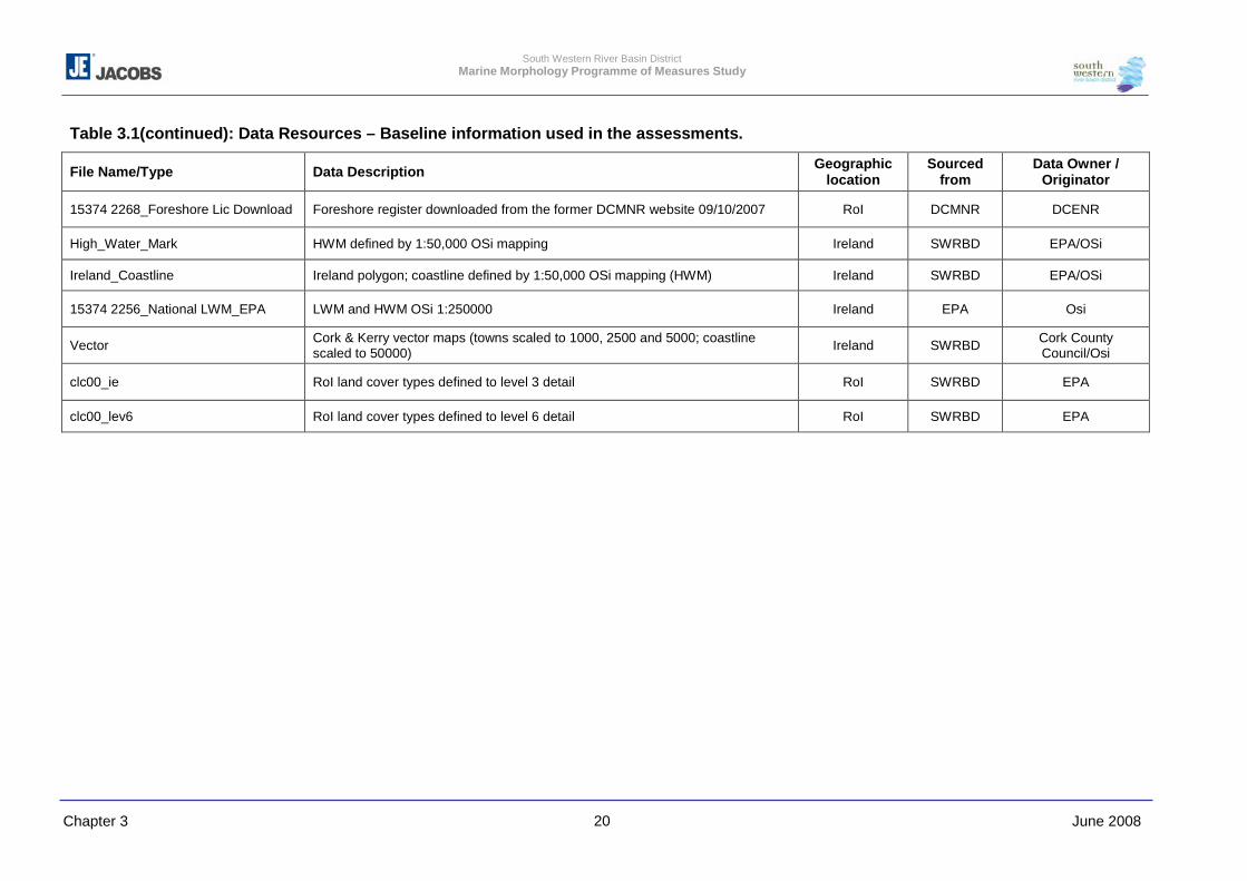
South Western River Basin District Marine Morphology Programme of Measures Study
Chapter 3 June 2008 20
Table 3.1(continued): Data Resources – Baseline information used in the assessments.
File Name/Type Data Description Geographic location
Sourced from
Data Owner / Originator
15374 2268_Foreshore Lic Download Foreshore register downloaded from the former DCMNR website 09/10/2007 RoI DCMNR DCENR
High_Water_Mark HWM defined by 1:50,000 OSi mapping Ireland SWRBD EPA/OSi
Ireland_Coastline Ireland polygon; coastline defined by 1:50,000 OSi mapping (HWM) Ireland SWRBD EPA/OSi
15374 2256_National LWM_EPA LWM and HWM OSi 1:250000 Ireland EPA Osi
Vector Cork & Kerry vector maps (towns scaled to 1000, 2500 and 5000; coastline scaled to 50000) Ireland SWRBD Cork County
Council/Osi
clc00_ie RoI land cover types defined to level 3 detail RoI SWRBD EPA
clc00_lev6 RoI land cover types defined to level 6 detail RoI SWRBD EPA
South Western River Basin District Marine Morphology Programme of Measures Study
Chapter 3 June 2008 21
3.2.2 Pressures
The pressures assessed within this study are discussed in detail in Chapter 5 in relation to
their potential impact on the morphology of TraC waters. The purpose of this section is to
outline the information considered for the further characterisation of each pressure type and
how this was prepared for assessment using TraC-MImAS. The TraC-MImAS tool was
developed to help regulators determine whether changes to the morphology of TraC waters
could pose a risk to ecology, and thereby identify those that could threaten the aim of
achieving GES or result in a deterioration of ecological status (see Chapter 2 and 5). The
tool uses a concept of ‘system capacity’ (allowable morphological change) to measure
impacts to morphological conditions. The tool assuming that a pristine water body has a
measure of assimilative ‘capacity’, which is degraded by anthropogenic activities or
pressures.
TraC-MImAS requires each pressure to be defined by its ‘footprint’ (area/length) per water
body as well as its proportion per tidal zone, i.e. intertidal and subtidal zone to assess the
pressure areas against the ‘system capacity’.
As part of the initial risk assessments undertaken in Ireland, preliminary information on the
those pressures outlined in Section 2 above was obtained and translated into files
compatible with the ESRI GIS ‘ArcGIS’. Shapefiles were created for each of the pressures
identified e.g. polygons of areas dredged. On completion of the initial risk assessments,
each RBD submitted the shapefiles collated for their District to the EPA who then merged
these to create national shapefiles for the purpose of reporting to the EC.
The baseline datasets outlined in Section 3.2.1 above are common to the assessment of
most if not all the pressures. The coverage of orthophotos and historical maps, for the
purpose of land claim pressures, was fundamental to the identification of pressure extents.
In the absence of orthophotos, the EPA Envision online mapper could be used to clarify
some pressure extents. However, pressures were only digitised in those areas where
orthophotos were available (as shown in Figures 3.4-3.9(b) (orthophotographic coverage
noted under Baseline section)).
3.2.2.1 Dredging, Other Disturbances & Disposal at Sea
‘Dredging’ and ‘Disposal at Sea’ are two pressures identified by the initial risk assessments
as potentially impacting on the morphology of TraC water bodies. For the purpose of further
characterisation Dredging is defined as either ‘Dredging - High Impact’', which corresponds
South Western River Basin District Marine Morphology Programme of Measures Study
Chapter 3 June 2008 22
for the most part to capital dredging (first time, deep dredge), or ‘Dredging - Low Impact’,
which corresponds for the most part to maintenance dredging (navigational channels etc).
The pressure ‘Other Disturbances to Seabed’ is defined as “any other temporary
disturbances to bed morphology or substrate character where the impacts are likely to be
restricted to the area of bed directly disturbed and where the bed is likely to recover
significantly over time” (see Table 3.2). Shellfish dredging, vessel movements, wind farms,
cables and pipelines were considered to represent this pressure type.
Wind farm zones were included in this pressure as, although the sea bed is unlikely to
recover “significantly over time” following development of these farms; these areas are
currently only ‘zoned’ and therefore likely to be subject to investigative surveys. For the
most part, these zones are offshore and outside the boundaries of the WFD water bodies.
As noted in Section 2.1 of this report, aquaculture is outside the scope of this study.
However, as this is such a prominent activity in Irish TraC waters, and is not being
considered elsewhere, it was agreed with the Marine Morphology Steering Group that the
pressure ‘Other Disturbances to Seabed’ should represent the aquaculture activities of
shellfish dredging and trawling only. This is a similar approach to that of the NS-Share
Marine Morphology study for which aquaculture was assessed and therefore assists in
harmonisation throughout Ireland. No detailed assessment was undertaken for aquaculture
other than the mapping of worked and licensed areas.
Data Resources
The following section outlines the data resources identified by the source organisations.
Office of Public Works
The information used to further characterise maintenance dredging included that associated
with arterial drainage schemes and drainage districts as recorded by the Office of Public
Works (OPW). The OPW is the Irish Government’s principal engineering agency whose
work includes the maintenance of arterial drainage schemes and the development, design
and implementation of urban flood alleviation works. For the purpose of the initial risk
assessments, the OPW released this information to the RBDs in 2004 for use in WFD
assessments. However, in January 2005 the OPW released updated datasets for arterial
drainage schemes and drainage districts to replace that previously issued. This first revision
includes corrections made to the channels, benefiting lands and embankment records only.
Corrected GIS layers for Drainage Districts, Bridges, Sluices and Weirs have yet to be
released.
South Western River Basin District Marine Morphology Programme of Measures Study
Chapter 3 June 2008 23
Marine Institute
The Marine Institute provided shipping navigation channel data, which in the absence of
accurate maintenance dredging information, was used to provide the area impact of the
navigation channels. These areas must be maintained for safe navigation and therefore are
subject to maintenance dredging as required. Records from the former DCMNR foreshore
and dumping at sea databases and the series of excel spreadsheets that were compiled by
the Marine Institute were used to ensure the areas were subject to maintenance dredging.
(Table 3.2) These sources also provided information and locations of dumping at sea areas.
Attribute information on the nature of the dredge / dump material, Site IDs and Licence
numbers were added to the dumping at sea areas.
The Marine Institute also provided information on subsea cables from the Kingfisher cable
safety charts as part of information used to assess areas designated for future offshore
wind farm development. These areas were also assessed as other disturbances to seabed,
as some are already being developed.
Fisheries information was provided by the Marine Institute, providing information on inshore
fisheries and fishing gear usage.
Former Department of Communications, Marine and Natural Resources
The former DCMNR provided a number of datasets on foreshore and licensing information
via their website, the Marine Licence Vetting Committee and the Marine Institute. The
former department had begun programmes to collate this information under the Costal
Zone Administration System (COZAS) programme, but due to departmental reorganisation
these programmes had been stalled indefinitely. As a result the positional accuracy of the
received data was insufficient to estimate the extents in most cases.
As an interim measure, the former DCMNR allowed access to their licence for oil and gas
infrastructure from Oilfields Publications Ltd.
Similarly the Integrated Fisheries Information System (IFIS), which was intended to provide
information on aquaculture and inshore fisheries, is currently unavailable. As a result,
information from existing databases was combined and compared; most notably the 2005
Aquaculture database the forerunner to the IFIS, which was provided by the former
DCMNR and DAFF.
South Western River Basin District Marine Morphology Programme of Measures Study
Chapter 3 June 2008 24
Bord Iascaigh Mhara (BIM)
BIM provided shellfisheries area data for some of the RBD areas. Much of the data BIM had
available was incorporated into the aquaculture database provided by the former DCMNR.
However, information on bivalves fisheries could be assessed, though there was
incomplete national coverage for this dataset.
Reference Information
Ferry route information was used from the ArcGIS European information. This is a series of
sets of information provided by the US National Imagery and Mapping Agency (NIMA) and
is based on USGS (United States Geological Survey) and the CIA (Central Intelligence
Agency) world gazetteer data. The dataset includes coastline data (1:1,000,000), towns,
cities, major rail and road links. The ferry routes are given for major European and UK
routes.
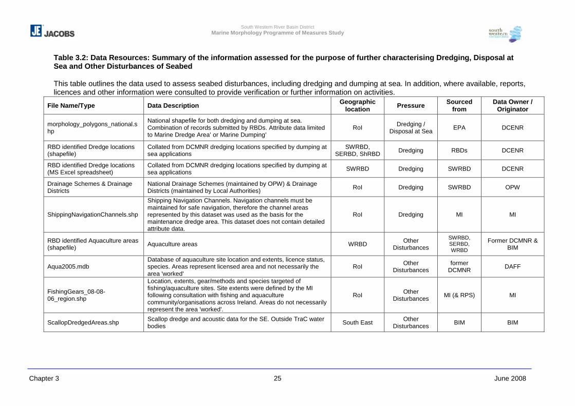
South Western River Basin District Marine Morphology Programme of Measures Study
Chapter 3 June 2008 25
Table 3.2: Data Resources: Summary of the information assessed for the purpose of further characterising Dredging, Disposal at Sea and Other Disturbances of Seabed This table outlines the data used to assess seabed disturbances, including dredging and dumping at sea. In addition, where available, reports, licences and other information were consulted to provide verification or further information on activities.
File Name/Type Data Description Geographic location Pressure Sourced
from Data Owner /
Originator
morphology_polygons_national.shp
National shapefile for both dredging and dumping at sea. Combination of records submitted by RBDs. Attribute data limited to Marine Dredge Area’ or Marine Dumping’
RoI Dredging / Disposal at Sea EPA DCENR
RBD identified Dredge locations (shapefile)
Collated from DCMNR dredging locations specified by dumping at sea applications
SWRBD, SERBD, ShRBD Dredging RBDs DCENR
RBD identified Dredge locations (MS Excel spreadsheet)
Collated from DCMNR dredging locations specified by dumping at sea applications SWRBD Dredging SWRBD DCENR
Drainage Schemes & Drainage Districts
National Drainage Schemes (maintained by OPW) & Drainage Districts (maintained by Local Authorities) RoI Dredging SWRBD OPW
ShippingNavigationChannels.shp
Shipping Navigation Channels. Navigation channels must be maintained for safe navigation, therefore the channel areas represented by this dataset was used as the basis for the maintenance dredge area. This dataset does not contain detailed attribute data.
RoI Dredging MI MI
RBD identified Aquaculture areas (shapefile) Aquaculture areas WRBD Other
Disturbances
SWRBD, SERBD, WRBD
Former DCMNR & BIM
Aqua2005.mdb Database of aquaculture site location and extents, licence status, species. Areas represent licensed area and not necessarily the area 'worked'
RoI Other Disturbances
former DCMNR DAFF
FishingGears_08-08-06_region.shp
Location, extents, gear/methods and species targeted of fishing/aquaculture sites. Site extents were defined by the MI following consultation with fishing and aquaculture community/organisations across Ireland. Areas do not necessarily represent the area 'worked'.
RoI Other Disturbances MI (& RPS) MI
ScallopDredgedAreas.shp Scallop dredge and acoustic data for the SE. Outside TraC water bodies South East Other
Disturbances BIM BIM
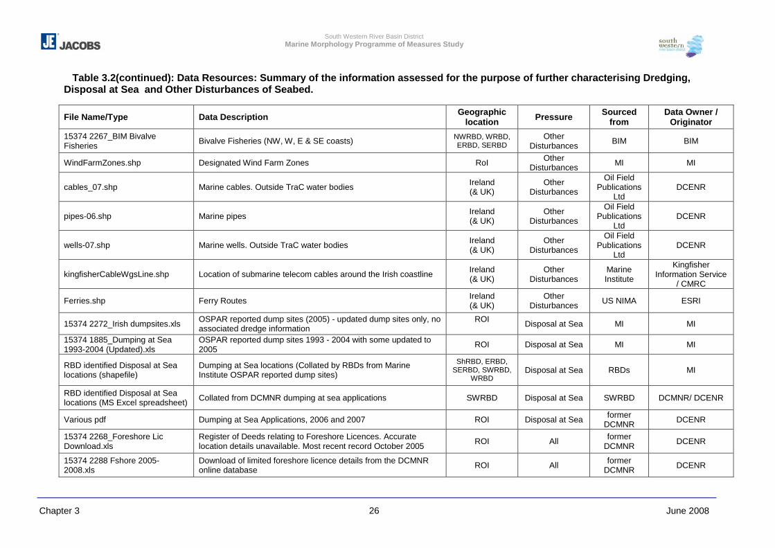
South Western River Basin District Marine Morphology Programme of Measures Study
Chapter 3 June 2008 26
Table 3.2(continued): Data Resources: Summary of the information assessed for the purpose of further characterising Dredging, Disposal at Sea and Other Disturbances of Seabed.
File Name/Type Data Description Geographic location Pressure Sourced
from Data Owner /
Originator
15374 2267_BIM Bivalve Fisheries Bivalve Fisheries (NW, W, E & SE coasts) NWRBD, WRBD,
ERBD, SERBD Other
Disturbances BIM BIM
WindFarmZones.shp Designated Wind Farm Zones RoI Other Disturbances MI MI
cables_07.shp Marine cables. Outside TraC water bodies Ireland (& UK)
Other Disturbances
Oil Field Publications
Ltd DCENR
pipes-06.shp Marine pipes Ireland (& UK)
Other Disturbances
Oil Field Publications
Ltd DCENR
wells-07.shp Marine wells. Outside TraC water bodies Ireland (& UK)
Other Disturbances
Oil Field Publications
Ltd DCENR
kingfisherCableWgsLine.shp Location of submarine telecom cables around the Irish coastline Ireland (& UK)
Other Disturbances
Marine Institute
Kingfisher Information Service
/ CMRC
Ferries.shp Ferry Routes Ireland (& UK)
Other Disturbances US NIMA ESRI
15374 2272_Irish dumpsites.xls OSPAR reported dump sites (2005) - updated dump sites only, no associated dredge information
ROI Disposal at Sea MI MI
15374 1885_Dumping at Sea 1993-2004 (Updated).xls
OSPAR reported dump sites 1993 - 2004 with some updated to 2005 ROI Disposal at Sea MI MI
RBD identified Disposal at Sea locations (shapefile)
Dumping at Sea locations (Collated by RBDs from Marine Institute OSPAR reported dump sites)
ShRBD, ERBD, SERBD, SWRBD,
WRBD Disposal at Sea RBDs MI
RBD identified Disposal at Sea locations (MS Excel spreadsheet) Collated from DCMNR dumping at sea applications SWRBD Disposal at Sea SWRBD DCMNR/ DCENR
Various pdf Dumping at Sea Applications, 2006 and 2007 ROI Disposal at Sea former DCMNR DCENR
15374 2268_Foreshore Lic Download.xls
Register of Deeds relating to Foreshore Licences. Accurate location details unavailable. Most recent record October 2005 ROI All former
DCMNR DCENR
15374 2288 Fshore 2005-2008.xls
Download of limited foreshore licence details from the DCMNR online database ROI All former
DCMNR DCENR
South Western River Basin District Marine Morphology Programme of Measures Study
Chapter 3 June 2008 27
Methodology for Assessing Dredging, Disposal at Sea and Other Disturbances of
Seabed
The following methodology was adopted for assessing Dredging, Disposal at Sea and
Other Disturbances of Seabed:
a. Collate all dredging and disposal data received from the RBDs and the EPA to ensure
all related attribute information is contained with a national shapefile. This resulted in
two shapefiles representing the national findings of the initial risk assessments for both
dredging and disposal at sea.
b. Identify which records from the national dredging file are most likely to represent
maintenance/capital dredging by removing those associated with aquaculture.
i. Firstly those records from the national dredge file that were not identical to, but
intersected with sites referenced in the former DCMNR 2005 Aquaculture Database
were selected.
ii. From this selection, those records most likely to represent maintenance/capital
dredging were identified following a review of the Marine Institute fishing atlas and
attribute data supplied by the RBDs.
iii. A review of foreshore licence records helped identify which sites were most likely
maintenance and capital dredge areas, and two shapefiles representing high and
low impact dredge areas were generated.
c. Identify additional maintenance/capital dredge areas within TraC water bodies
i. Shipping Navigation channels: The area of maintained channel for shipping and
navigation was used as the basis for maintenance dredge areas. Navigation
channels must be maintained for safe navigation, although the frequency of
maintenance for these areas is not recorded within this dataset.
ii. Dumping at Sea applications were reviewed and where possible the area dredged
was compared with the shipping navigation channels; none of which lay out side
these navigation areas.
iii. Another potential source of maintenance dredge data is that available through
OPW. Those records associated with ‘channels’ were selected for assessment.
Information relating to the extent of maintenance of these channels was limited.
Ttherefore, to estimate the area of channel/drain maintained the following buffer
extents were applied:
- Channel drains – 4.5m buffer: as the average drain size is 7-9m wide (King,
1996)).
- Channels – 150m: Based on the maintained channel width average for
navigation.
- Drainage Districts - data from drains and channels from the Drainage District
channels dataset (data from the OPW, drainage maintained by Local
South Western River Basin District Marine Morphology Programme of Measures Study
Chapter 3 June 2008 28
Authorities) were selected and buffered as above. The Fane estuary main
channel was identified from 2007 Central Fisheries Board (CFB) surveys and
ecological data as a maintained buoyed channel. The channel was therefore
buffered at 150m though not identified as such from the provided attribute data.
The buffer sizes were determined by assessment of channel and drain information
from OPW papers (such as scheme summaries on the OPW website and King,
1996) and in agreement with the Steering group.
iv. The foreshore licence/lease register was consulted and any additional dredge areas
and/or information of relevance to the identified dredged areas was added to the
national dredge file. A channel was added in the New Ross water body consisting
eight capital dredge polygons forming a channel. This had been identified as a
capital dredge operation, but is now maintained for navigation and was therefore
transferred to the shipping channels dataset with the agreement of the Steering
Group.
v. No additional capital (high impact) dredge areas were identified
d. Those associated with shipping and drainage channel maintenance were merged with
those identified in the initial risk assessments to generate a national file of maintenance
(low impact) dredge areas.
e. Identify pressure footprints for ‘Other Disturbances to Seabed’ - Shellfish dredging &
trawling.
i. To identify sites dredged or trawled for shellfish those records identified from the
Marine Institute fishing atlas as dredged and trawled with a shellfish targeted
species were firstly selected. No trawling sites were targeted at shellfish species.
ii. The former DCMNR 2005 aquaculture database does not specify the aquaculture
method used for each site. Therefore, it was assumed that aquaculture sites which
intersected with the shellfish dredge areas identified from the Marine Institute fishing
atlas represented licensed dredged shellfish areas. Sixty three sites were identified.
iii. National bivalve fishery areas were obtained from BIM. Using attribute data
supplied, those areas annotated by ‘dredging’ were selected for assessment.
iv. The sites identified by the steps above overlap in many areas. Also, the site
boundaries do not necessary mark the ‘worked area’ but where these activities are
licensed to take place. It was therefore considered most appropriate to ‘union’ all
sites within ArcGIS. This step ensures that sites that overlap do not result in a
double-up in footprint area. For example, if sites from BIM and Marine Institute
overlapped for 2km2; this 2km2 is only counted once as a footprint but records the
attribute information from both sources.
f. Identify pressure footprints for ‘Other Disturbances to Seabed’ – pipelines, cables and
vessel movements.
South Western River Basin District Marine Morphology Programme of Measures Study
Chapter 3 June 2008 29
i. Data for marine cables and pipelines was received in polyline format, but excluded
information relating to the width of these structures. Therefore, to estimate the area
potentially affected buffers were created for each structure as follows:
- Kingfisher cables: 25m (based on the potential zone of impact for laying and
scour action for surface cables (ABpMer, 2002)
- Pipelines: 50m (based on the potential zone of impact for laying and scour
action or rock armour impact for pipelines)
ii. Ferry routes were buffered to 150m (based on the average maintained channel
width for navigation channels)
g. Finalise ‘Other Disturbances to Seabed’
i. Footprints for the following pressure types were merged to create the final Other
Disturbances to Seabed file:
- Shellfish dredge areas
- Buffered cable and pipelines
- Designated wind farm areas
- Buffer ferry routes
ii. Cables, pipes, ferry routes, and wind farms all represent additional pressures to
shellfish dredge areas. Therefore, where these sites overlap the pressure footprints
will double for that area.
3.2.2.2 Piled, Flow and Sediment Manipulation Structures
For the purpose of this study piled structures are defined as ‘structures raised on one or
more foundation structures extending out into the adjacent water body e.g. bridge and pier
supports’ (SEPA et al (in press)). Flow and sediment manipulation structures are defined as
‘hard engineering structures built to stabilise waterways for navigation and counter the
effects of longshore drift’ SEPA et al (in press)) such as piers, groynes and training walls.
Data Resources
The information assessed for the purpose of further characterising piled and flow and
sediment manipulation structure is summarised in Table 3.3. The following section outlines
the data assessed by the source organisation
River Basin District Initial Risk Assessment
Ports and harbours were assessed as part of the pressure ‘Built Structures’. The location,
port name and tonnage were presented in point shapefiles. Further characterisation of ‘Built
Structures’ required the identification of the type and extents of structures associated with
these ports and harbours.
South Western River Basin District Marine Morphology Programme of Measures Study
Chapter 3 June 2008 30
Marine Institute
The Marine Institute, in partnership with Donegal, Mayo and Galway County Councils have
made available via an online National Coastal Infrastructure Service details of piers, quays,
harbours and slipways. A database of these structures including additional unreleased data
for County Cork was acquired from the Marine Institute for assessment of flow and
sediment manipulation structures. Due to the nature of the National Coastal Infrastructure
Service only specific information can be queried for external release; the following
information was obtained:
� Structure name
� Structure type
� Width (m)
� Length (m)
� Location
As with the information collated for the initial risk assessments, this dataset displayed as
point locations. However, measurements for structure width and length were provided for
approximately 75% of the records. In addition to anthropogenic structures this dataset also
included natural landing sites which were excluded from the assessment.
Coastal and Marine Resource Centre
Datasets relating to the location of ports, harbours, marinas, and sailing clubs were
obtained from the Coastal and Marine Resource Centre (CMRC). Additional information
provided for these locations included traffic volume, route and service information. Further
characterisation of pressures associated with these navigational sectors required the
extents of specific structures such as piers or jetties to be digitised.
South Western River Basin District Marine Morphology Programme of Measures Study
Chapter 3 June 2008 31
Table 3.3: Data Resources - Summary of the information assessed for the purpose of further characterising piled and flow and sediment manipulation structure This table outlines the information used to assess the pile, flow and sediment manipulation structures. This data was verified and expanded
supported by the baseline information in Table 3.1
File Name/Type Data Description Geographic location Pressure Sourced from Data Owner /
Originator
port_tonnage.shp ERBD Port name and tonnage, no structure details ERBD Flow/Sediment manipulation structures ERBD ERBD
Ports_Harbours.shp SERBD port name and tonnage, no structure details SERBD Flow/Sediment manipulation structures SERBD SERBD
Ports_Structures_point.shp
Structure type and tonnage defined for some records ShRBD Flow/Sediment manipulation structures ShRBD ShRBD
Ports&Harburs.shp Created layer based on the information contained in the CSO document “Statistics of Port Traffic” for the risk assessment. Port name and tonnage, no structure details
SWRBD Flow/Sediment manipulation structures SWRBD SWRBD
WRBD_Ports_point.shp Port location only, no structure details WRBD Flow/Sediment manipulation structures WRBD WRBD
NS_Harbours_etc.2.shp NS Coastal features such as jetties and piers. Attribute date includes structure type and title of oblique images used to identify structure NSS Flow/Sediment
manipulation structures NS-Share NS-Share
NS_Ports.shp NS Point location of ports, no structure details NSS Flow/Sediment manipulation structures NS-Share NS-Share
15374 2271_Coastal Structures Rev3.xls
Location of piers, quays, harbours and slipways collated for the National Coastal Infrastructure Service. Details of areal extents are provided for many structures. Information for counties Donegal, Mayo and Galway is available at coastal i.e as part of a data release from the first stage of the project. Further releases will include information for other counties. Data received included unreleased data for county Cork
Galway, Mayo, Donegal and
Cork
Flow/Sediment manipulation structures MI
MI; Donegal; Mayo; Galway; & Cork CoCo
intFerryPorts.shp Location of ports and route information Ireland Flow/Sediment manipulation structures CMRC CMRC
localFerryPorts.shp Location of ports and route information Ireland Flow/Sediment manipulation structures CMRC CMRC
South Western River Basin District Marine Morphology Programme of Measures Study
Chapter 3 June 2008 32
Table 3.3(continued): Data Resources - Summary of the information assessed for the purpose of further characterising piled and flow and sediment manipulation structure
File Name/Type Data Description Geographic location Pressure Sourced from Data Owner /
Originator
marinas.shp Marinas, pontoons, mooring, sailing, berths Ireland Flow/Sediment manipulation structures CMRC CMRC
rnliStations.shp Location of lifeboat stations and information on services available Ireland Flow/Sediment manipulation structures CMRC
Royal National Lifeboat
Institution
commercialPortsIE.shp Generalised locations of ports, traffic volume (2005) ROI Flow/Sediment manipulation structures CMRC CMRC
fishingPortsIE.shp Location of ports ROI Flow/Sediment manipulation structures CMRC CMRC
sailingClubIsa.shp Location and other relevant information about Irish Sailing Association (ISA) member sailing clubs ROI Flow/Sediment
manipulation structures CMRC CMRC
Merge_embed_26_1_04.shp
CMRC Cork Harbour Study: Merged information on shoreline features such as jetties and piers, human access points (steps & ladders)
Cork Harbour Flow/Sediment manipulation structures SWRBD CMRC
Merge_ship_26_1_04.shp
CMRC Cork Harbour Study: Information on the shipping related features of shoreline, such as dock or shipyard Cork Harbour Flow/Sediment
manipulation structures SWRBD CMRC
Bridge DD V1 Location of OPW Drainage District bridges. Point shapefile indicating location RoI Piled structures SWRBD OPW
South Western River Basin District Marine Morphology Programme of Measures Study
Chapter 3 June 2008 33
Methodology for Assessing Piled, Flow and Sediment Manipulation Structures
The following methodology was adopted for assessing Piled, Flow and Sediment
Manipulation Structures:
a Firstly, those coastal structures identified by the Marine Institute database lacking areal
measurements were reviewed using orthophotos and oblique images. Where identified,
these structures were digitised and the relevant attribute information extracted.
b The orthophotos and oblique images were then used to review the remaining data
sources listed in Table 3.1 above. Where orthophotos were available; the extents of
identified structures were digitised.
c On completion of this step, urban and industrial areas as identified by the EPA CORINE
were reviewed for any additional structures. The OPW records for bridges were also
reviewed and additional piled structures were digitised.
Oblique images were not available to confirm the presence of all piled structures particularly
those in upstream tidal channels.
3.2.2.3 Shoreline Reinforcement
Shoreline reinforcement structures are defined as two different structure types for the
purpose of further characterisation and assessment within TraC-MImAS:
� Shoreline reinforcement – High Impact: “The use of consolidated materials, e.g. rock
armour, revetments, retaining walls, gabion baskets, seawalls, wharves, sheet piling
etc. to protect vulnerable coastlines or harbours from erosion”. (SEPA et al (in press))
Refers to situations were the reinforcement is having a persistent influence over the
intertidal or subtidal zone.
� Shoreline reinforcement – Low Impact: “Stabilisation of the shoreline using beach
material to maintain beach levels and dimensions. May include use of synthetic
materials. Also includes other forms of low impact shoreline protection, for instance
protection that is set back and does not have a persistent influence over the intertidal or
subtidal zones.” (SEPA et al (in press))
Data Resources
A registered national database of coastal defence and protections structures is not
available for Ireland. However, the former DCMNR Engineering Division hold paper records
of structures licensed for construction but it was not practical to consult this data on a
national scale appraisal.
South Western River Basin District Marine Morphology Programme of Measures Study
Chapter 3 June 2008 34
The following resources (Table 3.4) were used to focus the review of Ireland’s coast for
shoreline reinforcement structures. Additional features were also digitised where identified
during the assessment of other pressures.
� Existing records of shoreline reinforcement type structures as provided by the RBDs
� Urban and industrial areas (as identified by the EPA CORINE 2000 land use dataset)
� Ortho and oblique photos, where available; and
� Foreshore licence records (shoreline reinforcement – low impact; beach nourishment)
River Basin District Initial Risk Assessment
Coastal defence features were identified in the initial risk assessments following the review
of coastal images produced by the former DCMNR Coastal Helicopter Survey (SnapMap
Project) and collated by the EPA into a national coastal defence shapefile for the purpose of
reporting. Records identified in the initial risk assessments for the WRBD and NWRBD
were not received for this Study and were absent from the national shapefile.
The RBD datasets contain a mixture of coastal defence structures, all of which do not
represent shoreline reinforcement as defined for this study but pressures of a different sort
e.g. embankments.
Coastal and Marine Resource Centre
The CMRC completed a Coastal Inventory project for Cork Harbour. As part of this project
the shoreline features of the following areas of Cork Harbour were identified and mapped;
Upper West and Mid Harbour, East Ferry, West Passage, Spike/Cobh, Whitegate, and
Owenabue. These areas of shoreline fall into the following WFD water bodies:
� Lee (Cork) Estuary Upper and Lower (SW_060_0950 and SW_060_0900);
� Lough Mahon (SW_060_0750);
� Lough Mahon (Harper’s Island) (SW_060_0700);
� North Channel Great Island (SW_060_0300);
� Cork Harbour (SW_060_0000); and
� Owenboy Estuary (SW_060_1200)
The information provided by CMRC to Cork County Council (and SWRBD) is bound by the
following copyright:
“The data contained on this CD can not be copied, utilised or disseminated in any way
without prior written consent from the CMRC. Many of the datasets contained on the CD
are used under licence from other agencies, information on the licences can be got by
contacting the CMRC”.
South Western River Basin District Marine Morphology Programme of Measures Study
Chapter 3 June 2008 35
Data produced by this project and provided by the SWRBD was incorporated into the
Marine Morphology study for the assessment of shoreline reinforcement in those water
bodies outlined above. However, permission must be sought from the CMRC prior to the
use of this data by other bodies outside Cork County Council (and SWRBD).
The former Department of Communications, Marine and Natural Resources
RPS Consulting Engineers are currently undertaking a flood risk study on behalf of the
former DCMNR. Discussions with RPS concluded that ‘at risk’ areas have been identified
for Ireland’s coast and it is the intention of this study to identify existing coastal
defence/protection in these areas. At the time of writing, those structures for ‘at risk’ areas
along the eastern Irish coastline were identified, however, release of this data was not
permitted until completion of the project.
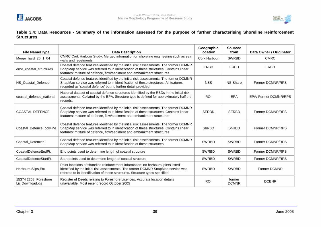
South Western River Basin District Marine Morphology Programme of Measures Study
Chapter 3 June 2008 36
Table 3.4: Data Resources - Summary of the information assessed for the purpose of further characterising Shoreline Reinforcement Structures
File Name/Type Data Description Geographic
location Sourced
from Data Owner / Originator
Merge_hard_26_1_04 CMRC Cork Harbour Study: Merged information on shoreline engineering such as sea walls and revetments Cork Harbour SWRBD CMRC
erbd_coastal_structures Coastal defence features identified by the initial risk assessments. The former DCMNR SnapMap service was referred to in identification of these structures. Contains linear features: mixture of defence, flow/sediment and embankment structures
ERBD
ERBD
ERBD
NS_Coastal_Defence Coastal defence features identified by the initial risk assessments. The former DCMNR SnapMap service was referred to in identification of these structures. All features recorded as 'coastal defence' but no further detail provided
NSS NS-Share Former DCMNR/RPS
coastal_defence_national National dataset of coastal defence structures identified by the RBDs in the initial risk assessments. Collated by the EPA. Structure type is defined for approximately half the records.
ROI EPA EPA/ Former DCMNR/RPS
COASTAL DEFENCE Coastal defence features identified by the initial risk assessments. The former DCMNR SnapMap service was referred to in identification of these structures. Contains linear features: mixture of defence, flow/sediment and embankment structures
SERBD SERBD Former DCMNR/RPS
Coastal_Defence_polyline Coastal defence features identified by the initial risk assessments. The former DCMNR SnapMap service was referred to in identification of these structures. Contains linear features: mixture of defence, flow/sediment and embankment structures
ShRBD ShRBD Former DCMNR/RPS
Coastal_Defences Coastal defence features identified by the initial risk assessments. The former DCMNR SnapMap service was referred to in identification of these structures. SWRBD SWRBD Former DCMNR/RPS
CoastalDefenceEndPt. End points used to determine length of coastal structure SWRBD SWRBD Former DCMNR/RPS
CoastalDefenceStartPt. Start points used to determine length of coastal structure SWRBD SWRBD Former DCMNR/RPS
Harbours,Slips,Etc Point locations of shoreline reinforcement information; no harbours, piers listed - identified by the initial risk assessments. The former DCMNR SnapMap service was referred to in identification of these structures. Structure types specified
SWRBD SWRBD Former DCMNR
15374 2268_Foreshore Lic Download.xls
Register of Deeds relating to Foreshore Licences. Accurate location details unavailable. Most recent record October 2005 ROI former
DCMNR DCENR
South Western River Basin District Marine Morphology Programme of Measures Study
Chapter 3 June 2008 37
Methodology for Assessing Shoreline Reinforcement
The following methodology was adopted for assessing Shoreline Reinforcement:
a All existing records of shoreline reinforcement type structures were firstly collated.
These records were then reviewed, verified and/or edited using the coastal imagery
resources.
b Where structures were not identified by the resources listed in Table 3.4 above a search
for additional structures was focused within areas identified as urban or industrial using
the EPA CORINE 2000 land use dataset.
c The foreshore licence/lease register was reviewed within ArcMap for areas of potential
beach nourishment (shoreline reinforcement – low impact), two of which were identified:
� MS51/8/2 Vol 7: Removal of sand for the purpose of nourishing the Beach at Bantry
(1985)
� MS51/8/984: Bere Island beach nourishment (1996)
This register does not provide detail relating to the extent of these activities therefore,
the footprints for these pressures could not be digitised.
d Following reference to the coastal imagery resources and the pressure footprint
description detailed in the introduction above, the structure ‘type’ and an impact rating
of ‘High’ or ‘Low’ was then assigned to each feature
e Where the likely impact of a seawall structure could not be confirmed by coastal
imagery, an impact rating of ‘High’ was assigned as a conservative default.
3.2.2.4 Flood Embankments
Flood Embankments are defined for the purpose of further characterisation and
assessment within TraC-MImAS as “An artificial bank of earth or stone created to prevent
inundation of estuarine and coastal floodplains”. (SEPA et al (in press))
Data Resources
The data resources for flood embankment assessments are summarised in Table 3.5
below.
River Basin District Initial Risk Assessment
The information used to report on flood embankments for the initial risk assessments was
obtained using data provided by the OPW and also a review of the former DCMNR coastal
oblique images. As noted in Section 3.2.2.1 (Dredging – Data Resources) above the OPW
released an updated revision of the GIS layer Drainage Scheme Embankments in 2005.
South Western River Basin District Marine Morphology Programme of Measures Study
Chapter 3 June 2008 38
Embankment datasets received from the RBDs were for the most part generated from the
superseded 2004 OPW dataset which incorporated additional records to those contained
within the 2005 revision, including line features representing the location of lands benefiting
from embankments. With respect to the request from OPW not to use the 2004 data those
records provided by the RBDs were clarified with the OPW 2005 dataset and/or coastal
imagery prior to inclusion as pressure footprints.
OPW requested that the following colour format be utilised for 2005 revision of Drainage
Embankments:
- Line 3 pixels thick; Colour green (red: 0, green: 125; blue: 0)
Following discussions with OPW relating to additional embankments identified, OPW asked
to be notified of any errors or new embankments identified on completion of this project.
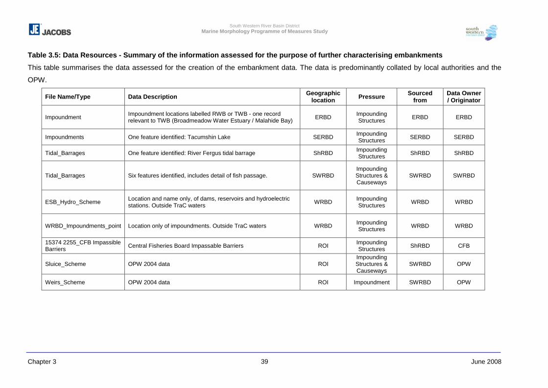
South Western River Basin District Marine Morphology Programme of Measures Study
Chapter 3 June 2008 39
Table 3.5: Data Resources - Summary of the information assessed for the purpose of further characterising embankments
This table summarises the data assessed for the creation of the embankment data. The data is predominantly collated by local authorities and the
OPW.
File Name/Type Data Description Geographic location Pressure Sourced
from Data Owner / Originator
Impoundment Impoundment locations labelled RWB or TWB - one record relevant to TWB (Broadmeadow Water Estuary / Malahide Bay) ERBD Impounding
Structures ERBD ERBD
Impoundments One feature identified: Tacumshin Lake SERBD Impounding Structures SERBD SERBD
Tidal_Barrages One feature identified: River Fergus tidal barrage ShRBD Impounding Structures ShRBD ShRBD
Tidal_Barrages Six features identified, includes detail of fish passage. SWRBD Impounding Structures & Causeways
SWRBD SWRBD
ESB_Hydro_Scheme Location and name only, of dams, reservoirs and hydroelectric stations. Outside TraC waters WRBD Impounding
Structures WRBD WRBD
WRBD_Impoundments_point Location only of impoundments. Outside TraC waters WRBD Impounding Structures WRBD WRBD
15374 2255_CFB Impassible Barriers Central Fisheries Board Impassable Barriers ROI Impounding
Structures ShRBD CFB
Sluice_Scheme OPW 2004 data ROI Impounding Structures & Causeways
SWRBD OPW
Weirs_Scheme OPW 2004 data ROI Impoundment SWRBD OPW
South Western River Basin District Marine Morphology Programme of Measures Study
Chapter 3 June 2008 40
Methodology for Assessing Flood Embankments
The following methodology was adopted for assessing Flood Embankments:
a Features identified as embankments in the RBD coastal defence datasets (SERBD and
NSS) were collated with those embankment datasets received from the SWRBD and
WRBD (OPW 2004 data).
b Embankment records from the OPW 2005 dataset were compared with those records
provided by the RBDs to identify those features additional to the OPW 2005 data.
c Additional records identified were then assessed in conjunction with coastal images and
foreshore licence records to focus review for additional embankment features.
d New embankment features were only digitised in areas for which orthophotos were
available.
e Ten foreshores licence records were identified as relating to embankments:
� North Bull Island (MS51/4/108): embankment digitised
� Boyne Estuary (no reference number provided): Embankments are digitized within
this water body; however, their association with this particular licence cannot be
confirmed.
� New Ross Port & Barrow Suir Nore Estuary (four records; MS51/6/150, MS51/1/64):
The OPW 2004 dataset includes embankments at two locations in these water
bodies. Also, on review of the EPA Envision online mapper, embankments are
evident in area. However, due to the lack of orthophoto coverage and oblique
images for these areas embankments were not digitized.
� Cork Harbour (Aghada): specific embankments were not identified for this area,
however land claim pressures were identified for this area (near Electricity Supply
Board (ESB)), a component of which may be embankments (near ESB).
� Lough Mahon (Marino Point – MS51/8/541; and Little Island – MS51/8/429): Area at
Marino Point is reclaimed therefore embankments were not required to be digitised;
however embankments at Little Island were added to the pressure file.
� Lower Shannon Estuary (Tarbert - MS51/9/213): these features are included in the
OPW 2005 dataset (Unique ID: 7792).
f As additional embankments to those recorded by the OPW (2005) were digitised where
identified using orthophotos, the colour format recommended for use by OPW was not
adopted for this pressure as a whole. However, the source of each feature contained
within the resulting pressure dataset was annotated as follows so that those features
representing records sourced from the OPW (2005) can be identified:
Records added / retained:
� “Article 5 –Coastal defence”: sourced from RBD coastal defence shapefiles
� “Article 5 & Orthophotos”: features additional to OPW datasets identified in Art 5
initial risk assessments and clarified using orthophotos.
South Western River Basin District Marine Morphology Programme of Measures Study
Chapter 3 June 2008 41
� “Article 5, Ortho & Obliques photos”: features additional to OPW datasets identified
in Art 5 initial risk assessments and clarified using ortho and oblique photos.
� “OPW 2005 & Orthophotos”
� “OPW 2005, Ortho & Oblique photos”
� “OPW_Oct_2005”: Sourced from OPW 2005 dataset, but extents not be clarified by
ortho or oblique images due to lack of coverage
� “Ortho & Oblique Photos”: new features identified by orthophotos and oblique
images
� “Orthophotos”: new features identified by orthophotos only
Records excluded:
� “Diff to OPW 2005 – breached – Delete”: embankment is contained within the OPW
2004 dataset but is currently breached and therefore not functioning as a flow
manipulating feature
� “Diff to OPW 2005 & no Orthos – Delete”: no orthophotos were available to confirm
the presence or extents of embankments
� “Diff to OPW 2005 & unclear in Orthos – Delete” resolution of orthophotos prevented
confirmation of the presence or extents of embankments
3.2.2.5 Impounding Structures & Causeways
Impounding Structures and Causeways are defined as follows for the purpose of further
characterisation and assessment within TraC-MImAS:
� Impounding Structures: A temporary (e.g. barrage) or permanent structure that
extends across a channel that is used to impound, measure or alter flow (e.g. weirs,
sluices).
� Causeways: A physical barrier projecting from the shore whose foundations extend to
the bed and where gaps in the foundings represent < 20% of the total length. Typically
used to support transport routes.
The pressure ‘footprint’ required for assessment of causeways within TraC-MImAS is the
total area (km) of each structure identified. Also, the proportion of this footprint within the
intertidal and subtidal zones must be estimated.
The footprint required for the assessment of impounding structures within TraC-MImAS was
not confirmed as part of the UKTAG hydromorphology work and it was concluded that each
agency applying TraC-MImAS should review potential footprint rules. Work undertaken to
date to help determine a suitable impact rating for impoundments on TraC waters is
discussed further in Chapter 5. Discussions with the Irish Marine Morphology Steering
South Western River Basin District Marine Morphology Programme of Measures Study
Chapter 3 June 2008 42
Group concluded the following in relation to the assessment of impounding structures within
TraC-MImAS:
� The Marine Morphology Steering Group advised that where historic impoundments are
the likely cause of WFD water bodies delineated as ‘lagoons’ (TW6 and CW10), these
impoundments should not be assigned as pressures on the lagoon, e.g. Durnesh Lough
and Inch Lough.
� The pressure footprint agreed with the Steering Group for assessment with TraC-
MImAS is the area of water body impounded by a structure. Adoption of this method
however, prevents those structures identified at the landward boundary of TraC waters,
such as embankment sluices, being assessed within MImAS, as the area of water
impounded is outside the TraC boundaries. Such pressures will be identified by the
either the Freshwater Morphology or Hydrometric PoMS studies. However, to ensure
the consideration of all relevant pressures on TraC water bodies identified structures of
this character will be reported on, where relevant, separately to MImAS.
Data Resources
The information used in the assessment in the assessment of impoundment structures and
causeways is summarised in Table 3.6. The data was received from the organisations listed
below.
River Basin District Initial Risk Assessment
The following resources were used to collate information relating to impounding structures
for the initial risk assessments:
� Local Authority information and local knowledge (tidal barrages)
� Central Fisheries Board (CFB) dataset of impassable barriers: This dataset was
prepared as part of the study completed by the Central Fisheries Board and Compass
Informatics and compiled in the report “Quantification of the Freshwater Salmon Habitat
in Ireland” (Mc Ginnity et al, 2003). This dataset has very limited attribute information
but represents two types of barriers impassable to salmon:
- Non-self sustaining salmon systems. Digitised points identify the location of the four
main hydroelectric dams (Liffey, Lee, Shannon, and Erne catchments).
- 'Complete' - These are other locations considered to limit salmon migration and
represent a mixture of manmade and natural features. Although the feature types
are not identified by the attribute table, it is considered that most records represent
natural barriers such as waterfalls.
As part of the Freshwater Morphology PoMS, a barrier impact assessment case study
was initiated in 2007 throughout the Nore catchment using data collected by the
Southern Regional Fisheries Board. The purpose of the Nore study is to assess the risk
South Western River Basin District Marine Morphology Programme of Measures Study
Chapter 3 June 2008 43
of in-river structures to the timing and success of salmon migration. The Freshwater
Morphology Group is seeking to build on the existing CFB database of impassable
barriers in order to progress the WFD barriers study.
Office of Public Works Sluice & Weir Data
In addition to OPW data relating to drainage channels and embankments, the 2004 OPW
dataset obtained via the SWRBD contained national records of sluice and weir locations
(which were not updated in 2005). These datasets were not considered for the initial risk
assessments.
The OPW have requested that these datasets are not interpreted to represent accurate
structure locations as they have yet to be fully quality audited (Nathy Gilligan, personal
communication, Feb 2008). OPW are currently reviewing their national data - a final dataset
for sluice and weir structures will not be available within the next year.
For the purpose of further characterisation, the pressure of these structures on TraC water
bodies for the most part is outside TraC-MImAS i.e. the footprint agreed for such
impounding structures, being the area of water body upstream of the structure, is mostly
represented by freshwater channels or drains.
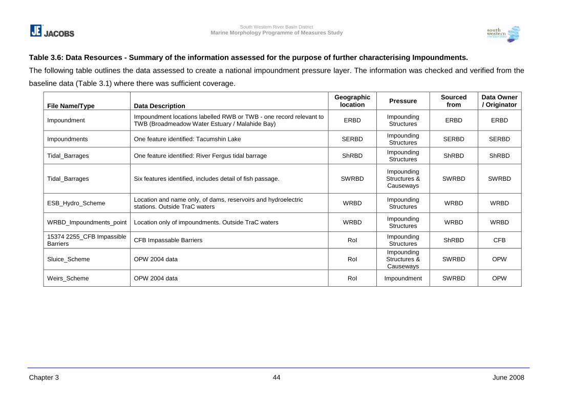
South Western River Basin District Marine Morphology Programme of Measures Study
Chapter 3 June 2008 44
Table 3.6: Data Resources - Summary of the information assessed for the purpose of further characterising Impoundments.
The following table outlines the data assessed to create a national impoundment pressure layer. The information was checked and verified from the
baseline data (Table 3.1) where there was sufficient coverage.
File Name/Type Data Description Geographic
location Pressure Sourced from
Data Owner / Originator
Impoundment Impoundment locations labelled RWB or TWB - one record relevant to TWB (Broadmeadow Water Estuary / Malahide Bay) ERBD Impounding
Structures ERBD ERBD
Impoundments One feature identified: Tacumshin Lake SERBD Impounding Structures SERBD SERBD
Tidal_Barrages One feature identified: River Fergus tidal barrage ShRBD Impounding Structures ShRBD ShRBD
Tidal_Barrages Six features identified, includes detail of fish passage. SWRBD Impounding Structures & Causeways
SWRBD SWRBD
ESB_Hydro_Scheme Location and name only, of dams, reservoirs and hydroelectric stations. Outside TraC waters WRBD Impounding
Structures WRBD WRBD
WRBD_Impoundments_point Location only of impoundments. Outside TraC waters WRBD Impounding Structures WRBD WRBD
15374 2255_CFB Impassible Barriers CFB Impassable Barriers RoI Impounding
Structures ShRBD CFB
Sluice_Scheme OPW 2004 data RoI Impounding Structures & Causeways
SWRBD OPW
Weirs_Scheme OPW 2004 data RoI Impoundment SWRBD OPW
South Western River Basin District Marine Morphology Programme of Measures Study
Chapter 3 June 2008 45
Methodology for Assessing Impounding Structures & Causeways
The following methodology was adopted for assessing Impounding Structures &
Causeways:
a Using the resources outlined above the locations of the impounding structures/tidal
barrages identified in the initial risk assessments were reviewed.
ERBD
� One structure of those identified in the initial risk assessment is relevant to TraC
waters (Broadmeadow Water Estuary / Malahide Bay). The Marine Morphology
Steering Group advised that impoundments should not be assigned to lagoons
created by historic impoundment (Broadmeadow Water). However, as this
impounding structure has not ‘land-locked’ the Broadmeadow Water it was
considered appropriate to represent this feature as a flow and sediment
manipulation structure joined to a piled structure; both of which were assigned to the
downstream water body Malahide Bay (EA_060_0000).
SERBD
� Tacumshin Lake impoundment was identified by the SERBD. A review of the
historic maps and oblique images indicated that the impoundment of this water body
is attributed to natural deposition of material which has created a barrier of dunes.
Taking account of this information and the Marine Morphology Steering Group
advice an impoundment structure was not digitised.
WRBD
� All features identified by the WRBD lay outside TraC water body boundaries.
ShRBD
� One structure was identified by the ShRBD; Fergus Tidal Barrage. This structure
falls outside TraC boundaries and therefore is not digitised. This structure, however,
is assessed by the HMWB PoMs study as the freshwater bodies upstream of this
structure are designated as provisionally heavily modified.
SWRBD
� A ‘tidal barrage’ (with fish passage) was identified in Roaring Water Bay, however,
on review of coastal imagery, this structure was digitised as piled structure not an
impoundment.
� A ‘tidal barrage’ identified in Outer Cork Harbour (Roberts Cove) was digitised as a
Causeway following a review of coastal imagery.
� A ‘causeway’ identified in Cork Harbour (cuskinny river) was confirmed and
digitised.
� A record identified as ‘sluice on lake’ in Rostellan Lake was digitised as a causeway
in Cork Harbour
South Western River Basin District Marine Morphology Programme of Measures Study
Chapter 3 June 2008 46
� A record identified as a ‘sluice/tidal barrage’ in Lough Mahon (Slatty Bridge) was
digitised as a combination of flow/sediment manipulation and pile structures
following review of coastal imagery.
� The presence of a ‘tidal sluice’ identified in Lower Black Water M Estuary was
confirmed. However, this structure was not digitised as the body of water potentially
impounded by this structure is not within the transitional water body boundary.
b Using coastal imagery and the additional data resources outlined in Table 3.6 above, a
search for impounding structures and causeways was undertaken. No additional
impounding structures were identified and many of those recorded by the initial risk
assessments were located outside TraC waters or where present were characterised as
flow and sediment manipulation structures, causeways or piled structures.
3.2.2.6 Land Claim
Land Claim and Tidal Channel Realignment pressures are defined as follows for the
purpose of further characterisation and assessment within TraC-MImAS:
� Land claim - High impact: Recent or proposed enclosure of intertidal or subtidal areas
within impermeable banks followed by infilling for use by agriculture, housing, port or
industry. Also used for land claim that has taken place in the past and is still deemed to
be having a significant impact.
� Land claim - Low impact: Historic (e.g. >50yrs ago) enclosure of intertidal or subtidal
areas within impermeable banks followed by infilling for use by agriculture, housing, port
or industry. Can also be used for more recent land claim where the impacts are minimal
or where the surrounding environment has partly recovered natural habitats and
features.
� Tidal channel realignment - High impact: Recent or proposed realignment of a tidal
channel. Also used for realignment that has taken place in the past and is still deemed
to be having a significant impact.
� Tidal channel realignment - Low impact: Low impact alterations to course or
planform of upper estuaries where the channel remains river-like. Includes straightening
and removal of meanders to increase channel gradient and flow velocity. Typically used
to cover historic work (e.g. >50yrs ago) and where the channel has partly recovered
natural habitats and features.
The pressure ‘footprint’ required for assessment of Land Claim and Tidal Channel
Realignment within TraC-MImAS is the total area (km2) reclaimed. Also, the proportion of
this footprint within the intertidal and subtidal zones must be estimated.
South Western River Basin District Marine Morphology Programme of Measures Study
Chapter 3 June 2008 47
Data Resources
The following resources were used to investigate the location and extent of land claim and
tidal channel realignment, details of which are outlined in Section 3.2.2.6 and 3.2.2.3 above:
� Coastal imagery: orthophotos and oblique images
� Historic maps: georeferenced bedrock maps provided by the GSI
� EPA CORINE Land Cover 2000 database
� Foreshore licence records
� Environmental Impact Statements
Methodology used to assess Land Claim
The following methodology was used to assess Land Claim:
a The review of Ireland’s coast for land reclamation and tidal realignment for the most part
focused on urban and industrial areas (as identified by the CORINE dataset) as well as
the locations of foreshore licence and EIS records. However, additional areas were
digitised where these had been identified during the review of other pressures types.
b Using numeric grids provided by RBDs (via OSi) and the GSI, the images for both
orthophotos and historic maps required for assessment were identified, and by
overlaying these images changes in coastal lands could be identified. The estimated
extents of reclaimed areas were digitised only where orthophotos and historic images
were available. No areas of tidal realignment were identified.
c For each area digitised an impact rating of High or Low was assigned based on the
footprint definitions outlined above. Due to the lack of background information
associated with reclaimed areas the age of land alteration is unknown in most cases.
Therefore, when assigning ‘High’ or ‘Low’ impact the likely ability of surrounding
environments to recover was considered as a prominent indicator.
d Following agreement with the Marine Morphology Steering Group, the whole area of
‘Clogheen Strand’ coastal lagoon water body (SW_100_0400) was assigned to land
claim.
e On assessment of the pressure land claim within TraC-MImAS the estimated area of a
water body prior to reclamation should be considered as the total water body area
impacted by the land claim identified. However, it must be noted that reclaimed areas
identified by this study date both before and after the delineation of the WFD water body
boundaries. Where land claim has occurred prior to the delineation of water body
boundaries this area is added to that of the water body to estimated the total ‘original’
water body area that this pressure has impacted on. Land claim which has occurred
post water body delineation is considered a new pressure on the water body area.
f The water body area entered into TraC-MImAS should be the sum of the existing water
body area (as defined by the EPA) and the estimated area of land claim.
South Western River Basin District Marine Morphology Programme of Measures Study
Chapter 3 June 2008 48
3.2.2.7 Intensive Land Use
For the purpose of the initial risk assessments, the EPA CORINE Land Cover 2000 data
was used to estimate the risk associated with ILU bordering transitional water bodies. Risk
categories were assigned based on the proportion of a water body shoreline flanked with
the following land cover types:
� Exploited bogs;
� Urban fabric;
� Industrial, commercial, transportation;
� Coniferous forestry; and
� Arable lands.
An identified land cover type inherently contains many of the more specific and distinct
pressures that have been identified and reviewed in more detail throughout the Marine
Morphology study. For example, the pressures of ‘Land Claim’ and ‘Flow and Sediment
Manipulation Structures’ can be related to urban and industrial land cover types, such as
the development of port infrastructure, and these specific pressures have been digitised
where identified in areas of orthophotos coverage.
The development of TraC-MImAS originally focused on its use in the assessment and
regulation of engineering type pressures and did not consider those pressures associated
with coastal land use. Therefore, pressure footprints of other land cover types such as
arable land and peat exploitation have not been quantified for assessment within TraC-
MImAS. However, its was agreed with the Steering Group that the proportion of TraC
shoreline bordering each of the land cover types noted above should be reported on
separately in MImAS so as to ensure that the potential risk of activities associated with
these land covers is considered for the PoMS. The extent of each land cover type bordering
Irish TraC waters is defined in Chapter 5.
Following agreement with the Marine Morphology Steering Group, the assessment of salt
marsh grazing as an intensive land use pressure was also excluded from TraC-MImAS
assessment within this Marine Morphology study. This pressure is discussed further in
Chapter 5 and 6.
Data Resources
Table 3.7 below lists the two layers of Corrine data assessed to determine intensive land
use adjacent to the TraC water bodies.
South Western River Basin District Marine Morphology Programme of Measures Study
Chapter 3 June 2008 49
Table 3.7 Summary of the information assessed for the purpose of further characterising Intensive Land Use File Name / Type Data Description Geographic
location Data Owner /
Originator
clc00_ie.shp RoI land cover types defined to level 3 detail – all land use types as identified by the CORINE project detailed to ‘level 3’
RoI EPA
clc00_lev6.shp
RoI land cover types defined to level 6 detail – land use types were further characterised for Pasture and Peatbog land used, detailing these to ‘level 6’
RoI EPA
Methodology used to Assess Intensive Land Use
The following methodology was used to assess Intensive land Use:
a Similarly to the initial risk assessment method; a buffer of 50m was created around the
Irish coastline (created from the inverse of TraC water bodies) in order to estimate the
length of shoreline bordering intensive land use types.
b The CORINE land cover codes queried are detailed in the Table 3.8 below. Those
Corrine codes that are shaded represent the areas assessed as intensive land use
Table 3.8: Selected Corine Land Cover codes by level of detail Level 1 Level 2 Level 3 Level 4 Level 5 Level 6
1.1.1 Continuous urban fabric 1.1 Urban fabric 1.1.2 Discontinuous urban
fabric
1.2.1 Industrial and commercial units
1.2.2 Road and rail networks and associated land
1. Artificial surfaces 1.2 Industrial,
commercial and transport units
1.2.3 Sea Ports 2.1.1 Non-irrigated arable land
2.1.2 Permanently irrigated land
2. Agricultural areas 2.1 Arable land
2.1.3 Rice fields 3. Forest and semi-natural areas
3.1 Forests 3.1.2 Coniferous forests
4.1.2 Peat bogs 4.1.2.1 Raised
4.1.2.1.1 Exploited
4.1.2.2 Blanket
4.1.2.2.1 Upland
4.1.2.2.1.1 Exploited
4. Wetlands 4.1 Inland wetlands
4.1.2.2.2 Lowland
4.1.2.2.2.1 Exploited
c The following attributes were identified for each water body:
� Total water body shoreline length
� Shoreline length bordering each land use
South Western River Basin District Marine Morphology Programme of Measures Study
Chapter 3 June 2008 50
� proportion of water body length bordering each land use per tidal zone
� % water body shoreline bordered by each land use
3.2.2.8 Abstractions
Data resources
Table 3.8 lists the main records assessed to establish the presence of marine surface water
abstraction. In addition, searches of available information and consultation were carried out
to assess whether there were any additional marine abstractions in Ireland.
River Basin District Initial Risk Assessment
The initial dataset received as part of the Article 5 characterisation has no marine
abstractions listed; however, updated information from ongoing work by the River Basin
Districts was requested. A data set received from the WRBD had four marine abstraction
records in the Shannon. On closer examination of the attribute information it appeared that
these records corresponded to only two licences, both listed under the same facility. The
abstractions were listed for an aluminium plant in the Shannon (Figure 3.12) and
corresponded to the updated WFD Schema data. The licences are in the order of 30,000m3
according to the IPPC data from the EPA WFD Schema data information. As a result
abstractions were not produced as a separate pressures layer, as all the points were within
a single water body. However, where relevant, information would be provided in the water
body summary sheets. Chapter 8 gives more information on future abstraction pressures.
SWRBD also provided a dataset for abstractions. On examination, none were marine.
Environmental Protection Agency
Abstractions data was received from the EPA as part of the WFD Schema geodatabase.
After careful examination of the dataset, only one marine abstraction site was recorded in
the database and corresponded with WRBD data. The IPPC (Integrated Pollution
Prevention and Control) information within the WFD schema was interrogated for more
information and the records corresponded to a single facility in the Shannon (Figure 3.12).
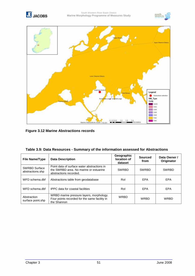
South Western River Basin District Marine Morphology Programme of Measures Study
Chapter 3 June 2008 51
Figure 3.12 Marine Abstractions records
Table 3.9: Data Resources - Summary of the information assessed for Abstractions
File Name/Type Data Description Geographic location of
dataset
Sourced from
Data Owner / Originator
SWRBD Surface abstractions.shp
Point data of surface water abstractions in the SWRBD area. No marine or estuarine abstractions recorded.
SWRBD SWRBD SWRBD
WFD schema.dbf Abstractions table from geodatabase RoI EPA EPA
WFD schema.dbf IPPC data for coastal facilities RoI EPA EPA
Abstraction surface point.shp
WRBD marine pressure layers, morphology. Four points recorded for the same facility in the Shannon
WRBD WRBD WRBD
South Western River Basin District Marine Morphology Programme of Measures Study
Chapter 3 June 2008 52
3.3 Morphology
3.3.1 Data Resources
In order to provide a concise general description of the water body morphology, a number
of sources were identified and assessed. These included internet searches for the area and
academic texts and the information was recorded on the water body summary sheets to
provide and enhance the description of the whole water body. The information was not
detailed or consistent enough to allow retyping of the water bodies. This may need to be re-
assessed when further information is available for the next RBMP (See Chapter 4 and 9).
River Basin District Initial Risk Assessment
Water bodies were assigned types for the initial risk assessment and this information
assisted with the interpretation of the morphological conditions. The initial typology
assessment (Sniffer, 2006, WFD-07) and the baseline datasets were also consulted. The
information from the report classified the water bodies according to their morphology type.
The GIS information also has some generic coverage of sediment types and exposure;
however the coverage and resolution of the data was course and incomplete.
Other sources
Generic water body descriptions were compiled from a number of sources, such as SAC
site synopsis, GSI descriptions and academic and other information from EIS, survey data
(including BioMAR), local government information and internet searches. This was used to
provide a generic description of the water body and compared to the morphological
attributes used in the Morphological Description (See Chapter 4). Insufficient information
was collated to reliably question the Article 5 characterisation. However no significant
conflicting information was found. This information and the references were recorded in the
water body summary sheets.
South Western River Basin District Marine Morphology Programme of Measures Study
Chapter 3 June 2008 53
3.4 Ecology
In order to provide a concise general description of the water body a number of sources
were identified, including internet searches for the area and academic texts. These were
recorded on the water body summary sheets and are summarised in Table 3.10.
3.4.1 Data Resources
Table 3.10 lists the data sources, which, supported by academic and public literature
research, were used to provide a generalised ecological overview of each water body
summary sheet.
River Basin District Initial Risk Assessment
Water bodies were assigned types for the initial risk assessment and this information
assisted with the interpretation of the ecology information. The initial typology assessment
(Sniffer WFD-07) was also consulted. Protected areas were coded and mapped as part of
the initial risk assessment.
National Parks and Wildlife Services
Protected area updates were downloaded from the website and used to ensure complete
coverage of SACs, Special Protected Areas, (SPAs) and Natural Heritage Areas (NHAs).
As of the 2008 protected areas update from the NPWS, the NHAs are statutory NHAs and
are reported as such in the summary sheets (personal communication NPWS 07/04/08)
The NPWS website (www.npws.ie) was consulted to review the site synopses for protected
areas identified within water bodies.
In 2007 some of the marine SAC sites were biotope mapped under contract from the
NPWS. It is planned to continue this work for other coastal and marine SACs in the coming
years (See Chapter 4). The initial results of the 2007 surveys for four sites were provided in
ArcGIS by Marine Institute and permission given from the NPWS to use the data which
included detailed habitat maps of the protected areas surveyed (Figure 3.13). Where these
sites occurred in water bodies already assessed, the biotope information was used to
inform the ecological description. The information in these surveys is significantly more
detailed than that available in most areas and would allow in depth evaluation of future
developments.
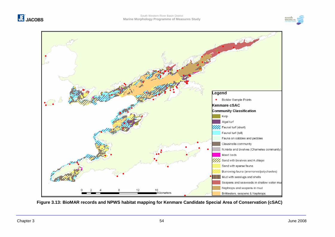
South Western River Basin District Marine Morphology Programme of Measures Study
Chapter 3 June 2008 54
Figure 3.13: BioMAR records and NPWS habitat mapping for Kenmare Candidate Special Area of Conservation (cSAC)
South Western River Basin District Marine Morphology Programme of Measures Study
Chapter 3 June 2008 55
BioMAR
A copy of the BioMAR database was provided by the NPWS and an x,y event layer of
surveys was created. BioMAR was a part European funded survey of littoral and sublittoral
coastal habitats, which ran from 1992 to 1996. The results of the recorded biotopes and
descriptions were included in the water body summary sheet ecology descriptions. In
addition, the database was compared with the JNCC Marine recorder data (2007) to ensure
complete survey record coverage, and to capture any survey data points from 1996 to
2000. Within the water body summary sheets the information from each survey station or
transect is listed. Where there are multiple points across a bay, a summary of the survey
points is provided. Where recorded, a biotope code is provided as referenced in the original
survey, and a description of the sample site is provided.
UK Joint Nature Conservation Committee (JNCC) Marine Recorder
Permission was given from the JNCC to compare the BioMAR results to the Marine
Recorder database to ensure complete coverage (biotope_merge.shp).
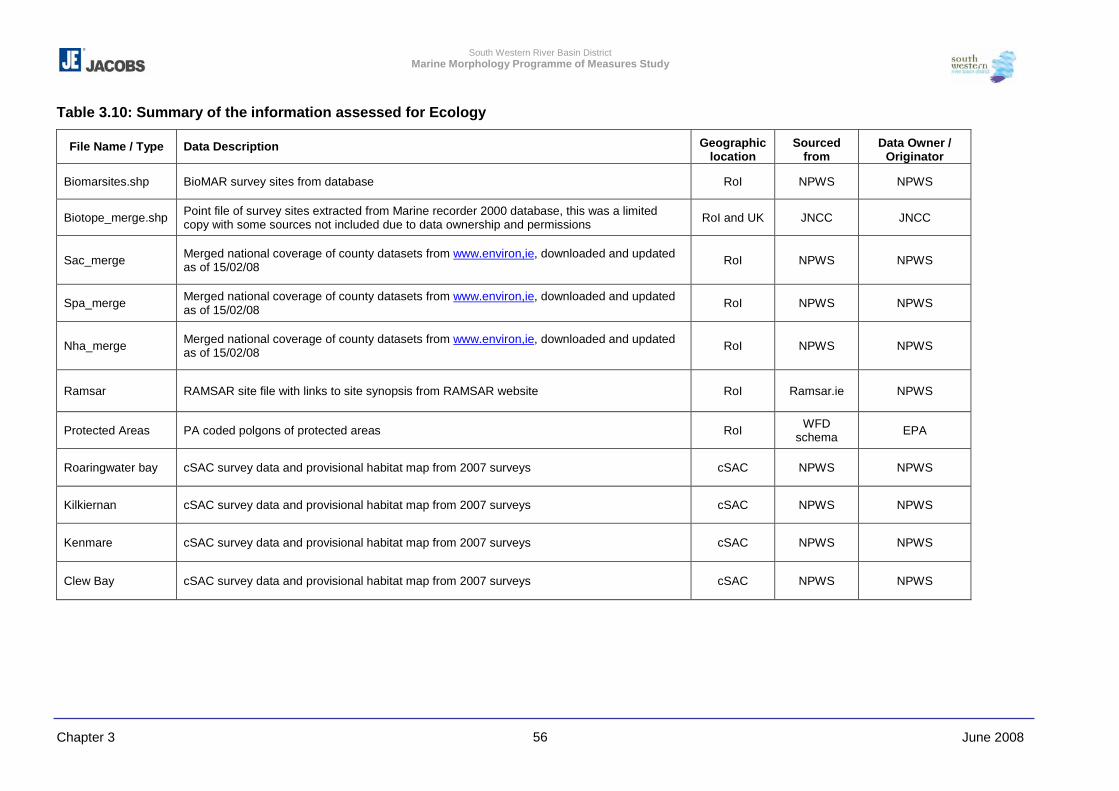
South Western River Basin District Marine Morphology Programme of Measures Study
Chapter 3 June 2008 56
Table 3.10: Summary of the information assessed for Ecology
File Name / Type Data Description Geographic location
Sourced from
Data Owner / Originator
Biomarsites.shp BioMAR survey sites from database RoI NPWS NPWS
Biotope_merge.shp Point file of survey sites extracted from Marine recorder 2000 database, this was a limited copy with some sources not included due to data ownership and permissions RoI and UK JNCC JNCC
Sac_merge Merged national coverage of county datasets from www.environ,ie, downloaded and updated as of 15/02/08 RoI NPWS NPWS
Spa_merge Merged national coverage of county datasets from www.environ,ie, downloaded and updated as of 15/02/08 RoI NPWS NPWS
Nha_merge Merged national coverage of county datasets from www.environ,ie, downloaded and updated as of 15/02/08 RoI NPWS NPWS
Ramsar RAMSAR site file with links to site synopsis from RAMSAR website
RoI Ramsar.ie NPWS
Protected Areas PA coded polgons of protected areas RoI WFD schema EPA
Roaringwater bay cSAC survey data and provisional habitat map from 2007 surveys cSAC NPWS NPWS
Kilkiernan cSAC survey data and provisional habitat map from 2007 surveys cSAC NPWS NPWS
Kenmare cSAC survey data and provisional habitat map from 2007 surveys cSAC NPWS NPWS
Clew Bay cSAC survey data and provisional habitat map from 2007 surveys cSAC NPWS NPWS
South Western River Basin District Marine Morphology Programme of Measures Study
Chapter 3 June 2008 57
In addition to these resources, the EIS from the ENFO were reviewed for any coastal
developments. Those with relevant marine or coastal developments were reviewed for
biological information, both general descriptions and species data from baseline surveys.
Where relevant this information was also summarised in the general ecological description.
3.4.2 Methodology for Assessing Ecology
The following method was used to assess Ecology:
a. From the information available a short summary of the ecology and biotopes recorded
within a water body was included in the water body summary sheets, accompanied by a map
of the water body, the protected areas and any biotope records that were mapped.
b. A link is provided in the Water Body Summary Sheets to the MarLIN website which
provides information of the biotopes and the sensitivity to physical and chemical
modifications. Unfortunately, there was insufficient biological information to carry out a full
appraisal of the water body’s ecological sensitivity to physical changes as outlined in
Chapter. However, the links to the MarLIN sensitivity information is included with the
summary sheets.
3.5 Pressure Footprints
Once all pressures footprints were defined where required, each feature was assigned to its
corresponding water body using a combination of automatic and manual methods. The
assessment of pressures within TraC-MImAS also requires that the footprint of each
pressure is estimated for the intertidal and subtidal zones of each water body. The proportion
of each footprint was assigned to a tidal zone using the intertidal zone shapefile created via
combination of automatic and manual methods.
A shapefile containing records for all 309 water bodies was compiled with the results of the
initial risk assessments and pressure footprints calculated by the above methods. Each
footprint is expressed in metres and kilometres. This information is then used within the
TraC-MImAS to assist in the further characterisation of risk to TraC water bodies (refer to
Chapter 5).
South Western River Basin District Marine Morphology Programme of Measures Study
Chapter 3 June 2008 58
3.6 Delivery and dissemination
Due to the end user issues, there are difficulties with the dissemination of the data gathered
for this project. The pressure layers created for the project through the methods outlined
above will be delivered to Cork County Council with this report, under the terms of agreement
with the various data providers. These layers will include metadata outlining all source data
used in the development of the layers, and acknowledges the data providers and their rights
over the information. The SWRBD project team will add these layers to the EPA WFD
Schema, assuming no objection from the data providers, to make this information available
for national appraisal. The source data will be provided to the Cork County Council only, and
archived pending future data agreements with the source organisations.
The data agreements between the various organisations and Cork County Council were
defined by either the data provider, or under the data agreement prepared by the SWRBD
project team. This agreement and the terms of use from others were to allow the pressures
layers to be disseminated to the organisations and councils who are involved in
implementing the WFD. However, in all cases the rights are reserved by the data provider.
The future handover of the data from Cork County Council to a final responsible body will
require permission from the data providers. It is hoped that this end user will be a
governmental department or a government agent/agency. This would mean
intergovernmental data agreements would be able to be used to access more
comprehensive baseline data.
The relevant licence restrictions on the incoming information have been logged with the file
reference and a copy is inserted into each folder.
All data generated has been provided with the following disclaimer in the metadata:
No data may be re-produced or transmitted in any form or stored in any retrieval system of
any nature, without the written permission of SWRBD Project Office, as Copyright Holder,
except as agreed for use on this specific project. All rights reserved by original data
provider.
South Western River Basin District Marine Morphology Programme of Measures Study
Chapter 3 June 2008 59
3.7 Recommendations for Further Data Requirements
The data that was able to be collected for the Marine Morphology task was severely limited
by the departmental re-organisation of marine services within the government. This resulted
in confusion in data ownership that prevented data access for this project as well as
difficulties in defining the end user for the data tool.
Several sub projects designed to provide government data for applications such as this one
also have had difficulties due to these changes; most notably the COZAS programme, which
was to provide marine licensing GIS data from the former DCMNR. As a result the records,
and particular areas of activities such as recent dredging, had to be researched in detail, and
in some cases estimated from the limited available information. Hopefully this programme will
be reinstated in the near future, along with the associated programmes such as the
Integrated Fisheries Information System (IFIS) that was to provide centralised GIS fisheries
and aquaculture information.
Though a centralised series of government databases for the marine environment is unlikely,
especially with the dissolution of a designated government department, better data sharing
and interoperability between departments is needed.
This project has collated a significant amount of data, much of which is relevant to future
assessment of the water bodies, which will be provided to Cork County Council on project
completion. In addition, work has been carried out to generate and digitise data from a
number of sources, most notably the orthophotography. A responsible body or end user will
need to take ownership of this work in order to allow dissemination to the various RBDs or
councils to enable them to assess proposals against morphology and GES, and to ensure
the data is updated.
Unfortunately, a full national coastal set of geographically referenced orthophotography was
not available for this study. Ideally, each County Council should ensure that they have
secured permission and the data from the OSi, and this should be a priority for future coastal
appraisal and planning. This information, when used with the former DCMNR oblique coastal
images allows the verification and interpretation of coastal features and data. At a local level,
site visits or local knowledge verification may be possible through the relevant councils,
though for this national study, such site visits are impractical.
South Western River Basin District Marine Morphology Programme of Measures Study
Chapter 3 June 2008 60
The water bodies represent a national reference dataset of rivers, lakes, transitional and
marine waters around Ireland. A national coastline is therefore the inverse of these areas,
and an ERSI shape file was created of the internal area of the coastal and transitional water
bodies that represented this area. However, during the course of this project, a national and
low water mark were unable to be obtained – as highlighted above. As this represents a
boundary of governmental and local authority department responsibilities, it is essential that
this dataset be developed and provided to the various bodies involved in implementing the
WFD.
3.7.1 Baseline Data
There are a number of baseline elements that are essential to the evaluation of water bodies.
These elements were not available for the majority of the RoI, but are available for other
European marine areas. However there are a series of programmes currently underway that
will hopefully fill this knowledge gap (see Chapter 4).
The resolution of many of the baseline datasets, such as the intertidal and water body
shapefiles, were generally insufficient for the study. Small spatial errors had to be corrected
wherever possible to ensure accuracy of the overall appraisal. However, in the cases of the
water bodies, these were set nationally and had small boundary errors with orthophotos and
the Irish Coastline.
From the Interim Data Review much more data was thought to be available than could be
accessed and collated for this study. As a result, much of the pressure information had to be
created. The lack of vectorised Ordnance Survey, and coverage of historic maps and
orthophotographs on a national basis, impacted the ability to generate information on these
pressures.
For future decision making, it is essential that this baseline information is made available to
national and local government. Without this baseline information, the assessment WFD
issues in the marine environment will be extremely difficult.
3.7.2 Morphological Data
The morphological or eco-morphological parameters to assess the type and conditions of the
water body are predominantly sediment type, depth, exposure and salinity which are all
associated with the physical characteristics, flow and tidal regimes of the estuary or water
body. This physical environment is the main factor affecting the ecology, and is often used as
the initial definition of a biotope. For example the EUNIS classifications system initially uses
South Western River Basin District Marine Morphology Programme of Measures Study
Chapter 3 June 2008 61
the physical hierarchy, then biological, to classify marine communities. Comparison between
ecologically surveyed parameters and eco-geomorphological attributes is outlined in
Chapters 4 and 9.
In inshore waters, the data for these elements is sparse. There is no vectorised bathymetric
data available from the IHO (International Hydrographic Office) or Admiralty Charts, though
the former DCMNR did have a raster version of the Skipper Series from which this
information could be digitised. However the status and licence for this data is currently
unavailable due to departmental changes and would also be an immense undertaking. Even
the 1997 GEBCO charts which give point depth data for much of world, and versions that
have been merged with existing data are now largely unavailable as they are no longer being
distributed as the data is dated and the INFOMAR project will eventually replace this
information.
Many of these near-shore parameters are being surveyed and evaluated for coastal erosion
programmes. The European EUROSION data was used to evaluate areas for this project,
but much of the data was not sufficiently detailed in Ireland.
Sediment maps are not available for much of the west coast. Sediment type was evaluated
from various point sources. The GSI does have Sea Bed Sediment maps (SBS) but only for
offshore areas or not in sufficient scale for inshore or water body evaluation. The future
programmes such as INFOMAR and the protected area mapping from the NPWS will
eventually provide this information for the next series of RBMPs.
Flow and salinity data for water body characterisation relied on the cross referencing of the
coastal typology with the available data on ecology and tidal information from the Marine
Institute and the Marine Models database. The typology for MImAS is consistent with the
methods used to type the water bodies in the SNIFFER (WFD07) report, and these
descriptions were checked and used to inform the impact evaluation. This information is not
sufficiently detailed to reassess. However, there is monitoring planned to assess these
factors in the future, and changes to water body type, either redefined by the monitoring
results or as a result of impact, can be updated (see Chapter 4).
3.7.3 Pressures
Much of the data for pressures was developed or digitised for orthophotography and oblique
photographic images. This is a laborious and time consuming exercise.

South Western River Basin District Marine Morphology Programme of Measures Study
Chapter 3 June 2008 62
Much of the data on coastal structure and historical changes is available in hard copy in the
DCENR Coastal Engineering division, and much of it is, or will be, digital data to support the
flood risk projects currently underway. It is assumed that these drawings and records are
catalogued and a valuable interim measure would be to link this catalogue to a spatial or
even water body reference to allow querying of this information for the assessment of future
developments. Again the release and ownership of this data was hampered by the lack of a
government representative to receive the data stored and generated by this project. This is
an important issue that must be resolved prior to the RBMPs being enacted.
Databases on foreshore licensing, marine dredging, dumping at sea and aquaculture /
fisheries are still in their relative infancy in Ireland. The information is available, but generally
in insufficient detail for mapping at water body scale. There were a series of initiatives
through the former DCMNR to integrate and centralise this data, with GIS as a significant
element. However, these programmes have not yet provided the mapping data required for
this study, and as a result, the data was generated or surrogate information used for this
study.
A number of decisions were made during the course of this study that may require further
appraisal by a suitable regulator. For example, no ‘time limit’ was given to land claim - it was
identified from changes between historic maps and the most up-to-date orthophotography
available. However, in many cases, some land claim had already occurred prior to the
historic maps. Dublin Bay, for example, has been altered for over 700 years as a site for
ports and harbours, and there is no limit within MImAS as to the point from which an initial
water body condition should be assessed.
The WFD schema, and ongoing work integrating the results of all the PoMS studies, provides
an active national and local government template for potential data sharing. The nature of the
WFD has allowed intergovernmental sharing of data, identification of metadata on existing
information, and future planning for web-enabled mapping information to be available to
decision makers and unrestricted information to be passed into the public domain.
South Western River Basin District Marine Morphology Programme of Measures Study
Chapter 3 June 2008 63
3.8 Conclusions
This study has examined the possible sources of data for marine morphology. Though
hampered by the lack of an appropriate end user, and unable to benefit from government
interdepartmental data sharing that would have allowed greater access to some key
datasets, the relevant pressures for marine morphology have been developed by analysing
available information and digitising extents from aerial and oblique photography. The extent
and demands of this data generation have been much greater that perceived at the project
outset compounded by the fact that a series of supporting programmes to collate this
information nationally for government did not occur for the marine environment.
Despite this, a series of national marine morphology pressures have been created and
assessed as part of this study to enable impact assessment of these and future pressures on
Irelands TraC water bodies. The data was developed to the best scale and detail possible
given the limitations described above, to provide a comprehensive and consistent dataset for
Ireland to use in the impact assessment.
From the best information available for this study the pressures have been compiled and
assessed and provided with full metadata. It is hoped that these derived layers can be made
available through Cork County Council and EPA WFD Schema to the relevant national and
local authorities. However, a suitable end user to take ownership for the collected information
and generated data and its continued updating was not able to be identified during the
course of this study.
South Western River Basin District Marine Morphology Programme of Measures Study
Chapter 4 1 June 2008
4 REVIEW OF EXISTING MONITORING SYSTEMS
4.1 Introduction.................................................................................................. 2 4.2 Review of Organisations Involved.............................................................. 3 4.3 Review Summary of Existing Marine Monitoring.................................... 7
4.3.1 Introduction ...................................................................................... 7 4.3.2 Pre-WFD Monitoring Programmes.................................................. 8 4.3.3 Variable Measured for Marine Water Samples ............................. 13 4.3.4 Environmental Impact Assessments / Investigations ................. 16 4.3.5 Conservation Monitoring............................................................... 16 4.3.6 Post-WFD Monitoring Programmes .............................................. 17
4.4 Water Framework Directive Monitoring Programme for TraC Waters ... 19 4.5 Conclusions............................................................................................... 25
This chapter summarises the findings of a review of existing European and national
monitoring systems with the aim to determine if the programmes in place are of
benefit to the assessment of morphological conditions within TraC waters.
There are two main requirements for marine morphology data under the WFD; to
determine the ecological status of a water body, and to detect changes that may
affect this status. Any relationship between existing monitoring programmes and
these requirements is outlined.
Recommendations for the design of the monitoring programme in relation to
morphology are outlined in Chapter 9.
South Western River Basin District Marine Morphology Programme of Measures Study
Chapter 4 2 June 2008
4.1 Introduction
The Water Framework Directive (WFD) requires the monitoring and assessment of
the ecological status of all waters within it’s geographic boundaries. Article 8 (1) of
the directive states ‘Member States shall ensure the establishment of programmes
for the monitoring of water status in order to establish a coherent and comprehensive
overview of water status within each river basin district’. In accordance with Ireland’s
regulations implementing the WFD (S.I. No.722 of 2003); the Environmental
Protection Agency (EPA) have prepared a programme of monitoring of water status
to achieve the requirements of Article 8 (and Article 7 which specifically relates to the
abstraction of drinking water) of the WFD, to be operational by December 2006. Also,
the EPA has specified the authority by which the monitoring is to be carried out.
Those authorities assigned monitoring tasks in the TraC component of the WFD
monitoring programme are the EPA, the Office of Public Works and the Marine
Institute.
For high ecological status to be achieved, the WFD requires that there are no more
than very minor human alterations to the hydromorphological quality element. To
determine this, existing baseline conditions and / or absence of pressures should be
demonstrated. For all other status classes, conditions should be ‘consistent with the
achievement of the values specified for the biological quality elements’ (WFD, Annex
V).
Formal hydromorphology classification tools have yet to be developed for use in
Ireland. As noted in Section 5.4.2 of Chapter 5, work aimed at developing
hydromorphological reference conditions and a draft classification scheme for TraC
waters has commenced in the UK (EA and SNIFFER). However, this has not resulted
in formal classification tools, but has emphasised the importance of the biological
classification scheme incorporating metrics that were sensitive to hydromorphological
changes. Few of the biological classification tools developed for use in Ireland are
relevant to morphology; these are discussed further in Section 4.3.6.
Marine Monitoring and Marine Morphology
Monitoring of morphology is a difficult process for which extensive baseline
information is required. This may include detailed bathymetry and flow information, or
hydrodynamic models. A baseline of morphological condition is an essential element
in providing a point of temporal reference from which change can be assessed.
South Western River Basin District Marine Morphology Programme of Measures Study
Chapter 4 3 June 2008
However, in many cases adequate baseline information is not available. This chapter
outlines the ongoing programmes that may provide this information in the future and
reviews those programmes that may be enhanced to include morphological
monitoring.
Though responses to man-made developments or extreme events can be rapid, in
general, natural morphological changes occur over long periods of time; therefore
time series data is essential to detect changes. A variety of existing marine
monitoring occurs in Europe, though there are few national programmes looking
specifically at morphology. As a result, indicators or surrogates for morphological
change monitoring may need to be identified from the existing programmes, until
such time as the WFD monitoring can provide further information.
Chapter 9 follows on from this review of existing systems to recommend surrogate
information from existing sources which can be used in the meantime to assess
change.
The following sections give an overview of the existing Irish and European marine
monitoring systems. They also identify the existing time series data that may be
available to represent baseline conditions and assist in monitoring future changes to
morphology.
4.2 Review of Organisations Involved
The Department of Environment, Heritage and Local Government (DEHLG)
The Minister for the Environment has the overall responsibility for the development
and implementation of environmental policy in Ireland. The Department of the
Environment, Heritage and Local Government (DEHLG) formulates the relevant
legislative framework to maintain satisfactory regulatory and monitoring systems for
environmental protection and to secure the provision of infrastructural services
necessary for both environmental and developmental purposes. The responsibilities
of the Department regarding environmental information are the result of policy needs,
statutory requirements and international obligations.
Environmental Protection Agency
The EPA operates under the aegis of the DEHLG. It is an independent agency that
was set up according to the Environmental Protection Agency Act of 1992. Its wide
South Western River Basin District Marine Morphology Programme of Measures Study
Chapter 4 4 June 2008
range of functions includes an overall co-ordination and supervisory role relating to
environmental monitoring, including the monitoring of surface waters. In particular,
the Agency is required to prepare a national monitoring programme and to identify
the organisations to undertake its implementation. The EPA is one of the competent
authorities under the Water Framework Directive.
The existing estuarine and coastal monitoring programme, which is discussed further
in Section 4.3 below, should be replaced by the WFD Monitoring Programme
(Section 4.4) which became operational on the 22 December 2006. The new WFD
programme for transitional and coastal waters is to be undertaken by the
Environmental Protection Agency in collaboration with the Marine Institute, Central
Fisheries Board and National Parks and Wildlife Service (NPWS), with those tasks of
relevance to hydromorphology assigned to the EPA, Marine Institute and the OPW.
In the new programme a total of 117 water bodies consisting of 82 transitional and 35
coastal will be monitored. The existing coastal and marine surface water monitoring
sites for Ireland are mapped by the EPA as shown in Figure 4.1 below.
As a result of funding issues, elements of the monitoring programme to be
undertaken by the Marine Institute have not yet commenced.
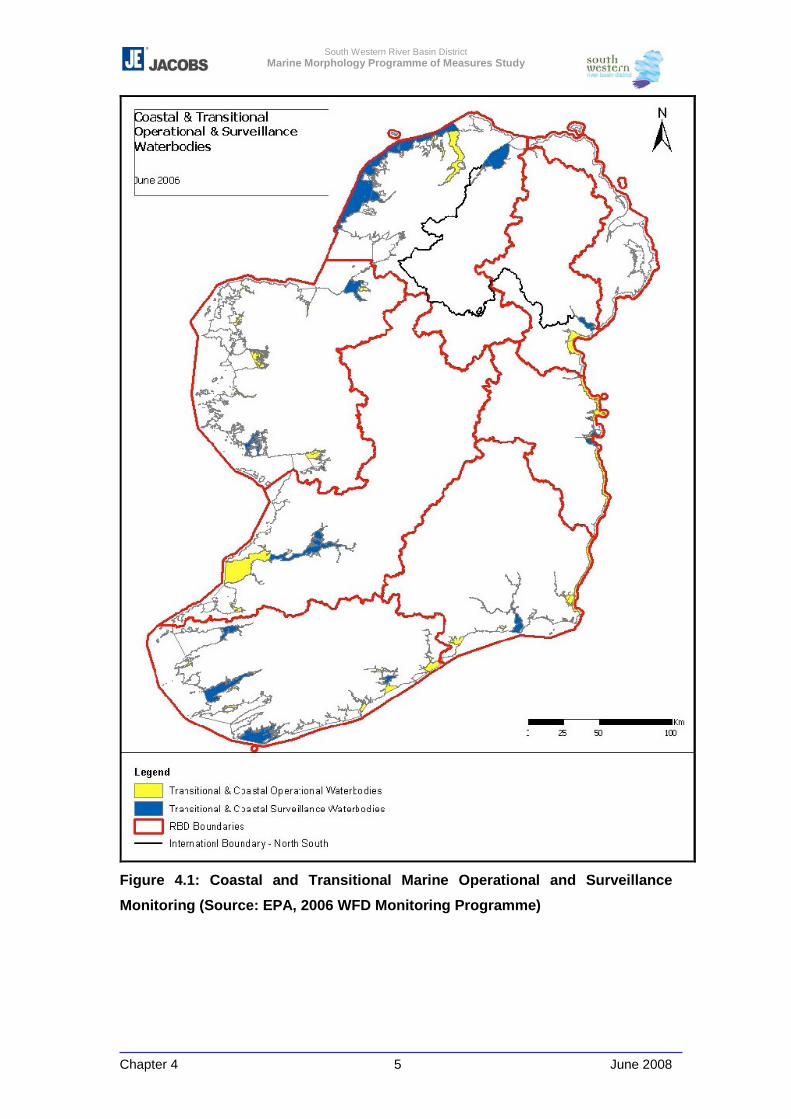
South Western River Basin District Marine Morphology Programme of Measures Study
Chapter 4 5 June 2008
Figure 4.1: Coastal and Transitional Marine Operational and Surveillance
Monitoring (Source: EPA, 2006 WFD Monitoring Programme)
South Western River Basin District Marine Morphology Programme of Measures Study
Chapter 4 6 June 2008
National Parks and Wildlife Service
The NPWS, part of the DEHLG, manages the Irish State's nature conservation
responsibilities under National and European law.
A particular responsibility of NPWS is the designation, monitoring and protection of
Special Areas of Conservation (SACs), Special Protection Areas (SPAs) and Natural
Heritage Areas (NHAs). Consultation with interested parties is an integral element of
the designation process.
For the purpose of the WFD monitoring programme and of relevance to TraC
morphology, the NPWS are responsible for the monitoring of coastal angiosperms.
The former Department of Communications, Marine and Natural Resources
(DCMNR) and the Marine Institute
Prior to Irelands reallocation of Departmental responsibilities after the 2007 general
elections, the DCMNR (formally the Department of Marine) implemented marine
monitoring programmes mainly through the work of its Fisheries Research Centre
and this role was devolved to the Marine Institute, established under the 1991 Marine
Institute Act.
The monitoring programmes have been carried out with the following objectives:
� ensuring the quality of fish for human consumption;
� identifying sources of pollution;
� determining temporal trends and spatial distribution of contaminants in offshore,
coastal and estuarine environments.
� meet European and International (OSPAR, ICES etc) reporting objectives
An important aim of the programmes is to comply with various international
agreements. Quality assurance activities include participation in the EU-funded
QUASIMEME quality control programme. The Marine Institute also compiles a
number of national data programmes for Oceanographic data, such as the National
Tidal Gauge Network.
The Marine Institute, currently under the aegis of DAFF, proposed a comprehensive
monitoring programme for the marine elements of the WFD in 2006/2007(MI, in
press). The programme identified the need for, but did not include the specification
for monitoring of morphological elements of the WFD. However, the information
collected can be interpreted for morphological monitoring as outlined in Section 4.3.3
South Western River Basin District Marine Morphology Programme of Measures Study
Chapter 4 7 June 2008
below. Most importantly a morphological baseline is identified as being collected
under the GSI (Geological Survey Ireland) and Marine Institutes’ Integrated mapping
for the sustainable development of Ireland’s marine resource (INFOMAR)
programme, which is also detailed below (Section 4.3.6).
Department of Agriculture, Fisheries and Food (DAFF)
As of 2007, the DAFF has been assigned a number of the responsibilities of the
former DCMNR, with other responsibilities being managed by the DEHLG, the
Department of Communications, Energy and Natural Resources (DCENR) and the
Department of Transport (DoT).
4.3 Review Summary of Existing Marine Monitoring
4.3.1 Introduction
A review of existing monitoring programmes has concluded that morphological
quality elements are currently poorly represented by Irish systems. However,
information relating to these elements may be included in the data associated with
the samples taken for other means. For example, ecological/conservation monitoring
may record the location, depth and granulometry / substrate of a site, and general
descriptions of the physiotope (physical habitat). This information can be used to help
determine a baseline and detect changes in morphology, as it can provide time
series data.
The data review undertaken by this study and reported in Chapter 3 found that
Ireland has little morphological baseline information from which to monitor change,
and although hydrographic charts and information is available, electronically there is
poor inshore information and no vectorised Hydrographic Office data. At present the
data collected by previous coastal monitoring programmes is not held within a central
repository, however, as monitoring is the responsibility of few select authorities, the
collation of this information is feasible.
As part of the National Monitoring Programme the NS-Share project team developed
a Marine Monitoring Database collating information for existing monitoring
programmes within the one nautical mile limit of TraC water bodies. Where possible,
South Western River Basin District Marine Morphology Programme of Measures Study
Chapter 4 8 June 2008
data, which was compiled on a water body basis, consisted of the following
information:
� Water body designation
� Risk assessment results
� Existing monitoring programmes
� Whether a point is a once-off dataset or repeat
� Relationship of monitoring points to other water bodies
� Pressures which exist on the water bodies
This database provides a very useful framework for the collation of TraC monitoring
information, and would be of benefit if updated and maintained following the
completion of national PoMS studies and WFD monitoring programme.
4.3.2 Pre-WFD Monitoring Programmes
In the EEA area the Oslo and Paris Commissions (OSPARCOM) and North Sea
Task Force are responsible for the overall coordination of monitoring in the North-
east Atlantic and the North Sea, while the Helsinki Commission (HELCOM) is in
charge of the overall coordination of monitoring of the Baltic Sea, the monitoring of
the Mediterranean being coordinated by the UNEP/MEDPOL programme.
The countries bordering these marine areas participate in the international monitoring
programmes and the monitoring activities are incorporated into the national marine
monitoring programmes. The national marine monitoring programmes are, however,
generally more comprehensive including more sampling sites, especially in coastal
areas, and measurement of more variables. The general purpose of national marine
monitoring programmes is to assess the environmental state of the nationally
important marine areas, and the national programmes are thus aimed at giving a
nation-wide overview of marine environmental quality status.
The EEA 1996, ‘Surface Water Quality Monitoring’ assessed national marine
monitoring programmes and made a comparison of similarities and differences
between the different existing marine monitoring activities. In total, information on
approximately 38 national marine monitoring programmes from ten countries has
been assessed by the EEA. Table 4.1 outlines those programmes reported for
Ireland and the UK. The OPSAR and INTERREG SIAM (Synergies in Assessment
and Monitoring) programme is currently reviewing existing programmes, looking at
synergies between programmes and European Directive objectives.
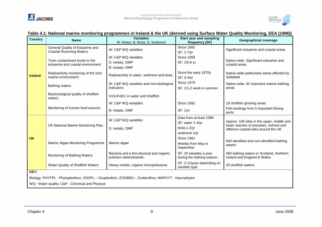
South Western River Basin District Marine Morphology Programme of Measures Study
Chapter 4 9 June 2008
Table 4.1: National marine monitoring programmes in Ireland & the UK (derived using Surface Water Quality Monitoring, EEA (1996)) Country Name Variables
W: Water; B: Biota; S: Sediment Start year and sampling
frequency (SF) Geographical coverage
Since 1992 General Quality of Estuarine and Coastal Receiving Waters W: C&P WQ variables
SF: 1-?/yr Significant estuarine and coastal areas
W: C&P WQ variables Since 1993 S: metals, OMP SF: 1/5-6 yr Toxic contaminant levels in the
estuarine and coastal environment B: metals, OMP
Nation-wide. Significant estuarine and coastal areas
Since the early 1970s Radioactivity monitoring of the Irish marine environment Radioactivity in water, sediment and biota
SF: 2-4/yr Nation-wide particularly areas affected by Sellafield
Since 1979 Bathing waters W: C&P WQ variables and microbiological
indicators SF: 1/1-2 week in summer Nation-wide. 92 important marine bathing areas
Bacteriological quality of shellfish waters COLIFAEC in water and shellfish
W: C&P WQ variables Since 1992 18 shellfish growing areas
Ireland
Monitoring of human food sources B: metals, OMP SF: 1/yr Fish landings from 5 important fishing
ports
Data from at least 1988 W: C&P WQ variables
SF: water 1-4/yr biota 1-2/yr
UK National Marine Monitoring Plan S: metals, OMP sediment 1/yr
Approx. 100 sites in the upper, middle and lower reaches of estuaries, inshore and offshore coastal sites around the UK
Since 1991 Marine Algae Monitoring Programme Marine algae Weekly from May to
September
640 identified and non-identified bathing waters
Monitoring of Bathing Waters Bacteria and a few physical and organic pollution determinands.
SF: 20 samples a year during the bathing season.
460 bathing waters in Scotland, Northern Ireland and England & Wales.
UK
Water Quality of Shellfish Waters Heavy metals, organic micropollutants. SF: 2-12/year depending on variable type. 29 shellfish waters.
KEY:
Biology: PHYTPL - Phytoplankton; ZOOPL – Zooplankton; ZOOBEN – Zoobenthos; MAPHYT - macrophytes
WQ - Water quality; C&P - Chemical and Physical
South Western River Basin District Marine Morphology Programme of Measures Study
Chapter 4 10 June 2008
Prior to the WFD monitoring programme, those reported as operational in Ireland’s
marine waters are summarised in Table 4.2 below. Subject to the confirmation of the
WFD marine monitoring these programme are considered active.
This national marine monitoring programme is a combination of the EPA and Marine
Institute programmes. The EPA programme aimed at providing a general
assessment of the quality of Irish estuarine and coastal waters, while the Marine
Institute programmes concentrated on the Irish Sea. The programme for coastal and
marine areas was split into 5 individual programmes:
� M1 focuses on the impact of organic waste and nutrients.
� M2 focuses on toxic contaminants (heavy metals and organic micropollutants) in
the Irish estuarine and coastal environments (this programme will sample a mix
of water column concentrations and sediments).
� M3 concerns monitoring of radioactivity in the Irish marine environment from
water sampling and sediments (material for dumping at sea and dredging is also
monitored under the existing legislation).
� M4 focuses on bathing water quality, predominantly for faecal coliform presence,
� M5 and M6 assess the quality of seafood used for human consumption.
In addition to the programmes noted above marine biological monitoring is
undertaken by the Marine Institute in a number of separate programmes of varying
intensity and duration.
Some of these programmes have, and will be replaced by the WFD monitoring
programme. Some associated with the Marine Institute (and DAFF) are proposed
within the Marine Institute’s monitoring proposal issued to the DEHLG.
The results of these programmes are reported to Europe in a standard cross country
format and will form an updated version of the ‘Status of the Seas’ reports produced
by the EEA under the EU. The common WFD format should allow cross comparison
and the identification of any larger scale trends that may require strategic attention.
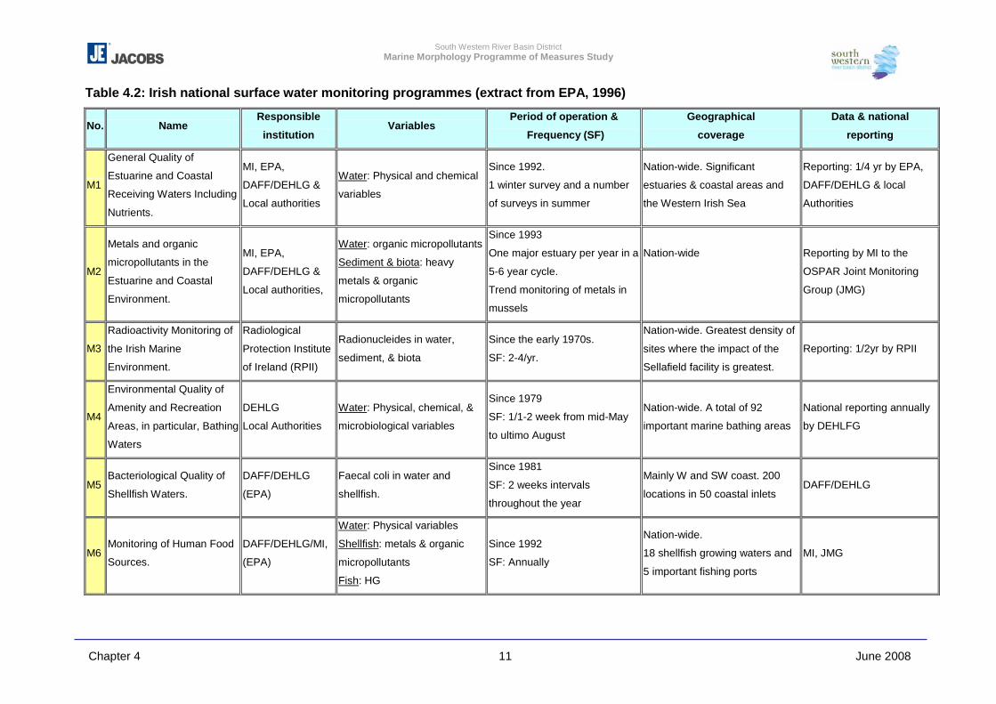
South Western River Basin District Marine Morphology Programme of Measures Study
Chapter 4 11 June 2008
Table 4.2: Irish national surface water monitoring programmes (extract from EPA, 1996)
No. Name Responsible
institution Variables
Period of operation &
Frequency (SF)
Geographical
coverage
Data & national
reporting
M1
General Quality of
Estuarine and Coastal
Receiving Waters Including
Nutrients.
MI, EPA,
DAFF/DEHLG &
Local authorities
Water: Physical and chemical
variables
Since 1992.
1 winter survey and a number
of surveys in summer
Nation-wide. Significant
estuaries & coastal areas and
the Western Irish Sea
Reporting: 1/4 yr by EPA,
DAFF/DEHLG & local
Authorities
M2
Metals and organic
micropollutants in the
Estuarine and Coastal
Environment.
MI, EPA,
DAFF/DEHLG &
Local authorities,
Water: organic micropollutants
Sediment & biota: heavy
metals & organic
micropollutants
Since 1993
One major estuary per year in a
5-6 year cycle.
Trend monitoring of metals in
mussels
Nation-wide
Reporting by MI to the
OSPAR Joint Monitoring
Group (JMG)
M3
Radioactivity Monitoring of
the Irish Marine
Environment.
Radiological
Protection Institute
of Ireland (RPII)
Radionucleides in water,
sediment, & biota
Since the early 1970s.
SF: 2-4/yr.
Nation-wide. Greatest density of
sites where the impact of the
Sellafield facility is greatest.
Reporting: 1/2yr by RPII
M4
Environmental Quality of
Amenity and Recreation
Areas, in particular, Bathing
Waters
DEHLG
Local Authorities
Water: Physical, chemical, &
microbiological variables
Since 1979
SF: 1/1-2 week from mid-May
to ultimo August
Nation-wide. A total of 92
important marine bathing areas
National reporting annually
by DEHLFG
M5 Bacteriological Quality of
Shellfish Waters.
DAFF/DEHLG
(EPA)
Faecal coli in water and
shellfish.
Since 1981
SF: 2 weeks intervals
throughout the year
Mainly W and SW coast. 200
locations in 50 coastal inlets DAFF/DEHLG
M6 Monitoring of Human Food
Sources.
DAFF/DEHLG/MI,
(EPA)
Water: Physical variables
Shellfish: metals & organic
micropollutants
Fish: HG
Since 1992
SF: Annually
Nation-wide.
18 shellfish growing waters and
5 important fishing ports
MI, JMG
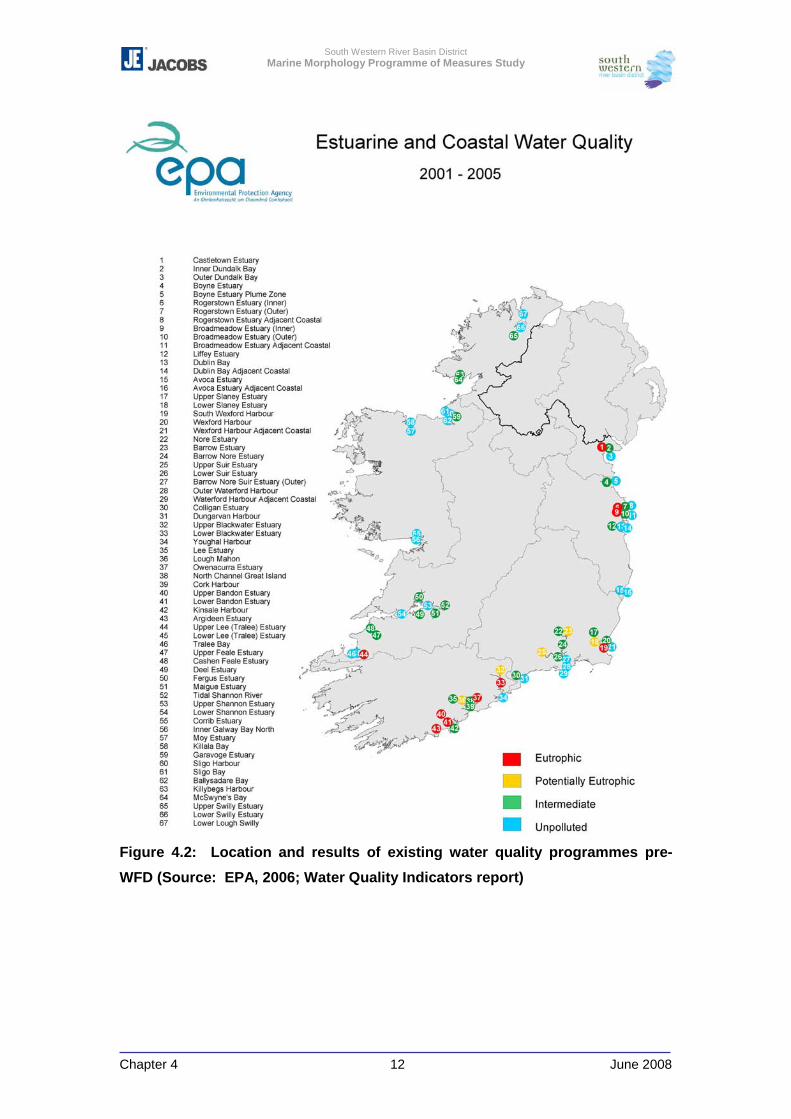
South Western River Basin District Marine Morphology Programme of Measures Study
Chapter 4 12 June 2008
Figure 4.2: Location and results of existing water quality programmes pre-
WFD (Source: EPA, 2006; Water Quality Indicators report)
South Western River Basin District Marine Morphology Programme of Measures Study
Chapter 4 13 June 2008
4.3.3 Variables Measured for Marine Water Samples
The Irish (and other EU countries) surface water monitoring programmes assess up
to 100 different chemical and physical parameters on water and sediment samples in
the various marine monitoring programmes, more than half of the variables being
different organic micropollutants.
The water quality variables of some relevance to morphology can be grouped into the
following broad categories:
� Basic variables (e.g. salinity, water temperature, pH, conductivity, dissolved
oxygen) used for a general characterisation of water quality.
� Suspended particulate matter (e.g. suspended solids, turbidity and organic
matter).
� Indicators of eutrophication: nutrients, dissolved oxygen and various biological
effect variables (e.g. chlorophyll a, Secchi disc transparency, phytoplankton,
zoobenthos).
� Biological indicators of the environmental state of the ecosystem (e.g.
phytoplankton, zooplankton, zoobenthos, fish, macrophytes).
Few of these ‘pre-WFD’ variables are directly relevant to morphology. However some
can be used as surrogates for baseline morphological information. Depth, sediment
type, flow and salinity can provide a reference for morphological conditions at a
specific point in space and time that can be compared. Turbidity or suspended solids
can also give an indication for the type of water body being assessed.
Basic Variables
Most of the marine monitoring programmes in Europe include measurements of basic
variables such as water temperature, salinity, dissolved oxygen and pH. In many
monitoring programmes basic variables are measured very frequently, typically
bimonthly sampling, though in Ireland the frequency has varied dependant on the
programme. Salinity results may be used is to provide baseline data as well as
indications of where there may have been changes to morphology (e.g. extensive
tidal channel realignment / land claim). This information should be assessed on a
water body basis. The use of this surrogate time series data can only assist in
identification of possible recent changes until long term monitoring data for
morphology is available.
South Western River Basin District Marine Morphology Programme of Measures Study
Chapter 4 14 June 2008
Suspended Particulate Matter
Suspended solids and turbidity can give an indication of the type of water body
environment. The level of turbidity is a significant environmental stress that defines
the ecology. Changes in turbidity can be an indicator of changes in morphology or
erosion. However, it is important to note that these changes may be attributed to
changes in morphology upstream or in adjacent water bodies. Investigative
monitoring can help identify the exact source.
The suspended sediments can give an indication of morphological changes, but only
when supported by other information such as flow, depth or marine topographical
changes, but could give an early indication of changes. Review of this data should
include examination of the water body type and regime. Changes in suspended
particulate matter can also indicate morphological changes from upstream of the
TraC water bodies and information from adjacent water body development or
morphological change should also be examined.
Eutrophication - Nutrients
Eutrophication is a product of increased nutrients. This is usually due to runoff from
agricultural land, point source discharges or due to change of land use from cleared
forestry or other cover. Intensive land use, maintained drainage ditches and runoff
can also contribute to eutrophication, all of which are pressures identified as
potentially impacting on morphology. In the absence of other monitoring systems in a
water body, eutrophication may act as an indicator of physical alterations.
Eutrophication associated algal blooms can reduce flow in certain waters bodies and
potentially affect sediment settlement and the morphology of a water body.
All the ten countries reported by EEA (1996) have at least one national marine
monitoring programme with the purpose of assessing the concentration of nutrients in
the water column. As a rule the monitoring programmes include measurement of
nitrogen, phosphorus, and silica. Additionally, the impact of eutrophication is
measured using general indicator variables such as Secchi disc transparency (SDT),
chlorophyll a and primary production.
SDT can be used as an indicator for suspended sediments which can be related to
morphology, however, existing programmes have used this variable to assess algal
bloom reducing under water visibility and therefore should only be used if there
associated observation records referring specifically to the likely presence of
South Western River Basin District Marine Morphology Programme of Measures Study
Chapter 4 15 June 2008
suspended sediments. Future use of such a variable will require nutrient or
chlorophyll values to put this variable in context.
Metals
Ireland measures heavy metals in a number of programmes, often linked to others
such as shellfisheries or areas where there have previously been levels of concern.
The sampling frequency varies from once every third year to 4-5 annual samples. In
most cases sample records include observations of depth and sediment type which
are crude indicators of morphology, and may provide long term records. Those
samples associated with measurement of metals in sediments will have more
detailed granulometric information that may assist in the identification of long term
morphological trends in the absence of other information. Proposed WFD
programmes measuring marine contaminants can also provide future sources of this
information.
Measurement of Metals in Sediments
Several of the marine monitoring programmes include measurement of metals
associated with the bottom sediment.
This existing sampling programme under the previous National Monitoring
Programmes, and noted in the NS-Share Monitoring Database, may be used to give
some baseline temporal information to inform marine morphology. Each sample
site was assessed for granulometry as well as metals. Granulometry (which can be
attributed to sediment type and depth) can be used as a baseline and indicator of
change in marine morphology. However, granulometry can also be attributed to
natural change, a factor which should be considered when interpreting results. In the
absence of a baseline for morphology, these repeat sample points, may provide a
time series of depth and sediment type that can be assessed for significant changes.
Any change in the overall depth of an estuary or sediment type are indicators of
morphological impact (planform, sediment size range and lateral transport process
are eco-geomorphologic attributes as defined in Table 5.6 of Chapter 5). By using
these surrogates where they occur a time series dataset can be used to assess long
term gradual changes, or marked changes can be assessed
Ireland requires the monitoring of dredge material in accordance with the
requirements under OSPAR. These sampling results are reported to the regulator
and contain detailed information of sediment types, granulometry as well as chemical
composition, which may be of use in providing information in the case of future
morphological changes, especially as they are associated with a morphological
South Western River Basin District Marine Morphology Programme of Measures Study
Chapter 4 16 June 2008
modifying activity. In addition, this monitoring is often associated with a detailed
bathymetric survey by the operator of the area dredged for navigation. This
associated information provides detailed morphological information of an impacted
area.
4.3.4 Environmental Impact Assessments / Investigations
Environmental Impact Assessments and other environmental reports accompanying
planning applications, foreshore lease/licence and dumping at sea applications can
provide good sources of baseline morphological [and ecological] data. Registers of
marine models and Environmental Impact Statements (see Appendices 2-1 and 3-2
respectively) completed in Ireland were generated as part of the Literature Review.
4.3.5 Conservation Monitoring
In addition to the various water quality monitoring programmes, Ireland also reports
to Europe on conservation status of protected areas and species under the Habitats
and Birds Directives (92/43/EEC and 79/409/EEC respectively). In compliance with
the Habitats Directive, the NPWS evaluate and report on the conservation status of
Special Areas of Conservation and Annex II species at 7 year intervals. This differs
from the WFD 6-year River Basin Management cycle. However, a programme of
Site Inspection Reporting (SIR) is carried out by the NPWS on a 3-year cycle. SIR is
the process by which activities and their impacts on designated sites are recorded by
NPWS Conservation Ranges. The data collected details the overall condition of the
site and lists the activities that have influenced its integrity. Protected areas currently
include a range of coastal dune and saltmarsh habitats.
The WFD will help ensure that where morphology and morphological pressures are a
contributing factor; this programme can provide information to assist assessment in
the future.
There are several techniques for the monitoring of these transitional and coastal
habitats, dependant on their location and type. In Ireland the monitoring is currently
carried out by transect or point samples for which a variety of information is recorded,
including the physiotope. The physiotope is an assessment of the physical habitat in
which the ecology is associated. In most of the biotope (physical and biological)
recording schemes this information is used to classify the ecology of a specific area.
In TraC habitats this would include recording of substrate, possibly including detailed
South Western River Basin District Marine Morphology Programme of Measures Study
Chapter 4 17 June 2008
granulometry, likely exposure etc. These are all essential elements to indicate
changes in marine morphology by indicating changes in sediment regimes or
erosion/deposition processes and important information on potential ecological
indicators of changes.
4.3.6 Post-WFD Monitoring Programmes
Floods Directive
Under the new Floods Directive (2007/60/EC) there are expected to be a number of
parallel national studies looking at coastal topology and flood risk. The surveys are
currently planned or underway and employ LiDAR surveys with orthophotography.
The work is being carried out in conjunction with the OPW and Coastal Engineering
Division of DAFF (the former DCMNR). The results of the first area studies are due
at the end of 2008. However these could provide significant nearshore information of
existing baseline conditions to inform morphological assessment.
INFOMAR (and the Irish National Seabed Survey (INSS)
The programme is a joint survey run by the GSI and Marine Institute and built on the
physical mapping programme of Irelands offshore waters (beyond 50m depth) the
Irish National Seabed Survey (INSS 2000-2006). The INFOMAR programme, an
extensive of the INSS, will provide full coverage in a large number of selected
inshore areas by 2013 (Marine Institute and GSI, 2006). INFOMAR will initially focus
on 26 priority bays and three priority areas around the coast (Figure 4.3) The
INFOMAR programme began in the summer of 2006 with surveys of valuable fishing
and fish farming areas in Bantry Bay, Dunmanus Bays and fish spawning areas off
the South West Coast (GSI, 2007). In early 2007, the survey began to extend
coverage of the biologically sensitive area off the Dingle Peninsula and continued
mapping Galway Bay and Waterford Bay. The survey plan continues in 2008 to
include surveys of Dublin Bay, Carlingford Lough, Donegal Bay and Sligo Bay
(Figure 4.3)
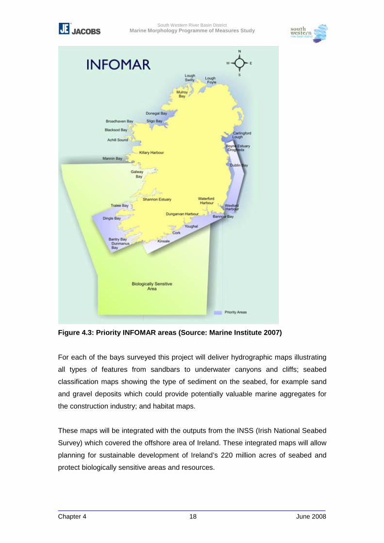
South Western River Basin District Marine Morphology Programme of Measures Study
Chapter 4 18 June 2008
Figure 4.3: Priority INFOMAR areas (Source: Marine Institute 2007)
For each of the bays surveyed this project will deliver hydrographic maps illustrating
all types of features from sandbars to underwater canyons and cliffs; seabed
classification maps showing the type of sediment on the seabed, for example sand
and gravel deposits which could provide potentially valuable marine aggregates for
the construction industry; and habitat maps.
These maps will be integrated with the outputs from the INSS (Irish National Seabed
Survey) which covered the offshore area of Ireland. These integrated maps will allow
planning for sustainable development of Ireland’s 220 million acres of seabed and
protect biologically sensitive areas and resources.
South Western River Basin District Marine Morphology Programme of Measures Study
Chapter 4 19 June 2008
INFOMAR provides key baseline data to support coastal and inshore development.
The data collected can also be used to input into tidal models and carrying capacity
models which can be used as the marine morphological baseline from which
changes can be monitored
4.4 Water Framework Directive Monitoring Programme for TraC Waters
As noted previously, the EPA prepared a report titled “Ireland – Water Framework
Directive Monitoring Programme” (2006) to meet the requirements of the WFD, the
National Regulations Implementing the Water Framework Directive (SI no 722 of
2003) and the National Regulations implementing the Nitrates Directive (SI no 788 of
2005). This document sets out the roles and responsibilities and tasks required to
implement the monitoring programmes which are assigned to various bodies within
the state as required under the National Regulations.
The EPA (2006) outlined the quality elements to be monitored by the WFD
programme. With regard to hydromorphology, the EPA summarise the following for
which the EPA, Marine Institute and OPW have responsibilities for:
Tidal Regime: ‘can be monitored on a national basis by a series of tide gauges
located around the coast and overseen by the Marine Institute. The criteria for
evaluating status have not yet been determined’.
Freshwater Flow: ‘High precision, high frequency monitoring will be required for the
long-term trend and flux sites (OSPAR and lakes). Automatic gauges will be used for
these subnets. Lower precision measurements may be sufficient for other subnets –
e.g. well-calibrated staff gauges with good ratings to enable flows to be determined
on the day of sampling if the gauge is read accurately’.
Morphological Conditions: ‘are described in the directive as the depth variation,
structure and substrate of the seabed and condition of the intertidal zones. In view of
these assessment criteria, a research project, under the auspices of the Programmes
of Measures Working Group, is underway to establish which morphological indicators
might best describe the conditions in coastal and transitional monitoring programmes
and respond to the pressures that might act specifically on the morphology of a water
body e.g. dredging (fishing, channelisation) or coastal defences. In addition the
project will define the relationship between morphology characteristics and biological
South Western River Basin District Marine Morphology Programme of Measures Study
Chapter 4 20 June 2008
status and develop a decision support tool for regulators to assess the potential
impact of future developments on individual water bodies, (i.e. to prioritise activities
and establish a tiered assessment system).
Details outlined for morphological conditions can be informed by the Marine
Morphology PoMS study. Chapter 5 introduces the relationship between
morphological features and processes and the pressures identified.
Recommendations relating to morphological indicators are then made in Chapter 9,
and Chapter 11 outlines how the findings of this study can be used to support
Ireland’s regulatory decision framework.
The biological elements and associated classification tools identified as sensitive to
hydromorphology are identified by the EPA (2006) as follows:
Macro-algae – Reduced Species List (Reponsible body: EPA - in progress)
Species richness can respond to changes in hydromorphology. This tool will include
measures of the number of species present on a shore and the ecological status of
these species. Changes in the numbers will indicate changes in the ecological status
of the area. Three to five sites in each identified water body will be monitored once
every 3 years.
Seagrass – Intertidal Spatial Extent, Density and Diversity (Responsible body:
EPA/NPWS - in progress)
Seagrass communties respond to physical disturbances. Likely responses include
reduction in species diversity and habitat extent. Initial surveys will be on an annual
basis, and once background data has been accumulated, this will be reduced to a 3
year cycle
Saltmarsh – Spatial Extent (Responsible body: EPA/NPWS; in progress)
Common in transitional waters and coastal lagoons, saltmarsh is particularly
susceptible to habitat loss through erosion. Monitoring for the purpose of the WFD is
based on simplified version of habitat mapping techniques (habitat extent and bed
diversity). Depending on the size of the saltmarsh, habitat monitoring will take place
at 1 to 3 locations in each identified water body on a 3 year cycle.
The EPA considered all 309 transitional and coastal water bodies for inclusion in the
national WFD coastal and transitional waters monitoring programme. The number of
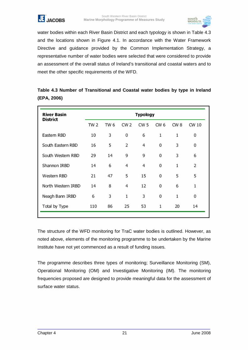
South Western River Basin District Marine Morphology Programme of Measures Study
Chapter 4 21 June 2008
water bodies within each River Basin District and each typology is shown in Table 4.3
and the locations shown in Figure 4.1. In accordance with the Water Framework
Directive and guidance provided by the Common Implementation Strategy, a
representative number of water bodies were selected that were considered to provide
an assessment of the overall status of Ireland’s transitional and coastal waters and to
meet the other specific requirements of the WFD.
Table 4.3 Number of Transitional and Coastal water bodies by type in Ireland
(EPA, 2006)
The structure of the WFD monitoring for TraC water bodies is outlined. However, as
noted above, elements of the monitoring programme to be undertaken by the Marine
Institute have not yet commenced as a result of funding issues.
The programme describes three types of monitoring; Surveillance Monitoring (SM),
Operational Monitoring (OM) and Investigative Monitoring (IM). The monitoring
frequencies proposed are designed to provide meaningful data for the assessment of
surface water status.
South Western River Basin District Marine Morphology Programme of Measures Study
Chapter 4 22 June 2008
Coastal and Transitional Surveillance Monitoring Network
A selection or ‘subnet’ of Surveillance Monitoring water bodies was chosen to
represent the range of significant pressures and typology scenarios present in
Ireland’s coastal and transitional waters. The subnets were also chosen with the
objective of assessing natural and long-term trends.
A frequency of 6 years is proposed for hydromorphology monitoring.
Other Overlapping Subnets
Within the structure of the WFD subnets (EPA, 2006) the Surveillance Monitoring
programme will also include the following overlapping subnets – overlapping in the
sense that they will also be contained in one or more of the four principal subnets
above.
� Eurowaternet (EIONET) sites,
� Surface water / groundwater interaction site,
� Selected reference condition sites
� WFD Intercalibration register sites
� EUROSION / IFRAMS networks (Erosion and Flooding mapping)
� Selected NPWS Protected Area sites – see also OM programme
Individual monitoring points may be included in one or more of the main subnets.
Coastal and Transitional Waters Operational Monitoring Network
The Operational Monitoring programme is a selection or subnet of representative
water bodies from those identified as being ‘at risk’ or ‘probably at risk’ of failing to
meet their environmental objectives. This selection was further divided into 3
additional subnets for the purposes of assessing the effectiveness of measures to
address impacts arising from point, diffuse and hydromorphological pressures, as
well as measures to maintain good and high status sites.
The operational programme for transitional and coastal waters has 6 subnets
consisting of 80 water bodies (Figure 4.1) (EPA, 2006). A frequency of 6 years is
proposed for hydromorphology monitoring.
The Marine Morphology study has further characterised the risk posed to water body
status. This could be used to refine the OM programme and focus on those water
South Western River Basin District Marine Morphology Programme of Measures Study
Chapter 4 23 June 2008
bodies estimated to at risk of failing to achieve good and / or high ecological status
(see Appendix 6-3 for further characterisation results).
Coastal and Transitional Waters Investigative Monitoring Network
No TraC water bodies have been proposed for investigative monitoring. Investigative
monitoring is required in situations where the reason for exceedances is unknown,
where surveillance or operational monitoring have indicated a failure of objectives
and not ascertained the causes. The results of such a monitoring programme will
inform the establishment of a PoMs to achieve the required objectives.
In addition to the marine programme, as the proposed revised programme includes
the continuation and adaptation of the existing monitoring, information and sample
sites for TraC water bodies may overlap with the rivers and lakes monitoring
programmes, which have commenced.
Rivers
The Freshwater Morphology PoMS study will make recommendations for the
monitoring of morphology in rivers. Consideration and / or adoption of these
recommendations should facilitate monitoring of TraC water bodies downstream of
any monitoring sites.
A riverine monitoring programme is being undertaken by EPA Regional Inspectorates
on behalf of the local authorities. The national monitoring programme includes mainly
large rivers and their main tributaries with approximately 1,500 sampling sites in 300
rivers. The aim is to obtain a sampling frequency of 12 times annually, the water
samples being analysed for indicators of organic pollution, nutrients and, metals. The
biological quality of rivers is monitored according to a national programme operated
by the EPA. The biological quality of rivers has been assessed every three to five
years since 1971 and existing sample points are likely to be repeated. The third river
monitoring activity is an annual recording of fish kills aimed at assessing their
causes, which includes salmonid waters and therefore some transitional and coastal
water body sites.
A few of the downstream river sampling points are in the transitional waters. Any
long term dataset monitoring substrate and depth could potentially be analysed for
changes as an indication of changes in morphology which may affect the ecology.
South Western River Basin District Marine Morphology Programme of Measures Study
Chapter 4 24 June 2008
However, due to the nature of morphological conditions the likelihood of natural
changes should also be considered.
Lakes and Reservoirs (including Saline Lagoons)
The EPA is continuing the development of a monitoring programme for lakes using
aircraft-borne remote sensing. In-situ monitoring of selected lakes and reservoirs is
undertaken by local authorities, by the EPA on their behalf, and by the Central
Fisheries Board. Though this survey programme only applies to a few TraC sites, of
particular importance to marine morphology monitoring is the technology used, which
is also being applied to flood mapping and would provide a potentially important
dataset for marine morphology assessment. The technology used for shallow water,
LiDAR (Light Detection and Ranging, also known as Airborne Laser Swath Mapping
or ALSM), can, be applied to coastal waters as well as saline lagoons. Surveys can
be repeated to provide rapid assessment of morphological changes, but would only
be applicable to intertidal or shallow water areas.
South Western River Basin District Marine Morphology Programme of Measures Study
Chapter 4 25 June 2008
4.5 Conclusions
There are a series of requirements under the WFD which require Member States to
monitor and assess the required hydromorphological quality elements. The following
outlines how Ireland is currently positioned to meet these requirements, and how the
Marine Morphology PoMs study can assist:
� The assessment of pressures and impacts on the morphology of surface waters:
- Monitoring of the hydromorphological quality elements in TraC water bodies,
with the exception of those biological elements listed above, has yet to
commence.
- The relationship between morphology and ecology has been investigated by
this study and significant pressures on TraC water bodies identified. The
location and extent of these pressures has been mapped where possible
which can help inform both surveillance and operational monitoring.
� The restoration and monitoring of those waters significantly impacted by
morphological alterations and requirements for the regulation of future
engineering activities:
- In the absence of formally adopted classification tools, the risk to TraC water
bodies has been further characterised through the use of TraC-MImAS. Using
the results of this assessment TraC water bodies have been prioritised by
identifying the potential objectives required of the PoMs, e.g. if a water body
requires restoration to at least good ecological status. This information can
help refine the selection of monitoring sites.
� The identification and designation of Heavily Modified Water bodies and Artificial
Water bodies:
- The HWMB & AWB PoMS studies have identified water bodies for
designation in the absence of monitoring data.
- The Marine Morphology study can help identify water bodies unable to meet
the WFD objectives due to physical alterations, and focus surveillance or
even investigative monitoring.
- If, in the absence of monitoring results, the pressures identified for a water
body indicate a significant risk to the achievement of good ecological status
the derogations of Article 4 of the WFD may be considered. Failure to comply
with the requirements of this Article may justify the need for investigative
monitoring.
South Western River Basin District Marine Morphology Programme of Measures Study
Chapter 4 26 June 2008
� River basin management planning - setting of realistic environmental objectives
but in balance with important socio-economic activities and industry (flood
defence and management, navigation, hydro-electricity etc.):
- Monitoring of hydromorphological quality elements will not be complete to
provide evidence-based classification results for the first RBMP.
- As noted above, the results of further characterisation have allowed the
estimation of objectives for TraC water bodies which may be referred to for
the first RMBP. However, monitoring will be required to confirm the base
information used and reported by the Marine Morphology PoMS study
Ireland does not have a complete detailed bathymetric and sedimentary baseline in
sufficient detail to monitoring changes in estuarine or coastal morphology.
Most of the marine monitoring programmes in Ireland, and the other European
countries include monitoring of chemical and physical variables in the water column,
and several also include studies of the biota (phytoplankton, zooplankton,
zoobenthos, etc.). These sampling networks generally consist of a number of
intensive sampling sites, typically less than 20 sites, at which frequent sampling (> 1-
12 times/yr) of the water column is made and may be supplemented with an
extensive sampling network including several sampling sites and low frequency
sampling (1-4 times/yr) of the water column. Zoobenthos and sediment samples are
generally taken at numerous sampling sites.
In Ireland the monitoring has predominantly been aimed at monitoring water quality,
and quality of water and shellfish. The programmes have been designed to report for
European legislation such as the Bathing Water Directive and the Shellfish Waters
legislation, details of which are now addressed by the WFD monitoring programme.
The assessment of protected areas often requires a once-off or infrequent
assessment of their environmental and biological quality. Whilst these may be part of
a larger or national programme, they are not frequently or repetitively sampled.
These surveys are separate from the WFD surface water monitoring. In Ireland, the
Special Areas of Conservation status monitoring is currently under review, but has
been discussed with the National Parks and Wildlife Service (telecom Dr E Kelly,
04/02/2008).
In order to assess changes and variations in morphology a baseline of sediment type
and the bathymetric profile and flow must be known. Therefore, from review of the
South Western River Basin District Marine Morphology Programme of Measures Study
Chapter 4 27 June 2008
planned monitoring programmes, it is proposed to adapt the existing and proposed
programmes and record morphological monitoring surrogates to assist in the
compilation of baseline data and monitoring of changes, until such time as a national
inshore morphological baseline is available (refer to Chapter 9). This surrogate
information (bathymetry, sediment type, exposure and associated ecology where
available) can also be used to confirm the morphological classification of the water
bodies.
The INFOMAR programme (2007-2013) will complete the Irish National Seabed
Surveys work in the inshore areas. Once completed this will provide a detailed
baseline for specific bays where changes in morphology can be assessed by
targeted re-surveying.
In the meantime it is suggested that morphological data be collected as part of other
existing monitoring programmes. The SAC monitoring transects carried out by the
NPWS may be levelled to assist not only the detection of changes in morphology, but
also identify potential changes in ecology as a result (this is discussed further in
Chapter 9).
Point source information can be collected as part of the benthic grab sampling in the
Marine Institute’s programme. It is also possible that other parts of the programme
such as plankton sampling transects, could be coupled with bathymetric or
multibeam surveys to detect changes.
There are a number of other programmes proposed such as shallow water LiDAR
surveys off the coast which are proposed as flood and coastal defence
investigations, from which the data could be used to look at coastal morphology in
this context.
South Western River Basin District Marine Morphology Programme of Measures Study
Chapter 5 1 June 2008
5 MORPHOLOGICAL IMPACT METHODOLOGY AND ASSESSMENT TOOL
5.1 Introduction to Morphology / Ecology Relationships in the Context of the WFD...2 5.2 Transitional and Coastal Morphological Impact Assessment System ................. 11
5.2.1 Module 1: Eco-geomorphic Attributes ........................................................... 13 5.2.2 Module 2: Typology ......................................................................................... 16 5.2.3 Module 3: Sensitivity Assessment.................................................................. 17 5.2.4 Module 4: Impact Assessment (Pressures) ................................................... 18 5.2.5 Module 5: Capacity Based Scoring System ................................................... 19
5.3 Pressures ................................................................................................................. 23 5.3.1 Land Claim & Tidal Realignment .................................................................... 24 5.3.2 Dredging, Other Disturbances to Seabed, & Disposal at Sea....................... 25 5.3.3 Piled Structures ............................................................................................... 29 5.3.4 Flow and Sediment Manipulation Structures................................................. 30 5.3.5 Impounding Structures & Causeways............................................................ 31 5.3.6 Shoreline Reinforcement................................................................................. 34 5.3.7 Flood Embankment.......................................................................................... 36 5.3.8 Intensive Land Use .......................................................................................... 37 5.3.8.1 Salt Marsh Grazing .......................................................................................... 40 5.3.8.2 Peat Bogs ........................................................................................................ 41 5.3.8.3 Intensive Sea Use ............................................................................................ 42
5.4 Development & Use of TraC-MImAS for the Purpose of Risk Assessments ........ 44 5.4.1 Clonakilty Harbour (SW_100_0100) ................................................................ 44 5.4.2 Development and approval stages of TraC-MImAS for use as a
morphological assessment tool in Ireland................................................ 53
This chapter aims to describe the various elements considered by the Marine Morphology
Study in relation to the impact assessment of morphology. The current understanding of the
relationship between morphology and ecology in the context of the WFD is outlined below,
with reference to the Literature Review (Appendix 2-1) and Chapter 2 of this report. The
concept and functions of the Scottish EPA’s (SEPA) TraC-MImAS tool introduced in section
2.1 are then detailed for each of its five modules. One of these modules is specifically
associated with the pressures defined in Chapter 3, and predicts the likelihood that these
pressures will impact on the morphological attributes of a water body. Section 5.3 of this
chapter summarises how this module of TraC-MImAS considers each identified pressure.
Following this description of TraC-MImAS, an example of how this tool can be used for the
purpose of risk assessments is provided using the transitional water body Clonakilty
Harbour (SW_100_0100). The various assumptions and calculations made by the five
module components are detailed using the pressure footprints identified for this water body.
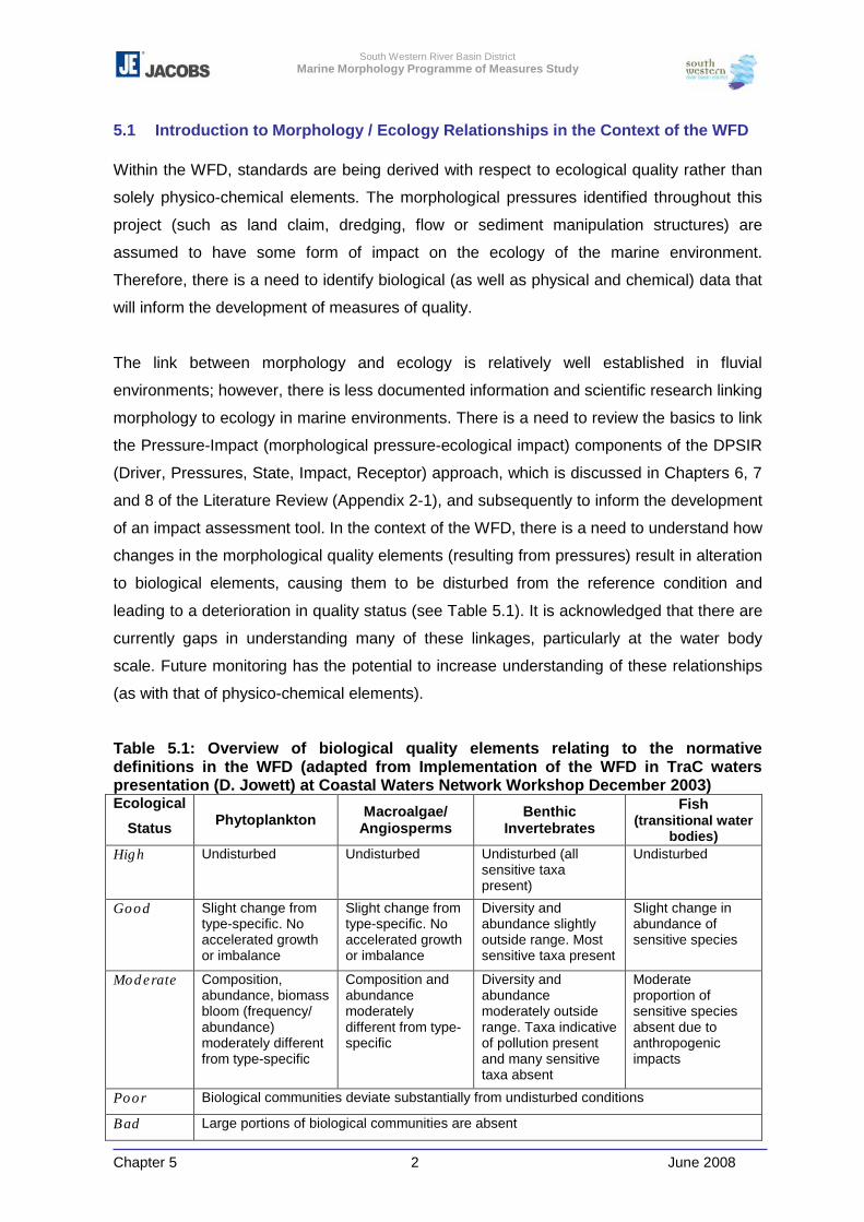
South Western River Basin District Marine Morphology Programme of Measures Study
Chapter 5 2 June 2008
5.1 Introduction to Morphology / Ecology Relationships in the Context of the WFD
Within the WFD, standards are being derived with respect to ecological quality rather than
solely physico-chemical elements. The morphological pressures identified throughout this
project (such as land claim, dredging, flow or sediment manipulation structures) are
assumed to have some form of impact on the ecology of the marine environment.
Therefore, there is a need to identify biological (as well as physical and chemical) data that
will inform the development of measures of quality.
The link between morphology and ecology is relatively well established in fluvial
environments; however, there is less documented information and scientific research linking
morphology to ecology in marine environments. There is a need to review the basics to link
the Pressure-Impact (morphological pressure-ecological impact) components of the DPSIR
(Driver, Pressures, State, Impact, Receptor) approach, which is discussed in Chapters 6, 7
and 8 of the Literature Review (Appendix 2-1), and subsequently to inform the development
of an impact assessment tool. In the context of the WFD, there is a need to understand how
changes in the morphological quality elements (resulting from pressures) result in alteration
to biological elements, causing them to be disturbed from the reference condition and
leading to a deterioration in quality status (see Table 5.1). It is acknowledged that there are
currently gaps in understanding many of these linkages, particularly at the water body
scale. Future monitoring has the potential to increase understanding of these relationships
(as with that of physico-chemical elements).
Table 5.1: Overview of biological quality elements relating to the normative definitions in the WFD (adapted from Implementation of the WFD in TraC waters presentation (D. Jowett) at Coastal Waters Network Workshop December 2003) Ecological
Status Phytoplankton Macroalgae/ Angiosperms
Benthic Invertebrates
Fish (transitional water
bodies) High Undisturbed Undisturbed Undisturbed (all
sensitive taxa present)
Undisturbed
Good Slight change from type-specific. No accelerated growth or imbalance
Slight change from type-specific. No accelerated growth or imbalance
Diversity and abundance slightly outside range. Most sensitive taxa present
Slight change in abundance of sensitive species
Moderate Composition, abundance, biomass bloom (frequency/ abundance) moderately different from type-specific
Composition and abundance moderately different from type-specific
Diversity and abundance moderately outside range. Taxa indicative of pollution present and many sensitive taxa absent
Moderate proportion of sensitive species absent due to anthropogenic impacts
Poor Biological communities deviate substantially from undisturbed conditions
Bad Large portions of biological communities are absent
South Western River Basin District Marine Morphology Programme of Measures Study
Chapter 5 3 June 2008
The basic underlying assumption is that the presence of species at a location is
encouraged or discouraged by the environmental factors occurring at that location. Those
factors may be natural; resulting in the presence of a particular community and a certain
species richness, or unnatural (brought about by human activities); resulting in a
modification of the expected natural communities. Separating natural variability, particularly
in dynamic estuarine and coastal environments, from change brought about by human
activities is often difficult. A commonly used approach is to develop ‘indicator species’ which
increase or decrease in response to pressures/environmental factors, or are considered to
favour or be intolerant of different pressures/environmental factors. The following are
relevant ‘indicator species’ studies identified and noted in section 4.8 of the appended
Literature Review 2-1:
� Review of current and historical seabed biological time-series studies in the UK and
Europe (Hiscock & Kimmance, 2003): Ninety-two seabed biological surveys that
include time-series data were identified, and a description of each study entered into
a time-series database, which is available as front page web browsers on the
MarLIN website (http://www.marlin.ac.uk/time_series_metadata/).
� Identification of seabed indicator species from time-series and other studies to
support the implementation of the EU Habitats and WF Directives (Hiscock et al,
2004). This seabed indicator research was undertaken as a follow-up to the review
of the time series studies. The time-series study identified the potential for the data
from some studies to describe the change in abundance of a particular marine
species in response to anthropogenic activities. The Joint Nature Conservation
Committee (JNCC) then commissioned a review (by the UK Marine Biological
Association) of existing data to identify indicator species whose change in
abundance may help assess the relative impact of anthropogenic activities on
marine habitats.
� Identification of seabed indicator species to support the implementation of the EU
Habitats and WFD Directives 2nd Edition (Hiscock et al, 2005a). Information from
further review of literature was collated into ‘A Seabed Indicators Species’ database
which is available on the web to search information on species habitat, impact and
literature gathered in the report,
http://www.marlin.ac.uk/indicatorsp/Indicator_search.php. This study is relevant to
the north-east Atlantic, and is associated with predominately estuarine and near
shore habitats.
South Western River Basin District Marine Morphology Programme of Measures Study
Chapter 5 4 June 2008
� Development of a hard substratum benthic invertebrate Water Framework Directive
compliant classification tool (Hiscock et al, 2005b): Findings of this report can also
be searched using the Seabed Indicators Species database.
Although Hiscock (2005a) reported that there is a significant amount of information
available for identifying indicators for physical disturbance, it was recommended that ”a
greater range of faunal and floral groups should be assessed to broaden the scope for
determining indicator species such as macroalgae and angiosperms (such as sea grasses)”
(Literature Review Appendix 2-1, 13.4).
Work undertaken through MarLIN, and other projects such as SensMap and BioMar have
also focused on the ‘biotope’ scale of habitat and species communities, all of which were
identified as useful reference points in the Literature Review (Literature Review Appendix 2-
1, Chapter 2).
The basic ecological concepts evaluated within MarLIN and SensMap can be summarised
as frequency/intensity of impact, sensitivity and tolerance of species.
Before discussing the ecological links between biology and morphology, it is useful to
define some of the basic concepts that recur in recent studies, such as MarLIN and
SensMap:
Recoverability is the ability of a habitat, community or species to return to a viable state
which is at least close to that which existed before the development, activity or event.
Recovery may occur through re-growth, re-colonisation by migration, or juveniles settling
from undamaged populations. Recovery can be partial or complete.
Sensitivity is the intolerance of a habitat, community or individual of a species to damage,
or death, from an external factor. Sensitivity refers to specific environmental perturbations.
Vulnerability expresses the likelihood that a habitat, community or individual of a species
will be exposed to an external factor to which it is sensitive, and indicates the likely severity
of damage should the factor occur at a defined intensity and/or frequency.
These factors (in terms of biology) are strongly linked to the frequency and intensity of
physical disturbances, which may result from morphological pressures, such as:
South Western River Basin District Marine Morphology Programme of Measures Study
Chapter 5 5 June 2008
Substrate Loss – Substrate occupied by the species or biotope under consideration is
removed. Species or community recovery assumes that the substrate within the habitat
preferences of the original species or community is present or recovers.
Smothering – Where an area of a biotope is smothered by sediments or impermeable
materials, such as concrete, oil, or tar.
Physical Disturbance and Abrasion – This factor includes mechanical interference,
crushing, physical blows against, or rubbing and erosion of the organism or habitat of
interest.
Other impacts resulting from pressures, identified by MarLIN (Tyler Walters and Hiscock,
2005), may include; changes in suspended sediment, desiccation (linked to changes in
emergence regime), changes in water flow rates, changes in turbidity (strongly linked to
changes in suspended sediment), changes in wave exposure, and displacement. The effect
of any given activity on an environmental factor is dependant on the site or location of that
activity. Similarly, the magnitude, duration, frequency and extent of the change in an
environmental factor will be dependant on:
- the type of activity;
- its scale;
- its extent and magnitude;
- its duration and frequency, as well as;
- the nature of the receiving environment, and hence;
- the location of the activity.
Both MarLIN and the SensMap project have produced matrices linking coastal activities
with the environmental factors likely to change as a result of these activities. These
matrices are outlined in Tables 5.2 and 5.3 below.
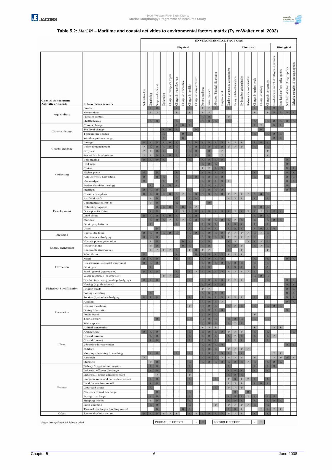
South Western River Basin District Marine Morphology Programme of Measures Study
Chapter 5 6 June 2008
Table 5.2: MarLIN – Maritime and coastal activities to environmental factors matrix (Tyler-Walter et al, 2002)
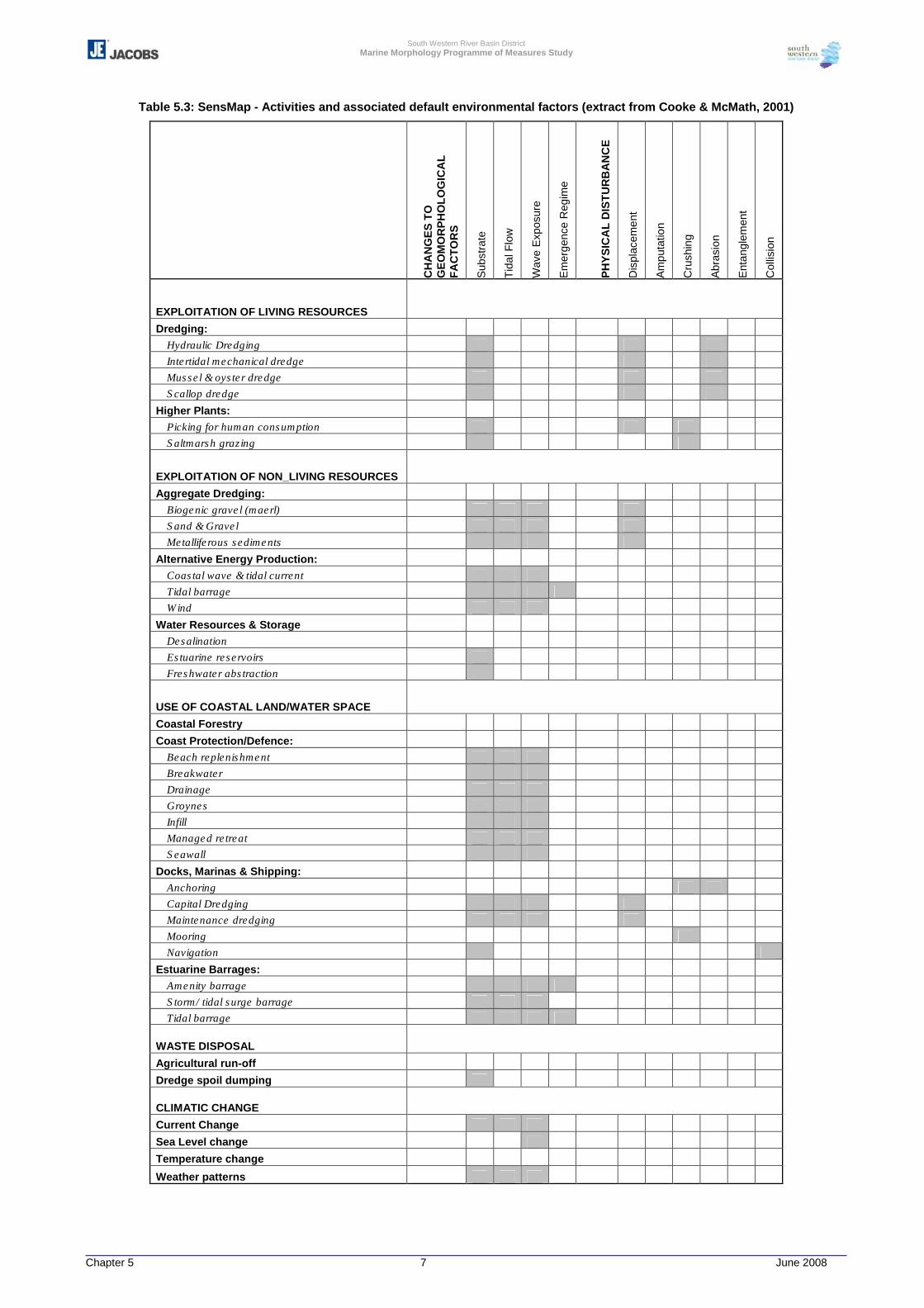
South Western River Basin District Marine Morphology Programme of Measures Study
Chapter 5 7 June 2008
Table 5.3: SensMap - Activities and associated default environmental factors (extract from Cooke & McMath, 2001)
CH
AN
GE
S T
O
GE
OM
OR
PH
OLO
GIC
AL
FAC
TOR
S
Sub
stra
te
Tida
l Flo
w
Wav
e E
xpos
ure
Em
erge
nce
Reg
ime
PH
YS
ICA
L D
ISTU
RB
AN
CE
Dis
plac
emen
t
Am
puta
tion
Cru
shin
g
Abr
asio
n
Ent
angl
emen
t
Col
lisio
n
EXPLOITATION OF LIVING RESOURCES Dredging:
Hydraulic Dredging Intertidal mechanical dredge Mussel & oyster dredge Scallop dredge
Higher Plants: Picking for human consumption Saltmarsh grazing
EXPLOITATION OF NON_LIVING RESOURCES Aggregate Dredging:
Biogenic gravel (maerl) Sand & Gravel Metalliferous sediments
Alternative Energy Production: Coastal wave & tidal current Tidal barrage Wind
Water Resources & Storage Desalination Estuarine reservoirs Freshwater abstraction
USE OF COASTAL LAND/WATER SPACE Coastal Forestry Coast Protection/Defence:
Beach replenishment Breakwater Drainage Groynes Infill Managed retreat Seawall
Docks, Marinas & Shipping: Anchoring Capital Dredging Maintenance dredging Mooring Navigation
Estuarine Barrages: Amenity barrage Storm/ tidal surge barrage Tidal barrage
WASTE DISPOSAL
Agricultural run-off Dredge spoil dumping
CLIMATIC CHANGE Current Change Sea Level change Temperature change
Weather patterns
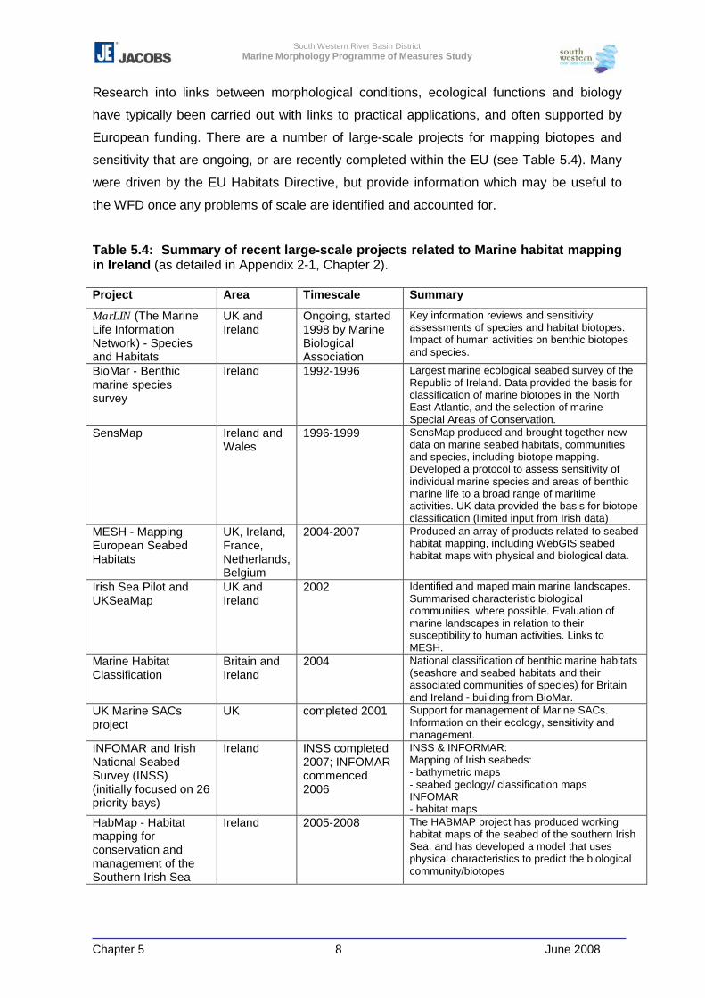
South Western River Basin District Marine Morphology Programme of Measures Study
Chapter 5 8 June 2008
Research into links between morphological conditions, ecological functions and biology
have typically been carried out with links to practical applications, and often supported by
European funding. There are a number of large-scale projects for mapping biotopes and
sensitivity that are ongoing, or are recently completed within the EU (see Table 5.4). Many
were driven by the EU Habitats Directive, but provide information which may be useful to
the WFD once any problems of scale are identified and accounted for.
Table 5.4: Summary of recent large-scale projects related to Marine habitat mapping in Ireland (as detailed in Appendix 2-1, Chapter 2). Project Area Timescale Summary
MarLIN (The Marine Life Information Network) - Species and Habitats
UK and Ireland
Ongoing, started 1998 by Marine Biological Association
Key information reviews and sensitivity assessments of species and habitat biotopes. Impact of human activities on benthic biotopes and species.
BioMar - Benthic marine species survey
Ireland 1992-1996 Largest marine ecological seabed survey of the Republic of Ireland. Data provided the basis for classification of marine biotopes in the North East Atlantic, and the selection of marine Special Areas of Conservation.
SensMap Ireland and Wales
1996-1999 SensMap produced and brought together new data on marine seabed habitats, communities and species, including biotope mapping. Developed a protocol to assess sensitivity of individual marine species and areas of benthic marine life to a broad range of maritime activities. UK data provided the basis for biotope classification (limited input from Irish data)
MESH - Mapping European Seabed Habitats
UK, Ireland, France, Netherlands, Belgium
2004-2007 Produced an array of products related to seabed habitat mapping, including WebGIS seabed habitat maps with physical and biological data.
Irish Sea Pilot and UKSeaMap
UK and Ireland
2002 Identified and maped main marine landscapes. Summarised characteristic biological communities, where possible. Evaluation of marine landscapes in relation to their susceptibility to human activities. Links to MESH.
Marine Habitat Classification
Britain and Ireland
2004 National classification of benthic marine habitats (seashore and seabed habitats and their associated communities of species) for Britain and Ireland - building from BioMar.
UK Marine SACs project
UK completed 2001 Support for management of Marine SACs. Information on their ecology, sensitivity and management.
INFOMAR and Irish National Seabed Survey (INSS) (initially focused on 26 priority bays)
Ireland INSS completed 2007; INFOMAR commenced 2006
INSS & INFORMAR: Mapping of Irish seabeds: - bathymetric maps - seabed geology/ classification maps INFOMAR - habitat maps
HabMap - Habitat mapping for conservation and management of the Southern Irish Sea
Ireland 2005-2008 The HABMAP project has produced working habitat maps of the seabed of the southern Irish Sea, and has developed a model that uses physical characteristics to predict the biological community/biotopes
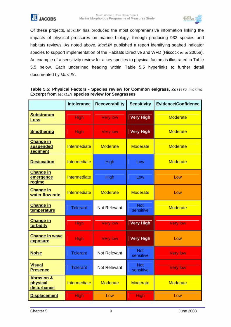
South Western River Basin District Marine Morphology Programme of Measures Study
Chapter 5 9 June 2008
Of these projects, MarLIN has produced the most comprehensive information linking the
impacts of physical pressures on marine biology, through producing 932 species and
habitats reviews. As noted above, MarLIN published a report identifying seabed indicator
species to support implementation of the Habitats Directive and WFD (Hiscock et al 2005a).
An example of a sensitivity review for a key species to physical factors is illustrated in Table
5.5 below. Each underlined heading within Table 5.5 hyperlinks to further detail
documented by MarLIN.
Table 5.5: Physical Factors - Species review for Common eelgrass, Zostera marina. Excerpt from MarLIN species review for Seagrasses
Intolerance Recoverability Sensitivity Evidence/Confidence
Substratum Loss High Very low Very High Moderate
Smothering High Very low Very High Moderate
Change in suspended sediment
Intermediate Moderate Moderate Moderate
Desiccation Intermediate High Low Moderate
Change in emergence regime
Intermediate High Low Low
Change in water flow rate Intermediate Moderate Moderate Low
Change in temperature Tolerant Not Relevant Not
sensitive Moderate
Change in turbidity High Very low Very High Very low
Change in wave exposure High Very low Very High Low
Noise Tolerant Not Relevant Not sensitive Very low
Visual Presence Tolerant Not Relevant Not
sensitive Very low
Abrasion & physical disturbance
Intermediate Moderate Moderate Moderate
Displacement High Low High Low
South Western River Basin District Marine Morphology Programme of Measures Study
Chapter 5 10 June 2008
Another approach that uses species sensitivity in response to pressures is the AMBI
(Marine Biotic Index), which uses benthic macroinvertebrate community status as a
biological indicator of disturbance (impacts and quality status of soft-bottom marine
communities). Macrobenthos are considered a good indicator of disturbance as species
respond rapidly to stressors, they are relatively sedentary, long living, and show differing
tolerances to disturbance. The index has been developed to respond to water quality and
pollution disturbance, but may be able to indicate areas where levels of sediment deposition
are increased, resulting in benthic infaunal community shifts where communities shift from
suspension feeders to dominance by deposit feeders. This is often seen as a lessening of
environmental quality as communities become dominated by taxa perceived as pollution
tolerant. Research using AMBI (Borja et al 2003) has shown that recovery of indicator
species after disturbance usually follows a pattern of; increase in abundance; then increase
in diversity, and finally a change in species composition from tolerant to sensitive taxa. This
bears a resemblance to the quality statements given in Table 5.1.
The review of recent seabed mapping projects and development of links between habitat
and species in marine environments shows that there are sound theoretical bases for
assuming that changes to morphology brought about by pressures will have resulting
impacts on ecological and biological features, and for the first round of river basin planning,
we may need to use tools that focus on these general links. There is a lack of suitably
detailed baseline data to currently utilise the methods developed in programmes such as
MarLIN for the WFD, and there are still issues to be resolved between the impact on
specific biotopes and at the water body scale as a whole. As part of the WFD monitoring
programme however, seagrass and benthic monitoring will be carried out; both of which will
significantly contribute to the understanding of the relationship between ecology and
morphology. Monitoring programmes that link morphological and biological surveys at the
water body scale can improve the knowledge and assessment of these issues. In summary:
“Better understanding of the links between hydromorphology and ecology (via monitoring) is
needed” (WFD and Hydromorphology, European workshop, October 2005, Prague).
South Western River Basin District Marine Morphology Programme of Measures Study
Chapter 5 11 June 2008
5.2 Transitional and Coastal Morphological Impact Assessment System
As noted in section 2.1 of this report, an impact assessment tool for the purpose of
estimating the risk posed by morphological alterations to the ecological status of TraC water
bodies, TraC-MImAS, was developed by SEPA in response to the absence of suitable data
to empirically derive standards for morphological conditions. The Marine Morphology PoMs
team have been involved in the development of TraC-MImAS through participation in the
UK-TAG TraC Morphology Steering Group and TraC MImAS Technical Panel. The TraC-
MImAS tool development team consisted of representatives of SEPA, Environment Agency,
RPS Consulting and Jacobs, with SEPA staff leading the development. Further to this work
the Scotland and Northern Ireland Forum for Environmental Research (SNIFFER)
commissioned an external interim technical review of the technical reports produced during
the development of TraC-MImAS. This detailed review was undertaken by Mr. Anton
Edwards of Metoc plc (environmental consultancy) at the end of 2007.
The TraC-MImAS tool was developed with the intention to help regulators determine
whether changes to the morphology of TraC waters could pose a risk to ecology, and
thereby identify those proposals that could;
� Threaten the aim of achieving ‘good ecological status’; or
� Result in a deterioration in ecological status
There are, at present, no environmental standards available to assess the ecological
impacts of alterations to the morphology of TraC waters, and regulatory decisions relating
to morphology are largely based on expert judgement. The TraC-MImAS tool was
developed in response to the current lack of ecological data required to support
development of ‘evidence-based’ environmental standards for morphology. Of relevance to
this, it was noted by A. Edwards (2007) that although it is clear that many morphological
pressures have the potential to affect aquatic ecology; “there is also considerable weakness
in the conceptualising and quantitative modelling of links between ecology and
hydromorphology”.
The TraC-MImAS tool is not intended to provide a detailed assessment of ecological status,
but rather provide a means of identifying where ecological conditions are likely to be
impaired through impacts to morphology, i.e. it is based on the assumption that an
assessment of impacts on ecologically relevant features and processes can be used to
protect morphology and ecology (SEPA, 2007).

South Western River Basin District Marine Morphology Programme of Measures Study
Chapter 5 12 June 2008
The tool uses a concept of ‘system capacity’ (allowable morphological change) to measure
impacts to morphological conditions, assuming that completely pristine TraC waters have a
measure of assimilative ‘capacity’, which can be degraded by anthropogenic activities.
SEPA have defined ‘system capacity’ as:
A measure of the ability of the water environment to absorb morphological alterations.
The likelihood (or risk) that morphological and ecological conditions are degraded will
increase as system capacity is consumed. This concept does not infer that degradation
of the environment is acceptable; rather it assumes that there is a degree to which minor
changes can be tolerated by the system.
TraC MImAS comprises of 5 modules which combine to estimate the existing system
capacity (%) of a water body, refer to Figure 5.1 below.
Figure 5.1: Overview of MImAS Modular Components
The capacity used by a water body is estimated for three zones; hydrodynamics, and the
intertidal and subtidal zones.
SEPA’s TraC-MImAS technical report and appendices titled ‘Development of a Decision
Support Tool for Regulating TraC Waters under the WFD version a4’ outlines in detail the
various components of MImAS. At the time of writing, this report had yet to be formally
signed-off by UKTAG, and therefore ‘does not necessarily represent the final or policy
positions of UKTAG or any of its partner’s agencies’.
Module 5- Capacity based scoring system
Module 1- Eco-geomorphic attributes Defines the morphological/ecological features that need to be protected
Module 2- Typology
Module 3- Sensitivity assessment
Module 4- Impact assessment
Allows assessment of how features vary between and within TraC waters
Predicts the sensitivity of features and processes to impacts
Predicts the likelihood that a morphological alteration will cause an impact
South Western River Basin District Marine Morphology Programme of Measures Study
Chapter 5 13 June 2008
TraC-MImAS is underpinned by a series of assumptions which should continue to be
assessed throughout the future application of this tool:
1 A TraC water body has some capacity to accommodate morphological change without
changes to its ecological status.
2 There is a relationship between the extent of morphological alteration and the impact
on ecological status
3 The response of a water body’s morphology to an engineering activity or other
pressure is predictable for that type of water body
4 The response of the ecology to morphological change is predictable and depends on
the sensitivity of the ecology of the water body.
In development of TraC-MImAS, MarLIN was a key resource reviewed by SEPA for
consideration of the eco-geomorphic attributes and sensitivity assessment. Similarly to
matrices produced by MarLIN and the SensMap project, TraC-MImAS links the identified
pressures with those eco-geomorphic attributes considered likely to change as a result of
the pressure (taking account of the above assumptions).
The modules of TraC-MImAS are detailed in the following sections (5.2.1 – 5.2.5). To
demonstrate further how these modules are applied in practical terms, an example using
Clonakilty Harbour in West Cork is provided in the subsequent section 5.4.
5.2.1 Module 1: Eco-geomorphic Attributes
A list of eco-geomorphic attributes representative of the intertidal, subtidal and
hydrodynamic zones of TraC waters were selected by SEPA in consultation with the
technical panel and project steering group for assessment by MImAS (Table 5.6). Each
attribute was chosen “for its role in the direct or indirect support of ecological communities
and the supporting processes needed to create and maintain the physical environment on
which ecological communities depend” (SEPA, 2007 version a4) and relevance to the
morphological quality elements specified by Annex V of the WFD (Table 5.7).
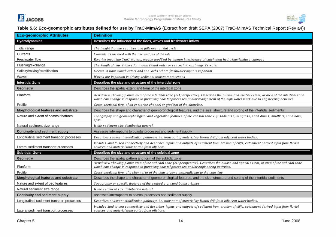
South Western River Basin District Marine Morphology Programme of Measures Study
Chapter 5 14 June 2008
Table 5.6: Eco-geomorphic attributes defined for use by TraC-MImAS (Extract from draft SEPA (2007) TraC-MImAS Technical Report (Rev a4))
Eco-geomorphic Attributes Definition Hydrodynamics Describes the influence of the tides, waves and freshwater inflow
Tidal range The height that the sea rises and falls over a tidal cycle
Currents Currents associated with the rise and fall of the tide
Freshwater flow Riverine input into TraC Waters, maybe modified by human interference of catchment hydrology/landuse changes
Flushing/exchange The length of time it takes for a transitional water or sea loch to exchange its water
Salinity/mixing/stratification Occurs in transitional waters and sea lochs where freshwater input is important
Waves Waves are important in driving sediment transport processes
Intertidal Zone Describes the size and structure of the intertidal zone
Geometry Describes the spatial extent and form of the intertidal zone
Planform
Aerial view showing planar area of the intertidal zone (2D perspective). Describes the outline and spatial extent, or area of the intertidal zone which can change in response to prevailing coastal processes and/or realignment of the high water mark due to engineering activities.
Profile Cross sectional form of an estuarine channel or gradient of the shoreline.
Morphological features and substrate Describes the shape and character of geomorphological features, and the size, structure and sorting of the intertidal sediments
Nature and extent of coastal features
Topography and geomorphological and vegetation features of the coastal zone e.g. saltmarsh, seagrass, sand dunes, mudflats, sand bars, spits.
Natural sediment size range Is the sediment size distribution natural
Continuity and sediment supply Assesses interruptions to coastal processes and sediment supply
Longitudinal sediment transport processes Describes sediment mobilization pathways i.e. transport of material by littoral drift from adjacent water bodies.
Lateral sediment transport processes Includes land to sea connectivity and describes inputs and outputs of sediment from erosion of cliffs, catchment derived input from fluvial sources and material transported from offshore.
Sub tidal Zone Describes the size and structure of the subtidal zone
Geometry Describes the spatial pattern and form of the subtidal zone
Planform Aerial view showing planar area of the subtidal zone (2D perspective). Describes the outline and spatial extent, or area of the subtidal zone which can change in response to prevailing coastal processes and/or engineering activities.
Profile Cross sectional form of a channel or of the coastal zone perpendicular to the coastline Morphological features and substrate Describes the shape and character of geomorphological features, and the size, structure and sorting of the intertidal sediments
Nature and extent of bed features Topography or specific features of the seabed e.g. sand banks, ripples.
Natural sediment size range Is the sediment size distribution natural
Continuity and sediment supply Assesses interruptions to coastal processes and sediment supply
Longitudinal sediment transport processes Describes sediment mobilization pathways i.e. transport of material by littoral drift from adjacent water bodies.
Lateral sediment transport processes Includes land to sea connectivity and describes inputs and outputs of sediment from erosion of cliffs, catchment derived input from fluvial sources and material transported from offshore.
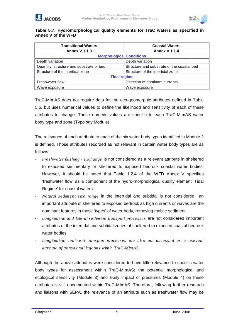
South Western River Basin District Marine Morphology Programme of Measures Study
Chapter 5 15 June 2008
Table 5.7: Hydromorphological quality elements for TraC waters as specified in Annex V of the WFD
Transitional Waters Coastal Waters Annex V 1.1.3 Annex V 1.1.4
Morphological Conditions Depth variation Depth variation Quantity, structure and substrate of bed Structure and substrate of the coastal bed Structure of the intertidal zone Structure of the intertidal zone
Tidal regime Freshwater flow Direction of dominant currents Wave exposure Wave exposure
TraC-MImAS does not require data for the eco-geomorphic attributes defined in Table
5.6, but uses numerical values to define the likelihood and sensitivity of each of these
attributes to change. These numeric values are specific to each TraC-MImAS water
body type and zone (Typology Module).
The relevance of each attribute to each of the six water body types identified in Module 2
is defined. Those attributes recorded as not relevant in certain water body types are as
follows:
- Freshwater flushing / exchange is not considered as a relevant attribute in sheltered
to exposed sedimentary or sheltered to exposed bedrock coastal water bodies.
However, it should be noted that Table 1.2.4 of the WFD Annex V specifies
‘freshwater flow’ as a component of the hydro-morphological quality element ‘Tidal
Regime’ for coastal waters.
- Natural sediment size range in the intertidal and subtidal is not considered an
important attribute of sheltered to exposed bedrock as high currents or waves are the
dominant features in these ‘types’ of water body, removing mobile sediment.
- Longitudinal and lateral sediment transport processes are not considered important
attributes of the intertidal and subtidal zones of sheltered to exposed coastal bedrock
water bodies.
- Longitudinal sediment transport processes are also not assessed as a relevant
attribute of transitional lagoons within TraC-MImAS.
Although the above attributes were considered to have little relevance to specific water
body types for assessment within TraC-MImAS; the potential morphological and
ecological sensitivity (Module 3) and likely impact of pressures (Module 4) on these
attributes is still documented within TraC-MImAS. Therefore, following further research
and liaisons with SEPA, the relevance of an attribute such as freshwater flow may be
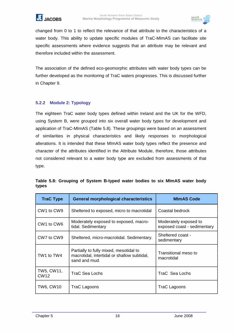
South Western River Basin District Marine Morphology Programme of Measures Study
Chapter 5 16 June 2008
changed from 0 to 1 to reflect the relevance of that attribute to the characteristics of a
water body. This ability to update specific modules of TraC-MImAS can facilitate site
specific assessments where evidence suggests that an attribute may be relevant and
therefore included within the assessment.
The association of the defined eco-geomorphic attributes with water body types can be
further developed as the monitoring of TraC waters progresses. This is discussed further
in Chapter 9.
5.2.2 Module 2: Typology
The eighteen TraC water body types defined within Ireland and the UK for the WFD,
using System B, were grouped into six overall water body types for development and
application of TraC-MImAS (Table 5.8). These groupings were based on an assessment
of similarities in physical characteristics and likely responses to morphological
alterations. It is intended that these MImAS water body types reflect the presence and
character of the attributes identified in the Attribute Module, therefore, those attributes
not considered relevant to a water body type are excluded from assessments of that
type.
Table 5.8: Grouping of System B-typed water bodies to six MImAS water body types
TraC Type General morphological characteristics MImAS Code
CW1 to CW9 Sheltered to exposed, micro to macrotidal Coastal bedrock
CW1 to CW6 Moderately exposed to exposed, macro-tidal. Sedimentary
Moderately exposed to exposed coast - sedimentary
CW7 to CW9 Sheltered, micro-macrotidal. Sedimentary. Sheltered coast - sedimentary
TW1 to TW4 Partially to fully mixed, mesotidal to macrotidal, intertidal or shallow subtidal, sand and mud.
Transitional meso to macrotidal
TW5, CW11, CW12 TraC Sea Lochs TraC Sea Lochs
TW6, CW10 TraC Lagoons TraC Lagoons
South Western River Basin District Marine Morphology Programme of Measures Study
Chapter 5 17 June 2008
TraC-MImAS relies heavily on the typology of water bodies, a point which was
highlighted at the November 2007 MTT meeting, at which the group agreed that the
function of this tool would benefit greatly from the further improvement of this module.
For the purpose of the Marine Morphology Study, each TraC water body was assigned a
typology from Table 5.8 above, and these are outlined in Section 6.2.2 of Chapter 6.
With the agreement of the Marine Morphology Steering Group it is recommended that on
completion of the monitoring programme, Irish TraC water bodies are reviewed and re-
typed where required. This will help increase confidence in an assessment tool which is
based on a water body’s physical characteristics and likely responses to morphological
alterations. Details of how monitoring results can increase confidence of water body
typology are outlined in Chapter 9.
On further development of TraC-MImAS it may be possible to divide a water body into
various sub-types to reflect the appropriate baseline conditions. Potential for further
development may involve the possibility to increase the sensitivity of a water type if for
example a large portion of its area is associated with saltmarsh i.e. the capacity of the
water body is likely to be absorbed quicker due to the sensitivity [and conservation
status] of saltmarsh habitats.
The typology module does not at present allow for the assessment of specific Protected
Areas.
5.2.3 Module 3: Sensitivity Assessment
This module combines the morphological and ecological sensitivity of each of the six
water body types to change.
Morphological Sensitivity
The likelihood that an attribute (as defined in Table 5.6) of a particular water body type
will change in response to an applied pressure is quantified by estimating the resilience
(ability to recover from change) and resistance (ability to absorb change) of that
particular attribute to change.
South Western River Basin District Marine Morphology Programme of Measures Study
Chapter 5 18 June 2008
� Resilience:
- 1 (low) = system/feature is unlikely to recover to a pre-disturbance state or
dynamic
- 0.5 (moderate) = system/feature will potentially recover to a pre-disturbance state
or dynamic
- 0 (high) = system/feature is likely to recover to a pre-disturbance state or
dynamic
� Resistance
- 1 (low) = System/feature likely to respond to disturbance
- 0.5 (moderate) = System/feature will potentially respond to disturbance
- 0 (high) = system/feature unlikely to respond to disturbance
The minimum value estimated for resilience and resistance is then used to estimate the
morphological sensitivity of each relevant eco-geomorphic attribute as follows:
0 = insensitive
0.5 = sensitive
1 = highly sensitive
Ecological Sensitivity
To estimate ecological sensitivity relating to all WFD biological elements the likelihood
that a disturbance to individual attributes (via pressures) will result in a degradation of
community of species integrity is quantified. The sensitivity values used are 0 =
insensitive; 0.5 = sensitive; and 1 = highly sensitive.
It is important to note here that on removal of a pressure from a water body the
ecological system may not be characteristic of a reversible system and in some cases
may even return to a different ecological state (A. Edwards, 2007). It is considered that
this sensitivity module will benefit greatly if updated using information obtained from
monitoring programmes.
5.2.4 Module 4: Impact Assessment (Pressures)
This module forms a distinction between intensity and extent of impact and comprises
two components:
- Likelihood that a morphological alteration will have an impact on an eco-geomorphic
attribute
South Western River Basin District Marine Morphology Programme of Measures Study
Chapter 5 19 June 2008
- Zone of impact: whether impacts are likely to be contained within the vicinity of the
pressure, or likely to extend beyond the local vicinity of the pressure. Three
categories are defined for use in TraC-MImAS; hydrodynamic, intertidal zone and
subtidal zone.
The morphological alterations (pressures) considered by TraC-MImAS are listed in Table
2.1 of Chapter 2. For each of these pressures the likelihood that they will result in an
impact on an attribute is estimated and quantified. For example, disposal at sea is
scored as unlikely to result in an impact on tidal range and therefore assigned a value of
‘0’, whereas land claim is considered highly likely to impact on the tidal range of a water
body.
The Marine Morphology Steering Group identified some issues relating to the numeric
values defined for the ‘zone of impact’; details of which were passed on to SEPA and
considered by the Technical Panel and Steering Group during the development of TraC-
MImAS. SEPA (pers comm. S. Greig) responded by noting that it is correct to conclude
that in some cases a whole water body will not be affected if the activity is small in
nature. However, in assessing the impact to a water body, the zone of impact is
combined with the footprint of the pressure, hence, pressures with a high zone of impact
but small footprint will have a smaller impact on the water body than similar pressures
over a greater area. SEPA also emphasised that some small scale works can affect a
whole water body, e.g. works occurring in narrow parts of estuaries. The current TraC-
MImAS tool cannot adequately address these situations.
The assessments within this module are independent of water body type; it is in
combination with the Sensitivity Module that impact assessment becomes water body
type specific.
5.2.5 Module 5: Capacity Based Scoring System
This module combines the outputs from all the above modules to quantify an estimated
impact rating for a particular water body.
For each pressure type, an impact score is firstly calculated for each attribute relevant to
that pressure using the equation summarised below.
South Western River Basin District Marine Morphology Programme of Measures Study
Chapter 5 20 June 2008
Relevance X Ecological Sensitivity X
Morphological Sensitivity X
Likelihood of Impact
Output from typology module
Output from sensitivity module
Output from sensitivity module
Output from pressure module
These impact scores are averaged for the attributes within each water body zone
(hydrodynamic, intertidal and subtidal) and then multiplied by the zone of impact to
estimate the overall impact rating for each pressure within each water body type. The
equation used to calculate this impact is summarised below.
Impact rating
= Relevance X Ecological
Sensitivity X Morphological Sensitivity X Likelihood
of Impact X Zone of Impact
Output from typology module
Output from sensitivity module
Output from sensitivity module
Output from pressure module
Output from pressure module
The percentage capacity used within a water body can then be estimated by combining
the impact ratings of the existing pressures with the ‘footprints’ calculated for each i.e.
the length or area over which a pressure extends.
The equation used within TraC-MImAS to calculate the percentage capacity used is
summarised as:
Impact rating X Footprint of morphological alteration Capacity Used (%) = � n ( Length/area of assessment unit ) X 100
Where ‘n’ is the number of morphological alterations within the assessed area.
The percentage capacity for each zone is calculated as follows:
Hydrodynamics:
- the sum of all pressure footprints (e.g. land claim and causeways) within both the
intertidal and subtidal zones are multiplied by the impact rating estimated for
hydrodynamics then divided by the water body area
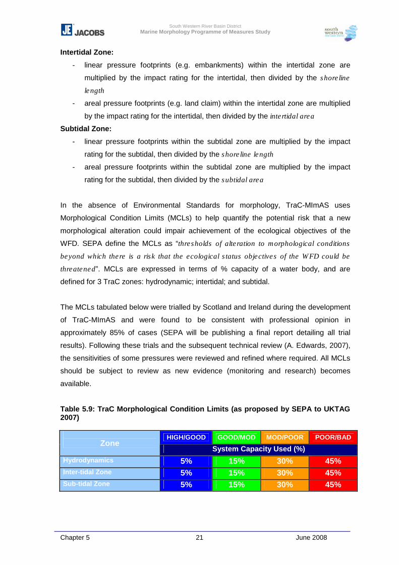
South Western River Basin District Marine Morphology Programme of Measures Study
Chapter 5 21 June 2008
Intertidal Zone:
- linear pressure footprints (e.g. embankments) within the intertidal zone are
multiplied by the impact rating for the intertidal, then divided by the shoreline
length
- areal pressure footprints (e.g. land claim) within the intertidal zone are multiplied
by the impact rating for the intertidal, then divided by the intertidal area
Subtidal Zone:
- linear pressure footprints within the subtidal zone are multiplied by the impact
rating for the subtidal, then divided by the shoreline length
- areal pressure footprints within the subtidal zone are multiplied by the impact
rating for the subtidal, then divided by the subtidal area
In the absence of Environmental Standards for morphology, TraC-MImAS uses
Morphological Condition Limits (MCLs) to help quantify the potential risk that a new
morphological alteration could impair achievement of the ecological objectives of the
WFD. SEPA define the MCLs as “thresholds of alteration to morphological conditions
beyond which there is a risk that the ecological status objectives of the WFD could be
threatened”. MCLs are expressed in terms of % capacity of a water body, and are
defined for 3 TraC zones: hydrodynamic; intertidal; and subtidal.
The MCLs tabulated below were trialled by Scotland and Ireland during the development
of TraC-MImAS and were found to be consistent with professional opinion in
approximately 85% of cases (SEPA will be publishing a final report detailing all trial
results). Following these trials and the subsequent technical review (A. Edwards, 2007),
the sensitivities of some pressures were reviewed and refined where required. All MCLs
should be subject to review as new evidence (monitoring and research) becomes
available.
Table 5.9: TraC Morphological Condition Limits (as proposed by SEPA to UKTAG 2007)
HIGH/GOOD GOOD/MOD MOD/POOR POOR/BAD Zone
System Capacity Used (%) Hydrodynamics 5% 15% 30% 45% Inter-tidal Zone 5% 15% 30% 45% Sub-tidal Zone 5% 15% 30% 45%
South Western River Basin District Marine Morphology Programme of Measures Study
Chapter 5 22 June 2008
These capacity limits are not water body type specific. The differences in response
between water body types to pressures are accounted for in the scoring system outlined
above.
Table 5.9 shows common MCLs for all three water body zones. It is important to
emphasis that the MCLs represent percentage capacity used and not the percentage
areal coverage of a pressure (development or activity), i.e. the impact ratings of
pressures for each of the three zones are weighted differently to reflect the sensitivity of
a zone (intertidal being the most sensitive and subtidal the least sensitive).
Within TraC-MImAS the risk of a water body failing the WFD objective of Good and High
Ecological Status is conveyed by using the status class boundary titles; High, Good,
Moderate, Poor, and Bad. TraC-MImAS uses the MCLs to help quantify the potential risk
that a new morphological alteration could impair achievement of the ecological
objectives of the WFD (for use in regulation).
As noted above, the impact ratings within TraC-MImAS have been generated using
professional judgement and should be subject to further development. However, the
framework underpinning TraC-MImAS is considered sound and should be used as the
basis for developing further research and development work to provide empirical
validation/calibration of the professional judgement values and/or assumptions applied in
the tool. This is the long term intention of SEPA for TraC-MImAS, and work has already
commenced for the Rivers-MImAS.
At a recent UK and Ireland MTT meeting (November 2007), attendees agreed the
following points in relation to the use of TraC-MImAS:
� The group was comfortable that the principles and approach underpinning TraC-
MImAS are logical and reasonable;
� TraC-MImAS is suitable to support the three purposes defined by SEPA:
- Regulatory risk assessments
- Identification of high status conditions for morphology
- Contribute to surrogate classification assessments for the other ecological status
boundaries (but not to be used in isolation)
� The condition limits proposed are set at an acceptable level for incorporation into the
UKTAG Environmental Standards report; however, these values should be reviewed
and refined where possible.
South Western River Basin District Marine Morphology Programme of Measures Study
Chapter 5 23 June 2008
5.3 Pressures
The initial risk assessments and resulting risk characterisations were primarily based on
the location of pressures and information relating to the ‘intensity’ of pressures was not
reviewed in detail.
Following an initial review of the pressures potentially impacting on the morphology of
TraC waters, it was concluded by Chapter 6 of the Literature Review (Appendix 2-1) that
the most appropriate method of identifying the intensity of a pressure involved the
subdivision of the primary pressure types into more defined activities to allow the
resultant changes in environmental factors (morphological attributes) to be investigated.
This is reflected within the structure of TraC-MImAS, i.e. to enable some form of generic
assessment of the sensitivity of coastal morphology and ecology, primary and secondary
pressures have been defined, for example, the subdivision of dredging into ‘low’ and
‘high’ impact categories to help represent pressure frequency and extent, and similar
definition of shoreline reinforcement representing differences in pressure intensity.
Those pressures agreed for assessment of Irish TraC water bodies for the purpose of
further characterisation using TraC-MImAS are outlined in Table 2.1 of Chapter 2. The
physical characteristics of the identified pressures and how these were assessed for the
purpose of characterisation are detailed in Chapter 3. It is important to note that these
pressure definitions still remain in draft form. They were proposed on development of
TraC-MImAS then further refined on completion of trials undertaken across Scotland and
Ireland. Therefore, future application of TraC-MImAS will undoubtedly identify further
refinements that will benefit the future development of this tool. The matrices
development by MarLIN and SensMap when linking similar pressures to environmental
factors were outlined above in Tables 5.2 - 5.3, and although these matrices do not
detail the probable scale of impact, the links identified are considered consistent with
those made within TraC-MImAS.
The sections below briefly outline the relationship between the pressures and potential
resultant impacts on ecology and morphology. The likelihood of impacts on the eco-
geomorphic attributes is tabulated for each pressure (Tables 5.10 – 5.17.)
South Western River Basin District Marine Morphology Programme of Measures Study
Chapter 5 24 June 2008
5.3.1 Land Claim & Tidal Realignment
Land Claim is defined as follows:
� Land claim - High impact: Recent or proposed enclosure of intertidal or subtidal
areas within impermeable banks followed by infilling for use by agriculture, housing,
port development or industry. Also used for land claim that has taken place in the
past and is still deemed to be having a significant impact.
� Land claim - Low impact: Historic (e.g. >50yrs ago) enclosure of intertidal or
subtidal areas within impermeable banks followed by infilling for use by agriculture,
housing, port development or industry. Can also be used for more recent land claim
where the impacts are minimal or where the surrounding environment has partly
recovered natural habitats and features.
The reclamation of any area of seabed has a direct impact on the biological integrity of
the existing habitats. Particularly, a reduction in intertidal area can reduce the carrying
capacity of existing habitats such as those associated with feeding grounds for
invertebrates, fish, and / or birds. Reclamation can be associated with additional
pressures related to the use of this new land such as intensive vessel movements.
Further to the definition of high and low impact land claim, the impact of reclamation on
TraC tidal zones is weighted differently by TraC-MImAS to reflect the increased pressure
likely on intertidal zones relative to that likely within the subtidal zones.
In addition to the direct removal of habitat, this new area of land also has the potential to
disrupt/alter coastal processes and natural sediment dynamics, as well as altering
bathymetry.
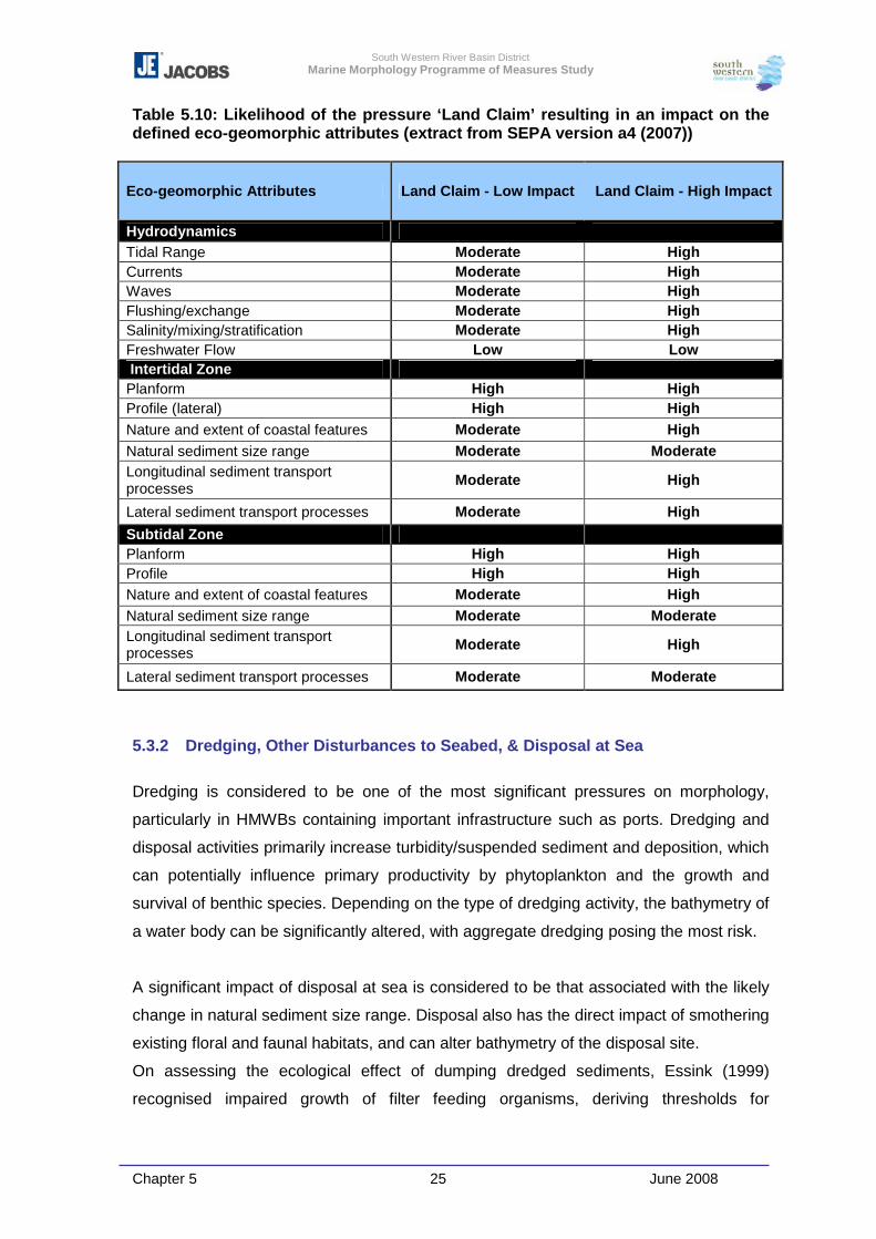
South Western River Basin District Marine Morphology Programme of Measures Study
Chapter 5 25 June 2008
Table 5.10: Likelihood of the pressure ‘Land Claim’ resulting in an impact on the defined eco-geomorphic attributes (extract from SEPA version a4 (2007))
Eco-geomorphic Attributes Land Claim - Low Impact Land Claim - High Impact
Hydrodynamics Tidal Range Moderate High Currents Moderate High Waves Moderate High Flushing/exchange Moderate High Salinity/mixing/stratification Moderate High Freshwater Flow Low Low Intertidal Zone Planform High High Profile (lateral) High High Nature and extent of coastal features Moderate High Natural sediment size range Moderate Moderate Longitudinal sediment transport processes Moderate High
Lateral sediment transport processes Moderate High Subtidal Zone Planform High High Profile High High Nature and extent of coastal features Moderate High Natural sediment size range Moderate Moderate Longitudinal sediment transport processes Moderate High
Lateral sediment transport processes Moderate Moderate
5.3.2 Dredging, Other Disturbances to Seabed, & Disposal at Sea
Dredging is considered to be one of the most significant pressures on morphology,
particularly in HMWBs containing important infrastructure such as ports. Dredging and
disposal activities primarily increase turbidity/suspended sediment and deposition, which
can potentially influence primary productivity by phytoplankton and the growth and
survival of benthic species. Depending on the type of dredging activity, the bathymetry of
a water body can be significantly altered, with aggregate dredging posing the most risk.
A significant impact of disposal at sea is considered to be that associated with the likely
change in natural sediment size range. Disposal also has the direct impact of smothering
existing floral and faunal habitats, and can alter bathymetry of the disposal site.
On assessing the ecological effect of dumping dredged sediments, Essink (1999)
recognised impaired growth of filter feeding organisms, deriving thresholds for
South Western River Basin District Marine Morphology Programme of Measures Study
Chapter 5 26 June 2008
smothering by deposits of one to two centimetres for these organisms. Other, more
mobile macrozoobenthos were found to survive burial of 20-30cm, as they were able to
migrate back to the surface (a process that took 1-2 weeks). Phytoplankton are sensitive
to light penetration, which is strongly impeded by suspended sediments. Impacts of
restricted light were found to be local and restricted in time, and are unlikely to always be
significant at the water body scale (depending on the scale and frequency of dredging).
Increased turbidity was also found to impair the growth of angiosperms such as
eelgrass. Some fish avoid turbid water, and enhanced suspended matter is unfavourable
to young herring and smelt, but this is difficult to generalise.
TraC-MImAS does not specifically consider suspended solids and turbidity as impacts
on ecology; however, these can be related to the eco-geomorphic attribute ‘natural
sediment size range’.
Sedimentation brought about by the dredging and deposition of material was found to
have varied impacts by Essink (1999). On intertidal flats, microphytobenthos species
were found to be well adapted to natural re-working of sediment by waves and currents,
however little information was sourced relating to the impacts on plants, although it is
concluded that the stability of intertidal sediments plays an important role in the
establishment and maintenance of sea grasses. Sessile (non-moving) species generally
had a low tolerance to increased sedimentation, while motile species had more varied
tolerance, often dependent on the substrate type. A change from predominantly soft
sediments to hard substrates as a result of decreased sedimentation would introduce
different communities, for example the development of rocky shore communities.
Frequent, short disturbances (perhaps one or two per year), were found to have a similar
impact to less frequent dredging in larger quantities, as less time was available for
sediments to redistribute and species to recover.
Aggregate dredging within Ireland is currently not an active pressure. However, recent
research undertaken in Irish waters, such as that associated with the Irish Sea Marine
Aggregates Initiative (IMAGIN) will provide information to inform policy generation in this
field. This pressure is likely to impact on off-shore waters, outside the WFD delineated
water bodies. If most aggregate extraction is concentrated in offshore areas, adverse
impacts on coastal process are likely to be limited, but impacts can include losses of
species diversity, population density and biomass of benthic invertebrates in dredged
areas.
South Western River Basin District Marine Morphology Programme of Measures Study
Chapter 5 27 June 2008
The assessment of the potential impacts that dredging activities may impose on the
morphology of TraC waters was considered using the following pressure types:
� Low impact dredging: within the Marine Morphology Study this pressure is
associated with maintenance dredging for purposes of navigation as identified using
the extents of shipping navigation channels, and also that associated with
OPW/Local Authority channel drainage schemes of TraC water bodies and
connected upstream waters
� High impact dredging: this was associated with identified capital dredging and is
also a suitable pressure definition for aggregate dredging. However, as aggregate
dredging can permanently change seabed bathymetry and significantly alter bed
ecology, the impact rating defined in TraC-MImAS may need to be increased.
� Other Disturbances to Seabed: In addition to the presence of marine cables and
pipes; this pressure type was used to define commercial dredging for shellfish
As noted above, Module 4 (impact assessment) of TraC-MImAS estimates both the
intensity (likelihood) and extent of impact (zone of impact). However, during a peer
review of TraC-MImAS. A. Edwards (2007) noted that the extent of impact can vary
between attributes “e.g. dredging will affect fine sediments over an area that is large
relative to the dredged-out cavity”. In the cavity benthos can be destroyed, whereas
outside of this the rate of fine deposition is only increased.
To assist in compliance of Arterial Drainage Maintenance operations with the European
Communities (Natural Habitat) Regulations 1997, the OPW have completed a series of
ecological impact assessments of the effects of statutory arterial drainage maintenance
activities on Natura 2000 sites (including raised bogs, atlantic salmon, otter, floating river
vegetation and fresh water pearl mussel).
It is evident from the data review that channels maintained by OPW and local authorities
are of limited extent within TraC waters. This is confirmed by OPW (2007); “Normally
none or limited maintenance is required in tidal areas”. However, the boundaries of
some TraC water bodies, reaching to river-like tidal channels are defined by the
alterations of the original Drainage Scheme embankments and channels, which “are
maintained at status quo” (OPW, 2007).
Within the series of ecological impact assessments, OPW define the differences
between the construction and maintenance of Arterial Drainage Schemes.
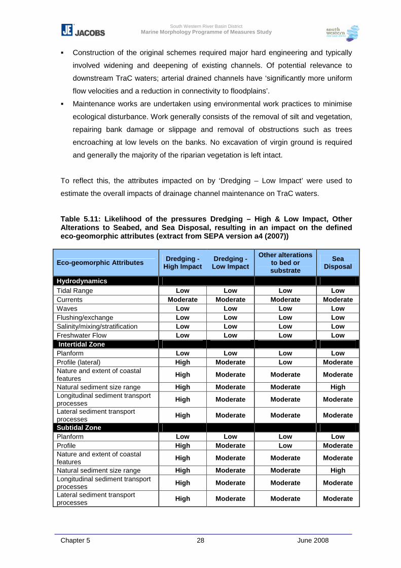
South Western River Basin District Marine Morphology Programme of Measures Study
Chapter 5 28 June 2008
� Construction of the original schemes required major hard engineering and typically
involved widening and deepening of existing channels. Of potential relevance to
downstream TraC waters; arterial drained channels have ‘significantly more uniform
flow velocities and a reduction in connectivity to floodplains’.
� Maintenance works are undertaken using environmental work practices to minimise
ecological disturbance. Work generally consists of the removal of silt and vegetation,
repairing bank damage or slippage and removal of obstructions such as trees
encroaching at low levels on the banks. No excavation of virgin ground is required
and generally the majority of the riparian vegetation is left intact.
To reflect this, the attributes impacted on by ‘Dredging – Low Impact’ were used to
estimate the overall impacts of drainage channel maintenance on TraC waters.
Table 5.11: Likelihood of the pressures Dredging – High & Low Impact, Other Alterations to Seabed, and Sea Disposal, resulting in an impact on the defined eco-geomorphic attributes (extract from SEPA version a4 (2007))
Eco-geomorphic Attributes Dredging - High Impact
Dredging - Low Impact
Other alterations to bed or substrate
Sea Disposal
Hydrodynamics Tidal Range Low Low Low Low Currents Moderate Moderate Moderate Moderate Waves Low Low Low Low Flushing/exchange Low Low Low Low Salinity/mixing/stratification Low Low Low Low Freshwater Flow Low Low Low Low Intertidal Zone Planform Low Low Low Low Profile (lateral) High Moderate Low Moderate Nature and extent of coastal features High Moderate Moderate Moderate
Natural sediment size range High Moderate Moderate High Longitudinal sediment transport processes High Moderate Moderate Moderate
Lateral sediment transport processes High Moderate Moderate Moderate
Subtidal Zone Planform Low Low Low Low Profile High Moderate Low Moderate Nature and extent of coastal features High Moderate Moderate Moderate
Natural sediment size range High Moderate Moderate High Longitudinal sediment transport processes High Moderate Moderate Moderate
Lateral sediment transport processes High Moderate Moderate Moderate
South Western River Basin District Marine Morphology Programme of Measures Study
Chapter 5 29 June 2008
For the purpose of this study ‘Other Disturbances to Seabed’ represents ferry
movements, licensed shellfish dredging areas, pipelines and cables, and wind farms.
This pressures type is defined by the SEPA MImAS study as “any other temporary
disturbances to bed morphology or substrate character where the impacts are likely to
be restricted to the area of bed directly disturbed and where the bed is likely to recover
significantly over time”.
As noted in Chapter 3, it is assumed that areas zoned for wind farms are currently
undergoing investigative surveying prior to development. However, on development of
these sites, the pressure on the water bodies containing these sites may be increased to
account for potential impacts such as seabed area loss due to the footprint of turbine
foundations (similar impacts associated with land claim), scouring, erosion and
sedimentation of the seabed (dredging high/low impact) and cables and traffic. The
potential ecological effects of off-shore wind farms are discussed in Hiscock et al (2002).
The extent of licensed aquaculture sites were mapped and reviewed as a component of
this pressure (estimated areas dredged for shellfish). However, detailed assessment of
aquaculture is outside the scope of this study.
5.3.3 Piled Structures
TraC-MImAS addresses this pressure in the form of total area covered by the structure
and not the footprint of the individual piles. Alternative footprints were assessed during
the trials of TraC-MImAS, e.g. sum of the area of individual piles supporting a structure,
but these proved difficult to use due to the lack of oblique coastal imagery and field trials
to confirm the number and extent of piles. This method resulted in the estimation of
many structures footprints in the trials, and was concluded as an inappropriate method
of assessment and was therefore revised.
The technical review of TraC-MImAS found that the overall scour effects of piled
structures are greater if the piles are close together (A. Edwards, 2007). This indicates
that TraC-MImAS would benefit from a more refined pressure footprint for piled
structures. I order to do this detailed coastal images or field trials would be required.
The construction of piled structures, such as bridges, can result in the direct loss of
habitat at the footprints of the piles, whilst there presence has the potential to alter
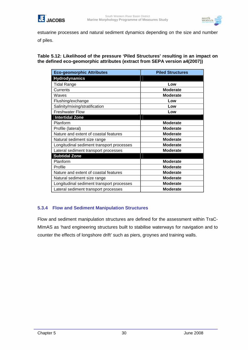
South Western River Basin District Marine Morphology Programme of Measures Study
Chapter 5 30 June 2008
estuarine processes and natural sediment dynamics depending on the size and number
of piles.
Table 5.12: Likelihood of the pressure ‘Piled Structures’ resulting in an impact on the defined eco-geomorphic attributes (extract from SEPA version a4(2007))
Eco-geomorphic Attributes Piled Structures Hydrodynamics Tidal Range Low Currents Moderate Waves Moderate Flushing/exchange Low Salinity/mixing/stratification Low Freshwater Flow Low Intertidal Zone Planform Moderate Profile (lateral) Moderate Nature and extent of coastal features Moderate Natural sediment size range Moderate Longitudinal sediment transport processes Moderate Lateral sediment transport processes Moderate Subtidal Zone Planform Moderate Profile Moderate Nature and extent of coastal features Moderate Natural sediment size range Moderate Longitudinal sediment transport processes Moderate Lateral sediment transport processes Moderate
5.3.4 Flow and Sediment Manipulation Structures
Flow and sediment manipulation structures are defined for the assessment within TraC-
MImAS as ‘hard engineering structures built to stabilise waterways for navigation and to
counter the effects of longshore drift’ such as piers, groynes and training walls.

South Western River Basin District Marine Morphology Programme of Measures Study
Chapter 5 31 June 2008
Table 5.13: Likelihood of the pressure ‘Flow and Sediment Manipulation Structures’ resulting in an impact on the defined eco-geomorphic attributes (extract from SEPA version a4 (2007))
Eco-geomorphic Attributes Flow and Sediment Manipulation
Hydrodynamics Tidal Range Low Currents Moderate Waves Low Flushing/exchange Low Salinity/mixing/stratification Low Freshwater Flow Low Intertidal Zone Planform Low Profile (lateral) Moderate Nature and extent of coastal features Moderate Natural sediment size range Moderate Longitudinal sediment transport processes Moderate Lateral sediment transport processes Moderate Subtidal Zone Planform Low Profile Moderate Nature and extent of coastal features Moderate Natural sediment size range Moderate Longitudinal sediment transport processes Moderate Lateral sediment transport processes Moderate
These structures have the potential to disrupt tidal flow and interaction, alter estuarine
processes and natural sediment dynamics. The construction of piers and slipways etc
can result in direct habitat loss at the footprint of the structure.
5.3.5 Impounding Structures & Causeways
These are defined as follows:
� Impounding Structures: A temporary or permanent structure that extends
across a channel that is used to impound, measure or alter flow (e.g. weirs,
sluices).
� Causeways: A physical barrier projecting from the shore whose foundations
extend to the bed and where gaps in the foundings represent <20% of the total
length. Typically used to support transport routes.
TraC-MImAS differentiates between these pressures by assigning a lower value in the
impact assessment of Causeways to indicate that the ‘likelihood’ that Causeways will
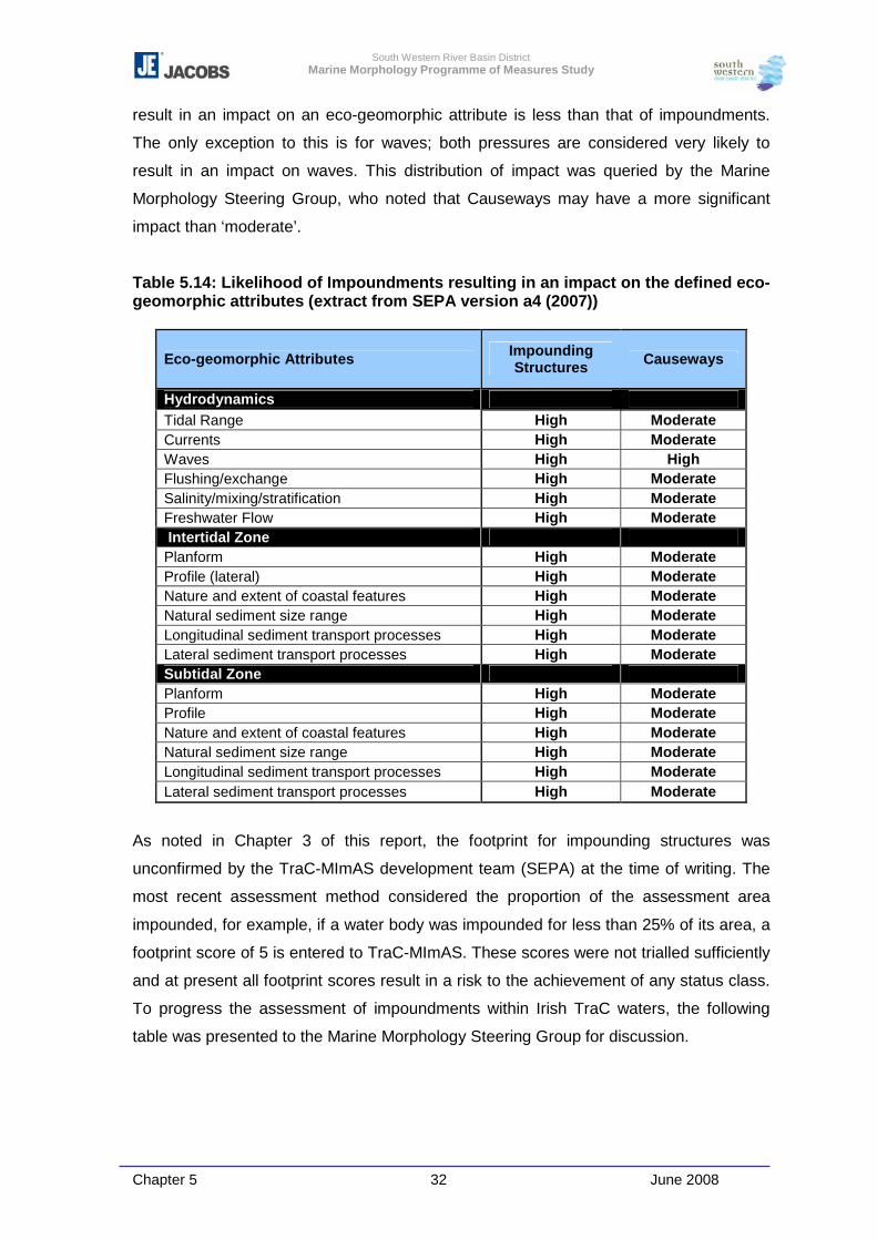
South Western River Basin District Marine Morphology Programme of Measures Study
Chapter 5 32 June 2008
result in an impact on an eco-geomorphic attribute is less than that of impoundments.
The only exception to this is for waves; both pressures are considered very likely to
result in an impact on waves. This distribution of impact was queried by the Marine
Morphology Steering Group, who noted that Causeways may have a more significant
impact than ‘moderate’.
Table 5.14: Likelihood of Impoundments resulting in an impact on the defined eco-geomorphic attributes (extract from SEPA version a4 (2007))
Eco-geomorphic Attributes Impounding Structures Causeways
Hydrodynamics Tidal Range High Moderate Currents High Moderate Waves High High Flushing/exchange High Moderate Salinity/mixing/stratification High Moderate Freshwater Flow High Moderate Intertidal Zone Planform High Moderate Profile (lateral) High Moderate Nature and extent of coastal features High Moderate Natural sediment size range High Moderate Longitudinal sediment transport processes High Moderate Lateral sediment transport processes High Moderate Subtidal Zone Planform High Moderate Profile High Moderate Nature and extent of coastal features High Moderate Natural sediment size range High Moderate Longitudinal sediment transport processes High Moderate Lateral sediment transport processes High Moderate
As noted in Chapter 3 of this report, the footprint for impounding structures was
unconfirmed by the TraC-MImAS development team (SEPA) at the time of writing. The
most recent assessment method considered the proportion of the assessment area
impounded, for example, if a water body was impounded for less than 25% of its area, a
footprint score of 5 is entered to TraC-MImAS. These scores were not trialled sufficiently
and at present all footprint scores result in a risk to the achievement of any status class.
To progress the assessment of impoundments within Irish TraC waters, the following
table was presented to the Marine Morphology Steering Group for discussion.
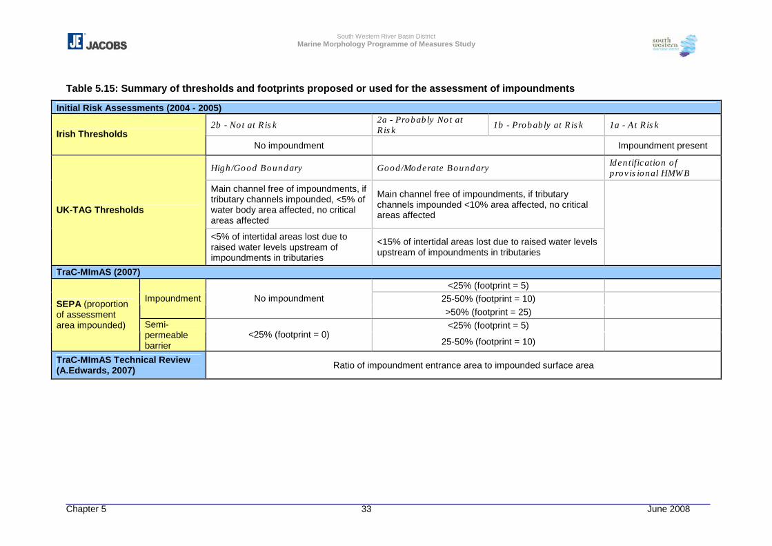
South Western River Basin District Marine Morphology Programme of Measures Study
Chapter 5 33 June 2008
Table 5.15: Summary of thresholds and footprints proposed or used for the assessment of impoundments
Initial Risk Assessments (2004 - 2005)
2b - Not at Risk 2a - Probably Not at Risk 1b - Probably at Risk 1a - At Risk
Irish Thresholds No impoundment Impoundment present
High/Good Boundary Good/Moderate Boundary Identification of provisional HMWB
Main channel free of impoundments, if tributary channels impounded, <5% of water body area affected, no critical areas affected
Main channel free of impoundments, if tributary channels impounded <10% area affected, no critical areas affected UK-TAG Thresholds
<5% of intertidal areas lost due to raised water levels upstream of impoundments in tributaries
<15% of intertidal areas lost due to raised water levels upstream of impoundments in tributaries
TraC-MImAS (2007) <25% (footprint = 5)
25-50% (footprint = 10) Impoundment No impoundment >50% (footprint = 25) <25% (footprint = 5)
SEPA (proportion of assessment area impounded) Semi-
permeable barrier
<25% (footprint = 0) 25-50% (footprint = 10)
TraC-MImAS Technical Review (A.Edwards, 2007) Ratio of impoundment entrance area to impounded surface area
South Western River Basin District Marine Morphology Programme of Measures Study
Chapter 5 34 June 2008
Table 5.15 summarises the thresholds/footprints used or proposed for the assessment of
impounding structures. It was agreed that the definitions provided by UKTAG for the
initial risk assessments were useful, but that defined by A. Edwards (2007) was most
appropriate for the assessment of impounding structures, but more suited to freshwater
impoundments. For the purpose of this study it was agreed that the area impounded, i.e.
not expressed as a ratio, was most suitable for the assessment of areal pressure
footprints within TraC-MImAS.
Within the TraC-MImAS definition of impounding structures are sluices. The assessment
of these structures using the above footprint is not possible, in many cases as sluices
are generally associated with embankment schemes and therefore a backup to drainage
channels, or with lagoons. It was agreed that where identified, these structures should
be reported on separately to the results of TraC-MImAS. For example, the following
sluices are reported in Chapter 6 of this report but not assessed within TraC-MImAS:
� Swilly Estuary - has an extensive network sluices associated with the 23km of
embankments identified
� Blanket Nook Lough - the flow exchange between this lagoon and Swilly estuary
occurs via a sluice.
The presence of impounding structures such as barrages, causeways and sluices can
alter the bathymetry in a water body, disrupt tidal flow and interaction, and alter natural
sediment dynamics via loss of continuity. Impacts to ecology can include destruction and
alteration of benthic habitats, loss of faunal nursery, refuge and feeding areas, as well as
disruption of habitat connectivity/continuity such as fish population movements.
5.3.6 Shoreline Reinforcement
Hard shoreline defences such as sea walls fix the coastline to its position at the time of
construction restricting it from naturally migrating landward or seaward in response to
sea level rise, wave action etc.
Protection or defence of a shoreline can disrupt beach/dune interactions, restrict or
prevent sediment inputs to the sediment budget, and more significantly, restrict the
shoreline’s ability to respond to sea level changes (coastal squeeze).
South Western River Basin District Marine Morphology Programme of Measures Study
Chapter 5 35 June 2008
TraC-MImAS considers two forms of shoreline reinforcement; high and low impact.
This allows the distinction between those structures which have persistent influence
over the intertidal or subtidal zones such as sea walls, sheet piling and revetments, and
those of ‘softer’ material or ‘set back’ with less influence on the water body.
Within TraC-MImAS, the likelihood that the following morphological attributes will be
impacted by shoreline reinforcement is higher for persistent, hard engineering type
structures (high impact):
� Waves – less persistent, or ‘softer’ reinforcement is less likely to restrict wave impact
on the shore.
� Nature and extent of coastal features – the restriction of wave impact on a
shoreline via the use of hard coastal structures can reduce the natural
erosion/deposition of a shore.
� Longitudinal sediment transport processes of the intertidal zone – the
restriction of waves breaking at the shore can in turn reduce the transport of material
parallel to the shore (littoral drift).
� Lateral sediment transport processes within the subtidal – restriction of
sediment input from processes such as littoral drift and shoreline erosion can impact
on this sediment transport process.
Ecological impacts potentially resulting from such alterations to morphological attributes
and processes include disruption to natural habitats, loss of faunal nursery, refuge and
feeding areas.
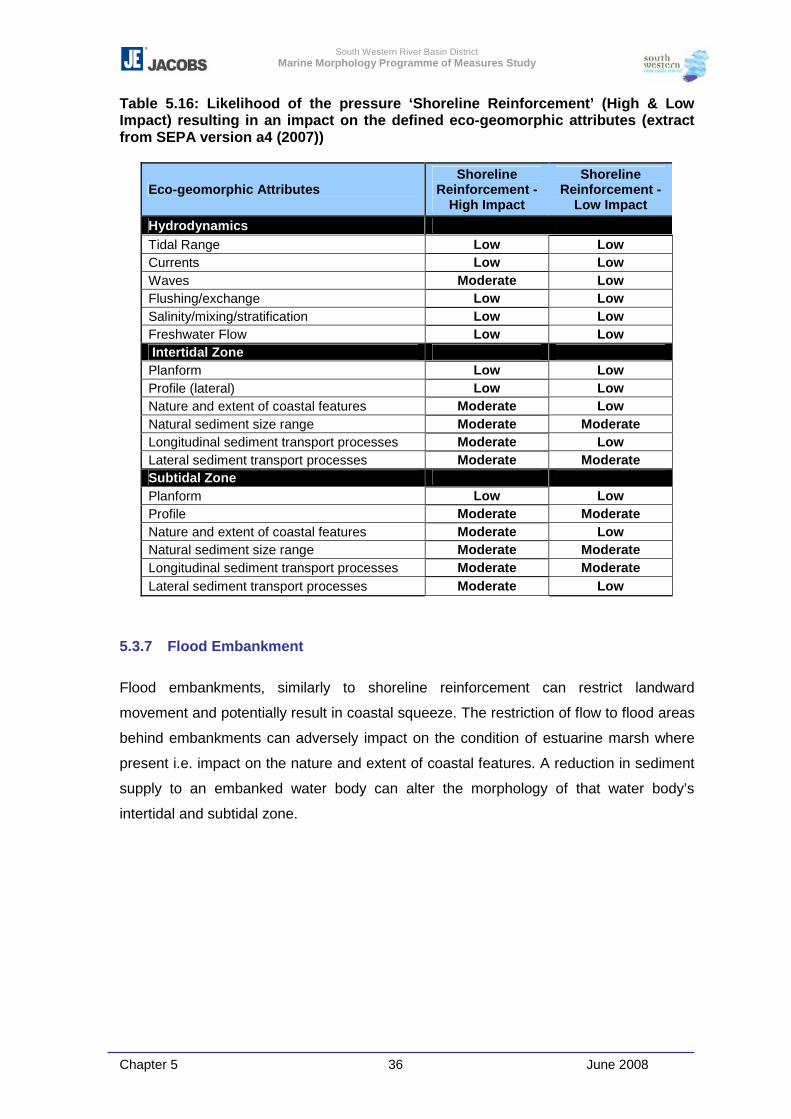
South Western River Basin District Marine Morphology Programme of Measures Study
Chapter 5 36 June 2008
Table 5.16: Likelihood of the pressure ‘Shoreline Reinforcement’ (High & Low Impact) resulting in an impact on the defined eco-geomorphic attributes (extract from SEPA version a4 (2007))
Eco-geomorphic Attributes Shoreline
Reinforcement - High Impact
Shoreline Reinforcement -
Low Impact
Hydrodynamics Tidal Range Low Low Currents Low Low Waves Moderate Low Flushing/exchange Low Low Salinity/mixing/stratification Low Low Freshwater Flow Low Low Intertidal Zone Planform Low Low Profile (lateral) Low Low Nature and extent of coastal features Moderate Low Natural sediment size range Moderate Moderate Longitudinal sediment transport processes Moderate Low Lateral sediment transport processes Moderate Moderate Subtidal Zone Planform Low Low Profile Moderate Moderate Nature and extent of coastal features Moderate Low Natural sediment size range Moderate Moderate Longitudinal sediment transport processes Moderate Moderate Lateral sediment transport processes Moderate Low
5.3.7 Flood Embankment
Flood embankments, similarly to shoreline reinforcement can restrict landward
movement and potentially result in coastal squeeze. The restriction of flow to flood areas
behind embankments can adversely impact on the condition of estuarine marsh where
present i.e. impact on the nature and extent of coastal features. A reduction in sediment
supply to an embanked water body can alter the morphology of that water body’s
intertidal and subtidal zone.
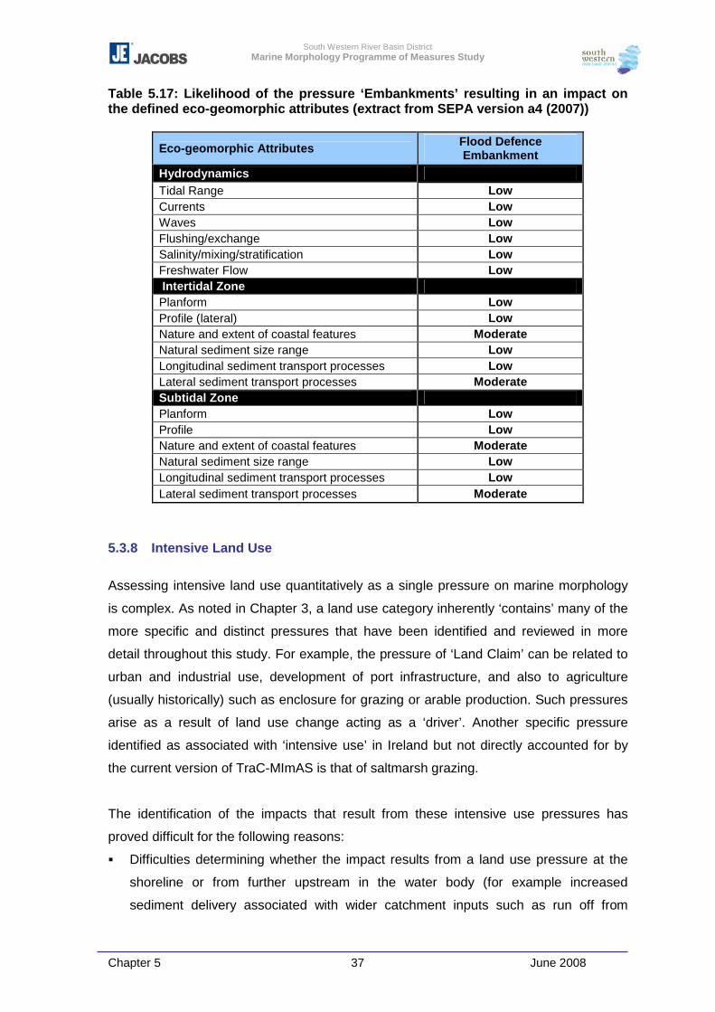
South Western River Basin District Marine Morphology Programme of Measures Study
Chapter 5 37 June 2008
Table 5.17: Likelihood of the pressure ‘Embankments’ resulting in an impact on the defined eco-geomorphic attributes (extract from SEPA version a4 (2007))
Eco-geomorphic Attributes Flood Defence Embankment
Hydrodynamics Tidal Range Low Currents Low Waves Low Flushing/exchange Low Salinity/mixing/stratification Low Freshwater Flow Low Intertidal Zone Planform Low Profile (lateral) Low Nature and extent of coastal features Moderate Natural sediment size range Low Longitudinal sediment transport processes Low Lateral sediment transport processes Moderate Subtidal Zone Planform Low Profile Low Nature and extent of coastal features Moderate Natural sediment size range Low Longitudinal sediment transport processes Low Lateral sediment transport processes Moderate
5.3.8 Intensive Land Use
Assessing intensive land use quantitatively as a single pressure on marine morphology
is complex. As noted in Chapter 3, a land use category inherently ‘contains’ many of the
more specific and distinct pressures that have been identified and reviewed in more
detail throughout this study. For example, the pressure of ‘Land Claim’ can be related to
urban and industrial use, development of port infrastructure, and also to agriculture
(usually historically) such as enclosure for grazing or arable production. Such pressures
arise as a result of land use change acting as a ‘driver’. Another specific pressure
identified as associated with ‘intensive use’ in Ireland but not directly accounted for by
the current version of TraC-MImAS is that of saltmarsh grazing.
The identification of the impacts that result from these intensive use pressures has
proved difficult for the following reasons:
� Difficulties determining whether the impact results from a land use pressure at the
shoreline or from further upstream in the water body (for example increased
sediment delivery associated with wider catchment inputs such as run off from
South Western River Basin District Marine Morphology Programme of Measures Study
Chapter 5 38 June 2008
agricultural land or forestry). A good deal of scientific/theoretical information is
available on the impacts of agricultural intensification in the uplands on river
morphology and flow, but much less for estuarine and coastal environments;
� That the ‘intensive use’ today often results from a historical change in use up to
hundreds’ of years ago, resulting in legacy impacts;
� Much ‘scientific’ information relates to the water quality impacts of pollution resulting
from land use, rather than morphological impacts;
� Current paucity of data to permit a comprehensive and consistent assessment of the
pressure to all water bodies, e.g. more data is available for designated sites such as
SACs.
Links between ‘intensive use’ and other pressures identified in this study
This issue is well illustrated by an example of the Shannon Estuary given by Healy and
Hickey (2002), where approximately 6,500ha of the estuary lowlands have been
reclaimed for agriculture and other purposes. Urban development and port and harbour
infrastructure have had significant impacts on this estuary. Early reclamation enclosed
salt marshes and mudflats with earth banks for agricultural purposes (details of which
are quantified for assessment with TraC-MImAS). More recently, reclamation for
industrial, commercial and recreational uses has taken place, as well as works for
suburban expansion and housing development with associated embankments and
revetments as flood protection devices. The ‘footprints’ of these pressures have been
digitised for these areas in the form of ‘land claim’, ‘flow and sediment manipulation’
structures, and shoreline reinforcement. Pasture and marsh/saltmarshes have been
partially drained, using channels leading to flap sluices and other outlets to artificial
drainage channels and tidal creeks (the presence and maintenance of such drainage
channels is quantified using estimated footprints of low impact dredging for assessment
within TraC-MImAS). Further dredging of the shipping channel through the estuary was
envisaged by Healy and Hickey (2002), as well as large-scale infrastructural
developments. The maintenance of this tidal channel has been quantified using the
footprint of the shipping channel as an indication of maintenance dredging.
The table below summarises the association of specific pressures assessed within this
study with land cover types identified by the EPA CORINE 2000 land cover dataset.
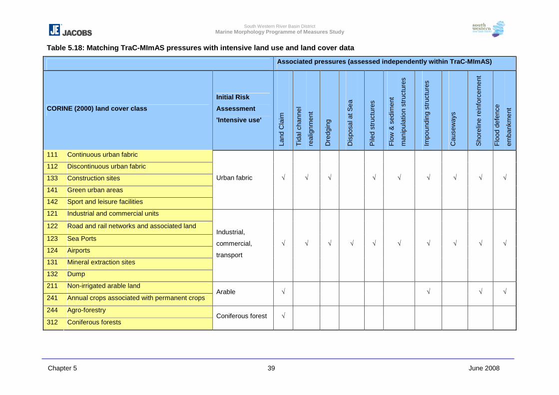
South Western River Basin District Marine Morphology Programme of Measures Study
Chapter 5 39 June 2008
Table 5.18: Matching TraC-MImAS pressures with intensive land use and land cover data
Associated pressures (assessed independently within TraC-MImAS)
CORINE (2000) land cover class
Initial Risk
Assessment
'Intensive use'
Land
Cla
im
Tida
l cha
nnel
real
ignm
ent
Dre
dgin
g
Dis
posa
l at S
ea
Pile
d st
ruct
ures
Flow
& s
edim
ent
man
ipul
atio
n st
ruct
ures
Impo
undi
ng s
truct
ures
Cau
sew
ays
Sho
relin
e re
info
rcem
ent
Floo
d de
fenc
e
emba
nkm
ent
111 Continuous urban fabric
112 Discontinuous urban fabric
133 Construction sites
141 Green urban areas
142 Sport and leisure facilities
Urban fabric � � � � � � � � �
121 Industrial and commercial units
122 Road and rail networks and associated land
123 Sea Ports
124 Airports
131 Mineral extraction sites
132 Dump
Industrial,
commercial,
transport
� � � � � � � � � �
211 Non-irrigated arable land
241 Annual crops associated with permanent crops Arable � � � �
244 Agro-forestry
312 Coniferous forests Coniferous forest �
South Western River Basin District Marine Morphology Programme of Measures Study
Chapter 5 40 June 2008
5.3.8.1 Salt Marsh Grazing
Reclamation, drainage and overgrazing have led to a marked depletion in the
number of saltmarshes in Ireland, indicating that their conservation is an urgent
requirement (Curtis & Skeffington, 1998).
Following land claim/enclosure, saltmarshes were historically used for grazing
domestic stock. This was considered a traditional use of the land, without ploughing
or agrochemicals, and created habitats of wildlife interest (grazing marsh). When
unimproved permanent pasture is used for low intensity grazing, it often develops a
vegetation structure attractive to nesting birds. Rare species of plants are often found
in association with pasture and the brackish water drainage ditches, the latter being
particularly important for a number of rare invertebrates. More recently, these semi-
natural habitats have in some cases been claimed for intensive agriculture.
Grazing can still occur extensively on marshes and has a major effect on the
structure and species composition of a marsh (e.g. through the grazing process itself
and also soil compaction and poaching/trampling by animals). In general, as grazing
intensity increases, there is a loss of structural and species diversity. Several levels
of grazing, with different levels of impact, can be defined:
Light most of the standing crop is not removed
Moderate maximum standing crop almost completely removed
Heavy height <10 cm, all standing crop removed
Abandoned matted vegetation, no standing crop removed.
The intensity of grazing of saltmarsh can be estimated by matching livestock density
reported by the Central Statistics Office (CSO) with the saltmarsh areas defined by
the EPA CORINE 2000 dataset. A study titled ‘Visual Environmental Data on Soils
and Landuse’ publish by Teagasc in 1999 included information and maps on the total
stocking density of livestock across Ireland, using information obtained from the 1991
Agricultural Census which report density per District Electoral Division, and therefore
easily mapped. However, the most recent Agricultural Census (2000) only provides
livestock data per county and excludes the land types marsh, bog and unused rough
grazing. These limitations prevented the identification of grazed saltmarsh areas
neighboring TraC waters.
South Western River Basin District Marine Morphology Programme of Measures Study
Chapter 5 41 June 2008
The NPWS are currently undertaking a review of Ireland’s saltmarsh, with the aim to
map all areas identified. It was agreed with the Marine Morphology Steering Group
that on completion of this NPWS study the mapped saltmarsh extents should be
compared with the outputs of this study, and more detailed census of livestock
density.
5.3.8.2 Peat Bogs
The initial risk assessments completed in 2005 identified a strong correlation
between mapped Bord na Mona peat extraction areas and CORINE information,
therefore, CORINE data was used in this assessment.
Exploitation and severe over-grazing of bog can result in extensive loss of plant
cover which in turn can lead to erosion of the surface peat by wind and rain.
However, changes in the management of agricultural and peat lands over the past
decade has introduced supportive measures (as outlined below) that have reduced
impacts on TraC waters from exploitation of peat bogs. These pressures are
therefore not considered significant for the morphological quality of Ireland’s TraC
waters.
A conference titled ‘The state of biological diversity in the European Union’ held in
May 2004 reported that wetlands cover 16% of the surface of Ireland and peat-bogs
represent 95% of this total. The main peat-bog areas are concentrated in the West
and North West of Ireland. In addition to land disturbance associated with exploited
bogs, these areas are drained to facilitate cutting. Once the land is drained, it is
suitable for other purposes such as coniferous forests. The conversion of peat-bogs
to transitional shrub land as a result of drainage is also common. This change in land
use can contribute to the pressures on wetland ecosystems.
The introduction of the EU Headage Payment Scheme led to large increases in
sheep numbers with a near “three-fold increase nationally since 1980” (MacGowan,
2002). Several studies have reported the impact of over grazing, but generally focus
on lakes and rivers. The loss of plant cover leads to the erosion of peat (down to the
mineral soil in some places) which are known to result in the siltation and acidification
of lakes, which in turn impacts on spawning beds of salmon and trout. It can be
assumed therefore, that similar impacts were likely of estuaries and lagoons
bordering such lands. However, in 1994 the voluntary Rural Environmental Protection
Scheme (REPS) was initiated to ‘reward farmers for carrying out their farming
South Western River Basin District Marine Morphology Programme of Measures Study
Chapter 5 42 June 2008
activities in an environmental friendly manner and to bring about environmental
improvement on existing farms’. This scheme has gone some way in reducing over
grazing of peat bogs. However, arable and intensive grassland are not recognised as
REPS habitats.
Recent research by Teagasc involves 16 projects focused primarily on research
strategies to reduce pollution from agriculture. This indicates that the current
practices surrounding agriculture and peat-bogs do not severely impact on the
morphology of transitional and coastal waters and are more significant to the
degradation of water quality.
Many raised and blanket bogs are designated Special Areas of Conservation or
proposed Natural Heritage Areas, and under REPS peat lands are protected from
their main threats of land improvement (turf cutting and afforestation), and
sustainable grazing is promoted.
In 2003 the Department of Agriculture, Food and Rural Development (DARD)
published Commonage Framework plans in agreement with the DEHLG. These
include grazing regimes for the commonage.
On review of the existing management schemes and statutory protection of sensitive
habitats, the impact of agricultural land use is not considered as a significant impact
to the morphology of TraC waters. However, this is with the exception of saltmarsh;
the further assessment of saltmarsh grazing is recommended on completion of the
NPWS study to help quantify the extent of intensive grazing of these habitats.
5.3.8.3 Intensive Sea Use
In addition to the range of intensive land uses at the margins of estuarine and coastal
areas, the sea itself is subject to increasing human activities and uses. Where these
uses involve building structures or dredging, the pressure will be assessed as
appropriate using TraC-MImAS. The types of activity that could result in
morphological pressures include:
• Aggregate extraction or navigation dredging;
• Deposition of waste/dredgings at sea;
• Cable and pipe laying;
South Western River Basin District Marine Morphology Programme of Measures Study
Chapter 5 43 June 2008
• Energy projects including marine wind turbine generators, wave energy
generators and tidal barrages;
• Marine aquaculture and fishing
• Shipping
The morphological impacts associated with these pressures are discussed above.
Although highly site and activity specific, the potential impacts could be generically
summarised to include: substrate removal; scour and alteration of bed topography;
altered turbidity/light levels; sediment mobilisation and plumes; re-suspension and
smothering by fine sediment.
The most significant intensive sea use within Ireland is that of aquaculture, with
licensed areas occupying approximately 17 % (2548km2) of the TraC water body
area, 15084km2. Detailed assessment of the impact of aquaculture practices is
outside the scope of this study (refer to Chapter 2, Section 2.1).
South Western River Basin District Marine Morphology Programme of Measures Study
Chapter 5 44 June 2008
5.4 Development & Use of TraC-MImAS for the Purpose of Risk Assessments
TraC-MImAS uses the concept of system capacity to estimate the risk of a water
body failing to meet WFD status classes. The following is an example of how this
system estimates this risk using the five modules detailed in Sections 5.2.1 – 5.2.5
above.
5.4.1 Clonakilty Harbour (SW_100_0100)
This water body was characterised by the initial risk assessments as ‘probably at risk’
from combined sewer and treatment plant overflows, and ‘probably not at risk’ from
point source discharges of waste water treatment plants and intensive land use.
Further characterisation of the pressures on this water body and assessment using
TraC-MImAS indicate that this water body is at risk of not achieving GES due to
physical alterations. If the pressures associated with point source discharges were
mitigated with the aim of achieving GES, the results of TraC-MImAS indicate that
physical (morphological) alterations in this water body may prevent the attainment of
GES.
Module 1 – Attribute Module & Module 2 – Typology Module
Clonakilty Harbour was classed as a water body type TW2 (polyhaline, mesotidal and
sheltered), which when using TraC-MImAS translates to a transitional, meso to
macrotidal water body. All eco-geomorphic attributes assessed within TraC-MImAS
are considered relevant to this type of water body.
Module 3 – Sensitivity Assessment
Table 5.19 below details the sensitivity values estimated for the ecology and
morphology of this type of water body, i.e. transitional meso to macro tidal. The key
to this table outlines the meanings of the values assigned.
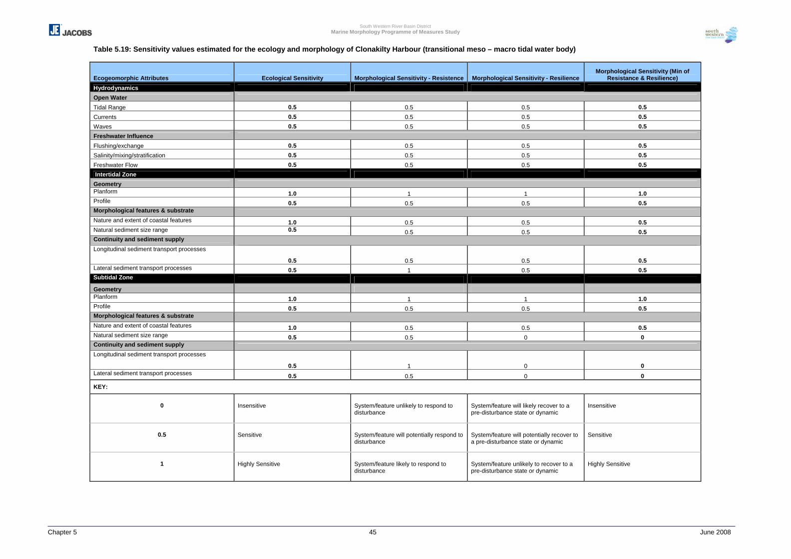
South Western River Basin District Marine Morphology Programme of Measures Study
Chapter 5 45 June 2008
Table 5.19: Sensitivity values estimated for the ecology and morphology of Clonakilty Harbour (transitional meso – macro tidal water body)
Ecogeomorphic Attributes Ecological Sensitivity Morphological Sensitivity - Resistence Morphological Sensitivity - Resilience Morphological Sensitivity (Min of
Resistance & Resilience)
Hydrodynamics
Open Water
Tidal Range 0.5 0.5 0.5 0.5
Currents 0.5 0.5 0.5 0.5
Waves 0.5 0.5 0.5 0.5
Freshwater Influence
Flushing/exchange 0.5 0.5 0.5 0.5
Salinity/mixing/stratification 0.5 0.5 0.5 0.5
Freshwater Flow 0.5 0.5 0.5 0.5
Intertidal Zone
Geometry Planform 1.0 1 1 1.0 Profile 0.5 0.5 0.5 0.5 Morphological features & substrate Nature and extent of coastal features 1.0 0.5 0.5 0.5 Natural sediment size range 0.5 0.5 0.5 0.5 Continuity and sediment supply Longitudinal sediment transport processes
0.5 0.5 0.5 0.5 Lateral sediment transport processes 0.5 1 0.5 0.5 Subtidal Zone
Geometry Planform 1.0 1 1 1.0 Profile 0.5 0.5 0.5 0.5 Morphological features & substrate Nature and extent of coastal features 1.0 0.5 0.5 0.5 Natural sediment size range 0.5 0.5 0 0 Continuity and sediment supply Longitudinal sediment transport processes
0.5 1 0 0 Lateral sediment transport processes 0.5 0.5 0 0
KEY:
0
Insensitive
System/feature unlikely to respond to disturbance
System/feature will likely recover to a pre-disturbance state or dynamic
Insensitive
0.5
Sensitive
System/feature will potentially respond to disturbance
System/feature will potentially recover to a pre-disturbance state or dynamic
Sensitive
1
Highly Sensitive
System/feature likely to respond to disturbance
System/feature unlikely to recover to a pre-disturbance state or dynamic
Highly Sensitive
South Western River Basin District Marine Morphology Programme of Measures Study
Chapter 5 46 June 2008
The morphological features of least sensitivity in this type of water body are subtidal
natural sediment size range, longitudinal and lateral sediment transport. It is
considered that although these features are likely to respond to disturbance, they are
resilient and likely to recover. The morphological attribute considered most sensitive
is planform. A change to the spatial extent and / or intertidal zone as a result of
prevailing coastal processes or realignment of the high water mark due to physical
alterations (pressures) is considered difficult to resist in such a water body, and
changes to these attributes are likely to prevent recovery to a pre-disturbed
state/dynamic.
Module 4 – Impact Assessment (Pressure) Module
Now that the sensitivity of changes to the morphological attributes relevant to a meso
to macrotidal transitional water body such as Clonakilty Harbour is estimated, the
‘likelihood’ that pressures will have an impact on these attributes can be determined
(see table 5.20).
The physical alterations (pressures) identified for Clonakilty Harbour are listed below,
and Table 5.21 shows how these pressures are distributed between the intertidal and
subtidal zones.
- High impact land claim
- Structures that manipulate flow / sediment – non-piled piers and slipway
- High impact shoreline reinforcement – associated with the harbour and
surrounding roads
- Embankments
The following key is used to estimate the likelihood of these pressures impacting the
attributes relevant to this water body:
1 In most cases, this activity will result in an impact on a eco-geomorphic attribute
0.5 In some cases, this activity will result in an impact on a eco-geomorphic attribute
0 In most cases, this activity will not result in an impact on a eco-geomorphic
attribute
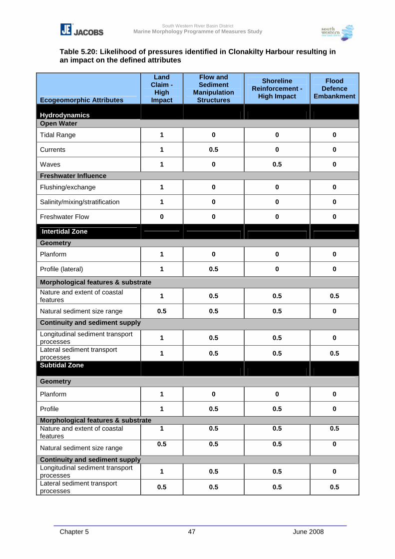
South Western River Basin District Marine Morphology Programme of Measures Study
Chapter 5 47 June 2008
Table 5.20: Likelihood of pressures identified in Clonakilty Harbour resulting in an impact on the defined attributes
Ecogeomorphic Attributes
Land Claim - High
Impact
Flow and Sediment
Manipulation Structures
Shoreline Reinforcement -
High Impact
Flood Defence
Embankment
Hydrodynamics Open Water
Tidal Range 1 0 0 0
Currents 1 0.5 0 0
Waves 1 0 0.5 0
Freshwater Influence
Flushing/exchange 1 0 0 0
Salinity/mixing/stratification 1 0 0 0
Freshwater Flow 0 0 0 0
Intertidal Zone Geometry
Planform 1 0 0 0
Profile (lateral) 1 0.5 0 0
Morphological features & substrate Nature and extent of coastal features 1 0.5 0.5 0.5
Natural sediment size range 0.5 0.5 0.5 0
Continuity and sediment supply
Longitudinal sediment transport processes 1 0.5 0.5 0
Lateral sediment transport processes 1 0.5 0.5 0.5
Subtidal Zone
Geometry
Planform 1 0 0 0
Profile 1 0.5 0.5 0
Morphological features & substrate Nature and extent of coastal features
1
0.5
0.5
0.5
Natural sediment size range 0.5
0.5
0.5
0
Continuity and sediment supply Longitudinal sediment transport processes 1 0.5 0.5 0
Lateral sediment transport processes 0.5 0.5 0.5 0.5
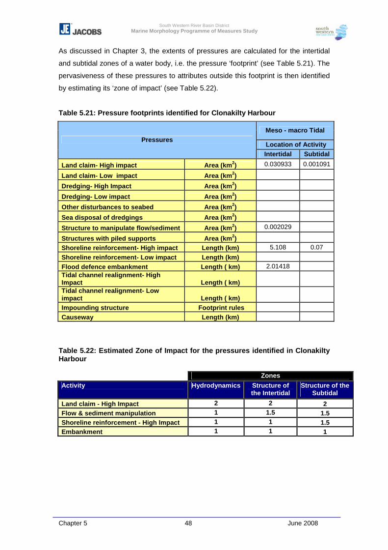
South Western River Basin District Marine Morphology Programme of Measures Study
Chapter 5 48 June 2008
As discussed in Chapter 3, the extents of pressures are calculated for the intertidal
and subtidal zones of a water body, i.e. the pressure ‘footprint’ (see Table 5.21). The
pervasiveness of these pressures to attributes outside this footprint is then identified
by estimating its ‘zone of impact’ (see Table 5.22).
Table 5.21: Pressure footprints identified for Clonakilty Harbour
Meso - macro Tidal
Location of Activity Pressures
Intertidal Subtidal
Land claim- High impact Area (km2) 0.030933 0.001091
Land claim- Low impact Area (km2)
Dredging- High Impact Area (km2)
Dredging- Low impact Area (km2)
Other disturbances to seabed Area (km2)
Sea disposal of dredgings Area (km2)
Structure to manipulate flow/sediment Area (km2) 0.002029
Structures with piled supports Area (km2)
Shoreline reinforcement- High impact Length (km) 5.108 0.07
Shoreline reinforcement- Low impact Length (km)
Flood defence embankment Length ( km) 2.01418 Tidal channel realignment- High Impact Length ( km)
Tidal channel realignment- Low impact Length ( km)
Impounding structure Footprint rules
Causeway Length (km)
Table 5.22: Estimated Zone of Impact for the pressures identified in Clonakilty Harbour Zones Activity Hydrodynamics Structure of
the Intertidal Structure of the
Subtidal
Land claim - High Impact 2 2 2 Flow & sediment manipulation 1 1.5 1.5 Shoreline reinforcement - High Impact 1 1 1.5 Embankment 1 1 1
South Western River Basin District Marine Morphology Programme of Measures Study
Chapter 5 49 June 2008
Module 5: Capacity Based Scoring System
Section 5.2.5 above introduced how the output values from the first four modules are
used to calculate an impact score for each attribute relevant to the existing pressures
within a water body.
Table 5.23 shows how the impact ratings were estimated for ‘Shoreline
Reinforcement – high impact’ in a transitional meso to macro tidal water body type,
using the equation below. The impact values for each attribute are first calculated
and are then averaged to provide an impact score for each of the three water body
zones.
Relevance X Ecological Sensitivity X
Morphological Sensitivity X
Likelihood of Impact
Output from typology module
Output from sensitivity module
Output from sensitivity module
Output from pressure module
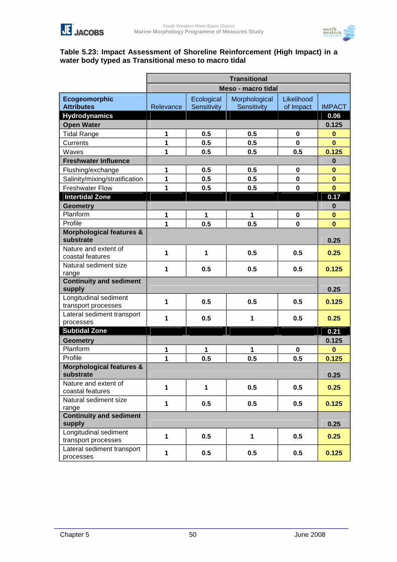
South Western River Basin District Marine Morphology Programme of Measures Study
Chapter 5 50 June 2008
Table 5.23: Impact Assessment of Shoreline Reinforcement (High Impact) in a water body typed as Transitional meso to macro tidal
Transitional Meso - macro tidal
Ecogeomorphic Attributes Relevance
Ecological Sensitivity
Morphological Sensitivity
Likelihood of Impact IMPACT
Hydrodynamics 0.06 Open Water 0.125 Tidal Range 1 0.5 0.5 0 0 Currents 1 0.5 0.5 0 0 Waves 1 0.5 0.5 0.5 0.125 Freshwater Influence 0 Flushing/exchange 1 0.5 0.5 0 0 Salinity/mixing/stratification 1 0.5 0.5 0 0 Freshwater Flow 1 0.5 0.5 0 0 Intertidal Zone 0.17 Geometry 0 Planform 1 1 1 0 0 Profile 1 0.5 0.5 0 0 Morphological features & substrate 0.25 Nature and extent of coastal features 1 1 0.5 0.5 0.25
Natural sediment size range 1 0.5 0.5 0.5 0.125
Continuity and sediment supply 0.25 Longitudinal sediment transport processes 1 0.5 0.5 0.5 0.125
Lateral sediment transport processes 1 0.5 1 0.5 0.25
Subtidal Zone 0.21 Geometry 0.125 Planform 1 1 1 0 0 Profile 1 0.5 0.5 0.5 0.125 Morphological features & substrate 0.25 Nature and extent of coastal features 1 1 0.5 0.5 0.25
Natural sediment size range 1 0.5 0.5 0.5 0.125
Continuity and sediment supply 0.25 Longitudinal sediment transport processes 1 0.5 1 0.5 0.25
Lateral sediment transport processes 1 0.5 0.5 0.5 0.125
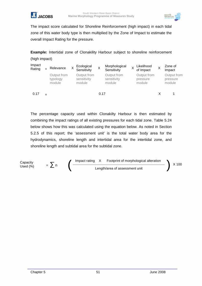
South Western River Basin District Marine Morphology Programme of Measures Study
Chapter 5 51 June 2008
The impact score calculated for Shoreline Reinforcement (high impact) in each tidal
zone of this water body type is then multiplied by the Zone of Impact to estimate the
overall Impact Rating for the pressure.
Example: Intertidal zone of Clonakility Harbour subject to shoreline reinforcement
(high impact)
Impact Rating
= Relevance X Ecological
Sensitivity X Morphological Sensitivity X Likelihood
of Impact X Zone of Impact
Output from typology module
Output from sensitivity module
Output from sensitivity module
Output from pressure module
Output from pressure module
0.17 = 0.17 X 1
The percentage capacity used within Clonakilty Harbour is then estimated by
combining the impact ratings of all existing pressures for each tidal zone. Table 5.24
below shows how this was calculated using the equation below. As noted in Section
5.2.5 of this report; the ‘assessment unit’ is the total water body area for the
hydrodynamics, shoreline length and intertidal area for the intertidal zone, and
shoreline length and subtidal area for the subtidal zone.
Impact rating X Footprint of morphological alteration Capacity Used (%) = � n ( Length/area of assessment unit ) X 100
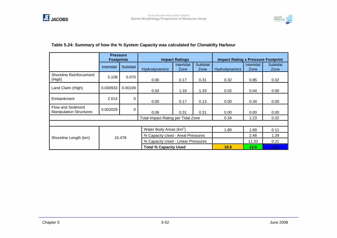
South Western River Basin District Marine Morphology Programme of Measures Study
Chapter 5 5-52 June 2008
Table 5.24: Summary of how the % System Capacity was calculated for Clonakilty Harbour
Pressure Footprints Impact Ratings Impact Rating x Pressure Footprint
Intertidal Subtidal Hydrodynamics Intertidal
Zone Subtidal
Zone Hydrodynamics Intertidal
Zone Subtidal
Zone Shoreline Reinforcement (High) 5.108 0.070
0.06 0.17 0.31 0.32 0.85 0.02
Land Claim (High) 0.030933 0.00109 0.50 1.33 1.33 0.02 0.04 0.00
Embankment 2.014 0 0.00 0.17 0.13 0.00 0.34 0.00
Flow and Sediment Manipulation Structures 0.002029 0
0.06 0.31 0.31 0.00 0.00 0.00 Total Impact Rating per Tidal Zone 0.34 1.23 0.02
Water Body Areas (km2) 1.80 1.69 0.11 % Capacity Used - Areal Pressures 2.48 1.29 % Capacity Used - Linear Pressures 11.33 0.21
Shoreline Length (km) 10.478
Total % Capacity Used 18.8 13.8 1.5
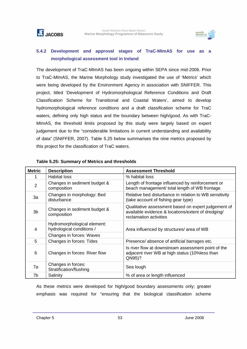
South Western River Basin District Marine Morphology Programme of Measures Study
Chapter 5 53 June 2008
5.4.2 Development and approval stages of TraC-MImAS for use as a
morphological assessment tool in Ireland
The development of TraC-MImAS has been ongoing within SEPA since mid-2006. Prior
to TraC-MImAS, the Marine Morphology study investigated the use of ‘Metrics’ which
were being developed by the Environment Agency in association with SNIFFER. This
project, titled ‘Development of Hydromorphological Reference Conditions and Draft
Classification Scheme for Transitional and Coastal Waters’, aimed to develop
hydromorphological reference conditions and a draft classification scheme for TraC
waters, defining only high status and the boundary between high/good. As with TraC-
MImAS, the threshold limits proposed by this study were largely based on expert
judgement due to the “considerable limitations in current understanding and availability
of data” (SNIFFER, 2007). Table 5.25 below summarises the nine metrics proposed by
this project for the classification of TraC waters.
Table 5.25: Summary of Metrics and thresholds
Metric Description Assessment Threshold 1 Habitat loss % habitat loss
2 Changes in sediment budget & composition
Length of frontage influenced by reinforcement or beach management/ total length of WB frontage.
3a Changes in morphology: Bed disturbance
Relative bed disturbance in relation to WB sensitivity (take account of fishing gear type)
3b Changes in sediment budget & composition
Qualitative assessment based on expert judgement of available evidence & locations/extent of dredging/ reclamation activities
Hydromorphological element: hydrological conditions / 4 Changes in forces: Waves
Area influenced by structures/ area of WB
5 Changes in forces: Tides Presence/ absence of artificial barrages etc.
6 Changes in forces: River flow Is river flow at downstream assessment point of the adjacent river WB at high status (10%less than QN95)?
7a Changes in forces: Stratification/flushing Sea lough
7b Salinity % of area or length influenced As these metrics were developed for high/good boundary assessments only; greater
emphasis was required for “ensuring that the biological classification scheme
South Western River Basin District Marine Morphology Programme of Measures Study
Chapter 5 54 June 2008
incorporated metrics that were sensitive to hydromorphological changes” (SNIFFER,
2007).
In July 2006, a UKTAG Special Transitional and Coastal Water Body meeting was held
in Edinburgh to determine if, and how, environmental standards could be developed for
TraC waters within the time scales required of the first river basin planning cycle. Both
the River MImAS tool and the Metrics tabulated above were presented by SEPA and the
EA respectively. It was concluded at this meeting that the framework currently being
developed for the Metrics would require further development within a more structured
framework to allow environmental standards to be developed and approved. UKTAG
requested that SEPA and the EA compare the two assessment methods and determine
if the MImAS framework could be successfully adopted for TraC waters. It was confirmed
to UKTAG that the scientific principles underpinning MImAS were transferable to TraC
waters; therefore work on the draft tool commenced.
As part of the development process, and to provide consistency throughout Ireland and
the UK, SEPA requested that TraC-MImAS was trialled for a selection of water bodies.
As of August 2007, both Scotland and Ireland had completed trials for 34 water bodies.
The purpose of the trials was to test the appropriateness of the MCLs and the also the
framework in which MImAS is applied to support regulation.
Trial workshops were held by RPS Consulting and Jacobs in Belfast and Dublin.
Representatives from the EPA, Marine Institute, and Environment Heritage Service
(EHS) provided guidance and feedback on the proposed TraC-MImAS tool and trial
results. Following the trials in Irish water bodies, TraC-MImAS was approved by the
Marine Morphology Steering Group as a risk assessment tool suitable for the further
characterisation of TraC water bodies.
The results of the RoI trials, outlined in Appendix 6-1, were submitted to SEPA in
September 2007 for incorporation with those of Scotland and Northern Ireland to assist
with further development/refinement of the tool.
TraC-MImAS was updated on completion of both these trials and an external technical
review undertaken by Anton Edwards of Metoc Environmental Consultants. In November
South Western River Basin District Marine Morphology Programme of Measures Study
Chapter 5 55 June 2008
2007, the UK-Ireland Marine Task Team endorsed TraC-MImAS as a regulatory
support tool and also agreed that in the absence of other assessment tools TraC-
MImAS is suitable as a support tool for classification pending further development.
The further development of the typology module of this tool was a key recommendation
of this group. With regard to the further development of the MCLs; further field
assessments including investigative monitoring are required to refine the association of
these values with morphological and ecological status class, this is discussed further
within Chapters 9 and 10.
Following endorsement by the both the Marine Morphology Steering Group and
Marine Task Team, TraC-MImAS was applied to Irish TraC water bodies for the
purpose of further characterising the risk associated with anthropogenic physical
alterations.

![SSECT [Supporting Successful Early Childhood Transitions] SSECT [Supporting Successful Early Childhood Transitions] POMS TA Consultant POMS TA Consultant](https://img.pdfslide.net/doc/110x75/551c5145550346a5458b4d30/ssect-supporting-successful-early-childhood-transitions-ssect-supporting-successful-early-childhood-transitions-poms-ta-consultant-poms-ta-consultant.jpg)