Embed Size (px)
Citation preview

319 SW WASHINGTON SUITE 1020 PORTLAND, OR 97204 503/295-7832 503/295-1107 (FAX)
MEMORANDUM
DATE: April 15, 2013
TO: Nate Brown Community Development Director CITY OF KEIZER FROM: JOHNSON REID, LLC
SUBJECT: Goal 9 and Goal 10 Analyses Reports
GOAL 9 ECONOMIC OPPORTUNITIES ANALYSIS GOAL 10: HOUSING AND RESIDENTIAL LANDS NEEDS
INTRODUCTION
This memo is meant to introduce and summarize the major findings of three work products. These products have been completed over the Fall of 2012 and the first half of 2013 with contributions from City Staff, Technical Advisory Committee, State of Oregon Staff, stakeholders, and a consultant team. Final input and approval will come from the Planning Commission and City Council. The three work products are:
Goal 9 Economic Opportunities Analysis
Goal 10: Housing and Residential Lands Needs
Appendix A: Buildable Lands Inventory
Consistent with the City of Keizer’s periodic review requirements, the City has retained JOHNSON REID and ANGELO PLANNING GROUP to conduct analyses of the Goal 9 (Economic Development) and Goal 10 (Housing) elements of the City’s Comprehensive Plan. This analysis generates projections of employment growth and household growth, respectively, and compares this projected growth to the amount of properly zoned land remaining in the city to accommodate those uses. This process may find a surplus or need for different kinds of land depending on the amount of buildable land remaining and the expected growth rates. In the case of Keizer, there will be a projected deficit over the next 20 years of both employment and residential land. This finding leads to subsequent work to address this deficit through measures ranging from encouraging more development within the existing city to expanding the Urban Growth Boundary.

KEIZER GOAL 9 EOA AND GOAL 10 – EXECUTIVE SUMMARY MEMO 2 PAGE 2
EXECUTIVE SUMMARY This section summarizes the major findings of the Goal 9 and Goal 10 reports. Much greater detail and discussion can be found in the report documents themselves. GOAL 9: ECONOMIC OPPORTUNITIES ANALYSIS (EOA) The EOA synthesizes data on local and national economic trends, employment trends and forecasts, existing industries, economic development goals and community vision to generate employment growth projections over the next 20 years. The projections are broken down by industry category, which in turn informs what type of built space and available land will be needed to accommodate that growth.
Keizer’s Economic Development Vision
Keizer aspires to provide more opportunities for a range of good paying jobs for people living in Keizer, which would result in faster growth in employment than in population growth. Keizer's vision for providing new employment opportunities is to capture professional services and associated uses in a "campus" setting, primarily but not exclusively related to medical office and research and education. These services may include a hospital and/or educational facilities, which are expected to provide Keizer with growth opportunities that fit the City's locational advantages. The city's economic vision is an economic strategy that will not directly compete with Salem but capitalizes on Keizer's own attributes and aspirations.
Figure 1: Comparison of Employment by Industry, Keizer vs. Oregon
1/ Transportation, Warehousing, & Utilities
SOURCE: Oregon Employment Department
0% 5% 10% 15% 20% 25% 30% 35%
Natural Resources
Construction
Manufacturing
Wholesale Trade
Retail Trade
T.W.U. 1/
Information
Financial Activities
Professional & Business
Education & Health
Leisure & Hospitality
Other Services
Public Administration
Distribution of Employment
Keizer Oregon

KEIZER GOAL 9 EOA AND GOAL 10 – EXECUTIVE SUMMARY MEMO 3 PAGE 3
The composition of employment by industry in Keizer exhibits several large deviations from the statewide composition (Figure 1). These deviations represent Keizer's competitive advantages in the economy, which fall largely in population-driven services. Industry classifications such as Retail Trade, Education & Health, and Food Service & Drinking Places have a high representation locally.
These well-represented industries, in combination with economic development goals and input from the stakeholders, were used to devise potential future target industries. After discussing and ranking industries based on local aspirations and current representation of that industry in Keizer, the Technical Advisory Committee arrived at the following list of target industries:
Medical facilities, including research, development and support Information technology/back office Educational services, including educational research and job training Professional services, including corporate headquarters Sporting events
Current employment levels by industry were projected forward based on regional job growth estimates and the above target industry goals (Figure 2). The growth forecast calls for a total of 3,774 new jobs over the next 20 years, representing growth of 55% over current levels.
Figure 2: Forecasted Employment Growth, 2013 – 2033, Keizer
HIGH FORECAST SCENARIO 2013
NAICS Base Year 2018 2023 2028 2033 Jobs AAGR
Natural Resources 35 37 39 41 43 9 1.14%
Construction 368 409 456 507 564 196 2.16%
Manufacturing 26 39 60 92 139 113 8.78%
Wholesale Trade 31 34 38 42 47 17 2.17%
Retail Trade 1,231 1,331 1,439 1,555 1,681 450 1.57%
T.W.U. 7 9 11 14 17 11 4.73%
Information 39 41 42 43 45 6 0.67%
Financial Activities 889 953 1,021 1,094 1,173 284 1.40%
Professional & Business 462 546 646 764 904 442 3.41%
Private Education 37 41 44 48 53 15 1.71%
Health Care & Social Assistance 1,208 1,445 1,728 2,067 2,473 1,265 3.65%
Leisure & Hospitality 1,100 1,221 1,355 1,503 1,668 568 2.10%
Other Services 618 671 728 791 858 240 1.66%
Government 769 806 845 886 929 160 0.95%
Total 6,820 7,583 8,452 9,448 10,595 3,774 2.23%
Forecast Estimates '13-'33 Growth
Source: Oregon Employment Department and Johnson Reid
The projected employment growth is used to estimate what types of employment land (i.e. commercial retail, office, or industrial) will be needed in the future by applying data on what types of real estate is used in each of these industry categories.

KEIZER GOAL 9 EOA AND GOAL 10 – EXECUTIVE SUMMARY MEMO 4 PAGE 4
Figure 3: Forecasted Employment Land Need, 2013 – 2033, Keizer
Land Type High Land Type High
Office Lands 34.5 Office Lands 41.4
Industrial Lands 0.6 Industrial Lands 0.7
Commercial Lands 1/ 57.9 Commercial Lands 69.5
Resident Driven 50.3 Resident Driven 60.4
Visitor Driven 7.6 Visitor Driven 9.1
Overnight Lodging 5.2 Overnight Lodging 6.2
Specialized Uses 2/ 34.8 Specialized Uses 41.8
TOTAL EMPLOYMENT LAND NEED 133.0 TOTAL EMPLOYMENT LAND NEED 159.61/ Only two scenarios were forecasted. Medium and High reflect reta i l need a l lowing for smal l growth in rea i l incomes
2/ Hospita ls , Cl inics , Ass is ted Living, etc. for employment not otherwise categorized.
3/ Assumes a 20% gross up of land need for infrastructure
BASELINE LAND NEED
Forecast
WITH INFRASTRUCTURE 3/
Forecast
As Figure 3 shows, there is an estimated need for 160 gross acres of land to accommodate the projected employment growth. An inventory of remaining buildable lands finds 123 acres of buildable land remaining within the city boundary, in the commercial and industrial categories. However, there is no land available that is well-suited for the institutional category, which includes hospitals, higher education facilities, and other uses that figure heavily into the City’s economic development strategy.
Figure 4: Forecasted Employment Land Need, 2013 – 2033, Keizer
Surplus/
Scenario Demand Supply Shortage
High Growth Scenario
Commercial 86.0 64.5 (21.6)
Industrial 31.8 59.6 27.8
Institutional 41.8 - (41.8)
1/ Assumes a demand distribution of Office support 25% to commercial and 75% to Industrial
As Figure 4 shows there is a net need for commercial and institutional lands amounting to 63.3 gross acres above and beyond what the City’s remaining buildable employment lands can accommodate.

KEIZER GOAL 9 EOA AND GOAL 10 – EXECUTIVE SUMMARY MEMO 5 PAGE 5
GOAL 10: HOUSING AND RESIDENTIAL LAND NEEDS ANALYSIS Unlike the Goal 9 analysis which reflects the community’s vision and economic development aspirations, the methodology of a Goal 10 housing analysis is much more formulaic. The Goal 10 analysis is based on the City’s adopted population forecast, and trends in household size, demographics and housing development. These are used to generate projections of population growth, number of households, and the number and types of housing units they will need over the 20-year period. The 20-year need is then compared with remaining buildable residential land to assess what additional land may be needed to accommodate that growth.
Keizer is a City of nearly 37,000 people, making it the 14th largest city in Oregon. Keizer has grown by an estimated 4,661 people between 2000 and 2013, or 14%. This growth was roughly equal to that experienced by Marion County (13%) and the state (14%) over that period.
Figure 5: Demographic Growth and Current Profile 2000 – 2013, Keizer
2000 2010 Growth Rate 2013 Growth Rate
(Census) (Census) 00-10 (Proj.) 10-13
Population1 32,203 36,478 1.3% 36,864 0.4%
Households2 12,110 13,703 1.2% 13,824 0.3%
Families3 8,642 9,498 0.9% 9,582 0.3%
Housing Units4 12,774 14,445 1.2% 14,531 0.2%
Group Quarters Population5 280 364 2.7% 368 0.4%
Household Size 2.64 2.64 0.0% 2.64 0.0%
2000 2010 Growth Rate 2013 Growth Rate
(Census) (Est.) 00-10 (Proj.) 10-13
Per Capita ($) $20,119 $24,645 2.0% $26,192 2.0%
Average HH ($) $53,425 $64,272 1.9% $67,937 1.9%
Median HH ($) $45,052 $53,042 1.6% $55,705 1.6%
SOURCE: Claritas, Census, and Johnson Reid
2 2013 Households = 2013 population/2013 HH Size
3 Ratio of 2013 Families to total HH is kept constant from 2010.
5 Ratio of 2012 Group Quarters Population to Total Population is kept constant from 2010.
4 2013 housing units are the 2010 Census total plus new units permitted from '10 through '12 (source: HUD State of the
Cities Data System)
PER CAPITA AND AVERAGE HOUSEHOLD INCOME
POPULATION, HOUSEHOLDS, FAMILIES, AND YEAR-ROUND HOUSING UNITS
1 Population is based on the certified 2012 estimate from PSU Population Research Center, projected forward one year
using the 2010 - 2012 growth rate (0.4%)

KEIZER GOAL 9 EOA AND GOAL 10 – EXECUTIVE SUMMARY MEMO 6 PAGE 6
Keizer’s median household income was over $53,000 in 2010. This is 22% higher than the median income found in the City of Salem ($43,500) and is similarly higher than the Marion County median ($45,594). Median income grew 18% between 2000 and 2010, while growing 13% in Marion County.
Over the 20-year period, the model projects growth in the number of non-group households over 20 years of 4,366 households, with accompanying population growth of 11,833 new residents. This is in keeping with Keizer’s adopted 2032 forecast (Figure 6).
Figure 6: Future Housing Profile 2033, Keizer
SOURCE
2013 Population (Minus Group Pop.) 36,496 2010 Census, PSU
Projected Annual Growth Rate 1.41% Based on Keizer adopted 2032 forecast City of Keizer
2033 Population (Minus Group Pop.) 48,260
Estimated group housing population: 437 From Marion County 2030 adopted forecast Marion Co.
Total Estimated 2033 Population: 48,697 Based on adopted 2032 population forecast (48,089 pop.) City of Keizer
Estimated Non-Group 2033 Households: 18,191 Based on Pop/HH ratio from County 2030 forecast Marion Co.
New Households 2013 to 2033 4,366
Avg. Household Size: 2.65 2032 Non-Group Pop/ Non-Group Households
Total Housing Units: 19,044 Based on Units/HH ratio from County 2030 forecast Marion Co.
Occupied Housing Units: 18,191 (= Number of Non-Group Households)
Vacant Housing Units: 854 (Total Units - Occupied Units )
Projected Vacancy Rate: 4.5% (Vacant Units/ Total Units )
PROJECTED FUTURE HOUSING CONDITIONS (2013 - 2033)
Sources: Keizer adopted 2032 Population Forecast, Marion County Adopted Population Forecast (2008), PSU Population Research Center, Census, JOHNSON REID LLC
When the needs of the projected 2033 population is compared to the current housing supply, the analysis projects the need for 4,513 new units to house the future population. This includes ownership and rental units, with additional allowance for 4.5% vacancy (Figure 7).
The largest share (40%) of one housing type is projected to be single family detached homes, due again to the stronger need for new ownership housing. The remainder of units (57%) is projected to be some form of attached housing, and 4% are projected to be mobile homes.
54% are projected to be ownership units, while 46% are projected to be rental units.

KEIZER GOAL 9 EOA AND GOAL 10 – EXECUTIVE SUMMARY MEMO 7 PAGE 7
Figure 7: Projected New Units Need by 2033, Keizer
Single Family
Detached
Single Family
AttachedDuplex
3- or 4-
plex
5+ Units
MFR
Mobile
home
Boat, RV,
other temp
Total
Units% of Units
Cummulative
%
Totals: 1,658 538 24 35 73 117 0 2,445 % All Units: 54.2%
Percentage: 67.8% 22.0% 1.0% 1.4% 3.0% 4.8% 0.0% 100.0%
Totals: 124 227 117 368 1,186 45 0 2,068 % All Units: 45.8%
Percentage: 6.0% 11.0% 5.7% 17.8% 57.4% 2.2% 0.0% 100.0%
Single FamilySingle Family
AttachedDuplex
3- or 4-
plex
5+ Units
MFR
Mobile
home
Boat, RV,
other temp
Total
Units% of Units
Totals: 1,782 765 141 402 1,260 162 0 4,513 100%
Percentage: 39.5% 17.0% 3.1% 8.9% 27.9% 3.6% 0.0% 100.0%
Sources : PSU Population Research Center, Clari tas Inc., Census , Johnson Reid
TOTAL HOUSING UNITS
OWNERSHIP HOUSING
Price Range
RENTAL HOUSING
The inventory of buildable residential lands finds a current supply of 327.7 acres which are vacant, partially vacant or re-developable. These acres can hold an estimated 2,590 units. The total 20-year unit need (4,513 units) minus this remaining buildable capacity (2,838 units), leaves a remainder of 1,674 units which must be accommodated beyond the City’s remaining capacity within its current boundary. (Figure 8)
Figure 8: Projected New Units Need by 2033, Keizer
S.F.
Detached
S.F.
AttachedDuplex
3- or 4-
plex
5+ Units
MFR
Mobile
home
Total
Units
1,782 765 141 402 1,260 162 4,513 New Units Needed (2032)
RS Single Family Residential 1,527 977 550 - - - - 1,527
RL Limited Density Residential - - - - - - - 0
RL-LU Limited D.R. - Limited Use - - - - - - - 0
RM (Medium) Medium Density Residential - - - - - - - 0
RM (Medium High) Medium Density Residential 362 - - - - 362 - 362 Distribution of Remaining
RM-LU MDR - Limited Use - - - - - - - 0 BLI Capacity
RH High Density Residential - - - - - - - 0
UT Urban Transition 383 245 138 - - - - 383
MU Mixed Use (Keizer Station) 153 - - - - 153 - 153
MU Mixed Use (Other) 314 - - - - 314 - 314
Totals/Averages: 2,738 1,222 687 0 0 829 0 2,738 Total Capacity of Buildable Lands
Accessory Dwelling Unit Assumption : 100 100
560 77 41 402 431 162 1,674 Remaining Unit Need
Sources: City of KEIZER, MWVCOG, Johnson Reid LLC
NEW UNITS NEEDED (2033) vs. CAPACITY
Zoning Designation
Capacity of
Vacant Lands
(In Units)1

KEIZER GOAL 9 EOA AND GOAL 10 – EXECUTIVE SUMMARY MEMO 8 PAGE 8
When this remaining land need is apportioned to Keizer’s residential zones, we estimate a 20-year need for 197 gross acres of residential land, to be accompanied by 43.5 acres of new land for parks to serve this new population, and 10 acres of land for new school facilities. This is a total of 250.4 gross acres (Figure 9)
Figure 9: Projected Residential and Support Land Need by 2033, Keizer
Remaining Need
Residential: 196.9
Parks and Recreation: 43.5
Schools: 10
Total New 20-Year Land Need: 250.4
Category of LandGross Acreage
Source: Johnson Reid LLC
SUMMARY OF TOTAL PROJECTED LAND NEED (GOAL 9 AND 10) The analysis summarized here and detailed in the attached reports results in a projected need for 314 gross acres of land beyond the current capacity of the City’s current boundary.
Figure 10: Projected Total New Land Need City of Keizer, 2033
Remaining Need
Commercial: 21.6
Industrial: 0
Institutional: 41.8
Residential: 196.9
Parks and Recreation: 43.5
Schools: 10
Total New 20-Year Land Need: 313.8
Gross AcreageCategory of Land
Source: Johnson Reid LLC

319 SW WASHINGTON STREET, SUITE 1020 PORTLAND, OR 97204 503/295-7832 503/295-1107 (FAX)
CITY OF KEIZER, OR
ECONOMIC OPPORTUNITIES ANALYSIS (OREGON STATEWIDE PLANNING GOAL 9)
Prepared For:
CITY OF KEIZER, OREGON
March, 2013
DRAFT: 4/24/13 Planning Commission Meeting

City of Keizer | Economic Opportunities Analysis i
TABLE OF CONTENTS
I. INTRODUCTION ...................................................................................................... 1
II. VISION AND GOALS ................................................................................................ 2
III. ECONOMIC TRENDS ............................................................................................... 3
NATIONAL TRENDS .............................................................................................................................................. 3
Effects of the National Recovery--Gross Domestic Product ....................................................................... 3
Effects of the National Recovery--Employment and Labor Force .............................................................. 4
Other Factors Affecting Short-Term Economic Conditions ......................................................................... 5
National Economic Outlook ....................................................................................................................... 5
Factors Affecting Long-Term Economic Conditions ................................................................................... 6
STATE & LOCAL CONDITIONS ................................................................................................................................. 7
Industry Analysis ........................................................................................................................................ 7
Economic Recovery Prospects .................................................................................................................... 8
Employment Conditions ............................................................................................................................. 9
Export Market .......................................................................................................................................... 10
Net In-Migration ...................................................................................................................................... 10
Risk Factors .............................................................................................................................................. 10
Statewide Outlook ................................................................................................................................... 11
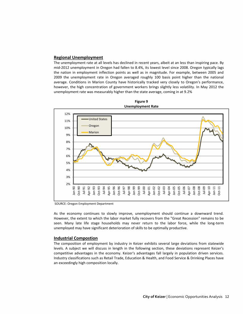
Regional Unemployment ......................................................................................................................... 12
Industrial Compostion .............................................................................................................................. 12
Personal Income ....................................................................................................................................... 14
Commute Patterns ................................................................................................................................... 14
Population Growth ................................................................................................................................... 15
Educational Attainment ........................................................................................................................... 15
IV. TARGET INDUSTRY ANALYSIS ............................................................................... 17
REGIONAL COORDINATION .................................................................................................................................. 17
KEIZER TARGETED INDUSTRIES ............................................................................................................................. 18
HISTORIC SECTOR PERFORMANCE......................................................................................................................... 21
Medical Facilities ..................................................................................................................................... 21
Information Technology/Back Office ....................................................................................................... 22
Educational Services ................................................................................................................................ 22
Professional Services ................................................................................................................................ 23
Sporting Events ........................................................................................................................................ 23
V. REQUIRED SITE TYPES ........................................................................................... 24
VI. FORECASTS OF EMPLOYMENT AND LAND NEED .................................................... 26
EMPLOYMENT FORECASTS .................................................................................................................................. 26
Creating a Base Year Estimate ................................................................................................................. 26

City of Keizer | Economic Opportunities Analysis ii
Conversion to Total Employment: ............................................................................................................ 26
Update to Base Year Estimate: ................................................................................................................ 27
Other Factors Affecting Growth Estimates .............................................................................................. 28
Adjustment for the Self-Employed ........................................................................................................... 28
Baseline Employment Forecast ................................................................................................................ 28
Alternative Growth Forecasts .................................................................................................................. 29
Structural Growth Sensitivity ................................................................................................................... 30
Alternative Growth Forecast by Industry ................................................................................................. 30
LAND NEED FORECASTS ...................................................................................................................................... 31
Findings .................................................................................................................................................... 32
Industrial and Office Land Need Methodology ........................................................................................ 32
Commercial Land Need Methodology...................................................................................................... 33
VII. BUILDABLE LAND INVENTORY .............................................................................. 36
VIII. RECONCILIATION OF VACANT LAND AND NEED .................................................... 38
Introduction & Methodology ................................................................................................................... 43
Employment - Buildable Lands Inventory................................................................................................. 48
Residential - Buildable Lands Inventory ................................................................................................... 50
This project is funded by Oregon general fund dollars through the Department of Land
Conservation and Development. The contents of this document do not necessarily reflect the
views or policies of the State of Oregon.

City of Keizer | Economic Opportunities Analysis 1
I. INTRODUCTION This report introduces analytical research presenting an Economic Opportunities Analysis (EOA) for the City of Keizer's portion of the broader Salem-Keizer Urban Growth Boundary (Referred to hereafter as the Keizer UGB)). The report fills the requirements of statewide Planning Goal 9, specifically OAR 660-009, which describes the EOA as:
"The economic opportunities analysis must identify the major categories of industrial or other employment uses that could reasonably be expected to locate or expand in the planning area based on information about national, state, regional, county or local trends."
Cities are required to reconcile estimates of future employment land demand with existing inventories of vacant and redevelopable employment land within the UGB. The principal purpose of the analysis is to provide an adequate land supply for economic development and employment growth. This is intended to be conducted through an linkage of planning for an adequate land supply to infrastructure planning, community involvement and coordination among local governments and the state. To this end, this report is organized into five sections:
Vision and Goals: Provides an economic vision for the City of Keizer and a series of goals to achieve that vision.
Economic Trends: Provides an overview of national, state and local economic trends affecting Keizer, including population projections, employment growth, retail trends and a demographic profile.
Economic Development Potential: Estimates future employment growth in Keizer's portion of the UGB. Examines Keizer’s economic assets and opportunities, and relates them to target industrial sectors for economic development.
Employment Land Supply: Provides an inventory of suitable existing industrial and commercial land (employment land) within the City of Keizer's share of the UGB.
Employment Land Needs: Examines projected demand for industrial and commercial land based on anticipated employment growth rates by sector. Compares short- and long-term demand for employment land to the existing land inventory to determine a 20-year surplus or deficit of suitable land.

City of Keizer | Economic Opportunities Analysis 2
II. VISION AND GOALS
VISION Keizer aspires to provide more opportunities for a range of good paying jobs for people living in Keizer, which would result in faster growth in employment than in population growth. Keizer's vision for providing new employment opportunities is to capture professional services and associated uses in a "campus" setting, primarily but not exclusively related to medical office and research and education. These services may include a hospital and/or educational facilities, which are expected to provide Keizer with growth opportunities that fit the City's locational advantages. The city's economic vision is an economic strategy that will not directly compete with Salem but capitalizes on Keizer's own attributes and aspirations.
COMMUNITY ECONOMIC DEVELOPMENT OBJECTIVES Keizer's objectives for the future will be to live with a thriving local economy with strong businesses, diverse industries and good jobs and enjoy…..
A variety of jobs across the economic spectrum A diversified economic base that attracts and retains a variety of industries An availability of clean, green jobs Industries that are invested in the community and enhance our connections to the regional and
global economy through strategic collaboration A range of goods and services for all Being a centrally-located event destination A high-quality, well-qualified work force
In an effort to achieve this, the following goals have been developed:
Increase employment opportunities in Keizer Provide an adequate supply of sites to accommodate target business, and other employment over
the planning period Provide high-value sites for specific uses and purposes Plan for infrastructure to support business development Encourage the continued development of the Keizer Station area Support existing businesses and business centers in Keizer Increase the potential for conference and tourist related economic activities including developing a
range of competitive sporting venues Encourage continued redevelopment of existing commercial corridors Monitor and periodically adjust goals and objectives Encourage high quality educational and training opportunities

City of Keizer | Economic Opportunities Analysis 3
III. ECONOMIC TRENDS The analysis in this chapter will present a summary of recent and anticipated factors affecting the future economic growth of the Keizer area. The section begins with the systematic trends and economic outlook at the national and state level before a more concentrated analysis of the competitive economic advantages of the State of Oregon and the Keizer economies. This section makes particular use of primary research and analysis produced by third party resources, specifically the Congressional Budget Office (CBO), the Bureau of Economic Analysis (BEA), and the Oregon Office of Economic Analysis (OEA).
NATIONAL TRENDS The economic outlook for Marion County and the City of Keizer will continue to be influenced by broader economic conditions in the United States and in the global marketplace. Specific trends likely to be most influential include:
Effects of the National Recovery--Gross Domestic Product Economic activity in the United States has continued to expand a modest pace throughout 2012. Initial "advanced" estimates of GDP came in at a 2.0% annualized for the third quarter, while second quarter estimates were revised downward to only 1.3%. According to the Bureau of Economic Analysis, "The increase in real GDP in the third quarter primarily reflected positive contributions from personal consumption expenditures (PCE), federal government spending, and residential fixed investment that were partly offset by negative contributions from exports, nonresidential fixed investment, and private inventory investment. Imports, which are a subtraction in the calculation of GDP, decreased.1"
Figure 1
Annualized Change in Real Gross Domestic Product
SOURCE: Bureau of Economic Analysis
-3%
-2%
-1%
0%
1%
2%
3%
4%
5%
6%
-10%
-8%
-6%
-4%
-2%
0%
2%
4%
6%
1Q
04
2Q
04
3Q
04
4Q
04
1Q
05
2Q
05
3Q
05
4Q
05
1Q
06
2Q
06
3Q
06
4Q
06
1Q
07
2Q
07
3Q
07
4Q
07
1Q
08
2Q
08
3Q
08
4Q
08
1Q
09
2Q
09
3Q
09
4Q
09
1Q
10
2Q
10
3Q
10
4Q
10
1Q
11
2Q
11
3Q
11
4Q
11
1Q
12
2Q
12
3Q
12
Infl
atio
n (
CP
I)
Re
al G
DP
G.D.P.
Inflation
While growth has remained positive, and threat of a recessionary turn remains subdued, the national economy continues to suffer from tepid hiring and exceedingly lackluster capital investment. On-going
1 Bureau of Economic Analysis. National Income and Product Accounts, 3Q12 Advanced Estimate, Released October 26, 2012

City of Keizer | Economic Opportunities Analysis 4
uncertainty about the future continues to drive the status quo; specifically the protracted European Debt Crisis, economic deceleration in Asia, and most importantly the lack of clarity of long-term domestic fiscal policy. In light of exhibited growth and long-term inflation estimates stuck below the Fed's duel mandate targets, the Federal Open Market Committee (FOMC) moved in the third quarter to provide additional accommodative stimulus through balance sheet expansion (QE3). In doing so, the Fed committed to open ended purchases of mortgage-backed securities at a rate of $40 billion per month. The FOMC further expanded asset purchases by an additional $40 billion per month with the expiration of its maturity extension program (Operation Twist). The effect of QE3 will keep the Federal Funds Rate near zero for the foreseeable future, and by extension maintain historically low borrowing costs. While the extent this monetary accommodation translates into economic expansion is a debated issue among academics, it is intended to provide strength to a sluggish recovery. And that is the outcome
expected by both the Federal Reserve and the Blue Chip2 consensus survey, which forecasts Real GDP growth in the vicinity 2.2% to 2.8% in 2013 and 2014.
Effects of the National Recovery--Employment and Labor Force
From peak to trough, nonfarm payroll employment in the United States fell by over 7.7 million jobs during the "Great Recession". This recession has been notably characterized for its depth and duration, a characteristic which international examples show are a common result of financial crises. During this period
the unemployment rate rose to over 10% with the more broadly defined U-6 metric exceeding 17%3. The unemployment rate would likely have been significantly higher had there not been an unusually large decline in labor force participation. However, the nation's employment situation has begun to slowly improve. In the first half of 2012, non-farm payrolls rose by an average of roughly 200,000 per month in the first quarter and 70,000 per month in the second quarter. The economy has regained nearly 2.8 million jobs and the unemployment rate has fallen back to 7.8%.
Figure 2
SOURCE: U.S. Bureau of Labor Statistics
Year-over-Year Employment Unemployment Rate
-12,000
-10,000
-8,000
-6,000
-4,000
-2,000
0
2,000
4,000
6,000
8,000
Jan
-06
May
-06
Sep
-06
Jan
-07
May
-07
Sep
-07
Jan
-08
May
-08
Sep
-08
Jan
-09
May
-09
Sep
-09
Jan
-10
May
-10
Sep
-10
Jan
-11
May
-11
Sep
-11
Jan
-12
May
-12
Job
s
0%
2%
4%
6%
8%
10%
12%
14%
16%
18%
20%
Jan
-05
May
-05
Sep
-05
Jan
-06
May
-06
Sep
-06
Jan
-07
May
-07
Sep
-07
Jan
-08
May
-08
Sep
-08
Jan
-09
May
-09
Sep
-09
Jan
-10
May
-10
Sep
-10
Jan
-11
May
-11
Sep
-11
Jan
-12
May
-12
Un
em
plo
yme
nt
U-3
U-6
2 Monthly survey of over 50 leading business economists from banking, insurance, manufacturing, and brokerage industries. 3 U-3 = The total unemployed as a percentage of the labor force. It is the official unemployment rate.
U-6 = Total unemployed, plus all persons marginally attached to the labor force, plus total employed part time for economic reasons, as a percent of the civilian labor force plus all persons marginally attached to the labor force.

City of Keizer | Economic Opportunities Analysis 5
Other Factors Affecting Short-Term Economic Conditions
Housing: Housing has emerged as a surprising strong point in the national economy after several years in the doldrums. The majority of data indicates that the housing market has turned the corner, with a slow drawing down of excess inventory. Fixed residential investment is expected to provide some much needed support to the economy in coming years.
Business Investment: Real business investment grew strongly in the first half of 2012, reaching an annualized rate of 6.4% through the first two quarters. This input is expected to maintain above average growth through the year. However, businesses are facing competing dynamics, with favorably borrowing conditions offset by the uncertainty of future fiscal conditions (see "Policy" below).
Government Spending: Reductions in government spending continue to be a drag on the economy, and will likely continue to do so in the near future with on-going political pressure toward fiscal austerity.
Policy: The direction of future fiscal policy with perhaps have the greatest impact on economic conditions seen in some time. The scheduled expiration of current tax cuts in addition to spending provisions in the 2011 Budget Control Act (broadly referred to as the "fiscal cliff") would severely impact near-term growth. Just the threat of such dramatic policy action is already weighing on business investment.
Consumer Spending: Consumer spending has remained weak reflecting high unemployment and stagnate disposable income growth. Consumer will certainly be impacted by whether or not the Bush Tax Cuts are allowed to expire in 2014.
External Shock: The extent to which the European Recession and financial crisis and slower economic growth in Asia impact U.S. growth.
National Economic Outlook
Over the longer term, the pace of economic growth is expected to accelerate moderately following 2013. Gradually, idle resource in the economy will begin to be productive, drawing growth higher to 4.3% between 2014 and 2017, and narrowing the production gap by 2018 and growing at the rate of potential (around 2.4%) thereafter.
Because of the large amount of unused resources currently in the economy, inflation is expected to remain subdued in the foreseeable future, despite additional monetary easing. Further, the Federal Reserve has
0.0%
1.0%
2.0%
3.0%
4.0%
5.0%
6.0%
7.0%
8.0%
9.0%
10.0%
20
11
20
12
20
13
20
14
20
15
20
16
20
17
20
18
20
19
20
20
20
21
20
22
Un
em
plo
yme
nt
Rat
e
0.0%
0.5%
1.0%
1.5%
2.0%
2.5%
3.0%
3.5%
4.0%
4.5%
20
11
20
12
20
13
20
14
20
15
20
16
20
17
20
18
20
19
20
20
20
21
20
22
GD
P G
row
th

City of Keizer | Economic Opportunities Analysis 6
openly committed to keeping the Federal Funds Rate low through 2015. Inflation rates should stay below 2% through 2022 on average. Payrolls should continue to increase at a moderate pace in the near-term, accelerating consistent with GDP growth. However, because unemployment had been driven down by lower labor force participation, the unemployment rate will recover at a slower pace. Unemployment is expected to average near 7% through 2015 and fall to 5.4% subsequently.
Factors Affecting Long-Term Economic Conditions
National Employment Shift: The share of employment in goods producing industries has declined markedly in recent cycles on increasing worker productivity and international outsourcing. With lower cost labor still widely available in foreign markets, this is a conditions which is expected to continue in the coming decade, albeit at a far more measured pace. U.S. employment growth is expected to be strongest in Health Care, Professional & Business, and Other Services.
Figure 3
= Service Producing Industries
= Goods Producing Industries
SOURCE: Bureau of Labor Statistics, Forecast of Industry Employment, CES Data
2000 2010 2020
Shift in U.S. Employment
18.6%
81.4%
13.6%
86.4%
13.0%
87.0%
Business Cycles: This evaluation is not attempting to predict future fluctuations in the business cycle. However, we are already several years into the current cycle, with cycles typically lasting 8 years on average. This would indicate a reasonable degree of likelihood of future economic contraction this decade.
Monetary Policy: Monetary Policy is expected to remain accommodative into the foreseeable future. When the threat of accelerated inflation begins to solidify, Monetary Policy will subsequently tighten. However, as mentioned above, by the end of 2015 we will be approaching a typical cyclical length. With policy expected to remain tight through this period, there is some risk that monetary policy will not get off the zero bound in this timeframe, seriously constricting the monetary "toolbox" to provide future accommodation.
Fiscal Policy: If current law holds, historic fiscal contraction will likely constrain growth considerably in the near-term, with higher growth further out resulting from a reduction in federal debt. However, if a compromise is made and the "fiscal cliff" is avoided, growth will accelerate in the near-term with slower growth farther out as federal debt crowds out private investment.

City of Keizer | Economic Opportunities Analysis 7
Demographic Factors: The aging of the baby boomer generation is already underway, with the share of the population age 55 and older approaching 25% in 2010, with the number of residents age 65 and older expected to double over the next 40 years. The economic effects of this shift will be widespread. A slowing of labor force growth will coincide with exceedingly high job replacement demand. Further, the increased demand for health care services will place additional pressure of federal balance sheets.
Lasting Impacts of Recession: The severe depth and prolonged duration of the recent recession and subsequent lackluster recovery with have permanent long term impacts on the economy. For example, job shortages have caused lowered labor force participation and in many cases early retirement. When combined with long-term unemployment increasing the risk of skill deterioration, the level of productive capital has certainly created a new reality for potential output. Similar deferrals of capital investment have occurred at sub optimal levels.
Other Factors: A wide range of other factors, certain and otherwise, known and unknown, will continue to shape the future of the economy in the long-term. Potential factors include the direction of energy price, unexpected improvements or deterioration in business and consumer confidence, and the direction of external factors such as the European financial crisis and the economies of Asia and Latina America.
STATE & LOCAL CONDITIONS Oregon’s GDP growth between 2010 and 2011 was nearly three times that of the U.S. economy, making Oregon the second fastest growing economy over this period. The state’s durable goods manufacturing industry was the second-fastest growing sector in the nation in 2011 at a rate of 3.94%, almost 20% of Oregon’s economic growth. High tech companies such as Intel Corp., which employs about 16,300 in Portland, dominate the durable goods manufacturing industry. This can be attributed to a reverse off shoring trend that is occurring partially as a result of defects, delays, and theft in overseas supply chain locations. Given its geographic location, Oregon trades largely with countries on the Pacific Rim, most notably Canada and Asian powers. Unfortunately, the later region is among the most economically volatile areas of the world right now, with economic growth falling off considerably. This, in turn, has caused Oregon's export driven growth to moderate somewhat in light of falling global demand.
Industry Analysis The figure below outlines a breakdown of Oregon's primary industries, where they appear to be in the cycle, and forecasts of growth over the near-term.

City of Keizer | Economic Opportunities Analysis 8
Through the first half of 2012, employment gains were generally positive across most industries, with the exception of Government and Transportation Equipment Manufacturing. Construction grew significantly, driven by a mix of public construction projects and the beginning of a rebound in housing starts. Other export driven commodities remained positive, but growth is down from 2011 highs. Service oriented industries are stabilizing at slow and steady rates commensurate with broader economic expansion.
Figure 4 Industry Performance Analysis
GrowthIndustry Signal 2012 2013 2014 Comments
Wood ProductsStrong Growth
1.9% 6.7% 5.8%Among the strongest forecasted sectors. Driven by
exports and housing recovery.
Computer & Electronic EquipmentModerating Growth
1.8% 0.2% 1.4%Recent growth will moderate on falling export growth.
Transportation EquipmentEarly Recovery
-0.9% 0.2% 5.2%Among the hardest hit recession sectors. Recovery is
just beginning.
Metals and MachineryPositive Growth
4.8% 2.5% -0.1%Strong growth emerging from a hard hit sectors.
Food ProcessingFlat Growth
1.3% -0.5% 1.1%Exports moderating. Global demand and price volitility
ConstructionPositive Growth
4.8% 2.5% 3.6%Looking forward to a rebound in housing starts. Still
well below recession levels.
GrowthIndustry Signal 2012 2013 2014 Comments
InformationStabilizing
0.8% 2.3% 1.9%Beginging to see job growth. Measured growth
estimated on the horizon.
Financial ActivitiesStabilizing
0.0% 3.0% 1.6%Weakness in real estate limits growth in 2012.
Measured recovery thereafter.
Professional & BusinessPositive Growth
3.7% 2.9% 4.2%Will grow slightly faster than the general economy. A
high growth sector
Education & HealthPositive Growth
1.5% 1.8% 2.3%Sector remaind positive through recesssion, and
growth will remain stable
Leisure & HospitalityPositive Growth
1.9% 2.8% 2.0%Growth curtailed by falling discresionary spending, but
remaining surprisingly positive.
GovernmentNegative Growth
-1.8% -0.1% 0.6%
Negative state and local growth partially offset by
Federal gains. Future federal growth less likely.
SOURCE: Oregon Office of Economic Analysis and Johnson Reid, LLC
Growth Projections
Growth Projections
Economic Recovery Prospects The Federal Reserve Bank of Philadelphia produces monthly indices of economic indicators for every state in the nation. The coincident indices combine four state-level indicators to summarize current economic conditions in a single statistic. The four state-level variables in each coincident index are nonfarm payroll employment, average hours worked in manufacturing, the unemployment rate, and wage and salary disbursements deflated by the consumer price index (U.S. city average). In its September 2012 release, Oregon's 3-month annualized growth reflected Oregon's recent soft patch, coming in at 1.9% compared to 2.5% nationally. However, The Fed's 6-month leading forecast has Oregon in the top 3 among all states, with estimated growth in the index of 4.5% annualized over the next two quarters.

City of Keizer | Economic Opportunities Analysis 9
Figure 5 Index of Leading Indicators
SOURCE: Federal Reserve Bank of Philadelphia
Six Month Leading Index Forecast (Sep. 2012) Historical Index Trend
165
170
175
180
185
190
195
200
205
210
215
20
05
20
06
20
07
20
08
20
09
20
10
20
11
20
12
Ind
ex
Val
ue
-1.5% to 0%
0% to 1.5%
1.5% to 4.5%
4.5% +
These findings from the Fed are generally echoed by the University of Oregon's Index of Economic Indicators. This series has seen steadfast improvement, increasing by 2.5% over the last 12-months.
Employment Conditions Reflecting its recovery prospects, payroll employment in Oregon has begun to recover from the recent recession. The State has exhibited 26 consecutive months of positive year-over-year job growth while adding nearly 50,000 since post-recession low employment.
Figure 6
SOURCE: Oregon Employment Department
Year-Over-Year Job Growth
-150,000
-100,000
-50,000
0
50,000
100,000
Jan
-06
Ap
r-0
6
Jul-
06
Oct
-06
Jan
-07
Ap
r-0
7
Jul-
07
Oct
-07
Jan
-08
Ap
r-0
8
Jul-
08
Oct
-08
Jan
-09
Ap
r-0
9
Jul-
09
Oct
-09
Jan
-10
Ap
r-1
0
Jul-
10
Oct
-10
Jan
-11
Ap
r-1
1
Jul-
11
Oct
-11
Jan
-12
Ap
r-1
2
Jul-
12
Job
s

City of Keizer | Economic Opportunities Analysis 10
Export Market Long-term growth in Oregon's economy will continue to be a function of export potential. Oregon trades primarily with Pacific Rim countries, specifically Canada, Malaysia, Japan, China, and Taiwan. In the near-term, exports are no longer leading recovery in Oregon, with total exports flat through the first three-quarters of 2012. Exports to China and Malaysia were down nearly 20% for the second consecutive year. However, the long-term outlook for developing Asian markets is quite strong, and the strength and on-going development of these economies and increased purchasing power will translate into growth for Oregon's export firms.
Net In-Migration Oregon continues to benefit from the exodus of households from California in light of exceedingly high taxes and a dire state fiscal position. Between 2004 and 2010, Oregon averaged a migration rate of 5.56 persons per 1,000 residents. During this time an astonishing 91% of net growth were households originating from California. This is a trend that is expected to continue, as the exodus from California in light of exceedingly high taxes and a dire state fiscal position does not seem to have an end in sight.
Figure 7 Oregon Net-Migration (2004-2010)
Net Net
State Migration Income
California 82,220 $2,641,513,000
Nevada 3,453 $25,274,000
Michigan 3,340 $85,928,000
Illinois 3,010 $112,489,000
New York 2,492 $130,814,000
Ohio 2,265 $65,849,000
Foreign 1,879 $185,000
Florida 1,737 $46,620,000
Colorado 1,711 $48,394,000
Hawaii 1,662 $37,990,000
Total, All States: 89,619 $2,928,807,000
Average Net-Migration Rate: 5.56
Risk Factors While it would appear that a systematic recovery, albeit at a slow pace, is underway both nationally and in Oregon, significant downside risks remain. The single greatest risk remains external factors such as further financial meltdown in the Euro zone, a bursting housing bubble in China, or military conflict in Iran. The housing market is beginning to move from the risk to the upside category, but many other downside factors remain:
A reversal of commodity prices from declining to inflation. The Fiscal Cliff Unknowns legislative changes and referendums derived out of the current election cycle Again, external factors in Europe, Asia, and the Middle East

City of Keizer | Economic Opportunities Analysis 11
Statewide Outlook In the long-term, Oregon's economic growth is expected to outpace growth at the national level. Through 2020, the Oregon economy, as measured by employment, is expected to outpace the national average, growing by an estimated 15% compared to 11% nationally. Incomes in Oregon are also expected to be above average, growing at 2.2% annually compared to just 2% at the national level. Over the intermediate term, Oregon's growth prospects will be a function of a number of factors.
Location to Asian countries and Canada continuing to drive trade growth.
High commodity prices for Oregon exports. Business cost advantages. Relative cost of living and housing affordability advantages. Statewide focus on traded sector industry recruitment and retention. Quality of life. Continued growth in renewable energy and clean technology sectors.
State and local tax incentives4 Positive population growth, most notably due to net-migration from California, Nevada, and large
Midwest and Eastern states. Oregon maintains a negative migration rate with Washington State and Idaho.
Through 2020, the Oregon Office of Economic Analysis forecasts 245,000 new jobs in the Oregon economy. Mirroring national forecasts, a significant share (44%) are expected to fall on Professional and Health Services. Manufacturing and Construction are expected to ad over 46,000 jobs in the state while growth in trade and other service categories is expected to be more measured.
Figure 8
SOURCE: Oregon Office of Economic Analysis
Oregon Job Growth by Industry (2012-2020)
22,200
24,400
16,800
9,700
10,700
4,100
9,500
61,900
46,200
12,800
7,100
19,200
0 10,000 20,000 30,000 40,000 50,000 60,000 70,000
Construction
Manufacturing
Wholesale Trade
Retail Trade
T.W.U.
Information
Financial Activities
Professional & Business
Education & Health
Leisure & Hospitality
Other Services
Government
Jobs
4 http://www.oregon4biz.com/The-Oregon-Advantage/Incentives/
Oregon U.S.
Oregon U.S.
(2.2% AAGR) (2.0% AAGR)
Economic Growth
Personal Income Growth
+15% +11%
+47% +44%
City of Keizer | Economic Opportunities Analysis 12
Regional Unemployment The unemployment rate at all levels has declined in recent years, albeit at an less than inspiring pace. By mid-2012 unemployment in Oregon had fallen to 8.4%, its lowest level since 2008. Oregon typically lags the nation in employment inflection points as well as in magnitude. For example, between 2005 and 2009 the unemployment rate in Oregon averaged roughly 100 basis point higher than the national average. Conditions in Marion County have historically tracked very closely to Oregon's performance, however, the high concentration of government workers brings slightly less volatility. In May 2012 the unemployment rate was measurably higher than the state average, coming in at 9.2%
Figure 9 Unemployment Rate
SOURCE: Oregon Employment Department
2%
3%
4%
5%
6%
7%
8%
9%
10%
11%
12%
Jan
-90
Oct
-90
Jul-
91
Ap
r-9
2
Jan
-93
Oct
-93
Jul-
94
Ap
r-9
5
Jan
-96
Oct
-96
Jul-
97
Ap
r-9
8
Jan
-99
Oct
-99
Jul-
00
Ap
r-0
1
Jan
-02
Oct
-02
Jul-
03
Ap
r-0
4
Jan
-05
Oct
-05
Jul-
06
Ap
r-0
7
Jan
-08
Oct
-08
Jul-
09
Ap
r-1
0
Jan
-11
Oct
-11
United States
Oregon
Marion
As the economy continues to slowly improve, unemployment should continue a downward trend. However, the extent to which the labor market fully recovers from the "Great Recession" remains to be seen. Many late life stage households may never return to the labor force, while the long-term unemployed may have significant deterioration of skills to be optimally productive.
Industrial Compostion The composition of employment by industry in Keizer exhibits several large deviations from statewide levels. A subject we will discuss in length in the following section, these deviations represent Keizer's competitive advantages in the economy. Keizer's advantages fall largely in population driven services. Industry classifications such as Retail Trade, Education & Health, and Food Service & Drinking Places have an exceedingly high composition locally.

City of Keizer | Economic Opportunities Analysis 13
Figure 10 Industrial Composition (2010)
1/ Transportation, Warehousing, & Utilities
SOURCE: Oregon Employment Department
0% 5% 10% 15% 20% 25% 30% 35%
Natural Resources
Construction
Manufacturing
Wholesale Trade
Retail Trade
T.W.U. 1/
Information
Financial Activities
Professional & Business
Education & Health
Leisure & Hospitality
Other Services
Public Administration
Distribution of Employment
Keizer Oregon
Among these concentrations that is not necessarily represented in the figure above in Government. With Salem as the State Capitol, the influence of State employment on the regional economy is quite significant. In Broader Salem MSA, roughly 27% of all employees are government workers (which also includes local government positions such as teachers). However, the sector's influence does not appear to be reaching Keizer. Roughly 12% of employed residents in Keizer are Government employees with 16% of actual employees in Keizer are in Government. Most of these, however, are in Education as opposed to State Public Administration.
Figure 11 Concentration of Government Workers (2010)
SOURCE: Oregon Employment Department, U.S. Census Bureau LEHD data
0% 5% 10% 15% 20% 25% 30%
Salem MSA
Keizer Employees
Keizer Residents

City of Keizer | Economic Opportunities Analysis 14
Personal Income Wages in Marion County have historically remained well below statewide levels, affording local businesses a competitive advantage of lower business costs at the expense of the region’s purchasing power. For example, in 2010 average wages in Marion County were roughly 67% of statewide levels. Unfortunately, this spread has been widening in recent years, with wage growth locally lagging. However, personal income in the region had exhibited an annual increase of 4.1% between 2000 and the “Great Recession, before a decline commensurate with the state and national levels. In the long-run, we expect wage differentials to remain between 65% and 70% of statewide levels, increasing on average in line with the long-term trend.
Figure 12 Personal Income and Wages (2010)
Commute Patterns The City of Keizer has long been a bedroom community for the broader Salem MSA. In 2010 there were 13,823 working residents in the City of Keizer. However, only 972 (7%) actually work in Keizer. The remaining residents commute to other employment centers throughout the region, specifically Salem (45%) and Portland (6%). Alternatively, in the same year there were 5,468 people employed in the City of Keizer. Again, 972 (18%) actually live in Keizer with the remaining employees living in areas throughout the region, specifically Salem (27%) and other unincorporated and incorporated areas throughout the region. "Other" in this case represents a broad range of smaller cities and unincorporated areas. However, our data set does not permit us to drill down to these geographies.

City of Keizer | Economic Opportunities Analysis 15
Figure 13 Commute Patterns (2010)
SOURCE: U.S. Census Bureau
59
93
105
136
153
154
161
161
173
179
201
311
373842
9723,467
6,283
66
79
59
38
96
84
140
12
39
52
31
51201
144
972
1,937
1,467
-3,000 -2,000 -1,000 0 1,000 2,000 3,000 4,000 5,000 6,000 7,000
Dallas
McMinnville
Corvallis
Hillsboro
Albany
Eugene
Four Corners
Wilsonville
Beaverton
Silverton
Tigard
Woodburn
Hayesville
City of Portland
Keizer
Other
Salem
Jobs
Keizer Residents work in...
Keizer Employees Live in...
Population Growth The rate of Keizer’s population growth will continue to drive Keizer’s population centric sectors of the economy, most notably Retail Trade, Education, Housing Construction, and most importantly Health Services. Over the last ten years, population growth in the City of Keizer (1.1% AAGR) slightly outpaced both statewide (1.05%) and Marion County (1.0%) levels. Over this time the City added nearly 3,800 new residents to its population base. Over the next ten years, We expect population in Keizer to average 1.33% annual growth based on its capture of projected growth in Marion County.
Figure 14 Population Trend
Region 2001 2002 2003 2004 2005 2006 2007 2008 2009 2010 2011 AAGROregon 3,470,385 3,502,588 3,538,591 3,578,895 3,626,938 3,685,206 3,739,359 3,784,182 3,815,775 3,837,300 3,857,625 1.06%Marion 287,676 289,757 294,188 296,268 299,484 303,545 307,481 310,807 313,643 315,900 318,150 1.0%Keizer 32,950 33,100 34,010 34,380 34,735 34,880 35,435 36,150 36,220 36,570 36,715 1.1%
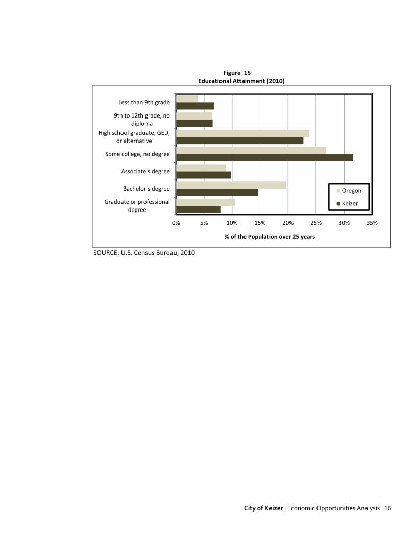
Educational Attainment An appropriately trained workforce is among the most critical inputs in managing economic development. Businesses need sufficiently trained workers to meet growth expectations. Further, workforce is among the primary criteria or relocating firms. In Keizer, the share of the adult population age 25-64 with at least a bachelors degree is 22%, which is measurably below the statewide average of 30%. Of greater concern is the local concentration of workers at the lowest education level. In Keizer an estimated 13.3% of workforce residents never finished high school. This is also above 10% at the state level. With education an increasingly important determinate of wage levels, changes in local education levels will influence Keizer’s economic prosperity in the long-run. While figure 15 is informative, one limitation of Census data is the failure to consider other vocational training, such as industry continuing education, trade-certificates, and apprenticeships.
City of Keizer | Economic Opportunities Analysis 16
Figure 15 Educational Attainment (2010)
SOURCE: U.S. Census Bureau, 2010
0% 5% 10% 15% 20% 25% 30% 35%
Less than 9th grade
9th to 12th grade, no diploma
High school graduate, GED, or alternative
Some college, no degree
Associate's degree
Bachelor's degree
Graduate or professional degree
% of the Population over 25 years
Oregon
Keizer

City of Keizer | Economic Opportunities Analysis 17
IV. TARGET INDUSTRY ANALYSIS Sound economies are best organized around a healthy set of industry clusters—similar and related
businesses and industries that are mutually supportive, regionally competitive, attract capital investment,
and encourage entrepreneurship. As an economic development strategy, specific clusters are targeted, and
emerge, when a particular geography holds an innate competitive advantage in that industry—whether it is
natural resources, human capital, political policies or geography. For example, Oregon’s oldest industries—
namely forestry and agriculture, emerged from physical and environmental attributes such as its climate,
trees, soils, and access to shipping and distribution networks. In turn, these industries spawned interrelated
clusters that include Food Processing & Manufacturing, Wood Product Manufacturing, Wholesaling &
Distribution, Machinery Manufacturing, and host of other industries.
What follows is critical evaluation of this concept as it relates to the Keizer economy, specifically Keizer’s
opportunities to change the status quo and improve its economic future.
REGIONAL COORDINATION The target industry analysis in this report was coordinated with recent regional planning efforts. Specifically,
in May 2011, the region competed a regional economic opportunities analysis (REOA) that collectively
evaluated the economic characteristics of the region, including the communities of Salem, Keizer, and
Turner. This report identified several industries important to the region, based primarily on the region's
competitive advantage in serving the needs of these business type. This analysis began with a regional
Strengths, Weaknesses, Opportunities, and Threats (SWOT) Analysis, which we recreate here:
STRENGTHS WEAKNESSES
Regional employment center, located between Eugene and Portland Low wages and income
State capital, with a substantial amount of State employment Comparatively small share of residents with a Bachelor's degree or higher
Access to Interstate-5 Lack of diversity in the composition of the regional economy
Large parcels of industrial land with urban services and access to Interstate-5 Slow state and regional job growth
High quality of life, including public services and access to natural areas Access to inexpensive electricity
Many existing small businesses Availability of potable water
Access to natural resources and agricultural production
Access to skilled, educated workers
Housing costs that are comparable to or lower than costs in nearby urban areas
Access to Union Pacific rail lines
Salem Convention Center and related facilities
Existing business concentration in:
Agriculture, Food, & Beverage Production
Traded-Sector Services
Metals, Machinery, & Equipment
Forest Products
Specialty Manufacturing
OPPORTUNITIES THREATS
Growth in traded-sector services and production Slow state-wide recovery from the recession
Growth in agriculture and food and beverage related products Potential for national large increase in energy prices
Long-term growth in state and local government Shrinking national manufacturing base
Growth in higher paying services, such as health care or professional services Outsourcing and off-shoring of jobs
Growth of small businesses Diversifying the regional economy
Coordinating economic development throughout the region
Availability of large, vacant parcels of employment land

City of Keizer | Economic Opportunities Analysis 18
We note that this regional effort may include some factors not particularly applicable to conditions at the
City of Keizer level, most notably the availability of larger vacant industrial sites. Nevertheless, the table
above characterizes the regional context in which the City of Keizer's economy will function over the
intermediate term.
KEIZER TARGETED INDUSTRIES Building upon the regional evaluation of economic opportunities in the region, Johnson Reid further profiled
a range of potential growth industries relating to Keizer. These profiles were developed from employment
data provided by the Oregon State Employment Department, and refined through several work sessions
with the project's Technical Advisory Committee.
The following is a brief summary of trends and patterns by target industry over the 2004 through 2010 time
period. This analysis relied on geocoded covered employment data from the Oregon Employment
Department. The term "covered employment" refers to firms where employees are covered under
unemployment insurance. Jobs not covered and therefore not considered in this analysis include self
employment and real estate brokers/agents.
Data limitations
Geocoding errors in the input data. Firms can often be misclassified in one year and classified correctly the next. This can be interpreted as a "new firm" in a certain geography when in fact it is simply a fix in the data.
The North American Industrial Classification System (NAICS) was broadly instituted by the Oregon Employment Department beginning in 2001. because of the systems youth and frequent industrial classification revisions, it is not uncommon for a firm's NAICS code to change, sometime broadly. This can be interpreted as an emergence of a new firm in a particular industry but it is simply a reclassification.
Firms with employees in multiple locations around the region are often reporting under a single ID# with an associated address. The can lead to instances where a firm looks to be of a particular size in a single location but may have many smaller locations around the region. This is common in retail.
Conversely, some firms may have multiple entities with unique ID# numbers located in a given geographic location. In other words, a single large company in a single campus or location may be reported as five or six smaller firms.
Employment in target industries are tallied by broad NAICS category, and may include some firms that are not actually engaged in activities associated with that target. Conversely, there may be firms in other industries that do engage in a target's activities that are not included.
A basic location quotient analysis was prepared for the City, which compares the mix of employment by
industrial sector with national averages. While simplistic in nature, this type of analysis can identify
industries with a disproportionate representation in the local economy, which is used as a proxy for "traded

City of Keizer | Economic Opportunities Analysis 19
sector" or export industries. Traded sector industries sell their products and services outside of the region,
providing a net influx of wealth into the local economy. As a result, these are typically a primary target of
economic development efforts.
As shown in the following table, the analysis indicates that the City of Keizer has a high concentration of
nursing and residential care facilities, with a location quotient of 4.01 indicating that the local concentration
is over four times the national average. The City also has high concentrations in retail trade industries, most
likely associated with the Keizer Station development which has a regional draw. A wide range of other
industries are also indicated to export at least some component of their production. The relatively high
representation of retail in the employment mix is also indicative of a bedroom community with a less than
mature industrial/commercial base. Residential expenditures associated with household growth drives
retail trade, while a lack of a traditional industrial base yields a high reliance upon retail for local
employment opportunities.
NAICS NAICS Description Employment L.Q.
623 Nursing and Residential Care Facilities 531 4.01
813 Religious, Grantmaking, Civic, Professional, and Similar Organizations 183 3.28
451 Sporting Goods, Hobby, Book, and Music Stores 76 2.97
444 Building Material and Garden Equipment and Supplies Dealers 141 2.91
453 Miscellaneous Store Retailers 88 2.68
221 Utilities 90 2.62
713 Amusement, Gambling, and Recreation Industries 151 2.58
443 Electronics and Appliance Stores 53 2.47
531 Real Estate 135 2.30
445 Food and Beverage Stores 256 2.15
722 Food Services and Drinking Places 713 1.80
711 Performing Arts, Spectator Sports, and Related Industries 29 1.76
811 Repair and Maintenance 82 1.70
452 General Merchandise Stores 201 1.58
236 Construction of Buildings 81 1.55
We also prepared a shift-share analysis of the local employment base. A shift-share analysis is one way to
account for the competitiveness of a City's industries and to analyze the local economic base. This analysis
assesses how well the City's current industries are performing by systematically examining the national,
local, and industrial components of employment change. A shift-share analysis will provide a dynamic
account of total regional employment growth that is attributable to growth of the national economy, a mix
of faster or slower than average growing industries, and the competitive nature of the local industries. The
analysis provides a representation of changes in employment growth or decline.
The shift-share analysis divides the change in local industry employment into three components:
National growth share - The share of local job growth that can be attributed to growth of the national economy. This factor describes the change that would be expected simply by virtue of the fact that the local area is part of a changing national economy.
Industrial mix - The share of local job growth that can be attributed to the region's mix of industries being analyzed. This second factor is the change in a local industry that would be attributable to the growth or decline of the industry nationally. This component isolates the fact that nationwide, some industries have grown faster or slower than others. It represents the

City of Keizer | Economic Opportunities Analysis 20
contribution that a specific industry nationally has made to the change in the number of jobs in the region.
Local share (Regional shift) - This share of local job growth describes the extent to which factors unique to the local area have caused growth or decline in regional employment of an industrial group. This is usually attributed to some local comparative advantage such as natural resources, linked industries, or favorable local labor situations.
Shift-share, and the local share component in particular, can point to industries that enjoy local comparative
advantage. The following is a summary of top industries in the City based on a shift-share analysis of trends
from 2004 through 2010. It shows a substantial level of growth attributable to regional shifts in retail trade
sectors, utilities, data processing and health and educational services.
Code NAICS Description Shift Share AAGR
448 Clothing and Clothing Accessories Stores 56.1%
517 Telecommunications 53.8%
451 Sporting Goods, Hobby, Book, and Music Stores 42.1%
221 Utilities 32.2%
443 Electronics and Appliance Stores 31.6%
444 Building Material and Garden Equipment and Supplies Dealers 30.7%
453 Miscellaneous Store Retailers 14.1%
442 Furniture and Home Furnishings Stores 12.8%
518 Data Processing, Hosting and Related Services 11.1%
522 Credit Intermediation and Related Activities 9.7%
814 Private Households 9.5%
713 Amusement, Gambling, and Recreation Industries 9.3%
531 Real Estate 9.1%
541 Professional, Scientific, and Technical Services 8.6%
515 Broadcasting (except Internet) 8.3%
523 Securities, Commodity Contracts, and Other Financial Investments and Related Activities7.6%
722 Food Services and Drinking Places 7.1%
452 General Merchandise Stores 5.6%
511 Publishing Industries (except Internet) 5.1%
721 Accommodation 4.7%
623 Nursing and Residential Care Facilities 4.4%
236 Construction of Buildings 4.3%
621 Ambulatory Health Care Services 3.8%
446 Health and Personal Care Stores 2.4%
337 Furniture and Related Product Manufacturing 1.3%
611 Educational Services 1.3%
Based on the preceding analysis, we tiered industries according to their level of regional aspiration as well
as their level of local representation. This analysis resulted in the following industrial tiers.
Tier 1: Regional Aspiration, but Little or no Local Representation
Renewable Energy Manufacturing
Food Processing
Metals & Machinery Manufacturing

City of Keizer | Economic Opportunities Analysis 21
Corporate Headquarters Tier 2: Regional Aspiration, with Some Local Representation
Information Technology/Back Office
Medical Facilities, including Research, Development, and Support
Professional Services
Warehouse and Distribution
Education Services Tier 3: Regional Aspiration, with Some Local Representation
Retail Trade
Leisure & Hospitality
Sporting Events
Other Services While each of the industries identified was seen as having potential to account for future employment
growth within the City of Keizer, the Technical Advisory Committee made a decision to focus on a smaller
number of targeted industries. This was coordinated with the City of Keizer's economic vision, which
outlines a strategy that does not directly compete with Salem but capitalizes on Keizer's attributes and
aspirations. The following list outlines the City's targeted industries:
Medical facilities, including research, development and support Information technology/back office Educational services, including educational research and job training Professional services, including corporate headquarters Sporting events
HISTORIC SECTOR PERFORMANCE
Medical Facilities This sector added 67 jobs, representing a 43.8% expansion from 2004 through 2010. This reflects an
average annual growth rate of 9.5%. The sector locally fared significantly better than the nation as whole,
which expanded by 8.5% over the same interval. Despite the rapid pace of recent growth, the City remains
below the State and National average for employment in this sector, indicating substantial potential for
future growth.
While the area has done quite well recently with medical services, the local population base and the
potential to appeal to a broader market area north and east of the Salem/Keizer metro area makes the
location of additional services in the City of Keizer highly likely.

City of Keizer | Economic Opportunities Analysis 22
Jobs %
United States: 665,362 8.5%
State of Oregon: 9,352 9.9%
City of Keizer: 67 43.8%
Jobs
UNITED STATES: 8,481,314 National AAGR: 2.1%
STATE OF OREGON: 103,530 Local AAGR: 9.5%
CITY OF KEIZER: 220 Local Affect AAGR: 7.8%
Share of Economy
MEDICAL OFFICE/CAMPUS
Sector Performance 2006-2010 Shift-Share Analysis (Keizer)
2006-2010 Job Growth
City of Keizer Sector Specialization (Location Quotient)
Employment in 2010
Target Industry NAICS Categories:- 6211 Offices of Physicians
- 6213 Offices of Other Health Practitioners- 6214 Outpatient Care Centers- 6215 Medical and Diagnostic Laboratories- 621999 All Other Miscellaneous Ambulatory Health Care Services
- 622 Hospitals
7.99%
7.85%
4.17%
0.47
0.52
2006
2010
67
13
54
Realized Growth
Expected Growth
Local Effect
Job
s
Information Technology/Back Office This sector has performed poorly at the National, State and Local level. From 2004 through 2010,
employment in the sector declined by 47.5%. As a share of the local economy, this industry is currently
under-represented. While identified by in Keizer's Preliminary Economic Vision, this industry sector does not
appear to represent a major area of opportunity.
Jobs %
United States: -89,753 -4.6%
State of Oregon: -1,904 -7.7%
City of Keizer: -48 -47.5%
Jobs
UNITED STATES: 1,867,335 National AAGR: -1.2%
STATE OF OREGON: 22,778 Local AAGR: -14.9%
CITY OF KEIZER: 53 Local Affect AAGR: -13.1%
Share of Economy
City of Keizer Sector Specialization (Location Quotient)
INFORMATION TECHNOLOGY/BACK OFFICE
Sector Performance 2006-2010 Shift-Share Analysis (Keizer)
2006-2010 Job Growth
Employment in 2010
Target Industry NAICS Categories:- 518 Data Processing, Hosting, and Related Services
- 5611 Office Administrative Services- 5612 Facilities Support Services- 5614 Business Support Services- 5619 Other Support Services
1.76%
1.73%
1.00%
1.24
0.57
2006
2010
-48
-5
-43
Realized Growth
Expected Growth
Local Effect
Job
s
Educational Services The educational services sector includes educational research and job training, in addition to the traditional
K-12 education. The sector performed well during the 2006 through 2010 period locally, reporting a local
average annual growth rate of 2.1%. This was considerably higher than the national or statewide rate.

City of Keizer | Economic Opportunities Analysis 23
Jobs %
United States: 371,952 3.2%
State of Oregon: 10,034 7.7%
City of Keizer: 50 8.6%
Jobs
UNITED STATES: 12,106,318 National AAGR: 0.8%
STATE OF OREGON: 140,790 Local AAGR: 2.1%
CITY OF KEIZER: 636 Local Affect AAGR: 1.3%
Share of Economy
EDUCATIONAL SERVICES
Sector Performance 2006-2010 Shift-Share Analysis (Keizer)
2006-2010 Job Growth
City of Keizer Sector Specialization (Location Quotient)
Employment in 2010
Target Industry NAICS Categories:- 611 Educational Services
PrivateFederalStateLocal
9.77%
8.81%
12.06%
1.24
1.23
2006
2010
50
19
32
Realized Growth
Expected Growth
Local Effect
Job
s
Professional Services Professional Services is an industry that has grown modestly at the national level (+0.4% AAGR), with
stronger growth (+5.4% AAGR) at the local level. This reflects the current under development of this sector
in the City of Keizer, which has a considerably lower level than would be anticipated. We would expect that
professional services will be a major source of new employment growth over the next twenty years as the
local service sector matches the area's population base and growth.
Jobs %
United States: 134,584 1.5%
State of Oregon: 2,927 3.0%
City of Keizer: 36 24.7%
Jobs
UNITED STATES: 9,312,691 National AAGR: 0.4%
STATE OF OREGON: 100,251 Local AAGR: 5.7%
CITY OF KEIZER: 182 Local Affect AAGR: 5.4%
Share of Economy
PROFESSIONAL SERVICES/CAMPUS
Sector Performance 2006-2010 Shift-Share Analysis (Keizer)
2006-2010 Job Growth
City of Keizer Sector Specialization (Location Quotient)
Employment in 2010
Target Industry NAICS Categories:- 5411 Legal Services
- 5412 Accounting, Tax Preparation, Bookkeeping, and Payroll Services- 5413 Architectural, Engineering, and Related Services- 5414 Specialized Design Services- 5415 Computer Systems Design and Related Services
- 5416 Management, Scientific, and Technical Consulting Services- 5417 Scientific Research and Development Services- 5418 Advertising, Public Relations, and Related Services- 5419 Other Professional, Scientific, and Technical Services
- 5511 Management of Companies and Enterprises
8.77%
7.60%
3.45%
0.38
0.39
2006
2010
36
2
34
Realized Growth
Expected Growth
Local Effect
Job
s
Sporting Events The City has targeted the development of a range of competitive sporting venues to support local tourism. Current assets include Volcanoes Stadium, which is the home field for the Keizer Volcanoes, Class A short-season affiliate of the San Francisco Giants. The stadium seats 4,252 fans, and has 11 concession stands, a sports bar, kids playground, a bandstand and 13 luxury box suites. The Keizer Youth Sports Association also has a multiple field facility, and hosts a series of youth tournaments throughout the year.

City of Keizer | Economic Opportunities Analysis 24
V. REQUIRED SITE TYPES In addition to the aggregate land demand associated with projected employment growth, this section addresses specific requirements at the site level to accommodate targeted employment sectors. The land needs associated with the projected employment growth are often quite specific by sector, and land requirements are more appropriately addressed through an assessment of site requirements for specific targeted and/or anticipated uses. For many use types, such as convenience commercial and professional services, the site requirements are relatively flexible and the uses are likely to find viable locations without much specific attention. For other uses, such as warehouse/distribution and medical campus uses, the requirements with respect to necessary scale and accessibility are highly significant. Then following table outlines some basic site requirements for target industries.
Target Industries
Min. Site
Size/Acres Site Requirements
Education Services
Campus 25+ - Transit access
Education Centers 0.5+ - Proximity to service population
Sporting Events
Arena 5-40 - Excellent local and regional access
Tournament Grounds 10-100+
IT/ Back Office
Campus 5 - Scale
End User Built 0.5 - Access
Speculative 0.5 - Visibility often marketable
Medical Office/ Campus
General Hospital 25 - Preference for co-location of uses
Emergency/Acute Care 5 - System control of properties
Surgicenter 2 - Physicians prefer ownership
Medical Office Space 0.5 - Many related tenants
Professional Services 0.5 Proximity to service population
As shown, the site needs for targeted industry cluster vary widely. For some sectors such as professional
services and education center, site requirements are not particularly difficult to meet. For others, such
as educational and medical campus uses, the needs are quite specific and less specific. While the site
characteristics for sporting events are specific, the City already has these facilities in place, and they are
not expected to require major site commitments.
The two targeted industries with specific land requirements are educational services and medical
office/campus uses. The need for educational services facilities is best determined through the strategic
planning of school districts (Salem-Keizer Public Schools. School District 24J), community colleges
(Chemeketa Community College), the Oregon University System. We would also expect some need from
privately held schools.
For the medical office/campus uses, we can take a look at the other recent major medical facility
projects to provide feedback on site characteristics.

City of Keizer | Economic Opportunities Analysis 25
Facility Characteristics
Sacred Heart at Riverbend PeaceHealth Springfield, OR
1.2 Million SF 338 Beds 181 Acres 1.0 miles from I-5 1.5 miles from I-105
Legacy Salmon Creek Vancouver, WA
1.1 Million SF 220 Beds 29 Acres 1/4 miles from I-5
Three Rivers Community Hospital Grants Pass, OR
193,000 SF 98 Beds 19.6 acres Adjacent to Hwy. 199 3.5 miles from I-5
Salem Hospital Salem Health Salem, OR
454 Beds 58 acres 3.0 miles from I-5
Within the survey, facilities had an average ratio of beds per acre of 3.9, with a median closer to 6.2. It is
important to note that health systems will show a strong preference to acquire additional lands, assuring
that they do not become land locked in the future and allowing for
high-value related uses such as medical office space. In addition
to the hospital facilities themselves, major medical facilities also
typically include a proximate concentration of medical office
space, allowing physicians with privileges at the hospital to
conveniently access the hospital facilities. Most hospital systems
prefer to control much of this space, while private medical practices also seek ownership of property in
the immediate area.
Based on the experience outlined in the case studies, an appropriate site for a major medical facility
would be in the 30 to 50 acre range, proximate to the I-5 interchange, and have adequate infrastructure
in place to accommodate the water, sewer and transportation loads of this type of facility.
Beds Acres Beds/Acre
220 29.0 7.6
98 19.6 5.0
338 181.0 1.9
454 58.0 7.8
1,110 287.6 3.9

City of Keizer | Economic Opportunities Analysis 26
VI. FORECASTS OF EMPLOYMENT AND LAND NEED
EMPLOYMENT FORECASTS
To assess future economic growth, and subsequently estimates of land need, The analysis herein employs two methods. The first method develops a baseline forecast for the Keizer UGB. It closely follows DLCD's Goal 9 Handbook, relying on trended analysis and secondary sources produced by the State of Oregon for forecasted growth rates. It is a classically planning-driven approach that begins with an evaluation of anticipated employment growth by broad industry category in the Oregon Employment Department's Workforce Region 3, which includes Marion, Polk, and Yamhill Counties. These forecasts produced by highly qualified economists at the State of Oregon form the basis for trended growth rates. This approach is predicated on the assumption that growth trends locally will generally reflect trends at the Regional level. The second method produces alternative growth scenarios based on the economic vision and objectives of the community, the relative strengths of the local economy, and the evaluation of targeted industries in Section IV. These alternative forecasts represent the path of growth Keizer anticipates would result, beyond the status quo, as a result of its economic development efforts and policies. Regardless of the forecast scenario, each forecast will begin with the same estimate of employment in the 2013 base year. The analytical steps to derive this estimate of total employment in 2013 from 2010 covered employment are as outlined below.
Creating a Base Year Estimate The Goal 9 rule requires an evaluation over a 20-year period. The period of evaluation for this analysis is from 2013 to 2033. The primary source of data on current employment patterns is the Oregon Employment Department’s ES-202 employment data. The ES-202 data is the best source for local employment counts at the UGB level. However, it omits certain sectors of the workforce. Further, ES-202 data is uncommonly available in the current year, and must be updated to the current period.
Conversion to Total Employment: For the year 2010, ES-202 reports estimate employment in Keizer to total 5,276 employees. However, our source ES-202 data reports “covered employment” only—employer firms that tracked through unemployment insurance. Because this data omits a significant portion of the workforce that are not covered (i.e. sole-proprietors, self-employed, commission workers) we must revise our estimates to reflect true total employment. Estimates from the Bureau of Economic Analysis (BEA) indicate that in 2010 covered employment accounted for approximately 73 percent of total employment in Marion County, with individual estimates reported by broad sector. Therefore, based on countywide estimates, in the same year, we estimate the total employed level in 2010 to be in the area of 7,174 employees. This reflects a slightly larger share of non-wage employers locally than at the county level as a result of different concentrations of employment by sector.

City of Keizer | Economic Opportunities Analysis 27
Figure 13 Conversion of Covered Employment to Total Employment
Keizer UGB Covered Share of Est. Keizer UGB
NAICS Covered Employment 1/ Total Employment 2/ Total Employment
Natural Resources 25 76.4% 33
Construction 288 67.6% 426
Manufacturing 28 99.4% 28
Wholesale Trade 25 82.2% 31
Retail Trade 1,019 79.4% 1,283
T.W.U. 5 75.9% 6
Information 39 73.9% 53
Financial Activities 338 40.0% 845
Professional & Business 342 64.5% 530
Private Education 17 48.0% 36
Heath Care & Social Assistance 933 77.6% 1,202
Leisure & Hospitality 928 81.6% 1,139
Other Services 418 60.5% 691
Government 871 100.0% 871
Total 5,276 73.5% 7,174
1/ From the Oregon Employment Department ES-202 data
SOURCE: Oregon Employment Department,U.S. Bureau of Economic Analysis, and Johnson Reid
2/ Data from the Bureau of Economic Analysis for 2010. the most recent year complete data is available. Assumption displays the percent of total
wage and salary (covered) employment to total nonfarm employment in Marion County.
Update to Base Year Estimate: The second step to creating our base year estimate is updating our 2010 total employment estimate to the current period, 2013. This process involves the evaluation of the recent employment trends in the region in addition to our anecdotal knowledge about local economic activity in Keizer. To update total employment estimates from 2010 to a 2013 base year, we apply the realized regional (Marion County) growth rates by industry over maximum data interval achievable. Outlined in Figure 14, we assume that between 2010 and 2012, the Keizer economy posted a modest employment loss, declining by roughly 40 jobs. Because data has not yet been released for 2013, we extrapolate this trend one additional year to include an additional 10 job loses. This 2013 estimate serves as the base year employed level for all forecast scenarios.

City of Keizer | Economic Opportunities Analysis 28
Figure 14 Base Year Employment Estimate
Est. 2010 '10-'12 Regional 2013
NAICS Total Employment Growth Rate 1 Base Year Estimate
Natural Resources 33 2.8% 36
Construction 426 -3.4% 385
Manufacturing 28 -1.0% 27
Wholesale Trade 31 1.7% 32
Retail Trade 1,283 0.1% 1,288
T.W.U. 6 3.8% 7
Information 53 -7.9% 41
Financial Activities 845 3.2% 930
Professional & Business 530 -3.0% 483
Private Education 36 2.7% 39
Health Care & Social Assistance 1,202 1.7% 1,264
Leisure & Hospitality 1,139 0.4% 1,151
Other Services 691 -2.2% 646
Government 871 -2.6% 804
Total 7,174 -0.3% 7,134 1 Based on the realized 2Q10 to 2Q12 Marion County growth rate in covered employment
SOURCE: Oregon Employment Department and Johnson Reid
Other Factors Affecting Growth Estimates Below we outline additional adjustments and assumptions utilized in the development of our baseline economic forecasts:
Adjustment for the Self-Employed In Figure 13 above we converted covered employment to total employment to account for the self-employed, sole-proprietors, etc. However, a share of these workers are likely to be non-space utilizing (i.e. work from home), and should not be counted in our land/space utilizing employment forecasts. According to commute trends from the U.S. Census Bureau, roughly 4.4 percent of Keizer's workers classify themselves as "working from home". We make this revision in the base year and expect it to remain constant through the forecast period. Variance in Employment Distribution: Because Keizer’s employment distribution by industry differs slightly from the regional level, forecasted growth varies from regional averages slightly.
Baseline Employment Forecast As discussed above, the baseline estimate regional growth rates by industry to our 2013 base year to project long-term employment by industry sector. Every two years, the Oregon Employment Department produces 10-year growth estimates for industries by workforce region. The most recent forecast was published in December 2011 and covers the period from 2010 to 2020. For this forecast interval, the Oregon Employment Department forecasts that the regional economy will expand by 1.5% annually while adding over 30,000 jobs. The greatest growth is expected occur in Education & Health Services (2.9% AAGR), Professional & Business Services (2.7% AAGR) and a rebound in Construction (1.9%) from the impending housing market recovery.

City of Keizer | Economic Opportunities Analysis 29
'10-'20
NAICS 2010 2020 Growth Rate
Natural Resources 14,100 15,800 1.1%
Construction 7,700 9,300 1.9%
Manufacturing 17,400 20,000 1.4%
Wholesale Trade 4,000 4,700 1.6%
Retail Trade 19,300 21,900 1.3%
T.W.U. 4,200 5,000 1.8%
Information 1,400 1,400 0.1%
Financial Activities 8,000 9,000 1.2%
Professional & Business 13,200 17,200 2.7%
Private Education 5,400 6,100 1.2%
Health Care & Social Assistance 22,400 29,800 2.9%
Leisure & Hospitality 14,600 17,500 1.8%
Other Services 6,300 7,300 1.5%
Government 47,000 50,300 0.7%
Total 185,000 215,300 1.5%
SOURCE: Oregon Employment Department, 2010-2020 Employment Projections by Industry
Region 3 Estimate
When applied to space-utilizing estimates of employment and extrapolated to 2033, the baseline forecast estimates growth of 2,990 new jobs over the forecast period, averaging 1.77% average annual growth over the 20-year planning period. BASELINE FORECAST 2013
NAICS Base Year 2018 2023 2028 2033 Jobs AAGR
Natural Resources 36 38 41 43 45 9 1.14%
Construction 385 423 465 511 561 176 1.91%
Manufacturing 27 29 31 33 36 9 1.40%
Wholesale Trade 32 35 38 41 44 12 1.63%
Retail Trade 1,288 1,372 1,461 1,557 1,658 370 1.27%
T.W.U. 7 8 9 9 10 3 1.76%
Information 41 41 42 42 42 1 0.10%
Financial Activities 930 986 1,046 1,110 1,177 247 1.18%
Professional & Business 483 552 630 719 820 337 2.68%
Private Education 39 42 44 47 50 11 1.23%
Health Care & Social Assistance 1,264 1,458 1,681 1,939 2,236 973 2.90%
Leisure & Hospitality 1,151 1,260 1,380 1,511 1,654 503 1.83%
Other Services 646 696 749 806 868 222 1.48%
Government 804 832 861 891 921 117 0.68%
Total 7,134 7,771 8,476 9,258 10,124 2,990 1.77%
SOURCE: Oregon Employment Department and Johnson Reid
Forecast Estimates '13-'33 Growth
Alternative Growth Forecasts This forecast method relies in large part on the research and analysis conducted in Section IV on Target Industries. This analysis identifies industries that present economic opportunities for the City of Keizer. In Figure 21, we translate and summarize this analysis into targeted growth estimates for these specific industries. In other words, Figure 21 presents our assessment of potential growth in the local economy beyond the status quo of trended or "capture" estimates.

City of Keizer | Economic Opportunities Analysis 30
Figure 21 Keizer Industrial and Commercial Targets
Broad Targeted Job Growth
Industry Sector Potential Growth Areas Potential ('13-'33) Comments/Strengths
- Renewable Energy Manufacturing - Targeted clusters for recruitment/growth regionally
- Food Processing - Proximity to high value agriculture
- Metals & Machinery Manufacturing - Existing concentration of firms/workers regionally
- Business Services - Relative wage affordability
- Back Office/Call Center - Cost of l iving
- Engineering, Research, etc. - Access to skil led educated workers
-
-
- Retirement and Nursing - Potential gap in service area
- Various Health Care Practitioners - favorable demographics/reirement growth
- Family Services - Existing retirement care concentration
- Hosptials
- Arts & Recreation - Strong natural and recreational amenities
- Accomodations - Exhibited growth in regional travel spending
- Wineries - Proximity to wine driven tourism
- Retail Trade - Response of economy to additional growth in targeted industries,
- Other Services concentrated in household and education services and retail
- Housing/Construction
- Construction
- Financial Services
- Local Education & Government
Other Industry
Response
7-13 net-new jobs
annually
Education & Health
Services
10-15 net-new jobs
annually
Leisure & Hospitality3-4 net-new jobs
annually
Manufacturing4-5 net-new jobs
annually
Professional & Business
Services
4-6 net-new jobs
annually
We assume targeted growth of 28 to 48 new jobs annually above and beyond structural growth in existing industry sectors. Growth is allocated across the Manufacturing, Professional & Business, Education & Health, and Leisure & Hospitality sectors. These estimates are considered aspirational potential employment growth that could reasonably occur in these sectors given the competitive advantages, land and location characteristics, support organizations, and commitment through policy of the City of Keizer and other stakeholders.
Structural Growth Sensitivity For sensitivity purposes, we also assume a moderate variation in structural economic growth under each alternative scenario. We assume 15-20 percent acceleration of baseline average annual growth rates by industry sector for the medium and high growth scenario, respectively. In both scenarios, we maintain baseline growth through 2013 as the economy has yet to exhibit a robust recovery stage.
Alternative Growth Forecast by Industry This methodology translates into an additional 543 to 916 jobs across the planning period. As detailed above, these forecasts are driven in large part by growth in Keizer's Professional & Business Services, Education & Health, Manufacturing, and Leisure & Hospitality sectors.

City of Keizer | Economic Opportunities Analysis 31
Figure 22 Alternative Employment Forecasts by Industry
MEDIUM FORECAST SCENARIO 2013
NAICS Base Year 2018 2023 2028 2033 Jobs AAGR
Natural Resources 35 37 39 41 43 9 1.14%
Construction 368 406 448 495 546 178 2.00%
Manufacturing 26 37 52 74 106 80 7.30%
Wholesale Trade 31 34 37 40 43 13 1.74%
Retail Trade 1,231 1,324 1,424 1,531 1,647 415 1.46%
T.W.U. 7 8 10 12 15 8 3.80%
Information 39 40 40 41 41 2 0.22%
Financial Activities 889 946 1,006 1,070 1,138 250 1.24%
Professional & Business 462 539 629 734 856 394 3.13%
Private Education 37 40 43 46 50 12 1.43%
Health Care & Social Assistance 1,208 1,424 1,677 1,977 2,329 1,121 3.34%
Leisure & Hospitality 1,100 1,216 1,343 1,483 1,638 538 2.01%
Other Services 618 670 727 788 855 237 1.63%
Government 769 803 839 876 914 145 0.87%
Total 6,820 7,522 8,313 9,208 10,222 3,401 2.04%
HIGH FORECAST SCENARIO 2013
NAICS Base Year 2018 2023 2028 2033 Jobs AAGR
Natural Resources 35 37 39 41 43 9 1.14%
Construction 368 409 456 507 564 196 2.16%
Manufacturing 26 39 60 92 139 113 8.78%
Wholesale Trade 31 34 38 42 47 17 2.17%
Retail Trade 1,231 1,331 1,439 1,555 1,681 450 1.57%
T.W.U. 7 9 11 14 17 11 4.73%
Information 39 41 42 43 45 6 0.67%
Financial Activities 889 953 1,021 1,094 1,173 284 1.40%
Professional & Business 462 546 646 764 904 442 3.41%
Private Education 37 41 44 48 53 15 1.71%
Health Care & Social Assistance 1,208 1,445 1,728 2,067 2,473 1,265 3.65%
Leisure & Hospitality 1,100 1,221 1,355 1,503 1,668 568 2.10%
Other Services 618 671 728 791 858 240 1.66%
Government 769 806 845 886 929 160 0.95%
Total 6,820 7,583 8,452 9,448 10,595 3,774 2.23%
Forecast Estimates '13-'33 Growth
Forecast Estimates '13-'33 Growth
LAND NEED FORECASTS For each growth scenario above, employment forecasts are first translated into demand for commercial and industrial space. This allows a filter of “space utilizing employment”, or jobs which require a need for physical space, and by extension land. This involves two critical assumptions:
Natural Resources: We assume that Natural Resource employment does not utilize urban land to a significant degree. Industry's in this sector include crop and animal production, logging, and crop harvesting. We assume this industry is not likely to translate into significant demand for net-new urban land. Existing Underutilized Space: Our employment forecast scenarios above consider accelerated growth as the economy recovers from the national recession. However, a significant share of this growth from a 2013 base is likely to locate in existing underutilized space. Therefore, we assume

City of Keizer | Economic Opportunities Analysis 32
slower net-new space-utilizing employment growth during the first five years of our forecast as markets equalize.
Findings The results summarized in Figure 26 highlight projections of net new demand within Keizer for commercial and industrial land between 2013 and 2033. Detailed findings by use type and growth scenario are included in the technical appendix. Over the next twenty years, net new demand for commercial and industrial land is expected to range from 91 to 133 net buildable acres, contingent upon Keizer’s realized growth pattern. These projections reflect the net developable land, required for building and impervious surface space requirements. Roads, right-of-ways, parks and public facilities, among other things necessary to serve projected land development, are also included by applying a typical 20 percent gross up of net-buildable land need for growth and availability of infrastructure in potential expansion areas.
Figure 26: Projected Aggregate Need for Commercial and Industrial Land in the Keizer Urban Growth Boundary,
(Net-Buildable Acres) 2013-2033
Land Type Baseline Medium High Land Type Baseline Medium High
Office Lands 26.3 30.8 34.5 Office Lands 31.5 37.0 41.4
Industrial Lands -8.2 -2.9 0.6 Industrial Lands -8.2 -2.9 0.7
Commercial Lands 1/ 47.7 57.9 57.9 Commercial Lands 57.3 69.5 69.5
Resident Driven 41.5 50.3 50.3 Resident Driven 49.8 60.4 60.4
Visitor Driven 6.2 7.6 7.6 Visitor Driven 7.5 9.1 9.1
Overnight Lodging 1.7 2.9 5.2 Overnight Lodging 2.1 3.5 6.2
Specialized Uses 2/ 23.1 30.0 34.8 Specialized Uses 27.7 36.0 41.8
TOTAL EMPLOYMENT LAND NEED 90.6 118.8 133.0 TOTAL EMPLOYMENT LAND NEED 108.8 142.6 159.61/ Only two scenarios were forecasted. Medium and High reflect reta i l need a l lowing for smal l growth in rea i l incomes
2/ Hospita ls , Cl inics , Ass is ted Living, etc. for employment not otherwise categorized.
3/ Assumes a 20% gross up of land need for infrastructure
BASELINE LAND NEED
Forecast ScenarioWITH INFRASTRUCTURE 3/
Forecast Scenario
Industrial and Office Land Need Methodology Demand for industrial and office commercial land is a direct function of employment growth in industrial sectors that occupy this type of space. As a result, our projections of industrial and office demand are based on forecasted employment growth by industrial sector within Keizer. Methodology for forecasting need for industrial and office commercial land follow a standard, multi-step process, summarized below. A number of exhibits are referenced, which are found in the technical appendix to this document. Demand for Office Building Space Sector employment growth for each of the three economic scenarios is converted into growth in office employment based on typical percentages of jobs, or capture factors, by sector that will be located in office development rather than industrial development. Employment density ratios, the average space in square feet necessary per office job, were utilized to calculate total office space demand given projected employment growth. Ratios and densities utilized are from the Urban Land Institute. [Exhibits 1.01 and 1.02] Demand for Office Commercial Land Demand for office land is a conversion of demand for space by an office floor area ratio (FAR). FAR is defined as the gross leasable building area divided by the buildable land area used. For example, a 5,000

City of Keizer | Economic Opportunities Analysis 33
square foot office building on a 10,000 square foot site would be an example of a 0.50 FAR. For projections under each of the three Keizer economic scenarios, JOHNSON REID assumed a relatively conservative 0.30 FAR. While surface parked office space can be produced at an FAR up to 0.50, the historic pattern in the region has included more single story structures at a substantially lower ratio. The FAR standards used here reflect the results of studies of built commercial and industrial lands in Oregon, as well as Urban Land Institute data. [Exhibit 1.03] Demand for Industrial Building Space Keizer's industry employment growth for each of the three economic scenarios is converted into growth in industrial employment based on typical percentages of employment by sector that will be located in industrial space. Employment is then further stratified by type of space, including warehouse/distribution, general industrial and high-tech/flex space. Finally, employment density ratios, calculated as average square feet of space necessary per industrial job, were utilized to calculate total space demand by industrial space type given projected employment growth. These ratios and densities are based on industry standards. [Exhibits 1.04 through 1.05] Demand for Industrial Land Demand for industrial land is a conversion of demand for space by floor area ratios (FARs) by industrial development type and the addition of non-industrial use demand for industrial land typical of business park space. Projections utilize the following FARs:
Warehouse/Distribution: 0.31 General Industrial: 0.30; and High-Tech/Flex: 0.26.
[Exhibits 1.06]
Commercial Land Need Methodology Unlike industrial and office commercial land need, retail land need is a direct function of households moving into Keizer, typical spending patterns by those households and visitor/tourist spending. Methodology for forecasting retail commercial land need is summarized below. Household Growth Projections For modeling growth in retail commercial land need driven by residential growth, JOHNSON REID utilized household growth rates within the Keizer UGB across the planning period. The Baseline Growth Scenario utilized household growth forecasts coordinated with Johnson Reid's ongoing Goal 10 housing analysis. Adjustments were made for Medium and High growth scenario forecasts for sensitivity purposes. Baseline, Medium, and High growth scenarios, and resulting household growth projections through 2033, were estimated as follows:
Household Forecast: Assumes household growth rate of 1.41% annually in accordance with adopted population forecasts. Real Income Growth: Baseline scenario assumes no real income growth, alternative growth scenario assumes 0.25% average annual real income growth.
Estimated Keizer Per-Household Retail Spending

City of Keizer | Economic Opportunities Analysis 34
JOHNSON REID estimated per-household annual spending by retail category utilizing data derived from the US Bureau of Labor Statistics Consumer Expenditure Survey. Categories are as detailed in the following table by the North American Industry Classification System (NAICS). Estimates are in 2012 dollars because 2013 spending data is not yet available.
Figure 27 Average Household Expenditures on Retail Goods, Keizer, Oregon
CONSUMER SPENDING PATTERNS Per Household
NAICS Category Expenditures1
Estimated Households in 2013: 13,824
441 Motor Vehicle and Parts Dealers $6,631
442 Furniture and Home Furnishings Stores $715
443 Electronics and Appliance Stores $824
444 Building Materials and Garden Equipment $3,302
445 Food and Beverage Stores $5,416
446 Health and Personal Care Stores $2,066
448 Clothing and Clothing Accessories Stores $1,696
451 Sporting Goods, Hobby, Book and Music Stores $768
452 General Merchandise Stores $5,069
453 Miscellaneous Store Retailers $982
722 Foodservices and Drinking Places $1,617
Totals/Weighted Averages $29,0871 Average Retai l Sa les Figures in 2012 Dol lars
SOURCE: Nielsen Claritas and JOHNSON REID Estimate Future Keizer Resident-Driven Retail Sales Future retail sales originating within Keizer were simply calculated as the product of future household counts under the baseline, medium, and high growth scenarios through 2033 and annual average retail sales by category. [Exhibit 1.07] Demand for Retail Commercial Space Future retail sales are converted into need for developed retail space by calculating the product of future Keizer retail sales by category to a category-specific Sales Support Factor. The Sales Support Factor is the national average retail sales per square foot of space for each category of retail. Sales support factors are from the Urban Land Institute publication Dollars & Cents. [Exhibit 1.08] Demand for Retail Commercial Land Demand estimates for developed retail space at different time points was then converted into demand for retail commercial land by applying the industry-standard retail Floor Area Ratio (FAR) of 0.25. The FAR assumes standard suburban retail space requiring four parking spaces per 1,000 square feet of retail floor area. [Exhibit 1.09] Region/Visitor Spending Projections

City of Keizer | Economic Opportunities Analysis 35
The City of Keizer maintains an above average concentration of retail employment relative to its population, exemplifying that people who are not living in Keizer are spending a share of their retail dollars in Keizer. This effect is driven largely by the Keizer Station, whose tenants draw from a broad trade area. Further, tourism spending in Marion County totaled $285 million in 2011, up 36% over the last 10 years. A share of this spending, specifically on retail goods, provides support for Keizer businesses. To compensate for non-resident commercial support, we assume that non-residents account for 15% of total retail capture in Keizer, fixed over the forecast period.

City of Keizer | Economic Opportunities Analysis 36
VII. BUILDABLE LAND INVENTORY A detailed profile of the methodology used to determine the Buildable Land Inventory is included in Appendix C, with key findings below. The following map shows the identified parcels by category: vacant, partially vacant, and redevelopable. Based on the MWVCOG methodology partially vacant parcels are assumed to be 30% buildable. “Redevelopable” parcels are assumed to be 100% developable. The section of Keizer Station shown in purple, is an industrial parcel which is currently in planning and development to include 25% commercial “flex” space as allowed under zoning. For this inventory, it is therefore counted as 25% commercial, and 75% industrial.
Figure 28 Employment Buildable Land Inventory, Keizer, Oregon (2013)
Vacant Industrial
Potential Redev. (IND)
Vacant Commercial
Potential Redev. (COM)
30% Developable
Ind with 25% Comm. Flex
I-5
N River Road
Lockhaven Dr
Source: MWVCOG B.L.I., City of Keizer, Johnson Reid LLC

City of Keizer | Economic Opportunities Analysis 37
For those parcels identified as “redevelopable”, the entire parcel is assumed to be buildable within the 20-year time horizon. There is one important exception to this assumption: The industrial lands in the northwest corner of the city, which are zoned Agricultural Industrial (AI) and shown here as potentially redevelopable are not assumed be to be 100% buildable over the 20-year period. These lands, while they show a low level of built-space development are generally under current uses which are envisioned and permitted under the AI zone. Furthermore, these parcels surround the wastewater treatment plant, in an Odor Improvement Overlay zone. According to the City of Keizer development code, “the purpose of the Agricultural Industrial zone is to provide appropriate areas suitable for agricultural uses, agricultural related industries, warehousing, transportation facilities, and other agricultural, industrial, and recreational uses that have relatively low employees per acre ratios.” This analysis assumes that some of these parcels may develop into somewhat more intensive uses such as agricultural processing or warehousing in the 20-year period, but not all of them. Therefore, this analysis includes an assumption that these “potential redevelopment” parcels in the northwestern area of the city are 20% redevelopable over the planning period. All other industrial and commercial “redevelopment” parcels shown below are assumed to be 100% redevelopable.
Figure 29 Employment Buildable Land Inventory, by Zone
Keizer, Oregon (2013)
ZoningTotal
Acreage
AI Agricultural Industrial 22.2
CG Commercial General 4.7
CM Commercial Mixed Use 11.4CO Commercial Office 0.4
CR Commercial Retail 2.7
IBP Industrial Business Park 29.3
IG Industrial General 12.0MU Mixed Use 41.4
TOTAL: 124.1
Source: MWVCOG B.L.I., City of Keizer, Johnson Reid LLC

City of Keizer | Economic Opportunities Analysis 38
VIII. RECONCILIATION OF VACANT LAND AND NEED The last step of the analysis is to compare the long-term demand for industrial and commercial land from the land need forecast with the existing supply of industrial and commercial acreage as identified through the Buildable Lands Inventory (BLI). The purpose of the reconciliation is (1) to assess whether the City of Keizer has an adequate supply of suitable employment land to satisfy economic expansion demands over the next 20 years, and (2) to serve as a basis for determining Urban Growth Boundary (UGB) expansion or other policy measures to increase the available employment land supply. In this section we compared the existing supply of buildable industrial and commercial acreage over the planning period for all three potential growth scenarios. It is important to remember that the different categories of employment land are not (necessarily) substitutable. For instance, a shortage of 10 acres of commercial land, and a surplus of 10 acres of industrial land do not cancel each other. The available industrial land may not be properly zoned, configured or located to serve as commercial land. In addition, there may be reasons to preserve the industrial land for the future. The net result in this example would be that there is still a need for 10 acres of commercial land, despite the apparent surplus of industrial land. Figure 30 shows the findings of land need for commercial, industrial and institutional uses based on the three employment growth scenarios. Institutional uses include hospitals, assisted living and other care facilities, post-secondary education facilities, etc. In all three scenarios, there is a projected need for commercial and institutional land and a projected surplus of industrial land.
Figure 30 Reconciliation of Projected 20-Year Land Need and Existing Supply
Keizer, Oregon
Surplus/
Scenario Demand Supply Shortage
Baseline Growth Scenario
Commercial 67.2 64.5 (2.8)
Industrial 15.5 59.6 44.2
Institutional 27.7 - (27.7)
Medium Growth Scenario
Commercial 82.2 64.5 (17.8)
Industrial 24.9 59.6 34.7
Institutional 36.0 - (36.0)
High Growth Scenario
Commercial 86.0 64.5 (21.6)
Industrial 31.8 59.6 27.8
Institutional 41.8 - (41.8)
1/ Assumes a demand distribution of Office support 25% to commercial and 75% to Industrial
The City has a shortage of commercial land in all three scenarios, ranging from 3 acres to 22 acres depending on the realized path of growth.
The City currently has roughly 59.6 acres of industrial land available for development. However, the City's economic development strategy identifies no net-new demand for strictly industrial space

City of Keizer | Economic Opportunities Analysis 39
when refill employment is included. Specifically refill in “Transportation, Warehousing and Utilities” and “Construction.” This results in a net surplus of 28 to 44 acres of industrial land relative to pure industrial demand.
However, the City's economic development strategy is heavily influenced by potential institutional uses, specifically targeted medical, research, and support, campus, and private educational services. These employment areas may typically locate on high value industrial land, but not exclusively. Development on commercial land is possible. Projected need for institutional land ranges from 28 acres to 42 acres.
With the assumptions of this analysis, Keizer has a deficient 20-year employment land supply.
Employment Land Need Conclusion Assuming no substitutability of industrial land for commercial or institutional use, and adopting the high employment growth scenario based on City policy and economic development strategy, results in a projected shortage of a total of 63.3 employment land acres (21.6 commercial and 41.8 institutional).

City of Keizer | Economic Opportunities Analysis 40
TECHNICAL APPENDIX

City of Keizer | Economic Opportunities Analysis 41
APPENDIX A: ACKNOWLEDGMENTS
City Staff
Technical Advisory Committee
Consulting Team

City of Keizer | Economic Opportunities Analysis 42
APPENDIX B: JOBS NOT INCLUDED IN COVERED EMPLOYMENT According to the Oregon Employment Department, employment and wage data on interstate railroad workers, who are covered under a separate unemployment insurance law administered by the Railroad Retirement Board, are not included in covered employment estimates. Also excluded from these numbers are: 1. Self-employment. 2. Agricultural labor performed for a farm with a quarterly payroll of less than $20,000 or not employing
at least 10 persons in each of 20 separate weeks during any calendar year. 3. Domestic service in a home, sorority or fraternity, providing the quarterly payroll at no time exceeds
$1,000. 4. Casual labor not in the course of an employer’s trade or business. 5. Service performed as an officer or member of the crew of any American vessel primarily engaged in
interstate, foreign, or high seas navigation, which does not maintain an office within Oregon from which the operations of the vessel are regularly managed and controlled, and service performed on any vessel of foreign registry. Officers and crews of vessels engaged in inland navigation on the Willamette and Columbia Rivers are covered.
6. Service performed by a person in the employ of a son, daughter, or spouse, and service performed by a child under the age of 18 in the employ of his father or mother.
7. Service performed by certain part-time, irregular and emergency employees of state or local government.
8. Service performed by elected officials. 9. Service by an appointed policymaking official of state or local government provided he or she works less
than eight hours a week. 10. Service performed by an individual in the delivery of newspapers or shopping news. 11. Service performed by a real estate broker, real estate salesman, real estate agent, insurance agent,
insurance solicitor or securities salesperson to the extent that compensation is solely by commission. 12. Service performed by an individual or partnership in the distribution of petroleum products with
remuneration for service primarily consisting of the difference between the amount the individual pays or is obligated to pay for the petroleum products and the amount the individual receives.
13. Commission sales of home improvements and in-home sales of consumer goods. 14. The 1999 Legislature passed legislation that impacted a certain segment of the fishing industry.
Effective October 23, 1999, House Bill 3308 excluded from unemployment insurance fishing services performed by workers on boats with crews of less than 10 individuals where the payment is based on the share of the catch.
15. Wages paid to corporate officers of closely held family corporations may elect to exclude from UI coverage those corporate officers who are directors of the corporation, have a substantial ownership interest in the corporation and are members of the same family.

City of Keizer | Economic Opportunities Analysis 43
APPENDIX C: BUILDABLE LAND INVENTORY METHODOLOGY
INTRODUCTION & METHODOLOGY
The Buildable Lands Inventory (BLI) used in this analysis is founded on the BLI prepared by the Mid-
Willamette Valley Council of Governments (MWVCOG) as part of the Regional Economic Opportunities
Analysis (EOA) prepared over recent years and adopted in 2011. This analysis focused on employment
lands. MWVCOG’s BLI of residential lands was updated through the end of 2009.
For the current Goal 9 and Goal 10 analyses prepared for the City of Keizer, the MWVCOG BLI was used as a
foundation, with findings further screened by JOHNSON REID and the City of Keizer to reflect more recent
development activity, and other discrepancies.
In keeping with State requirements, the BLI includes an assessment of vacant buildable lands, partially
vacant lands, and redevelopment parcels. The BLI for employment land and residential land differ
somewhat, as described below.
Employment Lands BLI
An in-depth discussion of the MWVCOG Buildable Lands Inventory completed in conjunction with the
Salem-Keizer Metropolitan Area EOA can be found in Appendix A of that report at:
www.mwvcog.org:8080/2/document-folder/eoa/economic-opportunity-analysis-final-report-and-
appendices
Key portions of Appendix A describing the MWVCOG BLI methodology are included here:
Methodology A review of the buildable land inventory methodology and definitions used for the Salem Keizer Metropolitan Area EOA is provided as follows. The buildable land inventory was conducted in two (2) phases. Phase One of the analysis included classifying all land into one of two categories - vacant or developed land. Phase Two of the analysis included an analysis of development constraints that were deducted as unbuildable land from the inventory. The buildable land inventory was completed primarily using Geographic Information Systems (GIS) technology. Data was gathered and analyzed at the parcel (tax lot) level using a combination of existing parcel-based land use inventory data, County Assessor's records, building permit data through December 31, 2009, and aerial photographs. The output of this analysis is a database of land inventory information by plan designation, which are summarized in both tabular and map format in this report. The buildable land inventory was also verified to ensure accuracy using aerial photo analysis and agency staff review. Although data for the inventory was gathered and evaluated at the parcel level, the
inventory does not represent a parcel-level analysis of lot availability and suitability. The

City of Keizer | Economic Opportunities Analysis 44
inventory does not take into account all of the specific factors needed to determine
whether or not an individual lot is suitable and available for development. The results of
the BLI have been aggregated by Comprehensive Plan designations, consistent with state
planning requirements. As such, the BLI is intended to be considered accurate in the
aggregate only and not at the parcel-level.
[…] Definitions For the purposes of this study, the following definitions were used:
Vacant Land -
1. Properties with no current development5 and available for future employment use; or 2. Properties with a commercial or industrial plan designation with a Floor Area Ratio (FAR) of .10 or less; and commercial lots one-half acre or greater in size, or industrial lots five (5) acres or greater in size. Of these selected lots, the estimated vacant portion is 30% of the lot.
Developed Land – Land that contains existing development and is not classified as vacant under the above definitions. MWVCOG and ECONorthwest also helped each jurisdiction in the planning area complete an analysis of Redevelopable Lands, which for the purposes of Goal 9 are included under the “Developed Land" category. In general, redevelopable lands were identified as properties with the potential to redevelop or change their land use over the twenty year planning period, based upon local redevelopment policies. The definitions used for this study are similar to the definitions for “vacant” and
“developed land” described in Goal 9 and the safe harbor method provisions found in OAR
660-024-0005(3). The definition of "vacant land" however, deviates somewhat to provide
a more inclusive definition that is not restricted by a minimum parcel size of one-half acre.
The more inclusive definition of vacant land provides a more accurate description of
vacant land within the planning area by identifying smaller vacant infill parcels within
established employment areas.
Source: Salem Keizer Metropolitan Area Economic Opportunities Analysis, Appendix A (MWVCOG, 2011)
5 Vacant land has no permanent building structure. Sheds, storage buildings or garages may be present. [footnote from original]

City of Keizer | Economic Opportunities Analysis 45
In addition to Appendix A to the regional EOA, MWVCOG supplied additional detail of parameters used to
narrow down the estimates of buildable employment lands. The following parameters were approved by
the Technical Advisory Committee of the regional EOA and applied using GIS analysis:
Vacant Land
1. Vacant Land – for commercial and industrial a. All commercial land, regardless of size b. All industrial land, regardless of size c. Apply constraints d. Exclude from summary tables any resulting sliver or small lots LT 5000
sq. feet
2. FAR less than .10 a. Commercial land , started with ½ acre lots or greater b. Industrial land, started with 5 acres lots or greater c. Apply constraints d. 30% of resulting area is considered buildable e. Exclude from BLI if the area is less than 30% of the original size
threshold, for Industrial this is 5 acres, for Commercial lands this is 1/2 acre.
Developed Land
3. Non- conforming a. Commercial, started with ½ acre or greater b. Industrial, ALL non-conforming uses regardless of size c. Apply constraints d. Resulting unconstrained area considered buildable e. Exclude any summary tables any resulting sliver/small lots LT 5000 sq
feet With the exceptions of specific properties identified for redevelopment in Turner by the city, and in Keizer with Mixed Use property at Keizer Station Area C.
4. FAR between .10 to .20 a. Commercial, started with ½ acre or greater b. Industrial, started with 5 acres or greater c. Apply constraints d. 30% of resulting area is considered buildable e. Exclude from BLI if the area considered buildable is less than 30% of the
original size threshold, for Industrial this is less than 5 acres, for Commercial lands this is less than 1/2 acre.
Source: Buildable Lands GIS Documentation (MWVCOG, 2011)
Residential Lands BLI
MWVCOG completed a Residential Lands BLI during a similar timeframe which was updated to reflect
permitting activity through the end of 2009. The residential BLI employed a similar methodology to that

City of Keizer | Economic Opportunities Analysis 46
described above, with a two phase approach of first identifying vacant and developed land, then applying
development constraints to deduct unbuildable lands from the inventory.
As with the employment BLI, the residential BLI includes vacant parcels, as well as partially vacant and
redevelopable parcels. For residential uses, the “partially vacant” and “redevelopable” parcels are defined
differently than in the employment BLI methodology. The following summarizes the parameters used by
MWVCOG for residential lands:
Buildable Lands Documentation for Housing:
Vacant Land
1. Vacant Land a. All residential land vacant land, regardless of size b. All mixed use land if flagged likely residential, regardless of size c. Apply constraints
2. Partially Vacant
a. All residential land greater than 17,000 sq. feet in size. b. Apply constraints c. Screen for size again, if the resulting net area is greater than 17,000 sq.
feet, deduct ¼ acre for each existing housing unit, the balance is considered vacant.
Redevelopable Land
3. Non- conforming a. Multi-family land with an existing single family use, greater than ½ acre
in size. b. Apply constraints c. Screen for size again, if the resulting net area is greater than ½ acre in
size, the entire lot is considered redevelopable.
Source: Buildable Lands GIS Documentation for Housing (MWVCOG, 2011)
Redevelopable Parcels: The MWVCOG methodology of identifying redevelopable parcels described above did not result in the identification of any residential redevelopment land. Johnson Reid conducted a second screen for redevelopable parcels by identifying residential parcels, of 0.5 acres or greater in size, and with an improvement/land ratio of less than 1.0. A low improvement-to-land ratio can be one indicator that the current use may be low in value relative to the value of the land itself. This may be a sign that there is a more economical and intensive “best use” for this property. By applying these criteria for redevelopable parcels, Johnson Reid identified some potential redevelopable residential lands while the MWVCOG BLI did not. Accessory Residential Housing (aka Accessory Dwelling Unit): The residential BLI also includes an assumption of Accessory Residential Housing built on existing developed single family lots. These are units built on a lot with an existing single family house, usually either behind or beside the existing unit. These units have a separate address, and are sometimes offered for rent, or for family to live separate from the primary residence, and are sometimes referred to as “mother-in-law” flats. These units are rare in Keizer, with an estimate of one permitted per year. For this analysis, we assume an increased production of 5 per

City of Keizer | Economic Opportunities Analysis 47
year, or 100 such units over the course of the 20-year forecast period. These units are built across all of the existing developed single-family neighborhoods and therefore are not specifically identified in the Residential BLI map presented below.
BLI Refinement
For the City of Keizer Goal 9 EOA and Goal 10 Housing analysis conducted in 2012, and the subject of this
report, the MWVCOG BLI data discussed above was mapped by Johnson Reid using GIS software and
presented to the City of Keizer and Technical Advisory Committee for further refinement. The refinement
generally reflected new development activity which had occurred since the MWVCOG BLI was prepared,
and some on-the-ground discrepancies which were not caught in the regional BLI given its wider scope and
inability to perform parcel-by-parcel analysis.
The findings of the City of Keizer BLI analysis of Employment and Residential Lands are presented below
with additional discussion.

City of Keizer | Economic Opportunities Analysis 48
EMPLOYMENT - BUILDABLE LANDS INVENTORY
The methodology as described above finds an existing buildable employment lands inventory as follows:
FIGURE C1: SUMMARY OF EMPLOYMENT BUILDABLE LAND INVENTORY, KEIZER
ZoningTotal
Acreage
AI Agricultural Industrial 22.2
CG Commercial General 4.7
CM Commercial Mixed Use 11.4CO Commercial Office 0.4
CR Commercial Retail 2.7
IBP Industrial Business Park 29.3
IG Industrial General 12.0MU Mixed Use 41.4
TOTAL: 124.1
Source: MWVCOG B.L.I., City of Keizer, Johnson Reid LLC
The following map shows the identified parcels by category: vacant, partially vacant, and redevelopable.
Based on the MWVCOG methodology partially vacant parcels are assumed to be 30% buildable. This 30%
estimate was based on examination of actual property cases which estimated the buildable lands remaining
after existing structure and circulation needs are accounted for. This standard was ultimately acceptable to
the parties involved and technical advisors of the MWVCOG regional EOA process.
For those parcels identified as “redevelopable”, the entire parcel is assumed to be buildable within the 20-
year time horizon. There is one important exception to this assumption: The industrial lands in the
northwest corner of the city, which are zoned Agricultural Industrial (AI) and shown here as potentially
redevelopable are not assumed be to be 100% buildable over the 20-year period. These lands, while they
show a low level of built-space development are generally under current uses which are envisioned and
permitted under the AI zone. Furthermore, these parcels surround the wastewater treatment plant, in an
Odor Improvement Overlay zone.
According to the City of Keizer development code, “the purpose of the Agricultural Industrial zone is to
provide appropriate areas suitable for agricultural uses, agricultural related industries, warehousing,
transportation facilities, and other agricultural, industrial, and recreational uses that have relatively low
employees per acre ratios.” This analysis assumes that some of these parcels may develop into somewhat
more intensive uses such as agricultural processing or warehousing in the 20-year period, but not all of
them.
Therefore, this analysis includes an assumption that these “potential redevelopment” parcels in the
northwestern area of the city are 20% redevelopable over the planning period. All other industrial and
commercial “redevelopment” parcels shown below are assumed to be 100% redevelopable.

City of Keizer | Economic Opportunities Analysis 49
FIGURE C2: EMPLOYMENT BUILDABLE LANDS INVENTORY, KEIZER (2013)
Vacant Industrial
Potential Redev. (IND)
Vacant Commercial
Potential Redev. (COM)
30% Developable
Ind with 25% Comm. Flex
I-5
N River Road
Lockhaven Dr
Source: MWVCOG B.L.I., City of Keizer, Johnson Reid LLC

City of Keizer | Economic Opportunities Analysis 50
RESIDENTIAL - BUILDABLE LANDS INVENTORY
The methodology as described above finds an existing buildable residential lands inventory as follows:
FIGURE C3: SUMMARY OF RESIDENTIAL BUILDABLE LAND INVENTORY, KEIZER
RS Single Family Residential 214.9 6.6 6.6 det. 8.0 att. 1,527 Low Density Residential
RL Limited Density Residential 0 4.8 - - Medium D.R. or Medium High D.R.
RL-LU Limited D.R. - Limited Use 0 9.6 - - Medium High Density Res.
RM (Medium) 1 Medium Density Residential 0 na - - (See footnote)
RM (Medium High) Medium Density Residential 24.1 9.6 15.0 362 Medium High Density Res.
RM-LU MDR - Limited Use 0 9.6 - - Medium High Density Res.
RH 2 High Density Residential 0 na - - (See footnote)
UT Urban Transition 53.9 6.6 6.6 det. 8.0 att. 383 Low Density Residential
MU3 Mixed Use (Keizer Station) 22.8 6.7 6.7 153 Mixed Use
MU Mixed Use (Other) 18.7 16.8 16.8 314 Mixed Use
Accessory Dwelling Unit Assumption: 100
Totals/Averages: 334.4 8.5 2,838
Sources: MWVCOG, City of KEIZER, Johnson Reid LLC
4 The target density is assumed to be the achieved density in most zones, as those zones are achieving density near the mid-point of the allowed density
range. In the RS zone, single family detached (SFD) and single family attached (SFA) units have two different target densities l isted. The SFD target density of
6.6 units/net acre represents the acheived density in the RS zone, while the SFA density of 8 units/net acre reflects that attached units acheive higher density,
but are nonetheless l imited to a maximum density of 8 units/acre by the zoning code. In the case of the RM (Medium Density Zone) - which has an underlying
Comp Plan desingation of "Medium High Density" - the achieved density of 9.6 units/net acre is at the low end of the allowed range (8 to 22 units/acre) and
therefore, a higher target density of 15 units/net acre (midpoint of range) is assumed here for buildout of remaining parcels in this category.
2 The City of Keizer Development Code presents standards for a zoning designation of RH (High Density Residential). This zone never appears on the zoning
map, and no parts of the city are actually covered by this zone. Those areas of the city which are designated "Medium High Density Residential" on the Comp
Plan map, are covered by the RM (Medium Density Residential) zone on the zoning map. Therefore, the RM (Medium Density Residential) zone conforms to
what is called "medium high density" in the Comp Plan, and in the absense of any land designated RH, RM is the city's highest density active zone.
3 This mixed use area is currently under master planning and is planned to include 153 units in addition to commercial uses. That unit count is reflected
here, and results in the density of 6.7 units/net acre.
Underlying Comp Plan
Designation
1 The City of Keizer Development Code presents standards for areas of the RM (Medium Density Residential) zone which also have an underlying "Medium
Density Residential" Comp Plan designation, there are no actual instances of this situation in the zoning map. On the zoning map, all areas zoned RM
(Medium Density Residential) have an underlying Comp Plan designation of "Medium High Density Residential."
Those parts of the Comp Plan designation map which are identified as "Medium Density Residential" are all covered by the Limited Density Residential zone
on the zoning map.
ZONING DESIGNATIONNet Vacant
Buildable
Acres
Observed
Density
(Units/ Net Acre)
Capacity of
Vacant Lands
(Units)
Target Density
(Units/ Net Acre)4
The residential BLI finds capacity for 2,590 units within the current UGB, under existing zoning, with a likely overall density of 7.9 units/net acre on remaining parcels. This does not represent the maximum potential density allowed, but is based on historically achieved density. (Efficiency measures to ensure efficient use of existing buildable lands will be addressed in a subsequent phase of this project.) The following map shows the identified parcels by category: vacant, partially vacant, and re-developable. As noted above in the section on methodology, this map does not specifically identify locations for Accessory Residential Units, because that assumption applies generally across all single-family parcels.

City of Keizer | Economic Opportunities Analysis 51
Based on the MWVCOG methodology, if partially vacant parcels exceed 17,000 sq.ft., then one quarter of an acre is removed for the existing dwelling and the remainder is assumed to be developable. This satisfies the state safe harbor method provisions found in OAR 660-024-0005(3).
FIGURE C4: RESIDENTIAL BUILDABLE LANDS INVENTORY, KEIZER (2013)
RESIDENTIAL PARCELS
Vacant
Partially Vacant
Redevelopable
MIXED USE PARCELS
Vacant
Redevelopable
Partially Vacant
I-5
N River Road
Lockhaven Dr
Source: MWVCOG B.L.I., City of Keizer, Johnson Reid LLC

City of Keizer | Economic Opportunities Analysis 52
APPENDIX D: LAND DEMAND FORECASTS
EXHIBIT 1.01: TOTAL AND OFFICE SPACE-UTILIZING EMPLOYMENT Baseline Scenario Base Year Office
Employment Sector 2013 2018 2023 2028 2033 Share 12018 2023 2028 2033
Construction 368 -233 -193 -149 -101 2% -5 -4 -3 -2
Manufacturing 26 -13 -11 -9 -7 5% -1 -1 0 0
Wholesale Trade 31 -25 -22 -19 -16 5% -1 -1 -1 -1
Retail Trade 1,231 243 328 420 517 5% 12 16 21 26
T.W.U. 7 -42 -41 -40 -40 30% -13 -12 -12 -12
Information 39 4 4 4 4 90% 3 3 4 4
Financial Activities 889 234 292 352 417 90% 211 262 317 375
Professional & Business 462 -67 7 93 190 90% -60 7 83 171
Private Education 37 -8 -5 -2 0 40% -3 -2 -1 0
Health Care & Social Assistance 1,208 333 546 793 1,077 35% 116 191 278 377
Leisure & Hospitality 1,100 259 373 498 635 5% 13 19 25 32
Other Services 618 -153 -102 -48 11 27% -41 -28 -13 3
Government 769 -13 14 43 72 30% -4 4 13 22
Total 6,786 519 1,190 1,935 2,761 228 456 710 994
Medium Growth Scenario Base Year Office
Employment Sector 2013 2018 2023 2028 2033 Share 12018 2023 2028 2033
Construction 368 -231 -189 -142 -91 2% -5 -4 -3 -2
Manufacturing 26 -4 11 34 65 5% 0 1 2 3
Wholesale Trade 31 -25 -22 -18 -15 5% -1 -1 -1 -1
Retail Trade 1,231 255 355 462 578 5% 13 18 23 29
T.W.U. 7 -41 -39 -37 -35 30% -12 -12 -11 -10
Information 39 4 4 5 5 90% 4 4 4 5
Financial Activities 889 237 298 362 430 90% 214 268 326 387
Professional & Business 462 -56 34 139 262 90% -50 31 125 235
Private Education 37 -7 -4 -1 2 40% -3 -2 0 1
Health Care & Social Assistance 1,208 363 617 916 1,268 35% 127 216 321 444
Leisure & Hospitality 1,100 270 397 537 692 5% 13 20 27 35
Other Services 618 -148 -92 -30 36 27% -40 -25 -8 10
Government 769 -6 30 67 106 30% -2 9 20 32
Total 6,786 611 1,400 2,292 3,304 257 522 824 1,167
High Growth Scenario Base Year Office
Employment Sector 2013 2018 2023 2028 2033 Share 12018 2023 2028 2033
Construction 368 -228 -182 -130 -73 2% -5 -4 -3 -1
Manufacturing 26 -1 19 51 98 5% 0 1 3 5
Wholesale Trade 31 -24 -20 -16 -11 5% -1 -1 -1 -1
Retail Trade 1,231 262 370 486 612 5% 13 18 24 31
T.W.U. 7 -41 -38 -36 -32 30% -12 -12 -11 -10
Information 39 5 6 8 9 90% 4 6 7 8
Financial Activities 889 244 313 386 464 90% 220 281 347 418
Professional & Business 462 -48 52 170 309 90% -43 46 153 278
Private Education 37 -7 -3 1 5 40% -3 -1 0 2
Health Care & Social Assistance 1,208 384 668 1,006 1,412 35% 134 234 352 494
Leisure & Hospitality 1,100 275 409 557 722 5% 14 20 28 36
Other Services 618 -147 -90 -28 40 27% -40 -24 -7 11
Government 769 -3 36 77 120 30% -1 11 23 36
Total 6,786 672 1,539 2,533 3,677 281 576 916 1,308
* Cumulative
1 Share of industry employment that utilizes office space. From the Urban Land Institute converted to NAICS by JOHNSON REID.
Total Employment Growth* Cumulative Office Space-Utilizing Employment
Total Employment Growth* Cumulative Office Space-Utilizing Employment
Total Employment Growth* Cumulative Office Space-Utilizing Employment

City of Keizer | Economic Opportunities Analysis 53
EXHIBIT 1.02: CUMULATIVE OFFICE SPACE NEED Baseline Scenario Avg. Space
Employment Sector 2018 2023 2028 2033 Per Job 12018 2023 2028 2033
Construction -5 -4 -3 -2 366 -1,876 -1,554 -1,200 -811
Manufacturing -1 -1 0 0 366 -265 -224 -181 -135
Wholesale Trade -1 -1 -1 -1 366 -499 -443 -381 -315
Retail Trade 12 16 21 26 366 4,889 6,612 8,446 10,400
T.W.U. -13 -12 -12 -12 366 -5,060 -4,977 -4,886 -4,787
Information 3 3 4 4 366 1,327 1,399 1,471 1,543
Financial Activities 211 262 317 375 366 84,951 105,674 127,654 150,967
Professional & Business -60 7 83 171 366 -24,356 2,682 33,546 68,776
Private Education -3 -2 -1 0 366 -1,219 -816 -388 66
Health Care & Social Assistance 116 191 278 377 366 46,866 76,987 111,729 151,801
Leisure & Hospitality 13 19 25 32 366 5,209 7,508 10,026 12,782
Other Services -41 -28 -13 3 366 -16,647 -11,119 -5,168 1,237
Government -4 4 13 22 366 -1,583 1,733 5,164 8,713
Total 228 456 710 994 91,739 183,463 285,831 400,240
Medium Growth Scenario Avg. Space
Employment Sector 2018 2023 2028 2033 Per Job 12018 2023 2028 2033
Construction -5 -4 -3 -2 366 -1,862 -1,522 -1,147 -734
Manufacturing 0 1 2 3 366 -82 231 676 1,309
Wholesale Trade -1 -1 -1 -1 366 -495 -434 -368 -296
Retail Trade 13 18 23 29 366 5,140 7,149 9,309 11,632
T.W.U. -12 -12 -11 -10 366 -4,965 -4,758 -4,509 -4,210
Information 4 4 4 5 366 1,412 1,569 1,729 1,890
Financial Activities 214 268 326 387 366 85,962 107,823 131,078 155,817
Professional & Business -50 31 125 235 366 -20,131 12,433 50,427 94,756
Private Education -3 -2 0 1 366 -1,155 -681 -172 374
Health Care & Social Assistance 127 216 321 444 366 51,115 86,896 129,059 178,743
Leisure & Hospitality 13 20 27 35 366 5,426 7,986 10,813 13,937
Other Services -40 -25 -8 10 366 -16,111 -9,962 -3,293 3,939
Government -2 9 20 32 366 -683 3,604 8,080 12,754
Total 257 522 824 1,167 103,571 210,333 331,682 469,912
High Growth Scenario Avg. Space
Employment Sector 2018 2023 2028 2033 Per Job 12018 2023 2028 2033
Construction -5 -4 -3 -1 366 -1,835 -1,463 -1,048 -587
Manufacturing 0 1 3 5 366 -29 386 1,019 1,982
Wholesale Trade -1 -1 -1 -1 366 -481 -403 -316 -219
Retail Trade 13 18 24 31 366 5,279 7,447 9,791 12,325
T.W.U. -12 -12 -11 -10 366 -4,918 -4,644 -4,299 -3,863
Information 4 6 7 8 366 1,736 2,232 2,745 3,275
Financial Activities 220 281 347 418 366 88,523 113,291 139,837 168,287
Professional & Business -43 46 153 278 366 -17,460 18,708 61,485 112,076
Private Education -3 -1 0 2 366 -1,064 -484 148 836
Health Care & Social Assistance 134 234 352 494 366 54,134 94,063 141,823 198,950
Leisure & Hospitality 14 20 28 36 366 5,536 8,229 11,218 14,534
Other Services -40 -24 -7 11 366 -16,030 -9,785 -3,006 4,355
Government -1 11 23 36 366 -305 4,395 9,322 14,486
Total 281 576 916 1,308 113,085 231,974 368,719 526,436
1 Average office employment density by industry sector based on Urban Land Institute guidelines.
2 Assumes a market-clearing 10% office space vacancy rate.
Cumulative Office Space-Utilizing Employment Cumulative Office Space Need2
Total Employment Cumulative Office Space Need2
Total Employment Cumulative Office Space Need2

City of Keizer | Economic Opportunities Analysis 54
EXHIBIT 1.03: CUMULATIVE OFFICE LAND NEED Baseline Scenario Typical
Employment Sector 2018 2023 2028 2033 F.A.R. 2018 2023 2028 2033
Construction -1,876 -1,554 -1,200 -811 0.35 -0.1 -0.1 -0.1 -0.1
Manufacturing -265 -224 -181 -135 0.35 0.0 0.0 0.0 0.0
Wholesale Trade -499 -443 -381 -315 0.35 0.0 0.0 0.0 0.0
Retail Trade 4,889 6,612 8,446 10,400 0.35 0.3 0.4 0.6 0.7
T.W.U. -5,060 -4,977 -4,886 -4,787 0.35 -0.3 -0.3 -0.3 -0.3
Information 1,327 1,399 1,471 1,543 0.35 0.1 0.1 0.1 0.1
Financial Activities 84,951 105,674 127,654 150,967 0.35 5.6 6.9 8.4 9.9
Professional & Business -24,356 2,682 33,546 68,776 0.35 -1.6 0.2 2.2 4.5
Private Education -1,219 -816 -388 66 0.35 -0.1 -0.1 0.0 0.0
Health Care & Social Assistance 46,866 76,987 111,729 151,801 0.35 3.1 5.0 7.3 10.0
Leisure & Hospitality 5,209 7,508 10,026 12,782 0.35 0.3 0.5 0.7 0.8
Other Services -16,647 -11,119 -5,168 1,237 0.35 -1.1 -0.7 -0.3 0.1
Government -1,583 1,733 5,164 8,713 0.35 -0.1 0.1 0.3 0.6
Total 91,739 183,463 285,831 400,240 6.0 12.0 18.7 26.3
Medium Growth Scenario Typical
Employment Sector 2018 2023 2028 2033 F.A.R. 2018 2023 2028 2033
Construction -1,862 -1,522 -1,147 -734 0.35 -0.1 -0.1 -0.1 0.0
Manufacturing -82 231 676 1,309 0.35 0.0 0.0 0.0 0.1
Wholesale Trade -495 -434 -368 -296 0.35 0.0 0.0 0.0 0.0
Retail Trade 5,140 7,149 9,309 11,632 0.35 0.3 0.5 0.6 0.8
T.W.U. -4,965 -4,758 -4,509 -4,210 0.35 -0.3 -0.3 -0.3 -0.3
Information 1,412 1,569 1,729 1,890 0.35 0.1 0.1 0.1 0.1
Financial Activities 85,962 107,823 131,078 155,817 0.35 5.6 7.1 8.6 10.2
Professional & Business -20,131 12,433 50,427 94,756 0.35 -1.3 0.8 3.3 6.2
Private Education -1,155 -681 -172 374 0.35 -0.1 0.0 0.0 0.0
Health Care & Social Assistance 51,115 86,896 129,059 178,743 0.35 3.4 5.7 8.5 11.7
Leisure & Hospitality 5,426 7,986 10,813 13,937 0.35 0.4 0.5 0.7 0.9
Other Services -16,111 -9,962 -3,293 3,939 0.35 -1.1 -0.7 -0.2 0.3
Government -683 3,604 8,080 12,754 0.35 0.0 0.2 0.5 0.8
Total 103,571 210,333 331,682 469,912 0.35 6.8 13.8 21.8 30.8
High Growth Scenario Typical
Employment Sector 2018 2023 2028 2033 F.A.R. 2018 2023 2028 2033
Construction -1,835 -1,463 -1,048 -587 0.35 -0.1 -0.1 -0.1 0.0
Manufacturing -29 386 1,019 1,982 0.35 0.0 0.0 0.1 0.1
Wholesale Trade -481 -403 -316 -219 0.35 0.0 0.0 0.0 0.0
Retail Trade 5,279 7,447 9,791 12,325 0.35 0.3 0.5 0.6 0.8
T.W.U. -4,918 -4,644 -4,299 -3,863 0.35 -0.3 -0.3 -0.3 -0.3
Information 1,736 2,232 2,745 3,275 0.35 0.1 0.1 0.2 0.2
Financial Activities 88,523 113,291 139,837 168,287 0.35 5.8 7.4 9.2 11.0
Professional & Business -17,460 18,708 61,485 112,076 0.35 -1.1 1.2 4.0 7.4
Private Education -1,064 -484 148 836 0.35 -0.1 0.0 0.0 0.1
Health Care & Social Assistance 54,134 94,063 141,823 198,950 0.35 3.6 6.2 9.3 13.0
Leisure & Hospitality 5,536 8,229 11,218 14,534 0.35 0.4 0.5 0.7 1.0
Other Services -16,030 -9,785 -3,006 4,355 0.35 -1.1 -0.6 -0.2 0.3
Government -305 4,395 9,322 14,486 0.35 0.0 0.3 0.6 1.0
Total 113,085 231,974 368,719 526,436 0.35 7.4 15.2 24.2 34.5
Cumulative Office Space Need Cumulative Land Need
Total Employment Cumulative Land Need
Total Employment Cumulative Land Need
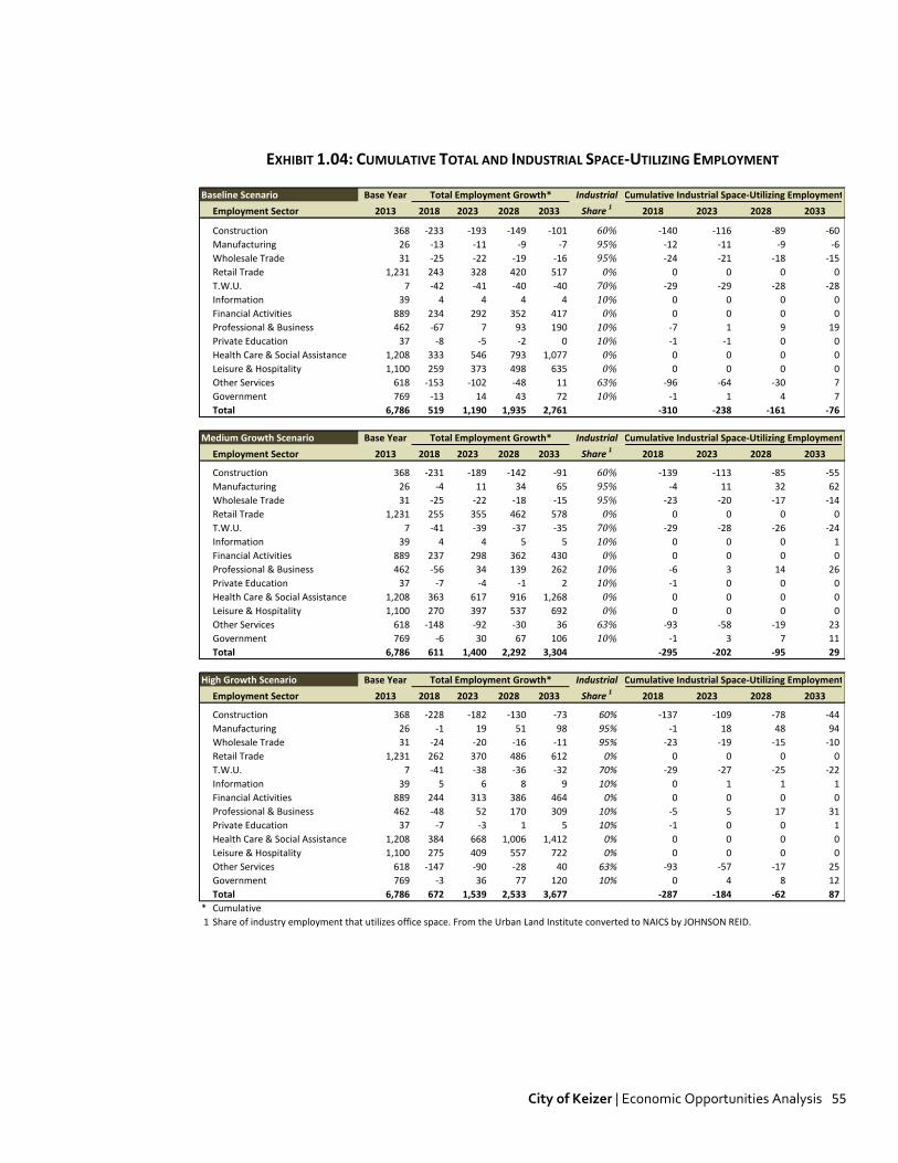
City of Keizer | Economic Opportunities Analysis 55
EXHIBIT 1.04: CUMULATIVE TOTAL AND INDUSTRIAL SPACE-UTILIZING EMPLOYMENT Baseline Scenario Base Year Industrial
Employment Sector 2013 2018 2023 2028 2033 Share 12018 2023 2028 2033
Construction 368 -233 -193 -149 -101 60% -140 -116 -89 -60
Manufacturing 26 -13 -11 -9 -7 95% -12 -11 -9 -6
Wholesale Trade 31 -25 -22 -19 -16 95% -24 -21 -18 -15
Retail Trade 1,231 243 328 420 517 0% 0 0 0 0
T.W.U. 7 -42 -41 -40 -40 70% -29 -29 -28 -28
Information 39 4 4 4 4 10% 0 0 0 0
Financial Activities 889 234 292 352 417 0% 0 0 0 0
Professional & Business 462 -67 7 93 190 10% -7 1 9 19
Private Education 37 -8 -5 -2 0 10% -1 -1 0 0
Health Care & Social Assistance 1,208 333 546 793 1,077 0% 0 0 0 0
Leisure & Hospitality 1,100 259 373 498 635 0% 0 0 0 0
Other Services 618 -153 -102 -48 11 63% -96 -64 -30 7
Government 769 -13 14 43 72 10% -1 1 4 7
Total 6,786 519 1,190 1,935 2,761 -310 -238 -161 -76
Medium Growth Scenario Base Year Industrial
Employment Sector 2013 2018 2023 2028 2033 Share 12018 2023 2028 2033
Construction 368 -231 -189 -142 -91 60% -139 -113 -85 -55
Manufacturing 26 -4 11 34 65 95% -4 11 32 62
Wholesale Trade 31 -25 -22 -18 -15 95% -23 -20 -17 -14
Retail Trade 1,231 255 355 462 578 0% 0 0 0 0
T.W.U. 7 -41 -39 -37 -35 70% -29 -28 -26 -24
Information 39 4 4 5 5 10% 0 0 0 1
Financial Activities 889 237 298 362 430 0% 0 0 0 0
Professional & Business 462 -56 34 139 262 10% -6 3 14 26
Private Education 37 -7 -4 -1 2 10% -1 0 0 0
Health Care & Social Assistance 1,208 363 617 916 1,268 0% 0 0 0 0
Leisure & Hospitality 1,100 270 397 537 692 0% 0 0 0 0
Other Services 618 -148 -92 -30 36 63% -93 -58 -19 23
Government 769 -6 30 67 106 10% -1 3 7 11
Total 6,786 611 1,400 2,292 3,304 -295 -202 -95 29
High Growth Scenario Base Year Industrial
Employment Sector 2013 2018 2023 2028 2033 Share 12018 2023 2028 2033
Construction 368 -228 -182 -130 -73 60% -137 -109 -78 -44
Manufacturing 26 -1 19 51 98 95% -1 18 48 94
Wholesale Trade 31 -24 -20 -16 -11 95% -23 -19 -15 -10
Retail Trade 1,231 262 370 486 612 0% 0 0 0 0
T.W.U. 7 -41 -38 -36 -32 70% -29 -27 -25 -22
Information 39 5 6 8 9 10% 0 1 1 1
Financial Activities 889 244 313 386 464 0% 0 0 0 0
Professional & Business 462 -48 52 170 309 10% -5 5 17 31
Private Education 37 -7 -3 1 5 10% -1 0 0 1
Health Care & Social Assistance 1,208 384 668 1,006 1,412 0% 0 0 0 0
Leisure & Hospitality 1,100 275 409 557 722 0% 0 0 0 0
Other Services 618 -147 -90 -28 40 63% -93 -57 -17 25
Government 769 -3 36 77 120 10% 0 4 8 12
Total 6,786 672 1,539 2,533 3,677 -287 -184 -62 87
* Cumulative
1 Share of industry employment that utilizes office space. From the Urban Land Institute converted to NAICS by JOHNSON REID.
Total Employment Growth* Cumulative Industrial Space-Utilizing Employment
Total Employment Growth* Cumulative Industrial Space-Utilizing Employment
Total Employment Growth* Cumulative Industrial Space-Utilizing Employment

City of Keizer | Economic Opportunities Analysis 56
EXHIBIT 1.05: CUMULATIVE INDUSTRIAL SPACE NEED Baseline Scenario Avg. Space
Employment Sector 2018 2023 2028 2033 Per Job 12018 2023 2028 2033
Construction -140 -116 -89 -60 517 -79,501 -65,847 -50,843 -34,352
Manufacturing -12 -11 -9 -6 517 -7,100 -6,019 -4,859 -3,616
Wholesale Trade -24 -21 -18 -15 2,518 -65,219 -57,843 -49,847 -41,179
Retail Trade 0 0 0 0 0 0 0 0 0
T.W.U. -29 -29 -28 -28 1,707 -55,062 -54,158 -53,170 -52,093
Information 0 0 0 0 467 188 198 209 219
Financial Activities 0 0 0 0 0 0 0 0 0
Professional & Business -7 1 9 19 467 -3,453 380 4,756 9,751
Private Education -1 -1 0 0 467 -389 -260 -124 21
Health Care & Social Assistance 0 0 0 0 0 0 0 0 0
Leisure & Hospitality 0 0 0 0 0 0 0 0 0
Other Services -96 -64 -30 7 517 -54,868 -36,648 -17,035 4,077
Government -1 1 4 7 908 -1,309 1,433 4,270 7,205
Total -310 -238 -161 -76 -266,713 -218,763 -166,643 -109,968
Medium Growth Scenario Avg. Space
Employment Sector 2017 2022 2027 2032 Per Job 12018 2023 2028 2033
Construction -139 -113 -85 -55 517 -78,890 -64,503 -48,621 -31,090
Manufacturing -4 11 32 62 517 -2,204 6,194 18,137 35,121
Wholesale Trade -23 -20 -17 -14 2,518 -64,729 -56,778 -48,111 -38,664
Retail Trade 0 0 0 0 0 0 0 0 0
T.W.U. -29 -28 -26 -24 1,707 -54,027 -51,780 -49,072 -45,810
Information 0 0 0 1 467 200 223 245 268
Financial Activities 0 0 0 0 0 0 0 0 0
Professional & Business -6 3 14 26 467 -2,854 1,763 7,149 13,434
Private Education -1 0 0 0 467 -369 -217 -55 119
Health Care & Social Assistance 0 0 0 0 0 0 0 0 0
Leisure & Hospitality 0 0 0 0 0 0 0 0 0
Other Services -93 -58 -19 23 517 -53,103 -32,833 -10,853 12,983
Government -1 3 7 11 908 -565 2,980 6,682 10,547
Total -295 -202 -95 29 -256,540 -194,952 -124,499 -43,092
High Growth Scenario Avg. Space
Employment Sector 2018 2023 2028 2033 Per Job 12018 2023 2028 2033
Construction -137 -109 -78 -44 517 -77,752 -61,980 -44,427 -24,892
Manufacturing -1 18 48 94 517 -790 10,357 27,337 53,198
Wholesale Trade -23 -19 -15 -10 2,518 -62,848 -52,633 -41,261 -28,602
Retail Trade 0 0 0 0 0 0 0 0 0
T.W.U. -29 -27 -25 -22 1,707 -53,524 -50,539 -46,779 -42,041
Information 0 1 1 1 467 246 316 389 464
Financial Activities 0 0 0 0 0 0 0 0 0
Professional & Business -5 5 17 31 467 -2,475 2,652 8,717 15,889
Private Education -1 0 0 1 467 -339 -154 47 267
Health Care & Social Assistance 0 0 0 0 0 0 0 0 0
Leisure & Hospitality 0 0 0 0 0 0 0 0 0
Other Services -93 -57 -17 25 517 -52,835 -32,252 -9,906 14,353
Government 0 4 8 12 908 -252 3,635 7,709 11,980
Total -287 -184 -62 87 -250,570 -180,598 -98,175 616
1 Share of industry employment that utilizes industrial space. Regional Industrial Land Study Phase III (EcoNorthwest and Otak, Inc., 2001) converted to
NAICS by JOHNSON REID. Reconciled with ULI Estimates.
Cumulative Industrial Space-Utilizing Employment Cumulative Industrial Space Need2
Cumulative Industrial Space-Utilizing Employment Cumulative Industrial Space Need2
Cumulative Industrial Space-Utilizing Employment Cumulative Industrial Space Need2

City of Keizer | Economic Opportunities Analysis 57
EXHIBIT 1.06: CUMULATIVE INDUSTRIAL LAND NEED Baseline Scenario Typical
Employment Sector 2018 2023 2028 2033 F.A.R. 2018 2023 2028 2033
Construction -79,501 -65,847 -50,843 -34,352 0.29 -6.3 -5.2 -4.0 -2.7
Manufacturing -7,100 -6,019 -4,859 -3,616 0.29 -0.6 -0.5 -0.4 -0.3
Wholesale Trade -65,219 -57,843 -49,847 -41,179 0.30 -5.0 -4.4 -3.8 -3.2
Retail Trade 0 0 0 0 0.00 0.0 0.0 0.0 0.0
T.W.U. -55,062 -54,158 -53,170 -52,093 0.31 -4.1 -4.0 -3.9 -3.9
Information 188 198 209 219 0.26 0.0 0.0 0.0 0.0
Financial Activities 0 0 0 0 0.00 0.0 0.0 0.0 0.0
Professional & Business -3,453 380 4,756 9,751 0.26 -0.3 0.0 0.4 0.9
Private Education -389 -260 -124 21 0.26 0.0 0.0 0.0 0.0
Health Care & Social Assistance 0 0 0 0 0.00 0.0 0.0 0.0 0.0
Leisure & Hospitality 0 0 0 0 0.00 0.0 0.0 0.0 0.0
Other Services -54,868 -36,648 -17,035 4,077 0.29 -4.3 -2.9 -1.3 0.3
Government -1,309 1,433 4,270 7,205 0.26 -0.1 0.1 0.4 0.6
Total -266,713 -218,763 -166,643 -109,968 -20.7 -16.9 -12.7 -8.2
Medium Growth Scenario Typical
Employment Sector 2018 2023 2028 2033 F.A.R. 2018 2023 2028 2033
Construction -78,890 -64,503 -48,621 -31,090 0.29 -6.2 -5.1 -3.8 -2.5
Manufacturing -2,204 6,194 18,137 35,121 0.29 -0.2 0.5 1.4 2.8
Wholesale Trade -64,729 -56,778 -48,111 -38,664 0.30 -5.0 -4.3 -3.7 -3.0
Retail Trade 0 0 0 0 0.00 0.0 0.0 0.0 0.0
T.W.U. -54,027 -51,780 -49,072 -45,810 0.31 -4.0 -3.8 -3.6 -3.4
Information 200 223 245 268 0.26 0.0 0.0 0.0 0.0
Financial Activities 0 0 0 0 0.00 0.0 0.0 0.0 0.0
Professional & Business -2,854 1,763 7,149 13,434 0.26 -0.3 0.2 0.6 1.2
Private Education -369 -217 -55 119 0.26 0.0 0.0 0.0 0.0
Health Care & Social Assistance 0 0 0 0 0.00 0.0 0.0 0.0 0.0
Leisure & Hospitality 0 0 0 0 0.00 0.0 0.0 0.0 0.0
Other Services -53,103 -32,833 -10,853 12,983 0.29 -4.2 -2.6 -0.9 1.0
Government -565 2,980 6,682 10,547 0.26 0.0 0.3 0.6 0.9
Total -256,540 -194,952 -124,499 -43,092 -19.9 -15.0 -9.3 -2.9
High Growth Scenario Typical
Employment Sector 2018 2023 2028 2033 F.A.R. 2018 2023 2028 2033
Construction -77,752 -61,980 -44,427 -24,892 0.29 -6.2 -4.9 -3.5 -2.0
Manufacturing -790 10,357 27,337 53,198 0.29 -0.1 0.8 2.2 4.2
Wholesale Trade -62,848 -52,633 -41,261 -28,602 0.30 -4.8 -4.0 -3.2 -2.2
Retail Trade 0 0 0 0 0.00 0.0 0.0 0.0 0.0
T.W.U. -53,524 -50,539 -46,779 -42,041 0.31 -4.0 -3.7 -3.5 -3.1
Information 246 316 389 464 0.26 0.0 0.0 0.0 0.0
Financial Activities 0 0 0 0 0.00 0.0 0.0 0.0 0.0
Professional & Business -2,475 2,652 8,717 15,889 0.26 -0.2 0.2 0.8 1.4
Private Education -339 -154 47 267 0.26 0.0 0.0 0.0 0.0
Health Care & Social Assistance 0 0 0 0 0.00 0.0 0.0 0.0 0.0
Leisure & Hospitality 0 0 0 0 0.00 0.0 0.0 0.0 0.0
Other Services -52,835 -32,252 -9,906 14,353 0.29 -4.2 -2.6 -0.8 1.1
Government -252 3,635 7,709 11,980 0.26 0.0 0.3 0.7 1.1
Total -250,570 -180,598 -98,175 616 -19.4 -13.8 -7.3 0.6
Cumulative Industrial Space Need Cumulative Land Need
Cumulative Industrial Space Need Cumulative Land Need
Cumulative Industrial Space Need Cumulative Land Need

City of Keizer | Economic Opportunities Analysis 58
EXHIBIT 1.07: TOTAL HOUSEHOLD RETAIL SPENDING Baseline Scenario Per Household
NAICS Category Expenditures 2013 2018 2023 2028 2033 '13-'33 ∆
441 Motor Vehicle and Parts Dealers $6,631 $91.7 $98.2 $105.2 $112.6 $120.6 $29.0
442 Furniture and Home Furnishings Stores $715 $9.9 $10.6 $11.3 $12.1 $13.0 $3.1
443 Electronics and Appliance Stores $824 $11.4 $12.2 $13.1 $14.0 $15.0 $3.6
444 Building Materials and Garden Equipment $3,302 $45.6 $48.9 $52.4 $56.1 $60.1 $14.4
445 Food and Beverage Stores $5,416 $74.9 $80.2 $85.9 $92.0 $98.5 $23.7
446 Health and Personal Care Stores $2,066 $28.6 $30.6 $32.8 $35.1 $37.6 $9.0
448 Clothing and Clothing Accessories Stores $1,696 $23.4 $25.1 $26.9 $28.8 $30.8 $7.4
451 Sporting Goods, Hobby, Book and Music Stores $768 $10.6 $11.4 $12.2 $13.1 $14.0 $3.4
452 General Merchandise Stores $5,069 $70.1 $75.1 $80.4 $86.1 $92.2 $22.1
453 Miscellaneous Store Retailers $982 $13.6 $14.5 $15.6 $16.7 $17.9 $4.3
722 Foodservices and Drinking Places $1,617 $22.3 $23.9 $25.6 $27.5 $29.4 $7.1
Totals/Weighted Averages $29,087 $310.4 $332.5 $356.1 $381.4 $408.5 $98.1
Alternative Commercial Retail Scenario Per Household
NAICS Category Expenditures 2013 2018 2023 2028 2033 '13-'33 ∆
441 Motor Vehicle and Parts Dealers $6,631 $91.7 $99.4 $107.8 $116.9 $126.8 $35.1
442 Furniture and Home Furnishings Stores $715 $9.9 $10.7 $11.6 $12.6 $13.7 $3.8
443 Electronics and Appliance Stores $824 $11.4 $12.4 $13.4 $14.5 $15.8 $4.4
444 Building Materials and Garden Equipment $3,302 $45.6 $49.5 $53.7 $58.2 $63.1 $17.5
445 Food and Beverage Stores $5,416 $74.9 $81.2 $88.1 $95.5 $103.6 $28.7
446 Health and Personal Care Stores $2,066 $28.6 $31.0 $33.6 $36.4 $39.5 $10.9
448 Clothing and Clothing Accessories Stores $1,696 $23.4 $25.4 $27.6 $29.9 $32.4 $9.0
451 Sporting Goods, Hobby, Book and Music Stores $768 $10.6 $11.5 $12.5 $13.5 $14.7 $4.1
452 General Merchandise Stores $5,069 $70.1 $76.0 $82.4 $89.4 $96.9 $26.9
453 Miscellaneous Store Retailers $982 $13.6 $14.7 $16.0 $17.3 $18.8 $5.2
722 Foodservices and Drinking Places $1,617 $22.3 $24.2 $26.3 $28.5 $30.9 $8.6
Totals/Weighted Averages $29,087 $310.4 $336.7 $365.1 $396.0 $429.4 $119.0
Household Retail Spending (In Millions)
Household Retail Spending (In Millions)
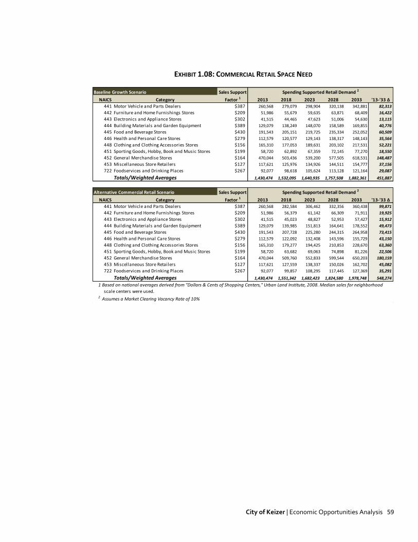
City of Keizer | Economic Opportunities Analysis 59
EXHIBIT 1.08: COMMERCIAL RETAIL SPACE NEED Baseline Growth Scenario Sales Support
NAICS Category Factor 1 2013 2018 2023 2028 2033 '13-'33 ∆
441 Motor Vehicle and Parts Dealers $387 260,568 279,079 298,904 320,138 342,881 82,313
442 Furniture and Home Furnishings Stores $209 51,986 55,679 59,635 63,871 68,409 16,422
443 Electronics and Appliance Stores $302 41,515 44,465 47,623 51,006 54,630 13,115
444 Building Materials and Garden Equipment $389 129,079 138,249 148,070 158,589 169,855 40,776
445 Food and Beverage Stores $430 191,543 205,151 219,725 235,334 252,052 60,509
446 Health and Personal Care Stores $279 112,579 120,577 129,143 138,317 148,143 35,564
448 Clothing and Clothing Accessories Stores $156 165,310 177,053 189,631 203,102 217,531 52,221
451 Sporting Goods, Hobby, Book and Music Stores $199 58,720 62,892 67,359 72,145 77,270 18,550
452 General Merchandise Stores $164 470,044 503,436 539,200 577,505 618,531 148,487
453 Miscellaneous Store Retailers $127 117,621 125,976 134,926 144,511 154,777 37,156
722 Foodservices and Drinking Places $267 92,077 98,618 105,624 113,128 121,164 29,087
Totals/Weighted Averages 1,430,474 1,532,095 1,640,935 1,757,508 1,882,361 451,887
Alternative Commercial Retail Scenario Sales Support
NAICS Category Factor 1 2013 2018 2023 2028 2033 '13-'33 ∆
441 Motor Vehicle and Parts Dealers $387 260,568 282,584 306,462 332,356 360,438 99,871
442 Furniture and Home Furnishings Stores $209 51,986 56,379 61,142 66,309 71,911 19,925
443 Electronics and Appliance Stores $302 41,515 45,023 48,827 52,953 57,427 15,912
444 Building Materials and Garden Equipment $389 129,079 139,985 151,813 164,641 178,552 49,473
445 Food and Beverage Stores $430 191,543 207,728 225,280 244,315 264,958 73,415
446 Health and Personal Care Stores $279 112,579 122,092 132,408 143,596 155,729 43,150
448 Clothing and Clothing Accessories Stores $156 165,310 179,277 194,425 210,853 228,670 63,360
451 Sporting Goods, Hobby, Book and Music Stores $199 58,720 63,682 69,063 74,898 81,226 22,506
452 General Merchandise Stores $164 470,044 509,760 552,833 599,544 650,203 180,159
453 Miscellaneous Store Retailers $127 117,621 127,559 138,337 150,026 162,702 45,082
722 Foodservices and Drinking Places $267 92,077 99,857 108,295 117,445 127,369 35,291
Totals/Weighted Averages 1,430,474 1,551,342 1,682,423 1,824,580 1,978,748 548,274
1 Based on national averages derived from "Dollars & Cents of Shopping Centers," Urban Land Institute, 2008. Median sales for neighborhood
scale centers were used.2 Assumes a Market Clearing Vacancy Rate of 10%
Spending Supported Retail Demand 2
Spending Supported Retail Demand 2

City of Keizer | Economic Opportunities Analysis 60
EXHIBIT 1.09: COMMERCIAL RETAIL LAND NEED Baseline Growth Scenario Retail
NAICS Category F.A.R. 1 2013 2018 2023 2028 2033 '13-'33 ∆
441 Motor Vehicle and Parts Dealers 0.25 23.9 25.6 27.4 29.4 31.5 7.6
442 Furniture and Home Furnishings Stores 0.25 4.8 5.1 5.5 5.9 6.3 1.5
443 Electronics and Appliance Stores 0.25 3.8 4.1 4.4 4.7 5.0 1.2
444 Building Materials and Garden Equipment 0.25 11.9 12.7 13.6 14.6 15.6 3.7
445 Food and Beverage Stores 0.25 17.6 18.8 20.2 21.6 23.1 5.6
446 Health and Personal Care Stores 0.25 10.3 11.1 11.9 12.7 13.6 3.3
448 Clothing and Clothing Accessories Stores 0.25 15.2 16.3 17.4 18.7 20.0 4.8
451 Sporting Goods, Hobby, Book and Music Stores 0.25 5.4 5.8 6.2 6.6 7.1 1.7
452 General Merchandise Stores 0.25 43.2 46.2 49.5 53.0 56.8 13.6
453 Miscellaneous Store Retailers 0.25 10.8 11.6 12.4 13.3 14.2 3.4
722 Foodservices and Drinking Places 0.25 8.5 9.1 9.7 10.4 11.1 2.7
Totals/Weighted Averages 131.4 140.7 150.7 161.4 172.9 41.5
Alternative Commercial Retail Scenario Retail
NAICS Category F.A.R. 1 2013 2018 2023 2028 2033 '13-'33 ∆
441 Motor Vehicle and Parts Dealers 0.25 23.9 25.9 28.1 30.5 33.1 9.2
442 Furniture and Home Furnishings Stores 0.25 4.8 5.2 5.6 6.1 6.6 1.8
443 Electronics and Appliance Stores 0.25 3.8 4.1 4.5 4.9 5.3 1.5
444 Building Materials and Garden Equipment 0.25 11.9 12.9 13.9 15.1 16.4 4.5
445 Food and Beverage Stores 0.25 17.6 19.1 20.7 22.4 24.3 6.7
446 Health and Personal Care Stores 0.25 10.3 11.2 12.2 13.2 14.3 4.0
448 Clothing and Clothing Accessories Stores 0.25 15.2 16.5 17.9 19.4 21.0 5.8
451 Sporting Goods, Hobby, Book and Music Stores 0.25 5.4 5.8 6.3 6.9 7.5 2.1
452 General Merchandise Stores 0.25 43.2 46.8 50.8 55.1 59.7 16.5
453 Miscellaneous Store Retailers 0.25 10.8 11.7 12.7 13.8 14.9 4.1
722 Foodservices and Drinking Places 0.25 8.5 9.2 9.9 10.8 11.7 3.2
Totals/Weighted Averages 131.4 142.5 154.5 167.5 181.7 50.31 Assumes typical suburban retail profile: single-story with four parking spaces per 1,000 square feet of developed space.
Commercial Retail Land Need (Acres)
Commercial Retail Land Need (Acres)

319 SW WASHINGTON STREET, SUITE 1020 PORTLAND, OR 97204 503/295-7832 503/295-1107 (FAX)
CITY OF KEIZER, OR HOUSING AND RESIDENTIAL LAND NEEDS ASSESSMENT
(OREGON STATEWIDE PLANNING GOAL 10)
Prepared For:
CITY OF KEIZER, OREGON
April, 2013
DRAFT: 4/24/13 Planning Commission Meeting

CITY OF KEIZER | GOAL 10 RESIDENTIAL LAND NEED ANALYSIS PAGE 1
TABLE OF CONTENTS
TABLE OF CONTENTS 1
20-YEAR HOUSING NEED FORECAST 2
INTRODUCTION 2
CITY OF KEIZER DEMOGRAPHIC PROFILE 2
CURRENT HOUSING NEEDS 6
ANTICIPATED HOUSING TRENDS 10
FUTURE HOUSING NEEDS (2033) 18
20-YEAR HOUSING LAND NEEDS ANALYSIS 22
INTRODUCTION 22
CURRENT RESIDENTIAL LANDS 22
FUTURE RESIDENTIAL LAND NEED (2033) 24
PARK AND SCHOOL FACILITY NEEDS (2033) 25
TOTAL RESIDENTIAL AND PUBLIC FACILITY LAND NEEDS (2033) 29
GOAL 10 HOUSING EXHIBITS 30
This project is funded by Oregon general fund dollars through the Department of Land Conservation and Development. The contents of this document do not necessarily reflect the views or policies of the State of Oregon.

CITY OF KEIZER | GOAL 10 RESIDENTIAL LAND NEED ANALYSIS PAGE 2
20-YEAR HOUSING NEED FORECAST
INTRODUCTION This analysis outlines a forecast of housing need within the City of Keizer/Urban Growth Boundary. Housing need and resulting land need are forecast to 2033 consistent with 20-year need assessment requirements of periodic review. This report presents a housing need analysis (presented in number and types of housing units) and a residential land need analysis, based on those projections. The primary data sources used in generating this forecast were:
City of Keizer Adopted 2032 Population Forecast Marion County Adopted 2030 Population Forecast MWVCOG Buildable Lands Inventory MWVCOG regional Housing Needs Analysis and Economic Opportunities Analysis (2011) U.S. Census Claritas Inc.
1
Portland State University Population Research Center. Other sources are identified as appropriate.
CITY OF KEIZER DEMOGRAPHIC PROFILE Population and Households
Keizer is a City of nearly 37,000 people located in the greater Salem-Keizer metropolitan area.
Keizer is the 14th
largest city in Oregon, but its population is nearly equal to that of the 13th
largest (Lake Oswego).
Keizer has grown by an estimated 4,661 people between 2000 and 2013, or 14%. This growth was roughly equal to that experienced by Marion County (13%) and the state (14%) over that period. The City of Salem experienced greater growth of 16%. (US Census and PSU Population Research Center)
Keizer was home to over 13,800 households in 2013. The percentage of families fell somewhat between 2000 and 2010 from 71.4% to 69.3% of all households. This is very similar to the Marion County figure of 68.2% family households, and the state’s 63.4%.
Keizer’s average household size is 2.64 persons, unchanged since 2000. This is slightly smaller than the Marion County average of 2.7 but larger than the statewide average of 2.47.
The following table (Figure 1) presents a profile of City of Keizer demographics from the 2000 and 2010 Census. It also presents projected demographics in 2013, based on assumptions detailed in the table footnotes.
1 Claritas Inc. is a third-party company providing data on demographics and market segmentation. It is owned by the Nielson Company which
conducts direct market research including surveying of households across the nation. Nielson combines proprietary data with data from the U.S. Census, Postal Service, and other federal sources, as well as local-level sources such as Equifax, Vallassis and the National Association of Realtors. Claritas promotes a “bottom-up” and “top-down” analysis using these sources to produce annual demographic and economic profiles for individual geographies. Projections of future growth are based on the continuation of long-term and emergent demographic trends identified through the above sources.

CITY OF KEIZER | GOAL 10 RESIDENTIAL LAND NEED ANALYSIS PAGE 3
FIGURE 1: KEIZER DEMOGRAPHIC PROFILE
2000 2010 Growth Rate 2013 Growth Rate
(Census) (Census) 00-10 (Proj.) 10-13
Population1 32,203 36,478 1.3% 36,864 0.4%
Households2 12,110 13,703 1.2% 13,824 0.3%
Families3 8,642 9,498 0.9% 9,582 0.3%
Housing Units4 12,774 14,445 1.2% 14,531 0.2%
Group Quarters Population5 280 364 2.7% 368 0.4%
Household Size 2.64 2.64 0.0% 2.64 0.0%
2000 2010 Growth Rate 2013 Growth Rate
(Census) (Est.) 00-10 (Proj.) 10-13
Per Capita ($) $20,119 $24,645 2.0% $26,192 2.0%
Average HH ($) $53,425 $64,272 1.9% $67,937 1.9%
Median HH ($) $45,052 $53,042 1.6% $55,705 1.6%
SOURCE: Claritas, Census, and Johnson Reid
2 2013 Households = 2013 population/2013 HH Size
3 Ratio of 2013 Families to total HH is kept constant from 2010.
5 Ratio of 2012 Group Quarters Population to Total Population is kept constant from 2010.
4 2013 housing units are the 2010 Census total plus new units permitted from '10 through '12 (source: HUD State of the
Cities Data System)
PER CAPITA AND AVERAGE HOUSEHOLD INCOME
POPULATION, HOUSEHOLDS, FAMILIES, AND YEAR-ROUND HOUSING UNITS
1 Population is based on the certified 2012 estimate from PSU Population Research Center, projected forward one year
using the 2010 - 2012 growth rate (0.4%)
Income Levels
Keizer’s median household income was over $53,000 in 2010. This is 22% higher than the median income found in the City of Salem ($43,500) and is similarly higher than the Marion County median ($45,594).
Median income grew 18% between 2000 and 2010, while growing 13% in Marion County.
Figure 2 shows the distribution of households by income in 2000 and 2013 (estimated). The largest single income cohort is those households earning between $50k and $75k, at 24% of households. 51% of households earn less than this, while 25% of households earn $75k or more per year.
20% of households earn $25k or less, down from 23% of households in 2000.

CITY OF KEIZER | GOAL 10 RESIDENTIAL LAND NEED ANALYSIS PAGE 4
FIGURE 2: SHARE OF HOUSEHOLDS WITHIN INCOME GROUPS, CITY OF KEIZER
0%
5%
10%
15%
20%
25%
30%
2000
2013
SOURCE: Claritas Inc., Johnson Reid LLC
FIGURE 3: SHARE OF HOUSEHOLDS BY AGE OF HOUSEHOLDER, CITY OF KEIZER
0%
5%
10%
15%
20%
25%
Age of Primary Householder
2000
2013
SOURCE: Claritas Inc., Johnson Reid LLC
Age Trends
Figure 3 shows the share of households by the age of the primary householder. In general, the distribution of households has shifted away from younger households and towards older households. Nevertheless, 56% of householders still fall 25 to 54 year range.
The greatest growth was in households in the 55 to 64 age range, coinciding with the oldest of the Baby Boom cohort. This cohort grew from 12.4% to 18.5% of households.

CITY OF KEIZER | GOAL 10 RESIDENTIAL LAND NEED ANALYSIS PAGE 5
20% of householders are now 65 years or older.
These figures reflect the age of householders, which is an important metric of housing needs as discussed more below. In terms of the total population, 27.3% of Keizer’s citizens are children under the age of 18 years, essentially unchanged since 2000. Keizer has more children than the statewide average of 22.6% of the population.
13% of Keizer’s population is 65 years or older which is slightly more than the share in 2000 (12.2%), and roughly equivalent to the statewide average.
Household Size
Keizer’s average household size is 2.64 persons, unchanged since 2000.
Figure 4 shows the share of households by the number of people. 24% are single-person households, up slightly since 2000. This is similar to the percentage in Marion County (25%), but less than the statewide average (27%).
The share of households with two to four people fell slightly, while large households of five or six people grew in share.
FIGURE 4: NUMBER OF PEOPLE PER HOUSEHOLD, CITY OF KEIZER
0%
5%
10%
15%
20%
25%
30%
35%
40%
2000
2010
SOURCE: US Census, Johnson Reid LLC

CITY OF KEIZER | GOAL 10 RESIDENTIAL LAND NEED ANALYSIS PAGE 6
CURRENT HOUSING NEEDS The profile of current housing conditions in the study area is based on Census 2010, forecasted forward to 2013 based on the most recent certified estimates from the Population Research Center at Portland State University. Estimates of current population and households were cross referenced with estimates from Claritas, and the U.S. Census.
FIGURE 5: CURRENT HOUSING PROFILE (2013)
SOURCE
Total 2013 Population: 36,864US Census, PSU Pop. Research
Center
- Estimated group housing population: 368 (1.0% of Total) US Census
Estimated Non-Group 2013 Population: 36,496 (Total - Group)
Avg. HH Size: 2.64 US Census
Estimated Non-Group 2013 Households: 13,824 (Pop/HH Size)
Total Housing Units: 14,531 (Occupied + Vacant) Census 2010 + permits
Occupied Housing Units: 13,824 (= # of HH)
Vacant Housing Units: 707 (Total HH - Occupied)
Current Vacancy Rate: 4.9% (Vacant units/ Total units)
Sources: Johnson Reid, LLC, City of KEIZER, PSU Population Research Center, U.S. Census
CURRENT HOUSING CONDITIONS (2013)
We estimate a current population of roughly 36,864, living in 13,824 households (excluding group living situations). Average household size is 2.64 persons (compared to 2.5 statewide). Keizer has a somewhat higher percentage of family households (69%) in comparison to the state or Salem (each with 63% family households.) There are an estimated 14,531 housing units in the city, with 707 units vacant. The estimated 2013 vacancy rate of housing units is 4.9% (Claritas, Census).
ESTIMATE OF CURRENT HOUSING DEMAND Following the establishment of the current housing profile, the current housing demand was determined based upon the age and income characteristics of current households. The analysis considered the propensity of households in specific age and income levels to either rent or own their home (Census), in order to derive the current demand for ownership and rental housing units and the appropriate housing cost level of each. The analysis takes into account the average amount that owners and renters tend to spend on housing costs. For instance, lower income households tend to spend more of their total income on housing, while upper income households spend less on a percentage basis. In this case, it was assumed that households in lower income bands would prefer housing costs at no more than 30% of gross income (a common measure of affordability). Higher income households pay a decreasing share down to 20% for the highest income households. Figure 6 presents a snapshot of current housing demand (i.e. preferences) equal to the number of households in the study area (13,824). The breakdown of tenure (owners vs. renters) reflects data from the 2010 Census. The 61% ownership rate is very similar to the statewide rate of 62%. The homeownership rate in Keizer has fallen since 2000 from almost 65%. During this period the statewide rate fell from 64% to 62%. While the overall rate is very similar the rate of decline

CITY OF KEIZER | GOAL 10 RESIDENTIAL LAND NEED ANALYSIS PAGE 7
was more pronounced in Keizer during this decade. Nationally, the homeownership rate has nearly reached the historical average of 65%, after the rate climbed from the late 1990’s to 2004 (69%).
FIGURE 6: ESTIMATE OF CURRENT HOUSING DEMAND (2013)
Price Range# of
HouseholdsIncome Range
% of
TotalCumulative
$0k - $70k 442 Less than $15,000 5.2% 5.2%
$70k - $120k 541 $15,000 - $24,999 6.4% 11.7%
$120k - $170k 839 $25,000 - $34,999 9.9% 21.6%
$170k - $240k 1,284 $35,000 - $49,999 15.2% 36.8%
$240k - $300k 2,184 $50,000 - $74,999 25.9% 62.7%
$300k - $350k 1,442 $75,000 - $99,999 17.1% 79.8%
$350k - $440k 827 $100,000 - $124,999 9.8% 89.6%
$440k - $530k 402 $125,000 - $149,999 4.8% 94.4%
$530k - $640k 263 $150,000 - $199,999 3.1% 97.5%
$640k + 209 $200,000+ 2.5% 100.0%
Totals: 8,432 % of All: 61.0%
Rent Level# of
HouseholdsIncome Range
% of
TotalCumulative
$0 - $380 990 Less than $15,000 18.4% 18.4%
$380 - $620 891 $15,000 - $24,999 16.5% 34.9%
$620 - $870 896 $25,000 - $34,999 16.6% 51.5%
$870 - $1090 1,177 $35,000 - $49,999 21.8% 73.3%
$1090 - $1370 1,074 $50,000 - $74,999 19.9% 93.2%
$1370 - $1680 255 $75,000 - $99,999 4.7% 98.0%
$1680 - $2100 69 $100,000 - $124,999 1.3% 99.2%
$2100 - $2520 28 $125,000 - $149,999 0.5% 99.7%
$2520 - $3360 3 $150,000 - $199,999 0.1% 99.8%
$3360 + 11 $200,000+ 0.2% 100.0% All Households
Totals: 5,392 % of All: 39.0% 13,824
Ownership
Rental
Sources: PSU Population Research Center, Claritas Inc., Census, JOHNSON REID
The affordable price level for ownership housing assumes 30-year amortization, at an interest rate of 6%, with 15% down payment. [These assumptions are designed to represent prudent lending and borrowing levels for ownership households. The 30-year mortgage commonly serves as the standard. Down payment assumptions tend to range from 20% for older/established households, and 10% for first-time buyers. In recent years, down payment requirements have fallen significantly. The 15% used here represents both the average between newer and older households and recognition that despite currently tightening standards due to the 2008/2009 credit crisis, over the long-run it is anticipated that down payment standards will remain sub-20% (i.e. a new “normal” has been established).]
CURRENT HOUSING INVENTORY The profile of current housing demand (Figure 6) represents the preference and affordability levels of households. In reality, the current housing supply (Figure 7 below) differs from this profile, meaning that some households find themselves in housing units which are not optimal, either not meeting the household’s own/rent preference, or being under- or over-affordable. A profile of current housing supply in Keizer was determined using Census data from the 2010 Census, which provides a profile of housing values, rent levels, and housing types (single family, attached, mobile home, etc.).

CITY OF KEIZER | GOAL 10 RESIDENTIAL LAND NEED ANALYSIS PAGE 8
The following figure presents a profile of current housing supply of ownership and rental housing in the study area.
An estimated 59.8% of housing units are ownership units, while an estimated 40.2% of housing units are rental units. The inventory includes vacant units, so the breakdown of ownership vs. rental does not exactly match the tenure split of actual households.
93% of ownership units are single family homes, while 41% of rental units are in structures of 5 units or more.
Of total housing units, an estimated 63% are detached homes, while 33% are some sort of attached type. 4% are mobile home units.
FIGURE 7: PROFILE OF CURRENT HOUSING SUPPLY (2013)
Price RangeSingle Family
Detached
Single Family
AttachedDuplex
3- or 4-
plex
5+ Units
MFR
Mobile
home
Boat, RV,
other
temp
Total
Units% of Units
Cummulative
%
$0k - $70k 211 9 0 7 0 275 0 502 5.8% 5.8%
$70k - $120k 193 12 0 17 0 142 0 363 4.2% 10.0%
$120k - $170k 1,417 41 0 7 0 0 0 1,465 16.9% 26.8%
$170k - $240k 3,405 63 0 3 0 0 0 3,471 39.9% 66.7%
$240k - $300k 1,049 19 0 0 0 0 0 1,068 12.3% 79.0%
$300k - $350k 632 12 0 0 0 0 0 644 7.4% 86.4%
$350k - $440k 757 5 0 0 0 0 0 762 8.8% 95.2%
$440k - $530k 199 0 0 0 0 0 0 199 2.3% 97.5%
$530k - $640k 84 0 0 0 0 0 0 84 1.0% 98.5%
$640k + 134 0 0 0 0 0 0 134 1.5% 100.0%
Totals: 8,081 161 0 34 0 417 0 8,693 % of All Units: 59.8%
Percentage: 93.0% 1.9% 0.0% 0.4% 0.0% 4.8% 0.0% 100.0%
Price RangeSingle Family
Detached
Single Family
AttachedDuplex
3- or 4-
plex
5+ Units
MFR
Mobile
home
Boat, RV,
other
temp
Total
Units% of Units
Cummulative
%
$0 - $380 8 15 8 21 55 38 0 146 2.5% 2.5%
$380 - $620 173 170 64 188 452 64 0 1,111 19.0% 21.5%
$620 - $870 420 382 145 456 1,199 26 0 2,628 45.0% 66.5%
$870 - $1090 300 194 82 242 603 0 0 1,420 24.3% 90.9%
$1090 - $1370 94 74 17 44 63 0 0 292 5.0% 95.9%
$1370 - $1680 42 16 6 6 27 0 0 97 1.7% 97.5%
$1680 - $2100 36 25 4 0 0 0 0 64 1.1% 98.6%
$2100 - $2520 45 20 0 0 0 0 0 65 1.1% 99.7%
$2520 - $3360 16 0 0 0 0 0 0 16 0.3% 100.0%
$3360 + 0 0 0 0 0 0 0 0 0.0% 100.0%
Totals: 1,134 896 324 958 2,399 128 0 5,838 % of All Units: 40.2%
Percentage: 19.4% 15.3% 5.6% 16.4% 41.1% 2.2% 0.0% 100.0%
Single Family
Detached
Single Family
AttachedDuplex
3- or 4-
plex
5+ Units
MFR
Mobile
home
Boat, RV,
other
temp
Total
Units% of Units
Totals: 9,215 1,056 324 992 2,399 544 0 14,531 100%
Percentage: 63.4% 7.3% 2.2% 6.8% 16.5% 3.7% 0.0% 100.0%
TOTAL HOUSING UNITS
OWNERSHIP HOUSING
RENTAL HOUSING
Sources: US Census, PSU Population Research Center, JOHNSON REID

CITY OF KEIZER | GOAL 10 RESIDENTIAL LAND NEED ANALYSIS PAGE 9
COMPARISON OF CURRENT HOUSING DEMAND WITH CURRENT SUPPLY A comparison of estimated current housing demand with the existing supply identifies the existing discrepancies between needs and the housing which is currently available. In general, this identifies a current need for additional ownership units at a range of price points, counterbalanced by a surplus of units in the $120,000 to $240,000 range. This is simply an indicator that most housing in the Keizer market is found in this range. Based on analysis of household incomes and ability to pay, there may be support for some ownership housing at higher price points. The analysis identifies a general need for rental units at the lowest price level and at middle price levels. There are levels of estimated surplus for apartments ($380 to $1090 per month), representing the average rent prices in Keizer, where most units can be expected to congregate. Rentals at more expensive levels generally represent single family homes for rent.
FIGURE 8: COMPARISON OF CURRENT NEED TO CURRENT SUPPLY
Price Range
Estimated
Current
Need
Estimated
Current
Supply
Unmet
(Need) or
Surplus
Rent
Estimated
Current
Need
Estimated
Current
Supply
Unmet
(Need) or
Surplus
$0k - $70k 442 502 60 $0 - $380 990 146 (844)
$70k - $120k 541 363 (177) $380 - $620 891 1,111 220
$120k - $170k 839 1,465 627 $620 - $870 896 2,628 1731
$170k - $240k 1,284 3,471 2187 $870 - $1090 1,177 1,420 243
$240k - $300k 2,184 1,068 (1116) $1090 - $1370 1,074 292 (782)
$300k - $350k 1,442 644 (798) $1370 - $1680 255 97 (158)
$350k - $440k 827 762 (65) $1680 - $2100 69 64 (4)
$440k - $530k 402 199 (203) $2100 - $2520 28 65 37
$530k - $640k 263 84 (179) $2520 - $3360 3 16 13
$640k + 209 134 (75) $3360 + 11 0 (11)
Totals: 8,432 8,693 261 Totals: 5,392 5,838 446
Occupied Units: 13,824
All Housing Units: 14,531
Total Unit Surplus: 707
Ownership Rental
Sources: PSU Population Research Center, Claritas Inc., Census, JOHNSON REID
Overall, the analysis identifies a total surplus of 261 ownership units, and a larger current surplus of rental units of 446. This is based on a model of general preferences of households in different age and income cohorts to either own or rent. There are an estimated 707 units more than the current number of households, which reflects the city’s current vacancy rate of 4.9%.

CITY OF KEIZER | GOAL 10 RESIDENTIAL LAND NEED ANALYSIS PAGE 10
ANTICIPATED HOUSING TRENDS This section discusses current and anticipated demographic and market trends which are expected to impact the nature of housing demand and development in the future. These are macro-level trends which generally apply on a regional or nationwide scale, but the potential impact for Keizer is discussed in each case. The impacts of these trends are factored into the projection of housing need and residential land need detailed in following sections of this report. The major demographic trends discussed here are:
Migration to urban environments Diminishing household sizes Baby Boom generation transitions Millennial generation preferences Immigration Workforce housing
A. Migration to Urban Environments The United States, and indeed most of the world, has been undergoing a long-term shift of population from rural areas to urban areas. For the first time in history, as of 2008, more people globally live in an urban environment than in rural areas. This shift is caused by the decline of small-scale farming as agriculture is mechanized, and the increasing dominance of cities in the global economy. In the developing world, cities are the location of jobs in factories and the export sectors. In the United States, metropolitan areas are the heart of the high-tech, creative and services-based sectors which are growing as manufacturing declines. Ironically, as communication technology increasingly enables dispersed work environments and the ability to connect from anywhere, the urban environment seems to have only grown in popularity. Sociologists and other experts now acknowledge the enduring importance of physical proximity for networking, doing business and forming clusters of competitors within an industry to spur innovation and share a talent pool of employees. These trends have been accompanied by the revitalization of city centers and a return of population growth in the core. For many cities, including Portland, this is a reversal of the out-migration trends of the 1970’s and 1980’s when the perception of urban crime and dysfunction led many to move to the suburbs to find a better family environment plus more space, cheaper housing and better schools. Since the late 1990’s, the return of urban prosperity, continuously falling crime rates, and a reaction against long commutes, many cities have seen increasing demand to live in the downtown area, or the surrounding neighborhoods. There is currently some speculation that this trend will have a negative impact on the suburban cities which surround the larger “core” city, and especially on the farther-flung “exurban” cities. As yet, the evidence is not conclusive that this will be the case. Rather than see this trend as an ominous sign for suburban cities, some experts interpret it as impetus for suburbs to encourage some aspects of urban lifestyle in the suburbs, most notably by revitalizing traditional downtowns, zoning for mixed uses, and/or creating new town center environments which offer the benefits of a larger central city on a smaller scale.
2 This trend is already apparent in many suburban cities, including Keizer.
In fact, a 2011 survey from the National Association of Realtors of community preferences found that the largest share of homeowners live in the suburbs (either residential-only areas, or neighborhoods with a mix of uses). When asked where they would prefer to live, the suburbs were still dominant, but with a greater preference for mixed-use suburban environments, over residential-only neighborhoods.
3 For renter households, the city market
was the most popular, but roughly 34% still expressed a preference for the suburban market.
2 McIlwain, John. “Housing in America: The Next Decade.” ULI, 2010. 3 Logan, Gregg. “RCLCO Forecast: Does the Housing Market Still Want the Suburbs?” RCLCO, “The Advisory,” 4/30/12.

CITY OF KEIZER | GOAL 10 RESIDENTIAL LAND NEED ANALYSIS PAGE 11
Implications for Keizer: As a first-tier suburb in the Salem metro area, the City of Keizer will continue to benefit from the general trend of migration to urban areas. The metro area as a whole can expect continued growth, with different suburbs filling different niches in terms of housing affordability, lifestyle amenities, and employment opportunities. The growing popularity of the urban core should not be interpreted as a zero-sum game in terms of attracting households. Suburban housing will continue to meet the needs for some households depending on life-stage and personal preferences. Keizer can continue to prioritize bringing some of the benefits of a more urban environment to the city, through the long-term development of mixed use areas.
B. Diminishing Household Sizes There is a clear long-term trend in the United States of falling household (and family) sizes. In 1900, the average household size in the US was 4.6 persons. By 1950, it was 3.4 persons, and in 2010 it was 2.58 persons (US Census). This is a rate of decline of -0.5% per year since 1900. However, in recent decades the trend has slowed considerably. Since 1980, the rate of decline has been -0.2%. Between 2000 and 2010, the average household size was essentially unchanged. This is reflected in Keizer, where the average household size remained constant from 2000 to 2010 (2.64 persons). Nationally, a continued slow decline of household size is expected over coming decades. Younger baby boomers will transition to empty nest status as kids leave the households. Older boomers will transition to single-person households as spouses pass away, if not in the coming decade than the following decade. (As discussed in more detail below, the size of the baby boom generation causes them to have an outsized effect on demographic trends.) At the same time, the trend for younger generations to delay having children and having fewer children than previous generations will continue. However, the rate of decline will continue to slow and the average household size is likely to reach a stable level eventually, as it cannot realistically approach a size of 1.0 person per household. Implications for Keizer: The city of Keizer has experienced a stable average household size since the year 2000. Given its nature as a suburban city of mostly detached single-family homes, it should continue to attract family households which will support the household size, and buck the national trend towards smaller households. The projections of future households in the following section reflect a household size which will grow very slightly to 2.65 over the next 20 years.
C. Baby Boom Generation Transitions Due to its sheer size, the baby boom generation has dominated US demographic trends since its appearance between 1946 and 1965. (Exact definitions of generational periods vary, but this is the generally accepted definition of the baby boom generation.) There are an estimated 78 million boomers, making them approximately 26% of the US population. In 2012, this generation is roughly 47 to 66 years old. Demographers often split the baby boom generation into an older and younger cohort when discussing their needs and preferences.
4 The prospects of these two cohorts are likely to be very different given the severity of the
recent economic downturn. The older cohort, aged 56 to 66, is closer to retirement, with less time to repair household finances if it is needed. Many in this generation have not saved adequately for retirement, and the recent expectation of using rising home
4 Most of this discussion draws from the following reports: McIlwain, John. “Housing in America: The Next Decade.” ULI, 2010. “State of the Nation’s Housing 2011.” Joint Center for Housing Studies of Harvard University, 2011.

CITY OF KEIZER | GOAL 10 RESIDENTIAL LAND NEED ANALYSIS PAGE 12
equity as a backstop has been frustrated by the housing downturn. This situation may limit some opportunities in retirement. Still, many in this older cohort were already near to retirement when the recession hit, and had built sufficient nest eggs and pension benefits to retire as planned. This cohort was able to take advantage of generally rising income growth and national prosperity over their careers. As incomes have stagnated over the last decade, they were still in their peak earning years. Many have access to pension and health benefits in retirement that are no longer offered to most workers. The younger cohort (aged 47-56) is larger, representing about 2/3 of the generation. This cohort is still entering the prime of its earning years, many with children still at home. Though job and income prospects may be diminished, there is still the opportunity to retrench for retirement. Economically, this younger boomer cohort has more in common with younger generations, in that it has experienced wage stagnation over the last decade. They did not necessarily share in the constant income growth and generous retirement benefits sometimes associated with older boomers. In terms of housing, the baby boom generation is more likely to own their homes, having decades to enter the ownership market and build equity. They are more likely to have greater equity in their homes, providing some cushion from the recent downturn. Nevertheless, many in this generation are still locked in underwater mortgages, and face the same dilemma as younger generations in being unable or unwilling to sell for a loss. For those entering retirement, the lack of mobility may be a source of frustration and inconvenience, but is not damaging in the sense that they are not compelled to move for job opportunities. For younger boomer, the lack of mobility may hurt job prospects. The older boomers also have the advantage of selling their current homes as “move up” housing to the younger boomers following them, though the prices received are likely to be greatly diminished. Younger boomers are once again in a tougher position, as their homes are most appropriate as move-up housing for the following generation: Generation X. The problem is that Generation X is much smaller, tends to be less prosperous, and shares the younger generations’ preference for an urban environment, rather than the suburbs where many younger boomers have located. What are the anticipated housing preferences of empty nesters and retirees? Two studies by RCLCO present somewhat different conclusions on this matter. A 2009 survey found that 75% of retiring boomers said they want to live in mixed-age, mixed-use communities, which implies a more urban environment. However, this mixed environment can be found in suburban town centers as well. A 2010 survey asked a sample of affluent households of a variety of ages what housing choices they anticipated making upon coming empty-nesters and/or retirees. 65% of respondents stated that they prefer to age in place. An additional 14% anticipated moving to a different single-family home in the same market. 7% stated the preference to move to a condominium either in the central city or suburb.
5
These findings suggest caution with the oft-stated belief that older households will increasingly want to live in multi-family housing in dense environments. While some segment of the population will make this choice, this trend can be overstated. Since baby boomers are likely to remain healthier and more active for longer than the previous generation, as well as face problems with underwater mortgages, they are likely to delay downsizing and seeking out senior-focused facilities for some time. Implications for Keizer: The baby boom generation’s share of Keizer’s population (33%) is higher than that of the state (27%), and the nation (26.5%). Keizer may expect to see the impacts of this generation’s lifestyle transitions to a somewhat greater degree.
5 Ducker, Adam and Bob Gardner. “Anticipating the Upscale Empty-Nester Condo Market Recovery” RCLCO, “The Advisory,” 8/11.

CITY OF KEIZER | GOAL 10 RESIDENTIAL LAND NEED ANALYSIS PAGE 13
Over the coming 20 years, the baby boom generation will remain healthier and more independent for longer than their parents, meaning that the transition to retirement communities will be postponed or never undertaken for some of these households. The youngest in this generation will have just reached the traditional retirement age in 20 years. Their housing legacy may be in leaving behind a large stock of large suburban homes to generations with lower incomes, and/or preferences for a more urban setting (see below). If this is the case, then housing prices in suburban locations may not experience as robust of gains as central urban housing. A subset of the baby boom generation will be interested in opportunities to live in well-planned and safe mixed-use communities in the future. The demand from older households for multi-family housing opportunities in town centers should be significant enough to be addressed by the market, but should not be overstated. Also, older seniors may prefer or require single-level housing.
D. Millennial Generation Preferences As the baby boom generation moves through mid-life and into retirement, the millennial generation is emerging as the dominant demographic group of the future. This generation, sometimes called the Echo Boomers or Generation Y, is actually larger than the baby boom generation at 83 million people. Definitions vary, but members of this generation were born roughly between 1980 and 2000 and are now in their teens to early 30’s. Aside from being large, this generation is in the prime years of defining popular culture as its greatest consumers. In broad strokes, the millennial generation is more technologically savvy, networked, environmentally and socially responsible than previous generations. They value diversity and activity, and therefore gravitate to urban environments more-so than older generations. This generation grew up in a time of generally rising economic prosperity in the 1980’s and 1990’s, but they find themselves at a disadvantage in the current economic downturn. Jobs are scarce while average student debt has risen sharply. Incomes for people younger than 35 have fallen over the last decade, meaning that this generation is starting from behind. Many experts expect that over their lifetimes, millennials will make less money and have a more modest quality of life than their parents. The reported desire of this generation to live in an urban setting seems to be very real:
A 2008 survey by RCLCO found that 77 percent of generation Y reports wanting to live in an urban core, not in the suburbs where they grew up. They want to be close to each other, to services, to places to meet, and to work, and they would rather walk than drive. They say they are willing to live in a smaller space in order to be able to afford this lifestyle.
6
Given their age and current finances, this currently means that millennial households are much more likely to rent units than own. In fact, the experience of the housing downturn has likely tempered the desire of many in this generation to own a home for the foreseeable future. Due to the economy, other members of this generation are currently living with their parents, or with many roommates, as evidenced by the falling rate of household formation. After 2008, the rate fell by more than half. Once the economy improves and unemployment drops among the young, this generation is likely to make up for lost time in forming new households and generating new demand for housing. There are indications that this trend is already beginning. Looking forward at the future housing needs of this large generation raises some questions. While they currently demand rental housing in the urban core, they will be less well-positioned to afford central city housing as they change life-stages and seek ownership opportunities and room for families. In the urban core, where they prefer to live, single-family homes will be scarce and expensive, owned mostly be generation X and boomer households.
6 McIlwain, John. “Housing in America: The Next Decade.” ULI, 2010.

CITY OF KEIZER | GOAL 10 RESIDENTIAL LAND NEED ANALYSIS PAGE 14
Childless millennials will continue to accept smaller multi-family units in order to remain in their preferred neighborhoods, either continuing to rent, or buying condos. But millennials with children will find many urban options either too constrained or too expensive. Like previous generations, they will seek a house with a yard at a price they can afford. This may create opportunities for close-in suburbs. The millennial generation may eventually provide a stock of demand for the suburban single family homes vacated by the boomer generation. Similarly, they will value well-planned town centers in suburban locations. Suburbs that are able to revitalize their traditional mixed-use town centers or create new ones may be more attractive to young refugees from the urban core. Millennials are expected to continue the trend of putting off child rearing until they are older, and therefore this trend may be slow to develop. If they move to the suburbs, this generation may be more accepting of living in denser types of housing, such as attached single-family, even with children. Implications for Keizer: It is generally believed that when millennials claim to prefer the urban core, they truly mean the center of a larger city (for instance, central Portland), rather than a suburban environment. However, the eventual impacts of affordability and life-stage decisions are likely to cause some significant share of this generation to either never move into the urban core, or move back out at some point. As of the 2010 Census, the generation born between 1980 and 2000 represented 27% of Keizer population. In comparison to larger nearby urban centers, this is lower than Salem (29%) and equivalent to Portland (27%). However, as of 2010 many in this generation were still dependents living with their parents. A closer examination of those aged 20 to 29 years in 2010 found that this group makes up 12% of Keizer’s population compared to 15% in Salem, and 17% in Portland. The data show that Keizer has more young millennials living as dependents, but is either losing them or not attracting them as residents in their 20’s the same extent as larger cities in the area. Keizer, like many suburban cities, can plan ahead for this generation by creating mixed-use town centers which will provide some urban amenities. Transit options and opportunities to walk and bike will also be attractive. For all of their differences, good schools and a safe environment will appeal to millennial households just as much as preceding generations. Whether millennials remain in Keizer or relocate from the city, a greater share of new housing units can be expected to be attached forms. This generation will need a sufficient stock of multi-family rentals. Townhomes will likely represent larger share of for-sale starter homes.
E. Immigration Immigration is expected to be one of the key drivers of population growth, and therefore housing need over the coming decades. Immigrants and their U.S.-born children and grandchildren constitute one of the fastest growing population segments. While native households are expected to trend towards smaller households, fewer children, and more childless households, the number of families and children among immigrant communities is expected to grow. Demographers credit the growth in immigrant households with slowing the decline in household size.
7
The result of this rapid growth among immigrants and their children is that minorities are expected to account for most of the population growth between now and 2050. Latinos and Asians are the key drivers of this trend. Immigrant households and their children have some key characteristics which impact their housing needs. These households tend to be poorer and larger than average. This means that many immigrants are reliant on rental housing, and often in lower-priced areas. They may stay in rental housing for more of their lifetime than other populations.
7 “State of the Nation’s Housing 2011.” Joint Center for Housing Studies of Harvard University, 2011.

CITY OF KEIZER | GOAL 10 RESIDENTIAL LAND NEED ANALYSIS PAGE 15
In rental and ownership housing, immigrants will need more space to house larger families. For this reason, suburbs will continue to be increasingly attractive to immigrant households. The old pattern of immigrants moving directly to a central city, and moving outwards in later generations has been reversed, and now many immigrant households move directly to suburban communities. Going forward, as smaller native households move back into the central city, the stock of older large suburban homes will be attractive to immigrant households. Suburban apartments also tend to be larger and offer more two and three bedroom units than central apartment properties. Suburbs can expect the trends towards greater diversity to continue. Implications for Keizer: Keizer’s foreign-born population is 9.2% of the total population, up from 8.2% in 2000. This is slightly less than the statewide figure of 10% foreign-born. The median income of foreign-born households tends to be lower than the general median, and household size tends to be larger. However, the immigrant population is not homogeneous and includes households ranging from refugees to highly-skilled recruits to local companies, from diverse countries and cultures around the world. The percentage of foreign-born households that are Latino (72%) is up from 2000 (60%). The next greatest share of the foreign-born population are European and Asian at 9% each. The main impact of these groups in Keizer and other suburbs will be continuing demand for low-to-moderate cost housing options, and the type of larger housing units already found in most suburbs. As long as the policies and land inventory allow for the production of multi-family units, it will be possible to meet the rental need for immigrants and other populations. Demand for for-sale housing will largely be met by older existing housing units, rather than new housing. It is likely that immigrant households and first-generation American households will provide a key source of demand for suburban boomer housing.
F. Workforce Housing Many communities seek to better align housing opportunities with employment opportunities. There are many benefits to housing the local workforce closer to the community in which the jobs are located, as well as bringing new employment closer to local households. This arrangement helps keep economic activity within the community. It also reduces local commuting, which helps reduce traffic congestion. Residents have more transportation choices and shorter commute periods. Many communities aspire to provide greater workforce housing opportunities in order to provide greater location equity among different classes of worker. In terms of housing, workforce housing generally means offering a full spectrum of housing at different levels of affordability. Depending on the community, there may be a lack of housing for lower-income workers who might have to commute from other communities. Or there may be a lack of higher-end or executive housing, meaning that higher-paid employees leave the community after work, bringing their financial and other resources with them. Implications for Keizer: Keizer has a significant outflow of workers (Figure 9). As of 2010, the US Census estimated that only 7% of local working residents actually worked in Keizer. 93% of Keizer workers commute out of Keizer to their primary job. At the same time, 4,500 workers commute in to Keizer from other cities to work in Keizer jobs. In general, a community can work to ensure a full spectrum of housing choices in order to provide opportunities to local workers to live in the community. At the same time, a community should have sufficient employment lands and economic development policies in place to encourage a broad range of employment in the community.

CITY OF KEIZER | GOAL 10 RESIDENTIAL LAND NEED ANALYSIS PAGE 16
FIGURE 9: INFLOW AND OUTFLOW OF WORKERS, CITY OF KEIZER
SOURCE: US Census, 2010 employment data
Conclusions on Anticipated Housing Trends These are the major demographic trends impacting future housing demand in Keizer, the region and nation. These trends were considered in building assumptions for the household growth projections presented in the following section. The general trends that Keizer can expect to see over the next 20 years include:
Continuing aging of the Baby Boom generation, which has higher presentation than the statewide average. These households will have a preference towards aging in place as long as possible, particularly for homeowners, and will on average be healthier longer than previous generations. When they do transition to other housing, their stock of older existing single family homes will be attractive starter and move-up homes to younger family households.
Keizer is likely to be less attractive to 20-something residents than larger cities, but can attract some on the margin be continuing to develop mixed use areas and urban-style amenities such as multi-modal environments, shopping and entertainment, and open space. Some in this generation is already starting young families and will be well into middle age during the 20-year planning period. Some of these households may then return to communities like Keizer for affordable housing, more space, and schools.
The share of population in Keizer that is foreign-born has grown from 8.2% to 9.2%% between 2000 and 2010. As with the rest of the state and nation, immigrants will continue to make up an increasing share of households in coming decades. While not homogeneous, these household on average tend to be larger, have lower incomes and are more likely to rent their homes than the average household.
In general, the homeownership rate (61%) is expected to continue a slight decline over the 20-year period. However, the local rate is already lower than the statewide average (62%) and the national average (65%) and the additional downward range is likely limited. Keizer remains a largely suburban community with single-family homes at attractive price ranges. It can expect to continue to attract young

CITY OF KEIZER | GOAL 10 RESIDENTIAL LAND NEED ANALYSIS PAGE 17
families and other seeking ownership opportunities in the Salem/Keizer Metro area. The following analysis projects a 20-year decline in ownership rate to just under 60% ownership. At the same time, the household size is expected to remain relatively stable, as the attractiveness of Keizer to families counteracts general trend towards smaller households in other demographic groups. As mentioned above the trend towards diminishing household size has been leveling off nationwide since 2000.
The following analysis also assumes a somewhat greater shift towards attached housing styles going forward. This trend reflects development trends since Keizer’s last Periodic Review, as well as the modest increase in rental tenure mentioned above. While an estimated 45% of units permitted since 2000 have been single-family detached homes, this analysis projects that 40% will be detached homes over the 20-year planning period.
The following section presents the projected future housing needs and provides more detail on methodology, assumptions and findings.

CITY OF KEIZER | GOAL 10 RESIDENTIAL LAND NEED ANALYSIS PAGE 18
FUTURE HOUSING NEEDS (2033) The projected future (20-year) housing profile (Figure 10) in the study area is based on the current housing profile, multiplied by an assumed projected future population growth rate. The projected future population is based on the recently adopted 2032 population forecast of the City of Keizer. The average 20-year growth rate from that forecast is projected forward one more year to generate a projection for the year 2033. Additional metrics such as household totals are based on the most recent Marion County Adopted Population Forecast from 2008. This forecast supplied projections of households and housing units to the year 2030. This analysis applied the ratio of population to households found in the Marion County projection, to the 2033 projected population forecast.
FIGURE 10: FUTURE HOUSING PROFILE (2033)
SOURCE
2013 Population (Minus Group Pop.) 36,496 2010 Census, PSU
Projected Annual Growth Rate 1.41% Based on Keizer adopted 2032 forecast City of Keizer
2033 Population (Minus Group Pop.) 48,260
Estimated group housing population: 437 From Marion County 2030 adopted forecast Marion Co.
Total Estimated 2033 Population: 48,697 Based on adopted 2032 population forecast (48,089 pop.) City of Keizer
Estimated Non-Group 2033 Households: 18,191 Based on Pop/HH ratio from County 2030 forecast Marion Co.
New Households 2013 to 2033 4,366
Avg. Household Size: 2.65 2032 Non-Group Pop/ Non-Group Households
Total Housing Units: 19,044 Based on Units/HH ratio from County 2030 forecast Marion Co.
Occupied Housing Units: 18,191 (= Number of Non-Group Households)
Vacant Housing Units: 854 (Total Units - Occupied Units )
Projected Vacancy Rate: 4.5% (Vacant Units/ Total Units )
PROJECTED FUTURE HOUSING CONDITIONS (2013 - 2033)
Sources: Keizer adopted 2032 Population Forecast, Marion County Adopted Population Forecast (2008), PSU Population Research Center, Census, JOHNSON REID LLC
The model projects growth in the number of non-group households over 20 years of 4,366 households, with accompanying population growth of 11,833 new residents. (The number of households differs from the number of housing units, because the total number of housing units includes a percentage of vacancy. Projected housing unit needs are discussed below.)
PROJECTION OF FUTURE HOUSING UNIT DEMAND (2033) The profile of future housing demand was derived using the same methodology used to produce the estimate of current housing need. This estimate includes current and future households, but does not include a vacancy assumption. The vacancy assumption is added in the subsequent step. Therefore the need identified below is the total need for actual households in occupied units (18,191). The analysis considered the propensity of households at specific age and income levels to either rent or own their home, in order to derive the future need for ownership and rental housing units, and the affordable cost level of each. The projected need is for all 2033 households and therefore includes the needs of current households.

CITY OF KEIZER | GOAL 10 RESIDENTIAL LAND NEED ANALYSIS PAGE 19
The price levels presented here use the same assumptions regarding the amount of gross income applied to housing costs, from 30% for low income households down to 20% for the highest income households. The affordable price level for ownership housing assumes 30-year amortization, at an interest rate of 6%, with 15% down payment. Because of the impossibility of predicting variables such as interest rates 20 years into the future, these assumptions were kept constant from the estimation of current housing demand. Income levels and price levels are presented in 2013 dollars. Figure 11 presents the projected occupied future housing demand (current and new households, without vacancy) in 2033.
FIGURE 11: PROJECTED OCCUPIED FUTURE HOUSING DEMAND (2033)
Price Range # Units % of Units Cumulative
$0k - $70k 638 5.9% 5.9%
$70k - $120k 759 7.0% 12.9%
$120k - $170k 1,064 9.8% 22.7%
$170k - $240k 1,660 15.3% 38.0%
$240k - $300k 2,717 25.0% 63.0%
$300k - $350k 1,799 16.6% 79.6%
$350k - $440k 1,037 9.6% 89.1%
$440k - $530k 518 4.8% 93.9%
$530k - $640k 363 3.3% 97.3%
$640k + 298 2.7% 100.0%
Totals: 10,854 % of All: 59.7%
Rent # Units % of Units Cumulative
$0 - $380 1,197 16.3% 16.3%
$380 - $620 1,068 14.6% 30.9%
$620 - $870 1,135 15.5% 46.3%
$870 - $1090 1,550 21.1% 67.5%
$1090 - $1370 1,521 20.7% 88.2%
$1370 - $1680 482 6.6% 94.8%
$1680 - $2100 219 3.0% 97.8%
$2100 - $2520 106 1.5% 99.2%
$2520 - $3360 32 0.4% 99.6%
$3360 + 27 0.4% 100.0% All Units
Totals: 7,336 % of All: 40.3% 18,191
Rental
Ownership
Sources: Claritas, Census, JOHNSON REID
COMPARISON OF FUTURE HOUSING DEMAND TO CURRENT HOUSING INVENTORY The profile of occupied future housing demand presented above (Figure 11) was compared to the current housing inventory to determine the total future need for new housing units by type and price range (Figure 12). This estimate includes a vacancy assumption. As reflected by the most recent Census data, and is common in most communities, the vacancy rate for rental units is higher than that for ownership units (6.5% vs. 1.8% in 2010). This analysis maintains this discrepancy going forward, so that the vacancy rate for rentals is assumed to be higher than the overall average, while the vacancy rate for ownership units is assumed to be less. The results show a need for over 4,500 new housing units by 2033.

CITY OF KEIZER | GOAL 10 RESIDENTIAL LAND NEED ANALYSIS PAGE 20
Of the new units needed, 54% are projected to be ownership units, while 46% are projected to be rental units.
The largest share (40%) of one housing type is projected to be single family detached homes, due again to the stronger need for new ownership housing. The remainder of units (57%) is projected to be some form of attached housing, and 4% are projected to be mobile homes.
The projected preferences for future unit types are based upon historically permitted units since the 1987 adoption of the Comp Plan, cross referenced with the profile of currently available buildable lands, and how that will shape future inventory (see next section on land need). It is projected that in coming decades a greater share of housing will be attached types, including attached single family. This trend is borne out in permitting data since 2000.
Single family attached units (townhomes on individual lots) are projected to meet 17% of future need.
Duplex through four-plex units are projected to represent over 12% of the total need.
28% of all needed units are projected to be multi-family in structures of 5+ attached units.
3.6% of new needed units are projected to be mobile home units, which meet the needs of some low-income households for both ownership and rental.
Mobile home units: Mobile home units are projected to make up a small share of future demand. It is projected here that there will on-going demand for mobile home units (162 units) in keeping roughly with the current share of mobile home units in the community. Mobile home units fill an important niche of low-cost rental and ownership opportunities. There are seven established mobile home parks in Keizer, all of which are located in residential zones. There are none currently facing displacement due to being located in commercial, industrial or high density residential zones (ORS 197.480). The existing parks feature an estimated 500 units, and are generally filled to capacity. Mobile home parks are allowed as special permitted uses in Keizer’s residential zones. A new mobile home park is required to be a minimum of three acres in size. Buildable lands of sufficient size in existing residential zones and any newly added residential land will permit new mobile home parks. Manufactured home units on individual lots are allowed in all residential zones and also provide an important source of lower-cost ownership housing. These unit types would be included in the “single family detached” category of the following table. Affordable Housing (Government Assisted): This report finds the need for more rental units at the bottom end of the price spectrum (below $620 in 2013 dollars). This pattern is common in most communities, because those in the lowest income cohorts generally must stretch to pay for housing near the median rent price. While a community has a full spectrum of income ranges, the rental market will naturally set most rents around the going market rate, with some variation for location, unit quality and size. Because of this effect, truly low-cost housing is generally limited to units which are subsidized through affordable housing programs. These include Housing Authority programs such as Public Housing and Section 8, as well as tax-credit and non-profit projects. The City of Keizer has policies and zoning in place to allow for the development of new affordable units in the city.

CITY OF KEIZER | GOAL 10 RESIDENTIAL LAND NEED ANALYSIS PAGE 21
FIGURE 12: PROJECTED FUTURE NEED FOR NEW HOUSING UNITS (2033)
Single Family
Detached
Single Family
AttachedDuplex
3- or 4-
plex
5+ Units
MFR
Mobile
home
Boat, RV,
other
temp
Total
Units% of Units
Cummulative
%
$0k - $70k 362 32 1 -3 4 77 0 474 19.4% 19.4%
$70k - $120k 488 37 2 -12 5 40 0 559 22.9% 42.3%
$120k - $170k -462 28 2 0 7 0 0 -425 -17.4% 24.9%
$170k - $240k -1,916 44 4 7 11 0 0 -1,850 -75.7% -50.8%
$240k - $300k 1,389 156 6 17 18 0 0 1,586 64.9% 14.1%
$300k - $350k 982 104 4 11 12 0 0 1,114 45.6% 59.7%
$350k - $440k 174 62 2 7 7 0 0 251 10.3% 69.9%
$440k - $530k 266 33 1 3 4 0 0 307 12.6% 82.5%
$530k - $640k 242 23 1 2 2 0 0 271 11.1% 93.6%
$640k + 133 19 1 2 2 0 0 157 6.4% 100.0%
Totals: 1,658 538 24 35 73 117 0 2,445 % All Units: 54.2%
Percentage: 67.8% 22.0% 1.0% 1.4% 3.0% 4.8% 0.0% 100.0%
Single Family
Detached
Single Family
AttachedDuplex
3- or 4-
plex
5+ Units
MFR
Mobile
home
Boat, RV,
other
temp
Total
Units% of Units
Cummulative
%
$0 - $380 197 168 64 195 530 14 0 1,169 56.5% 56.5%
$380 - $620 10 -7 0 4 70 23 0 101 4.9% 61.4%
$620 - $870 -225 -208 -77 -251 -645 9 0 -1,397 -67.6% -6.2%
$870 - $1090 -34 43 12 38 155 0 0 214 10.3% 4.2%
$1090 - $1370 167 159 75 231 680 0 0 1,311 63.4% 67.6%
$1370 - $1680 41 58 23 81 208 0 0 411 19.9% 87.5%
$1680 - $2100 2 9 10 40 107 0 0 167 8.1% 95.5%
$2100 - $2520 -27 -4 6 19 52 0 0 47 2.3% 97.8%
$2520 - $3360 -11 5 2 6 15 0 0 17 0.8% 98.6%
$3360 + 5 4 2 5 13 0 0 28 1.4% 100.0%
Totals: 124 227 117 368 1,186 45 0 2,068 % All Units: 45.8%
Percentage: 6.0% 11.0% 5.7% 17.8% 57.4% 2.2% 0.0% 100.0%
Single FamilySingle Family
AttachedDuplex
3- or 4-
plex
5+ Units
MFR
Mobile
home
Boat, RV,
other
temp
Total
Units% of Units
Totals: 1,782 765 141 402 1,260 162 0 4,513 100%
Percentage: 39.5% 17.0% 3.1% 8.9% 27.9% 3.6% 0.0% 100.0%
RENTAL HOUSING
Price Range
TOTAL HOUSING UNITS
OWNERSHIP HOUSING
Price Range
Sources: Marion County Adopted Population Forecast (2008), Claritas, Census, JOHNSON REID LLC

CITY OF KEIZER | GOAL 10 RESIDENTIAL LAND NEED ANALYSIS PAGE 22
20-YEAR HOUSING LAND NEEDS ANALYSIS
INTRODUCTION
This section summarizes the projected need for residential land associated with the household growth projections through 2033. Residential land needs are determined by comparing the housing unit needs discussed in the previous section, with the remaining area, zoning and achieved density of residentially-zoned land in Keizer. This analysis relies on the Buildable Land Inventory completed by the Mid-Willamette Valley Council of Governments (MWVCOG) over recent years and adopted in 2011. This inventory was further refined by JOHNSON REID LLC and the City of Keizer to reflect new development in the area. The Buildable Lands Inventory includes vacant, partially vacant and re-developable parcels in the city. (See Appendix A of this report for greater detail on the buildable lands inventory and methodology.)
CURRENT RESIDENTIAL LANDS The City of Keizer has eight varieties of residential zone intended primarily for residential uses, ranging from low density to high density configurations, as well as a “Residential Commercial”, and a Mixed Use zone. There are some irregularities in how these zones are implemented on the official zoning map, which are summarized here and in the footnotes to Figure 13:
The City features an Urban Transition zone in which historical rural uses are required to develop in a manner that will allow an urban pattern in the future, and new uses which would confound an urban pattern are restricted. This zoning now applies to distinct pockets and parcels in North Keizer which are surrounded by low density residential neighborhoods. Therefore, it is assumed in this analysis that land in the Urban Transition zone will develop into Single Family Residential neighborhoods over time, and therefore a maximum future density equal to the density found in low density residential zone is applied.
The City has two zones which are described in the Development Code, but are not actually applied to any areas of the city on the official zoning map. These zones are an RH (High Density Residential) zone, and the RC (Residential Commercial) zone.
The highest density zone actually applied to areas of the city on the zoning map is the RM (Medium Density Residential) zone. In theory, this zone actually covers two separate underlying Comp Plan designations: “Medium Density Residential,” and “Medium High Density Residential.” However, as it is actually applied on the zoning map, the RM zone is only applied to areas with an underlying “Medium High Density Residential” Comp Plan designation.
Those areas with an underlying Comp Plan designation of “Medium Density Residential” are zoned RL (Limited Density Residential) on the zoning map.
The Mixed Use zone in the following table is split into two line items, because one contiguous group of parcels of 22.8 acres is currently in the master planning process, with a specific planned build-out of 153 residential units in conjunction with commercial uses. The average observed density is applied to the remaining buildable Mixed Use parcels, identified as “Mixed Use (Other)”.
See footnotes to Figure 13 for additional comments. The “observed density” assumptions in the following table reflect the actual achieved density of these zones in Keizer as estimated in the broader Salem-Keizer Housing Needs Analysis completed in 2011. This analysis used

CITY OF KEIZER | GOAL 10 RESIDENTIAL LAND NEED ANALYSIS PAGE 23
data from the MWVCOG on the density of residential development between 1999 and 2009. Given the relatively recent vintage of this data and low housing production since 2007, this data has been used here to form the density assumption. (Source: Salem Keizer Housing Needs Analysis, ECONorthwest, 2011, Section 3.4, Table 3-8) Buildable Lands in Mixed Use zones were included in both the residential and employment land Buildable Lands Inventory, to reflect the potential mix of uses on these parcels.
FIGURE 13: RESIDENTIAL COMPREHENSIVE PLAN DESIGNATIONS, CITY OF KEIZER
RS Single Family Residential 214.9 6.6 6.6 det. 8.0 att. 1,527 Low Density Residential
RL Limited Density Residential 0 4.8 - - Medium D.R. or Medium High D.R.
RL-LU Limited D.R. - Limited Use 0 9.6 - - Medium High Density Res.
RM (Medium) 1 Medium Density Residential 0 na - - (See footnote)
RM (Medium High) Medium Density Residential 24.1 9.6 15.0 362 Medium High Density Res.
RM-LU MDR - Limited Use 0 9.6 - - Medium High Density Res.
RH 2 High Density Residential 0 na - - (See footnote)
UT Urban Transition 53.9 6.6 6.6 det. 8.0 att. 383 Low Density Residential
MU3 Mixed Use (Keizer Station) 22.8 6.7 6.7 153 Mixed Use
MU Mixed Use (Other) 18.7 16.8 16.8 314 Mixed Use
Accessory Dwelling Unit Assumption: 100
Totals/Averages: 334.4 8.5 2,838
Sources: MWVCOG, City of KEIZER, Johnson Reid LLC
4 The target density is assumed to be the achieved density in most zones, as those zones are achieving density near the mid-point of the allowed density
range. In the RS zone, single family detached (SFD) and single family attached (SFA) units have two different target densities l isted. The SFD target density of
6.6 units/net acre represents the acheived density in the RS zone, while the SFA density of 8 units/net acre reflects that attached units acheive higher density,
but are nonetheless l imited to a maximum density of 8 units/acre by the zoning code. In the case of the RM (Medium Density Zone) - which has an underlying
Comp Plan desingation of "Medium High Density" - the achieved density of 9.6 units/net acre is at the low end of the allowed range (8 to 22 units/acre) and
therefore, a higher target density of 15 units/net acre (midpoint of range) is assumed here for buildout of remaining parcels in this category.
2 The City of Keizer Development Code presents standards for a zoning designation of RH (High Density Residential). This zone never appears on the zoning
map, and no parts of the city are actually covered by this zone. Those areas of the city which are designated "Medium High Density Residential" on the Comp
Plan map, are covered by the RM (Medium Density Residential) zone on the zoning map. Therefore, the RM (Medium Density Residential) zone conforms to
what is called "medium high density" in the Comp Plan, and in the absense of any land designated RH, RM is the city's highest density active zone.
3 This mixed use area is currently under master planning and is planned to include 153 units in addition to commercial uses. That unit count is reflected
here, and results in the density of 6.7 units/net acre.
Underlying Comp Plan
Designation
1 The City of Keizer Development Code presents standards for areas of the RM (Medium Density Residential) zone which also have an underlying "Medium
Density Residential" Comp Plan designation, there are no actual instances of this situation in the zoning map. On the zoning map, all areas zoned RM
(Medium Density Residential) have an underlying Comp Plan designation of "Medium High Density Residential."
Those parts of the Comp Plan designation map which are identified as "Medium Density Residential" are all covered by the Limited Density Residential zone
on the zoning map.
ZONING DESIGNATIONNet Vacant
Buildable
Acres
Observed
Density
(Units/ Net Acre)
Capacity of
Vacant Lands
(Units)
Target Density
(Units/ Net Acre)4
GIS analysis of vacant, partially vacant and redevelopable parcels in Keizer found 334.4 net acres of buildable residential land, which will accommodate an estimated 2,738 housing units. Accessory Residential Housing (aka Accessory Dwelling Unit): The residential BLI also includes an assumption of Accessory Residential Housing built on existing developed single family lots. These are units built on a lot with an existing single family house, usually either behind or beside the existing unit. These units have a separate address, and are sometimes offered for rent, or for family to live separate from the primary residence, and are sometimes referred to as “mother-in-law” flats. These units are rare in Keizer, with an estimate of one permitted per year. For this analysis, we assume an increased production of 5 per year, or 100 such units over the course of the 20-year forecast period.
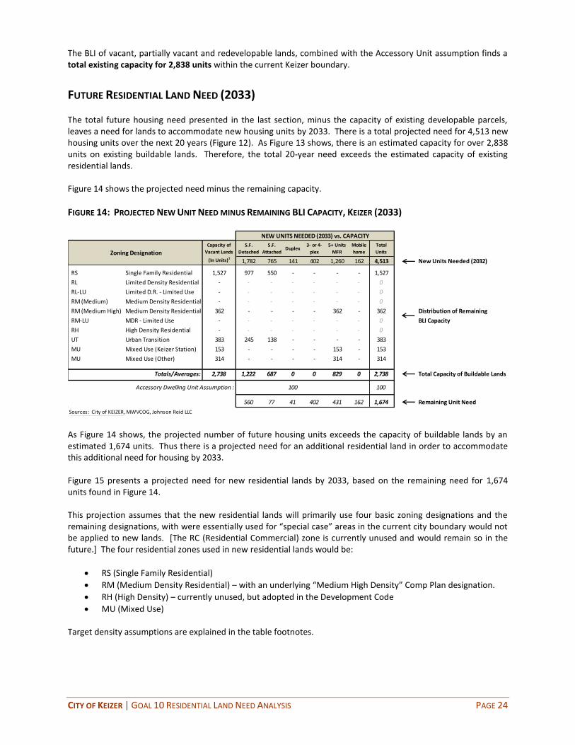
CITY OF KEIZER | GOAL 10 RESIDENTIAL LAND NEED ANALYSIS PAGE 24
The BLI of vacant, partially vacant and redevelopable lands, combined with the Accessory Unit assumption finds a total existing capacity for 2,838 units within the current Keizer boundary.
FUTURE RESIDENTIAL LAND NEED (2033) The total future housing need presented in the last section, minus the capacity of existing developable parcels, leaves a need for lands to accommodate new housing units by 2033. There is a total projected need for 4,513 new housing units over the next 20 years (Figure 12). As Figure 13 shows, there is an estimated capacity for over 2,838 units on existing buildable lands. Therefore, the total 20-year need exceeds the estimated capacity of existing residential lands. Figure 14 shows the projected need minus the remaining capacity.
FIGURE 14: PROJECTED NEW UNIT NEED MINUS REMAINING BLI CAPACITY, KEIZER (2033)
S.F.
Detached
S.F.
AttachedDuplex
3- or 4-
plex
5+ Units
MFR
Mobile
home
Total
Units
1,782 765 141 402 1,260 162 4,513 New Units Needed (2032)
RS Single Family Residential 1,527 977 550 - - - - 1,527
RL Limited Density Residential - - - - - - - 0
RL-LU Limited D.R. - Limited Use - - - - - - - 0
RM (Medium) Medium Density Residential - - - - - - - 0
RM (Medium High) Medium Density Residential 362 - - - - 362 - 362 Distribution of Remaining
RM-LU MDR - Limited Use - - - - - - - 0 BLI Capacity
RH High Density Residential - - - - - - - 0
UT Urban Transition 383 245 138 - - - - 383
MU Mixed Use (Keizer Station) 153 - - - - 153 - 153
MU Mixed Use (Other) 314 - - - - 314 - 314
Totals/Averages: 2,738 1,222 687 0 0 829 0 2,738 Total Capacity of Buildable Lands
Accessory Dwelling Unit Assumption : 100 100
560 77 41 402 431 162 1,674 Remaining Unit Need
Sources: City of KEIZER, MWVCOG, Johnson Reid LLC
NEW UNITS NEEDED (2033) vs. CAPACITY
Zoning Designation
Capacity of
Vacant Lands
(In Units)1
As Figure 14 shows, the projected number of future housing units exceeds the capacity of buildable lands by an estimated 1,674 units. Thus there is a projected need for an additional residential land in order to accommodate this additional need for housing by 2033. Figure 15 presents a projected need for new residential lands by 2033, based on the remaining need for 1,674 units found in Figure 14. This projection assumes that the new residential lands will primarily use four basic zoning designations and the remaining designations, with were essentially used for “special case” areas in the current city boundary would not be applied to new lands. [The RC (Residential Commercial) zone is currently unused and would remain so in the future.] The four residential zones used in new residential lands would be:
RS (Single Family Residential)
RM (Medium Density Residential) – with an underlying “Medium High Density” Comp Plan designation.
RH (High Density) – currently unused, but adopted in the Development Code
MU (Mixed Use) Target density assumptions are explained in the table footnotes.

CITY OF KEIZER | GOAL 10 RESIDENTIAL LAND NEED ANALYSIS PAGE 25
FIGURE 15: PROJECTED NEW RESIDENTIAL LAND NEED, KEIZER (2033)
S.F.
Detached
S.F.
AttachedDuplex
3- or 4-
plex
5+ Units
MFR
Mobile
home
Total
Units
560 77 41 402 431 162 1,674
RS Single Family Residential 560 162 722 6.6 109.4 136.8
RL Limited Density Residential 0 - - -
RL-LU Limited D.R. - Limited Use 0 - - -
RM (Medium) Medium Density Residential 0 - - -
RM (Medium High) Medium Density Residential 77 41 119 15.0 7.9 9.9
RM-LU MDR - Limited Use 0 - - -
RH High Density Residential 322 345 667 22.0 30.3 37.9
UT Urban Transition 0 - - -
MU Mixed Use (Keizer Station) 0 - - -
MU Mixed Use (Other) 80 86 167 16.8 9.9 12.4
Totals/Averages: 560 77 41 402 431 162 1,674 10.6 157.6 196.9
Sources: City of KEIZER, MWVCOG, Johnson Reid LLC
1 Target density is based on actual achieved density in the RS and MU zones.
Target dens i ty in the RM zone (15 units/acre) i s based on the median va lue of the a l lowed dens i ty range in that zone (8 to 22). This dens i ty target i s used
because the actual RM zone has his torica l ly achieved a dens i ty of 9.6 units/acre, which is low for a medium dens ity zone.
The RH zone has not his torica l ly been appl ied within the Ci ty, so a figure for the his torica l dens i ty achieved is not avai lable. The permitted dens i ty of this zone
is 16 units or more per net acre. The average target dens i ty of 22 units/acre appl ied here assumes a bui ld-out of garden apartments and townhome-style
development in this zone, which would be appropriate for a community of Keizer's s ize.
REMAINING UNIT NEED, AFTER BLI BUILD-OUT
Gross
Acreage
Needed
Target Density
(Units/ Net
Acre)1
Zoning DesignationNet
Acreage
Needed
As Figure 15 shows, there is a projected need for 196.9 gross acres of new residential land needed by 2033. A majority of the land (69%) is projected to be for single-family and mobile home unit demand. At a lower density, these units require more land to accommodate. The attached units, while constituting a greater share of unit need, can be accommodated on less land in the higher-density zones. The provision of additional land outside of the current UGB is highly policy dependent, so the mixture of land area covered by different zoning designations may be adjusted to include either more or less of any given zone, as long as the total surplus housing need (in units) is accommodated.
PARK AND SCHOOL FACILITY NEEDS (2033) In addition to the projected need for new residential land discussed above, there will be an accompanying need for new park and school facility lands to serve the new households. Methodology drawn from the City of Keizer Parks Master Plan and data from the Salem-Keizer Public Schools Planning and Property Services department were used to estimate future facilities needs associated with the projected 20-year population and housing growth. Park Land Needs The City of Keizer Parks and Recreation Master Plan adopted in January 2008 included an assessment of existing parks and recreation facilities with comparison to current population, to determine what deficiencies might exist. The 2008 analysis (outlined in Appendix D of that report), found that at the time, the developed parks inventory of 40.7 acres was roughly sufficient to provide 1.2 acre of parks space per 1,000 Keizer residents. The report notes that is much less than the amount of park land in most Oregon communities, which average between four and six acres per 1,000 residents.
8
8 “City of Keizer, Oregon – Parks and Recreation Master Plan”, January 2008, Appendix D, Page 8. The analysis in Appendix D
uses park acreage numbers which are somewhat lower that those found in the final “existing conditions” chapter of the report (for instance 36.7 acres of developed park vs. 40.7 acres). This discussion uses the higher acreage figures found in the “existing conditions” section.
CITY OF KEIZER | GOAL 10 RESIDENTIAL LAND NEED ANALYSIS PAGE 26
However, the 2008 analysis points out that at the time of the analysis, there were five planned parks which would bring an additional 136.2 acres of developed park inventory to the community (Keizer Rapids, Bair Park, Keizer Station, Palma Ciea, River’s Edge Parks). The analysis found that upon completion of these planned parks there would be sufficient developed park acreage to represent 4.4 acres per 1,000 residents for the projected 2030 population of 39,994. (This is the 2030 population projected in the Parks Master Plan, and differs from the 2033 projection in this housing analysis, as discussed below.) This provision of 4.3 acres per 1,000 people was deemed sufficient by the Parks Master Plan for those 39,994 residents in 2030. However, the 2033 projection included in this report exceeds this population mark by 8,703 people and therefore additional park land will be required to serve this additional population. This analysis adopts 5 acres/1,000 residents as the standard going forward as the middle of the 4-to-6 acre range cited in the Master Plan. The following outlines the analytic steps:
Assuming full development of the five planned parks, the estimated 2030 population of 39,994 would be served by 4.4 acres of developed park per 1000 residents. (176.9 existing and planned acres/ 39,994/ 1,000).
The projected 2033 population presented in this report (Figure 10) is 48,697 people. This is a net gain of 8,703 residents over the 2030 figure in the Parks Master Plan. This net new population would need to be served by new park land (over and above the five planned parks).
New park land to serve the new population (8,703) is estimated at 43.5 acres (based on the 5 acres/1,000 residents standard).
Therefore this analysis finds the need for a total of 43.5 gross acres of new land for parks over the 20-year period. This new gross need is in addition to the 120 acres of Keizer Rapids Park, some of which is not currently within the Urban Growth Boundary (UGB). This Keizer Rapids acreage, if brought into the UGB, would serve the projected 2030 population, but not the additional 8,703 new residents. Therefore the needed 43.5 gross acres is in addition to the 120 acres of Keizer Rapids Park. The Parks and Recreation Master Plan is best suited to help determine the breakdown and nature of these new park areas. The Master Plan also assesses the needs for specific Parks and Rec components such as playgrounds and ball fields. These facilities are assumed to be included in the gross acreage figure presented above. School Facilities Land Needs The Salem-Keizer Public Schools Planning and Property Services department provided information and data on how they estimate school facilities needs over time. This process was coordinated with the school district in keeping with ORS 195.110 9(b) and uses the district’s methodology and data for estimating need. The analysis uses an estimate of the number of students per household, based on different housing types. The following table is reproduced from the “Student Density by Housing Type” report from August 2006, which provides the standards the district applies. This data was compiled by the Mid-Willamette Valley Council of Governments. (While this report includes a similar table focused on just the McNary High School attendance area, the district reports using only the district-wide averages in its own calculation, and therefore they have been applied here.)

CITY OF KEIZER | GOAL 10 RESIDENTIAL LAND NEED ANALYSIS PAGE 27
FIGURE 16: REPRODUCED FROM STUDENT DENSITY STUDY
Source: “Student Density by Housing Type”, MWVCOG, 2006, Page 10.
FIGURE 17: STUDENT POPULATION AND CAPACITY OF KEIZER SCHOOLS (FALL 2012)
SchoolsFull
Capacity
Student
Population
Elementary
Cummings 463 390 73 16%
Keizer 682 604 78 11%
Kennedy 543 456 87 16%
Weddle 501 449 52 10%
Clear Lake 503 483 20 4%
Forest Ridge 463 376 87 19%
Gubser 543 477 66 12%
Total: 3,698 3,235 463 13%
Middle School
Claggett Creek 1,040 948 92 9%
Whiteaker 871 776 95 11%
Total: 1,911 1,724 187 10%
High School
McNary 2,072 2,037 35 2%
Remaining
Capacity
Source: Salem-Keizer Public Schools, Johnson Reid LLC
Figure 18 applies the density factors (Figure 16) to the projected 20-year need for new housing units (Figure 12). Not all projected housing types included in the 20-year projection are included in Figure 16, so in some cases the average density for the closest housing type was assumed.

CITY OF KEIZER | GOAL 10 RESIDENTIAL LAND NEED ANALYSIS PAGE 28
FIGURE 18: ESTIMATED NEW STUDENTS (2033) MINUS EXISTING CAPACITY
elem. middle high elem. middle high
S.F. Detached 1,782 0.277 0.128 0.162 494 228 289
S.F. Attached 765 0.277 0.128 0.162 212 98 124
Duplex 141 0.176 0.069 0.067 25 10 9
3- or 4-plex 402 0.176 0.069 0.067 71 28 27
5+ Units MFR 1,260 0.131 0.050 0.049 165 63 62
Mobile home 162 0.277 0.128 0.162 45 21 26
Total Units 4,513 1011 447 537
Current remaining capacity: 463 187 35
Additional students (20 years): 548 260 502
As % of Average Current School Size: 100% 27% 24%
Average Student Densities Projected New StudentsNEW UNITS NEEDED (2033)
Source: Salem-Keizer Public Schools, Johnson Reid LLC
The projected housing types would represent 1,995 new students based on the school district’s density factors.
Minus the current excess capacity in existing schools, there is a remaining need for facilities for 1,310 students.
Broken down by school type, the remaining 20-year projection of students would be enough to fill one elementary school, and roughly 25% each of a middle school and high school (based on student body size of current schools in Keizer.)
Based on these findings, there will be projected need for land to accommodate a new elementary school during the 20-year period. The school district uses a size standard of 10 acres for elementary schools in its planning.
While these additional middle and high school students will create additional demand on the current schools, a conservative assumption is that this is not enough to project new schools at these levels during the 20-year period. This excess demand may possibly be accommodated through shifting boundaries in the greater Salem-Keizer district until growth is high enough to warrant new schools.
Based on the above findings there is total projected need for 10 acres to accommodate a new elementary school facility over the 20-year period.

CITY OF KEIZER | GOAL 10 RESIDENTIAL LAND NEED ANALYSIS PAGE 29
TOTAL RESIDENTIAL AND PUBLIC FACILITY LAND NEEDS (2033) Based on the findings of projected land need presented above, this analysis concludes a total 20-year land need for residential, schools and park land need as follows:
FIGURE 19: ESTIMATED TOTAL NEW LAND NEED (2033)
Remaining Need
Residential: 196.9
Parks and Recreation: 43.5
Schools: 10
Total New 20-Year Land Need: 250.4
Category of LandGross Acreage
Source: Johnson Reid LLC Note: The analysis of needed land areas finds the acreage which is anticipated to supply the identified uses. These lands are not substitutable for other or additional uses identified in the future. For instance, if 15 acres of future residential land is needed for a new use not identified here, the need for those 15 acres for residential uses still exists. Therefore most additional uses not specifically identified above will be in addition to the finding of land need. For example, a conservative estimate is being made to include needed land for one additional elementary school (10 acres). Should the school district determine in the future a need for more land for additional schools, that need would have to be addressed outside and independent of this process. The school district has available to it an expedited process of UGB expansion of under 50 acres to address needed lands. It would be expected that the district would implement this or another alternative to address such an unanticipated need. The needed land could not come from another category of land use such as residential.

CITY OF KEIZER | GOAL 10 RESIDENTIAL LAND NEED ANALYSIS PAGE 30
GOAL 10 HOUSING EXHIBITS

2000 2010 Growth Rate 2013 Growth Rate
(Census) (Census) 00-10 (Proj.) 10-13
Population1 32,203 36,478 1.3% 36,864 0.4%
Households2 12,110 13,703 1.2% 13,824 0.3%
Families3 8,642 9,498 0.9% 9,582 0.3%
Housing Units4 12,774 14,445 1.2% 14,531 0.2%
Group Quarters Population5 280 364 2.7% 368 0.4%
Household Size 2.64 2.64 0.0% 2.64 0.0%
2000 2010 Growth Rate 2013 Growth Rate
(Census) (Est.) 00-10 (Proj.) 10-13
Per Capita ($) $20,119 $24,645 2.0% $26,192 2.0%
Average HH ($) $53,425 $64,272 1.9% $67,937 1.9%
Median HH ($) $45,052 $53,042 1.6% $55,705 1.6%
SOURCE: Claritas, Census, and Johnson Reid
2 2013 Households = 2013 population/2013 HH Size
3 Ratio of 2013 Families to total HH is kept constant from 2010.
5 Ratio of 2012 Group Quarters Population to Total Population is kept constant from 2010.
4 2013 housing units are the 2010 Census total plus new units permitted from '10 through '12 (source: HUD State of the Cities Data System)
PER CAPITA AND AVERAGE HOUSEHOLD INCOME
EXHIBIT 1
GENERAL DEMOGRAPHIC PROFILE
KEIZER, OREGON
POPULATION, HOUSEHOLDS, FAMILIES, AND YEAR-ROUND HOUSING UNITS
1 Population is based on the certified 2012 estimate from PSU Population Research Center, projected forward one year using the 2010 - 2012
growth rate (0.4%)

SOURCE
Total 2013 Population: 36,864US Census, PSU Pop. Research
Center
- Estimated group housing population: 368 (1.0% of Total) US Census
Estimated Non-Group 2013 Population: 36,496 (Total - Group)
Avg. HH Size: 2.64 US Census
Estimated Non-Group 2013 Households: 13,824 (Pop/HH Size)
Total Housing Units: 14,531 (Occupied + Vacant) Census 2010 + permits
Occupied Housing Units: 13,824 (= # of HH)
Vacant Housing Units: 707 (Total HH - Occupied)
Current Vacancy Rate: 4.9% (Vacant units/ Total units)
Sources: Johnson Reid, LLC, City of KEIZER, PSU Population Research Center, U.S. Census
KEIZER, OREGON
PROFILE OF CURRENT HOUSING CONDITIONS
EXHIBIT 2
CURRENT HOUSING CONDITIONS (2013)
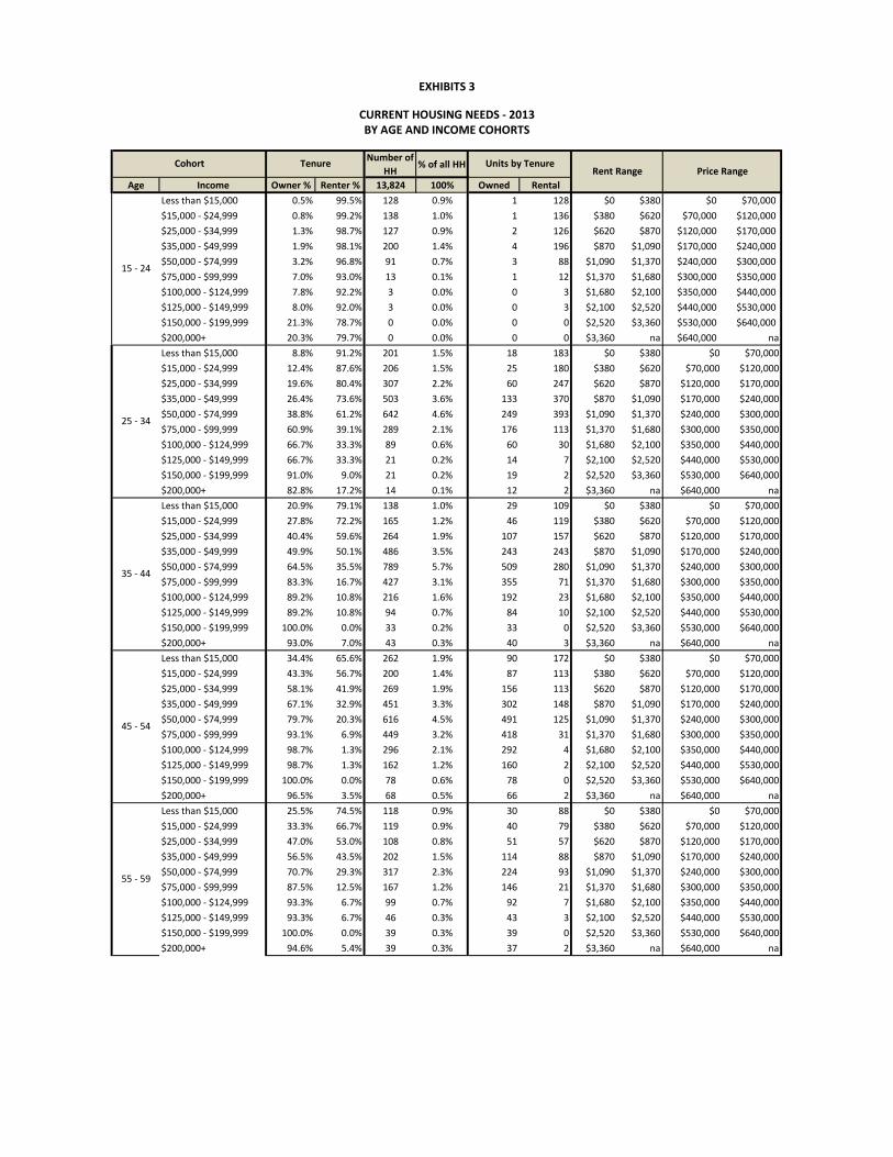
Number of
HH% of all HH
Age Income Owner % Renter % 13,824 100% Owned Rental
Less than $15,000 0.5% 99.5% 128 0.9% 1 128 $0 $380 $0 $70,000
$15,000 - $24,999 0.8% 99.2% 138 1.0% 1 136 $380 $620 $70,000 $120,000
$25,000 - $34,999 1.3% 98.7% 127 0.9% 2 126 $620 $870 $120,000 $170,000
$35,000 - $49,999 1.9% 98.1% 200 1.4% 4 196 $870 $1,090 $170,000 $240,000
$50,000 - $74,999 3.2% 96.8% 91 0.7% 3 88 $1,090 $1,370 $240,000 $300,000
$75,000 - $99,999 7.0% 93.0% 13 0.1% 1 12 $1,370 $1,680 $300,000 $350,000
$100,000 - $124,999 7.8% 92.2% 3 0.0% 0 3 $1,680 $2,100 $350,000 $440,000
$125,000 - $149,999 8.0% 92.0% 3 0.0% 0 3 $2,100 $2,520 $440,000 $530,000
$150,000 - $199,999 21.3% 78.7% 0 0.0% 0 0 $2,520 $3,360 $530,000 $640,000
$200,000+ 20.3% 79.7% 0 0.0% 0 0 $3,360 na $640,000 na
Less than $15,000 8.8% 91.2% 201 1.5% 18 183 $0 $380 $0 $70,000
$15,000 - $24,999 12.4% 87.6% 206 1.5% 25 180 $380 $620 $70,000 $120,000
$25,000 - $34,999 19.6% 80.4% 307 2.2% 60 247 $620 $870 $120,000 $170,000
$35,000 - $49,999 26.4% 73.6% 503 3.6% 133 370 $870 $1,090 $170,000 $240,000
$50,000 - $74,999 38.8% 61.2% 642 4.6% 249 393 $1,090 $1,370 $240,000 $300,000
$75,000 - $99,999 60.9% 39.1% 289 2.1% 176 113 $1,370 $1,680 $300,000 $350,000
$100,000 - $124,999 66.7% 33.3% 89 0.6% 60 30 $1,680 $2,100 $350,000 $440,000
$125,000 - $149,999 66.7% 33.3% 21 0.2% 14 7 $2,100 $2,520 $440,000 $530,000
$150,000 - $199,999 91.0% 9.0% 21 0.2% 19 2 $2,520 $3,360 $530,000 $640,000
$200,000+ 82.8% 17.2% 14 0.1% 12 2 $3,360 na $640,000 na
Less than $15,000 20.9% 79.1% 138 1.0% 29 109 $0 $380 $0 $70,000
$15,000 - $24,999 27.8% 72.2% 165 1.2% 46 119 $380 $620 $70,000 $120,000
$25,000 - $34,999 40.4% 59.6% 264 1.9% 107 157 $620 $870 $120,000 $170,000
$35,000 - $49,999 49.9% 50.1% 486 3.5% 243 243 $870 $1,090 $170,000 $240,000
$50,000 - $74,999 64.5% 35.5% 789 5.7% 509 280 $1,090 $1,370 $240,000 $300,000
$75,000 - $99,999 83.3% 16.7% 427 3.1% 355 71 $1,370 $1,680 $300,000 $350,000
$100,000 - $124,999 89.2% 10.8% 216 1.6% 192 23 $1,680 $2,100 $350,000 $440,000
$125,000 - $149,999 89.2% 10.8% 94 0.7% 84 10 $2,100 $2,520 $440,000 $530,000
$150,000 - $199,999 100.0% 0.0% 33 0.2% 33 0 $2,520 $3,360 $530,000 $640,000
$200,000+ 93.0% 7.0% 43 0.3% 40 3 $3,360 na $640,000 na
Less than $15,000 34.4% 65.6% 262 1.9% 90 172 $0 $380 $0 $70,000
$15,000 - $24,999 43.3% 56.7% 200 1.4% 87 113 $380 $620 $70,000 $120,000
$25,000 - $34,999 58.1% 41.9% 269 1.9% 156 113 $620 $870 $120,000 $170,000
$35,000 - $49,999 67.1% 32.9% 451 3.3% 302 148 $870 $1,090 $170,000 $240,000
$50,000 - $74,999 79.7% 20.3% 616 4.5% 491 125 $1,090 $1,370 $240,000 $300,000
$75,000 - $99,999 93.1% 6.9% 449 3.2% 418 31 $1,370 $1,680 $300,000 $350,000
$100,000 - $124,999 98.7% 1.3% 296 2.1% 292 4 $1,680 $2,100 $350,000 $440,000
$125,000 - $149,999 98.7% 1.3% 162 1.2% 160 2 $2,100 $2,520 $440,000 $530,000
$150,000 - $199,999 100.0% 0.0% 78 0.6% 78 0 $2,520 $3,360 $530,000 $640,000
$200,000+ 96.5% 3.5% 68 0.5% 66 2 $3,360 na $640,000 na
Less than $15,000 25.5% 74.5% 118 0.9% 30 88 $0 $380 $0 $70,000
$15,000 - $24,999 33.3% 66.7% 119 0.9% 40 79 $380 $620 $70,000 $120,000
$25,000 - $34,999 47.0% 53.0% 108 0.8% 51 57 $620 $870 $120,000 $170,000
$35,000 - $49,999 56.5% 43.5% 202 1.5% 114 88 $870 $1,090 $170,000 $240,000
$50,000 - $74,999 70.7% 29.3% 317 2.3% 224 93 $1,090 $1,370 $240,000 $300,000
$75,000 - $99,999 87.5% 12.5% 167 1.2% 146 21 $1,370 $1,680 $300,000 $350,000
$100,000 - $124,999 93.3% 6.7% 99 0.7% 92 7 $1,680 $2,100 $350,000 $440,000
$125,000 - $149,999 93.3% 6.7% 46 0.3% 43 3 $2,100 $2,520 $440,000 $530,000
$150,000 - $199,999 100.0% 0.0% 39 0.3% 39 0 $2,520 $3,360 $530,000 $640,000
$200,000+ 94.6% 5.4% 39 0.3% 37 2 $3,360 na $640,000 na
35 - 44
45 - 54
Cohort Tenure Units by Tenure
15 - 24
EXHIBITS 3
55 - 59
Rent Range Price Range
CURRENT HOUSING NEEDS - 2013BY AGE AND INCOME COHORTS
25 - 34

Number of
HH% of all HH
Age Income Owner % Renter % 13,824 100% Owned Rental
Cohort Tenure Units by Tenure
15 - 24
EXHIBITS 3
Rent Range Price Range
CURRENT HOUSING NEEDS - 2013BY AGE AND INCOME COHORTS
Less than $15,000 49.1% 50.9% 122 0.9% 60 62 $0 $380 $0 $70,000
$15,000 - $24,999 58.4% 41.6% 124 0.9% 72 52 $380 $620 $70,000 $120,000
$25,000 - $34,999 72.9% 27.1% 112 0.8% 82 30 $620 $870 $120,000 $170,000
$35,000 - $49,999 79.8% 20.2% 210 1.5% 168 43 $870 $1,090 $170,000 $240,000
$50,000 - $74,999 89.5% 10.5% 330 2.4% 295 35 $1,090 $1,370 $240,000 $300,000
$75,000 - $99,999 98.5% 1.5% 174 1.3% 171 3 $1,370 $1,680 $300,000 $350,000
$100,000 - $124,999 100.0% 0.0% 103 0.7% 103 0 $1,680 $2,100 $350,000 $440,000
$125,000 - $149,999 100.0% 0.0% 48 0.3% 48 0 $2,100 $2,520 $440,000 $530,000
$150,000 - $199,999 100.0% 0.0% 40 0.3% 40 0 $2,520 $3,360 $530,000 $640,000
$200,000+ 98.1% 1.9% 40 0.3% 40 1 $3,360 na $640,000 na
Less than $15,000 53.5% 46.5% 214 1.5% 114 99 $0 $380 $0 $70,000
$15,000 - $24,999 62.7% 37.3% 208 1.5% 130 77 $380 $620 $70,000 $120,000
$25,000 - $34,999 76.7% 23.3% 241 1.7% 185 56 $620 $870 $120,000 $170,000
$35,000 - $49,999 82.9% 17.1% 246 1.8% 204 42 $870 $1,090 $170,000 $240,000
$50,000 - $74,999 91.7% 8.3% 283 2.0% 260 23 $1,090 $1,370 $240,000 $300,000
$75,000 - $99,999 99.6% 0.4% 144 1.0% 143 1 $1,370 $1,680 $300,000 $350,000
$100,000 - $124,999 100.0% 0.0% 58 0.4% 58 0 $1,680 $2,100 $350,000 $440,000
$125,000 - $149,999 100.0% 0.0% 26 0.2% 26 0 $2,100 $2,520 $440,000 $530,000
$150,000 - $199,999 98.5% 1.5% 40 0.3% 40 1 $2,520 $3,360 $530,000 $640,000
$200,000+ 98.5% 1.5% 15 0.1% 15 0 $3,360 na $640,000 na
Less than $15,000 52.2% 47.8% 166 1.2% 87 79 $0 $380 $0 $70,000
$15,000 - $24,999 61.5% 38.5% 201 1.5% 123 77 $380 $620 $70,000 $120,000
$25,000 - $34,999 75.6% 24.4% 223 1.6% 169 54 $620 $870 $120,000 $170,000
$35,000 - $49,999 82.0% 18.0% 119 0.9% 98 22 $870 $1,090 $170,000 $240,000
$50,000 - $74,999 88.5% 11.5% 146 1.1% 129 17 $1,090 $1,370 $240,000 $300,000
$75,000 - $99,999 96.5% 3.5% 27 0.2% 26 1 $1,370 $1,680 $300,000 $350,000
$100,000 - $124,999 99.9% 0.1% 21 0.2% 21 0 $1,680 $2,100 $350,000 $440,000
$125,000 - $149,999 100.0% 0.0% 20 0.1% 20 0 $2,100 $2,520 $440,000 $530,000
$150,000 - $199,999 98.4% 1.6% 9 0.1% 9 0 $2,520 $3,360 $530,000 $640,000
$200,000+ 98.4% 1.6% 0 0.0% 0 0 $3,360 na $640,000 na
Less than $15,000 16.5% 83.5% 83 0.6% 14 70 $0 $380 $0 $70,000
$15,000 - $24,999 22.4% 77.6% 72 0.5% 16 56 $380 $620 $70,000 $120,000
$25,000 - $34,999 33.5% 66.5% 83 0.6% 28 55 $620 $870 $120,000 $170,000
$35,000 - $49,999 42.6% 57.4% 44 0.3% 19 25 $870 $1,090 $170,000 $240,000
$50,000 - $74,999 55.5% 44.5% 43 0.3% 24 19 $1,090 $1,370 $240,000 $300,000
$75,000 - $99,999 74.0% 26.0% 8 0.1% 6 2 $1,370 $1,680 $300,000 $350,000
$100,000 - $124,999 76.1% 23.9% 10 0.1% 8 2 $1,680 $2,100 $350,000 $440,000
$125,000 - $149,999 76.1% 23.9% 10 0.1% 8 2 $2,100 $2,520 $440,000 $530,000
$150,000 - $199,999 90.8% 9.2% 5 0.0% 5 0 $2,520 $3,360 $530,000 $640,000
$200,000+ 90.8% 9.2% 0 0.0% 0 0 $3,360 na $640,000 na
TOTALS: 13,824 100.0% 8,432 5,392
Source: Johnson Reid LLC
65 - 74
75 - 84
85+
60 - 64

Price Range# of
HouseholdsIncome Range
% of
TotalCumulative
$0k - $70k 442 Less than $15,000 5.2% 5.2%
$70k - $120k 541 $15,000 - $24,999 6.4% 11.7%
$120k - $170k 839 $25,000 - $34,999 9.9% 21.6%
$170k - $240k 1,284 $35,000 - $49,999 15.2% 36.8%
$240k - $300k 2,184 $50,000 - $74,999 25.9% 62.7%
$300k - $350k 1,442 $75,000 - $99,999 17.1% 79.8%
$350k - $440k 827 $100,000 - $124,999 9.8% 89.6% Census 2010:
$440k - $530k 402 $125,000 - $149,999 4.8% 94.4%
$530k - $640k 263 $150,000 - $199,999 3.1% 97.5%
$640k + 209 $200,000+ 2.5% 100.0%
Totals: 8,432 % of All: 61.0%
Rent Level# of
HouseholdsIncome Range
% of
TotalCumulative
$0 - $380 990 Less than $15,000 18.4% 18.4%
$380 - $620 891 $15,000 - $24,999 16.5% 34.9%
$620 - $870 896 $25,000 - $34,999 16.6% 51.5%
$870 - $1090 1,177 $35,000 - $49,999 21.8% 73.3%
$1090 - $1370 1,074 $50,000 - $74,999 19.9% 93.2%
$1370 - $1680 255 $75,000 - $99,999 4.7% 98.0%
$1680 - $2100 69 $100,000 - $124,999 1.3% 99.2%
$2100 - $2520 28 $125,000 - $149,999 0.5% 99.7%
$2520 - $3360 3 $150,000 - $199,999 0.1% 99.8%
$3360 + 11 $200,000+ 0.2% 100.0% All Households
Totals: 5,392 % of All: 39.0% 13,824
Source: Johnson Reid LLC
Ownership
EXHIBITS 4
CURRENT HOUSING NEEDS (2013)
INDICATED BY TENURE AND COST
Rental

Price RangeSingle Family
Detached
Single Family
AttachedDuplex
3- or 4-
plex
5+ Units
MFR
Mobile
home
Boat, RV,
other temp
Total
Units% of Units Cummulative %
$0k - $70k 211 9 0 7 0 275 0 502 5.8% 5.8%
$70k - $120k 193 12 0 17 0 142 0 363 4.2% 10.0%
$120k - $170k 1,417 41 0 7 0 0 0 1,465 16.9% 26.8%
$170k - $240k 3,405 63 0 3 0 0 0 3,471 39.9% 66.7%
$240k - $300k 1,049 19 0 0 0 0 0 1,068 12.3% 79.0%
$300k - $350k 632 12 0 0 0 0 0 644 7.4% 86.4%
$350k - $440k 757 5 0 0 0 0 0 762 8.8% 95.2%
$440k - $530k 199 0 0 0 0 0 0 199 2.3% 97.5%
$530k - $640k 84 0 0 0 0 0 0 84 1.0% 98.5%
$640k + 134 0 0 0 0 0 0 134 1.5% 100.0%
Totals: 8,081 161 0 34 0 417 0 8,693 % of All Units: 59.8%
Percentage: 93.0% 1.9% 0.0% 0.4% 0.0% 4.8% 0.0% 100.0%
Price RangeSingle Family
Detached
Single Family
AttachedDuplex
3- or 4-
plex
5+ Units
MFR
Mobile
home
Boat, RV,
other temp
Total
Units% of Units Cummulative %
$0 - $380 8 15 8 21 55 38 0 146 2.5% 2.5%
$380 - $620 173 170 64 188 452 64 0 1,111 19.0% 21.5%
$620 - $870 420 382 145 456 1,199 26 0 2,628 45.0% 66.5%
$870 - $1090 300 194 82 242 603 0 0 1,420 24.3% 90.9%
$1090 - $1370 94 74 17 44 63 0 0 292 5.0% 95.9%
$1370 - $1680 42 16 6 6 27 0 0 97 1.7% 97.5%
$1680 - $2100 36 25 4 0 0 0 0 64 1.1% 98.6%
$2100 - $2520 45 20 0 0 0 0 0 65 1.1% 99.7%
$2520 - $3360 16 0 0 0 0 0 0 16 0.3% 100.0%
$3360 + 0 0 0 0 0 0 0 0 0.0% 100.0%
Totals: 1,134 896 324 958 2,399 128 0 5,838 % of All Units: 40.2%
Percentage: 19.4% 15.3% 5.6% 16.4% 41.1% 2.2% 0.0% 100.0%
Single Family
Detached
Single Family
AttachedDuplex
3- or 4-
plex
5+ Units
MFR
Mobile
home
Boat, RV,
other temp
Total
Units% of Units
Totals: 9,215 1,056 324 992 2,399 544 0 14,531 100%
Percentage: 63.4% 7.3% 2.2% 6.8% 16.5% 3.7% 0.0% 100.0%
Sources: Claritas Inc., Census, Johnson Reid
CURRENT HOUSING INVENTORY BY PRICE/RENT RANGE
EXHIBITS 5
TOTAL HOUSING UNITS
OWNERSHIP HOUSING
RENTAL HOUSING

Price Range
Estimated
Current
Need
Estimated
Current
Supply
Unmet
(Need) or
Surplus
Rent
Estimated
Current
Need
Estimated
Current
Supply
Unmet
(Need) or
Surplus
$0k - $70k 442 502 60 $0 - $380 990 146 (844)
$70k - $120k 541 363 (177) $380 - $620 891 1,111 220
$120k - $170k 839 1,465 627 $620 - $870 896 2,628 1731
$170k - $240k 1,284 3,471 2187 $870 - $1090 1,177 1,420 243
$240k - $300k 2,184 1,068 (1116) $1090 - $1370 1,074 292 (782)
$300k - $350k 1,442 644 (798) $1370 - $1680 255 97 (158)
$350k - $440k 827 762 (65) $1680 - $2100 69 64 (4)
$440k - $530k 402 199 (203) $2100 - $2520 28 65 37
$530k - $640k 263 84 (179) $2520 - $3360 3 16 13
$640k + 209 134 (75) $3360 + 11 0 (11)
Totals: 8,432 8,693 261 Totals: 5,392 5,838 446
Occupied Units: 13,824
All Housing Units: 14,531
Total Unit Surplus: 707
Sources: Claritas, Census, Johnson Reid
EXHIBITS 6
Ownership Rental
INDICATED BY TENURE AND COST
CURRENT HOUSING NEEDS COMPARED TO CURRENT SUPPLY (2013)

SOURCE
2013 Population (Minus Group Pop.) 36,496 2010 Census, PSU
Projected Annual Growth Rate 1.41% Based on Keizer adopted 2032 forecast City of Keizer
2033 Population (Minus Group Pop.) 48,260
Estimated group housing population: 437 From Marion County 2030 adopted forecast Marion Co.
Total Estimated 2033 Population: 48,697 Based on adopted 2032 population forecast (48,089 pop.) City of Keizer
Estimated Non-Group 2033 Households: 18,191 Based on Pop/HH ratio from County 2030 forecast Marion Co.
New Households 2013 to 2033 4,366
Avg. Household Size: 2.65 2032 Non-Group Pop/ Non-Group Households
Total Housing Units: 19,044 Based on Units/HH ratio from County 2030 forecast Marion Co.
Occupied Housing Units: 18,191 (= Number of Non-Group Households)
Vacant Housing Units: 854 (Total Units - Occupied Units)
Projected Vacancy Rate: 4.5% (Vacant Units/ Total Units)
PROJECTED FUTURE HOUSING CONDITIONS (2013 - 2033)
EXHIBIT 7
PROFILE OF FUTURE HOUSING CONDITIONS
KEIZER, OREGON
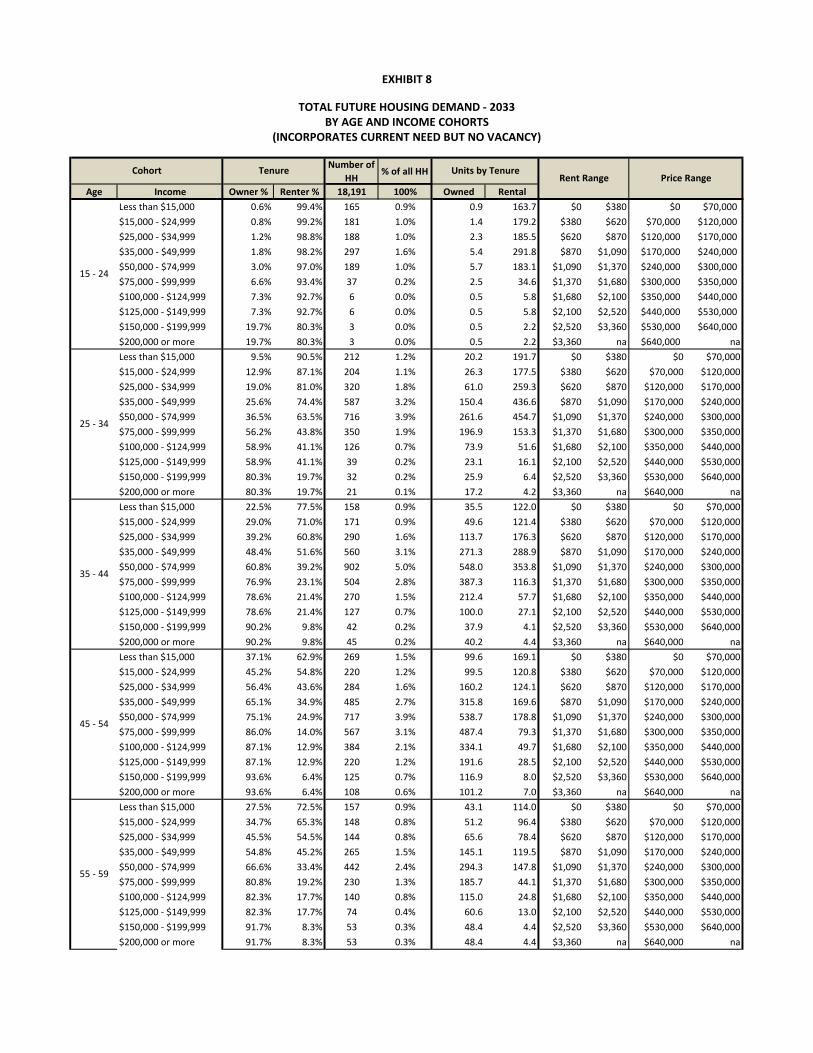
Number of
HH% of all HH
Age Income Owner % Renter % 18,191 100% Owned Rental
Less than $15,000 0.6% 99.4% 165 0.9% 0.9 163.7 $0 $380 $0 $70,000
$15,000 - $24,999 0.8% 99.2% 181 1.0% 1.4 179.2 $380 $620 $70,000 $120,000
$25,000 - $34,999 1.2% 98.8% 188 1.0% 2.3 185.5 $620 $870 $120,000 $170,000
$35,000 - $49,999 1.8% 98.2% 297 1.6% 5.4 291.8 $870 $1,090 $170,000 $240,000
$50,000 - $74,999 3.0% 97.0% 189 1.0% 5.7 183.1 $1,090 $1,370 $240,000 $300,000
$75,000 - $99,999 6.6% 93.4% 37 0.2% 2.5 34.6 $1,370 $1,680 $300,000 $350,000
$100,000 - $124,999 7.3% 92.7% 6 0.0% 0.5 5.8 $1,680 $2,100 $350,000 $440,000
$125,000 - $149,999 7.3% 92.7% 6 0.0% 0.5 5.8 $2,100 $2,520 $440,000 $530,000
$150,000 - $199,999 19.7% 80.3% 3 0.0% 0.5 2.2 $2,520 $3,360 $530,000 $640,000
$200,000 or more 19.7% 80.3% 3 0.0% 0.5 2.2 $3,360 na $640,000 na
Less than $15,000 9.5% 90.5% 212 1.2% 20.2 191.7 $0 $380 $0 $70,000
$15,000 - $24,999 12.9% 87.1% 204 1.1% 26.3 177.5 $380 $620 $70,000 $120,000
$25,000 - $34,999 19.0% 81.0% 320 1.8% 61.0 259.3 $620 $870 $120,000 $170,000
$35,000 - $49,999 25.6% 74.4% 587 3.2% 150.4 436.6 $870 $1,090 $170,000 $240,000
$50,000 - $74,999 36.5% 63.5% 716 3.9% 261.6 454.7 $1,090 $1,370 $240,000 $300,000
$75,000 - $99,999 56.2% 43.8% 350 1.9% 196.9 153.3 $1,370 $1,680 $300,000 $350,000
$100,000 - $124,999 58.9% 41.1% 126 0.7% 73.9 51.6 $1,680 $2,100 $350,000 $440,000
$125,000 - $149,999 58.9% 41.1% 39 0.2% 23.1 16.1 $2,100 $2,520 $440,000 $530,000
$150,000 - $199,999 80.3% 19.7% 32 0.2% 25.9 6.4 $2,520 $3,360 $530,000 $640,000
$200,000 or more 80.3% 19.7% 21 0.1% 17.2 4.2 $3,360 na $640,000 na
Less than $15,000 22.5% 77.5% 158 0.9% 35.5 122.0 $0 $380 $0 $70,000
$15,000 - $24,999 29.0% 71.0% 171 0.9% 49.6 121.4 $380 $620 $70,000 $120,000
$25,000 - $34,999 39.2% 60.8% 290 1.6% 113.7 176.3 $620 $870 $120,000 $170,000
$35,000 - $49,999 48.4% 51.6% 560 3.1% 271.3 288.9 $870 $1,090 $170,000 $240,000
$50,000 - $74,999 60.8% 39.2% 902 5.0% 548.0 353.8 $1,090 $1,370 $240,000 $300,000
$75,000 - $99,999 76.9% 23.1% 504 2.8% 387.3 116.3 $1,370 $1,680 $300,000 $350,000
$100,000 - $124,999 78.6% 21.4% 270 1.5% 212.4 57.7 $1,680 $2,100 $350,000 $440,000
$125,000 - $149,999 78.6% 21.4% 127 0.7% 100.0 27.1 $2,100 $2,520 $440,000 $530,000
$150,000 - $199,999 90.2% 9.8% 42 0.2% 37.9 4.1 $2,520 $3,360 $530,000 $640,000
$200,000 or more 90.2% 9.8% 45 0.2% 40.2 4.4 $3,360 na $640,000 na
Less than $15,000 37.1% 62.9% 269 1.5% 99.6 169.1 $0 $380 $0 $70,000
$15,000 - $24,999 45.2% 54.8% 220 1.2% 99.5 120.8 $380 $620 $70,000 $120,000
$25,000 - $34,999 56.4% 43.6% 284 1.6% 160.2 124.1 $620 $870 $120,000 $170,000
$35,000 - $49,999 65.1% 34.9% 485 2.7% 315.8 169.6 $870 $1,090 $170,000 $240,000
$50,000 - $74,999 75.1% 24.9% 717 3.9% 538.7 178.8 $1,090 $1,370 $240,000 $300,000
$75,000 - $99,999 86.0% 14.0% 567 3.1% 487.4 79.3 $1,370 $1,680 $300,000 $350,000
$100,000 - $124,999 87.1% 12.9% 384 2.1% 334.1 49.7 $1,680 $2,100 $350,000 $440,000
$125,000 - $149,999 87.1% 12.9% 220 1.2% 191.6 28.5 $2,100 $2,520 $440,000 $530,000
$150,000 - $199,999 93.6% 6.4% 125 0.7% 116.9 8.0 $2,520 $3,360 $530,000 $640,000
$200,000 or more 93.6% 6.4% 108 0.6% 101.2 7.0 $3,360 na $640,000 na
Less than $15,000 27.5% 72.5% 157 0.9% 43.1 114.0 $0 $380 $0 $70,000
$15,000 - $24,999 34.7% 65.3% 148 0.8% 51.2 96.4 $380 $620 $70,000 $120,000
$25,000 - $34,999 45.5% 54.5% 144 0.8% 65.6 78.4 $620 $870 $120,000 $170,000
$35,000 - $49,999 54.8% 45.2% 265 1.5% 145.1 119.5 $870 $1,090 $170,000 $240,000
$50,000 - $74,999 66.6% 33.4% 442 2.4% 294.3 147.8 $1,090 $1,370 $240,000 $300,000
$75,000 - $99,999 80.8% 19.2% 230 1.3% 185.7 44.1 $1,370 $1,680 $300,000 $350,000
$100,000 - $124,999 82.3% 17.7% 140 0.8% 115.0 24.8 $1,680 $2,100 $350,000 $440,000
$125,000 - $149,999 82.3% 17.7% 74 0.4% 60.6 13.0 $2,100 $2,520 $440,000 $530,000
$150,000 - $199,999 91.7% 8.3% 53 0.3% 48.4 4.4 $2,520 $3,360 $530,000 $640,000
$200,000 or more 91.7% 8.3% 53 0.3% 48.4 4.4 $3,360 na $640,000 na
55 - 59
15 - 24
25 - 34
EXHIBIT 8
TOTAL FUTURE HOUSING DEMAND - 2033
(INCORPORATES CURRENT NEED BUT NO VACANCY)
Cohort Tenure Units by TenurePrice Range
BY AGE AND INCOME COHORTS
35 - 44
45 - 54
Rent Range

EXHIBIT 8
TOTAL FUTURE HOUSING DEMAND - 2033
(INCORPORATES CURRENT NEED BUT NO VACANCY)
Cohort Tenure Units by TenurePrice Range
BY AGE AND INCOME COHORTS
Rent RangeLess than $15,000 52.9% 47.1% 163 0.9% 86.4 77.0 $0 $380 $0 $70,000
$15,000 - $24,999 60.9% 39.1% 154 0.8% 93.6 60.0 $380 $620 $70,000 $120,000
$25,000 - $34,999 70.7% 29.3% 150 0.8% 106.0 43.9 $620 $870 $120,000 $170,000
$35,000 - $49,999 77.4% 22.6% 275 1.5% 213.2 62.3 $870 $1,090 $170,000 $240,000
$50,000 - $74,999 84.3% 15.7% 460 2.5% 387.9 72.2 $1,090 $1,370 $240,000 $300,000
$75,000 - $99,999 91.0% 9.0% 239 1.3% 217.6 21.5 $1,370 $1,680 $300,000 $350,000
$100,000 - $124,999 91.6% 8.4% 145 0.8% 133.2 12.2 $1,680 $2,100 $350,000 $440,000
$125,000 - $149,999 91.6% 8.4% 77 0.4% 70.2 6.4 $2,100 $2,520 $440,000 $530,000
$150,000 - $199,999 95.2% 4.8% 55 0.3% 52.3 2.6 $2,520 $3,360 $530,000 $640,000
$200,000 or more 95.2% 4.8% 55 0.3% 52.3 2.6 $3,360 na $640,000 na
Less than $15,000 57.7% 42.3% 388 2.1% 224.1 164.3 $0 $380 $0 $70,000
$15,000 - $24,999 65.4% 34.6% 410 2.3% 267.9 141.7 $380 $620 $70,000 $120,000
$25,000 - $34,999 74.4% 25.6% 462 2.5% 343.9 118.3 $620 $870 $120,000 $170,000
$35,000 - $49,999 80.4% 19.6% 510 2.8% 410.0 100.1 $870 $1,090 $170,000 $240,000
$50,000 - $74,999 86.4% 13.6% 603 3.3% 521.1 82.2 $1,090 $1,370 $240,000 $300,000
$75,000 - $99,999 92.0% 8.0% 295 1.6% 271.1 23.4 $1,370 $1,680 $300,000 $350,000
$100,000 - $124,999 92.5% 7.5% 136 0.7% 126.2 10.2 $1,680 $2,100 $350,000 $440,000
$125,000 - $149,999 92.5% 7.5% 45 0.2% 41.9 3.4 $2,100 $2,520 $440,000 $530,000
$150,000 - $199,999 95.5% 4.5% 72 0.4% 68.7 3.2 $2,520 $3,360 $530,000 $640,000
$200,000 or more 95.5% 4.5% 37 0.2% 35.2 1.7 $3,360 na $640,000 na
Less than $15,000 56.3% 43.7% 183 1.0% 103.3 80.2 $0 $380 $0 $70,000
$15,000 - $24,999 64.1% 35.9% 221 1.2% 141.5 79.2 $380 $620 $70,000 $120,000
$25,000 - $34,999 73.3% 26.7% 231 1.3% 169.4 61.5 $620 $870 $120,000 $170,000
$35,000 - $49,999 79.5% 20.5% 140 0.8% 111.3 28.6 $870 $1,090 $170,000 $240,000
$50,000 - $74,999 85.8% 14.2% 150 0.8% 129.0 21.3 $1,090 $1,370 $240,000 $300,000
$75,000 - $99,999 91.8% 8.2% 39 0.2% 36.0 3.2 $1,370 $1,680 $300,000 $350,000
$100,000 - $124,999 92.3% 7.7% 30 0.2% 27.4 2.3 $1,680 $2,100 $350,000 $440,000
$125,000 - $149,999 92.3% 7.7% 19 0.1% 17.8 1.5 $2,100 $2,520 $440,000 $530,000
$150,000 - $199,999 95.4% 4.6% 13 0.1% 12.5 0.6 $2,520 $3,360 $530,000 $640,000
$200,000 or more 95.4% 4.6% 0 0.0% 0.0 0.0 $3,360 na $640,000 na
Less than $15,000 17.8% 82.2% 141 0.8% 25.0 115.5 $0 $380 $0 $70,000
$15,000 - $24,999 23.4% 76.6% 119 0.7% 27.9 91.5 $380 $620 $70,000 $120,000
$25,000 - $34,999 32.5% 67.5% 129 0.7% 42.1 87.2 $620 $870 $120,000 $170,000
$35,000 - $49,999 41.3% 58.7% 90 0.5% 37.2 52.9 $870 $1,090 $170,000 $240,000
$50,000 - $74,999 53.8% 46.2% 58 0.3% 31.2 26.7 $1,090 $1,370 $240,000 $300,000
$75,000 - $99,999 71.8% 28.2% 20 0.1% 14.7 5.8 $1,370 $1,680 $300,000 $350,000
$100,000 - $124,999 73.8% 26.2% 20 0.1% 14.7 5.2 $1,680 $2,100 $350,000 $440,000
$125,000 - $149,999 73.8% 26.2% 17 0.1% 12.7 4.5 $2,100 $2,520 $440,000 $530,000
$150,000 - $199,999 88.1% 11.9% 0 0.0% 0.1 0.0 $2,520 $3,360 $530,000 $640,000
$200,000 or more 88.1% 11.9% 3 0.0% 2.5 0.3 $3,360 na $640,000 na
TOTALS: 18,191 100.0% 10,854 7,336
Source: Johnson Reid LLC
60 - 64
85+
65 - 74
75 - 84

Price Range # Units % of Units Cumulative
$0k - $70k 638 5.9% 5.9%
$70k - $120k 759 7.0% 12.9%
$120k - $170k 1,064 9.8% 22.7%
$170k - $240k 1,660 15.3% 38.0%
$240k - $300k 2,717 25.0% 63.0%
$300k - $350k 1,799 16.6% 79.6%
$350k - $440k 1,037 9.6% 89.1%
$440k - $530k 518 4.8% 93.9%
$530k - $640k 363 3.3% 97.3%
$640k + 298 2.7% 100.0%
Totals: 10,854 % of All: 59.7%
Rent # Units % of Units Cumulative
$0 - $380 1,197 16.3% 16.3%
$380 - $620 1,068 14.6% 30.9%
$620 - $870 1,135 15.5% 46.3%
$870 - $1090 1,550 21.1% 67.5%
$1090 - $1370 1,521 20.7% 88.2%
$1370 - $1680 482 6.6% 94.8%
$1680 - $2100 219 3.0% 97.8%
$2100 - $2520 106 1.5% 99.2%
$2520 - $3360 32 0.4% 99.6%
$3360 + 27 0.4% 100.0% All Units
Totals: 7,336 % of All: 40.3% 18,191
Source: Johnson Reid LLC
Rental
EXHIBIT 9
TOTAL FUTURE HOUSING DEMAND (2033)
INDICATED BY TENURE AND COST
(INCORPORATES CURRENT NEED BUT NO VACANCY ASSUMPTION)
Ownership

Single Family
Detached
Single Family
AttachedDuplex
3- or 4-
plex
5+ Units
MFR
Mobile
home
Boat, RV,
other temp
Total
Units% of Units Cummulative %
$0k - $70k 573 41 1 4 4 352 0 655 5.9% 5.9%
$70k - $120k 681 49 2 5 5 181 0 779 7.0% 12.9%
$120k - $170k 955 69 2 7 7 0 0 1,092 9.8% 22.7%
$170k - $240k 1,489 107 4 10 11 0 0 1,703 15.3% 38.0%
$240k - $300k 2,438 175 6 17 18 0 0 2,788 25.0% 63.0%
$300k - $350k 1,614 116 4 11 12 0 0 1,846 16.6% 79.6%
$350k - $440k 931 67 2 7 7 0 0 1,064 9.6% 89.1%
$440k - $530k 465 33 1 3 4 0 0 532 4.8% 93.9%
$530k - $640k 326 23 1 2 2 0 0 373 3.3% 97.3%
$640k + 267 19 1 2 2 0 0 305 2.7% 100.0%
Totals: 9,739 699 24 69 73 534 0 11,138 % of All Units: 58.5%
Percentage: 87.4% 6.3% 0.2% 0.6% 0.7% 4.8% 0.0% 100.0%
Single Family
Detached
Single Family
AttachedDuplex
3- or 4-
plex
5+ Units
MFR
Mobile
home
Boat, RV,
other temp
Total
Units% of Units Cummulative %
$0 - $380 205 183 72 216 585 52 0 1,291 16.3% 16.3%
$380 - $620 183 163 64 193 522 87 0 1,151 14.6% 30.9%
$620 - $870 195 174 68 205 554 35 0 1,223 15.5% 46.3%
$870 - $1090 266 237 93 280 758 0 0 1,671 21.1% 67.5%
$1090 - $1370 261 233 92 275 743 0 0 1,639 20.7% 88.2%
$1370 - $1680 83 74 29 87 235 0 0 519 6.6% 94.8%
$1680 - $2100 38 34 13 40 107 0 0 236 3.0% 97.8%
$2100 - $2520 18 16 6 19 52 0 0 115 1.5% 99.2%
$2520 - $3360 5 5 2 6 15 0 0 34 0.4% 99.6%
$3360 + 5 4 2 5 13 0 0 29 0.4% 100.0%
Totals: 1,258 1,123 442 1,325 3,585 173 0 7,907 % of All Units: 41.5%
Percentage: 15.9% 14.2% 5.6% 16.8% 45.3% 2.2% 0.0% 100.0%
Single Family
Detached
Single Family
AttachedDuplex
3- or 4-
plex
5+ Units
MFR
Mobile
home
Boat, RV,
other temp
Total
Units% of Units
Totals: 10,997 1,822 466 1,394 3,659 707 0 19,044 100%
Percentage: 57.7% 9.6% 2.4% 7.3% 19.2% 3.7% 0.0% 100.0%
Source: Johnson Reid LLC
TOTAL FUTURE NEEDED HOUSING INVENTORY (2033)
Price Range
Price Range
(INCORPORATES CURRENT NEED & VACANCY ASSUMPTION)
EXHIBIT 10
BY PRICE/RENT RANGE
OWNERSHIP HOUSING
RENTAL HOUSING
TOTAL HOUSING UNITS

Single Family
Detached
Single Family
AttachedDuplex
3- or 4-
plex
5+ Units
MFR
Mobile
home
Boat, RV, other
temp
Total
Units% of Units Cummulative %
$0k - $70k 362 32 1 -3 4 77 0 474 19.4% 19.4%
$70k - $120k 488 37 2 -12 5 40 0 559 22.9% 42.3%
$120k - $170k -462 28 2 0 7 0 0 -425 -17.4% 24.9%
$170k - $240k -1,916 44 4 7 11 0 0 -1,850 -75.7% -50.8%
$240k - $300k 1,389 156 6 17 18 0 0 1,586 64.9% 14.1%
$300k - $350k 982 104 4 11 12 0 0 1,114 45.6% 59.7%
$350k - $440k 174 62 2 7 7 0 0 251 10.3% 69.9%
$440k - $530k 266 33 1 3 4 0 0 307 12.6% 82.5%
$530k - $640k 242 23 1 2 2 0 0 271 11.1% 93.6%
$640k + 133 19 1 2 2 0 0 157 6.4% 100.0%
Totals: 1,658 538 24 35 73 117 0 2,445 % All Units: 54.2%
Percentage: 67.8% 22.0% 1.0% 1.4% 3.0% 4.8% 0.0% 100.0%
Single Family
Detached
Single Family
AttachedDuplex
3- or 4-
plex
5+ Units
MFR
Mobile
home
Boat, RV, other
temp
Total
Units% of Units Cummulative %
$0 - $380 197 168 64 195 530 14 0 1,169 56.5% 56.5%
$380 - $620 10 -7 0 4 70 23 0 101 4.9% 61.4%
$620 - $870 -225 -208 -77 -251 -645 9 0 -1,397 -67.6% -6.2%
$870 - $1090 -34 43 12 38 155 0 0 214 10.3% 4.2%
$1090 - $1370 167 159 75 231 680 0 0 1,311 63.4% 67.6%
$1370 - $1680 41 58 23 81 208 0 0 411 19.9% 87.5%
$1680 - $2100 2 9 10 40 107 0 0 167 8.1% 95.5%
$2100 - $2520 -27 -4 6 19 52 0 0 47 2.3% 97.8%
$2520 - $3360 -11 5 2 6 15 0 0 17 0.8% 98.6%
$3360 + 5 4 2 5 13 0 0 28 1.4% 100.0%
Totals: 124 227 117 368 1,186 45 0 2,068 % All Units: 45.8%
Percentage: 6.0% 11.0% 5.7% 17.8% 57.4% 2.2% 0.0% 100.0%
Single FamilySingle Family
AttachedDuplex
3- or 4-
plex
5+ Units
MFR
Mobile
home
Boat, RV, other
temp
Total
Units% of Units
Totals: 1,782 765 141 402 1,260 162 0 4,513 100%
Percentage: 39.5% 17.0% 3.1% 8.9% 27.9% 3.6% 0.0% 100.0%
Sources: PSU Population Research Center, Claritas Inc., Census, Johnson Reid
EXHIBIT 11
RENTAL HOUSING
Price Range
TOTAL HOUSING UNITS
FUTURE NEW UNITS NEEDED (2033)
BY PRICE/RENT RANGE
(TOTAL FUTURE NEED MINUS CURRENT INVENTORY)
OWNERSHIP HOUSING
Price Range

RS Single Family Residential 214.9 6.6 6.6 det. 8.0 att. 1,527 Low Density Residential
RL Limited Density Residential 0 4.8 - - Medium D.R. or Medium High D.R.
RL-LU Limited D.R. - Limited Use 0 9.6 - - Medium High Density Res.
RM (Medium) 1 Medium Density Residential 0 na - - (See footnote)
RM (Medium High) Medium Density Residential 24.1 9.6 15.0 362 Medium High Density Res.
RM-LU MDR - Limited Use 0 9.6 - - Medium High Density Res.
RH 2 High Density Residential 0 na - - (See footnote)
UT Urban Transition 53.9 6.6 6.6 det. 8.0 att. 383 Low Density Residential
MU3 Mixed Use (Keizer Station) 22.8 6.7 6.7 153 Mixed Use
MU Mixed Use (Other) 18.7 16.8 16.8 314 Mixed Use
Accessory Dwelling Unit Assumption: 100
Totals/Averages: 334.4 8.5 2,838
Sources: MWVCOG, City of KEIZER, Johnson Reid LLC
4 The target density is assumed to be the achieved density in most zones, as those zones are achieving density near the mid-point of the allowed density range. In the RS
zone, single family detached (SFD) and single family attached (SFA) units have two different target densities listed. The SFD target density of 6.6 units/net acre represents
the acheived density in the RS zone, while the SFA density of 8 units/net acre reflects that attached units acheive higher density, but are nonetheless limited to a
maximum density of 8 units/acre by the zoning code. In the case of the RM (Medium Density Zone) - which has an underlying Comp Plan desingation of "Medium High
Density" - the achieved density of 9.6 units/net acre is at the low end of the allowed range (8 to 22 units/acre) and therefore, a higher target density of 15 units/net acre
(midpoint of range) is assumed here for buildout of remaining parcels in this category.
2 The City of Keizer Development Code presents standards for a zoning designation of RH (High Density Residential). This zone never appears on the zoning map, and no
parts of the city are actually covered by this zone. Those areas of the city which are designated "Medium High Density Residential" on the Comp Plan map, are covered
by the RM (Medium Density Residential) zone on the zoning map. Therefore, the RM (Medium Density Residential) zone conforms to what is called "medium high
density" in the Comp Plan, and in the absense of any land designated RH, RM is the city's highest density active zone.
3 This mixed use area is currently under master planning and is planned to include 153 units in addition to commercial uses. That unit count is reflected here, and results
in the density of 6.7 units/net acre.
EXHIBIT 12
Underlying Comp Plan
Designation
1 The City of Keizer Development Code presents standards for areas of the RM (Medium Density Residential) zone which also have an underlying "Medium Density
Residential" Comp Plan designation, there are no actual instances of this situation in the zoning map. On the zoning map, all areas zoned RM (Medium Density
Residential) have an underlying Comp Plan designation of "Medium High Density Residential."
Those parts of the Comp Plan designation map which are identified as "Medium Density Residential" are all covered by the Limited Density Residential zone on the zoning
map.
PROFILE OF
RESIDENTIAL ZONING DESIGNATIONS
KEIZER, OREGON
ZONING DESIGNATIONNet Vacant
Buildable
Acres
Observed Density
(Units/ Net Acre)
Capacity of
Vacant Lands
(Units)
Target Density
(Units/ Net Acre)4

S.F.
Detached
S.F.
AttachedDuplex
3- or 4-
plex
5+ Units
MFR
Mobile
home
Total
Units
1,782 765 141 402 1,260 162 4,513 New Units Needed (2032)
RS Single Family Residential 1,527 977 550 - - - - 1,527
RL Limited Density Residential - - - - - - - 0
RL-LU Limited D.R. - Limited Use - - - - - - - 0
RM (Medium) Medium Density Residential - - - - - - - 0
RM (Medium High) Medium Density Residential 362 - - - - 362 - 362 Distribution of Remaining
RM-LU MDR - Limited Use - - - - - - - 0 BLI Capacity
RH High Density Residential - - - - - - - 0
UT Urban Transition 383 245 138 - - - - 383
MU Mixed Use (Keizer Station) 153 - - - - 153 - 153
MU Mixed Use (Other) 314 - - - - 314 - 314
Totals/Averages: 2,738 1,222 687 0 0 829 0 2,738 Total Capacity of Buildable Lands
Accessory Dwelling Unit Assumption : 100 100
560 77 41 402 431 162 1,674 Remaining Unit Need
Sources: City of KEIZER, MWVCOG, Johnson Reid LLC
EXHIBIT 13
REMAINING RESIDENTIAL UNIT NEED - 2033
(NEW UNITS NEEDED (2033) MINUS CAPACITY OF BUILDABLE LANDS)
KEIZER, OREGON
NEW UNITS NEEDED (2033) vs. CAPACITY
Zoning DesignationCapacity of
Vacant Lands
(In Units)1

S.F.
Detached
S.F.
AttachedDuplex
3- or 4-
plex
5+ Units
MFR
Mobile
home
Total
Units
560 77 41 402 431 162 1,674
RS Single Family Residential 560 162 722 6.6 109.4 136.8
RL Limited Density Residential 0 - - -
RL-LU Limited D.R. - Limited Use 0 - - -
RM (Medium) Medium Density Residential 0 - - -
RM (Medium High) Medium Density Residential 77 41 119 15.0 7.9 9.9
RM-LU MDR - Limited Use 0 - - -
RH High Density Residential 322 345 667 22.0 30.3 37.9
UT Urban Transition 0 - - -
MU Mixed Use (Keizer Station) 0 - - -
MU Mixed Use (Other) 80 86 167 16.8 9.9 12.4
Totals/Averages: 560 77 41 402 431 162 1,674 10.6 157.6 196.9
Sources: City of KEIZER, MWVCOG, Johnson Reid LLC
1 Target density is based on actual achieved density in the RS and MU zones.
Target density in the RM zone (15 units/acre) is based on the median value of the allowed density range in that zone (8 to 22). This density target is used because the actual RM zone has
historically achieved a density of 9.6 units/acre, which is low for a medium density zone.
The RH zone has not historically been applied within the City, so a figure for the historical density achieved is not available. The permitted density of this zone is 16 units or more per net acre.
The average target density of 22 units/acre applied here assumes a build-out of garden apartments and townhome-style development in this zone, which would be appropriate for a community
of Keizer's size.
EXHIBIT 14
NEW FUTURE RESIDENTIAL ACREAGE NEEDED - 2033
(TOTAL FUTURE NEED MINUS CURRENT VACANT PARCELS)
KEIZER, OREGON
REMAINING UNIT NEED, AFTER BLI BUILD-OUT
Gross
Acreage
Needed
Target Density
(Units/ Net
Acre)1
Zoning DesignationNet
Acreage
Needed

CITY OF KEIZER | APPENDIX A: BUILDABLE LANDS INVENTORY SUMMARY AND METHODOLOGY PAGE 1
APPENDIX A: BUILDABLE LANDS INVENTORY
INTRODUCTION & METHODOLOGY
The Buildable Lands Inventory (BLI) used in this analysis is founded on the BLI prepared by the Mid-Willamette Valley Council of Governments (MWVCOG) as part of the Regional Economic Opportunities Analysis (EOA) prepared over recent years and adopted in 2011. This analysis focused on employment lands. MWVCOG’s BLI of residential lands was updated through the end of 2009. For the current Goal 9 and Goal 10 analyses prepared for the City of Keizer, the MWVCOG BLI was used as a foundation, with findings further screened by JOHNSON REID and the City of Keizer to reflect more recent development activity, and other discrepancies. In keeping with State requirements, the BLI includes an assessment of vacant buildable lands, partially vacant lands, and redevelopment parcels. The BLI for employment land and residential land differ somewhat, as described below. Employment Lands BLI An in-depth discussion of the MWVCOG Buildable Lands Inventory completed in conjunction with the Salem-Keizer Metropolitan Area EOA can be found in Appendix A of that report at: www.mwvcog.org:8080/2/document-folder/eoa/economic-opportunity-analysis-final-report-and-appendices Key portions of Appendix A describing the MWVCOG BLI methodology are included here:
Methodology A review of the buildable land inventory methodology and definitions used for the Salem Keizer Metropolitan Area EOA is provided as follows. The buildable land inventory was conducted in two (2) phases. Phase One of the analysis included classifying all land into one of two categories - vacant or developed land. Phase Two of the analysis included an analysis of development constraints that were deducted as unbuildable land from the inventory. The buildable land inventory was completed primarily using Geographic Information Systems (GIS) technology. Data was gathered and analyzed at the parcel (tax lot) level using a combination of existing parcel-based land use inventory data, County Assessor's records, building permit data through December 31, 2009, and aerial photographs. The output of this analysis is a database of land inventory information by plan designation, which are summarized in both tabular and map format in this report. The buildable land inventory was also verified to ensure accuracy using aerial photo analysis and agency staff review. Although data for the inventory was gathered and evaluated at the parcel level, the inventory does not represent a parcel-level analysis of lot availability and suitability. The inventory does not take into account all of the specific factors needed to determine whether or not an individual lot is suitable and available for development. The results of the BLI have been aggregated by

CITY OF KEIZER | APPENDIX A: BUILDABLE LANDS INVENTORY SUMMARY AND METHODOLOGY PAGE 2
Comprehensive Plan designations, consistent with state planning requirements. As such, the BLI is intended to be considered accurate in the aggregate only and not at the parcel-level. […] Definitions For the purposes of this study, the following definitions were used:
Vacant Land -
1. Properties with no current development1 and available for future employment use; or 2. Properties with a commercial or industrial plan designation with a Floor Area Ratio (FAR) of .10 or less; and commercial lots one-half acre or greater in size, or industrial lots five (5) acres or greater in size. Of these selected lots, the estimated vacant portion is 30% of the lot.
Developed Land – Land that contains existing development and is not classified as vacant under the above definitions. MWVCOG and ECONorthwest also helped each jurisdiction in the planning area complete an analysis of Redevelopable Lands, which for the purposes of Goal 9 are included under the “Developed Land" category. In general, redevelopable lands were identified as properties with the potential to redevelop or change their land use over the twenty year planning period, based upon local redevelopment policies. The definitions used for this study are similar to the definitions for “vacant” and “developed land” described in Goal 9 and the safe harbor method provisions found in OAR 660-024-0005(3). The definition of "vacant land" however, deviates somewhat to provide a more inclusive definition that is not restricted by a minimum parcel size of one-half acre. The more inclusive definition of vacant land provides a more accurate description of vacant land within the planning area by identifying smaller vacant infill parcels within established employment areas.
Source: Salem Keizer Metropolitan Area Economic Opportunities Analysis, Appendix A (MWVCOG, 2011)
In addition to Appendix A to the regional EOA, MWVCOG supplied additional detail of parameters used to narrow down the estimates of buildable employment lands. The following parameters were approved by the Technical Advisory Committee of the regional EOA and applied using GIS analysis:
Vacant Land
1. Vacant Land – for commercial and industrial a. All commercial land, regardless of size b. All industrial land, regardless of size c. Apply constraints d. Exclude from summary tables any resulting sliver or small lots LT 5000 sq. feet
1 Vacant land has no permanent building structure. Sheds, storage buildings or garages may be present. [footnote from original]

CITY OF KEIZER | APPENDIX A: BUILDABLE LANDS INVENTORY SUMMARY AND METHODOLOGY PAGE 3
2. FAR less than .10 a. Commercial land , started with ½ acre lots or greater b. Industrial land, started with 5 acres lots or greater c. Apply constraints d. 30% of resulting area is considered buildable e. Exclude from BLI if the area is less than 30% of the original size threshold, for
Industrial this is 5 acres, for Commercial lands this is 1/2 acre. Developed Land
3. Non- conforming a. Commercial, started with ½ acre or greater b. Industrial, ALL non-conforming uses regardless of size c. Apply constraints d. Resulting unconstrained area considered buildable e. Exclude any summary tables any resulting sliver/small lots LT 5000 sq feet
With the exceptions of specific properties identified for redevelopment in Turner by the city, and in Keizer with Mixed Use property at Keizer Station Area C.
4. FAR between .10 to .20 a. Commercial, started with ½ acre or greater b. Industrial, started with 5 acres or greater c. Apply constraints d. 30% of resulting area is considered buildable e. Exclude from BLI if the area considered buildable is less than 30% of the original
size threshold, for Industrial this is less than 5 acres, for Commercial lands this is less than 1/2 acre.
Source: Buildable Lands GIS Documentation (MWVCOG, 2011)
Residential Lands BLI MWVCOG completed a Residential Lands BLI during a similar timeframe which was updated to reflect permitting activity through the end of 2009. The residential BLI employed a similar methodology to that described above, with a two phase approach of first identifying vacant and developed land, then applying development constraints to deduct unbuildable lands from the inventory. As with the employment BLI, the residential BLI includes vacant parcels, as well as partially vacant and redevelopable parcels. For residential uses, the “partially vacant” and “redevelopable” parcels are defined differently than in the employment BLI methodology. The following summarizes the parameters used by MWVCOG for residential lands:
Buildable Lands Documentation for Housing: Vacant Land
1. Vacant Land a. All residential land vacant land, regardless of size b. All mixed use land if flagged likely residential, regardless of size c. Apply constraints
2. Partially Vacant
a. All residential land greater than 17,000 sq. feet in size. b. Apply constraints

CITY OF KEIZER | APPENDIX A: BUILDABLE LANDS INVENTORY SUMMARY AND METHODOLOGY PAGE 4
c. Screen for size again, if the resulting net area is greater than 17,000 sq. feet, deduct ¼ acre for each existing housing unit, the balance is considered vacant.
Redevelopable Land
3. Non- conforming a. Multi-family land with an existing single family use, greater than ½ acre in size. b. Apply constraints c. Screen for size again, if the resulting net area is greater than ½ acre in size, the
entire lot is considered redevelopable.
Source: Buildable Lands GIS Documentation for Housing (MWVCOG, 2011)
Redevelopable Parcels: The MWVCOG methodology of identifying redevelopable parcels described above did not result in the identification of any residential redevelopment land. Johnson Reid conducted a second screen for redevelopable parcels by identifying residential parcels, of 0.5 acres or greater in size, and with an improvement/land ratio of less than 1.0. A low improvement-to-land ratio can be one indicator that the current use may be low in value relative to the value of the land itself. This may be a sign that there is a more economical and intensive “best use” for this property. By applying these criteria for redevelopable parcels, Johnson Reid identified some potential redevelopable residential lands while the MWVCOG BLI did not. Accessory Residential Housing (aka Accessory Dwelling Unit): The residential BLI also includes an assumption of Accessory Residential Housing built on existing developed single family lots. These are units built on a lot with an existing single family house, usually either behind or beside the existing unit. These units have a separate address, and are sometimes offered for rent, or for family to live separate from the primary residence, and are sometimes referred to as “mother-in-law” flats. These units are rare in Keizer, with an estimate of one permitted per year. For this analysis, we assume an increased production of 5 per year, or 100 such units over the course of the 20-year forecast period. These units are built across all of the existing developed single-family neighborhoods and therefore are not specifically identified in the Residential BLI map presented below. BLI Refinement For the City of Keizer Goal 9 EOA and Goal 10 Housing analysis conducted in 2012, and the subject of this report, the MWVCOG BLI data discussed above was mapped by Johnson Reid using GIS software and presented to the City of Keizer and Technical Advisory Committee for further refinement. The refinement generally reflected new development activity which had occurred since the MWVCOG BLI was prepared, and some on-the-ground discrepancies which were not caught in the regional BLI given its wider scope and inability to perform parcel-by-parcel analysis. The findings of the City of Keizer BLI analysis of Employment and Residential Lands are presented below with additional discussion.
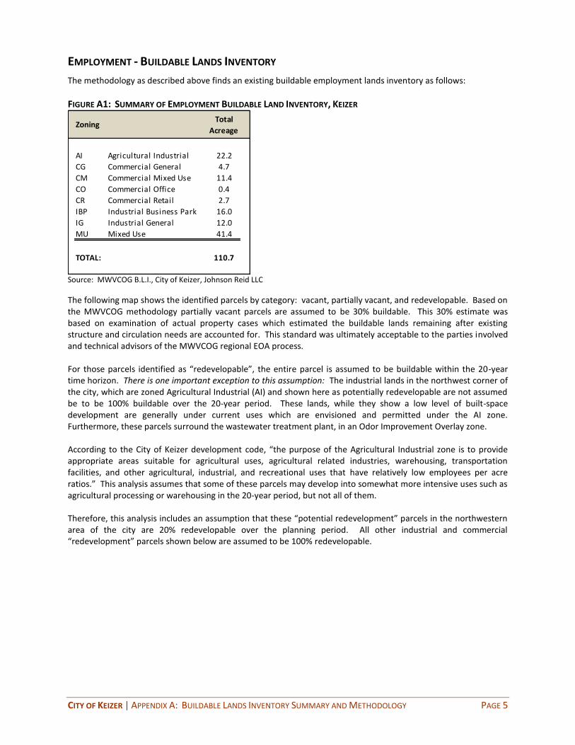
CITY OF KEIZER | APPENDIX A: BUILDABLE LANDS INVENTORY SUMMARY AND METHODOLOGY PAGE 5
EMPLOYMENT - BUILDABLE LANDS INVENTORY
The methodology as described above finds an existing buildable employment lands inventory as follows:
FIGURE A1: SUMMARY OF EMPLOYMENT BUILDABLE LAND INVENTORY, KEIZER
ZoningTotal
Acreage
AI Agricultural Industrial 22.2
CG Commercial General 4.7
CM Commercial Mixed Use 11.4
CO Commercial Office 0.4
CR Commercial Retail 2.7
IBP Industrial Business Park 16.0
IG Industrial General 12.0
MU Mixed Use 41.4
TOTAL: 110.7
Source: MWVCOG B.L.I., City of Keizer, Johnson Reid LLC
The following map shows the identified parcels by category: vacant, partially vacant, and redevelopable. Based on the MWVCOG methodology partially vacant parcels are assumed to be 30% buildable. This 30% estimate was based on examination of actual property cases which estimated the buildable lands remaining after existing structure and circulation needs are accounted for. This standard was ultimately acceptable to the parties involved and technical advisors of the MWVCOG regional EOA process. For those parcels identified as “redevelopable”, the entire parcel is assumed to be buildable within the 20-year time horizon. There is one important exception to this assumption: The industrial lands in the northwest corner of the city, which are zoned Agricultural Industrial (AI) and shown here as potentially redevelopable are not assumed be to be 100% buildable over the 20-year period. These lands, while they show a low level of built-space development are generally under current uses which are envisioned and permitted under the AI zone. Furthermore, these parcels surround the wastewater treatment plant, in an Odor Improvement Overlay zone. According to the City of Keizer development code, “the purpose of the Agricultural Industrial zone is to provide appropriate areas suitable for agricultural uses, agricultural related industries, warehousing, transportation facilities, and other agricultural, industrial, and recreational uses that have relatively low employees per acre ratios.” This analysis assumes that some of these parcels may develop into somewhat more intensive uses such as agricultural processing or warehousing in the 20-year period, but not all of them. Therefore, this analysis includes an assumption that these “potential redevelopment” parcels in the northwestern area of the city are 20% redevelopable over the planning period. All other industrial and commercial “redevelopment” parcels shown below are assumed to be 100% redevelopable.

CITY OF KEIZER | APPENDIX A: BUILDABLE LANDS INVENTORY SUMMARY AND METHODOLOGY PAGE 6
FIGURE A2: EMPLOYMENT BUILDABLE LANDS INVENTORY, KEIZER (2013)
Vacant Industrial
Potential Redev. (IND)
Vacant Commercial
Potential Redev. (COM)
30% Developable
Ind with 25% Comm. Flex
I-5
N River Road
Lockhaven Dr
Source: MWVCOG B.L.I., City of Keizer, Johnson Reid LLC

CITY OF KEIZER | APPENDIX A: BUILDABLE LANDS INVENTORY SUMMARY AND METHODOLOGY PAGE 7
FIGURE A3: EMPLOYMENT BUILDABLE LANDS INVENTORY PARCEL SUMMARY, KEIZER (2013)
Parcels Acres Parcels Acres Parcels Acres Parcels Acres
AI Agricultural Industrial 11 22.2 11 22.2
CG Commercial General 2 2.8 2 0.73 1 1.1 5 4.7
CM Commercial Mixed Use 8 6.2 15 4.1 2 1.13 25 11.4
CO Commercial Office 2 0.4 2 0.4
CR Commercial Retail 3 2.7 3 2.7
IBP Industrial Business Park 2 16.0 2 16.0
IG Industrial General 7 1.0 2 11.1 9 12.0
MU Mixed Use 8 16.7 3 2.0 36 22.8 47 41.5
TOTAL: 29 43.0 20 6.8 55 61.0 104 110.9
ZoningVacant Partially Vacant Redevelopable TOTAL
Source: MWVCOG B.L.I., City of Keizer, Johnson Reid LLC

CITY OF KEIZER | APPENDIX A: BUILDABLE LANDS INVENTORY SUMMARY AND METHODOLOGY PAGE 8
RESIDENTIAL - BUILDABLE LANDS INVENTORY
The methodology as described above finds an existing buildable residential lands inventory as follows:
FIGURE A4: SUMMARY OF RESIDENTIAL BUILDABLE LAND INVENTORY, KEIZER
RS Single Family Residential 214.9 6.6 6.6 det. 8.0 att. 1,527 Low Density Residential
RL Limited Density Residential 0 4.8 - - Medium D.R. or Medium High D.R.
RL-LU Limited D.R. - Limited Use 0 9.6 - - Medium High Density Res.
RM (Medium) 1 Medium Density Residential 0 na - - (See footnote)
RM (Medium High) Medium Density Residential 24.1 9.6 15.0 362 Medium High Density Res.
RM-LU MDR - Limited Use 0 9.6 - - Medium High Density Res.
RH 2 High Density Residential 0 na - - (See footnote)
UT Urban Transition 53.9 6.6 6.6 det. 8.0 att. 383 Low Density Residential
MU3 Mixed Use (Keizer Station) 22.8 6.7 6.7 153 Mixed Use
MU Mixed Use (Other) 18.7 16.8 16.8 314 Mixed Use
Accessory Dwelling Unit Assumption: 100
Totals/Averages: 334.4 8.5 2,838
Sources: MWVCOG, City of KEIZER, Johnson Reid LLC
4 The target density is assumed to be the achieved density in most zones, as those zones are achieving density near the mid-point of the allowed density
range. In the RS zone, single family detached (SFD) and single family attached (SFA) units have two different target densities l isted. The SFD target density of
6.6 units/net acre represents the acheived density in the RS zone, while the SFA density of 8 units/net acre reflects that attached units acheive higher density,
but are nonetheless l imited to a maximum density of 8 units/acre by the zoning code. In the case of the RM (Medium Density Zone) - which has an underlying
Comp Plan desingation of "Medium High Density" - the achieved density of 9.6 units/net acre is at the low end of the allowed range (8 to 22 units/acre) and
therefore, a higher target density of 15 units/net acre (midpoint of range) is assumed here for buildout of remaining parcels in this category.
2 The City of Keizer Development Code presents standards for a zoning designation of RH (High Density Residential). This zone never appears on the zoning
map, and no parts of the city are actually covered by this zone. Those areas of the city which are designated "Medium High Density Residential" on the Comp
Plan map, are covered by the RM (Medium Density Residential) zone on the zoning map. Therefore, the RM (Medium Density Residential) zone conforms to
what is called "medium high density" in the Comp Plan, and in the absense of any land designated RH, RM is the city's highest density active zone.
3 This mixed use area is currently under master planning and is planned to include 153 units in addition to commercial uses. That unit count is reflected
here, and results in the density of 6.7 units/net acre.
Underlying Comp Plan
Designation
1 The City of Keizer Development Code presents standards for areas of the RM (Medium Density Residential) zone which also have an underlying "Medium
Density Residential" Comp Plan designation, there are no actual instances of this situation in the zoning map. On the zoning map, all areas zoned RM
(Medium Density Residential) have an underlying Comp Plan designation of "Medium High Density Residential."
Those parts of the Comp Plan designation map which are identified as "Medium Density Residential" are all covered by the Limited Density Residential zone
on the zoning map.
ZONING DESIGNATIONNet Vacant
Buildable
Acres
Observed
Density
(Units/ Net Acre)
Capacity of
Vacant Lands
(Units)
Target Density
(Units/ Net Acre)4
The residential BLI finds capacity for 2,838 units within the current UGB, under existing zoning, with a likely overall density of 8.5 units/net acre on remaining parcels. This does not represent the maximum potential density allowed, but is based on historically achieved density. (Efficiency measures to ensure efficient use of existing buildable lands will be addressed in a subsequent phase of this project.) The following map shows the identified parcels by category: vacant, partially vacant, and re-developable. As noted above in the section on methodology, this map does not specifically identify locations for Accessory Residential Units, because that assumption applies generally across all single-family parcels. Based on the MWVCOG methodology, if partially vacant parcels exceed 17,000 sq.ft., then one quarter of an acre is removed for the existing dwelling and the remainder is assumed to be developable. This satisfies the state safe harbor method provisions found in OAR 660-024-0005(3).

CITY OF KEIZER | APPENDIX A: BUILDABLE LANDS INVENTORY SUMMARY AND METHODOLOGY PAGE 9
FIGURE A5: RESIDENTIAL BUILDABLE LANDS INVENTORY, KEIZER (2013)
RESIDENTIAL PARCELS
Vacant
Partially Vacant
Redevelopable
MIXED USE PARCELS
Vacant
Redevelopable
Partially Vacant
I-5
N River Road
Lockhaven Dr
Source: MWVCOG B.L.I., City of Keizer, Johnson Reid LLC

CITY OF KEIZER | APPENDIX A: BUILDABLE LANDS INVENTORY SUMMARY AND METHODOLOGY PAGE 10
FIGURE A6: RESIDENTIAL BUILDABLE LANDS INVENTORY PARCEL SUMMARY, KEIZER (2013)
Parcels Acres Parcels Acres Parcels Acres Parcels Acres
RS Single Family Res. 126 45.3 380 162.6 4 7.0 510 214.9
RM Medium Family Res. 12 5.7 10 18.4 22 24.1
UT Urban Transition 57 8.6 59 45.3 116 53.9
MU Mixed Use 8 16.7 3 2.0 36 22.8 47 41.5
TOTAL: 203 76.3 442 209.9 50 48.2 695 334.4
Vacant Partially Vacant Redevelopable TOTALZoning
Source: MWVCOG B.L.I., City of Keizer, Johnson Reid LLC

City of Keizer Evaluation of Land Use Efficiency Measures
Page 1 of 13
Memorandum
DATE: April 2, 2013
TO: Jerry Johnson and Brendan Buckley, Johnson Reid
CC: Sam Litke and Nate Brown, City of Keizer
FROM: Matt Hastie and Shayna Rehberg, Angelo Planning Group
SUBJECT: City of Keizer Draft - Evaluation of Land Use Efficiency Measures and Potential Amendments to the City of Keizer Development Code
As part of the process of updating the City’s Comprehensive Plan, the City of Keizer is currently conducting a Housing Needs Analysis (HNA) and Economic Opportunities Analysis (EOA) with the assistance of consulting firms Johnson Reid and Angelo Planning Group. State law requires that cities maintain a supply of buildable land within their urban growth boundaries (UGBs) that is adequate to meet housing, employment and related needs. As part of the process of preparing the HNA and EOA, the consulting team has assessed the need for future land, identified the supply of building land within the existing UGB and made a preliminary assessment regarding the ability of the current UGB to accommodate future (20-year) land needs. This initial assessment indicates that the city does not have enough land within the existing UGB to accommodate future needs. This may result in a need to expand the City’s UGB. State law requires that before considering an expansion to an urban growth boundary (UGB) to accommodate land needed to support future growth, cities must consider a variety of other measures to improve the efficiency of land use inside the existing UGB, thereby reducing or eliminating the need for a UGB expansion. These measures can include redesignating land to address targeted efficiencies (e.g., redesignating residential land for employment use), increasing allowable densities, promoting infill or redevelopment and/or other approaches. The Transportation and Growth Management Program’s Planning for Residential Growth: A Workbook for Oregon's Urban Areas http://www.oregon.gov/LCD/docs/publications/planning_for_residential_growth.pdf identifies a number of specific types of efficiency approaches that can be considered, including the following:
Apply appropriate plan and zone designations
Increase densities
Reduce parking requirements
Establish narrower street width and turning radii standards
Provide for more flexible development standards
Allow types of housing that are currently prohibited, restricted, or not identified

City of Keizer Evaluation of Land Use Efficiency Measures
Page 2 of 13
Offer developer incentives or reduce regulatory barriers
Increase the efficiency of public infrastructure provision
Require that certain housing types and densities be planned and built
Adopt Interim development standards. While the guidebook is somewhat out-of-date, the State has not prepared a more recent document to supplement or replace it. Following is a summary of measures that the City has considered, including those that have already been implemented, those that are not feasible, and those that could be implemented in the future.
1. Apply appropriate plan and zone designations
In some cases, it is appropriate to consider redesignating land from one Comprehensive Plan or zoning designation to another to use a surplus in the supply of land in one designation to account for a deficit in another designation. For example, if there is a deficit of employment land in the UGB but a surplus of residential land, it may be appropriate to redesignate some land from residential to employment use. Similarly, if a city has a surplus of one type of residential land (e.g., high density or multi-family residential land) and a deficit of another type of residential land (e.g., low density or single-family detached zones), it may be possible to redesignate land in one residential classification to another residential zone to address the imbalance.
Analysis Findings and/or Current Practice
The recently completed Employment Opportunities Analysis (EOA) and Housing Needs Analysis (HNA) found the following:
There is a deficit of land in all residential zoning classifications.
There is an overall deficit of land needed to meet future employment needs.
There is a surplus of land zoned for industrial uses but a deficit of land zoned to meet commercial and institutional employment needs.
Not all of the surplus industrial land is suitable to meet commercial or employment needs.
Measures Considered
Because there is both an overall deficit of land needed for future residential use and an overall deficit of employment lands, redesignating land from employment to residential use (or vice versa) is not a viable option for reducing the overall deficit of land needed to meet future residential or employment needs. Similarly, because there is a deficit in all residential zoning designations, it is not feasible to redesignate land from one residential zone to another to reduce the extent of a needed UGB expansion. One caveat is that there is no buildable land currently designated High Density Residential. So there is the possibility of redesignating lower density zoned land to High Density

City of Keizer Evaluation of Land Use Efficiency Measures
Page 3 of 13
Residential. However, because there is a deficit of low and medium density residential lands, this would not affect the overall need for land to accommodate future housing needs unless this were applied to industrial land with a low development capacity.
The City’s industrial zone allows for some non-industrial (commercial or retail uses), so a portion of the existing industrial land supply also can be used to address the estimated deficit of commercial lands. At the same time, future institutional land uses will require specific site characteristics that cannot necessarily be met by land currently zoned for industrial use. These include the following:
Site sizes of at least 30-50 acres
Access to regional transportation facilities
Ability to purchase (rather than lease) land.
As a result, the majority of the surplus industrial land in the inventory is not expected to be suitable for meeting future institutional uses.
Recommendation and Potential Impact
Two rezoning actions are recommended:
1. Consider rezoning some land zoned Agricultural Industrial (AI) toresidential; and
2. Consider rezoning some land zoned from lower density residential to higher density residential to meet a portion of the need for higher density residential uses.
These two actions will reduce the overall amount of land needed for an expansion (by approximately 10-40 acres). They also will result in locating higher density residential land in closer proximity to city and commercial services.
2. Increase densities
Analysis Findings and/or Current Practice
The City of Keizer has a two-map system that includes a Comprehensive Plan Map and a Zoning Map. Minimum and maximum residential densities are established in the Keizer Development Code (KDC) according to comprehensive plan and zoning designation. Existing residential density requirements are shown in Table 1. The table also presents the densities that were assumed in estimating 20-year land needs for housing in the 2013 HNA.
Currently, there is not land in the Keizer UGB designated as High Density Residential per the Development Code. However, as addressed in the previous section of this report, it is recommended that land be rezoned and designated High Density Residential and the assumed density is included in Table 1. There also is no buildable land in the 2013 City of Keizer Buildable Lands Inventory (BLI) that is designated Limited Density Residential (RL and RL-LU), Medium Density Residential (RM-Medium), Medium Density Residential

City of Keizer Evaluation of Land Use Efficiency Measures
Page 4 of 13
Limited Use (RM-LU), Mixed Use Keizer Station (MU-Keizer Station), or Urban Transition (UT), and that is also reflected in the table below.
Table 1: Summary of Existing Density Regulations and HNA Density Assumptions
Zone Minimum Density Maximum Density Density Assumed in HNA*
Single Family Residential (RS)
4 units/gross acre 8 units/gross acre 6.6 units/net acre
Limited Density Residential (RL) – Medium
6 units/gross acre 10 units/gross acre -
Limited Density Residential (RL) – Medium High
8 units/gross acre 14 units/gross acre -
Medium Density (RM) – Medium
6 units/gross acre 10 units/gross acre -
Medium Density (RM) – Medium High
8 units/gross acre 22 units/gross acre 15.0 units/net acre
High Density Residential (RH)
16 units/gross acre No maximum 22.00 units/net acre
Urban Transition (UT)**
4 units/gross acre 8 units/gross acre -
Mixed Use (MU) 8 units/acre 24 units/acre 16.8 units/net acre
* 2013 HNA, Figure 13 and Exhibits 13 and 14
Measures Considered
As the table shows, the existing density requirements in the Medium Density Residential Zone-Medium are only slightly higher than existing RS requirements and are much lower than the existing RH requirements; density requirements in the Medium Density Residential Zone-Medium High serve as a better bridge between the low density and high density zones. In order to achieve the development and densities assumed in the HNA, more land in the existing UGB and proposed UGB expansion should be designated Medium Density Residential-Medium High and High Density Residential.
Recommendation and Potential Impact
Density assumptions in the HNA are aggressive when compared to historical development densities in Keizer but are consistent with existing density requirements, which are sufficient to achieve the densities assumed in the HNA if more fully instituted.

City of Keizer Evaluation of Land Use Efficiency Measures
Page 5 of 13
Rezoning recommendations are made in the previous section of this report. Recommended measures related to density include:
Consolidate the Comprehensive Plan Designation of Medium and Medium High Density Residential so that the density requirements for the Medium Residential Zone are those of the Medium High Density Residential (8 units/acre – 22 units/acre).
Discontinue application of UT zoning to any new areas.
Designate and zone land in UGB expansion areas according to the land needs found in the HNA, with higher percentages of Medium Density Residential and High Density Residential than have been designated in Keizer in the past.
These measures will allow for development of housing at densities consistent with those assumed in the HNA. However, given the aggressive nature of the density assumptions in the HNA, these measures are not projected to reduce the need for residential land in a UGB amendment.
3. Reduce parking requirements
Analysis Findings and/or Current Practice
City parking space requirements for employment uses are similar to those in the Oregon Model Development Code for Small Cities (3rd edition). Requirements for residential uses were reduced during the 2009 TSP update.
Measures Considered
If lower parking requirements were warranted, they could reduce land needs associated with future development and also would lower the average cost of development.
Recommendation and Potential Impact
As noted above, the City’s off-street parking requirements already are in line with recommended state guidelines and were reviewed as part of the most recent update of the City’s TSP. As a result, no further changes are recommended and no impact on land needs is assumed.
4. Establish narrower street width and turning radii standards
Analysis Findings and/or Current Practice
Existing local street standards range from 28 to 34 feet of pavement and 35 to 48 feet of right-of-way (2009 TSP, Table 4-1), which are consistent with Model Code standards for local streets with parking on both sides. Existing infill standards require just 30-32 feet of right-of-way for public streets (KDC Section 2.316.06). During its 2009 TSP update, the City of Keizer developed street design standards based on the functional classification and operational needs of the roadway and in close collaboration with City planning and public works staff. These standards are consistent with the Transportation Planning

City of Keizer Evaluation of Land Use Efficiency Measures
Page 6 of 13
Rule’s requirement for minimum standards that meet operational needs.
Consistent with the State’s safe harbor requirements, the HNA assumes that 20% of the land needed for residential uses would be needed for streets, utilities and other infrastructure, excluding schools and parks (which were accounted for separately). Assumed street widths and radii can increase these land needs.
Measures Considered
Given the work completed as part of the recent TSP update, it is not necessary to consider additional measures.
Recommendation and Potential Impact
Given no recommended changes to existing standards, there would be no impact on projected future land needs. Further, reductions in street standards likely would have an insignificant impact on projected overall land needs, given that assumptions about land needs associated with public facilities (20%) is a relatively conservative assumption, consistent with state safe harbor requirements.
5. Provide for more flexible development standards (e.g., yard setbacks, lot coverage)
Analysis Findings and/or Current Practice
Existing setback standards in the KDC are generally 5-10 feet, and lot coverage standards 70-75% for residential uses. Zero side yard housing is permitted and regulated in the city by KDC Section 2.404. Infill development standards are provided in KDC Section 2.316 and flag lots are permitted pursuant to regulations in KDC Section 2.310.3.E. Particularly in allowing for zero side yard and infill housing, the City’s existing code provides flexibility in development.
Measures Considered
It is not necessary to consider additional measures.
Recommendation and Potential Impact
Given no recommended changes to existing standards, there would be no impact on projected future land needs.
6. Allow types of housing that are currently prohibited, restricted, or not identified
Analysis Findings and/or Current Practice
Other than detached single family housing, existing RS zone regulations allow duplexes on corner lots; the regulations limit building to one primary building per lot. Lot sizes can be as small as 5,445 square feet except in the case of zero lot line housing, which can be sited on lots less than 5,000 square feet (4,000 square feet per Section 2.102.05.A).

City of Keizer Evaluation of Land Use Efficiency Measures
Page 7 of 13
In addition to uses allowed in the RS zone, the RL, RM, and RH zones permit buildings with two or more dwelling units and combinations of permitted attached or detached dwellings on a lot. In the RL zone, minimum lot sizes allow for densities up to one unit per 3,112 square feet (multi-family housing); in the RM zone, up to one unit per 1,980 square feet (multi-family housing); and in the RH zone, there are no maximum density regulations.
All residential zones allow Planned Unit Development, “shared housing” (or accessory dwelling units), and zero side yard housing as special permitted uses (KDC Sections 2.311, 2.403, and 2.404). Planned Unit Development permits detached and attached housing, is subject to the density requirements of the underlying zoning, and offers density bonuses for increases in open space above minimum requirements. Pursuant to existing regulations, access dwelling units must be separate from primary dwelling and are limited to 25% of primary dwelling building area.
There are also emerging housing types and/or arrangements, such as small home (“cottage”) clusters and live/work units. These are not currently identified in the code as allowed uses but in some cases could be allowed under existing provisions.
Measures Considered
In the case of emerging housing types and arrangements, cottage clusters can be permitted as either fee simple lots with a homeowner’s association holding common areas, or as condominiums with shared ownership of the entire development. In order to more easily permit and encourage cottage cluster development, code language specific to cottage clusters is typically adopted. These code provisions would address the minimum and maximum number of dwellings per development, minimum lot size, setbacks, maximum cottage area, cottage design requirements, parking, access, accessory structures, and open space.
Live/work units (especially live/work apartments or townhouses) provide for flexibility in mixed use areas, allow for co-locating residential and commercial uses, and can allow residential uses on the ground floor of live/work structures until the market is ready to support retail in these areas. They would be suitable in mixed use zones in the city. Code language for live/work units typically includes a definition of a live/work unit and standards regulating the location and size/area of commercial uses, primary street frontage, off-street parking, access, signs, and business operations.
Recommendation and Potential Impact
It is recommended that the City ultimately amend its code to allow for and reduce obstacles to constructing accessory dwelling units, cottage clusters and/or live work developments. Recommended changes include removing the requirement for accessory dwelling unit separation, increasing the allowed building area (limiting it to just be smaller than primary dwelling unit), and removing or reducing parking requirements. It is also recommended that code provisions be adopted for cottage clusters and live/work units.

City of Keizer Evaluation of Land Use Efficiency Measures
Page 8 of 13
These code amendments will help the City meet the full range of projected housing type needs. However, given the housing density and mix assumptions which are already incorporated in the HNA, these changes would not affect projected overall land needs or the magnitude of a needed UGB expansion.
7. Offer developer incentives or reduce regulatory barriers, including revising or developing design standards/require master plans or specific development plans; providing research, education, and up-front services to developers; streamlining the permitting and development process; providing financial incentives in the form of waiving or reducing permitting or other fees; and/or assembling or dedicating land for specific development projects.
Analysis Findings and/or Current Practice
The City currently does not provide for reduced permitting fees for affordable housing or other specific types of housing development. The City also does not currently waive or defer system development charges (SDCs). However, the City has made a policy choice to charge less than they could potentially charge for SDCs per their adopted SDC methodology. They charge lower fees than other nearby jurisdictions (such as Salem). The City has decided to do this to help reduce the cost of residential and other development in the City, making housing development more affordable.
The City does not have a formal program or requirements for streamlining its permitting process. However, the City does provide free pre-application conferences to help provide information and answer questions about development proposals. Most other jurisdictions we work with charge a fee for these types of conferences. Therefore, this practice represents a service to developers which they reportedly find this useful and beneficial in terms of reducing the cost of permitting and development.
The City’s Development Code includes provisions for Master Planning in the Keizer Station Area and the City has worked with developers in that area to develop a Master Plan for Area C that incorporates a mix of development types. As part of this process, the City also has assisted with land assembly efforts. The City does not have any other formal program to assist with land assembly or dedication and has not applied its Master Planning provisions to other areas of the City. However, there are relatively few opportunities for master planning of residential land within the existing UGB, given the character of the supply of buildable land there.
Measures Considered
To the extent that City resources are available, the City could consider implementing additional financial incentives (e.g., fee waivers or deferrals) or regulatory streamlining activities to improve the efficiency of the development review process and reduce the cost of housing, particularly for non-profit affordable housing developers. The City of Tigard has a program for offering fee relief for affordable housing developers (currently

City of Keizer Evaluation of Land Use Efficiency Measures
Page 9 of 13
capped at $10,000 for all projects).1 At the same time, current measures being undertaken by the City are considered to be effective in meeting these goals already and to represent a set of strategies that are consistent with the intent of these types of efficiency measures.
Similarly, the City could consider expanding it Master Planning provisions to a broader area. Such provisions could continue to include supportive efforts by the City to help assemble land for larger master-planned developments. Those efforts likely would be more applicable and effective in areas that may be brought into the UGB in the future if they represent larger vacant parcels that would lend themselves to master planning.
Recommendation and Potential Impact
All of these measures can be helpful in achieving the city’s economic or housing development goals, particularly in implementing certain types of developments that meet specific community objectives or needs (e.g., mixed use development, affordable housing or targeted employment uses). However, they would not be expected to have a direct or measurable impact on the overall density or efficiency of development as evaluated in the city’s EOA and HNA. As a result, implementing these programs would be beneficial for the city, developers and future residents and further consideration of them is recommended. However, they would not affect the assumptions about future development mix and density included in the EOA and HNA and therefore would not affect the estimated need for a potential UGB expansion. As a result, their implementation should not be required prior to pursuing a possible UGB expansion.
8. Increase the efficiency of public infrastructure provision (e.g., require adequate services for development, charge full cost)
Analysis Findings and/or Current Practice
The City has existing code provisions that require concurrent public facility provision for zone changes (KDC Section 3.110.04.D). The City’s code does not include any other “concurrency” requirements.
Measures Considered
There is no need to consider additional measures.
Recommendation and Potential Impact
While more efficient infrastructure provision will enable the type and level of development assumed in the EOA and HNA, it would not be expected to result in denser or more efficient development than already assumed in the HNA’s development assumptions. Therefore, it would not impact projected future land needs.
9. Require that certain housing types and densities be planned and built (e.g. require
1 http://www.tigard-or.gov/city_hall/departments/cd/docs/affordable_housing_assistance_request.pdf.

City of Keizer Evaluation of Land Use Efficiency Measures
Page 10 of 13
a minimum percentage of multi family housing)
Analysis Findings and/or Current Practice
The City does not currently require that all or a portion of a given development in a medium or high density zone consist of single-family attached or multi-family housing.
Measures Considered
While the City does not currently implement these types of requirements, application of current and proposed minimum density requirements would essentially serve the same purpose and ensure that at least a portion of developments in these areas consist of higher density housing types, including single-family attached and multi-family housing. While additional requirements could be considered to help further ensure that needed housing types and densities are developed in line with the assumptions made in the HNA, such changes are not considered necessary or essential if the City implements changes in minimum density for the medium density housing zone recommended in this report.
Recommendation and Potential Impact
Additional measures will only assist in achieving development levels assumed in the HNA; they will not have an impact on the total future projected land need or the amount of magnitude of a potential UGB amendment.
10. Adopt Interim development standards (e.g., shadow platting)
Analysis Findings and/or Current Practice
Existing regulations in the Urban Transition (UT) zone state that “(t)he location of parcel lines shall not significantly reduce feasible options for the future location of urban roads or services, or preclude basic development options on the property or adjacent properties. A development plan may be required which indicates how the proposed division will not preclude future development at densities allowed in the Comprehensive Plan” (KDC Section2.118.10.C.3).
The City’s development code does not include any other similar requirements that apply to other zones or areas of the city.
Measures Considered
These measures should be considered for application in potential future UGB expansion areas that include larger developable parcels to ensure that future development in those areas is as efficient as possible.
Recommendation and Potential Impact
Additional measures likely would increase the efficiency of future development and would improve the ability of developers to achieve the development densities assumed in the HNA. However, there would be no measurable increase in efficiency over and

City of Keizer Evaluation of Land Use Efficiency Measures
Page 11 of 13
above levels of development already assumed in the HNA and EOA. In addition, these measures would be most successful in UGB expansion areas that include larger parcels with the capacity for multiple dwelling units. The bulk of the supply of vacant and redevelopable parcels in the inventory of building land within the existing UGB will not be affected by these measures because they typically are relatively small lots with limited capacity for additional development (e.g., one to two additional units).
Summary As addressed in this report and summarized in the table below, most efficiency measures would help the City achieve the types and densities of development assumed in the HNA and EOA, as well as address other City planning objectives. For instance, the mix and density of housing types assumed in the HNA are higher densities and more compact forms of housing than have been built in Keizer in the last five to 20 years. Therefore, given these relatively aggressive assumptions in the HNA and EOA, instituting these measures is not expected to reduce the overall amount of land proposed in a UGB amendment.
The one efficiency measure with the most potential to reduce the need for additional land inside the UGB is rezoning. Rezoning land, whether from industrial to commercial or residential zoning or from lower to higher density residential zoning, will help reduce land needs, but only in a limited number of circumstances.
Table 2: Summary of Efficiency Measures, Findings, Recommendations, and Impacts
Efficiency Measures Current Practice/Findings Recommendation/Impact of Measure
1. Apply appropriate plan and zone designations
Deficit of land in all residential zones in next 20 years
Surplus of land in industrial zones and a deficit of land for commercial and institutional uses
Recommendation: Consider rezoning some industrial land for commercial or residential use while maintaining an adequate supply of industrial land; consider rezoning some low or medium density residential land to higher density residential designations
Impact: Could reduce residential land needs by 10-40 acres
2. Increase densities Densities assumed in the 2013 Housing Needs Analysis (HNA) consistent with density requirements
Current application of Comprehensive Plan and zoning designations is not consistent with future land needs
Recommendation: Simplify or clarify differences between Comprehensive Plan and Zoning designations; ensure land in new residential areas is adequate to meet specific types of housing needs and densities
Impact: Will allow for achieving densities assumed in the HNA; will not reduce the

City of Keizer Evaluation of Land Use Efficiency Measures
Page 12 of 13
Efficiency Measures Current Practice/Findings Recommendation/Impact of Measure
estimated need for residential land
3. Reduce parking requirements
Parking requirements for employment uses are consistent with the Oregon TGM Model Development Code for Small Cities
Parking requirements for residential uses were reduced during the 2009 TSP update
No recommendation: Existing requirements have recently been reduced and are consistent with State guidelines; no changes are recommended
Impact: No projected impact on land needs
4. Establish narrower street standards
Existing local street standards are consistent with Model Code standards for streets with parking on both sides and Transportation Planning Rule provisions
20% of the projected land need for residential uses was assumed for street, utilities, and other infrastructure, consistent with State “safe harbor” provisions
No recommendation: Existing requirements are consistent with State guidelines and regulations; no changes are recommended
Impact: No projected impact on land needs
5. Provide for more flexible development standards (e.g., yard setbacks, lot coverage)
Existing setback and lot coverage standards are reasonable and consistent with state guidelines
Zero side yard, infill housing, and flag lot provisions are available in existing code
No recommendation: Existing requirements allow for flexibility in development
Impact: No projected impact on land needs
6. Allow types of housing that are currently prohibited, restricted, or not identified
Existing regulations allow detached and attached housing, duplexes, multi-family housing, shared housing/accessory dwelling units, and mixed uses (including housing)
Recommendation: Reduce restrictions on the development of “shared housing” (accessory dwelling units); add code provisions to support the development of new housing types and arrangements such as cottage clusters and live/work units
Impact: Recommended changes will help the City meet the range of projected housing needs already assumed in the HNA no projected impact on residential land needs
7. Provide developer incentives and/or reduce regulatory barriers (e.g., fee reductions, deferrals, or waivers; permit
The City does not currently offer fee reductions, deferrals, or waivers for targeted types of housing development, but charges low system development charges (SDCs) as a way to keep
Recommendation: Consider additional financial incentives and streamlining/fast-tracking the development process for applicants, including affordable housing developers; consider expanding Master Planning provisions and support for

City of Keizer Evaluation of Land Use Efficiency Measures
Page 13 of 13
Efficiency Measures Current Practice/Findings Recommendation/Impact of Measure
streamlining) development costs more affordable
The City does not have a streamlined/fast-track development review process, but provides a free pre-application conference to applicants
assembly of land for larger developments
Impact: The recommended changes will facilitate the development of needed employment and housing identified in the HNA; no projected impact on residential land needs
8. Increase the efficiency of public infrastructure provision (e.g., require adequate services for development, charge full cost)
Existing code provisions require concurrent public facility provision for zone changes; no other “concurrency” requirements in place
No recommendation: No changes are recommended
Impact: More efficient infrastructure provision would facilitate development assumed in the EOA and HNA; no projected impact on residential land needs
9. Require that certain housing types and densities be planned and built (e.g. min. percentage of multi-family housing)
These types of requirements do not currently exist, but application of existing and recommended density requirements and zoning designations will ensure housing types are consistent with zoning
No recommendation: No changes are recommended
Impact: Additional requirements would help achieve development assumed in the HNA; no projected impact on residential land needs
10. Adopt interim development standards (e.g., shadow platting)
Existing urban transition zone provisions require that parcelization allow for future development at urban densities, but the code does not include any other similar requirements that apply to other zones or areas of the city
Recommendation: These measures should be considered for application in potential future UGB expansion areas with large developable parcels to ensure efficient development patterns
Impact: These measures will help achieve development levels assumed in the EOA and HNA; no projected impact on residential land needs

City of Keizer
Draft Residential Development Policies
April 16, 2013 Page 1 of 4
Memorandum
DATE: April 16, 2013
TO: Jerry Johnson, Johnson Reid
FROM: Matt Hastie and Shayna Rehberg, Angelo Planning Group
SUBJECT: City of Keizer Draft Proposed Residential Goals, Objectives and Policies
Following are updated draft goals, objectives and policies related to Residential Development
proposed for inclusion in the City of Keizer’s Comprehensive Plan. They would replace the
existing goals, objectives and policies in this section of the Plan in their entirety. They include a
combination of existing goals, objectives and policies, along with new language that is consistent
with the regional Economic Opportunities Analysis and Housing Needs Analysis, as well as the
work being conducted by Johnson Reid and the city specific to Keizer.
RESIDENTIAL DEVELOPMENT GOALS, OBJECTIVES AND POLICIES:
Goal 1: Provide residential land for a variety to meet a full range of needed housing
types, sizes densities, locations and costs.
Objective 1.1: Provide housing opportunities for a full range of housing needs as
identified by the City’s most current Housing Needs Analysis.
Policies:
1.1.A Encourage and support development of housing units for low and
moderate-income households.
1.1.B Encourage housing opportunities for the elderly, people with
disabilities, minority, single parent, and single-person households.
1.1.C. Account for shifts in age, ethnicity and other demographic factors,
along with associated housing needs such as low- and moderate-
income housing, household sizes, housing types, housing size, and
more central housing locations.
1.1.D Plan for low, medium and high density residential uses consistent
with 20-year housing needs analysis projections of demand.
Periodically monitor and analyze the population and dwelling unit
projections compared to the supply of vacant and potentially
redevelopable land to provide a reliable basis for land use decisions
and to assure sufficient residential land to maintain a positive
balance between supply and demand.

City of Keizer
Draft Residential Development Policies
April 16, 2013 Page 2 of 4
1.1.E Ensure that residential land use designations provide opportunities
for non-traditional or emerging housing types such as accessory
dwelling units, cottage clusters, live-work units, other mixed
residential/commercial development types, multi-generational
housing and other housing options that are suited to infill and higher
density residential development.
1.1.F Provide for and promote through incentives development of housing
at densities that will result in a compact urban form.
1.1.G Encourage higher density residential development near industrial and
commercial zones.
1.1.H Encourage in-filling of existing undeveloped lots that is sensitive to
the existing neighborhood patterns.
1.1.I Provide for the retention of large parcels of residentially zoned land
to facilitate their use or reuse for projects requiring such parcels.
1.1.J Periodically review development densities and consider methods for
increasing residential density where density targets established in the
Comprehensive Plan are not being met.
1.1.K Establish zoning, subdivision, and other appropriate ordinances to
assure that site designs consider important natural features such as
drainage, soils, slopes, flood plains, and significant trees.
1.1.L Ensure an adequate supply of land for housing for families with
children enrolled in local schools.
Objective 1.2: Encourage and support development of housing units for low and
moderate income households.
Policies:
1.2.A Support public, private, nonprofit, and cooperative associations and
joint public-private partnerships which develop, assist in creating
and/or manage low and moderate income housing units. In
particular, coordinate and collaborate with local housing providers
and advocacy groups in order to leverage funding for development
of such housing.
1.2.B Continue to support the use of federal and local housing assistance
programs to help fund housing projects for low and moderate-
income households available through an appropriate housing
authority.
1.2.C Investigate the desirability and fiscal feasibility of starting a housing
authority to establish minimum housing standards in the city. This
may include: emergency housing assistance, housing assistance
programs, etc.

City of Keizer
Draft Residential Development Policies
April 16, 2013 Page 3 of 4
1.2.D Consider providing financial incentives such as waiving or deferring
permitting or other fees for affordable housing developments.
Goal 2: Encourage the location of residential development where full urban services,
public facilities, and routes of public transportation are available.
Objective 2.1 Coordinate new residential development with the provision of an adequate
level of services and facilities, such as sewers, water, transportation
facilities, schools and parks.
Policies:
2.1.A Develop and annually revise a capital improvement program to
ensure that public facilities are provided for residential development
in a timely and efficient manner. Coordinate with federal, state,
regional, and local jurisdictions and agencies with responsibilities for
planning and construction of such facilities.
2.1.B Consider rezoning parcels to higher residential density to meet the
identified multi-family housing needs provided such proposals are
consistent with the policies of this Plan and its implementing
ordinances. Parcels to be considered for rezoning should have access
to major transportation corridors that are served by transit; are
served, or can be served, by all urban services, including parks and
recreational facilities; and are in close proximity to opportunities for
shopping, employment and/or schools.
2.1.C Consider establishing a study that would inventory and prioritize sites
that may satisfy future multi-family needs in an effort to allow more
flexibility and certainty in the land use process.
Goal 3: Stabilize and protect the essential characteristics of residential
environments, including natural features.
Objective 3.1 Ensure compatibility among all types of new and existing residential uses,
and between residential and non-residential uses.
Policies:
3.1.A Protect existing and proposed residential areas from conflicting non-
residential land uses while providing for compatible mixed-use
development (residential and non-residential).
3.1.B Conserve the existing supply of housing in stable neighborhoods
through code enforcement, appropriate zoning, rehabilitation
programs, and by discouraging conversions to non-residential use.
3.1.C Use development and subdivision code provisions and other
regulations to protect residential uses from other land use activities

City of Keizer
Draft Residential Development Policies
April 16, 2013 Page 4 of 4
that generate an excessive level of noise, pollution, traffic volume,
nuisances, and hazards to residents.

City of Keizer
Draft Economic Development Policies
April 16, 2013 Page 1 of 7
Memorandum
DATE: April 16, 2013
TO: Jerry Johnson, Johnson Reid
FROM: Matt Hastie and Shayna Rehberg, Angelo Planning Group
SUBJECT: City of Keizer Draft Proposed Economic Development Goals, Objectives and Policies
Following are updated draft goals, objectives and policies related to Economic Development
proposed for inclusion in the City of Keizer’s Comprehensive Plan. They would replace the
existing goals, objectives and policies in this section of the Plan in their entirety. They include a
combination of existing goals, objectives and policies, along with new language that is consistent
with the regional Economic Opportunities Analysis and Housing Needs Analysis, as well as the
work being conducted by Johnson Reid and the city specific to Keizer.
4. GOALS AND POLICIES: ECONOMIC, COMMERCIAL AND
INDUSTRIAL DEVELOPMENT Goal 1: Provide an adequate supply of sites to accommodate target industries and
other employment needs identified over the planning period.
Objective 1.1: Recognize that Keizer has a limited supply of sites that will allow for
target industry employment opportunities and seek to develop strategies
that will result in additional inventory of these sites.
Policies:
1.1.a Provide land to meet the site characteristics and site sizes described
in the 20-year land needs that are identified in the EOA. These sites
may include vacant, undeveloped land, partially developed sites with
potential for additional development through infill development, and
redevelopable areas. The City can provide land in two ways: (1)
increasing commercial and industrial land-use efficiency by
promoting infill or redevelopment and (2) bringing new land into the
urban growth boundary, if necessary.
1.1.b Work with property owners and their representatives to help ensure
that prime development and redevelopment sites throughout the city
and urban growth boundary are known, able to be aggregated and
ready to develop.
1.1.c Work with property owners and their representatives to ensure that
prime development and redevelopment sites throughout the city and
urban growth boundary designated for employment use are

City of Keizer
Draft Economic Development Policies
April 16, 2013 Page 2 of 7
preserved for future employment needs and are not subdivided or
developed for non-employment uses.
1.1.d Provide a short-term supply of suitable land to respond to immediate
economic development opportunities.
1.1.e Periodically review local land use regulations to determine whether
they pose barriers to economic development and employment
growth. Where regulations pose barriers, balance the goals of such
regulations with economic development objectives.
Objective 1.2: Facilitate the development of local target industry employment sites with
appropriate businesses.
Policies:
1.2.a Target industry employment businesses as identified in the local
economic opportunity analysis (EOA) are those associated with
medical and health care and related research, including but not
limited to medical research and corporate campus facilities.
1.2.b Facilitate the development of a marketing plan to attract businesses
within the identified target industry business sectors.
Objective 1.3: Analyze opportunities for rezoning of lands; developing adequate infill
strategies, or consideration of an urban growth boundary expansion to
allow for the provision and future development of target industry sites as
identified in the Keizer EOA.
Policies:
1.3.a Conduct a planning analysis to identify employment site
opportunities that can be developed through rezoning, expanding the
urban growth boundary, or other means.
1.3.b Consider infill strategies to meet additional employment land needs;
implement zoning map or development code amendments that will
enable the city and property owners to implement these strategies.
Objective 1.4: Maintain an adequate supply of land for employment uses.
Policies:
1.4.a Develop and implement a system to monitor the supply of
commercial and industrial lands. This includes monitoring
commercial and industrial development (through permits) as well as
land consumption (e.g. development on vacant or redevelopable
lands).

City of Keizer
Draft Economic Development Policies
April 16, 2013 Page 3 of 7
1.4.b Track employment land use trends and re-evaluate employment land
needs approximately every five to seven years.
Objective 1.5: Preserve large sites, especially sites with access to I-5, to provide
opportunities for development by businesses that require large sites with
access to regional transportation facilities, as identified in the Keizer EOA.
Policies:
1.5.a Designate land for target industry uses or business parks to provide
opportunities for development of business clusters for related or
complementary uses.
1.5.b Develop policies and related development code amendments, as
needed to provide certainty for the future use of land on designated
large target industry sites as identified in the EOA and that restrict
incompatible or undesirable uses from occurring on these sites.
1.5.c To the extent there is a lack of adequate target industry sites within
the City’s urban growth boundary, the city may need to pursue an
urban growth boundary expansion to provide for sites that will meet
this future employment need.
Goal 2: Increase employment opportunities in Keizer.
Objective 2.1: Increase the city’s ratio of Employment to Population. from 7:1 to 4:1
Policies:
2.1.a Identify and facilitate development of target industry sites with
appropriate potential businesses as identified in the Keizer EOA.
2.1.b Broaden, improve and diversify the Keizer economy while
maintaining or enhancing its environment.
2.1.c Establish a range of employment opportunities in all wage classes,
including entry-level jobs.
Goal 3: Provide infrastructure needed to support economic development.
Objective 3.1: Provide adequate infrastructure to facilitate employment growth in new
and existing employment areas.

City of Keizer
Draft Economic Development Policies
April 16, 2013 Page 4 of 7
Policies:
3.1.a Coordinate capital improvement planning with land use and
transportation planning to strengthen the City’s Economic
Development Strategy.
3.1.b Prioritize use of Systems Development Charge revenues for
infrastructure on sites that provide prime opportunities for new
employment uses as a result of location, site size, or other significant
site characteristics.
3.1.c Where appropriate, ensure that public-private development
agreements to recover construction costs are in effect prior to
financing and constructing public improvements.
3.1.d Establish alternative funding mechanisms that provide timely
completion of ‘connecting’ public facilities (e.g., an unpaved block
of a street or missing sections of a sewer line), with preference given
to projects in existing commercial or industrial areas and others that
foster economic development.
3.1.e Assist with providing infrastructure through the use of urban renewal
funding, where appropriate.
3.1.f Work with ODOT, Marion County and the City of Salem to develop
a regional funding plan for improvements as noted in the Chemawa /
I-5 Interchange Area Management Plan.
3.1.g Develop a facilities financing plan for target industry sites to plan
and provide for the adequate facilities to serve those sites.
3.1.h Determine how to provide for infrastructure needs, such as
telecommunication or other facilities, that are in addition to standard
sewer, water, stormwater, and transportation facilities, as identified
in the City’s EOA and/or site-specific market analyses.
Goal 4: Facilitate the development of all of Keizer Station.
Objective 4.1: Encourage the continued development of the Keizer Station as a
developing retail / mixed use /industrial development which will
continue to attract new businesses and provide additional
opportunities for current employees.
Policies:
4.1.a Strive to retain and attract new businesses within the Keizer Station.

City of Keizer
Draft Economic Development Policies
April 16, 2013 Page 5 of 7
4.1.b Work with potential new businesses to make them aware of the
city’s master plan requirements for businesses within the Keizer
Station.
4.1.c Consider, as necessary, adjustments to zoning districts or
requirements within the Keizer Station, master plan amendments,
and allocation of square footage for retail and other uses, based on
the need to respond to changing economic factors and development
trends.
Goal 5: Support and assist existing businesses in Keizer.
Objective 5.1: Continue to support existing businesses within Keizer as a valuable
component of the city’s economy.
Policies:
5.1.a Develop and implement an outreach strategy to determine how the
City can assist existing businesses. Opportunities for assistance may
include options such as providing assistance with the development
process, forming public-private partnerships to promote Keizer
businesses and other strategies as appropriate.
5.1.b Encourage self-help methods and programs for business districts
such as the formation of business associations and special self-
assessment districts for economic improvement.
5.1.c Pursue special projects and grant applications that help support local
business and industry.
5.1.d Remain supportive of the local Chamber of Commerce and other
local business groups and their activities.
5.1.e Strive to retain and attract new businesses along River Road / Cherry
Avenue corridors.
5.1.f Continue to implement projects identified by the River Road
Renaissance Plan and the Keizer Urban Renewal Board.
5.1.h Ensure compatibility between commercial and industrial lands and
lands adjacent to them.
5.1.i Allow commercial offices or retail uses to be located in the same
structure as compatible residential uses.
5.1.j Allow transit services and shelters to be provided in lieu of a certain
amount of required off-street parking.

City of Keizer
Draft Economic Development Policies
April 16, 2013 Page 6 of 7
Goal 6: Increase the potential for conference and tourist related economic activities.
Objective 6.1: Support tourism efforts within Keizer.
Policies:
6.1.a Encourage development of destination point projects such as Points
of Interest and the art walk series that draw visitors to Keizer.
6.1.b Ensure that the factors that are likely to attract visitors to Keizer,
especially Keizer’s environmental quality and natural beauty, are
protected and enhanced.
6.1.c Work closely with local businesses and the Chamber of Commerce
to promote local events and activities such as the Keizer Iris Festival,
Miracle of Lights and other events that highlight and promote
Keizer.
Objective 6.2: Increase the use of the Keizer Convention Center.
Policies:
6.2.a Continue to operate the conference center with the goal of making it
financially independent.
6.2.b Develop a marketing plan to guide the operation of the convention
center.
Goal 7: Recruit target industry businesses with a range of jobs that provide for a
range of incomes, including those that pay higher than average wages.
Objective 7.1: Economic development recruitment efforts for the city should focus on
business that provide a range of wages and benefits, including high-wage
jobs in target industry businesses.
Policies:
7.1.a Work with SEDCOR and other economic development organizations
to target and recruit businesses.
7.1.b Work with local agencies to meet workforce needs, such as: training
and education, job advancement, or local expansion of businesses
that are less subject to boom and bust cycles.

City of Keizer
Draft Economic Development Policies
April 16, 2013 Page 7 of 7
7.1.c Coordinate with community and economic development
organizations to develop a coherent and effective marketing
program. Coordinate development of this strategy with local,
regional and state economic development agencies.
7.1.d. Develop regional economic development policies, strategies, and an
ongoing forum with partners including the City of Salem, Marion
County, Polk County, and the State. Base the policies, strategies, and
discussions on findings from the most recent market analyses and
regional and local EOAs.
7.1.e Support industries identified in market analyses and EOAs that are
“sustainable” in terms of providing living wages, using resources
efficiently, and having limited environmental impacts.
7.1.f Work with regional and local planning agencies, the County
Assessor, and the Oregon Department of Economic Development to
prepare and update annually an inventory of vacant commercial and
industrial land parcels in the city.
Goal 8: Monitor and adjust economic development goals and objectives
approximately every six to 10 years.
Objective 8.1: Regularly monitor the overall completion and benefits of the identified
economic goals and objectives.
Policies:
8.1.a Identify a set of criteria or events that would trigger the need for
updating economic goals, policies and analyses.
8.1.a Revise economic development goals, objectives, and strategies as
appropriate to reflect ongoing success, and fiscal issues, constraints
and new opportunities.

City of Keizer Preliminary Assessment of Expansion Area Alternatives
Page 1 of 14
Memorandum
DATE: April 3, 2013
TO: Sam Litke and Nate Brown, City of Keizer
CC: Jerry Johnson and Brendan Buckley, Johnson Reid
FROM: Matt Hastie, Shayna Rehberg, and Andrew Parish, Angelo Planning Group
SUBJECT: City of Keizer Preliminary Assessment of Expansion Area Alternatives ‐ DRAFT
As part of the process of updating the City’s Comprehensive Plan, the City of Keizer is currently conducting a Housing Needs Analysis (HNA) and Economic Opportunities Analysis (EOA) with the assistance of consulting firms Johnson Reid and Angelo Planning Group (APG). State law requires that cities maintain a supply of buildable land within their urban growth boundaries (UGBs) that is adequate to meet housing, employment and related needs. As part of the process of preparing the HNA and EOA, the consulting team has assessed the need for future land, identified the supply of building land within the existing UGB and made a preliminary assessment regarding the ability of the current UGB to accommodate future (20‐year) land needs. This initial assessment indicates that the city does not have enough land within the existing UGB to accommodate future needs.
As part of the current EOA and HNA planning process, the City expects to adopt the findings associated with those studies, including policy and other amendments to its Comprehensive Plan. As part of a future, follow‐up effort, the City will further evaluate the need for an expansion of its UGB and then potentially move forward to implement that expansion. This will require significant coordination with a variety of local, regional and state stakeholder groups and other community members. It will entail the following steps:
• Refine estimates of lands needed for inclusion in a UGB expansion
• Consider and potentially implement “efficiency measures” that can be undertaken to reduce the amount of land that may need to be included in a UGB expansion
• Identify potential areas that should be considered as alternative locations for a UGB expansion
• Recommend one or more specific UGB expansion areas
• Develop findings that support UGB expansion in conformance with state laws and administrative rules
• Work with Marion County and the City of Salem to submit a proposed UGB expansion; coordinate with the Oregon Department of Land Conservation and Development and the Land Conservation and Development Commission regarding state acknowledgement of the proposed expansion area.

City of Keizer Preliminary Assessment of Expansion Area Alternatives
Page 2 of 14
In evaluating and proposing a UGB expansion, the City would need to consider and conform to a variety of state rules and regulations that regulate such actions. While the UGB expansion process, if undertaken, is expected to occur after completion of the EOA and HNA planning process, preliminary analysis has been done as part of that process to help inform future UGB expansion efforts. No formal recommendation or decision regarding UGB expansion is expected as part of the current EOA and HNA planning process. However, input on a preliminary assessment of the process and possible expansion areas would be helpful.
The remainder of this memorandum provides an initial summary of the basis for a potential UGB expansion and describes the factors that would need to be addressed in planning for a UGB amendment. The memorandum also identifies and presents a preliminary assessment of potential expansion areas adjacent to the existing City of Keizer UGB. The assessment of possible expansion areas is conducted in two stages: (1) in relation to requirements in state statute governing the priority of areas to be considered for UGB expansion; and (2) pursuant to locational factors established by Statewide Planning Goal 14 (Urbanization). These requirements also have been clarified over the years through a variety of legal decisions. The memorandum concludes with a discussion of next steps in the process of preparing for a potential UGB amendment.
Land Needs
Employment Opportunities Analysis (EOA) and Housing Needs Analysis (HNA) Findings State law requires cities in Oregon to maintain a supply of land that is sufficient to meet housing, employment and other land needs within a 20‐year planning period. Cities typically address this requirement as part of the process of periodically updating their Comprehensive Plans (the “Periodic Review” process). The periodic review process generally entails an analysis of future housing and employment opportunities and needs and an assessment of the amount, location and characteristics of land associated with those needs. As part of a team led by Johnson Reid, APG is currently assisting the City of Keizer with just such an assessment.
As part of an Employment Opportunities Analysis (EOA) and Housing Needs Analysis (HNA) conducted for the City in March 2013, Johnson Reid estimated the amount of land needed in Keizer for employment and housing over the next 20 years. Johnson Reid generally found a shortage of land available within the City’s existing UGB to meet both future (2032) employment and housing needs. While the EOA shows a potential surplus of industrial land, the analysis also indicates that this land is not suitable for other employment types and therefore would not be available to address the shortages of commercial and institutional land.
These analyses were reviewed by a project advisory committee that includes a variety of local representatives, including members of the City Council, City Planning Commission, the Keizer Chamber of Commerce, Marion and Polk Counties, the Keizer School District and other property owners and

City of Keizer Preliminary Assessment of Expansion Area Alternatives
Page 3 of 14
citizens. The group also includes representatives of the Oregon Department of Land Conservation and Development (DLCD) and 1,000 Friends of Oregon. Johnson Reid has refined their analyses as part of this review process. Tables 1 and 2 summarize the results of the land needs analysis. As shown out in Table 2, the residential land needs include land for uses associated and to be sited with residential uses such as parks and schools. Land needs also are shown as “gross land needs” and include land needed for roads, utilities and other public infrastructure.
Table 1: Employment Land Needs in 2032
Scenario Surplus/(Shortage) (acres)
Proposed (High) Growth Scenario
Commercial (23.1)
Industrial 27.8
Institutional (41.8)
Net Deficit/Need (64.9)
Table 2: Residential Land Needs in 2032
Land Use Gross Acres Needed
Residential 256.2
Single Family Residential 153.2
Medium Density Residential 14.1
High Density Residential 43.0
Mixed Use 14.1
Parks and Recreation 69.8
Schools 10.0
Net Deficit/Need 304.1
As explained in detail in the EOA and HNA (available from the City as separate reports), these land need estimates represent the land needed above and beyond the existing land supply in the City’s UGB. This supply includes land that was identified as vacant, partially vacant, or redevelopable through a structured buildable lands inventory (BLI) process. The results of the BLI process are included as an appendix to the EOA and HNA.

City of Keizer Preliminary Assessment of Expansion Area Alternatives
Page 4 of 14
Efficiency Measures Prior to proposing an amendment to a UGB, cities must consider and, where appropriate, implement a range of “efficiency measures” that can be used to minimize or eliminate the need for a UGB expansion. The Transportation and Growth Management (TGM) Program’s Planning for Residential Growth: A Workbook for Oregon's Urban Areas identifies a variety of potential efficiency strategies for consideration, and these strategies were evaluated systematically for Keizer in a separate report and are summarized in the following table.
Table 2: Summary of Efficiency Measures, Findings, Recommendations, and Impacts
Efficiency Measures Current Practice/Findings Recommendation/Impact of Measure
1. Apply appropriate plan and zone designations
• Deficit of land in all residential zones in next 20 years
• Surplus of land in industrial zones and a deficit of land for commercial and institutional uses
• Recommendation: Consider rezoning some industrial land for commercial or residential use while maintaining an adequate supply of industrial land; consider rezoning some low or medium density residential land to higher density residential designations
• Impact: Could reduce residential land needs by 10‐40 acres
2. Increase densities • Densities assumed in the 2013 Housing Needs Analysis (HNA) consistent with density requirements
• Current application of Comprehensive Plan and zoning designations is not consistent with future land needs
• Recommendation: Simplify or clarify differences between Comprehensive Plan and Zoning designations; ensure land in new residential areas is adequate to meet specific types of housing needs and densities
• Impact: Will allow for achieving densities assumed in the HNA; will not reduce the estimated need for residential land
3. Reduce parking requirements
• Parking requirements for employment uses are consistent with the Oregon TGM Model Development Code for Small Cities
• Parking requirements for residential uses were reduced during the 2009 TSP update
• No recommendation: Existing requirements have recently been reduced and are consistent with state guidelines; no changes are recommended
• Impact: No projected impact on land needs
4. Establish narrower street standards
• Existing local street standards are consistent with Model Code standards for streets with parking on both sides and Transportation Planning Rule provisions
• No recommendation: Existing requirements are consistent with state guidelines and regulations; no changes are recommended
• Impact: No projected impact on land needs

City of Keizer Preliminary Assessment of Expansion Area Alternatives
Page 5 of 14
Efficiency Measures Current Practice/Findings Recommendation/Impact of Measure
• 20% of the projected land need for residential uses was assumed for street, utilities, and other infrastructure, consistent with state “safe harbor” provisions
5. Provide for more flexible development standards (e.g., yard setbacks, lot coverage)
• Existing setback and lot coverage standards are reasonable and consistent with state guidelines
• Zero side yard, infill housing, and flag lot provisions are available in existing code
• No recommendation: Existing requirements allow for flexibility in development
• Impact: No projected impact on land needs
6. Allow types of housing that are currently prohibited, restricted, or not identified
• Existing regulations allow detached and attached housing, duplexes, multi‐family housing, shared housing/accessory dwelling units, and mixed uses (including housing)
• Recommendation: Reduce restrictions on the development of “shared housing” (accessory dwelling units); add code provisions to support the development of new housing types and arrangements such as cottage clusters and live/work units
• Impact: Recommended changes will help the City meet the range of projected housing needs already assumed in the HNA no projected impact on residential land needs
7. Provide developer incentives and/or reduce regulatory barriers (e.g., fee reductions, deferrals, or waivers; permit streamlining)
• The City does not currently offer fee reductions, deferrals, or waivers for targeted types of housing development, but charges low system development charges (SDCs) as a way to keep development costs more affordable
• The City does not have a streamlined/fast‐track development review process, but provides a free pre‐application conference to applicants
• Recommendation: Consider additional financial incentives and streamlining/fast‐tracking the development process for applicants, including affordable housing developers; consider expanding Master Planning provisions and support for assembly of land for larger developments
• Impact: The recommended changes will facilitate the development of needed employment and housing identified in the HNA; no projected impact on residential land needs
8. Increase the efficiency of public infrastructure provision (e.g., require adequate services for development, charge
• Existing code provisions require concurrent public facility provision for zone changes; no other “concurrency” requirements in place
• No recommendation: No changes are recommended
• Impact: More efficient infrastructure provision would facilitate development assumed in the EOA and HNA; no projected impact on residential land needs

City of Keizer Preliminary Assessment of Expansion Area Alternatives
Page 6 of 14
Efficiency Measures Current Practice/Findings Recommendation/Impact of Measure
full cost)
9. Require that certain housing types and densities be planned and built (e.g. min. percentage of multi‐family housing)
• These types of requirements do not currently exist, but application of existing and recommended density requirements and zoning designations will ensure housing types are consistent with zoning
• No recommendation: No changes are recommended
• Impact: Additional requirements would help achieve development assumed in the HNA; no projected impact on residential land needs
10. Adopt interim development standards (e.g., shadow platting)
• Existing urban transition zone provisions require that parcelization allow for future development at urban densities, but the code does not include any other similar requirements that apply to other zones or areas of the city
• Recommendation: These measures should be considered for application in potential future UGB expansion areas with large developable parcels to ensure efficient development patterns
• Impact: These measures will help achieve development levels assumed in the EOA and HNA; no projected impact on residential land needs
As shown in the preceding table, most of the efficiency measures would help the City achieve the types and densities of development assumed in the HNA and EOA. The mix and density of housing types assumed in the HNA already assume higher densities and more compact forms of housing than have been built in Keizer in the last five to 20 years. Most of the efficiency measures would also help address other City planning objectives. However, given the relatively aggressive assumptions about future residential densities and the mix of housing types in the HNA, instituting these measures are not expected to reduce the overall amount of land proposed in a UGB amendment.
The one type of measure that could be used to reduce the need for additional land inside the UGB would be rezoning of selected areas. However, because the city has deficiencies in land supply in nearly every zoning category, rezoning would only reduce land needs in a limited number of circumstances. These could include the following:
• Rezoning land currently zoned Agricultural Industrial to residential use. This would reduce overall land needs for two reasons. First, vacant land in this designation is restricted in terms of the types of industrial uses it can accommodate. As a result, it has a lower industrial development capacity than land in other industrial areas. Secondly, the EOA indicates that the city has a net surplus of industrial land (i.e., more buildable industrial land within the existing UGB than is needed to support estimated 20‐year industrial land needs). As a result, rezoning some of this land from Agricultural Industrial to residential use could reduce the total amount of land needed for a potential UGB expansion.

City of Keizer Preliminary Assessment of Expansion Area Alternatives
Page 7 of 14
• Rezoning vacant land from a lower to a higher residential land designation. This would increase the capacity of the existing supply of residential land within the UGB and potentially reduce the total amount of land needed in a UGB expansion in some cases. It should be noted that because there is a deficit of buildable land in all residential land categories (low, medium and high density), this strategy generally will not impact the overall land need. It will change the location of different types of residential development but will not reduce the overall need. In fact, if applied to partially vacant residential land in established residential areas (i.e., large single family lots with existing development but with the theoretical opportunity for additional development), this approach could be counterproductive. In those cases, development of medium or high density housing would be particularly challenging given residential development compatibility issues and potential opposition from existing residents. As a result, the theoretical capacity for development would likely not be realized.
A detailed assessment of the impact of rezoning on overall land needs has not been undertaken. However, based on the character and mix of land in the buildable land inventory, rezoning actions would be expected to reduce overall UGB expansion land needs by only approximately 10‐40 acres, resulting in a preliminary estimated net land need of approximately 330‐360 acres.
In addition to meeting overall land needs, the City must meet specific needs for certain types of employment land. In particular, the Keizer EOA establishes specific site characteristics for needed institutional employment land (i.e., major medical facilities). A survey of four hospitals from Vancouver, Washington and Salem, Springfield, and Grants Pass, Oregon found site sizes ranging from 20 to 288 acres; the EOA narrows this range with a recommendation of a 30‐50 acre site for a major medical facility. In addition to site size, the following characteristics have been identified as important for regional medical/institutional uses:
• Room to expand a hospital as well as to cluster with related facilities such as medical offices
• Proximity to major transportation facilities, particularly Interstate 5 (I‐5)
• Adequate infrastructure to support high water, sewer, and transportation demand.
Given the lack of existing large sites zoned or appropriate for these identified institutional uses, potential UGB expansion areas will need to meet general needs for residential and employment uses, as well as industry‐specific needs for institutional uses.
Preliminary Evaluation of UGB Expansion Area Alternatives For purposes of evaluating different possible areas for future UGB expansion, land adjacent to the existing Keizer UGB has been divided into eight conceptual potential UGB expansion areas, shown in Figure 1. The boundaries of these areas are based on their proximity or relationship to the following:
• Proximity and relationship to the Willamette River and its floodway
• Location of “exception areas” (areas not zoned for farm and forest use)
• Location relative to the largest exception area (due north of the existing UGB)

City of Keizer Preliminary Assessment of Expansion Area Alternatives
Page 8 of 14
• Location relative to I‐5.
Alternative boundaries would be used but these sub‐area definitions allow for comparison of areas with different characteristics related to state criteria for assessing and comparing potential UGB expansion areas. At this stage of the analysis, the boundaries are somewhat fluid and used for comparison purposes only.
State Statute Priority Hierarchy Oregon Revised Statute (ORS) 197.298 establishes a hierarchy of lands to be considered for UGB expansion that can be generally represented as:
1. Urban reserves 2. Exception areas 3. Marginal lands 4. Farm and forest land, with further prioritization related to soil classifications.
There are no urban reserves established in the Salem‐Keizer region and no marginal lands or forest lands designated in the area around Keizer. Therefore, UGB expansion area alternatives must be evaluated first considering exception areas and then farmland.
Areas of prime and non‐prime agricultural soils are mixed throughout the area surrounding the existing UGB, making it difficult to use that characteristic to establish alternative expansion areas. However, in general, prime versus non‐prime farmland is located in each potential UGB expansion area as follows:
• Area A – The distribution of prime and non‐prime farmland has not yet been assessed. However, given the location of this area across the Willamette River from Keizer and entirely within the river’s floodway, the character of soils in this area is not a significant issue.
• Area B ‐ Almost all of the farmland in this area is non‐prime farmland.
• Area C – The majority of the area is prime farmland.
• Area D – Approximately two‐thirds of the area is prime farmland.
• Area E – The area is almost evenly divided between prime and non‐prime farmland.
• Area F – The majority of the area is prime farmland. However, this area must be considered as a first priority because it consists of exception lands.
• Area G – The area is mostly prime farmland with non‐prime farmland at the very northern end of the area.
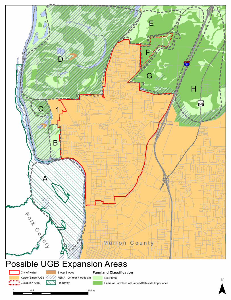
ËÌ99E
§̈¦5
Possible UGB Expansion Areas
0 1 20.5 Miles
City of KeizerKeizer/Salem UGBException Area
Steep SlopesFEMA 100 Year FloodplainFloodway
Farmland ClassificationNot PrimePrime or Farmland of Unique/Statewide Importance ¯
A
B
1
D
E
F
GH
C
Po l k C o u n t y
P o l k C o u n t y M a r i o n C o u n t yM a r i o n C o u n t y

City of Keizer Preliminary Assessment of Expansion Area Alternatives
Page 10 of 14
Exception Areas There is one significant area and two smaller areas of exception land adjacent to the Keizer UGB, shown in Figure 1 as Area F and in Figure 2 as Areas 1, 2, 3, and 4. Area F is predominantly zoned Acreage Residential (AR) by Marion County (approximately 96% of the total area and total developable area is zoned AR); the AR zone is essentially the County’s rural residential zone. The other areas are zoned Urban Transition (UT‐5) with the exception of the one large lot in Area 1, which is zoned Public and currently used for the City’s wastewater treatment plant and associated buffer areas.
Developable land in exception areas was estimated with methods used in the residential BLI, which includes calculations for potentially developable land on large lots with limited existing development. The assumptions are very conservative and may not provide a realistic assessment of actual development capacity in the area given the character of development there, as further described on page 12. The analysis of capacity in this area could be refined in future evaluations to better reflect these conditions. However, the current estimate provides a conservative or maximum estimate of capacity in this area.
Table 4: Exception Areas Adjacent to the Keizer UGB
Area 1 Area 2 Area 3
Area 4
(Area F)
Total Number of Lots 2 13 (including partial lots)
1 100
Distribution of Lot Sizes
>5 acres 1 1 5
2‐5 acres 1 19
1‐2 acres 3 50
<1 acre 1 9 26
Number of Vacant Lots 0 3 0 27
Number of Lots with Homes or Businesses
2 10 1 73
Total Acres 122.49 11.33 2.33 188.24
Total Developable Acres 0 5 0 150.85

City of Keizer Preliminary Assessment of Expansion Area Alternatives
Page 11 of 14
Figure 2: Exception Areas Adjacent to the Keizer UGB

City of Keizer Preliminary Assessment of Expansion Area Alternatives
Page 12 of 14
The total developable acres between the exception areas is approximately 156 acres, which constitutes a little less than half of the need for residential land in a potential UGB expansion. The shape, configuration, and existing development patterns of lots in the exception areas may pose considerable challenges to efficient urbanization of these areas, which is discussed in more detail under the Goal 14 locational factors. These exception areas would be targeted primarily for residential development and possibly some commercial or retail development intended to serve future residents in this area or adjacent areas. The parcelized nature of these areas – and having to assemble lots – is prohibitive to creating a 30‐50 acre site for a regional medical institutional use. For all of these reasons, farmland in other areas adjacent to the UGB will be considered for meeting the remaining residential, commercial and institutional land needs.
Farmland As can be seen in Figure 1, farmland surrounds the City of Keizer. This land is largely either prime farmland or of unique/statewide importance based on soil classifications. Some non‐prime farmland is located in this area but in many cases, the location and configuration of land with non‐prime soil classifications does not lend itself to consideration for contiguous development and makes it challenging to evaluate non‐prime areas separately from land with prime soils. The most significant areas of non‐prime farmland are found in Areas B, D, E, and H, and these are discussed in more detail in the next section in preparing to consider Goal 14 locational factors for the UGB expansion area alternatives.
Goal 14 Locational Factors Factors for locating a UGB are established in Goal 14, Oregon Administrative Rules (OAR) 660‐015‐000(14), and address issues such as efficiency of urbanization and relative potential social, economic and environmental impacts of UGB expansion area alternatives.
Before evaluating the Keizer UGB expansion area alternatives pursuant to the Goal 14 locational factors, it is advisable to screen the areas for “fatal flaws” that eliminate them from further consideration. It is recommended that the following areas be removed from further consideration for the following reasons.
• Area A – This area is located both across the Willamette River from the existing City of Keizer city limits and UGB and is in the floodway. Expanding the UGB across the river poses significant challenges in terms of expensive transportation and other facilities needed to literally bridge the areas and the barrier the river is to creating a connected and cohesive urban area. In addition, land within a floodway typically is not suitable for development of housing or employment uses because structures within such an area are not allowed to displace water during a flood event. This makes virtually all forms of residential and employment development impractical and infeasible from a cost and development perspective.
• Areas C and D – These areas are adjacent to the existing UGB but are in the 100‐year floodplain as designated by FEMA. The southern half of Area C is comprised of water bodies. (Note: Area 1 in Figure 1 is within the existing UGB but is unincorporated. This area is the site of a regional wastewater treatment plant.) Expanding urban development into a floodplain would not be

City of Keizer Preliminary Assessment of Expansion Area Alternatives
Page 13 of 14
advisable from the standpoint of development efficiency, natural resource protection or cost‐effective public service provision.
• Area H – This area lies east of I‐5 from Keizer. Like the Willamette River, I‐5 constitutes a major barrier to urban development that is connected and cohesive, one that would be extremely costly to bridge and expand across. In addition, this area is within the Salem portion of the Salem‐Keizer UGB and, therefore, is not appropriate for consideration as part of an amendment to Keizer’s UGB.
After removing the areas above, Areas B, E and G are left to be evaluated pursuant to Goal 14 locational criteria. Following is a general summary of how these areas compare to the locational factors. A more detailed analysis will need to be conducted as part of a future phase of evaluation.
• Area B o Efficiency. This area consists of both small and large lots with some existing development.
Urbanization of this area should be relatively efficient on the larger lots. However, with fewer large lots than Areas E and G, urbanization here will likely be less efficient and more costly than in those areas. This area is constrained to the west by floodplain but does not have any other identified natural resource constraints.
o Energy, Social, Environment and Economic Conditions. As one of the less efficient areas to urbanize, associated energy and economic costs should be higher in Area B. In addition, Area B does not meet institutional employment land needs, due to a lack of large site and limited or no access to regional transportation facilities. As a result, it is not expected to provide significant employment land and jobs resulting from providing employment land.
o Impacts on Farmland. As an area made up primarily of non‐prime farmland, little agricultural production on prime farmland would be lost if this area was converted for urbanization, compared to other potential expansion areas. In addition, Area B is a smaller potential UGB expansion area surrounded by designated open space (Keizer Rapids Park) instead of agricultural uses. As a result, it would be expected to have fewer impacts on existing agricultural uses in comparison to other alternative expansion areas.
• Area E o Efficiency. Area E consists mostly of larger lots, particularly lots with more land in the
interior of the area. Urbanization should be relatively efficient on larger lots. With fewer large lots than Area G, urbanization should be less efficient and more costly than Area G but more efficient and less costly than Area B.
o Energy, Social, Environment and Economic Conditions. As one of the more efficient areas to urbanize, associated energy and infrastructure costs should be lower in this area. Area E has the potential to provide significant employment land and resulting jobs, given the presence of larger parcels and major transportation facility access that could support future institutional employment. There are no identified natural resource constraints in Area E.
o Impacts on Farmland. With a split of non‐prime and prime farmland, non‐prime farmland in Area E can be targeted for urbanization, minimizing the loss of agricultural production on prime farmland, compared to other potential expansion areas. Agricultural lands are
City of Keizer Preliminary Assessment of Expansion Area Alternatives
Page 14 of 14
located to the north and west, potentially resulting in more significant impacts on surrounding farm activities in comparison to Area G. Use and development standards (including density standards) may need to be specialized in this area to provide an appropriate transition between development and surrounding farm activity.
• Area G o Efficiency. Area G is a large area of mid‐sized to large lots. Even though not all the lots in
this area are large, because this area is larger than the others and has several large lots, it should be more efficient to urbanize than Areas, B, E and F if the larger lots are included in the expansion area.
o Energy, Social, Environment and Economic Conditions. As one of the more efficient areas to urbanize, associated energy and infrastructure costs should be lower in Area G. Area G has the potential to meet the large site and major transportation facility access needs of a medical institutional use. As a result, Area G likely has the highest potential to provide significant employment land and resulting jobs in comparison to other potential alternative expansion areas.
o Impacts on Farmland. As an area of mostly prime farmland, there would be a relatively greater loss of agricultural production on prime farmland if it is converted for urbanization, compared to other potential expansion areas. Area G is primarily surrounded by non‐agricultural uses – I‐5 to the east, Keizer to the south, and the exception area (Area F) to the west. As a result, it would be expected to have fewer impacts on existing agricultural uses in comparison to Area E. The northern part of Area G could be subject to specialized use and development standards to provide an appropriate transition between development and surrounding farm activity.
Next Steps
A preliminary draft of this memorandum has been reviewed with City Staff. Further review with staff will be needed in order to refine the observations included in this assessment. The alternatives and associated assessment will be reviewed briefly with members of the project’s Citizen Advisory Committee (CAC), including key partners and stakeholders such as DLCD, the City of Salem, Marion County and others to gain initial input on the preliminary assessment.
After adoption of the EOA and HNA, the City will determine whether and how to proceed with a UGB amendment process. If it decides to proceed, additional analysis of potential alternative UGB expansion area will be undertaken. Once that analysis has been undertaken and thoroughly reviewed with local, regional and state agencies and other stakeholders, the City may proceed with a formal request to amend its UGB. Ultimately such a proposal must be acknowledged by the state Land Conservation and Development Commission.