Embed Size (px)
Citation preview
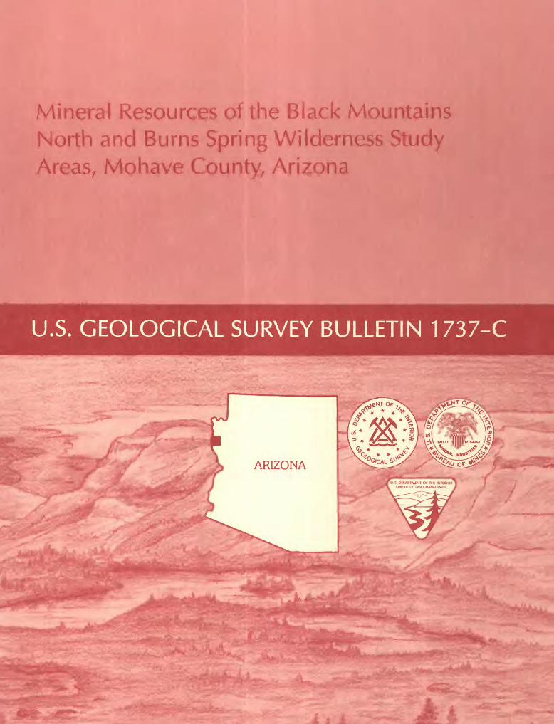
Mineral Resources of the Black Mountains North and Burns Spring Wilderness Study Areas, Mo have County, Arizona
- f. - - - ' ' - ' -f 5* -----
U.S. GEOLOGICAL SURVEY BULLETIN 1737-C

Chapter C
Mineral Resources of the Black Mountains North and Burns Spring Wilderness Study Areas, Mohave County, Arizona
By JAMES E. CONRAD, RANDALL H. HILL, and ROBERT C. JACHENS U.S. Geological Survey
JOHN T. NEUBERT U.S. Bureau of Mines
U.S. GEOLOGICAL SURVEY BULLETIN 1737
MINERAL RESOURCES OF WILDERNESS STUDY AREAS: BLACK MOUNTAINS REGION, ARIZONA
DEPARTMENT OF THE INTERIOR
MANUEL LUJAN, JR., Secretary
U.S. GEOLOGICAL SURVEY
Dallas L Peck, Director
Any use of trade, product, or firm names in this publication is for descriptive purposes only and does not imply endorsement by the U.S. Government
UNITED STATES GOVERNMENT PRINTING OFFICE, WASHINGTON : 1990
For sale by the Books and Open-File Reports Section, U.S. Geological Survey Federal Center, Box 25425 Denver, CO 80225
Library of Congress Cataloging-in-Publication Data
Mineral resources of the Black Mountains North and Burns Spring WildernessStudy Areas, Mohave County, Arizona / by James E. Conrad ... [et al.].
p. cm. (U.S. Geological Survey bulletin ; 1737-C)Includes bibliographical references (p.Supt. of Docs.: I 19.3:1737-C1. Mines and mineral resources Arizona Black Mountains North Wilder
ness. 2. Mines and mineral resources Arizona Burns Spring Wilderness. 3. Black Mountains North Wilderness (Ariz.) 4. Burns Spring Wilderness (Ariz.) I. Conrad, James E. II. Series.QE75.B9 no. 1737-C 557.3 s-dc20 89-600386 [TN24.A6] [553'.09791'59] CIP
STUDIES RELATED TO WILDERNESS
Bureau of Land Management Wilderness Study Area
The Federal Land Policy and Management Act (Public Law 94-579, October 21, 1976) requires the U.S. Geological Survey and the U.S. Bureau of Mines to conduct mineral surveys on certain areas to determine the mineral values, if any, that may be present. Results must be made available to the public and be submitted to the President and the Congress. This report presents the results of a mineral survey of part of the Black Mountains North (AZ-020-009) and Burns Spring (AZ-020-OlO) Wilderness Study Areas, Mohave County, Arizona.

CONTENTS
Summary 1 Abstract 1 Character and setting 1 Identified resources 1 Mineral resource potential of the Black Mountains North Wilderness Study
Area 3Mineral resource potential of the Burns Spring Wilderness Study Area 3
Introduction 5Location and physiography 5 Previous and present investigations 5 Acknowledgments 6
Appraisal of identified resources 6 Mining history 6 Recent mining and exploration 6 Land status 7 Results 7
Gold 7 Zeolites 9 Perlite 9
Assessment of mineral resource potential 9 Geology 9
Precambrian rocks 10 Tertiary and Quaternary rocks 10 Structure 11
Geochemical studies 11 Methods 11 Results 12
Geophysical studies 13 Aeromagnetic data 13 Gravity data 15
Mineral and energy resource potential of the Black Mountains North Wilder ness Study Area 15
Mineral and energy resource potential of the Burns Spring Wilderness StudyArea 16
References cited 16 Appendixes
Definition of levels of mineral resource potential and certainty ofassessment 20
Resource/reserve classification 21 Geologic time chart 22
PLATE
[In pocket]
1. Mineral resource potential map of the Black Mountains North and Burns Spring Wilderness Study Areas, Mohave County, Arizona
Contents
FIGURES
1. Index map showing location of the Black Mountains North and Burns Spring Wilderness Study Areas, Mohave County, Arizona 2
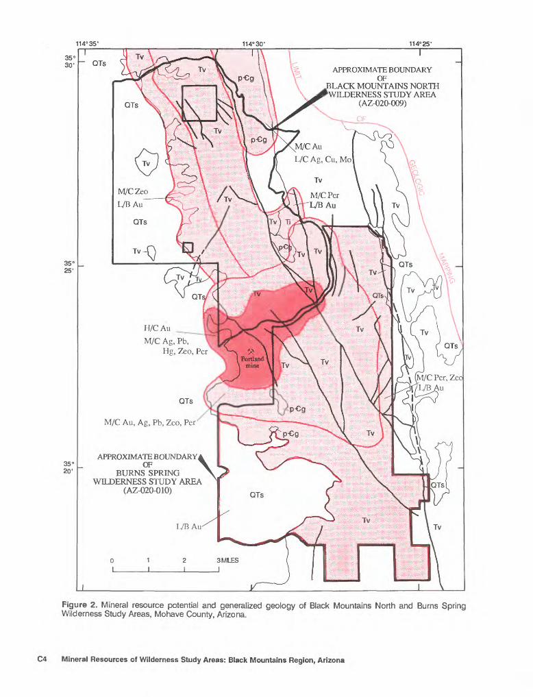
2. Map showing mineral resource potential and generalized geology of the Black Mountains North and Burns Spring Wilderness Study Areas, Mohave County, Arizona 4
TABLES
1. Lower limits of detection for elements analyzed by direct current arc emission spectrographic method 12
2. Wet-chemical methods and their lower limits of detection 133. Threshold values for all elements analyzed 14
VI Contents
Mineral Resources of the Black Mountains North and Burns Spring Wilderness Study Areas, Mohave County, ArizonaBy James E. Conrad, Randall H. Hill, and Robert C. Jachens U.S. Geological Survey
John T. Neubert U.S. Bureau of MinesSUMMARY
Abstract
At the request of the U.S. Bureau of Land Management, approximately 19,300 acres of the Black Mountains North Wilderness Study Area (AZ-020-009) and 23,310 acres of the Burns Spring Wilderness Study Area (AZ-020-Q10) were evaluated for mineral resources and mineral resource poten tial. In this report, the area studied is referred to, collectively or individually, as the "wilderness study area" or simply "the study area"; any reference to the Black Mountains North or Burns Spring Wilderness Study Areas refers only to that part of the wilderness study area for which a mineral survey was requested by the U.S. Bureau of Land Management. The study area is located in western Arizona, about 30 mi northwest of Kingman. There are no identified resources in the study area. An area surrounding the Portland mine and including the southern part of the Black Mountains North Wilderness Study Area and the extreme northwestern part of the Burns Spring Wilderness Study Area has high resource potential for gold and moderate resource potential for silver, lead, and mercury. The area surrounding this and including much of the northern part of the Burns Spring Wilderness Study Area has moderate potential for gold, silver, and lead. The northeastern corner of the Black Mountains North Wil derness Study Area has moderate potential for gold and low potential for silver, copper, and molybdenum resources. The central part, including the narrow strip of land just west of the central part, of the Black Mountains North Wilderness Study Area and the southern and extreme eastern parts of the Burns Spring Wilderness Study Area have low resource potential for gold. The central and southern parts of the Black Mountains North Wilderness Study Area and all but the southwestern part of the Burns Spring Wilderness Study Area have moderate resource potential for perlite. Moderate re-
Manuscript approved for publication November 29, 1989.
source potential for zeolites is assigned to a large area around the Portland mine that includes parts of both study areas, to a narrow strip of land just west of the central part of the Black Mountains North Wilderness Study Area, and to all but the southwest corner of the Burns Spring Wilderness Study Area. There is no potential for oil and gas in either study area. Sand and gravel are present in both study areas, but abundant quantities of these resources are available closer to existing markets.
Character and Setting
The study areas are underlain by Precambrian (see appendixes for geologic time chart) gneiss, schist, and granite unconformably overlain and in fault contact with Tertiary volcanic and associated sedimentary rocks. Small plugs of rhyolite intrude the older crystalline and volcanic rocks in several places in the study area. Mod erately to well-cemented Tertiary fanglomerate underlies the western parts of the study areas in Cottonwood Valley (fig. 1). Numerous, predominantly north-trending normal faults of varying displacement cut the study area, particularly west of the range crest. In this area, the volcanic rocks are characterized by extensive fracturing and faulting.
Identified Resources
There are no identified resources in the Black Mountains North or Burns Spring Wilderness Study Areas.
The Virginia mining district extends into the north ern Black Mountains North Wilderness Study Area and the Union Pass (or Katherine) district includes the southern tip of the Burns Spring Wilderness Study Area; production from within the study areas, if any, has been small.
Black Mountains North and Burns Spring Wilderness Study Areas, Arizona C1
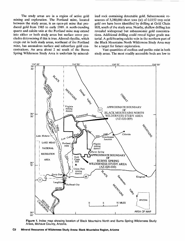
The study areas are in a region of active gold mining and exploration. The Portland mine, located between the study areas, is an open-pit mine that pro duced gold from 1985 to early 1989. A north-trending quartz and calcite vein at the Portland mine may extend into either or both study areas but surface cover pre cludes determining if this is true. Altered rhyolite, which crops out in both study areas, northeast of the Portland mine, has anomalous surface and subsurface gold con centrations. An area about 2 mi south of the Burns Spring Wilderness Study Area is underlain by mineral
ized rock containing detectable gold. Subeconomic re sources of 3,280,000 short tons (st) of 0.0152 troy oz/st gold ore have been identified by drilling at Gold Chain Hill, south of the study area. Nearby, shallow drilling has revealed widespread but subeconomic gold concentra tions. Additional drilling could reveal higher grade ma terial. A gold-bearing calcite vein in the northern part of the Black Mountains North Wilderness Study Area may be a target for future exploration.
Vast quantities of zeolites and perlite exist in both study areas. The most readily accessible beds are low to
114°30 114° 15' 114° 00'
APPROXIMATE BOUNDARY93V OF
BLACK MOUNTAINS NORTH r°*d \ WILDERNESS STUDY AREA
(AZ-020-009)
^^Grasshopper Junction
Cat>in
I LAKE MEAD\\\ Portland
NATIONAL A
! RECREATION
AREA
. Burns Spring
APPROXIMATE BOUNDARYOF
BURNS SPRINGWILDERNESS STUDY AREA
(AZ-020-010)p, ; Union Pass
mining district
Figure 1. Index map showing location of Black Mountains North and Burns Spring Wilderness Study Areas, Mohave County, Arizona.
C2 Mineral Resources of Wilderness Study Areas: Black Mountains Region, Arizona
medium quality. Higher quality zeolites and perlite may be present in the study areas.
Mineral Resource Potential of the Black Mountains North Wilderness Study Area
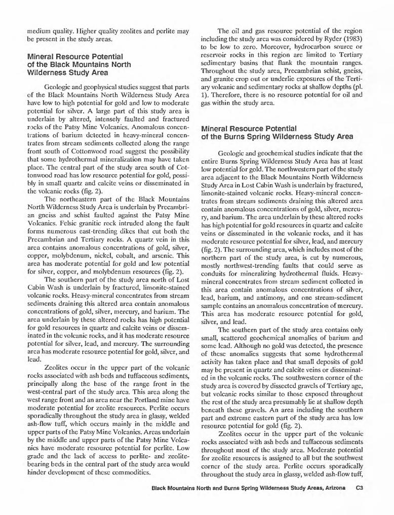
Geologic and geophysical studies suggest that parts of the Black Mountains North Wilderness Study Area have low to high potential for gold and low to moderate potential for silver. A large part of this study area is underlain by altered, intensely faulted and fractured rocks of the Patsy Mine Volcanics. Anomalous concen trations of barium detected in heavy-mineral concen trates from stream sediments collected along the range front south of Cottonwood road suggest the possibility that some hydrothermal mineralization may have taken place. The central part of the study area south of Cot tonwood road has low resource potential for gold, possi bly in small quartz and calcite veins or disseminated in the volcanic rocks (fig. 2).
The northeastern part of the Black Mountains North Wilderness Study Area is underlain by Precambri- an gneiss and schist faulted against the Patsy Mine Volcanics. Felsic granitic rock intruded along the fault forms numerous east-trending dikes that cut both the Precambrian and Tertiary rocks. A quartz vein in this area contains anomalous concentrations of gold, silver, copper, molybdenum, nickel, cobalt, and arsenic. This area has moderate potential for gold and low potential for silver, copper, and molybdenum resources (fig. 2).
The southern part of the study area north of Lost Cabin Wash is underlain by fractured, limonite-stained volcanic rocks. Heavy-mineral concentrates from stream sediments draining this altered area contain anomalous concentrations of gold, silver, mercury, and barium. The area underlain by these altered rocks has high potential for gold resources in quartz and calcite veins or dissem inated in the volcanic rocks, and it has moderate resource potential for silver, lead, and mercury. The surrounding area has moderate resource potential for gold, silver, and lead.
Zeolites occur in the upper part of the volcanic rocks associated with ash beds and tuffaceous sediments, principally along the base of the range front in the west-central part of the study area. This area along the west range front and an area near the Portland mine have moderate potential for zeolite resources. Perlite occurs sporadically throughout the study area in glassy, welded ash-flow tuff, which occurs mainly in the middle and upper parts of the Patsy Mine Volcanics. Areas underlain by the middle and upper parts of the Patsy Mine Volca nics have moderate resource potential for perlite. Low grade and the lack of access to perlite- and zeolite- bearing beds in the central part of the study area would hinder development of these commodities.
The oil and gas resource potential of the region including the study area was considered by Ryder (1983) to be low to zero. Moreover, hydrocarbon source or reservoir rocks in this region are limited to Tertiary sedimentary basins that flank the mountain ranges. Throughout the study area, Precambrian schist, gneiss, and granite crop out or underlie exposures of the Terti ary volcanic and sedimentary rocks at shallow depths (pi. 1). Therefore, there is no resource potential for oil and gas within the study area.
Mineral Resource Potentialof the Burns Spring Wilderness Study Area
Geologic and geochemical studies indicate that the entire Burns Spring Wilderness Study Area has at least low potential for gold. The northwestern part of the study area adjacent to the Black Mountains North Wilderness Study Area in Lost Cabin Wash is underlain by fractured, limonite-stained volcanic rocks. Heavy-mineral concen trates from stream sediments draining this altered area contain anomalous concentrations of gold, silver, mercu ry, and barium. The area underlain by these altered rocks has high potential for gold resources in quartz and calcite veins or disseminated in the volcanic rocks, and it has moderate resource potential for silver, lead, and mercury (fig. 2). The surrounding area, which includes most of the northern part of the study area, is cut by numerous, mostly northwest-trending faults that could serve as conduits for mineralizing hydrothermal fluids. Heavy- mineral concentrates from stream sediment collected in this area contain anomalous concentrations of silver, lead, barium, and antimony, and one stream-sediment sample contains an anomalous concentration of mercury. This area has moderate resource potential for gold, silver, and lead.
The southern part of the study area contains only small, scattered geochemical anomalies of barium and some lead. Although no gold was detected, the presence of these anomalies suggests that some hydrothermal activity has taken place and that small deposits of gold may be present in quartz and calcite veins or disseminat ed in the volcanic rocks. The southwestern corner of the study area is covered by dissected gravels of Tertiary age, but volcanic rocks similar to those exposed throughout the rest of the study area presumably lie at shallow depth beneath these gravels. An area including the southern part and extreme eastern part of the study area has low resource potential for gold (fig. 2).
Zeolites occur in the upper part of the volcanic rocks associated with ash beds and tuffaceous sediments throughout most of the study area. Moderate potential for zeolite resources is assigned to all but the southwest corner of the study area. Perlite occurs sporadically throughout the study area in glassy, welded ash-flow tuff,
Black Mountains North and Burns Spring Wilderness Study Areas, Arizona C3
114°35' 114° 30' 114°25'
APPROXIMATE BOUNDARYOF
BLACK MOUNTAINS NORTHWILDERNESS STUDY AREA
(AZ-020-009)
M/CAu
L/C Ag, Cu, Mo
M/CZeo
L/BAuM/CPer L/B Au
H/C Au
M/C Ag, Pb,Hg, Zeo, Per
M/C Per, Zeo L/BAu
QTs
M/C Au, Ag, Pb, Zeo, Per'
APPROXIMATE BOUNDARYOF
BURNS SPRINGWILDERNESS STUDY AREA
(AZ-020-010)
Figure 2. Mineral resource potential and generalized geology of Black Mountains North and Burns Spring Wilderness Study Areas, Mohave County, Arizona.
C4 Mineral Resources of Wilderness Study Areas: Black Mountains Region, Arizona
which occurs mainly in the middle and upper parts of the Patsy Mine Volcanics. Areas underlain by the middle and upper parts of the Patsy Mine Volcanics have moderate resource potential for perlite. However, the low grade and lack of access to these perlite- and zeolite-bearing beds in the central part of the study area would hinder their development.
The oil and gas resource potential of region includ ing the study area was considered by Ryder (1983) to be low to zero. In this region, however, hydrocarbon source or reservoir rocks are limited to Tertiary sedimentary basins that flank the mountain ranges. Within the study area, Precambrian schist, gneiss, and granite either crop out or underlie exposures of the Tertiary volcanic and sedimentary rocks at shallow depths. Therefore, there is no resource potential for oil and gas within the study area.
INTRODUCTION
This mineral survey was requested by the U.S. Bureau of Land Management and is the result of a cooperative effort by the U.S. Geological Survey and the U.S. Bureau of Mines. An introduction to the wilderness review process, mineral survey methods, and agency
EXPLANATION
Area having high resource potential (H)
Area having moderate resource potential (M)
Area having low resource potential (L)
Levels of certainty of assessment
Data only suggest level of potentialData give good indication of level of potentialMine
AuAg CuHg
QTsTiTVpeg
Commodities
Gold Silver Copper Mercury
Mo Pb Per Zeo
Molybdenum Lead Perlite Zeolites
Geologic map units
Surficial deposits (Quaternary and Tertiary)Intrusive rocks (Tertiary)Volcanic rocks (Tertiary)Granite, schist, and gneiss (Precambrian)
Contact
~ ~ Normal fault Dashed where approximately located
Figure 2. Continued.
responsibilities was provided by Beikman and others (1983). The U.S. Bureau of Mines evaluates identified resources at individual mines and known mineralized areas by collecting data on current and past mining activities and through field examination of mines, pros pects, claims, and mineralized areas. Identified resources are classified according to a system that is a modification of that described by McKelvey (1972) and U.S. Bureau of Mines and U.S. Geological Survey (1980). U.S. Geolog ical Survey studies are designed to provide a reasonable scientific basis for assessing the potential for undiscov ered mineral resources by determining geologic units and structures, possible environments of mineral deposition, presence of geochemical and geophysical anomalies, and applicable ore-deposit models. Goudarzi (1984) dis cussed mineral assessment methodology and terminology as they apply to these surveys. See appendixes for the definition of levels of mineral resource potential and certainty of assessment and for the resource/reserve classification.
Location and Physiography
The Black Mountains North and Burns Spring Wilderness Study Areas cover 19,300 and 23,310 acres, respectively, in western Arizona (fig. 1). They are located in the Black Mountains and are adjacent to the Lake Mead National Recreation Area. Topography in the study area is steep and rugged; elevations range from about 1,200 ft in Cottonwood Valley in the western part of the study area to about 4,300 ft in the eastern part.
The study areas are about 30 mi northwest of Kingman, Ariz., and about 12 mi northeast of Bullhead City, Ariz. Cottonwood road, a well-maintained dirt road branching off U.S. Highway 93 provides access to the northern part of the Black Mountains North Wilderness Study Area. Other dirt roads lead from U.S. Highway 93 and branch off to provide access to most of the eastern side of the wilderness study areas. A dirt road leading south from Cottonwood road divides the two wilderness study areas through Lost Cabin Wash and continues south near the west boundary of the Burns Spring Wilderness Study Area. This road provides access to the southern part of the Black Mountains North Wilderness Study Area and to the northern and western parts of the Burns Spring Wilderness Study Area. The western part of the Black Mountains North Wilderness Study Area and the southern part of the Burns Spring Wilderness Study Area are not accessible by road.
Previous and Present Investigations
The study area is included in reconnaissance geo logic maps by Wilson and Moore (1959) and Wilson and others (1969). A reconnaissance geologic study of the Colorado River region of Arizona and Nevada by Long-
Black Mountains North and Burns Spring Wilderness Study Areas, Arizona C5
well (1963) provided the first formal description of the Tertiary volcanic and sedimentary units exposed in the study area. Anderson (1971) and Anderson and others (1972) further refined the stratigraphy and volcanic and structural history of the region surrounding the study areas.
The U.S. Geological Survey conducted field inves tigations of the Black Mountains North and Burns Spring Wilderness Study Areas in 1986 and 1987. This work included geologic mapping at scales of 1:62,500 and 1:24,000, geochemical sampling, and examining outcrops for evidence of mineralization. Rock and stream- sediment (including a fine fraction and heavy-mineral concentrate) samples were collected for the geochemical survey. These samples were analyzed for 33 elements by semiquantitative emission spectrography. Gold, arsenic, antimony, cadmium, mercury, zinc, and bismuth were analyzed for by atomic-absorption methods, and uranium and thorium were analyzed for by delayed-neutron count. Earlier geophysical data, which consisted of regional gravity and magnetic surveys, were compiled and ana lyzed for this study. Further details on analytical proce dures used for this resource assessment are given in the sections that follow.
Studies by the U.S. Bureau of Mines included a background search of published and unpublished reports and U.S. Bureau of Mines files to gather data pertinent to the geology and mining history of the wilderness study areas. U.S. Bureau of Land Management files were searched for mining claim and lease information.
Fieldwork required 66 days and included examin ing and sampling mineralized areas, mines, and prospects in and within 0.5 mi of the study areas. Mining company geologists working within or near the study areas were interviewed to gain a better understanding of the miner alization of the Black Mountains.
A total of 213 rock, 35 panned-concentrate, and 34 stream-sediment samples was taken for analysis. Perlite and zeolite samples were tested for suitability for various industrial uses.
Most samples were analyzed by neutron activation for gold, silver, and 33 other elements by Bondar-Clegg, Lakewood, Colo. Five perlite samples were tested by the Perlite Corp., Chester, Pa.; eight zeolite samples were analyzed by CSMRI-Analytica, Inc., Golden, Colo.
Acknowledgments
The authors would like to thank Charles Williams and Jim Woods of Western States Mineral Corp.; Fred Humphrey and Jack Hamm of Combined Metals Reduc tion, Co.; Perry Durning and Bud Hillemeyer of Fischer- Watt Gold Co., Inc.; Pete Drobeck, consultant, and Bob Harrison of the U.S. Bureau of Land Management for their information regarding the geology and mining ac
tivity in the study areas. Additional thanks go to Bill Hamilton, local rancher, for his help in locating obscure and scattered mine workings.
APPRAISAL OF IDENTIFIED RESOURCES
By John T. Neubert U.S. Bureau of Mines
Mining History
The Black Mountains are host to many gold mining districts. The closest districts to the study areas, from north to south, are the Virginia, the Pilgrim, and the Union Pass (or Katherine) (fig. 1). The Portland mine and associated prospects lie about 7 mi from all these districts.
The Portland mine, which is between the study areas, was probably discovered in the early 1930's. Un derground and surface mining began in late 1935 or early 1936 and the ore was shipped to the Katherine Mill (Gardner, 1936, p. 48). Gold was the commodity pro duced, but production figures are unknown. Mining probably was discontinued in the early 1940's.
The Union Pass (or Katherine) district is 1 mi south of the Burns Spring Wilderness Study Area. The district was active intermittently from 1865 to 1943, and it had reported production of 704,000 st of ore from which 128,000 troy oz of gold and 313,000 troy oz of silver were recovered (Keith and others, 1983, p. 52-53).
The Virginia district is north of and overlaps the northern part of the Black Mountains North Wilderness Study Area. The district was active intermittently from 1907 to 1955, and in those years reported production was 76,000 st of ore from which 17,800 troy oz of gold, 17,700 troy oz of silver, 1,000 Ib of copper, and 3,000 Ib of lead were recovered (Keith and others, 1983, p. 52-53). Production from within the study area is not recorded but is small, as determined from the size of the workings present.
The Pilgrim district lies about 3 mi east of the Burns Spring Wilderness Study Area. The district pro duced 281,000 st of ore from which 48,000 troy oz of gold and 72,000 troy oz of silver were recovered between 1929 and 1945 (Keith and others, 1983, p. 42-43). This district does not extend into either wilderness study area.
Recent Mining and Exploration
The Portland mine was reopened as an open pit by Western States Minerals Corp. in March 1985. Mining ceased, at least temporarily, in mid-1987. Leaching activ ity continued into 1988, and the claim was sold in March 1989. Approximately 1,000,000 st of ore was removed in the most recent mining. Premining grade estimates were
C6 Mineral Resources of Wilderness Study Areas: Black Mountains Region, Arizona
0.06-0.07 troy oz of gold/st. Possible additional reserves were evaluated north, south, and east of the pit, along strike and downdip; this evaluation included drilling near the Portland vein and fault zone in early 1988. The open-pit mining plan assumed a gold price of $350/troy oz. A higher gold price could increase known reserves (Charles Williams, geologist, Western States Minerals Corp., oral commun., 1988).
Just east of the Portland mine, along Lost Cabin Wash road, a claim block that covers parts of the study areas has been staked by Combined Metals Reduction Co. In May 1987 the company drilled seven shallow (less than 100 ft deep) holes in altered volcanic rock having anomalous concentrations of gold in surface exposures. Gold anomalies continued to the depth tested, and the company plans additional deeper drilling when the land use status of the tract is decided (Fred Humphrey,, geologist, Combined Metals Reduction Co., oral com mun., 1988).
Geologic mapping, drilling, and sampling in the southern part of the Burns Spring Wilderness Study Area was done by Gold Fields Mining Corp., Anaconda Min erals Co., and Fisher-Watt Gold Co., Inc. between 1983 and 1986. Subeconomic resources of 3,280,000 st of 0.0152 troy oz/st gold were indicated at Gold Chain Hill, approximately 3 mi south of the wilderness study area. Drill holes between Gold Chain Hill and the wilderness study area intersected gold-bearing rock, but no resour ces were defined in the areas drilled (Fischer-Watt Gold Co., Inc. files, Kingman, Ariz.).
Zeolites along Cottonwood road, inside and adja cent to the Black Mountains North Wilderness Study Area, were examined by Occidental Minerals in 1979. The area was subsequently staked, but the claims were allowed to expire sometime during the transfer of zeolite properties among Occidental, Phelps Dodge Corp., Ten- neco Minerals Co., and Steelhead Resources (U.S. Bu reau of Land Management files, Kingman, Ariz.).
Other areas of mining activity near the wilderness study area include: the Virginia district, about 1 mi north of the Black Mountains North Wilderness Study Area, where Combined Metals Reduction Co. is developing a plan to extract up to 20,000 troy oz of gold by an open-pit heap-leaching operation at the Klondyke mine (Fred Humphrey, geologist, Combined Metals Reduction Co., oral commun., 1988); the Black Dyke mine area, about 3 mi south of the Burns Spring Wilderness Study Area, currently being drilled by Western States Mineral Corp. (Charles Williams, geologist, Western States Mineral Corp., oral commun., 1988); and the Roadside mine, about 1 mi southeast of Gold Chain Hill, where inde pendent miners were working in the spring of 1987. The Roadside mine was part of an exploration program by Anaconda and Fischer-Watt from 1983 to 1986, and Combined Metals Reduction Co. is currently (1988) evaluating the property.
Land Status
With the exception of two isolated parcels, the land within the study area is federally administered. However, the mineral rights within the study area are rather complex: Santa Fe Railroad and other private parties own the mineral rights to approximately 60 percent of the Black Mountains North Wilderness Study Area; about 65 percent of the mineral rights in the Burns Spring Wilder ness Study Area is federally administered; and the other 35 percent is held by Santa Fe Railroad, the State of Arizona, and other private parties. Oil and gas leases are present in both study areas, but no activities relating to oil and gas production were observed in the field. Petro leum potential in the study areas is rated low to zero because of the lack of source or reservoir rocks; the study areas are predominantly Precambrian rocks overlain by Tertiary volcanic rocks (Ryder, 1983).
Results
Gold
The Portland mine is an open-pit operation be tween the study areas in Portland Wash on the west side of the Black Mountains. The ore is found in a 5- to 20-ft-thick brecciated quartz and calcite vein striking approximately north and dipping 20-30° E. and in 10 to 150 ft of stockwork in the footwall. Undated quartz diorite and basalt dikes are exposed in the footwall, and Tertiary andesite and latite make up the hanging wall. The mineral deposit is nearly devoid of sulfides, and only trace amounts of gold are disseminated in the hanging wall of the vein. Average ore grade was about 0.05-0.08 troy oz gold/st and about 1,000,000 st were mined from 1985 to 1987 (Charles Williams, Western States Minerals Corp., oral commun., 1988; Pete Drobeck, consultant, oral commun., 1988).
A 2.5-ft-wide fault zone striking N. 80° E. and dipping 45° N. is exposed in a shaft a few hundred feet southeast of leach pads at the Portland mine. The zone cuts andesite and consists of red-brown gouge and brec ciated andesite. A 2.5-ft-long chip sample collected across the fault zone contains 7,830 parts per billion (ppb) or 0.23 troy oz gold/st and 41 parts per million (ppm) or 1.2 troy oz silver/st. The fault zone is not traceable at the surface due to alluvial cover (Neubert, 1989).
Prospect pits and outcrops in the vicinity of the Portland mine were sampled. North of the Portland mine, three samples of altered volcanic rocks were weak ly mineralized and contain a maximum of 19 ppb (0.006 troy oz/st) gold. Samples from prospect pits around the mine are barren of gold; most pits west of the mine appeared to be location pits dug for claim validation purposes (Neubert, 1989).
Black Mountains North and Burns Spring Wilderness Study Areas, Arizona C7
South of the Portland mine, Precambrian rock is exposed, but in most places the contact between the Precambrian and Tertiary rocks is covered by soil. The overlying Tertiary rock is conglomeratic, and in other places it is brecciated. Outcrop samples from the Pre cambrian and Tertiary units near the contact contain a maximum of 7 ppb (0.0002 troy oz gold/st). Two stream- sediment samples and a panned-concentrate sample from this vicinity contain a maximum of 11 ppb (0.0003 troy oz/st) gold (Neubert, 1989). No resources are iden tified in the vicinity of the Precambrian-Tertiary contact south of the Portland mine. The existence of detectable gold in some samples, however, indicates weak mineral ization possibly associated with the contact.
Combined Metals Reduction Co. has a claim block covering part of an area of fractured, altered rhyolite about 1.5 mi northeast of the Portland mine. The locally vesicular rhyolite is yellow to brown on fresh surfaces; limonite and hematite are concentrated on fracture sur faces and disseminated in the groundmass to some extent. The rhyolite is cut by mafic dikes and quartz and calcite veins and veinlets.
This altered area has been structurally prepared for mineralization. Two northwest-trending faults cut the area, and the rhyolite is severely fractured. A northeast- trending fault may also be present (Jack Hamm, Com bined Metals Reduction Co., oral commun., 1988). In the northern part of the altered area, rhyolite is in contact with Precambrian granite. Because the contact is not exposed, it is unclear whether it is a depositional or fault contact.
Prospect pits and outcrops in the altered area were sampled. The highest gold content in rock samples from the area is 360 ppb (0.10 troy oz/st). With the exception of two samples, all rock samples taken from the altered area north of Lost Cabin Wash contain gold in low concentrations (Neubert, 1989).
Stream-sediment and panned-concentrate samples were collected from washes draining the altered area. With the exception of one, every panned-concentrate sample contains detectable gold. The maximum concen tration of gold is 9,950 ppb (0.29 troy oz/st). One stream-sediment sample from the altered area contains gold (6 ppb, 0.0002 troy oz/st) (Neubert, 1989).
Combined Metals Reduction Co. drilled seven holes, each less than 100 ft deep, on their claim block in May 1987. Rock containing anomalous gold concentra tions was intersected, however, the grades were not economic. After the land use status is decided, the company plans drilling deep enough to reach the Precambrian-Tertiary contact in order to determine whether the contact is a mineralized detachment fault (Fred Humphrey, Jack Hamm, Combined Metals Re duction Co., oral commun., 1988).
About 2 mi south of the Burns Spring Wilderness Study Area, the Union Pass (Katherine) mining district
contains several prospects and small underground work ings. Although most of this area is covered by alluvium, both Precambrian and Tertiary rock is exposed on low ridges and knobs. Virtually every exposure of these pre-Quaternary rocks has been prospected.
Geologically, the area is complex; Precambrian porphyritic granite is intruded by Tertiary rhyolite dikes trending generally northwest, and some rhyolite flows are present as well. Much of the rock is brecciated and altered to the extent that the original rock type is obscured. Silicification has occurred in some of the dikes and breccias. The rock is cut by northwest-trending, steeply dipping faults.
Gold and minor amounts of silver are widely distributed in this area. With the exception of a sample from the Sunshine prospect containing oxidized copper, no base-metal-bearing minerals or sulfides were identi fied. Of 122 surface and underground samples taken near the southern end of the Burns Spring Wilderness Study Area, 80 contain detectable gold ranging from 5 to 6,650 ppb (0.002-0.19 troy oz/st). Eight samples contain greater than 1,000 ppb (0.029 troy oz/st). The higher concentrations are found in breccia, granite, and rhyolite (Neubert, 1989).
The highest gold concentrations at the surface were at three localities: the Desert prospect, the Sunshine prospect, and Gold Chain Hill (pi. 1). These areas and other locations near the southern end of the study area were drilled in the 1980's. Drill results indicate wide spread but subeconomic gold concentrations throughout the area south of the Burns Spring Wilderness Study Area, but there are no identified resources of gold in the study area. Three miles south of the wilderness study area at Gold Chain Hill, drilling indicates subeconomic resources of 3,280,000 st containing 0.0152 troy oz gold/st from the surface to about 200 ft deep. The mineralization in this area is related to a low-angle detachment fault that is exposed southeast of the study area and probably extends at shallow depth beneath the area (Fischer-Watt Gold Co., Inc., Kingman, Ariz., files). If this is the case, mineralized rock underlies shallow unconsolidated Quaternary deposits in the southern end of the study area. Most drilling has been done on or adjacent to knobs exposed through alluvium. Drilling away from the knobs could reveal economic concentra tions of gold beneath a thin, unconsolidated overburden.
The northernmost part of the Black Mountains North Wilderness Study Area lies along the south border of the Virginia mining district. Two small workings lie within the study area (pi. 1). Within and adjacent to the study area, Tertiary volcanic rocks are cut by northwest- trending low- and high-angle faults and veins; veins are filled with calcite and lesser amounts of quartz. Because of alluvial cover, none of the veins outside the wilderness study area could be traced into the study area; however, a low-angle gouge zone and a high-angle calcite vein are
C8 Mineral Resources of Wilderness Study Areas: Black Mountains Region, Arizona
exposed in the study area. The low-angle gouge zone is 1 in. thick, and the hanging wall and footwall of the zone contain low gold concentrations of 16 ppb (0.0005 troy oz/st) and 39 ppb (0.001 troy oz/st), respectively. The calcite vein contains gold concentrations ranging from 9 ppb (0.0003 troy oz/st) to 1,950 ppb (0.057 troy oz/st). In addition, the hanging wall of the vein has numerous calcite veinlets and stringers and carries from 15 ppb (0.004 troy oz/st) to 32 ppb (0.009 troy oz/st) gold. The footwall of the vein is fractured, but it is relatively calcite free and contains no detectable gold. Southeast of this vein, in and adjacent to the Black Mountains North Wilderness Study Area in the Squaw Pocket well vicinity, prospect pits have been dug in Tertiary volcanic rocks, Precambrian rocks, and at the contacts of a Tertiary intrusion in Precambrian rocks (pi. 1). Low gold concen trations ranging from 6 to 10 ppb (0.002-0.003 troy oz/st) are contained in 3 of 12 samples. Near Lost Cabin Spring (pi. 1), prospect pits expose quartz veins and pods in Precambrian granite. Gold concentrations of 7-8 ppb (0.0002 oz/st) were present in 4 of 10 samples. However, there are no identified gold resources in the Black Mountains North Wilderness Study Area.
Zeolites
Zeolite-bearing ash beds of Tertiary age are com mon in both wilderness study areas, however, there are no identified resources of zeolites in either study area. Some of the beds, usually the most accessible, were mapped and sampled. Clinoptilolite and mordenite were identified by x-ray diffraction.
The major use of clinoptilolite and mordenite is in the treatment of municipal sewage and radioactive waste- water. Clinoptilolite is also used as a filler in paper, a detergent additive, a carrier of agricultural chemicals, an animal feed supplement, a soil conditioner, and in ply wood manufacturing. Mordenite is sometimes used in the production of lightweight brick (Torii, 1978, p. 441).
A quality critical to the value of zeolites, especially for wastewater treatment, is the ammonium ion- exchange capacity. Mercer and Ames (1978, p. 451) recommended a minimum ammonium ion-exchange ca pacity of 1.7 milliequivalents per grain (meq/g). Most past and present zeolite-producing deposits are fairly pure, ranging from about 60 to 99 percent zeolites. Experimental methods to beneficiate ore from 60-70 percent to 80-85 percent zeolite have been successful (Mondale and others, 1978, p. 527).
Zeolites sampled in and near the wilderness study areas were in beds from 7 to 100 ft thick. The zeolite content ranged from 10 to 50 percent clinoptilolite, from 20 to 55 percent mordenite, and from 60 to 80 percent total zeolite. The ammonium ion-exchange capacity ranged from 0.32 to 0.64 meq/g. The samples taken were usually the purest looking material and purposely exclud
ed quartz and fluorite veins and veinlets that cut some of the zeolite beds, therefore the actual zeolite content of the deposits is somewhat lower than 60-80 percent (Neubert, 1989).
Although the zeolite beds sampled in this study are low grade and have a low ammonium ion-exchange capacity, beneficiation of the ore could improve the ammonium ion-exchange capacity. Any attempt to quan tify the resources would require large numbers of sam ples and detailed mapping. Additional zeolite beds occur in parts of the wilderness study areas not traversed.
Perlite
Perlite, a volcanic glass, is found in both study areas, near zeolites. However, neither study area con tains identified resources of perlite. When crushed to uniform size and rapidly heated to its softening point, it expands to a lightweight, porous material used for nu merous industrial applications, such as lightweight aggre gate for plaster and concrete, filter aid, insulation, and paint extenders.
Surface samples of perlite taken from 7- to 50- ft-thick beds were expanded, or popped, at three differ ent pre-heat temperatures. Post-popping densities ranged from 71 kg/m3 (kilograms per cubic meter) to 128 kg/m3 . Perlite of this quality is acceptable for use as aggregate in plaster and concrete, although most current ly exploited ore is higher in quality (The Perlite Corp., written commun., 1987). Both wilderness study areas contain perlite. Detailed mapping and sampling of the beds is required to quantify the resources. Additional perlite beds probably exist at the surface in parts of the wilderness study areas not traversed.
ASSESSMENT OF MINERAL RESOURCE POTENTIAL
By James E. Conrad, Randall H. Hill, and Robert C. Jachens U.S. Geological Survey
Geology
Precambrian gneiss, schist, and granitic rocks crop out along the eastern border of the Black Mountains North Wilderness Study Area. Most of the Black Moun tains North and Burns Spring Wilderness Study Areas are underlain by Tertiary volcanic rocks that consist of latite, dacite, and rhyolite ash-flow tuffs, flows, and silicic intrusive bodies. Basaltic to andesitic lava flows and tuffaceous sedimentary rocks are important components in the upper part of the volcanic section. The Precambri an rocks probably underlie the volcanic rocks at shallow depth everywhere in the study area. Aplitic dikes and
Black Mountains North and Burns Spring Wilderness Study Areas, Arizona C9
small intrusive bodies cut the Tertiary volcanic and Precambrian rocks. Tertiary fanglomerate overlies these rocks in the western part of the study area in Cottonwood Valley and is cut and eroded by modern streams and washes. The generalized geology of the study areas is shown on plate 1 and in figure 2.
Precambrian Rocks
Precambrian rocks are exposed along the eastern part of the Black Mountains North Wilderness Study Area. Within the study area, the northernmost exposure of these rocks consists of augen gneiss containing plagi- oclase porphyroclasts up to 0.5 in. across in a granular matrix of biotite and quartz. The central part of this exposure consists of fine-grained quartz-biotite schist. The southern part of the Precambrian exposure consists of reddish-weathering medium- to coarse-grained biotite granite that is deeply weathered in the northern part. The Precambrian rocks are in fault contact with Tertiary volcanic rocks to the west, which dip 35-50° W. The eastern and southern contact with the volcanic rocks appears to be depositional; however, because the contact is poorly exposed, the possibility that it is a low-angle fault cannot be ruled out.
Tertiary and Quaternary Rocks
The Patsy Mine Volcanics comprises a section of ash-flow tuffs and lavas that is about 13,000 ft thick at its type locality near the town of Nelson, Nev. (Anderson, 1971). Within the study area, this unit is cut by numerous faults and only the uppermost 6,000 ft of section appears to be present. The Patsy Mine Volcanics forms most of the bedrock in the study area. The unit is largely rhyolitic, dacitic, and latitic ash-flow tuffs. Basalt, andesite, and latite flows are also found throughout the section but are most common in the lower part of the section. Near the top of the unit, a sequence of tuffaceous sedimentary rocks occurs and is locally mapped separately (pi. 1). These yellowish-weathering tuffaceous rocks are com monly zeolitized. Thickness of this sedimentary unit is variable but generally thickens from about 300 ft at Cottonwood road to about 600 ft in the southern part of the Burns Spring Wilderness Study Area. Potassium- argon (K-Ar) ages for flows in this unit ranging from 14.5±0.6 to more than 40 Ma (million years before the present) are reported by Anderson and others (1972); however, ages older than about 20 Ma are considered anomalous and result from contamination of older ma terial incorporated into the flows. Anderson and others (1972) considered the best age for this unit to range from 14.5 to 18.6 Ma or early to middle Miocene. Three samples from this unit collected along the east bound aries of the study areas during this study gave ages of
15.7±0.4, 15.7±0.5, and 15.6±0.4 Ma, suggesting that these rocks correlate with the middle part of the Patsy Mine Volcanics as defined by Anderson and others (1972).
The Mount Davis Volcanics consists of a thick sequence of dark-brown to black-weathering basalt and andesite flows named for exposures at Mount Davis, about 5 mi northwest of the study area (Longwell, 1963). Maximum thickness of this unit may exceed 4,000 ft (Longwell, 1963), but only a small part of this thickness is exposed in the study area. The Mount Davis Volcanics is exposed along the base of the western range front, where the lowermost part of the section lies above the Patsy Mine Volcanics with an angular discordance of about 35°. Other small outcrops of this unit occur mainly along the eastern edge of the study area, where nearly flat-lying dark lavas of the Mount Davis Volcanics cap hills above exposures of tilted Patsy Mine Volcanics. The unit con sists mainly of fine-grained, dark-brown to black glassy basalt containing phenocrysts of olivine commonly rimmed with iddingsite. Some flows contain sparse phe nocrysts of plagioclase and pyroxene. Also present are flows of fine-grained gray andesite containing pheno crysts of plagioclase, pigeonite, and augite. Several rhy olitic ash-flow tuffs are present in the section; these flows contain phenocrysts of quartz, sanidine, and biotite in a matrix of perlitic glass. Ages for this unit, as determined by the K-Ar method, range from 14.6±0.3 to 11.8±0.5 Ma (Anderson and others, 1972) or middle Miocene. Basalt from a flow capping a ridge in the eastern part of the Burns Spring Wilderness Study Area was dated for this study at 11.7±0.4 Ma.
Numerous felsic dikes and small intrusive bodies are exposed in several places in the study area. The northern part of the Black Mountains North Wilderness Study Area is cut by these east-trending felsic dikes that are about 10 to 25 ft wide and as long as 1.5 mi. These dikes consist mainly of quartz and feldspars and contain little or no mafic minerals. Biotite from one of these dikes gave a K-Ar age of 15.7±0.4 Ma. Near Lost Cabin Wash, several small- to medium-sized bodies of similar composition are exposed.
The western part on the Black Mountains North Wilderness Study Area and the southwestern part of the Burns Spring Wilderness Study Area are underlain by Quaternary and Tertiary sedimentary deposits that are presently being eroded by younger alluvial channels draining the Black Mountains. These include moderately to well-cemented fanglomerate derived from the Black Mountains, lacustrine deposits, and older perched gravel and sandstone deposits of the Colorado River. Younger sedimentary deposits occur throughout the study areas and include alluvial fans along the edge of the Black Mountains, unconsolidated sand and gravel in stream bottoms, and unconsolidated rock debris on gentle slopes and talus on steeper slopes.
CIO Mineral Resources of Wilderness Study Areas: Black Mountains Region, Arizona
Structure
Rocks within the study area are faulted and tilted as a result of late Tertiary deformation related to exten- sional tectonics (Anderson, 1971). In the central part of the Black Mountains North Wilderness Study Area, rocks of the Patsy Mine Volcanics dip about 45° W. The bottom of the section is cut out by the northwest-trending fault that runs nearly the entire length of the study area and juxtaposes the volcanic rocks with the Precambrian rocks. Dip decreases to the south, and so outcrops of the Patsy Mine Volcanics dip about 20° W. in the southern part of the Burns Spring Wilderness Study Area. Just east of the study area, rocks probably representing the upper part of the Patsy Mine Volcanics are nearly flat lying to slightly eastward dipping. Overall, the structural pattern indicates a faulted, southward-plunging anticline cored by the Precambrian rocks.
On the eastern side of the Black Mountains North Wilderness Study Area, the nature of the eastern contact between the Precambrian and Tertiary volcanic rocks is equivocal. Tertiary rocks appear to lie on the Precambri an rocks conformably, but nowhere is the contact well exposed. About 10 mi south of the study area, near Davis Dam, Tertiary volcanic rocks are faulted against Precam brian rocks along a low-angle detachment fault. It is likely that this fault extends beneath the entire western part of the study area. Therefore, the possibility that the eastern contact between Precambrian and Tertiary rocks is a low-angle fault cannot be ruled out.
Geochemical Studies
Methods
In November 1986, a reconnaissance geochemical survey was conducted in the Black Mountains North and Burns Spring Wilderness Study Areas to aid the mineral resource assessment. Rocks, stream sediments, and panned heavy-mineral concentrates were used as the sample media for evaluation. Fresh, unaltered rock sam ples were collected and analyzed to determine geochem ical background values of the rocks in the study areas. Stream sediments represent a composite of the chemistry of rock and soil exposed in the drainage basin upstream from the sample site. Chemical analyses of these stream- sediment samples provide data useful in identifying those basins that contain unusually high concentrations of elements possibly related to mineral occurrences. In addition, studies have shown that heavy-mineral panned concentrates derived from stream sediment are a useful sample medium in arid to semi arid environments or in areas of rugged topography, where mechanical erosion predominates over chemical erosion (Bugrov and Shala- by, 1975; Overstreet and Marsh, 1981). The heavy-
mineral-concentrate samples provide information about the chemistry of a limited number of minerals present in rock material eroded from the drainage basin upstream from each sample site. The procedure for the analysis of the heavy-mineral concentrate results in a sample repre senting a concentration of a mineral assemblage that may be rich in ore-forming and ore-related minerals. This selective concentration of ore-related minerals permits determination of some elements that are not easily detected in bulk stream-sediment samples.
Forty-four fresh and unaltered rock samples were collected to represent the rocks exposed near the sites. The actual areal extent of influence of the geochemical information is not known; the sampling was designed to provide some general information on the geochemical background values of the lithologies present. Single grab samples from outcrops were collected. In addition, one mine-dump sample was collected to provide some gen eral information on the mineral deposits present in the area.
Sixty-two minus-60-mesh stream-sediment sam ples collected from active stream alluvium and 62 heavy- mineral panned concentrates derived from stream sediment were collected and analyzed. The dry stream- sediment samples were sieved through 60-mesh stainless-steel sieves. The minus-60-mesh material was retained for analysis and pulverized with ceramic plates to at least minus-100-mesh size prior to analysis.
To produce the heavy-mineral concentrate, bulk stream sediment was first sieved through a 10-mesh screen. Approximately 25-30 Ib of minus-10-mesh sedi ment was panned to remove most quartz, feldspar, organic material, and clay-sized material. These samples were air dried, passed through a 30-mesh sieve, and then separated into light and heavy fractions using bromoform (heavy liquid, specific gravity 2.86). The light fraction was discarded. The material of specific gravity higher than 2.86 was separated into three fractions (highly magnetic, weakly magnetic, and nonmagnetic) using a modified Frantz Isodynamic Magnetic Separator. The nonmagnet ic fraction was hand ground and retained for emission spectrographic analysis. Rock samples were crushed and then pulverized to at least minus-100-mesh size with ceramic plates prior to analysis.
Rock, stream-sediment, and nonmagnetic portions of the prepared heavy-mineral concentrate were ana lyzed using a semiquantitative, direct current arc emis sion spectrographic method (Grimes and Marranzino, 1968). The rock and stream sediments were analyzed spectrographically for 31 elements, and the nonmagnetic portion of the heavy-mineral-concentrate samples was analyzed for 37 elements. The lower limits of detection of the elements analyzed are listed in table 1. In addition, the rock and stream-sediment samples were analyzed for some elements by the more sensitive and precise tech niques summarized in table 2. Of the elements detected
Black Mountains North and Burns Spring Wilderness Study Areas, Arizona C11
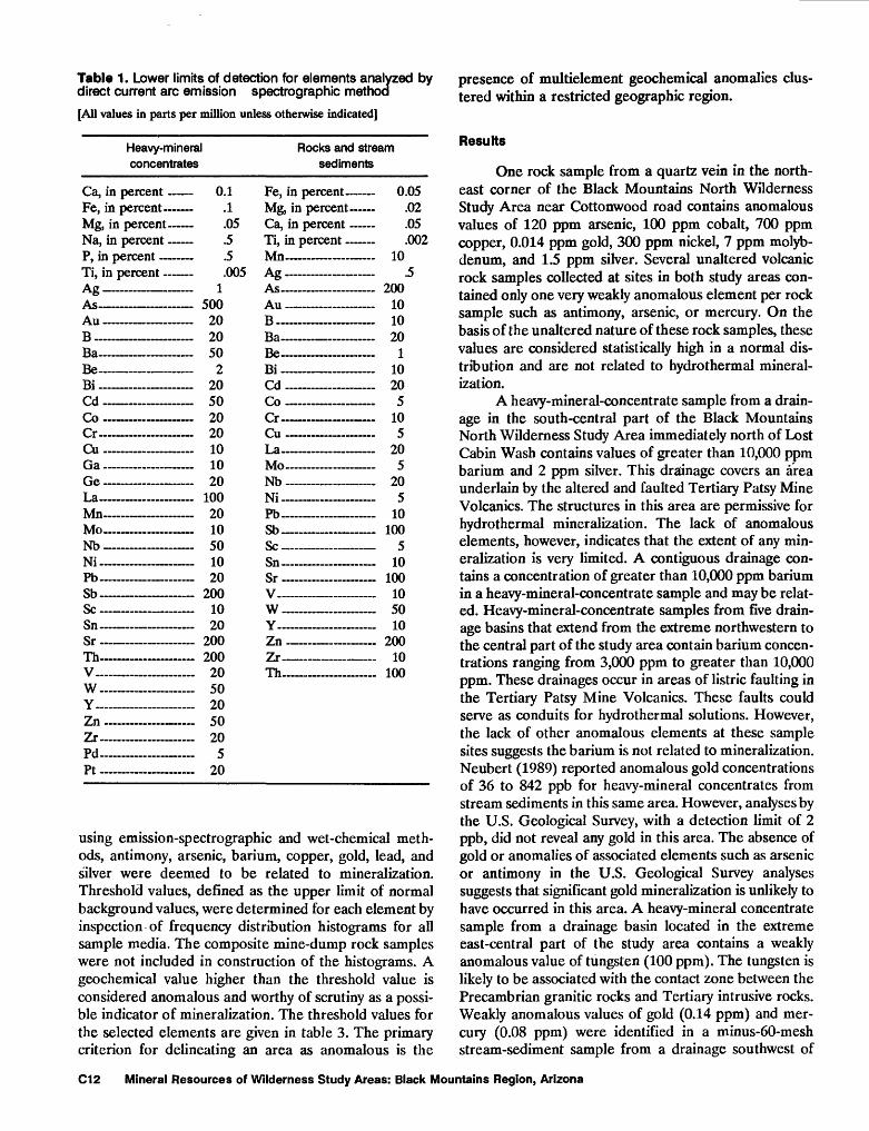
Table 1. Lower limits of detection for elements analyzed by direct current arc emission spectrographic method
[All values in parts per million unless otherwise indicated]
Heavy-mineral concentrates
Ca, in percent Fe, in percent Mg, in percent Na, in percent P, in percent Ti, in percent Ag ________"t? As _________Au ________B _________Ba _________BeBi _________Cd _ ______Co ___ __ _Cr~-Cu _______ ...Ga - ________Ge ________La _ .. .Mn _______ Mo~Nb .....................Ni- -Pb _________Sb _________Sc __ ______Sn ~ _~- ....Sr -Th _________V... .................w . _ . ____Y--Zn ________Zr- .Pd-~Pt _ .
Rocks and stream sediments
0.1 .1 .05 .5 .5 .005
1 500 20 20 50
2 20 50 20 20 10 10 20
100 20 10 50 10 20
200 10 20
200 200
20 50 20 50 20
5 20
Fe, in percent Mg, in percent Ca, in percent Ti, in percent Mn~-~~ ~ ... ... ...Ac _- _-.__ «-*& -A«
Au .....................
Ba Be ________Bi _________Cd ~Co ________CrCu - _______La _________Mo- - - -_--Nb Ni _________Pb - - -SbScSn ______ _Sr _ . ... ..V .-- __- _ _W _________YZn .....................Zr . ....... ....Th
0.05 .02 .05 .002
10 .5
200 10 10 20
1 10 20
5 10 5
20 5
20 5
10 100
5 10
100 10 50 10
200 10
100
using emission-spectrographic and wet-chemical meth ods, antimony, arsenic, barium, copper, gold, lead, and silver were deemed to be related to mineralization. Threshold values, defined as the upper limit of normal background values, were determined for each element by inspection of frequency distribution histograms for all sample media. The composite mine-dump rock samples were not included in construction of the histograms. A geochemical value higher than the threshold value is considered anomalous and worthy of scrutiny as a possi ble indicator of mineralization. The threshold values for the selected elements are given in table 3. The primary criterion for delineating an area as anomalous is the
presence of multielement geochemical anomalies clus tered within a restricted geographic region.
Results
One rock sample from a quartz vein in the north east corner of the Black Mountains North Wilderness Study Area near Cottonwood road contains anomalous values of 120 ppm arsenic, 100 ppm cobalt, 700 ppm copper, 0.014 ppm gold, 300 ppm nickel, 7 ppm molyb denum, and 1.5 ppm silver. Several unaltered volcanic rock samples collected at sites in both study areas con tained only one very weakly anomalous element per rock sample such as antimony, arsenic, or mercury. On the basis of the unaltered nature of these rock samples, these values are considered statistically high in a normal dis tribution and are not related to hydrothermal mineral ization.
A heavy-mineral-concentrate sample from a drain age in the south-central part of the Black Mountains North Wilderness Study Area immediately north of Lost Cabin Wash contains values of greater than 10,000 ppm barium and 2 ppm silver. This drainage covers an area underlain by the altered and faulted Tertiary Patsy Mine Volcanics. The structures in this area are permissive for hydrothermal mineralization. The lack of anomalous elements, however, indicates that the extent of any min eralization is very limited. A contiguous drainage con tains a concentration of greater than 10,000 ppm barium in a heavy-mineral-concentrate sample and may be relat ed. Heavy-mineral-concentrate samples from five drain age basins that extend from the extreme northwestern to the central part of the study area contain barium concen trations ranging from 3,000 ppm to greater than 10,000 ppm. These drainages occur in areas of listric faulting in the Tertiary Patsy Mine Volcanics. These faults could serve as conduits for hydrothermal solutions. However, the lack of other anomalous elements at these sample sites suggests the barium is not related to mineralization. Neubert (1989) reported anomalous gold concentrations of 36 to 842 ppb for heavy-mineral concentrates from stream sediments in this same area. However, analyses by the U.S. Geological Survey, with a detection limit of 2 ppb, did not reveal any gold in this area. The absence of gold or anomalies of associated elements such as arsenic or antimony in the U.S. Geological Survey analyses suggests that significant gold mineralization is unlikely to have occurred in this area. A heavy-mineral concentrate sample from a drainage basin located in the extreme east-central part of the study area contains a weakly anomalous value of tungsten (100 ppm). The tungsten is likely to be associated with the contact zone between the Precambrian granitic rocks and Tertiary intrusive rocks. Weakly anomalous values of gold (0.14 ppm) and mer cury (0.08 ppm) were identified in a minus-60-mesh stream-sediment sample from a drainage southwest of
C12 Mineral Resources of Wilderness Study Areas: Black Mountains Region, Arizona
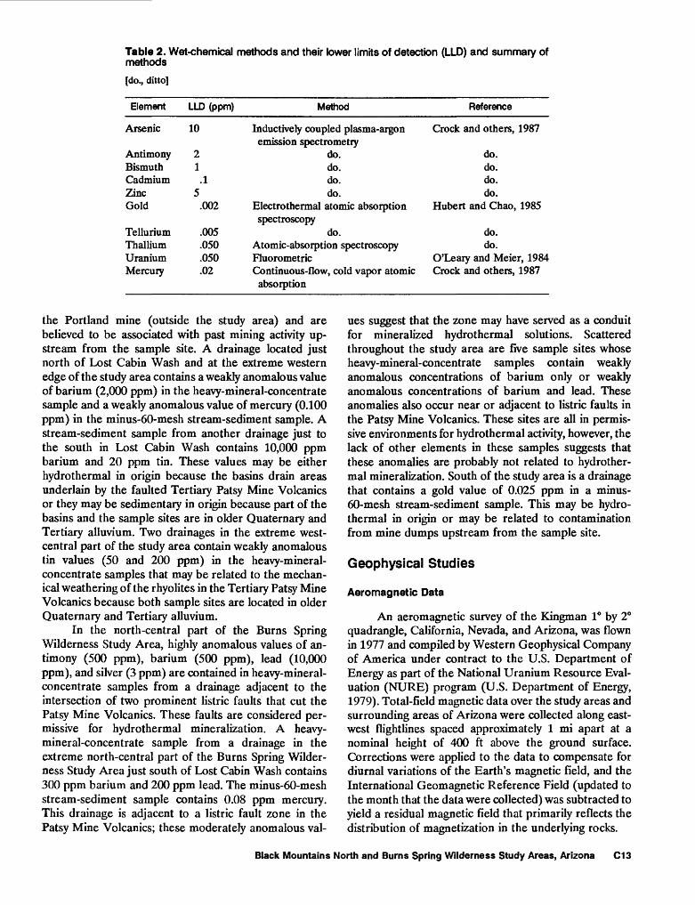
Table 2. Wet-chemical methods and their lower limits of detection (LLD) and summary of methods
[do., ditto]
Element
Arsenic
Antimony BismuthCadmiumZincGold
TelluriumThallium Uranium Mercury
LLD (ppm)
10
2 1
.15
.002
.005
.050
.050
.02
Method
Inductively coupled plasma-argonemission spectrometry
do. do.do.do.
Electrothermal atomic absorptionspectroscopy
do.Atomic-absorption spectroscopy Fluorometric Continuous-flow, cold vapor atomic absorption
Reference
Crock and others, 1987
do. do.do.do.
Hubert and Chao, 1985
do.do.
O'Leary and Meier, 1984 Crock and others, 1987
the Portland mine (outside the study area) and are believed to be associated with past mining activity up stream from the sample site. A drainage located just north of Lost Cabin Wash and at the extreme western edge of the study area contains a weakly anomalous value of barium (2,000 ppm) in the heavy-mineral-concentrate sample and a weakly anomalous value of mercury (0.100 ppm) in the minus-60-mesh stream-sediment sample. A stream-sediment sample from another drainage just to the south in Lost Cabin Wash contains 10,000 ppm barium and 20 ppm tin. These values may be either hydrothermal in origin because the basins drain areas underlain by the faulted Tertiary Patsy Mine Volcanics or they may be sedimentary in origin because part of the basins and the sample sites are in older Quaternary and Tertiary alluvium. Two drainages in the extreme west- central part of the study area contain weakly anomalous tin values (50 and 200 ppm) in the heavy-mineral- concentrate samples that may be related to the mechan ical weathering of the rhyolites in the Tertiary Patsy Mine Volcanics because both sample sites are located in older Quaternary and Tertiary alluvium.
In the north-central part of the Burns Spring Wilderness Study Area, highly anomalous values of an timony (500 ppm), barium (500 ppm), lead (10,000 ppm), and silver (3 ppm) are contained in heavy-mineral- concentrate samples from a drainage adjacent to the intersection of two prominent listric faults that cut the Patsy Mine Volcanics. These faults are considered per missive for hydrothermal mineralization. A heavy- mineral-concentrate sample from a drainage in the extreme north-central part of the Burns Spring Wilder ness Study Area just south of Lost Cabin Wash contains 300 ppm barium and 200 ppm lead. The minus-60-mesh stream-sediment sample contains 0.08 ppm mercury. This drainage is adjacent to a listric fault zone in the Patsy Mine Volcanics; these moderately anomalous val
ues suggest that the zone may have served as a conduit for mineralized hydrothermal solutions. Scattered throughout the study area are five sample sites whose heavy-mineral-concentrate samples contain weakly anomalous concentrations of barium only or weakly anomalous concentrations of barium and lead. These anomalies also occur near or adjacent to listric faults in the Patsy Mine Volcanics. These sites are all in permis sive environments for hydrothermal activity, however, the lack of other elements in these samples suggests that these anomalies are probably not related to hydrother mal mineralization. South of the study area is a drainage that contains a gold value of 0.025 ppm in a minus- 60-mesh stream-sediment sample. This may be hydro- thermal in origin or may be related to contamination from mine dumps upstream from the sample site.
Geophysical Studies
Aeromagnetic Data
An aeromagnetic survey of the Kingman 1° by 2° quadrangle, California, Nevada, and Arizona, was flown in 1977 and compiled by Western Geophysical Company of America under contract to the U.S. Department of Energy as part of the National Uranium Resource Eval uation (MURE) program (U.S. Department of Energy, 1979). Total-field magnetic data over the study areas and surrounding areas of Arizona were collected along east- west flightlines spaced approximately 1 mi apart at a nominal height of 400 ft above the ground surface. Corrections were applied to the data to compensate for diurnal variations of the Earth's magnetic field, and the International Geomagnetic Reference Field (updated to the month that the data were collected) was subtracted to yield a residual magnetic field that primarily reflects the distribution of magnetization in the underlying rocks.
Black Mountains North and Burns Spring Wilderness Study Areas, Arizona C13
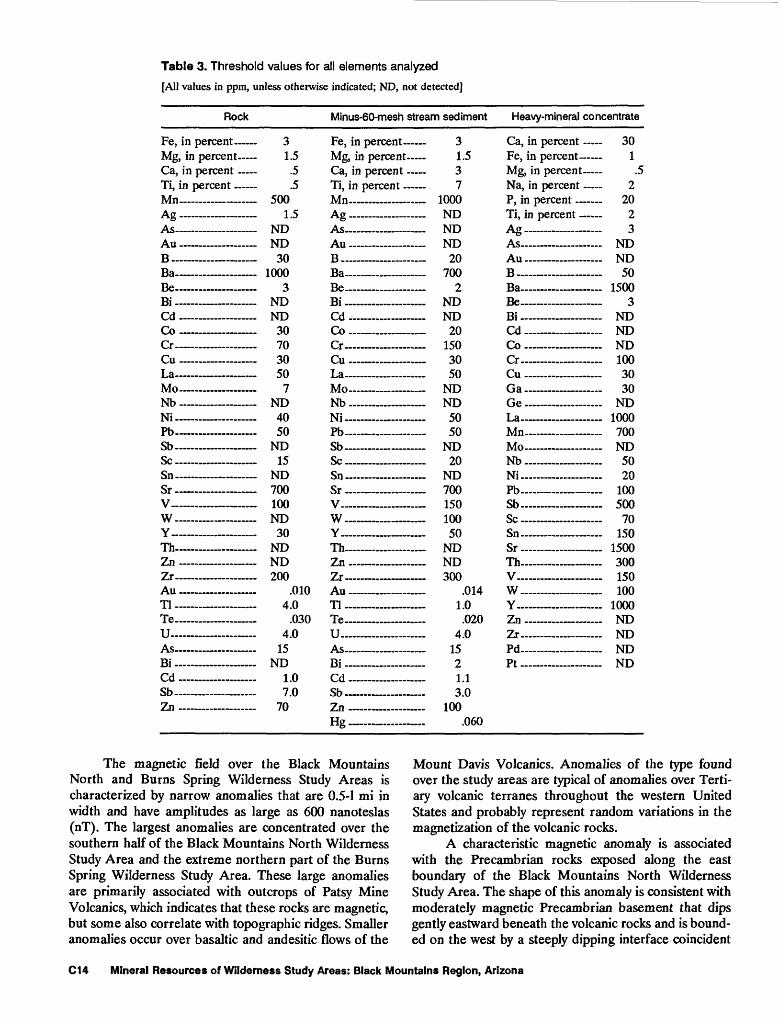
Table 3. Threshold values for all elements analyzed
[All values in ppm, unless otherwise indicated; ND, not detected]
Rock
Fe, in percent Mg, in percent Ca, in percent Ti, in percent Mn - - - -As . ______ " & As Au .... ... .......B .... ____ . __Ba __ - __ - __Be ________Bi . __ _ . .Cd .. .. ..........CoCr _______ -Cu _____ .....La ______ - ....Mo - ----- Mb __ __ . .Ni ______ . ....Pb __Sb ______ __ScSn __Sr __ - ___V _______ . ....w _ _ .Y_. __ .....ThZn ___ . ___Zr ________Au ________Tl __ ___ ...Te _____ . .......U Ac
Bi . .... .......Cd ________Sb ________Zn __ ___ -
Minus-60-mesh stream sediment
3 1.5
.5
.5 500
1.5 ND ND
30 1000
3 ND ND
30 70 30 50
7 ND 40 50
ND 15
ND 700 100 ND
30 ND ND 200
.010 4.0
.030 4.0
15 ND
1.0 7.0
70
Fe, in percent Mg, in percent Ca, in percent Ti, in percent Mn- AJ? _________.i-».g AsAu - - - - __ -B . __ . ... _.BaBe- _________Bi ____ ..... ......CdCo ________ _Cr ____ .. __Cu _____La -- -.Mo _ __ -Mb _ ... . . ... ..Ni _____ ........Pb _ .... .SbScSn __Sr ___________V _________w __ _ ..Y ___ . . __ ..Th - -Zn __Zr __ ..Au - __ _____Tl ___ __ Te - -uAs ____ - __ ...Bi ___ _........_Cd ______ - _Sb - ___ Zn . ~~ -Hg . . .
3 1.5 3 7
1000 ND ND ND
20 700
2 ND ND
20 150 30 50
ND ND
50 50
ND 20
ND 700 150 100 50
ND ND 300
.014 1.0
.020 4.0
15 2 1.1 3.0
100 .060
Heavy-mineral concentrate
Ca, in percent T7p in TVaT*.'*_3T<ll"
Mg, in percent Na, in percent P, in percent Ti, in percent As _ __
&
As- ____ Au _____ B ___ . ...._...__..Ba ________Be -Bi ___________Cd _ . _Co __ . __Cr _______Cu __________GaGeLa ______Mn -- __ .....Mo- ____ - _ ...Nb ... - .-Ni ....... .....Pb --_ Sb _____Sc . ____ .Sn ___ . _ . ......Sr -Th - - VW .Y ____ .........Zn _ . _ ____Zr -- Pd ________ .Pt ....... _____
30 1
.5 2
20 2 3
ND ND 50
1500 3
ND ND ND 100 30 30
ND 1000 700 ND
50 20
100 500
70 150
1500 300 150 100
1000 ND ND ND ND
The magnetic field over the Black Mountains North and Burns Spring Wilderness Study Areas is characterized by narrow anomalies that are 0.5-1 mi in width and have amplitudes as large as 600 nanoteslas (nT). The largest anomalies are concentrated over the southern half of the Black Mountains North Wilderness Study Area and the extreme northern part of the Burns Spring Wilderness Study Area. These large anomalies are primarily associated with outcrops of Patsy Mine Volcanics, which indicates that these rocks are magnetic, but some also correlate with topographic ridges. Smaller anomalies occur over basaltic and andesitic flows of the
Mount Davis Volcanics. Anomalies of the type found over the study areas are typical of anomalies over Terti ary volcanic terranes throughout the western United States and probably represent random variations in the magnetization of the volcanic rocks.
A characteristic magnetic anomaly is associated with the Precambrian rocks exposed along the east boundary of the Black Mountains North Wilderness Study Area. The shape of this anomaly is consistent with moderately magnetic Precambrian basement that dips gently eastward beneath the volcanic rocks and is bound ed on the west by a steeply dipping interface coincident
C14 Mineral Resources of Wilderness Study Areas: Black Mountains Region, Arizona
with the mapped fault that lies along the west edge of the Precambrian outcrop. Magnetic models suggest that the vertical offset of the basement across this fault is approx imately 1,000 ft. A broad magnetic high near the Port land mine roughly coincides with locally high gravity values and may represent the shallowly buried Precam brian basement in this area.
Magnetic data along two flightlines that pass over a Tertiary intrusive body located at the east edge of the Black Mountain North Wilderness Study Area indicate that this body is nonmagnetic. Most volcanic rocks ex posed in both study areas are magnetic. Therefore, the aeromagnetic data probably cannot be used to locate any Tertiary intrusive bodies concealed beneath the volcanic rocks.
Gravity Data
Gravity data for the Black Mountains North and Burns Spring Wilderness Study Areas are those from Mariano and others (1986) and an additional eight measurements made during 1987. These data are spaced at about 1-mi intervals along a profile that follows Portland Wash between the two study areas and at about 3-mi spacing outside the study areas. The sparse distri bution of the gravity data makes it adequate for deter mining the regional structural and tectonic setting but does not permit detailed statements about the mineral resource potential at the deposit scale. Only three gravity stations are located within the Burns Spring Wilderness Study Area and none are located within Black Mountains North Wilderness Study Area. The gravity data were reduced to isostatic residual gravity values (Jachens and Griscom, 1985) to accentuate the anomalies from near- surface density distributions.
The highest values are associated with outcrops of dense Precambrian rocks (average density of 10 samples, 2.76 grams per cubic centimeter or g/cm3 ). Lower gravity values occur at all stations on outcrops of Tertiary volcanic rocks (average density of 78 samples, 2.46 g/cm3 ). In the study areas, gravity values associated with volcanic outcrops are typically 6-15 milligals (mGal) lower than those associated with Precambrian outcrops; these data suggest that the volcanic deposits reach thick nesses of as much as 4,000 ft. However, near the Portland mine gravity values are only about 2 mGal lower than those associated with the Precambrian outcrop to the north and thus indicate that the Precambrian basement is shallow (only about 500 ft deep at the gravity stations).
Mineral and Energy Resource Potential of the Black Mountains North Wilderness Study Area
Geologic, geochemical, and geophysical studies suggest that parts of the Black Mountains North Wilder ness Study Area have low to high potential for gold and
and low to moderate potential for silver. A large part of this study area is underlain by intensely faulted and fractured rocks of the Patsy Mine Volcanics. Most of these exposures contain anomalous amounts of barium in heavy-mineral concentrates from stream sediments but contain no gold or other associated elements such as arsenic or antimony. The presence of barium, however, suggests the possibility that some hydrothermal mineral ization may have taken place. Exposures of the Patsy Mine Volcanics in the central part, including the strip of land just west of the central part, of the study area south of Cottonwood road have low resource potential for gold (fig. 2, pi. 1), possibly in small quartz and calcite veins or disseminated in the rock. Because the geochemical stud ies revealed no gold or other associated elements, the certainty level of this assessment is B.
The northeastern part of the Black Mountains North Wilderness Study Area is underlain by Precambri an gneiss and schist faulted against the Patsy Mine Volcanics. Felsic granitic rock intruded along the fault and forms numerous east-trending dikes that cut both the Precambrian and Tertiary rocks. A quartz vein from this area contains anomalous concentrations of gold, silver, copper, molybdenum, nickel, cobalt, and arsenic. This area has moderate potential for gold and low potential for silver, copper, and molybdenum resources, certainty level C.
The southern part of the study area north of Lost Cabin Wash is underlain by fractured and limonite- stained rocks of the Patsy Mine Volcanics. Heavy- mineral concentrates from stream sediments draining this altered area contain anomalous concentrations of gold, silver, mercury, and barium. The area underlain by these altered rocks has high potential for gold resources, certainty level C, in quartz and calcite veins or dissemi nated in the volcanic rocks and moderate resource po tential for silver, lead, and mercury, certainty level C. The surrounding area has moderate resource potential for gold, silver, and lead, certainty level C.
Zeolites occur in the upper part of the Patsy Mine Volcanics associated with ash beds and tuffaceous sedi mentary rocks, locally mapped as unit Ts (pi. 1). There fore, the west-central part of the study area and an area around the Portland mine have moderate potential for zeolite resources, certainty level C. Perlite occurs spo radically throughout the study area in glassy, welded ash-flow tuff, which occurs mainly in the middle and upper parts of the Patsy Mine Volcanics. The central and southern parts of the study area mostly underlain by the middle and upper parts of the Patsy Mine Volcanics have moderate resource potential for perlite, certainty level C. Low grade and the lack of access to perlite- and zeolite- bearing beds in the study area would hinder development of these commodities.
The oil and gas resource potential of the study area was considered by Ryder (1983) to be low to zero. In this
Black Mountains North and Burns Spring Wilderness Study Areas, Arizona C15
region, however, hydrocarbon source or reservoir rocks are limited to Tertiary sedimentary basins that flank the mountain ranges. Within the study area, Precambrian schist, gneiss, and granite crop out or everywhere under lie exposures of the Tertiary volcanic and sedimentary rocks at shallow depths. Therefore, there is no potential for oil and gas resources in the study area, certainty level D.
Mineral and Energy Resource Potential of the Burns Spring Wilderness Study Area
Geologic and geochemical studies indicate that the Burns Spring Wilderness Study Area has at least low potential for gold. The northwestern part of the study area adjacent to the Black Mountains North Wilderness Study Area in Lost Cabin Wash is underlain by fractured and limonite-stained rocks of the Patsy Mine Volcanics. Heavy-mineral concentrates from stream sediments draining this altered area contain anomalous concentra tions of gold, silver, mercury, and barium. The area underlain by these altered rocks has high potential for gold resources, certainty level C, in quartz and calcite veins or disseminated in the volcanic rocks, and moderate resource potential for silver, lead, and mercury, certainty level C (fig. 2, pi. 1). The surrounding area, which includes most of the northern part of the study area, is cut by numerous, mostly northwest-trending faults that could serve as conduits for mineralizing hydrothermal fluids. Heavy-mineral concentrates from stream sedi ments draining this area contain anomalous amounts of silver, lead, barium, and antimony, and one stream- sediment sample contains an anomalous value of mercu ry. This area has moderate resource potential for gold, silver, and lead, certainty level C.
The southern part of the study area contains only small, scattered geochemical anomalies of barium and some lead. Although no gold was detected, the presence of these anomalies suggests that some hydrothermal activity has taken place, most likely along prominent faults, and that small deposits of gold may be present in quartz and calcite veins or disseminated in the volcanic rocks. The southwestern corner of the study area is covered by dissected gravels of Tertiary age, but volcanic rocks similar to those exposed throughout the rest of the study area presumably lie at shallow depth beneath these gravels. An area including the southern and extreme eastern parts of the study area has low resource potential for gold, but the lack of reliable indicators of gold mineralization in the geochemical samples warrants a certainty level rating of B.
Zeolites occur in the upper part of the Patsy Mine Volcanics associated with ash beds and tuffaceous sedi mentary rocks, locally mapped as unit Ts (pi. 1). Areas underlain by the upper part of the Patsy Mine Volcanics including all but the southwest corner of the study area
have moderate potential for zeolite resources, certainty level C. Perlite occurs sporadically throughout the study area in glassy, welded ash-flow tuff, which occurs mainly in the middle and upper parts of the Patsy Mine Volca nics. Areas in the southern and extreme eastern parts of the study area underlain by the middle and upper parts of the Patsy Mine Volcanics have moderate resource poten tial for perlite, certainty level C. Low grade and the lack of access to perlite- and zeolite-bearing beds in the central part of the study area would hinder development of these commodities.
The oil and gas resource potential of the study area was considered by Ryder (1983) to be low to zero. In this region, however, hydrocarbon source or reservoir rocks are limited to Tertiary sedimentary basins that flank the mountain ranges. Within the study area, Precambrian schist, gneiss, and granite crop out or everywhere under lie exposures of the Tertiary volcanic and sedimentary rocks at shallow depths. Therefore, there is no potential for oil and gas resources in the study area, certainty level D.
REFERENCES CITED
Anderson, R.E., 1971, Thin skin distension in Tertiary rocks of southeastern Nevada: Geological Society of America Bulletin, v. 82, p. 43-58.
Anderson, R.E., Longwell, C.R., Armstrong, R.L., and Marvin, R.F., 1972, Significance of K-Ar ages of Tertiary rocks from the Lake Mead region, Nevada-Arizona: Geologi cal Society of America Bulletin, v. 83, p. 273-288.
Beikman, H.M., Hinkle, M.E., Frieders, Twila, Marcus, S.M., and Edward, J.R., 1983, Mineral surveys by the Geolog ical Survey and the Bureau of Mines of Bureau of Land Management Wilderness Study Areas: U.S. Geological Survey Circular 901, 28 p.
Bugrov, V.A., and Shalaby, I.M., 1975, Geochemical prospect ing in the eastern desert of Egypt, in I.L., Elliott and W.K., Fletcher, eds., Geochemical Exploration, 1974: Elsevier, p. 523-530.
Crock, J.G., Briggs, P.H., Jackson, L.L., and Lichte, F.E., 1987, Analytical methods for the analysis of stream sediments and rocks from the wilderness study areas: U.S. Geolog ical Survey Open-File Report 87-84, p. 13-21, 22-28.
Gardner, E.D., 1936, Gold mining and milling in the Black Mountains, western Mohave County, Arizona: U.S. Bu reau of Mines 1C 6901, 59 p.
Goudarzi, G.H., 1984, Guide to preparation of mineral survey reports on public lands: U.S. Geological Survey Open- File Report 84-787, 51 p.
Grimes, D.J., and Marranzino, A.P., 1968, Direct-current arc and alternating-current spark emission spectrographic field methods for the semiquantitative analysis of geo logic materials: U.S. Geological Survey Circular 591, 6 p.
Hubert, A.E., and Chao, T.T., 1985, Determination of gold, indium, tellurium, and thallium in the same sample digest of geological materials by atomic-absorption spec- troscopy and two-step solvent extraction: Talanta, v. 32, no. 7, p. 568-570.
C16 Mineral Resources of Wilderness Study Areas: Black Mountains Region, Arizona
Jachens, R.C., and Griscom, Andrew, 1985, An isostatic resid ual gravity map of California a residual map for inter pretation of anomalies from intracrustal sources, in Hinze, WJ., ed., The Utility of Regional Gravity and Magnetic Anomaly Maps: Tulsa, Oklahoma, Society of Exploration Geophysicists, p. 347-360.
Keith, S.B., Gest, D.E., DeWitt, Ed, Toll, N.W., and Everson, B.A., 1983, Metallic mineral districts and production in Arizona: Arizona Bureau of Geology and Mineral Tech nology Bulletin 194, 58 p.
Longwell, C.R., 1963, Reconnaissance geology between Lake Mead and Davis Dam, Arizona-Nevada: U.S. Geological Survey Professional Paper 374-E, 51 p.
Mariano, John, Helferty, M.G., and Gage, T.B., 1986, Bouguer and isostatic residual gravity maps of the Colorado River region, including the Kingman, Needles, Salton Sea, and El Centre quadrangles: U.S. Geological Survey Open- File Report 86-347, 6 sheets, scale 1:250,000, 1 sheet, scale 1:750,000.
McKelvey, V.E., 1972, Mineral resource estimates and public policy: American Scientist, v. 60, p. 32-40.
Mercer, B.W., and Ames, L.L., 1978, Zeolite ion exchange in radioactive and municipal wastewater treatment; in Sand, L.B., Mumpton, F.A., eds., Natural zeolites, occur rence, properties, use: Pergamon Press, Elmsford, New York, p. 451-462.
Mondale, K.D., Mumpton, R.A., and Apian, F.F., 1978, Bene- ficiation of natural zeolites from Bowie, Arizona: a preliminary report; in Sand, L.B., and Mumpton, F.A., eds., Natural zeolites, occurrence, properties, use: Per gamon Press, Elmsford, New York, p. 527-537.
Neubert, J.T., 1989, Mineral resources of the Black Mountains North (AZ-020-009) and Burns Spring (AZ-020-010) Wilderness Study Areas, Mohave County, Arizona: U.S. Bureau of Mines Open-File Report 1-89, 78 p.
O'Leary, R.M., and Meier, A.L., 1984, Analytical methods used in geochemical exploration: U.S. Geological Survey Cir cular 948, p. 100-106.
Overstreet, W.C., and Marsh, S.P., 1981, Some concepts and techniques in geochemical exploration, in Skinner, B J., ed., Economic Geology: Seventy-Fifth Anniversary Vol ume 1905-1982, p. 775-805.
Ryder, R.T., 1983, Petroleum potential of wilderness lands in Arizona, in Miller, B.W., ed., Petroleum potential of wilderness lands in the western United States: U.S. Geological Survey Circular 902, p. C1-C22.
Torii, Kazuo, 1978, Utilization of natural zeolites in Japan, in Sand, L.B., and Mumpton, F.A., eds., Natural zeolites, occurrence, properties, use: Pergamon Press, Elmsford, New York, p. 441-450.
U.S. Bureau of Mines and U.S. Geological Survey, 1980, Principles of a resource/reserve classification for miner als, U.S. Geological Survey Circular 831, 5 p.
U.S. Department of Energy, 1979, Airborne gamma-ray spec trometer and magnetometer survey, Kingman quadran gle, Arizona, California, Nevada: U.S. Department of Energy Open-File Report GJBX 59 (79), v. 2, variously paged.
Wilson, E.D., and Moore, R.T., 1959, Geologic map of Mohave County: Arizona Bureau of Mines, scale 1:375,000.
Wilson, E.D., Moore, R.T., and Cooper, J.R., 1969, Geologic map of Arizona: U.S. Geological Survey, scale 1:500,000.
Black Mountains North and Burns Spring Wilderness Study Areas, Arizona C17

APPENDIXES
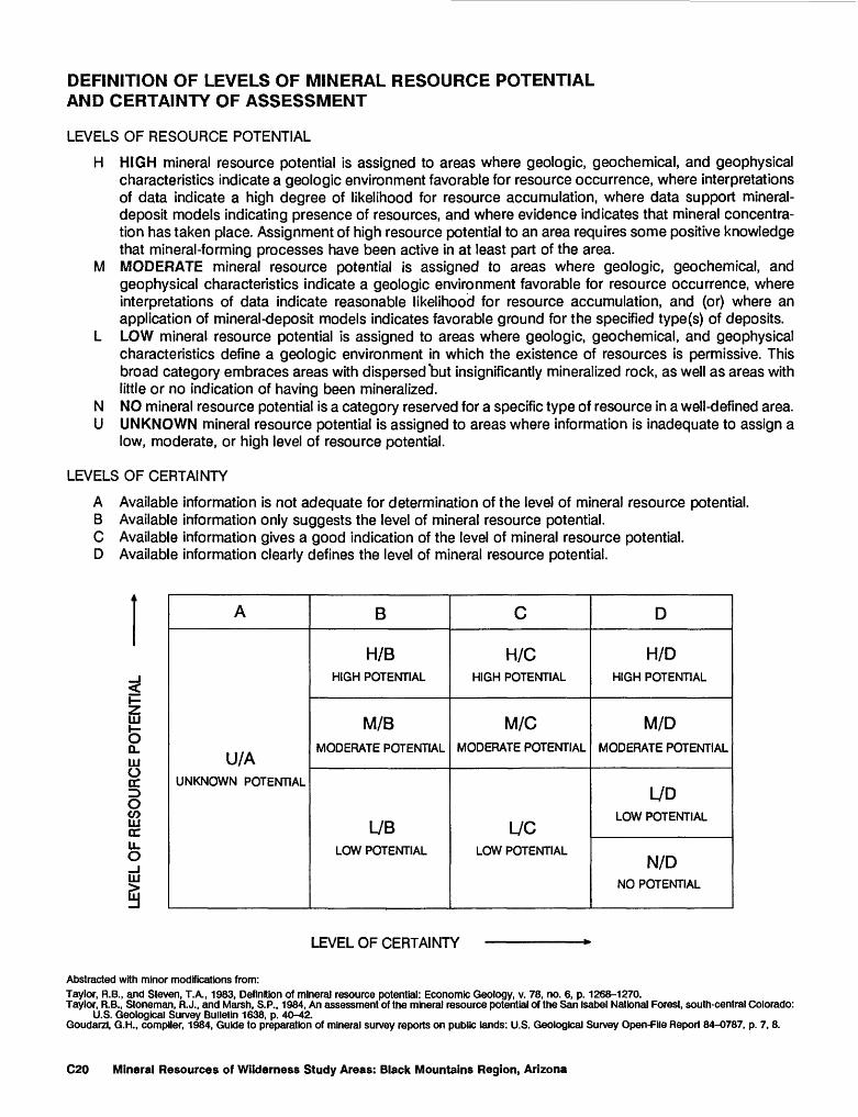
DEFINITION OF LEVELS OF MINERAL RESOURCE POTENTIAL AND CERTAINTY OF ASSESSMENT
LEVELS OF RESOURCE POTENTIAL
H HIGH mineral resource potential is assigned to areas where geologic, geochemical, and geophysical characteristics indicate a geologic environment favorable for resource occurrence, where interpretations of data indicate a high degree of likelihood for resource accumulation, where data support mineral- deposit models indicating presence of resources, and where evidence indicates that mineral concentra tion has taken place. Assignment of high resource potential to an area requires some positive knowledge that mineral-forming processes have been active in at least part of the area.
M MODERATE mineral resource potential is assigned to areas where geologic, geochemical, and geophysical characteristics indicate a geologic environment favorable for resource occurrence, where interpretations of data indicate reasonable likelihood for resource accumulation, and (or) where an application of mineral-deposit models indicates favorable ground for the specified type(s) of deposits.
L LOW mineral resource potential is assigned to areas where geologic, geochemical, and geophysical characteristics define a geologic environment in which the existence of resources is permissive. This broad category embraces areas with dispersed "but insignificantly mineralized rock, as well as areas with little or no indication of having been mineralized.
N NO mineral resource potential is a category reserved for a specific type of resource in a well-defined area.U UNKNOWN mineral resource potential is assigned to areas where information is inadequate to assign a
low, moderate, or high level of resource potential.
LEVELS OF CERTAINTY
A Available information is not adequate for determination of the level of mineral resource potential.B Available information only suggests the level of mineral resource potential.C Available information gives a good indication of the level of mineral resource potential.D Available information clearly defines the level of mineral resource potential.
A
U/AUNKNOWN POTENTIAL
B
H/BHIGH POTENTIAL
M/B
MODERATE POTENTIAL
L7BLOW POTENTIAL
C
H/CHIGH POTENTIAL
M/CMODERATE POTENTIAL
L/CLOW POTENTIAL
D
H/DHIGH POTENTIAL
M/DMODERATE POTENTIAL
L7DLOW POTENTIAL
N/DNO POTENTIAL
HI
5Q. HI Orr OCOLLI CC U. O
HI
LEVEL OF CERTAINTY
Abstracted with minor modifications from:Taylor, R.B., and Steven, T.A., 1983, Definition of mineral resource potential: Economic Geology, v. 78, no. 6, p. 1268-1270.Taylor, R.B., Stoneman, R. J., and Marsh, S.P., 1984, An assessment of the mineral resource potential of the San Isabel National Forest, south-central Colorado:
U.S. Geological Survey Bulletin 1638, p. 40-42. Goudarzi, G.H., compiler, 1984, Guide to preparation of mineral survey reports on public lands: U.S. Geological Survey Open-File Report 84-0787, p. 7, 8.
C20 Mineral Resources of Wilderness Study Areas: Black Mountains Region, Arizona
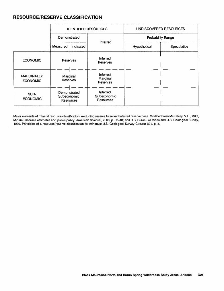
RESOURCE/RESERVE CLASSIFICATION
IDENTIFIED RESOURCES
Demonstrated
Measured IndicatedInferred
UNDISCOVERED RESOURCES
Probability Range
Hypothetical Speculative
ECONOMIC
MARGINALLY ECONOMIC
SUB-
ECONOMIC
Reserves Inferred Reserves
_ _I _ _ __ _ _ _ _ _
Marginal Reserves
Inferred Marginal Reserves
DemonstratedSubeconomic
Resources
InferredSubeconomic
Resources
Major elements of mineral resource classification, excluding reserve base and inferred reserve base. Modified from McKelvey, V.E., 1972, Mineral resource estimates and public policy: American Scientist, v. 60, p. 32-40; and U.S. Bureau of Mines and U.S. Geological Survey, 1980, Principles of a resource/reserve classification for minerals: U.S. Geological Survey Circular 831, p. 5.
Black Mountains North and Burns Spring Wilderness Study Areas, Arizona C21
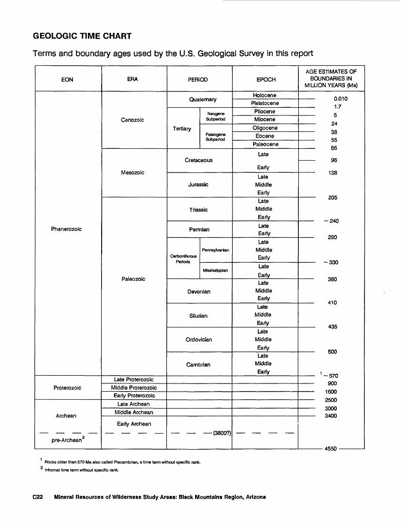
GEOLOGIC TIME CHART
Terms and boundary ages used by the U.S. Geological Survey in this report
EON
Phanerozoic
Proterozoic
Archean
pre-Archean2
ERA
Cenozoic
Mesozoic
Paleozoic
Late ProterozoicMiddle ProterozoicEarly Proterozoic
Late ArcheanMiddle Archean
Early Archean
PERIOD
Quaternary
Tertiary
Neogene Subperiod
Paleogene Subperiod
Cretaceous
Jurassic
Triassic
Permian
Carboniferous Periods
Pennsylvania
Mississippian
Devonian
Silurian
Ordovician
Cambrian
(3800?)
EPOCH
HolocenePleistocene
PlioceneMiocene
OligoceneEocene
Paleocene
Late
Early
Late Middle Early
Late Middle Early
Late Early
Late Middle Early
Late
EarlyLate
Middle Early
Late Middle Early
Late Middle
EarlyLate
Middle Early
AGE ESTIMATES OF BOUNDARIES IN
MILLION YEARS (Ma)
0.010
1.7 5 24
oo 55
cc
....... . Oft
loo
£.\J*J
C.TW
._._ oon
WW
ODD
410
doe
......... *;nn
1 , *-7n.. ....... onn
1600
^ouu
Ov/v/vJ
odnfi
4R5n
Rocks older than 570 Ma also called Precambrian, a time term without specific rank.
Informal time term without specific rank.
C22 Mineral Resources of Wilderness Study Areas: Black Mountains Region, Arizona