Embed Size (px)
Citation preview
MONITORING AND MODELING OF RAINFALL-INDUCED LANDSLIDES–A CASE STUDY OF SONG-MAO LANDSLIDE IN
CENTRAL TAIWAN
Ming-Chien Chung1*, Chih-Hao Tan2, Shu-Yeong Chi3, Cheng-Yu Ku4, Tai-Wei Su5, Jiin-Fa Lee6, Li-Yuan Fei7
ABSTRACT In recent years, the increase in the frequency and intensity of extreme rainfall events accompanied with typhoons has brought significant landslide and debris flow disasters in Taiwan. This study is aimed to better understand the mechanisms triggering landslide hazards so that casualties and property damages can hopefully be reduced in the events of future natural disasters through ultimately some appropriate warning system. For the active landslide analysis, a two-dimensional numerical program, GeoStudio, and a three-dimensional numerical program, FLAC 3D, were employed and modeling practice was performed. The reliability of the resulting numerical results was validated with field data from one case study at Song-Mao landslide site. It is expected that the landslide initiation, enlargement and reactivation can be more confidently predicted through the use of aforementioned physics-based models. Key Words: Rainfall-induced landslide, Hydrogeologic, Modeling, Monitoring, Song-Mao landslide, Typhoon INTRODUCTION Slope instability study is increasingly getting attentions in many countries around the world, including Taiwan. The causes of landslides in slopes are attributed to a number of factors. Notably, rainfall is known to be one of the most significant triggering factors for landslides (Ng and Shi, 1998). In general, the rainfall infiltration could result in changing the suction and
1 Researcher, Geotechnical Engineering Research Center, Sinotech Engineering Consultants, Inc., Taipei 110,
Taiwan, R.O.C. (*Corresponding Author; Tel.: +886-2-2758-0568 ext. 227; Fax: +886-2-2729-0273; Email: [email protected])
2 Section Chief, Geotechnical Engineering Research Center, Sinotech Engineering Consultants, Inc., Taipei 110, Taiwan, R.O.C.
3 Manager, Geotechnical Engineering Research Center, Sinotech Engineering Consultants, Inc., Taipei 110, Taiwan, R.O.C.
4 Assistant Professor, Department of Harbor and River Engineering, National Taiwan Ocean University, Keelung 202, Taiwan, R.O.C.
5 Associate Technical Specialist, Environmental and Engineering Geology Division, Central Geological Survey, Ministry of Economic Affairs, Taipei County 235, Taiwan, R.O.C.
6 Section Chief, Environmental and Engineering Geology Division, Central Geological Survey, Ministry of Economic Affairs, Taipei County 235, Taiwan, R.O.C.
7 Division Chief, Environmental and Engineering Geology Division, Central Geological Survey, Ministry of Economic Affairs, Taipei County 235, Taiwan, R.O.C.
-372-

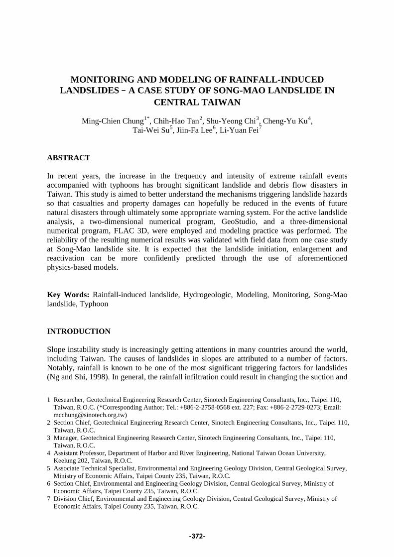
the moisture of soil, raising the unit weight of soil, and reducing the shear strength of soil in the colluvium of landslide. The stability of landslide is closely related to the groundwater pressure in response to rainfall infiltration, the geological and topographical conditions, and the physical and mechanical parameters. To assess the potential susceptibility to landslide, an effective modeling of rainfall-induced landslide is essential (Tsaparas et al., 2002; Jiao et al., 2005; Central Geological Survey, 2008). Taking the Song-Mao landslide as an example, this paper presents the modeling of rainfall-induced landslide using a numerical approach coupled with infiltration, seepage, stability and deformation. The establishment of model was based on the in-situ investigation, including geological drilling, field geological investigation, geophysical investigation, and borehole explorations. The material strength and hydraulic properties of the model were obtained both from the field and laboratory tests. In addition, monitoring data of landslide were collected and used to compare with the modeling results. The Song-Mao landslide site, located at Dajia river watershed in central Taiwan (Fig. 1), is an active landslide triggered by earthquake and typhoon events. The precipitation in the area is about 2,150 mm annually of which the majority occur on summer (about 64%), and the average temperature is 15.2 ℃ . Investigative results show that there are signs of deformation destruction at the Song-Mao landslide site which has made it a site with high failure potential (Fig. 2).
Fig. 1 Location map of Song-Mao landslide site
-373-
Displacement about 30 cm
Colluvium
Fractured slate
Shear zone
Bed rock
Core sample (BH-03)
Inclinometer uplift
BH-03
BH-05
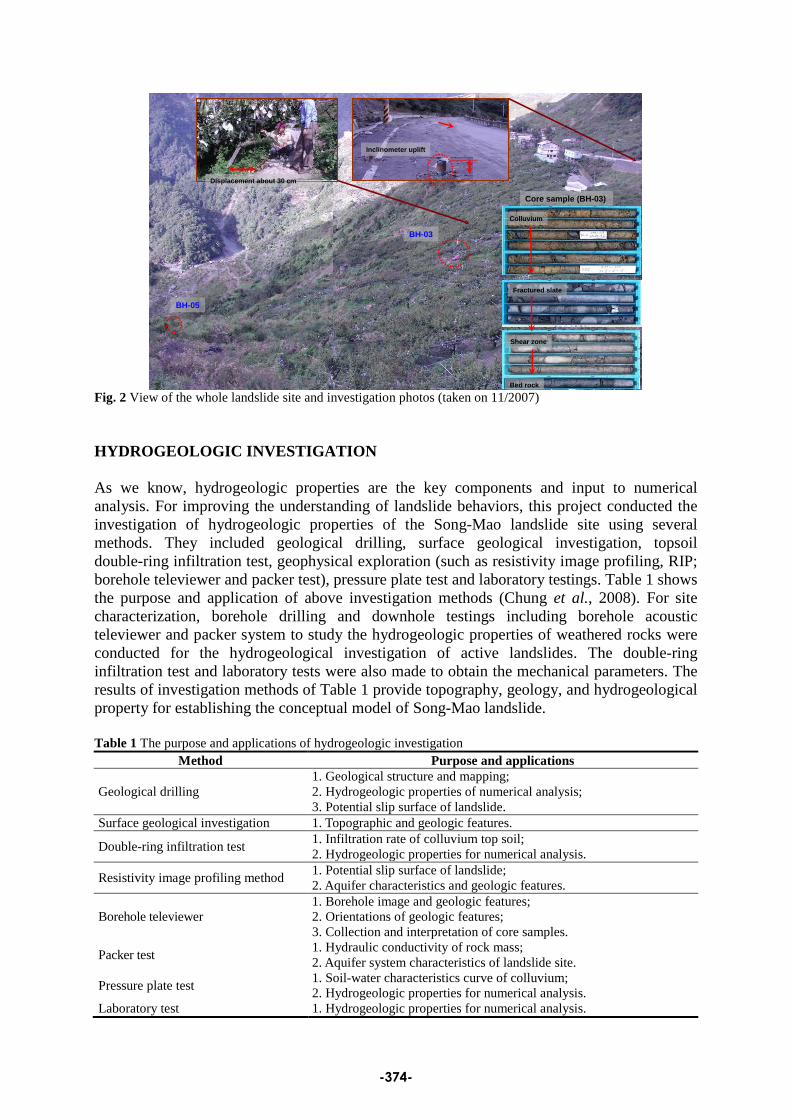
Fig. 2 View of the whole landslide site and investigation photos (taken on 11/2007) HYDROGEOLOGIC INVESTIGATION As we know, hydrogeologic properties are the key components and input to numerical analysis. For improving the understanding of landslide behaviors, this project conducted the investigation of hydrogeologic properties of the Song-Mao landslide site using several methods. They included geological drilling, surface geological investigation, topsoil double-ring infiltration test, geophysical exploration (such as resistivity image profiling, RIP; borehole televiewer and packer test), pressure plate test and laboratory testings. Table 1 shows the purpose and application of above investigation methods (Chung et al., 2008). For site characterization, borehole drilling and downhole testings including borehole acoustic televiewer and packer system to study the hydrogeologic properties of weathered rocks were conducted for the hydrogeological investigation of active landslides. The double-ring infiltration test and laboratory tests were also made to obtain the mechanical parameters. The results of investigation methods of Table 1 provide topography, geology, and hydrogeological property for establishing the conceptual model of Song-Mao landslide. Table 1 The purpose and applications of hydrogeologic investigation
Method Purpose and applications
Geological drilling 1. Geological structure and mapping; 2. Hydrogeologic properties of numerical analysis; 3. Potential slip surface of landslide.
Surface geological investigation 1. Topographic and geologic features.
Double-ring infiltration test 1. Infiltration rate of colluvium top soil; 2. Hydrogeologic properties for numerical analysis.
Resistivity image profiling method 1. Potential slip surface of landslide; 2. Aquifer characteristics and geologic features.
Borehole televiewer 1. Borehole image and geologic features; 2. Orientations of geologic features; 3. Collection and interpretation of core samples.
Packer test 1. Hydraulic conductivity of rock mass; 2. Aquifer system characteristics of landslide site.
Pressure plate test 1. Soil-water characteristics curve of colluvium; 2. Hydrogeologic properties for numerical analysis.
Laboratory test 1. Hydrogeologic properties for numerical analysis.
-374-
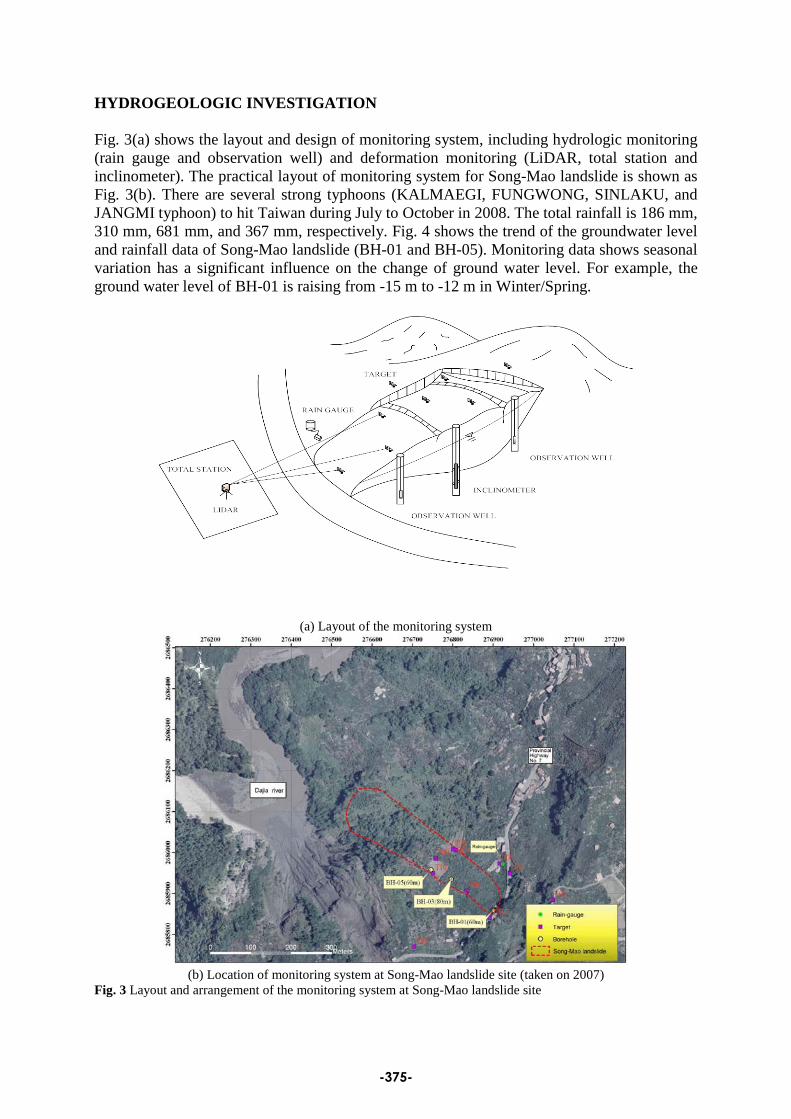
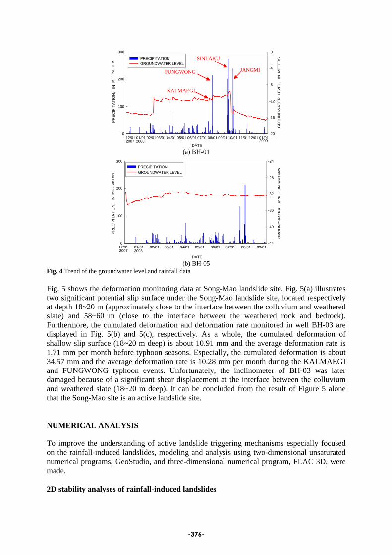
HYDROGEOLOGIC INVESTIGATION Fig. 3(a) shows the layout and design of monitoring system, including hydrologic monitoring (rain gauge and observation well) and deformation monitoring (LiDAR, total station and inclinometer). The practical layout of monitoring system for Song-Mao landslide is shown as Fig. 3(b). There are several strong typhoons (KALMAEGI, FUNGWONG, SINLAKU, and JANGMI typhoon) to hit Taiwan during July to October in 2008. The total rainfall is 186 mm, 310 mm, 681 mm, and 367 mm, respectively. Fig. 4 shows the trend of the groundwater level and rainfall data of Song-Mao landslide (BH-01 and BH-05). Monitoring data shows seasonal variation has a significant influence on the change of ground water level. For example, the ground water level of BH-01 is raising from -15 m to -12 m in Winter/Spring.
(a) Layout of the monitoring system
(b) Location of monitoring system at Song-Mao landslide site (taken on 2007)
Fig. 3 Layout and arrangement of the monitoring system at Song-Mao landslide site
-375-
時間
12/01 01/01 02/01 03/01 04/01 05/01 06/01 07/01 08/01 09/01 10/01 11/01 12/01 01/01
PR
EC
IPIT
ATI
ON
, IN
MIN
IME
TER
S
0
100
200
300
GR
OU
ND
WA
TER
LE
VE
L,
IN M
ETE
RS
-20
-16
-12
-8
-4
0
PRECIPITATIONGROUNDWATER LEVEL
DATE2007 2008 2009
(a) BH-01
時間
12/01 01/01 02/01 03/01 04/01 05/01 06/01 07/01 08/01 09/01 0
100
200
300
-44
-40
-36
-32
-28
-24PRECIPITATIONGROUNDWATER LEVEL
2007 2008
PR
EC
IPIT
ATI
ON
, IN
MIN
IME
TER
S
GR
OU
ND
WA
TER
LE
VE
L,
IN M
ETE
RS
DATE (b) BH-05
Fig. 4 Trend of the groundwater level and rainfall data Fig. 5 shows the deformation monitoring data at Song-Mao landslide site. Fig. 5(a) illustrates two significant potential slip surface under the Song-Mao landslide site, located respectively at depth 18~20 m (approximately close to the interface between the colluvium and weathered slate) and 58~60 m (close to the interface between the weathered rock and bedrock). Furthermore, the cumulated deformation and deformation rate monitored in well BH-03 are displayed in Fig. 5(b) and 5(c), respectively. As a whole, the cumulated deformation of shallow slip surface (18~20 m deep) is about 10.91 mm and the average deformation rate is 1.71 mm per month before typhoon seasons. Especially, the cumulated deformation is about 34.57 mm and the average deformation rate is 10.28 mm per month during the KALMAEGI and FUNGWONG typhoon events. Unfortunately, the inclinometer of BH-03 was later damaged because of a significant shear displacement at the interface between the colluvium and weathered slate (18~20 m deep). It can be concluded from the result of Figure 5 alone that the Song-Mao site is an active landslide site. NUMERICAL ANALYSIS To improve the understanding of active landslide triggering mechanisms especially focused on the rainfall-induced landslides, modeling and analysis using two-dimensional unsaturated numerical programs, GeoStudio, and three-dimensional numerical program, FLAC 3D, were made. 2D stability analyses of rainfall-induced landslides
KALMAEGI
FUNGWONG
SINLAKU
JANGMI
MIL
LIM
ETE
R
MIL
LIM
ETE
R
-376-
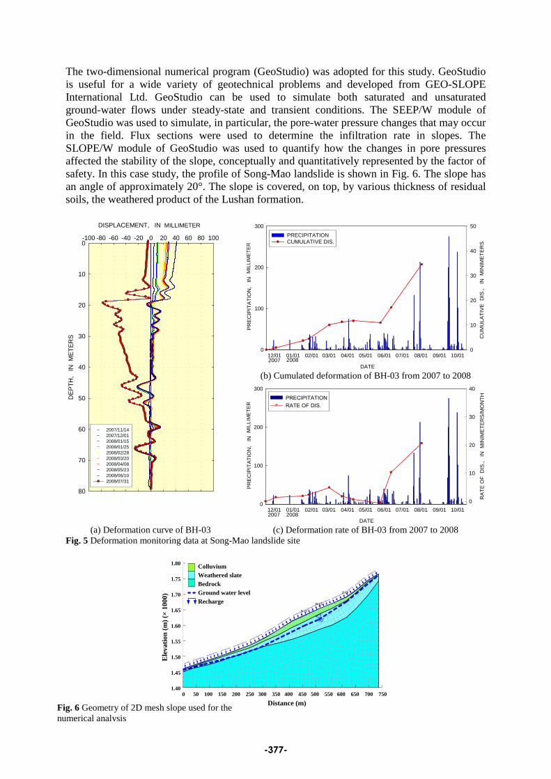
The two-dimensional numerical program (GeoStudio) was adopted for this study. GeoStudio is useful for a wide variety of geotechnical problems and developed from GEO-SLOPE International Ltd. GeoStudio can be used to simulate both saturated and unsaturated ground-water flows under steady-state and transient conditions. The SEEP/W module of GeoStudio was used to simulate, in particular, the pore-water pressure changes that may occur in the field. Flux sections were used to determine the infiltration rate in slopes. The SLOPE/W module of GeoStudio was used to quantify how the changes in pore pressures affected the stability of the slope, conceptually and quantitatively represented by the factor of safety. In this case study, the profile of Song-Mao landslide is shown in Fig. 6. The slope has an angle of approximately 20°. The slope is covered, on top, by various thickness of residual soils, the weathered product of the Lushan formation.
DISPLACEMENT, IN MINIMETERS
-100 -80 -60 -40 -20 0 20 40 60 80 100
DEP
TH,
IN M
ETER
S
0
10
20
30
40
50
60
70
80
2007/11/142007/12/012008/01/152008/01/252008/02/282008/03/202008/04/082008/05/232008/06/102008/07/31
時間
12/01 01/01 02/01 03/01 04/01 05/01 06/01 07/01 08/01 09/01 10/01 0
100
200
300
CU
MU
LATI
VE
DIS
., I
N M
INIM
ETE
RS
0
10
20
30
40
50PRECIPITATIONCUMULATIVE DIS.
2007 2008
PR
EC
IPIT
ATI
ON
, IN
MIN
IME
TER
S
DATE (b) Cumulated deformation of BH-03 from 2007 to 2008
時間
12/01 01/01 02/01 03/01 04/01 05/01 06/01 07/01 08/01 09/01 10/01 0
100
200
300
RAT
E O
F D
IS.,
IN
MIN
IMET
ERS/
MO
NTH
0
10
20
30
40
PRECIPITATIONRATE OF DIS.
2007 2008
PREC
IPIT
ATIO
N,
IN M
INIM
ETER
S
DATE (a) Deformation curve of BH-03 (c) Deformation rate of BH-03 from 2007 to 2008
Fig. 5 Deformation monitoring data at Song-Mao landslide site
ColluviumWeathered slateBedrockGround water levelRecharge
0 50 100 150 200 250 300 350 400 450 500 550 600 650 700 750
Distance (m)
1.80
1.75
1.70
1.65
1.60
1.55
1.50
1.45
1.40
Ele
vatio
n (m
) (×
1000
)
Fig. 6 Geometry of 2D mesh slope used for the numerical analysis
MIL
LIM
ETE
R
MIL
LIM
ETE
R
MILLIMETER
-377-

Morphometric and geotechnical analyses were carried out for Song-Mao landslide site through a series of in-situ and laboratory tests, the results of which were used as input for subsequent modeling process. Firstly, based on laboratory tests, the soil-water characteristics curve (SWCC) for colluvium of the Song-Mao landslide site are derived as displayed in Fig. 7. Secondly, a finite element seepage analysis for transient conditions was then employed to simulate changes in pore water pressure during rainfall events, using the computed infiltration rate as the ground surface boundary. Finally, using the data from the previous step as input, the limit equilibrium Morgenstern-Price slope stability method was applied to calculate the variations in the factor of safety during rainfall events. Table 2 summarizes the parameters used for slope stability analyses. Table 2 Parameters used for slope stability analysis
Colluvium Weathered rock Bedrock Hydraulic conductivity
Ks (m/sec) 1.76×10 9.62×10⁻⁶ 3.82×10⁻⁷ -8
Water content w (%)
30.4 25 21
Unit weight γ t (kN/m3 15.7
) 26.4 26.5
Friction angle Φ (deg)
30 29 36
Cohesion C (kPa)
10 90 500
Young’s modulus E (kPa)
50000 1250000 2600000
According to the above data, we can estimate the factor of safety (F.S.) of each potential slip surface by SLOPE/W modulus. The result of stability analysis shows that the F.S. of the critical slip surface is 1.36, which located at the interface between colluvium and weathered slate (Fig. 8(a)). The F.S. of the minor potential slip surface is 1.40, which located at the interface between weathered slate and bedrock (Fig. 8(b)). According to the result of Fig. 8, we can understand that Song-Mao landslide is in the safety and steady status without raining. Table 3 shows the F.S. of slip surface in the difference rainfall intensity. From Table 3, we can find that the sensitive slip surface is the interface between colluvium and weathered slate. The F.S. of this slip surface will reduce to 0.85 from 1.57 when rainfall intensity up to 210 mm. In addition, the F.S. of minor slip surface (upper shear zone) will reduce to 0.97 from 1.59 when rainfall intensity up to 310 mm. It illustrates that Song-Mao landslide has slip potential during heavy rainfall period. The critical and minor slip surface located at 20 m to 40 m under the ground. Furthermore, the F.S. of many slip surface will under 1.0 when the rainfall intensity up to 380 mm. Comparing the results of monitoring and analysis shows the result of analysis has well performance with monitoring data. For example, deformation monitoring data (Fig. 5) has a significant slip surface between colluvium and weathered slate
Matric Suction (kPa)
1e+0 1e+1 1e+2 1e+3 1e+4 1e+5 1e+6
Volu
met
ric W
ater
Con
tent
(Nor
mal
izatio
n)
0.0
0.2
0.4
0.6
0.8
1.0
Fig. 7 SWCC for colluvium at Song-Mao landslide site
-378-
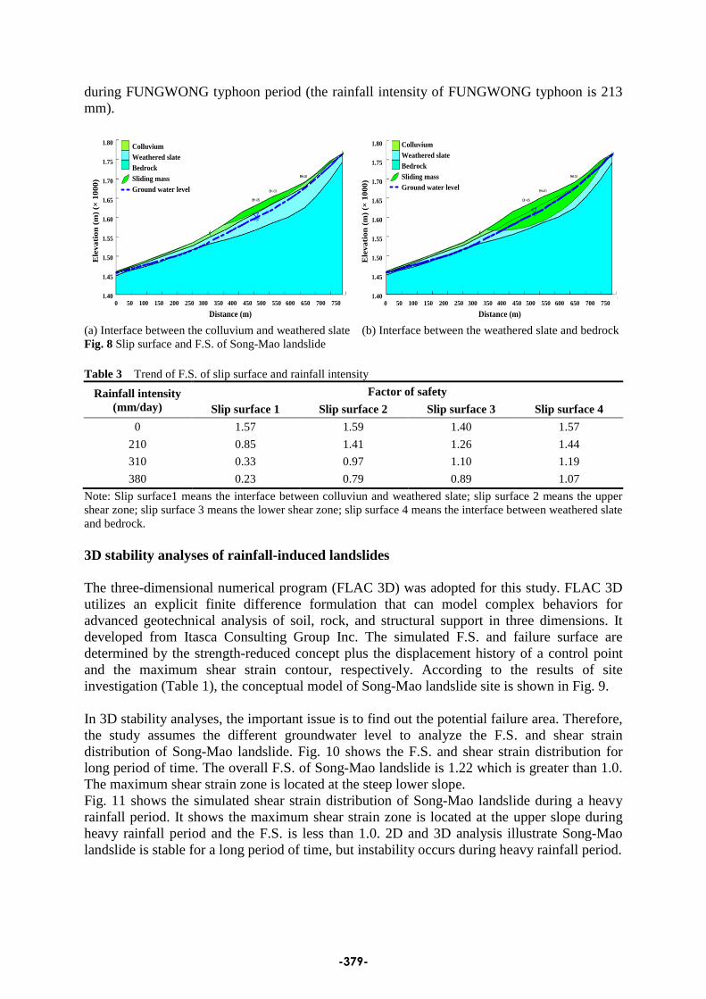
during FUNGWONG typhoon period (the rainfall intensity of FUNGWONG typhoon is 213 mm).
ColluviumWeathered slateBedrockSliding massGround water level
0 50 100 150 200 250 300 350 400 450 500 550 600 650 700 750
Distance (m)
1.80
1.75
1.70
1.65
1.60
1.55
1.50
1.45
1.40
Ele
vati
on (m
) (×
1000
)
ColluviumWeathered slateBedrockSliding massGround water level
0 50 100 150 200 250 300 350 400 450 500 550 600 650 700 750
Distance (m)
1.80
1.75
1.70
1.65
1.60
1.55
1.50
1.45
1.40
Ele
vati
on (m
) (×
1000
)
(a) Interface between the colluvium and weathered slate (b) Interface between the weathered slate and bedrock Fig. 8 Slip surface and F.S. of Song-Mao landslide Table 3 Trend of F.S. of slip surface and rainfall intensity
Rainfall intensity (mm/day)
Factor of safety Slip surface 1 Slip surface 2 Slip surface 3 Slip surface 4
0 1.57 1.59 1.40 1.57
210 0.85 1.41 1.26 1.44
310 0.33 0.97 1.10 1.19
380 0.23 0.79 0.89 1.07
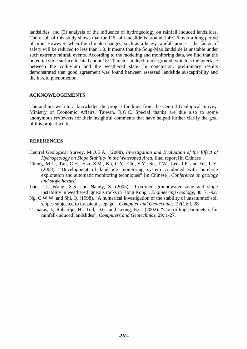
Note: Slip surface1 means the interface between colluviun and weathered slate; slip surface 2 means the upper shear zone; slip surface 3 means the lower shear zone; slip surface 4 means the interface between weathered slate and bedrock. 3D stability analyses of rainfall-induced landslides The three-dimensional numerical program (FLAC 3D) was adopted for this study. FLAC 3D utilizes an explicit finite difference formulation that can model complex behaviors for advanced geotechnical analysis of soil, rock, and structural support in three dimensions. It developed from Itasca Consulting Group Inc. The simulated F.S. and failure surface are determined by the strength-reduced concept plus the displacement history of a control point and the maximum shear strain contour, respectively. According to the results of site investigation (Table 1), the conceptual model of Song-Mao landslide site is shown in Fig. 9. In 3D stability analyses, the important issue is to find out the potential failure area. Therefore, the study assumes the different groundwater level to analyze the F.S. and shear strain distribution of Song-Mao landslide. Fig. 10 shows the F.S. and shear strain distribution for long period of time. The overall F.S. of Song-Mao landslide is 1.22 which is greater than 1.0. The maximum shear strain zone is located at the steep lower slope. Fig. 11 shows the simulated shear strain distribution of Song-Mao landslide during a heavy rainfall period. It shows the maximum shear strain zone is located at the upper slope during heavy rainfall period and the F.S. is less than 1.0. 2D and 3D analysis illustrate Song-Mao landslide is stable for a long period of time, but instability occurs during heavy rainfall period.
-379-
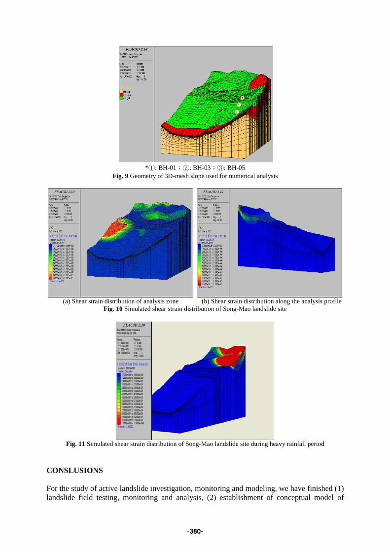
*①: BH-01;②: BH-03;③: BH-05
Fig. 9 Geometry of 3D-mesh slope used for numerical analysis
(a) Shear strain distribution of analysis zone (b) Shear strain distribution along the analysis profile
Fig. 10 Simulated shear strain distribution of Song-Mao landslide site
Fig. 11 Simulated shear strain distribution of Song-Mao landslide site during heavy rainfall period
CONSLUSIONS For the study of active landslide investigation, monitoring and modeling, we have finished (1) landslide field testing, monitoring and analysis, (2) establishment of conceptual model of
-380-
landslides, and (3) analysis of the influence of hydrogeology on rainfall induced landslides. The result of this study shows that the F.S. of landslide is around 1.4~1.6 over a long period of time. However, when the climate changes, such as a heavy rainfall process, the factor of safety will be reduced to less than 1.0. It means that the Song-Mao landslide is unstable under such extreme rainfall events. According to the modeling and monitoring data, we find that the potential slide surface located about 18~20 meter in depth underground, which is the interface between the colluvium and the weathered slate. In conclusion, preliminary results demonstrated that good agreement was found between assessed landslide susceptibility and the in-situ phenomenon. ACKNOWLOGEMENTS The authors wish to acknowledge the project fundings from the Central Geological Survey, Ministry of Economic Affairs, Taiwan, R.O.C. Special thanks are due also to some anonymous reviewers for their insightful comments that have helped further clarify the goal of this project work. REFERENCES Central Geological Survey, M.O.E.A., (2008). Investigation and Evaluation of the Effect of
Hydrogeology on Slope Stability in the Watershed Area, final report [in Chinese]. Chung, M.C., Tan, C.H., Hsu, S.M., Ku, C.Y., Chi, S.Y., Su, T.W., Lee, J.F. and Fei, L.Y.
(2008). “Development of landslide monitoring system combined with borehole exploration and automatic monitoring techniques” [in Chinese], Conference on geology and slope hazard.
Jiao, J.J., Wang, X.S. and Nandy, S. (2005). “Confined groundwater zone and slope instability in weathered igneous rocks in Hong Kong”, Engineering Geology, 80: 71-92.
Ng, C.W.W. and Shi, Q. (1998). “A numerical investigation of the stability of unsaturated soil slopes subjected to transient seepage”, Computer and Geotechnics, 22(1): 1-28.
Tsaparas, I., Rahardjo, H., Toll, D.G. and Leong, E.C. (2002). “Controlling parameters for rainfall-induced landslides”, Computers and Geotechnics, 29: 1-27.
-381-