Embed Size (px)
Citation preview
MULTIFUNCTIONALITY OF LARGE RIVERS
Monitoring and modelling concept for ecological optimizedharbour dredging and fine sediment disposal in large rivers
Marlene Haimann . Christoph Hauer . Michael Tritthart .
David Prenner . Patrick Leitner . Otto Moog . Helmut Habersack
Received: 3 August 2015 / Revised: 28 July 2016 / Accepted: 31 July 2016 / Published online: 14 September 2016
� The Author(s) 2016. This article is published with open access at Springerlink.com
Abstract In this paper, a monitoring and modelling
concept for ecological optimized harbour dredging
and fine sediment disposal in large rivers is presented.
According to the concept, first a preliminary assess-
ment should be performed previous to the dredging
and dumping procedure to derive knowledge about the
current status in hydrodynamics, morphology and
instream habitat quality. During the performance of
the maintenance work, a high-resolution monitoring
program has to be organized to measure flow veloc-
ities, the suspended sediment concentrations and the
extent of the occurring plume. These data can then be
compared with natural suspended sediment conditions
and serve as input data for numerical sediment
transport modelling. Furthermore, bathymetric sur-
veys and biotic sampling enable the detection of
possible effects of dredging and disposal in the post-
dumping stage. Based on sediment transport mod-
elling approaches, short- to mid-term developments of
the sediment plume can be predicted with an addi-
tional and final habitat evaluation at the end of the
project. This concept was applied and optimized
during the maintenance work at the case study winter
harbour Linz at the Danube River. The findings of the
presented study highlight the necessity of integrated
monitoring and modelling approaches for harbour
dredging especially in large river systems.
Keywords Harbour dredging � Fine sediment
disposal �Monitoring and modelling concept �DanubeRiver
Introduction
Sediments form a natural and integral component of
fluvial systems and play an important part for the
hydrological, geomorphological and ecological func-
tioning of rivers. Whether material is transported as
bedload or suspended load is determined by the
relationship between flow conditions and the structure,
density and size of the material, whereas fine (or clay
and silt sized) sediments, formed by inorganic and
Guest editors: Helmut Habersack & Roswitha Samek /
Multifunctionality of large rivers
M. Haimann (&) � C. Hauer � M. Tritthart �D. Prenner � H. HabersackChristian Doppler Laboratory for Advanced Methods in
River Monitoring, Modelling and Engineering, Institute of
Water Management, Hydrology and Hydraulic
Engineering, Department of Water, Atmosphere and
Environment, BOKU - University of Natural Resources
and Life Sciences, Vienna, Muthgasse 107, 1190 Vienna,
Austria
e-mail: [email protected]
P. Leitner � O. Moog
Institute of Hydrobiology and Aquatic Ecosystem
Management, Department of Water, Atmosphere and
Environment, BOKU - University of Natural Resources
and Life Sciences Vienna, Max-Emanuel-Strasse 17,
1180 Vienna, Austria
123
Hydrobiologia (2018) 814:89–107
https://doi.org/10.1007/s10750-016-2935-z
organic particles, are likely to be transported in
suspension (Owens et al., 2005). Suspended sediments
form the main part of the transported sediments in
rivers and are therefore of great interest for many
sediment-related issues. Even in natural ecosystems,
the suspended sediment concentrations and deposition
rates are temporally and spatially variable depending
on natural (e.g. seasonal changes in flow rates)
(Ashmore & Church, 2001) as well as human influ-
ences (e.g. reservoir construction/flushing or land use
change) (Walling & Fang, 2003) and the characteris-
tics of the river system and corresponding catchment
(Walling & Webb, 1987; Walling, 2005). Thus, fish
and other aquatic organisms have to adapt themselves
to accommodate a range of sediment loads (Kemp
et al., 2011). Nevertheless, elevated fine sediment
loads may cause a variety of ecological problems
(Kemp et al., 2011; Hauer, 2015).
High percentages of the total sediment load are
usually transported in suspension during flood events
in large rivers. Exemplarily, at the Austrian Danube,
suspended sediments are trapped in the reservoirs of
hydropower plants during low and mean flow condi-
tions but are remobilized during floods (Reichel &
Nachtnebel, 1994), with suspended sediment concen-
tration up to 15,000 mg l-1 (Nachtnebel et al., 2004).
In the course of such events, extremely high sediment
loads are flushed downstream and are partially
deposited again in inundated areas (Prazan, 1990) or
other areas of low flow velocities, such as inland
harbours and harbour entrances. Consequently inland
harbours, which are of great economic importance, are
partly inaccessible for navigation. In particular cases,
the harbour entrances are completely impassable and
the shipment of goods therefore interrupted. The
accessibility and navigability, however, should be
guaranteed for the whole year at waterways, thus
maintenance measures such as dredging have to be
performed regularly (e.g. Darby & Thorne, 1995;
Hauschild, 2009). As most large rivers, which are
frequently used for inland navigation, contain
high suspended sediment loads during high-flow
events (Prosser et al., 2001), a strong need exists for
an increased understanding of the physical processes
that occur during dredging and disposal of fine
sediments. An increased process understanding, how-
ever, can only be achieved by high-resolution sam-
pling techniques and integrated monitoring concepts
for the design of future mitigation measures from both
the technical and ecological perspective. In Austria,
exemplarily, deposited material (formerly bed load or
suspended load) in the Danube as one of the most
important inland waterways in Europe has to be
dredged by the Austrian waterway authority to main-
tain the functionality of harbours and to guarantee a
minimum fairway depth for navigation. Generally, the
dredged material is subsequently dumped into the
main stream of the Danube River without any
knowledge of possibilities for an interference of the
ecosystem. Moreover, this dredging and dumping is
done without any evidence if this measure is sustain-
able and what the consequences on the physical and
biotic environment respectively are. This lack of
information, however, has to be related to the lack of
process understanding. Beside the missing quantifica-
tion of impacts on the ecosystem [exceptions given by
Moog et al. (2015)], a monitoring and sampling
program evaluating harbour excavation and possible
dredging of excavated material for large rivers is
missing. Although several studies for monitoring (e.g.
Fettweis et al., 2011; Cutroneo et al., 2013) and
numerical modelling (Bai et al., 2003; Je et al., 2007;
Mestres et al., 2014; Paarlberg et al., 2015) of
excavation and dumping of fine sediments and the
consequences on the aquatic fauna (e.g. Koel &
Stevenson, 2002; Wilber & Clarke, 2001, 2007) have
been published, only limited integrated monitoring
concepts for large rivers have been discussed. Most
published studies focused on estuaries and coastal
areas, whereas these maintenance works in fluvial
systems have rarely been investigated (Wilber &
Clarke, 2007).
Thus, an integrated monitoring and modelling
concept (conceptual model) has been developed in
the present study to address both technical and
ecological issues in terms of harbour dredging. The
aim of the process based sediment management
concept is to enable optimized excavating and dump-
ing strategies for inland harbours in large rivers. It is
anticipated that the following steps are necessary to
achieve the aim of a sustainable sediment management
concept: (i) preliminary habitat studies, (ii) determi-
nation of the extent of the sediment plumes caused by
dredging and dumping activities applying integrated
monitoring techniques, (iii) comparison of the con-
centrations of the plume to naturally appearing
concentrations in the river for discussing possible
ecological impacts and (iv) verification of the
90 Hydrobiologia (2018) 814:89–107
123
application of a 2D/3D numerical model in the
integrated monitoring concept to simulate and predict
possible changes in the abiotic and biotic environment
due to the induced sediment plume. The theoretical
concept was tested and optimized based on a case
study at the winter harbour Linz at the Austrian
Danube.
Materials and methods
Conceptual model for an ecologically oriented
harbour dredging
From an ecological perspective inland harbours have
to be discussed in two different ways. From a
hydraulic and morphological point of view, inland
harbours provide different physical boundaries for
aquatic ecology due to reduced flow velocities (back-
water effects) similar to downstream connected side
arms in non-regulated rivers. In large rivers used for
inland navigation, such habitat types are often limited
due to regulation of the main course based on cross-
sectional adjustments. In contrast to the possible minor
habitat improvement of the physical components of a
large regulated river, the water and sediment quality
might be impaired due to industrial pollution, which is
associated with the operation of an inland harbour.
Both issues, the hydro-morphological status as well as
sediment and water quality, have to be considered in
terms of dredging and subsequent dumping of the
dredged fine sediments.
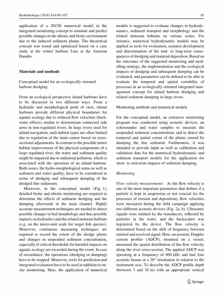
Moreover, in the conceptual model (Fig. 1),
detailed biotic and abiotic monitoring are required to
determine the effects of sediment dredging and the
dumping afterwards in the main channel. Highly
accurate measurement techniques are needed to detect
possible changes in bed morphology and thus possible
impacts on hydraulics and the related instream habitats
(e.g. on the micro-unit scale for target fish species).
Moreover, continuous measuring techniques are
required to record the extent of the dredge plume
and changes in suspended sediment concentration,
especially if critical thresholds for harmful impacts on
aquatic ecology are exceeded during the event. In case
of exceedance, the operations (dredging or dumping)
have to be stopped. Moreover, tools for prediction and
integrated evaluation have to be used in addition to on-
site monitoring. Here, the application of numerical
models is suggested to evaluate changes in hydrody-
namics, sediment transport and morphology and the
related instream habitats on various scales. For
instance, numerical hydrodynamic models may be
applied as tools for evaluation, scenario development
and determination of the mid- to long-term conse-
quences of dredging and material deposition. Based on
the outcomes of the suggested monitoring and mod-
elling strategy, the implementation and the ecological
impacts of dredging and subsequent dumping can be
evaluated, and parameters can be defined to be able to
evaluate the temporal and spatial variability of
processes in an ecologically oriented integrated man-
agement concept for inland harbour dredging and
related sediment dumping in large rivers.
Monitoring methods and numerical models
For the conceptual model, an extensive monitoring
program was conducted using acoustic devices, an
echosounder and water samples to measure the
suspended sediment concentrations and to detect the
temporal and spatial extent of the plume caused by
dumping the fine sediment. Furthermore, it was
intended to provide input as well as calibration and
validation data for the numerical hydrodynamic and
sediment transport models for the application for
short- to mid-term impacts of sediment dumping.
Monitoring
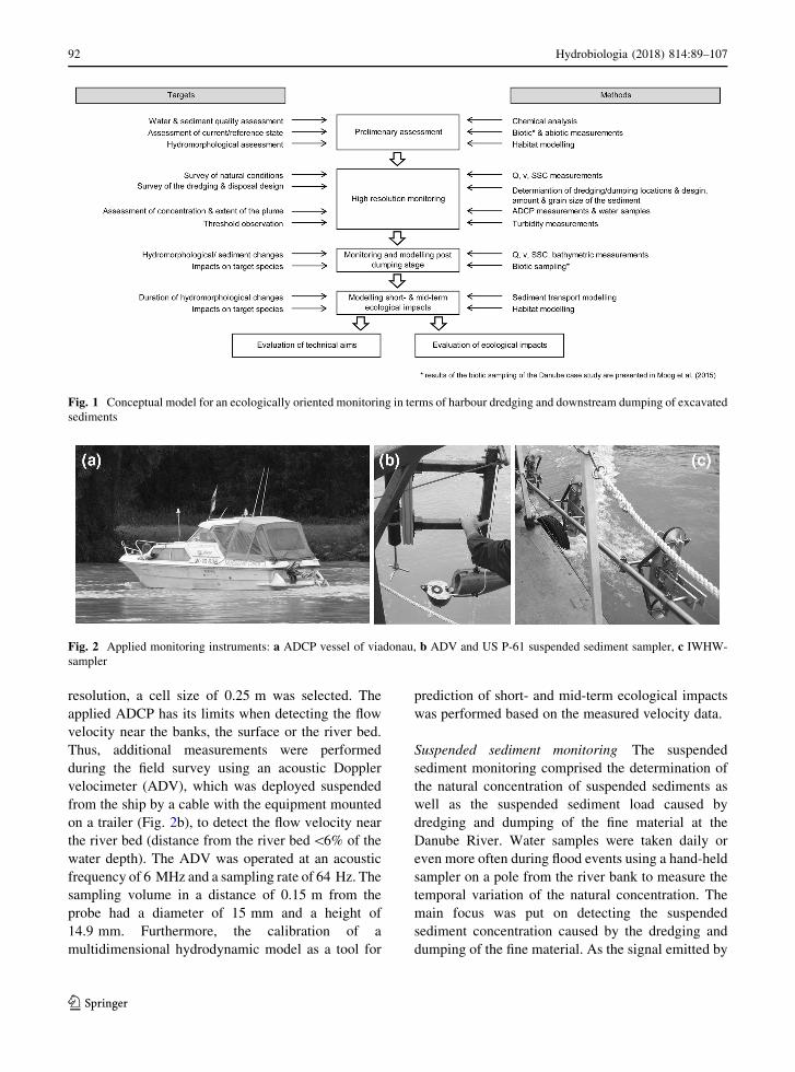
Flow velocity measurements As the flow velocity is
one of the most important parameters that defines if a
particle is kept in suspension or not (crucial for the
processes of erosion and deposition), flow velocities
were measured during the field campaign applying
two different acoustic devices (Fig. 2a, b). Ultrasonic
signals were emitted by the transducers, reflected by
particles in the water, and the backscatter was
registered by the device. The flow velocity is
determined based on the shift of frequency between
emitted and received signal. Here, an acoustic Doppler
current profiler (ADCP), mounted on a vessel,
measured the spatial distribution of the flow velocity
along the river cross-section. The applied ADCP was
operating at a frequency of 600 kHz and had four
acoustic beams at a 20� orientation in relation to the
instrument axis. To describe the ADCP profile depth
(between 3 and 10 m) with an appropriate vertical
Hydrobiologia (2018) 814:89–107 91
123
resolution, a cell size of 0.25 m was selected. The
applied ADCP has its limits when detecting the flow
velocity near the banks, the surface or the river bed.
Thus, additional measurements were performed
during the field survey using an acoustic Doppler
velocimeter (ADV), which was deployed suspended
from the ship by a cable with the equipment mounted
on a trailer (Fig. 2b), to detect the flow velocity near
the river bed (distance from the river bed\6% of the
water depth). The ADV was operated at an acoustic
frequency of 6 MHz and a sampling rate of 64 Hz. The
sampling volume in a distance of 0.15 m from the
probe had a diameter of 15 mm and a height of
14.9 mm. Furthermore, the calibration of a
multidimensional hydrodynamic model as a tool for
prediction of short- and mid-term ecological impacts
was performed based on the measured velocity data.
Suspended sediment monitoring The suspended
sediment monitoring comprised the determination of
the natural concentration of suspended sediments as
well as the suspended sediment load caused by
dredging and dumping of the fine material at the
Danube River. Water samples were taken daily or
even more often during flood events using a hand-held
sampler on a pole from the river bank to measure the
temporal variation of the natural concentration. The
main focus was put on detecting the suspended
sediment concentration caused by the dredging and
dumping of the fine material. As the signal emitted by
Fig. 1 Conceptual model for an ecologically oriented monitoring in terms of harbour dredging and downstream dumping of excavated
sediments
Fig. 2 Applied monitoring instruments: a ADCP vessel of viadonau, b ADV and US P-61 suspended sediment sampler, c IWHW-
sampler
92 Hydrobiologia (2018) 814:89–107
123
ADCPs is reflected by the particles in the water, the
suspended sediment concentration can be estimated
from the backscatter intensity (e.g. Guerrero et al.,
2016), using the sonar equation formulated as a
working version by Deines (1999), which describes a
balance of the acoustic pulse from the emission at the
transducer until its registration including the lost
energy (Eq. 1).
Sv ¼ C þ 10 log10TTR
2
LPT
� �þ 2aRþ KcðE � ErÞ;
ð1Þ
where Sv is the backscattering strength, C a constant,
TT the temperature of the transducer, R the range along
the beam (slant range) to the scatterers, L the transmit
pulse length, PT the transmit power, a an attenuation
coefficient, Kc a scale factor, E the relative backscatter
equal to echo intensity and Er the received noise. The
attenuation coefficient a is the sum of water absorption
(aw) and particle attenuation (as) summarized in
Francois and Garrison (1982a, b) and Urick (1948),
respectively (Aardom, 2006).
This method was already used to detect the
suspended sediment concentration in the Danube
River (Reichel & Nachtnebel, 1994; Baranya & Jozsa,
2013) and to measure the suspended sediment plume
caused by dredging and dumping operations of fine
material at Tylers Beach in Virginia (Thevenot et al.,
1992) and in the Baltic Sea near Rugen (Maushake,
2008). In the presented case, the device was used in a
similar way, i.e. detection of the spatial distribution of
the plume for cross- and longitudinal sections. Addi-
tionally, the temporal distribution of the suspended
sediment concentration caused by dumping of the
material was observed by measuring the passing
plume at a fixed position (river-km 2,131.4 and
2,131.5). Moreover, for the purpose of calibrating
the signals, samples were taken at 1, 2 and 3 m depth
applying the IWHW-sampler (Habersack et al., 2000)
(Fig. 2c). The relationship between backscatter inten-
sity and suspended sediment concentration was cali-
brated separately for each of the eight dumping
operations. As it was not possible to detect the
suspended sediment concentration at the lowest 6%
of the water depth with the ADCP device, additional
samples were taken close to the river bed using an US
P-61 suspended sediment sampler (Edwards &
Glysson, 1999) (Fig. 2b). By applying a US P-61
suspended sediment sampler as well as the IWHW-
sampler, the isokinetic extraction of the sample was
ensured. The suspended sediment concentration of all
water samples was analysed in the lab by vacuum
filtration using cellulose filters with pore diameters of
0.45 lm. To determine the grain size distribution of
the dredged fines, a representative amount of the
material was taken from each barge. Furthermore,
samples of the Danube bed material were taken to
determine the grain size distributions. The granulo-
metric analyses were conducted using sievingmethods
(grain size[ 20 lm) and X-ray sedimentation
method (Sedigraph) for the fine fractions.
Bathymetric survey The data of the morphological
changes of the river bed were measured, using a multi-
beam echosounder, and processed by viadonau, the
Austrian waterway authority. The provided dataset for
determining river bed changes contained a
bathymetric resolution of 1 m in the planimetric
view. At the dredging site, the dimensions of the
dredged area were mapped, and in the main stream of
the Danube River (river-km 2,131.0–2,131.75),
measurements were performed to determine if
morphological changes occur due to aggradation of
dumped material at the river bed. These surveys were
conducted before the maintenance work was started
and in the evenings after completion of the works.
Numerical modelling
Hydrodynamic model description The flow field of
the investigated Danube reach in Austria was obtained
with the model River Simulation 3D (RSim-3D)
(Tritthart, 2005; Tritthart & Gutknecht, 2007). It
provides concurrent solutions of the three momentum
equations (Reynolds equations, Eq. 2), the continuity
equation and two equations for modelling the
turbulence. These governing equations are solved by
application of the finite volume method on a mesh
based on polyhedral cells with predominantly
hexagonal base shapes.
uioui
oxi¼ � 1
qo�p
oxi�ou
0iu
0j
oxjþ t
o2ui
ox2jþ S; ð2Þ
where ui indicates the mean flow velocity in each
spatial dimension xi, p the pressure in a cell, q the
density, u0i the mean turbulent fluctuations (Reynolds
Hydrobiologia (2018) 814:89–107 93
123
stresses), t the time, m the kinematic viscosity and S the
source term accounting for external forces acting on
the fluid (Tritthart & Gutknecht, 2007). Variables
denoted by an overbar are time-averaged, while those
with a prime sign are instantaneous, fluctuating
components.
The pressure distribution in the model is non-
hydrostatic; the pressure field is linked to the flow field
by the SIMPLE algorithm (Patankar & Spalding,
1972). For turbulence modelling, the hydrodynamic
model can be run with either the standard k-e or severalvariations of the k-xmodel; in this study, the standard
k-e model was used. At the wall, a no-slip condition
(zero velocity) is enforced, with the velocity at the first
node in the flow continuum being estimated from a
logarithmic velocity profile that relies on a user-
supplied absolute wall roughness, which is subject to
model calibration. Turbulence and dissipation values
for the near-wall node are calculated from empirical
relationships (Tritthart, 2005). The model calculates
upstream flow velocities from a given discharge value,
while downstream a known water surface boundary
condition is applied. The position of the free water
surface in all other regions of the numerical mesh is
obtained by iteratively translating a pressure surplus or
deficit at the surface into water level changes.
Habitat modelling Instream habitat modelling was
conducted in a preliminary assessment and post-
evaluation of the project, respectively. Here, the
mesohabitat description and quantification was done
by the mesohabitat evaluation model (MEM). The
conceptual MEMmodel was developed by Hauer et al.
(2009) and enables the evaluation of six different
mesohabitats according to their abiotic characteristics.
In the MEM analysis, three abiotic parameters (flow
velocity, water depth and bottom shear stress) were
incorporated. First, depth-averaged velocity (m s-1)
and water depth (m) are selected and divided into five
classes (according to the range of values). This yields
specific velocity depth relationships at each node of
the modelling mesh. In a second step of the modelling
approach, the velocity–depth relationships are
weighted by three classes of bottom shear stress
(energy potential), allowing six statistically different
mesohabitat types to be distinguished (Hauer et al.,
2009). Riffles and fast runs are classified as high
energetic (high bottom shear stress), run and pool as
moderate energetic and backwaters and/or shallow
water habitats as low-energetic hydromorphological
units. For practical purposes, the MEM concept was
implemented into a Java software application which
enables MEM evaluation based on one of three
different two-dimensional models (CCHE2D,
River2D, Hydro_AS-2D) and two different three-
dimensional models (RSim-3D, SSIIM). Loading
multiple result files at the same time enables habitat
evaluations for different discharges as well as
unsteady flow simulations (Tritthart et al., 2008).
Within this case study, mesohabitats were mapped
graphically and, in addition, quantified by area (m2)
and evaluated in relation to the total wetted area (%).
Sediment transport modelling For modelling
sediment transport and morphodynamics, the integrated
sediment transport model (iSed) (Tritthart et al.,
2009, 2011) was applied. For simulating the sediment
transport, not only sediment but also hydrodynamic
properties (bed shear stress, flow velocities and water
depth) have to be considered. The integrated sediment
transport model iSed does not calculate these parameters
but obtains them from an external hydrodynamic model.
As the model iSed acknowledges various mesh types, it
can be coupled with various numerical models of
different dimensionality (2D or 3D).
Within the model iSed, the suspended load and the
bedload can be calculated separately but as the results
of grain size analyses revealed a very fine grain size of
the excavated material (d\ 0.2 mm) only the sus-
pended sediment transport was of interest for this
investigation and therefore considered within the
simulations. The transport of suspended sediments is
described by a convection–diffusion equation (Eq. 3),
extended by a term capturing the interaction with bed
material, and is solved separately for each grain size
fraction.
oc
otþ oðu1cÞ
ox1þ oðu2cÞ
ox2
¼ o
ox1Kt
oc
ox1
� �þ o
ox2Kt
oc
ox2
� �þ sdep � sero� �
;
ð3Þ
where c is the depth-averaged suspended sediment
concentration, ui the flow velocities in the correspond-
ing coordinate directions xi, Kt is a depth-averaged
diffusion coefficient estimated from Eq. 4 and t is
94 Hydrobiologia (2018) 814:89–107
123
time. sdep is the deposition flux and sero is the erosion
flux, calculated after van Rijn (1984) and Garcia &
Parker (1991), respectively.
The depth-averaged diffusion coefficient for every
node is calculated from:
Kt ¼1
6hu�j; ð4Þ
where h is water depth, j von Karman’s constant
(j = 0.41) and u* the shear velocity at the bed,
computed from the bed shear stress delivered by the
hydrodynamic model.
For every time step of an unsteady hydrograph, first
the hydrodynamic model is called, which solves Eq. 2.
Then, for the same time step, Eq. 3 is solved in the
iSed model using the flow field and bed shear stress
previously provided by the hydrodynamic model.
When coupled with a 3D hydrodynamic model, the
flow velocities ui in the two horizontal coordinate
directions are obtained from depth-averaging the
three-dimensional flow field.
Study reach
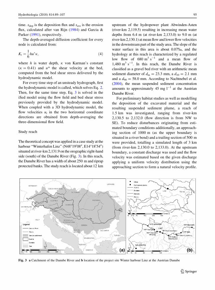
The theoretical conceptwas applied in a case study at the
harbour ‘‘Winterhafen Linz’’ (N48�1900800, E14�1805400)situated at river-km2,131.9 on the orographic right-hand
side (south) of the Danube River (Fig. 3). In this reach,
the Danube River has a width of about 250 m and riprap
protected banks. The study reach is located about 12 km
upstream of the hydropower plant Abwinden-Asten
(river-km 2,119.5) resulting in increasing mean water
depths from 6.4 m (at river-km 2,133.0) to 9.0 m (at
river-km2,130.1) atmean flow and lower flowvelocities
in the downstreampart of the study area. The slope of the
water surface in this area is about 0.07%, and the
hydrology at this reach is characterized by a regulated
low flow of 680 m3 s-1 and a mean flow of
1,480 m3 s-1. In this reach, the Danube River is
classified as a gravel bed river with an arithmetic mean
sediment diameter of dm = 23.3 mm, a d10 = 2.1 mm
and a d90 = 58.0 mm. According to Nachtnebel et al.
(2004), the mean suspended sediment concentration
amounts to approximately 45 mg l-1 at the Austrian
Danube River.
For preliminary habitat studies as well as modelling
the deposition of the excavated material and the
resulting suspended sediment plume, a reach of
1.5 km was investigated, ranging from river-km
2,130.5 to 2,132.0 (flow direction is from NW to
SE). To reduce disturbances originating from esti-
mated boundary conditions additionally, an approach-
ing section of 1000 m (as the upper boundary is
situated in a river bend) and a trailing section of 500 m
were provided, totalling a simulated length of 3 km
(from river-km 2,130.0 to 2,133.0). At the upstream
boundary, a constant discharge was used and the flow
velocity was estimated based on the given discharge
applying a uniform velocity distribution using the
approaching section to form a natural velocity profile.
Fig. 3 a Catchment of the Danube River and b location of the project site Winter harbour Linz at the Austrian Danube
Hydrobiologia (2018) 814:89–107 95
123
Fixed water levels, estimated from the characteristic
water levels of the Danube River [Kennzeichnende
Wasserstande der Donau KWD (Austrian Federal
Waterways Authority, 1997)], were defined at the
downstream boundary. The horizontal spacing of the
computational mesh amounted to 10 m in the centre of
the river and 7 m near the banks as well as in the
harbour regions. In the vertical, six depth layers were
applied, resulting in a total of 89,000 cells in 3D. The
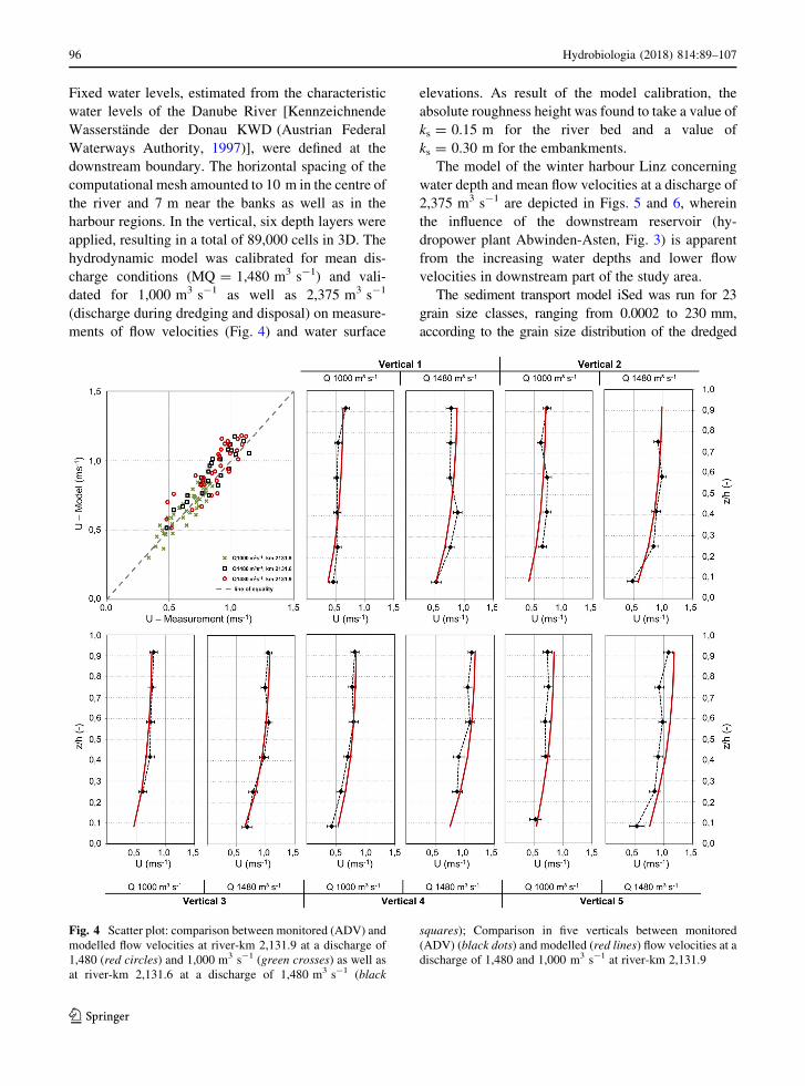
hydrodynamic model was calibrated for mean dis-
charge conditions (MQ = 1,480 m3 s-1) and vali-
dated for 1,000 m3 s-1 as well as 2,375 m3 s-1
(discharge during dredging and disposal) on measure-
ments of flow velocities (Fig. 4) and water surface
elevations. As result of the model calibration, the
absolute roughness height was found to take a value of
ks = 0.15 m for the river bed and a value of
ks = 0.30 m for the embankments.
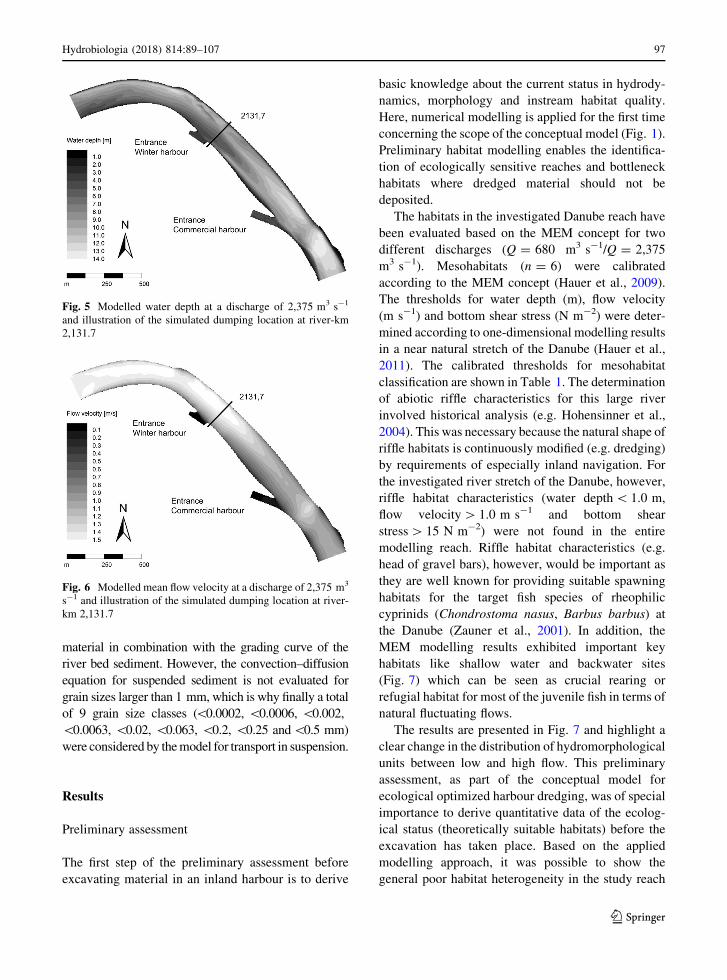
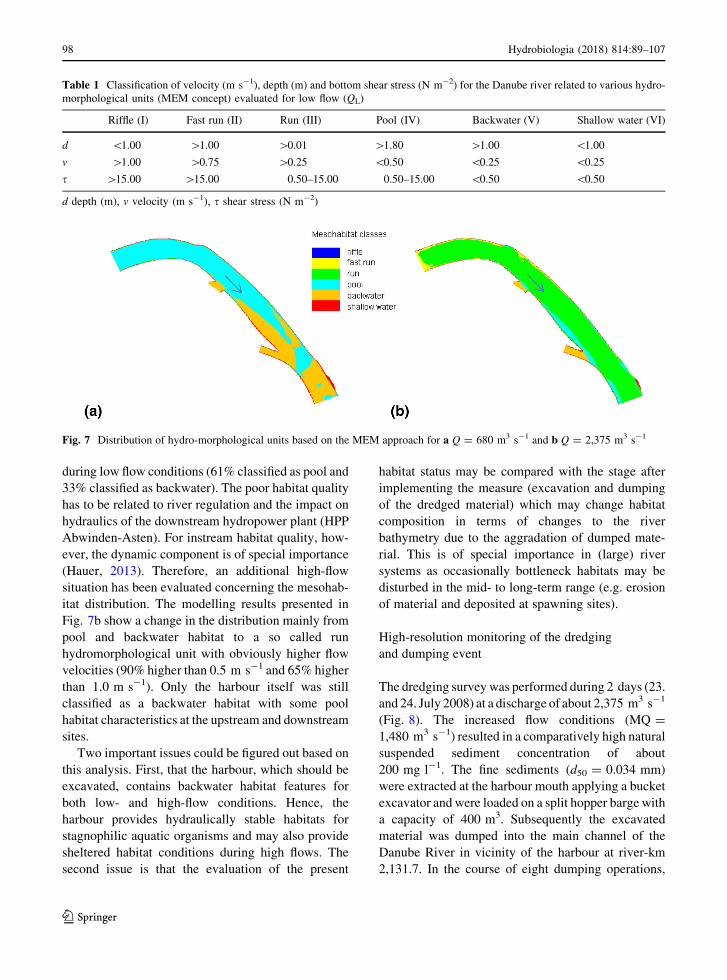
The model of the winter harbour Linz concerning
water depth and mean flow velocities at a discharge of
2,375 m3 s-1 are depicted in Figs. 5 and 6, wherein
the influence of the downstream reservoir (hy-
dropower plant Abwinden-Asten, Fig. 3) is apparent
from the increasing water depths and lower flow
velocities in downstream part of the study area.
The sediment transport model iSed was run for 23
grain size classes, ranging from 0.0002 to 230 mm,
according to the grain size distribution of the dredged
Fig. 4 Scatter plot: comparison between monitored (ADV) and
modelled flow velocities at river-km 2,131.9 at a discharge of
1,480 (red circles) and 1,000 m3 s-1 (green crosses) as well as
at river-km 2,131.6 at a discharge of 1,480 m3 s-1 (black
squares); Comparison in five verticals between monitored
(ADV) (black dots) and modelled (red lines) flow velocities at a
discharge of 1,480 and 1,000 m3 s-1 at river-km 2,131.9
96 Hydrobiologia (2018) 814:89–107
123
material in combination with the grading curve of the
river bed sediment. However, the convection–diffusion
equation for suspended sediment is not evaluated for
grain sizes larger than 1 mm, which is why finally a total
of 9 grain size classes (\0.0002, \0.0006, \0.002,
\0.0063, \0.02, \0.063, \0.2, \0.25 and\0.5 mm)
were considered by themodel for transport in suspension.
Results
Preliminary assessment
The first step of the preliminary assessment before
excavating material in an inland harbour is to derive
basic knowledge about the current status in hydrody-
namics, morphology and instream habitat quality.
Here, numerical modelling is applied for the first time
concerning the scope of the conceptual model (Fig. 1).
Preliminary habitat modelling enables the identifica-
tion of ecologically sensitive reaches and bottleneck
habitats where dredged material should not be
deposited.
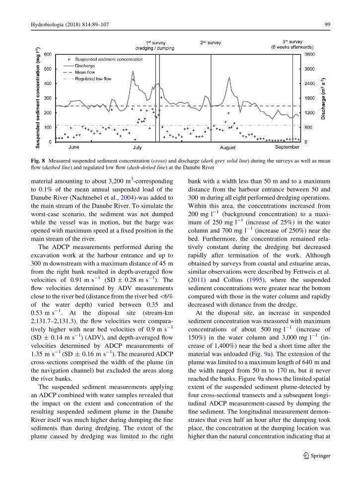
The habitats in the investigated Danube reach have
been evaluated based on the MEM concept for two
different discharges (Q = 680 m3 s-1/Q = 2,375
m3 s-1). Mesohabitats (n = 6) were calibrated
according to the MEM concept (Hauer et al., 2009).
The thresholds for water depth (m), flow velocity
(m s-1) and bottom shear stress (N m-2) were deter-
mined according to one-dimensional modelling results
in a near natural stretch of the Danube (Hauer et al.,
2011). The calibrated thresholds for mesohabitat
classification are shown in Table 1. The determination
of abiotic riffle characteristics for this large river
involved historical analysis (e.g. Hohensinner et al.,
2004). This was necessary because the natural shape of
riffle habitats is continuously modified (e.g. dredging)
by requirements of especially inland navigation. For
the investigated river stretch of the Danube, however,
riffle habitat characteristics (water depth\ 1.0 m,
flow velocity[ 1.0 m s-1 and bottom shear
stress[ 15 N m-2) were not found in the entire
modelling reach. Riffle habitat characteristics (e.g.
head of gravel bars), however, would be important as
they are well known for providing suitable spawning
habitats for the target fish species of rheophilic
cyprinids (Chondrostoma nasus, Barbus barbus) at
the Danube (Zauner et al., 2001). In addition, the
MEM modelling results exhibited important key
habitats like shallow water and backwater sites
(Fig. 7) which can be seen as crucial rearing or
refugial habitat for most of the juvenile fish in terms of
natural fluctuating flows.
The results are presented in Fig. 7 and highlight a
clear change in the distribution of hydromorphological
units between low and high flow. This preliminary
assessment, as part of the conceptual model for
ecological optimized harbour dredging, was of special
importance to derive quantitative data of the ecolog-
ical status (theoretically suitable habitats) before the
excavation has taken place. Based on the applied
modelling approach, it was possible to show the
general poor habitat heterogeneity in the study reach
Fig. 5 Modelled water depth at a discharge of 2,375 m3 s-1
and illustration of the simulated dumping location at river-km
2,131.7
Fig. 6 Modelled mean flow velocity at a discharge of 2,375 m3
s-1 and illustration of the simulated dumping location at river-
km 2,131.7
Hydrobiologia (2018) 814:89–107 97
123
during low flow conditions (61% classified as pool and
33% classified as backwater). The poor habitat quality
has to be related to river regulation and the impact on
hydraulics of the downstream hydropower plant (HPP
Abwinden-Asten). For instream habitat quality, how-
ever, the dynamic component is of special importance
(Hauer, 2013). Therefore, an additional high-flow
situation has been evaluated concerning the mesohab-
itat distribution. The modelling results presented in
Fig. 7b show a change in the distribution mainly from
pool and backwater habitat to a so called run
hydromorphological unit with obviously higher flow
velocities (90% higher than 0.5 m s-1 and 65% higher
than 1.0 m s-1). Only the harbour itself was still
classified as a backwater habitat with some pool
habitat characteristics at the upstream and downstream
sites.
Two important issues could be figured out based on
this analysis. First, that the harbour, which should be
excavated, contains backwater habitat features for
both low- and high-flow conditions. Hence, the
harbour provides hydraulically stable habitats for
stagnophilic aquatic organisms and may also provide
sheltered habitat conditions during high flows. The
second issue is that the evaluation of the present
habitat status may be compared with the stage after
implementing the measure (excavation and dumping
of the dredged material) which may change habitat
composition in terms of changes to the river
bathymetry due to the aggradation of dumped mate-
rial. This is of special importance in (large) river
systems as occasionally bottleneck habitats may be
disturbed in the mid- to long-term range (e.g. erosion
of material and deposited at spawning sites).
High-resolution monitoring of the dredging
and dumping event
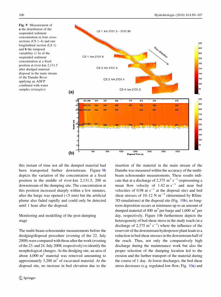
The dredging surveywas performed during 2 days (23.
and 24. July 2008) at a discharge of about 2,375 m3 s-1
(Fig. 8). The increased flow conditions (MQ =
1,480 m3 s-1) resulted in a comparatively high natural
suspended sediment concentration of about
200 mg l-1. The fine sediments (d50 = 0.034 mm)
were extracted at the harbour mouth applying a bucket
excavator and were loaded on a split hopper barge with
a capacity of 400 m3. Subsequently the excavated
material was dumped into the main channel of the
Danube River in vicinity of the harbour at river-km
2,131.7. In the course of eight dumping operations,
Table 1 Classification of velocity (m s-1), depth (m) and bottom shear stress (N m-2) for the Danube river related to various hydro-
morphological units (MEM concept) evaluated for low flow (QL)
Riffle (I) Fast run (II) Run (III) Pool (IV) Backwater (V) Shallow water (VI)
d \1.00 [1.00 [0.01 [1.80 [1.00 \1.00
v [1.00 [0.75 [0.25 \0.50 \0.25 \0.25
s [15.00 [15.00 0.50–15.00 0.50–15.00 \0.50 \0.50
d depth (m), v velocity (m s-1), s shear stress (N m-2)
Fig. 7 Distribution of hydro-morphological units based on the MEM approach for a Q = 680 m3 s-1 and b Q = 2,375 m3 s-1
98 Hydrobiologia (2018) 814:89–107
123
material amounting to about 3,200 m3-corresponding
to 0.1% of the mean annual suspended load of the
Danube River (Nachtnebel et al., 2004)-was added to
the main stream of the Danube River. To simulate the
worst-case scenario, the sediment was not dumped
while the vessel was in motion, but the barge was
opened with maximum speed at a fixed position in the
main stream of the river.
The ADCP measurements performed during the
excavation work at the harbour entrance and up to
300 m downstream with a maximum distance of 45 m
from the right bank resulted in depth-averaged flow
velocities of 0.91 m s-1 (SD ± 0.28 m s-1). The
flow velocities determined by ADV measurements
close to the river bed (distance from the river bed\6%
of the water depth) varied between 0.35 and
0.53 m s-1. At the disposal site (stream-km
2,131.7–2,131.3), the flow velocities were compara-
tively higher with near bed velocities of 0.9 m s-1
(SD ± 0.14 m s-1) (ADV), and depth-averaged flow
velocities determined by ADCP measurements of
1.35 m s-1 (SD ± 0.16 m s-1). The measured ADCP
cross-sections comprised the width of the plume (in
the navigation channel) but excluded the areas along
the river banks.
The suspended sediment measurements applying
an ADCP combined with water samples revealed that
the impact on the extent and concentration of the
resulting suspended sediment plume in the Danube
River itself was much higher during dumping the fine
sediments than during dredging. The extent of the
plume caused by dredging was limited to the right
bank with a width less than 50 m and to a maximum
distance from the harbour entrance between 50 and
300 m during all eight performed dredging operations.
Within this area, the concentrations increased from
200 mg l-1 (background concentration) to a maxi-
mum of 250 mg l-1 (increase of 25%) in the water
column and 700 mg l-1 (increase of 250%) near the
bed. Furthermore, the concentration remained rela-
tively constant during the dredging but decreased
rapidly after termination of the work. Although
obtained by surveys from coastal and estuarine areas,
similar observations were described by Fettweis et al.
(2011) and Collins (1995), where the suspended
sediment concentrations were greater near the bottom
compared with those in the water column and rapidly
decreased with distance from the dredge.
At the disposal site, an increase in suspended
sediment concentration was measured with maximum
concentrations of about 500 mg l-1 (increase of
150%) in the water column and 3,000 mg l-1 (in-
crease of 1,400%) near the bed a short time after the
material was unloaded (Fig. 9a). The extension of the
plume was limited to a maximum length of 640 m and
the width ranged from 50 m to 170 m, but it never
reached the banks. Figure 9a shows the limited spatial
extent of the suspended sediment plume-detected by
four cross-sectional transects and a subsequent longi-
tudinal ADCP measurement-caused by dumping the
fine sediment. The longitudinal measurement demon-
strates that even half an hour after the dumping took
place, the concentration at the dumping location was
higher than the natural concentration indicating that at
Fig. 8 Measured suspended sediment concentration (cross) and discharge (dark grey solid line) during the surveys as well as mean
flow (dashed line) and regulated low flow (dash-dotted line) at the Danube River
Hydrobiologia (2018) 814:89–107 99
123
this instant of time not all the dumped material had
been transported further downstream. Figure 9b
depicts the variation of the concentration at a fixed
position in the middle of river-km 2,131.5, 200 m
downstream of the dumping site. The concentration at
this position increased sharply within a few minutes,
after the barge was opened (\5 min) but the artificial
plume also faded rapidly and could only be detected
until 1 hour after the disposal.
Monitoring and modelling of the post-dumping
stage
The multi-beam echosounder measurements before the
dredging/disposal procedure (evening of the 22. July
2008)were comparedwith those after thework (evening
of the 23. and 24. July 2008, respectively) to identify the
morphological changes. At the dredging site, an area of
about 4,000 m2 material was removed amounting to
approximately 3,200 m3 of excavated material. At the
disposal site, no increase in bed elevation due to the
insertion of the material in the main stream of the
Danube was measured within the accuracy of the multi-
beam echosounder measurements. These results indi-
cate that at a discharge of 2,375 m3 s-1 (representing a
mean flow velocity of 1.42 m s-1 and near bed
velocities of 0.98 m s-1 at the disposal site) and bed
shear stresses of 10–12 N m-2 (determined by RSim-
3D simulations) at the disposal site (Fig. 10b), no long-
term deposition occurs at minimum up to an amount of
dumped material of 400 m3 per barge and 1,600 m3 per
day, respectively. Figure 10b furthermore depicts the
heterogeneity of bed shear stress in the study reach (at a
discharge of 2,375 m3 s-1) where the influence of the
reservoir of the downstreamhydropower plant leads to a
reduction in bed shear stresses in the downstreamhalf of
the reach. Thus, not only the comparatively high
discharge during the maintenance work but also the
proper selection of the dumping location led to the
erosion and the further transport of the material during
the course of 1 day. At lower discharges, the bed shear
stress decreases (e.g. regulated low flow, Fig. 10a) and
Fig. 9 Measurement of
a the distribution of the
suspended sediment
concentration in four cross-
sections (CS 1–4) and one
longitudinal section (LS 1)
and b the temporal
variability (1 h) of the
suspended sediment
concentration at a fixed
position at river-km 2,131.5
after dredged material
disposal in the main stream
of the Danube River
applying an ADCP
combined with water
samples (triangles)
100 Hydrobiologia (2018) 814:89–107
123
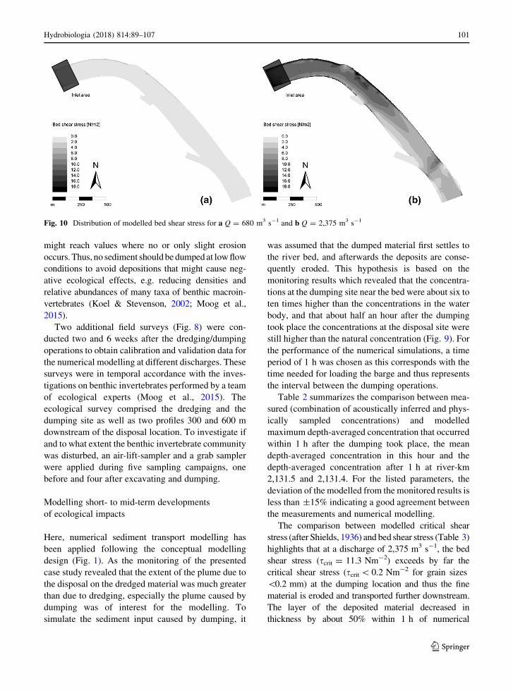
might reach values where no or only slight erosion
occurs. Thus, no sediment shouldbedumpedat lowflow
conditions to avoid depositions that might cause neg-
ative ecological effects, e.g. reducing densities and
relative abundances of many taxa of benthic macroin-
vertebrates (Koel & Stevenson, 2002; Moog et al.,
2015).
Two additional field surveys (Fig. 8) were con-
ducted two and 6 weeks after the dredging/dumping
operations to obtain calibration and validation data for
the numerical modelling at different discharges. These
surveys were in temporal accordance with the inves-
tigations on benthic invertebrates performed by a team
of ecological experts (Moog et al., 2015). The
ecological survey comprised the dredging and the
dumping site as well as two profiles 300 and 600 m
downstream of the disposal location. To investigate if
and to what extent the benthic invertebrate community
was disturbed, an air-lift-sampler and a grab sampler
were applied during five sampling campaigns, one
before and four after excavating and dumping.
Modelling short- to mid-term developments
of ecological impacts
Here, numerical sediment transport modelling has
been applied following the conceptual modelling
design (Fig. 1). As the monitoring of the presented
case study revealed that the extent of the plume due to
the disposal on the dredged material was much greater
than due to dredging, especially the plume caused by
dumping was of interest for the modelling. To
simulate the sediment input caused by dumping, it
was assumed that the dumped material first settles to
the river bed, and afterwards the deposits are conse-
quently eroded. This hypothesis is based on the
monitoring results which revealed that the concentra-
tions at the dumping site near the bed were about six to
ten times higher than the concentrations in the water
body, and that about half an hour after the dumping
took place the concentrations at the disposal site were
still higher than the natural concentration (Fig. 9). For
the performance of the numerical simulations, a time
period of 1 h was chosen as this corresponds with the
time needed for loading the barge and thus represents
the interval between the dumping operations.
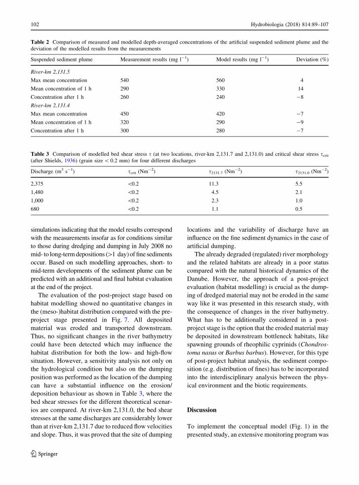
Table 2 summarizes the comparison between mea-
sured (combination of acoustically inferred and phys-
ically sampled concentrations) and modelled
maximum depth-averaged concentration that occurred
within 1 h after the dumping took place, the mean
depth-averaged concentration in this hour and the
depth-averaged concentration after 1 h at river-km
2,131.5 and 2,131.4. For the listed parameters, the
deviation of the modelled from the monitored results is
less than ±15% indicating a good agreement between
the measurements and numerical modelling.
The comparison between modelled critical shear
stress (after Shields, 1936) and bed shear stress (Table 3)
highlights that at a discharge of 2,375 m3 s-1, the bed
shear stress (scrit = 11.3 Nm-2) exceeds by far the
critical shear stress (scrit\0.2 Nm-2 for grain sizes
\0.2 mm) at the dumping location and thus the fine
material is eroded and transported further downstream.
The layer of the deposited material decreased in
thickness by about 50% within 1 h of numerical
Fig. 10 Distribution of modelled bed shear stress for a Q = 680 m3 s-1 and b Q = 2,375 m3 s-1
Hydrobiologia (2018) 814:89–107 101
123
simulations indicating that the model results correspond
with the measurements insofar as for conditions similar
to those during dredging and dumping in July 2008 no
mid- to long-termdepositions ([1 day)of fine sediments
occur. Based on such modelling approaches, short- to
mid-term developments of the sediment plume can be
predicted with an additional and final habitat evaluation
at the end of the project.
The evaluation of the post-project stage based on
habitat modelling showed no quantitative changes in
the (meso-)habitat distribution compared with the pre-
project stage presented in Fig. 7. All deposited
material was eroded and transported downstream.
Thus, no significant changes in the river bathymetry
could have been detected which may influence the
habitat distribution for both the low- and high-flow
situation. However, a sensitivity analysis not only on
the hydrological condition but also on the dumping
position was performed as the location of the dumping
can have a substantial influence on the erosion/
deposition behaviour as shown in Table 3, where the
bed shear stresses for the different theoretical scenar-
ios are compared. At river-km 2,131.0, the bed shear
stresses at the same discharges are considerably lower
than at river-km 2,131.7 due to reduced flow velocities
and slope. Thus, it was proved that the site of dumping
locations and the variability of discharge have an
influence on the fine sediment dynamics in the case of
artificial dumping.
The already degraded (regulated) river morphology
and the related habitats are already in a poor status
compared with the natural historical dynamics of the
Danube. However, the approach of a post-project
evaluation (habitat modelling) is crucial as the dump-
ing of dredged material may not be eroded in the same
way like it was presented in this research study, with
the consequence of changes in the river bathymetry.
What has to be additionally considered in a post-
project stage is the option that the eroded material may
be deposited in downstream bottleneck habitats, like
spawning grounds of rheophilic cyprinids (Chondros-
toma nasus or Barbus barbus). However, for this type
of post-project habitat analysis, the sediment compo-
sition (e.g. distribution of fines) has to be incorporated
into the interdisciplinary analysis between the phys-
ical environment and the biotic requirements.
Discussion
To implement the conceptual model (Fig. 1) in the
presented study, an extensive monitoring program was
Table 2 Comparison of measured and modelled depth-averaged concentrations of the artificial suspended sediment plume and the
deviation of the modelled results from the measurements
Suspended sediment plume Measurement results (mg l-1) Model results (mg l-1) Deviation (%)
River-km 2,131.5
Max mean concentration 540 560 4
Mean concentration of 1 h 290 330 14
Concentration after 1 h 260 240 -8
River-km 2,131.4
Max mean concentration 450 420 -7
Mean concentration of 1 h 320 290 -9
Concentration after 1 h 300 280 -7
Table 3 Comparison of modelled bed shear stress s (at two locations, river-km 2,131.7 and 2,131.0) and critical shear stress scrit(after Shields, 1936) (grain size\ 0.2 mm) for four different discharges
Discharge (m3 s-1) scrit (Nm-2) s2131.7 (Nm
-2) s2131.0 (Nm-2)
2,375 \0.2 11.3 5.5
1,480 \0.2 4.5 2.1
1,000 \0.2 2.3 1.0
680 \0.2 1.1 0.5
102 Hydrobiologia (2018) 814:89–107
123
conducted using acoustic devices, echosounder and
water samples. By applying the combined monitoring
system, it was possible to obtain data (flow velocity,
suspended sediment concentrations, the temporal and
spatial extent of the plume and changes in bed
morphology caused by dumping the fine sediments)
that could not be detected with a single instrument.
ADCPs provide immediate results and allow a real-
time determination of the extent and diffusion of the
plume created by the dredge and disposal based on the
intensity of the backscatter (Cutroneo et al., 2012).
Using water samples to calibrate the ADCP signal has
the disadvantage that no in situ calibration of the
signal is possible as these water samples have to be
analysed in the lab. One option to perform a rough
calibration of the ADCP signals in real-time is the use
of optical backscatter sensors (Aardom, 2006). As the
signals of optical devices are not only dependent on
suspended sediment concentration but also on the size,
composition and shape of the particles (Gippel, 1995;
Czuba et al., 2014), this first calibration can then be
optimized by means of the laboratory results of
suspended sediment concentration and particle size
distribution of the water samples during post-process-
ing. Furthermore, optical sensors can be used to
observe the compliance of pre-defined thresholds
(Cutroneo et al., 2012) and thus be able to stop the
measures in time when these values are exceeded to
prevent harmful impacts on the aquatic environment.
Optical sensors seem to be an essential supplement to
the integrated monitoring approach applied during the
field survey. Based on the detailed monitoring in the
ecologically oriented conceptual approach, important
data concerning future sediment management at the
Danube could be derived.
In their strategy developed for coral communities,
Orpin et al. (2004) argue that the natural variability of
the system could be used to define the limits of
acceptable turbidity levels for the present species
during dredging or disposal operations. Such an
approach assumes that a short-term increase (several
hours) that falls within the range of natural variability
will not have any significant ecological effect (Fet-
tweis et al., 2011). Although the concentrations caused
by dumping the fine sediments considerably exceed
the mean annual suspended sediment concentration of
45 mg l-1 (Nachtnebel et al., 2004) of the Austrian
Danube River, these values are still lower than the
concentration of 15,000 mg l-1 which was measured
during the 20-year flood event of August 2002
(Nachtnebel et al., 2004). Concentrations of about
3,000 mg l-1 (maximum concentrations measured
during the field campaign at Winter harbour Linz)
already occur at discharges of 5,000 m3 s-1 and have
a statistical recurrence interval of about five years at
the Danube River (measurement site Linz; source:
viadonau).
The occurring concentrations (2,000–3,500 mg l-1
of a duration of a few minutes and concentrations of
300–600 mg l-1 of a duration of up to 1 h) are at the
lower level of concentrations considered in literature
(e.g. Bucher, 2002; Newcombe & MacDonald, 1991),
investigating the influence that increased suspended
sediment concentrations have on riverine fish. Based
on the highly accurate suspended sediment sampling,
it could be detected that the plume had a limited extent
(maximum length of 600 and width of 170 m) and did
not reach the river banks, where fish often take shelter.
These results suggest only a slight modification of
behaviour (avoiding) or sporadic pathologic appear-
ances (e.g. increased mucus production in gills
epithelium) as they can also occur during flood events.
Negative effects on the feeding and consequently on
the condition of the fish are probably negligible due to
the short duration of increased concentrations (Haber-
sack et al., 2009).
The present status of Danube aquatic fauna is
heavily impacted due to different anthropogenic
pressures such as (i) flood protection, (ii) inland
navigation and (iii) hydropower use. Especially inland
navigation (e.g. dredging) and hydropower (e.g.
deposition in backwaters of HP) exhibit major impacts
on the sediment continuum and sediment dynamics.
Here, consequences of the disturbed sediment regime
are, however, mainly related to bed load deficits (e.g.
ongoing river bed incision) and not to increase in the
turbidity (or possible substrate clogging), such as it
was documented for the dumping of dredged material
(Moog et al., 2015). Thus, in a broader ecological
perspective, fish may be affected indirectly by the
maintenance activities if the amount and composition
of their food organisms is altered. A study about the
impact of inland harbour excavating and dredged
sediment disposal on benthic invertebrates, an impor-
tant energy source for fish fauna was performed (Moog
et al., 2015). The effects were investigated and
documented by Moog et al. (2015) based on five
sampling campaigns for the presented case study at the
Hydrobiologia (2018) 814:89–107 103
123
Danube, one before and four after excavating and
dumping. It could be shown that under given condi-
tions, the sediment dumping did not affect the biota
due to the sufficiently high minimum flow velocities
(1.4 and *1.0 m s-1 near the river bed) that only
allowed short-term deposition at the disposal site and
therefore prevented a clogging of the natural bed
sediment. During the study, however, it became
evident that the excavation of harbour sediment had
an effect on the biota leading to a decline of 82% of the
benthic invertebrate biomass as consequence of the
maintenance operations (Moog et al., 2015). Based on
a rough trend line analysis, a recovery time (return of
the impaired area to pre-operation conditions) for the
harbour bottom fauna of approximately 235 days was
determined.
However, in other studies, dredging and disposal
effects (at estuaries and coasts) were found to be site
specific (Ware et al., 2010) and when assessing the
potential environmental effects, the characteristics of
the sediment being deposited, the mode of disposal,
timing of the works, volume to be disposed and
frequency of the disposal activity are important
aspects to consider (Bolam et al., 2006); so the
findings of the presented study and the work of Moog
et al. (2015) are not generally applicable. To be able to
develop recommendations or guidelines for an opti-
mized dredging and dumping procedure, the effects at
different boundary conditions must be known. Thus,
within the conceptual framework, numerical mod-
elling has been applied to simulate the suspended
sediment transport induced by the insertion of the fine
material in the main stream of the Danube River. The
occurring plume could be reproduced in terms of
duration and suspended sediment concentration by the
model iSed, but there is still a need to improve and
further develop the numerical model.
The applied numerical model determines the sus-
pended sediment transport and the deposition and
erosion flux between the bed and the flowing medium
for each grain size fraction individually. This is crucial
as the percentage of dumped material that is deposited
(coarse fraction) and material that goes immediately
into suspension or into resuspension (first deposited on
the bed and then remobilized) and is transported
further downstream (fine fraction: silt and clay), is
very much dependent on the grain size distribution.
Consequently, the grain size distribution (besides the
mode of disposal, timing of the works, volume to be
disposed and frequency of the disposal activity)
affects the evolution of the river bed and the artificial
plume during dumping operations. But with decreas-
ing particle size, electrostatic attraction between the
particles gets more dominant than gravitational forces,
which leads to cohesive behaviour (Mehta et al.,
1989). Based on the above facts, the size of the
individual grain becomes less important since coag-
ulation and formation of flocs dominates with cohe-
sive suspended sediments (Droppo et al., 1998).
However, these characteristics are in conflict with
the grain fraction separated calculation scheme of the
applied numerical model and/or numerical modelling
in general, and the cohesion of the bed particles is not
considered sufficiently by the mathematical formula-
tions of van Rijn (1984) and Garcia & Parker (1991)
that are implemented in the numerical model iSed for
sediment exchange with the bed. As the grain size of
the excavated material had a d50 of 0.034 mm and a
d90 of 0.142 mm, respectively, it is expected that
consideration of cohesiveness would yield more
accurate results.
Moreover, the behaviour of the sediment immedi-
ately after the opening of the barge and the insertion in
the water could not be investigated within this study,
but is crucial for ecologically oriented monitoring
concepts. More information about the settling veloc-
ity, the drift and the proportion of material that does
not settle down but goes directly into suspension are
necessary and should be gained by detailed large-scale
lab investigations. A better understanding of this
process would further facilitate achieving more accu-
rate modelling results in the future.
Conclusions
Based on the findings of the presented study and the
discussion on the scope of the derived conceptual
model, it can be concluded that both integrated
monitoring and modelling approaches are recom-
mended for instream harbour dredging, especially in
large river systems. The preliminary habitat modelling
work is of great importance for determining the habitat
quality of the areas of dredging and possible dumping
and if, due to erosion and downstream transport,
crucial (bottleneck) habitats like spawning sites are
impacted. Moreover, accurate and high-resolution
monitoring of suspended sediment concentration is
104 Hydrobiologia (2018) 814:89–107
123
required due to the fact that certain thresholds, e.g.
harmful impacts on the fish zoonosis, may be exceeded
and hence the dumping has to be stopped immediately.
Moreover, the development of the plume and deposits
on the river bed is of great importance. Here, high-
resolution bathymetry measuring systems have to be
applied in the post-placement stage. Alternatively,
numerical models can be used for calculating the
short- to mid-term development of the sediment
deposits. A final integrated evaluation based on
numerical habitat modelling (using target species), in
which the meso-unit scale is recommended, should be
performed at the end of the entire monitoring program.
The results of the presented study furthermore not
only highlight the operative range but also limit where
and when disposal of fine material in a river is not
possible or should not be performed. As dredging
always yields an impact on the environment (e.g.
decline in benthic biota), the frequency and the
amount of dredging should be kept to an absolute
minimum required to guarantee a minimum navigable
depth and access to harbours for navigation. When
selecting a dumping location, it has to be considered
that negative impacts on sensitive habitats (e.g.
spawning places, scour holes), at the dumping location
itself and further downstream, should be prevented. In
general, long-term deposition due to dumping should
be avoided; hence the location and the amount of
dumped material should be adjusted to the present
flow conditions. Generally, higher discharges are
favoured for the performance of sediment disposals
as they induce higher flow velocities and bed shear
stresses, thus the further transport of the dumped
material is enhanced. At discharges where the flow
velocities and bed shear stresses are too low, so that no
or only an insufficient transport of the material occurs,
no dumping should be performed.
Acknowledgments Open access funding provided by
University of Natural Resources and Life Sciences Vienna
(BOKU). The authors would like to thank the following
institutions for funding this research work: viadonau; Federal
Ministry for Transport, Innovation and Technology; Federal
Ministry of Agriculture, Forestry, Environment and Water
Management; Verbund Hydropower (VHP); Province of Lower
Austria; Province of Upper Austria; Ennshafen GmbH.
Furthermore, the financial support by the Federal Ministry of
Economy, Family and Youth and the National Foundation for
Research, Technology and Development is gratefully
acknowledged. The authors thank the staff of the
hydrographical and hydrological departments of viadonau for
their participation in field measurements as well as the
colleagues Franz Bock, Philipp Gmeiner, Marcel Liedermann
and Bernhard Schober for their assistance.
Open Access This article is distributed under the terms of the
Creative Commons Attribution 4.0 International License (http://
creativecommons.org/licenses/by/4.0/), which permits unre-
stricted use, distribution, and reproduction in any medium,
provided you give appropriate credit to the original
author(s) and the source, provide a link to the Creative Com-
mons license, and indicate if changes were made.
References
Aardom, J. H., 2006. Quantification of sediment concentrations
and fluxes from ADCP measurements, IXemes Journees
Nationales Genie Civil – Genie Cotier, 12–14 September
2006, Brest: 501–510.
Ashmore, P. & M. Church, 2001. The impact of climate change
on rivers and riverprocesses in Canada. Geological Survey
of Canada, Bulletin 555: 58.
Austrian Federal Waterways Authority, 1997. Die kennzeich-
nenden Wasserstande der osterreichischen Donau (KWD
1996). Austrian Federal Waterways Authority, Vienna.
Bai, Y., Z. Wang & H. Shen, 2003. Three-dimensional mod-
elling of sediment transport and the effects of dredging in
the Haihe Estuary. Estuarine, Coastal and Shelf Science 56:
175–186.
Baranya, S. & J. Jozsa, 2013. Estimation of suspended sediment
concentrations with ADCP in Danube River. Journal of
Hydrology and Hydromechanics 61(3): 232–240.
Bolam, S. G., H. L. Rees, P. Somerfield, R. Smith, K. R. Clarke,
R. M. Warwick, M. Atkins & E. Garnacho, 2006. Eco-
logical consequences of dredged material disposal in the
marine environment: a holistic assessment of activities
around the England and Wales coastline. Marine Pollution
Bulletin 52: 415–426.
Bucher, R., 2002. Feinsedimente in schweizerischen Fliess-
gewassern – Einfluss auf Fischbestande. Fischnetz-Pub-
likation. EAWAG, Dubendorf.
Collins, T. R., 1995. Dredging induced near-field resuspended-
sediment concentrations and source strength. Misc. paper
D-95-2, U.S. Army Engineer Waterways Experiment Sta-
tion, Vicksburg, MS.
Cutroneo, L., M. Castellano, A. Pieracci, P. Povero, S. Tucci &
M. Capello, 2012. The use of a combined monitoring
system for following a turbid plume generated by dredging
activities in a port. Journal of Soils and Sediments 12:
797–809.
Cutroneo, L., M. Castellano, M. P. Ferranti, P. Povero, S. Tucci
& M. Capello, 2013. Use of optical and acoustic instru-
ments to study the turbid plumes generated by three dif-
ferent types of dredges during dredging activities inside
and outside of a port. Journal of Soils and Sediments 13:
1645–1654.
Czuba, J. S., T. D. Straub, C. A. Curran, M. N. Landers & M.
M. Domanski, 2014. Comparison of fluvial suspended-
sediment concentrations and particle-size distributions
Hydrobiologia (2018) 814:89–107 105
123
measured with in-stream laser diffraction and in physical
samples. Water Resources Research, 51, 320–340.
Darby, S. E. & C. R. Thorne, 1995. Fluvial maintenance oper-
ations in managed alluvial rivers. Aquatic Conservation.
Marine and Freshwater Ecosystems 5: 37–54.
Deines, K. L., 1999. Backscatter Estimation Using Broadband
Acoustic Doppler Current Profilers. In: Oceans 99 MTS/
IEEE Conference Proceedings, San Diego, pp. 249–253.
Droppo, I. G., D. Jeffries, C. Jaskot & S. Backus, 1998. The
prevalence of freshwater flocculation in cold regions: a
case study from the mackenzie River Delta, Northwest
Territories. Canada. Arctic 51(2): 155–164.
Edwards, T. & G. Glysson, 1999. Field methods for measure-
ment of fluvial sediment. Techniques of Water-Resources
Investigations of the U.S. Geological Survey, Book 3,
Application of Hydraulics, Chapter C2. Reston, Virginia.
Fettweis, M., M. Baeye, F. Francken, B. Lauwaert, D. Van den
Eynde, V. Van Lancker, C.Martnes & T.Michielsen, 2011.
Monitoring the effects of disposal of fine sediments from
maintenance dredging on suspended particulate matter
concentration in the Belgian nearshore area (southern
North Sea). Marine Pollution Bulletin 62: 258–269.
Francois, R. E. & G. R. Garrison, 1982a. Sound absorption
based on ocean measurements. Part I: Pure water and
magnesium sulfate contributions. Journal of the Acoustic
Society of America 72: 896–907.
Francois, R. E. & G. R. Garrison, 1982b. Sound absorption
based on ocean measurements. Part II: Boric acid contri-
bution and equation for total absorption. Journal of the
Acoustic Society of America 72: 1870–1890.
Garcia, M. & G. Parker, 1991. Entrainment of bed sediment into
suspension. Journal of Hydraulic Engineering 117:
414–435.
Gippel, C. J., 1995. Potential of turbidity monitoring for mea-
suring the transport of suspended solids in streams.
Hydrological Processes 9: 83–97.
Guerrero, M., N. Ruther, R. Szupiany, S. Haun, S. Baranya & F.
Latosinski, 2016. The acoustic properties of suspended
sediment in large rivers: consequences on ADCP methods
applicability. Water 8(1): 13.
Habersack, H., P. Mayr, R. Gierlinger & S. Schneglberger,
2000. Mehrdimensionale Abflussmodellierung am der
Beispiel Lafnitz. Wiener Mitteilungen Wasser – Abwasser
– Gewasser. 165: 1–170.
Habersack, H., O. Moog, C. Wiesner, M. Haimann, I. Stubauer,
F. Charousek, F. Bock, C. Frangez, P. Gmeiner, W. Graf,
W. Hirth, T. Huber, B. Janecek, P. Leitner, M. Liedermann,
K. Moog, B. Muller, J. Radinger, B. Schober, F. Sporka &
M. Tritthart, 2009. Untersuchung der Auswirkungen von
Baggerungen und Verklappungen hochwasserbedingter
Feinsedimentablagerungen in der Donau am Fallbeispiel
Winterhafen Linz. Report, University of Natural Resources
and Life Sciences, Vienna.
Hauer, C., 2013. Eco-hydraulic modelling and river morpho-
dynamics in context of the European Water-Management
Directives (floods-, water framework-, renewable resour-
ces-). Habilitation thesis -Universitat fur Bodenkultur
Wien; Habilitation im Fach Okohydraulik und Naturnaher
Wasserbau.
Hauer, C., 2015. Review of hydro-morphological management
criteria on a river basin scale for preservation and
restoration of freshwater pearl mussel habitats. Limno-
logica – Ecology and Management of Inland Waters 50:
40–53.
Hauer, C., G. Mandlburger & H. Habersack, 2009. Hydrauli-
cally related hydro-morphological units: description based
on a new conceptual mesohabitat evaluation model (MEM)
using lidar data as geometric input. River Research and
Application 25(1): 29–47.
Hauer, C., G. Unfer, M. Tritthart, E. Formann & H. Habersack,
2011. Variability of mesohabitat characteristics in riffle-
pool reaches: testing an integrative evaluation concept
(FGC) for MEM-application. River Research and Appli-
cation 27(4): 403–430.
Hauschild, A., 2009. Sedimenttransportmodellierung mit
Delft3D am Beispiel von Maßnahmen am Rhein. In bgf
(ed.) Sedimentologische Prozesse – Analyse, Beschrei-
bung, Modellierung; 11. Gewassermorphologisches Kol-
loquium, Koblenz, 11–12. November.78–88.
Hohensinner, S., H. Habersack, M. Jungwirth & G. Zauner,
2004. Reconstruction of the characteristics of a natural
alluvial river-floodplain system and hydromorphological
changes following human modifications: The Danube
River (1812–1991). River Research and Applications 20:
25–41.
Je, C., D. F. Hayes & K. Kim, 2007. Simulation of resuspended
sediments resulting from dredging operations by a
numerical flocculent transport model. Chemosphere 70:
187–195.
Kemp, P., D. Sear, A. Collins, P. Naden & I. Jones, 2011. The
impacts of fine sediment on riverine fish. Hydrological
Processes 25: 1800–1821.
Koel, T. M. & K. E. Stevenson, 2002. Effects of dredge material
placement on benthic macroinvertebrates of the Illinois
River. Hydrobiologia 474: 229–238.
Maushake, C., 2008. Untersuchungen zur Verdriftung von
Baggergut mit ADCP auf einer Klappstelle vor Rugen. In
Bundesanstalt fur Gewasserkunde (eds), Ultraschall in der
Hydrometrie: neue Technik – neuer Nutzen?!; Seminar 3–4
June 2008. Koblenz: 65–75.
Mehta, A. J., E. J. Hayter, W. R. Parker, R. B. Krone & A.
M. Teeter, 1989. Cohesive Sediment Transport. I: Process
Description. Journal of Hydraulic Engineering 115(8):
1076–1093.
Mestres, M., J. P. Sierra, C. Mosso, A. Sanchez-Arcilla, M.
Hernaez & J. Morales, 2014. Numerical assessment of the
dispersion of overspilled sediment from a dredge barge and
its sensitivity to various parameters. Marine Pollution
Bulletin 79(2014): 225–235.
Moog, O., I. Stubauer, M. Haimann, H. Habersack & P. Leitner,
2015. Effects of harbour excavating and dredged sediment
disposal on the benthic invertebrate fauna of River Danube
(Austria). Hydrobiologia. doi:10.1007/s10750-015-2476-x.
Nachtnebel, H. P., A. Debene, R. A. Herget, P. Flicker, C. Kolbl,
H. Schimpf & L. Grill, 2004. Schwebstoffbilanzierung im
Bereich von Stauraumen an der osterreichischen Donau,
WP Donau TP 02. In Lebensministerium (ed.) Analyse der
Hochwasserereignisse vom August 2002—FloodRisk,
Technical Report, BMLFUW.
Newcombe, C. P. & D. D. MacDonald, 1991. Effects of sus-
pended sediments on aquatic ecosystems. North American
journal of fisheries management 11: 72–82.
106 Hydrobiologia (2018) 814:89–107
123
Orpin, A. R., P. V. Ridd, S. Thomas, K. R. N. Anthony, P.
Marshall & J. Oliver, 2004. Natural turbidity variability
and weather forecasts in risk management of anthro-
pogenic sediment discharge near sensitive environments.
Marine Pollution Bulletin 49: 602–612.
Owens, P. N., R. J. Batalla, A. J. Collins, B. Gomez, D.
M. Hicks, A. J. Horowitz, G. M. Kondolf, M. Marden, M.
J. Page, D. H. Peacock, E. L. Petticrew, W. Salmons & N.
A. Trustrum, 2005. Fine-grained sediment in river systems:
environmental significance and management issues. River
Research and Application 21: 693–717.
Paarlberg, A. J., M. Guerrero, F. Huthoff & M. Re, 2015.
Optimizing dredg-and-dump activities for river navigabil-
ity using a hydro-morphodynamik model. Water 7:
3943–3962.
Patankar, S. V. & D. P. Spalding, 1972. A calculation procedure
for heat, mass and momentum transfer in three-dimen-
sional parabolic flows. International Journal of Heat And
Mass Transfer 15: 1787–1806.
Prosser, I. P., I. D. Rutherford, J. M. Olley, W. J. Young, P.
J. Wallbrink & C. J. Moran, 2001. Large-scale patterns of
erosion and sediment transport in river networks, with
examples from Australia. Marine and Freshwater Research
52: 81–99.
Prazan, H., 1990. Uber Schwebstoffablagerungen in den
Stauraumen der Donaukraftwerke in Osterreich. (Sedi-
mentdepositions in the resevoirs of the ‘‘Danube Hydro,
Austria’’). Osterreichische Wasserwirtschaft 42: 73–84.
Reichel, G. & H. P. Nachtnebel, 1994. Suspended sediment
monitoring in a fluvial environment: advantages and lim-
itations applying an acoustic Doppler current profiler.
Water Research 28: 751–761.
Shields, A., 1936. Application of similarity principles and tur-
bulence research to bed-load movement. Mitteilung der
Preussischen Versuchsanstalt fur Wasserbau und Schiff-
bau, 26.
Thevenot, M. M., T. L. Prickett & N. C. Kraus, 1992. Tylers
Beach, Virginia, Dredged Material; Plume Monitoring
Project 27 September to 4 October 1991. Technical Report.
Tritthart, M., 2005. Three-dimensional numerical modelling of
turbulent river flow using polyhedral finite volumes.
Vienna University of Technology, Austria. Wiener Mit-
teilungen Wasser-Abwasser-Gewasser 193: 1–179.
Tritthart, M. & D. Gutknecht, 2007. Three-dimensional simu-
lation of free-surface flows using polyhedral finite vol-
umes. Engineering Applications of Computational Fluid
Mechanics 1: 1–14.
Tritthart, M., C. Hauer, M. Liedermann & H. Habersack, 2008.
Computer-aided mesohabitat evaluation, part II – model
development and application in the restoration of a large
river. [River Flow 2008, Cesme-Izmir, 3.-5.9.2008] In:
Altinakar, M.S., Kokpinar, M.A., Darama, Y., Yegen, E.B.,
Harmancioglu, N. (eds), International Conference on Flu-
vial Hydraulics: 1885–1893.
Tritthart, M., B. Schober, M. Liedermann & H. Habersack,
2009. Development of an integrated sediment transport
model and its application to the Danube River. In Water
Engineering for a sustainable Environment; Proceedings of
33rd IAHR Congress, pp. 876–883.
Tritthart, M., B. Schober & H. Habersack, 2011. Non-unifor-
mity and layering in sediment transport modelling 1: flume
simulations. Journal of Hydraulic research 49(3): 325–334.
van Rijn, L. C., 1984. Sediment transport, Part II: suspended
load transport. Journal of Hydraulic Engineering, ASCE
110(12): 1613–1641.
Walling D. W., 2005. Tracing suspended sediment sources in
catchments and river systems. Science of the Total Envi-
ronment 344: 159–184.
Walling, D. E. & D. Fang, 2003. Recent trends in the suspended
sediment loads of the world’s rivers. Global and Planetary
Change 39: 111–126.
Walling, D. E. & B. W. Webb, 1987. Suspended load in gravel-
bed rivers: UK experience. In Thorne, C.R., Bathurst, J.C.,
Hey, R.D., (eds), Sediment Transport in Gravel-bed Rivers.
Wiley: 691–723.
Ware, S., S. G. Bolam & H. L. Rees, 2010. Impact and recovery
associated with the deposition of capital dredgings at UK
disposal sites: Lessons for future licensing and monitoring.
Marine Pollution Bulletin 60(2010): 79–90.
Wilber, D. & D. Clarke, 2001. Biological effects of suspended
sediments: a review of suspended sediment impacts on fish
and shellfish with relation to dredging activities in estuar-
ies. North American Journal of Fisheries Management
21(4): 855–875.
Wilber, D. & D. Clarke, 2007. Defining and assessing benthic
recovery following dredging and dredged material dis-
posal. In Proceedings XXVII World Dredging Congress
2007, Orlando, FL, pp. 603–618.
Urick, R. J., 1948. The absorption of sound in irregular particles.
Journal of the Acoustic Society of America 20(3):
283–289.
Zauner, G., P. Pinka & O. Moog, 2001. Pilotstudie Oberes
Donautal – Gewasserokologische Evaluierung neuges
chaffener Schotterstrukturen im Stauwurzelbereich des
Kraftwerks Aschach. Studie im Auftrag der Wasser-
straßendirektion.
Hydrobiologia (2018) 814:89–107 107
123