Embed Size (px)
Citation preview
POGO course on MSP
MSP as a step-by-step process - 1
Online, April 2021
Andreas Kannen, Kira Gee

Policy Cycle Frameworks
1) Agenda setting (problem identification) – Understand situation
2) Policy formulation – Identify potential solutions
3) Decision-making – Decide on solutions
4) Implementation – Do what you plan
5) Evaluation – Do your solutions work?
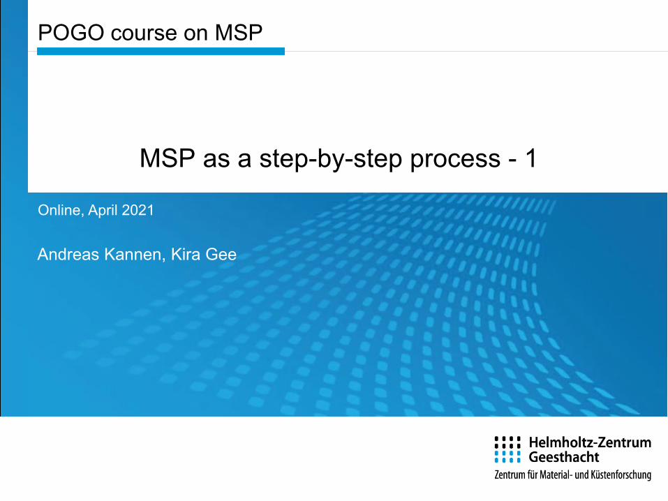
The Planning Wheelfor England’ MSPs (Source: Marine Management Organisation
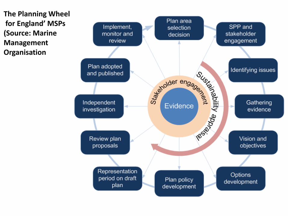
Managing the maritime spatial planning process
Establishing the MSP context
EC Maritime Spatial Planning Directive EC Marine Strategy Framework Directive …
Relevant competent authorities Governance structure and secretariat functions Stakeholder consultation and feedback processes Scientific and technical advisory processes
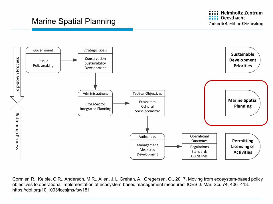
Marine Spatial Planning
Cormier, R., Kelble, C.R., Anderson, M.R., Allen, J.I., Grehan, A., Gregersen, Ó., 2017. Moving from ecosystem-based policy objectives to operational implementation of ecosystem-based management measures. ICES J. Mar. Sci. 74, 406–413. https://doi.org/10.1093/icesjms/fsw181
Strategic Goals
ConservationSustainabilityDevelopment
Tactical Objectives
EcosystemCultural
Socio-economic
Operational Outcomes
RegulationsStandardsGuidelines
Sustainable Development
Priorities
Marine Spatial Planning
PermittingLicensing of
Activities
Top-
dow
n Pr
oces
s
Government
PublicPolicymaking
Administrations
Cross-Sector Integrated Planning
Authorities
Management Measures
Development
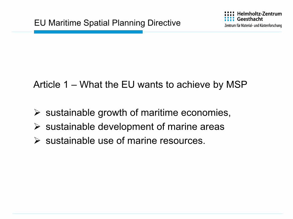
EU Maritime Spatial Planning Directive
Article 1 – What the EU wants to achieve by MSP
sustainable growth of maritime economies, sustainable development of marine areas sustainable use of marine resources.
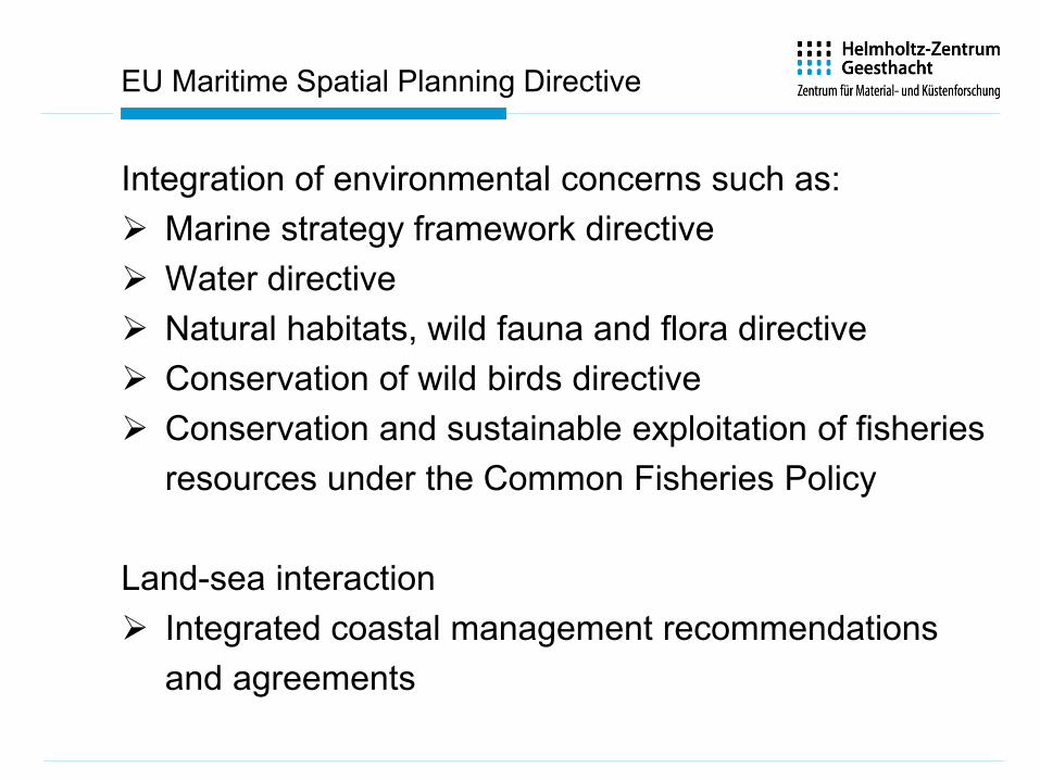
EU Maritime Spatial Planning Directive
Integration of environmental concerns such as: Marine strategy framework directive Water directive Natural habitats, wild fauna and flora directive Conservation of wild birds directive Conservation and sustainable exploitation of fisheries
resources under the Common Fisheries Policy
Land-sea interaction Integrated coastal management recommendations
and agreements
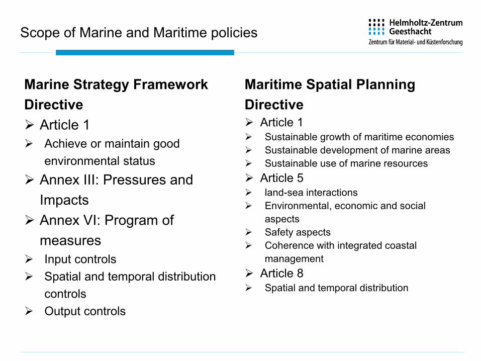
Scope of Marine and Maritime policies
Marine Strategy Framework Directive Article 1 Achieve or maintain good
environmental status Annex III: Pressures and
Impacts Annex VI: Program of
measures Input controls Spatial and temporal distribution
controls Output controls
Maritime Spatial Planning Directive Article 1 Sustainable growth of maritime economies Sustainable development of marine areas Sustainable use of marine resources Article 5 land-sea interactions Environmental, economic and social
aspects Safety aspects Coherence with integrated coastal
management Article 8 Spatial and temporal distribution
9
From legislative boundariesto
legislationto
statutory communication
10
GREAT BARRIER REEF WORLD HERITAGE AREA
Great Barrier Reef Marine Park Act 1975
Great Barrier Reef Marine Park Regulations 1983
Historic Shipwrecks Act 1976
Environment Protection (Sea Dumping) Act 1981
Sea Installations Act 1987
Environment Protection and Biodiversity Conservation Act 1999
GREAT BARRIER REEF MARINE
PARK AUTHORITY
DEPARTMENT OF THE
ENVIRONMENT
MINISTER FOR THE ENVIRONMENT
MINISTER FOR INFRASTRUCTURE AND REGIONAL DEVELOPMENT
AUSTRALIAN MARITIME
SAFETY
AUTHORITY
Protection of the Sea (Prevention of Pollution from Ships) Act 1983
AUSTRALIAN GOVERNMENT
Sustainable Planning Act 2009
State Development and Public Works Organisation Act 1971
QUEENSLAND GOVERNMENT
DEPARTMENT OF STATE
DEVELOPMENT, INFRASTRUCTURE
AND PLANNING
MINISTER FOR STATE DEVELOPMENT, INFRASTRUCTURE AND PLANNING
Economic Development Act 2012
MINISTER FOR TRANSPORT AND MAIN ROADSDEPARTMENT OF TRANSPORT AND
MAIN ROADS
Transport Infrastructure Act 1994
MINISTER FOR NATURAL RESOURCES AND MINES
DEPARTMENT OF NATURAL
RESOURCES AND
MINES
Water Act 2000
Wet Tropics World Heritage Protection and Management Act 1993
Vegetation Management Act 1999
Environment Protection Act 1994
Coastal Protection and Management Act 1995
DEPARTMENT OF ENVIRONMENT AND
HERITAGE
MINISTER FOR ENVIRONMENT AND HERITAGE
MINISTER FOR AGRICULTURE, FISHERIES AND FORESTRYDEPARTMENT OF
AGRICULTURE, FISHERIES
AND FORESTRY
Fisheries Act 1994
COASTAL AND CATCHMENT AREAS
Transport Operations (Marine Pollution) Act 1995
Maritime Safety Act 2002 MARITIME SAFETY
QUEENSLAND
MINISTER FOR NATIONAL PARKS, RECREATION, SPORT AND RACING
PARKS AND WILDLIFE
SERVICE
Marine Parks Act 2004
Nature Conservation Act 1992
QUEENSLAND GOVERNMENT
COAST PARK MARINE PARK
Signatories to Intergovernmental Agreement
Prime Minister of Australia Queensland State Premier
Minister for the Environment
Minister for Infrastructure and Regional Development
Cabinet of the Australian
Government
Department of the Environment
Great Barrier Reef Marine Park Authority
Australian Maritime Safety Authority
Minister for State Development, Infrastructure
and Planning
Minister for Environment and Heritage Protection
Cabinet of the Queensland Government
Minister for Natural Resources and Mines
Minister for National Parks, Recreation, Sport and Racing
Minister for Agriculture, Forestry and Fisheries
Minister for Transport and Main Roads
Ministerial Forum
Standing Committee of Officials
Department of Environment and Heritage
Protection
Queensland Parks and Wildlife Service
Department of State Development,
Infrastructure and Planning
Department of Agriculture, Forestry and Fisheries
Department of Natural Resources and Mines
Department of Transport and Main Raods
Department of Premier and Cabinet
Department of Prime Minister and Cabinet
Intergovernmental Agreement
Intergovernmental Operations Committee
Reef Water Quality Protection Plan
North East Shipping Plan North East Shipping
Working Group
Maritime Safety Queensland
Queensland Local Government
Signatories to draft Bi-Lateral Agreement and
MoU
Local Marine Advisory Committees
Reef Advisory Committees
Field Management Strategy, Ops, Compliance)
Regional/Place Based Partnership Groups
(Gladstone Healthy Harbours
Partnership)
Consultation and Engagement with
Regional and Local Non-Government
Entities
Constitution of Australia Constitution of Queensland
Department of Agriculture, Forestry and
Fisheries
Partnership Committee (includes AgForce, QLD Farmers
Fed, Canegrower Rep, NRM reps, WWF, QLD Conservation
Council)
Marine Spatial Planning
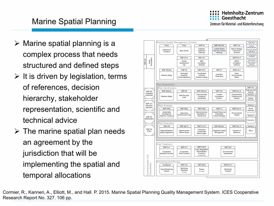
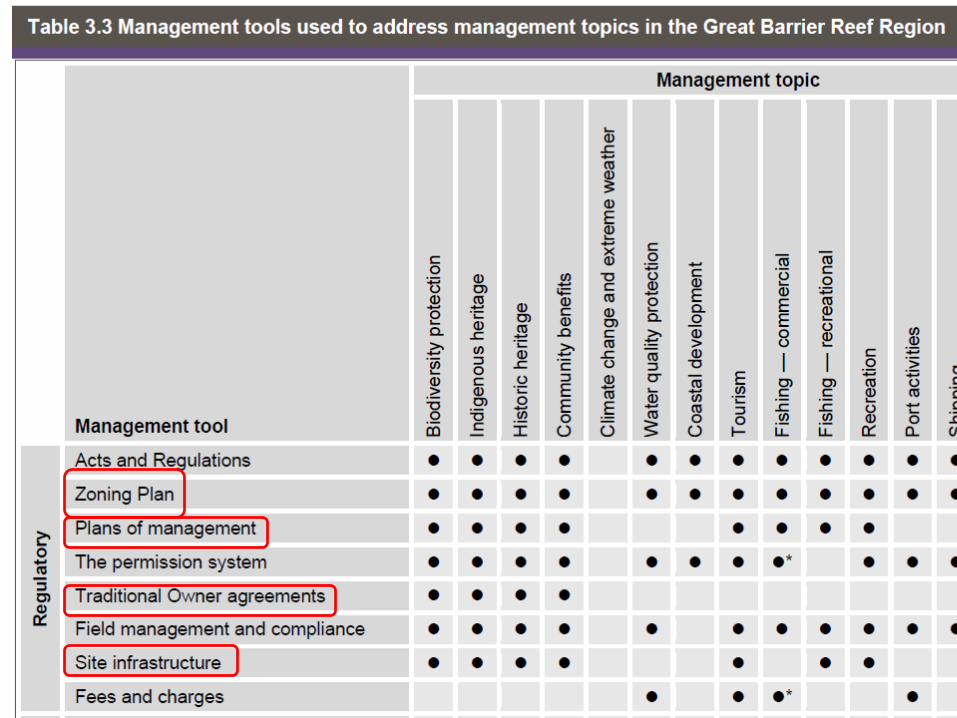
Marine spatial planning is a complex process that needs structured and defined steps
It is driven by legislation, terms of references, decision hierarchy, stakeholder representation, scientific and technical advice
The marine spatial plan needs an agreement by the jurisdiction that will be implementing the spatial and temporal allocations
Maritime Spatial Management Context
Risk TreatmentC
omm
unic
atio
n an
dC
onsu
ltatio
n
Risk AssessmentRisk Identification
Risk Analysis
Risk Evaluation
MSP A9Competent Authorities
MSP A9Stakeholders
MSP A6(2)(b)
Maritime Safety
MSFD Ax III
Characteristics Pressures and
Impacts
MSP A6(2)(c)
Maritime Safety
MSP A7
Land-Sea Interactions
MSP A6(2)(c)
Trans-boundaryCoherence
Coordination
MSP A8
Multi-Purpose Uses
MSP (21)EconomicOperators
MSFD Ax VI
Program of Measures
Monitoring and Review
MSP (1)
Coastal ResourcesUnderwater
Cultural Heritage
MSFD Ax IV
Environmental Targets
UNCLOS
National Maritime Safety Regulations
Compliance
Vessel Monitoring System
MSP A1(1)
GrowthDevelopment
Use
MSP A2(1)(3)
Coastal WatersTown and Country
Planning
MSP A2(2)
DefenseNational Security
MSP A2(4)
Sovereign RightsJurisdiction
MSP A3(1)
CoordinatedCoherent
Decision-making
MSP A5
EcologicalEconomic
Social Objectives
MSP A3(3)(4)
Marine RegionMSFD A4
Marine Water A7
MSP A4
EstablishImplementPlanning
MSP A10Data use and
sharingAdvisory
Natural Sciences
Advisory
SocialSciences
Advisory
Economic
Advisory
Policy
MSP
A9
Publ
ic
Parti
cipa
tion MSP A13
MSPCompetent Authority
MSP (14)
Marine Strategy Framework Directive
MSFD Ax I
Good Environmental
Status
MSFD Ax II
MSFDCompetent Authority
MSFD Ax V
Monitoring Program
MSP A14
MonitoringReporting
(4 Years)
MSP (23)
Environmental Assessment
MSP A6(2)(c)
Integrated Coastal Management
MSP A8(2)
Interactions Activities and Uses
MSP (8)(11)
ApportionmentMarine Space
MSP A11(1)
Coherence Coordinated
Marine region
MSP (16)
Coastal Ecosystems
Erosion
MSP A5(2)
Sustainable Development
Maritime Transport
Policy
WaterborneTransport
Policy
Blue Growth
MSP A4(6)
National policies, regulations or mechanisms
MSP A15(1)Laws, Regulations
Administrative Provisions(18 Sept 2016)
MSP A11
CooperationMember Countries
MSP A11
CooperationThird Countries
MSP A9Public
MSP A6(3)
Review(10 Years)
Cormier, R., Kannen, A., Elliott, M., and Hall. P. 2015. Marine Spatial Planning Quality Management System. ICES Cooperative Research Report No. 327. 106 pp.
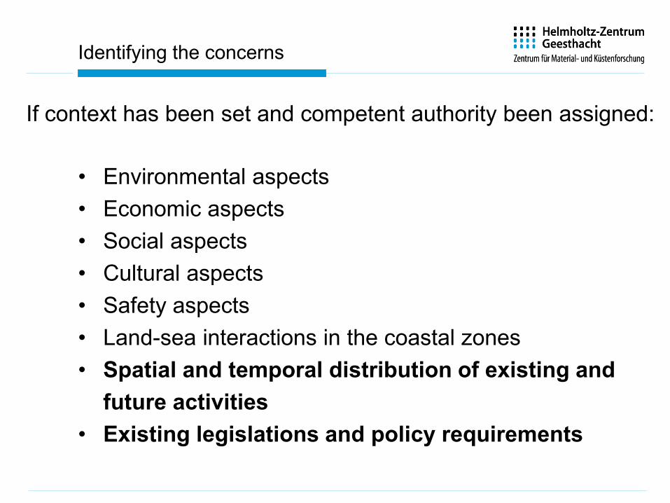
Identifying the concerns
• Environmental aspects• Economic aspects• Social aspects• Cultural aspects• Safety aspects• Land-sea interactions in the coastal zones• Spatial and temporal distribution of existing and
future activities• Existing legislations and policy requirements
If context has been set and competent authority been assigned:
15
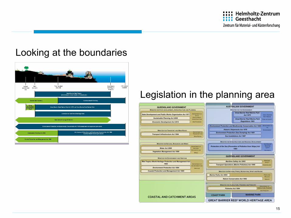
Looking at the boundaries
GREAT BARRIER REEF WORLD HERITAGE AREA
Great Barrier Reef Marine Park Act 1975
Great Barrier Reef Marine Park Regulations 1983
Historic Shipwrecks Act 1976
Environment Protection (Sea Dumping) Act 1981
Sea Installations Act 1987
Environment Protection and Biodiversity Conservation Act 1999
GREAT BARRIER REEF MARINE
PARK AUTHORITY
DEPARTMENT OF THE
ENVIRONMENT
MINISTER FOR THE ENVIRONMENT
MINISTER FOR INFRASTRUCTURE AND REGIONAL DEVELOPMENT
AUSTRALIAN MARITIME
SAFETY
AUTHORITY
Protection of the Sea (Prevention of Pollution from Ships) Act 1983
AUSTRALIAN GOVERNMENT
Sustainable Planning Act 2009
State Development and Public Works Organisation Act 1971
QUEENSLAND GOVERNMENT
DEPARTMENT OF STATE
DEVELOPMENT, INFRASTRUCTURE
AND PLANNING
MINISTER FOR STATE DEVELOPMENT, INFRASTRUCTURE AND PLANNING
Economic Development Act 2012
MINISTER FOR TRANSPORT AND MAIN ROADSDEPARTMENT OF TRANSPORT AND
MAIN ROADS
Transport Infrastructure Act 1994
MINISTER FOR NATURAL RESOURCES AND MINES
DEPARTMENT OF NATURAL
RESOURCES AND
MINES
Water Act 2000
Wet Tropics World Heritage Protection and Management Act 1993
Vegetation Management Act 1999
Environment Protection Act 1994
Coastal Protection and Management Act 1995
DEPARTMENT OF ENVIRONMENT AND
HERITAGE
MINISTER FOR ENVIRONMENT AND HERITAGE
MINISTER FOR AGRICULTURE, FISHERIES AND FORESTRYDEPARTMENT OF
AGRICULTURE, FISHERIES
AND FORESTRY
Fisheries Act 1994
COASTAL AND CATCHMENT AREAS
Transport Operations (Marine Pollution) Act 1995
Maritime Safety Act 2002 MARITIME SAFETY
QUEENSLAND
MINISTER FOR NATIONAL PARKS, RECREATION, SPORT AND RACING
PARKS AND WILDLIFE
SERVICE
Marine Parks Act 2004
Nature Conservation Act 1992
QUEENSLAND GOVERNMENT
COAST PARK MARINE PARK
Legislation in the planning area
#*
*#
(!
!(!(
!(!(
!(
(!
!(!( !(!( !(
!(
(!(!
(!
!(
#*#*
*#
#**#
*##*
#*(!
*#!(#*
!
!
!
! !
!!
! !
!
! !
!
!
!
"/
"/
/"$1$$1
"/ "/
"/ "/
//
/
"/
/"
"/
"/
/"/"
"/ "/
"/
"/ "/
$1
"/
/"
"/ "/ "/"/
"/ $1
.! .!.!.
.!
.!
!. "/
.!
!.
!.
.!
.!
!.
!.!.!.!.!.!.
.!
!.
.!
!.!.
! .!..!
.!.!
.!.!. .! !..!
.! .! !
.! !.!.
!.!. .! .!.
! . .! .!.! .!
.!
.!.! ! .
!.
!.!.!.!.!.!.!.!.!.!! .
!. .!..! !.!.!.!.!!.
!.
!.!. .!! . ! .
!.
.!
!.
.! ! .
!.! . .!
!..!.!.!
!
! .!.
! . .!!.
.!! . .!
.!!.
!.!.
!.
!.
!.
.!.!.!
.!
!.!.! .!.!.!.
.!
!.
!.
!.!.!.
"//
"/ $1.! "/
.!
!."/1$1
!
!
!
BREMEN
BremerhavenWilhelmshaven !(!(Norden
Emden
Oldenburg
!(Cuxhaven
Büsum(!
8°0'E7°0'E6°0'E5°0'E4°0'E
4°0'E 5°0'E 6°0'E 7°0'E 8°0'E 9°0'E
!.!.
56°0'N 56°0'N
55°0'N 55°0'N
54°0'N 54°0'N
53°0'N 53°0'N
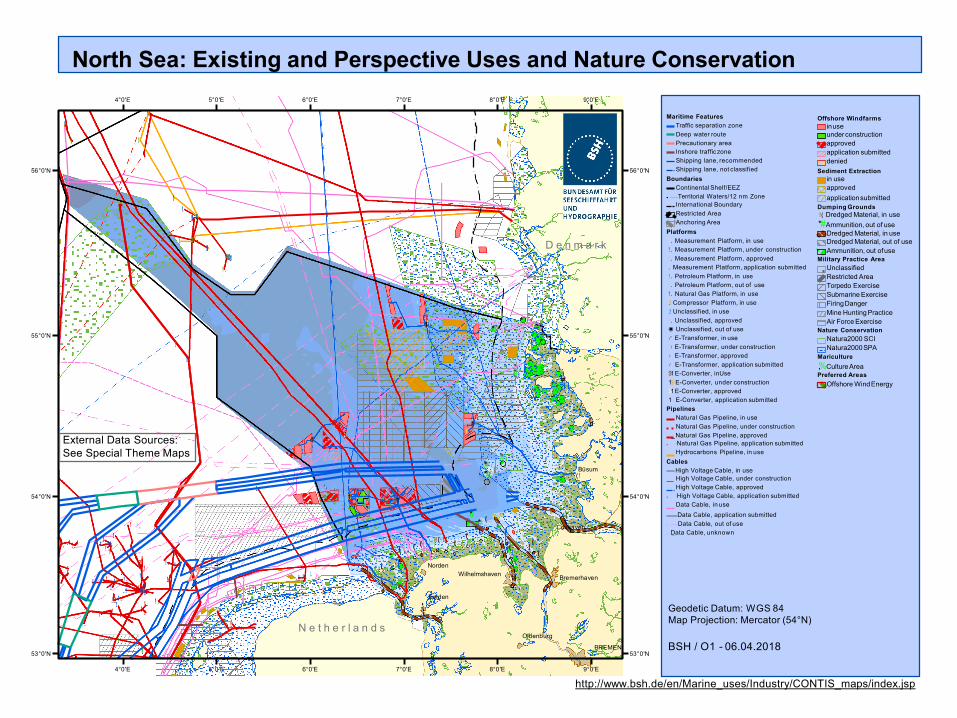
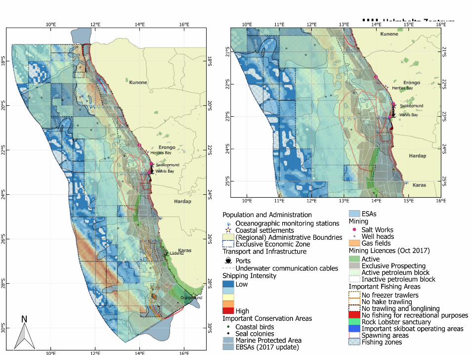
North Sea: Existing and Perspective Uses and Nature Conservation
BSH / O1 - 06.04.2018
Geodetic Datum: WGS 84Map Projection: Mercator (54°N)
Maritime Features Traffic separation zone Deep water routePrecautionary area Inshore traffic zoneShipping lane, recommended Shipping lane, not classified
BoundariesContinental Shelf/EEZ
● Territorial Waters/12 nm ZoneInternational Boundary Restricted Area Anchoring Area
Platforms!. Measurement Platform, in use!. Measurement Platform, under construction!. Measurement Platform, approved.! Measurement Platform, application submitted!. Petroleum Platform, in use!. Petroleum Platform, out of use!. Natural Gas Platform, in use.! Compressor Platform, in use.! Unclassified, in use!. Unclassified, approved◉ Unclassified, out of use/" E-Transformer, in use"/ E-Transformer, under construction/" E-Transformer, approved/ E-Transformer, application submitted$1 E-Converter, inUse1$ E-Converter, under construction$1 E-Converter, approved1 E-Converter, application submitted
PipelinesNatural Gas Pipeline, in useNatural Gas Pipeline, under constructionNatural Gas Pipeline, approved
● ! Natural Gas Pipeline, application submitted Hydrocarbons Pipeline, in use
CablesHigh Voltage Cable, in useHigh Voltage Cable, under construction High Voltage Cable, approved
● ! High Voltage Cable, application submitted Data Cable, in useData Cable, application submitted
● Data Cable, out of use● ! Data Cable, unknown
N e t h e r l a n d s
D e n m a r k
External Data Sources: See Special Theme Maps
9°0'E
http://www.bsh.de/en/Marine_uses/Industry/CONTIS_maps/index.jsp
Offshore Windfarmsinuseunderconstruction approvedapplication submitted denied
Sediment Extractionin use approvedapplicationsubmitted
Dumping Grounds!( Dredged Material, in use*# Ammunition, out of use
Dredged Material, in useDredged Material, out of use Ammunition, out ofuse
Military Practice Area Unclassified Restricted Area Torpedo Exercise Submarine Exercise FiringDangerMine Hunting Practice Air Force Exercise
Nature Conservation Natura2000 SCI Natura2000SPA
Mariculture,% CultureAreaPreferred Areas
Offshore WindEnergy
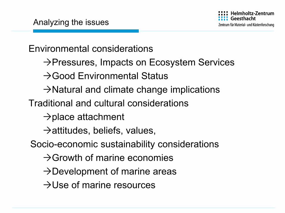
Analyzing the issues
Environmental considerationsPressures, Impacts on Ecosystem ServicesGood Environmental StatusNatural and climate change implications
Traditional and cultural considerationsplace attachmentattitudes, beliefs, values,
Socio-economic sustainability considerationsGrowth of marine economiesDevelopment of marine areasUse of marine resources
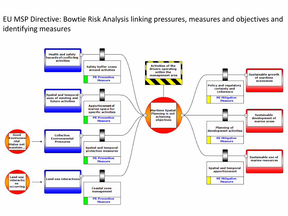
EU MSP Directive: Bowtie Risk Analysis linking pressures, measures and objectives and identifying measures
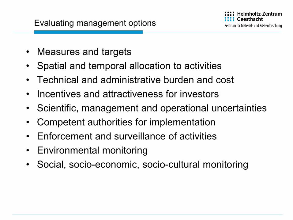
Evaluating management options
• Measures and targets• Spatial and temporal allocation to activities• Technical and administrative burden and cost• Incentives and attractiveness for investors• Scientific, management and operational uncertainties• Competent authorities for implementation• Enforcement and surveillance of activities• Environmental monitoring• Social, socio-economic, socio-cultural monitoring
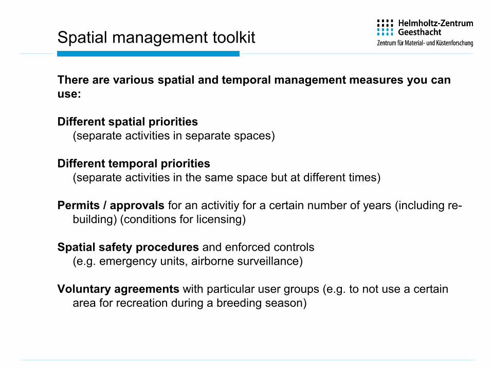
Spatial management toolkit
There are various spatial and temporal management measures you can use:
Different spatial priorities(separate activities in separate spaces)
Different temporal priorities(separate activities in the same space but at different times)
Permits / approvals for an activitiy for a certain number of years (including re-building) (conditions for licensing)
Spatial safety procedures and enforced controls(e.g. emergency units, airborne surveillance)
Voluntary agreements with particular user groups (e.g. to not use a certainarea for recreation during a breeding season)
Deciding on base of the evaluated management optionsleads to a draft plan, which may go for public consultationand subsequent steps in the planning cycle
23
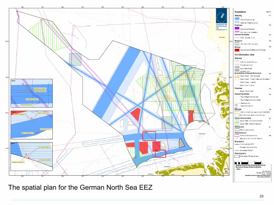
The spatial plan for the German North Sea EEZ
From overview of the planning process
to a detailed look into conflict analysis and
how to identify compatibilities
between human activities in the sea
Now you have completed your initial assessmentof the planning area.
What do you do next?
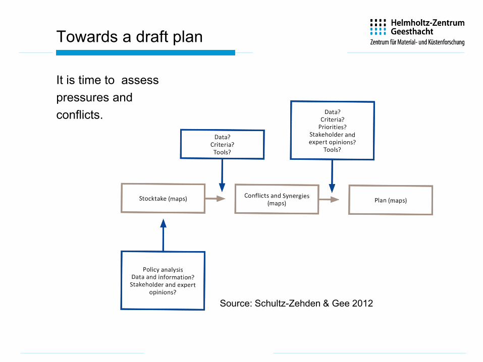
Towards a draft plan
It is time to assesspressures andconflicts.
Source: Schultz-Zehden & Gee 2012
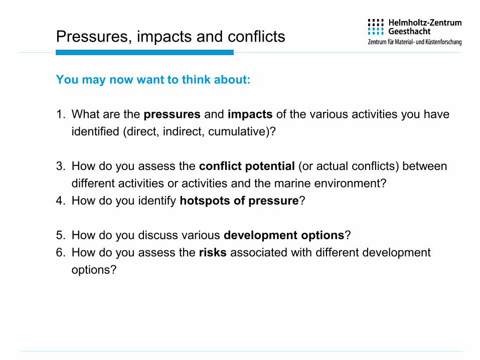
Pressures, impacts and conflicts
You may now want to think about:
1. What are the pressures and impacts of the various activities you have identified (direct, indirect, cumulative)?
3. How do you assess the conflict potential (or actual conflicts) between different activities or activities and the marine environment?
4. How do you identify hotspots of pressure?
5. How do you discuss various development options?6. How do you assess the risks associated with different development
options?

Source: www.marviva.net
This map shows therelative pressures on a planning area, indicated by thenumber of activitiesoccurringconcurrently
Pressure maps

Impacts
Examples of impacts – direct and indirect:
• Environmental impacts of activities(e.g. pollution, destruction of seafloor habitats …)
• Ecological impacts of activities(e.g. impact on biodiversity, disruption of networks of habitats, indirect impacts of marine activities on fish distribution …)
• Spatial impacts of activities(e.g. one activity leads to the displacement of others, one activitymay need particularly large areas)
• Impacts of activities on other marine activities(e.g. activities preclude other activities due to some form ofincompatibility)
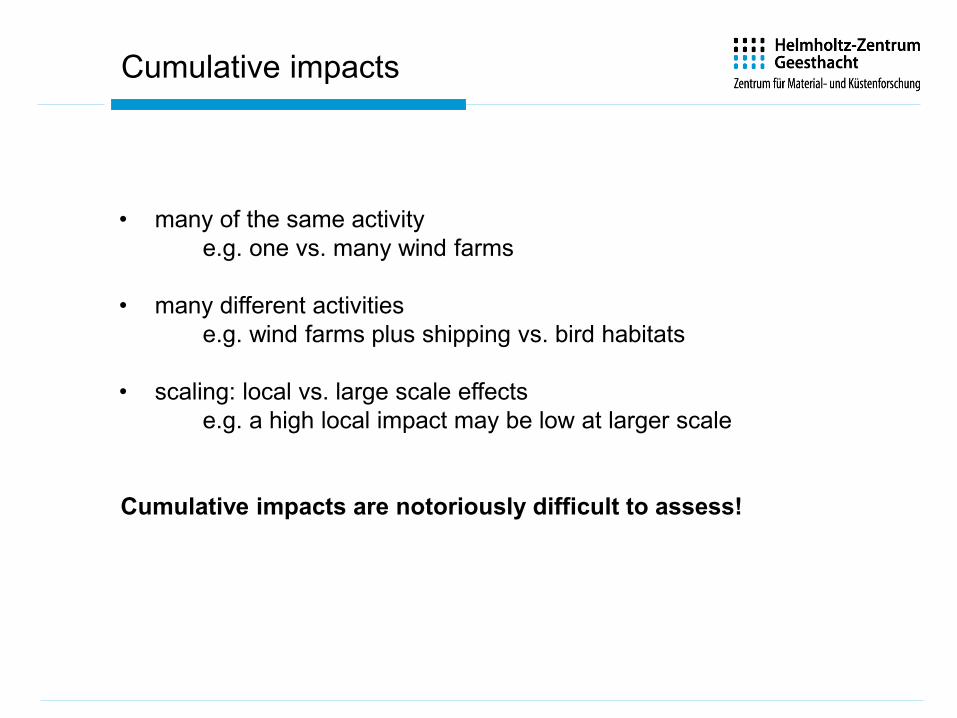
• many of the same activitye.g. one vs. many wind farms
• many different activitiese.g. wind farms plus shipping vs. bird habitats
• scaling: local vs. large scale effectse.g. a high local impact may be low at larger scale
Cumulative impacts are notoriously difficult to assess!
Cumulative impacts
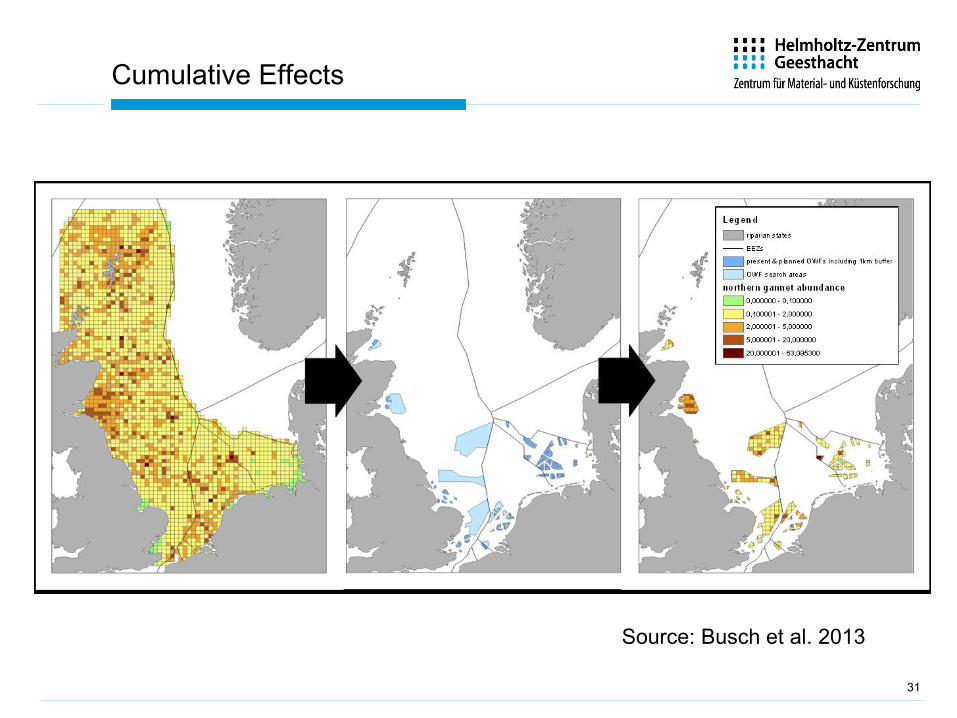
31
Cumulative Effects
Source: Busch et al. 2013
32
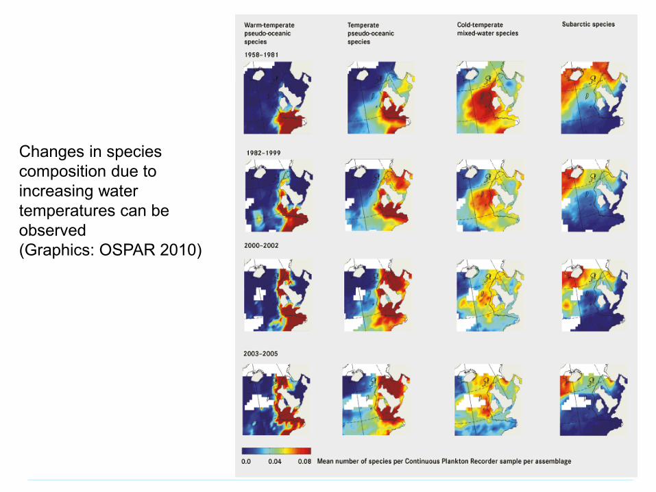
Changes in speciescomposition due toincreasing watertemperatures can beobserved(Graphics: OSPAR 2010)
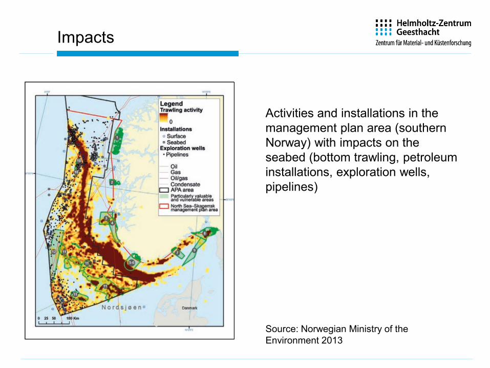
Impacts
Activities and installations in themanagement plan area (southern Norway) with impacts on theseabed (bottom trawling, petroleuminstallations, exploration wells, pipelines)
Source: Norwegian Ministry of theEnvironment 2013
Conflict analysis
Impact is not the same as conflict, although the two are obviously linked.
• There is no hard and fast rule for how to do a conflict analysis.• It is important to differentiate between real, potential and imagined
conflicts and scales of conflict (temporal and spatial)• It is important to rate conflicts in terms of their severity and relevance to
the planning area.
Importance of stakeholder involvement in conflict analysis!
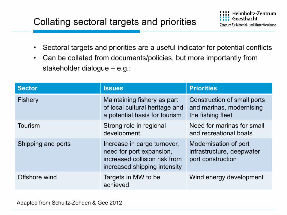
Collating sectoral targets and priorities
• Sectoral targets and priorities are a useful indicator for potential conflicts• Can be collated from documents/policies, but more importantly from
stakeholder dialogue – e.g.:
Sector Issues Priorities
Fishery Maintaining fishery as partof local cultural heritage anda potential basis for tourism
Construction of small portsand marinas, modernisingthe fishing fleet
Tourism Strong role in regional development
Need for marinas for smalland recreational boats
Shipping and ports Increase in cargo turnover, need for port expansion, increased collision risk fromincreased shipping intensity
Modernisation of portinfrastructure, deepwaterport construction
Offshore wind Targets in MW to beachieved
Wind energy development
Adapted from Schultz-Zehden & Gee 2012
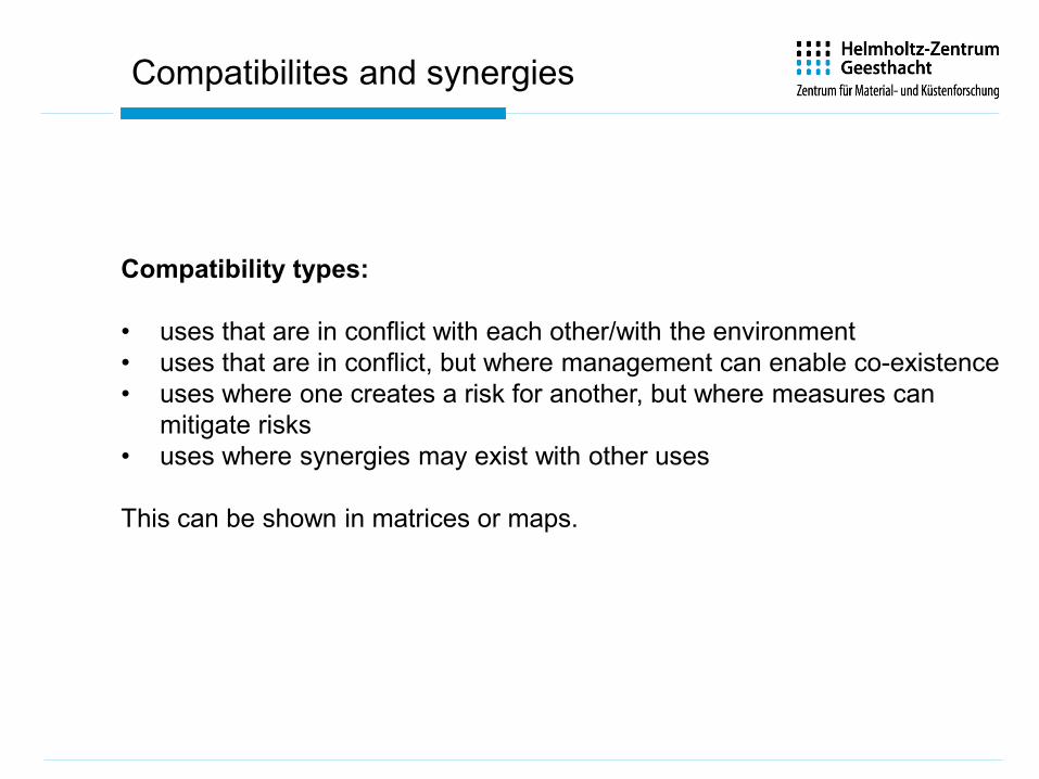
Compatibility types:
• uses that are in conflict with each other/with the environment• uses that are in conflict, but where management can enable co-existence• uses where one creates a risk for another, but where measures can
mitigate risks• uses where synergies may exist with other uses
This can be shown in matrices or maps.
Compatibilites and synergies

Tools for conflict analysis: Compatibilitymatrices
Source: Schultz-Zehden & Gee 2012
A spatialcompatibilitymatrix fordifferent uses in the Baltic

Tools for conflict analysis: Compatibilitymatrices
Compatibility of activities and habitats
Source: Punta Banco – Punta Burica MSP process, Costa Rica (www.marviva.net)
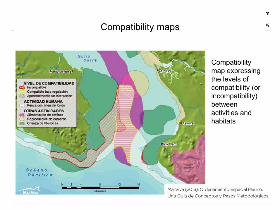
Compatibility maps
Compatibility map expressing the levels of compatibility (or incompatibility) between activities and habitats

40
Creating conflict maps
In a conflict map, existing and sometimes overlapping or conflicting uses, areas and interests are displayed. It becomes obvious where use conflicts arise and where solutions must be negotiated and decided (WWF 2010)
Note: Just because activities overlap does not automatically imply a conflict!
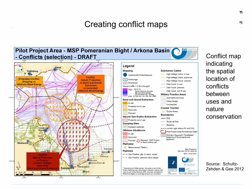
Creating conflict maps
Source: Schultz-Zehden & Gee 2012
Conflict map indicating the spatial location of conflicts between uses and nature conservation
Risk assessment (rating conflicts and impacts)
It may be worth discussing the risks associated with various conflicts and impacts.
Consider:
• Ecological risks• Economic risks• Social and cultural risks • What assets are to be protected?
This step should link back to the aims and objectives of the plan that have been developed previously.
The outcome of conflict analysis
• Important: Conflict analysis is a dynamic process! Views might change overtime and in the light of new knowledge
• Conflict analysis should leave planners with a specific task to be addressed.
Analysing spatial claims and needs
The diversity of uses takes place in four dimensions:• at different times, and possibly with different intensities at times• on the sea surface (e.g. shipping)• in the water column (e.g. fisheries)• on the seafloor (e.g. resource extraction)
Location of uses depends on the quality of that space – differs for each use:• Mining will only take place where high geological resource deposits exist• Conservation will only take place where valuable biodiversity is• Shipping does not need a good environmental status but uninhibited access to ports
and • Fishing and mariculture strongly depend on good environmental status and “intact”
habitat
Example: Namibia
The mere overlap of activities does not automatically imply they are in conflict.
Some uses can gladly co-exist in the same marine area – they simply do not interfere with each other, for example:
• Sustainable tourism, heritage and environmental protection
Other uses cannot occupy the same space at the same time and are mutually exclusive, leading to conflict, for example:
• Geological resource exploitation and environmental protection
Spatial compatibilities
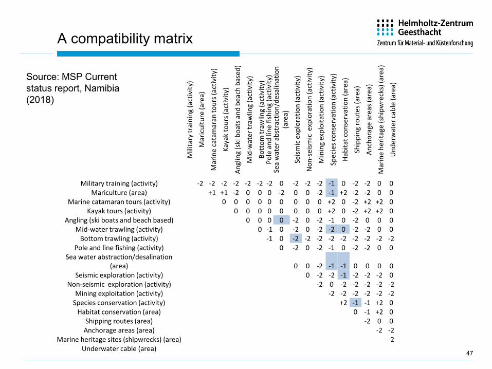
A compatibility matrix
Mili
tary
trai
ning
(act
ivity
)
Mar
icul
ture
(are
a)
Mar
ine
cata
mar
an to
urs (
activ
ity)
Kaya
k to
urs (
activ
ity)
Angl
ing
(ski
boa
ts a
nd b
each
bas
ed)
Mid
-wat
er tr
awlin
g (a
ctiv
ity)
Bott
om tr
awlin
g (a
ctiv
ity)
Pole
and
line
fish
ing
(act
ivity
)Se
a w
ater
abs
trac
tion/
desa
linat
ion
(are
a)
Seism
ic e
xplo
ratio
n (a
ctiv
ity)
Non
-sei
smic
exp
lora
tion
(act
ivity
)
Min
ing
expl
oita
tion
(act
ivity
)
Spec
ies c
onse
rvat
ion
(act
ivity
)
Habi
tat c
onse
rvat
ion
(are
a)
Ship
ping
rout
es (a
rea)
Anch
orag
e ar
eas (
area
)
Mar
ine
herit
age
(shi
pwre
cks)
(are
a)
Und
erw
ater
cabl
e (a
rea)
Military training (activity) -2 -2 -2 -2 -2 -2 -2 0 -2 -2 -2 -1 0 -2 -2 0 0Mariculture (area) +1 +1 -2 0 0 0 -2 0 0 -2 -1 +2 -2 -2 0 0
Marine catamaran tours (activity) 0 0 0 0 0 0 0 0 0 +2 0 -2 +2 +2 0Kayak tours (activity) 0 0 0 0 0 0 0 0 +2 0 -2 +2 +2 0
Angling (ski boats and beach based) 0 0 0 0 -2 0 -2 -1 0 -2 0 0 0Mid-water trawling (activity) 0 -1 0 -2 0 -2 -2 0 -2 -2 0 0
Bottom trawling (activity) -1 0 -2 -2 -2 -2 -2 -2 -2 -2 -2Pole and line fishing (activity) 0 -2 0 -2 -1 0 -2 -2 0 0
Sea water abstraction/desalination (area) 0 0 -2 -1 -1 0 0 0 0
Seismic exploration (activity) 0 -2 -2 -1 -2 -2 -2 0Non-seismic exploration (activity) -2 0 -2 -2 -2 -2 -2
Mining exploitation (activity) -2 -2 -2 -2 -2 -2Species conservation (activity) +2 -1 -1 +2 0
Habitat conservation (area) 0 -1 +2 0Shipping routes (area) -2 0 0
Anchorage areas (area) -2 -2Marine heritage sites (shipwrecks) (area) -2
Underwater cable (area)47
Source: MSP Currentstatus report, Namibia (2018)
Activity Requirements Other uses affected and nature ofimpacts
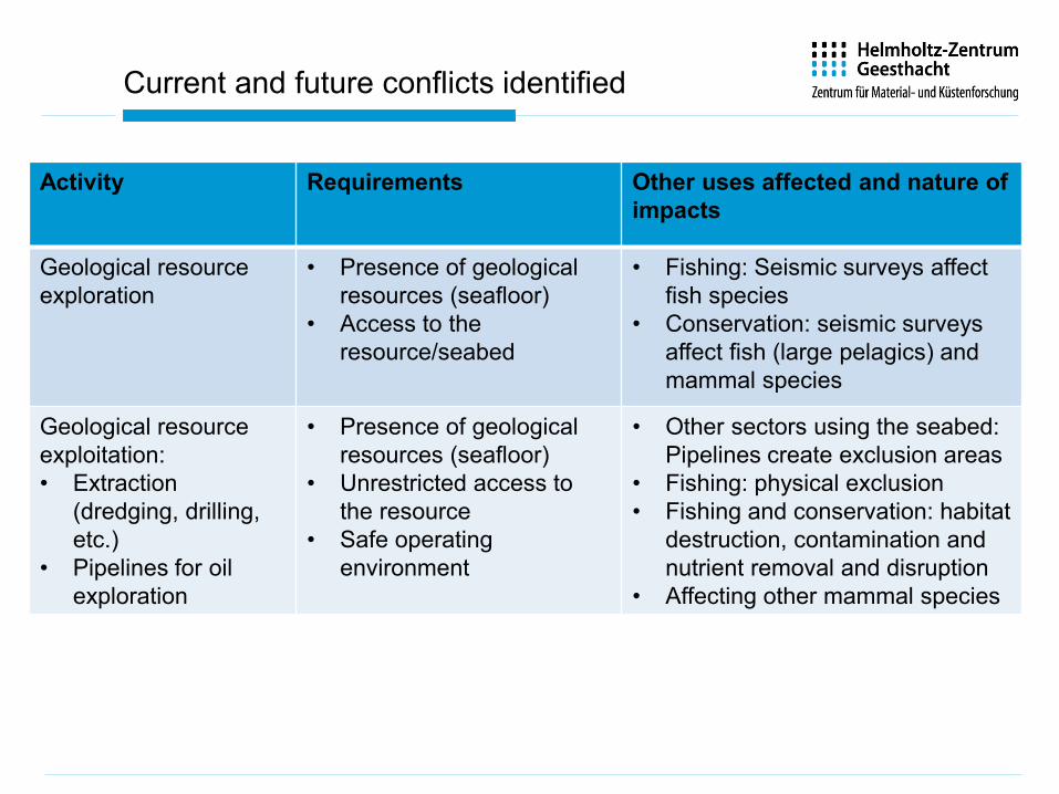
Geological resource exploration
• Presence of geological resources (seafloor)
• Access to the resource/seabed
• Fishing: Seismic surveys affect fish species
• Conservation: seismic surveys affect fish (large pelagics) and mammal species
Geological resource exploitation:• Extraction
(dredging, drilling, etc.)
• Pipelines for oil exploration
• Presence of geological resources (seafloor)
• Unrestricted access to the resource
• Safe operating environment
• Other sectors using the seabed: Pipelines create exclusion areas
• Fishing: physical exclusion• Fishing and conservation: habitat
destruction, contamination and nutrient removal and disruption
• Affecting other mammal species
Current and future conflicts identified
Activity Requirements Other uses affected and nature ofimpacts
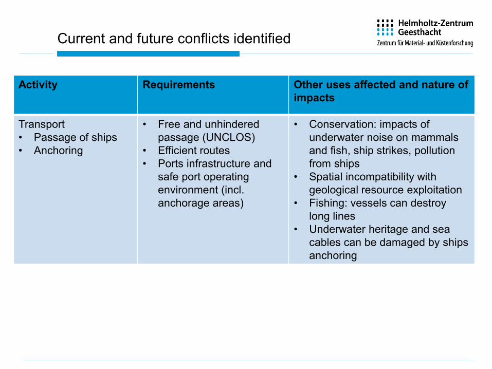
Transport • Passage of ships• Anchoring
• Free and unhindered passage (UNCLOS)
• Efficient routes • Ports infrastructure and
safe port operating environment (incl. anchorage areas)
• Conservation: impacts of underwater noise on mammals and fish, ship strikes, pollution from ships
• Spatial incompatibility with geological resource exploitation
• Fishing: vessels can destroy long lines
• Underwater heritage and sea cables can be damaged by ships anchoring
Current and future conflicts identified
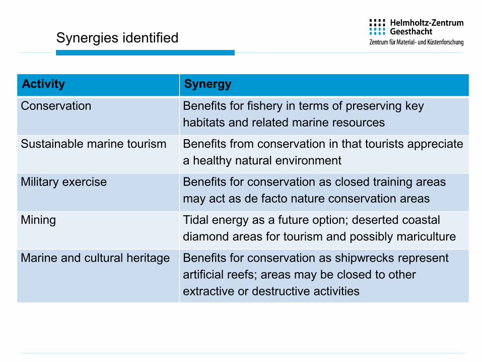
Activity Synergy
Conservation Benefits for fishery in terms of preserving key habitats and related marine resources
Sustainable marine tourism Benefits from conservation in that tourists appreciate a healthy natural environment
Military exercise Benefits for conservation as closed training areas may act as de facto nature conservation areas
Mining Tidal energy as a future option; deserted coastal diamond areas for tourism and possibly mariculture
Marine and cultural heritage Benefits for conservation as shipwrecks represent artificial reefs; areas may be closed to other extractive or destructive activities
Synergies identified
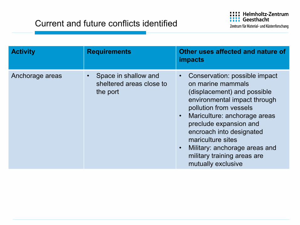
Activity Requirements Other uses affected and nature ofimpacts
Anchorage areas • Space in shallow and sheltered areas close to the port
• Conservation: possible impact on marine mammals (displacement) and possible environmental impact through pollution from vessels
• Mariculture: anchorage areas preclude expansion and encroach into designated mariculture sites
• Military: anchorage areas and military training areas are mutually exclusive
Current and future conflicts identified
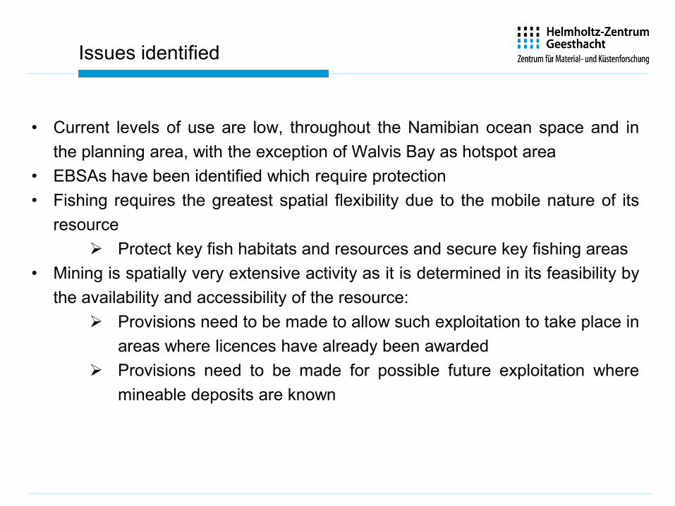
• Current levels of use are low, throughout the Namibian ocean space and inthe planning area, with the exception of Walvis Bay as hotspot area
• EBSAs have been identified which require protection• Fishing requires the greatest spatial flexibility due to the mobile nature of its
resource Protect key fish habitats and resources and secure key fishing areas
• Mining is spatially very extensive activity as it is determined in its feasibility bythe availability and accessibility of the resource:
Provisions need to be made to allow such exploitation to take place inareas where licences have already been awarded
Provisions need to be made for possible future exploitation wheremineable deposits are known
Issues identified
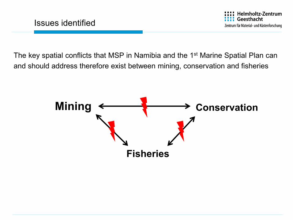
The key spatial conflicts that MSP in Namibia and the 1st Marine Spatial Plan canand should address therefore exist between mining, conservation and fisheries
Mining Conservation
Fisheries
Issues identified
Finally,
If a spatial plan is the output of the MSP process, what then is the outcome?
Who implements the plan?
Who decides on investments (public or private) and along which rules?
54
55
Homework
Based on the overview of activities in your marine area, we now wantto know whether these are in conflict or not.
• Prepare your own compatibility matrix for the activitiesoccurring there.
• Highlight sectors that might be susceptible to climate changeor other relevant pressures – how will this affect themspatially?
• Are there any „hotspot“ areas where there are particularcumulative pressures?
Remember to focus on activities rather than sectors – fishing forexample can be many different types of fishing, each of which mayhave different compatibilities.
• From your analysis, develop planning recommendations: Whatissues and areas should MSP concentrate on?