Embed Size (px)
Citation preview

December 2017
Conducted by:
ADRA Indonesia
HelpAge International
Risk Analysis Report Mt. Agung Volcano, Bali, Indonesia
TABLE OF CONTENTS
ACRONYMS 1
ACKNOWLEDGEMENTS 2
EXECUTIVE SUMMARY 3
A. INTRODUCTION 5
B. DATA COLLECTION 6
C. CONSTRAINTS 7
D. ASSESSMENT FINDINGS 7
D.1 Background of Mt. Agung 7
D.2 Latest eruption of Mt. Agung 8
D.2 Evacuation Centres and IDPs 9
D.3 Electricity Supplies 10
D.4 Fuel Supplies 11
D.5 Communication Systems 12
D.6 Clean Water Supplies 12
D.8 Health 15
D.9 Livelihoods and Economy 16
E. SUMMARY AND RECOMMENDATIONS 16
Risk Analysis Report, Mt. Agung, Bali, Indonesia, December 2017 1
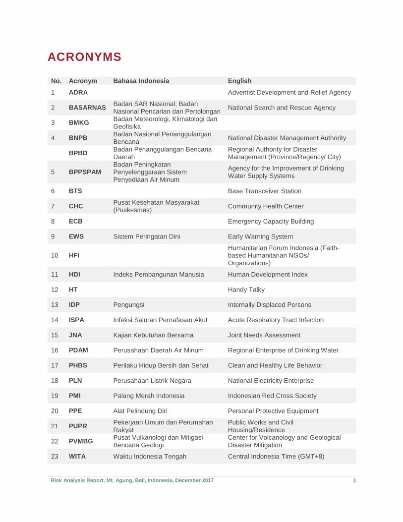
ACRONYMS
No. Acronym Bahasa Indonesia English
1 ADRA Adventist Development and Relief Agency
2 BASARNAS Badan SAR Nasional; Badan Nasional Pencarian dan Pertolongan
National Search and Rescue Agency
3 BMKG Badan Meteorologi, Klimatologi dan Geofisika
4 BNPB Badan Nasional Penanggulangan Bencana
National Disaster Management Authority
BPBD Badan Penanggulangan Bencana Daerah
Regional Authority for Disaster Management (Province/Regency/ City)
5 BPPSPAM Badan Peningkatan Penyelenggaraan Sistem Penyediaan Air Minum
Agency for the Improvement of Drinking Water Supply Systems
6 BTS Base Transceiver Station
7 CHC Pusat Kesehatan Masyarakat (Puskesmas)
Community Health Center
8 ECB Emergency Capacity Building
9 EWS Sistem Peringatan Dini Early Warning System
10 HFI Humanitarian Forum Indonesia (Faith-based Humanitarian NGOs/ Organizations)
11 HDI Indeks Pembangunan Manusia Human Development Index
12 HT Handy Talky
13 IDP Pengungsi Internally Displaced Persons
14 ISPA Infeksi Saluran Pernafasan Akut Acute Respiratory Tract Infection
15 JNA Kajian Kebutuhan Bersama Joint Needs Assessment
16 PDAM Perusahaan Daerah Air Minum Regional Enterprise of Drinking Water
17 PHBS Perilaku Hidup Bersih dan Sehat Clean and Healthy Life Behavior
18 PLN Perusahaan Listrik Negara National Electricity Enterprise
19 PMI Palang Merah Indonesia Indonesian Red Cross Society
20 PPE Alat Pelindung Diri Personal Protective Equipment
21 PUPR Pekerjaan Umum dan Perumahan Rakyat
Public Works and Civil Housing/Residence
22 PVMBG Pusat Vulkanologi dan Mitigasi Bencana Geologi
Center for Volcanology and Geological Disaster Mitigation
23 WITA Waktu Indonesia Tengah Central Indonesia Time (GMT+8)
Risk Analysis Report, Mt. Agung, Bali, Indonesia, December 2017 2
ACKNOWLEDGEMENTS
Key to the development of this report was the commitment of the assessment team, who was led by
D'Karlo Purba and supported by Ralfie Ch Maringka and Kyriakos E. Erlan. Marthen Leuna and Bobby
Kikhau provided logistical support to the team, and Dr. Juma Khudonazarov and Robert Patton technical
advice.
Much of the detail contained in this report would not have been possible without the willingness of
government departments and state-owned companies’ staff who gave of their time to provide information
through interviews and to share key documents (see Section B in the report for details).
Additionally, there was the Denpasar Seventh-day Adventist Church and Permata Ibu Seventh-day
Adventist Elementary School that was used as a basecamp by the assessment team, YAKKUM
Emergency Unit, who helped with contacts and basic key information, Wahana Visi Indonesia (partner of
World Vision Indonesia) who informed the Shelter cluster about the plan for the risk assessment work,
and Sinduwati, Sangkan Gunung, Tangkup, Wisma Kerta Village Heads and volunteer team, and the
Rending Agriculture Camp Managers.
Funding support from the Start Network enabled the assessment and the production of this report.
The Start Fund is supported by the following donors:
Risk Analysis Report, Mt. Agung, Bali, Indonesia, December 2017 3
EXECUTIVE SUMMARY ADRA Indonesia and HelpAge International conducted an assessment from 17 – 20 December in Bali,
Indonesia, to identify the current impact of the Mt. Agung eruption on surrounding communities, and
project what the impact would likely be if an eruption similar to 1963 occurred.
Mt. Agung is a stratovolcano. The main hazards produced by this type of volcano are: explosive
eruptions, pyroclastic flows, lahars and slow-moving lava flows. Typically the pyroclastic flows and lahars
cause the majority of the deaths, with the ash generated by explosions creating the greatest disruption
and discomfort to communities.
The last eruption of Mt. Agung was in 1963 and resulted in the death of about 1,600 people. The eruptive
phase lasted for almost one year.
The latest eruption of Mt. Agung started in early August 2017. This has resulted in explosive eruptions,
pyroclastic flows, lahars and lava flows, with about 70,000 persons currently displaced at evacuation
centres. Experts are not willing to predict how long or large this current eruption will be. The eruptions to
date have not been as large as the 1963 one.
It is estimated that if an eruption the size of 1963 occurred there could be as many as 180,000 IDPs.
Based on the current assessed needs of IDPs, priority needs are likely to include shelter, food security,
NFIs especially bedding, protection for women and girls, education and livelihoods support.
The electricity supply is particularly vulnerable to a major eruption. The electricity supplier has taken
mitigatory steps in this regards, however it is expected there will be major electricity outages. Generators
have been pre-positioned for most evacuation centres.
Bali’s fuel storage centres are not considered to be at risk from a major eruption. There is at any one time
more than one month’s fuel supply stored on the island.
Cellphone network providers have taken mitigatory steps to ensure the cellphone network should
continue to either be available or repaired and up and running quickly following an eruption. The
government has established a radio-based communication system for early warning and to facilitate a
quick and orderly evacuation in areas not well serviced by the cellphone network.
Water supplies in the regency surrounding Mt. Agung are at high risk of being lost in the event of a major
eruption. Already more than 50,000 people have been affected by the recent eruptions. It is expected that
clean and adequate water supply will be a major issue following an eruption.
Although school-aged children have been displaced, this appears to have been managed well, primarily
by integrating into schools near evacuation centres. This however has placed pressure on the schooling
system.
A number of community health centres have been closed in the evacuation zone. At this point in time
existing health facilities appear to have been able to accommodate the health needs of IDPs. There are
three hospitals in the regency surround Mt. Agung, however none of them are located in the high risk
zones.

Risk Analysis Report, Mt. Agung, Bali, Indonesia, December 2017 4
The Karangasem Regency has the lowest HDI among the Bali Regencies. This indicates the population
are likely to be more vulnerable to shocks. This is further exacerbated by the downturn in tourism, which
is an economic driver in Bali, and through displacement the loss of opportunity to earn an income.
Given that the needs of current IDPs are not being fully met, and that services such as health and
education are barely managing due to depleted services, it is expected that a major volcanic eruption of
Mt. Agung would result in a humanitarian crisis. The assessment has identified the greatest needs as
being for shelter, WASH, food security, NFIs especially bedding and health needs.
Risk Analysis Report, Mt. Agung, Bali, Indonesia, December 2017 5
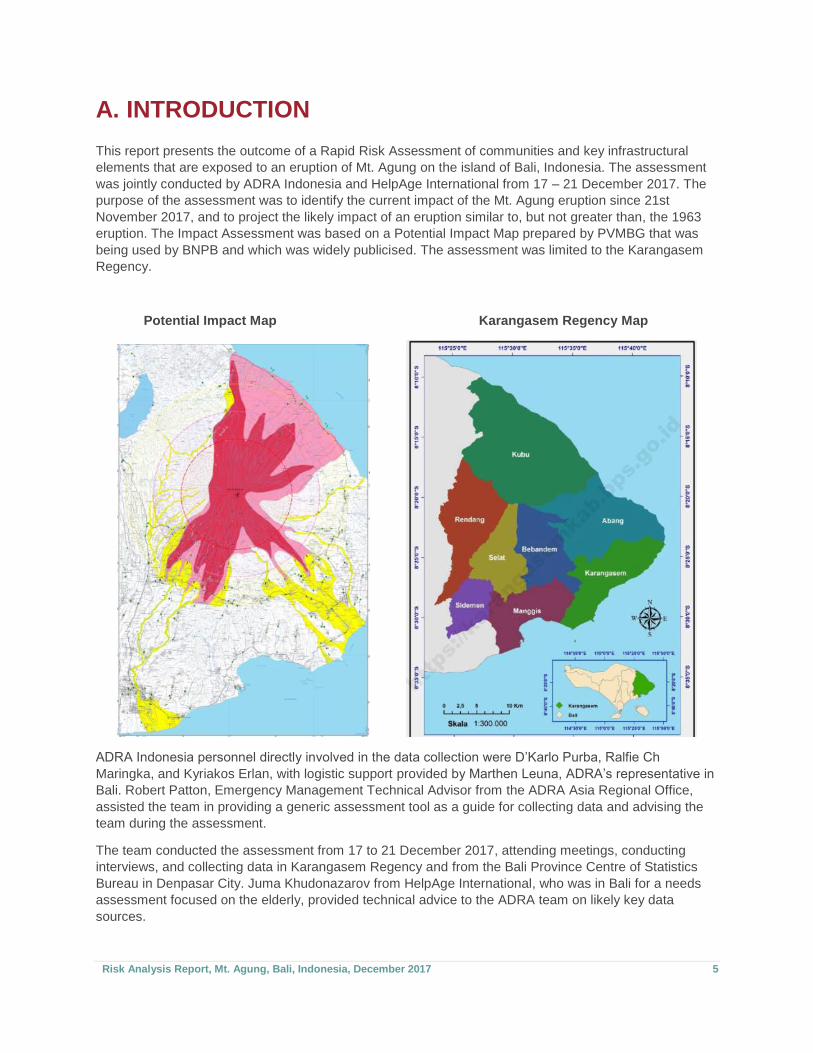
A. INTRODUCTION This report presents the outcome of a Rapid Risk Assessment of communities and key infrastructural
elements that are exposed to an eruption of Mt. Agung on the island of Bali, Indonesia. The assessment
was jointly conducted by ADRA Indonesia and HelpAge International from 17 – 21 December 2017. The
purpose of the assessment was to identify the current impact of the Mt. Agung eruption since 21st
November 2017, and to project the likely impact of an eruption similar to, but not greater than, the 1963
eruption. The Impact Assessment was based on a Potential Impact Map prepared by PVMBG that was
being used by BNPB and which was widely publicised. The assessment was limited to the Karangasem
Regency.
Potential Impact Map Karangasem Regency Map
ADRA Indonesia personnel directly involved in the data collection were D’Karlo Purba, Ralfie Ch
Maringka, and Kyriakos Erlan, with logistic support provided by Marthen Leuna, ADRA’s representative in
Bali. Robert Patton, Emergency Management Technical Advisor from the ADRA Asia Regional Office,
assisted the team in providing a generic assessment tool as a guide for collecting data and advising the
team during the assessment.
The team conducted the assessment from 17 to 21 December 2017, attending meetings, conducting
interviews, and collecting data in Karangasem Regency and from the Bali Province Centre of Statistics
Bureau in Denpasar City. Juma Khudonazarov from HelpAge International, who was in Bali for a needs
assessment focused on the elderly, provided technical advice to the ADRA team on likely key data
sources.
Risk Analysis Report, Mt. Agung, Bali, Indonesia, December 2017 6
B. DATA COLLECTION To identify the maximum credible eruption event and the consequential impact of such an eruption, team
members identified key sources of data, interviewed key persons at government agencies and relevant
state-owned companies and reviewed key documents. The following individuals were contacted and
interviewed:
1. Lieut. Col. Benny Rahardian, Incident Commander at Tanah Ampo, Mt. Agung’s Response
Operation Command Centre, Karangasem Regency
2. Mr. Sangtu Adi Sanjaya, Bali Province BPBD’s Operation Control Centre Staff
3. Mr. Ketut Arimbawa, Karangasem Regency BPBD Head/Chief Operation Officer
4. Mr. I Gede Pawana, Chief of Pasebaya (a representative for a communication forum consisting of
the 28 villages within the danger zones)
5. Mr. Weda, Secretary of Karangasem Regency Department of Public Works and Civil Housing
6. Karangasem Regency Department of Education Staff
7. I Ketut Subawa and Nikomang Artini, Department of Health of Karangasem
8. Mr. Agung and Mr. Sigit Padmono, National Disaster Management Authority’s (BNPB) Mitigation
and Preparedness Deputy Staff
9. Mr. I Made Ari Susanto, Department of Livestock and Animal Health, Deputy Head
10. Mr. Surya Admaja, State-owned, National Electricity Company’s (PLN) Karangasem Field Office
Manager
11. Mr. Gusti Singarsih, State-owned, Regional Drinking Water Company’s Director
12. Mr. Sukarba, Section Head of Karangasem Regency Department of Housing and Residence.
The government documents, mostly in digital form, that were obtained from the National Statistics Centre
offices in Bali Province and Karangasem Regency, and from specific departments that were contacted for
this assessment are:
1. Karangasem Regency Contingency Plan
2. Public Works and Civil Housing Department’s Emergency Operation Plan
3. Health Cluster Emergency Operation Plan
4. Minutes of Meeting of Tanah Ampo Command Centre’s Daily Evaluation
5. Karangasem Regency’s Department of Health Profile year 2017, e-book and e-report
6. Karangasem Regency in Figures year 2017, e-book
7. Eight e-books Sub-district in Figures year 2017 (8 sub-districts within Karangasem Regency)
8. Bali Province in Figures year 2017
9. Local and national News sources post-eruption of 21st November 2017
10. Several thematic maps sourced from BNPB website
All these documents and interviews enabled the ADRA Indonesia assessment team to identify the likely
impact in the event of an eruption of Mt. Agung consistent with the 1963 eruption.
Risk Analysis Report, Mt. Agung, Bali, Indonesia, December 2017 7
C. CONSTRAINTS
The main constraint with the risk analysis was the short timeframe within which the assessment was
required to be completed, especially considering the timing was at the end of the year when personnel to
be interviewed were extremely busy. This was coupled with the limited number of assessment personnel
that were available for the assignment. This constraint likely impacted on the ability to gather a wider and
more comprehensive range of data.
In a number of meetings with government officials and representatives from private companies, it was
mentioned that some information was confidential and could not be released for general publication. This
constraint also potentially contributed to the level of comprehensive data provided in the report.
Much of the data that was collected and then analysed for this report is very technical. The assessment
personnel and the writer of this report do not have expertise in these technical areas, which may have
contributed to some misinterpretation and limited analysis of the data, potentially affecting the subsequent
summary of findings and recommendations.
D.ASSESSMENT FINDINGS
D.1 Background of Mt. Agung
Mt. Agung is a stratovolcano, also known as a composite volcano. Stratovolcanoes are characterized by
a steep profile and periodic explosive eruptions. They are among the most common types of volcanoes,
in contrast to the less common shield volcanoes. The lava flowing from stratovolcanoes typically cools
and hardens before spreading far due to high viscosity. Extensive lava flows from stratovolcanoes are
uncommon, but some have travelled as far as 15 km (9.3 mi).
There are four main hazards generated by a stratovolcano eruption:
1) Explosive eruptions of ash and larger particles, including what is commonly referred to as
“volcanic bombs”.
2) Pyroclastic flows
3) Lahars
4) Slow-moving lava flows
Historically, most deaths during the eruption of stratovolcanoes have been caused by pyroclastic flows
and lahars (mudflows). Volcanic ash clouds from explosive eruptions pose a serious hazard to aviation
safety, and on the ground can cause respiratory, skin and eye irritation. With significant ashfall, buildings
can collapse under the weight of the ash and pipes with rain-harvesting systems and drainage channels
can become blocked. The ash can also cause significant damage to engines that require air to run, as air
filters block and abrasive particles enter engines resulting in their failure.
Volcanic bombs are rocks ranging from the size of books to small cars, that are explosively ejected from
stratovolcanoes during their climactic eruptive phases. These "bombs" can travel up to 20 km (12 mi)
away from the volcano, and present a risk to buildings and living things while traveling at very high
speeds through the air.
Risk Analysis Report, Mt. Agung, Bali, Indonesia, December 2017 8
Lava flows from stratovolcanoes are generally not a significant threat to people because the highly
viscous lava moves slowly enough for people to move out of the path of flow. The lava flows are more of
a threat to property, damaging and destroying houses and infrastructure, such as roads.
Lahars (also called debris flows or volcanic mudflows) are mixtures of volcanic debris and water. The
water usually comes as a result of rainfall. Depending on the proportion and temperature of water to
volcanic material, mudflows can range from fast-flowing, soupy floods to thick, gooey flows that have the
consistency of wet concrete. As mudflows sweep down the steep sides of stratovolcanoes, they have the
strength and speed to flatten or bury everything in their paths.
The last eruption of Mt. Agung was in 1963. On February 18 of that year, local residents heard loud
explosions and saw clouds rising from the crater of Mount Agung. On February 24, lava began flowing
down the northern slope of the mountain, eventually traveling 7 km in the next 20 days. On March 17, the
volcano erupted, sending debris 8 to 10 km into the air and generating massive pyroclastic flows. These
flows devastated numerous villages, killing an estimated 1,100–1,500 people. Lahars caused by heavy
rainfall after the eruption killed an additional 200 people. A second eruption on May 16 led to pyroclastic
flows that killed another 200 inhabitants. Minor eruptions and flows followed and lasted almost a year.
D.2 Latest eruption of Mt. Agung1
The current period of volcanic activity at Mt. Agung was first noted in early August when volcanic
earthquakes were recorded. The intensity of these increased, along with some volcanic plumes that were
visible. This resulted in BNPB declaring a 12km exclusion zone around the volcano on 24 September that
resulted in the evacuation of about 120,000 people. By late October volcanic activity had decreased
significantly, so that on 29 October the alert status was lowered to 3 (with 4 being the highest level).
Mt. Agung erupted again on 21 November 2017, resulting in wider cracks on the crater and other
indications of rising magma. A second eruption followed on Saturday 25 November, with magmatic
eruptions in bright, reddish yellow lava that continued until the next morning. These eruptions were not as
large as that of 1963. The volcano’s activity can be seen live, plus related information from the
Observatory Post at Rendang Sub-district and Command Centre at Tanah Ampo via this link:
https://www.youtube.com/watch?v=vIr-RmByqN4.
The Centre of Volcanology and Geological Hazard Mitigation (PVMBG) reported that since December 4,
the volcano could be seen spewing whitish to greyish smoke with a medium pressure up to 1,500 metres
above the crater towards the east and west, with tremors continuing to be recorded. PVMBG flew a drone
over the volcano in mid-December to take aerial photographs and it was identified that around one-third
of the crater is now filled with lava. PVMBG is unable to conclude whether the magma will continue to rise
up the crater or will go down. According to the Head of Division for Mitigation PVMBG, Gede Suantika, it
would take years to completely fill the crater with lava with the speed of current magma movement into
the crater. PVMBG continues to monitor the volcano and regularly provides updates on the status of Mt.
Agung.
Since December 21, visually the volcano has been covered by a veil of cloud. Whitish to greyish smoke
with medium pressure is rising up to 500 – 1,000 metres from the crater towards the east and west. At
night the lava flare from the peak of the volcano continues to be seen. PVMBG emphasized that the
estimated danger zone, with no increase in activity, remains at 8 km radius from Mt. Agung crater, with a
sectoral extension to the north-northeast and southeast-south-southwest as far as 10 km from the crater.
Outside these areas, all normal activities can and should continue. PVMBG still maintains the alert status
1 Information collected from BNPB website and email received from Head of UNOCHA; update on Mount Agung as at 15 December 2017.

Risk Analysis Report, Mt. Agung, Bali, Indonesia, December 2017 9
at Level IV for the volcano. The Government of Indonesia is doing its utmost to boost tourism in Bali
Island and requests other stakeholders’ support. On Saturday, 23rd December 2017 at 11.57am local
time, Mt. Agung erupted again, with the volcanic plume reaching to a height of 2,500 metres. This was
just a day after President Joko Widodo (Jokowi) conducted a limited cabinet meeting in Bali. One of the
agenda items was to end the emergency response period status of Mt. Agung.
The Head of the Meteorological, Hydrological and Geophysical Agency, (BMKG), Prof. Dr. Dwikorita
Karnawati, explained that until February 2018 the wind is predicted to blow eastward, expectedly driving
Mt. Agung volcanic materials away from Ngurah Rai International Airport. In March 2018, the wind is
predicted to change its direction towards the southwest. As the rainy season is underway, BMKG predicts
that medium to heavy rains will fall in some areas in Bali. It is predicted that the rain will fall at an altitude
above the volcanic ash and will help to clear the air of ash. With heavy rainfall, there is an increased risk
of lahars forming on the slopes of Mt. Agung.
D.2 Evacuation Centres and IDPs BNPB recorded that as of 21 December 2017 at 18:00 WITA (Central Indonesia Time) the number of
evacuees had reached 71,109 persons who are being accommodated at 239 evacuation sites:
No. Regency or City No. of IDPs No. of Evac. Centres
1 Karangasem Regency 43,093 133
2 Klungkung Regency 11,441 43
3 Buleleng Regency 9,796 9
4 Bangli Regency 978 4
5 Gianyar Regency 3,502 8
6 Tabanan Regency 770 9
7 Denpasar City 734 5
8 Badung Regency 590 5
9 Jembrana Regency 205 23
TOTAL 71,109 239
BNPB maintains a website that provides up-to-date data on the evacuation sites and the number of IDPs:
https://bnpb.go.id/data-pengungsi
The majority of the temporary shelters are tribal village halls (banjar), which are typically used for cultural
ceremonies, weddings, worships and community programs. When the IDPs cannot be accommodated in
banjars, the government has provided tents.
BNPB estimates that if all the population in the red zone were to evacuate, there would be a total of 90 –
100,000 IDPs. Based on current population demographics, it is estimated that if a 1963-type eruption
occurred, the number of evacuated people could be as many as 180,000 at the peak of the eruption. It is
likely that people could be displaced for up to one year, given that the last eruption lasted for 11 months.
To identify the priority needs of IDPs, the shelter cluster initiated and coordinated a Joint Needs
Assessment from 3 to 5 December in five regencies that canvassed 45 IDP camps. Based on the result of
the JNA2 by ECD and HFI and their partners, they identified there are six basic needs still unfulfilled:
tarpaulins for shelters
2 Humanitarian Forum Indonesia (HFI), Emergency Capacity Building (ECB) dan Mitra Lembaga yang terlibat: CARE International Indonesia, Mercy Corps Indonesia, Yayasan Sayangi Tunas Cilik, Catholic Relief Services, Wahana Visi Indonesia, PLAN, Muhammadiyah Disaster Management Center, PKPU-HI, YAKKUM Emergency Unit, BTB, Rumah Zakat dan LBH APIK mitra OXFAM. JNA was conducted on 3-7 December 2017 using CommCare, Android-based mobile app used by CRS for developing and using JNA tool.

Risk Analysis Report, Mt. Agung, Bali, Indonesia, December 2017 10
although rice, the staple food, is available, however side dishes such as protein-based foods and
vegetables are not enough
bedding (mat/mattress and blanket), especially for the pregnant women and older people
special compartment/room for pregnant women, breastfeeding mothers and older people
schooling/learning equipment/tools
help with livelihoods, since many IDPs are now unproductive and stressed during their stay in the
camps; they need to generate incomes for supporting their family.
For a more detailed report on these needs, please refer to the JNA Report.
None of the evacuation Centres are located in the high-risk zones, as shown on the below Risk Zone Map
for Mt. Agung.
D.3 Electricity Supplies The electricity supply to Bali is generated both within Bali and in Java. The electricity from Java comes via
undersea high voltage transmission lines. All electricity within the area of Karangasem is currently
supplied through a power substation located at urban Kecicang Village, Amlapura. The region of
Amlapura is prone to lahar flow (as impact map shows), while the National Electricity (PLN) Field Office
and power substation are close to the river which is prone to lahar flows. The PLN Field Office will shut off
the electricity in the event of an eruption and lahar flows threatening the power substation. If this was to
Risk Analysis Report, Mt. Agung, Bali, Indonesia, December 2017 11
happen, then around 48,223 customers will be affected. When the early warning sirens are activated from
Tanah Ampo Command Center, PLN Field Office will also cut off the electricity current to all the hazard
zones.
When the volcano erupted on 21st November 2017, several transformers failed due to volcanic ash
exposure causing the power to go off in many areas. Currently, there are 3 transformer units that are shut
down within the radius of 6-8 km. PLN has provided assurances that outside the exclusion zones there
will be electricity, as there are 8 generators with large capacity at the sub-districts of Abang, Karangasem,
Seraya, and Amed, which are highly populated. The information was not provided as to how much of the
usual electricity demand can be met by the pre-positioned generators. For a greater evacuation, PLN has
prepared a plan to supply electricity to the camps. Thirteen generators are ready for use at Manggis,
Sidemen, Klungkung, Rendang and Tejakula camps. A number of current camps already have generators
in situ. The capacity of these generators will only provide for lighting, radios and charging of phones and
similar low wattage items. It is reported there have been issues experienced as IDPs have carried high
wattage electrical items with them, such as rice cookers. Use of these has resulted in a failure of the
electricity supply from the generator.
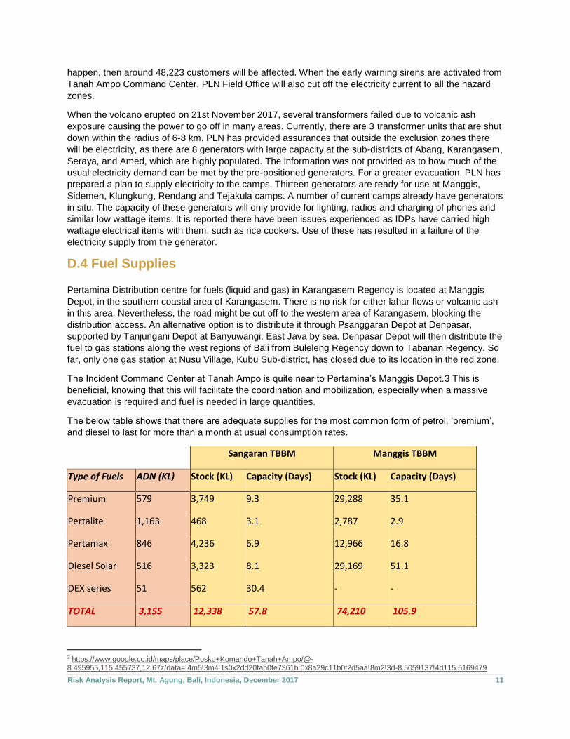
D.4 Fuel Supplies Pertamina Distribution centre for fuels (liquid and gas) in Karangasem Regency is located at Manggis
Depot, in the southern coastal area of Karangasem. There is no risk for either lahar flows or volcanic ash
in this area. Nevertheless, the road might be cut off to the western area of Karangasem, blocking the
distribution access. An alternative option is to distribute it through Psanggaran Depot at Denpasar,
supported by Tanjungani Depot at Banyuwangi, East Java by sea. Denpasar Depot will then distribute the
fuel to gas stations along the west regions of Bali from Buleleng Regency down to Tabanan Regency. So
far, only one gas station at Nusu Village, Kubu Sub-district, has closed due to its location in the red zone.
The Incident Command Center at Tanah Ampo is quite near to Pertamina’s Manggis Depot.3 This is
beneficial, knowing that this will facilitate the coordination and mobilization, especially when a massive
evacuation is required and fuel is needed in large quantities.
The below table shows that there are adequate supplies for the most common form of petrol, ‘premium’,
and diesel to last for more than a month at usual consumption rates.
Sangaran TBBM Manggis TBBM
Type of Fuels ADN (KL) Stock (KL) Capacity (Days) Stock (KL) Capacity (Days)
Premium 579 3,749 9.3 29,288 35.1
Pertalite 1,163 468 3.1 2,787 2.9
Pertamax 846 4,236 6.9 12,966 16.8
Diesel Solar 516 3,323 8.1 29,169 51.1
DEX series 51 562 30.4 - -
TOTAL 3,155 12,338 57.8 74,210 105.9
3 https://www.google.co.id/maps/place/Posko+Komando+Tanah+Ampo/@-8.495955,115.455737,12.67z/data=!4m5!3m4!1s0x2dd20fab0fe7361b:0x8a29c11b0f2d5aa!8m2!3d-8.5059137!4d115.5169479
Risk Analysis Report, Mt. Agung, Bali, Indonesia, December 2017 12
D.5 Communication Systems Telecommunication providers such as Telkomsel, XL, Tri and Indosat are widely used by people in
Karangasem Regency. Though almost all of Karangasem is covered by these providers, there are still
areas where a mobile phone network signal cannot be accessed due to its hilly landscape. To anticipate
communication traffic overload and the impact an eruption might have on existing mobile towers, some
providers have pre-positioned Compact Mobile Base Stations (Combat) or mobile BTS (Base Transceiver
Stations) and prepared generators for power backup to ensure continuity of the mobile network.
BNPB has set up a community-based radio communication system and installed 6 siren units for an early
warning system (EWS). Since 17th November 2017, Pasebaya Forum has been formed by 28 villages
within the hazard zones. Having 700 volunteers, the forum aims to ease the challenge of communication
and coordination between village leaders, providing information related to all hazards and the updates on
volcanic activity is live streamed through the radio. On 18th December 2017, BNPB handed over
equipment that included 4 Repeaters, 4 Rigs, 20 Batteries, 4 Solar cells, and 140 Handy Talky units
(HTs) to the Pasebaya Forum, providing each village with 3 HTs. Volunteers will use this equipment to
quickly evacuate the villagers. Pasebaya Forum works with ORARI (Indonesian Amateur Radio
Organization) and directly communicates with the Command Centre at Tanah Ampo. Radio Coverage,4
Sirens5 and Warning and Evacuation Signs6 for the early warning system are now in-place. Sirens can
be controlled directly by the Command Centre. Information about the system and what to do when the
sirens are heard is still being circulated to community members. The activation of the sirens can only be
authorised by the IC (Incident commander) at Tanah Ampo Command Centre.
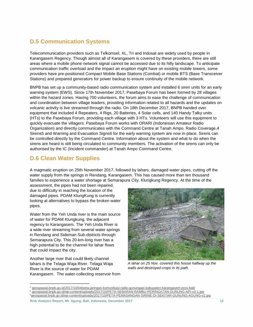
D.6 Clean Water Supplies A magmatic eruption on 25th November 2017, followed by lahars, damaged water pipes, cutting off the
water supply from the springs in Rendang, Karangasem. This has caused more than ten thousand
families to experience a water shortage at Semarapura City, Klungkung Regency. At the time of the
assessment, the pipes had not been repaired,
due to difficulty in reaching the location of the
damaged pipes. PDAM KlungKung is currently
looking at alternatives to bypass the broken water
pipes.
Water from the Yeh Unda river is the main source
of water for PDAM Klungkung, the adjacent
regency to Karangasem. The Yeh Unda River is
a wide river streaming from several water springs
in Rendang and Sideman Sub-districts through
Semarapura City. This 20-km-long river has a
high potential to be the channel for lahar flows
that could impact the city.
Another large river that could likely channel
lahars is the Telaga Waja River. Telaga Waja
River is the source of water for PDAM
Karangasem. The water-collecting reservoir from
4 geospasial.bnpb.go.id/2017/10/04/peta-jaringan-komunikasi-radio-gunungapi-kabupaten-karangasem-prov-bali/ 5 geospasial.bnpb.go.id/wp-content/uploads/2017/10/PETA-SEBARAN-RAMBU-PERINGATAN-GUNUNG-API-v3-1.jpg 6geospasial.bnpb.go.id/wp-content/uploads/2017/10/PETA-PEMASANGAN-SIRINE-DI-SEKITAR-GUNUNG-AGUNG-v2.jpg
A lahar on 25 Nov. covered this house halfway up the
walls and destroyed crops in its path.
Risk Analysis Report, Mt. Agung, Bali, Indonesia, December 2017 13
the river has a capacity of 10,000 cubic metres and is located in Menanga Village, Rendang Sub-district.
It is currently closed as it has been abandoned by the staff as they are afraid to stay at the operating site.
Water from the Telaga Waja district is distributed to about 15,000 consumers via a gravity-fed system.
The piping network is 87-km long with a pipe diameter of 70-cm.
As the majority of the reticulated water supply to Karangasem is provided from river sources and relies on
a piping network that runs near rivers, it makes it highly susceptible to the impact of lahar flows. Rivers
that were affected by the lahar flows on 25th November 2017 are:
1) Kubu Sub-district: Dalem River (Ban Village down to Sukadana Village) along 12 km
2) Selat Sub-district: Bambang Biaung River (Duda Utara and Desa Duda Villages) along 10 km and
flowing to Tunjung Penyalin River ended in Unda River, while also another overflow along the
Sebudi River (Sebudi Village)
3) Bebandem Sub-district: Nang-ka River (Bhuana Giri Village)
4) Klungkung Sub-district: Yeh Unda River (Tangkas Village), the second largest river in
Karangasem Regency
Knowing the above risks to the water supplies, PDAM took several actions, such as creating more bore
wells in several areas, e.g. borewell with a capacity of 20 litres per second at Akah Village, and borewells
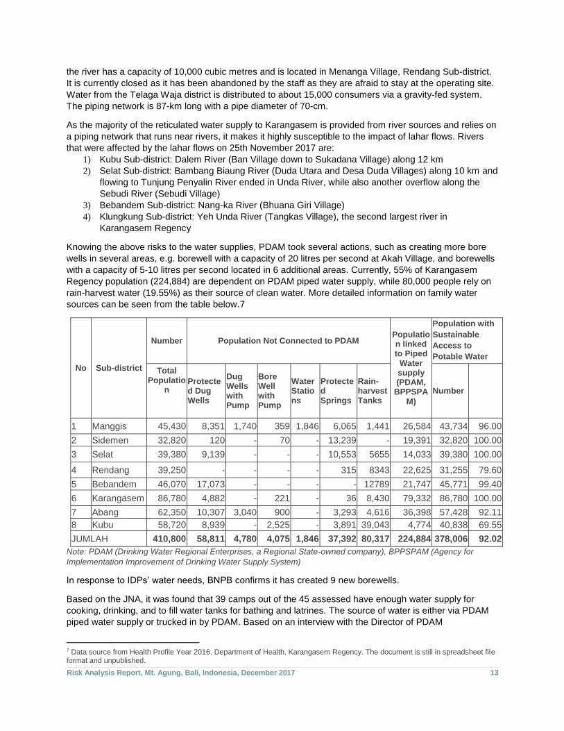
with a capacity of 5-10 litres per second located in 6 additional areas. Currently, 55% of Karangasem
Regency population (224,884) are dependent on PDAM piped water supply, while 80,000 people rely on
rain-harvest water (19.55%) as their source of clean water. More detailed information on family water
sources can be seen from the table below.7
No Sub-district
Number Population Not Connected to PDAM Population linked to Piped
Water supply (PDAM,
BPPSPAM)
Population with
Sustainable
Access to
Potable Water
Total Populatio
n
Protected Dug Wells
Dug Wells with Pump
Bore Well with Pump
Water Stations
Protected Springs
Rain-harvest Tanks
Number
1 Manggis 45,430 8,351 1,740 359 1,846 6,065 1,441 26,584 43,734 96.00
2 Sidemen 32,820 120 - 70 - 13,239 - 19,391 32,820 100.00
3 Selat 39,380 9,139 - - - 10,553 5655 14,033 39,380 100.00
4 Rendang 39,250 - - - - 315 8343 22,625 31,255 79.60
5 Bebandem 46,070 17,073 - - - - 12789 21,747 45,771 99.40
6 Karangasem 86,780 4,882 - 221 - 36 8,430 79,332 86,780 100.00
7 Abang 62,350 10,307 3,040 900 - 3,293 4,616 36,398 57,428 92.11
8 Kubu 58,720 8,939 - 2,525 - 3,891 39,043 4,774 40,838 69.55
JUMLAH 410,800 58,811 4,780 4,075 1,846 37,392 80,317 224,884 378,006 92.02
Note: PDAM (Drinking Water Regional Enterprises, a Regional State-owned company), BPPSPAM (Agency for
Implementation Improvement of Drinking Water Supply System)
In response to IDPs’ water needs, BNPB confirms it has created 9 new borewells.
Based on the JNA, it was found that 39 camps out of the 45 assessed have enough water supply for
cooking, drinking, and to fill water tanks for bathing and latrines. The source of water is either via PDAM
piped water supply or trucked in by PDAM. Based on an interview with the Director of PDAM
7 Data source from Health Profile Year 2016, Department of Health, Karangasem Regency. The document is still in spreadsheet file format and unpublished.
Risk Analysis Report, Mt. Agung, Bali, Indonesia, December 2017 14
Karangasem, he informed that generally water tankers are providing water to camps every second day,
however, there is a feedback mechanism in place whereby a call can be made if there is a shortage of
water at a camp.
However, an extreme shortage of latrines was identified. In many of the camps, the government has
provided temporary latrines that are connected to a waste collecting tank that needs to be emptied on a
regular basis. The PUPR Department reported they only have two trucks for waste collection. There is no
separation between men and women toilet facilities.
D.7 Education8
Currently, in 12 villages, there are 21 Public Elementary Schools unused as they are located in the red
zone (within the radius of 0-9 km from the crater) and high risk to be exposed to Pyroclastic Flow, Lava
Flows & Gas, including Ash/Tephra Fallout. Also, there are 6 senior high schools in three sub-districts of
the red zone. Within the yellow zone, the radius of 12-15 km potential to expose to Ash/Tephra fallout,
there are 13 senior high schools and 1 public school with special needs in Karangasem Sub-district.
There are 15 senior high schools within the white zone (high risk for lahars flow) in 6 sub-districts.
Provided link below is the BNPB map of the locations and distances from the hazard zones.9
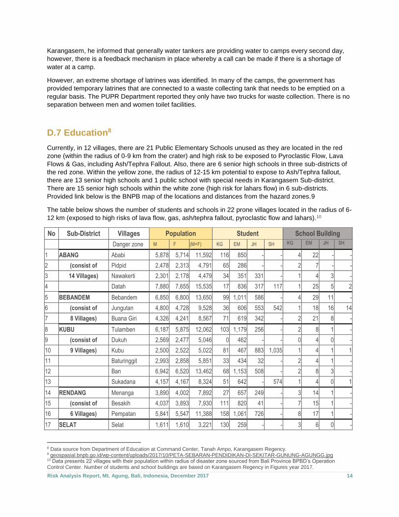
The table below shows the number of students and schools in 22 prone villages located in the radius of 6-
12 km (exposed to high risks of lava flow, gas, ash/tephra fallout, pyroclastic flow and lahars).10
No Sub-District Villages Population Student School Building
Danger zone M F (M+F) KG EM JH SH KG EM JH SH
1 ABANG Ababi 5,878 5,714 11,592 116 850 - - 4 22 - -
2 (consist of Pidpid 2,478 2,313 4,791 65 286 - - 2 7 - -
3 14 Villages) Nawakerti 2,301 2,178 4,479 34 351 331 - 1 4 3 -
4 Datah 7,880 7,655 15,535 17 836 317 117 1 25 5 2
5 BEBANDEM Bebandem 6,850 6,800 13,650 99 1,011 586 - 4 29 11 -
6 (consist of Jungutan 4,800 4,728 9,528 36 606 553 542 1 18 16 14
7 8 Villages) Buana Giri 4,326 4,241 8,567 71 619 342 - 2 21 8 -
8 KUBU Tulamben 6,187 5,875 12,062 103 1,179 256 - 2 8 1 -
9 (consist of Dukuh 2,569 2,477 5,046 0 462 - - 0 4 0 -
10 9 Villages) Kubu 2,500 2,522 5,022 81 467 883 1,035 1 4 1 1
11 Baturinggit 2,993 2,858 5,851 33 434 32 - 2 4 1 -
12 Ban 6,942 6,520 13,462 68 1,153 508 - 2 8 3 -
13 Sukadana 4,157 4,167 8,324 51 642 - 574 1 4 0 1
14 RENDANG Menanga 3,890 4,002 7,892 27 657 249 - 3 14 1 -
15 (consist of Besakih 4,037 3,893 7,930 111 820 41 - 7 15 1 -
16 6 Villages) Pempatan 5,841 5,547 11,388 158 1,061 726 - 8 17 1 -
17 SELAT Selat 1,611 1,610 3,221 130 259 - - 3 6 0 -
8 Data source from Department of Education at Command Center, Tanah Ampo, Karangasem Regency. 9 geospasial.bnpb.go.id/wp-content/uploads/2017/10/PETA-SEBARAN-PENDIDIKAN-DI-SEKITAR-GUNUNG-AGUNGG.jpg 10 Data presents 22 villages with their population within radius of disaster zone sourced from Bali Province BPBD’s Operation Control Center. Number of students and school buildings are based on Karangasem Regency in Figures year 2017.
Risk Analysis Report, Mt. Agung, Bali, Indonesia, December 2017 15
18 (consist of Peringsari 3,258 3,359 6,617 89 624 931 - 3 5 1 -
19 8 Villages) Muncan 4,380 4,469 8,849 120 702 516 - 3 6 1 -
20 Duda Utara 3,807 3,650 7,457 119 576 465 - 3 4 1 -
21 Amerta Bhuana 1,800 1,819 3,619 68 368 - - 2 3 - -
22 Sebudi 3,077 3,114 6,191 68 507 - - 3 4 - -
TOTAL 181,073 1,664 14,470 6,736 2,268 58 232 55 18
The JNA identified that most IDP students go to school at or nearby the IDP camps. The greatest need is
that of school bags, books and uniforms (39.44%), stationary (38.03%), tables and chairs (12.68%) and
school buildings (9.86%) at the schools to accommodate the additional students. It is unknown as to what
impact the relocation of students to these schools and the resultant increase in class numbers might have
on their learning.
D.8 Health Karangasem Regency has a government general hospital employing 38 physicians (1 paediatrician, 2
surgeons, 5 obstetricians/gynaecologists, 2 internists, 8 other specialists, and 17 general practitioners), 2
dentists, 48 midwives and 112 nurses with capacity for 218 beds. One 64-bed private hospital having 20
medical specialists, 9 general practitioners and 2 dentists, 22 midwives and 71 nurses. There are 12
community health centres (CHCs) with their 71 satellite CHCs, and 17 mobile CHCs with 51 physicians,
24 dentists, and 337 health workers including midwives, nurses, sanitarians, nutritionists and other
applied health staff. There are 6 CHCs in red zones not operating due to the eruption: CHC Rendang,
CHC Selat, CHC Bebandem, CHC Abang I, CHC Abang II, and CHC Kubu.
There is also a general hospital located in Amlapura City, capital of Karangasem Regency; it is not in the
lahar risk zone. Nevertheless, if a bigger eruption occurs mobilizing a greater number of IDPs, then the
capacity of health workers in the hospitals and CHCs is far from sufficient. The Health Cluster is now
working to have an Operational Plan together with PMI (Indonesian Red Cross Society), BASARNAS
(National Search and Rescue Agency), and some referral hospitals outside of Karangasem Regency,
including ambulance support and a plan to evacuate the survivors through the sea towards Denpasar
City.
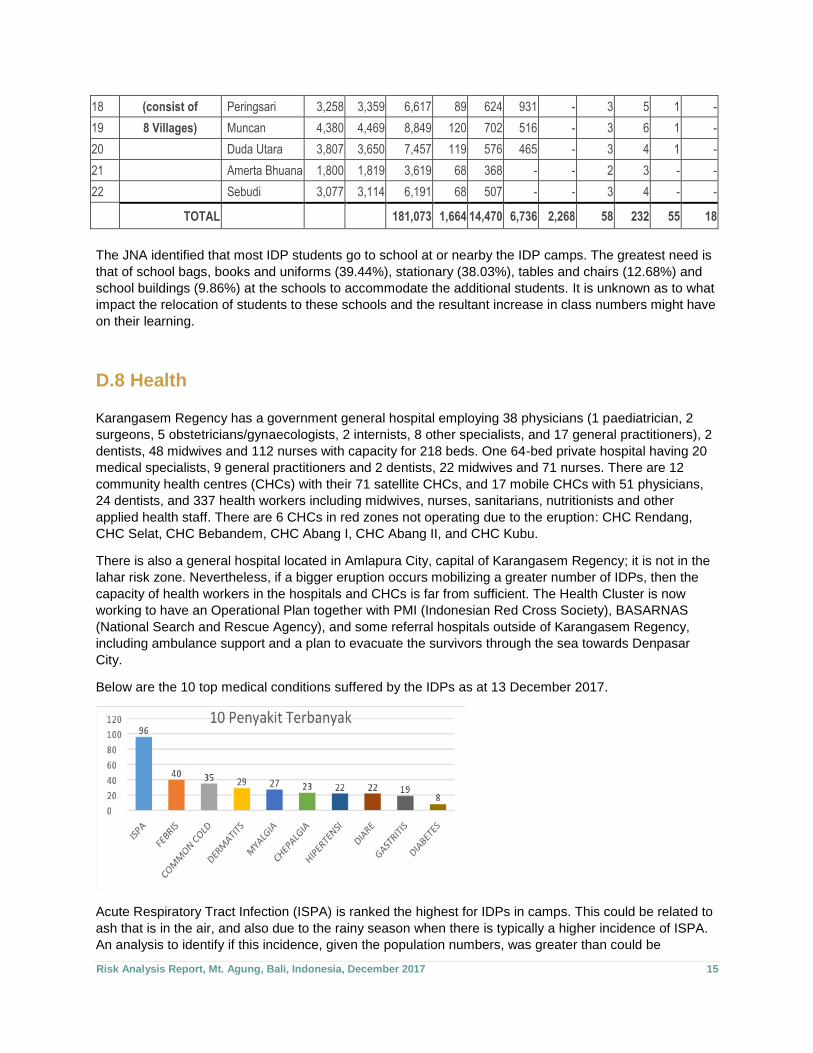
Below are the 10 top medical conditions suffered by the IDPs as at 13 December 2017.
Acute Respiratory Tract Infection (ISPA) is ranked the highest for IDPs in camps. This could be related to
ash that is in the air, and also due to the rainy season when there is typically a higher incidence of ISPA.
An analysis to identify if this incidence, given the population numbers, was greater than could be
Risk Analysis Report, Mt. Agung, Bali, Indonesia, December 2017 16
expected, has not been done. The Department of Health’s strategy to manage these health conditions is
to distribute face masks, conduct health talks to the IDPs to reduce their outdoor activities whenever
possible during bad weather and for PHBS (clean and healthy lifestyle) promotions, and also providing
medical treatment. The assessment team was unable to secure information as to current level of medical
supplies, such as masks.
D.9 Livelihoods and Economy Vulnerability to disasters increases when society’s economic situation is low. Karangasem Regency has
the lowest Human Development Index11 (HDI) among the 9 regencies in Bali province. In 2016, there
were 27,120 poor people, making the regency ranked the poorest in Bali.
Since the increased volcanic activity of Mt. Agung in September up to December 2017, according to the
Minister of Tourism, Arief Yahya, the losses within the tourism sector have reached IDR
9,000,000,000,000 (9 trillion) equivalent to around USD 663 million. During the same period, losses of
IDR 2,000,000,000,000 (2 trillion) or USD 147 million due to bad credits in Karangasem Regency,
considered to be as a direct result of loss of jobs due to the downturn in tourism, combined with moving to
live in IDP camps has reduced the opportunity to generate income.
E. SUMMARY AND RECOMMENDATIONS
1. Evacuation Centres and IDPs The current number of IDPs at evacuation centres is about 71,000 persons. The JNA identified there are
currently six unmet needs. It is estimated that a worst-case scenario could see as many as 180,000
persons evacuated. If these needs are not being met for the current IDP population, then it is highly likely
it will be the same for a greater number of persons.
Planning should be completed to determine how best to meet currently identified needs, and
implemented. Through the process, it will identify what preparations and planning will need to be put in
place to meet the same needs in a larger-scale event.
2. Electricity Supplies In the event of a large-scale volcanic eruption, it is highly likely there will be widespread loss of electricity.
There are contingency plans in place for the provision of emergency electricity supply via generators.
Where generators are already in place in camps, issues have been experienced due to inappropriate use
of the electricity supply. In the event of a wide-scale loss of electricity, the consequent loss of lighting at
night raises protection issues, especially for women, girls and boys.
Educational materials about the appropriate use of electricity supply when a generator is used should be
prepared. The provision of solar lights will increase the availability of a more reliable source of lighting at
night.
11 HDI components are: Life expectancy, the expected years of schooling, the average length of school and average
purchasing power parity per capita.
Risk Analysis Report, Mt. Agung, Bali, Indonesia, December 2017 17
3. Fuel Supply The assessment identified it was unlikely that fuel supplies would be adversely affected by a major
volcanic eruption. This then should ensure adequate fuel supplies for evacuation vehicles and for
electricity generators.
4. Communication Systems Mobile phone companies have well-developed contingency plans to ensure continuity of the mobile
phone services in the event of a significant volcanic eruption. BNPB has established a radio network
across the 28 villages in the hazard zone that is supported by a community forum of volunteers. The radio
network primarily enables communicate to facilitate a quick evacuation. Sirens have been installed to
inform communities of the need for evacuation.
All humanitarian agencies operating in the area should be familiar with the EWS and the evacuation plans
for the communities. This ensures their own safety when working in the communities and also enables
them to endorse the knowledge of the system and associated processes to the community. Liaison and
working with Pasebaya Forum is recommended to facilitate the previous recommendations.
5. Water Supply The reticulated water supply system and the sources of water are extremely vulnerable to damage from
lahars, of which notable damage has already occurred, resulting in water shortages. More than 220,000
persons rely on this water source. PDAM and BNPB recognise the risk to water supply and have taken
the mitigatory measures of installing additional borewells, however in a large-scale eruption there is a
high likelihood of significant shortages of water, and the water that is available will likely require trucking
as the reticulated system will not be functioning.
Planning and preparations should be put in place to enable the management of water if water trucking is
the primary means of providing water, how best to ensure the safety of drinking water and educational
materials on the conservation of water.
Rainwater harvesting at the camps should be encouraged and supplies provided to facilitate this,
especially as this is now the rainy season. The Incident Command Centre is endeavouring to build
rainwater harvesting installations at several IDP camps. This effort should be supported by humanitarian
organisations.
6. Education There are a significant number of schools within the hazard zones, however, an assessment has
identified that most displaced students have joined the local schools nearest to the IDP camp where they
are staying. The JNA identified there are some educational-related needs.
Planning should be completed to determine how best to meet currently identified needs, and
implemented. Through the process, it should identify what preparations and planning will need to be put
in place to meet the same needs in a larger-scale event.

Risk Analysis Report, Mt. Agung, Bali, Indonesia, December 2017 18
7. Health Half the CHCs are currently closed in Karangasem Regency due to being located within the hazard zone.
The remaining CHCs have managed to pick up the extra workload. The two general hospitals on
Karangasem are not located in the hazard zone. The health sector has well-developed contingency plans.
It is unknown what level of medical supplies they have. During an active volcanic eruption, there is likely
to be an increase in injuries, respiratory disorders, and eye and skin irritation, which will place an
increased demand for medical services and medical supplies. Additionally, it is likely that health staff
numbers could be reduced due to inability to work, either because they cannot get to the hospital or are
affected physically by the ash fall.
Humanitarian organisations either working in Bali, or those likely to respond if there was a humanitarian
need as a result of a volcanic eruption, should identify what PPE they require for their staff, procure it and
provide training to their staff in the correct use of the PPE. It is likely that PPE such as masks and eye
goggles for distribution to the public will be in short supply. Humanitarian organisations should identify in
advance vendors, and what stock they have. The Dept. of Health should be contacted to identify what
information leaflets they have on protection during a volcanic eruption, and ensure all staff have access to
this information.
8. Livelihoods Communities with low socio-economic status are more vulnerable to hazards. Karangasem Regency
registers the lowest HDI in Bali. The current volcanic activity has significantly reduced income from the
tourism industry, of which Bali is heavily reliant. Being displaced from their homes has also impacted on
the ability to earn an income. This combination of factors has negatively impacted on the IDPs.
Identify income-generating activities that utilise and build on existing skills and are suitable for the IDP
Camp context.
Risk Analysis Report, Mt. Agung, Bali, Indonesia, December 2017 19
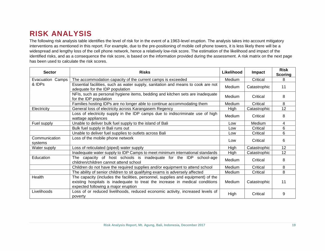
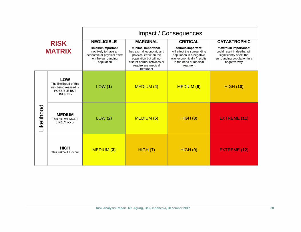
RISK ANALYSIS The following risk analysis table identifies the level of risk for in the event of a 1963-level eruption. The analysis takes into account mitigatory
interventions as mentioned in this report. For example, due to the pre-positioning of mobile cell phone towers, it is less likely there will be a
widespread and lengthy loss of the cell phone network, hence a relatively low-risk score. The estimation of the likelihood and impact of the
identified risks, and as a consequence the risk score, is based on the information provided during the assessment. A risk matrix on the next page
has been used to calculate the risk scores.
Sector Risks Likelihood Impact Risk
Scoring
Evacuation Camps & IDPs
The accommodation capacity of the current camps is exceeded Medium Critical 8
Essential facilities, such as water supply, sanitation and means to cook are not adequate for the IDP population
Medium Catastrophic 11
NFIs, such as personal hygiene items, bedding and kitchen sets are inadequate for the IDP population
Medium Critical 8
Families hosting IDPs are no longer able to continue accommodating them Medium Critical 8
Electricity General loss of electricity across Karangasem Regency High Catastrophic 12
Loss of electricity supply in the IDP camps due to indiscriminate use of high wattage appliances
Medium Critical 8
Fuel supply Unable to deliver bulk fuel supply to the island of Bali Low Medium 4
Bulk fuel supply in Bali runs out Low Critical 6
Unable to deliver fuel supplies to outlets across Bali Low Critical 6
Communication systems
Loss of the mobile phone network Low Critical 6
Water supply Loss of reticulated (piped) water supply High Catastrophic 12
Inadequate water supply to IDP Camps to meet minimum international standards High Catastrophic 12
Education The capacity of host schools is inadequate for the IDP school-age children/children cannot attend school
Medium Critical 8
Children do not have the required supplies and/or equipment to attend school Medium Critical 8
The ability of senior children to sit qualifying exams is adversely affected Medium Critical 8
Health The capacity (includes the facilities, personnel, supplies and equipment) of the existing hospitals is inadequate to treat the increase in medical conditions expected following a major eruption
Medium Catastrophic 11
Livelihoods Loss of or reduced livelihoods, reduced economic activity, increased levels of poverty
High Critical 9
Risk Analysis Report, Mt. Agung, Bali, Indonesia, December 2017 20
RISK MATRIX
Impact / Consequences
NEGLIGIBLE
small/unimportant; not likely to have an
economic or physical effect on the surrounding
population
MARGINAL
minimal importance; has a small economic and
physical effect on the population but will not
disrupt normal activities or require any medical
treatment
CRITICAL
serious/important; will affect the surrounding population in a negative
way economically / results in the need of medical
treatment
CATASTROPHIC
maximum importance; could result in deaths; will
significantly affect the surrounding population in a
negative way
Lik
elih
ood
LOW The likelihood of this risk being realized is
POSSIBLE BUT UNLIKELY
LOW (1) MEDIUM (4) MEDIUM (6) HIGH (10)
MEDIUM This risk will MOST
LIKELY occur
LOW (2) MEDIUM (5) HIGH (8) EXTREME (11)
HIGH This risk WILL occur
MEDIUM (3) HIGH (7) HIGH (9) EXTREME (12)
Risk Analysis Report, Mt. Agung, Bali, Indonesia, December 2017 21
ABOUT ADRA
The Adventist Development and Relief Agency (ADRA) is
the global humanitarian organization of the Seventh-day
Adventist Church. Through an international network, ADRA
delivers relief and development assistance to individuals in
more than 140 countries—regardless of their ethnicity,
political affiliation, or religious association. By partnering
with communities, organizations, and governments, ADRA
is able to improve the quality of life of millions through
community development and disaster response.
ACKNOWLEDGEMENTS
We would like to acknowledge the contributing support from
HelpAge International, without whom this report would not be
possible.
Risk Analysis Report
Mt. Agung, Bali, Indonesia
December 2017
Published by ADRA Indonesia
Gedung Pertemuan Advent Lt.4,
Jl.MT.Haryono Kav 4-5 Blok A, Jakarta 12810
+62 21 83703185 | [email protected]
www.adra.org
www.adraindonesia.org
@ADRAIntl ADRA Indonesia
Copyright © ADRA Indonesia 2018