Embed Size (px)
Citation preview
Herrier J.-L., J. Mees, A. Salman, J. Seys, H. Van Nieuwenhuyse and I. Dobbelaere (Eds). 2005. p. 219-228 Proceedings ‘Dunes and Estuaries 2005’ – International Conference on Nature Restoration Practices in European Coastal Habitats, Koksijde, Belgium, 19-23 September 2005 VLIZ Special Publication 19, xiv + 685 pp.
- 219 -
Multi-technique survey of fine sediment transport and deposition in a managed estuary: the Authie Estuary, northern France
Claire Marion1, Edward J. Anthony1 and Alain Trentesaux2
1 Université du Littoral , Côte d’Opale, Coastal Geomorphology and Shoreline Management Unit EA 3599, MREI 2, 189a Avenue M. Schumann, 59140 Dunkerque, France E-mail: [email protected]
2 Université des Sciences et Techniques de Lille, CNRS UMR 8110, Processus et Bilans des Domaines Sédimentaires, SN5, 59655 Villeneuve d’Ascq, France
Abstract
This article presents an overview of a range of simple and high-technology techniques and scientific methods used in a small, human-managed, highly dynamic, temperate macrotidal estuary to quantify the movement and deposition of fine sediment in space and time. The principle of each technique and its limitations are exposed. It is shown that this multi-technique approach is relevant to a better understanding of sedimentary processes, rhythms and rates, while the data acquired are of importance to reliable modelling. Permanent feedback from high-resolution field monitoring is still a necessary pre-requisite in forecasting the evolution of estuarine systems.
Keywords: Survey techniques; Estuarine monitoring; Sediment dynamics; Authie Estuary; northern France.
Introduction
Estuaries are highly dynamic environments of great socio-economic and ecological importance due to their position at the interface between marine and terrestrial environments. This location commonly entails an adequate supply of coarse (sand) and fine (mud) particles from both marine and continental sources. A good knowledge of the fine sediment distribution pattern in time and space is important because estuarine accretion eventually leads to the evolution of intertidal habitats towards supratidal ones, while erosion may result in damage to infrastructure. Erosion and accretion patterns may also determine the distribution of pollutants in estuaries. Moreover, by providing space, resources and habitat for wildlife, the loci of fine sedimentation are of critical ecological significance. Estuarine management and eventual habitat restoration need preliminary studies, pertinent surveys and tools to understand the behaviour of sediment stocks and to allow the quantification of sediments budgets. It is difficult to evaluate qualitative and quantitative aspects of sediment dynamics, as a result of overall mixing inside the
C. Marion et al.
- 220 -
estuarine system and recycling of materials. This issue is also complicated by the nature of the materials in movement and their physical properties, as well as by variations in the energetic forces driving estuarine dynamics (wind, waves, tide, river discharge). One way of maximising data collection with a view towards improving the understanding of estuaries is by diversifying the range of methodological procedures and techniques in order to attempt to match the diversity of estuarine parameters at different spatio-temporal scales.
Site presentation
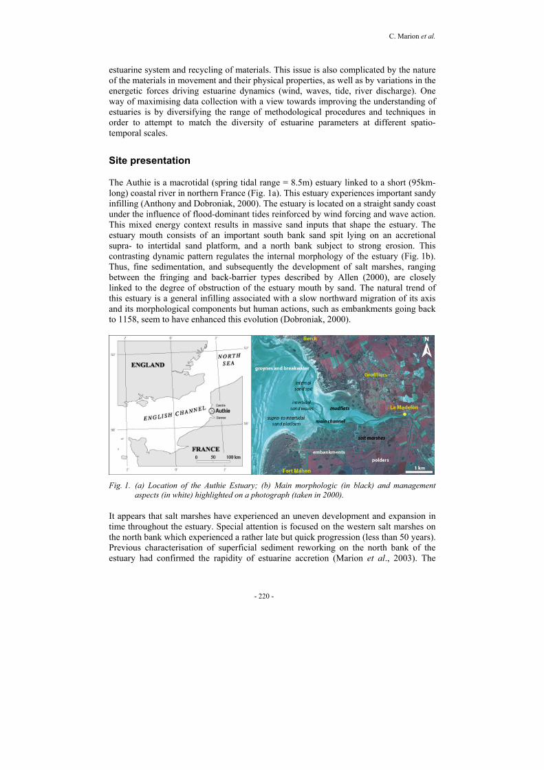
The Authie is a macrotidal (spring tidal range = 8.5m) estuary linked to a short (95km-long) coastal river in northern France (Fig. 1a). This estuary experiences important sandy infilling (Anthony and Dobroniak, 2000). The estuary is located on a straight sandy coast under the influence of flood-dominant tides reinforced by wind forcing and wave action. This mixed energy context results in massive sand inputs that shape the estuary. The estuary mouth consists of an important south bank sand spit lying on an accretional supra- to intertidal sand platform, and a north bank subject to strong erosion. This contrasting dynamic pattern regulates the internal morphology of the estuary (Fig. 1b). Thus, fine sedimentation, and subsequently the development of salt marshes, ranging between the fringing and back-barrier types described by Allen (2000), are closely linked to the degree of obstruction of the estuary mouth by sand. The natural trend of this estuary is a general infilling associated with a slow northward migration of its axis and its morphological components but human actions, such as embankments going back to 1158, seem to have enhanced this evolution (Dobroniak, 2000).
Fig. 1. (a) Location of the Authie Estuary; (b) Main morphologic (in black) and management
aspects (in white) highlighted on a photograph (taken in 2000).
It appears that salt marshes have experienced an uneven development and expansion in time throughout the estuary. Special attention is focused on the western salt marshes on the north bank which experienced a rather late but quick progression (less than 50 years). Previous characterisation of superficial sediment reworking on the north bank of the estuary had confirmed the rapidity of estuarine accretion (Marion et al., 2003). The
Fine sediment multi-techniques survey
- 221 -
development of the internal sand spit especially leads to enhanced protection of the inner estuarine areas upstream of this spit. Notwithstanding the energetic tidal regime in this estuary, fine to very fine sedimentation occurs in sheltered areas where the estuarine morphology induces a significant decrease of hydrodynamic tidal forcing (Marion et al., 2004a). Three different salt marsh cross-shore profiles are under survey along the northern bank of the Authie which presents narrower interfaces between major morphological components (and thus better site accessibility) and overall a quickly accreting sand spit and tidal flat. The first profile is situated in the lee of the internal sand spit and exhibits a young marsh. The two others are located further inward through older marshes and present respectively a prograding pioneer zone and a micro-cliff transition to tidal flats in the direction of the main channel. A tidal channel located between these two profiles is also monitored. The comprehension of fine sediment stock behaviour and the quantification of the estuarine sediment budget using a multi-scale approach is the global aim of the present work which focuses on multi-technique surveys of fine sediment transport and deposition.
Technical aspects
Sediment transport survey Argus Surface Meter (ASM IV)
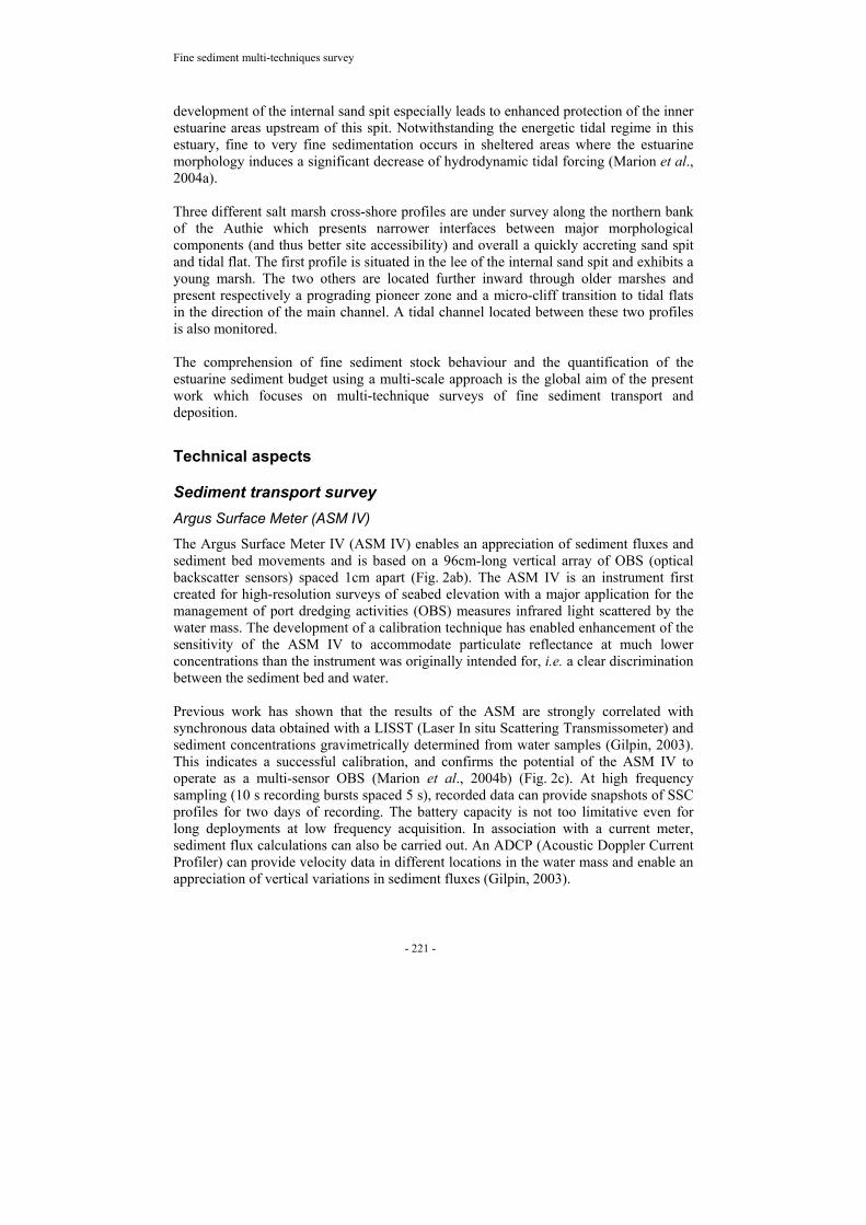
The Argus Surface Meter IV (ASM IV) enables an appreciation of sediment fluxes and sediment bed movements and is based on a 96cm-long vertical array of OBS (optical backscatter sensors) spaced 1cm apart (Fig. 2ab). The ASM IV is an instrument first created for high-resolution surveys of seabed elevation with a major application for the management of port dredging activities (OBS) measures infrared light scattered by the water mass. The development of a calibration technique has enabled enhancement of the sensitivity of the ASM IV to accommodate particulate reflectance at much lower concentrations than the instrument was originally intended for, i.e. a clear discrimination between the sediment bed and water. Previous work has shown that the results of the ASM are strongly correlated with synchronous data obtained with a LISST (Laser In situ Scattering Transmissometer) and sediment concentrations gravimetrically determined from water samples (Gilpin, 2003). This indicates a successful calibration, and confirms the potential of the ASM IV to operate as a multi-sensor OBS (Marion et al., 2004b) (Fig. 2c). At high frequency sampling (10 s recording bursts spaced 5 s), recorded data can provide snapshots of SSC profiles for two days of recording. The battery capacity is not too limitative even for long deployments at low frequency acquisition. In association with a current meter, sediment flux calculations can also be carried out. An ADCP (Acoustic Doppler Current Profiler) can provide velocity data in different locations in the water mass and enable an appreciation of vertical variations in sediment fluxes (Gilpin, 2003).
C. Marion et al.
- 222 -
Fig. 2. (a) ASM IV on the field in the Authie Estuary (upper part of the main mudflat); (b) Zoom on the OBS sensor array; (c) Example of results (from Marion et al., 2004b): snapshot of sediment transport during a tide after conversion into sediment concentrations (black areas on each part corresponding to heights without water and on the bottom to sediment level). Note that only the first 30cm of the water column are concerned by important sediment concentration and that sediment resuspension occurs at the beginning and the end of the tidal cycle.
Booner tube
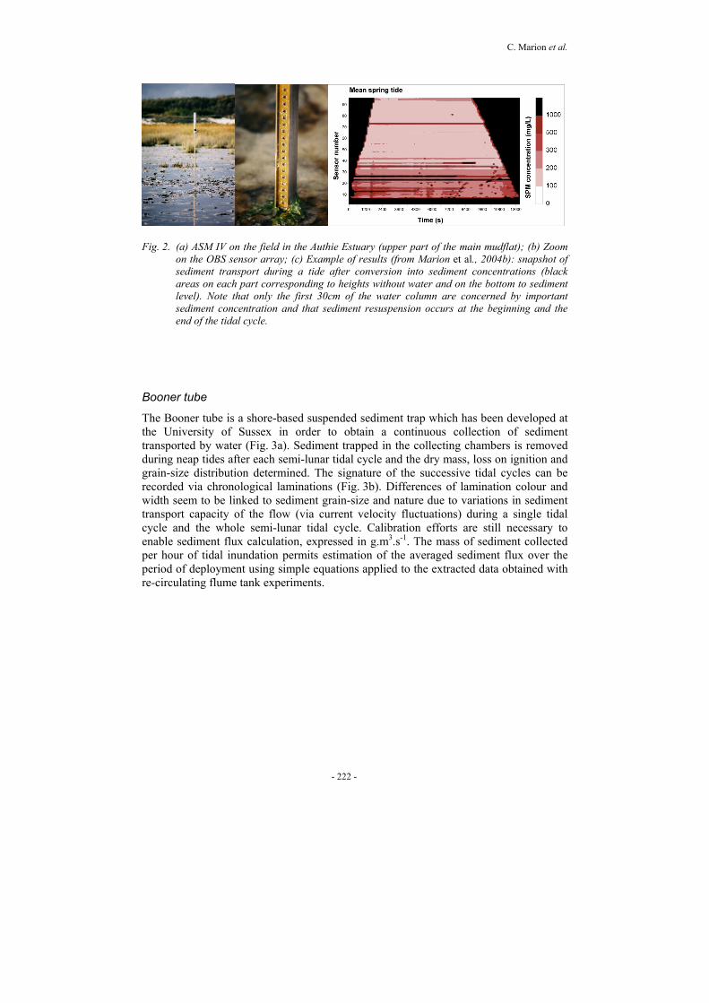
The Booner tube is a shore-based suspended sediment trap which has been developed at the University of Sussex in order to obtain a continuous collection of sediment transported by water (Fig. 3a). Sediment trapped in the collecting chambers is removed during neap tides after each semi-lunar tidal cycle and the dry mass, loss on ignition and grain-size distribution determined. The signature of the successive tidal cycles can be recorded via chronological laminations (Fig. 3b). Differences of lamination colour and width seem to be linked to sediment grain-size and nature due to variations in sediment transport capacity of the flow (via current velocity fluctuations) during a single tidal cycle and the whole semi-lunar tidal cycle. Calibration efforts are still necessary to enable sediment flux calculation, expressed in g.m3.s-1. The mass of sediment collected per hour of tidal inundation permits estimation of the averaged sediment flux over the period of deployment using simple equations applied to the extracted data obtained with re-circulating flume tank experiments.
Fine sediment multi-techniques survey
- 223 -
Fig. 3. (a) Booner tube design and principle of working (from Charman, 2004); (b) Example of results: sediment collected in the clear Perspex central cylinder after a semi-lunar tidal cycle from three different locations in the estuary. Note the numerous laminations recorded.
Sediment deposition survey Filter method
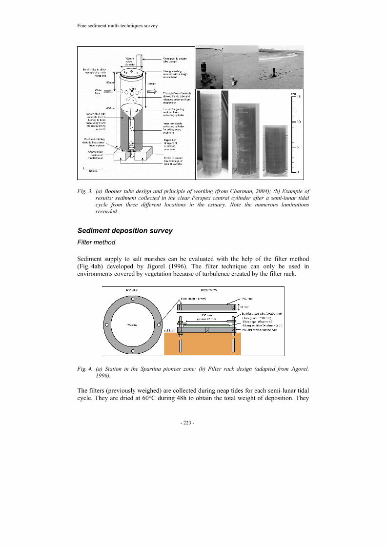
Sediment supply to salt marshes can be evaluated with the help of the filter method (Fig. 4ab) developed by Jigorel (1996). The filter technique can only be used in environments covered by vegetation because of turbulence created by the filter rack.
Fig. 4. (a) Station in the Spartina pioneer zone; (b) Filter rack design (adapted from Jigorel, 1996).
The filters (previously weighed) are collected during neap tides for each semi-lunar tidal cycle. They are dried at 60°C during 48h to obtain the total weight of deposition. They

C. Marion et al.
- 224 -
are then incinerated at 500°C during 1h and weighed again, the loss on ignition representing the part of organic matter. The results are expressed in g.cm-2 relative to the filter collecting surface (75.43cm²) and can be linked to time exposition to seawater inundation.
Altimeter
The ALTUS (SA Micrel) altimeter enables monitoring of elevation changes at high frequencies. The principle of the altimeter is to measure the time taken between the emission by the transducer of a 2MHz wave and the reception by the same transducer of the echo sent back by the target (i.e. sediment surface). The time measurements can then be transformed easily into distance via a preliminary coordinates calibration (altitude resolution = 0.6mm+/- 2mm in reduced range of 20 to 70cm). Its energy (four years of recording at 15min) and recording (three months at 15min) capacities allow for deployments of several months, enabling monitoring of seasonal trends in sedimentation.
Marker horizon: burrowing PVC plate
A marker horizon is an artificial layer easily distinguishable from surrounding sediments that enables measurement of vertical accretion (Cahoon and Turner, 1989). Numerous materials such as sand, feldspar, brick dust and glitter or white feldspar can be used as marker horizons but intensive bioturbation can easily remove the layer and the coring methods used to obtain the depth of the horizon exclude repeated measurements. Burrowing PVC plates have been preferred for these reasons. The distance between the burrowing plate and the sediment surface is measured with the help of a pin driven vertically in the substrate by a pre-perforated matrix with nine holes.
Rod Surface-Elevation Table (RSET)
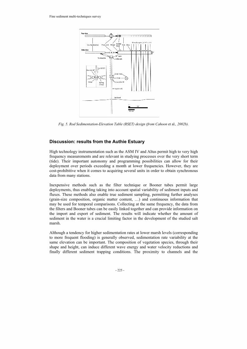
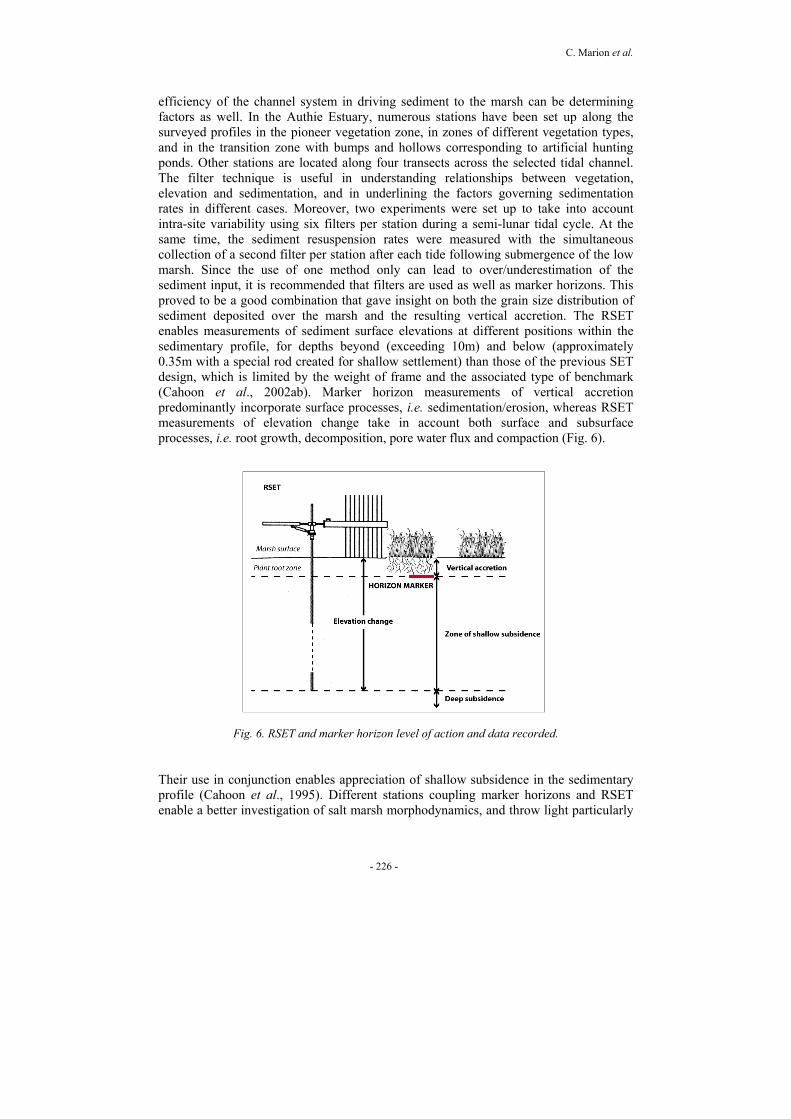
The Rod Surface-Elevation Table (RSET) is a non-intrusive method for precisely measuring elevation changes over long periods (Cahoon et al., 2002b) (Fig. 5). The central benchmark is a 15mm diameter stainless steel rod cut into 1.2m sections that are driven successively into the substrate up to the substrate resistance limits, with a 30-60cm section of the rod extending above the sediment surface to enable the RSET attachment. When fixed, the RSET provides a constant reference plane in space from which the distance to the sediment surface can be measured by means of pins lowered on the sediment surface. Repeated measurements of elevation can be made with high precision because the orientation of the table in space remains fixed for each sampling comprising nine measures. In addition, repeated sampling of eight fixed positions around the rod can be accomplished by the rod collar coupling the device, allowing for replicated measurement at the same station. Under field conditions, confidence intervals for the measured heights of an individual pin range from +/- 1.3mm to 4.3mm in a salt marsh (Cahoon et al., 2002b). Data provided by the RSET are essential for long term monitoring, necessary for medium term surveys, but can be equally interesting for recording the effects of short time-scale events.
Fine sediment multi-techniques survey
- 225 -
Fig. 5. Rod Sedimentation-Elevation Table (RSET) design (from Cahoon et al., 2002b).
Discussion: results from the Authie Estuary
High technology instrumentation such as the ASM IV and Altus permit high to very high frequency measurements and are relevant in studying processes over the very short term (tide). Their important autonomy and programming possibilities can allow for their deployment over periods exceeding a month at lower frequencies. However, they are cost-prohibitive when it comes to acquiring several units in order to obtain synchronous data from many stations. Inexpensive methods such as the filter technique or Booner tubes permit large deployments, thus enabling taking into account spatial variability of sediment inputs and fluxes. These methods also enable true sediment sampling, permitting further analyses (grain-size composition, organic matter content, …) and continuous information that may be used for temporal comparisons. Collecting at the same frequency, the data from the filters and Booner tubes can be easily linked together and can provide information on the import and export of sediment. The results will indicate whether the amount of sediment in the water is a crucial limiting factor in the development of the studied salt marsh. Although a tendency for higher sedimentation rates at lower marsh levels (corresponding to more frequent flooding) is generally observed, sedimentation rate variability at the same elevation can be important. The composition of vegetation species, through their shape and height, can induce different wave energy and water velocity reductions and finally different sediment trapping conditions. The proximity to channels and the
C. Marion et al.
- 226 -
efficiency of the channel system in driving sediment to the marsh can be determining factors as well. In the Authie Estuary, numerous stations have been set up along the surveyed profiles in the pioneer vegetation zone, in zones of different vegetation types, and in the transition zone with bumps and hollows corresponding to artificial hunting ponds. Other stations are located along four transects across the selected tidal channel. The filter technique is useful in understanding relationships between vegetation, elevation and sedimentation, and in underlining the factors governing sedimentation rates in different cases. Moreover, two experiments were set up to take into account intra-site variability using six filters per station during a semi-lunar tidal cycle. At the same time, the sediment resuspension rates were measured with the simultaneous collection of a second filter per station after each tide following submergence of the low marsh. Since the use of one method only can lead to over/underestimation of the sediment input, it is recommended that filters are used as well as marker horizons. This proved to be a good combination that gave insight on both the grain size distribution of sediment deposited over the marsh and the resulting vertical accretion. The RSET enables measurements of sediment surface elevations at different positions within the sedimentary profile, for depths beyond (exceeding 10m) and below (approximately 0.35m with a special rod created for shallow settlement) than those of the previous SET design, which is limited by the weight of frame and the associated type of benchmark (Cahoon et al., 2002ab). Marker horizon measurements of vertical accretion predominantly incorporate surface processes, i.e. sedimentation/erosion, whereas RSET measurements of elevation change take in account both surface and subsurface processes, i.e. root growth, decomposition, pore water flux and compaction (Fig. 6).
Fig. 6. RSET and marker horizon level of action and data recorded.
Their use in conjunction enables appreciation of shallow subsidence in the sedimentary profile (Cahoon et al., 1995). Different stations coupling marker horizons and RSET enable a better investigation of salt marsh morphodynamics, and throw light particularly
Fine sediment multi-techniques survey
- 227 -
on the interactions between sedimentation and vegetation, as well as the principal factors responsible for salt marsh elevation (biological, hydrological or geological processes).
Conclusion
There are several methods for determining sedimentation rates and patterns in estuaries at various time scales. The methods presented in this paper enable continuous and discontinuous measurement of sediment transport and deposition at different frequencies. A few examples involving the crossing of methods have shown the pertinence of multitechnique surveys to better understand the processes in action. Special attention is required for instrument calibration and field deployment, notably to ensure the representative character of the measurements (replicates). These different approaches enable monitoring of the temporal and spatial variations in fine sedimentation rates and patterns inside a macrotidal estuarine system that will eventually allow for the calculation of a realistic sediment budget based on a large data bank.
Acknowledgements
This work was supported by a Contrat de Plan Etat-Région (CPER) programme funded by the Nord Pas-de-Calais Regional Council, the French Government and the ERDF programme. Further financial support was provided by the INTERREG III project RIMEW (Rives-Manche Estuarine Watch). The authors wish to thank Dr. D.R. Cahoon (US Geological Survey) for the RSET design, Micrel S.A. for the Altus conception, Dr A. Jigorel (INSA Rennes, France) for the filter technique, Dr. J. Taylor, Dr. A.B. Cundy and R. Charman (Sussex University, UK) for the Booner tube design, and finally Mr Joerg Gutkuhn (Argus, Germany) and M.B. Gilpin (Greenwich University, UK) for the work on ASM IV, especially on calibration.
References
Allen J.R.L. 2000. Morphodynamics of Holocene salt marshes: a review sketch from the Atlantic and Southern North Sea coats of Europe. Quaternary Science Review 19:1155-1231.
Anthony E.J. and C. Dobroniak. 2000. Erosion and recycling of aeolian dunes in a rapidly infilling macrotidal estuary: the Authie, Picardy, northern France. In: Coastal and Estuarine Environments: Sedimentology, Geomorphology and Geoarchaeology. Pye K. and J.R.L. Allen (Eds). Geological Society, London, Special Publications, 175:109-121.
Cahoon D.R., J.C. Lynch, P. Hensel, R. Boumans, B.C. Perez, B. Segura and J.W. Day, Jr. 2002a. High-precision measurements of wetland sediment elevation: I. Recent improvements to the Sedimentation-Elevation Table. Journal of Sedimentary Research 72(5):730-733.

C. Marion et al.
- 228 -
Cahoon D.R., J. C. Lynch, B.C. Perez, B. Segura, R.D Holland, C. Stelly, G. Stephenson and P. Hensel. 2002b. High-precision measurements of wetland sediment elevation. II. The Rod Surface Elevation Table. Journal of Sedimentary Research 72(5):734-739.
Cahoon D.R., D.J. Reed and J.W. Day, Jr. 1995. Estimating shallow subsidence in microtidal salt marshes of the southeastern United States: Kaye and Barghoorn revisited. Marine Geology 128:1 –9.
Cahoon D.R. and R.E. Turner. 1989. Accretion and canal impacts in a rapidly subsiding wetland: II. Feldspar marker horizon technique. Estuaries 12:260–268.
Charman R. 2004. The use of shore-based sediment traps (Booner tubes) in estuarine waters: an example from the Ouse Estuary, East Sussex, UK. p.36-38. In: Proceedings Int. Workshop HWK Delmenhorst 15-18 April 2004 - From Particle Size to Sediment Dynamics. Book of abstracts.
Dobroniak C. 2000. Géomorphologie, hydrodynamique et écologie d’un estuaire tempéré macrotidal : l’Authie, Manche Orientale, France. Ph.D Dissertation, Univ. Littoral - Côte d’Opale. 308p.
Gilpin M.B. 2003. A snapshot of suspended sediment concentrations and fluxes using optical and acoustic velocity profilers, the Stour Estuary, Suffolk, UK. Report Argus Gesellschaft für Umweltmesstechnik MBH. 17p.
Jigorel A. 1996. Effects of environmental change on European saltmarshes. Environment Research Programme (1990-1994). Final Report 2:7-37.
Marion C., E.J. Anthony, A. Trentesaux and C. Dobroniak. 2003. Caractérisation des stocks sédimentaires superficiels de la rive nord de l’estuaire de l’Authie, Pas-de-Calais. Colloque International ‘Dynamique littoral Quaternaire’ et Journée Nationale des Jeunes Géomorphologues, Rennes, mars 2003. Livre des résumés.
Marion C., E.J. Anthony and A. Trentesaux. 2004a. Tidal influence on fine sedimentation in a macrotidal estuary: the Authie, northern France. p.130-133. In: Book of Abstracts. 6th International Conference on Tidal Sedimentation - Tidalites 2004, Copenhagen 2-5th August 2004, Denmark.
Marion C., M.B. Gilpin and E.J. Anthony. 2004b. A multi-sensor OBS for sediment transport study: Quantification of fluxes over a mudflat: the Authie Estuary, northern France. IAS 23th Conference, Coimbra 15-17th September 2004, Portugal. CD-Rom of abstracts.