Embed Size (px)
Citation preview
ARTICLE
Fine sediment storage in an eroding forest trail systemJonathan D. Phillips a, Daniel A. Mariona,b and Kathleen G. Kilcoynea
aEarth Surface Systems Program, Department of Geography, University of Kentucky, Lexington, KY, USA;bFormerly: Southern Research Station, USDA Forest Service, Hot Springs, AR, USA
ABSTRACTWe measured fine sediment accumulations (FSA) adjacent to erod-ing off-highway vehicle trails in Ouachita National Forest, Arkansas.Measured trailside FSA was 643 m3. Extrapolated to the entire trailnetwork, this amounts to 216 t ha−1 of trail surface, with a residencetime of <1 yr. Natural topographic features are the main storagesites, accounting for 83% of the total, and constructed features for16%. More than two thirds occur in channels indicates high sedi-ment connectivity. For all types of FSAs, the single largest depositaccounted for about 30% or more of the total. These hotspots arefound where topographically suitable storage sites occur down-slope of an area of above-average rates of, or recent, trail erosion.Because in many cases trail erosion occurs without evident gulliesor rills, these accumulation foci are effective ways to identify ero-sion hotspots. Relatively small amounts of fine sediment are storedin low-order stream channels. However, the low storage amounts(4,060 m3 estimated for all low-order streams) and lack of silt andclay indicate that fine sediments are highly mobile once reachingstreams. Overall, results indicate predominantly short-term storageof fine sediments and high connectivity with and rapid movementthrough the fluvial system.
ARTICLE HISTORYReceived 2 December 2019Accepted 27 February 2020
KEYWORDSFine sediment; sedimentstorage; ATV trails; trailerosion; connectivity
Introduction
Accelerated soil erosion (i.e. greater than background levels) is associated with bothonsite impacts such as land degradation and reduced biological productivity, and offsiteimpacts such as stream sedimentation and water pollution. Linking offsite impacts witherosion sources can be quite difficult, given that there is rarely a steady-state relationshipbetween soil loss on uplands and sediment supplied to streams (James, 2018). Betweenerosion source areas and stream channels (and within channels), there may be numeroussites where sediment is stored for various amounts of time. The purpose of this study is todocument the fate of fine sediment eroded from an off-highway vehicle trail system (WolfPen Gap Trail Complex, Ouachita National Forest, Arkansas). Studies of trail erosion andits geomorphic impacts on streams in the study area indicate extensive erosion, butlimited, localized impacts on streams and limited fine sediment in the main streamdraining the area (Marion et al., 2019, 2014; Phillips &Marion, 2019). Given the apparentdisconnect between trail erosion and stream sediment, we initiated this study to
CONTACT Jonathan D. Phillips [email protected]
PHYSICAL GEOGRAPHY2021, VOL. 42, NO. 1, 50–72https://doi.org/10.1080/02723646.2020.1743613
© 2020 Informa UK Limited, trading as Taylor & Francis Group
determine the fate of eroded fine sediments, in the context of sediment dynamics ofhillslopes and drainage basins.
Several studies in the 1960s and 1970s (reviewed byMeade, 1982;Walling, 1983) showedthat the concept of a direct linkage between an eroding field or hillslope and streams is notapplicable inmany cases. Time lags, and colluvial and alluvial sediment storage, create non-steady-state relationships between erosion and stream sediment loads, and sedimentdelivery ratios (erosion divided by fluvial sediment yield) substantially lower than 1.0. Bythe early 1980s reviews and syntheses of work on fluvial sediment budgets, sedimentdelivery ratios, and storage and fates of sediment erosion from uplands made it clear thatdirect “conveyor belt” connectivity and erosion/yield steady states are rare and transient,particularly in drainage basins experiencing accelerated anthropic erosion (Meade, 1982;Walling, 1983). Subsequent work, continuing to the present, has refined knowledge ofsediment storage and routing, and linked these ideas to broader concepts of hydrologicaland geomorphological connectivity (Bracken et al., 2015; Fryirs, 2013; James, 2018; Lisenby& Fryirs, 2017; Thompson et al., 2016). The most poorly understood aspects at present areslope-to-stream delivery, and sediment storage as colluvium and in low-order valleys(Baartman et al., 2013; Fu et al., 2010; James, 2018; Lecce et al., 2006; Merten et al., 2016;Royall & Kennedy, 2016; Slattery et al., 2002). This includes production and delivery ofsediment from unpaved roads (Fu et al., 2010) and sediment linkages within low-order,headwater drainage basins (Johnson et al., 2010; MacDonald & Coe, 2007).
We can identify two endpoint situations with respect to sediment connectivity betweenan eroding unpaved road or trail and a stream system (assuming the two are in the samewatershed and potentially hydrologically connected). One is complete disconnectivity,where the stream is completely buffered from the source area, and none of the erodedmaterialreaches it. At the other end of the continuum, all eroded sediment is delivereddirectly to the stream. Because erosion and transport are discontinuous and episodic,connectivity in part depends on the time scale involved. In this case, we are concernedwith an annual time scale–that is, upland erosion source areas and streams are consideredconnected if eroded material reaches the stream, on average, within a year. We alsoacknowledge that connectivity may vary considerably from one erosion and runoff eventto the next, and also according to the timing and sequence of events.
Previous research in the Wolf Pen Gap study area has established accelerated erosionand sediment production from a network of off-road vehicle trails (Marion et al., 2019),assessed sediment connectivity of individual erosion features to trails (Phillips & Marion,2020), and examined impacts on streams (Marion et al., 2014; Phillips & Marion, 2019).A key question emerging from this work is the fate (transport, storage, and sinks) of finesediment. The goal of this project is to document the fate of fine sediment eroded fromthe trail system between the eroding source areas and streams. This involves measuringsediment storage on hillslopes and in low-order valleys. The work is motivated by bothgeneral questions related to fluvial sediment budgets, and specific questions regarding thefate of eroded sediments in the study area.
It is beyond the scope of this paper to review the literature on erosion and slope tostream sediment delivery on forest roads and trails, but recent reviews and syntheses aregiven by Anderson and Lockaby (2011), Cambi et al. (2015), Marion andWimpey (2017),and Benda et al. (2019).
PHYSICAL GEOGRAPHY 51
The Wolf Pen Gap (WPG) Trail Complex in Ouachita National Forest, westernArkansas, is a network of unpaved forest roads and trails designated for off-highwayvehicle (OHV) use. The trail system has experienced extensive erosion and continues toproduce sediment. Despite this, there is limited evidence of fine sediment storage oraccumulations in main-valley streams within the Complex (Marion et al., 2014; Phillips& Marion, 2020). Localized erosion features such as rills, gullies, and washed-out wingditches associated with the trail system are typically strongly connected to channels, asindicated by tracing of flow indicators and sediment from the erosion source to nearbylow-order channels (Phillips & Marion, 2020).
Previous work
Marion et al. (2019) found that the WPG trails are all worn down to or near underlyingbedrock, with a mean soil truncation of about 40 cm since construction. The trail erosionrate was conservatively estimated 75 to 210 t ha−1 yr−1 (t = metric tons), depending onsediment availability. These rates are five orders of magnitude greater than those ofundisturbed forest (Marion et al., 2019). Underscoring the role of the trails as erodingsediment sources is the fact that limited evidence of erosion was observed in the mostlyforested area otherwise, and that sediment production from trails depends strongly ontrail width and construction method. Nearly 18 visible erosion features occur per km oftrail, with nearly 70% of them rated as having high to very-high connectivity to nearbydrainage ways (Phillips & Marion, 2020).
Before 2012, WPG trails commonly had ford-type crossings of stream channels. Thegeomorphic impacts of 15 such crossings were examined by Marion et al. (2014).Channel effects included increased mud coatings on gravel and cobble particles in thestreams downstream of the crossings (10 sites), and in-channel sediment accumulationsat six sites. However, observable effects extended only about 200 m or less downstreamfrom the trail crossings.
Fourteen geomorphically active reaches of the channel of Board Camp Creek (themain stream draining the WPG complex) examined by Phillips and Marion (2019)showed significant alluvial accumulations in the form of point, lateral, or mid-channelbars. Ten of the reaches exhibited net sediment storage, but alluvium was dominated bymedium to large gravel and cobble material. Finer (<8 mm diameter) sediment erodedfrom the trail system is apparently not accumulating in the creek, suggesting that it iseither transported efficiently through the channel system, and/or that significant quan-tities of fine sediment are sequestered before reaching Board Camp Creek (Phillips &Marion, 2019). The latter finding was a major motivation for the current study. Amongother issues, fine sediments are considered to have the greatest potential adverse impactson stream ecology (Wood & Armitage, 1997).
Study area
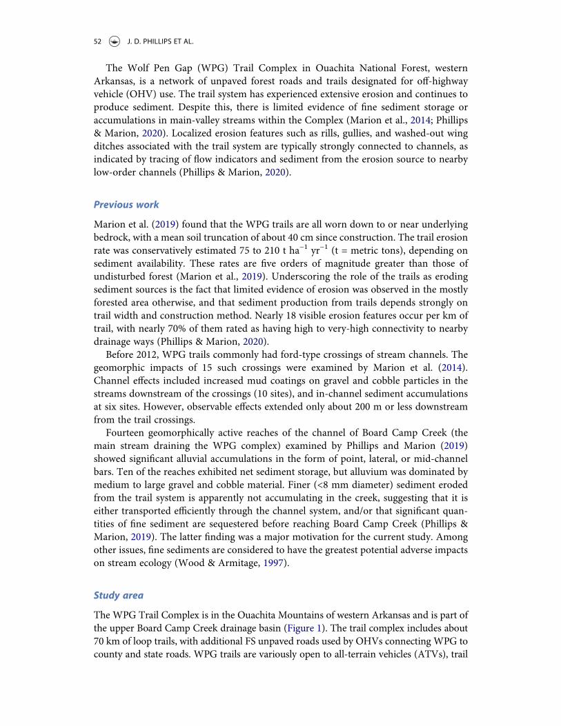
The WPG Trail Complex is in the Ouachita Mountains of western Arkansas and is part ofthe upper Board Camp Creek drainage basin (Figure 1). The trail complex includes about70 km of loop trails, with additional FS unpaved roads used by OHVs connecting WPG tocounty and state roads. WPG trails are variously open to all-terrain vehicles (ATVs), trail
52 J. D. PHILLIPS ET AL.
motorcycles, and four-wheel-drive or high ground clearance trucks and utility vehicles,referred to by the umbrella term off-highway vehicles. By far the most widely used areATVs (also called quads or four-wheelers and including UTVs or utility vehicles), and thetrails are referred to in Forest Service signage and literature as ATV trails.
Trails were comprised of existing unpaved Forest Service roads and former loggingroads when the trail complex was first opened in the early 1990s. Since then, trailsspecifically intended for ATV use have been constructed, and other trails have beenmodified to make them more appropriate for ATV use and to minimize erosion andsediment loss. All trails have unpaved, native surfaces (i.e. any construction or main-tenance has used on-site materials).
The WPG Trail Complex occurs within the Ouachita Mountains of western Arkansas,a landscape comprised of parallel ridges trending approximately east-west. Peak elevationsin the study area are generally 420 to 480 masl. The Ouachitas are geologically complex,composed of extensively tectonically deformed Paleozoic sedimentary rocks consisting ofinterbedded sandstones, shales, cherts, and novaculites. Steeply dipping and folded strataare common, as are numerous faults and related structures. Weathered bedrock is oftenexposed in eroded areas such as ridgelines and along unpaved roads and trails.
Soils are predominantly Typic Hapludults (US. Soil Taxonomy) on ridgetops and sideslopes, though some Dystrudepts are found in thin-soil areas. Paleudalfs are also foundon upland sites. Valley bottom soils are Typic Udifluvents or Ultic Hapludalfs (Olson,2003). Except in valley bottoms, soils are thin – mainly <1 m over weathered orunweathered bedrock, and rock outcrops are common. Virtually all soils have significantrock fragment content, with volumes of >30% rock fragments the norm, and volumes upto 70% or more possible. Soil textures range from sandy loam to clay, with the formeroccurring where weathered sandstone is the parent material, with clay to sandy clay loamtextures ubiquitous due to the shale content of nearly all parent materials (i.e. shale isinterbedded with all other underlying lithologies; Olson, 2003).
Figure 1. Study area map showing trail sections surveyed for fine sediment accumulations and streamsample sites.
PHYSICAL GEOGRAPHY 53
The climate is humid subtropical, with hot summers, relatively mild winters, and year-round precipitation. Mean annual precipitation in the WPG area is about 1350 mm,nearly all as rain. The WPG area is >99% forested. Trails, parking areas, and a fewscattered clearings are the only unvegetated areas.
Potential fine sediment storage sites
On steep hillslopes, unpaved roads and trails may represent topographic terraces. Ifsignificant sediment is produced upslope, the trails themselves may be sites of netdeposition. This can be ruled out at WPG, except perhaps in isolated local situa-tions, due to lack of evidence of significant soil erosion other than from trailsurfaces, and the fact that essentially all trail surfaces are eroding or recently eroded(Marion et al., 2019).
Colluvial sediment can be stored on the downslope side of eroding trails in the form ofrill fans, colluvial or cumulic soils, and depositional berms. This is not a major storagecomponent in WPG, at least over timescales of interest. Little evidence of berms, cumulicsoils, or colluvial deposits is evident in the field, though local disturbance by trailconstruction and maintenance may obscure some evidence. Some rill fans exist, butthese nearly all have high or very high connectivity to fluvial channels, and any storage istherefore transient (Phillips & Marion, 2020).
Artificially constructed features do trap a significant amount of sediment at WPG.A program of trail improvements to reduce off-trail sediment export and potentialimpacts on streams was initiated in 2011 (Poff, 2012; Stinchfield et al., 2011). Theseimprovements include redesigning sections of the trail system and installing more than700 sediment traps. The traps vary in effectiveness, but in general measurements ofvolume accumulated over known time periods show that the traps collect substantialamounts of sediment, but would require maintenance every few years to continue tofunction effectively (Marion et al., 2019). Wing ditches (turnouts associated with waterbars) are intended as water control structures to improve road/trail drainage. Thesetypically accumulate eroded fine material, though in some cases they may transitionfrom storage to erosion sites as ditches overflow with sediment or previous deposits areeroded. Some of the trails, especially those that are part of the National Forest roadsystem, have parallel ditches that may accumulate sediments. These are insloped roadsand collect runoff that is usually conveyed under the road via culvert. However, theseare strongly connected to drainageways and may be considered transient storage(Phillips & Marion, 2020).
Sediment may also accumulate in unchannelled valleys (hollows or zero-ordervalleys), and in low-order stream channels. Based on the paucity of fine material inBoard Camp Creek and the localized nature of impacts at trail crossings of streams(Marion et al., 2014; Phillips & Marion, 2019) we did not expect much alluvialstorage in channels. However, we sampled such sites to confirm (or refute) thisexpectation.
54 J. D. PHILLIPS ET AL.
Methods
Trailside deposits
We assessed fine sediment accumulations (FSA) by measuring all detectable accumula-tion sites along a sampling of trails. 26.3 km of trail was traversed on foot and by OHV torepresent the variety of topographic settings and trail types, ages, and usages in the WPGarea. Pilot studies confirmed that FSA can be visually identified in the field. This is basedon sediments that are unconsolidated and show no evidence of significant pedogenicdevelopment, such as soil structural aggregates, horizonation, clay or other illuvialaccumulations, or redoximorphic features. Vegetation establishment is quite rapid inthe humid subtropical climate of the study area, as is the onset of pedogenesis, so theabsence of pedogenic development or vegetation cover is strong evidence of recentdeposition. Some fine sediment deposits may occur in very thin (<2 mm) thick layersunderneath leaf litter. We did not include these in our assessment.
Our original concern was with clay, silt, and sand fractions (<2 mm diameter).However, these are so commonly and thoroughly intermixed with small gravel (in thiscase 2–8 mm diameter), that to facilitate extensive sampling we used a working definitionof fine sediment as clay, silt, and sand, and 2–8 mm diameter gravel, if mixed with <2 mmmaterial. In the Wentworth particle size classification system, clay particles havea diameter of <0.002 mm, silt is 0.002 to 0.0625 mm, and sand 0.0625 to 2 mm. Thefinest gravel (granule) category is 2–4 mm, and 8 mm is the upper limit of the fine pebblecategory.
Sampling of sites other than fluvial channels was restricted to sites where the sedimentcan be attributed to erosion from the trail. In the sampled areas we examined allunvegetated or minimally vegetated surfaces in the following settings:
● Low-order stream channels (referred to hereafter as small streams) adjacent to orcrossed by trails. Crossings of these smaller streams are either ford-type crossingsthat are dry except in wet weather, or small pipe or culvert crossings.
● Unchannelled headwater valleys and hollows.● Local topographic depressions.● Surficial deposits associated with water and sediment control structures (e.g. wingditches, sediment traps).
Thickness of fine sediment was measured by manually probing or excavating theunconsolidated material to underlying soil or bedrock. Depending on the specific sitecharacteristics this was accomplished with soil probes, steel rods (rebar) hammered tobedrock or cohesive soil, or shallow trowel excavation. In small-stream channels, thechannel boundaries are bedrock or cohesive materials that provide a clear demarcationbetween FSA and other materials. Cohesive soil or bedrock also constitutes the under-lying surface in some of the other depositional settings, but sometimes buried soilA-horizons or organic layers are underneath the deposits. Depth of the FSA wasmeasured using a folding ruler, to the nearest cm. If a thin cover of FSA was evidentbut too thin to reliably measure, this was recorded as “veneer.”
The surface area of the FSA was surveyed using a laser level and prism, survey tape, orfolding ruler, depending on the size of the feature. Accumulation area was calculated
PHYSICAL GEOGRAPHY 55
using length times mean width, with the number of width measurements increasing withthe length and complexity of the accumulation. Mean depth of FSA was based on at leastfive measurements, with at least one depth measurement per square meter of surface areafor larger deposits.
The location of each FSA feature at its closest point to the trail was recorded usingGPS. The longitudinal slope along the thalweg of selected ephemeral and small-streamFSAs was surveyed using the laser level and prism.
These methods are conservative and results should be taken as minimum estimates.They do not include deposits that might not be visually evident, or older colluviumobscured by vegetation or soil development.
Stream channel deposits
A stratified random selection of potential sample locations was based on landformassociations and channel types. Three landform associations occur within the studyarea. Valley side slopes and ridges (VSR) encompass the ridgelines and side slopes ofprimary and secondary valleys. Ridgelines are narrow, slope lengths are long, with typicalridgetop-to-valley bottom distances of 400 to 500 m, though the slope gradients andcurvatures are typically quite variable. Relief is relatively high; typically 120–215 m. Thebenchlands and ridge saddles (BRS) unit occurs at middle elevations, predominantly onnorth-facing slopes. Terrain consists of gently to moderately sloping, broken or knobbyterrain. Predominant local peak to saddle slope lengths are short to moderate (<50 to300 m). External relief is moderate and internal relief is low to moderate. Valley bottoms(VB) occur at the lowest elevations within primary valleys. Terrain consists of activechannel areas, flood plains or terraces (if present), or lower footslopes. Slope lengths aredominated by local microtopographic features and are thus short to very short (<50 m)and relief is low.
The channel network to be classified was derived from one developed by Guarneri(2013). Guarneri (2013) found that using an inverse distance weighted interpolation of10-m digital elevation model data to produce a 5-m model, and a constant mean flowaccumulation of 4 ha produced the most accurate predictions of channel initiationlocations. The digital network derived from these points was then edited using ArcGISto correct minor errors (mostly segment gaps) and remove first-order segments < 10 mlong which we deemed were too short to be confident of their existence. The derivationprocess did not capture some low-order channels that occur within the BRS and VBassociations. Low internal relief within these associations prevents these channels fromalways being detected in the digital modelling, while heavy canopy cover and narrowwidths hide them during aerial imagery inspection. These excluded channels weresampled as part of the trailside FSA sampling.
Channels were classified into seven categories. Three (Lower Valley 1, LV2, LV3) areconfined to VB settings along Board Camp Creek, with estimates of fine sediments basedon alluvial soil mapping and main channel field surveys. UV1 and UV2 channels(UV = upper valley) occur within BRS and VB associations. UV1 streams typically donot have depositional features visible on aerial imagery within the channel. Low sinuosityindicates the channel is confined and the channel generally fills the valley bottom. Thechannel adjacent slopes are generally short but can be moderate to long where channel
56 J. D. PHILLIPS ET AL.
occurs at the boundary between BRS and VSR. The UV2 type is confined within narrowvalley trenches but exhibits meandering within these boundaries. Small depositionalfeatures (bars) are visible but very limited in extent. UV1 and UV2 channels generallyhave drainage areas ≤3 or >3 km2, respectively.
H1 and H2 channel types are low-order headwater channels. Note that we refer tostream order only in relative terms, as we found that results obtained through “blue line”analysis of maps and GIS stream coverages and by digital elevation model analysesshowed results that differed by an average of two orders for any given channel segment.H1 and H2 channels occur in the VSR and BRS landform associations, and have nodeposition features visible on aerial imagery. H1 channels are steeper and have longer,steeper valley side slopes than H2.
Once the streams were classified, the total length of H1, H2, UV1, and UV2 channelswas determined and a stratified sampling scheme developed to represent their propor-tional presence in the study area. While some sampled reaches were a short distance up-or downstream of trail crossings, we avoided sampling channel segments immediatelyadjacent to trails to avoid possible effects of trail maintenance and construction offeatures such as trail-edge berms and culverted crossings.
In all sampled H1, H2, UV1 and UV2 channels, the longitudinal profile was surveyedusing a hand level and stadia rod. Banktop channel widths were measured at thebeginning and end of the study reach. Reach lengths were at least 20 times width at thestarting point. These data were used with the Shields function to estimate the thresholdshear stress to entrain an 8 mm diameter particle.
τc ¼ Kg ρs " ρw! "
D (1)
where is the critical or threshold shear stress, g is the gravity constant, ρs, ρw are thedensities of sediment and water, respectively (taken to be 2.65 and 1.00 g cm−3), and D isparticle diameter (mm). The value of the constant k is 0.03, the value recommended forsteep cobble-bed streams (Jarrett, 1990).
This yields a value of τc = 3.88 N m−2. Then, the mean boundary shear stressin Equation (2) was solved for R (hydraulic radius, assumed to be approximately equalto mean depth) to determine the depth required to entrain particles ≤8 mm for the rangeof S (slope) values measured in the field.
τ ¼ ρw g RS (2)
Widths were also measured at the transition between hydraulic units identified in thefield (riffles, pools, runs). In the smaller channels (H1, H2) the area of each unit wasdetermined (length X width), and FSA was measured as described for trailside accumula-tions above. At least six measurements per unit were taken, including measurements ofzero where no fine sediment occurred. These were averaged to determine a mean depthfor each unit. This sampling detail was not feasible in the larger (UV1, UV2) channels.There, each width measurement site was treated as a transect sample. For each area ofFSA encountered along the transect, depth (or the mean depth of several samples forlarger accumulations) was measured, along with its associated length along the widthtransect. This information was extrapolated using the area of the hydraulic units todetermine total fine sediment storage for each unit.
PHYSICAL GEOGRAPHY 57
To better describe the grain-size composition of FSAs within small channels, substratesamples from four sites were collected and analyzed. Bulk samples of 150–250 g wereexcavated from measured FSA deposits by digging vertically about 10 cm with a handtrowel. Each sample was oven-dried and analyzed using a half-phi sieve stack andstandard gravimetric procedures.
In each sampled reach the maximum mobile clast size was measured as a potentialindex of stream competence. Two were selected, one each from the up and downstreamhalf of the reach. These were stones completely within the channel, with no mud coats,moss or biofilms, and not embedded in or interlocked with other material. The mediandiameters were measured in the field.
Tests for significant differences among stream types were based on unpaired t-tests,with α = 0.05.
FSA in larger streams
Fifteen ford-type OHV trail crossings of streams were examined by Marion et al. (2014) toassess geomorphic impacts and to compare reaches up- and downstream of the crossings.Results and field notes from these sites were reexamined with respect to fine sedimentstorage in the channels. While quantitative measurements of sediment accumulation werenot systematically made at all sites, at a minimum, the presence of any fine sedimentdeposits, and mud coatings on rock fragments and exposed bedrock were noted.
Sediment storage and channel erosion in the highest order, main channel in the studyarea (Board Camp Creek) was assessed in 14 representative, geomorphically active reachesby Phillips and Marion (2019). Here, in-channel sediment storage is dominated by coarse(gravel to boulder) sediment, but field notes and results were reassessed with respect toevidence of storage (or remobilization by bank erosion) of stored fine sediments.
Floodplain sediment storage
Because our primary concern was fine sediment storage between trail erosion sites andstreams, and due to practical constraints, we did not attempt field measurements of recentFSA on stream floodplains. However, to determine whether substantial amounts of finesediment are sequestered in floodplains, and to get at least a broad general perspective ofthis component of fine sediment storage in the Board Camp Creek watershed, we estimatedfloodplain fine sediments in alluvial soils. Because alluvial soils accumulate over longerperiods and include material that predates the trail system, these estimates are not directlycomparable to our field measurements but are presented for completeness.
Floodplains are not extensive on the smaller streams in WPG and are discontinuouson the larger streams. Soil survey data were used to estimate floodplain sediment storageusing the US. Department of Agriculture’s Web Soil Survey (WSS; https://websoilsurvey.sc.egov.usda.gov/App/HomePage.htm). The WSS data for the WPG are based on the SoilSurvey of Polk County, Arkansas (Olson, 2003).
Area of alluvial floodplain soils was determined using the map data, and modalthickness and fine sediment proportion using soil attribute data, soil profile descriptions(Olson, 2003), and our own measurements of bank exposures of alluvial soils. Most of
58 J. D. PHILLIPS ET AL.
this area occurs along Board Camp Creek, but small patches along other streams werealso included in the alluvial storage estimates.
There exist scattered locations where recent floodplain deposition is clearly attribu-table to the trail system (Phillips & Marion, 2019), but much of this material is older.
Mud coats
Some fine sediment exists as muddy coatings on cobbles and boulders and bedrock exposedin the channel. To get a general idea of whether this is significant as a source of fine sedimentstorage (as opposed to an indicator of sediment transport and deposition dynamics andrelated flow dynamics) we sampled three sites and analyzed a total of five samples. While notrare throughout the study area, the abundance and thickness of mud coats at the sampledsites (by visual assessment) all appeared considerably muddier than typical.
The mass of mud coats (all in the silt and clay size ranges) was determined by carefullywashing all surface sediment into a clean, tared crucible. Excess water was removed byoven drying at 103°C until all water was evaporated. Organic matter was removed byignition in a muffle furnace (600°C for 6 hours). Sediment was weighed to the nearest0.01 g using a calibrated scale.
Surface area of each clast was determined bymeasuring the plan dimensions of a sheet ofpaper to the nearest 0.1 mm, and then weighing to the nearest 0.01 g. Mass/area was thencomputed for the measured sheet. The coated surface area of each sample clast was thentightly wrapped in an identical sheet of paper, trimming away all excess paper and ensuringno overlaps in coverage. The trimmed paper was then weighed, and the computed areadetermined based on (mass of trimmed paper)/(mass/area of measured sheet).
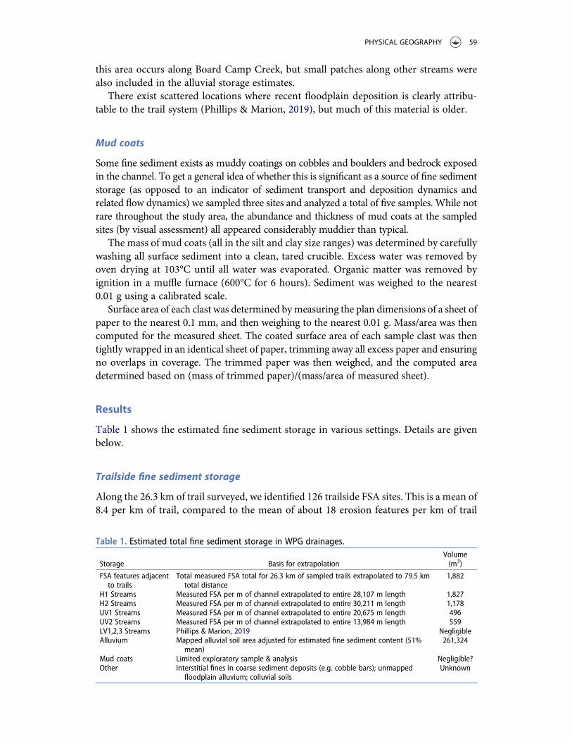
Results
Table 1 shows the estimated fine sediment storage in various settings. Details are givenbelow.
Trailside fine sediment storage
Along the 26.3 km of trail surveyed, we identified 126 trailside FSA sites. This is a mean of8.4 per km of trail, compared to the mean of about 18 erosion features per km of trail
Table 1. Estimated total fine sediment storage in WPG drainages.
Storage Basis for extrapolationVolume(m3)
FSA features adjacentto trails
Total measured FSA total for 26.3 km of sampled trails extrapolated to 79.5 kmtotal distance
1,882
H1 Streams Measured FSA per m of channel extrapolated to entire 28,107 m length 1,827H2 Streams Measured FSA per m of channel extrapolated to entire 30,211 m length 1,178UV1 Streams Measured FSA per m of channel extrapolated to entire 20,675 m length 496UV2 Streams Measured FSA per m of channel extrapolated to entire 13,984 m length 559LV1,2,3 Streams Phillips & Marion, 2019 NegligibleAlluvium Mapped alluvial soil area adjusted for estimated fine sediment content (51%
mean)261,324
Mud coats Limited exploratory sample & analysis Negligible?Other Interstitial fines in coarse sediment deposits (e.g. cobble bars); unmapped
floodplain alluvium; colluvial soilsUnknown
PHYSICAL GEOGRAPHY 59
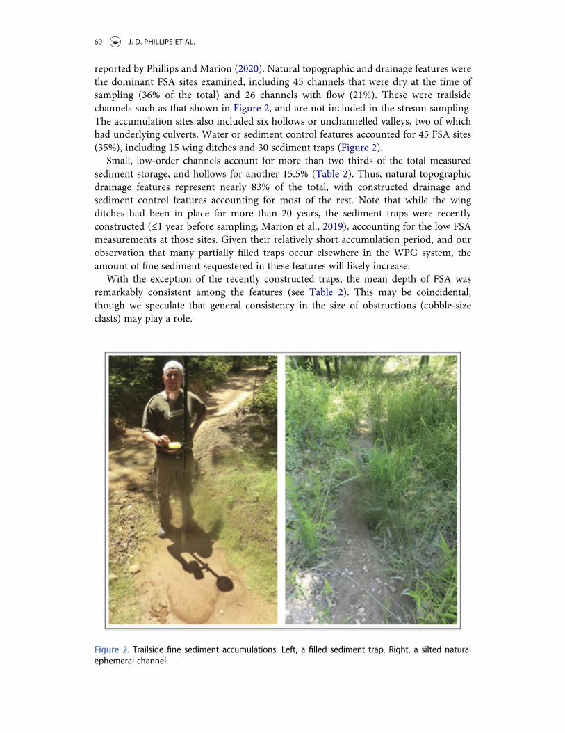
reported by Phillips and Marion (2020). Natural topographic and drainage features werethe dominant FSA sites examined, including 45 channels that were dry at the time ofsampling (36% of the total) and 26 channels with flow (21%). These were trailsidechannels such as that shown in Figure 2, and are not included in the stream sampling.The accumulation sites also included six hollows or unchannelled valleys, two of whichhad underlying culverts. Water or sediment control features accounted for 45 FSA sites(35%), including 15 wing ditches and 30 sediment traps (Figure 2).
Small, low-order channels account for more than two thirds of the total measuredsediment storage, and hollows for another 15.5% (Table 2). Thus, natural topographicdrainage features represent nearly 83% of the total, with constructed drainage andsediment control features accounting for most of the rest. Note that while the wingditches had been in place for more than 20 years, the sediment traps were recentlyconstructed (≤1 year before sampling; Marion et al., 2019), accounting for the low FSAmeasurements at those sites. Given their relatively short accumulation period, and ourobservation that many partially filled traps occur elsewhere in the WPG system, theamount of fine sediment sequestered in these features will likely increase.
With the exception of the recently constructed traps, the mean depth of FSA wasremarkably consistent among the features (see Table 2). This may be coincidental,though we speculate that general consistency in the size of obstructions (cobble-sizeclasts) may play a role.
Figure 2. Trailside fine sediment accumulations. Left, a filled sediment trap. Right, a silted naturalephemeral channel.
60 J. D. PHILLIPS ET AL.
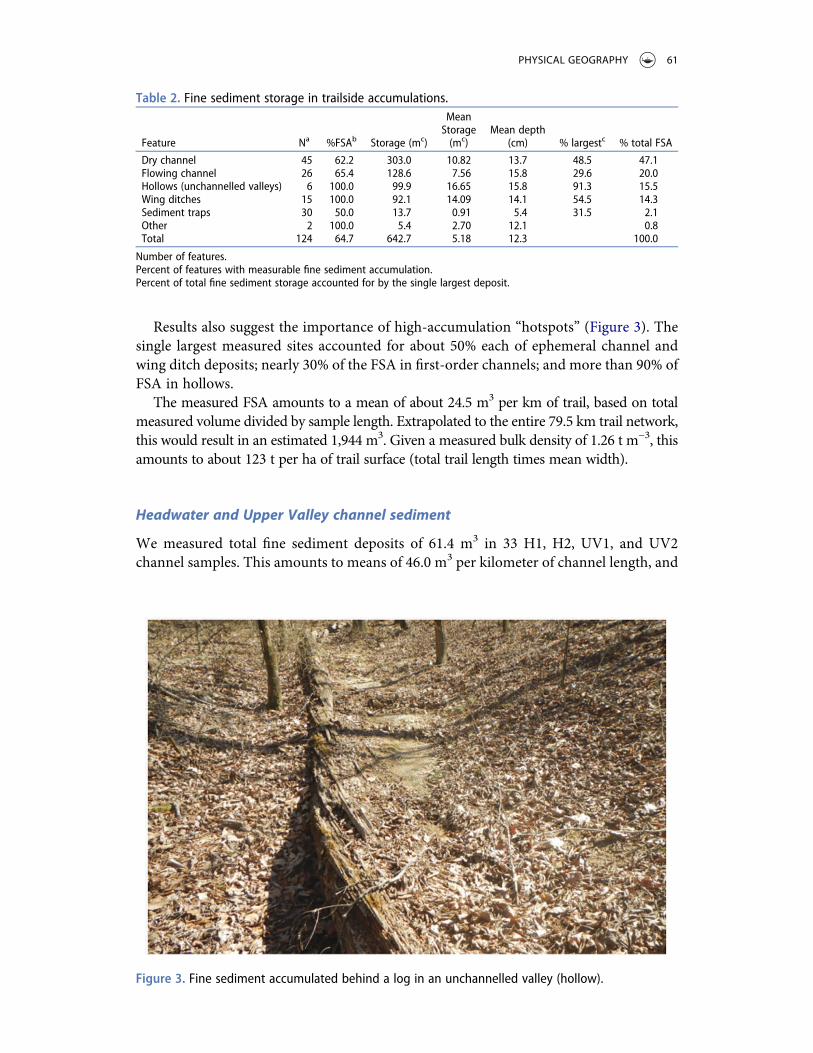
Results also suggest the importance of high-accumulation “hotspots” (Figure 3). Thesingle largest measured sites accounted for about 50% each of ephemeral channel andwing ditch deposits; nearly 30% of the FSA in first-order channels; and more than 90% ofFSA in hollows.
The measured FSA amounts to a mean of about 24.5 m3 per km of trail, based on totalmeasured volume divided by sample length. Extrapolated to the entire 79.5 km trail network,this would result in an estimated 1,944 m3. Given a measured bulk density of 1.26 t m−3, thisamounts to about 123 t per ha of trail surface (total trail length times mean width).
Headwater and Upper Valley channel sediment
We measured total fine sediment deposits of 61.4 m3 in 33 H1, H2, UV1, and UV2channel samples. This amounts to means of 46.0 m3 per kilometer of channel length, and
Table 2. Fine sediment storage in trailside accumulations.
Feature Na %FSAb Storage (mc)
MeanStorage(mc)
Mean depth(cm) % largestc % total FSA
Dry channel 45 62.2 303.0 10.82 13.7 48.5 47.1Flowing channel 26 65.4 128.6 7.56 15.8 29.6 20.0Hollows (unchannelled valleys) 6 100.0 99.9 16.65 15.8 91.3 15.5Wing ditches 15 100.0 92.1 14.09 14.1 54.5 14.3Sediment traps 30 50.0 13.7 0.91 5.4 31.5 2.1Other 2 100.0 5.4 2.70 12.1 0.8Total 124 64.7 642.7 5.18 12.3 100.0
Number of features.Percent of features with measurable fine sediment accumulation.Percent of total fine sediment storage accounted for by the single largest deposit.
Figure 3. Fine sediment accumulated behind a log in an unchannelled valley (hollow).
PHYSICAL GEOGRAPHY 61

0.030 m3 per m2 of channel bed area, equating to a mean depth of <3 cm. FSA examplesfor these channel types are shown in Figure 4.
Table 3 compares sample sites potentially subject to runoff and sediment input fromtrails to those with no trail effects. As expected, more fine sediment is found in trail-influenced reaches. However, the differences are not statistically significant according tot-tests. This includes a test using only H1, H2 channel types, as all but one UV site hadtrail effects. FSA per unit bed area suggests an accumulation of 2 to 3 cm if spread evenly.However, measurements show that FSA is highly concentrated both within and betweenpatches or sub-reaches.
Comparisons among low-order stream types (Table 4) might suggest some differencesbetween channel types, but none of the differences among the four types (separately oraggregated) is statistically significant.
Sediment mobility
The maximum mobile clasts ranged from 22 to 320 mm in diameter, with an overallmean of 173 mm. Table 5 shows comparisons between trail-impacted and non-impactedsites, and among stream types. No statistically significant differences exist between those
Figure 4. FSA examples in sampled headwater streams. On left, a typical reach with very little FSA. Onright, a localized accumulation behind coarse woody debris.
Table 3. Fine sediment storage in low-order channels (meanvalues; standard deviations in parentheses).
No trail effects(n = 12)
Trail effects(n = 21)
FSA volume (m3) 1.21 (0.99) 2.23 (2.41)Vol./km channel length 32.0 (25.0) 55.0 (68.0)Vol./m2 channel bed 0.021 (0.014) 0.036 (0.048)
62 J. D. PHILLIPS ET AL.
sites potentially impacted by trails and those not. The values are higher in UV1 and UV2as compared to H1 and H2 channels, with the difference statistically significant.
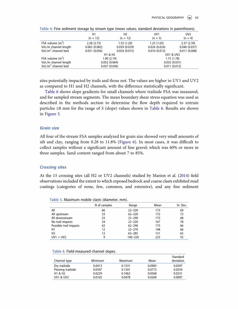
Table 6 shows slope gradients for small channels where trailside FSA was measured,and for sampled stream segments. The mean boundary shear stress equation was used asdescribed in the methods section to determine the flow depth required to entrainparticles ≤8 mm for the range of S (slope) values shown in Table 6. Results are shownin Figure 5.
Grain size
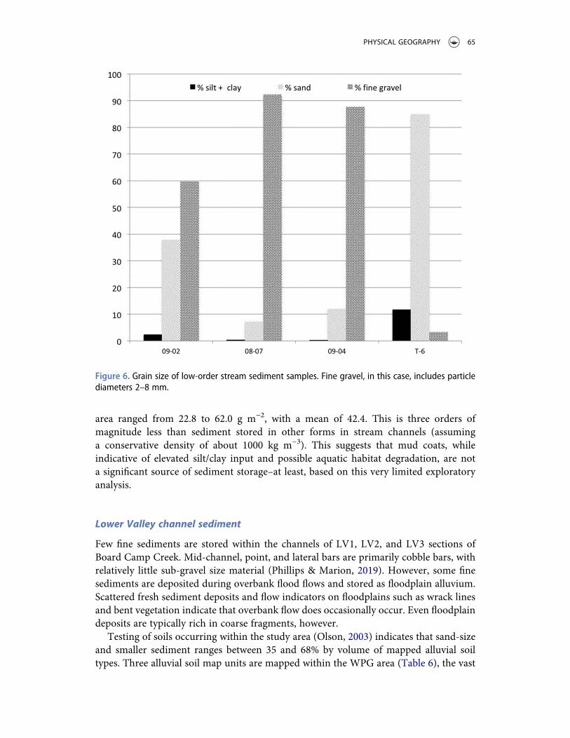
All four of the stream FSA samples analyzed for grain size showed very small amounts ofsilt and clay, ranging from 0.28 to 11.8% (Figure 6). In most cases, it was difficult tocollect samples without a significant amount of fine gravel; which was 60% or more inthree samples. Sand content ranged from about 7 to 85%.
Crossing sites
At the 15 crossing sites (all H2 or UV2 channels) studied by Marion et al. (2014) fieldobservations included the extent to which exposed bedrock and coarse clasts exhibitedmudcoatings (categories of none, few, common, and extensive), and any fine sediment
Table 4. Fine sediment storage by stream type (mean values; standard deviations in parentheses).H1
(n = 12)H2
(n = 12)UV1
(n = 5)UV2
(n = 4)FSA volume (m3) 2.28 (2.73) 1.53 (1.20) 1.25 (1.03) 2.37 (2.39)Vol./m channel length 0.065 (0.082) 0.039 (0.029) 0.024 (0.024) 0.040 (0.037)Vol./m2 channel bed 0.051 (0.056) 0.024 (0.015) 0.010 (0.013) 0.011 (0.008)
H1 & H2 UV1 & UV2FSA volume (m3) 1.90 (2.19) 1.75 (1.78)Vol./m channel length 0.052 (0.064) 0.032 (0.031)Vol./m2 channel bed 0.037 (0.036) 0.011 (0.012)
Table 5. Maximum mobile clasts (diameter, mm).N of samples Range Mean St. Dev.
All 66 22–320 173 69All upstream 33 62–320 172 72All downstream 33 22–290 173 68No trail impacts 24 22–320 167 78Possible trail impacts 42 62–290 175 66H1 12 22–270 148 66H2 12 62–285 151 65UV1 + UV2 9 140–320 223 55
Table 6. Field-measured channel slopes.
Channel type Minimum Maximum MeanStandarddeviation
Dry trailside 0.0413 0.1531 0.0983 0.0397Flowing trailside 0.0397 0.1341 0.0772 0.0334H1 & H2 0.0229 0.1062 0.0568 0.0231UV1 & UV2 0.0165 0.0478 0.0269 0.0097
PHYSICAL GEOGRAPHY 63
accumulations.Mud coats were present downstream of the trail crossing at all 15 sites; at allbut one site somemud coatings were also found upstream. However, as shown in Table 5 ofMarion et al. (2014), in some cases these were present only in pools or backwater areasupstream, and in many cases were more prevalent downstream of the crossings.
For the most part, other fine sediment deposits were absent, rare, or isolated. Threesites, however, had braided subreaches or sediment plugs. As Marion et al. (2014) noted,visible or measurable evidence of geomorphic impacts was generally confined to thevicinity of the crossing; at 200 m or greater, downstream impacts apparently attributableto the trail crossing were not visible.
Mud coats
The five sampled clasts were all in the coarse pebble category (45–64 mm mediandiameters). Surface areas ranged from 75.4 to 133.3 cm2. Mass of mud coats per unit
Table 7. Alluvial soils mapped in the study area (USDA Web Soil Survey). The range of percent fines istaken from the map unit descriptions in Olson (2003) and the official series descriptions.Map unit Area (ha) % Finesa
Ceda very cobbly fine sandy loam, 0% to 3% slopes frequently flooded 211.0 30 to 65 (35)Kenn gravelly fine sandy load, 0% to 3% slopes occasionally flooded 5.1 35 to 70 (68)Kenn-Ceda complex, 0% to 3% slopes, frequently flooded 150.5 30 to 65
Number in parentheses is percent fines (silt + clay sizes) calculated from profile description in the soil survey of PolkCounty, AR.
Figure 5. Minimum depth necessary to transport an 8 mm median diameter particle for the range ofslopes shown in Table 6.
64 J. D. PHILLIPS ET AL.
area ranged from 22.8 to 62.0 g m−2, with a mean of 42.4. This is three orders ofmagnitude less than sediment stored in other forms in stream channels (assuminga conservative density of about 1000 kg m−3). This suggests that mud coats, whileindicative of elevated silt/clay input and possible aquatic habitat degradation, are nota significant source of sediment storage–at least, based on this very limited exploratoryanalysis.
Lower Valley channel sediment
Few fine sediments are stored within the channels of LV1, LV2, and LV3 sections ofBoard Camp Creek. Mid-channel, point, and lateral bars are primarily cobble bars, withrelatively little sub-gravel size material (Phillips & Marion, 2019). However, some finesediments are deposited during overbank flood flows and stored as floodplain alluvium.Scattered fresh sediment deposits and flow indicators on floodplains such as wrack linesand bent vegetation indicate that overbank flow does occasionally occur. Even floodplaindeposits are typically rich in coarse fragments, however.
Testing of soils occurring within the study area (Olson, 2003) indicates that sand-sizeand smaller sediment ranges between 35 and 68% by volume of mapped alluvial soiltypes. Three alluvial soil map units are mapped within the WPG area (Table 6), the vast
Figure 6. Grain size of low-order stream sediment samples. Fine gravel, in this case, includes particlediameters 2–8 mm.
PHYSICAL GEOGRAPHY 65
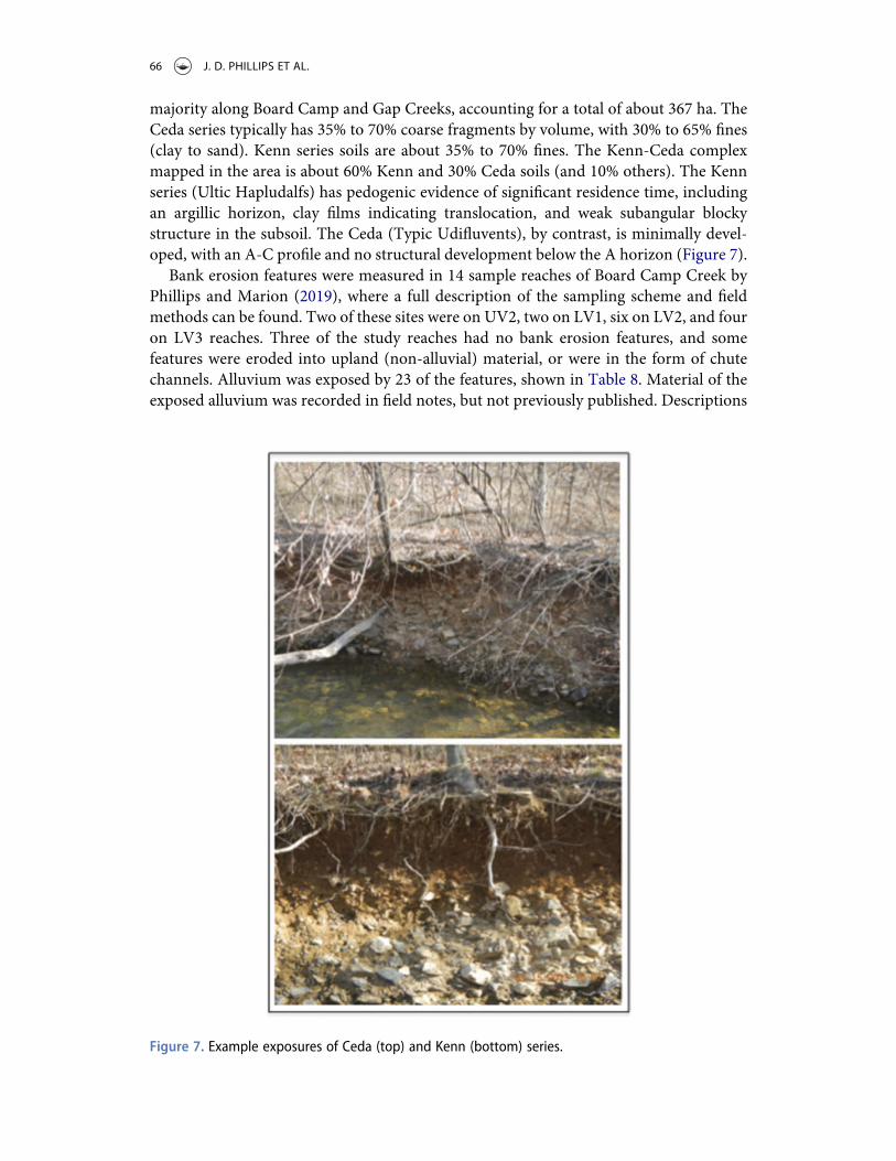
majority along Board Camp and Gap Creeks, accounting for a total of about 367 ha. TheCeda series typically has 35% to 70% coarse fragments by volume, with 30% to 65% fines(clay to sand). Kenn series soils are about 35% to 70% fines. The Kenn-Ceda complexmapped in the area is about 60% Kenn and 30% Ceda soils (and 10% others). The Kennseries (Ultic Hapludalfs) has pedogenic evidence of significant residence time, includingan argillic horizon, clay films indicating translocation, and weak subangular blockystructure in the subsoil. The Ceda (Typic Udifluvents), by contrast, is minimally devel-oped, with an A-C profile and no structural development below the A horizon (Figure 7).
Bank erosion features were measured in 14 sample reaches of Board Camp Creek byPhillips and Marion (2019), where a full description of the sampling scheme and fieldmethods can be found. Two of these sites were on UV2, two on LV1, six on LV2, and fouron LV3 reaches. Three of the study reaches had no bank erosion features, and somefeatures were eroded into upland (non-alluvial) material, or were in the form of chutechannels. Alluvium was exposed by 23 of the features, shown in Table 8. Material of theexposed alluvium was recorded in field notes, but not previously published. Descriptions
Figure 7. Example exposures of Ceda (top) and Kenn (bottom) series.
66 J. D. PHILLIPS ET AL.
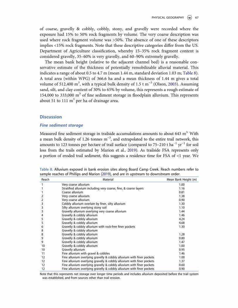
of coarse, gravelly & cobbly, cobbly, stony, and gravelly were recorded where theexposure had 15% to 50% rock fragments by volume. The very coarse description wasused where rock fragment volume was >50%. The absence of one of these descriptorsimplies <15% rock fragments. Note that these descriptive categories differ from the US.Department of Agriculture classification, whereby 15–35% rock fragment content isconsidered gravelly, 35–60% is very gravelly, and 60–90% extremely gravelly.
The mean bank height (relative to the adjacent channel bed) is a reasonable con-servative estimate of the thickness of potentially remobilizable alluvial material. Thisindicates a range of about 0.5 to 4.7 m (mean 1.44 m, standard deviation 1.03 m; Table 8).A total area (within WPG) of 366.6 ha and a mean thickness of 1.44 m gives a totalvolume of 512,400 m3, with a typical bulk density of 1.5 t m−3 (Olson, 2003). Assumingsand, silt, and clay content of 30% to 65% by volume, this represents a rough estimate of154,000 to 333,000 m3 of fine sediment storage in floodplain alluvium. This representsabout 51 to 111 m3 per ha of drainage area.
Discussion
Fine sediment storage
Measured fine sediment storage in trailside accumulations amounts to about 643 m3. Witha mean bulk density of 1.26 tonnes m−3, and extrapolated to the entire trail network, thisamounts to 123 tonnes per hectare of trail surface (compared to 75–210 t ha−1 yr−1 for soilloss from the trails estimated by Marion et al., 2019). As trailside FSA represents onlya portion of eroded trail sediment, this suggests a residence time for FSA of <1 year. We
Table 8. Alluvium exposed in bank erosion sites along Board Camp Creek. Reach numbers refer tosample reaches of Phillips and Marion (2019), and are in upstream to downstream order.Reach Material Mean Bank Height (m)
1 Very coarse alluvium 1.001 Stratified alluvium including very coarse, fine, & coarse layers 1.161 Coarse alluvium 0.812 Very coarse alluvium 1.382 Very coarse alluvium 0.903 Cobbly alluvium overlain by finer, silty alluvium 1.303 Silty alluvium overlying stony soil 1.103 Gravelly alluvium overlying very coarse alluvium 1.444 Gravelly & cobbly alluvium 1.465 Gravelly & cobbly alluvium 4.245 Gravelly & cobbly alluvium 4.686 Gravelly & cobbly alluvium with rock-free finer pockets 1.308 Gravelly & cobbly alluvium8 Gravelly & cobbly alluvium 1.289 Gravelly & cobbly alluvium 0.809 Gravelly & cobbly alluvium 1.4710 Gravelly & cobbly alluvium 1.0010 Gravelly alluvium 0.9511 Fine alluvium with gravel & cobbles 1.4612 Fine alluvium overlying gravelly & cobbly alluvium with finer pockets 1.0012 Fine alluvium overlying gravelly & cobbly alluvium with finer pockets 1.3712 Fine alluvium overlying gravelly & cobbly alluvium with finer pockets 0.6012 Fine alluvium overlying gravelly & cobbly alluvium with finer pockets 0.90
Note that this represents net storage over longer time periods and includes alluvium deposited before the trail systemwas established, and from sources other than trail erosion.
PHYSICAL GEOGRAPHY 67
only measured unvegetated FSA with no pedogenic development, and none of the excavatedsites contained buried plant litter. These field indicators are also indicative of short residencetimes of <1 year, as vegetation establishment is quite rapid in the humid subtropical climateand litterfall is significant in the forest setting. These observations, coupled with the highsediment connectivity of erosion features documented by Phillips andMarion (2020) suggestthat many of the FSAs are transitory, pass-through accumulations.
The potential mobility of the FSA material is illustrated by the steep channel slopes ofthe channel trailside FSAs, and of the sampled headwater and upper valley streams. Theslopes are such that mean flow depths of <25 mm (< 1 inch) are sufficient to transportsmall gravel particles, along with sand and silt. The transportability of gravel is supportedby the presence of mobile clasts in the sampled channels averaging about 150 mm inheadwater and 220 mm in upper valley channels.
Results with respect to trailside FSA may be contingent on when sampling occurred.Sampling for the sediment connectivity study was conducted in May 2012. This included14.9 km of trail that were also surveyed for FSA. Phillips and Marion (2020) recorded 156“overflowing wing ditches” and 36 “silted natural ephemeral channels” – features thatwould have been included in a trailside FSA survey. The former are wing ditches thatappeared to have filled with sediment, and had visually evident sediment being exportedfrom the feature. The latter were recorded where the channel upslope of the trail crossinghad no evident channel erosion or sediment accumulation, but downstream of the trailwere obvious recent deposits of trail-derived sediment. Even discounting the fact that anadditional 10 km of trail was sampled in 2012 as opposed to the FSA sampling inMarch 2014, and the different purposes and goals of the two studies, it appears thatvisually identifiable accumulations may have been less common in 2014. The Mena, ARweather station recorded 48 mm of precipitation 2 days before sampling began on18 March, making for wetter conditions than during the 2012 sampling, so recent runoffis unlikely to account for the difference. Use levels of the trails is a more likely explana-tion, as spring, in general, is a higher use period than winter (though no quantitative datafor either period are available).
Results point to the importance of natural topographic features as FSA sites. Channelsand hollows account for about 83% of the total, while wing ditches and sediment trapshad about 16% (though, as noted, sediment trap sequestration is likely to have increased).The fact that more than two thirds of the total occur in channels is consistent with thehigh sediment connectivity of erosion features and the fluvial system found by Phillipsand Marion (2020).
For all categories of fine sediment accumulations, the single largest deposit accountedfor about 30% or more of the total – 91% for hollows. These hotspots are found wherea topographically suitable storage site occurs downslope of an area of above-average ratesof, or recent, trail erosion. Because in many cases trail erosion occurs without evidentgullies or rills (underlying bedrock is exposed at or near the surface throughout the trailnetwork; Marion et al., 2019), this suggests that these accumulation hotspots are effectiveways to identify erosion hotspots.
Relatively small amounts of fine sediment are stored in low-order stream channels,with no conclusive evidence of greater volumes per unit of channel bed area in sitespotentially affected by ATV trails compared to those with no trail effects. The low storage
68 J. D. PHILLIPS ET AL.
amounts (4,060 m3 estimated for all low-order streams) and lack of silt and clay indicatethat fine sediments are generally highly mobile once reaching streams.
Mud coats on coarse clasts do not appear to be a large contributor to sediment storage,though additional data are needed to corroborate this. These coats are, however, anindicator of sites of potential adverse water and habitat quality impacts.
The total fine sediment storage in trailside accumulations and low-order streams,extrapolated to the entire study area, amounts to 5,942 m3 (Table 1). The total estimatedfine sediment in alluvial soils is nearly 44 times as much (about 261,000 m3), but cannotbe directly compared to the other measurements due to the longer time frame foraccumulation and generally unknown source. Nearly all the trailside FSA occurs indrainageways or in constructed features and can thus be considered highly mobile. Thesmall-stream accumulations are also highly mobile, as are deposits in the main channel(Phillips & Marion, 2019). The alluvial storage, by contrast, is mobilized only by bankerosion and occasional surface stripping during high flow events.
Fluvial sediment systems
Results of this study show significant amounts of fine sediment storage, amounting toa substantial portion of trail erosion. This supports the notion of non-steady-staterelationships (at the annual to decadal time scale most relevant to land use and manage-ment) between erosion and sediment yield, and significant storage and time lags in thedrainage basin sediment system. On the other hand, there is little evidence of long-termsediment storage or fine sediment sinks. Thus, while WPG does not fit a conveyor beltmetaphor, a somewhat intermittent, leaky conveyor belt would perhaps be appropriate.
With reference to the endpoint situations – direct delivery of eroded sediment tostreams vs. complete disconnectivity –WPG is closer to the former than the latter, at leastat the annual time scale. This likely reflects the linear nature of the eroding areas, andtheir frequent proximity to streams. GIS analysis shows 480 locations were trails intersectstream channels, and an additional 2.15 km of trail length where the trails are within15 m of channels. The intersections include channels of all sizes, and crossings includingbridges, culverts and arches, fords crossing perennial channels, and wet-weather fordsthat may often be dry. The number of actual crossings is uncertain due to the spatialresolution of the trail layer of the GIS, in areas where trails follow valley bottoms or alongthe upper edge of steep valley wells. However, any apparent crossings that were incor-rectly counted occur where trails are within a few meters of channels and do reflect sitesof very high trail-channel connectivity.
Conclusions
Fine sediment storage in trailside accumulations, extrapolated to the entire trail network,amounts to 123 tonnes per hectare of trail surface (compared to 75–210 t ha−1 yr−1 for soilloss from the trails). Because these FSAs are unvegetated, contain no litter deposits orpedogenic development, and represent only a portion of eroded trail sediment, thisindicates a residence time of <1 year. Many of the FSAs are transitory, pass-throughaccumulations.
PHYSICAL GEOGRAPHY 69
Natural topographic features – channels and hollows – are the most important deposi-tion sites, accounting for about 83% of the total (though, as noted, sediment trapsequestration is likely to have increased). More than two thirds of the total occur inchannels, indicating high sediment connectivity of erosion features and the fluvial system.Hotspots are also important, with the single largest deposit accounting for 30% to 90% ofthe total for all types of FSA. These accumulation foci are effective ways to identify erosionhotspots, as obvious erosion features such as rills or gullies are often absent.
Only small amounts of fine sediment are stored in stream channels, with limitedevidence of greater sequestration in sites potentially affected by ATV trails versus thosewith no trail effects. The low storage amounts (4,060 m3 estimated for all low-orderstreams) and lack of silt and clay indicate that fine sediments are generally highly mobileonce reaching streams. Overall, the fine sediments appear to be highly mobile and notsubject to long-term storage.
While the results of this study support the idea of non-steady-state relationshipsbetween erosion and sediment yield, there is little evidence of long-term sediment storageor fine sediment sinks occurring.
Acknowledgments
Prior to his retirement in May 2019, Marion worked as a Research Hydrologist for the USDAForest Service, Southern Research Station. Chad Yocum (now on the Prescott National Forest)provided key logistic support, and field data collection. We appreciate the cooperation andassistance of the Ouachita National Forest (ONF). Derek Law, Alex Rittle, and Li Chih Hsuprovided valuable field assistance.
Disclosure statement
No potential conflict of interest was reported by the authors.
Funding
This research was supported by the USDA Forest Service, National Stream and Aquatic EcologyCenter (agreement 09-CS-11132422-229).
ORCID
Jonathan D. Phillips http://orcid.org/0000-0003-0283-6023
References
Anderson, C. J., & Lockaby, B. G. (2011). The effectiveness of forestry best management practicesfor sediment control in the southeastern United States: A literature review. Southern Journal ofApplied Forestry, 35(4), 170–177. https://doi.org/10.1093/sjaf/35.4.170
Baartman, J. E. M., Masselink, R., Keesstra, S. D., & Temme, A. J. A. M. (2013). Linking landscapemorphological complexity and sediment connectivity. Earth Surface Processes and Landforms,38(12), 1457–1471. https://doi.org/10.1002/esp.3434
70 J. D. PHILLIPS ET AL.
Benda, L., James, C., Miller, D., & Andras, K. (2019). Road erosion and delivery index (READI):Amodel for evaluating unpaved road erosion and stream sediment delivery. Journal of the AmericanWater Resources Association, 55(2), 459–484. https://doi.org/10.1111/jawr.2019.55.issue-2
Bracken, L., Turnbull, L., Wainwright, J., & Bogaart, P. (2015). Sediment connectivity:A framework for understanding sediment transfer at multiple scales. Earth Surface Processesand Landforms, 40(2), 177–188. https://doi.org/10.1002/esp.3635
Cambi, M., Certini, G., Neri, F., & Marchi, E. (2015). The impact of heavy traffic on forest soils: Areview. Forest Ecology and Management, 338, 124–138. https://doi.org/10.1016/j.foreco.2014.11.022
Fryirs, K. (2013). (Dis)Connectivity in catchment sediment cascades: A fresh look at the sedimentdelivery problem. Earth Surface Processes and Landforms, 38(1), 30–46. https://doi.org/10.1002/esp.v38.1
Fu, B., Newhan, L. T. H., & Ramos-Scharron, C. E. (2010). A review of surface erosion andsediment delivery models for unsealed roads. Environmental Modelling and Software, 25(1),1–14. https://doi.org/10.1016/j.envsoft.2009.07.013
Guarneri, J. C. 2013. Spatial modeling of channel initiation in the Ouachita National Forest[Master’s thesis]. University of Arkansas at Monticello, 61 p.
James, L. A. (2018). Ten conceptual models of large-scale legacy sedimentation—A review.Geomorphology, 317, 199–217. https://doi.org/10.1016/j.geomorph.2018.05.021
Jarrett, R. D. (1990). Hydrologic and hydraulic research in mountain rivers. Water ResourcesBulletin, 26(3), 419–429. https://doi.org/10.1111/jawr.1990.26.issue-3
Johnson, R. M., Warburton, J., Mills, A. J., &Winter, C. (2010). Evaluating the significance of eventand post-event sediment dynamics in a first order tributary using multiple sediment budgets.Geografiska Annaler (Series A, Physical Geography), 92(2), 189–209. https://doi.org/10.1111/j.1468-0459.2010.00389.x
Lecce, S. A., Pease, P. P., Gares, P. A., &Wang, J. Y. (2006). Seasonal controls on sediment deliveryin a small coastal plain watershed, North Carolina, USA. Geomorphology, 73(3–4), 246–260.https://doi.org/10.1016/j.geomorph.2005.05.017
Lisenby, P., & Fryirs, K. (2017). Sedimentologically significant tributaries: Catchment-scale con-trols on sediment (dis) connectivity in the Lockyer Valley. SEQ, Australia. Earth SurfaceProcesses and Landforms, 4(2), 1493–1504. https://doi.org/10.1002/esp.4130
MacDonald, L. H., & Coe, D. (2007). Influence of headwater streams on downstream reaches inforested areas. Forest Science, 53(2), 148–168. https://doi.org/10.1093/forestscience/53.2.148
Marion, D. A., Phillips, J. D., Yocum, C., & Jahnz, J. (2019). Sediment availability and erosion rateson off-highway vehicle trails in the Ouachita Mountains, USA. Journal of the American WaterResources Association, 55(6), 1425–1442. https://doi.org/10.1111/1752-1688.12793
Marion, D. A., Phillips, J. D., Yocum, C., & Mehlhope, S. H. (2014). Stream channel responses andsoil loss at off-highway vehicle stream crossings in the Ouachita National Forest.Geomorphology, 216, 40–52. https://doi.org/10.1016/j.geomorph.2014.03.034
Marion, J. L., & Wimpey, J. (2017). Assessing the influence of sustainable trail design andmaintenance on soil loss. Journal of Environmental Management, 189, 46–57. https://doi.org/10.1016/j.jenvman.2016.11.074
Meade, R. H. (1982). Sources, sinks, and storage of river sediment in the Atlantic drainage of theUnited States. Journal of Geology, 90(3), 235–252. https://doi.org/10.1086/628677
Merten, G. H., Welch, H. L., & Tomer, M. D. (2016). Effects of hydrology, watershed size, andagricultural practices on sediment yields in two river basins in Iowa and Mississippi. Journal ofSoil and Water Conservation, 71(3), 267–278. https://doi.org/10.2489/jswc.71.3.267
Olson, J. W. (2003). Soil Survey of Polk County, Arkansas. US Government Printing Office.Phillips, J. D., & Marion, D. A. (2019). Coarse sediment storage and connectivity and off-highway
vehicle use, Board Camp Creek, Arkansas. Geomorphology, 344, 99–112. https://doi.org/10.1016/j.geomorph.2019.07.018
Phillips, J. D., & Marion, D. A. 2020. Sediment connectivity of erosion features on ATV trails,Ouachita National Forest (technical report). USDA Forest Service, Southern Research Station.
Poff, R. J. 2012. Technical specifications for erosion and sediment control for OHV trails in wolf pengap, RJ poff & associates, draft plan 3/4/12. Ouachita National Forest.
PHYSICAL GEOGRAPHY 71
Royall, D., & Kennedy, L. (2016). Historical erosion and sedimentation in two small watersheds ofthe southern Blue Ridge Mountains, North Carolina, USA. Catena, 143, 174–186. https://doi.org/10.1016/j.catena.2016.03.020
Slattery, M. C., Gares, P. A., & Phillips, J. D. (2002). Slope-channel linkage and sediment deliveryon North Carolina coastal plain cropland. Earth Surface Processes and Landforms, 27(13),1377–1387. https://doi.org/10.1002/()1096-9837
Stinchfield, J., Johnson, S., Gwin, S., & Albers, C. (2011).Assessment of wolf pen gap trail complex. USDepartment of Agriculture, Forest Service, Trails Unlimited Enterprise Unit. Retrieved October 7,2019, from http://www.fs.usda.gov/Internet/FSE_DOCUMENTS/stelprdb5321663.pdf
Thompson, C., Fryirs, K., & Croke, J. (2016). The disconnected sediment conveyor belt: Patterns oflongitudinal and lateral erosion and deposition during a catastrophic flood in the LockyerValley, southeast Queensland, Australia. River Research and Applications, 32(4), 540–551.https://doi.org/10.1002/rra.2897
Walling, D. E. (1983). The sediment delivery problem. Journal of Hydrology, 65(1–3), 209–217.237. https://doi.org/10.1016/0022-1694(83)90217-2
Wood, P. J., & Armitage, P. D. (1997). Biological effects of fine sediment in the lotic environment.Environmental Management, 21(2), 203–217. https://doi.org/10.1007/s002679900019
72 J. D. PHILLIPS ET AL.