Embed Size (px)
Citation preview
NATIONAL BOARD FOR TECHNICAL EDUCATION, KADUNA
NATIONAL DIPLOMA (ND)
IN
HYDROLOGY AND WATER RESOURCES MANAGEMENT
CURRICULUM AND COURSE SPECIFICATIONS
PLOT ‘B’ BIDA ROAD, P. M. B. 2239, KADUNA – NIGERIA.
MAY, 2017
GENERAL INFORMATION
1.0 GOAL AND OBJECTIVES
NATIONAL DIPLOMA (ND)
PROGRAMME GOAL:
The National Diploma (ND) in Hydrology and Water Resources Management is aimed at producing diplomates with soundknowledge and skills to effectively manage the water resources potentials of the Nigerian economy. It would enable themacquire technological and professional skills necessary for employment and job creation in various areas of hydrology andwater resources management, such as river basin development, watershed management, erosion and sedimentation control,urban drainage system management, aquatic plant and animal resources management, environmental resources and sanitationmanagement, managing of hydro-power stations, environmental disaster and risks analysis amongst others.
PROGRAMME OBJECTIVES:
On completion of this course, the ND diplomates should be able to:
Employ the operational knowledge involved in hydrological and water resources management in analysing sedimentand water quality samples and computing sediment discharge and sediment yield from catchment reservoirsedimentation and water quality characteristics and studying effects of main pollutants;
Maintain data necessary in managing water projects such as dams, reservoir, underground and surface water resources;
Apply basic principles of conventional/ electronic instrumentation and computers and the basic principles of computerprogramming and data processing in the monitoring of public water supply and associated health risk mitigations;
Predict geomorphological changes within the drainage basin system for decision making/ planning purposes;
Maintaining data records, carrying out pre-processing and transmitting data in appropriate formats necessary inpredicting and controlling flood risk, drought and disaster management;
Operating and maintaining various types of equipments used for measuring meteorological and hydrologicalparameters as well as collecting data necessary for the design, construction and operations of hydrologic structures;
Understand general aspects of ground water flow, ground water recharge and extraction including hydrological andwater quality aspects, and assisting in carrying out pumping tests;
Preparing water resources account of a river basin and;
Maintain and manage gauging stations for stream flow measurements, handling equipments and observing stationsusing different techniques.
2.0 MINIMUM ENTRY REQUIREMENTS
The academic requirements for admission into the ND Hydrology and Water Resources Management programme are:
(i) Five (5) credit GCE (O level), SSCE and NECO at not more than two sittings. The five subjects must include EnglishLanguage, Mathematics, Physics or Geography and any other two Science subjects Plus at least passes in Chemistry and Biology.
(ii) Five credit passes in an NBTE recognized preliminary National Diploma course offered in a Polytechnic or similar postsecondary technical institution. The credit passes must include Mathematics, Geography and Physics
3.0 PROJECT
Every ND student is required to successfully complete a relevant project in Hydrology and Water Resources Management duringhis/her final year.
4.0 CURRICULUM
The curriculum consists of four main components. These are:
i. General Studies coursesii. Foundation Coursesiii. Professional Coursesiv. Supervised Industrial Work Experience Scheme (SIWES)
The General Studies component shall include courses in Science and Technology related programmes, English Language,Computer/ICT, Entrepreneurship Education and Educational Psychology; Citizenship Education (the Nigerian Constitution),Sociology, and Entrepreneurship. The General Studies component shall account for not more than 10-15% of total contact hours forthe programme.
Foundation courses include courses in English Language, Languages, and Basic Computer Applications. The number of hours willaccount for about 10-15% of the total contact hours.
Professional Courses are the core Hydrology and Water Resources Management Courses which give the student the theoretical andpractical skills needed to practice in hydrology and water resources management. These may account for between 70-80% of thecontact hours.
5.0 CURRICULUM STRUCTURE OF THE ND PROGRAMME IN HYDROLOGY AND WATER RESOURCESMANAGEMENT
The structure of the ND programme consists of four semesters of Classroom, Laboratory and Studio activities in the institution. Eachsemester shall be of 17 weeks duration made up as follows: 15 contact weeks of teaching (Lecture and Practical Exercises), and 2weeks for Tests, Quizzes, and Examinations, and Registration.
6.0 ACCREDITATION
The National Diploma (ND) in Hydrology and Water Resources Management shall be accredited by NBTE before the diplomates canbe awarded the Diploma Certificate. Details about the process of accrediting a programme for the award of the ND are available fromthe Executive Secretary, National Board for Technical Education, Plot ‘B’, Bida Road, P.M.B. 2239, Kaduna, Nigeria or the Board’swebsite at www.nbte.ng.org.
7.0 CONDITIONS FOR THE AWARD OF THE DIPLOMA
Institutions offering accredited programmes shall award the National Diploma (ND) to candidates who have successfully completedthe programme after passing prescribed course work, examinations and diploma project. Such candidates should have completed aminimum of 72 semester credit units.
The Diplomas shall be classified as follows on a 4-point grading system:
Distinction - CGPA of 3.50 and above
Upper Credit – CGPA of 3.00 – 3.49
Lower Credit – CGPA of 2.50 – 2.99
Pass - CGPA of 2.00 – 2.49
8.0 GUIDANCE NOTES FOR TEACHERS TEACHING THE PROGRAMME
8.1 The new curriculum is drawn in course units. This is in keeping with the provisions of the National Policy on Education whichstresses the introduction of the semester credit units, which will enable a student who so wishes to transfer the units alreadycompleted in an institution to another of similar standard.
8.2 In designing the units, the principle of the modular system by product has been adopted thus making each of the professionalmodules, when completed, to provide the student with technical operative skills, which can be used for job creation andemployment purposes.
8.3 As the success of the credit unit system depends on the articulation of programmes between the institutions and industry, theCurriculum Content has been written in behavioral objectives, so that the expected performance of the student whosuccessfully completed the courses of the programme is clear to it. There is a slight departure in the presentation of theperformance based curriculum which requires the conditions under which the performances are expected to be carried out andthe criteria for the acceptable levels of performance to be stated. It is a deliberate attempt to get the staff of the departmentteaching the programme to write their own curriculum stating the conditions existing in their institution under which theperformance can take place and to follow that with the criteria for determining an acceptable level of performance. TheAcademic Board of the institution may vet departmental submission on the final curriculum. The aim is to continue to see to itthat a solid internal evaluation system exists in each institution for ensuring minimum standards and quality of education in theprogrammes offered throughout the polytechnic and other specialized institution such as the Hydrology and Water ResourcesManagement sector system.
8.4 The teaching of the theory and practical work should, as much as possible, be integrated. Practical exercises, especially thosein professional courses and studio work should not be taught in isolation from the theory. For each course, there should be abalance of theory to practice.
9.0 GUIDELINES ON SIWES FOR ND THAT HAS MORE THAN TWO ND PROGRAMMES AS ITS PRE-REQUISITE
9.1 For the smooth operation of the SIWES the following guidelines shall apply.
a. Institution offering the ND programme shall arrange to place the students in industry. By the end of the secondsemester/first year of the programme, six copies of the master list showing where each student has been placed shall besubmitted to the Executive Secretary, NBTE, who shall, in turn authenticate the list and forward it to the Industrial TrainingFund, Jos.
b. The Placement Officer should discuss and agree with industry on the followingi. A task inventory of what the student is expected to experience during the period of attachment. It may be wise to
adopt the one already approved for each field by the industry based supervisor. ii. The evaluation of the student by the industry based supervisor and the institution-based supervisor.iii. The final grading of the student during the period of attachment should be weighted more on the evaluation by
industry-based supervisor.
c. The Supervised Industrial Work Experience Scheme (SIWES) shall be for a minimum of three months in the relevantIndustry.
9.2 Evaluation of Students during the SIWES
In the evaluation of the student, cognizance should be taken of the following items:
i. Punctualityii. Attendanceiii. General Attitude to Workiv. Respect for authorityv. Interest in the field/technical areavi. Technical competence as a potential technician in his field.vii. Team work
9.3 Grading of SIWES
To ensure uniformity of grading scales, the institution should ensure that the uniform grading of students work which has beenagreed to by all polytechnics is adopted.
9.4 The Institution Based Supervisor
The institution-based supervisor should initial the log book during each visit. This will enable him to check and determine towhat extent the objectives of the scheme are being met and to assist students having any problems regarding the specificassignments given to them by their industry-based supervisor.
9.5 Frequency of Visit
Institution should ensure that students placed on attachment are visited within one month of their placement. Other visits shallbe arranged so that:
1. There is another visit six weeks after the first visit; and2. Final visit in the last month of the attachment
9.6 Stipend for Students in SIWES
The rate of stipend payable shall be determined from time to time by the Federal Government after due consultation with theFederal Ministry of Education, the Industrial Training Fund and the National Board for Technical Education (NBTE).
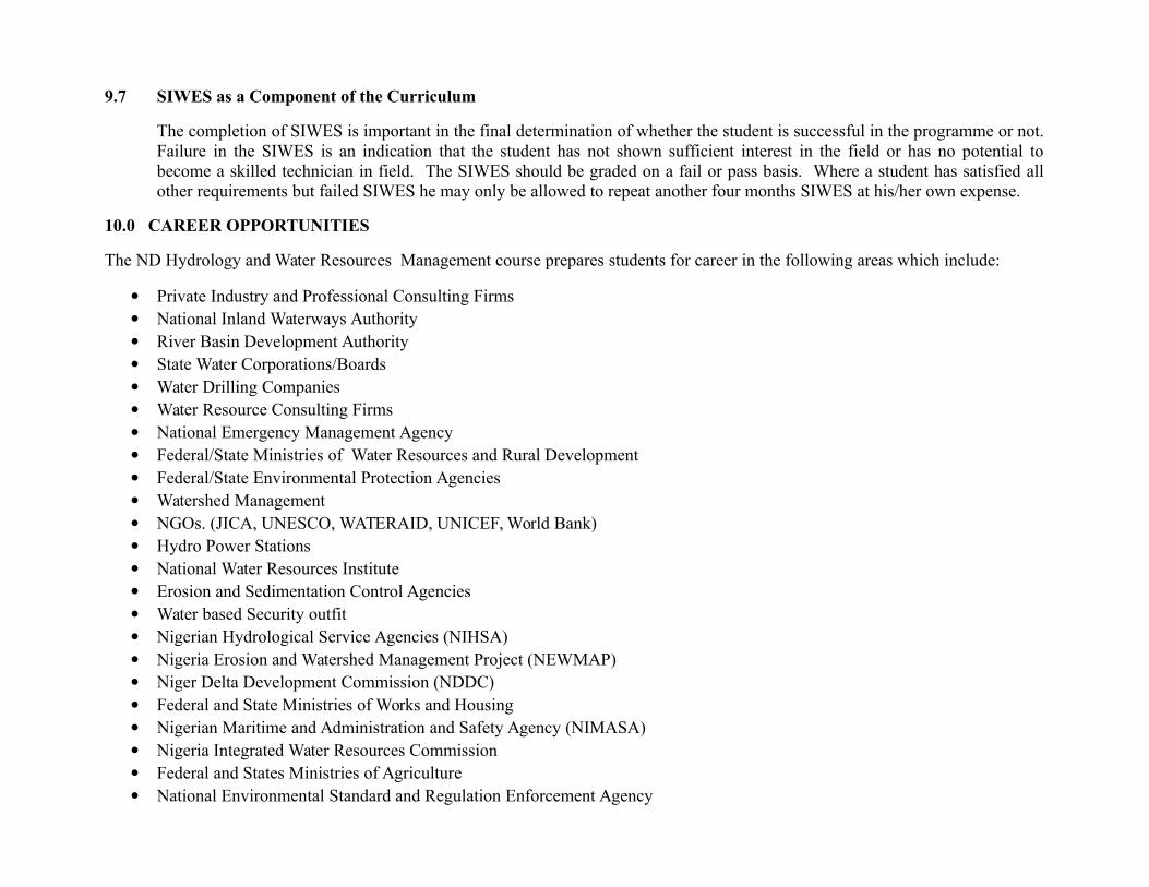
9.7 SIWES as a Component of the Curriculum
The completion of SIWES is important in the final determination of whether the student is successful in the programme or not.Failure in the SIWES is an indication that the student has not shown sufficient interest in the field or has no potential tobecome a skilled technician in field. The SIWES should be graded on a fail or pass basis. Where a student has satisfied allother requirements but failed SIWES he may only be allowed to repeat another four months SIWES at his/her own expense.
10.0 CAREER OPPORTUNITIES
The ND Hydrology and Water Resources Management course prepares students for career in the following areas which include:
Private Industry and Professional Consulting Firms National Inland Waterways Authority River Basin Development Authority State Water Corporations/Boards Water Drilling Companies Water Resource Consulting Firms National Emergency Management Agency Federal/State Ministries of Water Resources and Rural Development Federal/State Environmental Protection Agencies Watershed Management NGOs. (JICA, UNESCO, WATERAID, UNICEF, World Bank) Hydro Power Stations National Water Resources Institute Erosion and Sedimentation Control Agencies Water based Security outfit Nigerian Hydrological Service Agencies (NIHSA) Nigeria Erosion and Watershed Management Project (NEWMAP) Niger Delta Development Commission (NDDC) Federal and State Ministries of Works and Housing Nigerian Maritime and Administration and Safety Agency (NIMASA) Nigeria Integrated Water Resources Commission Federal and States Ministries of Agriculture National Environmental Standard and Regulation Enforcement Agency

11.0 QUALIFICATION OF THE IMPLEMENTERS OF THE CURRICULUM
Since there are few hydrologist specialist that are to implement the curriculum, those in water resources and allied disciplines such asGeographers, Environmental Resources Managers, Hydrogeologist, Water Resources Engineers with relevant qualifications andcognate experience should be considered. Years of teaching experience in the industry as well as selected certificates will be an addedadvantage. Additional qualifications in the field will also be an added advantage.
CURRICULUM TABLE
First Semester
No.CourseCode
Course TitleContactHours
Hours Per Week CreditUnitsTheory Practical Total
1 *GNS 101 Use of English 30 2 0 2 2
2 HWR 111 Basic Hydrology 1 45 2 1 3 3
3 *GNS 112 Physics I 45 1 2 3 3
4 MTH 112 Algebra and Elementary Trigonometry 30 2 0 2 2
5 HWR 112Map Reading and Photo Interpretation
30 1 1 2 2
6 MEC 112 Technical Drawing 45 1 2 3 3
7 ICT 119 Introduction to Computing (ICT) 45 1 2 3 3
8 **GNS111 Citizenship Education I 30 2 0 2 2
9 HWR 113 Hydro-Chemistry 30 1 1 2 2
10 HWR 114 Physical Geography 30 1 1 2 2
Total Hours Per Week 360 14 10 24 24
*See General Studies syllabus **See Citizenship Education syllabus *** See NBTE Syllabus
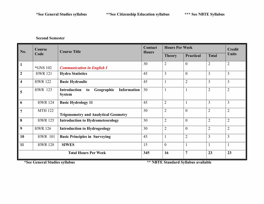
Second Semester
No.CourseCode
Course TitleContactHours
Hours Per Week CreditUnitsTheory Practical Total
1*GNS 102 Communication in English I
30 2 0 2 2
2 HWR 121 Hydro Statistics 45 3 0 3 3
4 HWR 122 Basic Hydraulic 45 1 2 3 3
5HWR 123 Introduction to Geographic Information
System30 1 1 2 2
6 HWR 124 Basic Hydrology 11 45 2 1 3 3
7 MTH 122Trigonometry and Analytical Geometry
30 2 0 2 2
8 HWR 125 Introduction to Hydrometeorology 30 2 0 2 2
9 HWR 126 Introduction to Hydrogeology 30 2 0 2 2
10 HWR 101 Basic Principles in Surveying 45 1 2 3 3
11 HWR 128 SIWES 15 0 1 1 1
Total Hours Per Week 345 16 7 23 23
*See General Studies syllabus ** NBTE Standard Syllabus available
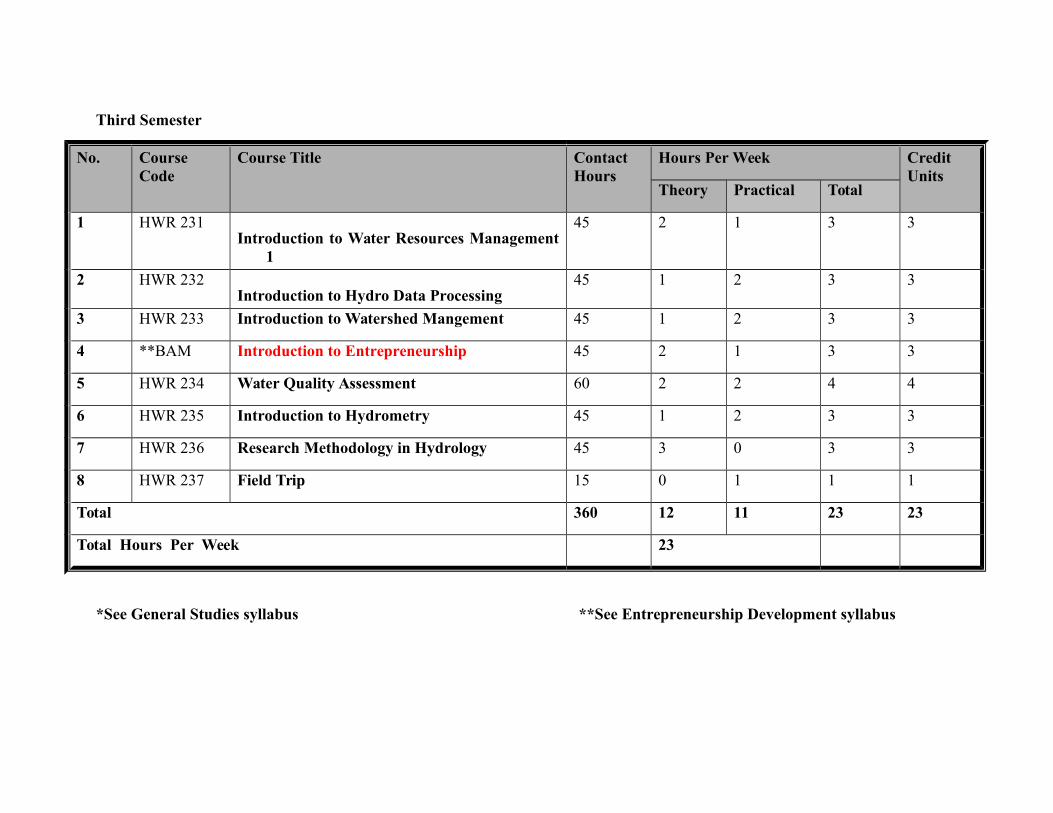
Third Semester
No. CourseCode
Course Title ContactHours
Hours Per Week CreditUnits
Theory Practical Total
1 HWR 231Introduction to Water Resources Management
1
45 2 1 3 3
2 HWR 232Introduction to Hydro Data Processing
45 1 2 3 3
3 HWR 233 Introduction to Watershed Mangement 45 1 2 3 3
4 **BAM Introduction to Entrepreneurship 45 2 1 3 3
5 HWR 234 Water Quality Assessment 60 2 2 4 4
6 HWR 235 Introduction to Hydrometry 45 1 2 3 3
7 HWR 236 Research Methodology in Hydrology 45 3 0 3 3
8 HWR 237 Field Trip 15 0 1 1 1
Total 360 12 11 23 23
Total Hours Per Week 23
*See General Studies syllabus **See Entrepreneurship Development syllabus
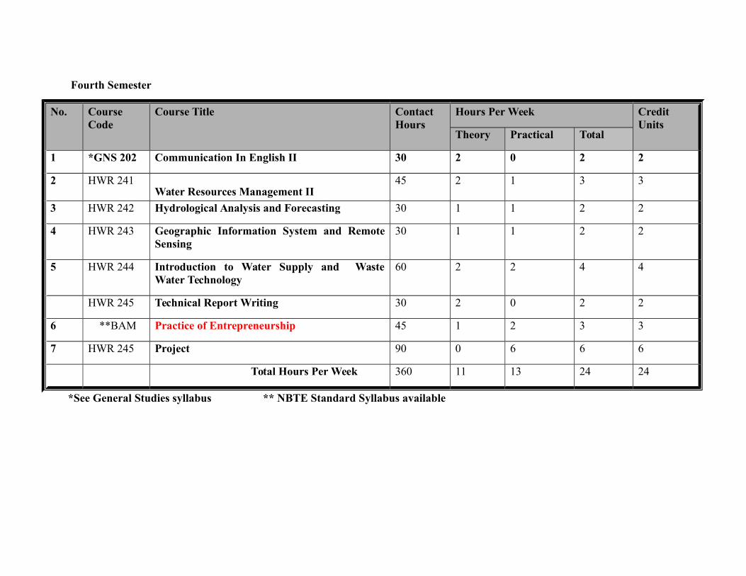
Fourth Semester
No. CourseCode
Course Title ContactHours
Hours Per Week CreditUnits
Theory Practical Total
1 *GNS 202 Communication In English II 30 2 0 2 2
2 HWR 241Water Resources Management II
45 2 1 3 3
3 HWR 242 Hydrological Analysis and Forecasting 30 1 1 2 2
4 HWR 243 Geographic Information System and RemoteSensing
30 1 1 2 2
5 HWR 244 Introduction to Water Supply and WasteWater Technology
60 2 2 4 4
HWR 245 Technical Report Writing 30 2 0 2 2
6 **BAM Practice of Entrepreneurship 45 1 2 3 3
7 HWR 245 Project 90 0 6 6 6
Total Hours Per Week 360 11 13 24 24
*See General Studies syllabus ** NBTE Standard Syllabus available
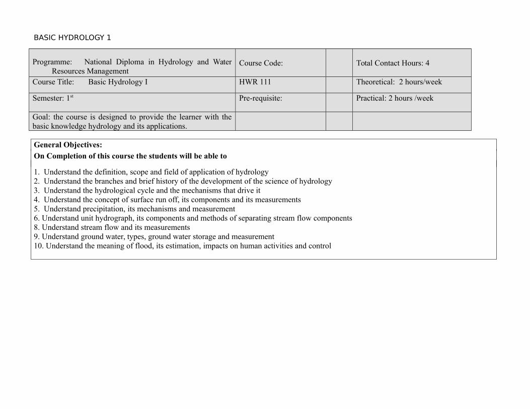
BASIC HYDROLOGY 1
Programme: National Diploma in Hydrology and WaterResources Management
Course Code: Total Contact Hours: 4
Course Title: Basic Hydrology I HWR 111 Theoretical: 2 hours/week
Semester: 1st Pre-requisite: Practical: 2 hours /week
Goal: the course is designed to provide the learner with thebasic knowledge hydrology and its applications.
General Objectives:
On Completion of this course the students will be able to
1. Understand the definition, scope and field of application of hydrology2. Understand the branches and brief history of the development of the science of hydrology3. Understand the hydrological cycle and the mechanisms that drive it4. Understand the concept of surface run off, its components and its measurements 5. Understand precipitation, its mechanisms and measurement6. Understand unit hydrograph, its components and methods of separating stream flow components 8. Understand stream flow and its measurements9. Understand ground water, types, ground water storage and measurement10. Understand the meaning of flood, its estimation, impacts on human activities and control
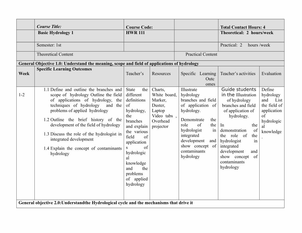
Course Title: Course Code: Total Contact Hours: 4 Basic Hydrology 1 HWR 111 Theoretical: 2 hours/week
Semester: 1st Practical: 2 hours /week
Theoretical Content Practical Content
General Objective 1.0: Understand the meaning, scope and field of applications of hydrology
WeekSpecific Learning Outcomes
Teacher’s Resources Specific LearningOutcomes
Teacher’s activities Evaluation
1-21.1 Define and outline the branches and
scope of hydrology Outline the fieldof applications of hydrology, thetechniques of hydrology and theproblems of applied hydrology
1.2 Outline the brief history of thedevelopment of the field of hydrology
1.3 Discuss the role of the hydrologist inintegrated development
1.4 Explain the concept of contaminantshydrology
State thedifferentdefinitionsofhydrology,thebranchesand explainthe variousfield ofapplications ofhydrologicalknowledgeand theproblemsof appliedhydrology
Charts,White board,Marker,Duster,LaptopVideo tabs ,Overheadprojector
Illustratehydrologybranches and fieldof application ofhydrology.
Demonstrate therole of thehydrologist inintegrateddevelopment andshow concept ofcontaminantshydrology
Guide studentsin the Illustration
of hydrologybranches and fieldof application of
hydrology.
In thedemonstration ofthe role of thehydrologist inintegrateddevelopment andshow concept ofcontaminantshydrology
Definehydrologyand Listthe field ofapplicationofhydrologicalknowledge.
General objective 2.0:Understandthe Hydrological cycle and the mechanisms that drive it
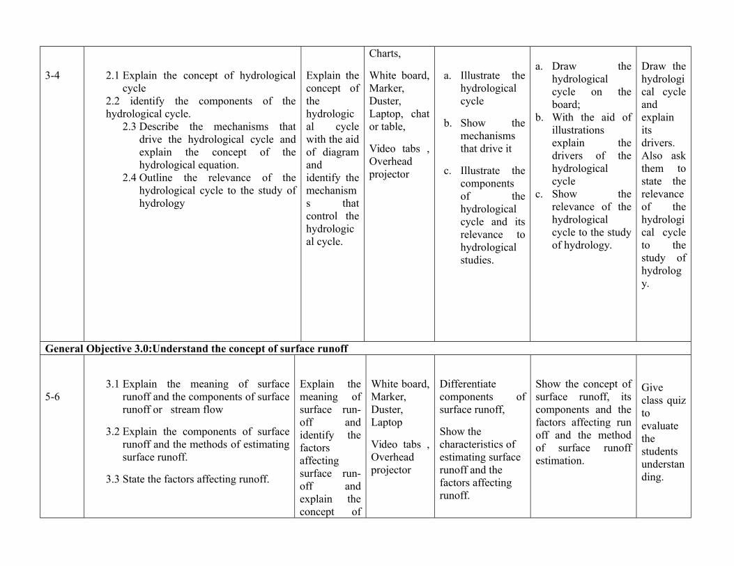
3-4 2.1 Explain the concept of hydrologicalcycle
2.2 identify the components of thehydrological cycle.
2.3 Describe the mechanisms thatdrive the hydrological cycle andexplain the concept of thehydrological equation.
2.4 Outline the relevance of thehydrological cycle to the study ofhydrology
Explain theconcept ofthehydrological cyclewith the aidof diagramandidentify themechanisms thatcontrol thehydrological cycle.
Charts,
White board,Marker,Duster,Laptop, chator table,
Video tabs ,Overheadprojector
a. Illustrate thehydrologicalcycle
b. Show themechanismsthat drive it
c. Illustrate thecomponentsof thehydrologicalcycle and itsrelevance tohydrologicalstudies.
a. Draw thehydrologicalcycle on theboard;
b. With the aid ofillustrationsexplain thedrivers of thehydrologicalcycle
c. Show therelevance of thehydrologicalcycle to the studyof hydrology.
Draw thehydrological cycleandexplainitsdrivers.Also askthem tostate therelevanceof thehydrological cycleto thestudy ofhydrology.
General Objective 3.0:Understand the concept of surface runoff
5-63.1 Explain the meaning of surface
runoff and the components of surfacerunoff or stream flow
3.2 Explain the components of surfacerunoff and the methods of estimatingsurface runoff.
3.3 State the factors affecting runoff.
Explain themeaning ofsurface run-off andidentify thefactorsaffectingsurface run-off andexplain theconcept of
White board,Marker,Duster,Laptop
Video tabs ,Overheadprojector
Differentiatecomponents ofsurface runoff,
Show the characteristics of estimating surface runoff and the factors affecting runoff.
Show the concept ofsurface runoff, itscomponents and thefactors affecting runoff and the methodof surface runoffestimation.
Giveclass quiztoevaluatethestudentsunderstanding.
surface waterestimation
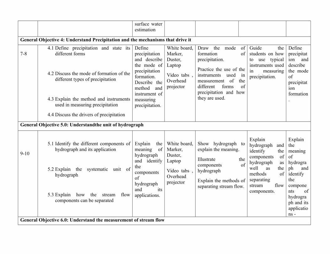
General Objective 4: Understand Precipitation and the mechanisms that drive it
7-84.1 Define precipitation and state its
different forms
4.2 Discuss the mode of formation of thedifferent types of precipitation
4.3 Explain the method and instrumentsused in measuring precipitation
4.4 Discuss the drivers of precipitation
Defineprecipitationand describethe mode ofprecipitationformation.Describe themethod andinstrument ofmeasuringprecipitation.
White board,Marker,Duster,Laptop
Video tabs ,Overheadprojector
Draw the mode offormation ofprecipitation.
Practice the use of theinstruments used inmeasurement of thedifferent forms ofprecipitation and howthey are used.
Guide thestudents on howto use typicalinstruments usedin measuringprecipitation.
Defineprecipitation anddescribethe modeofprecipitationformation.
General Objective 5.0: Understandthe unit of hydrograph
9-10
5.1 Identify the different components ofhydrograph and its application
5.2 Explain the systematic unit ofhydrograph
5.3 Explain how the stream flowcomponents can be separated
Explain themeaning ofhydrographand identifythecomponentsofhydrographand itsapplications.
White board,Marker,Duster,Laptop
Video tabs ,Overheadprojector
Show hydrograph toexplain the meaning.
Illustrate thecomponents ofhydrograph
Explain the methods ofseparating stream flow.
Explainhydrograph andidentify thecomponents ofhydrograph aswell as themethods ofseparatingstream flowcomponents.
Explainthemeaningofhydrograph andidentifythecomponents ofhydrograph and itsapplications -
General Objective 6.0: Understand the measurement of stream flow
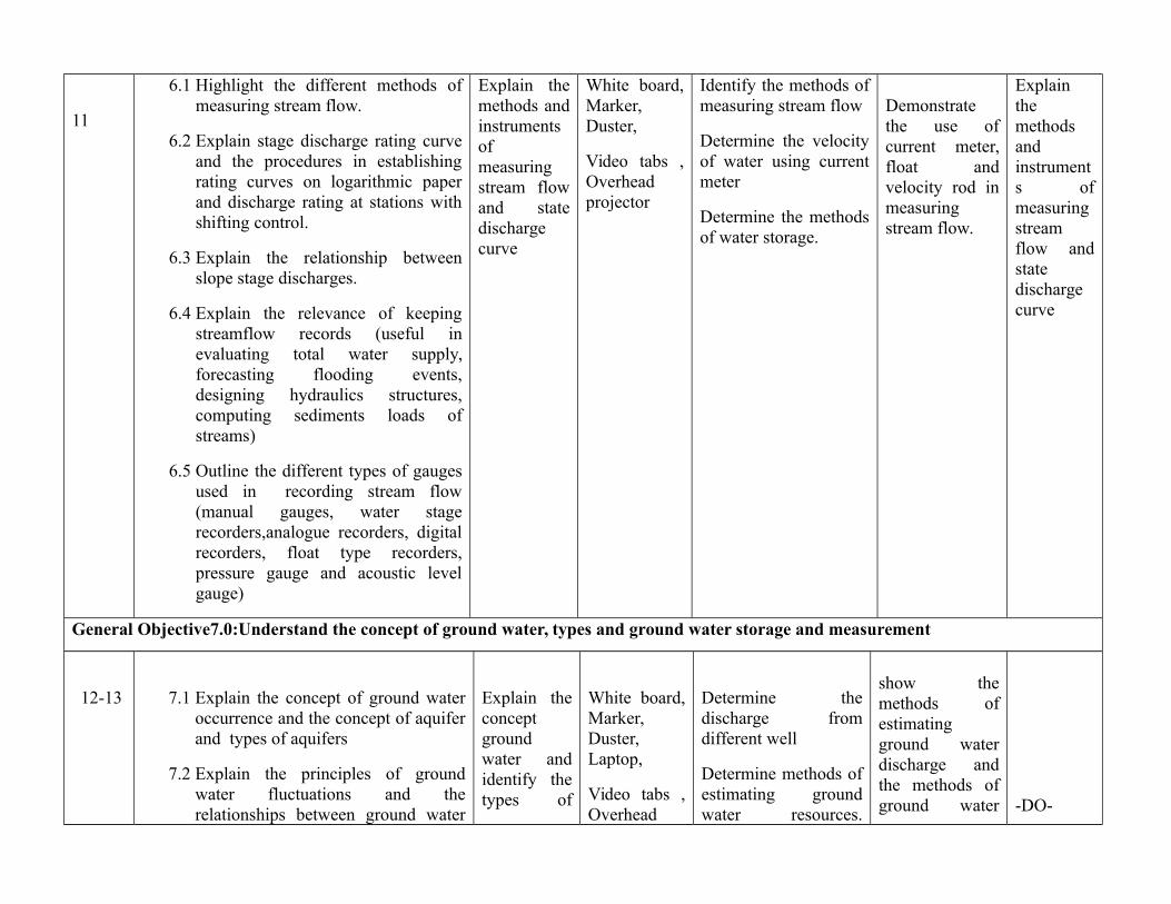
11
6.1 Highlight the different methods ofmeasuring stream flow.
6.2 Explain stage discharge rating curveand the procedures in establishingrating curves on logarithmic paperand discharge rating at stations withshifting control.
6.3 Explain the relationship betweenslope stage discharges.
6.4 Explain the relevance of keepingstreamflow records (useful inevaluating total water supply,forecasting flooding events,designing hydraulics structures,computing sediments loads ofstreams)
6.5 Outline the different types of gaugesused in recording stream flow(manual gauges, water stagerecorders,analogue recorders, digitalrecorders, float type recorders,pressure gauge and acoustic levelgauge)
Explain themethods andinstrumentsofmeasuringstream flowand statedischargecurve
White board,Marker,Duster,
Video tabs ,Overheadprojector
Identify the methods ofmeasuring stream flow
Determine the velocityof water using currentmeter
Determine the methodsof water storage.
Demonstratethe use ofcurrent meter,float andvelocity rod inmeasuringstream flow.
Explainthemethodsandinstruments ofmeasuringstreamflow andstatedischargecurve
General Objective7.0:Understand the concept of ground water, types and ground water storage and measurement
12-13 7.1 Explain the concept of ground wateroccurrence and the concept of aquiferand types of aquifers
7.2 Explain the principles of groundwater fluctuations and therelationships between ground water
Explain theconceptgroundwater andidentify thetypes of
White board,Marker,Duster,Laptop,
Video tabs ,Overhead
Determine thedischarge fromdifferent well
Determine methods ofestimating groundwater resources.
show themethods ofestimatingground waterdischarge andthe methods ofground water
-DO-

and surface water.
7.3 Explain the principle of ground waterflow and differentiate between thetransmissibility of confined andunconfined aquifer.
7.4 Explain the principle of wellhydraulics and the principle of wellconstruction and spacing.
7.5 Describe the purpose and approachesof ground water exploration.
7.6 Explain the hydraulic of open well
vii. Discuss the methods of evaluatingground water resources
aquifer.Describe theconcept oftransmissibility and themethods ofestimatinggroundwaterresources.
projector Differentiate betweenconfined andunconfined aquifer asmethods of groundwater storage.
storage.
General Objective 8.0:Understand flood estimation and control
14-15
8.1 Discuss the meaning of flood andhighlight
8.2 the different types of flood; andexplain the causes of flood
8.3 Discuss the approaches to floods andflood hazard management
8.4 Explain soil conservation measures
8.5 Explain flood control approaches
Explain themeaning offlood anddiscuss thesocio-economicimpacts offlood aswell as themethods offloodcontrol
White board,Marker,Duster,Laptop,
Video tabs ,Overheadprojector
Identify flood sites
Show the possibleimpacts of flood
Determine themethods of floodcontrol
Explain differenttypes of flood,
show the effectsof flood onhuman activities
Determine thepossiblemethods offlood control.
Explainthemeaningof floodanddiscuss thesocio-economicimpacts offlood aswell as themethodsof flood
control
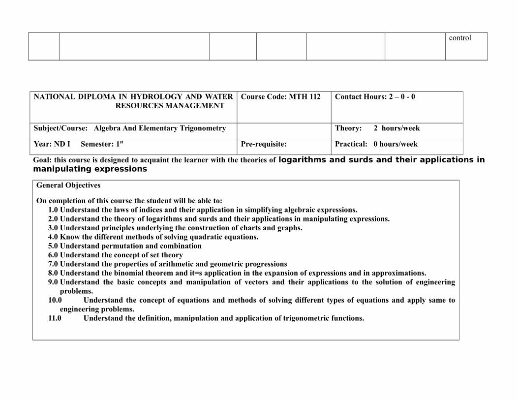
NATIONAL DIPLOMA IN HYDROLOGY AND WATERRESOURCES MANAGEMENT
Course Code: MTH 112 Contact Hours: 2 – 0 - 0
Subject/Course: Algebra And Elementary Trigonometry Theory: 2 hours/week
Year: ND I Semester: 1st Pre-requisite: Practical: 0 hours/week
Goal: this course is designed to acquaint the learner with the theories of logarithms and surds and their applications inmanipulating expressions
General Objectives
On completion of this course the student will be able to:1.0 Understand the laws of indices and their application in simplifying algebraic expressions.2.0 Understand the theory of logarithms and surds and their applications in manipulating expressions.3.0 Understand principles underlying the construction of charts and graphs.4.0 Know the different methods of solving quadratic equations.5.0 Understand permutation and combination6.0 Understand the concept of set theory7.0 Understand the properties of arithmetic and geometric progressions8.0 Understand the binomial theorem and it=s application in the expansion of expressions and in approximations.9.0 Understand the basic concepts and manipulation of vectors and their applications to the solution of engineering
problems.10.0 Understand the concept of equations and methods of solving different types of equations and apply same to
engineering problems.11.0 Understand the definition, manipulation and application of trigonometric functions.

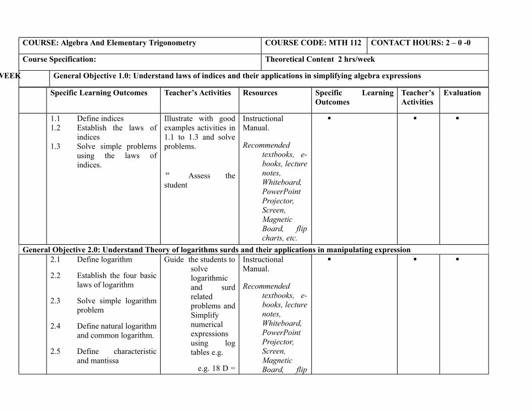
COURSE: Algebra And Elementary Trigonometry COURSE CODE: MTH 112 CONTACT HOURS: 2 – 0 -0
Course Specification: Theoretical Content 2 hrs/week
WEEK General Objective 1.0: Understand laws of indices and their applications in simplifying algebra expressions
Specific Learning Outcomes Teacher’s Activities Resources Specific LearningOutcomes
Teacher’sActivities
Evaluation
1.1 Define indices1.2 Establish the laws of
indices1.3 Solve simple problems
using the laws ofindices.
Illustrate with goodexamples activities in1.1 to 1.3 and solveproblems.
Assess thestudent
InstructionalManual.
Recommendedtextbooks, e-books, lecturenotes,Whiteboard,PowerPointProjector,Screen,MagneticBoard, flipcharts, etc.
General Objective 2.0: Understand Theory of logarithms surds and their applications in manipulating expression2.1 Define logarithm
2.2 Establish the four basiclaws of logarithm
2.3 Solve simple logarithmproblem
2.4 Define natural logarithmand common logarithm.
2.5 Define characteristicand mantissa
Guide the students tosolvelogarithmicand surdrelatedproblems andSimplifynumericalexpressionsusing logtables e.g.
e.g. 18 D =
InstructionalManual.
Recommendedtextbooks, e-books, lecturenotes,Whiteboard,PowerPointProjector,Screen,MagneticBoard, flip
Specific Learning Outcomes Teacher’s Activities Resources Specific LearningOutcomes
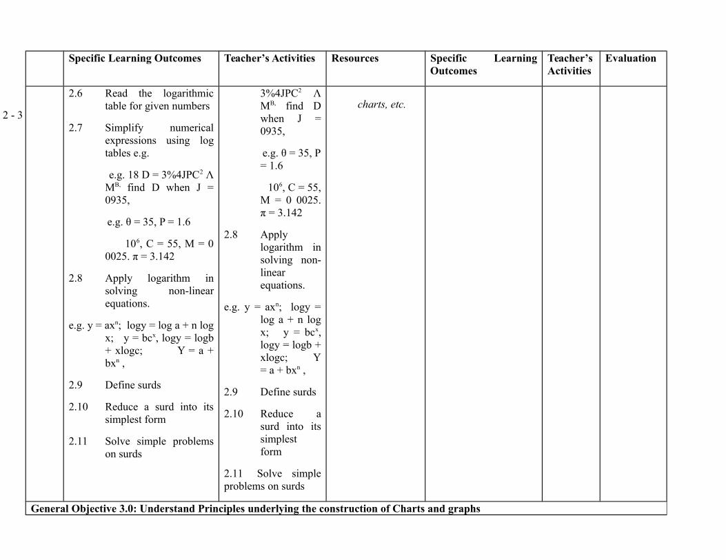
Teacher’sActivities
Evaluation
2 - 3
2.6 Read the logarithmictable for given numbers
2.7 Simplify numericalexpressions using logtables e.g.
e.g. 18 D = 3%4JPC2 ΛMB, find D when J =0935,
e.g. θ = 35, P = 1.6
106, C = 55, M = 00025. π = 3.142
2.8 Apply logarithm insolving non-linearequations.
e.g. y = axn; logy = log a + n logx; y = bcx, logy = logb+ xlogc; Y = a +bxn ,
2.9 Define surds
2.10 Reduce a surd into itssimplest form
2.11 Solve simple problemson surds
3%4JPC2 ΛMB, find Dwhen J =0935,
e.g. θ = 35, P= 1.6
106, C = 55,M = 0 0025.π = 3.142
2.8 Applylogarithm insolving non-linearequations.
e.g. y = axn; logy =log a + n logx; y = bcx,logy = logb +xlogc; Y= a + bxn ,
2.9 Define surds
2.10 Reduce asurd into itssimplestform
2.11 Solve simpleproblems on surds
charts, etc.
General Objective 3.0: Understand Principles underlying the construction of Charts and graphs
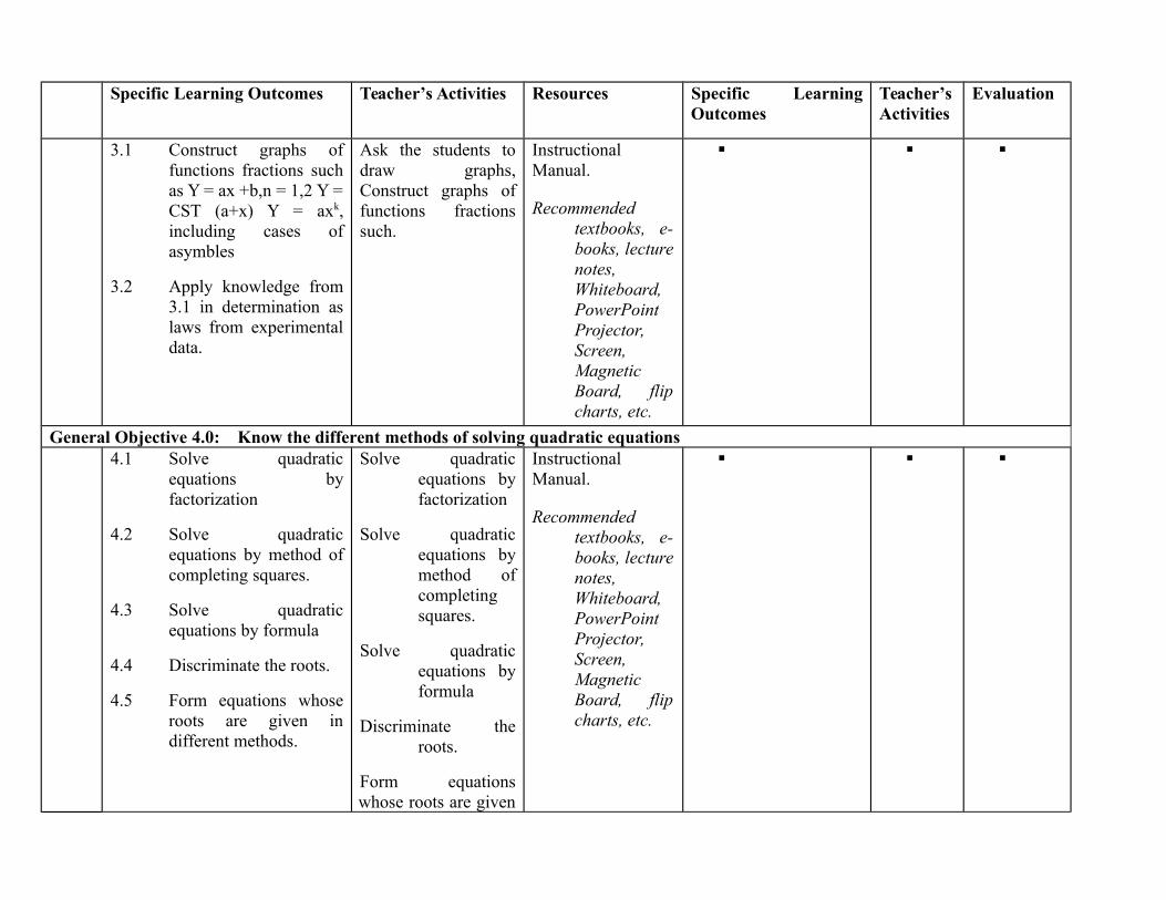
Specific Learning Outcomes Teacher’s Activities Resources Specific LearningOutcomes
Teacher’sActivities
Evaluation
3.1 Construct graphs offunctions fractions suchas Y = ax +b,n = 1,2 Y =CST (a+x) Y = axk,including cases ofasymbles
3.2 Apply knowledge from3.1 in determination aslaws from experimentaldata.
Ask the students todraw graphs,Construct graphs offunctions fractionssuch.
InstructionalManual.
Recommendedtextbooks, e-books, lecturenotes,Whiteboard,PowerPointProjector,Screen,MagneticBoard, flipcharts, etc.
General Objective 4.0: Know the different methods of solving quadratic equations4.1 Solve quadratic
equations byfactorization
4.2 Solve quadraticequations by method ofcompleting squares.
4.3 Solve quadraticequations by formula
4.4 Discriminate the roots.
4.5 Form equations whoseroots are given indifferent methods.
Solve quadraticequations byfactorization
Solve quadraticequations bymethod ofcompletingsquares.
Solve quadraticequations byformula
Discriminate theroots.
Form equationswhose roots are given
InstructionalManual.
Recommendedtextbooks, e-books, lecturenotes,Whiteboard,PowerPointProjector,Screen,MagneticBoard, flipcharts, etc.

Specific Learning Outcomes Teacher’s Activities Resources Specific LearningOutcomes
Teacher’sActivities
Evaluation
in different methods.
General Objective 5.0: Understand Permutations and Combinations
5.1 Define permutation
5.2 State examples ofpermutations
5.3 Define combination
5.4 State examples ofcombination
5.5 Establish the theoremnPr = n !/[ (n-r)!]givingexamples
e.g. number of ways ofcollecting two out of 8balls
Explain permutation
Permutations,
combination
with examples
Establish the theoremnPr = n !/[ (n-r)!]givingexamples
e.g. numberof ways of collectingtwo out of 8 balls
InstructionalManual.
Recommendedtextbooks, e-books, lecturenotes,Whiteboard,PowerPointProjector,Screen,MagneticBoard, flipcharts, etc.
General Objective 6.0: Understand the concept of set theory6.1 Establish nCr = nCn B r.
6.2 Define sets, subsets, andnull sets
6.3 Define union, inter-section and completionof sets
6.4 Draw Venn diagrams todemonstrate theconcepts in 6.1 and 6.3above.
Establish nCr = nCn Br.
Explain sets, subsets,and null sets
Explain union, inter-section andcompletionof sets
Draw Venn diagramsto
InstructionalManual.
Recommendedtextbooks, e-books, lecturenotes,Whiteboard,PowerPointProjector,Screen,MagneticBoard, flip

Specific Learning Outcomes Teacher’s Activities Resources Specific LearningOutcomes
Teacher’sActivities
Evaluation
6.5 Calculate the size ornumber of elements in agiven set.
demonstratethe conceptsin 6.1 and6.3 above.
6.5 Calculate thesize or number ofelements in a givenset.
charts, etc.
General Objectives 7.0: Understand the properties of arithmetic and geometric progressions
8 - 9
7.1 Define an Arithmeticprogression (A.P.)
7.2 Obtain the formula fornth term and the first nterms of an A.P.
7.3 Give examples of theabove e.g. find the 20th
term of the series e.g. 2+ 4 + 6 + Y.. Find alsothe series of the first 20terms.
7.4 Define a geometricprogression (G.P.)
7.5 Obtain the formula forthe nth term and the firstn terms of a geometricseries.
7.6 State examples of 7.5above e.g. given the
Take the studentsthrough anArithmeticprogression(A.P.)
Obtain the formulafor nth termand the firstn terms of anA.P.
Giving examples ofthe abovee.g. find the20th term ofthe series e.g.2 + 4 + 6 +Y.. Find alsothe series ofthe first 20terms.
Explain a geometric
InstructionalManual.
Recommendedtextbooks, e-books, lecturenotes,Whiteboard,PowerPointProjector,Screen,MagneticBoard, flipcharts, etc.
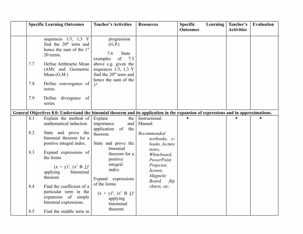
Specific Learning Outcomes Teacher’s Activities Resources Specific LearningOutcomes
Teacher’sActivities
Evaluation
sequences 1/3, 1,3 Yfind the 20th term andhence the sum of the 1st
20 terms.
7.7 Define Arithmetic Mean(AM) and GeometricMean (G.M.)
7.8 Define convergence ofseries.
7.9 Define divergence ofseries.
progression(G.P.)
7.6 Stateexamples of 7.5above e.g. given thesequences 1/3, 1,3 Yfind the 20th term andhence the sum of the1st
General Objectives 8.0: Understand the binomial theorem and its application in the expansion of expressions and in approximations.8.1 Explain the method of
mathematical induction
8.2 State and prove thebinomial theorem for apositive integral index.
8.3 Expand expressions ofthe forms
(x + y)2, (x2 B 1)s
applying binominaltheorem
8.4 Find the coefficient of aparticular term in theexpansion of simplebinomial expressions.
8.5 Find the middle term in
Explain theimportance andapplication of thetheorem.
State and prove thebinomialtheorem for apositiveintegralindex.
Expand expressionsof the forms
(x + y)2, (x2 B 1)s
applyingbinominaltheorem
InstructionalManual.
Recommendedtextbooks, e-books, lecturenotes,Whiteboard,PowerPointProjector,Screen,MagneticBoard, flipcharts, etc.
Specific Learning Outcomes Teacher’s Activities Resources Specific LearningOutcomes
Teacher’sActivities
Evaluation
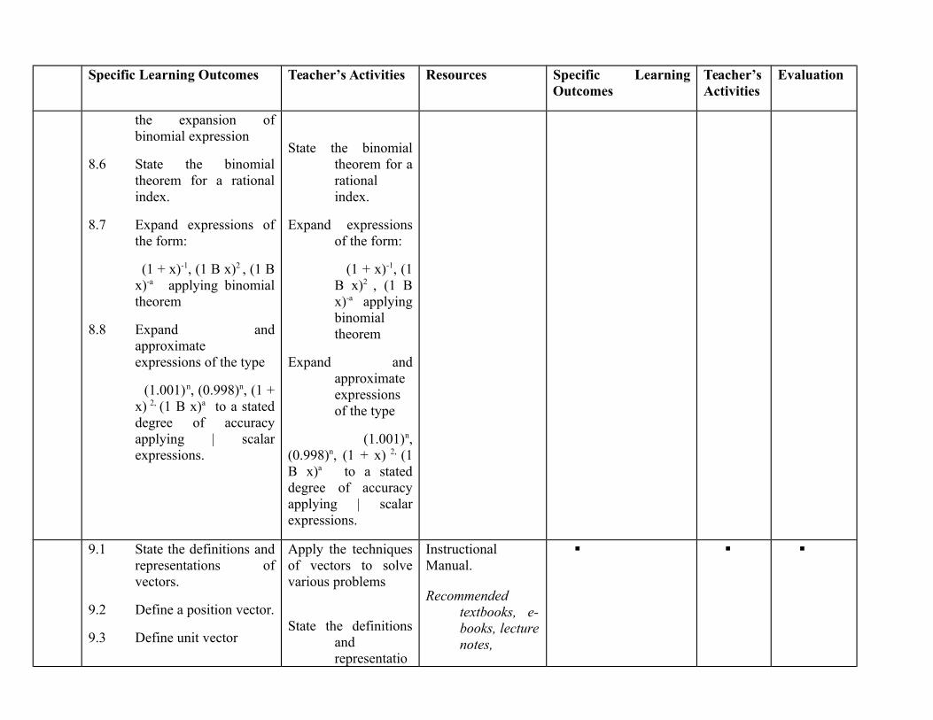
the expansion ofbinomial expression
8.6 State the binomialtheorem for a rationalindex.
8.7 Expand expressions ofthe form:
(1 + x)-1, (1 B x)2 , (1 Bx)-a applying binomialtheorem
8.8 Expand andapproximateexpressions of the type
(1.001)n, (0.998)n, (1 +x) 2, (1 B x)a to a stateddegree of accuracyapplying | scalarexpressions.
State the binomialtheorem for arationalindex.
Expand expressionsof the form:
(1 + x)-1, (1B x)2 , (1 Bx)-a applyingbinomialtheorem
Expand andapproximateexpressionsof the type
(1.001)n,(0.998)n, (1 + x) 2, (1B x)a to a stateddegree of accuracyapplying | scalarexpressions.
9.1 State the definitions andrepresentations ofvectors.
9.2 Define a position vector.
9.3 Define unit vector
Apply the techniquesof vectors to solvevarious problems
State the definitionsandrepresentatio
InstructionalManual.
Recommendedtextbooks, e-books, lecturenotes,

Specific Learning Outcomes Teacher’s Activities Resources Specific LearningOutcomes
Teacher’sActivities
Evaluation
9.4 Explain scalar multipleof a vector
9.5 List the characteristicsof parallel vectors
9.6 Identify quantities thatmay be classified asvector e.g. displacementvelocity, acceleration,force etc.
9.7 Compute the modulusof any given vector upto 2 and 3 dimensions.
9.8 State the parallelogramlaw in solving problemsincluding addition andsubtraction of vectors
9.9 Apply the parallelogramlaw in solving problemsincluding addition andsubtraction of vectors.
9.10 Explain the concept ofcomponents of a vectorand the meaning oforthogonal components.
9.11 Resolve a vector into itsorthogonal components.
9.12 List characteristics ofcoplanar localized
ns of vectors.
Define a positionvector.
Explain unit vector
Explain scalarmultiple of a vector
classified as vectore.g.displacementvelocity,acceleration,force etc.
Compute themodulus ofany givenvector up to2 and 3dimensions.
State the parallelogram law in solving problems including addition and subtraction of vectors
Apply the
Whiteboard,PowerPointProjector,Screen,MagneticBoard, flipcharts, etc.
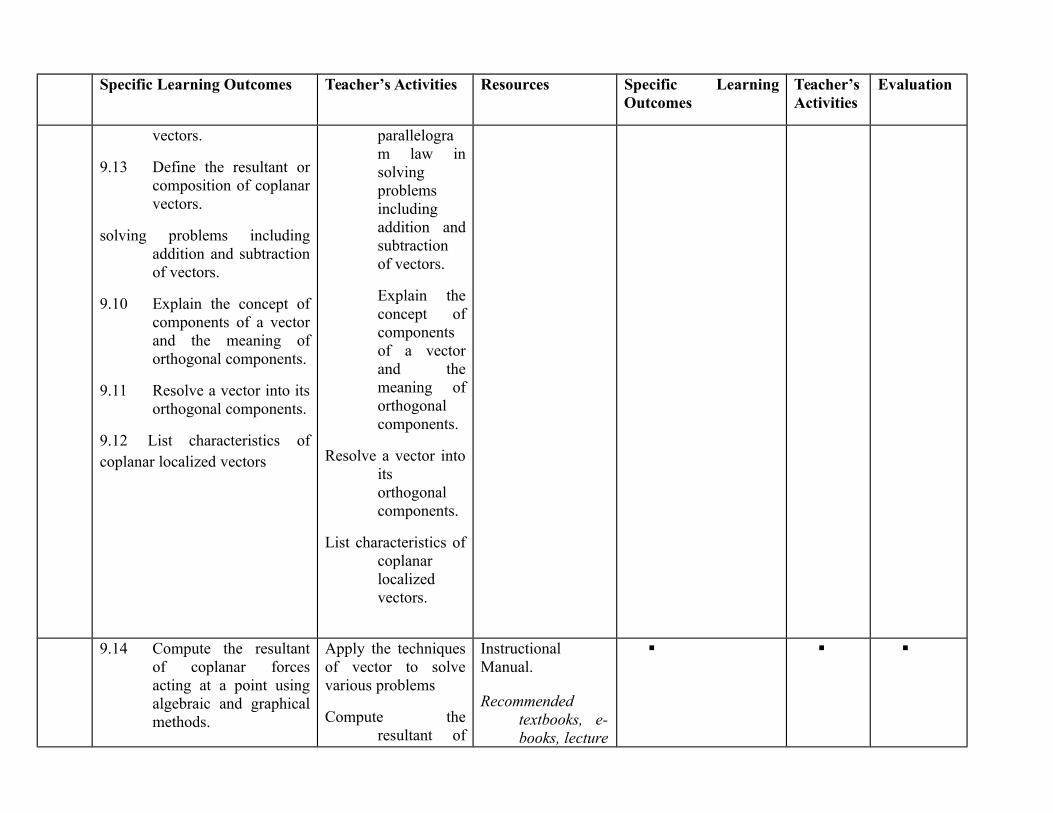
Specific Learning Outcomes Teacher’s Activities Resources Specific LearningOutcomes
Teacher’sActivities
Evaluation
vectors.
9.13 Define the resultant orcomposition of coplanarvectors.
solving problems includingaddition and subtractionof vectors.
9.10 Explain the concept ofcomponents of a vectorand the meaning oforthogonal components.
9.11 Resolve a vector into itsorthogonal components.
9.12 List characteristics ofcoplanar localized vectors
parallelogram law insolvingproblemsincludingaddition andsubtractionof vectors.
Explain theconcept ofcomponentsof a vectorand themeaning oforthogonalcomponents.
Resolve a vector intoitsorthogonalcomponents.
List characteristics ofcoplanarlocalizedvectors.
9.14 Compute the resultantof coplanar forcesacting at a point usingalgebraic and graphicalmethods.
Apply the techniquesof vector to solvevarious problems
Compute theresultant of
InstructionalManual.
Recommendedtextbooks, e-books, lecture
Specific Learning Outcomes Teacher’s Activities Resources Specific LearningOutcomes
Teacher’sActivities
Evaluation
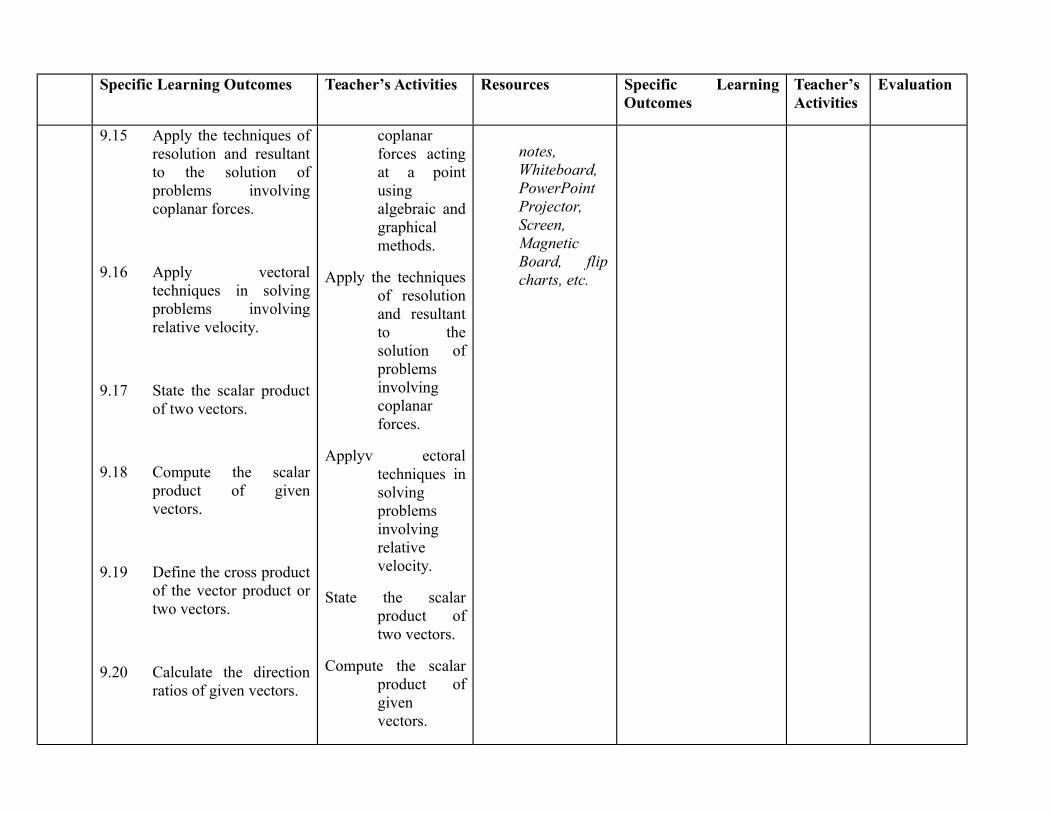
9.15 Apply the techniques ofresolution and resultantto the solution ofproblems involvingcoplanar forces.
9.16 Apply vectoraltechniques in solvingproblems involvingrelative velocity.
9.17 State the scalar productof two vectors.
9.18 Compute the scalarproduct of givenvectors.
9.19 Define the cross productof the vector product ortwo vectors.
9.20 Calculate the directionratios of given vectors.
coplanarforces actingat a pointusingalgebraic andgraphicalmethods.
Apply the techniquesof resolutionand resultantto thesolution ofproblemsinvolvingcoplanarforces.
Applyv ectoraltechniques insolvingproblemsinvolvingrelativevelocity.
State the scalarproduct oftwo vectors.
Compute the scalarproduct ofgivenvectors.
notes,Whiteboard,PowerPointProjector,Screen,MagneticBoard, flipcharts, etc.
Specific Learning Outcomes Teacher’s Activities Resources Specific LearningOutcomes
Teacher’sActivities
Evaluation
9.21 Calculate the anglebetween two vectorsusing the scalar product.
Define the crossproduct ofthe vectorproduct ortwo vectors.
Calculate thedirectionratios ofgivenvectors.
Calculate the anglebetween two vectorsusing the scalarproduct.
General Objectives 10.0: Understand the Concept of equations and apply same to engineering problems
13 - 14
10.1 Explain the concept ofequation, i.e. A = Bwhere A and B areexpressions.
10.2 List different types ofequations:- Linear,quadratic, cubic, etc.
10.3 State examples of linearsimultaneous equationswith two unknowns andsimultaneous equationswith at least onequadratic equation.
10.4 Apply algebraic and
Ask the student tosolve variousequations asindicated in section10
solving twosimultaneousequationsinvolving alinearequation anda quadraticequation.
Apply the algebraic
InstructionalManual.
Recommendedtextbooks, e-books, lecturenotes,Whiteboard,PowerPointProjector,Screen,MagneticBoard, flipcharts, etc.
Specific Learning Outcomes Teacher’s Activities Resources Specific LearningOutcomes
Teacher’sActivities
Evaluation
graphical methods insolving twosimultaneous equationsinvolving a linearequation and a quadraticequation.
10.5 Apply the algebraic andgraphical methods insolving twosimultaneous quadraticequations.
10.6 Define a determinant ofnth order.
10.7 Apply determinants oforder 2 and 3 in solvingsimultaneous linearequations.
and graphicalmethods insolving twosimultaneousquadraticequations.
Define a determinantof nth order.
Apply determinantsof order 2 and 3 insolving simultaneouslinear equations
General Objectives 11.0: Understand the definition, manipulation and application of trigonometric functions11.1 Define the basic
trigonometric ratios,sine, cosine and tangentof an angle.
11.2 Derive the othertrigonometric ratios;cosecant, secant andcotangent using thebasic trigonometricratios in 11.1 above.
Define and Derivethe trigonometricratios and identities
Derive the othertrigonometricratios;cosecant,secant andcotangentusing thebasictrigonometric
InstructionalManual.
Recommendedtextbooks, e-books, lecturenotes,Whiteboard,PowerPointProjector,Screen,MagneticBoard, flip
Specific Learning Outcomes Teacher’s Activities Resources Specific LearningOutcomes
Teacher’sActivities
Evaluation
11.3 Derive identitiesinvolving thetrigonometric ratios ofthe form; Cos2 θ+Sin2 θ= 1, Sec2 θ = 1 + tan2 θ,etc.
11.4 Derive the compoundangle formulae for sin(A+B), Cos (A+B) andTan (A+B).
ratios in 11.1above.
Derive identitiesinvolving thetrigonometricratios of theform; Cos2
θ+Sin2 θ = 1,Sec2 θ = 1 +tan2 θ, etc.
Derive the compoundangle formulae forsin (A+B), Cos(A+B) and Tan(A+B).
charts, etc.
ASSESSMENT: The continuous assessment, tests and quizzes will be awarded 40% of the total score. The end of the Semester Examinationwill make up for the remaining 60% of the total score.
Programme: NATIONALDIPLOMA IN HYDROLOGY ANDWATER RESOURCESMANAGEMENT
Course Code: HWR 112 Credit Hours: 2
Course: Map Reading and PhotoInterpretation
Pre-Requisite Theoretical: Hours/Week
Semester: Practical:
Course Main Aim/Goal:
GENERAL OBJECTIVES
1.0 understand the scope and content of water shed management and its basic concepts2.0 Understand conversion from different scales3.0 Understand directions and bearing4.0 understand contour lines and its uses5.0 understand the interpretation and uses of human based maps6.0 Understand the uses and interpretation of physical maps7.0 Understand estimation of different geographical dimensions on map8.0 understand the basics of photo interpretation9.0 understand the principle of object identification

Programme: NATIONAL DIPLOMA IN HYDROLOGY AND WATER RESOURCES MANAGEMENTCourse: Map Reading and Photo Interpretation Course Code:
HWR 112CH/CU Hour: 2
Goal:General Objectives 1.0: understand the scope and content of water shed management and its basic conceptsCourse Specifications: THEORETICAL CONTENT
Theoretical Content Practical ContentWeek Specific Learning
OutcomesTeacher’sActivities
Resources Specific LearningOutcomes
Teacher’sActivities
Evaluation
1 1.1 Define map2.1 Explain the types
of maps3.1 Describe uses of
map : routefinding, militaryuses, civilengineering works,game and sport,etc
Explain thetypes of maps
Describe uses ofmap : routefinding, militaryuses, civilengineering works,game and sport, etc
White board,Marker, duster,Laptop, video,overheadprojector, TopographicalmapsThematic maps
Classify differenttypes of maps
Show thedifferent types ofmaps Analyse theiruses
Highlight theuses of maps
General Objectives 2.0: Understand conversion from different scales2 1.1 Define scales :
linear scale,fraction scale andstatement scale
2.1 Explain theprocesses of scaleconversion
Explain scales :linear scale,fraction scaleand statementscale
Explain theprocesses of scaleconversion
White board,Marker,duster,Laptop, video,overheadprojector.1:50,000topographicalsheet
Demonstrate theconversion fromone scale type tothe other
Demonstrate theconversion fromone scale type tothe other
Convert fromone scale to theother
General Objectives: 3.0 Understand directions and bearing3 3.1 Explain the
differentdirections:Magnetic northand true north
Explain thedifferentdirections:
Magneticnorth and
White board,Marker,duster,Laptop, video,overhead
show thedirectionalinformation on themap
Explain thedirectionalinformation onthe map
What is thedifferencebetween the truenorth andmagnetic north
3.2 Explain bearingand directions
3.3 Discuss the uses ofdirection andbearing
true northExplain bearingand directionsDiscuss the uses ofdirection andbearing
projector,1:50,000topographicalsheet
Calculate thebearing of onelocation fromanother
Calculate thebearing of onelocation fromanother
Calculate thebearing of 5locations on themap fromanother.
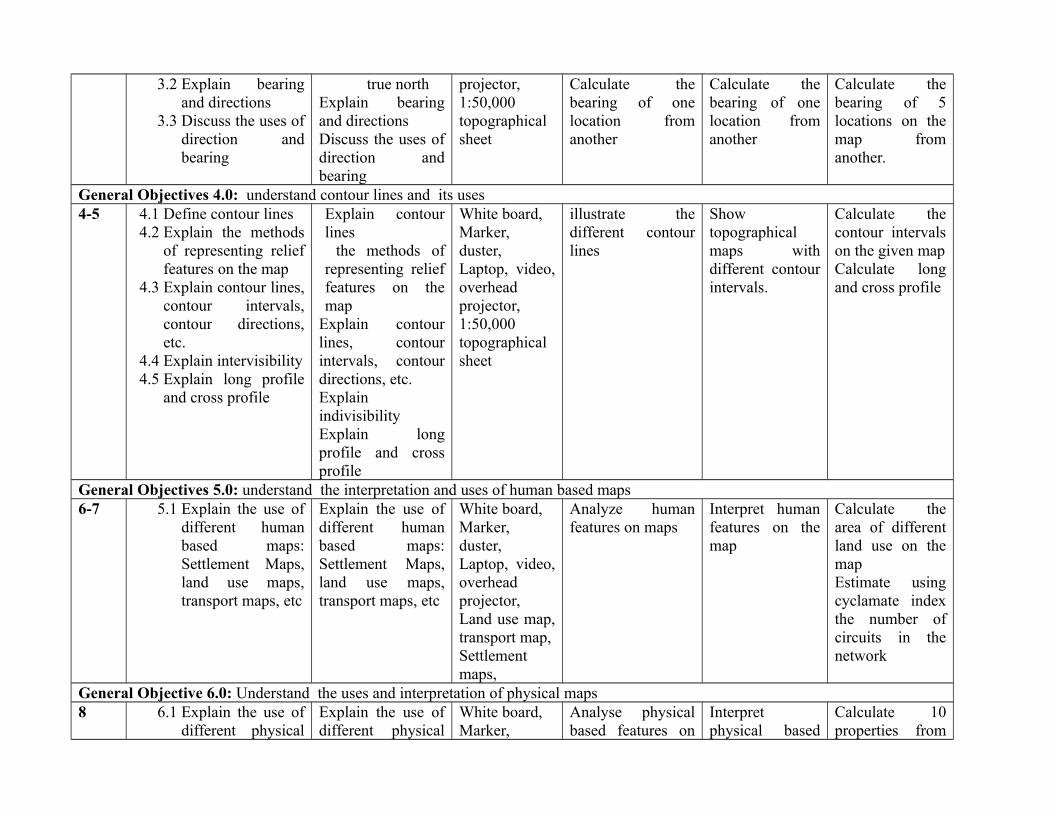
General Objectives 4.0: understand contour lines and its uses4-5 4.1 Define contour lines
4.2 Explain the methodsof representing relieffeatures on the map
4.3 Explain contour lines,contour intervals,contour directions,etc.
4.4 Explain intervisibility4.5 Explain long profile
and cross profile
Explain contourlines the methods ofrepresenting relieffeatures on themap
Explain contourlines, contourintervals, contourdirections, etc.ExplainindivisibilityExplain longprofile and crossprofile
White board,Marker,duster,Laptop, video,overheadprojector,1:50,000topographicalsheet
illustrate thedifferent contourlines
Showtopographicalmaps withdifferent contourintervals.
Calculate thecontour intervalson the given mapCalculate longand cross profile
General Objectives 5.0: understand the interpretation and uses of human based maps6-7 5.1 Explain the use of
different humanbased maps:Settlement Maps,land use maps,transport maps, etc
Explain the use ofdifferent humanbased maps:Settlement Maps,land use maps,transport maps, etc
White board,Marker,duster,Laptop, video,overheadprojector,Land use map,transport map,Settlementmaps,
Analyze humanfeatures on maps
Interpret humanfeatures on themap
Calculate thearea of differentland use on themapEstimate usingcyclamate indexthe number ofcircuits in thenetwork
General Objective 6.0: Understand the uses and interpretation of physical maps8 6.1 Explain the use of
different physicalExplain the use ofdifferent physical
White board,Marker,
Analyse physicalbased features on
Interpretphysical based
Calculate 10properties from
based maps:topographicalmaps, geologicalmaps, climaticmaps,hydrographicalmaps
based maps:topographicalmaps, geologicalmaps, climaticmaps,hydrographicalmaps
duster,Laptop, video,overheadprojector,Topographicalmaps,Geologicalmap, climaticmaps,hydrographicmaps
the maps features on themap
the topographicsheet givencalculate thewind speed andirection in themap given
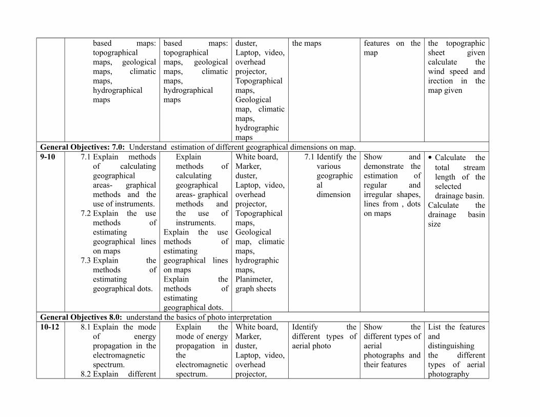
General Objectives: 7.0: Understand estimation of different geographical dimensions on map.9-10 7.1 Explain methods
of calculatinggeographicalareas- graphicalmethods and theuse of instruments.
7.2 Explain the usemethods ofestimatinggeographical lineson maps
7.3 Explain themethods ofestimatinggeographical dots.
Explainmethods ofcalculatinggeographicalareas- graphicalmethods andthe use ofinstruments.
Explain the usemethods ofestimatinggeographical lineson mapsExplain themethods ofestimatinggeographical dots.
White board,Marker,duster,Laptop, video,overheadprojector,Topographicalmaps,Geologicalmap, climaticmaps,hydrographicmaps,Planimeter,graph sheets
7.1 Identify thevariousgeographicaldimension
Show anddemonstrate theestimation ofregular andirregular shapes,lines from , dotson maps
Calculate thetotal streamlength of theselecteddrainage basin.
Calculate thedrainage basinsize
General Objectives 8.0: understand the basics of photo interpretation10-12 8.1 Explain the mode
of energypropagation in theelectromagneticspectrum.
8.2 Explain different
Explain themode of energypropagation intheelectromagneticspectrum.
White board,Marker,duster,Laptop, video,overheadprojector,
Identify thedifferent types ofaerial photo
Show thedifferent types ofaerialphotographs andtheir features
List the featuresanddistinguishingthe differenttypes of aerialphotography
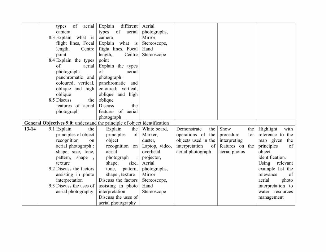
types of aerialcamera
8.3 Explain what isflight lines, Focallength, Centrepoint
8.4 Explain the typesof aerialphotograph:panchromatic andcoloured; vertical,oblique and highoblique
8.5 Discuss thefeatures of aerialphotograph
Explain differenttypes of aerialcameraExplain what isflight lines, Focallength, CentrepointExplain the typesof aerialphotograph:panchromatic andcoloured; vertical,oblique and highoblique Discuss thefeatures of aerialphotograph
Aerialphotographs,MirrorStereoscope,HandStereoscope
General Objectives 9.0: understand the principle of object identification13-14 9.1 Explain the
principles of objectrecognition onaerial photograph :shape, size, tone,pattern, shape ,texture
9.2 Discuss the factorsassisting in photointerpretation
9.3 Discuss the uses ofaerial photography
Explain theprinciples ofobjectrecognition onaerialphotograph :shape, size,tone, pattern,shape , texture
Discuss the factorsassisting in photointerpretationDiscuss the uses ofaerial photography
White board,Marker,duster,Laptop, video,overheadprojector,Aerialphotographs,MirrorStereoscope,HandStereoscope
Demonstrate theoperations of theobjects used in theinterpretation ofaerial photograph
Show theprocedure forinterpretingfeatures on theaerial photos
Highlight withreference to themap given theprinciples ofobjectidentification.Using relevantexample list therelevance ofaerial photointerpretation towater resourcesmanagement
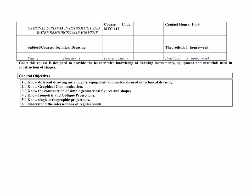
NATIONAL DIPLOMA IN HYDROLOGY ANDWATER RESOURCES MANAGEMENT
Course Code:MEC 112
Contact Hours: 1-0-3
Subject/Course: Technical Drawing Theoretical: 1 hours/week
Year: 1 Semester: 1 Pre-requisite: - Practical: 3 hours /weekGoal: this course is designed to provide the learner with knowledge of drawing instruments, equipment and materials used inconstruction of shapes.
General Objectives
1.0 Know different drawing instruments, equipment and materials used in technical drawing.2.0 Know Graphical Communication.3.0 Know the construction of simple geometrical figures and shapes.4.0 Know Isometric and Oblique Projections.5.0 Know single orthographic projections.6.0 Understand the intersections of regular solids.
Course: Technical DrawingCourse Code: MEC 112 Contact Hours: 1-0-3
Theoretical: 1 hours/week
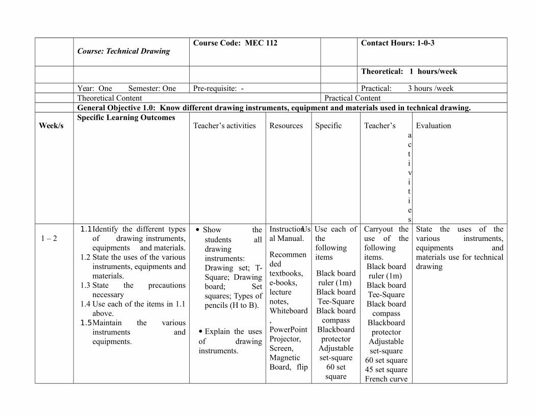
Year: One Semester: One Pre-requisite: - Practical: 3 hours /weekTheoretical Content Practical ContentGeneral Objective 1.0: Know different drawing instruments, equipment and materials used in technical drawing.
Week/sSpecific Learning Outcomes
Teacher’s activities Resources Specific Teacher’sactivities
Evaluation
1 – 21.1Identify the different types
of drawing instruments,equipments and materials.
1.2 State the uses of the variousinstruments, equipments andmaterials.
1.3 State the precautionsnecessary
1.4 Use each of the items in 1.1above.
1.5Maintain the variousinstruments andequipments.
Show thestudents alldrawinginstruments:Drawing set; T-Square; Drawingboard; Setsquares; Types ofpencils (H to B).
Explain the usesof drawinginstruments.
Instructional Manual.
Recommendedtextbooks,e-books,lecturenotes,Whiteboard,PowerPointProjector,Screen,MagneticBoard, flip
Us Use each ofthefollowingitems
Black boardruler (1m)
Black boardTee-SquareBlack board
compassBlackboardprotector
Adjustableset-square
60 setsquare
Carryout theuse of thefollowingitems.Black boardruler (1m)
Black boardTee-SquareBlack board
compassBlackboardprotector
Adjustableset-square
60 set square45 set squareFrench curve
State the uses of thevarious instruments,equipments andmaterials use for technicaldrawing

charts, etc. 45 setsquareFrench
curve setTemplatesCompletedrawing
table.
in . Maintain thevariousinstrumentsandequipment
setTemplatesCompletedrawing
table.
Carryout themaintenanceof thevariousinstrumentsandequipments.
General Objective 2.0: Know Graphical Communication

2.1 Explain graphics anddifferent types ofgraphic presentation.
2.2 Illustrate the variousconvention present ingraphical productions ofconstruction lines,finished lines, hidden andoverhead detailsprojections, centre lines,break lines, dimensioningof plane, elevation andsections of objects.
2.3 State the variousstandards of drawingsheets.
2.4 Print letters and figuresof various forms andcharacters.
2.5 Illustrate conventionalsigns, symbols andappropriate letteringcharacters.
Explaintechnicallettering incapital andsmall letters,using, free handand using letterstencils.
Identify thevarious standardsheets A0 –A4
Instructional Manual.
Recommendedtextbooks,e-books,lecturenotes,Whiteboard,PowerPointProjector,Screen,Magneticboard, flipcharts, etc.
Layout ofdrawingsheets withthefollowing(a) Margins(b) Titleblock etc
Illustrate indrawing thevarioustypes oflines basedon BS 3081972 Part 2.
Set drawingarea on A1paper with atitle blockand theboarderlines.
Drawconventional signs andsymbols
Carryoutlayout ofdrawingsheets
Carryoutdrawing ofvarious typesof linesbased on BS308 1972
Demonstratedrawing areaon A1 paperwith a titleblock and theboarder lines.
Carryoutdrawing ofconventionalsigns andsymbols.
Explain graphics anddifferent types ofgraphic presentation.
General Objective 3.0: Know the construction of simple geometrical figures and shapes.3 – 6 3.1 Explain the purpose of Discuss the
various types ofInstruction

geometrical construction in
drawing.
informationrequired forwritingtechnical report.
Use questionsand answertechnique
Give examples
Giveassignments
al Manual.
Recommendedtextbooks,e-books,lecturenotes,Whiteboard,PowerPointProjector,Screen,MagneticBoard, flipcharts, etc.
General Objective 4.0: Know Isometric and Oblique Projections.
7 - 10
4.1 Mention main sources ofdata. 4.2 Discuss techniques of data collection:
a. Laboratory.b. Field
survey/measurement.c. Questionnaire.d. Oral interviews.
Explaintechniquesinvolved insourcing data
Use questionsand answertechnique
Give examples
Giveassignments
InstructionalManual.
Recommended textbooks,e-books,lecture notes,Whiteboard,PowerPointProjector,Screen,Magneticboard, flipcharts, etc.
General Objective 5.0: Know single orthographic projections.5.1 Explain how to present datain a
Explain tostudent on
InstructionalManual.
11 - 12 manner suitable for writing technical report in thefollowing form: Tables, Graphs, Charts, bars. 5.2 Input information into computer.5.3 Print out results.
techniquesinvolved inpresentinginformation/data
Use questionsand answertechnique
Give examples
Giveassignments
Recommended textbooks,e-books,lecture notes,Whiteboard,PowerPointProjector,Screen,MagneticBoard, flipcharts, etc.
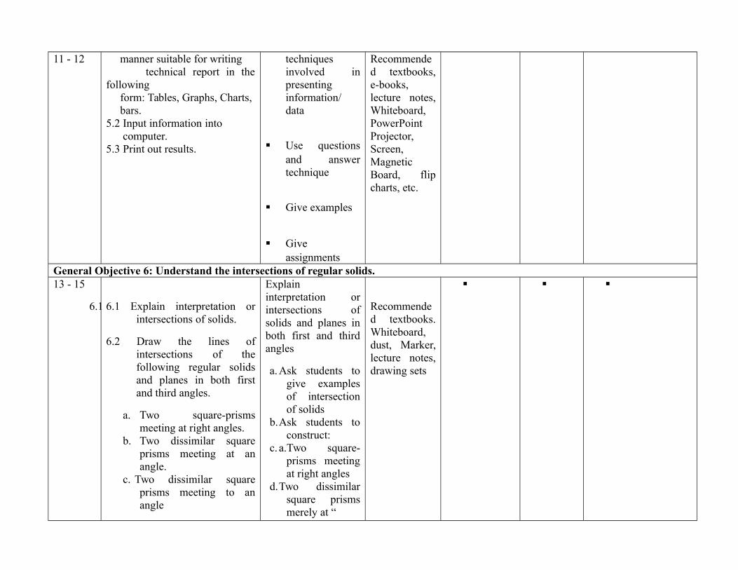
General Objective 6: Understand the intersections of regular solids.13 - 15
6.1 6.1 Explain interpretation orintersections of solids.
6.2 Draw the lines ofintersections of thefollowing regular solidsand planes in both firstand third angles.
a. Two square-prismsmeeting at right angles.
b. Two dissimilar squareprisms meeting at anangle.
c. Two dissimilar squareprisms meeting to anangle
Explaininterpretation orintersections ofsolids and planes inboth first and thirdangles
a. Ask students togive examplesof intersectionof solids
b.Ask students toconstruct:
c. a.Two square-prisms meetingat right angles
d.Two dissimilarsquare prismsmerely at “
Recommended textbooks.Whiteboard,dust, Marker,lecture notes,drawing sets
d. A hexagonal prismmeeting a square prism atright angles.
e. Two dissimilar cylindersmeeting at an angle
f. Two dissimilar cylindersmeeting at right angle,their centres not being inthe same vertical plane.
e. Two dissimilarsquare prismsmeeting 60
f. An hexagonalprism meeting asquare prism
g.Two dissimilarcylindersmeeting at ananglef. Twodismal cylindersmeeting at rightangle, thencentres at longin the samevertical place
h.As in 6.2ASSESSMENT: The continuous assessment, tests and quizzes will be awarded 40% of the total score. The end of the Semester Examinationwill make up for the remaining 60% of the total score.
Competency: Students to acquire skills in technical report writing.

NATIONAL DIPLOMA IN HYDROLOGYAND WATER RESOURCESMANAGEMENT
Course Code: ICT 119 Contact Hours: 1 – 0 - 2
Subject/Course: Introduction to Computing Theoretical: 1 hours/week
Year: 1 Semester: 2 Pre-requisite: Practical: 2 hours /week
Goal: this course is designed to provide the learner with knowledge of computer system software using word, graphics and spreadsheets package.
General Objectives
1.0 Know history and uses of a computer system.2.0 Know Windows operating system.3.0 Understand file management in Windows/ Mac OS, concept of a software packages and printing.4.0 Know Word-Processing packages. 5.0 Know graphic packages.
6.0 Know spreadsheet package.
7.0 Know the use of a database package.
8.0 Know how to use the internet to retrieve and upload information.
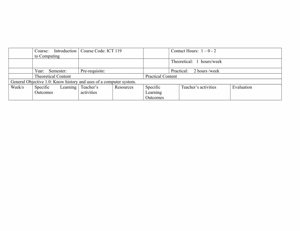
Course: Introductionto Computing
Course Code: ICT 119 Contact Hours: 1 – 0 - 2
Theoretical: 1 hours/week
Year: Semester: Pre-requisite: Practical: 2 hours /weekTheoretical Content Practical Content
General Objective 1.0: Know history and uses of a computer system.Week/s Specific Learning
OutcomesTeacher’sactivities
Resources SpecificLearningOutcomes
Teacher’s activities Evaluation
1 - 2
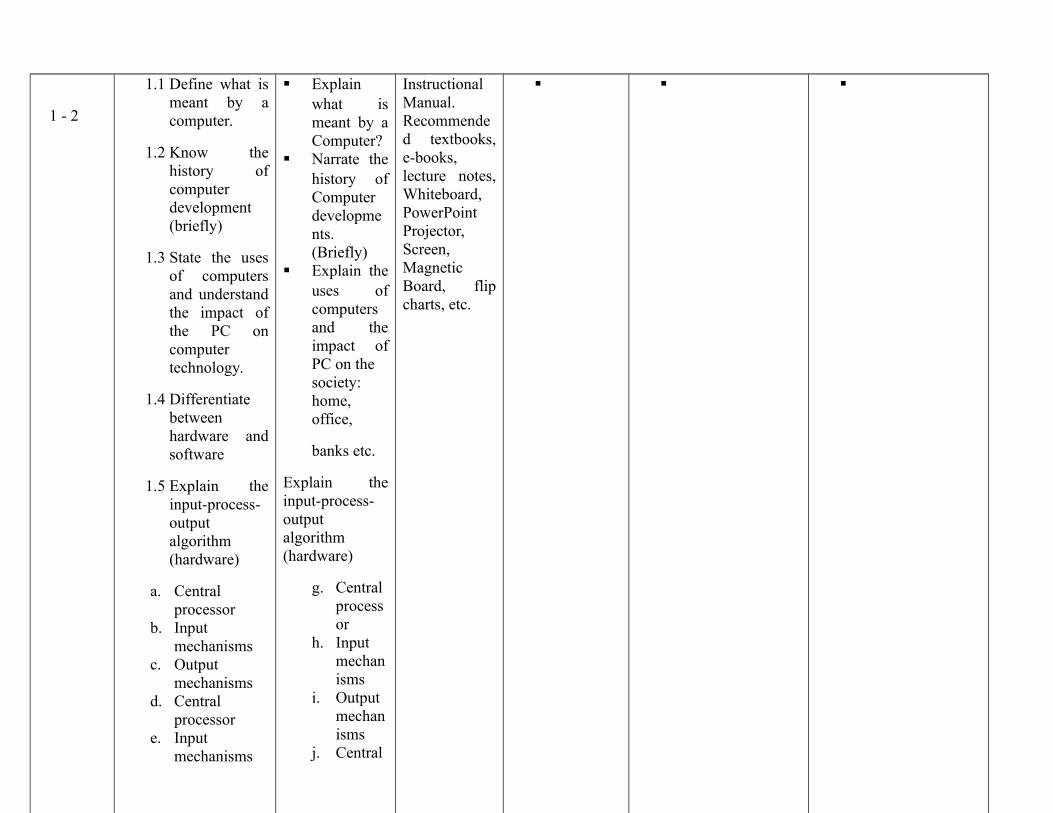
1.1 Define what ismeant by acomputer.
1.2 Know thehistory ofcomputerdevelopment(briefly)
1.3 State the usesof computersand understandthe impact ofthe PC oncomputertechnology.
1.4 Differentiatebetweenhardware andsoftware
1.5 Explain theinput-process-outputalgorithm(hardware)
a. Centralprocessor
b. Inputmechanisms
c. Outputmechanisms
d. Centralprocessor
e. Inputmechanisms
Explainwhat ismeant by aComputer?
Narrate thehistory ofComputerdevelopments.(Briefly)
Explain theuses ofcomputersand theimpact ofPC on thesociety:home,office,
banks etc.
Explain theinput-process-outputalgorithm(hardware)
g. Centralprocessor
h. Inputmechanisms
i. Outputmechanisms
j. Central
InstructionalManual.Recommended textbooks,e-books,lecture notes,Whiteboard,PowerPointProjector,Screen,MagneticBoard, flipcharts, etc.
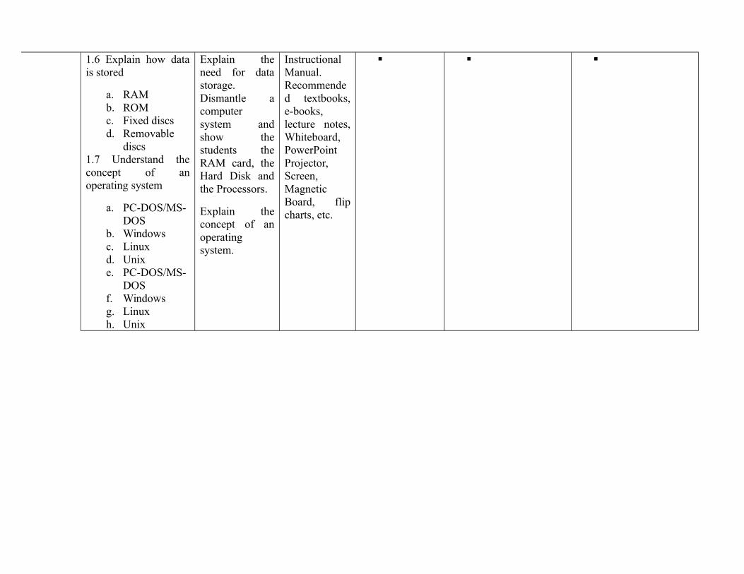
1.6 Explain how datais stored
a. RAMb. ROMc. Fixed discsd. Removable
discs1.7 Understand theconcept of anoperating system
a. PC-DOS/MS-DOS
b. Windowsc. Linuxd. Unixe. PC-DOS/MS-
DOSf. Windowsg. Linuxh. Unix
Explain theneed for datastorage.Dismantle acomputersystem andshow thestudents theRAM card, theHard Disk andthe Processors.
Explain theconcept of anoperatingsystem.
InstructionalManual.Recommended textbooks,e-books,lecture notes,Whiteboard,PowerPointProjector,Screen,MagneticBoard, flipcharts, etc.
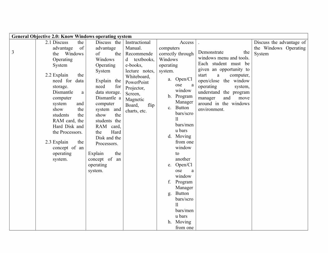
General Objective 2.0: Know Windows operating system
3
2.1 Discuss theadvantage ofthe WindowsOperatingSystem
2.2 Explain theneed for datastorage.Dismantle acomputersystem andshow thestudents theRAM card, theHard Disk andthe Processors.
2.3 Explain theconcept of anoperatingsystem.
Discuss theadvantageof theWindowsOperatingSystem
Explain theneed fordata storage.Dismantle acomputersystem andshow thestudents theRAM card,the HardDisk and theProcessors.
Explain theconcept of anoperatingsystem.
InstructionalManual.Recommended textbooks,e-books,lecture notes,Whiteboard,PowerPointProjector,Screen,MagneticBoard, flipcharts, etc.
Accesscomputerscorrectly throughWindowsoperatingsystem.
a. Open/Close awindow
b. ProgramManager
c. Buttonbars/scrollbars/menu bars
d. Movingfrom onewindowtoanother
e. Open/Close awindow
f. ProgramManager
g. Buttonbars/scrollbars/menu bars
h. Movingfrom one
.
Demonstrate thewindows menu and tools.Each student must begiven an opportunity tostart a computer,open/close the windowoperating system,understand the programmanager and movearound in the windowsenvironment.
Discuss the advantage ofthe Windows OperatingSystem

windowtoanother
General Objective 3.0: Understand file management in Windows/ Mac OS, concept of a software packages and printing.
4.1 Define filemanagement;
a. Creating a fileand folder
b. Manipulatingfiles (moving,copying,saving,deleting)
c. Print managerd. Creating a file
and foldere. Manipulating
files (moving,copying,saving,deleting)
Print manager
Explain .1Demonstratefilemanagement;
Creating a fileand folderManipulatingfiles (moving,copying, saving,deleting)Print managerCreating a fileand folderManipulatingfiles (moving,copying, saving,deleting)
Printmanager
InstructionalManual.Recommended textbooks,e-books,lecture notes,Whiteboard,PowerPointProjector,Screen,MagneticBoard, flipcharts, etc.
3.1 Demonstratefile management;
Creating a fileand folderManipulatingfiles (moving,copying, saving,deleting)Print managerCreating a fileand folderManipulatingfiles (moving,copying, saving,deleting)Print manager
Show the process ofcreating a file,manipulating the file anduse of the print managerto print documents.
Creating a file and folderManipulating files(moving, copying,saving, deleting with Pentium IV, 2GBRAM, 80GB HDD withoptical drive, 1.5GHzProcessor, Windows orMac OS).
Laser Jet Printer (at amaximum of 4 studentsto 1 printer).
1 Ream of A4 papers to10 students.
4 tonners per printer persemester.
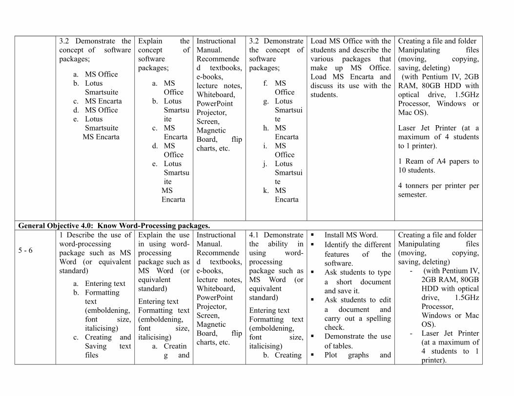
3.2 Demonstrate theconcept of softwarepackages;
a. MS Officeb. Lotus
Smartsuitec. MS Encartad. MS Officee. Lotus
SmartsuiteMS Encarta
Explain theconcept ofsoftwarepackages;
a. MSOffice
b. LotusSmartsuite
c. MSEncarta
d. MSOffice
e. LotusSmartsuite
MSEncarta
InstructionalManual.Recommended textbooks,e-books,lecture notes,Whiteboard,PowerPointProjector,Screen,MagneticBoard, flipcharts, etc.
3.2 Demonstratethe concept ofsoftwarepackages;
f. MSOffice
g. LotusSmartsuite
h. MSEncarta
i. MSOffice
j. LotusSmartsuite
k. MSEncarta
Load MS Office with thestudents and describe thevarious packages thatmake up MS Office.Load MS Encarta anddiscuss its use with thestudents.
Creating a file and folderManipulating files(moving, copying,saving, deleting) (with Pentium IV, 2GBRAM, 80GB HDD withoptical drive, 1.5GHzProcessor, Windows orMac OS).
Laser Jet Printer (at amaximum of 4 studentsto 1 printer).
1 Ream of A4 papers to10 students.
4 tonners per printer persemester.
General Objective 4.0: Know Word-Processing packages.
5 - 6
1 Describe the use ofword-processingpackage such as MSWord (or equivalentstandard)
a. Entering textb. Formatting
text(emboldening,font size,italicising)
c. Creating andSaving textfiles
Explain the usein using word-processingpackage such asMS Word (orequivalentstandard)
Entering textFormatting text(emboldening,font size,italicising)
a. Creating and
InstructionalManual.Recommended textbooks,e-books,lecture notes,Whiteboard,PowerPointProjector,Screen,MagneticBoard, flipcharts, etc.
4.1 Demonstratethe ability inusing word-processingpackage such asMS Word (orequivalentstandard)
Entering textFormatting text(emboldening,font size,italicising)
b. Creating
Install MS Word. Identify the different
features of thesoftware.
Ask students to typea short documentand save it.
Ask students to edita document andcarry out a spellingcheck.
Demonstrate the useof tables.
Plot graphs and
Creating a file and folderManipulating files(moving, copying,saving, deleting)
- (with Pentium IV,2GB RAM, 80GBHDD with opticaldrive, 1.5GHzProcessor,Windows or MacOS).
- Laser Jet Printer(at a maximum of4 students to 1printer).
d. Editing andmoving text
e. Importingobjects
f. Spelling andGrammarChecking
g. Creating andmanipulatingtables, textboxes,equations
h. Printingi. Entering textj. Formatting
text(emboldening,font size,italicising)
Savingtextfiles
Editing andmovingtext
ImportingobjectsSpelling andGrammarCheckingCreating andmanipulatingtables, textboxes,equationsPrintingEntering textFormatting text(emboldening,font size,italicising)
InstructionalManual.Recommended textbooks,e-books,lecture notes,Whiteboard,PowerPointProjector,Screen,MagneticBoard, flipcharts, etc.
andSavingtext files
Editing andmoving text
ImportingobjectsSpelling andGrammarChecking
Creating andmanipulating tables, textboxes,equationsPrinting
Entering textFormatting text(emboldening,font size,italicising)Creating andSaving text filesEditing andmoving textImportingobjectsSpelling andGrammarCheckingCreating andmanipulatingtables, textboxes, equationsPrinting
charts. - 1 Ream of A4papers to 10students.
- 4 tonners perprinter persemester.
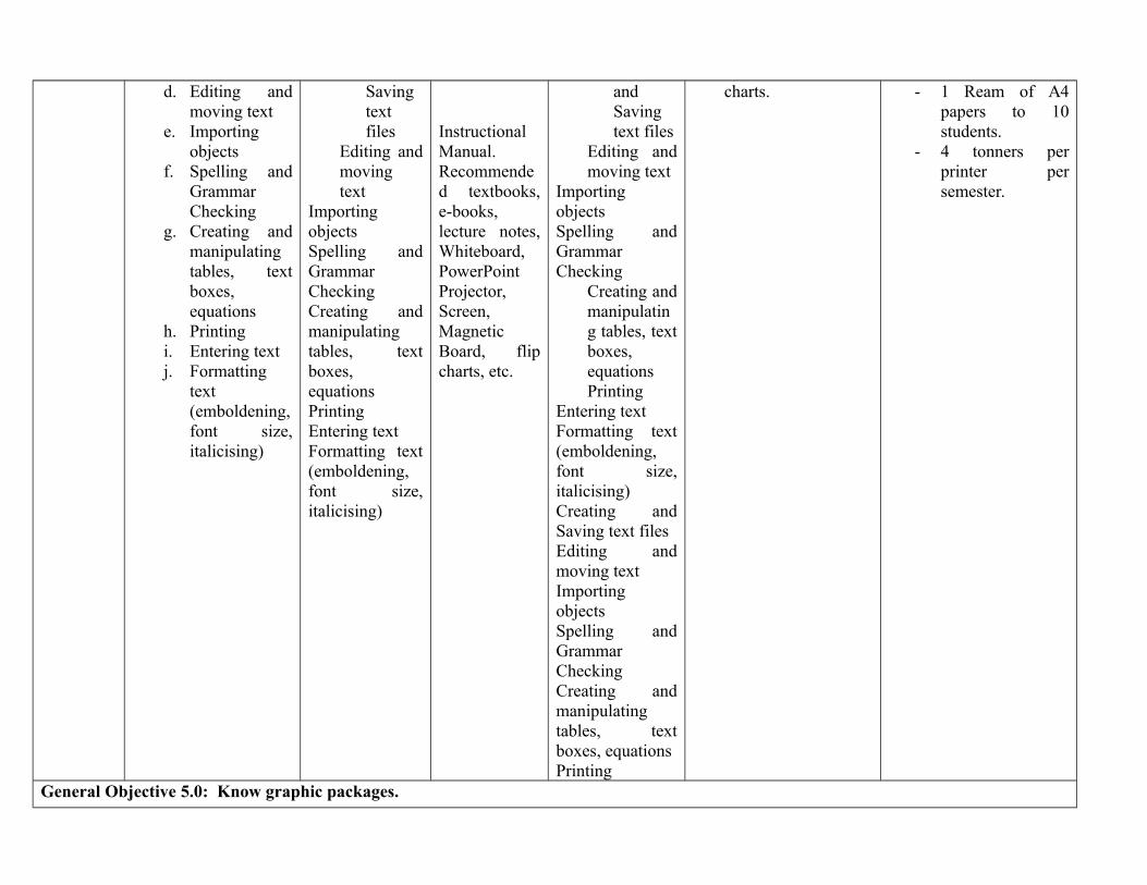
General Objective 5.0: Know graphic packages.

7 - 8
5.1 Describe theability in usinggraphic package suchas Corel Draw (orequivalent standard)
a. Drawing toolsb. Text as
graphicsc. Creating and
saving imagefiles
d. Editing andmovingimages
e. Importing andexportinggraphics
f. Windows‘Clipboard’facility
g. Creating andmanipulatingimages (re-sizing etc)
h. Image filestandard(JPEG, PCX,GIF etc)
Printing
Explain theability in usinggraphic packagesuch as CorelDraw (orequivalentstandard)
Explain thevarious toolsText as graphicsCreating andsaving imagefilesEditing andmoving imagesImporting andexportinggraphicsWindows‘Clipboard’facilityCreating andmanipulatingimages (re-sizing etc)Image filestandard (JPEG,PCX, GIF etc)
Printing
InstructionalManual.Recommended textbooks,e-books,lecture notes,Whiteboard,PowerPointProjector,Screen,MagneticBoard, flipcharts, etc.
InstructionalManual.Recommended textbooks,e-books,lecture notes,Whiteboard,PowerPointProjector,Screen,MagneticBoard, flip
5.1 Demonstratethe ability inusing graphicpackage such asCorel Draw (orequivalentstandard)
Drawing toolsText as graphicsCreating andsaving imagefilesEditing andmoving imagesImporting andexportinggraphicsWindows‘Clipboard’facilityCreating andmanipulatingimages (re-sizingetc)Image filestandard (JPEG,PCX, GIF etc)PrintingDrawing toolsText as graphicsCreating andsaving imagefilesEditing andmoving imagesImporting and
Load Corel Draw. Show features of the
software. Show creating and
saving of images. Edit saved images. Export the graphics
to other packages. Show how to re-size
images.
Maximum of 4students to 1computer
Maximum of 4computers to aprinter except whena Net work is in use.
1 Ream of A4 papersto 10 students.
4 Ink cartridges perprinter per semester.
charts, etc. exportinggraphicsWindows‘Clipboard’facilityCreating andmanipulatingimages (re-sizingetc)
a. Imagefilestandard(JPEG,PCX,GIF etc)
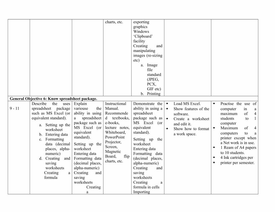
b. PrintingGeneral Objective 6: Know spreadsheet package.
9 - 11Describe the usesspreadsheet packagesuch as MS Excel (orequivalent standard).
a. Setting up theworksheet
b. Entering datac. Formatting
data (decimalplaces, alpha-numeric)
d. Creating andsavingworksheets
Creating aformula
Explainvariouse theability in usinga spreadsheetpackage such asMS Excel (orequivalentstandard).
Setting up theworksheetEntering dataFormatting data(decimal places,alpha-numeric)Creating andsavingworksheets
Creatinga
InstructionalManual.Recommended textbooks,e-books,lecture notes,Whiteboard,PowerPointProjector,Screen,MagneticBoard, flipcharts, etc.
Demonstrate theability in using aspreadsheetpackage such asMS Excel (orequivalentstandard).
Setting up theworksheetEntering dataFormatting data(decimal places,alpha-numeric)Creating andsavingworksheetsCreating aformula in cellsImporting
Load MS Excel. Show features of the
software. Create a worksheet
and edit it. Show how to format
a work space.
Practise the use ofcomputer in amaximum of 4students to 1computer
Maximum of 4computers to aprinter except whena Net work is in use.
1 Ream of A4 papersto 10 students.
4 Ink cartridges per printer per semester.
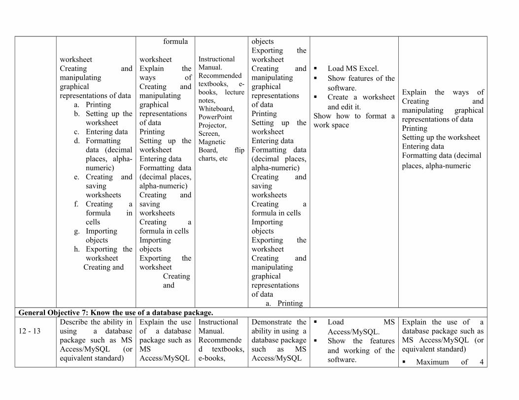
worksheetCreating andmanipulatinggraphicalrepresentations of data
a. Printingb. Setting up the
worksheetc. Entering datad. Formatting
data (decimalplaces, alpha-numeric)
e. Creating andsavingworksheets
f. Creating aformula incells
g. Importingobjects
h. Exporting theworksheet
Creating and
formula
worksheetExplain theways ofCreating andmanipulatinggraphicalrepresentationsof dataPrintingSetting up theworksheetEntering dataFormatting data(decimal places,alpha-numeric)Creating andsavingworksheetsCreating aformula in cellsImportingobjectsExporting theworksheet
Creatingand
InstructionalManual.Recommendedtextbooks, e-books, lecturenotes,Whiteboard,PowerPointProjector,Screen,MagneticBoard, flipcharts, etc
objectsExporting theworksheetCreating andmanipulatinggraphicalrepresentationsof dataPrintingSetting up theworksheetEntering dataFormatting data(decimal places,alpha-numeric)Creating andsavingworksheetsCreating aformula in cellsImportingobjectsExporting theworksheetCreating andmanipulatinggraphicalrepresentationsof data
a. Printing
Load MS Excel. Show features of the
software. Create a worksheet
and edit it.Show how to format awork space
Explain the ways ofCreating andmanipulating graphicalrepresentations of dataPrintingSetting up the worksheetEntering dataFormatting data (decimal places, alpha-numeric
General Objective 7: Know the use of a database package.
12 - 13Describe the ability inusing a databasepackage such as MSAccess/MySQL (orequivalent standard)
Explain the useof a databasepackage such asMSAccess/MySQL
InstructionalManual.Recommended textbooks,e-books,
Demonstrate theability in using adatabase packagesuch as MSAccess/MySQL
Load MSAccess/MySQL.
Show the featuresand working of thesoftware.
Explain the use of adatabase package such asMS Access/MySQL (orequivalent standard)
Maximum of 4
a. Drawing toolsb. Text as
graphicsc. Creating &
saving imagefiles
d. Editing &movingimages
e. Importing &exportinggraphics
Windows
Creating &manipulating images(re-sizing etc)
a. Image filestandards(JPEG, PCX,GIF etc)
b. Printingc. Drawing tools
Text as
a. graphicsb. Creating &
saving imagefiles
c. Editing &movingimages
(or equivalentstandard)
Drawing toolsText as graphicsCreating &saving imagefilesEditing &moving imagesImporting &exportinggraphicsWindows
Explain processin Creating &manipulatingimages (re-sizing etc)Image filestandards(JPEG, PCX,GIF etc)PrintingDrawing toolsText as graphicsCreating &saving imagefilesEditing &moving imagesImporting &exportinggraphicsWindows
lecture notes,Whiteboard,PowerPointProjector,Screen,MagneticBoard, flipcharts, etc.
InstructionalManual.Recommendedtextbooks, e-books, lecturenotes,Whiteboard,PowerPoint
(or equivalentstandard)
Drawing toolsText as graphicsCreating &saving imagefilesEditing &moving imagesImporting &exportinggraphicsWindows‘Clipboard’facilityCreating &manipulatingimages (re-sizingetc)
h. Imagefilestandards (JPEG,PCX,GIF etc)
i. Printingj. Drawing
toolsk. Text as
graphicsl. Creating
& savingimagefiles
m. Editing&
Use students recordas example and enterthe records in thestructure querymodify and producetypical report.
Show how to indexand sort files inalphabetical order.
students to 1computer.
MySQL Software. Maximum of 4
computers to aprinter except whena Net work is in use.
1 Ream of A4 papersto 10 students.
4 Ink cartridges perprinter per semester.
d. Importing &exportinggraphics
e. Windows‘Clipboard’facility
f. Creating &manipulatingimages (re-sizing etc)
g. Image filestandards(JPEG, PCX,GIF etc)
Printing
‘Clipboard’facilityCreating &manipulatingimages (re-sizing etc)Image filestandards(JPEG, PCX,GIF etc)Printing
Projector,Screen,MagneticBoard, flipcharts, etc
movingimages
n. Importing &exportinggraphics
o. Windows‘Clipboard’facility
p. Creating&manipulatingimages(re-sizingetc)
q. Imagefilestandards (JPEG,PCX,GIF etc)
r. PrintingGeneral Objective 8: Know how to use the internet to retrieve and upload information.
14 – 15 Exemplify how to usethe internet to retrieveand uploadinformation.
a. World WideWeb (WWW)
b. Download
Explain how touse the internetto retrieve anduploadinformation.
World WideWeb (WWW)
Instructional Manual.Recommendedtextbooks,e-books,lecturenotes,
Demonstrate howto use the internetto retrieve anduploadinformation.
World Wide Web(WWW)
Show students how to
surf the Internet. Write and send an
email.
Maximum of 4students to 1computer
Maximum of 4computers to aprinter except whena Net work is in use.
informationc. Paste retrieved
informationinto anappropriateapplication
d. Use e-mail tosend andreceivemessages.
e. National andinternationale-mail
f. E-mailattachments(sending &receiving)
g. World WideWeb (WWW)
h. Downloadinformation
i. Paste retrievedinformationinto anappropriateapplication
j. Use e-mail tosend andreceivemessages.
k. National andinternationale-mail
E-mail attachments(sending & receiving)
DownloadinformationPaste retrievedinformation intoan appropriateapplicationUse e-mail tosend andreceivemessages.National andinternational e-mailE-mailattachments(sending &receiving)World WideWeb (WWW)DownloadinformationPaste retrievedinformation intoan appropriateapplicationUse e-mail tosend andreceivemessages.National andinternational e-mailE-mailattachments(sending &receiving)
Whiteboard,PowerPointProjector,Screen,MagneticBoard, flipcharts, etc
InstructionalManual.Recommended textbooks, e-books, lecturenotes,
Whiteboard,PowerPointProjector,Screen,MagneticBoard, flipcharts, etc
Downloadinformation
Paste retrievedinformation intoan appropriateapplication
Use e-mail tosend and receivemessages.National andinternational e-mailE-mailattachments(sending &receiving)World Wide Web(WWW)DownloadinformationPaste retrievedinformation intoan appropriateapplicationUse e-mail tosend and receivemessages.National andinternational e-mailE-mailattachments(sending &receiving)
1 Ream of A4 papersto 10 students.
4 Ink cartridges perprinter per semester.
Internet connectivity.
ASSESSMENT: The continuous assessment, tests and quizzes will be awarded 40% of the total score. The end of the Semester Examination willmake up for the remaining 60% of the total score.
Department/Programme: NATIONAL DIPLOMA INHYDROLOGY AND WATERRESOURCES MANAGEMENT
Course Code: GNS 111 Contact Hours: 2 – 0 - 0
Subject/Course: Citizenship Education I Theory: 2 hours/week
Year: ND I Semester: 1st Pre-requisite: Practical: 0 hours/week
Goal: this course is designed to acquaint the learner with knowledge of Nigerian constitution.
General Objectives:
1.0 Understand the Constitution of Nigeria2.0 Understand the federal system of government in Nigeria3.0 Know the constitutional rights and obligations of Nigerian citizens4.0 Understand Citizenships5.0 Understand fundamental objectives and directive principles of state policy in Nigeria

PROGRAMME: NATIONAL DIPLOMA IN HYDROLOGY AND WATER RESOURCES MANAGEMENT
Course: Citizenship Education I Course Code: GNS 111 Contact Hours 2HRS/WEEK
Course Specification: Theoretical Content: 2 hrs Practical Content: hrs
General Objective: Understand Constitution
Week General Objective 1.0: Understand the Constitution of Nigeria
Specific Learning Outcome: Teacher Activities Resources Specific LearningOutcome:
TeacherActivities
Resources
1-4
1.1 Explain the term constitution
1.2 Distinguish the different types ofconstitution
1.3 Highlight some provisions of anInternational Constitution
1.4 Explain the effectiveness ofInternational Constitution
1.5 Explain the supremacy of theNigerian Constitution to otherlaws with emphasis on the 1989constitution
1.6 Evaluate the main parts of theNigeria Constitution
1.7 Draft a constitution for anassociation
1.8 Trace the historical developmentof the Nigerian Constitution
1.9 Discuss the merits and demeritsof each of the Nigerianconstitutions
1.10 Explain the concept of “rule oflaw”
1.1 Explain theterm constitution and tothe different rules ofconstitution and explain the effectivenessof InternationalConstitution
1.2 Explain NigerianConstitution to otherlaws.
1.3 Identify the main partsof the NigerianConstitution.
1.4 explain how to draft aconstitution by drafting aconstitution for anassociation
InstructionalManual.
Recommendedtextbooks,e-books,lecturenotes,Whiteboard,PowerPointProjector,Screen,MagneticBoard,flipcharts,etc.
General Objective: 2.0 Understand the federal system of government in Nigeria5-7 Specific Learning Outcome: Teachers Activities Resources Specific Learning
Outcome:TeacherActivities
Evaluation
2.1 Describe a federation Explain the term federation anddifferentiate between a
Instructional
2.2 Distinguish a federation from aconfederation
2.3 Outline the basis for the federalsystem in Nigeria
2.4 Examine the evolution, structureand functions of the federalsystem in Nigeria.
2.5 Analyse the relationships amongthe three tiers of government inNigeria
2.6 Evaluate the revenue allocationformula in operation in Nigeria
2.7 Compare and contrast otherfederation with Nigeria
federation and aconfederation
a. to define the functions ofthe federal system inNigeria and therelationship among the three tiers of government
b. to evaluate the revenueallocation formulaoperation in Nigeria.
Manual.
Recommendedtextbooks,e-books,lecturenotes,Whiteboard,PowerPointProjector,Screen,MagneticBoard,flipcharts,etc.
General Objective: 3.0 Know the constitutional rights and obligations of Nigerian citizens8-9 Specific Learning Outcome: Teachers Activities Resources Specific Learning
Outcome:TeacherActivities
Evaluation
3.1 Examine the significance of rightsand obligations in Nigeria
3.2 Assess government’s protection offundamental rights as contained inthe Nigerian constitution
3.3 Evaluate the responsibilities andduties of Nigerian citizenships andthe benefits for performing them
3.4 Assess the responsibilities and dutiesof constituted authority to the people
Explain after which you willask the students toidentify theresponsibilities and dutiesof Nigerian citizenship
InstructionalManual.
Recommendedtextbooks,e-books,lecturenotes,Whiteboard,PowerPointProjector,Screen,

3.5 Evaluate the responsibilities andduties of government to the People Magnetic
Board,flipcharts,etc.
Week General Objective 4.0: Understand Citizenships10-12 Specific Learning Outcome: Teachers Activities Resources Specific Learning
Outcome:TeacherActivities
Evaluation
4.1 Discuss the significance ofcitizenship
4.2 Analyse the principles and benefitsof citizenship
4.3 Explain the difference in the modesof acquiring citizenship
4.4 Evaluate the merits and demerits ofeach type of citizenship
4.4 Analyse the basis for the acquisitionand withdrawal of Nigeriancitizenship
4.5 Examine the benefits derivablefrom Nigeria citizenship
Explain the principles andbenefits of citizenship
Analyze the basis for theacquisition and withdrawal ofNigerian citizenship
InstructionalManual.
Recommendedtextbooks,e-books,lecturenotes,Whiteboard,PowerPointProjector,Screen,MagneticBoard,flipcharts,etc.
Week General Objective 5.0: Fundamental objectives and directive principles of state policy in Nigeria
Specific Learning Outcome: Teachers Activities Resources Specific LearningOutcome:
TeacherActivities
Evaluation
13-15 5.1 State the fundamental obligations ofgovernment as provided in theconstitution
5.2 Explain the general provisions of thefundamental objectives and directiveprinciples of state policy
5.3 Explain the political, economic,social and education policies ofNigeria
5.4 Explain the directive principles andpolicy of the Nigerian governmenton culture, the mass media, nationalethics and duties of the citizen
5.5 Assess the conformity observanceand application of the fundamentalobjectives and directive principlesof state policy by governments andpeople of Nigeria.
5.6 Recommend improvements on theprovision conformity,
observance and application of thefundamental
objectives and directive principlesof state policy
5.1 Discuss withexamples the directiveprinciples and policy of the Nigerianprinciples of statepolicy
5.2 Government oncultures, themass media, nationalethnics and duties of thecitizen.
5.3-5.6 Assess theconformity observanceand application of thefundamental objectivesand directive principlesof state policy bygovernments and peopleof Nigeria.
5.6 Recommendimprovements on theprovision conformity,
observance andapplication of thefundamental
objectives anddirective principles of
InstructionalManual.
Recommendedtextbooks,e-books,lecturenotes,Whiteboard,PowerPointProjector,Screen,MagneticBoard,flipcharts,etc.
state policyASSESSMENT: The continuous assessment, tests and quizzes will be awarded 40% of the total score. The end of the Semester Examination will make upfor the remaining 60% of the total score.

Programme: ND HWR Course Code: Credit Hours:
Course: Hydro Chemistry HWR 113Theoretical: hours/week
2Year: Semester: Pre-requisite: Practical: hours /week 3
Goal: this course is designed to provide the learner with the principles and applications of Gravimetric Analysis
General Objectives1.0 Understand the Analytical Process
2.0 Understand the physical/chemical principles involved in separation methods
3.0 Understand the Statistical Analysis of Experimental Data
4.0 Understand the principle of Titrimetric Analysis, including the use of non-aqueous solvents
5.0 Understand the principles and applications of Gravimetric Analysis

Course: Hydro Chemistry Course Code: STC 123 Credit HoursTheoretical: 2 hours/week
Year: Semester: Pre-requisite: Practical: 3 hours /weekTheoreticalContent
Practical ContentGeneral Objective 1.0: Understand the Analytical Process
Week/s
Specific Learning Outcomes Teacher’sactivities
Resources SpecificLearningOutcomes
Teacher’sactivities
Evaluation
1
2
1.1Relate the issues involved with samplecollection and storage. Discuss how toobtain a representative sample.
1.2Describe the techniques used in samplepreparation.
1.3Explain ‘Fitness for purpose’ andrelevant technique characteristics: limitof detection, limit of quantization,sensitivity, and selectivity.
1.4Explain the three methods ofcalibration: external standards, internalstandards and standard additions.
1.5 use the method of least squares tocalculate a straight line through datapoints
Explain samplecollection andstorage. Discuss howto obtain arepresentativesample.Describe thetechniques used insample preparation.Explain ‘Fitness forpurpose’ and relevanttechniquecharacteristics: limitof detection, limit ofquantization,sensitivity, andselectivity.
1.6Explain thethree methods
Blackboard,chalk
Blackboard,chalk,calculators
Calibration ofa pipette– useof labglassware andanalyticalbalance
Practical use oflinearregression
Explain;introduction togeneralapparatus,demonstration n ofcorrectmethod ofoperation
Studentguidance
Balance,50and/or 25mlpipettes,pipettefillers,weighingcontainers, table ofdensity vs.temperature forwater,thermometer s
Rulers,calculators
General Objective 2.0: Understand the physical/chemical principles involved in separation methodsWeek/s
Specific Learning Outcomes Teacher’sactivities
Resources
SpecificLearningOutcomes
Teacher’sactivities
Resources
32.1 Define chromatography as a means of
separating2.2 mixtures by the distribution of its
components between a stationary and amobile phase in adsorption andpartition chromatography.
2.3 Describe paper and silica gelthin layer chromatography
2.4 Describe column chromatography oversilica gel
2.5 Describe gas chromatography2.6 Distinguish between adsorption
chromatography and partitionchromatography
2.7 Define partition coefficient and retentiontime
2.8 Define the terms Rf and Rv (retention
Explain withrelevantexamples and giveassignments.
Definechromatography as ameans of separating
mixtures by thedistribution of itscomponentsbetween astationary and amobile phase inadsorption andpartitionchromatography.
Describepaper and
ClassroomResources Chromatographiccolumn,thin layerplate,mixture ofcomponents
Separatemixtureinto its variouscomponentsusing silica gelTLC andcolumnchromatography
Demonstrateand let thestudentpracticetheseparationof amixture
Definechromatography as ameans ofseparatingmixturesby thedistributionof itscomponents betweenastationaryand amobilephase inadsorptionand
42.8 Describe the technique of solvent extraction2.9 Explain why it is more efficient to extract a solute from a solution by using two or more portions of an immiscible solvent than touse the same total volume in one bulk.
2.10 Describe the functioning of soxhlet extraction.2.11 Differentiate between batch and continuous extraction.
Explain and illustratewith relevantexamples
Describe the techniqueof solvent extraction Explain why it ismore efficient toextract a solute from asolution by using twoor more portions of an
ClassroomResourcesSolventsextractionapparatus
Determine theextent ofextraction of amaterial fromone phase intoa second phaseapplying theprinciple ofpartition law.
Demonstrateand allowstudents toapplysomeprinciples
Describe thetechnique ofsolventextraction Explain whyit is moreefficient toextract a solutefrom asolution byusing two ormore

52.12 Describe methods for the detection of colourless
material in paper and thin layerchromatography and solvents in GC.
2.13 Describe the chemical form of an acidicor basic ion exchange resin.
Explain withrelevantexamples and giveassignments
Classroomresources
Identifycolourlessmaterial inpaper and thinlayerchromatograp
Demonstrateand let thestudentspracticethe
Paper andthin layerchromatogram phicequipment
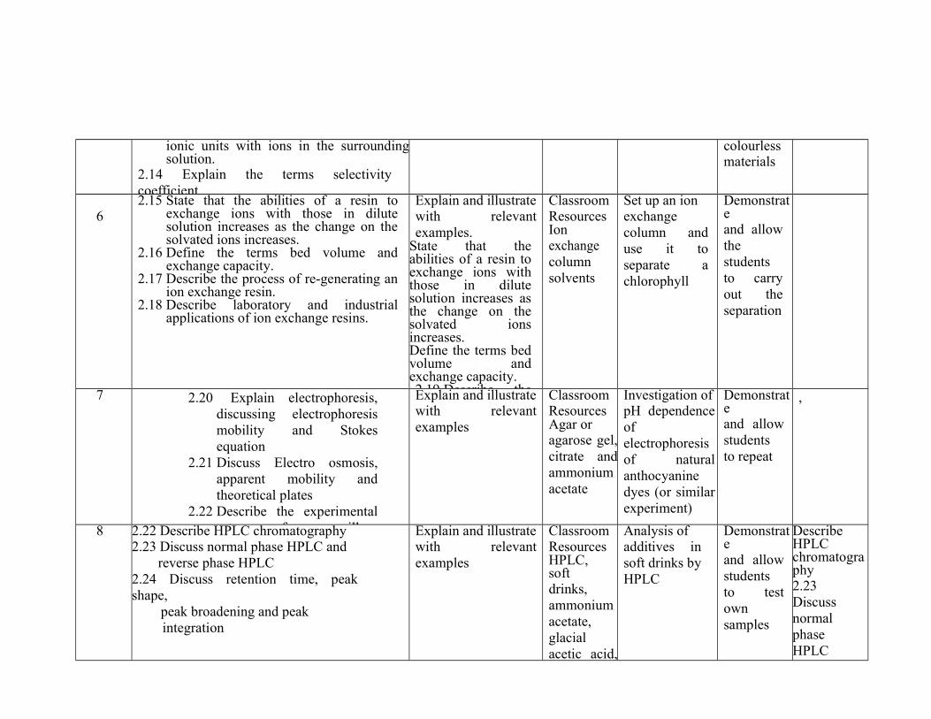
ionic units with ions in the surroundingsolution.
2.14 Explain the terms selectivitycoefficient
colourlessmaterials
62.15 State that the abilities of a resin to
exchange ions with those in dilutesolution increases as the change on thesolvated ions increases.
2.16 Define the terms bed volume andexchange capacity.
2.17 Describe the process of re-generating anion exchange resin.
2.18 Describe laboratory and industrialapplications of ion exchange resins.
Explain and illustratewith relevantexamples.
State that theabilities of a resin toexchange ions withthose in dilutesolution increases asthe change on thesolvated ionsincreases.Define the terms bedvolume andexchange capacity.2.19 Describe the
ClassroomResourcesIonexchangecolumnsolvents
Set up an ionexchangecolumn anduse it toseparate achlorophyll
Demonstrateand allowthestudentsto carryout theseparation
7 2.20 Explain electrophoresis,discussing electrophoresismobility and Stokesequation
2.21 Discuss Electro osmosis,apparent mobility andtheoretical plates
2.22 Describe the experimentalset-up for capillary
Explain and illustratewith relevantexamples
ClassroomResourcesAgar oragarose gel,citrate andammoniumacetate
Investigation ofpH dependenceofelectrophoresisof naturalanthocyaninedyes (or similarexperiment)
Demonstrateand allowstudentsto repeat
,
8 2.22 Describe HPLC chromatography2.23 Discuss normal phase HPLC and reverse phase HPLC2.24 Discuss retention time, peakshape, peak broadening and peak integration
Explain and illustratewith relevantexamples
ClassroomResourcesHPLC,softdrinks,ammoniumacetate,glacialacetic acid,
Analysis ofadditives insoft drinks byHPLC
Demonstrateand allowstudentsto testownsamples
DescribeHPLCchromatography2.23DiscussnormalphaseHPLCand

General Objectives: 3.0: Understand the Statistical Analysis of Experimental Data
93.1 Explain the limitations of
analytical methods.3.2 Define accuracy.
Explain and illustratewith appropriate
Classroomresources,
Treat variousexperimental
Demonstrateand allow
Calculators
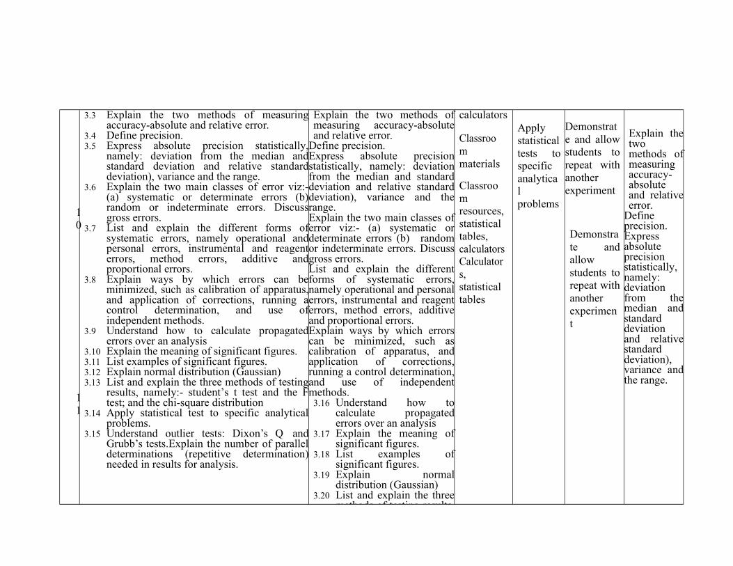
10
11
3.3 Explain the two methods of measuringaccuracy-absolute and relative error.
3.4 Define precision.3.5 Express absolute precision statistically,
namely: deviation from the median andstandard deviation and relative standarddeviation), variance and the range.
3.6 Explain the two main classes of error viz:-(a) systematic or determinate errors (b)random or indeterminate errors. Discussgross errors.
3.7 List and explain the different forms ofsystematic errors, namely operational andpersonal errors, instrumental and reagenterrors, method errors, additive andproportional errors.
3.8 Explain ways by which errors can beminimized, such as calibration of apparatus,and application of corrections, running acontrol determination, and use ofindependent methods.
3.9 Understand how to calculate propagatederrors over an analysis
3.10 Explain the meaning of significant figures.3.11 List examples of significant figures.3.12 Explain normal distribution (Gaussian)3.13 List and explain the three methods of testing
results, namely:- student’s t test and the Ftest; and the chi-square distribution
3.14 Apply statistical test to specific analyticalproblems.
3.15 Understand outlier tests: Dixon’s Q andGrubb’s tests.Explain the number of paralleldeterminations (repetitive determination)needed in results for analysis.
Explain the two methods ofmeasuring accuracy-absoluteand relative error.
Define precision.Express absolute precisionstatistically, namely: deviationfrom the median and standarddeviation and relative standarddeviation), variance and therange.Explain the two main classes oferror viz:- (a) systematic ordeterminate errors (b) randomor indeterminate errors. Discussgross errors.List and explain the differentforms of systematic errors,namely operational and personalerrors, instrumental and reagenterrors, method errors, additiveand proportional errors.Explain ways by which errorscan be minimized, such ascalibration of apparatus, andapplication of corrections,running a control determination,and use of independentmethods.
3.16 Understand how tocalculate propagatederrors over an analysis
3.17 Explain the meaning ofsignificant figures.
3.18 List examples ofsignificant figures.
3.19 Explain normaldistribution (Gaussian)
3.20 List and explain the threemethods of testing results,
calculators
Classroommaterials
Classroomresources,statisticaltables,calculatorsCalculators,statisticaltables
Applystatisticaltests tospecificanalyticalproblems
Demonstrate and allowstudents torepeat withanotherexperiment
Demonstrate andallowstudents torepeat withanotherexperiment
Explain thetwomethods ofmeasuringaccuracy-absoluteand relativeerror.
Defineprecision.Expressabsoluteprecisionstatistically,namely:deviationfrom themedian andstandarddeviationand relativestandarddeviation),variance andthe range.
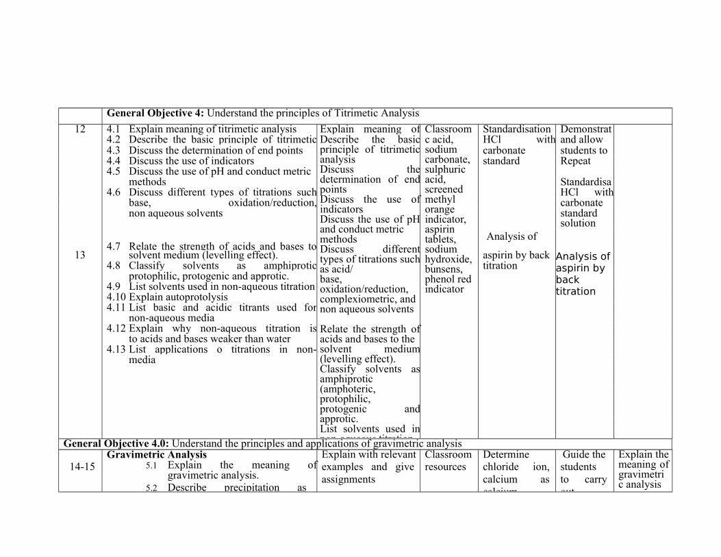
General Objective 4: Understand the principles of Titrimetic Analysis
12 4.1 Explain meaning of titrimetic analysis Explain meaning oftitrimetic analysis
Classroom Standardisationof
Demonstrate4.2 Describe the basic principle of titrimetic
analysisDescribe the basicprinciple of titrimeticanalysisDiscuss thedetermination of endpointsDiscuss the use ofindicatorsDiscuss the use of pHand conduct metricmethodsDiscuss differenttypes of titrations suchas acid/base,oxidation/reduction,complexiometric, andnon aqueous solvents
Relate the strength ofacids and bases to thesolvent medium(levelling effect).Classify solvents asamphiprotic(amphoteric,protophilic,protogenic andapprotic.List solvents used innon-aqueous titration
c acid,sodiumcarbonate,sulphuricacid,screenedmethylorangeindicator,aspirintablets,sodiumhydroxide,bunsens,phenol redindicator
HCl withsodium
and allow4.3 Discuss the determination of end points carbonate students to4.4 Discuss the use of indicators standard
solutionRepeat
4.5 Discuss the use of pH and conduct metricmethods Standardisa
4.6 Discuss different types of titrations suchas acid/
HCl withbase, oxidation/reduction,complexiometric, and
carbonatenon aqueous solvents standard
solution
4.7 Relate the strength of acids and bases to Analysis of
13 solvent medium (levelling effect). aspirin by back Analysis ofaspirin by backtitration
4.8 Classify solvents as amphiprotic(amphoteric,
titrationprotophilic, protogenic and approtic.
4.9 List solvents used in non-aqueous titration4.10 Explain autoprotolysis4.11 List basic and acidic titrants used for
non-aqueous media4.12 Explain why non-aqueous titration is
applicableto acids and bases weaker than water4.13 List applications o titrations in non-
aqueousmedia
General Objective 4.0: Understand the principles and applications of gravimetric analysis
14-15Gravimetric Analysis
5.1 Explain the meaning ofgravimetric analysis.
5.2 Describe precipitation as
Explain with relevantexamples and giveassignments
Classroomresources
Determinechloride ion,calcium ascalcium
Guide thestudentsto carryout
Explain themeaning ofgravimetric analysis
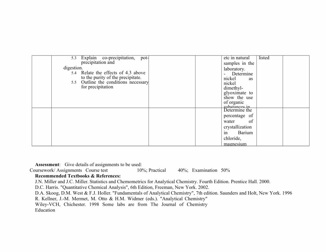
5.3 Explain co-precipitation, pot-precipitation and
digestion.5.4 Relate the effects of 4.3 above
to the purity of the precipitate.5.5 Outline the conditions necessary
for precipitation
etc in naturalsamples in thelaboratory.- Determinenickel asnickeldimethyl-glyoximate toshow the useof organicsubstances in
listed
Determine thepercentage ofwater ofcrystallizationin Bariumchloride,magnesium
Assessment: Give details of assignments to be used:Coursework/ Assignments Course test 10%; Practical 40%; Examination 50%
Recommended Textbooks & References:J.N. Miller and J.C. Miller. Statistics and Chemometrics for Analytical Chemistry. Fourth Edition. Prentice Hall. 2000.D.C. Harris. "Quantitative Chemical Analysis", 6th Edition, Freeman, New York. 2002.D.A. Skoog, D.M. West & F.J. Holler. "Fundamentals of Analytical Chemistry", 7th edition. Saunders and Holt, New York. 1996R. Kellner, J.-M. Mermet, M. Otto & H.M. Widmer (eds.). "Analytical Chemistry"Wiley-VCH, Chichester. 1998 Some labs are from The Journal of ChemistryEducation
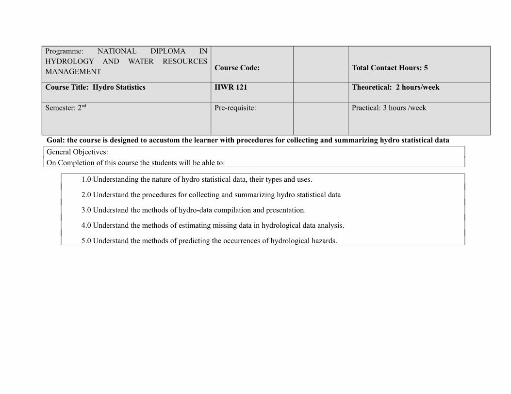
Programme: NATIONAL DIPLOMA INHYDROLOGY AND WATER RESOURCESMANAGEMENT Course Code: Total Contact Hours: 5
Course Title: Hydro Statistics HWR 121 Theoretical: 2 hours/week
Semester: 2nd Pre-requisite: Practical: 3 hours /week
Goal: the course is designed to accustom the learner with procedures for collecting and summarizing hydro statistical data
General Objectives:
On Completion of this course the students will be able to:
1.0 Understanding the nature of hydro statistical data, their types and uses.
2.0 Understand the procedures for collecting and summarizing hydro statistical data
3.0 Understand the methods of hydro-data compilation and presentation.
4.0 Understand the methods of estimating missing data in hydrological data analysis.
5.0 Understand the methods of predicting the occurrences of hydrological hazards.
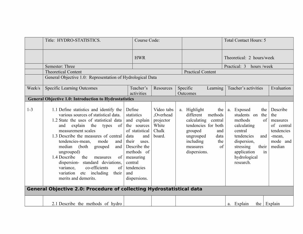
Title: HYDRO-STATISTICS. Course Code: Total Contact Hours: 5
HWR Theoretical: 2 hours/week
Semester: Three Practical: 3 hours /weekTheoretical Content Practical ContentGeneral Objective 1.0: Representation of Hydrological Data
Week/s Specific Learning Outcomes Teacher’sactivities
Resources Specific LearningOutcomes
Teacher’s activities Evaluation
General Objective 1.0: Introduction to Hydrostatistics
1-3 1.1 Define statistics and identify thevarious sources of statistical data.
1.2 State the uses of statistical dataand explain the types ofmeasurement scales
1.3 Describe the measures of centraltendencies-mean, mode andmedian (both grouped andungrouped)
1.4 Describe the measures ofdispersion- standard deviations,variance, co-efficients ofvariation etc including theirmerits and demerits.
Definestatisticsand explainthe sourcesof statisticaldata andtheir uses.Describe themethods ofmeasuringcentraltendenciesanddispersions.
Video tabs,OverheadprojectorWhiteChalkboard.
a. Highlight thedifferent methodscalculating centraltendencies for bothgrouped andungrouped dataincluding themeasures ofdispersions.
a. Exposed thestudents on themethods ofcalculatingcentraltendencies anddispersion,stressing theirapplication inhydrologicalresearch.
Describethemeasuresof centraltendencies-mean,mode andmedian
General Objective 2.0: Procedure of collecting Hydrostatistical data
2.1 Describe the methods of hydro a. Explain the Explain

4-5 data collection (Census, samplesurvey, experiment, observationalstudy,)
2.2 Explain the steps in planning andconducting surveys and state thecharacteristics of well designedand well conducted surveys
2.3 Explain the meaning of samplingand describe relevant samplingterminologies-population,samplings frame, targetpopulation etc
2.4 Describe the different types ofsampling methods (probabilityand non probability) withexamples and the sources of biasin sampling and surveys
Explain themeaning ofsampling,types ofsamplingmethodswithexamples
Video tabs,Overheadprojector
a. Show differentsamplingmethods andterminologies
b. Differentiatebetweenprobability andnon probabilitysamplingmethods.
meaning ofsampling anddistinguishedbetweenprobabilityand nonprobabilitysampling.
sampling anddescriberelevantsamplingterminologies-population,samplings
General Objective 3.0: Methods of hydrological data compilation, summarisation andpresentation
6-7 3.1 Identify the methods of hydro-statistical methods compilation andpresentation (charts, pictorial,tables, graphs, diagrams)
3.2 Describe the methods of presentinghydro-data using any of theaforementioned stating their meritsand demerits.
3.3 Outline the methods of constructingand interpreting graphical displaysof distributions of univariate data
Describethemethodsofconstructing andinterpretinggraphicaldisplaysof
Video tabs,Overheadprojector.PPT slideshow,Whiteboard.
a. Student should beable to explain themethods ofconstructing andinterpretinggraphical displaysof univariate data
Describe thmethods ofconstructing andinterpretingunivariate data aswell as methodsof summarizingunivariate data.
Outline themethods ofconstructingandinterpretinggraphicaldisplays ofdistributionsof univariatedata (dot plot,
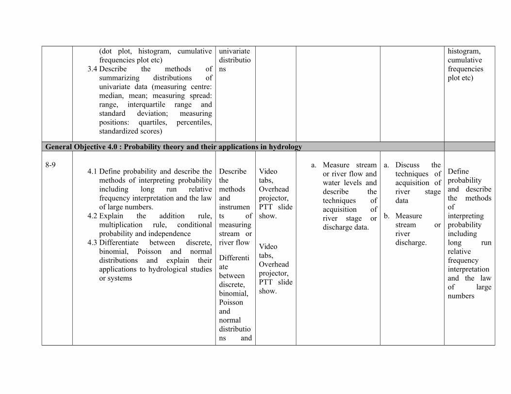
(dot plot, histogram, cumulativefrequencies plot etc)
3.4 Describe the methods ofsummarizing distributions ofunivariate data (measuring centre:median, mean; measuring spread:range, interquartile range andstandard deviation; measuringpositions: quartiles, percentiles,standardized scores)
univariatedistributions
histogram,cumulativefrequenciesplot etc)
General Objective 4.0 : Probability theory and their applications in hydrology
8-94.1 Define probability and describe the
methods of interpreting probabilityincluding long run relativefrequency interpretation and the lawof large numbers.
4.2 Explain the addition rule,multiplication rule, conditionalprobability and independence
4.3 Differentiate between discrete,binomial, Poisson and normaldistributions and explain theirapplications to hydrological studiesor systems
Describethemethodsandinstruments ofmeasuringstream orriver flow
Differentiatebetweendiscrete,binomial,Poissonandnormaldistributions and
Videotabs,Overheadprojector,PTT slideshow.
Videotabs,Overheadprojector,PTT slideshow.
a. Measure streamor river flow andwater levels anddescribe thetechniques ofacquisition ofriver stage ordischarge data.
a. Discuss thetechniques ofacquisition ofriver stagedata
b. Measurestream orriverdischarge.
Defineprobabilityand describethe methodsofinterpretingprobabilityincludinglong runrelativefrequencyinterpretationand the lawof largenumbers
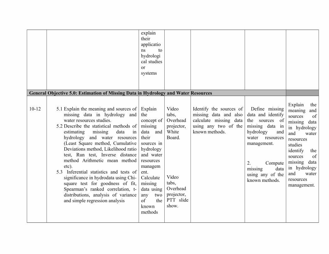
explaintheirapplications tohydrological studiesorsystems
General Objective 5.0: Estimation of Missing Data in Hydrology and Water Resources
10-12 5.1 Explain the meaning and sources ofmissing data in hydrology andwater resources studies.
5.2 Describe the statistical methods ofestimating missing data inhydrology and water resources(Least Square method, CumulativeDeviations method, Likelihood ratiotest, Run test, Inverse distancemethod Arithmetic mean methodetc).
5.3 Inferential statistics and tests ofsignificance in hydrodata using Chi-square test for goodness of fit,Spearman’s ranked correlation, t-distributions, analysis of varianceand simple regression analysis
Explaintheconcept ofmissingdata andtheirsources inhydrologyand waterresourcesmanagement.Calculatemissingdata usingany twoof theknownmethods
Videotabs,Overheadprojector,WhiteBoard.
Videotabs,Overheadprojector,PTT slideshow.
Identify the sources ofmissing data and alsocalculate missing datausing any two of theknown methods.
Define missingdata and identifythe sources ofmissing data inhydrology andwater resourcesmanagement.
2. Computemissing datausing any of theknown methods.
Explain themeaning andsources ofmissing datain hydrologyand waterresourcesstudiesidentify thesources ofmissing datain hydrologyand waterresourcesmanagement.
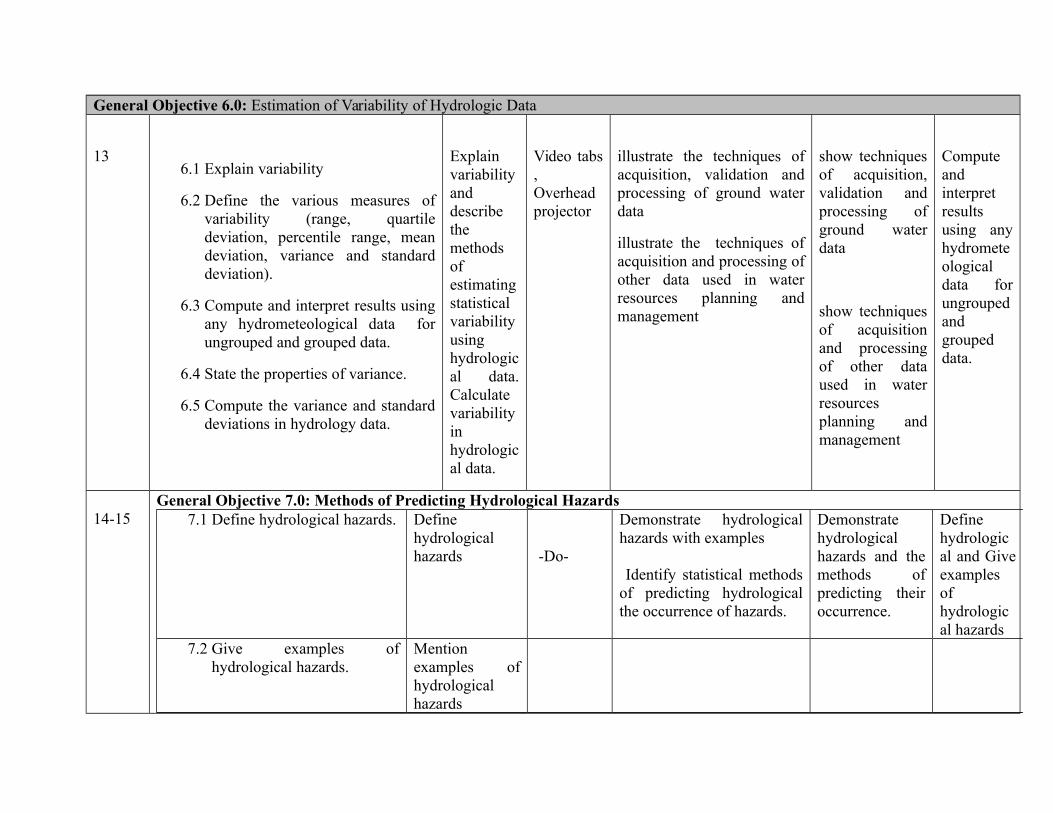
General Objective 6.0: Estimation of Variability of Hydrologic Data
136.1 Explain variability
6.2 Define the various measures ofvariability (range, quartiledeviation, percentile range, meandeviation, variance and standarddeviation).
6.3 Compute and interpret results usingany hydrometeological data forungrouped and grouped data.
6.4 State the properties of variance.
6.5 Compute the variance and standarddeviations in hydrology data.
Explainvariabilityanddescribethemethodsofestimatingstatisticalvariabilityusinghydrological data.Calculatevariabilityinhydrological data.
Video tabs,Overheadprojector
illustrate the techniques ofacquisition, validation andprocessing of ground waterdata
illustrate the techniques ofacquisition and processing ofother data used in waterresources planning andmanagement
show techniquesof acquisition,validation andprocessing ofground waterdata
show techniquesof acquisitionand processingof other dataused in waterresourcesplanning andmanagement
Computeandinterpretresultsusing anyhydrometeologicaldata forungroupedandgroupeddata.
14-15General Objective 7.0: Methods of Predicting Hydrological Hazards
7.1 Define hydrological hazards. Definehydrologicalhazards -Do-
Demonstrate hydrologicalhazards with examples
Identify statistical methodsof predicting hydrologicalthe occurrence of hazards.
Demonstratehydrologicalhazards and themethods ofpredicting theiroccurrence.
Definehydrological and Giveexamplesofhydrological hazards
7.2 Give examples ofhydrological hazards.
Mentionexamples ofhydrologicalhazards

-Do- -Do- -Do7.3 predict hydrological hazard
using appropriate statisticalprocedure (Poissondistribution, Monte Carloanalysis)
Identify themethods ofpredictinghydrologicalhazards
Show ways of Identify themethods of predictinghydrological hazards
Show ways ofIdentify themethods ofpredictinghydrologicalhazards
Explaindifferentmethods ofpredictinghydrological hazards
Coursework/ Laboratory Reports Final Total
Theoretical 20 20 40
Practical 20 40 60%
Total 100%
HWR 233 Introduction to Basic Hydraulics 20hrs
Definition and units; hydrostatics: pressure and its measurements, pressure diagrams; open channel hydraulics; steady and non steadyflow, uniform and non-uniform flow, application of Bernoulli’s equation, Chezy and Manning formulas, measuring devices: flumes,notches, weirs and orifices, backwater effect and bifurcation effect; flow in pipes; sediment transport and river-bed processes.

Programme: NATIONALDIPLOMA IN HYDROLOGY ANDWATER RESOURCESMANAGEMENT
Course Code: HWR 122 Credit Hours:20
Course: Basic Hydraulics Pre-Requisite Theoretical: Hours/Week 2
Semester: 3 Practical: 3
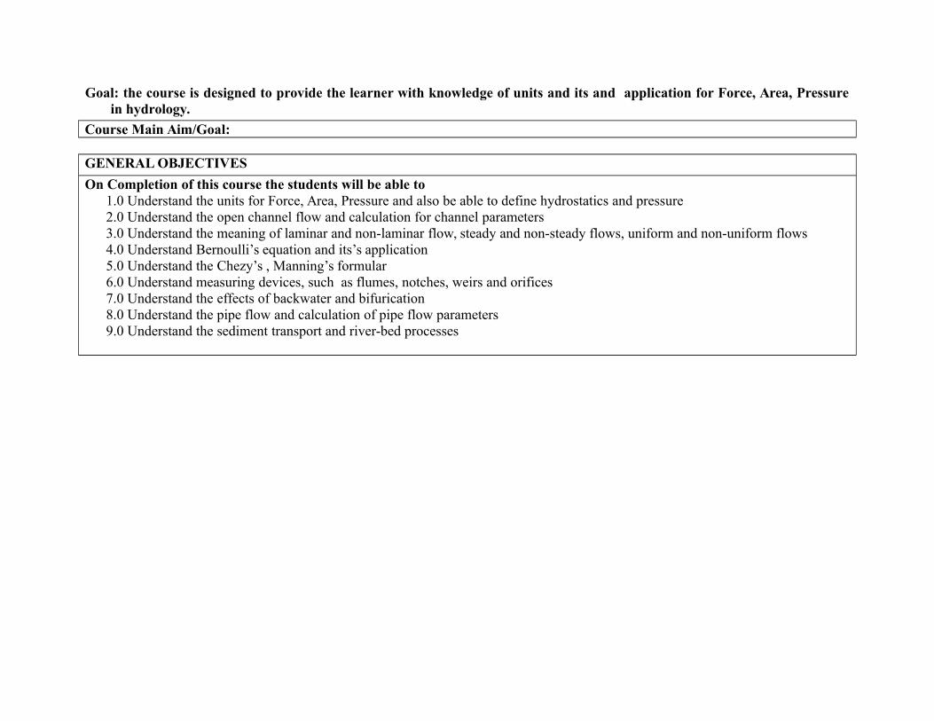
Goal: the course is designed to provide the learner with knowledge of units and its and application for Force, Area, Pressurein hydrology.
Course Main Aim/Goal:
GENERAL OBJECTIVES
On Completion of this course the students will be able to1.0 Understand the units for Force, Area, Pressure and also be able to define hydrostatics and pressure 2.0 Understand the open channel flow and calculation for channel parameters3.0 Understand the meaning of laminar and non-laminar flow, steady and non-steady flows, uniform and non-uniform flows4.0 Understand Bernoulli’s equation and its’s application5.0 Understand the Chezy’s , Manning’s formular6.0 Understand measuring devices, such as flumes, notches, weirs and orifices7.0 Understand the effects of backwater and bifurication8.0 Understand the pipe flow and calculation of pipe flow parameters9.0 Understand the sediment transport and river-bed processes
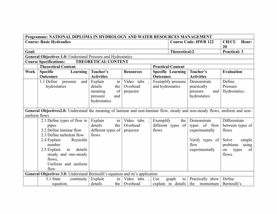
Programme: NATIONAL DIPLOMA IN HYDROLOGY AND WATER RESOURCES MANAGEMENTCourse: Basic Hydraulics Course Code: HWR 122 CH/CU Hour:
20Goal: Theoretical:2 Practical: 3General Objectives 1.0: Understand Pressure and HydrostaticsCourse Specifications: THEORETICAL CONTENT
Theoretical Content Practical ContentWeek Specific Learning
OutcomesTeacher’sActivities
Resources Specific LearningOutcomes
Teacher’sActivities
Evaluation
1.1 Define pressure andhydrostatics
Explain indetails themeaning ofpressure andhydrostatics
Video tabs ,Overheadprojector
Exemplify pressureand hydrostatics
Demonstratepracticallypressure andhydrostatics
Define:PressureHydrostatics.
General Objectives2.0: Understand the meaning of laminar and non-laminar flow, steady and non-steady flows, uniform and non-uniform flows
2.1 Define types of flow inpipes
2.2 Define laminar flow2.3 Define turbulent flow2.4 Explain Reynolds
number2.5 Explain in details
steady and ono-steadyflows,Uniform and uniformflow
Explain indetails thedifferent types offlows
Video tabs ,Overheadprojector
Exemplify thedifferent types offlows
Demonstratetypes of flowexperimentally
Verify types offlowexperimentally
Differentiatebetween types offlows
Solve simpleproblems usingon types offlows.
General Objectives 3.0: Understand Bernoulli’s equation and its’s application3.1 State continuity
equation,Explain indetails the
Video tabs ,Overhead
Use graph toexplain in details
Practically showthe momentum
DefineBernoulli’s

momentum equationand Bernoulli’sTheorem.
continuityequation,momentum andBernoulli’sequation
projector the continuityequation,momentum andBernoulli’sequation
equation inrelationship toBernoulli’sequation
equation
General Objectives 4.0: Understand the Chezy’s and Manning’s formular
4.1 Explain the Chezy’sand Manning’sformula
Explain theChezy’s andManning’sformula
Video tabs ,Overheadprojector
Show in detailsthe Chezy’s andManning formula
Experiments onManning’scoefficient
Determine theManning’scoefficient
General Objectives 5.0: Know about flow through office weirs etc5.1 Explain the
application ofventri-meter andpitot tube
5.2 Explain flowthrough notches andweirs.
5.3 Identify the flow insmall and largeorifices
5.4 Establishrelationship betweenflow rate andpressure difference
Explain theapplication ofventri-meter andpitot tube
Explain flowthrough notchesand weirs.
Identify the flowin small andlarge orifices
Establishrelationshipbetween flowrate and pressuredifference
Video tabs ,Overheadprojector
Differentiatebetween Venturiand pitot tube,Notches and Weirs,Small and LargeOrifices
Laboratoryexperiments onVenturi, pitottube, notches,weirs, small andlarge notches
Differentiatebetween Venturiand pitot tube,Notches andWeirs,Small and LargeOrifices
General Objectives 6.0: Understand the different types of flow in pipes6.1 Explain head losses
in pipe (i.e.roughness
Explain headlosses in pipe(i.e. roughness
Video tabs ,Overheadprojector
Calculate the headlosses in pipes,Due to sudden
Laboratoryexperiments ondetermination of
Calculate majorand minor headlosses in pipe
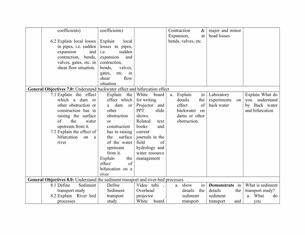
coefficients)
6.2 Explain local lossesin pipes, i.e. suddenexpansion andcontraction, bends,valves, gates, etc. inshear flow situation.
coefficients)
Explain locallosses in pipes,i.e. suddenexpansion andcontraction,bends, valves,gates, etc. inshear flowsituation
Contraction &Expansion, atbends, valves, etc.
major and minorhead losses
General Objectives 7.0: Understand backwater effect and bifurcation effect7.1 Explain the effect
which a dam orother obstruction orconstruction has inraising the surfaceof the waterupstream from it.
7.2 Explain the effect ofbifurcation on ariver
Explain theeffect whicha dam orotherobstructionorconstructionhas in raisingthe surfaceof the waterupstreamfrom it.
Explain theeffect ofbifurcation on ariver
White boardfor writingProjector andPPT slideshows.Related textbooks andcurrentjournals in thefield ofhydrology andwater resourcemanagement
a. Explain indetails theeffect ofbackwater ondams or otherobstruction.
Laboratoryexperiments onback water
Explain What doyou understandby Back waterand bifurcation
General Objectives 8.0: Understand the sediment transport and river-bed processes8.1 Define Sediment
transport study8.2 Explain River bed
processes
DefineSedimenttransportstudy
Video tabs ,OverheadprojectorWhite board
a. show indetails thesedimenttransport
Demonstrate indetails thesedimenttransport and
What is sedimenttransport study?a. What do
you
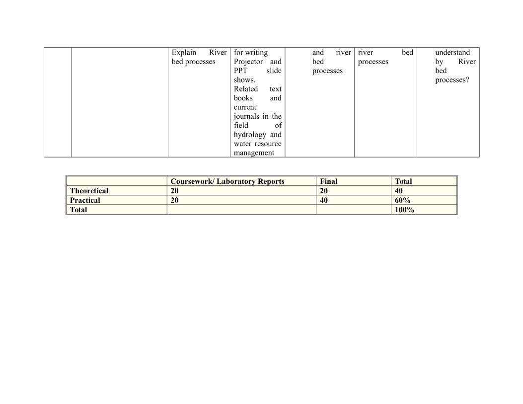
Explain Riverbed processes
for writingProjector andPPT slideshows.Related textbooks andcurrentjournals in thefield ofhydrology andwater resourcemanagement
and riverbedprocesses
river bedprocesses
understandby Riverbedprocesses?
Coursework/ Laboratory Reports Final TotalTheoretical 20 20 40Practical 20 40 60%Total 100%
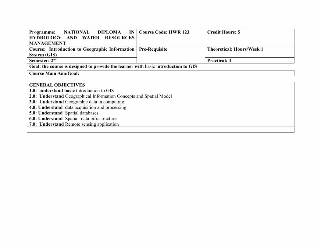
Programme: NATIONAL DIPLOMA INHYDROLOGY AND WATER RESOURCESMANAGEMENT
Course Code: HWR 123 Credit Hours: 5
Course: Introduction to Geographic InformationSystem (GIS)
Pre-Requisite Theoretical: Hours/Week 1
Semester: 2nd Practical: 4Goal: the course is designed to provide the learner with basic introduction to GIS
Course Main Aim/Goal:
GENERAL OBJECTIVES1.0: understand basic introduction to GIS2.0: Understand Geographical Information Concepts and Spatial Model3.0: Understand Geographic data in computing4.0: Understand data acquisition and processing5.0: Understand Spatial databases6.0: Understand Spatial data infrastructure7.0: Understand Remote sensing application

Programme: NATIONAL DIPLOMA IN HYDROLOGY AND WATER RESOURCES MANAGEMENT Course: Introduction to Geographic Information System (GIS) Course Code: HWR 123 CH/CU Hour:Goal:General Objectives 1.0: Introduction to GISCourse Specifications: THEORETICAL CONTENT
Theoretical Content Practical ContentWeek Specific Learning
OutcomesTeacher’sActivities
Resources Specific LearningOutcomes
Teacher’sActivities
Evaluation
1.1 Define GIS and itsfunctionality:concepts,components, scopeand application;
1.2 Explain relationshipof GIS to other fieldi.e. Atmosphericsciences,meteorology andoceanography.Identify various GISand theircomponents
Define GIS andits functionality:concepts,components,scope andapplication; Explainrelationship ofGIS to otherfield i.e.Atmosphericsciences,meteorology andoceanography.Identify variousGIS and theircomponents
Video tabs ,OverheadprojectorWhite Board,Marker, dusterand Powerpointprojector.GIS Hardwareand Software
Interpret the basicconcept of GIS
Translate thebasiccomponents ofGIS:Computerhardware andsoftware as wellas theirfunctionality
Define GIS andits functionality:concepts,components,scope andapplication;
General Objectives 2.0: Geographical Information Concepts and Spatial Model2 Describe the Conceptual
models of spatialinformation; alternativerepresentation of spatialinformation.
ExplainConceptualmodels of spatialinformation;alternative
Video tabs ,OverheadprojectorWhite Board,Marker, duster
Use the applicationof GIS
Exposing thecadets to GISlaboratory andImageprocessing
Describe theConceptualmodels ofspatialinformation;

representation ofspatialinformation
and Powerpointprojector.GIS Hardwareand Software
equipments alternativerepresentation ofspatialinformation.
General Objectives 3.0: Geographic data in the computer3 3.1 Describe the ways
in which spatial datamay be efficientlycoded into acomputer system tosupport theoperation of GIS;
3.2 Explain thetopology and itsutilization; dataquality and dataexchange standards
3.3 Identify variousgeographic dataformats: ”Open”format (XML, GMLSVG); Performbasic dataconversionfunctions; raster tovector and vice-versa.
Describe theways in whichspatial data maybe efficientlycoded into acomputer systemto support theoperation ofGIS; Explain thetopology and itsutilization; dataquality and dataexchangestandardsIdentify variousgeographic dataformats: ”Open”format (XML,GML SVG);Perform basicdata conversionfunctions; rasterto vector andvice- versa.
Video tabs ,OverheadprojectorWhite Board,Marker, dusterand Powerpointprojector.GIS Hardwareand Software
Demonstrate theapplication of GIS,data conversionand its functions
Exposing thecadets toGIS laboratoryand Imageprocessingequipments.Perform basicdata conversionfunctions; rasterto vector andvice- versa usingArc GISsoftware orQGIS.
Describe theways in whichspatial data maybe efficientlycoded into acomputer systemto support theoperation of GIS
General Objectives 4.0: Data acquisition and processing4 4.1 Identify Sources of Identify Sources Video tabs , Understanding the At the Explain methods
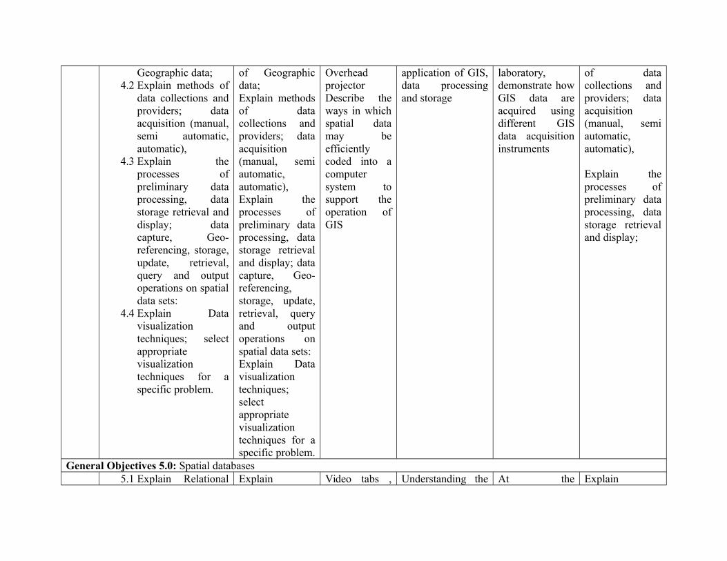
Geographic data;4.2 Explain methods of
data collections andproviders; dataacquisition (manual,semi automatic,automatic),
4.3 Explain theprocesses ofpreliminary dataprocessing, datastorage retrieval anddisplay; datacapture, Geo-referencing, storage,update, retrieval,query and outputoperations on spatialdata sets:
4.4 Explain Datavisualizationtechniques; selectappropriatevisualizationtechniques for aspecific problem.
of Geographicdata;Explain methodsof datacollections andproviders; dataacquisition(manual, semiautomatic,automatic),Explain theprocesses ofpreliminary dataprocessing, datastorage retrievaland display; datacapture, Geo-referencing,storage, update,retrieval, queryand outputoperations onspatial data sets: Explain Datavisualizationtechniques;selectappropriatevisualizationtechniques for aspecific problem.
OverheadprojectorDescribe theways in whichspatial datamay beefficientlycoded into acomputersystem tosupport theoperation ofGIS
application of GIS,data processingand storage
laboratory,demonstrate howGIS data areacquired usingdifferent GISdata acquisitioninstruments
of datacollections andproviders; dataacquisition(manual, semiautomatic,automatic),
Explain theprocesses ofpreliminary dataprocessing, datastorage retrievaland display;
General Objectives 5.0: Spatial databases5.1 Explain Relational Explain Video tabs , Understanding the At the Explain
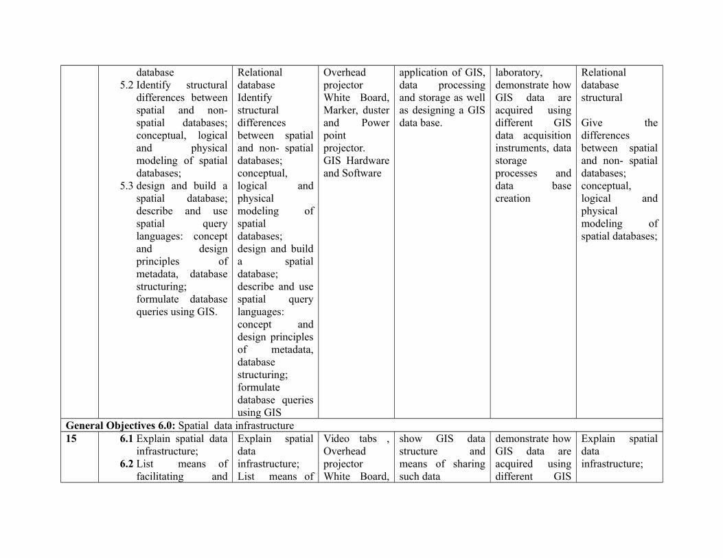
database5.2 Identify structural
differences betweenspatial and non-spatial databases;conceptual, logicaland physicalmodeling of spatialdatabases;
5.3 design and build aspatial database;describe and usespatial querylanguages: conceptand designprinciples ofmetadata, databasestructuring;formulate databasequeries using GIS.
RelationaldatabaseIdentifystructuraldifferencesbetween spatialand non- spatialdatabases;conceptual,logical andphysicalmodeling ofspatialdatabases; design and builda spatialdatabase;describe and usespatial querylanguages:concept anddesign principlesof metadata,databasestructuring;formulatedatabase queriesusing GIS
OverheadprojectorWhite Board,Marker, dusterand Powerpointprojector.GIS Hardwareand Software
application of GIS,data processingand storage as wellas designing a GISdata base.
laboratory,demonstrate howGIS data areacquired usingdifferent GISdata acquisitioninstruments, datastorageprocesses anddata basecreation
Relationaldatabasestructural
Give thedifferencesbetween spatialand non- spatialdatabases;conceptual,logical andphysicalmodeling ofspatial databases;
General Objectives 6.0: Spatial data infrastructure15 6.1 Explain spatial data
infrastructure;6.2 List means of
facilitating and
Explain spatialdatainfrastructure;List means of
Video tabs ,OverheadprojectorWhite Board,
show GIS datastructure andmeans of sharingsuch data
demonstrate howGIS data areacquired usingdifferent GIS
Explain spatialdatainfrastructure;
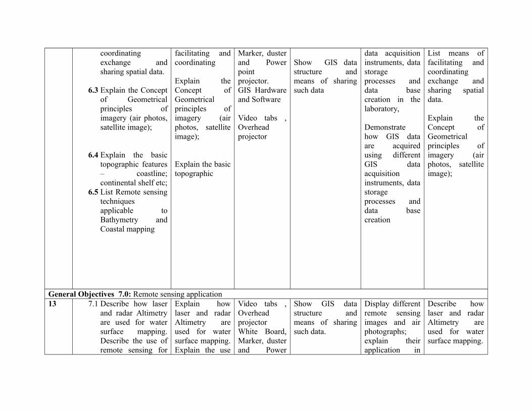
coordinatingexchange andsharing spatial data.
6.3 Explain the Conceptof Geometricalprinciples ofimagery (air photos,satellite image);
6.4 Explain the basictopographic features– coastline;continental shelf etc;
6.5 List Remote sensingtechniquesapplicable toBathymetry andCoastal mapping
facilitating andcoordinating
Explain theConcept ofGeometricalprinciples ofimagery (airphotos, satelliteimage);
Explain the basictopographic
Marker, dusterand Powerpointprojector.GIS Hardwareand Software
Video tabs ,Overheadprojector
Show GIS datastructure andmeans of sharingsuch data
data acquisitioninstruments, datastorageprocesses anddata basecreation in thelaboratory,
Demonstratehow GIS dataare acquiredusing differentGIS dataacquisitioninstruments, datastorageprocesses anddata basecreation
List means offacilitating andcoordinatingexchange andsharing spatialdata.
Explain theConcept ofGeometricalprinciples ofimagery (airphotos, satelliteimage);
General Objectives 7.0: Remote sensing application13 7.1 Describe how laser
and radar Altimetryare used for watersurface mapping.Describe the use ofremote sensing for
Explain howlaser and radarAltimetry areused for watersurface mapping.Explain the use
Video tabs ,OverheadprojectorWhite Board,Marker, dusterand Power
Show GIS datastructure andmeans of sharingsuch data.
Display differentremote sensingimages and airphotographs;explain theirapplication in
Describe howlaser and radarAltimetry areused for watersurface mapping.
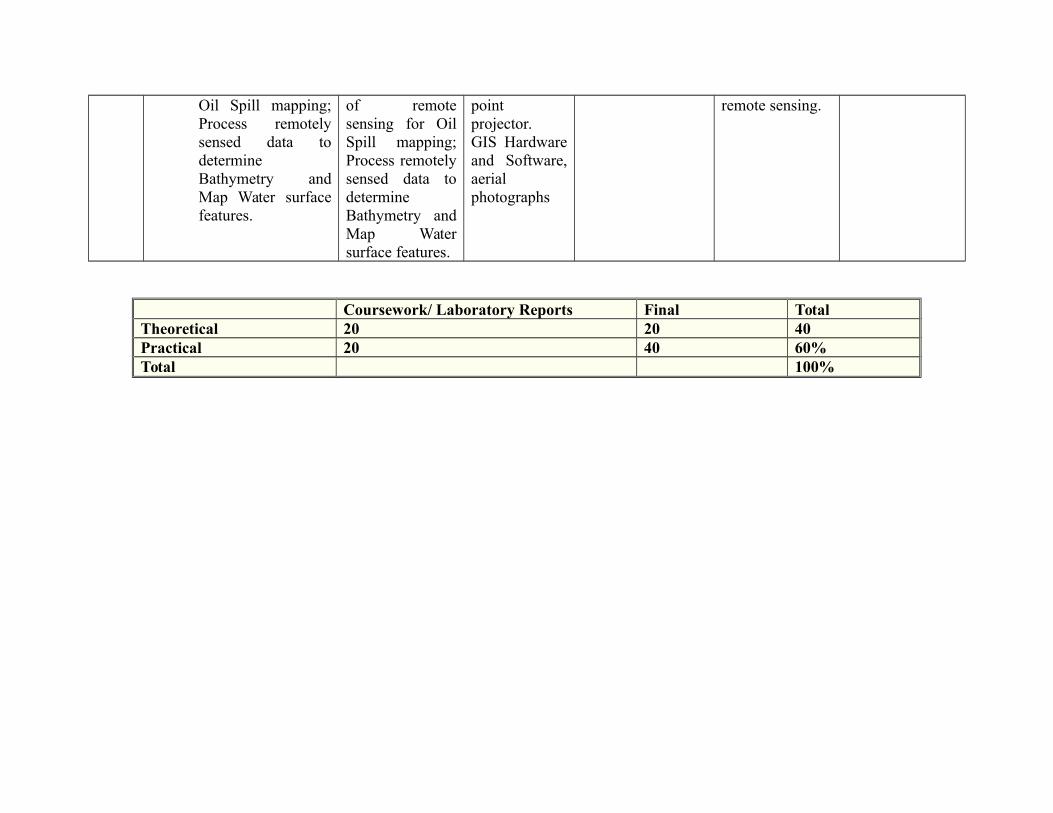
Oil Spill mapping;Process remotelysensed data todetermineBathymetry andMap Water surfacefeatures.
of remotesensing for OilSpill mapping;Process remotelysensed data todetermineBathymetry andMap Watersurface features.
pointprojector.GIS Hardwareand Software,aerialphotographs
remote sensing.
Coursework/ Laboratory Reports Final TotalTheoretical 20 20 40Practical 20 40 60%Total 100%
Programme: NATIONALDIPLOMA IN HYDROLOGY ANDWATER RESOURCESMANAGEMENT
Course Code: HWR 124 Credit Hours: 3
Course: BASIC HYDROLOGY II Pre-Requisite HWR 111 Theoretical: Hours/Week 2
Semester: 2nd Practical:
Course Main Aim/Goal: This course is designed to enable students acquire the necessary knowledge in hydrology in hydrology cycleand water balance .
GENERAL OBJECTIVES
On completion of the course the student should:1.0 Understand hydrology cycle and water balance.2.0 Understand hydrological catchment and geomorphologic characteristics.3.0 Understand hydrological process and interactions4.0 Understand hydrological regimes.5.0 Understand eco hydrology
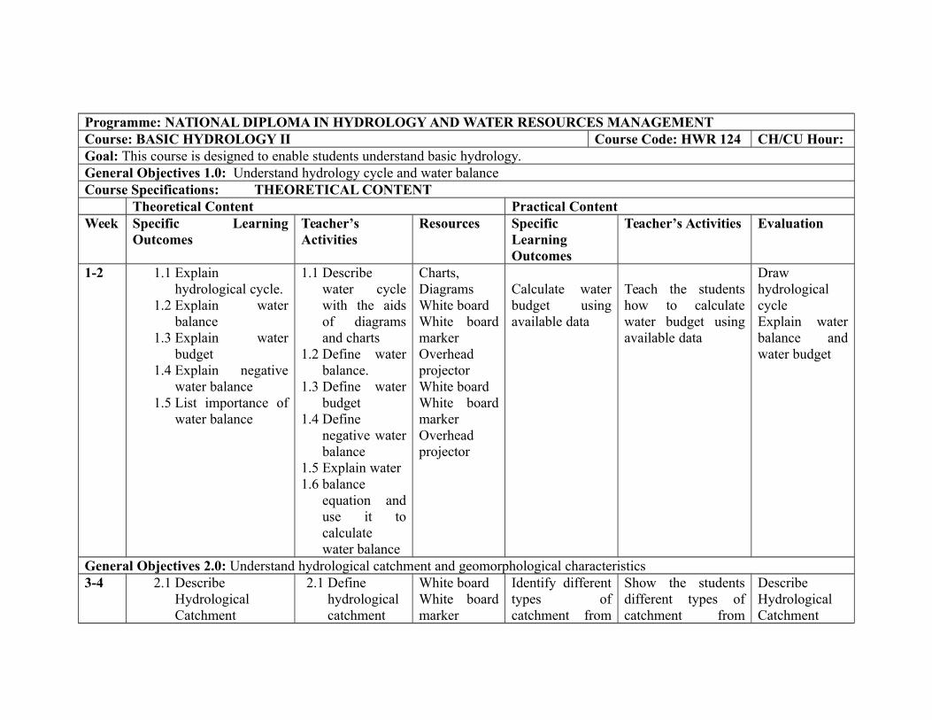
Programme: NATIONAL DIPLOMA IN HYDROLOGY AND WATER RESOURCES MANAGEMENTCourse: BASIC HYDROLOGY II Course Code: HWR 124 CH/CU Hour:Goal: This course is designed to enable students understand basic hydrology.General Objectives 1.0: Understand hydrology cycle and water balanceCourse Specifications: THEORETICAL CONTENT
Theoretical Content Practical ContentWeek Specific Learning
OutcomesTeacher’sActivities
Resources SpecificLearningOutcomes
Teacher’s Activities Evaluation
1-2 1.1 Explainhydrological cycle.
1.2 Explain waterbalance
1.3 Explain waterbudget
1.4 Explain negativewater balance
1.5 List importance ofwater balance
1.1 Describewater cyclewith the aidsof diagramsand charts
1.2 Define waterbalance.
1.3 Define waterbudget
1.4 Definenegative waterbalance
1.5 Explain water1.6 balance
equation anduse it tocalculatewater balance
Charts,DiagramsWhite boardWhite boardmarkerOverheadprojectorWhite boardWhite boardmarkerOverheadprojector
Calculate waterbudget usingavailable data
Teach the studentshow to calculatewater budget usingavailable data
DrawhydrologicalcycleExplain waterbalance andwater budget
General Objectives 2.0: Understand hydrological catchment and geomorphological characteristics3-4 2.1 Describe
HydrologicalCatchment
2.1 Definehydrologicalcatchment
White boardWhite boardmarker
Identify differenttypes ofcatchment from
Show the studentsdifferent types ofcatchment from
DescribeHydrologicalCatchment
2.2 ExplainGeomorphologicalcharacteristics
2.2 List differenttypes ofcatchment
2.3 Definegeomorphology
2.4 Describe thegeomorphologiccharacteristics ofcatchments.
OverheadprojectorMaps, charts
White boardWhite boardmarkerOverheadprojector
maps andpictures
maps and pictures
General Objectives 3.0: Explain hydrological process and interaction General Objectives5-9 3.1 Explain the
followings aspectsof hydrologicalprocessesPrecipitationEvapotranspiration
3.2 Explain Surfacerun-off formation
3.3 Explain infiltration
Defineprecipitation,evapotranspiration
Explain factorsaffecting evapotranspiration
Explain surfacerun-off formation
White boardWhite boardmarkerOverheadprojectorRain gaugeHygrometerLysimeter
White boardWhite boardmarkerOverheadprojector
Field trip to
Demonstratemethods ofmeasuring ofprecipitation
Demonstratemethod ofmeasuring ofevaporationusingpsychomotor
Guide students toDemonstratemethods ofmeasuring ofprecipitation
Demonstrate methodof measuring ofevaporation usingpsychomotor
Show students howto measure soilmoisture usingfeel method,gravitational method,tensiometer
Outline fourfactorsaffectingtranspiration
3.4 Explain soilmoisture
3.5 ExplainGroundwater flow
3.6 Explain theinteractionsbetweenhydrologicalprocesses.
Define infiltrationDescribe capillaryactionOutline factorsaffectinginfiltration
Define soilmoistureOutline factorsaffecting soilmoisture
Explain natureand types ofgroundwater.Describe effect ofsurface water flowon groundwaterflowDescribe theinteractionsbetween hydrologicalprocesses
stream orriver
White boardWhite boardmarkerOverheadprojectorTensiometer
White boardWhite boardmarkerOverheadprojector
Tetrameter
Demonstratemethods ofmeasuring ofsurface run-offusing flowgauge, tracertechnique
Demonstratemethods ofmeasuring ofsurface run-offusing flowgauge, tracertechniqueIdentifyequipment anddemonstratemethod ofmeasuring ofinfiltration
Demonstratemethod ofmeasuring of soilmoistureDemonstrate theuse tetrameter forfindinggroundwater
Show students howto use tetrameter tolocate groundwater
Demonstratemethods ofmeasuring of surfacerun-off using flowgauge, tracertechniqueIdentify equipmentand demonstratemethod of measuringof infiltration
Demonstrate methodof measuring of soilmoistureDemonstrate the use tetrameter for finding groundwater
Explain soilmoisture
Explain theinteractionsbetweenhydrologicalprocesses.
General Objectives 4.0: Understand hydrological regimes.
10-12 4.1 Explainhydrological
Definehydrological
White boardWhite board
Field trip toidentify
Show studentsdifferent type of

regimes
4.2 Enumerate stream flowcharacteristics, e.g.magnitude, frequency,duration, timing andrate of changes of flowetc
4.2 Explain the effectof seasonal changeson flow regimes
regimes
Describe flowregimeclassification,ephemeral,intermittent,perennial.Enumerate streamflowcharacteristics,e.g. magnitude,frequency,duration, timingand rate ofchanges of flowetc.
Explain the effectof seasonalchanges on flowregimes.
markerOverheadprojector
Field Trip
White boardWhite boardmarkerOverheadprojector
Field trip
hydrologicalregimes ofstreams types
Field trip toidentify variousstream types andtheircharacteristics
stream types as itrelates to streamflow
Show studentsdifferent streamcharacteristics
List fourcharacteristicof stream flow
Explain theeffect ofseasonalchanges onflow regimes
General Objectives 5.0: Understand eco hydrology.13-14 Explain the mechanism of
eco hydrologyExplain the effect ofvegetation on hydrology
Define ecohydrologyDescribe theimportance offorest onhydrologicalregimes, floodand erosioncontrol etc.
White boardWhite boardmarkerOverheadproject Showthe effect ofvegetation onhydrology or
Illustrate themechanism ofeco hydrology
Show the effectof vegetation onhydrology
Field trip to identifyeffect of vegetationon stream flow
Field trip
Explain themechanism ofeco hydrologyon vegetation.
Explain the effect ofhydrology on animalsespecially fishes
Explain the effectof hydrologicalregimes onmigratory fishesespecially as itaffectsreproduction,timing ofmigration andavailability offood.
Identify anddraw locallyavailablemigratory fishesand shrimps
Namemigratoryfishes andshrimp inNigeria
Department/Programme: ND Water ResourcesEngineering Technology
Course Code: MTH 122 Contact Hours: 2 – 0 - 0
Subject/Course: Trigonometry and AnalyticalGeometry
Theory: 2 hours/week
Year: ND II Semester: 1st Pre-requisite: MTH 112 Practical: 0 hours/week
GOAL: This course is designed to provide basic concept of measurement and its application to Engineering problems.
General Objectives:
On completion of this course the student will be able to:1.0 Understand the manipulation of Trigonometric Formulae and equations
2.0 Understand the concept of mensuration and its application to Engineering problems.
3.0 Understand concept of Analytical Geometry and their applications.
4.0 Know the different forms of conics such as ellipse, Parabola and hyperbola
ROGRAMME:
COURSE: TRIGONOMETRY AND ANALYTICAL GEOMETRY COURSE CODE: MTH 122 CONTACT HOUR: 2–0-0
Course Specification: Theoretical Content: 2 hrs Practical Content: 0hrs
General Objective 1.0: Understand the manipulation of trigonometric equations
Week General Objective 1.0: Understand the manipulation of trigonometric equations
Specific Learning Outcome: Teacher Activities Resources Specific LearningOutcome:
TeacherActivities
Resources
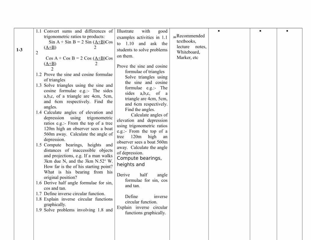
1-3
1.1 Convert sums and differences oftrigonometric ratios to products:
Sin A + Sin B = 2 Sin (A+B)Cos(A+B) 2
2 Cos A + Cos B = 2 Cos (A+B)Cos
(A+B) 2 21.2 Prove the sine and cosine formulae
of triangles1.3 Solve triangles using the sine and
cosine formulae e.g.:- The sidesa,b,c, of a triangle are 4cm, 5cm,and 6cm respectively. Find theangles.
1.4 Calculate angles of elevation anddepression using trigonometricratios e.g.:- From the top of a tree120m high an observer sees a boat560m away. Calculate the angle ofdepression.
1.5 Compute bearings, heights anddistances of inaccessible objectsand projections, e.g. If a man walks3km due N, and the 3km N.52o W.How far is the of his starting point?What is his bearing from hisoriginal position?
1.6 Derive half angle formulae for sin,cos and tan.
1.7 Define inverse circular function.1.8 Explain inverse circular functions
graphically.1.9 Solve problems involving 1.8 and
Illustrate with goodexamples activities in 1.1to 1.10 and ask thestudents to solve problemson them.
Prove the sine and cosineformulae of trianglesSolve triangles usingthe sine and cosineformulae e.g.:- Thesides a,b,c, of atriangle are 4cm, 5cm,and 6cm respectively.Find the angles.
Calculate angles ofelevation and depressionusing trigonometric ratiose.g.:- From the top of atree 120m high anobserver sees a boat 560maway. Calculate the angleof depression.Compute bearings, heights and
Derive half angleformulae for sin, cosand tan.
Define inversecircular function.
Explain inverse circularfunctions graphically.
Recommendedtextbooks,lecture notes,Whiteboard,Marker, etc
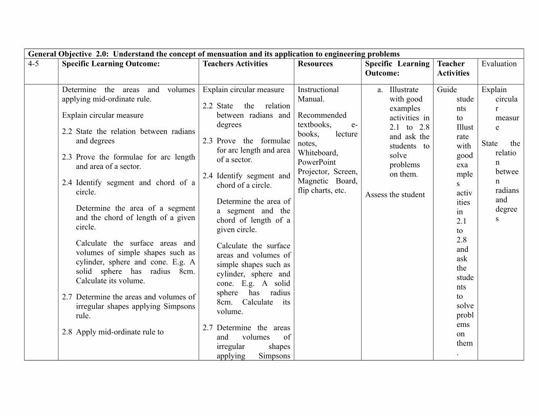
General Objective 2.0: Understand the concept of mensuation and its application to engineering problems4-5 Specific Learning Outcome: Teachers Activities Resources Specific Learning
Outcome:TeacherActivities
Evaluation
Determine the areas and volumesapplying mid-ordinate rule.
Explain circular measure
2.2 State the relation between radiansand degrees
2.3 Prove the formulae for arc lengthand area of a sector.
2.4 Identify segment and chord of acircle.
Determine the area of a segmentand the chord of length of a givencircle.
Calculate the surface areas andvolumes of simple shapes such ascylinder, sphere and cone. E.g. Asolid sphere has radius 8cm.Calculate its volume.
2.7 Determine the areas and volumes ofirregular shapes applying Simpsonsrule.
2.8 Apply mid-ordinate rule to
Explain circular measure
2.2 State the relationbetween radians anddegrees
2.3 Prove the formulaefor arc length and areaof a sector.
2.4 Identify segment andchord of a circle.
Determine the area ofa segment and thechord of length of agiven circle.
Calculate the surfaceareas and volumes ofsimple shapes such ascylinder, sphere andcone. E.g. A solidsphere has radius8cm. Calculate itsvolume.
2.7 Determine the areasand volumes ofirregular shapesapplying Simpsons
InstructionalManual.
Recommendedtextbooks, e-books, lecturenotes,Whiteboard,PowerPointProjector, Screen,Magnetic Board,flip charts, etc.
a. Illustratewith good examplesactivities in2.1 to 2.8and ask thestudents tosolveproblemson them.
Assess the student
GuidestudentstoIllustratewithgoodexamplesactivitiesin2.1to2.8andaskthestudentstosolveproblemsonthem.
Explaincircularmeasure
State therelationbetweenradiansanddegrees
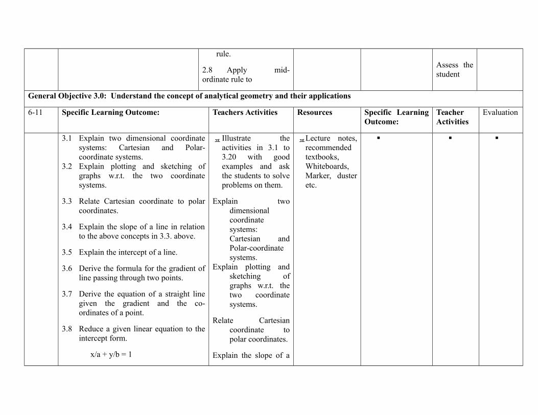
rule.
2.8 Apply mid-ordinate rule to
Assess thestudent
General Objective 3.0: Understand the concept of analytical geometry and their applications
6-11 Specific Learning Outcome: Teachers Activities Resources Specific LearningOutcome:
TeacherActivities
Evaluation
3.1 Explain two dimensional coordinatesystems: Cartesian and Polar-coordinate systems.
3.2 Explain plotting and sketching ofgraphs w.r.t. the two coordinatesystems.
3.3 Relate Cartesian coordinate to polarcoordinates.
3.4 Explain the slope of a line in relationto the above concepts in 3.3. above.
3.5 Explain the intercept of a line.
3.6 Derive the formula for the gradient ofline passing through two points.
3.7 Derive the equation of a straight linegiven the gradient and the co-ordinates of a point.
3.8 Reduce a given linear equation to theintercept form.
x/a + y/b = 1
Illustrate theactivities in 3.1 to3.20 with goodexamples and askthe students to solveproblems on them.
Explain twodimensionalcoordinatesystems:Cartesian andPolar-coordinatesystems.
Explain plotting andsketching ofgraphs w.r.t. thetwo coordinatesystems.
Relate Cartesiancoordinate topolar coordinates.
Explain the slope of a
Lecture notes,recommendedtextbooks,Whiteboards,Marker, dusteretc.

3.9 Determine the coordinates of the pointof intersection of two straight lines.
3.10 Define locus
3.11 Derive the slope-intercept form of theequation of a straight line:
y = mx+c
3.12 Derive the point B slope form of theequation of a straight line:
y - y1 = m(x - x1)
3.13 Derive the double B point form of theequations of the straight line:
y - y1 = y2 - y1 (x - x1)
x2 - x1
3.14 Derive the perpendicular form of theequation of a straight line
3.15 Solve examples of 3.11 to 3.14 above.
3.16 Find the angle (Q) between two lineswhose slopes, (m1, and m2) areKnown: Q = tan (m2 B m1)/1 + m1 m2
3.17 Determine the conditions for two linesto be parallel and to be perpendicular.
3.18 Derive the expression for theperpendicular distance from a point toa line.
line in relation tothe aboveconcepts in 3.3.above.
Explain the intercept ofa line.
Derive the formula forthe gradient ofline passingthrough twopoints.
3.7 Derive theequation of astraight line giventhe gradient andthe co-ordinatesof a point.
3.8 Reduce a givenlinear equation tothe interceptform.
x/a + y/b = 1
3.9 Determine thecoordinates of thepoint ofintersection oftwo straight lines.
3.10 Define locus
Recommendedtextbook,lecture notes,Whiteboard,Marker etc.
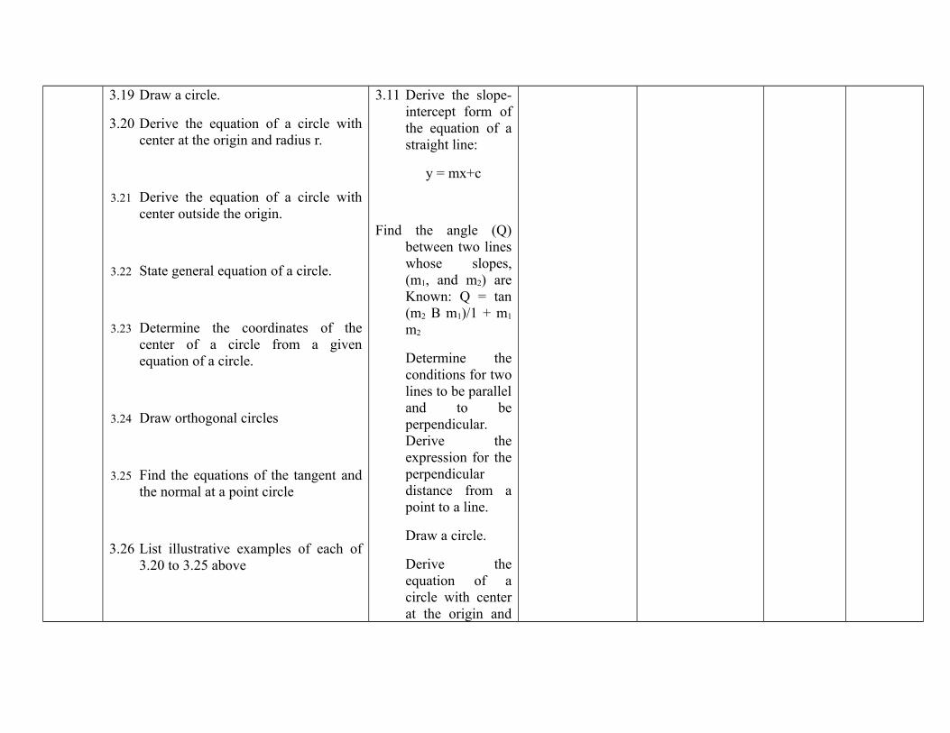
3.19 Draw a circle.
3.20 Derive the equation of a circle withcenter at the origin and radius r.
3.21 Derive the equation of a circle withcenter outside the origin.
3.22 State general equation of a circle.
3.23 Determine the coordinates of thecenter of a circle from a givenequation of a circle.
3.24 Draw orthogonal circles
3.25 Find the equations of the tangent andthe normal at a point circle
3.26 List illustrative examples of each of3.20 to 3.25 above
3.11 Derive the slope-intercept form ofthe equation of astraight line:
y = mx+c
Find the angle (Q)between two lineswhose slopes,(m1, and m2) areKnown: Q = tan(m2 B m1)/1 + m1
m2
Determine theconditions for twolines to be paralleland to beperpendicular.Derive theexpression for theperpendiculardistance from apoint to a line.
Draw a circle.
Derive theequation of acircle with centerat the origin and
radius r.
Derive theequation of acircle with centeroutside the origin.
State generalequation of acircle.
Determine thecoordinates of the
Illustrate the activitiesin 3.21 to 3.26 and askthe students to solveproblems on them
Week General Objective 4.0: Know the different forms of conics such as ellipse, parabola and hyperbola12-14 Specific Learning Outcome: Teachers Activities Resources Specific Learning
Outcome:TeacherActivities
Evaluation
4.1 Define the Parabola
4.2 Derive the standard equation of aParabola y2 = 4ax
4.3 State the properties of the parabola
4.4 Define the focal chord, axis and lotusrectum of the parabola
4.5 Determine the equation of the tangentand normal from a given point to theparabola.
Illustrate with goodexamplesactivities in 4.1 to4.19 and ask thestudents to solveproblems on them.
Assess the
InstructionalManual.
Recommendedtextbooks, e-books, lecturenotes,Whiteboard,PowerPointProjector, Screen,Magnetic Board,flip charts, etc.

4.6 Solve problems on parabola e.g. Writedown the equation of the parabola andstate its vertex if the focus B is (2,0)and the direct x = -2.
4.7 Define and ellipse
4.8 Derive the equation of an ellipse x2/G2
+ y2/b2 = 1
4.9 State the properties of the ellipse
4.10 Determine the equation of the tangentand the normal to an ellipse from agiven point.
4.11 Define focal chord and axes of ellipse.
4.12 Solve problems on ellipses e.g. Findthe length of the axes and theeccentricity for the ellipse: 4x2 + 9y2 =36
4.13 Define the Hyperbola
4.14 Derive the equation of the Hyperbola
4.15 Identify the properties of theHyperbola.
4.16 Define asymptotes, chord, tangent andnormal to a hyperbola.
4.17 Solve problems on hyperbola e.g.Find the foci and directrices forhyperbola: x2/16 B y2/9 = 1
student
Define and ellipse
Derive the equation ofan ellipse x2/G2 +y2/b2 = 1
State the properties ofthe ellipse
Determine the equationof the tangent andthe normal to anellipse from agiven point.
Define focal chord andaxes of ellipse.
Solve problems onellipses e.g. Find thelength of the axes andthe eccentricity for theellipse: 4x2 + 9y2 = 36
Define the Hyperbola
Derive the equation ofthe Hyperbola
Identify the properties
InstructionalManual.
Recommendedtextbooks, e-books, lecture
notes,Whiteboard,PowerPoint
Projector, Screen,Magnetic Board,flip charts, etc.
4.18 Explain rectangular hyperbola
4.19 Determine tangent and normal to therectangular hyperbola.
of the Hyperbola.
Defineasymptotes, chord,tangent and normal to ahyperbola.
4.17 Solve problemson hyperbola e.g.Find the foci anddirectrices forhyperbola: x2/16B y2/9 = 1
4.18 Explainrectangularhyperbola
4.19 Determinetangent and normal tothe rectangularhyperbola.
ASSESSMENT: The continuous assessment, tests and quizzes will be awarded 40% of the total score. The end of the Semester Examination willmake up for the remaining 60% of the total score.

Programme: NATIONALDIPLOMA IN HYDROLOGY ANDWATER RESOURCESMANAGEMENT
Course Code: HWR125 Credit Hours: 2
Course: INTRODUCTION TOHYDROMETEOROLOGY
Pre-Requisite Theoretical: Hours/Week 1:15 minutes
Semester: Practical: 45 MinutesGoal: the course is designed to provide the students with information of the relationships between meteorology and hydrology Course Main Aim/Goal:
GENERAL OBJECTIVES
On Completion of this course the students will be able to:1.0 Understand the relationships between meteorology and hydrology2.0 Understand the water cycle3.0 Understand the meteorological elements4.0 Understand the various forms of precipitations5.0 Understand the measurement of precipitation6.0 Understand the precipitation analysis and integrated hydro-meteorological system7.0 Understand the meteorological and hydrological forecasting
Programme: NATIONAL DIPLOMA IN HYDROLOGY AND WATER RESOURCES MANAGEMENTCourse: INTRODUCTION TO HYDROMETEOROLOGY Course Code:
HWR125CH/CU Hour:
Goal:General Objectives 1.0: Understand the relationship between meteorology and hydrologyCourse Specifications: THEORETICAL CONTENT
Theoretical Content Practical ContentWeek Specific Learning Outcomes Teacher’s
ActivitiesResources Specific
LearningOutcomes
Teacher’sActivities
Evaluation
1 1.1 Discuss the relationshipbetween meteorology andhydrology
1.2 Examine the generalprinciples of forecasting
1.3 Explain meteorologicalforecasting
1.4 Explain hydrologicalforecasting
Discuss therelationshipbetweenmeteorologyand hydrology
Examine thegeneralprinciples offorecasting
Explainmeteorologicalforecasting
Explainhydrologicalforecasting
Video tabs ,OverheadprojectorMAN OronWeatherStation andAutomatedWeatherStation
Exposing thecadets to the reallife situationusingmeteorologicaland hydrologicalinstrumentsavailable in theAcademy.
Demonstratehow to do itthroughpracticalapplication.
Discuss therelationshipbetweenmeteorologyand hydrology
Explain thegeneralprinciples offorecasting
General Objectives 2.0: Understand the meteorological elements2 2.1 State the effects of the State the Video tabs , Describe the Demonstrate Explain the

following on weather andclimate
a. Latitude and longitudecontrols
b. Earth rotation andrevolution
c. Amount ofdistribution and typeof precipitation
d. Temperaturee. Wind-speed and
directionf. Humidityg. air pressureh. sky condition (cloudy
and clear)
effects of thefollowing onweather andclimate
Latitude andlongitudecontrols
Earth rotationand revolution
Amount ofdistributionand type ofprecipitationTemperatureWind-speedand directionHumidityair pressuresky condition(cloudy andclear)
Overheadprojector
uses of thevariousinstruments formeteorologicalmeasurement.
the uses of thevariousinstrumentsthroughpracticalapplication.
termMeteorologicalStation andAutomatedWeather Station
General Objectives 3.0: Understand the water cycle3 3.1 Explain the hydrologic
cycle and the importance ofaccurate meteorologicaldata in soil and waterconservation
Define thehydrologiccycle.Explain whatmeteorologicaldata is and itsimportance
Chalk ormagic boardcardboarddrawings,slides.
illustrate theprecipitation,evaporation,transpiration andevapotranspirationas they apply tocrop growth
Give theillustrations ofthe items inrelation towaterrequirementsfor cropgrowth
Chalk or magicboardcardboarddrawings,slides.
General Objectives 4.0; Discuss the various forms of precipitations4.1 Explain the types and
mechanisms of formation4.2 Describe the mechanisms of
formation of precipitation’sstated above
4.3 Distinguish betweenvarious forms ofprecipitation - drizzle, rain,glaze, sleet, show and hail.
4.4 Recognize the basicinstruments for themeasurement ofprecipitation.
4.5 Outline the working andoperation of rain gaugessuch as recording and non-recording gauge.
4.6 Outline the sources oferrors in reading theseinstruments.
4.7 Explain the need toestablish a network ofgauge stations in an area.
4.8 Outline the sources oferrors in reading theseinstruments.
4.9 Explain the need toestablish a network of
Explain themechanisms offormation ofprecipitation,forms ofprecipitation, LectureExplain how totake readingsusing the raingauge,anemometer,thermometer,psychomotor,
Video tabs ,Overheadprojector
Chalk ormagic boardcardboarddrawings,slides.Meteorologicalmeasuringinstruments.
Usemeteorologicaland hydrologicalinstrumentsavailable in theAcademy
Take accuratemeteorologicalreadings usingvarious measuringinstruments
Demonstratethe use of theinstrumentthroughpracticalapplication.
Demonstratehow to takereadings withrain gauge,anemometer,thermometer,psychomotor,etc andsupervisestudents to dothe same
Explain thetypes andmechanisms offormationDistinguishbetweenvarious formsof precipitation- drizzle, rain,glaze, sleet,show and hail
gauge stations in an area.
4.10 Describe the factors to beconsidered in siting orlocating gauges
General Objectives 5.0: Discuss the measurement of precipitation5 5.1Calculate monthly and
annual rainfall figures,mean rainfall, meanmonthly temperature andrelative humidity
5.1 Explainhow tocalculatethenecessaryfiguresfromstandardmeteorological data
Chalk ormagic board,cardboarddrawings.Standard datasets
calculate themonthly rainfall,temperature andrelative humidityfigures from datasets and chartsand how suchinformation canbe used in cropproduction
Supervisestudents incalculatingmonthly andannual rainfallfigures usingdata collected.
show howsuch data canbe used tomanage cropproductionsystems
Explain waysto calculatemonthly andannual rainfallfigures, meanrainfall, meanmonthlytemperatureand relativehumidity
General Objectives 6.0: Understand the precipitation analysis and integrated hydro-meteorological system6 6.1 ) Describe forecasting
techniques in meteorologyand hydrology
6.2 Explain the term numericweather prediction as itrelates to forecasting
6.3 Describe the term nowcasting (that is short termprediction
Describeforecastingtechniques inmeteorologyand hydrology
Explain theterm numericweatherprediction as itrelates to
Video tabs ,Overheadprojector
show how asound predictioncan be donenumerically
Demonstratesoundpredictionusing weathermaps
Describeforecastingtechniques inmeteorologyand hydrologyUsingautomatedweather station

forecasting
Describe theterm nowcasting (that isshort termprediction
General Objectives 7.0: Understand the precipitation analysis and integrated hydro-meteorological system7 7.1 Explain precipitation
climatology
7.2 Differentiate betweenannual, intra-annual anddaily variations
7.3 Discuss the trends inprecipitation and intensityduration relationships
Explainprecipitationclimatology
Differentiatebetweenannual, intra-annual anddailyvariations
Discuss thetrends inprecipitationand intensitydurationrelationships
Video tabs ,OverheadprojectorMAN OronMeteorologicalstation andAutomatedWeatherStation
Using relatedmeteorologicalmeasuringinstruments tomeasureprecipitation
Demonstratehow to do itusingmeteorologicalmeasuringinstrument andautomatedweatherstation
Explainprecipitationclimatology
Differentiatebetweenannual, intra-annual anddaily variations
Coursework/ Laboratory Reports Final Total
Theoretical 30 40 70%Practical 10 20 30%

Department/Programme: NATIONAL DIPLOMA INHYDROLOGY AND WATERRESOURCESMANAGEMENT
Course Code: HWR126
Contact Hours: 1 – 0 - 1
Subject/Course: INTRODUCTION TOHYDROGEOLOGY
Theory: 1 hours/week
Year: ND II Semester: 2ND Pre-requisite: Practical: 1 hours/week
1.0 Goal: The course is designed to familiarize student to the occurrences of ground water distribution and their uses.General Objectives:
2.0 Understand the occurrences of ground water distribution and their uses.3.0 Understand factors that affect water movement in soils.4.0 Know the principles of groundwater investigation/exploration.5.0 Understand the principles of groundwater exploitation.6.0 Understand the chemical characteristics of groundwater.
PROGRAMME: NATIONAL DIPLOMA IN HYDROLOGY AND WATER RESOURCES MANAGEMENT
Course: INTRODUCTION TOHYDROGEOLOGY
Course Code: HWR 126 Contact Hours: 1 – 0 – 1
Course Specification: Theoretical Content: 1 hrs Practical Content: 1 hrs
Week
1-2
General Objective 1.0: Understand the occurrences of ground water distribution and their uses.
Specific Learning Outcome: Teacher Activities Resources Specific LearningOutcome:
TeacherActivities
Evaluation
1.1 Explain the occurrences ofgroundwater
1.2 Describe how groundwaterresources can be used.
1.3 Describe how groundwateraffects engineeringconstruction.
Explain the occurrencesof groundwater Explain the usage ofgroundwater Explain howgroundwater affectsengineering construction
InstructionalManual.
Geologicalmaps,geologicalhammer,GPS,compass
Recommended textbooks,e-books,lecture notes,Whiteboard,PowerPointProjector,Screen,MagneticBoard, etc..
illustrate groundwater sources
Visit constructionsites
Developpracticalmanual forfieldworks andexercises inthis course.
Preparepractical asindicated inthe manual
Developmanual andfiled visitguides
Explain theoccurrencesofgroundwaterand uses.
Week General Objective 2.0:Understand factors that affect water movement in soils
3-6 Specific Learning Outcome: Teachers Activities Resources Specific Learning Teacher Resources
117
Outcome: Activities
2.1 Name the factors that affectthe movement of water insoils.
2.2 Define each of the factorsin 2.1 above.
2.3 Define aquifers
2.4 List different types ofaquifers (aquiclude, aquitard,aquifuge)
2.5 Illustrate flow patterns indifferent types of aquifers.
Explain factorsaffecting themovement of waterin soils.
Explain differenttypes of aquifer.
Explain flowpatterns in aquifers
InstructionalManual.
Recommended textbooks,e-books,lecture notes,Whiteboard,PowerPointProjector,Screen,MagneticBoard, etc.
Week General Objective 3.0: Know the principles of groundwater investigation/exploration.
Specific Learning Outcome: Teachers Activities Resources Specific LearningOutcome:
TeacherActivities
Resources
7 3.1 List the different types ofgroundwater investigationtechniques
Explain differenttypes ofgroundwaterinvestigationtechniques.
InstructionalManual.
Recommendedtextbooks,e-books,lecturenotes,Whiteboard
Collect field datafrom resistivity andother techniques.
Interpret field datausing manual andcomputerinterpretations
Guide students toCarry outresistivity method.
Interpret field data
Explain thedifferenttypes ofgroundwaterinvestigationtechniques
118
PowerPointProjector,Screen,MagneticBoard, etc.
8 3.2 Explain each of the types in3.1 above, e.g, electrical andelectromagnetic seismicretraction etc.
Explain electricalresistivity, seismic,electro-magneticetc, filed methodsand interpretation.
InstructionalManual.
Recommendedtextbooks,e-books,lecturenotes,WhiteboardPowerPointProjector,Screen,MagneticBoard, etc.
Demonstrate and collectfield data from resistivityand other techniques.
Interpret field data usingmanual and computerinterpretation
Carry outresistivity method.
Interpret field data
Explaintypeselectricalandelectromagnetic seismicretraction
General Objective 4.0: Understand the principles of groundwater exploitation.
Week Specific Learning Outcome: Teachers Activities Resources Specific LearningOutcome:
TeacherActivities
Evaluation
9 4.1 Define water table4.2 Explain the factors that
affect aquifer yield.
Explain water tablewith diagram
Solve calculationsbased problem toillustrate wellhydraulics.
InstructionalManual.
Recommendedtextbooks, e-books,lecturenotes,
Define watertable and explain thefactors thataffectaquiferyield.
119

PowerPointProjector,Screen,MagneticBoard, etc
10 4.3 Illustrate the variousmethods of ground waterexploitation e.g. bore-hole,shallow wells, deep wells,open wells, infiltrationgalleries, artesian wells,.
Explain the variousmethods of groundwater exploitation
InstructionalManual.
Recommended textbooks, e-books, lecturenotes,Whiteboard,PowerPointProjector,Screen,MagneticBoard, flipcharts, etc.
Explain thevariousmethods ofground waterexploitation
11 4.4 List various drillingequipment
Explain the variousdrilling equipment andtheir uses
InstructionalManual.
Recommended textbooks, e-books, lecturenotes,Whiteboard,PowerPointProjector,Screen,MagneticBoard, flip
Illustrate Listvarious drillingequipment
Show themechanismof theoperationof variousdrillingequipment
Explain thevariousdrillingequipmentand theiruses
120
charts, etc.
12 4.5 Describe methods ofartificial recharge.
Explain artificialrecharge
InstructionalManual.
Projector,Screen,MagneticBoard, flipcharts, etc.
Describemethods ofartificialrecharge.
General Objective 5.0:Understand the chemical characteristics of groundwater.
Week Specific Learning Outcome: Teachers Activities Resources Specific LearningOutcome:
TeacherActivities
Resources
13
5.1 Name the sources ofimpurities in groundwater
5.2 Identify the causes ofspecific types of impurities.
5.3 Explain the possible methodsof preventing groundwaterpollution and contamination.
5.1 Explain sources ofimpurities ingroundwater
5.2 Identify thesources ofpollution.
5.3 Explain methodsof preventinggroundwaterpollution to wellse.g grouting, deepplacement ofscreens etc.
InstructionalManual.
Recommendedtextbooks,e-books,lecturenotes,WhiteboardPowerPointProjector,Screen,MagneticBoard, etc.
Transportation.Field waterquality testing
Demonstrate thesources of impurities ingroundwater
Show the causes ofspecific types ofimpurities.
Show the possiblemethods of preventinggroundwater pollutionand contamination.
Prepare relevantguides on the visitand explain thedifferent sourcesof pollution
Name thesources ofimpurities ingroundwaterExplain thecauses ofspecifictypes ofimpurities
121
equipment
ASSESSMENT: The continuous assessment, tests and quizzes will be awarded 40% of the total score. The end of the Semester Examination willmake up for the remaining 60% of the total score.
Competency: Students expected to have in depth knowledge of ground water location, movement, quality and harnessing Techniques.
Reference: 1. Hydrogeology (1959) Wister G. O. John Wiley
2. Hydrogeology (1966) Davis S.W. John Wiley
122
Department/Programme: NATIONAL DIPLOMA INHYDROLOGY AND WATERRESOURCESMANAGEMENT
Course Code: HWR127
Contact Hours: 1 – 0 - 4
Subject/Course: Basic Principles of Surveying Theory: 1 hours/week
Year: ND I Semester: 1st Pre-requisite: Practical: 4 hours/week
General Objectives1.0 Know fundamental concepts of surveying2.0 Appreciate surveying trigonometry3.0 Know basic survey drawing techniques4.0 Understand leveling5.0 Know traversing6.0 Know triangulation7.0 Know tachometry8.0 Understand the procedure and methods of third order theodolite and total station traversing.9.0 Understand the basic principles and methods of using total station and GIS Equipment.10.0 Understand problems involved in producing contoured plans.
123
PROGRAMME: NATIONAL DIPLOMA IN HYDROLOGY AND WATER RESOURCES MANAGEMENT
Course: Basic Principles ofSurveying
CODE: HWR 127 CONTACT HOURS: 1 – 0 - 4
Goal: The student on completion of this course should have a sound understanding of basic principles of surveying and be able toundertake field surveying required fo rHydrology Water Resources Management
Course Specification: THEORETICAL CONTENT PRACTICAL CONTENT
Week General Objective 1.0: Know the fundamental concepts of surveying.
Specific Learning Outcome: Teacher Activities Resources Specific LearningOutcome:
TeachersActivities
Evaluation
1 1.1 Define Surveying1.2 Distinguish between the
following major divisionsof surveying:
(i) geodetic surveying(ii) plane surveying
1.3 State the uses of planesurveying (e.g. maps andplans, geographical,geological engineering,military purpose etc,).
1.4 Explain the three stages ofsurveying process.(i) reconnaissance(ii) observation andmeasurement(iii) presentation
1.5 Illustrate the basicprinciples of surveyingmeasurements (linear and
1.1 Develop instructionalmanual for teachingthis course.
1.2 Explain thefundamental conceptsof surveying.
1.3 Explain the relevanceof surveying to miningindustry and thevarious professionswhere surveying issignificant
InstructionalManual.
Recommendedtextbooks, e-books, lecturenotes,Whiteboard,PowerPointProjector,Screen, MagneticBoard, flipcharts, etc.
Distinguishbetween thefollowingmajordivisions ofsurveying:(i) geodeticsurveying(ii) planesurveying
124
angular)1.6 State the branches of
surveying in mineralexploration andexploitation.
General Objective 2.0: Appreciate surveying trigonometry.
Week Specific Learning Outcome: Teachers Activities Resources Specific LearningOutcome:
TeachersActivities
Evaluation
2 2.1 Review trigonometricratios of common angles.
2.2 Solve problems involvingtriangles (sine rule, cosinerule, area of triangle,Napier's tangent rule).
2.1 Revise trigonometricratios and solveproblems involvingtriangles
2.2 Evaluate the studentsIn Solving problemsinvolving triangles(sine rule, cosine rule,area of triangle,Napier's tangent rule).
InstructionalManual.
Recommendedtextbooks, e-books, lecturenotes,Whiteboard,PowerPointProjector,Screen, MagneticBoard, flipcharts, etc.
General Objective 3.0: Know basic survey drawing techniquesWeek Specific Learning Outcome: Teachers Activities Resources Specific Learning
Outcome:TeachersActivities
Resources
3 3.1 Explain the use of scalesand handling of otherdrawing instruments.
3.1 Explain the use ofbasic survey drawingtechniques
3.2 Evaluate the students
a. InstructionalManual.
b. Recommended textbooks,e-books,lecture notes,Whiteboard,
a. Identify all thedrawinginstruments(compasses,dividers,protractors, setsquares, pencil,etc.)
a. Developpracticalmanual forlaboratory/workshopexercises inthis course.
b. Prepare
Explain theuse of scalesandhandling ofother draw-inginstruments.
125
PowerPointProjector,Screen,MagneticBoard, flipcharts, etc.
b. Demonstrate thesimple procedurefor ink-drawing andlettering techniques
practical asindicated inthe manual
General Objective 4.0: Understand leveling
Week Specific Learning Outcome: Teachers Activities Resources Specific LearningOutcome:
TeachersActivities
Evaluation
4-5 4.1 Define leveling4.2 Explain the following
terms related to leveling:datum; level surface, lineof collimation, mean sealevel, bench mark.
4.3 Describe the basic principleof leveling
4.4 Explain the followingleveling procedure:(a) compound leveling(b) flying level(c) profile leveling(d) reciprocal leveling.
4.5 Explain the reduction ofleveling results by
(a) rise and fall method, and
(b) height of collimationmethod.
4.6 Describe the effect of eachcurvature and atmosphericrefraction on leveling.
4.1 Explain the termsrelated to leveling
4.2 Describe basicprinciples of leveling
4.3 Evaluate the students4.8 Explain the following
leveling procedure:(a) compound leveling(b) flying level(c) profile leveling(d) Reciprocalleveling.
4.9 Explain the reductionof leveling results by
(a) rise and fall method,and
(b) Height of collimationmethod.
4.4 Describe the effect ofeach curvature andatmospheric refractionon leveling
InstructionalManual.
Recommendedtextbooks, e-books, lecturenotes,Whiteboard,PowerPointProjector,Screen, MagneticBoard, flipcharts,
PracticalManual.
Theodolite,ranging rods,ranging staff,survey recordbook etc.
Measure horizontal andvertical angels usingtheodolite.
Developpracticalmanual forlaboratory/workshopexercises inthis course.
Preparepractical asindicated inthe manual.
Identifyworkingcomponentsof theodoliteand measurehorizontaland verticalangles withtheodolite.
Explain thefollowingterms.principle ofleveling datum;levelsurface, lineofcollimation,mean sealevel, benchmark.
126
4.7 State typical errors thatmay occur in leveling.
General Objective 5.0: Know traversing
Week Specific Learning Outcome: Teachers Activities Resources Specific LearningOutcome:
TeachersActivities
Evaluation
7 5.1 Define Traversing.5.2 Describe the principle of
traversing5.3 Explain the methods of
adjustment of closedtraverses, - Bowditchmethod and transit method.
5.4 Perform calculations ofbearings, distances and Co-ordinates from traversesurveys
5.1 Explain the concept oftraversing
5.2 Solve problems ofbearings, distances andcoordinates fromtraverse surveys.
a. InstructionalManual.
b. Recommendedtextbooks,e-books,lecturenotes,Whiteboard,PowerPointProjector,Screen,MagneticBoard, flipcharts, etc.
Describe theprinciple oftraversing
General Objective 6.0: Know triangulationWeek Specific Learning Outcome: Teachers Activities Resources Specific Learning
Outcome:TeachersActivities
Evaluation
8 6.1 Define triangulation6.2 Describe the principle of
triangulation6.3 State application of
triangulation6.4 Enumerate other
parameters of triangulationsuch as selection,
6.1 Describe thetriangulationprinciples and itsmethods ofmeasurement
6.2 Asses the students
a. InstructionalManual.
b. Recommended textbooks,e-books,lecture notes,Whiteboard,PowerPoint
Describe theprinciple oftriangulation
127
beaconing, numbering oftriangulation stations,baseline, azimuthdetermination, extension ofconnected triangles,angular repetition,reciprocal observations,angular misclosures, fieldmeasurement checks etc.
6.5 Explain methods ofmeasurement oftriangulation angles (re-iteration and repetitionmethods)
6.6 Explain methods foradjusting values oftriangulation angles(triangle, braisedquadrilateral and polygonaladjustments).
6.7 Write angular observationsin conventional forms.
6.3 Explain methodsof measurement oftriangulation an-gles (re-iterationand repetitionmethods)
6.4 Explain methodsfor adjustingvalues oftriangulationangles (triangle,braisedquadrilateral andpolygonaladjustments).
Write angularobservations inconventional forms
Projector,Screen,MagneticBoard, flipcharts, etc.
Explainmethods ofmeasurement oftriangulation angles (re-iteration andrepetitionmethods)
General Objective 7.0: Know tacheometryWeek Specific Learning Outcome: Teachers Activities Resources Specific Learning
Outcome:TeachersActivities
Evaluation
9 7.1 Define tachometry7.2 Describe the principle of
the stadia-system (fixed-hair and sub tensetacheometers)
7.3 Describe the determinationof tachometric constants.
7.4 Describe the sub tense
7.1 Explain the concepttachometry,
7.2 Describe thedetermination oftachometric constantsand
7.3 Describe sub tensesystem
InstructionalManual.
Recommendedtextbooks, e-books, lecturenotes,Whiteboard,PowerPoint
Conduct atachometricexercise.
Determinetachometricconstants from fieldmeasurement.
Plot contours from
Developpracticalmanual forlaboratory/workshopexercises inthis course.
Prepare
DefinetachometryDescribe theprinciple ofthe stadia-system(fixed-hairand sub
128

system7.5 Outline the optical wedge
system.7.6 Explain tachometric
methods for plottingcontours
7.4 Asses the students Projector,Screen, Magneticboard, flipcharts, etc.
tachometricmeasurements in7.8 above.
practical asindicated inthe manual
tensetachometers
Staff
RangingPoles
10 7.7 Observe small verticalangles precisely byrepetition.
7.8Determine horizontaldistance using verticalstage and tachometer.
7.9Explain the specialcharacteristics and use ofself reducing tachometers.
7.10 Measure distancesusing a theodolites astachometer.
7.11 Determine spot-heightsand survey detail bytachometry.
Illustrate with goodexamples activities in 1.1to 1.5 and ask the studentsto solve problems onthem.
Assess the student
Engineer’s level
Field book
Compass,drawing paper,scales, pencil,rules, eraser
a. Carry out compasstraversing of aclosed figure
b. Produce the planand make graphicaladjustment.
a. Demonstrate compasstraversingand directthe studentto produceplan.
Determinehorizontaldistanceusingverticalstage andtachometers.Explain thespecialcharacteristics and useof
Week General Objective 8.0: Understand the procedure and methods of third order theodolite and total station traversing.
11 Specific Learning Outcome: Teachers Activities Resources Specific LearningOutcome:
TeacherActivities
Evaluation
8.1 List specifications formeasurement of angles anddistance.
8.2 Determine bearings andtolerable linear and angular
8.10 List specificationsfor measurement ofangles and distance.
8.11 Determinebearings and tolerable
Theodolite
Tapes
Identify the variousitems of equipmentused in theodoliteand total stationtraversing.
Supervisethe use oftraversing.
Direct thestudents to
Theodolite, totalstation,targets,poles,
129
misclosures for secondaryand tertiary traverses.
8.3 Explain the need forconnection to andprocedure for verificationof existing controls.
8.4 Describe field method oftraversing using surfacetaping.
8.5 Explain the variousprecautions in fieldmeasurements.
8.6 Describe the field checksapplicable.
8.7 Use the force centeringequipment explainingspecial advantage thereof.
8.8 Explain the role oftheodolite and total stationtraversing in provision ofcontrol for surveys.
8.9 Carry out traverse usingsurface taping 2.1. Verifythe control to which thesurvey 2.9 is connected, thesurveying of adjacentdetails (by radiation andintersection), computing thetraverse, adjustingdistances, bearings and co-ordinates, and producing aplan in ink
linear and angularmisclosures forsecondary and tertiarytraverses.
Explain the need for.
8.12 Describe fieldmethod of traversingusing surface taping.
8.13 Explain thevarious precautions infield measurements.
8.14 Describe the fieldchecks applicable.
8.15 Use the forcecentering equipmentexplaining specialadvantage thereof.
8.16 Explain the roleof theodolite and totalstation traversing inprovision of controlfor surveys.
Carry out traverse usingsurface taping 2.1. Verifythe control to which thesurvey 2.9 is connected,the surveying of adjacentdetails (by radiation andintersection), computingthe traverse, adjustingdistances, bearings andco-ordinates, and
Carry out theodolitetraversing of theroads surroundingthe school Computeand plot thetraverse.
use reducedbearing anddistances toplot atraverse.
drawing
130

producing a plan in ink
131

General Objective: 9.0 Understand the basic principles and methods of using total station and GIS Equipment.
Week Specific Learning Outcome: Teachers Activities Resources Specific LearningOutcome:
TeacherActivities
Evaluation
12 9.1 Describe a total station and itsaccessories.
9.2 Compare total station with atheodolite.
9.3 Explain the working principles ofa total station.
9.4 Describe the procedures ofobservation with a total station.
9.5 Carry out a simple survey using atotal station.
9.6 Retrieve the measured data froma total station field data on to aPC.
9.7 Process the data from the PC.9.8 Plot the plan of the surveyed area
manually.9.9 Describe the various types of
GPS equipment e.g. hand heldand tripod types.
9.10 Explain the workingprinciples of GPS.
9.11 Carry out GPS observationson selected points.
Illustrate with goodexamples activitiesin 9.1 to 9.11.
Total station
Targets
Computer
GPS
SoftwarePaper,pencil,eraser.
Theodolite,staff.
Use theodolite along withstaff to obtain distancesand heights.
Use total station to obtainvalues
Supervise the useof theodolites asin tachometricsurveys.
Describe atotal stationand itsaccessories.
Retrieve themeasureddata from atotal stationfield data onto a PC.
General Objective: 10.0 Understand problems involved in producing contoured plans.Week Specific Learning Outcome: Teachers Activities Resources Specific Learning
Outcome:TeacherActivities
Evaluation
13 5.1 Name the different referenceIllustrate with good
Lev Explain
132
directions for contoured plan.5.2 Explain basic need for heights in
topographical Engineering andTownship Surveys.
5.3 Illustrate optimum distribution ofspot heights for contoured plans.
5.4 Describe the use of grids oflevels.
5.5 Carry out contouring at 0.5mvertical interval from a mesh ofspot heights.
examplesactivities in5.1 to 5.5.
els The
odolite
basic needfor heightsintopographicalEngineeringandTownshipSurveys.
ASSESSMENT: The continuous assessment, tests and quizzes will be awarded 40% of the total score. The end of the Semester Examination willmake up for the remaining 60% of the total score.
Revision : 2 weeks. Revise main topics, give worked examples etc.
References : Surveying for Engineers (1994) Uren J Macmillan and Price WF, Setting Out Procedures (1998) Sonlorove BM
Butterworth Heinemann.
Competency: The student who completes this unit should be proficient in using levels and theodolites, capable of undertaking simple surveys andbe able to set out buildings with confidence.
STUDENTS’ INDUSTRIAL WORK EXPERIENCE SCHEME (SIWES)
133
PROGRAMME: WATER RESOURCES TECHNOLOGYCOURSE: INDUSTRIAL TRAININGDURATION: 4 MONTHS
TASK INVESTORY1.0 Goal: The industrial training is designed to familiarize student the structure of organization and management in hydrology and
water resourses.
GENERAL OBJECTIVES:On completion of the Industrial Training Scheme, the students should be able to
1.0 Understand the objectives and structure of the organization.2.0 Understand simple operational knowledge of hydrological data collections.3.0 Understand the methods of data management in hydrology and water resources.4.0 Understand the use of basic instruments in hydrological data collection. 5.0 Understand the geomorphologic processes affecting water resources.6.0 Understand the basic aspects of groundwater level and groundwater flow measurements and as well conduct pumping
test7.0 Acquire practical skills in areas of surveying relevant to civil engineering8.0 Understand the preparation of water resources account9.0 Acquire basic skills in the analysis of water and waste water.10.0 Understand the maintenance and management of gauge stations and equipment handling in hydrology and water
resources.11.0 Appreciate the importance of keeping accurate record of work experience.12.0 Appreciate the importance of the host company’s monitoring SIWES students.13.0 Appreciate the importance of polytechnic’s supervision SIWES student as related to his Professional training
134
Course: Industrial Training Course Code: HWR 128 Duration: 4 Months
Course Specification: Theoretical Content
General Objective 1.0: Understand the objective and structure of the organization
Week Specific Learning Outcome Teachers Activities Resources
1.1 List the objectives of the organization.
1.2 Draw the organization chart/organogram of the company.
1.3 Maintain cordial relationship with the members of staff.
1.4 Make safe and adequate use of equipment, instruments,tools and materials
1.5 Put on appropriate clothing
1.6 Record and maintain a log-book of his day-to-dayactivities
• Supervise the students on monthly basis tocheck logbook in accordance with theexpectations here
• Request and mark reports, Grade report andsubmit to SIWES office
General Objective 2.0: Understand simple operational knowledge of hydrological data collection
Week Specific Learning Outcome Teachers Activities Resources
2.1 list the types of data in hydrology and water resources.
2.2 list the sources of hydrological data
2.3 itemize the problems encountered and the limitation ofhydrological data.
Supervise the students on monthly basis tocheck logbook in accordance with theexpectations here
• Request and mark reports, Grade report andsubmit to SIWES office
135
Course Specification: Theoretical Content
General Objective: 3.0 Understand the methods of data management in hydrology and water resources.
Week Special Learning Objective: Teachers Activities Resources
1.1 Explain the importance of hydrologic data
3.2 . Explain the methods of data preservation in hydrology-hard and soft data.
Supervise the students on monthly basis to checklogbook in accordance with the expectationshere
• Request and mark reports, Grade report andsubmit to SIWES office
General Objective 4.0: Understand the use of basic instruments in Hydrology and water Resources.
Week Special Learning Objective: Teachers Activities Resources
4.1 Give some basic background on the use of basicinstruments- rain gauges, current meter, evaporimetres,sunshine dial, thermometers, etc..
4.2 Use different instruments
4.3 Explain the errors encountered in the use of theseinstruments..
4.4 Explain the problems encountered while comparing resultsfrom different instruments of different models and differentcalibration.
Supervise the students on monthly basis tocheck logbook in accordance with theexpectations here
• Request and mark reports, Grade report andsubmit to SIWES office
Course: Industrial Training Course Code: Duration: 4Months
136
Course Specification: Theoretical Content
General Objective 5.0: understand the geomorphological processes affecting water resources and basin hydrology.
Week Special Learning Objective: Teachers Activities Resources
5.1 Perform the following on soil with appropriate tools andequipment sieve analysis, , hydrometer, rate of erosion,sediment load, sediment yield..
5.2 Draw curves and compute appropriate data for the abovetests.
Supervise the students on monthly basis tocheck logbook in accordance with theexpectations here
• Request and mark reports, Grade report andsubmit to SIWES office
General Objective 6.0: understand the basic aspects of groundwater level and flow measurements as well as conduct pumpingtest.
Week Special Learning Objective: Teachers Activities Resources
6.1 Perform groundwater flow experiment on well cuttingsusing appropriate equipment.
6.2 Measure changes in groundwater levels from shallow andboreholes.
6.3 Participate in well drilling and development exercises
6.4 Prepare borehole log.
6.5 Perform hydraulic draw down, specific yield and pumpingtest
Supervise the students on monthly basis tocheck logbook in accordance with theexpectations here
• Request and mark reports Grade report andsubmit to SIWES office
Course Specification: Theoretical Content
General Objective 7.0: Acquire practical skills in areas of surveying relevant to civil engineering.
137
Week Special Learning Objective: Teachers Activities Resources
7.1 Carry out jobs involving the use of the followinginstruments, chains, tape; ranging poles, optical squares,level; theodolites, total station, digital levels, EDM etc.
7.2 Carry out profile leveling and cross-sections
7.3 Extra setting out details and data from plan.
7.4 Set out frame work for bridges, drainage, building, roads,etc. from known reference point.
7.5 Compute bearings and coordinates of points from horizontalangle measurements.
7.6 Reduce levels of various points.
7.7 Plot plan, cross-section, profiles and contours.
7.8 Determine areas and volumes from survey data.
raSupervise the students on monthly basis tocheck logbook in accordance with theexpectations here
• Request and mark reports Grade report andsubmit to SIWES office
General Objective 8.0: Understand the preparation of water resource account.
Week Special Learning Objective: Teachers Activities Resources
8.1 Get acquainted with the components of water budget .
8.2 Estimate runoff.
8.1 Estimate rainfall.
8.3 Estimate evaporation.
8.4 Compute water Budget..
8.5 Draw water budget graphs
Supervise the students on monthly basis tocheck logbook in accordance with theexpectations here
• Request and mark reports Grade report andsubmit to SIWES office
138

.
Course Specification: Theoretical Content
General Objective 9: Acquire basic skills in the analysis of water and waste.
Week Special Learning Objective: Teachers Activities Resources
12.1 Carry out the following tests on water samples:
a. Physical tests e.g.colour, odor and TDS and taste.
b. Chemical tests e.g. hardness, salinity, PH etc.
c. Bacteriological test e.g. coliform count.
12.2 Carry out biochemical test on waste water (BOD) andCOD).
Supervise the students on monthly basis tocheck logbook in accordance with theexpectations here
• Request and mark reports Grade report andsubmit to SIWES office
General Objective 10.0: Understand the maintainace of gauge station and equipment handling in hydrology and waterresources.
Week Special Learning Objective: Teachers Activities Resources
13.1 Identify the factors involved in the selection of gaugesites.
13.2 Install hydrometry equipment.
13.3 Carry out basic readings from these equipment.
13.4 Identify basic principles of equipment handling.
Supervise the students on monthly basis tocheck logbook in accordance with theexpectations here
• Request and mark reports Grade report andsubmit to SIWES office
General Objective 11.0: Appreciate the importance of keeping accurate record of work experience.
Week Special Learning Objective: Teachers Activities Resources
139
15.1 collect design data: tables charts, standards and codes.
15.2 Collect sample drawings of projects for study and reportwriting.
15.3 Draw programme of works.
15.4 Obtain project cost estimates.
15.5 Collect equipment and instruments Specifications.
15.6 Write concise report on training experience in good, simpleand clear English.
Supervise the students on monthly basis tocheck logbook in accordance with theexpectations here
• Request and mark reports Grade report andsubmit to SIWES office
General Objective 12.0: Appreciate the importance of host company’s monitoring SIWES students
Week Special Learning Objective: Teachers Activities Resources
16.1 Supervise training scheme of students.
16.2 Check reports during and after training duration
16.3 Comment on reports and performances of students
16.4 Scope student participation.
Supervise the students on monthly basis tocheck logbook in accordance with theexpectations here
• Request and mark reports Grade report andsubmit to SIWES office
General Objective 13.0: Appreciate the importance of polytechnic supervision of SIWES student as relates to his professionaltraining
Week Special Learning Objective: Teachers Activities Resources
17.1 Supervise training scheme.
17.2 Assess performance on training scheme of:
a. student
Supervise the students on monthly basis tocheck logbook in accordance with theexpectations here
140
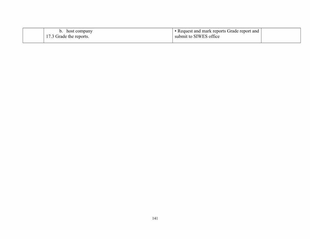
b. host company17.3 Grade the reports.
• Request and mark reports Grade report andsubmit to SIWES office
141

Programme: NATIONALDIPLOMA IN HYDROLOGY ANDWATER RESOURCESMANAGEMENT
Course Code: HWR 231 Credit Hours: 3
Course: Introduction to WaterResources Management 1
Pre-Requisite Theoretical: Hours/Week 2
Semester: 1 Practical: 1
1.0 Course Main Aim/Goal: Goal: The course is designed to provide students with the scope and concept of water resourcesmanagement
GENERAL OBJECTIVES
On Completion of this course the students will be able to1.0 Understand the scope and concept of water resources management2.0 Understand the concept of water budget3.0 Understand the concept of surface runoff4.0 Understand the impact of human interference on water balance 5.0 Understand the principle of water allocation and balancing demand and supply6.0 Estimate urban water demand and pricing of urban water7.0 Estimate agricultural water demand and yield response due to water shortage8.0 Estimate environmental water requirements
142
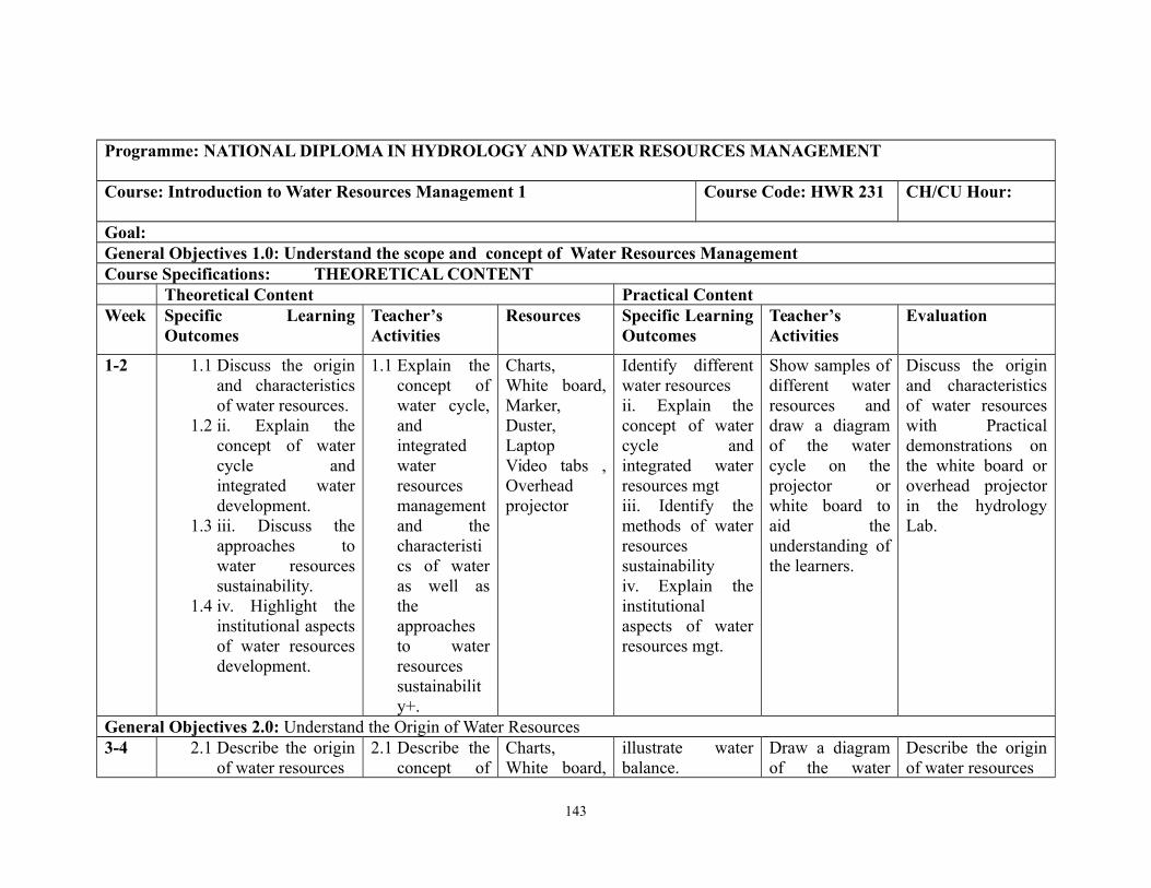
Programme: NATIONAL DIPLOMA IN HYDROLOGY AND WATER RESOURCES MANAGEMENT
Course: Introduction to Water Resources Management 1 Course Code: HWR 231 CH/CU Hour:
Goal:General Objectives 1.0: Understand the scope and concept of Water Resources ManagementCourse Specifications: THEORETICAL CONTENT
Theoretical Content Practical ContentWeek Specific Learning
OutcomesTeacher’sActivities
Resources Specific LearningOutcomes
Teacher’sActivities
Evaluation
1-2 1.1 Discuss the originand characteristicsof water resources.
1.2 ii. Explain theconcept of watercycle andintegrated waterdevelopment.
1.3 iii. Discuss theapproaches towater resourcessustainability.
1.4 iv. Highlight theinstitutional aspectsof water resourcesdevelopment.
1.1 Explain theconcept ofwater cycle,andintegratedwaterresourcesmanagementand thecharacteristics of wateras well astheapproachesto waterresourcessustainability+.
Charts,White board,Marker,Duster,LaptopVideo tabs ,Overheadprojector
Identify differentwater resourcesii. Explain theconcept of watercycle andintegrated waterresources mgtiii. Identify themethods of waterresourcessustainabilityiv. Explain theinstitutionalaspects of waterresources mgt.
Show samples ofdifferent waterresources anddraw a diagramof the watercycle on theprojector orwhite board toaid theunderstanding ofthe learners.
Discuss the originand characteristicsof water resourceswith Practicaldemonstrations onthe white board oroverhead projectorin the hydrologyLab.
General Objectives 2.0: Understand the Origin of Water Resources3-4 2.1 Describe the origin
of water resources 2.1 Describe the
concept ofCharts,White board,
illustrate waterbalance.
Draw a diagramof the water
Describe the originof water resources
143
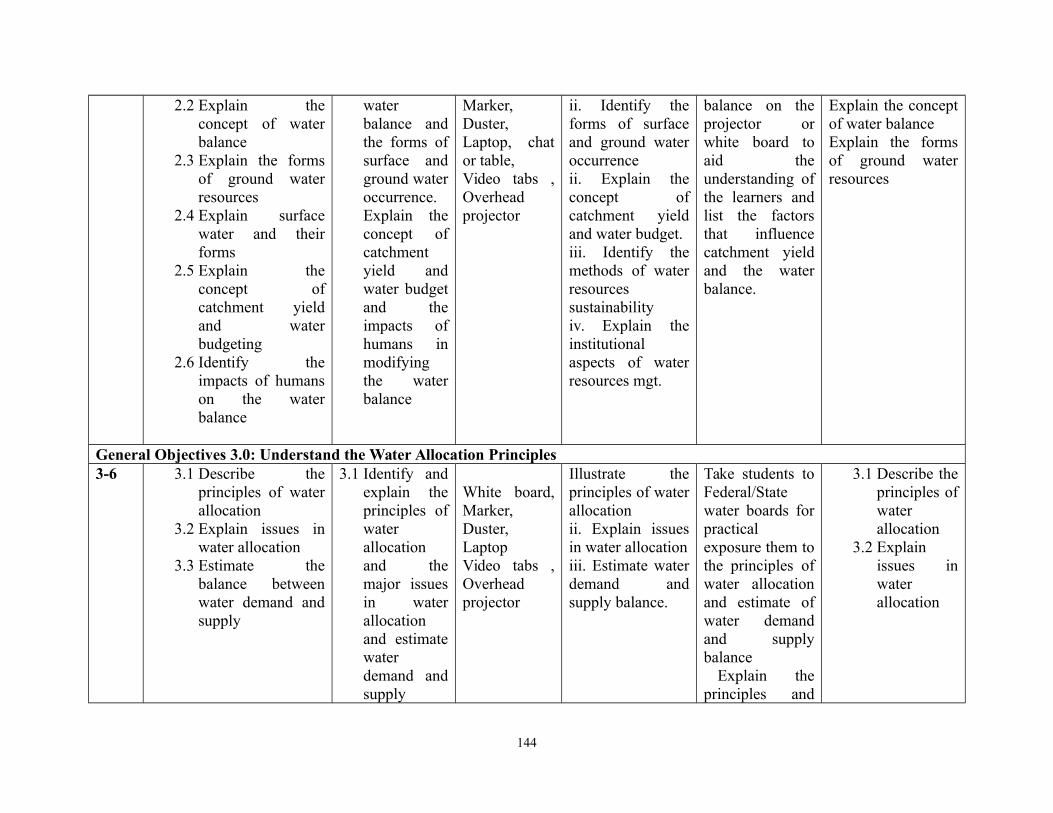
2.2 Explain theconcept of waterbalance
2.3 Explain the formsof ground waterresources
2.4 Explain surfacewater and theirforms
2.5 Explain theconcept ofcatchment yieldand waterbudgeting
2.6 Identify theimpacts of humanson the waterbalance
waterbalance andthe forms ofsurface andground wateroccurrence.Explain theconcept ofcatchmentyield andwater budgetand theimpacts ofhumans inmodifyingthe waterbalance
Marker,Duster,Laptop, chator table,Video tabs ,Overheadprojector
ii. Identify theforms of surfaceand ground wateroccurrenceii. Explain theconcept ofcatchment yieldand water budget.iii. Identify themethods of waterresourcessustainabilityiv. Explain theinstitutionalaspects of waterresources mgt.
balance on theprojector orwhite board toaid theunderstanding ofthe learners andlist the factorsthat influencecatchment yieldand the waterbalance.
Explain the conceptof water balance Explain the formsof ground waterresources
General Objectives 3.0: Understand the Water Allocation Principles3-6 3.1 Describe the
principles of waterallocation
3.2 Explain issues inwater allocation
3.3 Estimate thebalance betweenwater demand andsupply
3.1 Identify andexplain theprinciples ofwaterallocationand themajor issuesin waterallocationand estimatewaterdemand andsupply
White board,Marker,Duster,LaptopVideo tabs ,Overheadprojector
Illustrate theprinciples of waterallocationii. Explain issuesin water allocationiii. Estimate waterdemand andsupply balance.
Take students toFederal/Statewater boards forpracticalexposure them tothe principles ofwater allocationand estimate ofwater demandand supplybalance Explain theprinciples and
3.1 Describe theprinciples ofwaterallocation
3.2 Explainissues inwaterallocation
144
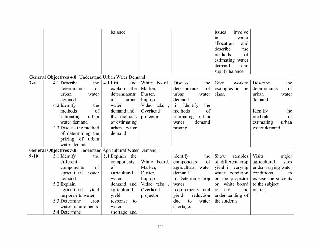
balance issues involvein waterallocation anddescribe themethods ofestimating waterdemand andsupply balance
General Objectives 4.0: Understand Urban Water Demand7-8 4.1 Describe the
determinants ofurban waterdemand
4.2 Identify themethods ofestimating urbanwater demand
4.3 Discuss the methodof determining thepricing of urbanwater demand
4.1 List andexplain thedeterminantsof urbanwaterdemand andthe methodsof estimatingurban waterdemand.
White board,Marker,Duster,LaptopVideo tabs ,Overheadprojector
Discuss thedeterminants ofurban waterdemand.ii. Identify themethods ofestimating urbanwater demandpricing.
Give workedexamples in theclass.
Describe thedeterminants ofurban waterdemand
Identify themethods ofestimating urbanwater demand.
General Objectives 5.0: Understand Agricultural Water Demand9-10 5.1 Identify the
differentcomponents ofagricultural waterdemand
5.2 Explainagricultural yieldresponse to water
5.3 Determine cropwater requirements
5.4 Determine
5.1 Explain thecomponentsofagriculturalwaterdemand andagriculturalyieldresponse towatershortage and
White board,Marker,Duster,LaptopVideo tabs ,Overheadprojector
identify thecomponents ofagricultural waterdemand.ii. Determine cropwaterrequirements andyield reductiondue to watershortage.
Show samplesof different cropyield in varyingwater conditionon the projectoror white boardto aid theunderstanding ofthe students
Visits majoragricultural sitesunder varying waterconditions toexpose the studentsto the subject matter.
145
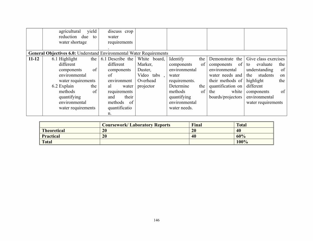
agricultural yieldreduction due towater shortage
discuss cropwaterrequirements.
General Objectives 6.0: Understand Environmental Water Requirements11-12 6.1 Highlight the
differentcomponents ofenvironmentalwater requirements
6.2 Explain themethods ofquantifyingenvironmentalwater requirements
6.1 Describe thedifferentcomponentsofenvironmental waterrequirementsand theirmethods ofquantification.
White board,Marker,Duster,Video tabs ,Overheadprojector
Identify thecomponents ofenvironmentalwaterrequirements.Determine themethods ofquantifyingenvironmentalwater needs.
Demonstrate thecomponents ofenvironmentalwater needs andtheir methods ofquantification onthe whiteboards/projectors
Give class exercisesto evaluate theunderstanding ofthe students onhighlight thedifferentcomponents ofenvironmentalwater requirements
Coursework/ Laboratory Reports Final TotalTheoretical 20 20 40Practical 20 40 60%Total 100%
146
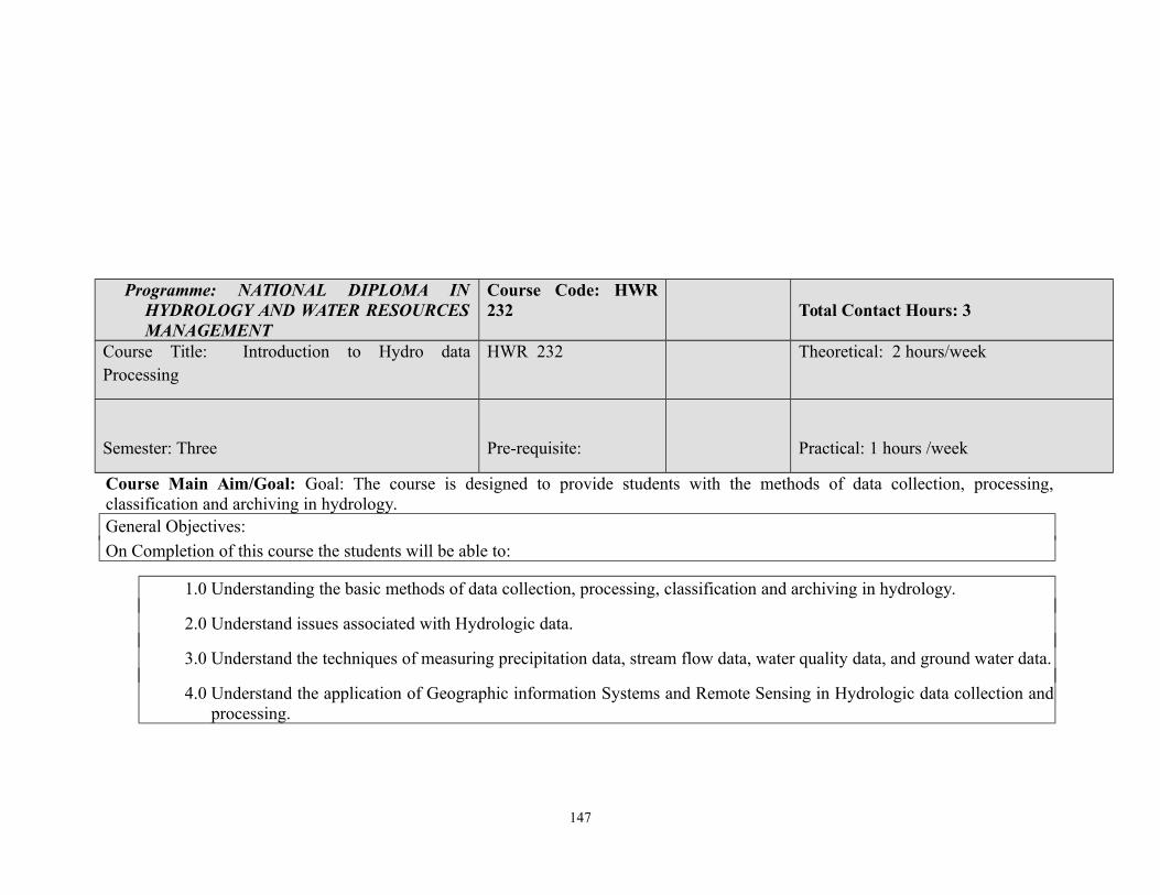
Programme: NATIONAL DIPLOMA INHYDROLOGY AND WATER RESOURCESMANAGEMENT
Course Code: HWR232 Total Contact Hours: 3
Course Title: Introduction to Hydro dataProcessing
HWR 232 Theoretical: 2 hours/week
Semester: Three Pre-requisite: Practical: 1 hours /week
Course Main Aim/Goal: Goal: The course is designed to provide students with the methods of data collection, processing,classification and archiving in hydrology.General Objectives:
On Completion of this course the students will be able to:
1.0 Understanding the basic methods of data collection, processing, classification and archiving in hydrology.
2.0 Understand issues associated with Hydrologic data.
3.0 Understand the techniques of measuring precipitation data, stream flow data, water quality data, and ground water data.
4.0 Understand the application of Geographic information Systems and Remote Sensing in Hydrologic data collection andprocessing.
147

Title: Introduction to Data Processing inHydroMet.
Course Code: HWR 232 Total Contact Hours: 5
HWR 232 Theoretical: 2 hours/week
Semester: Three Practical: 3 hours /week
Theoretical Content Practical Content
General Objective 1.0: Hydrologic Data
Week/s Specific Learning Outcomes Teacher’sactivities
Resources Specific LearningOutcomes
Teacher’s activities Evaluation
General Objective: Collection of Hydrologic data
1.1 Describe the differentmethods of collectingHydrologic data
1.2 Classification ofHydrologic Data:
a. Timeorienteddata,
b. Spaceorienteddata
c. Relationoriented
Describe thedifferent methodsof collectingHydrologic data
Classification ofHydrologic Data:
d.T
e.a
Video tabs,Overheadprojector,WhiteBoard
1.1 Highlight thedifferent methods ofcollectinghydrologic such asdirect measurement,remote sensing andthe use of chemicaltracers
1.2 Identify and discussthe different classesof hydro data
At the weatherstation, demonstratehow rain gauge isused in collectingprecipitation data,how the data areprocessed, storedand interpreted.
Describethedifferenttools usedfor dataHydrodatacollection.
148
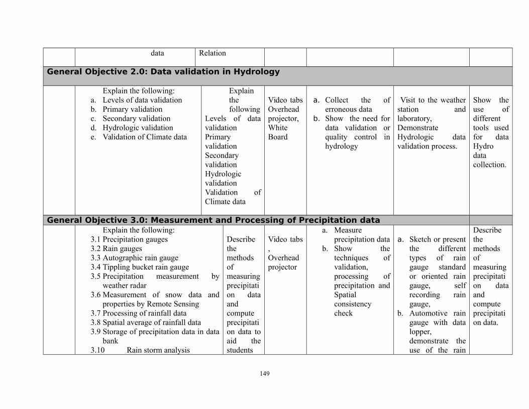
data Relation
General Objective 2.0: Data validation in Hydrology
Explain the following:a. Levels of data validationb. Primary validationc. Secondary validationd. Hydrologic validatione. Validation of Climate data
Explainthefollowing
Levels of datavalidationPrimaryvalidationSecondaryvalidationHydrologicvalidationValidation ofClimate data
Video tabsOverheadprojector,WhiteBoard
a. Collect the oferroneous data
b. Show the need fordata validation orquality control inhydrology
Visit to the weatherstation andlaboratory,DemonstrateHydrologic datavalidation process.
Show theuse ofdifferenttools usedfor dataHydrodatacollection.
General Objective 3.0: Measurement and Processing of Precipitation data Explain the following:
3.1 Precipitation gauges3.2 Rain gauges3.3 Autographic rain gauge3.4 Tippling bucket rain gauge3.5 Precipitation measurement by
weather radar3.6 Measurement of snow data and
properties by Remote Sensing3.7 Processing of rainfall data3.8 Spatial average of rainfall data3.9 Storage of precipitation data in data
bank3.10 Rain storm analysis
Describethemethodsofmeasuringprecipitation dataandcomputeprecipitation data toaid thestudents
Video tabs,Overheadprojector
a. Measureprecipitation data
b. Show thetechniques ofvalidation,processing ofprecipitation andSpatialconsistencycheck
a. Sketch or presentthe differenttypes of raingauge standardor oriented raingauge, selfrecording raingauge,
b. Automotive raingauge with datalopper,demonstrate theuse of the rain
Describethemethodsofmeasuringprecipitation dataandcomputeprecipitation data.
149
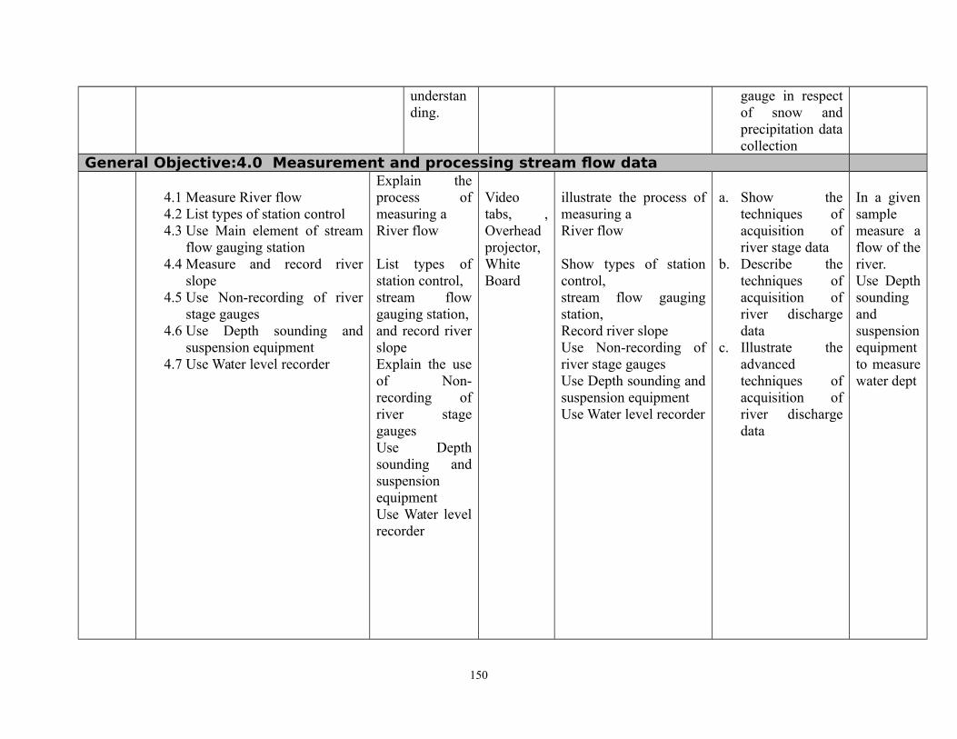
understanding.
gauge in respectof snow andprecipitation datacollection
General Objective:4.0 Measurement and processing stream flow data
4.1 Measure River flow 4.2 List types of station control4.3 Use Main element of stream
flow gauging station4.4 Measure and record river
slope4.5 Use Non-recording of river
stage gauges4.6 Use Depth sounding and
suspension equipment4.7 Use Water level recorder
Explain theprocess ofmeasuring a River flow
List types ofstation control,stream flowgauging station,and record riverslopeExplain the useof Non-recording ofriver stagegaugesUse Depthsounding andsuspensionequipmentUse Water levelrecorder
Videotabs, ,Overheadprojector,WhiteBoard
illustrate the process ofmeasuring a River flow
Show types of stationcontrol,stream flow gaugingstation,Record river slopeUse Non-recording ofriver stage gaugesUse Depth sounding andsuspension equipmentUse Water level recorder
a. Show thetechniques ofacquisition ofriver stage data
b. Describe thetechniques ofacquisition ofriver dischargedata
c. Illustrate theadvancedtechniques ofacquisition ofriver dischargedata
In a givensamplemeasure aflow of theriver.Use Depthsoundingandsuspensionequipmentto measurewater dept
150
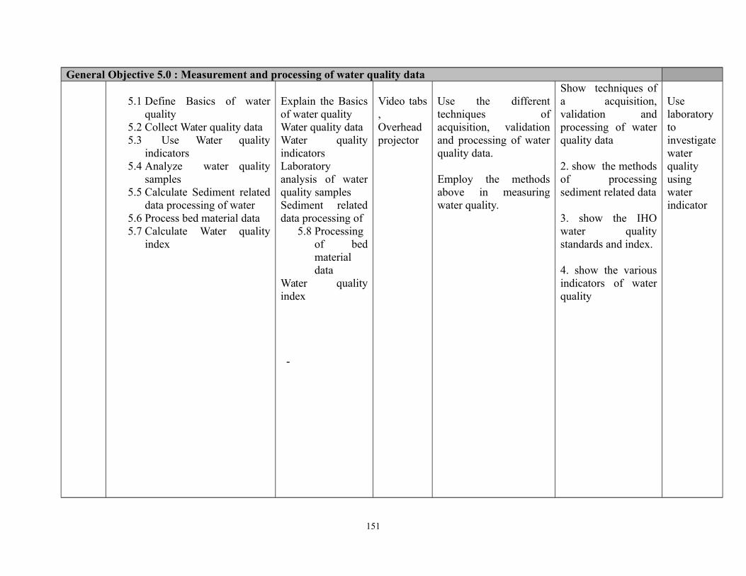
General Objective 5.0 : Measurement and processing of water quality data
5.1 Define Basics of waterquality
5.2 Collect Water quality data5.3 Use Water quality
indicators5.4 Analyze water quality
samples5.5 Calculate Sediment related
data processing of water5.6 Process bed material data5.7 Calculate Water quality
index
Explain the Basicsof water qualityWater quality dataWater qualityindicatorsLaboratoryanalysis of waterquality samplesSediment relateddata processing of
5.8 Processingof bedmaterialdata
Water qualityindex
-
Video tabs,Overheadprojector
Use the differenttechniques ofacquisition, validationand processing of waterquality data.
Employ the methodsabove in measuringwater quality.
Show techniques ofa acquisition,validation andprocessing of waterquality data 2. show the methodsof processingsediment related data
3. show the IHOwater qualitystandards and index.
4. show the variousindicators of waterquality
Uselaboratorytoinvestigatewaterqualityusingwaterindicator
151
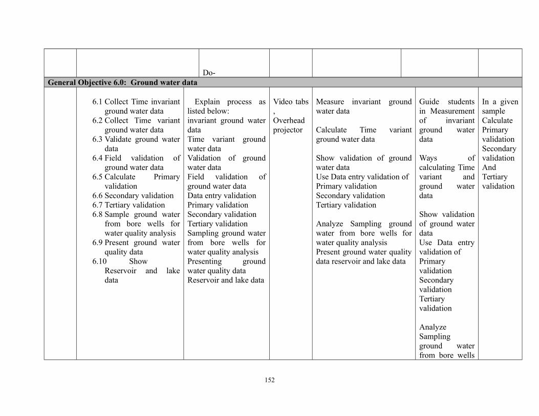
Do-General Objective 6.0: Ground water data
6.1 Collect Time invariantground water data
6.2 Collect Time variantground water data
6.3 Validate ground waterdata
6.4 Field validation ofground water data
6.5 Calculate Primaryvalidation
6.6 Secondary validation6.7 Tertiary validation6.8 Sample ground water
from bore wells forwater quality analysis
6.9 Present ground waterquality data
6.10 ShowReservoir and lakedata
Explain process aslisted below:invariant ground waterdataTime variant groundwater dataValidation of groundwater dataField validation ofground water dataData entry validationPrimary validationSecondary validationTertiary validationSampling ground waterfrom bore wells forwater quality analysisPresenting groundwater quality dataReservoir and lake data
Video tabs,Overheadprojector
Measure invariant groundwater data
Calculate Time variantground water data
Show validation of groundwater dataUse Data entry validation ofPrimary validationSecondary validationTertiary validation
Analyze Sampling groundwater from bore wells forwater quality analysisPresent ground water qualitydata reservoir and lake data
Guide studentsin Measurementof invariantground waterdata
Ways ofcalculating Timevariant andground waterdata
Show validationof ground waterdataUse Data entryvalidation ofPrimaryvalidationSecondaryvalidationTertiaryvalidation
AnalyzeSamplingground waterfrom bore wells
In a givensampleCalculatePrimaryvalidationSecondaryvalidationAndTertiaryvalidation
152
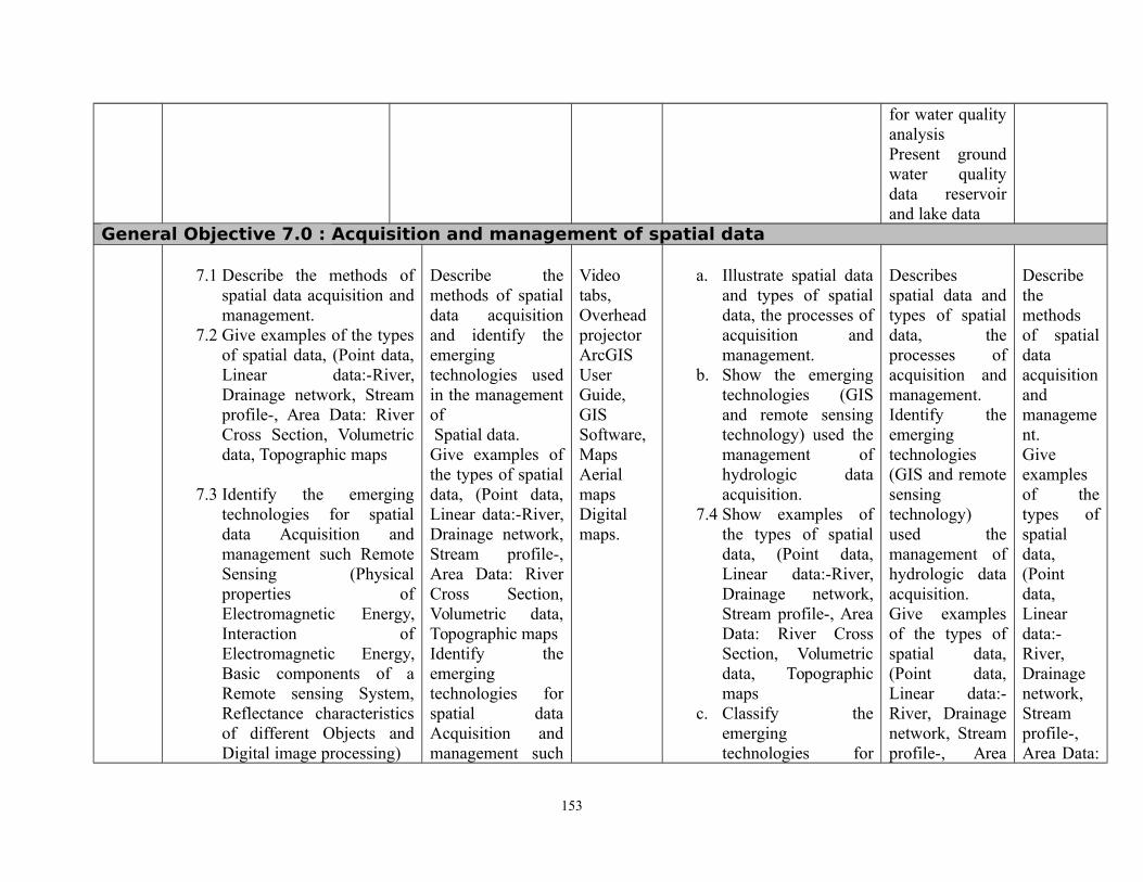
for water qualityanalysisPresent groundwater qualitydata reservoirand lake data
General Objective 7.0 : Acquisition and management of spatial data
7.1 Describe the methods ofspatial data acquisition andmanagement.
7.2 Give examples of the typesof spatial data, (Point data,Linear data:-River,Drainage network, Streamprofile-, Area Data: RiverCross Section, Volumetricdata, Topographic maps
7.3 Identify the emergingtechnologies for spatialdata Acquisition andmanagement such RemoteSensing (Physicalproperties ofElectromagnetic Energy,Interaction ofElectromagnetic Energy,Basic components of aRemote sensing System,Reflectance characteristicsof different Objects andDigital image processing)
Describe themethods of spatialdata acquisitionand identify theemergingtechnologies usedin the managementof Spatial data. Give examples ofthe types of spatialdata, (Point data,Linear data:-River,Drainage network,Stream profile-,Area Data: RiverCross Section,Volumetric data,Topographic mapsIdentify theemergingtechnologies forspatial dataAcquisition andmanagement such
Videotabs,OverheadprojectorArcGISUserGuide,GISSoftware,MapsAerialmapsDigitalmaps.
a. Illustrate spatial dataand types of spatialdata, the processes ofacquisition andmanagement.
b. Show the emergingtechnologies (GISand remote sensingtechnology) used themanagement ofhydrologic dataacquisition.
7.4 Show examples ofthe types of spatialdata, (Point data,Linear data:-River,Drainage network,Stream profile-, AreaData: River CrossSection, Volumetricdata, Topographicmaps
c. Classify theemergingtechnologies for
Describesspatial data andtypes of spatialdata, theprocesses ofacquisition andmanagement.Identify theemergingtechnologies(GIS and remotesensingtechnology)used themanagement ofhydrologic dataacquisition. Give examplesof the types ofspatial data,(Point data,Linear data:-River, Drainagenetwork, Streamprofile-, Area
Describethemethodsof spatialdataacquisitionandmanagement.Giveexamplesof thetypes ofspatialdata,(Pointdata,Lineardata:-River,Drainagenetwork,Streamprofile-,Area Data:
153
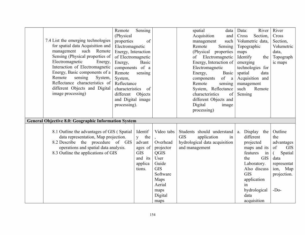
7.4 List the emerging technologiesfor spatial data Acquisition andmanagement such RemoteSensing (Physical properties ofElectromagnetic Energy,Interaction of ElectromagneticEnergy, Basic components of aRemote sensing System,Reflectance characteristics ofdifferent Objects and Digitalimage processing)
Remote Sensing(Physicalproperties ofElectromagneticEnergy, Interactionof ElectromagneticEnergy, Basiccomponents of aRemote sensingSystem,Reflectancecharacteristics ofdifferent Objectsand Digital imageprocessing).
spatial dataAcquisition andmanagement suchRemote Sensing(Physical propertiesof ElectromagneticEnergy, Interaction ofElectromagneticEnergy, Basiccomponents of aRemote sensingSystem, Reflectancecharacteristics ofdifferent Objects andDigital imageprocessing)
Data: RiverCross Section,Volumetric data,TopographicmapsIdentify theemergingtechnologies forspatial dataAcquisition andmanagementsuch RemoteSensing
RiverCrossSection,Volumetricdata,Topographic maps
General Objective 8.0: Geographic Information System
8.1 Outline the advantages of GIS ( Spatialdata representation, Map projection.
8.2 Describe the procedure of GISoperations and spatial data analysis.
8.3 Outline the applications of GIS
Identify theadvantages ofGISand itsapplications.
Video tabs,OverheadprojectorQGISUserGuideGISSoftwareMapsAerialmapsDigitalmaps
Students should understandGIS application inhydrological data acquisitionand management
a. Display thedifferentprojectedmaps and itsfeatures inthe GISLaboratory.Also discussGISapplicationinhydrologicaldataacquisition
Outlinetheadvantagesof GIS( Spatialdatarepresentation, Mapprojection.
-Do-
154
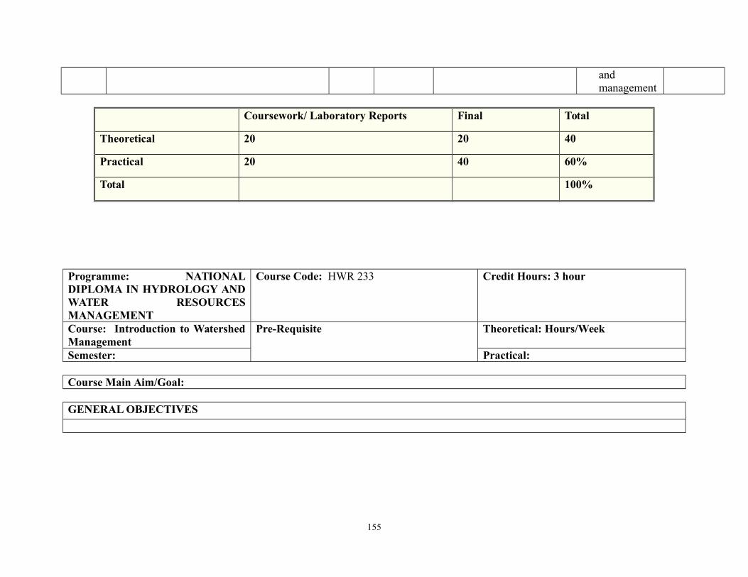
andmanagement
Coursework/ Laboratory Reports Final Total
Theoretical 20 20 40
Practical 20 40 60%
Total 100%
Programme: NATIONALDIPLOMA IN HYDROLOGY ANDWATER RESOURCESMANAGEMENT
Course Code: HWR 233 Credit Hours: 3 hour
Course: Introduction to WatershedManagement
Pre-Requisite Theoretical: Hours/Week
Semester: Practical:
Course Main Aim/Goal:
GENERAL OBJECTIVES
155
Programme: NATIONAL DIPLOMA IN HYDROLOGY AND WATER RESOURCES MANAGEMENTCourse: Introduction to Watershed Management Course Code:
HWR 233CH/CU Hour: 3
Goal:General Objectives 1.0: understand the scope and content of water shed management and its basic conceptsCourse Specifications: THEORETICAL CONTENT
Theoretical Content Practical ContentWeek Specific Learning
OutcomesTeacher’sActivities
Resources Specific LearningOutcomes
Teacher’sActivities
Evaluation
1 1.1 Explain themeaning ofwatershed
1.2 Consider thedefinitions ofwatershedmanagement
1.3 Introduce thebasic concepts ofwatershedmanagement-land use, eco-hydrology, watergovernance,watershedboundarydelineation,water resourceplan, etc.
1.4 Explainwatershedmanagement as asubset ofhydrology
Explain themeaning ofwatershed
Consider thedefinitions ofwatershedmanagementIntroduce thebasic concepts ofwatershedmanagement-landuse, eco-hydrology, watergovernance,watershedboundarydelineation, waterresource plan, etc.Explainwatershedmanagement.
management as asubset of
White board,Marker, duster,Laptop, video,overheadprojector
Identify watershedHydrology as asubset of hydrology
Mentions thedefinitions ofwatershedManagement
156
1.5 Discuss theprinciples ofsustainable waterdistribution.
hydrologyDiscuss theprinciples ofsustainable waterdistribution
General Objectives 2.0: Understand elementary modelling in watershed management2-3 2.1 Highlight the
relevance ofwatershedmodels toenvironmentalmanagement.
2.2 Explain rainfallrunoff relations
2.3 Discuss theblack boxmodels- unithydrograph,rationaleformulad
2.4 Discuss theLumped models-soil conservationcurve number,Stanfordwatershedmodel.
2.5 Discuss theDistributedmodels-unsteady state.
2.6 Explain systemthinking in
Highlight therelevance ofwatershedmodels toenvironmentalmanagement.
Explain rainfallrunoff relations
Discuss the blackbox models- unithydrograph,rationale formulaDiscuss theLumped models-soil conservationcurvenumber, Stanfordwatershed model.Discuss theDistributedmodels- unsteadystate.Explain system thinking in hydrology
White board,Marker, duster,Laptop, video,overheadprojector,Modelsoftware
Use specific/hypothetical butsimple example todemonstratesoftware using theblack box, lumpedmodels anddistributedmodels.
DemonstratesThe software toillustraterainfall- runoffrelations
List the types ofwatershed models.List the advantagesof system thinking inwatershedmanagement
157

hydrology General Objectives 3.0: Understand causes and solutions to problems of soil erosion4-5 3.1 Explain the
processes of soilerosion I: e rainfall,surface runoff,rivers, wind, massmovement.
3.2 Discuss the causesof soil erosion -climate, soilcharacteristics,agriculturalpractices, land useand cover,deforestation,urbanization androads, landdegradation, etc.
3.3 Explain themethods ofcontrolling soilerosion- windbreak,terracing,mulching,monocropping,crop rotation, etc.
3.4 Demonstrate Soilerosion modellingusing the UniversalSoil Loss Equation(USLE).
3.5 Explain the
3.1 Discuss theagents of soilerosion
3.2 Highlight thecauses of soilerosion
3.3 Illustrates thecontrolmethods
etc.Explain themethods ofcontrolling soilerosion-windbreak,terracing,mulching, mono-cropping, croprotation, etc.
Demonstrate Soilerosion modelingusing theUniversal SoilLoss Equation(USLE).Explain the measurement of
White board,Marker, duster,Laptop, video,overheadprojector,Sedimenttraps,Erosion pins
a. Demonstratethe USLEformular
b. Demonstratethe use oferosion pinsand
c. Sediment traps
Show theprocedure forusing sedimenttraps anderosion pins
a. Describe theprocesses ofsoil erosion.
b. Describedhow to checksoil erosion
158

measurement ofsoil erosion- Use ofsediment traps, Useof erosion pins
soil erosion- Use of sediment traps,Use of erosion pins
General Objectives 4.0: Understand the relationship between land use and water quality6-7 4.1 Explain land use
types4.2 Discuss the land
managementtechniques
4.3 Discuss theproblems ofwastemanagement
4.4 Discuss riversiltation andsedimentation ofopen waterbodies
4.5 Explain thequality of water-physical,biological andchemicalcharacterises ofwater
Identify theland use types
Emphasize thelinkage betweenland use andwater pollutionDiscuss theproblems ofsiltation oftropical rivers andreservoirs
White board,Marker, duster,Laptop, video,overheadprojector,Chemicalreagents andappropriatelaboratoryapparatuses
a. Show theprocedurefordetermining physical,chemicalandbiologicalpropertiesof water.
a. Highlight thelinkagebetween landuse and waterpollution
General Objectives 5.0: understand the causes and flood mitigation in the tropics8-9 5.1 Discuss the
nature of tropicalstorms
5.2 Explain Floodgenerating
Discuss thenature oftropicalstormsExplain Flood
White board,Marker, duster,Laptop, video,overheadprojector,
Field trip Visit to floodplains designandadministrationof questionnaire
What causes Flood?Using Least SquareMethod predict floodfor 5 years.
159
mechanisms5.3 Highlight the
types of floods5.4 Explain the
negative impactsof floods
5.5 Explain thepositive impactsof floods
5.6 Discuss Flooddamages
5.7 Explain floodmitigationstrategies.
5.8 Introduceelementary floodforecasting
generatingmechanismsHighlight thetypes offloodsExplain thenegativeimpacts offloodsExplain thepositiveimpacts offloodsDiscuss Flooddamages
Explain floodmitigationstrategies.Introduceelementary floodforecasting
Floodforecastingsoftwares
observation offlood damagesField testing offlood reliefstrategies. floodforecastingsoftwareexposure toflood routingtechniques
General Objectives 6.0: understand causes of drought its mitigation and adjustment strategies10-11 6.1 Classify drought
6.2 Highlight thecauses ofdroughts-climatic,anthropogenic,natural, etc.
6.3 Explain theImpacts ofdrought
6.4 Discuss Drought
Classify droughtHighlight thecauses ofdroughts
Climatic,anthropogenic,natural, etc.Explain theImpacts ofdrought
White board,Marker, duster,Laptop, video,overheadprojector,Rainfall datafor a minimumof 30 years
Estimate dry yearsusing theStandardizedAnomaly Index(SAI, RAI, SPI)
160
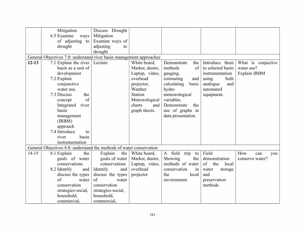
Mitigation 6.5 Examine ways
of adjusting todrought
Discuss DroughtMitigation Examine ways ofadjusting todrought
General Objectives 7.0: understand river basin management approaches12-13 7.1 Explain the river
basin as a unit ofdevelopment
7.2 Explainconjunctivewater use,
7.3 Discuss theconcept ofIntegrated riverbasinmanagement(IRBM)approach
7.4 Introduce toriver basininstrumentation
Lecture White board,Marker, duster,Laptop, video,overheadprojector,WeatherStationMeteorologicalcharts andgraph sheets.
Demonstrate themethods ofgauging,estimating andcalculating basichydrometeorologicalvariables.Demonstrate theuse of graphs indata presentation.
Introduce themto selected basininstrumentationusing bothanalogue andautomatedequipment.
What is conjuctivewater use?Explain IRBM
General Objectives 8.0: understand the methods of water conservation14-15 8.1 Explain the
goals of waterconservations
8.2 Identify anddiscuss the typesof waterconservationstrategies-social,household,commercial,
Explain thegoals of waterconservations
Identify anddiscuss the typesof waterconservationstrategies-social,household,commercial,
White board,Marker, duster,Laptop, video,overheadprojector
A field trip toShowing themethods of waterconservation inthe localenvironment
Fielddemonstrationof the localwater storageandpreservationmethods
How can youconserve water?
161
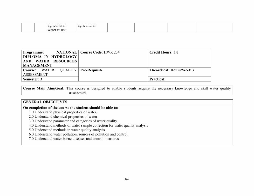
agricultural,water re use.
agricultural
Programme: NATIONALDIPLOMA IN HYDROLOGYAND WATER RESOURCESMANAGEMENT
Course Code: HWR 234 Credit Hours: 3.0
Course: WATER QUALITYASSESSMENT
Pre-Requisite Theoretical: Hours/Week 3
Semester: 3 Practical:
Course Main Aim/Goal: This course is designed to enable students acquire the necessary knowledge and skill water qualityassessment
GENERAL OBJECTIVES
On completion of the course the student should be able to:1.0 Understand physical properties of water.2.0 Understand chemical properties of water3.0 Understand parameter and categories of water quality4.0 Understand methods of water sample collection for water quality analysis5.0 Understand methods in water quality analysis6.0 Understand water pollution, sources of pollution and control.7.0 Understand water borne diseases and control measures
162
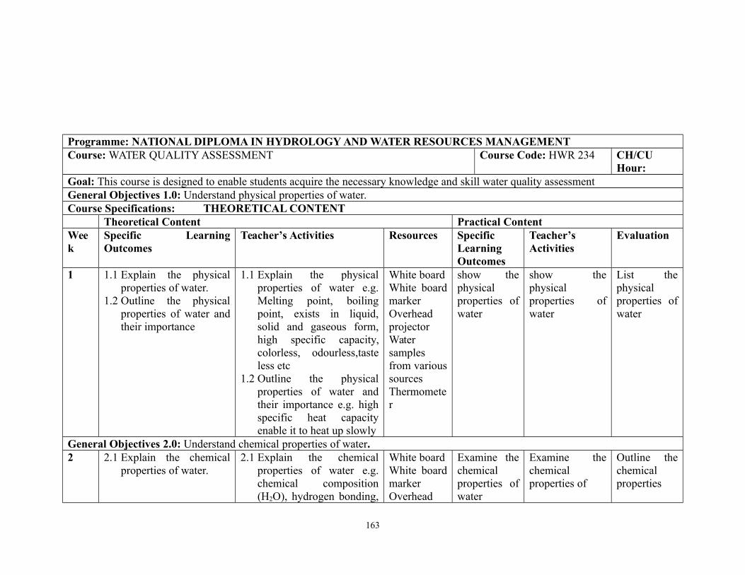
Programme: NATIONAL DIPLOMA IN HYDROLOGY AND WATER RESOURCES MANAGEMENTCourse: WATER QUALITY ASSESSMENT Course Code: HWR 234 CH/CU
Hour:Goal: This course is designed to enable students acquire the necessary knowledge and skill water quality assessmentGeneral Objectives 1.0: Understand physical properties of water.Course Specifications: THEORETICAL CONTENT
Theoretical Content Practical ContentWeek
Specific LearningOutcomes
Teacher’s Activities Resources SpecificLearningOutcomes
Teacher’sActivities
Evaluation
1 1.1 Explain the physicalproperties of water.
1.2 Outline the physicalproperties of water andtheir importance
1.1 Explain the physicalproperties of water e.g.Melting point, boilingpoint, exists in liquid,solid and gaseous form,high specific capacity,colorless, odourless,tasteless etc
1.2 Outline the physicalproperties of water andtheir importance e.g. highspecific heat capacityenable it to heat up slowly
White boardWhite boardmarkerOverheadprojectorWatersamplesfrom varioussourcesThermometer
show thephysicalproperties ofwater
show thephysicalproperties ofwater
List thephysicalproperties ofwater
General Objectives 2.0: Understand chemical properties of water.2 2.1 Explain the chemical
properties of water.2.1 Explain the chemical
properties of water e.g.chemical composition(H2O), hydrogen bonding,
White boardWhite boardmarkerOverhead
Examine thechemicalproperties ofwater
Examine thechemicalproperties of
Outline thechemicalproperties
163
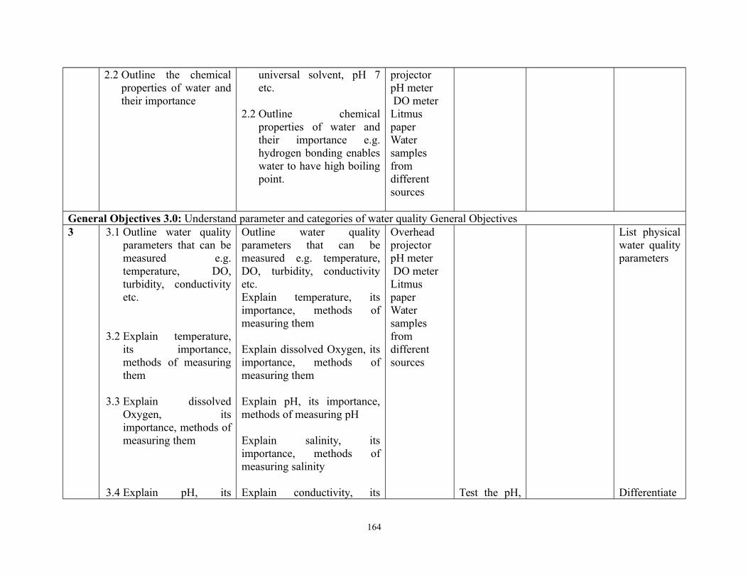
2.2 Outline the chemicalproperties of water andtheir importance
universal solvent, pH 7etc.
2.2 Outline chemicalproperties of water andtheir importance e.g.hydrogen bonding enableswater to have high boilingpoint.
projectorpH meter DO meterLitmuspaperWatersamplesfromdifferentsources
General Objectives 3.0: Understand parameter and categories of water quality General Objectives3 3.1 Outline water quality
parameters that can bemeasured e.g.temperature, DO,turbidity, conductivityetc.
3.2 Explain temperature,its importance,methods of measuringthem
3.3 Explain dissolvedOxygen, itsimportance, methods ofmeasuring them
3.4 Explain pH, its
Outline water qualityparameters that can bemeasured e.g. temperature,DO, turbidity, conductivityetc.Explain temperature, itsimportance, methods ofmeasuring them
Explain dissolved Oxygen, itsimportance, methods ofmeasuring them
Explain pH, its importance,methods of measuring pH
Explain salinity, itsimportance, methods ofmeasuring salinity
Explain conductivity, its
OverheadprojectorpH meter DO meterLitmuspaperWatersamplesfromdifferentsources
Test the pH,
List physicalwater qualityparameters
Differentiate
164
importance, methods ofmeasuring pH
3.5 Explain salinity, itsimportance, methods ofmeasuring salinity
3.6 Explain conductivity,its importance,methods of measuringconductivity
3.7 Explain hardness, itsimportance, methods ofmeasuring hardness
3.8 Explain transparency,its importance,methods of measuringtransparency
3.9 Explain total dissolvedsolid, its importance,methods of measuringtotal dissolved solid
3.10 Explain algae, its
importance, methods ofmeasuring Conductivity
Explain hardness, itsimportance, methods ofmeasuring hardness
Explain transparency, itsimportance, methods ofmeasuring transparency
3.1 Explain total dissolvedsolid e.g. sodium,chloride, potassium,calcium, manganese, etc.their importance, methodsof measuring them.
3.2 Explain algae, itsimportance, methods ofmeasuring algaepopulation in water
3.3 Explain phytoplankton, itsimportance, methods ofmeasuring phytoplanktonabundance
3.4 Explain bacteria, itsimportance, methods ofmeasuring them
List and explain categories of
itsimportance,methods ofmeasuringpH
Test thesalinity, itsimportance,methods ofmeasuringsalinity
Measure theconductivity
Test thehardness, ofwater
Identifymethods ofmeasuring ofhardness
Measuringtransparency
Calculatetotaldissolved
Identifycommon planktonic algae
betweenconductivityand hardness
165
importance, methods ofmeasuring algaepopulation in water
3.11 Explainphytoplankton, itsimportance, methods ofmeasuringphytoplanktonabundance
3.12 Explain bacteria,its importance,methods of measuringthem
3.13 List and explaincategories of waterquality
water quality e.g. humanconsumption, industrial,domestic use, environmentalwater quality
solid, itsimportance,methods ofmeasuringDrawcommonplanktonicalgae
General Objectives 4.0: Understand methods of water sample collection for water quality7 4.1 Explain methods of
collecting water samplefor water qualityanalysis
4.2 Explain methods ofstoring water samplefor analysis
4.1 Explain methods ofcollecting water samplefor water quality analysise.g. for chemical analysis,for BOD, COD, heavymetal and pollutants
4.2 Explain methods ofstoring water sample foranalysis
Whiteboard,marker,Winklerbottles,ReagentsPlasticcontainers
Make fieldtrip to collectwater samplefromdifferentwater bodies
Practicaldemonstration of methodsof watersamplecollection
Explainmethods ofcollectingwater samplefor waterqualityanalysis
General Objectives 5.0: Understand methods in water quality analysis8 5.1 Explain methods in
water quality analysisbased on the purpose.
5.1 Describe methods inwater quality analysison the purpose of
White boardWhite boardmarker
Conductpractical
Practicaldemonstration of
166
5.2 Explain the effect of in-situ and ex-situ waterquality analysis
5.3 Explain methods ofanalysing
a. Chemical parameters5.4 Explain methods of
analysingDO2. pH3. Salinity4. Nitrogen5. Phosphorus6. Major cations e.g.Sodium, potassium7. Heavy metals
5.5 Explain methods ofanalysing
b. Physical parameters1. Temperature2. Transparency3. Conductivity4. Turbidityetc
analysis e.g. Drinkingwater analysis,ambient water analysisfor rivers, lakes,coastal water bodies,natural disaster,pollution studies
5.2 Explain the effect ofin-situ and ex-situwater quality analysis
5.3 Describe methods ofanalysing
a. Chemicalparameters
b. DOc. pHd. Salinitye. Nitrogenf. Phosphorusg. Major cations
e.g. Sodiumh. Heavy metals
e.g. Lead,Mercury etc.
5.4 Describe methods of Analyzing Physicalparameters
a. Temperatureb. Transparency
Overheadprojector
White boardWhite boardmarkerOverheadprojectorMulti-probewateranalysismeter, wateranalysis kit
White boardWhite boardmarkerOverheadprojectorMulti-probewateranalysismeter, wateranalysis kitConductivity meterSecchi discWhite boardWhite boardmarkerOverheadprojector
demonstration to analysewater samplefor BOD andCOD
Conductpracticaldemonstration to analysewater samplefor BOD andCOD
Conductpracticaldemonstration to analysewater samplefor BOD and
analyzing:1. DO2. pH3. Salinity4. Nitrogen5. Phosphorus6. Major cationse.g. Sodium7. Heavy metalse.g. Lead,Mercury etc
Practicaldemonstration ofanalyzing:1. Temperature2. Transparency3. Conductivity4. Turbidity5.
Practical
Explain theeffect of in-situ and ex-situ waterqualityanalysis
167
5.6 Explain methods ofanalysing
a. Total solidcontent
b. Settleablesolids
c. Suspendedsolids
d. Filterablesolids
5.7 Explain methods ofanalysing for BOD,COD, coliform count,other bacteriologicalindicators
5.8 Explain methods ofanalysing forradioactive substances
c. Conductivityd. Turbidity
5.5 Describe methods of analysing
a. Total solidcontent
b. Settleablesolids
c. Suspendedsolids
d. Filterablesolids
5.6 Describe methods of analysing for BOD,COD, coliform count,other bacteriologicalindicators
5.7 Describe methods of analysing for radioactivesubstances
COD demonstration ofanalysing BODand COD
Outline themethods formeasuringTemperature,Transparency,ConductivityTurbidity
DifferentiatebetweenBOD andCOD
General Objectives 6.0: Understand water pollution, sources of pollution and control.12 6.1 Define pollution
and pollutant
6.2 Explain types ofpollution
6.3 List sources ofwater pollution
6.4 Explain
6.1 Define pollution andpollutant
6.2 Explain types ofpollution: waterpollution, airpollution, noisepollution, landpollution
White boardWhite boardmarkerOverheadprojector
State fivewaterpollutants
168
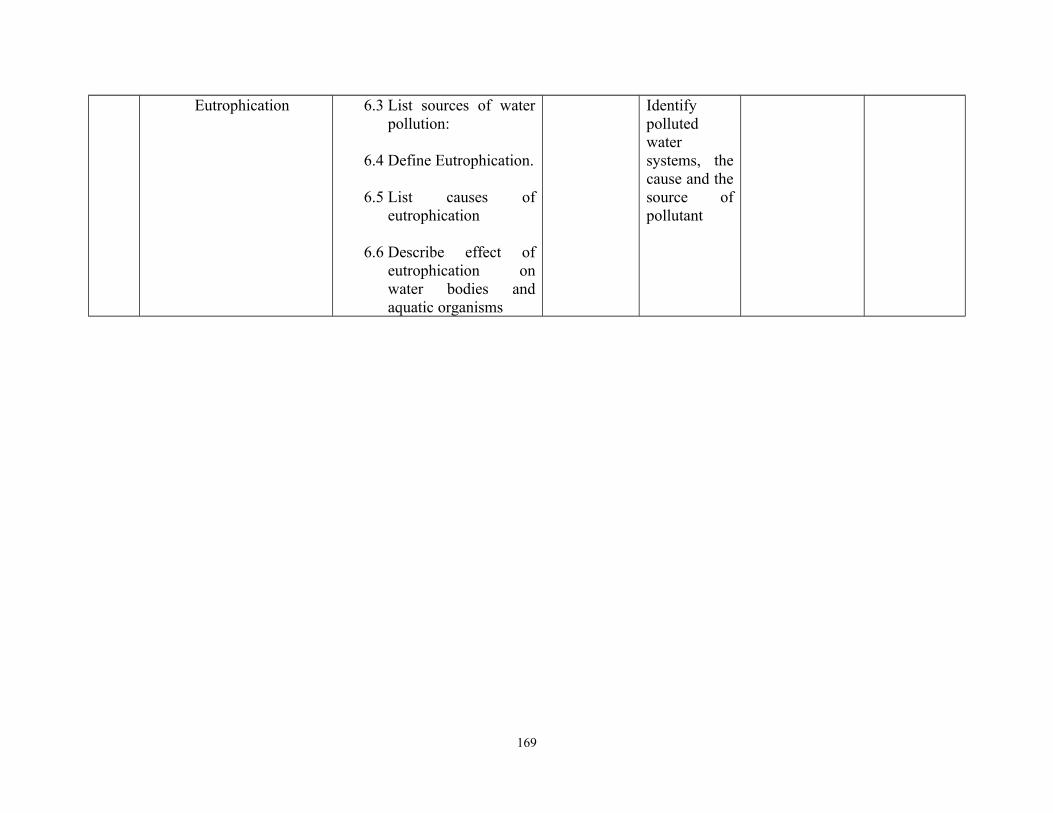
Eutrophication 6.3 List sources of waterpollution:
6.4 Define Eutrophication.
6.5 List causes ofeutrophication
6.6 Describe effect ofeutrophication onwater bodies andaquatic organisms
Identifypollutedwatersystems, thecause and thesource ofpollutant
169
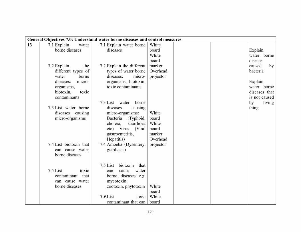
General Objectives 7.0: Understand water borne diseases and control measures13 7.1 Explain water
borne diseases
7.2 Explain thedifferent types ofwater bornediseases: micro-organisms,biotoxin, toxiccontaminants
7.3 List water bornediseases causingmicro-organisms
7.4 List biotoxin thatcan cause waterborne diseases
7.5 List toxiccontaminant thatcan cause waterborne diseases
7.1 Explain water bornediseases
7.2 Explain the differenttypes of water bornediseases: micro-organisms, biotoxin,toxic contaminants
7.3 List water bornediseases causingmicro-organisms:Bacteria (Typhoid,cholera, diarrhoeaetc) Virus (Viralgastroenteritis,Hepatitis)
7.4 Amoeba (Dysentery,giardiasis)
7.5 List biotoxin thatcan cause waterborne diseases e.g.mycotoxin,zootoxin, phytotoxin
7.6List toxiccontaminant that can
WhiteboardWhiteboardmarkerOverheadprojector
WhiteboardWhiteboardmarkerOverheadprojector
WhiteboardWhiteboard
Explainwater bornediseasecaused bybacteria
Explainwater bornediseases thatis not causedby livingthing
170
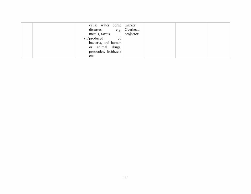
cause water bornediseases e.g.metals, toxins
7.7produced bybacteria, and humanor animal drugs,pesticides, fertilizersetc.
markerOverheadprojector
171
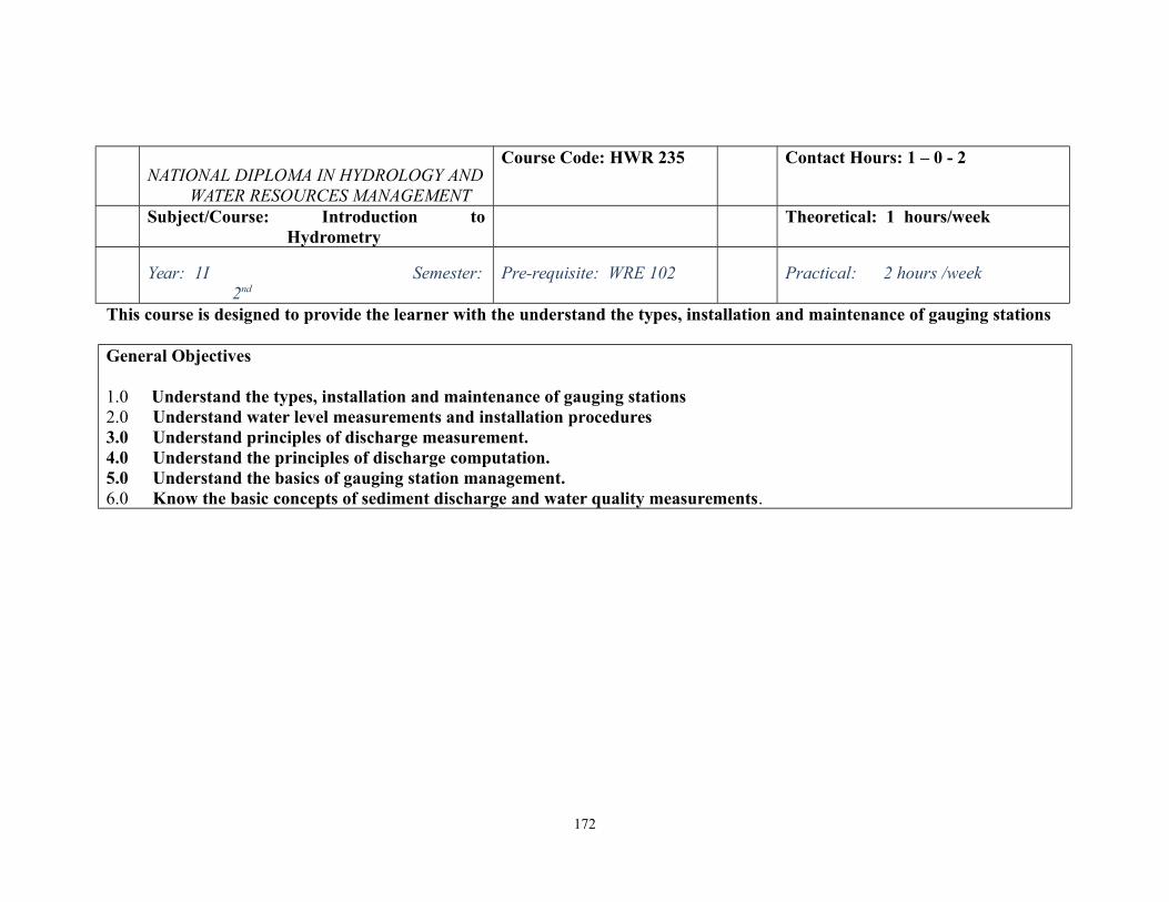
NATIONAL DIPLOMA IN HYDROLOGY ANDWATER RESOURCES MANAGEMENT
Course Code: HWR 235 Contact Hours: 1 – 0 - 2
Subject/Course: Introduction toHydrometry
Theoretical: 1 hours/week
Year: 1I Semester:2nd
Pre-requisite: WRE 102 Practical: 2 hours /week
This course is designed to provide the learner with the understand the types, installation and maintenance of gauging stations
General Objectives
1.0 Understand the types, installation and maintenance of gauging stations 2.0 Understand water level measurements and installation procedures 3.0 Understand principles of discharge measurement.4.0 Understand the principles of discharge computation.5.0 Understand the basics of gauging station management.6.0 Know the basic concepts of sediment discharge and water quality measurements.
172

PROGRAMME: NATIONAL DIPLOMA IN HYDROLOGY AND WATER RESOURCES MANAGEMENT
Course: Introduction to Hydrometry Course Code: HWR 235 Contact Hours: 1 – 0 - 2
Course Specification: Theoretical Content: 1 hrs Practical Content: 2 hrs
Year: ND II Semester: 2 Prerequisite :
Course Objectives 1.0: Understand the types, installation and maintenance of gauging stations
Week
1-2
General Objective 1.0:
Specific Learning Outcome: Teacher Activities ResourcesSpecific LearningOutcome:
Teacher Activities Resources
1.1 Explain Hydrometric1.2 Describe features and
components of a gaugingstation
1.3 Describe the criteria used inselecting gauging station.
1.4 Describe types of channelconditions.
1.1 Lecture1.2 Illustrate with
relevantdiagrams.
a. InstructionalManual.
b. Recommendedtextbooks,lecture notes,
c. PowerPoint,d. Projector &
Screen,
Identify somegauging stations
Show somegauging stations
ExplainHydrometric
Week General Objective 2.0: Understand water level measurements and installation procedures.
3-4 Specific Learning Outcome: Teachers Activities Resources Specific LearningOutcome:
Teacher Activities Resources
2.1 Explain water level/stage2.2 Describe types of water level
instruments.2.3 Show the usage and
2.1 Lecture andshow thestudents thevarious
a. InstructionalManual.
b. Recommendedtextbooks, e-
a. Identifyvarious waterlevelinstruments.
a. Prepare theequipmentsfor theoutdoor
Explain the useof Water levelinstruments
173
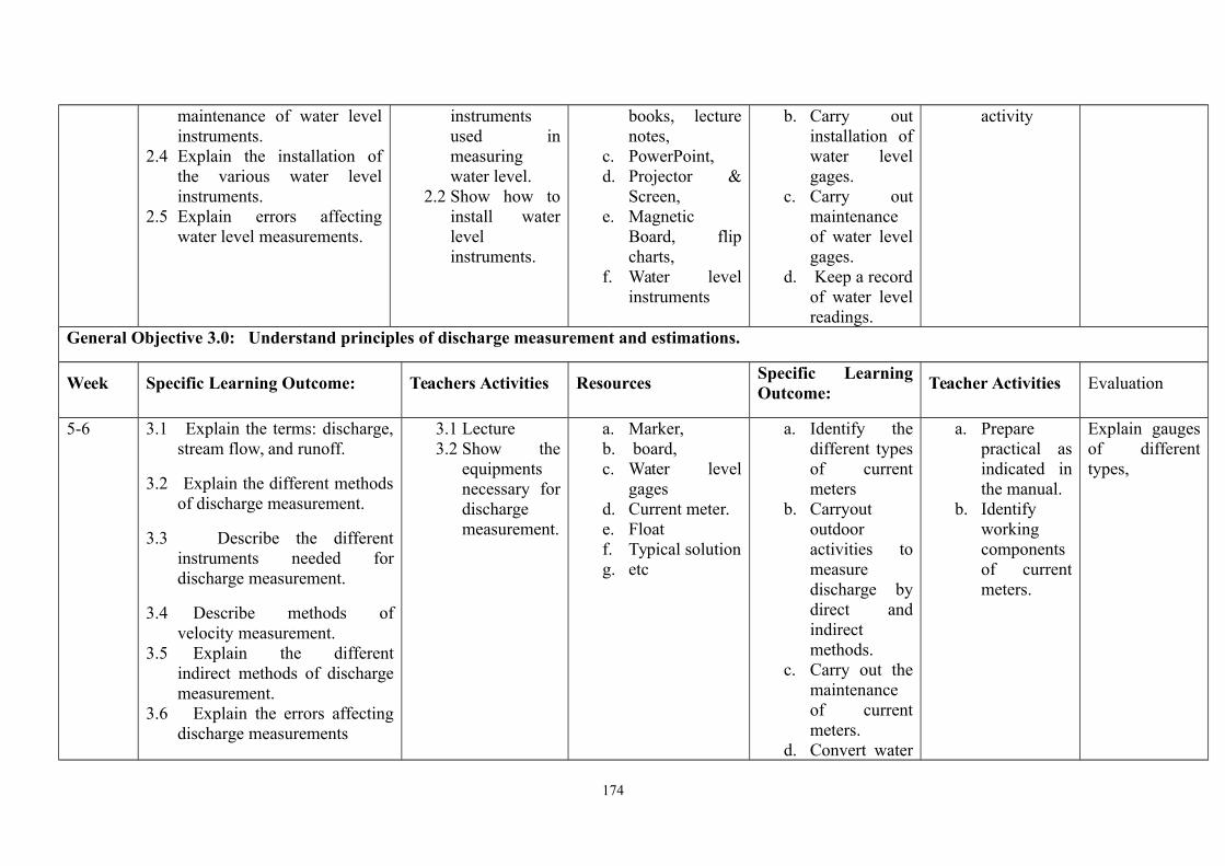
maintenance of water levelinstruments.
2.4 Explain the installation ofthe various water levelinstruments.
2.5 Explain errors affectingwater level measurements.
instrumentsused inmeasuringwater level.
2.2 Show how toinstall waterlevelinstruments.
books, lecturenotes,
c. PowerPoint,d. Projector &
Screen,e. Magnetic
Board, flipcharts,
f. Water levelinstruments
b. Carry outinstallation ofwater levelgages.
c. Carry outmaintenanceof water levelgages.
d. Keep a recordof water levelreadings.
activity
General Objective 3.0: Understand principles of discharge measurement and estimations.
Week Specific Learning Outcome: Teachers Activities ResourcesSpecific LearningOutcome:
Teacher Activities Evaluation
5-6 3.1 Explain the terms: discharge,stream flow, and runoff.
3.2 Explain the different methodsof discharge measurement.
3.3 Describe the differentinstruments needed fordischarge measurement.
3.4 Describe methods ofvelocity measurement.
3.5 Explain the differentindirect methods of dischargemeasurement.
3.6 Explain the errors affectingdischarge measurements
3.1 Lecture3.2 Show the
equipmentsnecessary fordischargemeasurement.
a. Marker,b. board,c. Water level
gagesd. Current meter.e. Floatf. Typical solutiong. etc
a. Identify thedifferent typesof currentmeters
b. Carryoutoutdooractivities tomeasuredischarge bydirect andindirectmethods.
c. Carry out themaintenanceof currentmeters.
d. Convert water
a. Preparepractical asindicated inthe manual.
b. Identifyworkingcomponentsof currentmeters.
Explain gaugesof differenttypes,
174
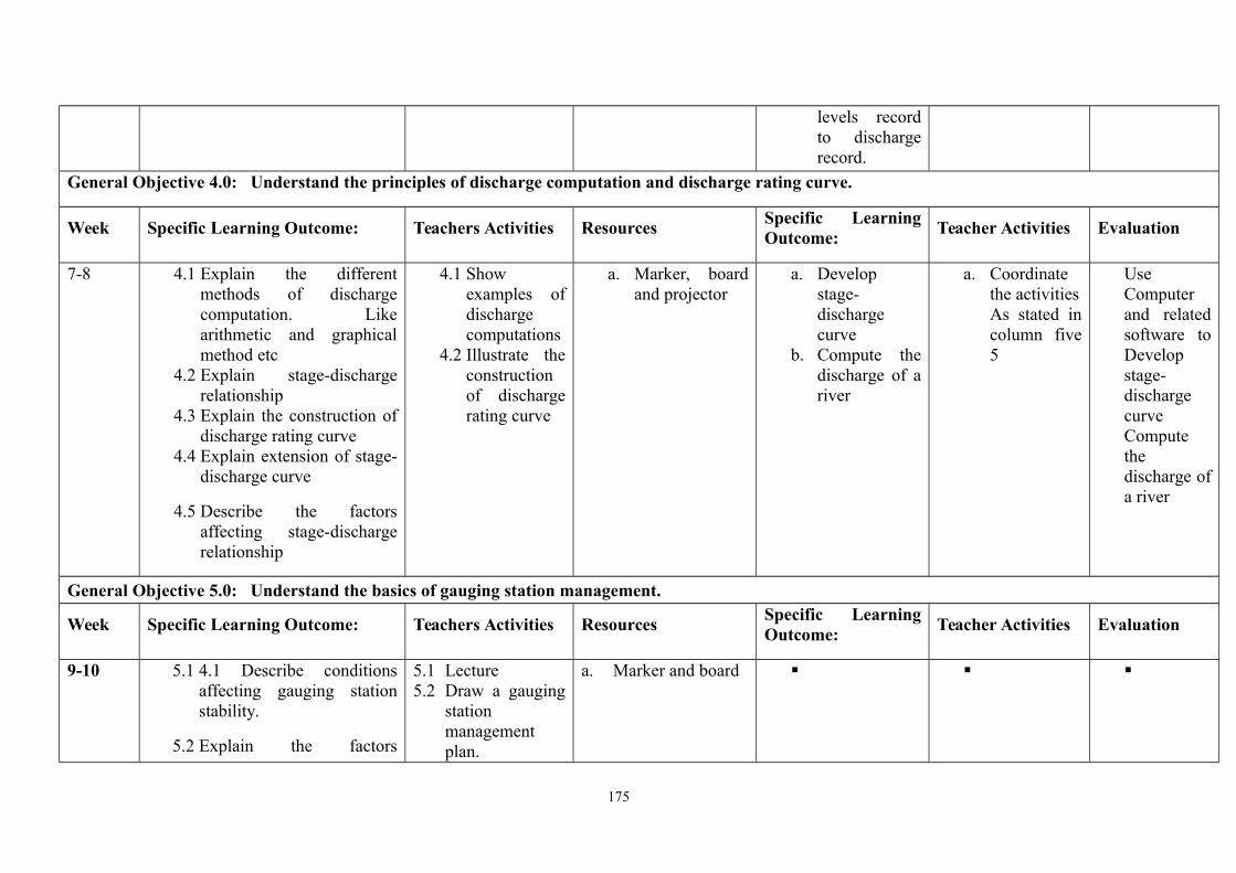
levels recordto dischargerecord.
General Objective 4.0: Understand the principles of discharge computation and discharge rating curve.
Week Specific Learning Outcome: Teachers Activities ResourcesSpecific LearningOutcome:
Teacher Activities Evaluation
7-8 4.1 Explain the differentmethods of dischargecomputation. Likearithmetic and graphicalmethod etc
4.2 Explain stage-dischargerelationship
4.3 Explain the construction ofdischarge rating curve
4.4 Explain extension of stage-discharge curve
4.5 Describe the factorsaffecting stage-dischargerelationship
4.1 Showexamples ofdischargecomputations
4.2 Illustrate theconstructionof dischargerating curve
a. Marker, boardand projector
a. Developstage-dischargecurve
b. Compute thedischarge of ariver
a. Coordinatethe activitiesAs stated incolumn five5
UseComputerand relatedsoftware toDevelopstage-dischargecurveComputethedischarge ofa river
General Objective 5.0: Understand the basics of gauging station management.
Week Specific Learning Outcome: Teachers Activities ResourcesSpecific LearningOutcome:
Teacher Activities Evaluation
9-10 5.1 4.1 Describe conditionsaffecting gauging stationstability.
5.2 Explain the factors
5.1 Lecture5.2 Draw a gauging
stationmanagementplan.
a. Marker and board
175
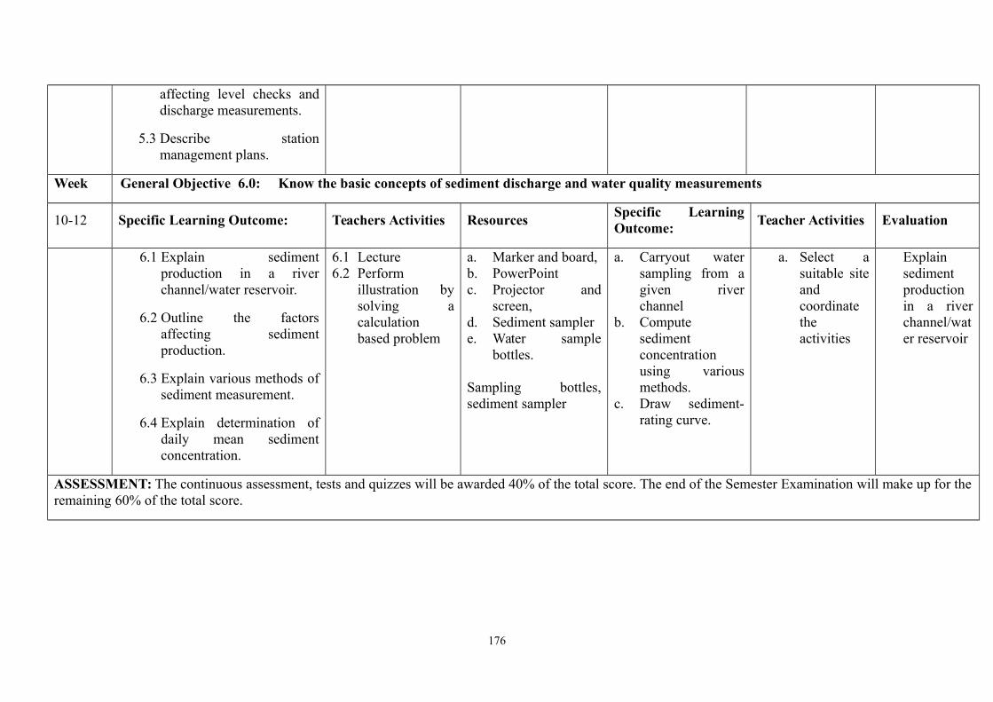
affecting level checks anddischarge measurements.
5.3 Describe stationmanagement plans.
Week General Objective 6.0: Know the basic concepts of sediment discharge and water quality measurements
10-12 Specific Learning Outcome: Teachers Activities ResourcesSpecific LearningOutcome:
Teacher Activities Evaluation
6.1 Explain sedimentproduction in a riverchannel/water reservoir.
6.2 Outline the factorsaffecting sedimentproduction.
6.3 Explain various methods ofsediment measurement.
6.4 Explain determination ofdaily mean sedimentconcentration.
6.1 Lecture6.2 Perform
illustration bysolving acalculationbased problem
a. Marker and board,b. PowerPointc. Projector and
screen,d. Sediment samplere. Water sample
bottles.
Sampling bottles,sediment sampler
a. Carryout watersampling from agiven riverchannel
b. Computesedimentconcentrationusing variousmethods.
c. Draw sediment-rating curve.
a. Select asuitable siteandcoordinatetheactivities
Explainsedimentproductionin a riverchannel/water reservoir
ASSESSMENT: The continuous assessment, tests and quizzes will be awarded 40% of the total score. The end of the Semester Examination will make up for theremaining 60% of the total score.
176
Programme: NATIONALDIPLOMA IN HYDROLOGY ANDWATER RESOURCESMANAGEMENT
Course Code: HWR 236 Credit Hours: 5
Course: Research Methodology inHydrology
Pre-Requisite Theoretical: Hours/Week 1
Semester: 3 Practical: 4
Course Main Aim/Goal: this course is design to expose the students to the nature of and scientific method research:
GENERAL OBJECTIVES
On Completion of this course the students will be able to: 1.0 Understanding the nature of research: The scientific method2.0 Describe observation variables 3.0 Understanding data analysis and hypothesis formation4.0 Understand research modelling 5.0 Understand the Formulation of scientific research proposal in methodology 6.0 Understanding the procedures in the presentation of Hydrological Findings
177

Programme: NATIONAL DIPLOMA IN HYDROLOGY AND WATER RESOURCES MANAGEMENTCourse: Research Methodology in Hydrology Course Code: HWR 236 CH/CU Hour:5
Goal: Theoretical: 1General Objectives 1.0: Nature of Research Practical: 4Course Specifications: THEORETICAL CONTENT
Theoretical Content Practical ContentWeek Specific Learning
OutcomesTeacher’sActivities
Resources Specific LearningOutcomes
Teacher’sActivities
Evaluation
1 1.1 Define the scientificmethods
1.2 List of steps in thescientific methods
Define thescientificmethodsList of steps inthe scientificmethods
White board,duster,marker,Video tabs ,Overheadprojector
General Objective 2.0: Observation of Variables2 2.1 Describe the
observation ofvariables
2.2 Explainexperimentaldesigns
2.3 Determine casualrelationship orquantify themagnitude ofresponse of avariable
2.4 Describe
Describe theobservationof variables
ExplainexperimentaldesignsDeterminecasualrelationship orquantify themagnitude ofresponse of avariable
White board,duster,marker,Video tabs ,Overheadprojector
178
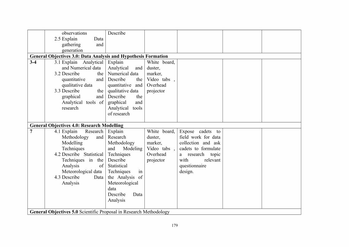
observations2.5 Explain Data
gathering andgeneration
Describe
General Objectives 3.0: Data Analysis and Hypothesis Formation3-4 3.1 Explain Analytical
and Numerical data3.2 Describe the
quantitative andqualitative data
3.3 Describe thegraphical andAnalytical tools ofresearch
ExplainAnalytical andNumerical dataDescribe thequantitative andqualitative dataDescribe thegraphical andAnalytical toolsof research
White board,duster,marker,Video tabs ,Overheadprojector
General Objectives 4.0: Research Modelling7 4.1 Explain Research
Methodology andModellingTechniques
4.2 Describe StatisticalTechniques in theAnalysis ofMeteorological data
4.3 Describe DataAnalysis
ExplainResearchMethodologyand ModelingTechniquesDescribeStatisticalTechniques inthe Analysis ofMeteorologicaldataDescribe DataAnalysis
White board,duster,marker,Video tabs ,Overheadprojector
Expose cadets tofield work for datacollection and askcadets to formulatea research topicwith relevantquestionnairedesign.
General Objectives 5.0 Scientific Proposal in Research Methodology
179

8-9 5.1 Explain thebackground to theresearch problem
5.2 Explain the datacollectionprocedures
5.3 Describe thequestionnaire designprocedures
5.4 Describe literaturereview
5.5 Explain theoreticalformulation of theResearch problem
Lecture White board,duster,marker,Video tabs ,Overheadprojector
General Objectives 6.0: Result Presentation and Report Writing10-12 6.1 Explain oral
presentation ofResults
6.2 ExplainResearch/ReportWriting
6.3 Explain publicationin scientific Journals
Lecture White board,duster,marker,Video tabs ,Overheadprojector
Cadets should writea mini researchproposal
Coursework/ Laboratory Reports Final TotalTheoretical 20 20 40Practical 20 40 60%Total 100%
180
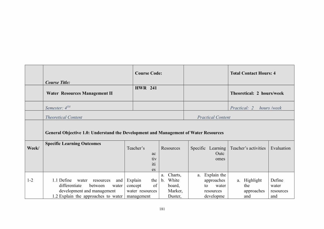
Course Title:
Course Code: Total Contact Hours: 4
Water Resources Management IIHWR 241
Theoretical: 2 hours/week
Semester: 4TH Practical: 2 hours /week
Theoretical Content Practical Content
General Objective 1.0: Understand the Development and Management of Water Resources
Week/Specific Learning Outcomes
Teacher’sactivities
Resources Specific LearningOutcomes
Teacher’s activities Evaluation
1-2 1.1 Define water resources anddifferentiate between waterdevelopment and management
1.2 Explain the approaches to water
Explain theconcept ofwater resourcesmanagement
a. Charts,b. White
board,Marker,Duster,
a. Explain theapproachesto waterresourcesdevelopme
a. Highlighttheapproachesand
Definewaterresourcesand
181

resources development andmanagement
1.3 Describe the advantages anddisadvantages of each of theapproaches
1.4 Highlight the problems of waterresources development andmanagement in Nigeria
anddevelopment ,the approachesto waterresourcesdevelopmentand thechallenges ofwaterdevelopmentandmanagement.
Laptopc. Video
tabs ,Overheadprojector
nt andmanagement
b. Identify theadvantagesof each oftheapproaches
c. Explain theproblemsof waterresourcesdevelopment andmanagement.
problems ofwaterresourcesdevelopment andmanagement on thewhiteboard/projector for thestudentsunderstanding.
differentiate betweenwaterdevelopment andmanagementExplain theapproachesto waterresourcesdevelopment andmanagement
General objective 2.0: Understand the Concept of Drainage Basin
3-5 2.1 Define drainage basin anddiscuss the features of drainagebasin
2.2 Explain major conceptsassociated with drainage basin
2.3 Discuss the patterns of drainagebasin
2.4 Compute morphometricparameters/indices of drainage
Define theconcept ofdrainage basinand associatedfeatures.Compute themorphometricparameters ofdrainage basinand explain the
Charts,White board,Marker,Duster,Laptop, chator table,Video tabs ,Overheadprojector
a. Illustratethe conceptof drainagebasin.
b. Calculatethemorphometricparametersof drainage
Take students forexcursions – visitsthe nearest riverbasin developmentauthority to acquaintthe students with theconcept of drainagebasin Give workedexamples of the themorphometric
Definedrainagebasin anddiscussthefeaturesofdrainagebasin
182
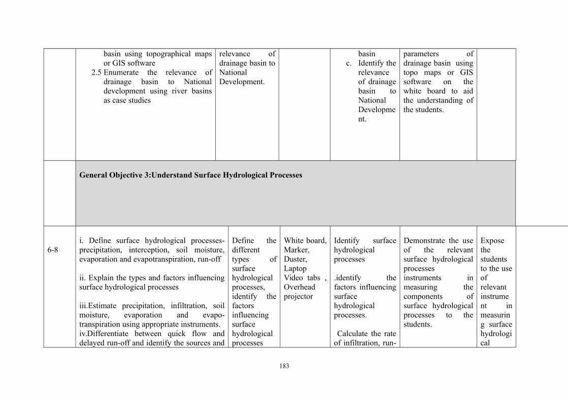
basin using topographical mapsor GIS software
2.5 Enumerate the relevance ofdrainage basin to Nationaldevelopment using river basinsas case studies
relevance ofdrainage basin toNationalDevelopment.
basinc. Identify the
relevanceof drainagebasin toNationalDevelopment.
parameters ofdrainage basin usingtopo maps or GISsoftware on thewhite board to aidthe understanding ofthe students.
General Objective 3:Understand Surface Hydrological Processes
6-8i. Define surface hydrological processes-precipitation, interception, soil moisture,evaporation and evapotranspiration, run-off
ii. Explain the types and factors influencingsurface hydrological processes
iii.Estimate precipitation, infiltration, soilmoisture, evaporation and evapo-transpiration using appropriate instruments. iv.Differentiate between quick flow anddelayed run-off and identify the sources and
Define thedifferenttypes ofsurfacehydrologicalprocesses,identify thefactorsinfluencingsurfacehydrologicalprocesses
White board,Marker,Duster,LaptopVideo tabs ,Overheadprojector
Identify surfacehydrologicalprocesses
.identify thefactors influencingsurfacehydrologicalprocesses.
Calculate the rateof infiltration, run-
Demonstrate the useof the relevantsurface hydrologicalprocessesinstruments inmeasuring thecomponents ofsurface hydrologicalprocesses to thestudents.
Exposethestudentsto the useofrelevantinstrument inmeasuring surfacehydrological
183
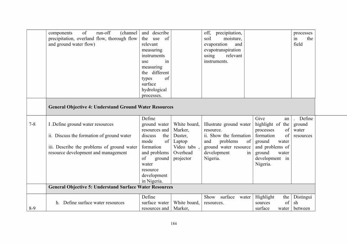
components of run-off (channelprecipitation, overland flow, thorough flowand ground water flow)
and describethe use ofrelevantmeasuringinstrumentsuse inmeasuringthe differenttypes ofsurfacehydrologicalprocesses.
off, precipitation,soil moisture,evaporation andevapotranspirationusing relevantinstruments.
processesin thefield
General Objective 4: Understand Ground Water Resources
7-8 I .Define ground water resources
ii. Discuss the formation of ground water
iii. Describe the problems of ground waterresource development and management
Defineground waterresources anddiscuss themode offormationand problemsof groundwaterresourcedevelopmentin Nigeria.
White board,Marker,Duster,LaptopVideo tabs ,Overheadprojector
Illustrate ground waterresource.ii. Show the formationand problems ofground water resourcedevelopment inNigeria.
Give anhighlight of theprocesses offormation ofground waterand problems ofground waterdevelopment inNigeria.
. Definegroundwaterresources
General Objective 5: Understand Surface Water Resources
8-9h. Define surface water resources
Definesurface waterresources and
White board,Marker,
Show surface waterresources.
Highlight thesources ofsurface water
Distinguishbetween
184
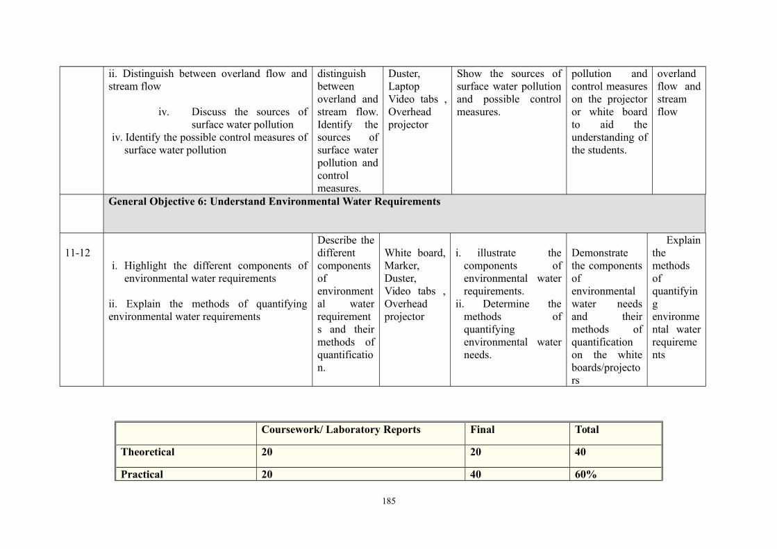
ii. Distinguish between overland flow andstream flow
iv. Discuss the sources ofsurface water pollution
iv. Identify the possible control measures ofsurface water pollution
distinguishbetweenoverland andstream flow.Identify thesources ofsurface waterpollution andcontrolmeasures.
Duster,LaptopVideo tabs ,Overheadprojector
Show the sources ofsurface water pollutionand possible controlmeasures.
pollution andcontrol measureson the projectoror white boardto aid theunderstanding ofthe students.
overlandflow andstreamflow
General Objective 6: Understand Environmental Water Requirements
11-12i. Highlight the different components of
environmental water requirements
ii. Explain the methods of quantifyingenvironmental water requirements
Describe thedifferentcomponentsofenvironmental waterrequirements and theirmethods ofquantification.
White board,Marker,Duster,Video tabs ,Overheadprojector
i. illustrate thecomponents ofenvironmental waterrequirements.
ii. Determine themethods ofquantifyingenvironmental waterneeds.
Demonstratethe componentsofenvironmentalwater needsand theirmethods ofquantificationon the whiteboards/projectors
Explainthemethodsofquantifyingenvironmental waterrequirements
Coursework/ Laboratory Reports Final Total
Theoretical 20 20 40
Practical 20 40 60%
185
Total 100%
Programme: NATIONALDIPLOMA IN HYDROLOGY ANDWATER RESOURCESMANAGEMENT
Course Code: HWR 242 Credit Hours: 3
Course: Hydrological Analysis andForecasting
Pre-Requisite Theoretical: Hours/Week
Semester: Practical:
Course Main Aim/Goal: this course is design to provide students with the understanding of the use of GIS and river basins
186
GENERAL OBJECTIVES
1. Understand uses of models
2. Understand the use of statistics in forecasting
3. Understand simulation of river basins
4. Understand the use of statistics in forecasting
5. Understand the use of GIS in hydrological modeling
6. understand engaged basins
Programme: NATIONAL DIPLOMA IN HYDROLOGY AND WATER RESOURCES MANAGEMENTCourse: Hydrological Analysis and Forecasting Course Code:
HWR 242CH/CU Hour:
187
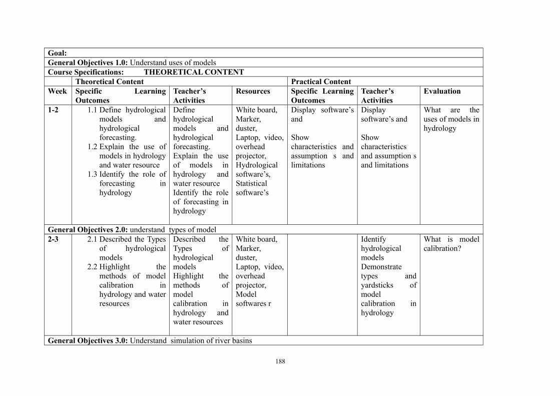
Goal:General Objectives 1.0: Understand uses of modelsCourse Specifications: THEORETICAL CONTENT
Theoretical Content Practical ContentWeek Specific Learning
OutcomesTeacher’sActivities
Resources Specific LearningOutcomes
Teacher’sActivities
Evaluation
1-2 1.1 Define hydrologicalmodels andhydrologicalforecasting.
1.2 Explain the use ofmodels in hydrologyand water resource
1.3 Identify the role offorecasting inhydrology
Definehydrologicalmodels andhydrologicalforecasting. Explain the useof models inhydrology andwater resourceIdentify the roleof forecasting inhydrology
White board,Marker,duster,Laptop, video,overheadprojector, Hydrologicalsoftware’s,Statisticalsoftware’s
Display software’sand
Showcharacteristics andassumption s andlimitations
Displaysoftware’s and
Showcharacteristicsand assumption sand limitations
What are theuses of models inhydrology
General Objectives 2.0: understand types of model2-3 2.1 Described the Types
of hydrologicalmodels
2.2 Highlight themethods of modelcalibration inhydrology and waterresources
Described theTypes ofhydrologicalmodelsHighlight themethods ofmodelcalibration inhydrology andwater resources
White board,Marker,duster,Laptop, video,overheadprojector,Modelsoftwares r
IdentifyhydrologicalmodelsDemonstratetypes andyardsticks ofmodelcalibration inhydrology
What is modelcalibration?
General Objectives 3.0: Understand simulation of river basins
188
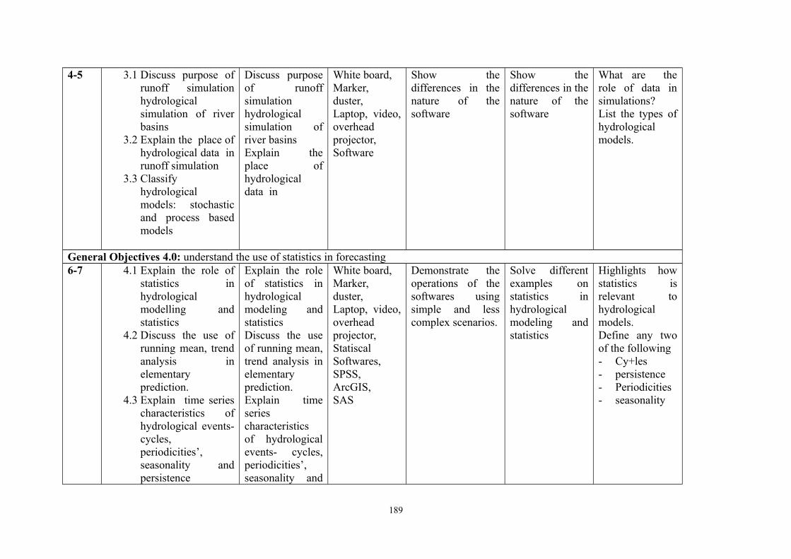
4-5 3.1 Discuss purpose ofrunoff simulationhydrologicalsimulation of riverbasins
3.2 Explain the place ofhydrological data inrunoff simulation
3.3 Classifyhydrologicalmodels: stochasticand process basedmodels
Discuss purposeof runoffsimulationhydrologicalsimulation ofriver basinsExplain theplace ofhydrologicaldata in
White board,Marker,duster,Laptop, video,overheadprojector,Software
Show thedifferences in thenature of thesoftware
Show thedifferences in thenature of thesoftware
What are therole of data insimulations?List the types ofhydrologicalmodels.
General Objectives 4.0: understand the use of statistics in forecasting6-7 4.1 Explain the role of
statistics inhydrologicalmodelling andstatistics
4.2 Discuss the use ofrunning mean, trendanalysis inelementaryprediction.
4.3 Explain time seriescharacteristics ofhydrological events-cycles,periodicities’,seasonality andpersistence
Explain the roleof statistics inhydrologicalmodeling andstatisticsDiscuss the useof running mean,trend analysis inelementaryprediction.Explain timeseriescharacteristicsof hydrologicalevents- cycles,periodicities’,seasonality and
White board,Marker,duster,Laptop, video,overheadprojector,StatiscalSoftwares, SPSS, ArcGIS, SAS
Demonstrate theoperations of thesoftwares usingsimple and lesscomplex scenarios.
Solve differentexamples onstatistics inhydrologicalmodeling andstatistics
Highlights howstatistics isrelevant tohydrologicalmodels.Define any twoof the following- Cy+les- persistence- Periodicities- seasonality
189
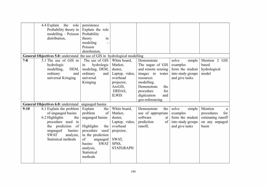
4.4 Explain the roleProbability theory inmodelling – Poissondistribution,
persistenceExplain the roleProbabilitytheory inmodeling –Poissondistribution,
General Objectives 5.0: understand the use of GIS in hydrological modelling7-8 5.1 The use of GIS in
hydrologicmodelling, DEM,ordinary anduniversal Kringing
The use of GISin hydrologicmodeling, DEM,ordinary anduniversalKringing
White board,Marker,duster,Laptop, video,overheadprojector,ArcGIS, ERDAS, ILWIS
DemonstrateThe uagae of GISand remote sensingimages in waterresources modelling.Demonstrate theprocedure fordigitization andgeo-referencing
solve simpleexamplesform the studentinto study groupsand give tasks.
Mention 2 GISbasedhydrologicalmodel
General Objectives 6.0: understand ungauged basins9-10 6.1 Explain the problem
of ungauged basins6.2 Highlights the
procedure used inthe prediction ofungauged basins-SWAT analysis,Statistical methods
Explain theproblem ofungauged basins
Highlights theprocedure usedin the predictionof ungaugedbasins- SWATanalysis,Statisticalmethods
White board,Marker,duster,Laptop, video,overheadprojector,
SWAT,SPSS,STATGRAPH
Demonstrate theuse of appropriatesoftware atprediction ofrunoff,
solve simpleexamplesform the studentinto study groupsand give tasks
Mention aprocedures forestimating runoffon any unpagedbasin
190

General Objectives 7.0: understand rainfall forecasting7.1 Demonstrate using
Statiscal packages atprediction low flowand peak flow usingsimple examples
Demonstrateusing Statiscalpackages atprediction lowflow and peakflow usingsimple examples
White board,Marker,duster,Laptop, video,overheadprojector,SPSSSASSTATGRAPH
Demonstrate usingStatiscal packagesat prediction lowflow and peak flowusing simpleexamples
Solve simpleexamples by forming thestudent intostudy groups andgive tasks
Using anymethod of yourchoice forecast 5year rainfall
191
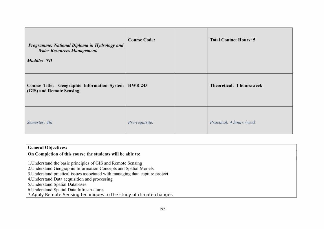
Programme: National Diploma in Hydrology andWater Resources Management.
Module: ND
Course Code: Total Contact Hours: 5
Course Title: Geographic Information System(GIS) and Remote Sensing
HWR 243 Theoretical: 1 hours/week
Semester: 4th Pre-requisite: Practical: 4 hours /week
General Objectives:
On Completion of this course the students will be able to:
1.Understand the basic principles of GIS and Remote Sensing2.Understand Geographic Information Concepts and Spatial Models3.Understand practical issues associated with managing data capture project4.Understand Data acquisition and processing5.Understand Spatial Databases6.Understand Spatial Data Infrastructures7.Apply Remote Sensing techniques to the study of climate changes
192
Course Title: Course Code: Total Contact Hours: 5
Geographic Information System (GIS)and Remote Sensing
Theoretical: 1 hours/week
Semester: 1st Practical: 4 hours /week
Theoretical Content Practical ContentGeneral Objective 1.0: Introduction to GIS
Week/Specific Learning Outcomes
Teacher’sactivities
Resources Specific LearningOutcomes
Teacher’s activities Evaluation
1
1.1 Define GIS and its functionality:concepts, components, scope andapplication;
1.2 Explain relationship of GIS to otherfield i.e. Atmospheric sciences,
Define GISand itsfunctionality:concepts,components,scope and
Video tabs, OverheadprojectorWhiteBoard,Marker,
Use GIS and itsfunctionality:concepts,components, scopeand application;
Define GIS and itsfunctionality:concepts,components, scopeand application;
Define GISand itsfunctionality: concepts,components, scope and
193
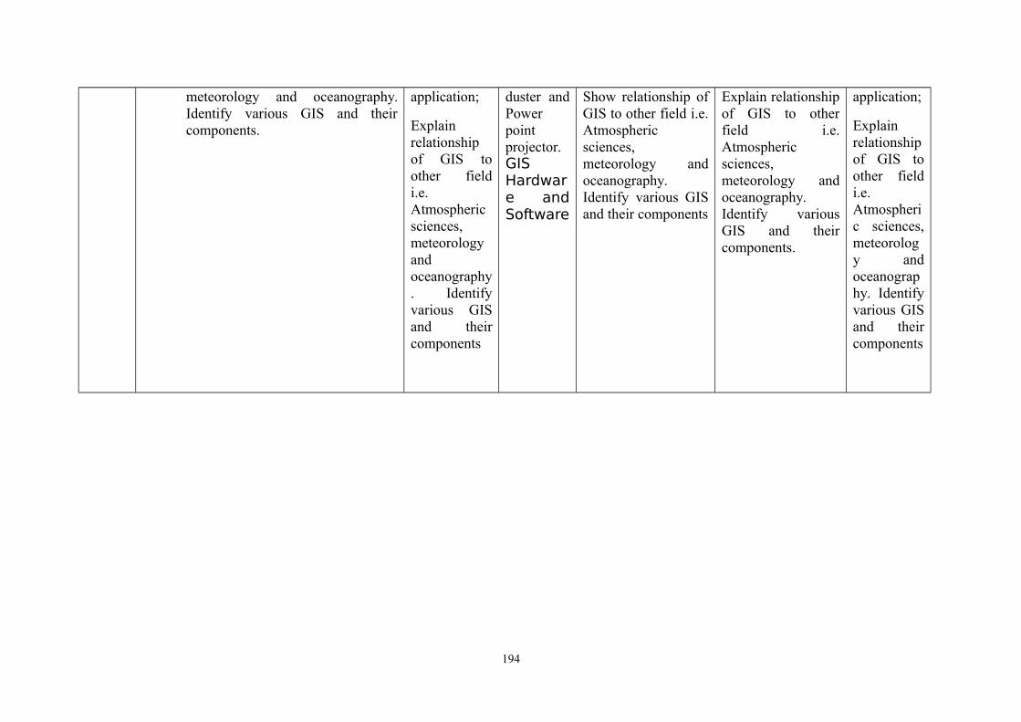
meteorology and oceanography.Identify various GIS and theircomponents.
application;
Explainrelationshipof GIS toother fieldi.e.Atmosphericsciences,meteorologyandoceanography. Identifyvarious GISand theircomponents
duster andPowerpointprojector.GISHardware andSoftware
Show relationship ofGIS to other field i.e.Atmosphericsciences,meteorology andoceanography.Identify various GISand their components
Explain relationshipof GIS to otherfield i.e.Atmosphericsciences,meteorology andoceanography.Identify variousGIS and theircomponents.
application;
Explainrelationshipof GIS toother fieldi.e.Atmospheric sciences,meteorology andoceanography. Identifyvarious GISand theircomponents
194
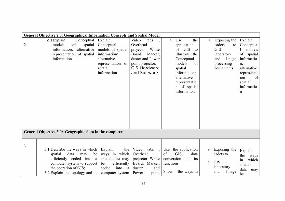
General Objective 2.0: Geographical Information Concepts and Spatial Model
22.1Explain Conceptual
models of spatialinformation; alternativerepresentation of spatialinformation.
ExplainConceptualmodels of spatialinformation;alternativerepresentation ofspatialinformation
Video tabs ,Overheadprojector WhiteBoard, Marker,duster and Powerpoint projector.GIS Hardwareand Software
a. Use theapplicationof GIS toillustrate theConceptualmodels ofspatialinformation;alternativerepresentation of spatialinformation.
a. Exposing thecadets toGISlaboratoryand Imageprocessingequipments
ExplainConceptual modelsof spatialinformation;alternativerepresentation ofspatialinformation
General Objective 3.0: Geographic data in the computer
33.1 Describe the ways in which
spatial data may beefficiently coded into acomputer system to supportthe operation of GIS;
3.2 Explain the topology and its
Explain theways in whichspatial data maybe efficientlycoded into acomputer system
Video tabs ,Overheadprojector WhiteBoard, Marker,duster andPower point
Use the applicationof GIS, dataconversion and itsfunctions
Show the ways in
a. Exposing thecadets to
b. GISlaboratoryand Image
Explainthe waysin whichspatialdata maybe
195
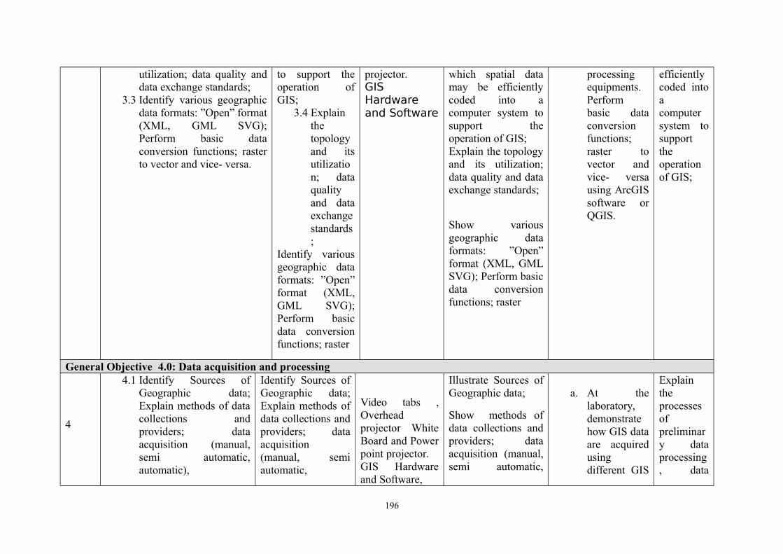
utilization; data quality anddata exchange standards;
3.3 Identify various geographicdata formats: ”Open” format(XML, GML SVG);Perform basic dataconversion functions; rasterto vector and vice- versa.
to support theoperation ofGIS;
3.4 Explainthetopologyand itsutilization; dataqualityand dataexchangestandards;
Identify variousgeographic dataformats: ”Open”format (XML,GML SVG);Perform basicdata conversionfunctions; raster
projector.GISHardwareand Software
which spatial datamay be efficientlycoded into acomputer system tosupport theoperation of GIS; Explain the topologyand its utilization;data quality and dataexchange standards;
Show variousgeographic dataformats: ”Open”format (XML, GMLSVG); Perform basicdata conversionfunctions; raster
processingequipments.Performbasic dataconversionfunctions;raster tovector andvice- versausing ArcGISsoftware orQGIS.
efficientlycoded intoacomputersystem tosupporttheoperationof GIS;
General Objective 4.0: Data acquisition and processing
4
4.1 Identify Sources ofGeographic data;Explain methods of datacollections andproviders; dataacquisition (manual,semi automatic,automatic),
Identify Sources ofGeographic data;Explain methods ofdata collections andproviders; dataacquisition(manual, semiautomatic,
Video tabs ,Overheadprojector WhiteBoard and Powerpoint projector.GIS Hardwareand Software,
Illustrate Sources ofGeographic data;
Show methods ofdata collections andproviders; dataacquisition (manual,semi automatic,
a. At thelaboratory,demonstratehow GIS dataare acquiredusingdifferent GIS
Explaintheprocessesofpreliminary dataprocessing, data
196
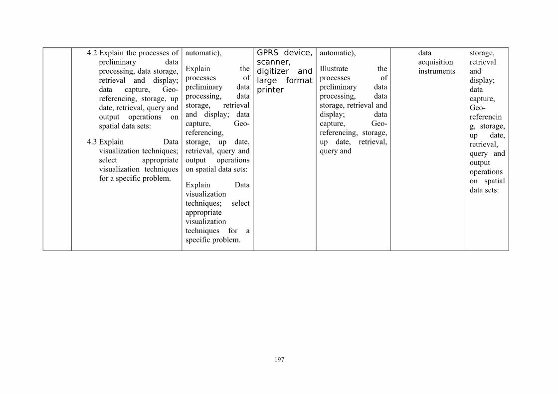
4.2 Explain the processes ofpreliminary dataprocessing, data storage,retrieval and display;data capture, Geo-referencing, storage, update, retrieval, query andoutput operations onspatial data sets:
4.3 Explain Datavisualization techniques;select appropriatevisualization techniquesfor a specific problem.
automatic),
Explain theprocesses ofpreliminary dataprocessing, datastorage, retrievaland display; datacapture, Geo-referencing,storage, up date,retrieval, query andoutput operationson spatial data sets:
Explain Datavisualizationtechniques; selectappropriatevisualizationtechniques for aspecific problem.
GPRS device,scanner,digitizer andlarge formatprinter
automatic),
Illustrate theprocesses ofpreliminary dataprocessing, datastorage, retrieval anddisplay; datacapture, Geo-referencing, storage,up date, retrieval,query and
dataacquisitioninstruments
storage,retrievalanddisplay;datacapture,Geo-referencing, storage,up date,retrieval,query andoutputoperationson spatialdata sets:
197

General Objectives 5.0: Spatial databases5.1 Explain Relational database; 5.2 Identify structural
differences between spatialand non- spatial databases;conceptual, logical andphysical modeling of spatialdatabases;
5.3Design and build a spatialdatabase; describe and usespatial query languages:concept and designprinciples of metadata,database structuring;formulate database queriesusing GIS.
ExplainRelationaldatabase; Identifystructuraldifferencesbetweenspatial andnon- spatialdatabases;conceptual,logical andphysicalmodeling ofspatialdatabases; design andbuild a spatial
database;describe anduse spatialquerylanguages:concept anddesignprinciples ofmetadata,databasestructuring;
Video tabs ,Overheadprojector WhiteBoard, Marker,duster and Powerpoint projector.GIS Hardwareand Software
a. Apply GIS,dataprocessingand storagein a structureas well asdesigning aGIS database.
a. At thelaboratory,demonstratehow GIS dataare acquiredusingdifferent GISdataacquisitioninstruments,data storageprocesses anddata basecreation
ExplainRelationaldatabase; Identifystructuraldifferencesbetweenspatial andnon-spatialdatabases;conceptual
198

formulatedatabasequeries usingGIS.
General Objective 6.0: Spatial data infrastructure
15
6.1 Explain spatial datainfrastructure;
6.2 List means of facilitatingand coordinating exchangeand sharing spatial data.
Explain spatialdatainfrastructure;List means offacilitating andcoordinatingexchange andsharing spatialdata.
Video tabs ,Overheadprojector WhiteBoard, Marker,duster andPower pointprojector.GIS Hardwareand Software
a. Show GISdata structureand means ofsharing suchdata.
a. demonstratehow GIS dataare acquiredusingdifferent GISdataacquisitioninstruments,data storageprocesses anddata basecreation
General Objective 6: Remote Sensing.
199
15
6.1 Explain the Concept ofGeometrical principles ofimagery (air photos,satellite image);
6.2 Explain the basictopographic features –coastline; continental shelfetc;
6.3 List Remote sensingtechniques applicable toBathymetry and Coastalmapping
Explain theConcept ofGeometricalprinciples ofimagery (airphotos, satelliteimage);
Explain thebasictopographic features –coastline;continentalshelf etc;
List Remotesensing techniquesapplicable toBathymetry andCoastal mapping
Video tabs ,Overheadprojector WhiteBoard, Marker,duster andPower pointprojector.GISHardwareandSoftware,aerialphotographs
a. Use RemoteSensing datastructure andmeans ofsharing suchdata.
a. At thelaboratory,displaydifferentremotesensingimages andairphotographs,explain theirapplication inremotesensing.
ExplaintheConcept ofGeometricalprinciplesof imagery(airphotos,satelliteimage);
General Objective 7.0: Remote sensing application
13
7.1 Describe how laser andradar Altimetry are usedfor water surfacemapping. Describe theuse of remote sensing forOil Spill mapping;Process remotely senseddata to determineBathymetry and Map
Describe howlaser and radarAltimetry areused for watersurface mapping.Describe the useof remote sensingfor
Video tabs ,Overheadprojector WhiteBoard, Marker,duster and Powerpoint projector.GIS Hardwareand Software,aerial
a. Identify GISdata structureand means ofsharing suchdata.
a. Displaydifferentremotesensingimages andairphotographs,explain theirapplication inremote
Describehow laserand radarAltimetryare usedfor watersurfacemapping
200
Water surface features. photographs sensing.
General Objective 8.0: Climate change mitigation
13
8.1Explain the Internationalpolitical response;flexibility mechanism ofthe Kyoto protocol, otherinternational legislationand response.
Explain theInternationalpoliticalresponse;flexibilitymechanism ofthe Kyotoprotocol, otherinternationallegislation andresponse
Video tabs ,Overheadprojector WhiteBoard, Powerpoint slide show,projector.aerialphotographs
Explain theInternationalpolitical response;flexibilitymechanism of theKyoto protocol,other internationallegislation andresponse
Coursework/ Laboratory Reports Final Total
Theoretical 20 20 40
Practical 20 40 60%
Total 100%
201
Department/ Programme: ND WaterResources Engineering Technology
Course Code: HWR 244 Contact Hours: 2 – 0 - 3
Subject/Course: Introduction To WaterSupply & Waste Water Technology
Theoretical: 2 hours/week
Year: 1I Semester:2nd
Pre-requisite: Practical: 3 hours /week
GENERAL OBJECTIVES:
On completion the student is expected to be able to:
1.0 Know how to estimate water demand2.0 Know sources of water3.0 Know the principles of intake design4.0 Know the different types of pump and their selection5.0 Understand the basic water treatment processes6.0 Understand methods of storage and distribution of treated water7.0 Know the general principles involved in rural water supply
8.0 Know the sources and characteristics of waste water.
9.0 Understand basic methods and processes of sewage treatment.
202

10.0 Know major sewer appurtenances
11.0 Understand the effects of pollution and the methods of control.
PROGRAMME: NATIONAL DIPLOMA IN HYDROLOGY AND WATER RESOURCES MANAGEMENT
203
Course: Introduction to Water Supplyand Wastewater Technology
Course Code: HWR 244 Contact Hours: 2 – 0 - 3
Course Specification: Theoretical Content: 2 hours Practical Content: 3 hours
Course Objectives: This course is designed to expose the students to the basic principles of water supply and wastewater technology
Week General Objective 1.0: Know methods of estimating water demand
Specific LearningOutcome:
Teacher Activities Resources Specific Learning Outcome: Teacher Activities Resources
204
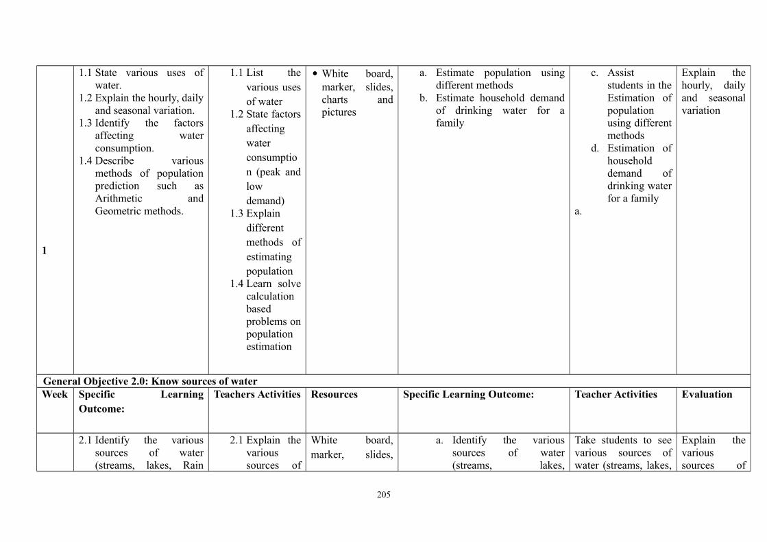
1
1.1 State various uses ofwater.
1.2 Explain the hourly, dailyand seasonal variation.
1.3 Identify the factorsaffecting waterconsumption.
1.4 Describe variousmethods of populationprediction such asArithmetic andGeometric methods.
1.1 List thevarious usesof water
1.2 State factorsaffectingwaterconsumption (peak andlowdemand)
1.3 Explaindifferentmethods ofestimatingpopulation
1.4 Learn solvecalculationbasedproblems onpopulationestimation
White board,marker, slides,charts andpictures
a. Estimate population usingdifferent methods
b. Estimate household demandof drinking water for afamily
c. Assiststudents in theEstimation ofpopulationusing differentmethods
d. Estimation ofhouseholddemand ofdrinking waterfor a family
a.
Explain thehourly, dailyand seasonalvariation
General Objective 2.0: Know sources of waterWeek Specific Learning
Outcome:Teachers Activities Resources Specific Learning Outcome: Teacher Activities Evaluation
2.1 Identify the varioussources of water(streams, lakes, Rain
2.1 Explain thevarioussources of
White board,marker, slides,
a. Identify the varioussources of water(streams, lakes,
Take students to seevarious sources ofwater (streams, lakes,
Explain thevarioussources of
205
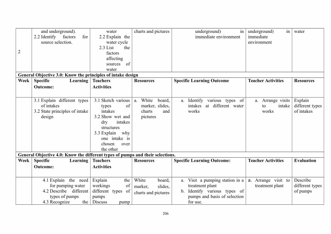
2
and underground).2.2 Identify factors for
source selection.
water2.2 Explain the
water cycle2.3 List the
factorsaffectingsources ofwater
charts and pictures underground) inimmediate environment
underground) inimmediateenvironment
water
General Objective 3.0: Know the principles of intake designWeek Specific Learning
Outcome:TeachersActivities
Resources Specific Learning Outcome Teacher Activities Resources
3.1 Explain different typesof intakes
3.2 State principles of intakedesign
3.1 Sketch varioustypes ofintakes
3.2 Show wet anddry intakesstructures
3.3 Explain whyone intake ischosen overthe other
a. White board,marker, slides,charts andpictures
a. Identify various types ofintakes at different waterworks
a. Arrange visitsto intakeworks
Explaindifferent typesof intakes
General Objective 4.0: Know the different types of pumps and their selections.Week Specific Learning
Outcome:TeachersActivities
Resources Specific Learning Outcome: Teacher Activities Evaluation
4.1 Explain the needfor pumping water
4.2 Describe differenttypes of pumps
4.3 Recognize the
Explain theworkings ofdifferent types ofpumpsDiscuss pump
White board,marker, slides,charts and pictures
a. Visit a pumping station in atreatment plant
b. Identify various types ofpumps and basis of selectionfor use.
a. Arrange visit totreatment plant
Describedifferent typesof pumps
206
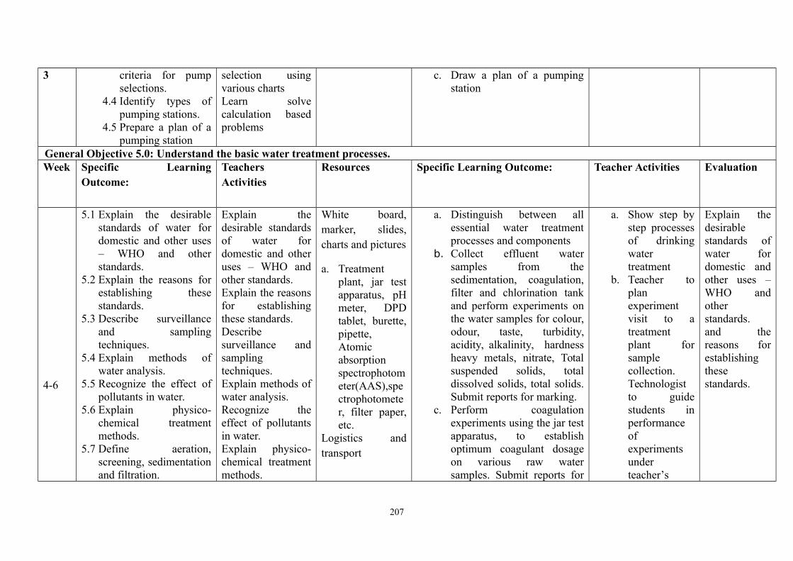
3 criteria for pumpselections.
4.4 Identify types ofpumping stations.
4.5 Prepare a plan of apumping station
selection usingvarious chartsLearn solvecalculation basedproblems
c. Draw a plan of a pumpingstation
General Objective 5.0: Understand the basic water treatment processes.Week Specific Learning
Outcome:TeachersActivities
Resources Specific Learning Outcome: Teacher Activities Evaluation
4-6
5.1 Explain the desirablestandards of water fordomestic and other uses– WHO and otherstandards.
5.2 Explain the reasons forestablishing thesestandards.
5.3 Describe surveillanceand samplingtechniques.
5.4 Explain methods ofwater analysis.
5.5 Recognize the effect ofpollutants in water.
5.6 Explain physico-chemical treatmentmethods.
5.7 Define aeration,screening, sedimentationand filtration.
Explain thedesirable standardsof water fordomestic and otheruses – WHO andother standards.Explain the reasonsfor establishingthese standards.Describesurveillance andsamplingtechniques.Explain methods ofwater analysis.Recognize theeffect of pollutantsin water.Explain physico-chemical treatmentmethods.
White board,marker, slides,charts and pictures
a. Treatmentplant, jar testapparatus, pHmeter, DPDtablet, burette,pipette,Atomicabsorptionspectrophotometer(AAS),spectrophotometer, filter paper,etc.
Logistics andtransport
a. Distinguish between allessential water treatmentprocesses and components
b. Collect effluent watersamples from thesedimentation, coagulation,filter and chlorination tankand perform experiments onthe water samples for colour,odour, taste, turbidity,acidity, alkalinity, hardnessheavy metals, nitrate, Totalsuspended solids, totaldissolved solids, total solids.Submit reports for marking.
c. Perform coagulationexperiments using the jar testapparatus, to establishoptimum coagulant dosageon various raw watersamples. Submit reports for
a. Show step bystep processesof drinkingwatertreatment
b. Teacher toplanexperimentvisit to atreatmentplant forsamplecollection.Technologistto guidestudents inperformanceofexperimentsunderteacher’s
Explain thedesirablestandards ofwater fordomestic andother uses –WHO andotherstandards.and thereasons forestablishingthesestandards.
207
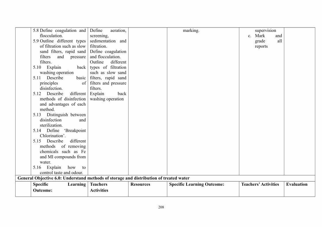
5.8 Define coagulation andflocculation.
5.9 Outline different typesof filtration such as slowsand filters, rapid sandfilters and pressurefilters.
5.10 Explain backwashing operation
5.11 Describe basicprinciples ofdisinfection.
5.12 Describe differentmethods of disinfectionand advantages of eachmethod.
5.13 Distinguish betweendisinfection andsterilization.
5.14 Define ‘BreakpointChlorination’.
5.15 Describe differentmethods of removingchemicals such as Feand MI compounds fromwater.
5.16 Explain how tocontrol taste and odour.
Define aeration,screening,sedimentation andfiltration.Define coagulationand flocculation.Outline differenttypes of filtrationsuch as slow sandfilters, rapid sandfilters and pressurefilters.Explain backwashing operation
marking. supervisionc. Mark and
grade allreports
General Objective 6.0: Understand methods of storage and distribution of treated waterSpecific LearningOutcome:
TeachersActivities
Resources Specific Learning Outcome: Teachers’ Activities Evaluation
208

7-8
6.1 Describe the generallayout of public watersupply schemes.
6.2 Explain the purpose ofservices/storagereservoirs.
6.3 Name the types of waterdistribution system.
6.4 Explain the need forwater metering.
6.5 Recognize problemsassociated with the typesof distribution systems.
6.6 Identify the types ofpipe materials for watersupply projects.
6.7 Describe different typesof pipe beddings forlaying of pipe.
6.8 Describe basic pipenetworks.
6.9 Identify the types ofjoints, valves used andtheir functions.
6.10 Explain thefunctions of firehydrants, washoutchambers, thrust block,etc.
6.11 Calculate simple
Explain the generalprinciples of pipelayout in a publicwater schemesExplain differenttypes ofdistribution andthere problems,advantages anddisadvantagesExplain thefunctions ofdifferentappurtenances in apipe networkUse differentmethods tocalculate headlosses in pipes
White board,marker,slides, chartsand picturesPipesnetwork,pipesconnections,bends, etc.,plumbers’toolbox
White board,marker, slides,charts andpictures
Draw water storage anddistribution systems.
Carry out the construction ofwater distribution line.
Calculate simple head lossesin pipe or in a pumping line.
Illustrate theconnections toand from storagereservoirs
Explain thegeneralprinciples ofpipe layout ina public waterschemes
209
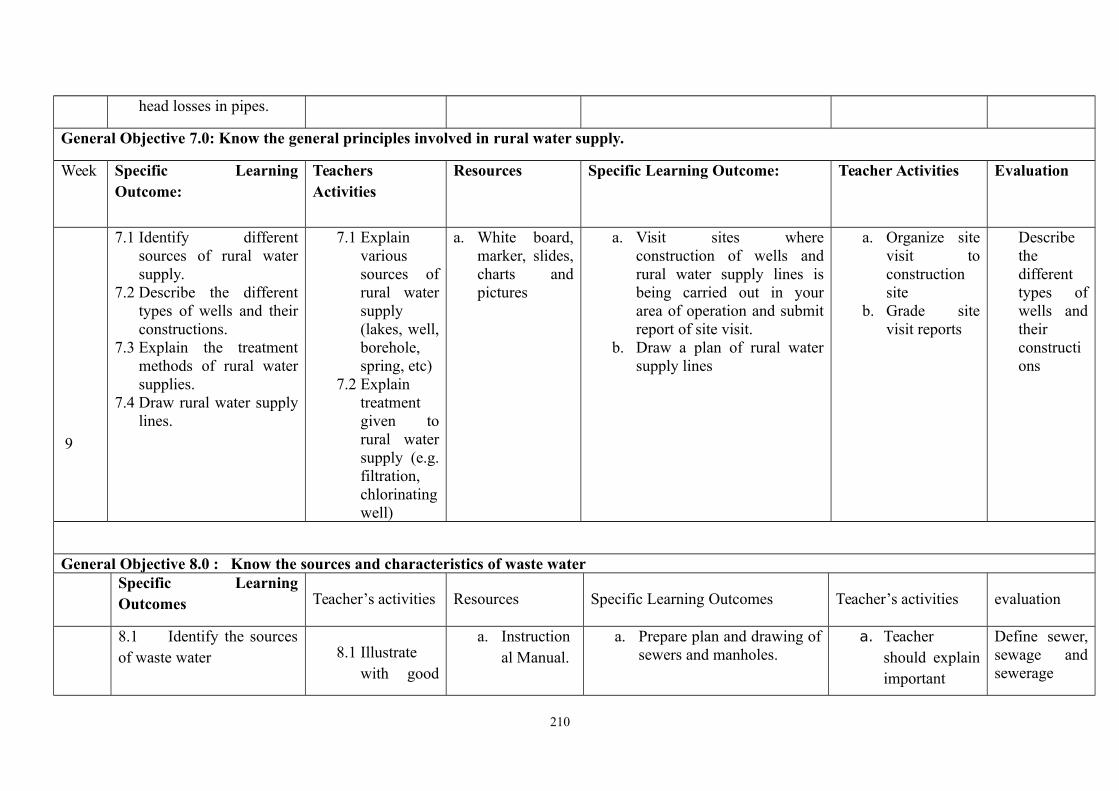
head losses in pipes.
General Objective 7.0: Know the general principles involved in rural water supply.
Week Specific LearningOutcome:
TeachersActivities
Resources Specific Learning Outcome: Teacher Activities Evaluation
9
7.1 Identify differentsources of rural watersupply.
7.2 Describe the differenttypes of wells and theirconstructions.
7.3 Explain the treatmentmethods of rural watersupplies.
7.4 Draw rural water supplylines.
7.1 Explainvarioussources ofrural watersupply(lakes, well,borehole,spring, etc)
7.2 Explaintreatmentgiven torural watersupply (e.g.filtration,chlorinatingwell)
a. White board,marker, slides,charts andpictures
a. Visit sites whereconstruction of wells andrural water supply lines isbeing carried out in yourarea of operation and submitreport of site visit.
b. Draw a plan of rural watersupply lines
a. Organize sitevisit toconstructionsite
b. Grade sitevisit reports
Describethedifferenttypes ofwells andtheirconstructions
General Objective 8.0 : Know the sources and characteristics of waste waterSpecific LearningOutcomes Teacher’s activities Resources Specific Learning Outcomes Teacher’s activities evaluation
8.1 Identify the sourcesof waste water 8.1 Illustrate
with good
a. Instructional Manual.
a. Prepare plan and drawing ofsewers and manholes.
a. Teachershould explainimportant
Define sewer,sewage andsewerage
210
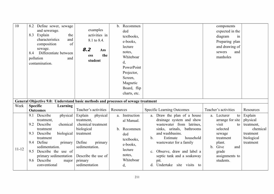
10 8.2 Define sewer, sewageand sewerage.
8.3 Explain thecharacteristics andcomposition ofsewage.
8.4 Differentiate betweenpollution andcontamination.
examplesactivities in8.1 to 8.4.
8.2 Assess thestudent
b. Recommendedtextbooks,e-books,lecturenotes,Whiteboard,PowerPointProjector,Screen,MagneticBoard, flipcharts, etc.
componentsexpected in thediagram inPreparing planand drawing ofsewers andmanholes
General Objective 9.0: Understand basic methods and processes of sewage treatmentWeek Specific Learning
Outcomes Teacher’s activities Resources Specific Learning Outcomes Teacher’s activities Resources
11-12
9.1 Describe physicaltreatment,
9.2 Describe chemicaltreatment
9.3 Describe biologicaltreatment
9.4 Define primarysedimentation.
9.5 Describe the use ofprimary sedimentation
9.6 Describe majorconventional
Explain physicaltreatment, chemical treatmentbiologicaltreatment
Define primarysedimentation.
Describe the use ofprimarysedimentation
a. Instructional Manual.
b. Recommendedtextbooks,e-books,lecturenotes,Whiteboard,
a. Draw the plan of a housedrainage system and showwastewater from latrines,sinks, urinals, bathroomsand washbasins.
b. Estimate householdwastewater for a family
c. Observe, draw and label aseptic tank and a soakawaypit.
d. Undertake site visits to
a. Lecturer toarrange for sitevisit toselectedsewagetreatmentplant.
b. Give andgradeassignments tostudents.
Explainphysicaltreatment, chemicaltreatmentbiologicaltreatment
211
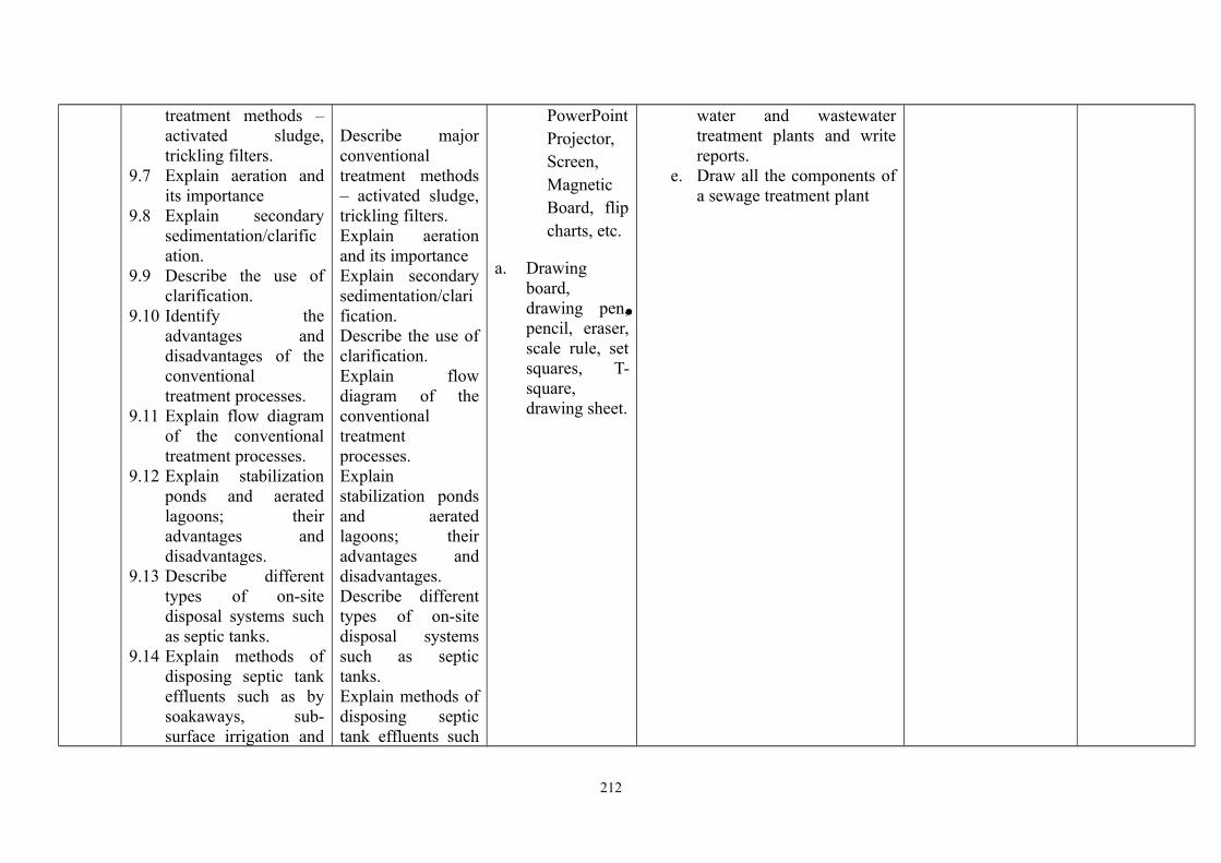
treatment methods –activated sludge,trickling filters.
9.7 Explain aeration andits importance
9.8 Explain secondarysedimentation/clarification.
9.9 Describe the use ofclarification.
9.10 Identify theadvantages anddisadvantages of theconventionaltreatment processes.
9.11 Explain flow diagramof the conventionaltreatment processes.
9.12 Explain stabilizationponds and aeratedlagoons; theiradvantages anddisadvantages.
9.13 Describe differenttypes of on-sitedisposal systems suchas septic tanks.
9.14 Explain methods ofdisposing septic tankeffluents such as bysoakaways, sub-surface irrigation and
Describe majorconventionaltreatment methods– activated sludge,trickling filters.Explain aerationand its importanceExplain secondarysedimentation/clarification.Describe the use ofclarification.Explain flowdiagram of theconventionaltreatmentprocesses.Explainstabilization pondsand aeratedlagoons; theiradvantages anddisadvantages.Describe differenttypes of on-sitedisposal systemssuch as septictanks.Explain methods ofdisposing septictank effluents such
PowerPointProjector,Screen,MagneticBoard, flipcharts, etc.
a. Drawingboard,drawing pen,pencil, eraser,scale rule, setsquares, T-square,drawing sheet.
water and wastewatertreatment plants and writereports.
e. Draw all the components ofa sewage treatment plant
212
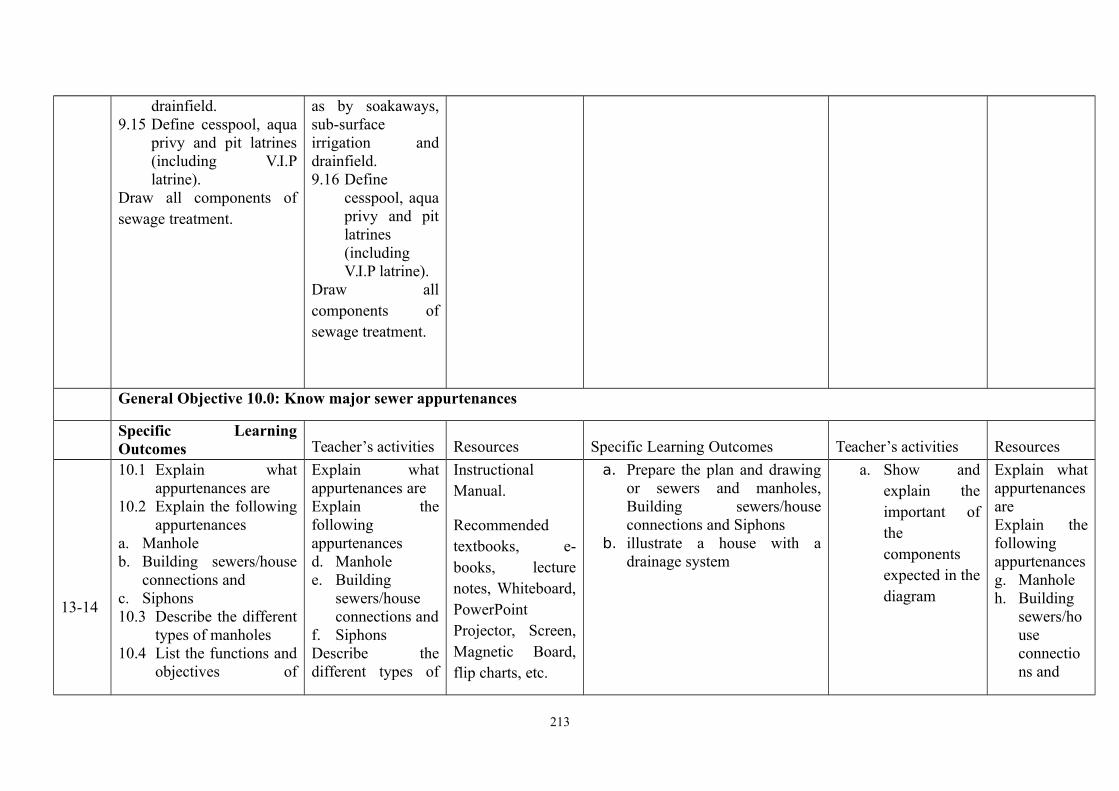
drainfield.9.15 Define cesspool, aqua
privy and pit latrines(including V.I.Platrine).
Draw all components ofsewage treatment.
as by soakaways,sub-surfaceirrigation anddrainfield.9.16 Define
cesspool, aquaprivy and pitlatrines(includingV.I.P latrine).
Draw allcomponents ofsewage treatment.
General Objective 10.0: Know major sewer appurtenances
Specific LearningOutcomes Teacher’s activities Resources Specific Learning Outcomes Teacher’s activities Resources
13-14
10.1 Explain whatappurtenances are
10.2 Explain the followingappurtenances
a. Manholeb. Building sewers/house
connections andc. Siphons10.3 Describe the different
types of manholes10.4 List the functions and
objectives of
Explain whatappurtenances areExplain thefollowingappurtenancesd. Manholee. Building
sewers/houseconnections and
f. SiphonsDescribe thedifferent types of
InstructionalManual.
Recommendedtextbooks, e-books, lecturenotes, Whiteboard,PowerPointProjector, Screen,Magnetic Board,flip charts, etc.
a. Prepare the plan and drawingor sewers and manholes,Building sewers/houseconnections and Siphons
b. illustrate a house with adrainage system
a. Show andexplain theimportant ofthecomponentsexpected in thediagram
Explain whatappurtenancesareExplain thefollowingappurtenancesg. Manholeh. Building
sewers/houseconnections and
213

manholes10.5 Explain the following
in relation tomanholes:
a. Spacingb. frame and
covers andc. channel and
benching10.6 Identify the types of
materials suitable forhouse connections
10.7 Describe the properprocedures for layingand making of houseconnections tosewers.
10.8 Identify the followingas waste watermeasuring devices
i. Weirsii. Parshall flumeiii. venturi flume
10.9 Explain the workingof these devices
10.10Draw the devicesenumerated above.
Enumerate how to calculatedischarges in the abovedevices.
manholesList the functionsand objectives ofmanholesExplain thefollowing inrelation tomanholes:
d. Spacing
e. frameand coversand
f. channelandbenching
Identify the typesof materialssuitable for houseconnectionsDescribe the properprocedures forlaying and makingof houseconnections tosewers.
Identify thefollowing
Drawing board,drawing pen,pencil, eraser,scale rule, setsquares, T-square,drawing sheet.
Siphons.
214
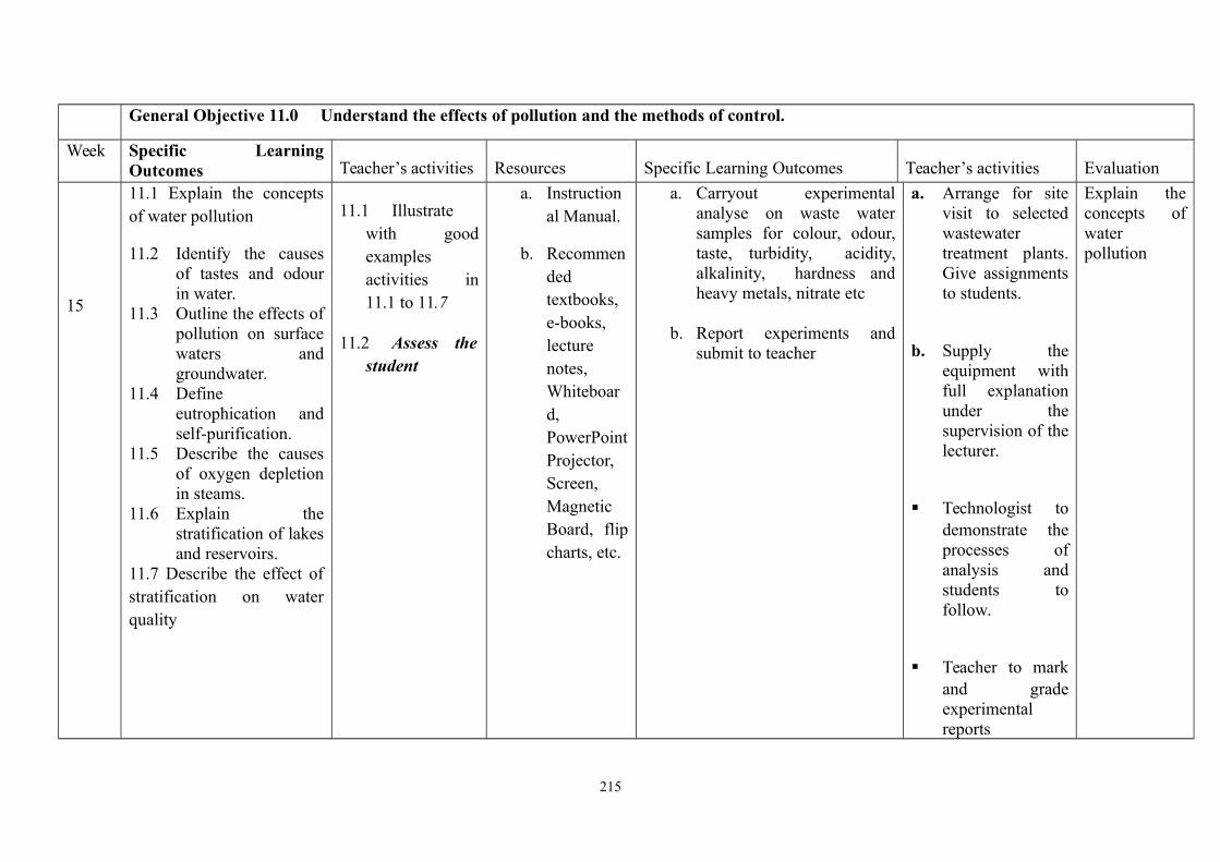
General Objective 11.0 Understand the effects of pollution and the methods of control.
Week Specific LearningOutcomes Teacher’s activities Resources Specific Learning Outcomes Teacher’s activities Evaluation
15
11.1 Explain the conceptsof water pollution
11.2 Identify the causesof tastes and odourin water.
11.3 Outline the effects ofpollution on surfacewaters andgroundwater.
11.4 Defineeutrophication andself-purification.
11.5 Describe the causesof oxygen depletionin steams.
11.6 Explain thestratification of lakesand reservoirs.
11.7 Describe the effect ofstratification on waterquality
11.1 Illustratewith goodexamplesactivities in11.1 to 11.7
11.2 Assess thestudent
a. Instructional Manual.
b. Recommendedtextbooks,e-books,lecturenotes,Whiteboard,PowerPointProjector,Screen,MagneticBoard, flipcharts, etc.
a. Carryout experimentalanalyse on waste watersamples for colour, odour,taste, turbidity, acidity,alkalinity, hardness andheavy metals, nitrate etc
b. Report experiments andsubmit to teacher
a. Arrange for sitevisit to selectedwastewatertreatment plants.Give assignmentsto students.
b. Supply theequipment withfull explanationunder thesupervision of thelecturer.
Technologist todemonstrate theprocesses ofanalysis andstudents tofollow.
Teacher to markand gradeexperimentalreports
Explain theconcepts ofwaterpollution
215
ASSESSMENT: The continuous assessment, tests and quizzes will be awarded 40% of the total score. The end of the Semester Examination will make up forthe remaining 60% of the total score.
Competency: Students exposed to activities of water supply industry waste water collection and disposal.Assessment: Coursework 20%; Course tests 20%; Practicals 20% Examination 40%
References: 1. Chadwick, A.J. and Morfatt, J.C. “Hydraulics in Civil and Environmental Engineering” Rontledge, 1998.
2. Henry, J.G. and Heinke, G.W. “Environmental Science and Engineering” Prentice Hall, 1989.
3.Venugopala Rao P. Textbook of Environmental Engineering Prentice Hall, India, 2004
Department/ Programme: ND WaterResources Engineering Technology
Course Code: HWR245
Contact Hours: 2 – 0 – 0
Subject/Course: Introduction to TechnicalReport Writing
Theoretical: 2 hours/week
Year: II Semester: 1st Pre-requisite: - Practical: 0 hours /week
216
General Objectives:
1.0 Understand the Content of a Technical Report2.0 Understand the methodology and sequence of writing Technical Report3.0 Understand the information that is required in Technical Report Writing4.0 Know how to analyze data.5.0 Know how to present information/data
Course: Introduction toTechnical Report Writing
Course Code: HWR 245 Contact Hours: 2-0-0
Theoretical: 2 hours/week
Year: II Semester: 1st Pre-requisite: - Practical: 0 hours /week
Theoretical Content Practical ContentGeneral Objective 1.0: Understand the Content of a Technical Report
217
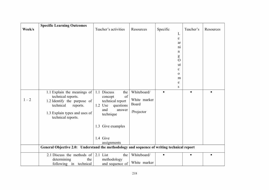
Week/sSpecific Learning Outcomes
Teacher’s activities Resources SpecificLearningOutcomes
Teacher’s Resources
1 – 2
1.1 Explain the meanings oftechnical reports.
1.2 Identify the purpose oftechnical reports.
1.3 Explain types and uses oftechnical reports.
1.1 Discuss theconcept oftechnical report
1.2 Use questionsand answertechnique
1.3 Give examples
1.4 Giveassignments
Whiteboard/
White markerBoard
/Projector
General Objective 2.0: Understand the methodology and sequence of writing technical report
2.1 Discuss the methods ofdetermining thefollowing in technical
2.1 List themethodologyand sequence of
Whiteboard/
White marker
218

3 – 5
reports;a. Topic and title.b. Justification of title.c. Abstract or synopsis of
the report.d. Aim and objectives of
the report..
e. Scope and limitation ofproject.
f. Classification of datag. Data analysis
(Graphical method,tabular methoddescriptive method).
h. Presentation of data(use of appendices).
writingtechnical report.
2.2 Explain themethods andsequence ofwritingtechnical report.
2.3 Use questionsand answertechnique
2.4 Give examples2.5 Give
assignments
Board/
Projector
General Objective 3.0: Understand the information that is required in technical report writing
6 – 9
3.1 Explain the various types ofinformation that would berequired in reports
3.2 Explain the factors thatinfluence solutions.
3.3 Select criteria required incase studies.
3.4 Determine critical analysisof case studies.
3.5 Produce summary.3.6 Make propositions (Author’s
Propositions).3.7 Develop conclusion to a
3.1 Discuss thevarious typesofinformationrequired forwritingtechnicalreport.
3.2 Usequestions andanswertechnique
Whiteboard/
White markerBoard/
Projector
219

technical report.3.8 Write a bibliography in
standard format.3.9 Explain terms of reference in
report.3.10 Explain the difference
between facts and opinions.3.11 Explain how facts and
opinions may bedistinguished in writingreport.
3.12 Write reports on selectedtechnical matters.
3.13 Rewrite the abstract.
3.3 Giveexamples
3.4 Giveassignments
General Objective 4.0: Know how to Analyze data.
10 - 12
4.1 Mention main sources ofdata.
4.2 Discuss techniques of data
collection:
Laboratory. Field
survey/measurement. Questionnaire. Oral interviews.
4.1 Guide studenton techniquesinvolved insourcing data
4.2 Use questionsand answertechnique
4.3 Give examples4.4 Give
assignments
Whiteboard/
White markerBoard/
Projector
General Objective 5.0: Know how to present information/data5.1 Explain how to present
data in a manner suitablefor writing technical
5.1 Guide studenton techniquesinvolved in
Whiteboard/
White marker
220

13 - 15 report in the followingform: Tables, Graphs,Charts,
5.2 bars. 5.3 Input information into
computer.5.4 Print out results.
presentinginformation/data
5.2 Use questionsand answertechnique
5.3 Give examples5.4 Give
assignments
Board/
Projector
Computers.
Softwares.
ASSESSMENT: The continuous assessment, tests and quizzes will be awarded 40% of the total score. The end of the SemesterExamination will make up for the remaining 60% of the total score.
221
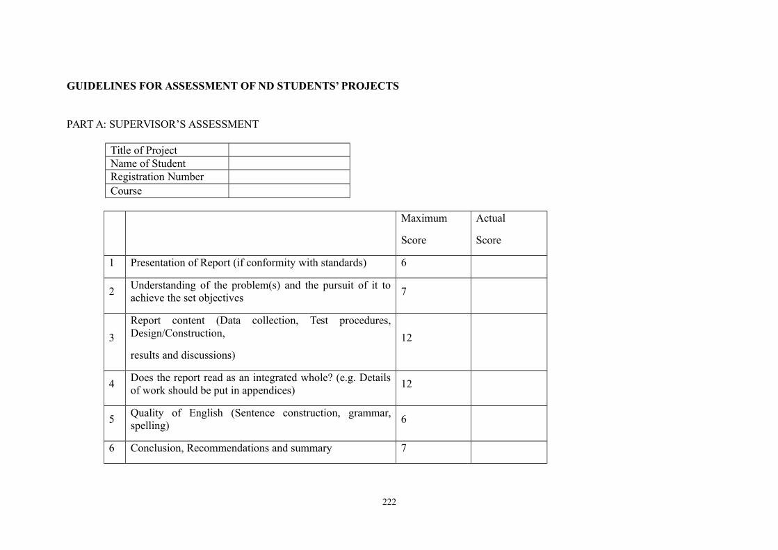
GUIDELINES FOR ASSESSMENT OF ND STUDENTS’ PROJECTS
PART A: SUPERVISOR’S ASSESSMENT
Title of ProjectName of StudentRegistration NumberCourse
Maximum
Score
Actual
Score
1 Presentation of Report (if conformity with standards) 6
2Understanding of the problem(s) and the pursuit of it toachieve the set objectives
7
3
Report content (Data collection, Test procedures,Design/Construction,
results and discussions)
12
4Does the report read as an integrated whole? (e.g. Detailsof work should be put in appendices)
12
5Quality of English (Sentence construction, grammar,spelling)
6
6 Conclusion, Recommendations and summary 7
222

Total 50
Brief Remark
______________________________________________________________________
______________________________________________________________________
Name of Reader _________________________________________________
Signature _________________________ Date ______________________
PART B: PANEL’S ASSESSMENT
Title of Project
Name of Student
Registration Number
Course
223
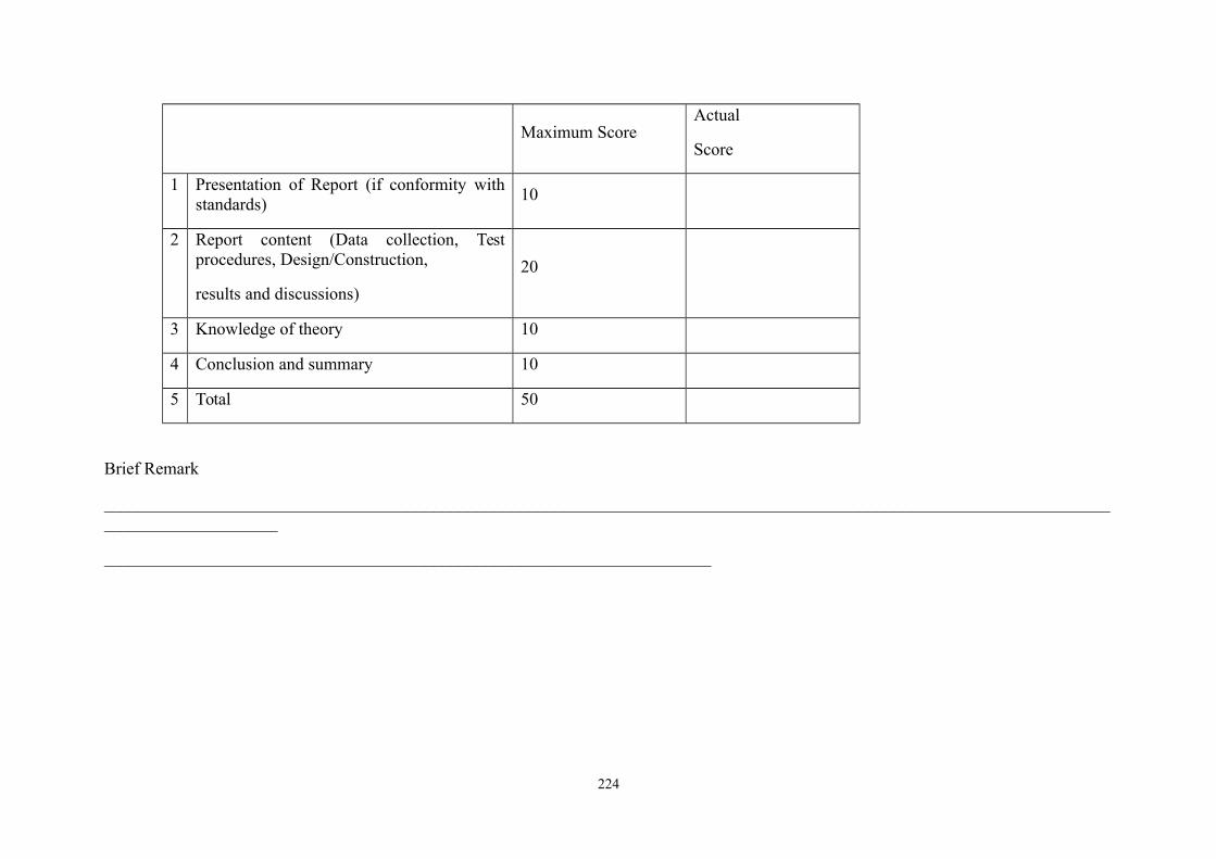
Maximum ScoreActual
Score
1 Presentation of Report (if conformity withstandards)
10
2 Report content (Data collection, Testprocedures, Design/Construction,
results and discussions)
20
3 Knowledge of theory 10
4 Conclusion and summary 10
5 Total 50
Brief Remark
________________________________________________________________________________________________________________________________________
______________________________________________________________________
224
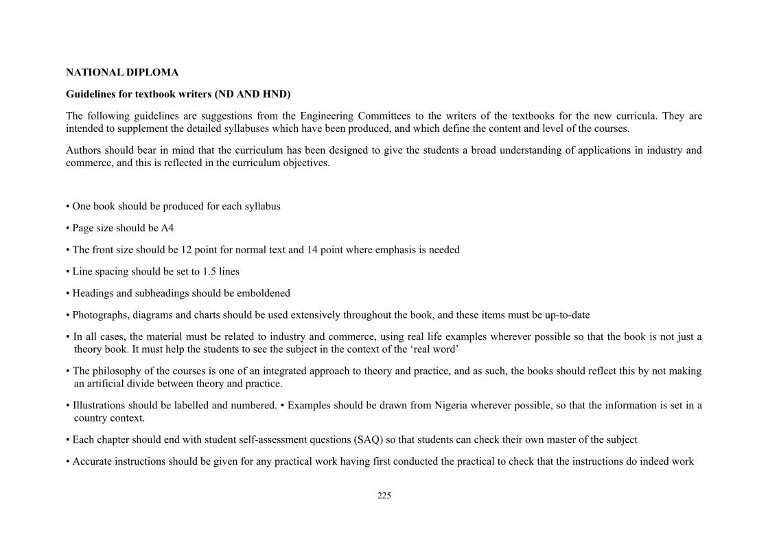
NATIONAL DIPLOMA
Guidelines for textbook writers (ND AND HND)
The following guidelines are suggestions from the Engineering Committees to the writers of the textbooks for the new curricula. They areintended to supplement the detailed syllabuses which have been produced, and which define the content and level of the courses.
Authors should bear in mind that the curriculum has been designed to give the students a broad understanding of applications in industry andcommerce, and this is reflected in the curriculum objectives.
• One book should be produced for each syllabus
• Page size should be A4
• The front size should be 12 point for normal text and 14 point where emphasis is needed
• Line spacing should be set to 1.5 lines
• Headings and subheadings should be emboldened
• Photographs, diagrams and charts should be used extensively throughout the book, and these items must be up-to-date
• In all cases, the material must be related to industry and commerce, using real life examples wherever possible so that the book is not just atheory book. It must help the students to see the subject in the context of the ‘real word’
• The philosophy of the courses is one of an integrated approach to theory and practice, and as such, the books should reflect this by not makingan artificial divide between theory and practice.
• Illustrations should be labelled and numbered. • Examples should be drawn from Nigeria wherever possible, so that the information is set in acountry context.
• Each chapter should end with student self-assessment questions (SAQ) so that students can check their own master of the subject
• Accurate instructions should be given for any practical work having first conducted the practical to check that the instructions do indeed work
225
• The books must have a proper index or table of contents, a list of references and an introduction based on the overall course philosophy andaims of the syllabus.
• Symbols and units must be listed and a unified approach used throughout the book
• In case of queries regarding the contents of the books and the depth of information, the author must contact the relevant curriculum committeevia the National Board for Technical Education
• The final draft version of the books should be submitted to Nigerian members of the curriculum working groups for their comments regardingthe content in relation to the desired syllabus.
226
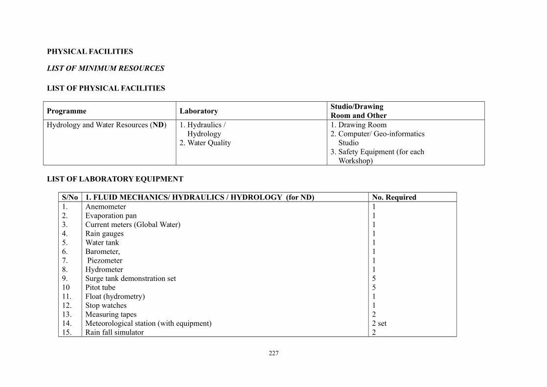
PHYSICAL FACILITIES
LIST OF MINIMUM RESOURCES
LIST OF PHYSICAL FACILITIES
Programme LaboratoryStudio/DrawingRoom and Other
Hydrology and Water Resources (ND) 1. Hydraulics / Hydrology2. Water Quality
1. Drawing Room2. Computer/ Geo-informatics Studio3. Safety Equipment (for each Workshop)
LIST OF LABORATORY EQUIPMENT
S/No 1. FLUID MECHANICS/ HYDRAULICS / HYDROLOGY (for ND) No. Required1.2.3.4.5.6.7.8.9.1011.12.13.14.15.
AnemometerEvaporation panCurrent meters (Global Water)Rain gaugesWater tankBarometer, PiezometerHydrometerSurge tank demonstration setPitot tubeFloat (hydrometry)Stop watchesMeasuring tapesMeteorological station (with equipment)Rain fall simulator
11111111551122 set2
227
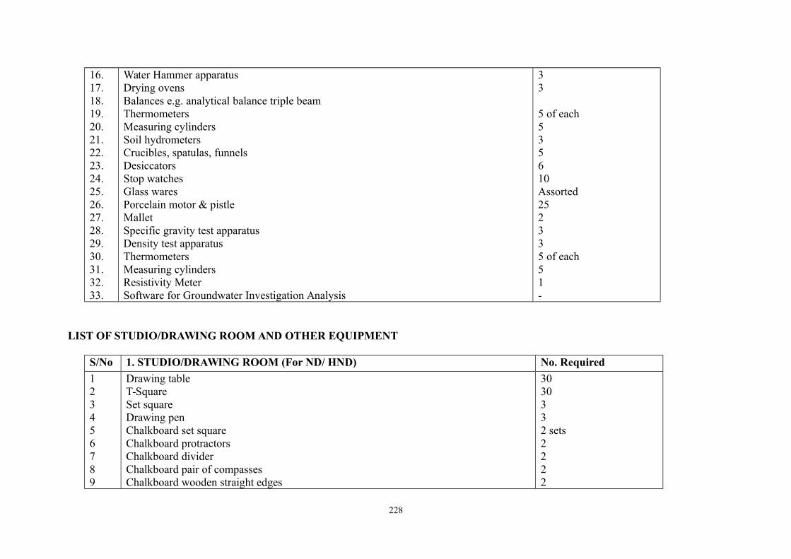
16.17.18.19.20.21.22.23.24.25.26.27.28.29.30.31.32.33.
Water Hammer apparatusDrying ovensBalances e.g. analytical balance triple beamThermometersMeasuring cylindersSoil hydrometersCrucibles, spatulas, funnelsDesiccatorsStop watchesGlass waresPorcelain motor & pistleMalletSpecific gravity test apparatusDensity test apparatus ThermometersMeasuring cylindersResistivity MeterSoftware for Groundwater Investigation Analysis
33
5 of each535610Assorted252335 of each51-
LIST OF STUDIO/DRAWING ROOM AND OTHER EQUIPMENT
S/No 1. STUDIO/DRAWING ROOM (For ND/ HND) No. Required
123456789
Drawing table T-SquareSet squareDrawing penChalkboard set squareChalkboard protractorsChalkboard dividerChalkboard pair of compassesChalkboard wooden straight edges
3030332 sets2222
228
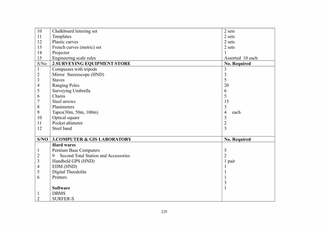
101112131415
Chalkboard lettering setTemplatesPlastic curvesFrench curves (metric) setProjectorEngineering scale rules
2 sets2 sets2 sets2 sets1Assorted 10 each
S/No 2.SURVEYING EQUIPMENT STORE No. Required123456789101112
Compasses with tripodsMirror Stereoscope (HND)StavesRanging PolesSurveying UmbrellaChainsSteel arrowsPlanimetersTapes(30m, 50m, 100m)Optical squarePocket altimeterSteel band
33520651534 each323
S/NO 3.COMPUTER & GIS LABORATORY No. Required
123456
12
Hard waresPentium Base Computers9 Second Total Station and AccessoriesHandheld GPS (HND)EDM (HND)Digital TheodolitePrinters
SoftwareDBMSSURFER-S
521 pair11131
229
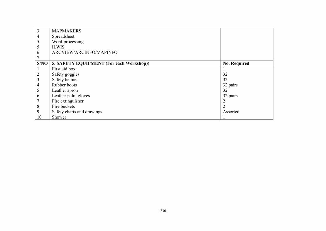
345567
MAPMAKERSSpreadsheetWord-processingILWISARCVIEW/ARCINFO/MAPINFO
S/NO 5. SAFETY EQUIPMENT (For each Workshop)) No. Required12345678910
First aid boxSafety gogglesSafety helmetRubber bootsLeather apronLeather palm glovesFire extinguisherFire bucketsSafety charts and drawingsShower
1323232 pairs3232 pairs22Assorted1
230
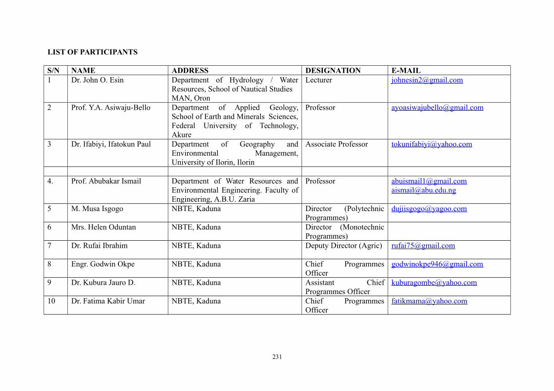
LIST OF PARTICIPANTS
S/N NAME ADDRESS DESIGNATION E-MAIL1 Dr. John O. Esin Department of Hydrology / Water
Resources, School of Nautical StudiesMAN, Oron
Lecturer [email protected]
2 Prof. Y.A. Asiwaju-Bello Department of Applied Geology,School of Earth and Minerals Sciences,Federal University of Technology,Akure
Professor [email protected]
3 Dr. Ifabiyi, Ifatokun Paul Department of Geography andEnvironmental Management,University of Ilorin, Ilorin
Associate Professor [email protected]
4. Prof. Abubakar Ismail Department of Water Resources andEnvironmental Engineering. Faculty ofEngineering, A.B.U. Zaria
Professor [email protected]@abu.edu.ng
5 M. Musa Isgogo NBTE, Kaduna Director (PolytechnicProgrammes)
6 Mrs. Helen Oduntan NBTE, Kaduna Director (MonotechnicProgrammes)
7 Dr. Rufai Ibrahim NBTE, Kaduna Deputy Director (Agric) [email protected]
8 Engr. Godwin Okpe NBTE, Kaduna Chief ProgrammesOfficer
9 Dr. Kubura Jauro D. NBTE, Kaduna Assistant ChiefProgrammes Officer
10 Dr. Fatima Kabir Umar NBTE, Kaduna Chief ProgrammesOfficer
231