Embed Size (px)
Citation preview

NATIONAL SPACE-BASED
POSITIONING, NAVIGATION, AND
TIMING ADVISORY BOARD
Twentieth Meeting
November 15-16, 2017
Crown Plaza Redondo Beach
300 N. Harbor Drive, Redondo Beach, CA
John Paul Stenbit James J. Miller
Chair Executive Director

2
National Space-Based Positioning, Navigation, and Timing Advisory Board
Crowne Plaza Redondo Beach, Peninsula/Pacific Ballrooms
300 N. Harbor Drive, Redondo Beach, CA 90277
Agenda
WEDNESDAY, NOVEMBER 15, 2017 9:00 - 9:05 Board Convenes Call to Order & Announcements Mr. James J. Miller, Executive Director, PNT Advisory Board, NASA Headquarters 9:05 - 9:30 20th PNT Board Focus & Priorities Sustaining GPS as a Worldwide Utility — Protect, Toughen, Augment Mr. John Stenbit, Chair; Dr. Bradford Parkinson, 1st Vice-Chair; Gov Jim Geringer, 2nd Vice-Chair 9:30 - 10:05 Global Positioning System Status & Modernization Milestones GPS III Satellite Vehicle and OCX Progress & Plans VIEW PDF (5 MB) Col Gerard "Gerry" Gleckel, Deputy Director, GPS Directorate (GPS-D), Space & Missile Systems Center 10:05 - 10:30 Timing Criticality & Note on "GPS Week-Roll-Over" New Developments, Lessons Learned, and Receiver Preparation VIEW PDF (2 MB) Mr. Edward Powers, Division Chief, GPS Operations, United States Naval Observatory (USNO) 10:30 - 10:45 BREAK
3
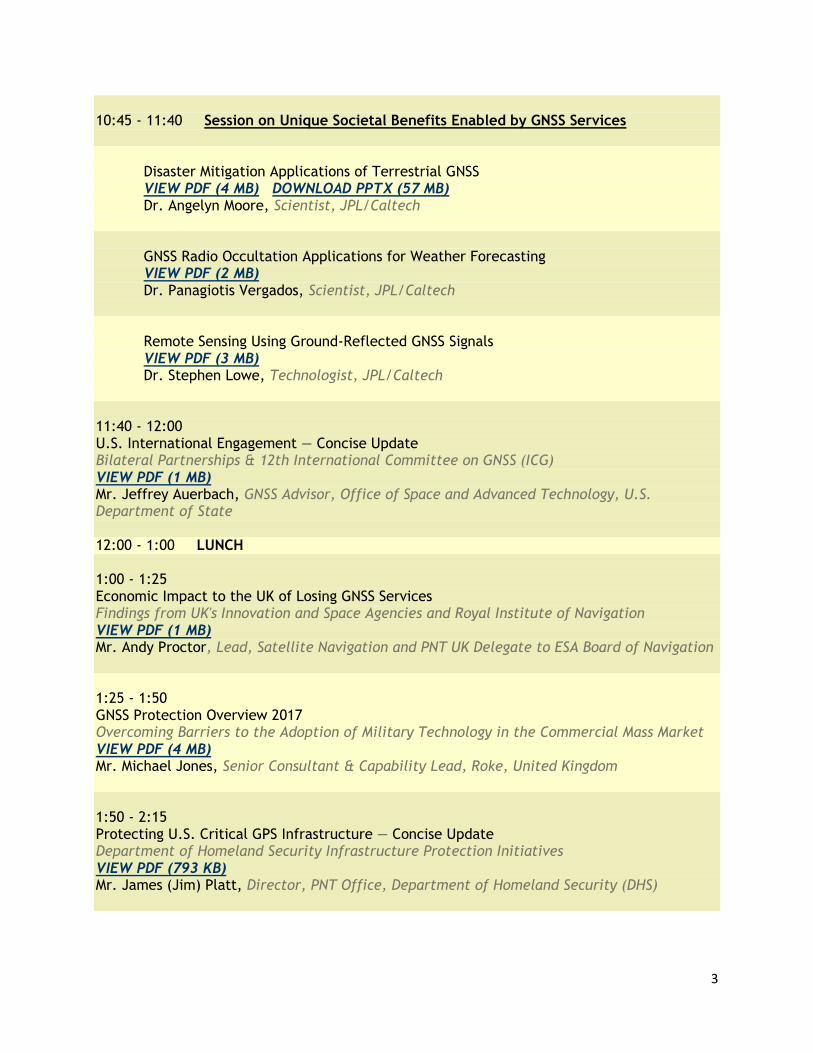
10:45 - 11:40 Session on Unique Societal Benefits Enabled by GNSS Services Disaster Mitigation Applications of Terrestrial GNSS VIEW PDF (4 MB) DOWNLOAD PPTX (57 MB) Dr. Angelyn Moore, Scientist, JPL/Caltech GNSS Radio Occultation Applications for Weather Forecasting VIEW PDF (2 MB) Dr. Panagiotis Vergados, Scientist, JPL/Caltech Remote Sensing Using Ground-Reflected GNSS Signals VIEW PDF (3 MB) Dr. Stephen Lowe, Technologist, JPL/Caltech 11:40 - 12:00 U.S. International Engagement — Concise Update Bilateral Partnerships & 12th International Committee on GNSS (ICG) VIEW PDF (1 MB) Mr. Jeffrey Auerbach, GNSS Advisor, Office of Space and Advanced Technology, U.S. Department of State 12:00 - 1:00 LUNCH 1:00 - 1:25 Economic Impact to the UK of Losing GNSS Services Findings from UK's Innovation and Space Agencies and Royal Institute of Navigation VIEW PDF (1 MB) Mr. Andy Proctor, Lead, Satellite Navigation and PNT UK Delegate to ESA Board of Navigation 1:25 - 1:50 GNSS Protection Overview 2017 Overcoming Barriers to the Adoption of Military Technology in the Commercial Mass Market VIEW PDF (4 MB) Mr. Michael Jones, Senior Consultant & Capability Lead, Roke, United Kingdom 1:50 - 2:15 Protecting U.S. Critical GPS Infrastructure — Concise Update Department of Homeland Security Infrastructure Protection Initiatives VIEW PDF (793 KB) Mr. James (Jim) Platt, Director, PNT Office, Department of Homeland Security (DHS)
4
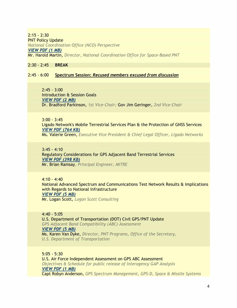
2:15 - 2:30 PNT Policy Update National Coordination Office (NCO) Perspective VIEW PDF (1 MB) Mr. Harold Martin, Director, National Coordination Office for Space-Based PNT 2:30 - 2:45 BREAK 2:45 - 6:00 Spectrum Session: Recused members excused from discussion
2:45 - 3:00 Introduction & Session Goals VIEW PDF (2 MB) Dr. Bradford Parkinson, 1st Vice-Chair; Gov Jim Geringer, 2nd Vice-Chair 3:00 - 3:45 Ligado Network's Mobile Terrestrial Services Plan & the Protection of GNSS Services VIEW PDF (764 KB) Ms. Valerie Green, Executive Vice President & Chief Legal Officer, Ligado Networks 3:45 - 4:10 Regulatory Considerations for GPS Adjacent Band Terrestrial Services VIEW PDF (398 KB) Mr. Brian Ramsay, Principal Engineer, MITRE 4:10 - 4:40
National Advanced Spectrum and Communications Test Network Results & Implications with Regards to National Infrastructure
VIEW PDF (5 MB) Mr. Logan Scott, Logan Scott Consulting 4:40 - 5:05 U.S. Department of Transportation (DOT) Civil GPS/PNT Update GPS Adjacent Band Compatibility (ABC) Assessment VIEW PDF (5 MB) Ms. Karen Van Dyke, Director, PNT Programs, Office of the Secretary, U.S. Department of Transportation
5:05 - 5:30 U.S. Air Force Independent Assessment on GPS ABC Assessment Objectives & Schedule for public release of Interagency GAP Analysis VIEW PDF (1 MB) Capt Robyn Anderson, GPS Spectrum Management, GPS-D, Space & Missile Systems

5
Center
5:30 - 6:00 Bringing it all Together
An Economic Policy Perspective on Terrestrial Mobile Broadband and Space-to-Earth GNSS Spectrum Management VIEW PDF (3 MB)
Dr. George Ford, Chief Economist, Phoenix Center for Advanced Legal & Economic Public Policy Studies
6:00 ADJOURNMENT
THURSDAY, NOVEMBER 16, 2017 9:00 - 9:05 Board Convenes Call to Order Mr. James J. Miller, PNT Advisory Board Executive Director, NASA HQ 9:05 - 9:15 Announcements, Agenda & Schedule at Chair’s Discretion Mr. John Stenbit, Chair 9:15 - 10:30 Representative/International Reports & Perspectives: Special Topic: Spoofing Event at ION GNSS+ 2017 VIEW PDF (3 MB) Mr. Logan Scott, Logan Scott Consulting (Guest Speaker) Progress on PTA VIEW PDF (2 MB) Mr. Dana Goward, Resilient Navigation & Timing Foundation (U.S.) GNSS Issues Discussed at the United Nations in 2017 VIEW PDF (173 KB)
Dr. Sergio Camacho-Lara, U.N. Center of Science and Space Technology (Mexico) Multi-GNSS and Recent Science Issues in the International GNSS Service (IGS) VIEW PDF (2 MB)
Dr. Gerhard Beutler, International Association of Geodesy (Switzerland)

6
Impacts to U.S. Markets from International Standards VIEW PDF (146 KB)
Ms. Ann Ciganer, GPS Innovation Alliance (U.S.) Regional Update VIEW PDF (2 MB) Dr. Refaat Rashad, Arab Institute of Navigation (Egypt) Regional Update VIEW PDF (2 MB) Mr. Matt Higgins, International GNSS Society (Australia) Regional Update Mr. Arve Dimmen, Norwegian Coastal Administration (Norway) 10:30 - 10:45 BREAK 10:45 - 12:00 PNT Board Member Roundtable Discussion & Work Plan: Recommendations for PNT Executive Committee (EXCOM) Recused members excused from discussion Dr. Bradford Parkinson, 1st Vice-Chair; Gov Jim Geringer, 2nd Vice-Chair 12:00 - 1:00 LUNCH — Working 1:00 ADJOURNMENT
Note: dates and times are as originally scheduled and do not reflect actual presentation times.

7
Table of Contents
Executive Summary: 20h PNT Advisory Board Session………………………………………………………………… 9
Day 1: Wednesday, November 15, 2017
Board Convenes / Mr. John Stenbit; Mr. James J. Miller....………………………………………………………... 10
Priorities for the 20th PNT Advisory Board Session / Mr. John Stenbit,
Dr. Brad Parkinson, Gov Jim. Geringer…..………………………………………………………………………… 10
Global Positioning System Status & Modernization Milestones / Col Gerard Gleckel...……………………..…...... 11
Timing Criticality & Note on “GPS Week-Roll-Over” / Mr. Ed. Powers…………..………………………………. 12
PNT Policy Update / Mr. Harold Martin. ………….……………………………………………………………...... 13
Session on Unique Societal Benefits Enabled by GNSS Service
Disaster Mitigation Applications of Terrestrial GNSS / Dr. Angelyn Moore …………….…...……………….. 13
GNSS Radio Occultation Applications for Weather Forecasting / Dr. Panagiotis Vergados………………….. 14
Remote Sensing Using Ground-Reflected GNSS Signals / Dr. Stephen Lowe …………………………........... 15
U.S. International Engagement – Concise Update / Mr. Jeffrey Auerbach ………………………………………..... 16
Economic Impact to the UK of Losing GNSS Services / Mr. Andy Proctor ……………………………………….. 17
GNSS Protection Overview 2017 / Mr. Michael Jones …………..…………………………………………………. 19
Protecting U.S. Critical GPS Infrastructure – Concise Update / Mr. James (Jim) Platt …………………………… 19
Session on Spectrum / Chaired by Dr. B. Parkinson
Ligado Networks Presentation / Ms. Valerie Green…………….…...…………………………………………. 21
History and Precedents for all the 1 dB Interference Protection Criterion (IPC) and Regulatory Status of
Adjacent Band Terrestrial Services / Mr. Brian Ramsey...…………………………………………………….. 25
National Advanced Spectrum and Communications Test Network (NASCTN) Results & Implications with
Regards to National Infrastructure / Mr. Logan Scott……………………………………………………........... 26
U.S. Department of Transportation (DOT) Civil GPS/PNT Update / Ms. Karen Van Dyke ...……………….. 28
U.S. Air Force Independent Assessment on GPS ABC Assessment / Capt. Robyn Anderson ……………….. 28
Bringing it all Together: An Economic Policy Perspective on Terrestrial / Dr. George Ford…………........... 29

8
Day 2: Thursday, November 16, 2017
Board Convenes / Mr. James J. Miller…………………….…………………………………………........................ 30
Announcements, Agenda & Schedule at Chair’s Discretion / Mr. John Stenbit……………………........................ 30
.
Comments from PNT Advisory Board Subgroups
Agriculture / Mr. Ron Hatch …………….…...…………………………………………………………….…. 30
Aviation & Aerospace / Dr. Per Enge…………………....…………………………………………………….. 30
Critical Infrastructure / Dr. John Betz …………………………………………………………….……........... 30
Science / Dr. Gerhard Beutler ………………………………………………………………..……………….. 30
Transportation (Non-Aviation) / Mr. Arve Dimmen ………………………………………………………….. 31
Special Topics, Representative International Reports and Perspectives
Special Topics: Spoofing Event at ION GNSS+ 2017 / Mr. Logan Scott…………….…………………….…. 31
Progress on PTA / Mr. Dana Goward …..……………....…………………………………………………….. 31
GNSS Issues Discussed at the United Nations in 2017 / Dr. Sergio Camacho-Lara……………….……........... 32
International Association of Geodesy / Dr. Gerhard Beutler ……………………………..…..……………….. 33
Impacts to U.S. Markets from International Standards / Ms. Ann Ciganer …………………………………….. 33
Regional Update / Dr. Refaat Rashad [Egypt]……………….………………………………………..…........... 34
Regional Update / Mr. Matt Higgins [Australia] ……………………………..…..…………………………….. 34
Regional Update / Mr. Arve Dimmen [Norway] ………………………………………………….………….. 34
Comments from the Chair / Mr. John Stenbit…………………………………………………………........................ 35
PNT Roundtable Discussion and Work Plan / Dr. Bradford Parkinson (1st Vice-Chair), Gov. Jim Geringer (2nd Vice-
Chair)……………………………………..…………………………………...……………………........................... 36
Appendix A: PNT Advisory Board Membership……………………………………………………........................ 40
Appendix B: List of Presentations……………………………………………………………………........................ 41
Appendix C: Sign-In List……………………………………………………………………….……........................ 42
Appendix D: Acronyms and Definitions…………………………………………………………….......................... 46

9
20th
PNT Advisory Board Session
Executive Summary
The 20th session of the National Space-Based Positioning, Navigation, and Timing (PNT) Advisory Board met on November 15-
16, 2017, in Redondo Beach, California. The main objective of this session was to prepare the Advisory Board’s submission to
the next session of the PNT Executive Committee (EXCOM).
This document summarizes the key briefing points and discussions at the meeting.
High-Level Action Items:
After hearing a new briefing from Ligado, Dr. Brad Parkinson (1st Vice-Chair), in consultation with other board
members, began work on a letter for submission to the PNT EXCOM with its recommendations regarding the latest
proposal.
Specifically, Dr. Parkinson asked Dr. John Betz, in consultation with Ms. Karen Van Dyke (Department of
Transportation, DOT), to report at the next Advisory Board meeting on what classes of receivers could potentially be
placed at risk by the Ligado concept.
Further, Dr. Parkinson requested Dr. Betz to provide clarifying language for the Ligado response pertinent to how
future possible changes to federal requirements might affect Ligado’s operation.
The Advisory Board expressed willingness to hear a revised presentation from Ligado concepts provided such
presentation met the board’s six proposed criteria (1 dB margin, and others). The Advisory Board believes such criteria
are critical for the protection of the Global Positioning System (GPS) and other Global Navigation Satellite Systems
(GNSS).
Mr. Stenbit, Chair – as part of continued efforts to “get ahead of the curve” - directed all previously established
Advisory Board work subgroups to report at the next Advisory Board meeting on the major issues faced in each group.
Mr. Stenbit asked Mr. Ron Hatch (Agriculture Subgroup) to report at the next meeting current definitions and
prospective changes in that field.
Mr. Stenbit asked Dr. Per Enge (Aviation &Aerospace Subgroup) to report at the next meeting on how the use of
drones differ from other aviation users.
Mr. Stenbit also noted the full Advisory Board needs to discuss in more definite detail what it means by ‘mitigation.’
Other Action Items:
Mr. Stenbit’s offer of having the Advisory Board conduct a more thorough study of cyber concerns was welcomed by
Mr. Jeffrey Auerbach, Department of State (DOS).
Many Advisory Board members renewed their emphasis on the need to revise or eliminate the Federal Communications
Commission (FCC) Rule 25 waiver provision regarding U.S. use of foreign GNSS signals.

10
Wednesday, November 15, 2017 Session
Board Convenes/ Call to Order Mr. James J. Miller, Executive Director National Space-Based Advisory Board on Positioning, Navigation, and Timing (PNT)
Mr. Miller welcomed everybody to the 20th Meeting of the PNT Advisory Board (PNTAB). The board has been in existence for
over a decade and through three Presidential administrations. It is charged with addressing the most challenging issues facing
PNT. At today’s meeting a number of critical technical issues will be raised for discussion. The board will also develop a
number of recommendations for the new Presidential Administration. Mr. Miller also expressed thanks to the U.S. Air Force for
its continuing leadership regarding GPS. Advisory Board members are nominated by one of the nine federal department and
agency members of the PNT EXCOM, and then appointed by the National Aeronautics and Space Administration (NASA)
Administrator. Board members volunteer their time to make valuable contributions through their expertise in GPS. The PNTAB
was explicitly created as an external body to provide an independent perspective. It operates under the Federal Advisory
Committee Act (FACA) and, thus, a set of ethics rules apply. Board members anticipating a potential conflict of interest in a
particular discussion must recuse themselves, and their recusal noted for the record.
* * *
20TH PNT Advisory Board Focus and Priorities
Mr. John Stenbit, Chair
Mr. Stenbit thanked the attendees and noted that, in general, the board has transitioned from looking backward to looking forward
as it relates to PNT issues. The 19th Advisory Board meeting, held in June 2016, established subgroups with expertise in
designated areas (note: meeting minutes and presentations available at:
https://www.gps.gov/governance/advisory/meetings/2017-06/), and on the following day reports will be heard from those
subgroups. Next he addressed the PNTAB’s on-going program to Protect, Augment and Toughen (PTA) GPS. A key issues is
what constitutes sufficient GPS backup? Limited deployment of Enhanced Loran (eLoran) has been presented as a potential
backup to the GPS timing function. However, given the variety of areas where GPS is essential, different backup requirements
exist and it may be difficult for a single backup system to address them all. Hopefully this topic can be addressed at the 20th PNT
Advisory Board.
Governor Jim Geringer, 2nd Vice-Chair
Gov. Geringer noted that, as a former Governor of Wyoming, he is aware of a Rocky Mountain ethos that stresses aiding one’s
neighbors. Also, there is an adage that says to “talk less; say more.” GPS is “the beast for whose brand we ride” – meaning, the
Advisory Board has a fiduciary responsibility to regard for the well-being of GPS as a higher calling than one’s personal
concerns. A good example of “riding for the brand” is that of a private group he was briefed about that uses GPS to map out
escape routes particularly for elderly persons to use in an emergency.
* * *

11
Global Positioning System Status & Modernization Milestones
GPS III Satellite Vehicles and OCX Progress & Plans
Col Gerard Gleckel, Deputy Director, GPS Directorate (GPS-D)
Col Gleckel thanked the Advisory Board for its continued advocacy for GPS and also holding the U.S. Air Force accountable to
its published standards. He presented the latest GPS Enterprise Operational View and an overview of the latest status. Next, he
presented the GPS Performance Report Card, which demonstrates an admirable job is being done to meet the established
standards. In the current report card 11 of the 12 metrics are graded ‘green’; the sole exception related an issue in status and
problem reporting. This exception is because of a single instance in 2016 where a specific issue was not been reported within the
targeted 48-hour timeframe.
The first ten GPS III satellite vehicles (SV) – SV 01 through SV 10 – are under contract to Lockheed-Martin. The first GPS III
satellite (SV01) is complete and in storage ready for launch. SV02 is currently in thermal vacuum testing, a two-month rigorous
heat/cold test that is proceeding well. The rest of the first 10 satellites are in production. Col Gleckel announced also that GPS
III satellites SV11 through SV32 are now officially called GPS IIIF. The intent for the GPS IIIF design is to combine the
stability of having a single contractor while also building in technical ‘on ramps’ to allow adaptations as new information and
circumstances may warrant.
Regarding the modernized GPS operational control segment (OCX), OCX Block 0 – the launch and checkout ground system –
has been delivered by Raytheon and, following extensive testing, accepted by the Air Force. These tests addressed 137
requirements. The OCX program has been subject to delays, so this successful delivery is important and very good news.
Regarding GPS contingency operations, the systems to fill the gap between the current legacy systems and OCX Block 1 should
be operational in April 2019.
Military GPS User Equipment (MGUE) efforts include the development of both ground and airborne/maritime receiver cards.
Military users will choose the cards most suitable to their requirements as one size does not fit all needs. The MGUE Precision
Guided Munitions Test program has been very successful. Further, four test flights with B-2s, flying different configurations
with cards integrated into the guidance system, have verified operation with M-code.
Also, according to the GPS-D Director the key perspectives for GPS are: it is a global utility; enhancement of resiliency must
continue; alternate PNT sources are needed, and that the potential of multi-GNSS should be explored and expanded.
Gov. Geringer noted that Col Gleckel referenced GPS IIIF (SVs 11-32). Does this imply 32 SVs is the intended GPS
constellation size? Also, does Col Gleckle believe another GNSS system could catch up with GPS?
Col Gleckel responded that, in regard to other GNSS systems, his view is that the more the better. GPS is likely to
remain the baseline. Also, it is doubtful there will be a single global alternate system to GPS as different users have
different needs. In terms of the nominal constellation size, it is not being increased to 32 SVs.
Dr. Parkinson noted he and others have long advocated an all-code GPS receiver. However, the procurement
equipment Col Gleckel has described does not include the GPS L5 signal. In his view, U.S. equipment should receive
all signals and, thus, he urged Col Gleckel to consider this. Also, is Col Gleckel concerned about the integrity of
foreign GNSS signals? Are efforts being made to assure signal integrity for the military user?
Col Gleckel responded: Yes.
Mr. Stenbit asked if the path of production of receiver cards is sufficiently rapid.
Col Gleckel said MGUE has initial offerings for each of the military services. Work has begun with the Air Force and
is moving ahead with the Navy. Actual replacement dates depend on the fleet servicing schedule. For example, some
Navy vessels only come in for major servicing once every two years.
Mr. Miller said he visited and was impressed by the facility at which where GPS III SVs 01-10 are being built.
Col Gleckel reported that biweekly meetings of the pertinent agencies are held to ensure coordination.
Mr. Goward asked if MGUE deployment includes those needed by small units, including personal use.
Col Gleckel said MGUE Increment 2 will address the needs of handheld devices. Requests have been published to
miniaturize the equipment. The goal is for individuals in the field to have a military-issue device superior to anything
commercially available.
Dr. Betz commented, in follow up to Dr. Parkinson’s comments on the L5 signal, there are many reasons why it is not
being tracked. One of them is that there would be differences in the antenna requirement for tracking L5. Thus,
expanding MGUE to track L5 signal would slow efforts to retrofit military receivers.
Dr. Parkinson stressed the hazards of delaying the initiation of any project. He urged Col Gleckel to start as best he
could with what is currently available, and to look into pertinent efforts already been carried out by commercial firms.
* * *
12
Timing Criticality & Note on “GPS Week-Roll-Over”
New Developments, Lessons Learned, and Receiver Preparation
Mr. Ed Powers, Division Chief, GPS Operations
United States Naval Observatory
GPS provides the timing standard to the world. While this is essential to banking operations, the power grid, communications,
financial transactions, and others, its criticality is poorly understood by many. GPS is such an excellent a source of timing
information that, in consequence, has inhibited the sale of atomic clocks.
Various systems have been successively used to provide timing and synchronization. These began with the Navy Time broadcast
in 1902, which has been followed by increasingly accurate systems. Today, GPS timing accuracy is in the range of 10 to 100
nanoseconds.
In terms of alternatives to GPS, other GNSS systems exist but they shared the GPS weakness of low signal strength broadcasts
and use of nearly the same frequencies. Thus, they are not a full alternative. Mr. Powers identified various atomic clocks, e.g.,
cesium, rubidium, currently available. However, again, this is just a partial solution as such clocks do not provide
synchronization. A ground-based transmitter such as Loran or eLoran (see Appendix D) could support sub-microsecond level
timing across the nation. Other possibilities include use of existing communication infrastructures, such as Distance Measuring
Equipment (DME), or the Wide Area Augmentation System (WAAS) with a Message Type 12 (MT-12) and directional antenna.
In the absence of GPS, the best alternative is a layered approach, consisting of an alternate channel combined into a solution that
manages local flywheel clocks, all calibrated to a master clock.
Another key issue is that of GPS timing service performance and the GPS Week Rollover (for definition see ‘GPS Week
Rollover’ in Appendix D).
In addition to navigation, GPS provides timekeeping to the financial and other industries. An enormous improvement has been
achieved over the past quarter-century. For most of the past decade, GPS has provided sub-nanosecond accuracy.
GPS rollover occurs every 20 years. The original definition of the GPS navigation message allowed counting to be done for 1024
weeks. GPS time, which began on January 6, 1980, has already gone through one GPS rollover in 1999 and the second one will
occur on April 6, 2019. When the first rollover occurred, receivers were tested and work was done with manufacturers to ensure
they could handle the rollover. Receiver manufacturers are responsible for addressing this situation. Challenges with the
pending rollover include the involvement of many manufacturers who were not in business in 1999 and, also, the fact that the
number of receivers in use is much larger. Mr. Powers noted that, in his view, most manufacturers are working this issue
competently but it possible some malfunction could occur such as, for example, time being reported jumping by 19.7 years.
Also, some operations started the 19.7-year cycle from the time they wrote their specific firmware, which placed the rollover
issue at some time in the future. Newer receivers should have no problem provided their manufacturers follow the GPS ICD-200
standard. Older receivers may have problems, so users should consult the manufacturers. Testing can also be conducted through
use of a GPS simulator.
Gov. Geringer said it appears that when timing is discussed, the need for time synchronization between satellites is
often overlooked.
Mr. Powers said the most critical time synchronization challenge is GPS. Individual satellites are kept to one
nanosecond accuracy from each other. Galileo (European GNSS) has some advantage relative to GPS in that its clock
model is more stable. Galileo updates are done perhaps 12 times daily, compared to only twice daily on GPS. Also, in
his view GLONASS (Russia’s GNSS) is likely to remain somewhat less accurate than GPS and Galileo. BeiDou
(China’s GNSS) is striving towards a high degree of accuracy.
Dr. Axelrad asked Mr. Powers to clarify that he is referring to paper clock corrections.
Mr. Powers said, yes, that is the case.
Dr. Axelrad asked if the modernized messages provide any improvement.
Mr. Power responded that they do.
Mr. Hatch said he is concerned with the size of step change when a clock is updated.
Mr. Powers replied that the control filter segment attempts to account for that. A decade ago, step corrections were on
the order of 20 to 30 nanoseconds; today, they are much smaller.
Mr. Higgins asked if testing has been done for the Locata system (Locata consists of commercially available radio-
location technology that gives precise positioning where GPS is unavailable, see Appendix D).
13
Mr. Powers said tests took place two years ago. Locata performed quite well, but was not compatible with GPS.
Locata, is a very good example of a commercial pseudolite system, but to-date no one is using it for timing.
* * *
Mr. Stenbit exercised his prerogative as Chair to ask Mr. Harold Martin to give his presentation now, rather than at the originally
scheduled time.
* * *
PNT Policy Update
National Coordination Office (NCO) Perspective
Mr. Harold Martin, Director
National Coordination Office for Space-Based PNT
Mr. Martin noted he would report on what remains the same and what has changed during the first year of the new
administration. The National Space Policy remains unchanged. The National Space-based PNT organization remains focused
around the PNT EXCOM, which continues along with its strategic focus on GPS sustainment and modernization, international
cooperation, spectrum management, critical infrastructure, PNT resilience, and outreach.
A change is the creation of a National Space Council, chaired by the Vice President and tasked with advising and assisting on
National Space Policy and Strategy on a full range of issues, not just PNT.
Regarding resiliency, we can draw an analogy to the internet. At one point, the internet appeared to be an unmixed blessing, but
then came computer viruses. Similarly, with GPS the original view was that the spectrum would remain a benign environment.
This has proven not to be the case, leading to concerns that receivers lack sufficient cyber-resilience. It has become a national
issue and the NCO, working with the Department of Homeland Security (DHS), earlier this year released ‘best practice’
recommendations for both users and manufacturers. There are two specific issues at hand, positioning spoofing and data
spoofing. The latter can produce lingering effects as incorrect information ripples through the system. As a response to cyber
challenges, those who purchase receivers should demand that they’re fully compliant with the newest specifications.
Finally, in terms of a GPS backup, the FY17 National Defense Authorization Act (NDAA) directs various steps should be taken,
but makes no specific budget appropriation.
* * *
Recusals: Mr. Miller announced that Mr. Larry James would be recusing himself from the forthcoming three presentations by the
Jet Propulsion Laboratory (JPL) / California Institute of Technology.
* * *
Session on Unique Societal Benefits Enabled by GNSS Services
1) Disaster Mitigation Applications of Terrestrial GNSS
Dr. Angelyn Moore, Scientist
Jet Propulsion Laboratory / California Institute of Technology
Dr. Moore described a geodetic ground station located at JPL. About 1,200 such stations are in place. The antenna
legs are buried ten meters deep. As this brings them in contact with bedrock, surface level activity cannot cause
movement. The station pictured is the oldest and has been operating since 1992. In that time, it has moved one meter
to the east.
Dr. Moore then presented data from another station, which clearly captures the 1999 and 2010 earthquakes. Geodesy
measures actual movement, whereas seismology is study of waves emanating from an earthquake.
Dr. Moore then discussed Earthquake detection. She presented videos showing the cumulative horizontal and vertical
displacement caused by the 2011 Tohoku-Oki earthquake. Japan has 1,200 geodetic stations. The maximum
permanent horizontal movement was about five meters, and the maximum permanent vertical displacement was about

14
0.75 meters. Earthquake early warning detected the earliest and fastest waves emanating from quake. The intensity
and direction can be determined from these waves and a warning issued. For example, earthquake detection in the
Salton Sea, CA, would provide Los Angeles residents with 60 to 90 seconds of early detection. This is sufficient time
to exit from elevators, lose water pipe valves, and other precautions. Japan, Taiwan, Mexico, and Turkey are now
using such systems. A major problem in the 2011 Japan earthquake was that the original estimate of magnitude was
faulty. Thus, incorporating GPS in the detection system helps improve accuracy.
Dr. Moore then introduced the topic of ground GPS meteorology. The signal travel time to a GPS satellite is in part a
function of precipitable water vapor, which, is near-continuously monitored. The accuracy of these measurements is a
unique capability of GPS.
Finally, GPS Interferometric Reflectometry may be used to determine changes in snow, soil moisture, and vegetation.
Maps from a prototype system in California, 2007 to 2016, clearly depict the drought years.
Dr. Axelrad asked what limits current performance and what would improve performance. She noted conflict
between the speed and the accuracy of a prediction.
Dr. Moore said the addition of data from other GNSS systems would improve both the metrology and
hydrology aspects.
Mr. Burns asked if the science involved could produce ‘acre-level’ accuracy.
Dr. Moore said current reporting is at the level of 1000 square meters.
Dr. Parkinson asked if all receivers are of the highest class available.
Dr. Moore said the system can detect accuracies of 1-2 mm. horizontally and 3-5 mm. vertically.
2) GNSS Radio Occultation Applications for Weather Forecasting
Dr. Panagiotis Vergados, scientist
Jet Propulsion Laboratory, California Institute of Technology
GPS radio occultation (RO) is based on the bending of a GPS signal in the atmosphere. The degree of bending
provides very accurate information on temperature, pressure, and humidity. A unique characteristic of this approach is
its very high resolution, all-weather operation, global coverage, and high accuracy. Dr. Vergados presented a 20+ year
history of developments in this field. Each new system has reduced the error in weather forecasting. He also
presented, as an example of weather forecasting benefit, a chart showing the improvement GPS has provided to
measuring the genesis of Hurricane Ernesto in 2006. The system provides a basis for estimating hurricane intensity,
which greatly improves the quantity of timely information.
GPS RO is useful to a variety of scientific applications, including: climate modeling, characterizing the planetary
boundary layer, monitoring the expansion of the tropical belt, and measuring electron density irregularities. The
COSMIC-2 / FORMOSAT-7 mission’s (see Appendix D) six satellites are set for launch in March 2018. They will
improve the distribution of RO profiles and, thereby, improve global weather forecasting capabilities.
In summary, (1) Radio occultation improves weather forecasting. It has demonstrated great potential in extreme
weather research and provides valuable information for space weather research; (2) Given this success, future and
follow-on missions will track additional signals of opportunity beyond those of GPS; and (3) Synergistic applications
between GNSS RO and laser ranging to GNSS satellites equipped with laser retro-reflector arrays, appear to be a viable
path forward to explore new science applications.
Gov. Geringer asked, relative to Dr. Vergados’ suggestion that data from other GNSS systems would be
advantageous, whether GPS is be the best data one could expect. Further, is some other type of information
being sought?
Dr. Vergados said having other GNSS signals would be of substantial value.
Mr. Stenbit, asked Dr. Beutler whether he has considered such issues.

15
Dr. Beutler said he has. RO is an excellent example of how multi-GNSS can improve a branch of science.
The magnitude of improvement is substantial.
Mr. Allen said the ultimate users of this information could be the National Weather Service (NWS) and the
Federal Emergency Management Agency (FEMA). For example, there are on-going efforts in Alabama to
measure the rise and fall in river water levels. Perhaps a presentation could be made that incorporates all
these elements.
Dr. Parkinson expressed concern on how a signal emanating from the Earth could create interference to
GNSS-based RO.
Dr. Vergados said that the future should bring a better signal/noise ratio.
3) Remote Sensing Using Ground-Reflected GNSS Signals
Dr. Stephen Lowe, Technologist
Jet Propulsion Laboratory, California Institute of Technology
Dr. Lowe said he would address three topics: what is GNSS Reflectometry (GNSS-R), what measurements can
GNSS-R make, and, what is currently happening in this field.
Compared to radar, where a signal returns to its point of origin, GNSS-R provides a forward scatter. The responses
allow one to determine power vs. time, which in turn is used to determine surface roughness and height. Within a few
years over 100 transmitters will be in operation. This will: (1) Permit multiple, simultaneous observations with high
spatial / temporal resolution; (2) Leverage the huge global infrastructure while requiring no transmitter; and (3) Employ
the same hardware as radio occultation.
GNSS-R can be used to measure anything that can be measured with L-Band radar. Applications include
oceanography (including tsunami warning), studying the terrain (including measuring soil moisture and wetland
extent), and studying the cryosphere (including measuring snow depth). There has been an explosion of data in recent
years, including the Cyclone Global Navigation Satellite System (CYGNSS) mission that is now collecting 500,000
reflections each day.
CYGNSS is a $157 million program whose central goal is to improve hurricane intensity forecasting. Dr. Lower
presented August 25, 2017 data on Hurricane Harvey, including preliminary views of the Amazon rainforest showing
CYGNSS data to be superior to the Soil Moisture Active Passive (SMAP) mission radiometer. The same appears to be
true of measurements of the Indian subcontinent. Dr. Lowe also presented a slide on the use of GNSS-R to determine
the extent of wetlands, a leading source of methane production that is released into the atmosphere.
In summary, said GNSS-R is an Earth-remote sensing technique that has experienced explosive growth since 2015. It
offers such unique advantages as high spatial/temporal coverage, forward scattering, GNSS-RO compatibility, and
long-term SI-traceable (i.e. traceable to atomic time) signals. Active research is underway into studying ocean winds,
soil moisture, freeze-thaw status, etc.
Mr. Burns asked whether a fleet of aircraft could gather the same data at lower cost.
Dr. Lowe said aircraft are better for a local view, but GNSS-R is highly preferable for a global view.
Gov. Geringer asked about the periodicity of orbit and how frequently the surface is scanned.
Dr. Lowe said low-Earth orbit periods are approximately 90 minutes long, thus the Earth was is largely
covered every 24 hours.
Dr. Parkinson said his understanding is that cows are a major source of methane.
Dr. Lowe said cows are a substantial source, but wetlands release much more methane.
Mr. Higgins referred to CYGNSS’ cost of $157 million, and asked what it would cost to provide a similar
result using aircraft-based radar.
Dr. Lowe said he doubts radar can accomplish everything CYGNSS does.

16
Mr. Higgins said it appears GNSS-R would not have happened without the ‘signals of opportunity’ provided
by GPS.
Dr. Lowe said that is the case.
Mr. Stenbit said the trio of presenters had done an excellent job of making the Advisory Board aware of GPS
uses the board was not aware of. The presented information would be kept in mind as the Advisory Board
proceeds.
* * *
U.S. International Engagement
Bilateral Partnerships & 12th International Committee on GNSS (ICG)
Mr. Jeffrey Auerbach, GNSS Advisor, Office of Space and Advanced Technology
U.S. Department of State
Mr. Auerbach noted that 2017 has been a very busy year of important accomplishments. He restated the U.S. National Space
Policy and provided the table of organization for its execution. The Department of State is a PNT EXCOM member agency, and
it also chairs the GPS International Working Group (GIWG). Mr. Auerbach described the four global and two regional space-
based navigation systems, and also several new Satellite-Based Augmentation Systems (SBAS). U.S. objectives when working
with other GNSS service providers include: ensure compatibility, achieve interoperability, and promote fair competition.
Regarding bilateral cooperation, the next plenary meeting with China is tentatively scheduled for early 2018. The U.S.-India
Civil Space Joint Working Group met the previous month in Washington D.C. Relative to the European Union (EU), a request to
waive FCC Part 25 rules has been discussed. With Japan, a civil space dialog was held in Washington in May, and the Technical
Working Group met in September to discuss compatibility coordination. Mr. Auerbach also reported briefly on additional
bilateral efforts involving Canada, South Korea, Australia, Vietnam, United Arab Emirates, and Ukraine.
At this time, there is no new important information regarding FCC Part 25 rules. This issue was being worked through the
National Telecommunications and Information Administration (NTIA), which has established criteria for waivers. No waivers
have yet been granted. The NTIA had submitted the EU’s waiver request to the FCC in 2015, recommending it be granted. The
FCC sought comments in a public notice issued January 6, 2017, with 13 comments received by the February 21, 2017 closing
date. The EU and FCC have met on the subject. The DOS was not party to the discussion and, thus, has no comment.
Turning to the ICG, Mr. Auerbach noted that the organization includes GNSS providers, other United Nations (UN) member
states, and certain international organizations. The ICG-11 meeting was held in Sochi, Russia in November 2016, and the ICG-
12 meeting will be held in Kyoto, Japan, in December 2017. Dr. Betz will participate in ICG-12 and provide an update on
Advisory Board activities. Mr. Auerbach encouraged participation by Advisory Board members at ICG meetings. He also
welcomed the action by Canada which, following the suggestion of the Advisory Board, to establish a PNT Advisory Board of its
own. Since its inception, a core focus of the ICG has been to develop a strategy “to detect and mitigate sources of
electromagnetic interference, taking existing regulatory mechanisms into consideration.” This includes efforts to inform non-
GNSS providers of the benefits of spectrum protection. Further, an Interference Detection and Mitigation (IDM) task force has
organized workshops and discussions. Achieving interoperability is a major topic, thus a task force on Interoperability has been
established; discussions held on performance standards, and work proceeds on establishing standards which the ICG believes all
systems should monitor. Work is also proceeding on timing discussions, the GNSS Space Service Volume – an area in which
NASA is taking the lead – and GNSS-based Search and Rescue (SAR).
In summary, the U.S. encourages other GNSS providers to work towards compatibility, interoperability, and transparency, an
effort pursued through both bilateral and multilateral dialogue. The ICG, with strong U.S. participation, is an excellent
mechanism for collaboration on spectrum protection, interference detection, and mitigation, interoperability, and other topics.
Ms. Ciganer noted that the agreement with the EU is still in effect, and has 25 signatories. As she understands Articles
V and VI of this agreement, if either party has a standard they wish to impose, they are obliged to bring it into bilateral
discussion.
Mr. Auerbach said that is case.
Ms. Ciganer asked when US-EU GPS-Galileo Working Group B (on trade) last met.
Mr. Auerbach said he believes it last met in December 2016.

17
Ms. Ciganer asked if that meeting has led to any published outcome.
Mr. Auerbach said DOS does not publish working group reports.
Ms. Ciganer asked when the group will meet next.
Mr. Auerbach said Working Group B meets on an “as needed” basis. Working Group C has met twice a year.
Mr. McGurn asked why no bilateral activity with Russia has been reported.
Mr. Auerbach said no tasks currently require discussions with Russia.
Mr. McGurn noted he would like to know whether the absence of meetings with Russia is based on political
considerations. He is anxious to remain current with any efforts related to annual reporting by nations of their activities
related to IDM.
Gov. Geringer asked if any other GNSS providers have requested FCC Rule 25 waivers, or whether any such requests
are anticipated.
Mr. Auerbach said that information is not public. Theoretically, any GNSS provider can advance such a request.
Mr. Goward asked why another country might apply for a waiver.
Mr. Auerbach said it is U.S. law, so technically other GNSS providers currently are not compliant. It is the provider or
manufacturer who is responsible to obtain a waiver, not the owner of a receiver.
Dr. Parkinson expressed concern that the U.S. refusal to formally permit operation by other GNSS providers might
prompt reciprocation, thus restricting the use of GPS worldwide. This would be a disservice to PNT users. In fact, the
latest cellphone chips already track all GNSS signals.
Mr. Auerbach noted that this discussion has been proceeding for quite some time. The fact is that, ultimately, it is the
responsibility of the FCC, not DOS.
Mr. Stenbit said the Advisory Board, and other groups, have expressed their view on this subject. Several presentations
have been made that touch on resilience and robustness. He asked Mr. Auerbach if it would be useful to DOS if the
Advisory Board examines the exact issues relating to cyber concerns. Mr. Stenbit also asked Advisory Board members
to say what they feel on this point.
Mr. Auerbach said he sees benefit to such an activity.
* * *
Economic Impact to the United Kingdom (UK) of Losing GNSS Services
Findings from UK’s Innovation and Space Agencies and Royal Institute of Navigation
Mr. Andy Proctor, Lead
Satellite Navigation and PNT UK Delegate to the ESA Board of Navigation
Mr. Proctor explained that he works for Innovate UK and chairs a cross-government group in the United Kingdom (UK) that
discusses issues like those addressed by the Advisory Board. The goal of Innovate UK is to stimulate economic innovation.
Considerable work has been done with precision agriculture and other areas that use GNSS. The organization has invested
heavily in European Space Agency (ESA) business applications, including €30 billion (EUR) for navigation systems. GNSS in
the UK has created 4,000 jobs, with $2 billion in annual turnover, and supports 11.3% of the British economy, about $250 billion
annually. With the continued broadening use of GNSS, services need to be reliable, trusted, and resilient. Resilience is currently
a prime issue.
Asking what the economic impact is if we were to lose GPS has prompted a better understanding of existing dependencies. A six
month study has been conducted by 30 experts from groups ranging from telecommunications to precision agriculture. The study
is a step toward risk analysis and consequences. It has quantified the public investment made in GNSS over the past two
decades. The study identifies four sectors and monetized the benefits to each. Further, it examines existing mitigations and how
they’re likely to work. The study focuses on a hypothetical five-day GPS ‘outage.’ No cause for the outage for the outage was
assigned. The study also assumes that after a five day outage full use is restored.

18
The study monetizes the benefits of GNSS at £6.7 billion (GBP), a figure which is likely to be on the low end because it is
difficult to monetize all the benefits from GNSS. The study shows negative costs of about £1 billion each day. The biggest
effects (37% of the total) are on road transportation due to increased congestion, emergency services taking longer to respond,
and disruption of supply chain and food production systems. Rail operations, which use GPS to support train positioning, are
also affected, due to increased route cancellations. Port operations, including use of cranes, are also affected. For example, a
particular major UK grocery chain operates on a four-hour shelf restocking system, so if container ships were unable to unload,
then food shortages occur within a few days. All benefits of surveying would also be lost. The overall economic cost of a five-
day GNSS interruption has been determined to be at least £5.2 billion. This estimate does not include many situations such as,
for example, the effect of a ’panic buying’ spree at supermarkets that could cause food shortages even more quickly.
However, not all is ‘doom and gloom.’ While there is no single ‘magic bullet’ that solves the problem, there are some backup
systems in place. While eLoran is the single most useful backup, it is not sufficient to support all GNSS applications. However,
backup systems currently in place could mitigate £4 billion, which is a somewhat above three fourths of the overall loss.
Mr. Proctor noted he expects little private investment in backup systems, as the value of such systems is difficult to monetize.
Regarding public investment, evidence is clear that investment was warranted, as will be further investment. In the UK public
funding since 2000 has been approximately £1.5 billion. To date it appears that every £ invested yields a return four or five times
greater. This generally compares, however, to a seven-to-one cost/benefit ratio in Innovate UK activities. The difference is
because of the UK’s involvement with ESA, where more must be done to improve the return on investment.
Mr. Stenbit noted that such studies are difficult. The Advisory Board has partitioned the task into two subgroups, one
to assess the impact and another to assess what can be done to mitigate the loss of GPS. Would Mr. Proctor’s data be
available to assist the board’s effort?
Mr. Proctor said his report is public.
Mr. Stenbit asked if Mr. Proctor is open to questions by telephone.
Mr. Proctor said he is.
Gov. Geringer commended Mr. Proctor on the comprehensive nature of the study. In his view, when the national
government acts as an ‘anchor tenant,’ then private organizations can contribute a smaller amount and gain substantial
return.
Mr. Proctor said he believes all those involved should have ‘skin in the game.’ The task of Innovate UK is to help
companies convert skills into something they can sell.
Mr. McGurn asked who would turn on the backup systems Mr. Proctor described.
Mr. Proctor said that, in the timing world, many users have three or four sources of time. Some users are not reliant on
GPS because they already have atomic clocks; in such cases the backup is automatic.
Mr. McGurn asked about the backup to the positioning function.
Mr. Proctor said that is more difficult to answer. For example, it is difficult to provide backups to agriculture because
its users are dispersed all over the country.
Mr. McGurn asked if there is a formal plan for actual use of backup systems.
Mr. Proctor said not yet; the UK government is still considering this.
Mr. Goward noted a discrepancy between the value Mr. Proctor assigned to GNSS – £6.7 billion annually – and the
daily estimated cost of £1 billion of losing such services. Which number does Mr. Proctor regard as central?
Mr. Proctor said he believes the true value of GNSS services to the UK is in order of £365 billion annually.
Mr. Goward noted that extrapolating that figure to the U.S. economy suggests that GNSS had a value of $3 trillion.
* * *
19
GNSS Protection Overview 2017
Overcoming Barriers to the Adoption of Military Technology in the Commercial Mass Market
Mr. Michael Jones, Senior Consultant and Capability Lead
Roke, United Kingdom
Mr. Jones explained that he works principally in the field of navigation warfare, which involves considerable focus on anti-
jamming and anti-spoofing. Roke is a British organization working principally on defense issues and, as such, is licensed to
undertake open air jamming and spoofing trials. He presented a map showing the impact of a hypothetical 100-watt jammer
located on London’s tallest building. The question is, what could be done about it? His approach is based on protect, toughen,
and augment, which is the same as the PNT Advisory Board is promoting.
Regarding how to locate jammers, an advantage is that they are readily apparent. These matters are well understood in the
military domain. The question is how to use them in the civilian world. Mr. Jones presented a video on Augmented Reality
Jammer Geolocation, which combines multiple sources of information. This system is currently at TRL 5 (Technology
Readiness Level 5). Once operational it will work in real time and permit the identification of multiple jammers. The technology
is low cost and easy to use.
Turning over to anti-jamming activities, simple solutions to jamming exist. One involves digging a hole to provide 20 dB
protection to one’s device. When simple steps don’t work, other measures – such as the controlled radiation pattern antenna – are
needed. Anti-jamming technology was first been introduced in 1984. A variety of products are now on the market, such as a
Raytheon’s state-of-the-art ‘Landshield’ for GPS anti-jam protection.
Regarding spoofing, an exercise was been undertaken in a forested area. Adding an anti-jam antenna offered no improvement.
However, adding an adaptive antenna with anti-spoof was an effective mitigation.
Many believe military technology is classified, export controlled, and expensive, which makes it commercially unattractive. This
is often mistaken. The matters commonly cited are not really barriers to commercial adaption. Military units can be expensive,
but some have been sold for as little as $500. Mr. Jones presented some examples of civilian available antennas.
In conclusion, the view is that in technological terms the world is in very good shape for responding to jamming and spoofing.
The problem is an absence of market demand sufficient to greatly reduce the unit cost. Private and commercial users are likely to
act only in the aftermath of a massive financial loss, or if compelled by government regulation.
Mr. Stenbit commented he is quite heartened by Mr. Jones’ optimism. In his experience system integration always
involves more elements than originally anticipated. The question of who provides the funding will always be present,
but it is certainly easier to secure such funding when one has a solution to offer.
* * *
Protecting U.S. Critical GPS Infrastructure
Department of Homeland Security Infrastructure Protection Initiatives
Mr. James (Jim) Platt, Director, PNT Office
Department of Homeland Security (DHS)
Mr. Platt noted that the need for a GPS backup system was identified in 2003; yet, still no such backup system is in place. The
FY17 NDAA directs that efforts be made on this. Such efforts include defining the requirements for a backup, a task that has
become complicated as the number of GPS applications and users keeps increasing.
Turning to risk management, DHS takes the view that one has to measure how much risk reduction a given measure may achieve.
Resources are finite, so cost / benefit considerations are appropriate. DHS has completed a study on timing study, and initiated
studies for navigation and positioning. For these new efforts DHS is seeking assistance from manufacturers, as it is they who put
technology in marketable forms. A disproportionate share of the value of GPS comes from precision receivers. Thus, a backup
system that just provides 10-meter positioning accuracy would not address the needs of a significant portion of GPS’ added
value.
It is an open question whether one can commercially sell any system that is less accurate than GPS. A complicating factor is that
few believe the Air Force could potentially fail in its mission to keep GPS in operation. The question many in the commercial
world pose is: what is the rate of return on investments made with backups? How, does one create a market demand? This raises

20
the question: what is the rate of return on government funds invested on a GPS backup? Another question is the size of the
backup. One does not want a system that is larger than, say, the network of cellphones for which it is providing PNT backup.
On the topic of the DHS timing study, some believe that a GPS outage would take down the power grid in just hours. However,
his view is that it would probably be a matter of days. In banking, DHS has looked at both Wall Street financial transactions and
Automated Teller Machine (ATM) transactions. On Wall Street, many investment houses are beginning to take steps towards
having a backup. How a GPS outage affects cell phone use is difficult to predict, because each major cellphone service provider
is taking different steps aimed at mitigation. Cellphone service quality would generally decline precipitously should an outage
last several weeks. The timing study has been distributed to users that could be affected. The positioning and navigation studies
are now in progress and, as such, DHS is very interested in working both with the Advisory Board and private industry.
Gov. Geringer asked how “backup” should be defined. Different systems have differing sensitivity to time
requirements. At which systems is DHS looking?
Mr. Platt said variables are being considered. The goal is to provide a sliding scale so that a user knows how each level
of protection costs, e.g. X for $100M; Y for $400M. This is a complicated issue.
Mr. Allen said whenever this discussion is brought up new levels of complexity are introduced. This makes it difficult
when looking for a clear path on which to proceed.
Mr. Platt said he does not think it is unsolvable. The problem is defining the problem that needs to be solved. DHS
emphasizes lifeline sectors, which must get up first in any emergency. If a fix can be found for these, it would provide
a baseline for estimating other sectors.
Mr. Goward commented that if timing supports networks, and the networks are the main thing, then timing becomes
the highest priority. According to one of Mr. Platt’s charts, precision agriculture is far more valuable than timing, but
that doesn’t make sense. He recommended not using that chart as it could be very misleading for those who may not be
aware of the limitations in the study it is based upon
Mr. Platt agreed, saying that is why DHS decided to first look at the timing aspects.
* * *
Mr. Stenbit, noted he would recuse himself from the balance of the afternoon’s presentations and, thus, he wished to make
several comments before leaving. First, much has been said about mitigation and what that could mean. This issue should be
brought up for discussion on the following day. Second, he also wants to hear briefly from each of the Advisory Board
subgroups on what they regard as the one or two most significant issues in their area.
Mr. Miller noted that a number of Advisory Board members would be recusing themselves from the upcoming session of
spectrum.
Those recusing themselves included: Mr. Stenbit, Mr. Hatch, Dr. Enge, Mr. Burns, Mr. McGurn, and Ms. Ciganer.
With this, the gavel was passed to Dr. Parkinson, 1st Vice Chair.
* * *
21
Session on Spectrum / Chaired by Dr. Parkinson:
Members recused: Mr. Stenbit, Mr. Hatch, Dr. Enge, Mr. Burns, Mr. McGurn, and Ms. Ciganer.
Dr. Parkinson reiterated that the only metric used by the board is technical. Protecting the GPS signal and its users is the
essential task. To this end, the Advisory Board has stressed its policy of Protect, Toughen, and Augment. The discussion to
follow in the Spectrum Session focuses on the ‘Protect’ aspect. The three fundamental principles of GNSS are accuracy,
availability, and integrity. There have been a number of studies to determine the economic value of GPS. These studies have
most likely underestimated GPS’ value and, moreover, have not adequately reflected how high precision receivers provide a
disproportionate share of benefits even though the overall number of high precision receivers is smaller than other receiver types.
Benefits are also underestimated because whole sectors have not been counted (for example, maritime navigation and timing,
open pit mining, etc/) and because it is difficult to assign a dollar worth to safety-of-life, environmental protection, international
relations, and future uses. The central point is that the U.S. has an enormous stake in preserving current and future GPS
capabilities.
Adjacent band interference concerns exist. It is important that we understand in detail what we are dealing with. A while back a
proposal was advanced to repurpose two adjacent bands for use by a much stronger signal. Tests at 1/10th the proposed
transmission level showed that high precision users are affected. Since then it appears that the proposal to repurpose the upper
band has been rescinded, but it is not yet official. Regardless, the Advisory Board is concerned that this stronger signal in the
lower adjacent band will still harm precision GPS users. The proposer, Ligado, has funded a number of tests. The Advisory
Board provided 14 comments to one of such tests, but the response was that those queries fell outside what was required of the
tester. The Advisory Board has also provided six criteria to the DOT regarding its tests under the Adjacent Band Compatibility
(ABC) study, with emphasis that all receiver types be considered, including high precision receivers and those also using GNSS
signals other than GPS.
Another key issue for the board is how test results are interpreted. “Loss of lock” in a signal is not a sufficient criterion because:
(1) “loss of lock” is preceded by loss of accuracy; and (2) it begs the question whether a receiver was even able to achieve initial
“lock.” Thus, the Advisory Board strongly believes the 1 dB criterion is the appropriate standard regarding the limit beyond
which accuracy is lost. Another important criterion is whether a user is likely to be near a ground transmitter, which is where
many high accuracy applications, including those used by First Responders, are likely to operate.
The Advisory Board has invited Ligado to make a presentation, and the invitation was accepted. Ligado has been asked to
address various matters raised by the board and provide details of its proposed deployment, including spacing, antenna types, etc.
The Advisory Board intends to listen with an open mind. On a personal note, Dr. Parkinson said he wishes Ligado all success,
but it shouldn’t be at the expense of reducing the performance of GPS.
1) Briefing from Ligado Networks
Ms. Valerie Green
Executive Vice President and Chief Legal Officer
Ligado Networks
Ms. Green said this is Ligado’s first opportunity to present its plans. Ligado anticipates and welcomes an open dialog on
how it can pursue an economically beneficial agenda while protecting GPS.
Ligado Networks is a new company, with new owners, new management, and a new business plan. When it was formed the
first step was to meet with GPS equipment manufacturers – e.g. Garmin, Trimble, and others – to learn what changes would
be needed in Ligado’s original plan to protect GPS operation. Months of technical discussion determined the solutions
being presented to the Advisory Board. These solutions are stated in agreements reached with each company, and require
Ligado to: (1) operate at dramatically lower power levels; (2) significantly reduce out-of-band emissions; and (3) surrender
use of the 10 MHz of bandwidth closest to GPS.
These solutions have prompted the development of a new business plan focused on the industrial market for Internet of
Things (IoT). The five principal areas are manufacturing, natural resource/agriculture, commercial transportation, supply
chain management, and utilities. Ligado differs from other communications suppliers in being neither a broadband nor a
narrowband system. Ligado plans to address currently unmet needs by combining satellites and licensed ground
transmitters, along with specialized services that are customized to each individual user group.
22
Ms. Green presented a case study of how the Ligado system could aid rail transportation. Thirty percent of Class I rail
mileage lays outside wireless coverage. This limits railroads’ ability to improve system-wide efficiencies and overall safety.
Ligado would provide pervasive support from point-to-point with connectivity throughout, thus augmenting the advantages
of the $6 billion positive train control initiative. Another case study is power generation and distribution. This industry
continually needs to increase energy supply while reducing emissions and improving safety. Ligado could supply a highly
reliable support for complex systems and a secure, dedicated, and heterogeneous network. Further, it would enable
monitoring of out-of-sight system components. These examples show that Ligado can meet critical user needs, the
importance of which will further increase over time.
Approval of the Ligado proposal would ensure continued American leadership in 5G and the IoT by capitalizing on the
unused potential of underutilized spectrum. This, in turn, could generate billions of dollars of investment and create 8,000
new jobs. Each month of spectrum underutilization costs consumers about $2 billion in lost value.
Ms. Green then turned to the differences between the current Ligado proposal and the earlier (2011) LightSquared proposal,
and Ligado protects GPS. She presented a chart comparing the bandwidth that would have been employed by LightSquared,
and the maximum power authorized by the FCC, with what is contemplated by Ligado’s current submission. The current
Ligado submission surrenders use of the 10 MHz nearest the GNSS spectrum allocation (1545-1555 MHz). It should be
made clear, however, that while Ligado has asked that its use of this allocation be rescinded, formal rescission must come
from the FCC. In addition, the Ligado plan makes use of lower power levels (in the range of 9 to 13 dB); reduces out-of-
channel emissions; and has the lowest out-of-band emissions of any FCC licensee in the GNSS band. Thus, in her view the
new proposal is radically different from LightSquared’s.
Ms. Green also addressed the changes to the uplink portion of the proposal. These include dramatically lower power levels
and reductions to out-of-band emissions. Ligado’s out-of-band emissions would be greatly below those of neighboring
spectrum users. Turning to aviation, Ms. Green acknowledged the earlier LightSquared proposal prompted considerable
concern that it would interfere with certified aviation users. This concern, in her view, has now been alleviated by a
required adherence to all Federal Aviation Administration (FAA) standards for protection in the pertinent power band.
Ligado has discussed these matters with the FAA for over a year. Three needs have been identified: lower power levels,
nationwide power limitations, and tower-specific protections. These power level reductions reflect the aggregated power
effects of a network of network.
Ms. Green then presented statements from GPS equipment manufacturers (Garmin, John Deere, Trimble, NovAtel, and
TopCon) that have stated they do not oppose the plan Ligado is presenting. Over the past six years a series of tests
(including Roberson & Associates in 2016, and National Advanced Spectrum and Communications Test Network, or
NASCTN, in 2017) have been undertaken. These tests support the conclusion that Ligado and GPS can operate
congruently.
In conclusion, it would be “bad business and bad science” to invest billions of dollars in a system that conflicts with GPS.
However, such concerns are based on misassumptions about the nature of the new proposal and its intended operation. The
Ligado proposal puts to good use currently underutilized spectrum. This is not an either/or situation, i.e. Ligado vs. GPS.
Ligado is, of course, committed to protecting GPS. The question that remains is how it and GPS can work together to
resolve any issues that remain.
Ms. Green invited questions and comments.
Dr. Parkinson expressed concern that, while it appears certified aviation is being addressed, little has been said
about high precision applications.
Gov. Geringer noted that the five industry categories she identified are strongly dependent on GPS, particularly for
timing. Thus, it not clear how Ligado’s proposed integrated system Ligado would work. Ligado may be asking
those five industries to undertake considerable risks. It is important that those industries understand the risks they
may face. Therefore, a good faith effort should include an open-air test. Since the laws of physics cannot not be
suspended, any remedy must reflect a fact-based and independent test case. Ligado’s proposal is a commendable
activity, but in his view lacks the assurance that in practice it will work as intended.
Ms. Green agreed that the laws of physics cannot be suspended. That is why Ligado has worked diligently to
identify which business sectors it seeks to serve. She referenced the list of tests that have been undertaken and
asked what, if anything, has been left undone. Ms. Green emphasized that she is aware that threats to GPS exist
and, believes Ligado has taken itself off the list of threats. Early on, Ligado talked with such manufacturers as
Garmin, John Deere, and Trimble. Ligado has also met with Novatel specifically to get information on the impact
of high precision devices. Novatel is also actively supportive of the Ligado proposal.
23
Dr. Parkinson said that the Advisory Board, in a letter to Ligado, asked for certain things, particularly for
information on the operating configuration – spacing, density, antenna models, and propagation. Further, what is
the affected radius of Ligado transmitters? At this time these technical matters remain unclear. Also, he does now
know how the various number in Ms. Green’s presentation were determined and, thus, it is difficult to properly
assess them.
Ms. Green said that a propagation model was developed by the NTIA and the FAA, both federal experts on the
subject. Having the propagation model determined by the federal government is, in her view, the appropriate way
to proceed.
Dr. Parkinson asked how one can use a propagation model without other information such as, for example,
network density and/or antenna types?
Ms. Green noted that, because Ligado is focusing on meeting customer specific needs, it cannot provide detailed
information on the network density of its transmitters until it knows who the specific customers are. In any case,
because the number of towers will be limited to those actually needed then, the overall number will be
considerably lower compared to a nationwide network.
Dr. Axelrad noted Ms. Green said that the 1 dB requirement is not valid. Given that this is a standard metric, what
leads Ms. Green to take such position?
Ms. Green said the 1 dB metric is valid under many circumstances. However, Ligado’s view is that the 1 dB
metric is not an accurate measure of GPS performance. In her view the important question is whether a given
receiver can function.
Dr. Axelrad noted that receivers are used in various setting; thus the importance of the 1 dB metric is that it is a
standard that cuts across all user groups.
Ms. Green said manufacturers have reported that devices will operate without hindrance well above the 1 dB
threshold.
Dr. Axelrad said she believes Ms. Green may be missing the point of the 1 dB standard. How did Ligado select
which receiver manufacturers it would speak to?
Ms. Green said consultation occurred with the manufacturers of over 90% of receivers. Such manufacturers had,
in fact, opposed the LightSquared proposal. Further, at Dr. Parkinson’s suggestion, makers of high precision
devices were also included. Thus, while 1 dB is a great indicator it is not, in her view, a hard metric.
Dr. Camacho commented that Ms. Green presented a good picture of the Ligado business model. However, even
if the Advisory Board were assured that the noise level would not increase above 1 dB, it would still not guarantee
that the most sensitive equipment remains unaffected. Also, he is confused by the commitments made by the GPS
manufacturers after the system is fully deployed.
Ms. Green said testing will precede deployment. This will take some time as it is time consuming to build a
terrestrial network.
Dr. Camacho added that it is also expensive.
Ms. Green said that, therefore, there is no point in spending time and money testing a system until it is known
what a customer-specific system will consist of. Ligado is committed to supplying manufacturers with necessary
data in advance of any deployment.
Dr. Camacho said such approach can be risky. He then noted that Ms. Green has declared testing complete, with
the reports given to the regulator. Are they publicly available?
Ms. Green said all studies are publicly available, with the caveat that she cannot speak for the DOT study. Still,
much DOT data was available from the public workshops. Regarding the receivers, if one goes category by
category then many receivers – if not most receivers – are sufficiently resilient. Also, it is often overlooked that
the spectrum 1535-1545 MHz was allocated to Ligado by the FCC. The entire discussion should be about how
Ligado is working to prevent its use of spectrum allocated to it by the FCC from harming GPS operation.
Dr. Parkinson said Ligado originally received that spectrum for Mobile Satellite Services (MSS) use. The
subsequent move to use it primarily for a ground signal originated with Ligado, not the FCC.

24
Dr. Betz said the reduction in power levels is a promising step. Until, however, one knows the density of the 10-watt transmitters, one cannot know the aggregate impact.
Ms. Green asked what other data do Dr. Betz and others want? At this time no network deployment plan exists.
Dr. Parkinson referred to the letter he sent to Ligado, where he asked about spacing and density, antenna types, power levels, and proposed propagation patterns.
Ms. Green said it is too early in the process to answer some of those questions. The antennas will be developed so as to protect GPS.
Dr. Parkinson asked Ms. Van Dyke whether the FAA has agreed with or approved what Ligado is suggesting.
Ms. Van Dyke said the FAA has been working closely with Ligado on the certified aviation component of the analysis.
Mr. Ken Alexander (in the audience; Chief Scientific and Technical Advisor for Satellite Navigation System / FAA) said the DOT has conducted technical studies to understand the overall power levels that can be tolerated by all GNSS receivers. The FAA has assessed the power levels that would be tolerated by certified aviation receivers outside the assessment zone. It should be noted that inside the assessment zone GPS reception is not assured. The FAA has not completed the full assessment on all aviation receivers and continues to review the effects on non-certified receivers.
Dr. Parkinson said it appears that FAA has not given blanket approval to the numbers supplied by Ligado.
Ms. Green said that Ligado, in its work with the FAA, assumed every ‘worst case’ scenario. The FAA suggested that a 500-feet assessment zone be used, this being the closest an aircraft comes to any ground structure. Nevertheless, Ligado used a 250-feet assessment level so that helicopter operation could be included. The resulting testing shows that no GPS function outside that distance is affected.
Dr. Parkinson asked how such analysis can be done without knowing what antenna is being used.
Ms. Green said the FAA mask is based on criteria assuming ‘worst case.’ The FAA knows that certified GPS devices are considerably more resilient than the mask. Studies have been done on each antenna’s height, downtip angle, antenna pattern, and antenna gain.
Dr. Parkinson said Ligado appears to be focusing on aviation. However, so far we’ve heard nothing substantial about high precision operations.
Ms. Green said that in working with Novatel and Trimble, major makers of high precision devices, Ligado has gained an understanding of high precision requirements. Trimble and John Deere have said they are comfortable with the numbers Ligado presented.
Dr. Betz said, in response to Ms. Green’s query about what information the Advisory Board wishes, that if Ligado could supply a two-dimensional layout of its high-density towers, that information could be combined with information available for the FAA and other sources to give the Advisory Board a better handle on things.
Ms. Green said all that information is in the FAA report.
Dr. Betz called attention to Ms. Green’s slide #15, which references the NASCTN tests. The purpose of the NASCTN tests was to develop a test methodology, not to make compatibility assessments.
Ms. Green said, nonetheless, NASCTN tests developed the data and, in her view, Ligado engineers made appropriate use.
Dr. Betz noted that the same slide Ms. Green presented also references for three early tests that had found incompatibility with GPS. Ligado’s new proposal may require a reassessment of those tests.
Ms. Green acknowledged that each test may have not been, by itself, fully comprehensive. However, the point is one can still gain valuable data from those tests.
Mr. Tom Powell asked whether the 9 to 13 dBW on the downlink is a permanent limit.
25
Ms. Green said Ligado has requested it be required to adhere to whatever power limit exists, including any
potential future changes in that limit (something Ligado does not foresee).
Dr. Parkinson said he perceives a pattern in Ms. Green focusing mostly on interference to aviation rather than
other sectors and applications. He urged Ms. Green to review his original letter to Ligado and address the
technical points it raised. As noted earlier, the Advisory Board needs specific answers to how the Ligado
operation could affect surveying. It appears Ms. Green is stating that there are receivers within all classes that
would work. This worries him because that would not ensure adequate protection to existing users.
Ms. Green said she will supply additional information. The information supplied to the FAA was not limited to
aviation.
Dr. Parkinson asked how close a Real-Time-Kinematic (RTK) system can operate to one of Ligado’s prospective
transmitters / antennas.
Ms. Green said that such mapping has not been done. In her opinion that is the responsibility of the NTIA and
FCC.
Dr. Parkinson said that, nonetheless, this question is central to what the Advisory Board is attempting to ascertain.
Gov. Geringer, referencing his earlier observation, suggested Ms. Green might be wise to “talk less; listen more.”
In his view she seems more focused on rebuttal than on exchange. For example, the quotations she cited of
manufacturers do not include the caveats made by those same manufacturers. Thus, asserting compliance from
those manufacturers goes beyond what can be justified. Also, he is concerned about the apparent dismissiveness
of various well-established things, such as the 1 dB criterion.
Ms. Green responded that it was not her intention to appear in any way disrespectful to those present.
Mr. Younes (NASA) said he does not understand how Ligado can assert it has a business plan while not knowing
the antenna type, deployment standards, etc.
Ms. Green said some of the antenna information is proprietary. However, she would be happy to reveal it in a
non-public forum. In the FAA filing, the inter-site distance is 433 meters. The network itself will be determined
by the specific customer needs. Ligado is not creating a national network. At this time Ligado is thinking in
terms of deploying 10,000 to 20,000 towers.
Dr. Parkinson noted that this is a difficult situation for both sides, and again urged Ms. Green to review his letter
and pay close attention to the questions raised about proximity operations. To the extent that Ligado can provide
the data requested, the Advisory Board will undertake a fair assessment.
Recusals: Dr. Betz recused himself from the next presentation
2) History and Precedents for all the 1 dB Interference Protection Criterion (IPC) and
Regulatory Status of Adjacent Band Terrestrial Services
Mr. Brian Ramsey, Principal Engineer
MITRE
Mr. Ramsey noted he would address two topics: first, the 1 dB protection issue; second, the regulatory status of adjacent
band use. A very in-depth white paper on Interference Protection Criterion (IPC) was issued in June 2017. The 1 dB
standard is consistent with U.S. National Space Policy and supported by extensive domestic and international precedents.
Further, the 1 dB criterion for ‘worst case scenarios’ is just one of six criteria the Advisory Board is recommending for
judging proposed spectrum use near the GNSS band. Further, most comments elicited by the FCC public notice on the
Ligado proposal support the 1 dB criterion as well as the DOT ABC (which does use such criterion).
Dr. Parkinson asked if he correctly understood Mr. Ramsey that the companies saying they are not opposed to the
Ligado proposal, at the same time, do support the 1 dB criterion.
Mr. Ramsey said that is correct, with one exception where no opinion was expressed regarding the 1dB criterion.

26
The 1 dB criterion is central to discussion of spectrum issues. Arguments have been made that the 1 dB criterion not be
used for adjacent band terrestrial services relative to GPS. However, when terrestrial services were authorized in 2003, they
were auxiliary services tied to the MSS band. Stand-alone terrestrial services were specifically banned. Absent a waiver,
the current proposal is not allowed in the MMS band. Finally, the spectrum environment needs to be protected for GNSS
systems other than GPS.
The only thing allowed in the MSS L-Band (operating frequency range of 1–2 GHz) is an ancillary terrestrial component
(ATC). In 2003 the FCC stated that no stand-alone terrestrial service would be allowed in this band. The MSS band was
restricted to MSS signals, and other activity necessary for their support. The radio spectrum is allocated for specific
services, on a primary or secondary basis. In the MSS band, no secondary services were authorized. At that point a
question was raised on whether the terrestrial service should be regarded as part of the mobile service and, thus, bring it into
conformance? This question has yet not been resolved.
Mr. Ramsey then turned to the regulatory status and interference apportionment. The latter phrase refers to determining how
interference should be apportioned between sources. The 1 dB IPC preserves a margin for all other stressors of the signal.
Some of the uncertainty referenced earlier stems from the 2010 Harbinger Acquisition Order, which in his view was
inconsistent with the FCC MSS ATC rules. Mr. Ramsey noted he has reviewed other cases and could not find a reason why
the formal rules-making process was not followed in this particular instance. Had a public rule-making process been
followed in 2010-2011, much subsequent uncertainty would have probably been avoided.
In summary, the 1 dB criterion is strongly supported in the public rule making process. Such process should not be regarded
as antiquated or overly conservative.
Gov. Geringer asked if a potential investor would be at great risk if they had reason to expect a series of appeals
and reviews.
Mr. Ramsey said he is not qualified to address investor risk. However, in terms of process it is not clear that the
FCC has adhered to appropriate rules for this particular matter.
Dr. Parkinson said he would allow Ms. Green to offer a clarification from the floor.
Ms. Green said that, unlike the other instances cited, Ligado is not planning on converting the spectrum to
terrestrial use only. The company’s technology plan calls for use of satellites; Ligado has three such satellites
already orbiting and fourth ready for use.
Mr. Ramsey noted that the FCC has yet to rule on whether the Ligado business plan was compliant.
Recusals: After this briefing Dr. Betz returned.
3) National Advanced Spectrum and Communications Test Network (NASCTN) Results & Implications with Regards
to National Infrastructure
Mr. Logan Scott
Logan Scott Consulting
Mr. Scott asked for clarification on two statements made by Ms. Green. Her charts showed 32 dBW Equivalent
Isotropically Radiated Power (EIRP) as the maximum allowed, but also suggested that the maximum Ligado is seeking was
13 dBW. Which one is it?
Ms. Green said Ligado has agreed to set its power level at 9 to 13 dBW. This will change only if the FAA
changes its Minimum Operational Performance Standards (MOPS) and Technical Standard Orders (TSOs).
Dr. Parkinson expressed concern that this number references only a single user group – aviation. As noted earlier,
he regards high precision applications as of more consequence.
Ms. Green said that, based on the LightSquared experience, it appeared that certified aviation were the hardest
issue to solve. Ligado does indeed intend to address other areas.
Mr. Scott said he had sought clarification because his presentation is predicated on the EIRP from 1500-Watt transmitters,
so he does not want to rule out other options.
27
To date four very good tests have been conducted – Technical Working Group (TWG), Roberson Associates, DOT ABC,
and NASCTN. While these tests are in general agreement on the data, they disagree on the conclusions. The central
question is if one deploys 1500-watt transmitters, would this cause deterioration in high precision receivers at a considerable
distance? In his view the NASCTN study met its stated purpose to develop and validate a test method.
Addressing the downlink signal, Mr. Logan said his concern is with high precision receivers and RTK receivers. High
precision requires phase stability and high bandwidth. RTK is used for surveying; on-land movement; ship to shore cranes;
Unmanned Air Vehicles (UAVs), and geo-referencing data. Based on the RTK receiver NASCTN test results we can
determine for various receivers and antenna types what constitutes the “kill” threshold at which the receiver no longer
operates. The best receiver lost this capacity at -35 dBW; and the worst receiver lost it at -54 dBW. These receivers lack
high out-of-bound reject capacity. Receiver impairment differs between rural, suburban, and urban settings. On the other
hand, test results show a 1500 Watt transmitter can cause deterioration to high precision receivers at a considerable distance.
Of note, test results for DUT11 (RTK) receivers do show a potential instance of false acquisition, even when equipped with
high out-of-band reject filters.
Dr. Parkinson asked if this means the DUT11 was tracking something other than the intended signal.
Mr. Logan said he believes that is the case.
Mr. Logan also reported that at around -67 dBW, the receivers return to normal operation. It is odd that a receiver can
acquire a signal at a higher level than what it is capable of tracking. DUT11 with high out-of-bound reject filters acquired a
signal faster in the presence of interference, a result for which he cannot account for. Also, results show that DUT12 with
high out-of-bound filters cannot reliably acquire a signal.
Dr. Parkinson said it appears Mr. Logan is saying that if one is tracking then the high out-of-band seems well-
behaved, but if you are trying to acquire then it was not.
Mr. Logan said that appears to be the case.
Dr. Parkinson said his suspicion is that the filter has large phase distortions.
Mr. Scott said phase distortions can occur. Both RTK receivers in the NASCTN tests had anomalies.
From the NASCTN test we can conclude the following: (1) High Performance Positioning (HPP) and RTK receivers can
expect significant impairment at ranges up to one mile; (2) a particular RTK receiver tested showed symptoms consistent
with false acquisition; (3) high out-of-bound filers appear to impair acquisition; and (4) the small sample size means the
NASCTN tests do not provide an adequate basis to make a decision.
Mr. Scott quoted from the NASCTN report, “An LT network operating within the specifications proposed in Ligado’s
pending FCC applications will not harm the performance of GPS devices.” In his view this statement is not consistent with
the data. It is essential to protect existing applications and of provide spectrum protection for all GNSS systems. The
NASTCN tests only looked into GPS.
Dr. Parkinson said he believes Mr. Scott aid that normal RTK receivers are susceptible to the power levels
envisioned by Ligado. Is this correct?
Mr. Scott said, yes, some RTK receivers are.
Mr. Higgins said the final example Mr. Scott presented about multi-path obstruction is a use case in surveying. He
asked for additional information on the out-of-path antenna.
Mr. Scott said out-of-path antenna attempted to filter out the potential interference.
Mr. Younes noted, relative to out-of-band rejection, that whenever one rejects something there is a price to be
paid.
Mr. Scott said he could not say what the insertion losses are.

28
4) U.S. Department of Transportation (DOT) Civil GPS/PNT Update
GPS Adjacent Band Compatibility (ABC) Assessment
Ms. Karen Van Dyke, Director, PNT Programs
Office of the Secretary, Department of Transportation
Ms. Van Dyke said the goal of the ABC test series was to determine what is tolerable in generic terms and to establish a
basis for reviewing proposals. The tests focused on non-certified aviation. The effort involved GNSS receiver testing;
development of interference tolerance masks; development of a generic transmitter; and inverse and propagation modeling.
She presented the six minimum criteria developed by the Advisory Board for GPS adjacent band interference, which are
taken into account in this testing. Eighty eight receivers from a variety of sources were tested, including some that are high
precision. Of the six categories tests, cellphone receivers are the most tolerant, and high precision receivers the most
sensitive. These results are consistent with those reported by Mr. Scott.
Ms. Van Dyke described the work conducted to develop use case scenarios. Information was obtained from a variety of
users, including emergency responders, drone operators, construction firms, and others. A particular case was of a drone
supporting crop monitoring. Because different users have different requirements, it was not the aim to try find a single
answer. Therefore, testing was done at multiple distances – most commonly 10 and 100 meters from the transmitters. Ms.
Van Dyke defined the Macro Base Stations used in rural, suburban, and urban settings. She also presented a table with the
maximum tolerable power level for GPS/GNSS receivers at 1530 MHz as well as parallel data for space-based receivers.
The next step to be undertaken is coordination within the federal government the final DOT GPS ABC Assessment. When
that is completed then the report will be publicly issued. This should happen soon.
Dr. Parkinson said it would be of help to get additional information on the Ligado proposal in order to see how it
should be viewed in light of the ABC study.
Ms. Van Dyke said the value of the study is that it allows evaluation of any proposal brought forward.
5) U.S. Air Force Independent Assessment on GPS ABC Assessment
Objectives & Schedule for Public Release of Interagency GPS Analysis
Captain Robyn Anderson, GPS Spectrum Management
GPS-D, Space & Missile Systems Center
Capt Anderson explained she would be providing a high-level overview of the assessment of the ABC study conducted by
the U.S. Air Force. The Department of Defense (DoD) has collaborated with DOT on the ABC test; for one week it tested
military receivers along with civil receivers. That data is classified and results are now being finalized. However, she can
say that the Air Force supports the other tests that have been conducted and are now being used in decision-making.
The DoD’s intention was to make data-driven decisions in a transparent manner and with the goal of maintaining GPS as the
Gold Standard of GNSS. While DoD supports innovation, it will not support any action that would degrade GPS service.
Capt Anderson called attention to a background paper that had been prepared, and added that the DoD is committed to
keeping the broader community aware of whatever information it develops. The Air Force supports the 1 dB criterion
because national security may be compromised by time military receivers are introduced to something harmful. Therefore,
the focus will remain on spectrum protection. The Air Force is also developing tools to enable more agility in responding to
other proposals that may arise.
Dr. Parkinson invited Capt. Anderson to return once the report she referenced is complete. He then turned the
podium over to Mr. Jim Horejsi, Chief Engineer, GPS-D.
Mr. Horejsi said one directed task was to review the five reports previously submitted and asses them relative to
the criteria established by the Advisory Board. The intention was not to make a qualitative statement about the
conclusions of each review, but rather to assess how each test approached the problem. Hopefully the peer review
of the report will be completed in the present week. Upon completion, the report will be forwarded through the
NCO and scheduled for briefing at the next session of the PNT EXCOM. The PNT EXCOM will then determine
what is to be released.
Dr. Parkinson noted that, given that the Ligado proposal is on the table, there is some sense of urgency in this
report.
29
6) Bringing it all Together: An Economic Policy Perspective on Terrestrial
Mobile Broadband and Space-to-Earth GSS Spectrum Management
Dr. George Ford, Chief Economist,
Phoenix Center for Advanced Legal & Economic Public Policy Studies
Dr. Ford called attention to the 2010 decision to repurpose 500 MHz of spectrum for broadband use. Nearly the entire
useful spectrum has already been allocated and licensed, thus the 500 MHz can only be made available by taking spectrum
from one user and giving it to another. This is rife with potential conflict. Repurposing is more difficult when private
entities have license rights, though there is precedent. We can draw an analogy to land sales where no new land is being
created, yet a market exists allowing land to be bought and sold. Such a secondary market is needed to allow entities with
spectrum rights to sell those rights to others.
However, not all spectrum is suited to all uses. Further, not all things can be done within spectrum bands that are near bands
used for other things. In this case, it is not the buyer or the seller who is affected, but the third-party holder of adjacent
spectrum. FCC rules requires that movements of spectrum address interference problems. This establishes a property right
not for the buyer or the seller, but for any third-party that could be affected by the sale. Economists referred to this as “a
property right in the externality.”
All transactions have costs. One thing made clear in today’s discussion is that the spectrum lays in the forefront of
technological innovation. Whatever decisions are made relative to spectrum allocation will serve as precedent. The
Advisory Board has the option of solving a problem in a way that will prove useful in the future. Whatever the final
disposition on Ligado, the company will be remembered for having helped create a market for the buying and selling of
spectrum.
A “deal” would be made if Ligado’s use of the spectrum increases the value of the spectrum; that is, if the value to Ligado
exceeds the losses of all others concerned. Commonly market conditions prevent a deal from being made if unwise.
Therefore, it is possible no deal is made. We know who the current players are and, approximately, what each wants.
Ligado is in the odd situation of needing to devise a business plan without knowing what it was going to be allowed to
market. The power of the government is to either force a non-market outcome, or coordinate the reaching of a market
outcome.
Currently there are a number of issues. Persons opposed to repurposing could be accused of being old guard defenders of
the status quo, from which they have benefited. For example, the National Association of Broadcasting has spent decades
adding to spectrum problems. One needs to be aware of both facts and of how matters appears to others. It is difficult for
Ligado to predict what revenue will be produced when it lacks a business plan. A seller can only give a buyer all or part of
what it owns; it is not able to give another a share of third-party benefits. Spectrum is without value until it is used. If one
is considering investing billions in a use of spectrum, but then is informed that some decision will allow another user to do
something that cuts in half the investment value, the outcome is likely to be that the investment doesn’t get done. Thus,
parties with large existing investments should be given greater weight in deliberations.
Dr. Ford said he strongly encourages development of an open market for spectrum. In his view the government won’t do
this. Spectrum is made valuable by those who invest in it. The regulatory process should therefore treat them with greater
respect. The current Ligado proposal is part of a very valuable process. Spectrum decisions should not be micro-managed.
Proper management of the Ligado decision should make future matters easier for everyone.
Gov. Geringer noted that one cannot truly know the market value of Ligado unless its spectrum segment were put
up for auction.
Dr. Ford said Ligado has acquired the spectrum. This involved risk-taking on their part. In his view that spectrum
should not be taken away from them. Hopefully the current discussion could well aid in finding longer-term
solutions.
* * *
The Wednesday, November 15, 2017 session was adjourned at 6 p.m.

30
Thursday, November 16, 2017 Session
Board Convenes / Call to Order
Mr. James J. Miller, Executive Director, called the November 16, 2017 session of the PNT Advisory Board to order at 9:06 a.m.
* * *
Announcements, Agenda & Schedule at Chair’s Discretion
Mr. John Stenbit, Chair
Mr. Stenbit said he would start the meeting with brief comments from each of the Advisory Board’s subgroups, and asked each to
report on the largest problems faced and the most interesting future applications.
1) Agriculture: Mr. Hatch noted his subgroup’s largest concern is adjacent band interference. There is tremendous
economic benefit to agriculture, and it is not the group’s wish to lose any capability. Among the most promising
developing applications are methods of combining injection of seeds and fertilizer right over the seed, thereby
reducing both fertilizer costs and runoff.
Mr. Stenbit asked Mr. Hatch that for the next Advisory Board meeting he present a definition of current
standards and how they’re expected to change in the future. It is important that the Advisory Board get ahead
of the curve by knowing what users desire.
Gov. Geringer asked how agriculture might evolve beyond current two-dimensional capabilities.
Mr. Hatch noted there have been discussions regarding driverless tractors in vineyards, etc. As for the
vertical accuracy, such task is more difficult than horizontal accuracy. In his view additional satellites would
somewhat relieve the problem.
2) Aviation & Aerospace: Dr. Enge noted that GNSS’ biggest impact is in ground proximity developments, which
have enormously reduced the previous hazard of aircraft flying into terrain. In terms of resilience, the big news is
that the FAA has defined a first generation Alternate Position, Navigation, and Time (APNT). This does not
duplicate GPS. As noted earlier by Mr. Burns, no alternative to GPS currently exists for drone navigation.
Mr. Stenbit Dr. Enge to report at the next meeting how drones differ from others and how the sector could
evolve.
3) Critical Infrastructure: Dr. Betz noted that their strongest recommendation is that greater attention be paid to
Protect, Toughen, and Augment. Jammers should be put at risk, as it is time to stop playing defense against their
actions. Also, increased use of other GNSS systems will improve augmentation.
Mr. Allen said the FCC receiver issue still needs addressing. The National Security Presidential Directive 39
(NSPD-39), issued in 2004, has been overtaken by market forces and needs a thorough review.
Mr. Stenbit commented that NSPD-39 is beyond the board’s control.
Dr. Parkinson urged people to be careful what they wish for. A full NSPD-39 review could engage people
who wished to see the Advisory Board abolished. Such review might turn a flawed document into an even
more flawed document.
4) Science: Dr. Beutler said that by the end of 2018 three complete GNSS systems will be in operation. On behalf of
the International GNSS Service (IGS), he thanked the Advisory Board for its endorsement of IGS efforts. An IGS
White Paper on metadata has been added to its knowledge base. The most recent version includes information on
Galileo and Japan’s Quasi Zenith Satellite System (QZSS), which has become available more rapidly than
anticipated. For GPS to remain as the Gold Standard it needs to contribute information to the IGS’ metadata table.
The metadata for Galileo and QZSS improves orbital data and other parameters. In his view metadata is not just a
luxury, but key for supporting science applications that, in turn, contribute to improve GNSS capabilities. Dr.
Beutler reiterated his view that all GNSS satellites should be equipped with laser retro-reflector arrays.
Mr. Stenbit asked Dr. Beutler to add his question of the speculative future to his agenda.

31
5) Transportation (Non-Aviation): Mr. Dimmen said the main issue is the protection of the spectrum. The number of
sensors on automobiles is dramatically increasing. The subgroup sees merit in using all the GNSS that are
available, without restrictions. Regarding new possibilities, there are two megatrends. The first is Intelligent
Transportation Systems (ITS), and the second is Autonomous Operation. Both are driven by efficiency and safety,
as well as need for environmental sustainability. In his view transportation is on the verge of a revolution.
Mr. Stenbit commented that he wants the subgroups to challenge the Advisory Board and help it get ahead of the curve.
Hopefully at the next meeting we can spend ten minutes on each topics: three minutes for a subgroup presentation and seven
minutes for questions, answers, and discussion. Mr. Stenbit added that the Advisory Board would now return to its original
agenda.
* * *
Representative/International Reports and Perspectives:
1) Special Topic: Spoofing Event at ION GNSS+ 2017
Dr. Logan Scott
Logan Scott Consulting
Dr. Scott reported on a spoofing event at the ION GNSS 2017 convention forum. Most attendees received a faulty date on
their smartphones, and some could not receive emails. The problem was diagnosed by 2 p.m. The culprit was identified
within minutes by a direction finder within minutes. The spoofing device in question was a GPS simulator; while it had no
antenna its strength was sufficient to affect cell phones. Dr. Scott said that later, at a distance of 4 miles from the event, he
discovered his own phone had been affected. Curiously, the more people knew about their phones and tried to fix them, the
worse off they became. One conferee lost all his data, including his holiday gift list. Position fixes from open sky, normally
very quick, took several minutes.
We can draw a number of lessons from this event. A spoofing event is very confusing, and even a roomful of experts could
not figure it out. Different phones react differently, and recovery can be slow. One might imagine that cellphone users
should, perhaps, have secured time information from cellphone towers instead of GPS. However, we need to be cautious as
such towers operate worldwide and could be targets for cyber warfare. Thus, cellphones need a capacity to access
authenticated time sources.
Therefore, it is recommended that people not be too trusting; that penetration testing be done with certifications; that
cryptographically sign critical data be used for authentication, and that spectrum protection proceed for all GNSS systems.
2) Progress on PTA
Mr. Dana Goward
PNTAB Member
Mr. Goward said the first step to solving a problem is admitting it exists. This is happening with spoofing. Perhaps
unintentionally, the Russians are helping demonstrate the importance of GPS. They are working on how to jam GPS while
leaving GLONASS unaffected. They are making new inroads into spoofing; clearly, they do not care who may know about
this. Russian spoofing remains an on-going issue. For example, there was an event where ships in the Black Sea were
clocked at speeds 60 knots while in reality traveling at 15 knots. Over the previous two years, 600 incidents have occurred
of vessels in Russian waters reporting their positions as being in airports. Mr. Goward contacted a Russian official, who
said he had no knowledge of such circumstances.
The U.S. is doing well at admitting the problem, but has a mixed record in other areas. Laws needed to be updated and
made easier to enforce. There are on-going efforts in Europe to toughen receivers. Within the U.S., efforts have focused on
resiliency by better educating users. A ‘best practices’ document is in preparation. Numerous counterincentives exist to
install better equipment. There are a number of on-going studies regarding backups and augmentations, but he is skeptical
as the long history of making studies is not usually followed by a history of action. However, some positive steps are taking
place in Congress.
Gov. Geringer said, relative to threat assessment, the PNT EXCOM has urged this task be undertaken. There is, of
course, some hesitation regarding the wisdom of discussing threats.

32
Mr. Goward said all 22 threat vectors have been openly discussed in the press. This has not included classified
areas.
Ms. Ciganer noted that Mr. Goward’s presentation references European Telecommunications Standards Institute
(ETSI) standards ETSI EN 303 41 and ETSI TS 103 246-1. She has reservations regarding the information and
wishes it noted in the record. In fact, she questions whether European efforts at PTA rise to the standard of those
in the U.S.
Mr. Stenbit said Mr. Goward’s presentation could be a guide to other subgroups in determining the three most
important issues to address.
Mr. Burgett said he believes the current regulatory circumstance in Europe is a mess, and particularly anti-
competitive.
Ms. Ciganer said one European action asserts that equipment should be constructed efficiently and effectively to
use spectrum to avoid interference. This has merit, but it is not appropriate to characterize it as ‘toughen.’
Dr. Parkinson noted the irony where, officially, the U.S. cannot not use foreign signals but at the same time it is
telling other GNSS providers how to use theirs.
Ms. Ciganer said she was very sensitive to that. Some European system managers have made statements about all
systems needing to have and share mitigation techniques. This is an inappropriate move regarding spectrum use.
She restated that the two slides Mr. Goward had posted under ‘toughen’ in Europe ae open to question.
Mr. Stenbit said he believes Mr. Goward is being asked to substitute some other word for ‘toughen.’
Mr. Goward said he would include a note.
3) GNSS Issues Discussed at the United Nations in 2017
Dr. Sergio Camacho-Lara
U.N. Center of Science and Space Technology (Mexico)
Dr. Camacho-Lara reported on an ICG proposal on spectrum protection presented to the UN Scientific and Technical
Subcommittee (STSC) of the United Nations (UN) Committee on the Peaceful Uses of Outer Space (COPUOS). The
proposal is for GNSS spectrum protection and IDM and was welcomed by the Subcommittee. The Subcommittee’s intent is
to raise awareness of spectrum issues and IDM. It is expected that UN General Assembly action will follow in December
2017. China and the U.S. reported to the STSC on their spectrum protection activities. The Chinese report was good. It
identified shortcomings and committed China to addressing them. Dr. Camacho-Lara said he expects China to keep such
commitment. The U.S. report, however, was not as complete regarding spectrum protection activities that are carried out as
he had expected. Nonetheless, it provided an excellent template for other countries to follow when reporting on their
activities.
Gov. Geringer asked if the reports can be posted on the NCO website (www.gps.gov).
Dr. Camacho said he will supply copies of the reports to Mr. Miller, the PNT Advisory Board’s Executive
Director.
The Subcommittee has also considered other issues, including the use of the GNSS signal in the Cospas-Sarsat system and
its Medium Earth Orbit Search and Rescue (MEOSAR) system that relays distress signals from surface beacons via GNSS
satellites. This system currently has early operational capability and been successfully used in many search and rescue
efforts. MEOSAR, compared to previous LEO and GEO –based systems, provides near-simultaneous reporting of distress
alerts and their location,
The Subcommittee is well aware of topics covered at ICG 11th meeting in Sochi, Russia, and noted that the ICG is making
significant progress in establishing interoperability among GNSS constellations.
Gov. Geringer referred to the science and technology education workshops Dr. Camacho-Lara had described, and
asked if such information is available.
Dr. Camacho-Lara said he will be pleased to disseminate all materials.

33
Gov. Geringer asked, relative to search and rescue, whether the Advisory Board would be briefed on its
effectiveness by, say, DHS or other local perspective.
Dr. Camacho-Lara said he would check into it.
4) Multi-GNSS and Recent Science Issues in the International GNSS Service (IGS)
Dr. Gerhard Beutler
International Association of Geodesy
Dr. Gerhard Beutler said that as he had earlier covered his major points he would yield the balance of his time.
5) Impacts to U.S. Markets from International Standards
Ms. Ann Ciganer
GPS Innovation Alliance (GPSIA)
Ms. Ciganer said Mr. Kurt Zimmerman would present first.
Mr. Zimmerman said he hopes to create awareness of how misuse of international standards is imposing use restrictions on
GPS receivers. Decisions on the use of spectrum should be made in appropriate spectrum management fora, where U.S.
regulators are required to coordinate their efforts with foreign GNSS providers. This prompts relatively consistent
worldwide spectrum allocations, which is reassuring of users. Noninterference is crucial to this process. Also, we need to be
continuously vigilant of actions by our international partners. Article 5, the 2004 EU–US “Agreement on the Promotion,
Provision and Use of Galileo and GPS Systems” mandates that all signatories mutually consult on performance standards
and certification requirements that, directly or indirectly, would mandate use of any timing or navigation signals, unless such
mandating was expressly authorized by the International Civil Aviation Organization (ICAO).
Ms. Ciganer noted that, when possible, when spectrum use that affects an international standard is announced, clarification
is then sought to ensure there is no use of unallocated spectrum.
Mr. Zimmerman continued explaining that the stability of spectrum environment is essential to innovation.
Radiocommunication relies on two-way signals, whereas a radio relies on a one-way signal. GNSS signals are governed by
multilateral agreements. Further, receiver manufacturers build to what is expected. Interference protection criteria are
developed in international fora. Careful consideration of electromagnetic compatibility analysis is necessary in the U.S. and
international regulatory environments.
Ms. Ciganer noted that in an international environment, transmitter design is done to a European Standard (EN) that defines
their norm. When receivers are designed, it is a system design. U.S. procedures are different. Therefore, when a GNSS
standard has to do this in the European context, it is necessary to explain that the U.S. picks a single criterion from the
International Telecommunication Union (ITU) to demonstrate the absence of harmful interference for all receivers. This is a
very fair metric. Efforts to introduce a performance characteristic from a cellphone need to be resisted, as such an
introduction could create a disadvantage.
Mr. Zimmerman added that because of the existence of the GNSS paradigm, GNSS receivers already largely conform to
established spectrum allocations. GPS receivers effectively and efficiently use Radio Navigation Satellite Service (RNSS)
frequency bands in order to avoid harmful interference.
Ms. Ciganer commented that when one hears the phrase ‘effective and efficient’ use, one should know that GPSIA wants to
see effective testing; not overly complex testing.
Mr. Zimmerman observed that complicated testing can also act as a barrier to entry to smaller manufacturers.
Mr. Stenbit said it is useful to the Advisory Board to be aware of the sophistication in this area. The regulatory
state could potentially at the same time do seven different things that are at odds with each other.

34
6) Regional Update (Egypt)
Dr. Refaat Rashad
Arab Institute of Navigation
Dr. Rashad noted that GNSS signals, because they are offered as a free service, have become globally embraced. GPS is the
U.S.’ gift to the world. GNSS has become, generally, its’ providers soft velvet power across the world. There many uses of
GNSS, and they have contributed to economic growth. GNSS had become the “invisible public utility.” However, creating
and maintaining them carries a cost, including: research and development; experimentation; implementation and
administration; and the cost of educating on its use.
Non-provider nations also have responsibilities. Attacks on the GNSS signals are increasing. Various terrorist and/or
hostile organizations operating in parts of Asia and Africa pose a threat. Less developed countries may be aware of their
vulnerability, but do not have the knowledge or resources to act. Nonetheless, non-providers should be expected to
contribute to maintaining GNSS signals clean – uncontaminated by interference, jamming, or spoofing. Providers could
also develop bilateral memoranda of understanding with non-providers, or launch an awareness and education program for
non-providers that stressed the cost/benefit ratios of protecting GNSS signals. Further, international organizations should
act in. The ‘good’ to the world is that the signals are free and extremely useful; ‘the bad’ is that those signals are very weak;
and vulnerable, and ‘the ugly’ would be if it were not possible to protect and maintain the system.
Gov. Geringer noted that Dr. Rashad referenced Africa and Eastern Europe. Is he aware of any specific
organizations that may assist in this?
Dr. Rashad said that, unfortunately, he is not.
7) Regional Update (Australia)
Mr. Matt Higgins
International Global Navigation Satellite Systems Society, Inc. (IGNSS)
Mr. Higgins said he would describe how Australia is moving to dynamic datum. Efforts are needed to accommodate the fact
that Australia was moving at a rate of 7 centimeters per year in a northeasterly direction. When datum locations were first
defined in 1994, positioning capability was much less precise. Since that time, Australia had moved a total of 1.5 meters to
the northeast.
Mr. Higgins presented a video showing tectonic plate movement and the effect of such movement on positioning
information. In short, a conflict exists between positions based on the 1994 datum and current reality. By 2020, most
Australians will have devices that rely on space-based positioning measuring location information at 10 centimeter accuracy
level. Therefore, Australia needs to make plate-fixed maps align with space-based positioning. In consequence, in 2020
locations will be defined as 1.8 meters northeast of their 1994 plotting. Thereafter, Australia will implement a datum that
keeps in line with space-based information.
Work on Australia’s national infrastructure is well underway. The current flagship project is the SBAS trial, financed by A$
(Australian Dollar) 12 million from Australia and A$2 million from New Zealand. Part of the trial will look at next
generation SBAS.
Mr. Higgins closed by inviting everyone to the IGNSS 2018 Conference to be held in Sydney, February 7-9, 2018.
Mr. Allen asked if Australia is transitioning from its own datum to a center-of-the-Earth datum.
Mr. Higgins said that has already been done.
8) Regional Update (Norway)
Mr. Arve Dimmen
Norwegian Coastal Administration
Mr. Dimmen informed that the International Maritime Organization (IMO) had begun a regulatory scoping exercise with
regards to Autonomous Vessels. One of its purposes is to identify any regulatory obstacles for the introduction of
autonomous vessels in the civilian maritime domain. There are a lot of initiatives regarding such operations, and several test

35
areas in Norway have been established to demonstrate new concept of operations. The main goal is to increase efficiency,
reduce cost, facilitate greener operations and increase maritime safety.
* * *
Comments from the Chair
Mr. Stenbit said there were a few matters to address before he recuses himself from the upcoming discussion on spectrum issues.
First, ‘augmentations’ are frequently discussed but there is little progress to report. He would like to ask the user segment
operators to make comment on whether a GPS augmentation is needed and, if so, how important it is to each area. Mr. Stenbit
asked Mr. Goward to head a subgroup to consider how issues relating to augmenting GNSS could be segmented by user area.
Mr. Goward accepted the charge, and suggested naming the effort “GPS Backup Needs and Remedies.” He will disseminate
electronically what is needed for GPS backup by each user group, the practicality of this backup being it would be provided by
the users themselves.
Dr. Betz clarified that perhaps 20 different application areas could be reviewed along with initial consideration of what might be
done for each.
Mr. Stenbit said that is what he has in mind.
Mr. Higgins said that the challenges posed by precise positioning requirements differ from other areas. This application crosses
over many user groups.
Dr. Axelrad asked if the reference is to augment or backup.
Mr. Stenbit said the focus is on how to minimize the disruption of GPS.
Dr. Parkinson noted that augmentations often improved accuracy. However, he believes Mr. Stenbit is referring to what
augmentations would be available in the event of a GPS failure.
Mr. Stenbit said his general wish is to define threats to the system and what response to these threats can be made. In his view
this has not been adequately defined by user groups.
Mr. Burgett said he believed Mr. Goward’s idea of developing a threat matrix makes sense.
Mr. Stenbit said that past discussions have not pointed to specific actions.
Mr. Goward said the discussion is helpful, and suggested that the threat matrix be reconfigured by user group rather than by
threat.
Mr. Stenbit asked if the Advisory Board concurs with proceeding in this manner.
Mr. Higgins said he believes there are areas that cannot not be augmented and, thus, require improved jamming protection.
Mr. Goward said that if there are specific policy issues of concern, those should be identified.
Mr. Burgett said that when entities cannot get spectrum use authorized in the appropriate spectrum fora, they tend to go to
compliance bodies and seek to create ‘receiver standards’ that accommodate their agenda. This may include creating a receiver
standard, which begs the question of how existing receivers are going to be accommodated. Does this really help with free trade?
The fundamental problem is that discussions regarding spectrum reallocation is moving away from the appropriate fora.
Mr. Stenbit said has to withdraw the suggestion because the conversation has moved into the spectrum realm, from which he
must recuse himself. He asked Ms. Ciganer to contemplate what the Advisory Board could do.
Ms. Ciganer noted that Mr. Burgett raised a key point. The GPSIA has been invited to participate in European activities. What
GPSIA wants is the creation of a single standard that does not disadvantage any given user and that can be used in the current
operational environment. In her view this has been achieved. Formal citation is pending, and until that happens expensive
individual tests are required.
Mr. Stenbit said that because he is not permitted to comment on spectrum issues, he is formally withdrawing his
recommendation.

36
Mr. Miller noted that when the Advisory Board reconvenes following a brief recess, the members recused from the earlier
discussion on Spectrum Issues will once again be recused.
* * *
PNT Roundtable Discussion and Work Plan:
Recommendations for the PNT EXCOM
Dr. Bradford Parkinson, 1st Vice-Chair
Gov. Jim Geringer, 2nd Vice-Chair
Members recused: Mr. Stenbit, Mr. Hatch, Dr. Enge, Mr. Burns, Mr. McGurn, and Ms. Ciganer.
Participants: Mr. Allen, Dr. Camacho-Lara, Dr. Beutler, Mr. Goward, Col Gleckel, Col. Whitney, Maj Gen Chilton, Mr. James,
Mr. Younes, Gov. Geringer, Dr. Parkinson, Mr. Miller, Mr. Martin, Ms. Van Dyke, Dr. Betz, Mr. Higgins, Mr. Dimmen, Mr.
Powell, Dr. Axelrad.
Dr Parkinson said the Advisory Board needs to reach consensus on its letter to the PNT EXCOM. Its purpose is issue a public
report on key points raised at the 20th PNT Advisory Board. Dr. Parkinson presented an early draft of such letter for the Advisory
Board to review section by section and for members to comment and propose changes.
First, the letter should reiterate the value of GPS. It should emphasize that the Advisory Board invited Ligado to make a
presentation. It should also note that of the various tests referenced during the meeting, the DOT’s ABC test is the only one that
met the six criteria the Advisory Board proposed for reviewing spectrum-related proposals. Issues raised by the board regarding
other tests have not, to date, been corrected. Thus, the board believes a review of the Ligado proposal should be based on the
DOT ABC test.
Second, the letter should state a conclusion and, perhaps, make a recommendation.
Dr. Parkinson presented tentative text of the letter, which made the following points:
“The Advisory Board held a productive meeting. Concern was expressed with adjacent band interference. Ligado had
been invited to make a presentation. All Advisory Board members facing possible conflicts of interest recused
themselves. An update was received on the DOT ABC test.”
He noted – because, the letter’s intent is in part educational– that it is important to understand the difference between positioning
and timing, as they differ greatly in their susceptibility to interference.
Dr. Parkinson’s draft then noted:
“Ligado made a modified proposal that would utilize much lower power levels. However, no details were provided
that would allow the Advisory Board to make an independent analysis of the proposal. Ligado had overstated the level
of support its approach received from receiver manufacturers. Of the five manufacturers cited, four continue to
support the 1 dB standard. Ligado had not received statements of support from the manufacturers; rather, they have
statements of non-opposition. The FAA contradicted Ligado’s statement that it has received FAA approval. The
Ligado presentation continues to ignore the high concern placed on high precision receivers.”
Mr. Higgins commented that Ligado appears to emphasize aviation as the locus of concern.
Gov. Geringer said Ligado has not exaggerated its level of industry support; it’s more appropriate to say it has misrepresented it.
Mr. Goward suggested that the phrase “modified proposal” be instead termed “modified concept.”
Dr. Parkinson noted that the manufacturers do not represent the users. Manufacturers are incentivized to sell receivers and,
therefore, are less likely than users to object to receivers needing to be replaced.
Assisted by Ms. Van Dyke, Dr. Parkinson said the Ligado concept has not addressed non-certified aviation, which remains at
risk.
Dr. Parkinson asked what disagreements are pending.
37
Mr. Alexander (audience member, FAA) said he does not agree that Ligado misrepresented the FAA agreement. Rather, in his
view Ligado has overstated it. While no formal agreement exists, a common methodology has been used. The FAA supports a
number that is in the range Ligado has provided, but this is related only to non-general aviation.
Dr. Parkinson said it is therefore his understanding that non-certified aviation remained at risk.
Ms. Van Dyke responded that one cannot separate out a single part of the DOT report.
Dr. Parkinson said the FAA has not accepted the final concept. The Ligado report has focused on certified aviation (a
clarification was offered: “general aviation” refers to general aviation receivers, not general aviation aircraft, which is an aviation
class.) The wording was changed to “aviation receivers that are non-certified remain at risk.”
Dr. Parkinson asked which professional organizations have filed objections to the Ligado concept with the FCC.
[He was informed that the answer will be forthcoming.]
Dr. Parkinson said his letter next stresses the importance of GPS, with the high payoff particularly coming from high precision
operations.
Dr. Betz said the crucial point is that high precision applications add tens of billions in value all by themselves.
Mr. Goward urged focusing on high precision applications.
Dr. Parkinson noted that an annual value of $66 billion has been assigned to GPS in a study commissioned by the EXCOM.
Mr. Goward noted that the study in question is incomplete. Persons not familiar with the subject could be misled by it, or use it
to mislead others.
Dr. Parkinson said the EXCOM is unaware of the latest British study just presented to the Advisory Board. This study assigns a
much higher value to GPS.
Mr. Goward noted that the EXCOM has not endorsed the $66 billion figure as final.
Ms. Van Dyke suggested the discussion move to a broader view.
Dr. Parkinson agreed. His letter, reiterates the Advisory Board’s view is that 1 dB is the correct interference limit. Further, the
Advisory Board has major concerns with the three high value examples: precision surveying; machine control, and drones.
Dr. Parkinson said the letter should next provide a preliminary assessment of the Ligado working concept. He presented a list of
what has been requested of Ligado, noting that this might be included as a footnote. In his view Ligado has not adequately
responded to the points raised. Do other Advisory Board members agree with such statement?
Ms. Van Dyke noted that Ms. Green did address helicopters, though not the other items on Dr. Parkinson’s list.
Dr. Parkinson’s letter then outlines the Ligado working concept. Ligado has reaffirmed its abandonment of the upper band.
Clarifying, an Advisory Board member said Ligado has requested the FCC to rescind Ligado’s assignment of the upper band.
The FCC has yet to act on the request.
Another Advisory Board member noted that the 9-13 dB power levels reported in the Ligado concept are conditionally tied to any
future FAA action altering its standards.
Dr. Parkinson noted that future power levels are, therefore, not constrained. Further, his request for information on antenna
design brought a response that the information was proprietary. Ms. Green also referenced Ligado’s filing with the FAA, which
uses a network density figure of 433 meters.
Mr. Alexander noted the filing was with the FCC; not the FAA. The document was sent to the FAA for vetting.
Dr. Parkinson said Ms. Green did not say 433 meters was the actual density, just that this is the number that was filed.
Maj Gen Chilton noted that none of the manufacturers Ligado cited are military.
Ms. Van Dyke said she believes what has been presented is similar to the license modification request made in 2013. Such
request “would limit power as necessary to achieve compatibility with any current and future MOPS” ordered by FAA. Ligado’s
position is that it would defer to FAA standards as these evolved. Thus, in her view this is not new.
38
Dr. Axelrad suggested stating that while Ligado has responded to FAA standards for certified aviation (thereby giving Ligado
credit for that) it fell short in addressing other areas.
Dr. Parkinson said his understanding is that Ligado is proposing that all transmitters will operate at that power.
Dr. Betz asked how that can be achieved in a reasonable period. Changes to FAA MOPS and TSOs take many years to realize.
Mr. Alexander said new standards will emerge once the DOT ABC assessment is complete.
Dr. Betz noted that a change in standards does not translate into a change in practices until needed equipment is designed, tested,
purchased, and installed.
Dr. Parkinson asked Dr. Betz to flush out the paragraph on this topic. He added that Maj Gen Chilton has raised a different point;
namely, regarding system operators and whether they support the proposal. He asked Maj Gen Chilton whether it is fair to say
such GPS operators do not support the proposal.
Maj Gen Chilton said Air Force Space Command’s position is not one of support.
Ms. Van Dyke noted the Advisory Board’s position that it would not support any system that shifts the burden of IDM over to
GPS providers.
Dr. Parkinson asked what the technical experts found when they applied the ABC testing results to the Ligado concept.
Dr. Betz responded, with a caveat that this is a preliminary assessment, it appears that in the ABC tests at least half of the high
precision receivers within 100 meters of a Ligado are negatively affected.
Mr. Higgins asked whether, based on the ABC test results, other classes of receivers are affected. It is important that the board
does not focus on a single class of receivers.
Dr. Parkinson said other applications at risk can be identified in the letter. He asked Ms. Van Dyke and Dr. Betz to formulate a
response. He also asked Mr. Powell to draft statement regarding potential impacts to advanced and emerging applications. He
asked Mr. Powell, with contribution from Dr. Axelrad, to undertake drafting a statement on advanced and emerging applications
for review by the Advisory Board.
Note: Earlier, Dr. Parkinson requested a list of organizations that had filed objections with the FCC. Now forthcoming, the list
includes the Aerospace Industry Association; the American Metrology Society; the Aircraft Owners and Pilots Association;
Airlines for America; the General Aviation Manufacturers Association, and the Helicopter Association International.
Mr. Higgins noted that some of the organizations named are not airborne, but ground-based.
Mr. Miller reminder those present that the focus is on interference to GPS. The group should be careful not to delve into issues
relating to the weather.
Maj Gen Chilton asked that Air Force Space Command’s (AFSPC) endorsement of the ABC test methodology be noted.
Dr. Parkinson said the letter’s next section is the conclusion. He proposed the following statement to be included: “Based on
valid testing, the new working concept will/will not adequately protect high value GPS applications.”
In response, Advisory Board members unanimously supported the statement “will not” as a proper response based on the facts
that have been presented.
Col Gleckel noted that he also supports the conclusions of the ABC testing.
Maj Gen Chilton endorsed these results.
Dr. Axelrad asked “If Ligado were to use only 10-watt transmitters, and were permanently constrained permanently to that level,
would that greatly alter this conclusion?”
Dr. Parkinson said that would reduce the impact, but may not resolve other difficulties.
Dr. Betz said that, under the condition Dr. Axelrad suggested, receivers operating within 100 meters of a 10-watt Ligado
transmitter would generally still be affected.
Dr. Parkinson said the letter’s final section is “Recommendations to the EXCOM.” Does the Advisory Board support or oppose
the Ligado proposal?
39
After some discussion among the Advisory Board members, Ms. Van Dyke suggested the following wording: “Absent detailed
technical information from Ligado, we recommend they not be allowed to proceed.”
Mr. Parkinson expressed concern that such wording perhaps invites yet another submission that still doesn’t include the
information requested. Perhaps the following wording would be more appropriate: “Based on the information provided, we
recommend they not be allowed to proceed.”
Dr. Camacho-Lara asked whether the Advisory Board is making a final judgement on the Ligado proposal, or is it open to a
further presentation from the organization.
Dr. Parkinson said that while his opposition remains based on what has been presented so far, the Advisory Board is a public
body and must be open to further presentations from Ligado.
Dr. Axelrad suggested that if Ligado presents a plan that meets the 1 dB criterion, the Advisory Board should look at it. The
issue is whether Ligado is prepared to meet the technical requirements the Advisory Board has long supported.
Dr. Parkinson said he – and Mr. Stenbit, Chair – wished to move on from this issue to other matters of importance.
Dr. Axelrad said she is not necessarily recommending issuing an invitation to brief on this topic but, rather, is stating a
willingness to hear a revised proposal that meets the 1 dB requirement.
Dr. Betz suggested stating that the Advisory Board would entertain further concepts that adequately protect high performance
receivers.
Ms. Van Dyke noted that while, at the request of the Advisory Board, Ligado has provided some additional information, in her
view Ligado’s basic concept is not substantively too different from the previously filing in terms of issues that affect GPS.
Dr. Camacho-Lara said that, to avoid a continuously going back and forth on this topic, perhaps boundaries (i.e. type of antenna,
network deployment density, etc.) could be established for Ligado.
Mr. Goward noted that the Advisory Board answers to the PNT EXCOM and, thus, it is not obliged to take input from a third
party.
Dr. Parkinson recommended two additions to the document. First, a statement noting the board’s concern that the working
concept presented by Ligado, while better than the previous position, it nevertheless differs little in the issues that are important
to the board. Second, language to the effect that the Advisory Board is prepared to draft a statement of what conditions would
need to be met for it to reconsider the matter.
Ms. Van Dyke noted that to avoid misrepresentation, the letter being drafted/discussed at this time is just a draft and therefore
should not be presented publicly.
Dr. Parkinson said his position is that in the following weeks the Advisory Board consider the letter while keeping in mind the
substance of today’s discussion.
Mr. Miller said that, typographical/grammar errors aside, the reviewers should be careful not to change the substance of the key
points that have been raised. Substantive changes would need to, once again, be reviewed by the entire board.
* * *
Mr. Miller adjourned the meeting at 12:47 p.m.

40
Appendix A: PNT Advisory Board Membership
Special Government Employees: SGE's are experts from industry or academia who temporarily receive federal employee status
during Advisory Board meetings.
John Stenbit (Chair), Former Assistant Secretary of Defense
Bradford Parkinson (Vice Chair), Stanford University
James E. Geringer (Second Vice Chair), ESRI
Thad Allen, Booz Allen Hamilton
Penina Axelrad, University of Colorado
John Betz, MITRE
Dean Brenner, Qualcomm
Scott Burgett, Garmin International
Joseph D. Burns, Sensurion Aerospace
Per K. Enge, Stanford University
Martin C. Faga, MITRE
Ronald R. Hatch, consultant to John Deere
Larry James, Jet Propulsion Laboratory
Peter Marquez, Planetary Resources
Terence J. McGurn, private consultant (retired CIA)
Timothy A. Murphy, The Boeing Company
Ruth Neilan, Jet Propulsion Laboratory
T. Russell Shields, Ygomi
Representatives: Representatives are individuals designated to speak on behalf of particular interest groups.
Gerhard Beutler, International Association of Geodesy (Switzerland)
Sergio Camacho-Lara, United Nations Regional Education Center of Science and Space Technology - Latin America and
Caribbean (Mexico)
Ann Ciganer, GPS Innovation Alliance
Arve Dimmen, Norwegian Coastal Administration (Norway)
Dana Goward, Resilient Navigation and Timing Foundation
Matt Higgins, International GNSS Society (Australia)
Refaat M. Rashad, Arab Institute of Navigation (Egypt)
Executive Director: The membership of the Advisory Board is administered by a designated federal officer appointed by the NASA
Administrator:
James J. Miller, Executive Director
Special Counselors
Mr. Kirk Lewis, Institute for Defense Analyses (IDA)
Dr. Tom Powell, Aerospace Corporation
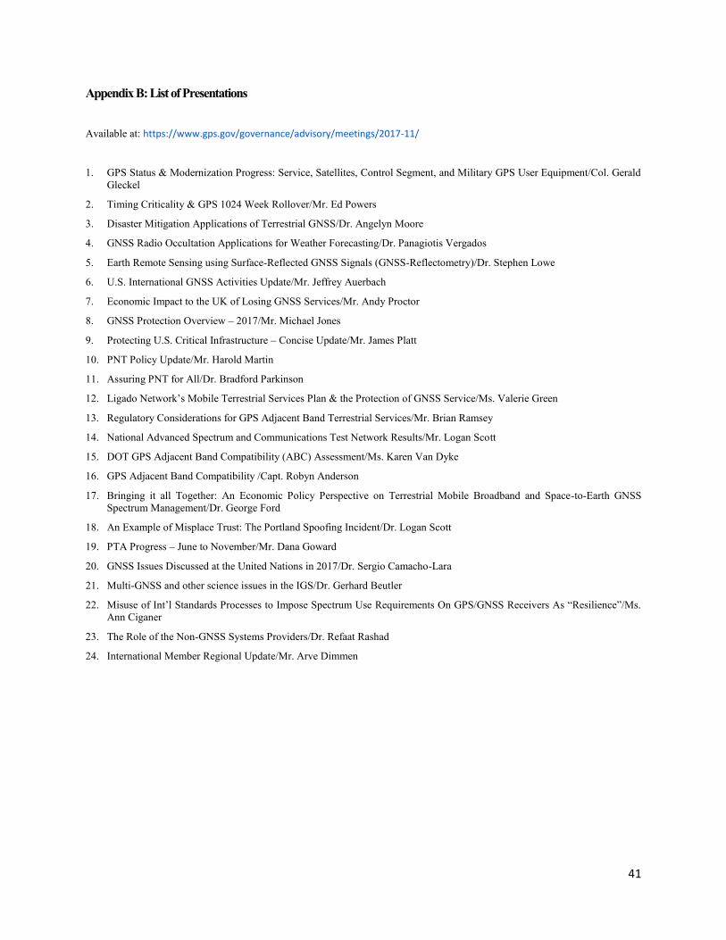
41
Appendix B: List of Presentations
Available at: https://www.gps.gov/governance/advisory/meetings/2017-11/
1. GPS Status & Modernization Progress: Service, Satellites, Control Segment, and Military GPS User Equipment/Col. Gerald
Gleckel
2. Timing Criticality & GPS 1024 Week Rollover/Mr. Ed Powers
3. Disaster Mitigation Applications of Terrestrial GNSS/Dr. Angelyn Moore
4. GNSS Radio Occultation Applications for Weather Forecasting/Dr. Panagiotis Vergados
5. Earth Remote Sensing using Surface-Reflected GNSS Signals (GNSS-Reflectometry)/Dr. Stephen Lowe
6. U.S. International GNSS Activities Update/Mr. Jeffrey Auerbach
7. Economic Impact to the UK of Losing GNSS Services/Mr. Andy Proctor
8. GNSS Protection Overview – 2017/Mr. Michael Jones
9. Protecting U.S. Critical Infrastructure – Concise Update/Mr. James Platt
10. PNT Policy Update/Mr. Harold Martin
11. Assuring PNT for All/Dr. Bradford Parkinson
12. Ligado Network’s Mobile Terrestrial Services Plan & the Protection of GNSS Service/Ms. Valerie Green
13. Regulatory Considerations for GPS Adjacent Band Terrestrial Services/Mr. Brian Ramsey
14. National Advanced Spectrum and Communications Test Network Results/Mr. Logan Scott
15. DOT GPS Adjacent Band Compatibility (ABC) Assessment/Ms. Karen Van Dyke
16. GPS Adjacent Band Compatibility /Capt. Robyn Anderson
17. Bringing it all Together: An Economic Policy Perspective on Terrestrial Mobile Broadband and Space-to-Earth GNSS
Spectrum Management/Dr. George Ford
18. An Example of Misplace Trust: The Portland Spoofing Incident/Dr. Logan Scott
19. PTA Progress – June to November/Mr. Dana Goward
20. GNSS Issues Discussed at the United Nations in 2017/Dr. Sergio Camacho-Lara
21. Multi-GNSS and other science issues in the IGS/Dr. Gerhard Beutler
22. Misuse of Int’l Standards Processes to Impose Spectrum Use Requirements On GPS/GNSS Receivers As “Resilience”/Ms.
Ann Ciganer
23. The Role of the Non-GNSS Systems Providers/Dr. Refaat Rashad
24. International Member Regional Update/Mr. Arve Dimmen

42
Appendix C: Sign-In List
Wednesday, November 15, 2017:
Advisory Board Members:
John Stenbit, Chair
Thad Allen
Penina Axelrad
John Betz
Gerhard Beutler, AIUB
Joe Burns
Ann Ciganer, GPSIA
Arve Dimmen, Norwegian Coastal Administration
Scott Burgett, Garmin
Jim Geringer, ESRI
Matt Higgins, IGNSS
Terry McGurn
Tom Powell, Aerospace (Special Counsel)
Refaat Rashad, Arab Navigation Institute
NASA Personnel:
R. J. Balanga, NASA HQ
Michael Connally, NASA Jet Propulsion Laboratory
Jennifer Donaldson, NASA GSFC
Larry James, NASA Jet Propulsion Laboratory
Paul Kim, NASA Ames
Javier Lecha, NASA
Robert Lilley, Avia Management Association
Stephen Lowe, NASA Jet Propulsion Laboratory
Angelyn Moore, NASA Jet Proposal Laboratory
William Notley, NASA
A.J. Oria, NASA/Overlook
Victor Sparrow, NASA
Panagiotis Vergados, NASA Jet Propulsion Laboratory
Larry Young, NASA Jet Proposal Laboratory
Other Attendees:
Ken Alexander, National Coordination Office
Magbool Aliana, Ligado Networks
Robyn Anderson, U.S. Air Force
Jeffrey Auerbach, Department of State
Jean-Luc Bald, EU Embassy
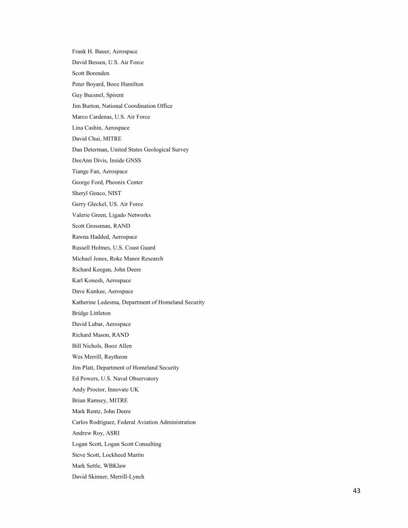
43
Frank H. Bauer, Aerospace
David Bessen, U.S. Air Force
Scott Borenden
Peter Boyard, Booz Hamilton
Guy Buesnel, Spirent
Jim Burton, National Coordination Office
Marco Cardenas, U.S. Air Force
Lina Cashin, Aerospace
David Chui, MITRE
Dan Determan, United States Geological Survey
DeeAnn Divis, Inside GNSS
Tiange Fan, Aerospace
George Ford, Pheonix Center
Sheryl Genco, NIST
Gerry Gleckel, US. Air Force
Valerie Green, Ligado Networks
Scott Grossman, RAND
Rawna Hadded, Aerospace
Russell Holmes, U.S. Coast Guard
Michael Jones, Roke Manor Research
Richard Keegan, John Deere
Karl Konesh, Aerospace
Dave Kunkee, Aerospace
Katherine Ledesma, Department of Homeland Security
Bridge Littleton
David Lubar, Aerospace
Richard Mason, RAND
Bill Nichols, Booz Allen
Wes Merrill, Raytheon
Jim Platt, Department of Homeland Security
Ed Powers, U.S. Naval Observatory
Andy Proctor, Innovate UK
Brian Ramsey, MITRE
Mark Rentz, John Deere
Carlos Rodriguez, Federal Aviation Administration
Andrew Roy, ASRI
Logan Scott, Logan Scott Consulting
Steve Scott, Lockheed Martin
Mark Settle, WBKlaw
David Skinner, Merrill-Lynch

44
Michael Striffolino, Department of Homeland Security
Alex Thein
David Tralli, Aerospace
John Uczekay, Aspen Avionics
Karen Van Dyke, Department of Transportation
Scott Wells, Booz Allen
Dennis Via, Booz Allen
William P. Williams,
David Williamson,
Julian Zamorro, ALPA
Frank Zane, National Coordination Office
Kurt Zimmerman
Thursday, November 16, 2017
Advisory Board Members:
Penina Axelrad
John Betz
Gerhard Beutler, AIUB
Arve Dimmen, Norwegian Coastal Administration
Matt Higgins, IGNSS
Tom Powell (Special Counsel)
Refaat Rashad, Arab Institute of Navigation
NASA Personnel:
R.J. Balanga, NASA
Paul Kim, NASA
Lisa Mazzuca, NASA
William Notley, NASA
Joel Parker, NASA
A.J. Oria, NASA/Overlook
Other Attendees:
Ken Alexander
Robyn Anderson, U.S. Air Force
Jean-Luc Bald, EU Embassy
Frank H. Bauer
David Besson
Guy Buesnel, Spirent
Jim Burton, National Coordination Office
Marco Cardenas, U.S. Air Force
Lina Cashin, Aerospace
Dee Ann Divis, Inside GNSS

45
Gerry Gleckel, U.S. Air Force
Scott Grossman, RAND
Russ Holmes, United States Coast Guard
Kate Ledesma, Department of Homeland Security
Robert Lilley, Avia Management Association
Andy Proctor,
Ed Powers, U.S. Naval Observatory
Brian Ramsey, MITRE
Mark Settle, WBKlaw
Michael Strifolino, Department of Homeland Security
Alex Thain
Karen Van Dyke, Department of Transportation

46
Appendix D: Acronyms & Definitions
€ Euro Currency
£ U.K. Pounds Sterling Currency
$ U.S. Dollar Currency
A$ Australian Dollar Currency
ABC DOT GPS Adjacent Band Compatibility Study
AFSPC Air Force Space Command
AIN Arab Institute of Navigation
APNT Alternate Position, Navigation, and Time
ATC Ancillary Terrestrial Components
ATM Automated Teller Machine
BeiDou China’s GNSS
cm centimeter
COPUOS UN Committee on the Peaceful Uses of Outer Space
COSMIC-2: Constellation Observing System for Meteorology, Ionosphere and Climate -2, also known as COSMIC-
2/FORMOSAT-7, is an international collaboration between Taiwan (NSPO) and the United States (NOAA)
that uses a constellation of six microsatellites to collect atmospheric data for weather prediction and for
ionosphere, climate and gravity research.
Cospas-Sarsat A treaty-based, nonprofit, intergovernmental, humanitarian cooperative nations and agencies dedicated to
detecting and locating radio beacons activated by persons, aircraft or vessels in distress, and forwarding this
alert information to authorities that can take action for rescue.[
CRECTEALC Center for Space Science and Technology Education for Latin America and Caribbean
CYGNSS Cyclone Global Navigation Satellite System
dB decibel
dBW decibel watt
DHS Department of Homeland Security
DME Distance Measuring Equipment
DOC Department of Commerce
DoD Department of Defense
DOS Department of State
DOT Department of Transportation
EIRP Equivalent Isotopically Radiated Power
eLoran Enhanced Loran
ESA European Space Agency
ETSI The European Telecommunications Standards Institute (ETSI) is an independent, not-for-profit,
standardization organization in the telecommunications industry (equipment makers and network operators)
in Europe.
EU European Union
EUR Euro Currency
EXCOM Executive Committee

47
FAA Federal Aviation Administration
FACA Federal Advisory Committee Act
FCC Federal Communications Commission
FEMA Federal Emergency Management Agency
FY Fiscal Year
Galileo European GNSS
GBP U.K. Pounds Sterling Currency
GDP Gross Domestic Product
GHz Gigahertz
GIWG GPS International Working Group (chaired by DOS)
GLONASS Russian GNSS
GNSS Global Navigation Satellite System
GNSS-R GNSS Reflectometry
GPS Global Positioning System
GPS-D GPS Directorate
GPS III GPS Block III SVs 1-10
GPS IIIF GPS Block III SVs 11-32
GPS Week Rollover: To limit the size of the numbers used in the data and calculations the GPS Week Number is a ten-bit count
in the range 0-1023, repeating every 1024 weeks. There are potential issues with some GPS-based equipment
or software that could be confused by the rollover event, which is akin to Y2K issue. The next rollover will
occur at 0000 GPS Time on April 7, 2019, when the GPS week number broadcast by satellites will change
from ‘1023’ to ‘0’. It is the responsibility of the user (i.e., user equipment or software) to account for the
previous 1024 weeks.
GPSIA U.S. GPS Industry Alliance
HPP High Performance Positioning or High Precision Positioning
Hz Hertz
ICAO International Civil Aviation Organization
ICD Interface Control Document
ICG International Committee on GNSS
IDM Interference Detection and Mitigation
IGS International GNSS Service
IMO International Maritime Organization
ION Institute of Navigation
IOT Internet of Things
IPC Interference Protection Criteria
ITS Intelligent Transportation Systems
ITU International Telecommunication Union
JPL NASA Jet Propulsion Laboratory
km kilometer
L1 C/A 1st GPS Civil Signal
L1C 4th GPS Civil Signal (interoperable with Galileo)

48
L2C 2nd GPS Civil Signal (commercial)
L5 3rd GPS Civil Signal (safety-of-life / aviation)
Ligado Ligado Networks is an American satellite communications company developing a satellite-terrestrial network
to support 5th Generation (5G) and IoT applications in North America.
Locata A privately-owned Australian company that has invented new radio-location technology that gives precise
positioning in many environments where GPS is either marginal or unavailable for modern applications.
Loran Long-Range Aid to Navigation (typical refers to the system up through Loran-C, now decommissioned in the
U.S)
LTE 4th Generation Mobile Communications Standard
M-Code GPS encrypted signal
MEOSAR Medium Earth Orbit Search and Rescue
MGUE Military User Equipment
MHz Megahertz
mm millimeter
MOPS FAA Minimum Operational Performance Standards
MSS Mobile Satellite Services
MT-12 WAAS Message Type 12
NASCTN National Advanced Spectrum and Communications Test Network
NASA National Aeronautics and Space Administration
NCO National Coordination Office (located at the Department of Commerce in Washington, D.C.)
NDAA National Defense Authorization Act
NSPD-39 National Security Presidential Directive 39, also known as the U.S. Space-Based Position, Navigation, and
Timing Policy
NTIA National Telecommunications and Information Administration
NWS National Weather Service
OCX Modernized GPS Operational Control System
QZSS Quasi-Zenith Satellite System, Japan’s regional navigation satellite system
PNT Positioning, Navigation, and Timing
PNTAB National Space-Based PNT Advisory Board
PTA Protect, Toughen, and Augment
RNSS Radio Navigation Satellite Service
RTK Real Time Kinematic
RO Radio Occultation
SAR Search and Rescue
SBAS Satellite-Based Augmentation System
SMAP Soil Moisture Active Passive
STSC UN Science and Technology Subcommittee
SV GPS satellite vehicle
TRL Technology Readiness Level
TSOs FAA Technical Standard Orders
TWG Technical Working Group
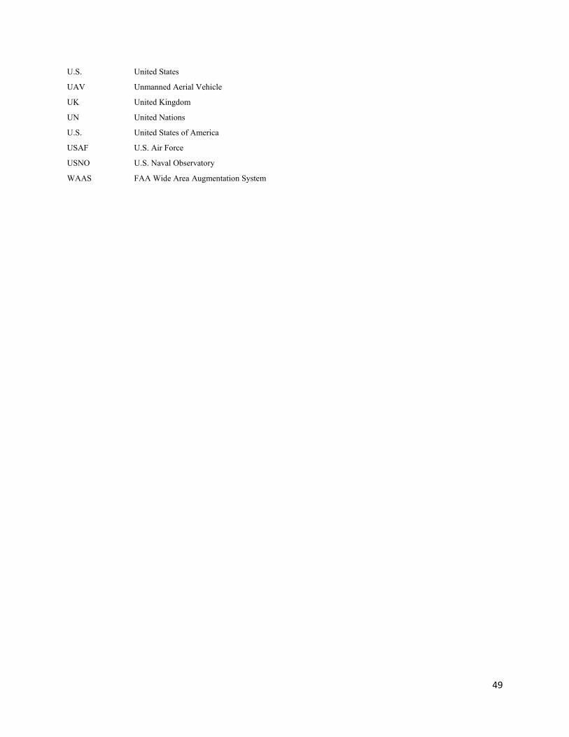
49
U.S. United States
UAV Unmanned Aerial Vehicle
UK United Kingdom
UN United Nations
U.S. United States of America
USAF U.S. Air Force
USNO U.S. Naval Observatory
WAAS FAA Wide Area Augmentation System