Embed Size (px)
Citation preview
17154-01
1
LARK & CREESE
62 Channel Highway, Kingston 7050 Ph 6229 6563 [email protected]
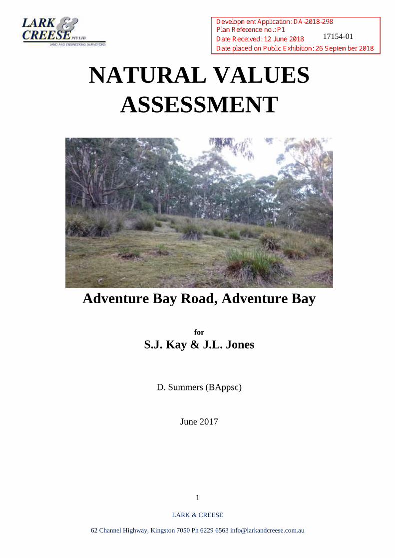
NATURAL VALUES
ASSESSMENT
Adventure Bay Road, Adventure Bay
for
S.J. Kay & J.L. Jones
D. Summers (BAppsc)
June 2017
17154-01
2
LARK & CREESE
62 Channel Highway, Kingston 7050 Ph 6229 6563 [email protected]
Table of Contents
Summary……………………………………………………………………………………. 3
Proposal and Site Description……………………………………………………………... 6
Native Vegetation…………………………………………………………………………... 7
Introduced Plants…………………………………………………………………………... 13
Conservation Values…………………………………………………………………………17
Comment on proposed development ................................................................................... 22
Legislative Implications ........................................................................................................ 24
Conclusions and Recommendations .................................................................................... 26
References .............................................................................................................................. 27
Plant Species List................................................................................................................... 30
17154-01
3
LARK & CREESE
62 Channel Highway, Kingston 7050 Ph 6229 6563 [email protected]
Summary
The following is a natural values assessment of the property 102713/1 Adventure Bay, Bruny
Island C.T. 116307/1, 102713/1 & 102713/2 on behalf of S.J. & J.L. Jones. Currently the
property is zoned Environmental Management under the Kingborough Interim Planning
Scheme 2015 (KIPS2015). This report looks at the potential for visitor accommodation
development and assesses potential short term and long term residual impacts on ecological
functions within and surrounding the proposed site.
Key Findings
Flora
No plant species on Schedules under Commonwealth Environment Protection and
Biodiversity Conservation Act 1999 were found.
The study site within potential range for species listed within Commonwealth
Environment Protection and Biodiversity Conservation Act 1999 however the study site
does not represent suitable habitat.
Study site supports two native vegetation communities as per TASVEG 3.0
o Dry Eucalyptus pulchella forest (DPU), and
o Regenerating dry Eucalyptus ovata woodland (DOV)
DOV is listed as a threatened vegetation community on Schedule 3A of the Tasmania’s
Nature conservation Act 2002.
Fauna
No fauna species on Schedules under Commonwealth Environment Protection and
Biodiversity Conservation Act 1999 were found.
The study site within potential range for species listed within Commonwealth
Environment Protection and Biodiversity Conservation Act 1999. The study represents
potential habitat for nationally endangered bird species such as the Swift parrot and
Forty-spotted Pardalote.
Introduced Plants
One introduced species classified as a ‘Weed of National Significance’ under the
Tasmanian Weed Management Act 1999 was found within the study site.
Two introduced species classified as a ‘declared weed’ under the Tasmanian Weed
Management Act 1999 was found within the study site.
One introduced species that should be considered for listing as an ‘environmental weed’
Discussion
The development has been designed and positioned to minimise the amount of Eucalyptus
ovata and Eucalyptus globulus trees required to be disturbed by locating majority the bushfire
hazard management areas within previously cleared agricultural land.
17154-01
4
LARK & CREESE
62 Channel Highway, Kingston 7050 Ph 6229 6563 [email protected]
E. ovata and E. globulus currently constitute potential foraging resources for the Swift parrot. It
anticipate the development will not result in a significant loss of important existing nesting
habitat for this critically endangered bird species (see Tonia Cochran’s report).
It is also unlikely the proposed development will result in the loss of significant refuge or
critical foraging habitat for individuals or populations of Eastern Quolls. Ad such referral to the
states policy Conservation assessment Branch is not required.
Recommendations
Whilst the final development may not significantly impact threatened fauna species, in the short
term it may temporarily displace other marsupials, birds and reptiles species. Under Table
E10.1 of the KIPS2015 the site is within the Biodiversity Protection Area and due to the
presence of dry Eucalyptus ovata vegetation community the site is classified as having ‘High
Priority Biodiversity Values’. The low impact development does not comply with Acceptable
Solution under the Biodiversity Code E10.7 building or Works. However it appears the
proposal satisfies Performance Criteria P1 c) in that;
• Development sites are limited to proposed sites
• Proposed sites utilise existing modified vegetation whilst elevated bushfire attack level
construction standards minimise impacts on existing high priority vegetation
• Recommendations include implementing best practice hygiene management protocols to
prevent an increase of existing weed species during the construction phase.
• Implement a 5 year weed management plan to control and eradicate Ragwort post
construction to protect and maintain existing high priority biodiversity values on site and
surrounding Fluted Cape National Park. In addition active management of the site will
include undertaking restoration, rehabilitation and revegetation of identified degraded
areas.
• Proposal complies with provision iii) of special circumstances in that the amount of high
priority vegetation requiring removal in insignificant relative to the extent of that
community elsewhere on the property. Amelioration of degraded areas will be undertaken
through revegetation and rehabilitation.
• Removal of high priority vegetation and potential threatened species habitat is
satisfactorily offset in-situ in accordance with Councils Biodiversity Offsets Policy 6.10
and guidelines in Local Planning Approval Process as a Part 5 Agreement formal
vegetation covenant.
• Proposed development including wastewater management is unlikely to lead to an
unacceptable loss of priority biodiversity values and in my opinion will not substantially
compromise or detract from the conservation status of existing biodiversity values in
vicinity of the development.
Additional management prescriptions for proposed development have been recommended to
ensure the retention and protection of existing biodiversity and ecological functions for
threatened and non-threatened marsupial, birds, reptiles and bat species that inhabit the area.
17154-01
5
LARK & CREESE
62 Channel Highway, Kingston 7050 Ph 6229 6563 [email protected]
Management prescriptions to address the construction phase of the development and potential
future land use could include:
• Implement measures to protect Eucalypts retained within proposed development sites and
during construction and upgrade of access in accordance with ‘Protection of trees on
development sites’ (AS 4970-2009).
• In conjunction with soil, water and erosion implement hygiene management prescriptions
to prevent accidental importation of new weed species and Phytophthora cinnamomi
during construction phase and address colonisation post construction.
• Specific management prescriptions within the soil, water and erosion management plan for
all development sites detailing location for soil, waste material storage and parking in
accordance with Tasmanian Washdown Guidelines for Weed and Disease Control:
Machinery, Vehicles and Equipment (Edition 1, 2004).
• Stage development to avoid blanket clearance when undertaking earthworks within the
designated development sites.
• Identify appropriate storage sites for soil and implement appropriate management
mechanisms to avoid mobilisation of sediment
• Avoid any unnecessary traffic outside the development envelope particularly when
constructing access for 102713/2
17154-01
6
LARK & CREESE
62 Channel Highway, Kingston 7050 Ph 6229 6563 [email protected]
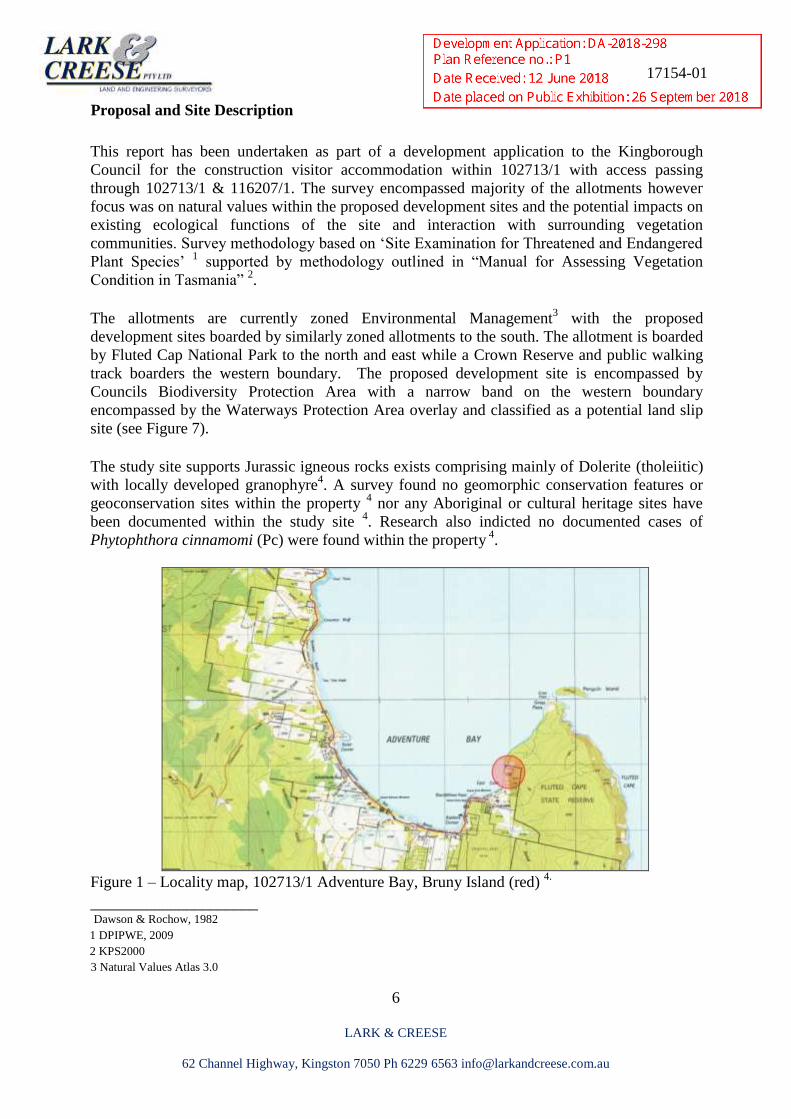
Proposal and Site Description
This report has been undertaken as part of a development application to the Kingborough
Council for the construction visitor accommodation within 102713/1 with access passing
through 102713/1 & 116207/1. The survey encompassed majority of the allotments however
focus was on natural values within the proposed development sites and the potential impacts on
existing ecological functions of the site and interaction with surrounding vegetation
communities. Survey methodology based on ‘Site Examination for Threatened and Endangered
Plant Species’ 1 supported by methodology outlined in “Manual for Assessing Vegetation
Condition in Tasmania” 2.
The allotments are currently zoned Environmental Management3 with the proposed
development sites boarded by similarly zoned allotments to the south. The allotment is boarded
by Fluted Cap National Park to the north and east while a Crown Reserve and public walking
track boarders the western boundary. The proposed development site is encompassed by
Councils Biodiversity Protection Area with a narrow band on the western boundary
encompassed by the Waterways Protection Area overlay and classified as a potential land slip
site (see Figure 7).
The study site supports Jurassic igneous rocks exists comprising mainly of Dolerite (tholeiitic)
with locally developed granophyre4. A survey found no geomorphic conservation features or
geoconservation sites within the property 4 nor any Aboriginal or cultural heritage sites have
been documented within the study site 4. Research also indicted no documented cases of
Phytophthora cinnamomi (Pc) were found within the property 4
.
Figure 1 – Locality map, 102713/1 Adventure Bay, Bruny Island (red)
4.
_____________________ Dawson & Rochow, 1982 1 DPIPWE, 2009 2 KPS2000 3 Natural Values Atlas 3.0
17154-01
7
LARK & CREESE
62 Channel Highway, Kingston 7050 Ph 6229 6563 [email protected]
Native Vegetation
The report assesses flora and fauna values within the study site with specific focus on possible
negative impacts to existing threatened vegetation communities and threatened species habitat.
No vascular plant species of national conservation significance, listed in the Commonwealth
Environment Protection & Biodiversity Conservation Act 1999 was recorded on site. No
vascular plant species listed under Schedule 3, 4 or 5 of the Threatened Species Protection Act
1995 was recorded on site 5. 23 native plant species were recorded – refer to Appendix A.
a), b)
c)
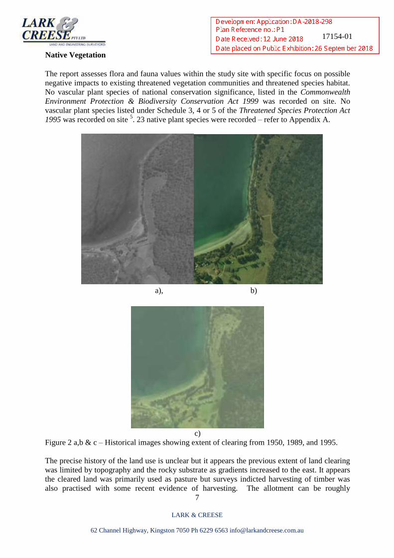
Figure 2 a,b & c – Historical images showing extent of clearing from 1950, 1989, and 1995.
The precise history of the land use is unclear but it appears the previous extent of land clearing
was limited by topography and the rocky substrate as gradients increased to the east. It appears
the cleared land was primarily used as pasture but surveys indicted harvesting of timber was
also practised with some recent evidence of harvesting. The allotment can be roughly
17154-01
8
LARK & CREESE
62 Channel Highway, Kingston 7050 Ph 6229 6563 [email protected]
delineated by the western boundary of DPU vegetation community that approximately
represents the extent of previous clearing and an increase in gradient to the east (see above)
Tasveg 3.0 classify the linear strip of land adjacent to dry Eucalyptus globulus veg community
as Agricultural land with the remaining land to the east classified as Regenerating land. Since
my first visit in 2015 a rough access road had been constructed within the previous footprint of
an old service track. The majority of the land in this half is dominated by a mosaic of sedges,
rushes, bracken fern and old pasture. Scattered young eucalypts and wattles emerge from larger
more established clumps of sedges with cleared grassy areas consisting of a mix of native and
exotics that appear to be heavily grazed by wildlife.
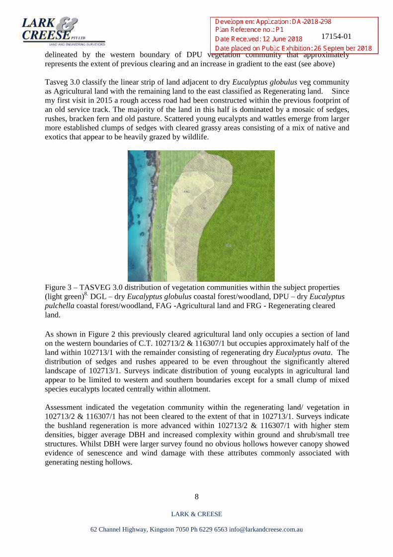
Figure 3 – TASVEG 3.0 distribution of vegetation communities within the subject properties
(light green)8.
DGL – dry Eucalyptus globulus coastal forest/woodland, DPU – dry Eucalyptus
pulchella coastal forest/woodland, FAG -Agricultural land and FRG - Regenerating cleared
land.
As shown in Figure 2 this previously cleared agricultural land only occupies a section of land
on the western boundaries of C.T. 102713/2 & 116307/1 but occupies approximately half of the
land within 102713/1 with the remainder consisting of regenerating dry Eucalyptus ovata. The
distribution of sedges and rushes appeared to be even throughout the significantly altered
landscape of 102713/1. Surveys indicate distribution of young eucalypts in agricultural land
appear to be limited to western and southern boundaries except for a small clump of mixed
species eucalypts located centrally within allotment.
Assessment indicated the vegetation community within the regenerating land/ vegetation in
102713/2 & 116307/1 has not been cleared to the extent of that in 102713/1. Surveys indicate
the bushland regeneration is more advanced within 102713/2 & 116307/1 with higher stem
densities, bigger average DBH and increased complexity within ground and shrub/small tree
structures. Whilst DBH were larger survey found no obvious hollows however canopy showed
evidence of senescence and wind damage with these attributes commonly associated with
generating nesting hollows.
17154-01
9
LARK & CREESE
62 Channel Highway, Kingston 7050 Ph 6229 6563 [email protected]
Surveys appear to indicate the larger eucalypts within Agricultural and regenerating dry
Eucalyptus ovata vegetation community are part of a recruitment cohort but unclear if the
process was driven by an episodic event. Given the cessation of previous land management
practices it also appears the existing on-going recruitment of woody species could be classified
as continuous. Recruitment of woody species such as small/tall shrubs appeared to be limited
and deficient in comparison to typical benchmarks species (≥ 50%) associated with existing
vegetation communities present. Given the previous land use, level of modification within the
site and regenerating status persistence potential of the site is considered medium in that:
Natural regeneration has been modified through previous land use and as such capacity
is restricted
Natural species provide more than half the cover in all vegetation layers however some
benchmark species are absent
Weed species present including high threat species such as Ragwort
Tussocks and shrubs provide habitat for smaller species to germinate and survive.
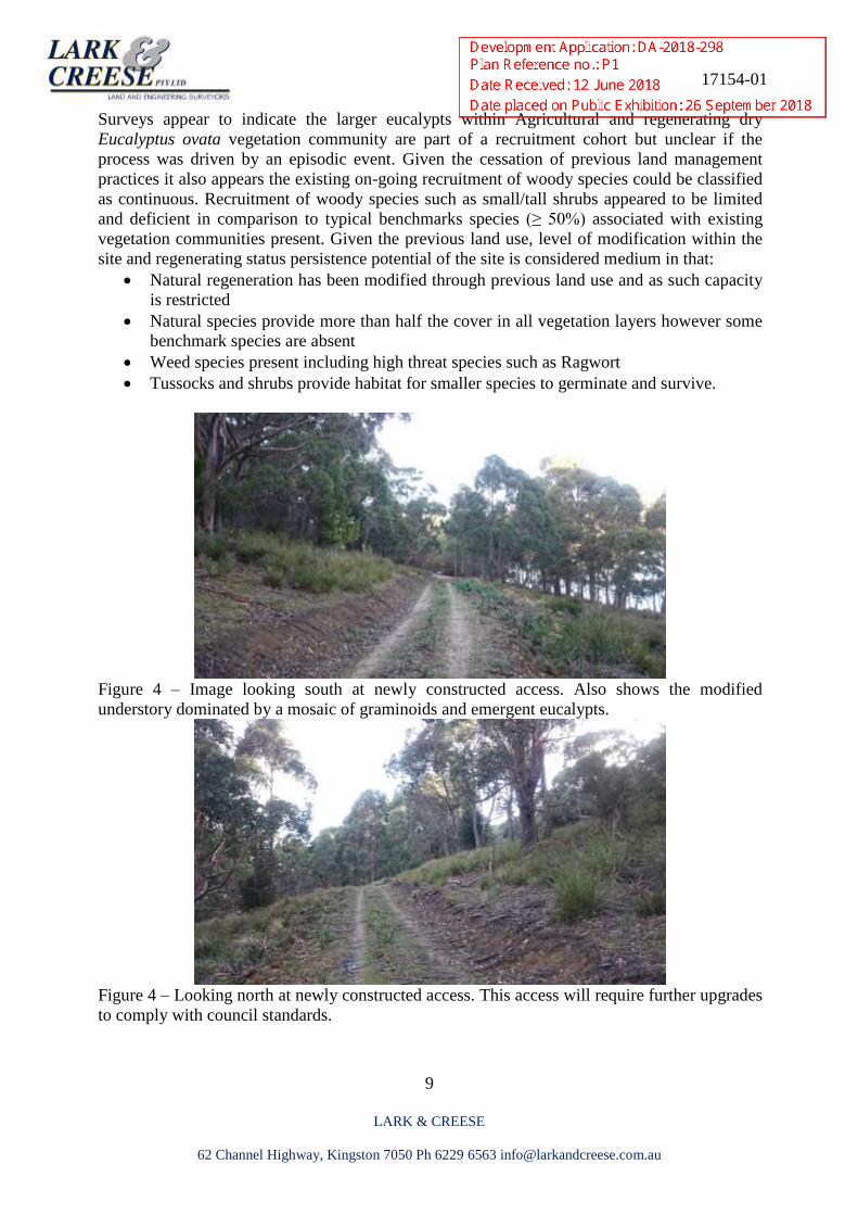
Figure 4 – Image looking south at newly constructed access. Also shows the modified
understory dominated by a mosaic of graminoids and emergent eucalypts.
Figure 4 – Looking north at newly constructed access. This access will require further upgrades
to comply with council standards.
17154-01
10
LARK & CREESE
62 Channel Highway, Kingston 7050 Ph 6229 6563 [email protected]
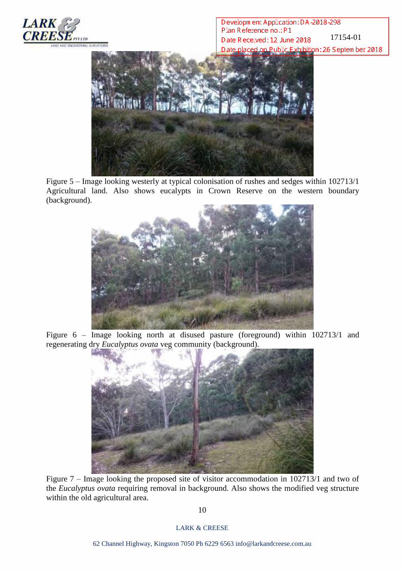
Figure 5 – Image looking westerly at typical colonisation of rushes and sedges within 102713/1
Agricultural land. Also shows eucalypts in Crown Reserve on the western boundary
(background).
Figure 6 – Image looking north at disused pasture (foreground) within 102713/1 and
regenerating dry Eucalyptus ovata veg community (background).
Figure 7 – Image looking the proposed site of visitor accommodation in 102713/1 and two of
the Eucalyptus ovata requiring removal in background. Also shows the modified veg structure
within the old agricultural area.
17154-01
11
LARK & CREESE
62 Channel Highway, Kingston 7050 Ph 6229 6563 [email protected]
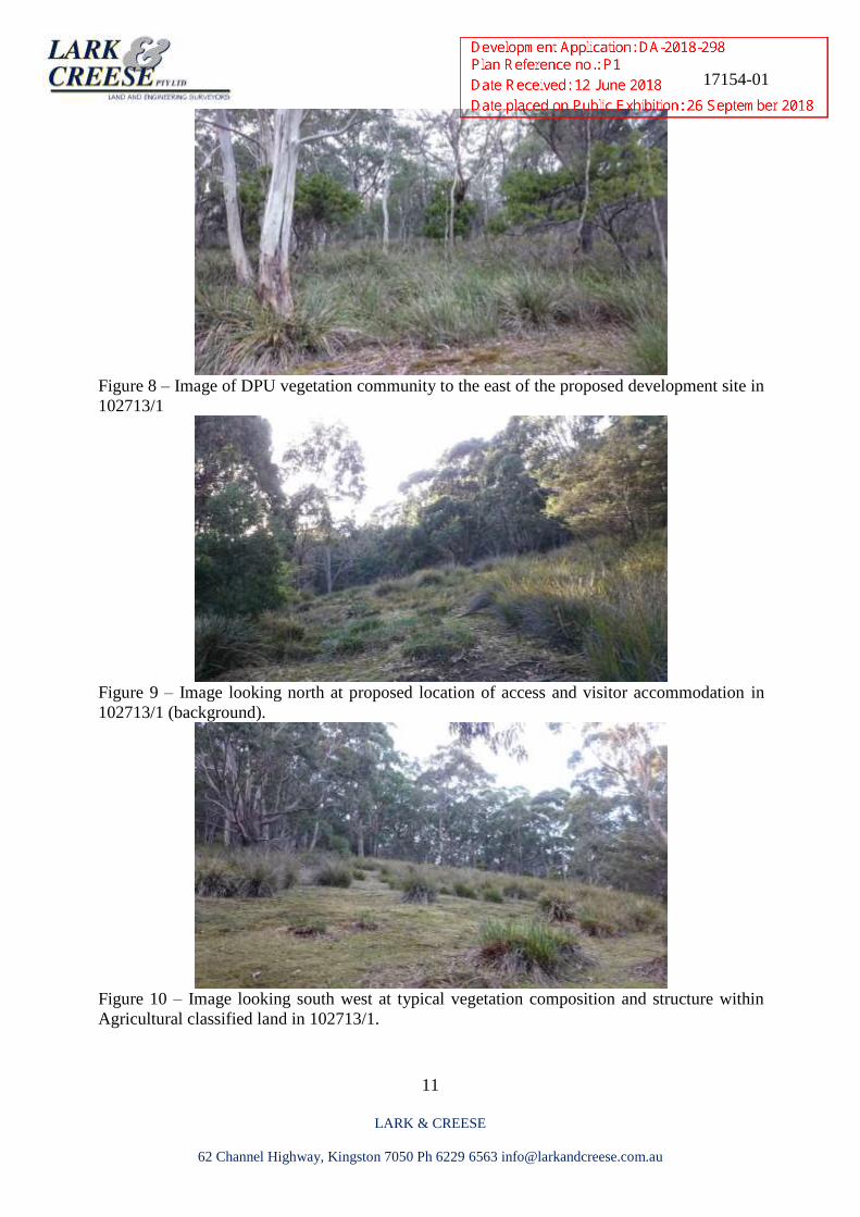
Figure 8 – Image of DPU vegetation community to the east of the proposed development site in
102713/1
Figure 9 – Image looking north at proposed location of access and visitor accommodation in
102713/1 (background).
Figure 10 – Image looking south west at typical vegetation composition and structure within
Agricultural classified land in 102713/1.
17154-01
12
LARK & CREESE
62 Channel Highway, Kingston 7050 Ph 6229 6563 [email protected]
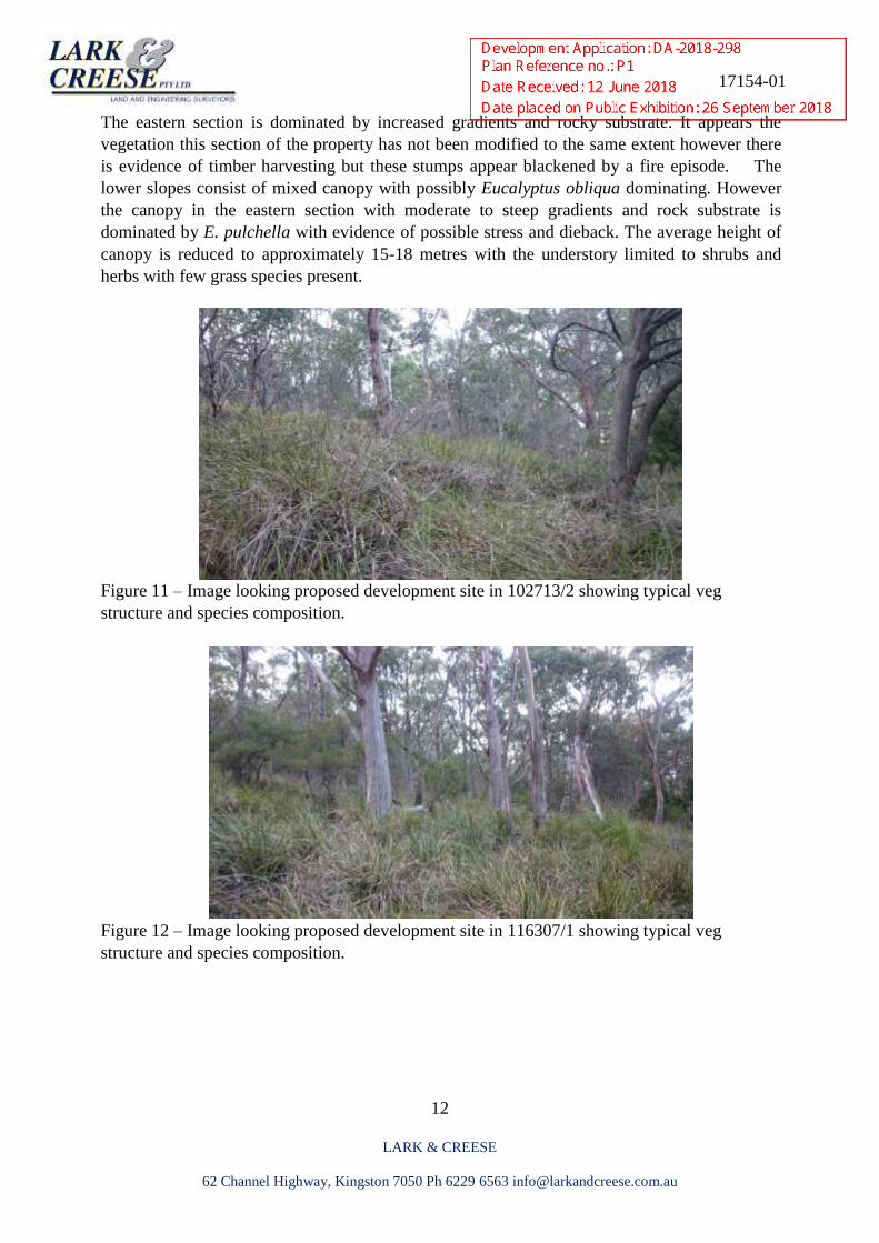
The eastern section is dominated by increased gradients and rocky substrate. It appears the
vegetation this section of the property has not been modified to the same extent however there
is evidence of timber harvesting but these stumps appear blackened by a fire episode. The
lower slopes consist of mixed canopy with possibly Eucalyptus obliqua dominating. However
the canopy in the eastern section with moderate to steep gradients and rock substrate is
dominated by E. pulchella with evidence of possible stress and dieback. The average height of
canopy is reduced to approximately 15-18 metres with the understory limited to shrubs and
herbs with few grass species present.
Figure 11 – Image looking proposed development site in 102713/2 showing typical veg
structure and species composition.
Figure 12 – Image looking proposed development site in 116307/1 showing typical veg
structure and species composition.
17154-01
13
LARK & CREESE
62 Channel Highway, Kingston 7050 Ph 6229 6563 [email protected]
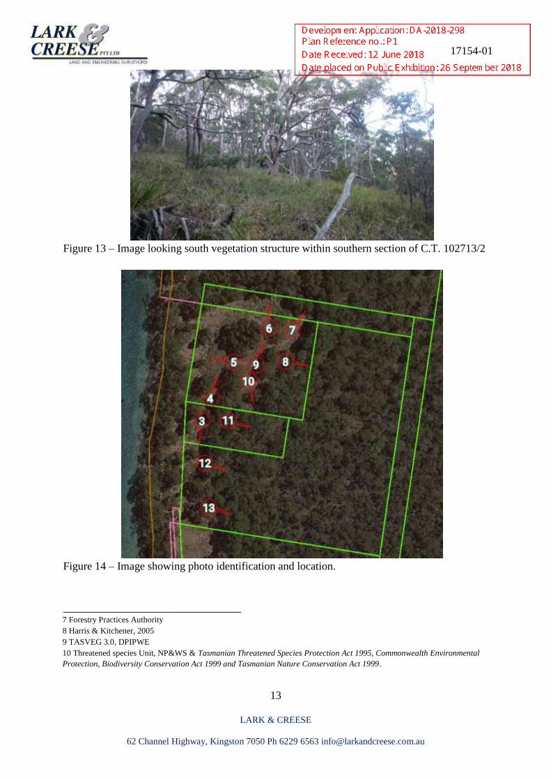
Figure 13 – Image looking south vegetation structure within southern section of C.T. 102713/2
Figure 14 – Image showing photo identification and location.
________________________________ 7 Forestry Practices Authority 8 Harris & Kitchener, 2005 9 TASVEG 3.0, DPIPWE 10 Threatened species Unit, NP&WS & Tasmanian Threatened Species Protection Act 1995, Commonwealth Environmental
Protection, Biodiversity Conservation Act 1999 and Tasmanian Nature Conservation Act 1999.
17154-01
14
LARK & CREESE
62 Channel Highway, Kingston 7050 Ph 6229 6563 [email protected]
Introduced Plants
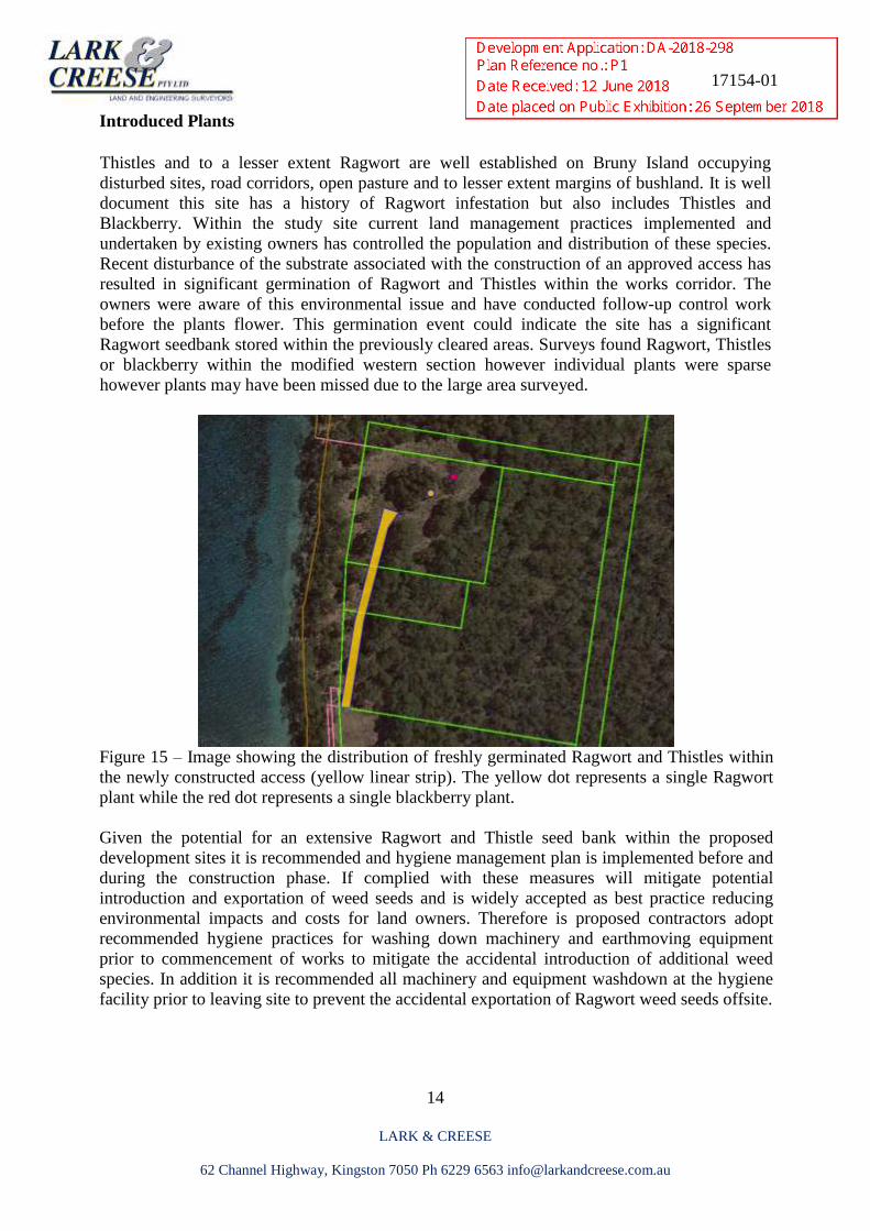
Thistles and to a lesser extent Ragwort are well established on Bruny Island occupying
disturbed sites, road corridors, open pasture and to lesser extent margins of bushland. It is well
document this site has a history of Ragwort infestation but also includes Thistles and
Blackberry. Within the study site current land management practices implemented and
undertaken by existing owners has controlled the population and distribution of these species.
Recent disturbance of the substrate associated with the construction of an approved access has
resulted in significant germination of Ragwort and Thistles within the works corridor. The
owners were aware of this environmental issue and have conducted follow-up control work
before the plants flower. This germination event could indicate the site has a significant
Ragwort seedbank stored within the previously cleared areas. Surveys found Ragwort, Thistles
or blackberry within the modified western section however individual plants were sparse
however plants may have been missed due to the large area surveyed.
Figure 15 – Image showing the distribution of freshly germinated Ragwort and Thistles within
the newly constructed access (yellow linear strip). The yellow dot represents a single Ragwort
plant while the red dot represents a single blackberry plant.
Given the potential for an extensive Ragwort and Thistle seed bank within the proposed
development sites it is recommended and hygiene management plan is implemented before and
during the construction phase. If complied with these measures will mitigate potential
introduction and exportation of weed seeds and is widely accepted as best practice reducing
environmental impacts and costs for land owners. Therefore is proposed contractors adopt
recommended hygiene practices for washing down machinery and earthmoving equipment
prior to commencement of works to mitigate the accidental introduction of additional weed
species. In addition it is recommended all machinery and equipment washdown at the hygiene
facility prior to leaving site to prevent the accidental exportation of Ragwort weed seeds offsite.
17154-01
15
LARK & CREESE
62 Channel Highway, Kingston 7050 Ph 6229 6563 [email protected]
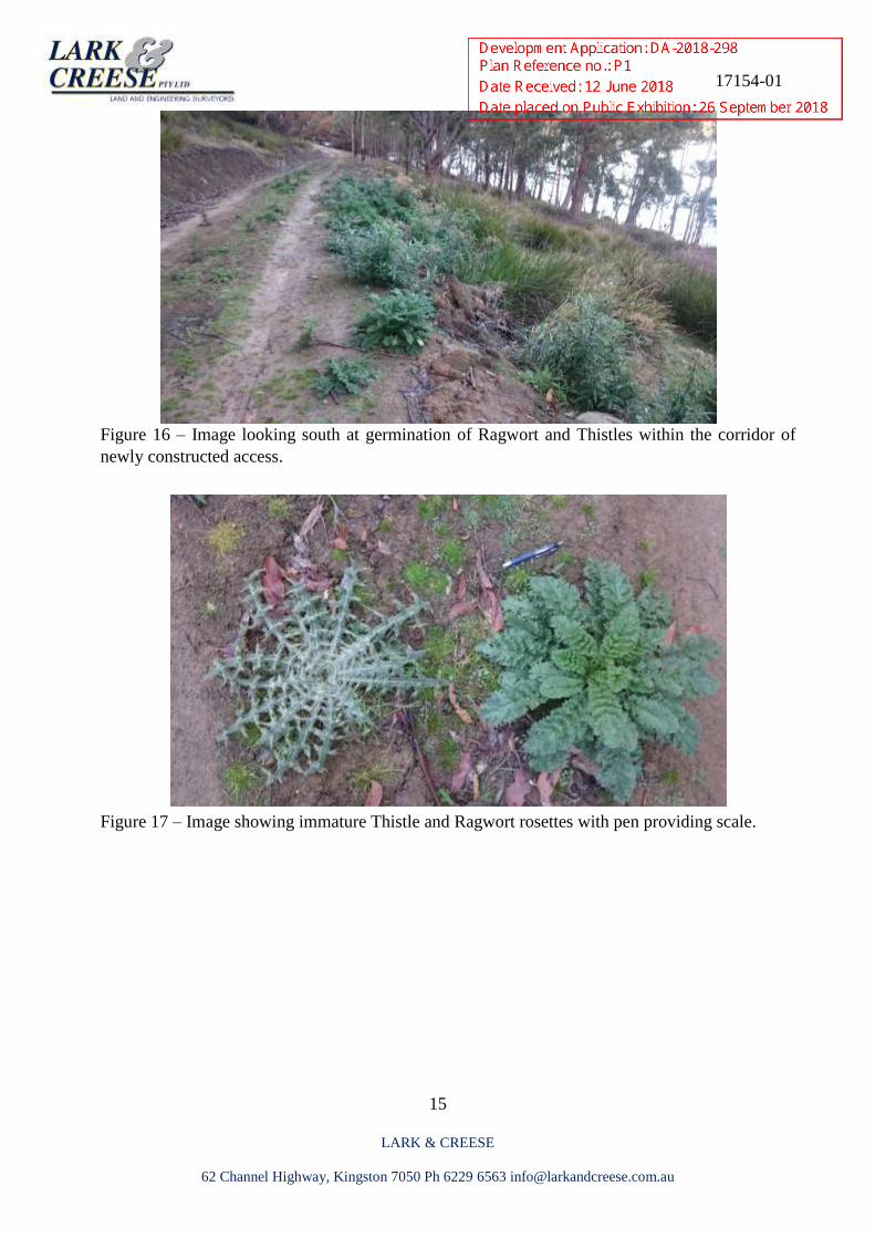
Figure 16 – Image looking south at germination of Ragwort and Thistles within the corridor of
newly constructed access.
Figure 17 – Image showing immature Thistle and Ragwort rosettes with pen providing scale.
17154-01
16
LARK & CREESE
62 Channel Highway, Kingston 7050 Ph 6229 6563 [email protected]
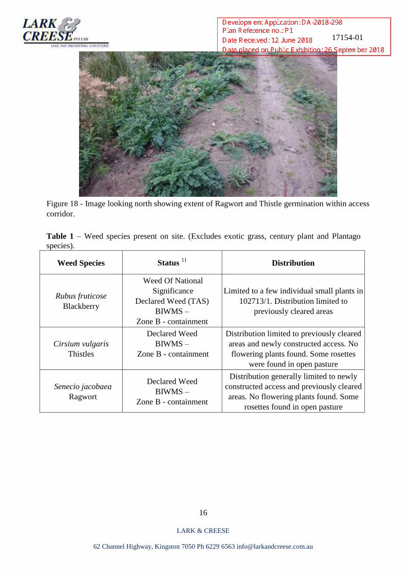
Figure 18 - Image looking north showing extent of Ragwort and Thistle germination within access
corridor.
Table 1 – Weed species present on site. (Excludes exotic grass, century plant and Plantago
species).
Weed Species Status 11
Distribution
Rubus fruticose
Blackberry
Weed Of National
Significance
Declared Weed (TAS)
BIWMS –
Zone B - containment
Limited to a few individual small plants in
102713/1. Distribution limited to
previously cleared areas
Cirsium vulgaris
Thistles
Declared Weed
BIWMS –
Zone B - containment
Distribution limited to previously cleared
areas and newly constructed access. No
flowering plants found. Some rosettes
were found in open pasture
Senecio jacobaea
Ragwort
Declared Weed
BIWMS –
Zone B - containment
Distribution generally limited to newly
constructed access and previously cleared
areas. No flowering plants found. Some
rosettes found in open pasture
17154-01
17
LARK & CREESE
62 Channel Highway, Kingston 7050 Ph 6229 6563 [email protected]
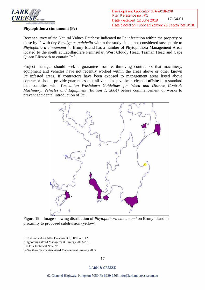
Phytophthora cinnamomi (Pc)
Recent survey of the Natural Values Database indicated no Pc infestation within the property or
close by 14
with dry Eucalyptus pulchella within the study site is not considered susceptible to
Phytophthora cinnamomi 13
. Bruny Island has a number of Phytophthora Management Areas
located to the south at Labillardiere Peninsular, West Cloudy Head, Tasman Head and Cape
Queen Elizabeth to contain Pc9.
Project manager should seek a guarantee from earthmoving contractors that machinery,
equipment and vehicles have not recently worked within the areas above or other known
Pc infested areas. If contractors have been exposed to management areas listed above
contractor should provide guarantees that all vehicles have been cleaned offsite to a standard
that complies with Tasmanian Washdown Guidelines for Weed and Disease Control:
Machinery, Vehicles and Equipment (Edition 1, 2004) before commencement of works to
prevent accidental introduction of Pc.
Figure 19 – Image showing distribution of Phytophthora cinnamomi on Bruny Island in
proximity to proposed subdivision (yellow).
___________________
11 Natural Values Atlas Database 3.0, DPIPWE 12
Kingborough Weed Management Strategy 2013-2018
13 Flora Technical Note No. 8. 14 Southern Tasmanian Weed Management Strategy 2005
17154-01
18
LARK & CREESE
62 Channel Highway, Kingston 7050 Ph 6229 6563 [email protected]
Conservation Values
Historical images indicate the area had been cleared of native veg as far back as 1920 and
remained clear until 1950’s. The area supports an area of modified but regenerating dry
Eucalyptus ovata eucalypt veg community and provides potential foraging habitat for the
critically endangered Swift parrot. Survey of eucalypt species within the previously cleared site
found Eucalyptus globulus, E. ovata and to a lesser extent E. obliqua are common in the poorly
drained western areas with shallow soil.
Studies have found it is the distribution and intensity of E. globulus flowering, rather than the
location of the nesting hollows, that largely determines the distribution of nesting swift parrots.
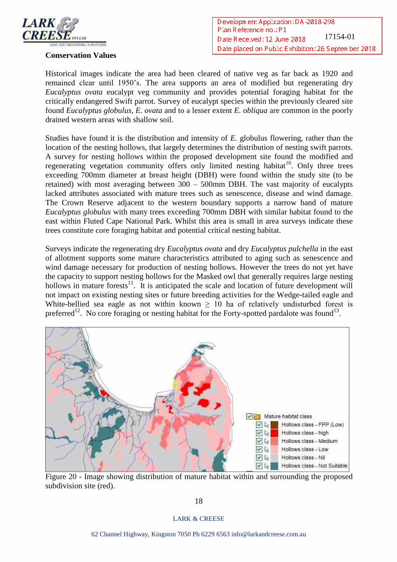
A survey for nesting hollows within the proposed development site found the modified and
regenerating vegetation community offers only limited nesting habitat10
. Only three trees
exceeding 700mm diameter at breast height (DBH) were found within the study site (to be
retained) with most averaging between 300 – 500mm DBH. The vast majority of eucalypts
lacked attributes associated with mature trees such as senescence, disease and wind damage.
The Crown Reserve adjacent to the western boundary supports a narrow band of mature
Eucalyptus globulus with many trees exceeding 700mm DBH with similar habitat found to the
east within Fluted Cape National Park. Whilst this area is small in area surveys indicate these
trees constitute core foraging habitat and potential critical nesting habitat.
Surveys indicate the regenerating dry Eucalyptus ovata and dry Eucalyptus pulchella in the east
of allotment supports some mature characteristics attributed to aging such as senescence and
wind damage necessary for production of nesting hollows. However the trees do not yet have
the capacity to support nesting hollows for the Masked owl that generally requires large nesting
hollows in mature forests11
. It is anticipated the scale and location of future development will
not impact on existing nesting sites or future breeding activities for the Wedge-tailed eagle and
White-bellied sea eagle as not within known ≥ 10 ha of relatively undisturbed forest is
preferred12
. No core foraging or nesting habitat for the Forty-spotted pardalote was found13
.
Figure 20 - Image showing distribution of mature habitat within and surrounding the proposed
subdivision site (red).
17154-01
19
LARK & CREESE
62 Channel Highway, Kingston 7050 Ph 6229 6563 [email protected]
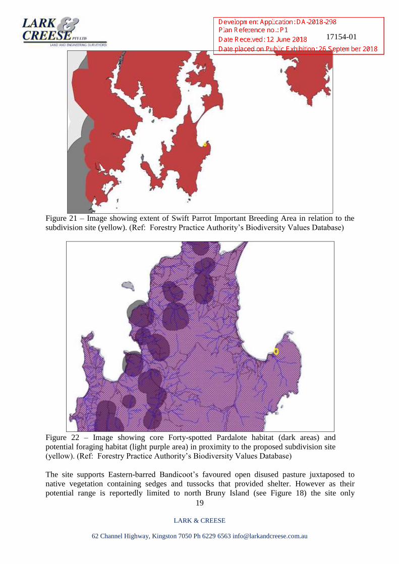
Figure 21 – Image showing extent of Swift Parrot Important Breeding Area in relation to the
subdivision site (yellow). (Ref: Forestry Practice Authority’s Biodiversity Values Database)
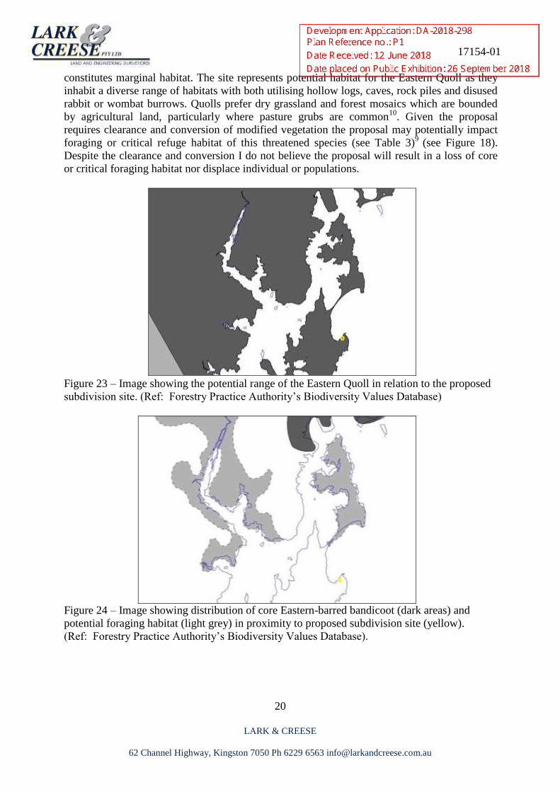
Figure 22 – Image showing core Forty-spotted Pardalote habitat (dark areas) and
potential foraging habitat (light purple area) in proximity to the proposed subdivision site
(yellow). (Ref: Forestry Practice Authority’s Biodiversity Values Database)
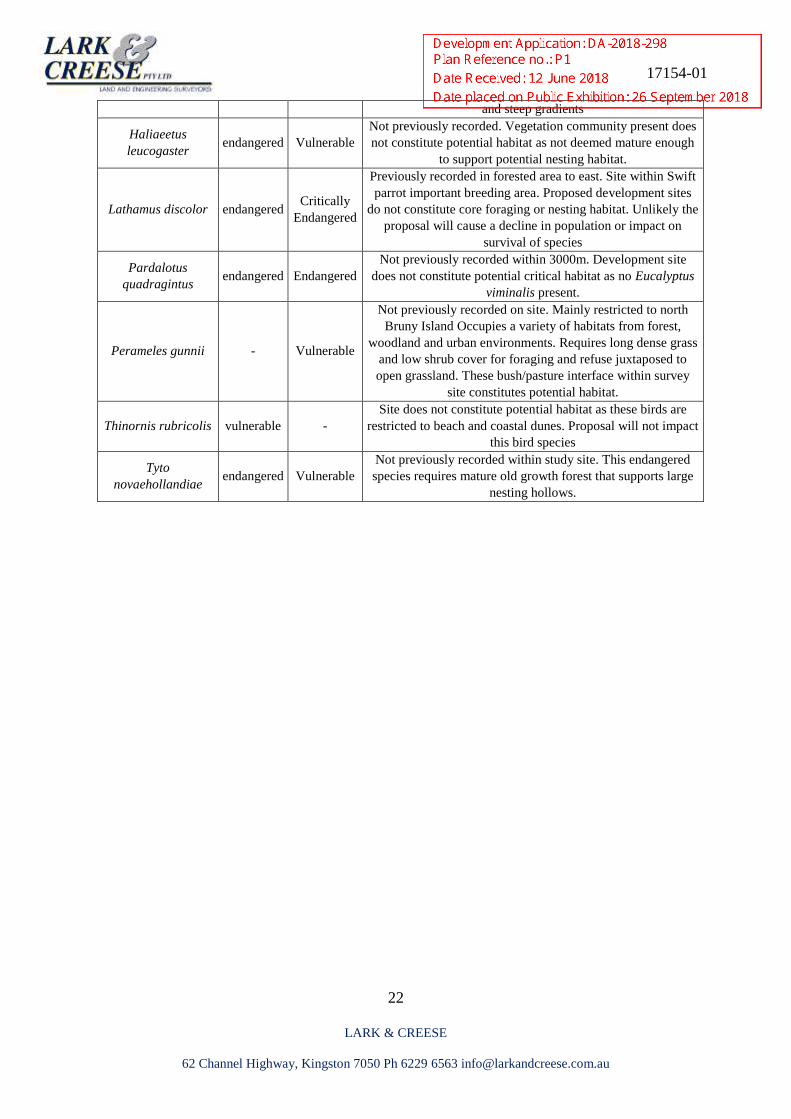
The site supports Eastern-barred Bandicoot’s favoured open disused pasture juxtaposed to
native vegetation containing sedges and tussocks that provided shelter. However as their
potential range is reportedly limited to north Bruny Island (see Figure 18) the site only
17154-01
20
LARK & CREESE
62 Channel Highway, Kingston 7050 Ph 6229 6563 [email protected]
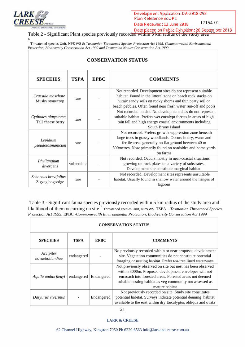
constitutes marginal habitat. The site represents potential habitat for the Eastern Quoll as they
inhabit a diverse range of habitats with both utilising hollow logs, caves, rock piles and disused
rabbit or wombat burrows. Quolls prefer dry grassland and forest mosaics which are bounded
by agricultural land, particularly where pasture grubs are common10
. Given the proposal
requires clearance and conversion of modified vegetation the proposal may potentially impact
foraging or critical refuge habitat of this threatened species (see Table 3)9
(see Figure 18).
Despite the clearance and conversion I do not believe the proposal will result in a loss of core
or critical foraging habitat nor displace individual or populations.
Figure 23 – Image showing the potential range of the Eastern Quoll in relation to the proposed
subdivision site. (Ref: Forestry Practice Authority’s Biodiversity Values Database)
Figure 24 – Image showing distribution of core Eastern-barred bandicoot (dark areas) and
potential foraging habitat (light grey) in proximity to proposed subdivision site (yellow).
(Ref: Forestry Practice Authority’s Biodiversity Values Database).
17154-01
21
LARK & CREESE
62 Channel Highway, Kingston 7050 Ph 6229 6563 [email protected]
Table 2 - Significant Plant species previously recorded within 5 km radius of the study area 5 &
6 Threatened species Unit, NP&WS & Tasmanian Threatened Species Protection Act 1995, Commonwealth Environmental
Protection, Biodiversity Conservation Act 1999 and Tasmanian Nature Conservation Act 1999.
CONSERVATION STATUS
SPECEIES TSPA EPBC COMMENTS
Crassula moschate
Musky stonecrop rare -
Not recorded. Development sites do not represent suitable
habitat. Found in the littoral zone on beach rock stacks on
humic sandy soils on rocky shores and thin peaty soil on
beach pebbles. Often found near fresh water run-off and pools
Cythodes platystoma
Tall cheese berry rare -
Not recorded on site. No development sites do not represent
suitable habitat. Prefers wet eucalypt forests in areas of high
rain fall and high energy coastal environments including
South Bruny Island
Lepidium
pseudotasmanicum rare -
Not recorded. Prefers growth suppression zone beneath
large trees in grassy woodlands. Occurs in dry, warm and
fertile areas generally on flat ground between 40 to
500metres. Now primarily found on roadsides and home yards
on farms
Phyllangium
divergens vulnerable -
Not recorded. Occurs mostly in near-coastal situations
growing on rock plates on a variety of substrates.
Development site constitute marginal habitat.
Schoenus brevifolius
Zigzag bogsedge rare -
Not recorded. Development sites represents unsuitable
habitat. Usually found in shallow water around the fringes of
lagoons
Table 3 - Significant fauna species previously recorded within 5 km radius of the study area and
likelihood of them occurring on site13
Threatened species Unit, NP&WS. TSPA - Tasmanian Threatened Species
Protection Act 1995, EPBC -Commonwealth Environmental Protection, Biodiversity Conservation Act 1999
CONSERVATION STATUS
SPECEIES
TSPA EPBC COMMENTS
Accipiter
novaehollandiae endangered -
No previously recorded within or near proposed development
site. Vegetation communities do not constitute potential
foraging or nesting habitat. Prefer tea-tree lined waterways
Aquila audax fleayi endangered Endangered
Not previously observed on site but nest has been observed
within 3000m. Proposed development envelopes will not
encroach into forested areas. Forested areas not deemed
suitable nesting habitat as veg community not assessed as
mature habitat
Dasyurus viverinus - Endangered
Not previously recorded on site. Study site constitutes
potential habitat. Surveys indicate potential denning habitat
available to the east within dry Eucalyptus obliqua and ovata
17154-01
22
LARK & CREESE
62 Channel Highway, Kingston 7050 Ph 6229 6563 [email protected]
and steep gradients
Haliaeetus
leucogaster endangered Vulnerable
Not previously recorded. Vegetation community present does
not constitute potential habitat as not deemed mature enough
to support potential nesting habitat.
Lathamus discolor endangered Critically
Endangered
Previously recorded in forested area to east. Site within Swift
parrot important breeding area. Proposed development sites
do not constitute core foraging or nesting habitat. Unlikely the
proposal will cause a decline in population or impact on
survival of species
Pardalotus
quadragintus endangered Endangered
Not previously recorded within 3000m. Development site
does not constitute potential critical habitat as no Eucalyptus
viminalis present.
Perameles gunnii - Vulnerable
Not previously recorded on site. Mainly restricted to north
Bruny Island Occupies a variety of habitats from forest,
woodland and urban environments. Requires long dense grass
and low shrub cover for foraging and refuse juxtaposed to
open grassland. These bush/pasture interface within survey
site constitutes potential habitat.
Thinornis rubricolis vulnerable -
Site does not constitute potential habitat as these birds are
restricted to beach and coastal dunes. Proposal will not impact
this bird species
Tyto
novaehollandiae endangered Vulnerable
Not previously recorded within study site. This endangered
species requires mature old growth forest that supports large
nesting hollows.
17154-01
23
LARK & CREESE
62 Channel Highway, Kingston 7050 Ph 6229 6563 [email protected]
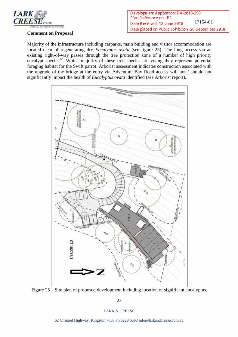
Comment on Proposal
Majority of the infrastructure including carparks, main building and visitor accommodation are
located clear of regenerating dry Eucalyptus ovata (see figure 25). The long access via an
existing right-of-way passes through the tree protection zone of a number of high priority
eucalypt species12
. Whilst majority of these tree species are young they represent potential
foraging habitat for the Swift parrot. Arborist assessment indicates construction associated with
the upgrade of the bridge at the entry via Adventure Bay Road access will not / should not
significantly impact the health of Eucalyptus ovata identified (see Arborist report).
Figure 25 – Site plan of proposed development including location of significant eucalyptus.
17154-01
24
LARK & CREESE
62 Channel Highway, Kingston 7050 Ph 6229 6563 [email protected]
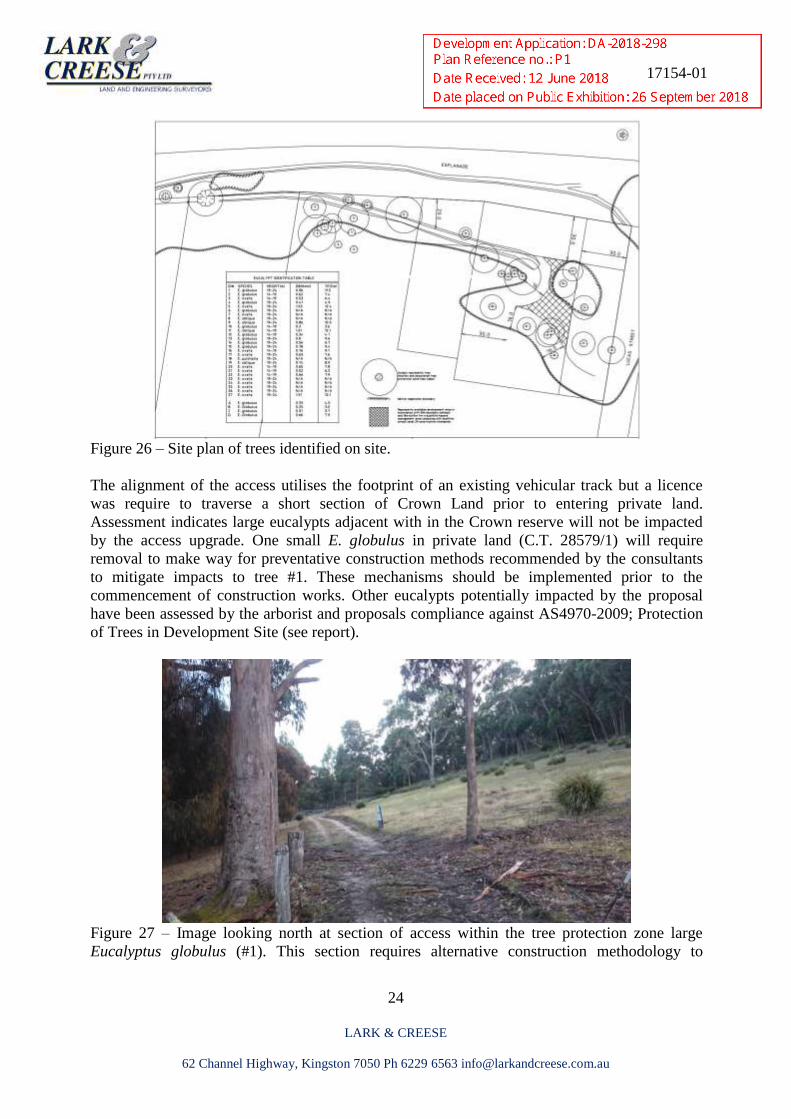
Figure 26 – Site plan of trees identified on site.
The alignment of the access utilises the footprint of an existing vehicular track but a licence
was require to traverse a short section of Crown Land prior to entering private land.
Assessment indicates large eucalypts adjacent with in the Crown reserve will not be impacted
by the access upgrade. One small E. globulus in private land (C.T. 28579/1) will require
removal to make way for preventative construction methods recommended by the consultants
to mitigate impacts to tree #1. These mechanisms should be implemented prior to the
commencement of construction works. Other eucalypts potentially impacted by the proposal
have been assessed by the arborist and proposals compliance against AS4970-2009; Protection
of Trees in Development Site (see report).
Figure 27 – Image looking north at section of access within the tree protection zone large
Eucalyptus globulus (#1). This section requires alternative construction methodology to
17154-01
25
LARK & CREESE
62 Channel Highway, Kingston 7050 Ph 6229 6563 [email protected]
mitigate compaction damage to roots and allow for transfer of water and gasses. The small E.
globulus on the right will require removal (see arborist report).
In line with arborist recommendations access construction methodology will raise the level of
existing natural surface level to avoid further disturbance of tree roots upslope. The new right-
of-way access runs parallel with the western boundary passing through private allotments prior
to entering the clients land. It is proposed runoff generated from the access will be dispersed
into a series of absorption trenches however for the first half of the access these trenches will
be located in Crown Land. Advice indicates a licence is required for this activity but anticipated
the alterations to drainage and hydrology will not result in long term residual impacts on the
health of trees and vegetation within the Crown Reserve.
Figure 28 - Image of Eucalyptus ovata #22 proposed to be removed. Right image showing the
presence of disease in the form of bracket fungi (see arborist report).
17154-01
26
LARK & CREESE
62 Channel Highway, Kingston 7050 Ph 6229 6563 [email protected]
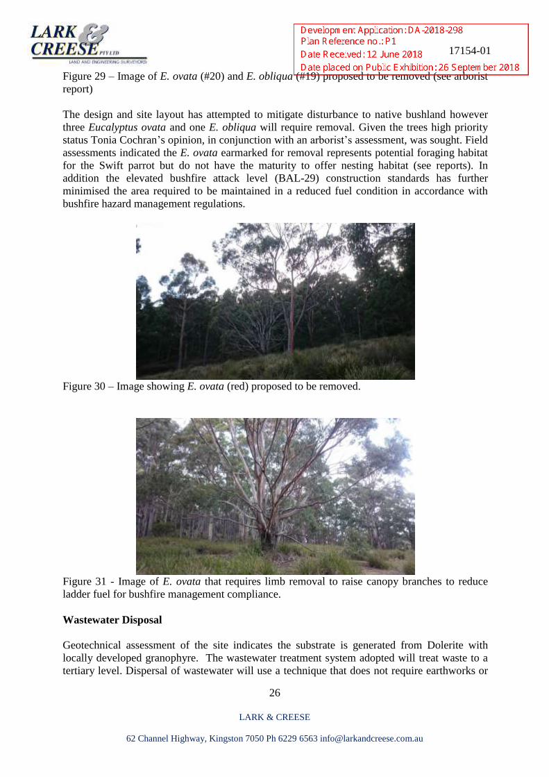
Figure 29 – Image of E. ovata (#20) and E. obliqua (#19) proposed to be removed (see arborist
report)
The design and site layout has attempted to mitigate disturbance to native bushland however
three Eucalyptus ovata and one E. obliqua will require removal. Given the trees high priority
status Tonia Cochran’s opinion, in conjunction with an arborist’s assessment, was sought. Field
assessments indicated the E. ovata earmarked for removal represents potential foraging habitat
for the Swift parrot but do not have the maturity to offer nesting habitat (see reports). In
addition the elevated bushfire attack level (BAL-29) construction standards has further
minimised the area required to be maintained in a reduced fuel condition in accordance with
bushfire hazard management regulations.
Figure 30 – Image showing E. ovata (red) proposed to be removed.
Figure 31 - Image of E. ovata that requires limb removal to raise canopy branches to reduce
ladder fuel for bushfire management compliance.
Wastewater Disposal
Geotechnical assessment of the site indicates the substrate is generated from Dolerite with
locally developed granophyre. The wastewater treatment system adopted will treat waste to a
tertiary level. Dispersal of wastewater will use a technique that does not require earthworks or
17154-01
27
LARK & CREESE
62 Channel Highway, Kingston 7050 Ph 6229 6563 [email protected]
disturbance of the substrate. Irrigation like lines will disperse waste water amongst the sedges
and rushes. Irrigation lines will be placed on the surface covered with 200-300mm of mulch
(see wastewater report). Assessment from arborist indicated wastewater dispersal methodology
and projected flow rates will not impact eucalypts adjacent or down slope from these areas.
Surveys of the proposed absorption sites indicate existing vegetation in the form of graminoids
provide a good natural mechanism to mitigate the potential for surface flow, erosion and
mobilisation of sediments within the Crown Reserve.
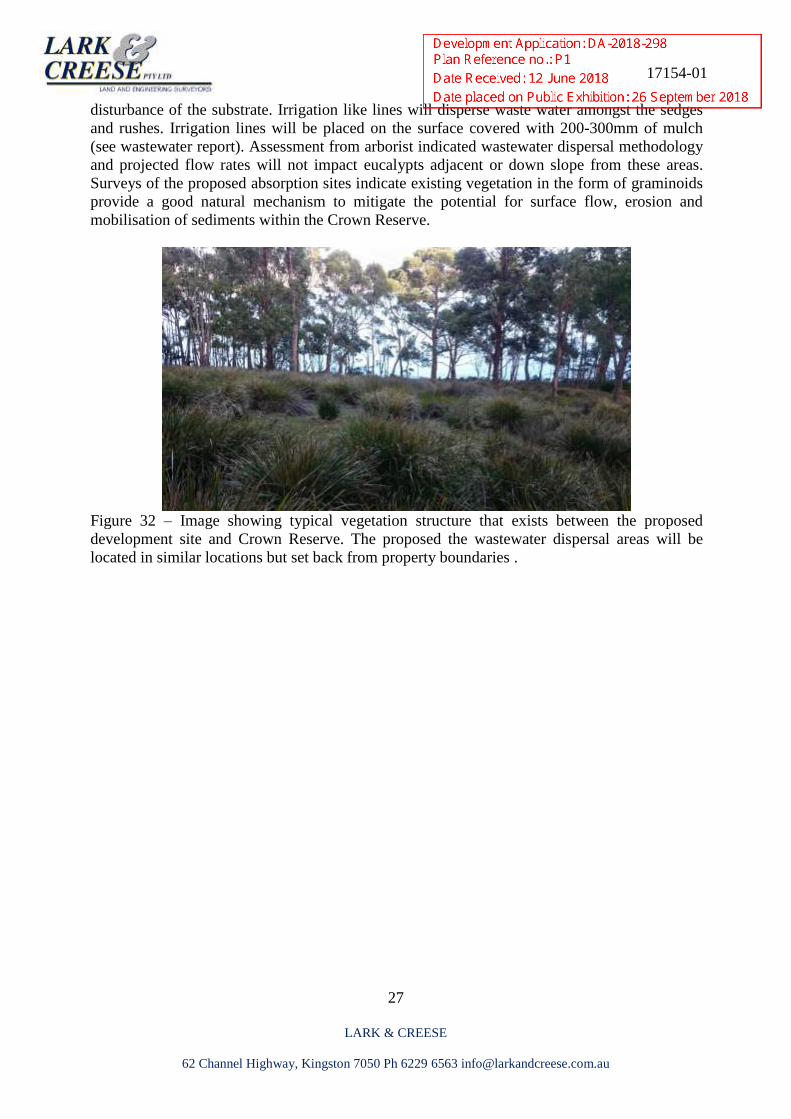
Figure 32 – Image showing typical vegetation structure that exists between the proposed
development site and Crown Reserve. The proposed the wastewater dispersal areas will be
located in similar locations but set back from property boundaries .
17154-01
28
LARK & CREESE
62 Channel Highway, Kingston 7050 Ph 6229 6563 [email protected]
Legislative Implications
Commonwealths’ Environmental Protection & Biodiversity Conservation Act 1999 (EPBCA).
There are 5 issues of national significance relating to the Act, the nationally endangered and
vulnerable fauna 21
• Aquila audax subsp fleayi (Tasmanian Wedge-tailed eagle) Endangered TSPA & EPBCA
• Dasyurus viverinus (Eastern Quoll) Endangered EPBCA
• Lathamus discolour (Swift parrot) - endangered TSPA & Critically endangered EPBCA
• Pardalotus quadringintus (Forty-spotted Pardalote) endangered TSPA & EPBCA
• Tyto novaehollandiae (Masked owl) , endangered TSPA & Vulnerable EPBCA
There are no issue relating to nationally endangered flora that could potentially occupy the site 21
Under the EPBC Act referral is required if:
‘An action has, will have, or is likely to have a significant impact on a vulnerable/endangered
species if it does, will or is likely to (amongst other things):
• Modify, destroy, remove, isolate or decrease the availability or quality of habitat to the
extent that the species is likely to decline
• Adversely affect habitat critical to the survival of a species’
The proposal will not significantly impact core foraging or existing nesting habitat for the Swift
parrot Forty-spotted pardalote, Masked Owl, Tasmanian Wedge-tailed eagle or White-bellied
sea eagle. It is also unlikely the proposal will impact the Eastern Quoll. On this basis the
proposal is unlikely to lead to a decline in listed species populations or the habitat used by these
species. Therefore, on this basis a referral under the EPBC Act will not be required 21
.
Tasmanian Threatened Species Protection Act 1995 (TSPA)
Any impacts to threatened species listed under the TSPA will require a permit from the Policy
and Conservation Assessment Branch (PCAB) DPIPWE 20
. No threatened species were
recorded within the study site. The Study site constitutes potential habitat for a number of
threatened plant species however when the ecology of these species is taken into consideration
it is anticipated the development proposal will not affect the survival of these species23
and as
such referral under the PCAB will not be required.
Tasmanian Nature Conservation Act 2002 and Land Use Planning and Approvals Act 1993
Vegetation communities present within the study site is considered threatened under the Nature
Conservation Act 2002 and as such considered potential threatened species habitat. The
removal of more than 1 ha is required to be assessed by the Forest Practices Authority. If
removal of threatened veg community is less than 1 ha the proposal will only require approval
from the Kingborough Council.
17154-01
29
LARK & CREESE
62 Channel Highway, Kingston 7050 Ph 6229 6563 [email protected]
Tasmanian Weed Management Act 1999 (WMA)
Declared weeds are subject to management plans under the WMA. Ragwort and Thistle species
have widespread infestations on Bruny Island and are listed as Declared weeds under
Tasmania’s Weed Management Act 1999 and classified as both Zone B under the Bruny Island
Weed Management Plan 2015-2020 24
. Surveys indicate historically Ragwort has been in the
area for many years with known distribution extending south into the old Adventure Bay
Caravan Park and north and east to the boundary of Fluted Cape National Park.
Recent access construction works has resulted in the germination of Ragwort and Spear thistles
within the access corridor. Current owners are aware of the Ragwort infestation and have
undertaken control actions with objectives to eradicate the species from the area. The
germination of these weed species resulting from disturbance possibly indicates both weeds
have established a significant seed bank from previous infestations. Both species produce many
seeds that remain viable for years after flowering.
Despite the infestation of these two declared weed species the allotments appear to be mostly
free of Spanish heath and other invasive weed species that are well established on Bruny Island.
It is therefore suggested a hygiene management facility be established at an appropriate site to
mitigate the accidental importation of other weed species.
Quarantine measures should include assurances from contractors all earth moving machinery
and equipment is washed down offsite at an appropriate site before entering the work site
to avoid the introduction of new weed species. Due to the presence of Ragwort and Thistles on
site it is also recommended all earth moving machinery and vehicles are appropriately cleaned
prior to leaving to avoid accidental exportation or at an appropriate facility prior. The weed
hygiene mechanism is also designed to prevent accidental introduction of Phytophthora
cinnamomi as the site represents potential habitat and susceptible plant species and when
established cannot be eradicated.
__________________________
18 Commonwealths’ Environmental Protection and Biodiversity Conservation Act 1999 19 Tasmanian Threatened Species Protection Act 1995 20 Tasmanian Nature Conservation Act 1999 & Land Use Planning and Approvals Act 1993 21 KIPS2015 22 Southern Tasmanian Weed Management Strategy 2011-2016 23 Flora Technical Notes No. 8
17154-01
30
LARK & CREESE
62 Channel Highway, Kingston 7050 Ph 6229 6563 [email protected]
Discussion and Recommendations
A survey of the study site found the vegetation community consistent with Kingborough
Council’s vegetation overlay classification of regenerating but threatened dry Eucalyptus ovata
woodland. The site is within potential range for a number of threatened flora species however
none were recorded on site.
The location and vegetation community present represent significant habitat for critically
endangered Swift Parrot and forty-spotted pardalote. Development has been positioned to
minimise removal of potential habitat for these threatened bird species, only requiring removal
of 4 eucalypts. Despite this I do not think a referral to the Policy Conservation Assessment
Branch is required (se Tonia Cochran’s habitat assessment for threatened bird species).
It is anticipated the small scale development is not considered a threatening process for the
nationally vulnerable Eastern Quoll. It is also anticipated post-construction residual impacts
will not result in the loss of core foraging or burrowing habitat and therefore a referral to the
PCAB will not be required. Whilst the final development may not directly impact threatened
fauna species, in the short term it may temporarily displace other marsupials, birds and reptiles
species. However it is anticipated future development will not result in long term residual
impacts to existing ecological functions of native vegetation communities present.
It is my opinion the proposal is consistent with the objectives under E10.7.1 Buildings and
Works in that:
• Clearance and conversion or disturbance associated with the proposal will not have an
unnecessary or unacceptable impact on priority biodiversity values
• Future development is unlikely to lead to an unnecessary or unacceptable residual impact
on priority biodiversity values
Provisions within the KIPS2015 require the loss of native vegetation within the Biodiversity
Protection Area to be offset in accordance with Guidelines for the Use of Biodiversity Offsets
in the Local Planning Approval Process, Southern Tasmanian Councils Authority 2013 and
Council’s Biodiversity Offset Policy 6.10. Given small scale of the development it is proposed
a suitable offset could be in the form of a Management Plan for the site.
Management prescriptions have been recommended to ensure the retention and protection of
existing biodiversity and ecological functions to address the construction phase of the
development and potential future land use could include:
• Stage development to avoid blanket clearance when undertaking earthworks within the
designated development envelopes.
• Identify appropriate storage sites for soil and implement appropriate management
mechanisms
• Avoid any unnecessary traffic outside the development
• In conjunction with soil, water and erosion implement a hygiene management plan for all
development including prescriptions to prevent accidental importation of new weed
species and Phytophthora cinnamomi during construction and address colonisation post
construction.
17154-01
31
LARK & CREESE
62 Channel Highway, Kingston 7050 Ph 6229 6563 [email protected]
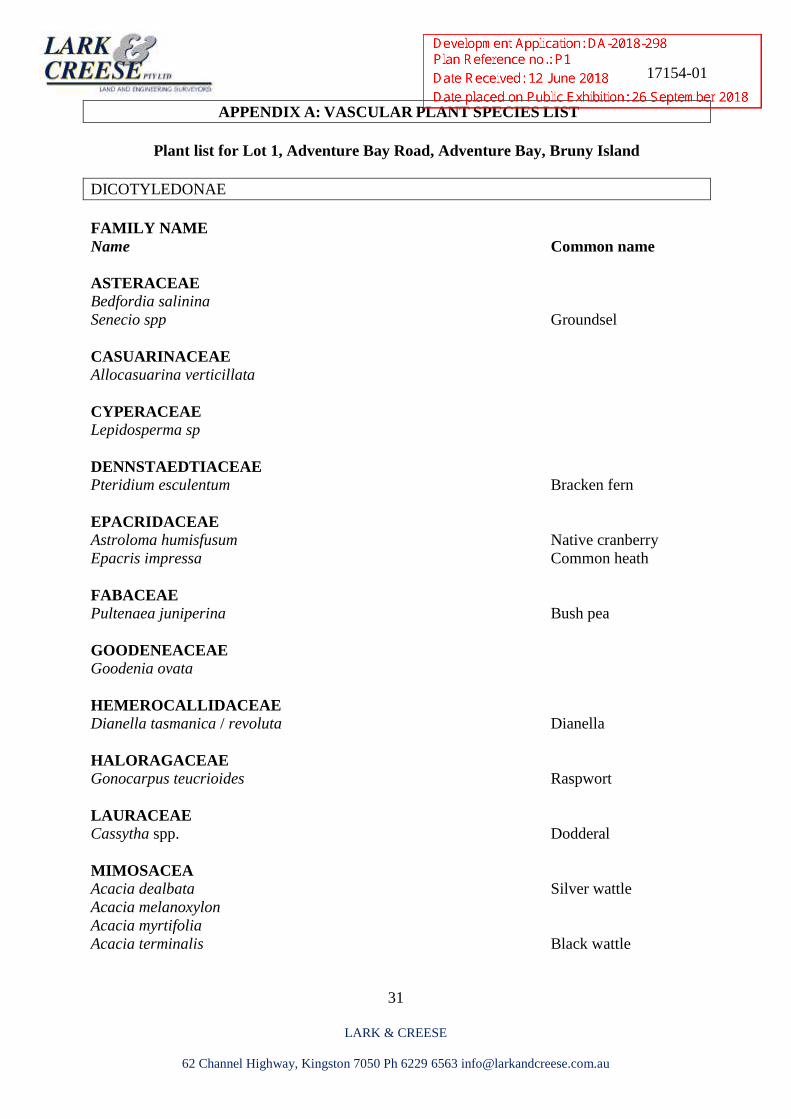
APPENDIX A: VASCULAR PLANT SPECIES LIST
Plant list for Lot 1, Adventure Bay Road, Adventure Bay, Bruny Island
DICOTYLEDONAE
FAMILY NAME
Name Common name
ASTERACEAE
Bedfordia salinina
Senecio spp Groundsel
CASUARINACEAE Allocasuarina verticillata
CYPERACEAE Lepidosperma sp
DENNSTAEDTIACEAE Pteridium esculentum Bracken fern
EPACRIDACEAE Astroloma humisfusum Native cranberry
Epacris impressa Common heath
FABACEAE Pultenaea juniperina Bush pea
GOODENEACEAE Goodenia ovata
HEMEROCALLIDACEAE
Dianella tasmanica / revoluta Dianella
HALORAGACEAE
Gonocarpus teucrioides Raspwort
LAURACEAE
Cassytha spp. Dodderal
MIMOSACEA Acacia dealbata Silver wattle
Acacia melanoxylon
Acacia myrtifolia
Acacia terminalis Black wattle
17154-01
32
LARK & CREESE
62 Channel Highway, Kingston 7050 Ph 6229 6563 [email protected]
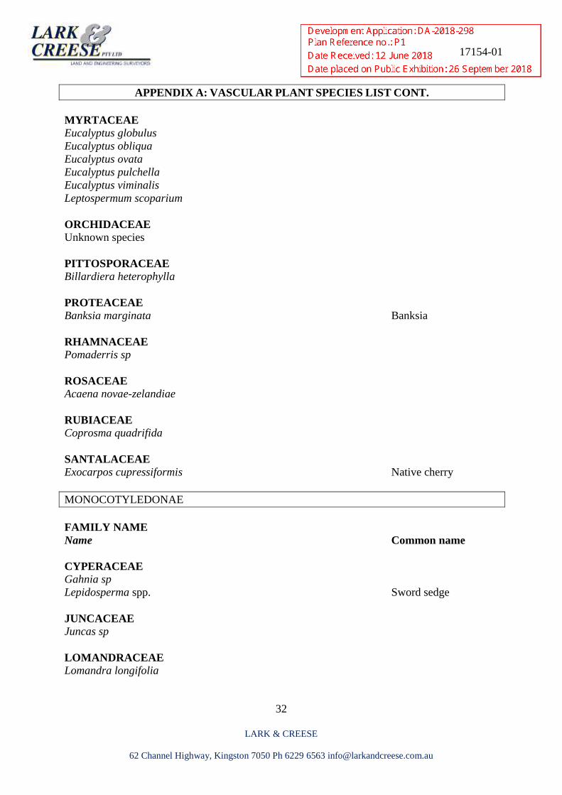
APPENDIX A: VASCULAR PLANT SPECIES LIST CONT.
MYRTACEAE Eucalyptus globulus
Eucalyptus obliqua
Eucalyptus ovata
Eucalyptus pulchella
Eucalyptus viminalis
Leptospermum scoparium
ORCHIDACEAE
Unknown species
PITTOSPORACEAE
Billardiera heterophylla
PROTEACEAE
Banksia marginata Banksia
RHAMNACEAE Pomaderris sp
ROSACEAE Acaena novae-zelandiae
RUBIACEAE Coprosma quadrifida
SANTALACEAE Exocarpos cupressiformis Native cherry
MONOCOTYLEDONAE
FAMILY NAME
Name Common name
CYPERACEAE Gahnia sp
Lepidosperma spp. Sword sedge
JUNCACEAE
Juncas sp
LOMANDRACEAE
Lomandra longifolia
17154-01
33
LARK & CREESE
62 Channel Highway, Kingston 7050 Ph 6229 6563 [email protected]
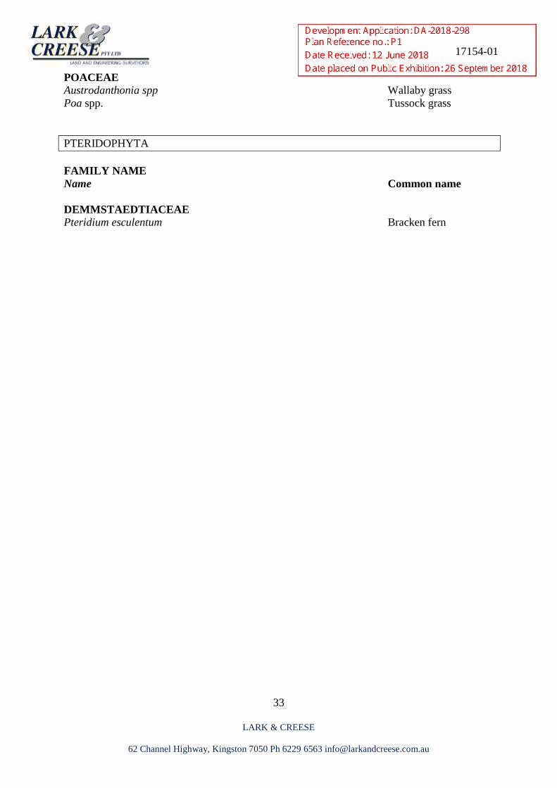
POACEAE Austrodanthonia spp Wallaby grass
Poa spp. Tussock grass
PTERIDOPHYTA
FAMILY NAME
Name Common name
DEMMSTAEDTIACEAE Pteridium esculentum Bracken fern
17154-01
34
LARK & CREESE
62 Channel Highway, Kingston 7050 Ph 6229 6563 [email protected]
References
Bruny Island Weed Management Strategy 2007.Kingborough Council.
Department of Primary Industries, Parks, Water and Environment, 2000, TASVEG 2000
Manual, Department of Primary Industries, Parks, Water and Environment, Hobart.
Department of Primary Industries, Parks, Water and Environment. Threatened Native
Vegetation Communities 2014, Released May 2015. Tasmanian Vegetation Monitoring and
Mapping Program, Natural and Cultural Heritage Division
Duncan, F. (1996). ‘A field key to Tasmanian species of Eucalyptus’ Tasforests vol. 8, Forestry
Tasmania. Tasmanian State Government, Government Printer, Hobart, Tasmania.
Environmental Protection & Biodiversity Conservation Act 1999. Commonwealth Government,
Office of Legislative Drafting and Publishing, Canberra.
Forest Practices Act (1985). Tasmanian State Government, Government Printer, Hobart,
Tasmania.
Forest Practices Authority. ’Eagle Nest Searching, Activity Checking and Nest Management’
Version 2.2 Fauna Technical Note No. 1, Forest Practices Authority, Hobart, Tasmania.
Forest Practices Authority. ’Identifying swift parrot breeding Habitat’, Fauna Technical Note
No. 3 Forest Practices Authority, Hobart, Tasmania.
Forest Practices Authority. ’Mt Mangana stag beetle survey protocol’, Fauna Technical Note
No. 5 Forest Practices Authority, Hobart, Tasmania.
Forest Practices Authority. ’Identifying Tasmanian devil and Spotted-tail Quoll habitat’, Fauna
Technical Note No. 10. Forest Practices Authority, Hobart, Tasmania.
Forest Practices Authority. ’Phytophthora cinnamomi in working forests’, Flora Technical Note
No. 8. Forest Practices Authority, Hobart, Tasmania.
Forest Practices Authority 2010, ‘Goshawk habitat categories’, Fauna Technical Note No. 12,
Forest
Practices Authority, Hobart, Tasmania.
Forest Practices Authority.’ Nest identification’, Fauna Technical Note No. 14 ‘Forest
Practices Authority, Hobart, Tasmania.
Forest Practices Authority (2005). Forest Botany Manual: Module 6 – D'Entrecasteaux Region.
Forest Practices Authority, Tasmania.
17154-01
35
LARK & CREESE
62 Channel Highway, Kingston 7050 Ph 6229 6563 [email protected]
Forest Practices Authority (2013), ‘Wedge-tailed Eagle Nest Monitoring Project 2007–12: Nest
site use, timing of breeding, and a review of the nesting habitat model’, Report to Roaring 40s,
Threatened Species and Marine Section (DPIPWE), April 2013, Forest Practices Authority
Scientific Report.
Forest Practices Authority 2012, Biodiversity landscape planning guideline: a framework for
managing biodiversity values, including RFA priority species, across the landscape in areas
covered by the Tasmanian forest practices system - a report to the Commonwealth Government
and the Forest Practices Authority, July 2012.
Forest Practices Authority (2010) Interim Species Habitat Planning Guideline for the
conservation management of Lathamus discolor (Swift Parrot) in areas regulated under the
Tasmanian Forest Practices System. Internal report to the Forest Practices Authority, Hobart,
Tasmania.
Goff, F.G, Dawson, G.A. and Rochow, J.J. (1982). ‘Site Examination for Threatened and
Endangered Plant Species’. Environmental Management 6 (4) pp 307-316.
Kingborough Council. Kingborough Interim Planning Scheme 2015.
Harris, S & Kitchener, A. eds (2005). From Forest to Fjaeldmark: Descriptions of Tasmania’s
Vegetation. Department of Primary Industries, Water and Environment, Printing Authority of
Tasmania, Hobart.
HYPERLINK "http://www.dpiw.tas.gov.au/inter" http://www.dpiw.tas.gov.au/inter
Koch, A. ‘Tree hollows in Tasmania: A Guide’ FPA Hollows Project Officer.
CRC for Forestry and the Forest Practices Authority, November 2009.
Land Use Planning and Approvals Act (1993). Tasmanian State Government, No. 70 of 1993.
Government printer, Hobart, Tasmania.
Nicolle, D. 2006, ‘Eucalypts of Victoria and Tasmania’ Blooming Books, Melbourne,
Australia.
Schrammeyer, E., 2005. Southern Tasmanian Weed Strategy, Management Regional
Committee
(NRM South) NRM South, Hobart
S. Pfennigwerth. 2007. ‘Minimising the swift parrot collision threat, Guidelines and
recommendations for parrot-safe building design. Melampus Media. WWF-Australia.
Tasmanian State Government (1993). Land Use Planning and Approvals Act 1993. No. 70 of
1993. Government Printer, Hobart, Tasmania.
17154-01
36
LARK & CREESE
62 Channel Highway, Kingston 7050 Ph 6229 6563 [email protected]
Tasmanian State Government (2002). Nature Conservation Act 2002. No. 63 of 2002.
Government Printer, Hobart, Tasmania.
Tasmanian State Government (1995). Threatened Species Protection Act 1995. No. 83 of
1995. Government Printer, Hobart, Tasmania.
Tasmanian State Government (1999). Tasmanian Weed Management Act 1999. Government
Printer, Hobart, Tasmania.
Tasmanian State Government (1997). Tasmanian Plant Quarantine Act: Section 12 –
Publications of pests and diseases. Government Printer, Hobart, Tasmania.
Threatened Species Unit; Threatened Flora of Tasmania. DPIPWE, 2003.
http://dpipwe.tas.gov.au/conservation/threatened-species/lists-of-threatened-
species/threatenedspecies-vertebrates/wedge-tailed-eagle
Wapstra, M., Wapstra, A., Wapstra. H. 2010. ‘Tasmanian Plant Names Unravelled’ Fullers
Books, Launceston, Tasmania.
Wapstra, M., Roberts, N., Wapstra, H. & Wapstra, A. (2010). Flowering Times of Tasmanian
Orchids: A Practical Guide for Field Botanists. Self-published by the authors (September 2010
version).
17154-01
37
LARK & CREESE
62 Channel Highway, Kingston 7050 Ph 6229 6563 [email protected]
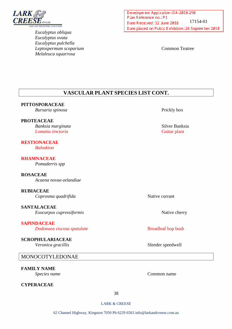
VASCULAR PLANT SPECIES LIST
ADVENTURE BAY ROAD, BRUNY ISLAND
DICOTYLEDONAE
FAMILY NAME
Species name Common name
ASTERACEAE
Bedfordia salicina
Helichrysum spp Everlasting
Senecio spp Groundsel
APIACEAE Hydrocotyle sicthorpioides
EPACRIDACEAE Astroloma humifusum Native cranberry
Epacris gunnii / lanuginosa
Epacris impressa Common heath
Lissanthe strigosa Peach berry
FABACEAE Pultenaea daphnoides obcordata native daphne
Daviesia ulicifolia Native gorse
Pultenaea juniperina
GOODENEACEAE Goodenia ovata Hop-Native primrose
HEMEROCALLIDACEAE Dianella tasmanica
HALORAGACEAE Gonocarpus micranthus
MIMOSACEA Acacia dealbata Silver wattle
Acacia melanoxylon Black wood
Acacia mucronata Native willow
Acacia terminalis Sunshine wattle
Acacia verticillata Prickly moses
MYRTACEAE Eucalyptus globulus
17154-01
38
LARK & CREESE
62 Channel Highway, Kingston 7050 Ph 6229 6563 [email protected]
Eucalyptus obliqua
Eucalyptus ovata
Eucalyptus pulchella
Leptospermum scoparium Common Teatree
Melaleuca squarrosa
VASCULAR PLANT SPECIES LIST CONT.
PITTOSPORACEAE Bursaria spinosa Prickly box
PROTEACEAE Banksia marginata Silver Banksia
Lomatia tinctoria Guitar plant
RESTIONACEAE Baloskion
RHAMNACEAE Pomaderris spp
ROSACEAE Acaena novae-zelandiae
RUBIACEAE Coprosma quadrifida Native currant
SANTALACEAE Exocarpos cupressiformis Native cherry
SAPINDACEAE Dodonaea viscosa spatulate Broadleaf hop bush
SCROPHULARIACEAE Veronica gracillis Slender speedwell
MONOCOTYLEDONAE
FAMILY NAME
Species name Common name
CYPERACEAE
17154-01
39
LARK & CREESE
62 Channel Highway, Kingston 7050 Ph 6229 6563 [email protected]
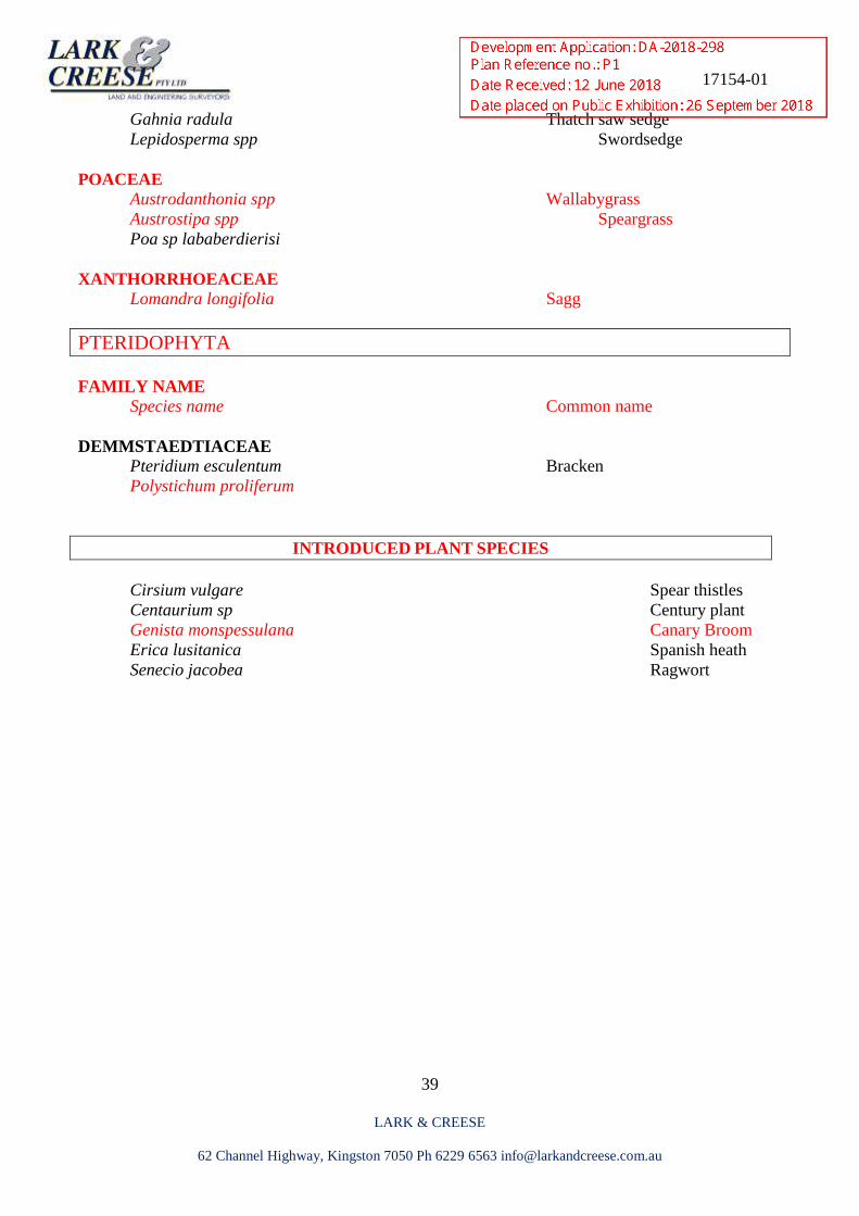
Gahnia radula Thatch saw sedge
Lepidosperma spp Swordsedge
POACEAE Austrodanthonia spp Wallabygrass
Austrostipa spp Speargrass
Poa sp lababerdierisi
XANTHORRHOEACEAE Lomandra longifolia Sagg
PTERIDOPHYTA
FAMILY NAME
Species name Common name
DEMMSTAEDTIACEAE Pteridium esculentum Bracken
Polystichum proliferum
INTRODUCED PLANT SPECIES
Cirsium vulgare Spear thistles
Centaurium sp Century plant
Genista monspessulana Canary Broom
Erica lusitanica Spanish heath
Senecio jacobea Ragwort