Embed Size (px)
Citation preview
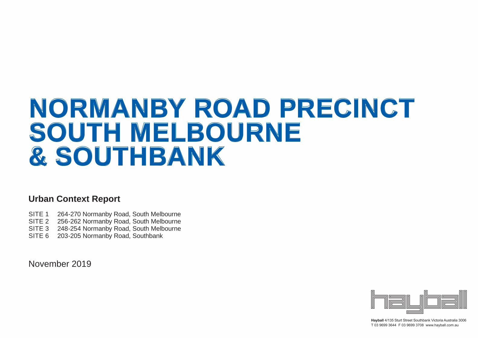
Urban Context ReportSITE 1 264-270 Normanby Road, South MelbourneSITE 2 256-262 Normanby Road, South Melbourne SITE 3 248-254 Normanby Road, South Melbourne SITE 6 203-205 Normanby Road, Southbank
November 2019
NORMANBY ROAD PRECINCT SOUTH MELBOURNE & SOUTHBANK
Project No 1949
1.0 KEY ISSUES 11.1 Introduction 1
2.0 URBAN CONTEXT ANALYSIS 22.1 Introduction 22.2 Site context 32.3 Montague precinct 42.4 Maximum Height 52.5 Subject sites 62.6 Transport and connectivity 72.7 Street analysis 82.8 Surrounding built form 92.9 Surrounding character 102.10 Elevated views 132.11 Movement study 14
3.0 DESIGN RESPONSE 153.1 Tower design response: Height Study 153.2 Streetscape design response, S1 - S3 193.3 Streetscape design response, S6 273.4 Loading and access response 323.5 Flood management response 333.6 View analysis 343.7 Shadow analysis 35
Contents
© Hayball
Project No 1949 1© Hayball
Normanby Road Precinct, South Melbourne & Southbank Urban Context Report + Design Response
1.0 Key issues
Montague PrecinctWirraway
Precinct
Lorimer Precinct
Sandridge Precinct
CBDHoddle Grid
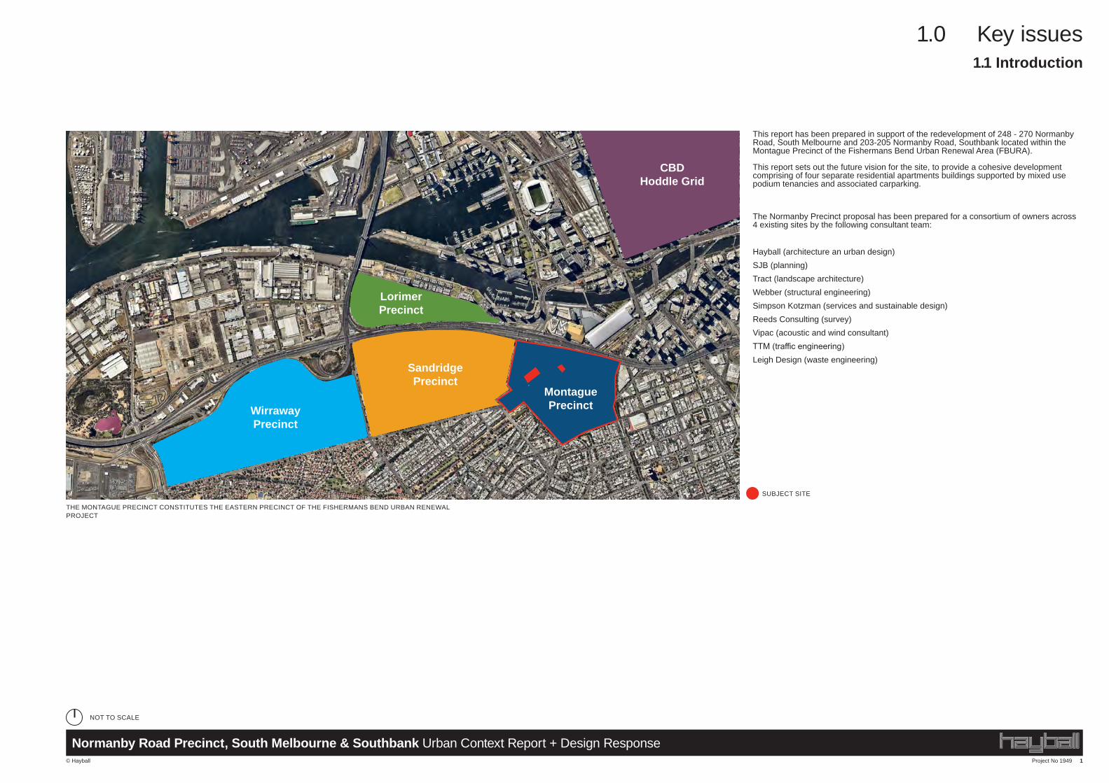
This report has been prepared in support of the redevelopment of 248 - 270 Normanby Road, South Melbourne and 203-205 Normanby Road, Southbank located within the Montague Precinct of the Fishermans Bend Urban Renewal Area (FBURA).
This report sets out the future vision for the site, to provide a cohesive development comprising of four separate residential apartments buildings supported by mixed use podium tenancies and associated carparking.
The Normanby Precinct proposal has been prepared for a consortium of owners across 4 existing sites by the following consultant team:
Hayball (architecture an urban design)SJB (planning)Tract (landscape architecture)Webber (structural engineering)Simpson Kotzman (services and sustainable design)Reeds Consulting (survey)Vipac (acoustic and wind consultant)TTM (traffic engineering)Leigh Design (waste engineering)
SUBJECT SITE
1.1 Introduction
NOT TO SCALE
THE MONTAGUE PRECINCT CONSTITUTES THE EASTERN PRECINCT OF THE FISHERMANS BEND URBAN RENEWAL PROJECT
Project No 1949 2
2.0 Urban context analysis
© Hayball
Normanby Road Precinct, South Melbourne & Southbank Urban Context Report + Design Response
2.0 Urban context analysis
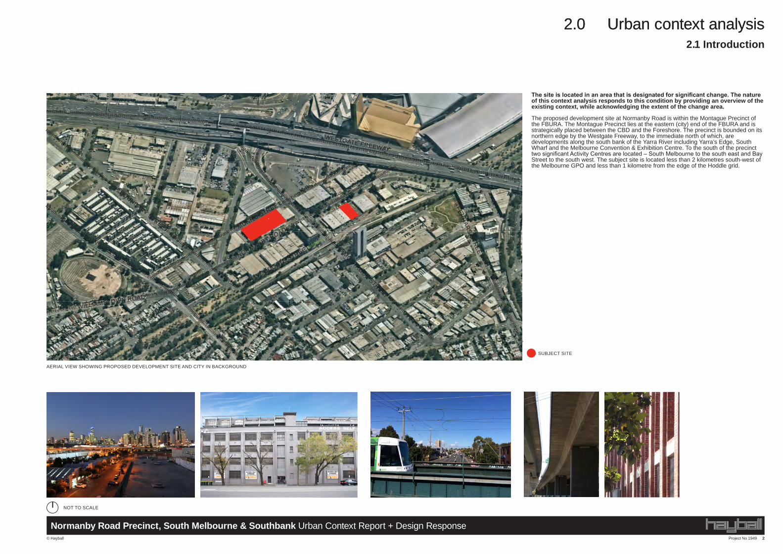
The site is located in an area that is designated for significant change. The nature of this context analysis responds to this condition by providing an overview of the existing context, while acknowledging the extent of the change area.
The proposed development site at Normanby Road is within the Montague Precinct of the FBURA. The Montague Precinct lies at the eastern (city) end of the FBURA and is strategically placed between the CBD and the Foreshore. The precinct is bounded on its northern edge by the Westgate Freeway, to the immediate north of which, are developments along the south bank of the Yarra River including Yarra’s Edge, South Wharf and the Melbourne Convention & Exhibition Centre. To the south of the precinct two significant Activity Centres are located – South Melbourne to the south east and Bay Street to the south west. The subject site is located less than 2 kilometres south-west of the Melbourne GPO and less than 1 kilometre from the edge of the Hoddle grid.
Project No 1949 2© Hayball
Normanby Road Precinct, South Melbourne & Southbank Urban Context Report + Design Response
2.0 Urban context analysis
The site is located in an area that is designated for significant change. The nature of this context analysis responds to this condition by providing an overview of the existing context, while acknowledging the extent of the change area.
The proposed development site at Normanby Road is within the Montague Precinct of the FBURA. The Montague Precinct lies at the eastern (city) end of the FBURA and is strategically placed between the CBD and the Foreshore. The precinct is bounded on its northern edge by the Westgate Freeway, to the immediate north of which, are developments along the south bank of the Yarra River including Yarra’s Edge, South Wharf and the Melbourne Convention & Exhibition Centre. To the south of the precinct two significant Activity Centres are located – South Melbourne to the south east and Bay Street to the south west. The subject site is located less than 2 kilometres south-west of the Melbourne GPO and less than 1 kilometre from the edge of the Hoddle grid.
MONTAGUE STREET
NORMANBY ROADMUNRO STREET
WOODGATE STREET
BOUNDARY STREET
INGLES STREET
WILLIAMSTOWN ROAD
FERRARS STREET
WESTGATE FREEWAY
2.1 Introduction
SUBJECT SITE
NOT TO SCALE
AERIAL VIEW SHOWING PROPOSED DEVELOPMENT SITE AND CITY IN BACKGROUND
MONTAGUE STREET
NORMANBY ROADMUNRO STREET
WOODGATE STREET
BOUNDARY STREET
INGLES STREET
WILLIAMSTOWN ROAD
FERR
ARS STR
EET
WESTGATE FREEWAY
2.1 Introduction
SUBJECT SITE
NOT TO SCALE
AERIAL VIEW SHOWING PROPOSED DEVELOPMENT SITE AND CITY IN BACKGROUND
Project No 1949 3
2.0 Urban context analysis
© Hayball
Normanby Road Precinct, South Melbourne & Southbank Urban Context Report + Design Response
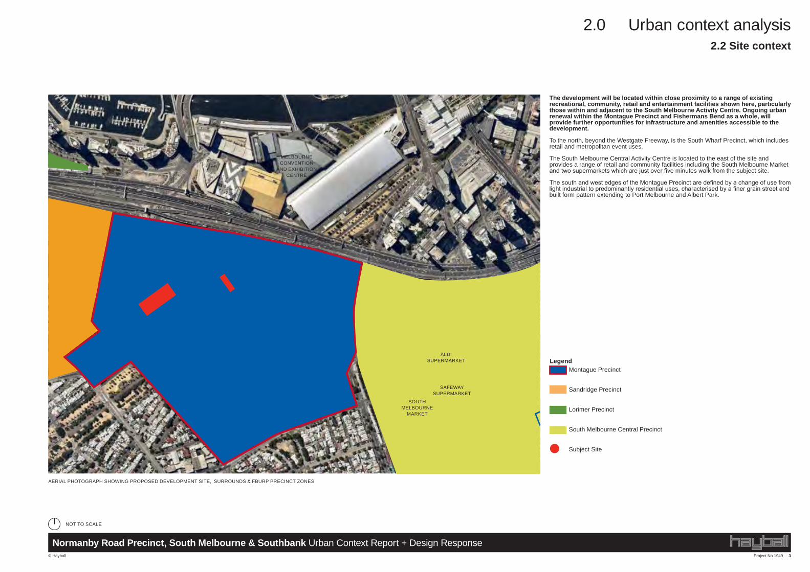
The development will be located within close proximity to a range of existing recreational, community, retail and entertainment facilities shown here, particularly those within and adjacent to the South Melbourne Activity Centre. Ongoing urban renewal within the Montague Precinct and Fishermans Bend as a whole, will provide further opportunities for infrastructure and amenities accessible to the development.
To the north, beyond the Westgate Freeway, is the South Wharf Precinct, which includes retail and metropolitan event uses.
The South Melbourne Central Activity Centre is located to the east of the site and provides a range of retail and community facilities including the South Melbourne Market and two supermarkets which are just over five minutes walk from the subject site.
The south and west edges of the Montague Precinct are defined by a change of use from light industrial to predominantly residential uses, characterised by a finer grain street and built form pattern extending to Port Melbourne and Albert Park.
AERIAL PHOTOGRAPH SHOWING PROPOSED DEVELOPMENT SITE, SURROUNDS & FBURP PRECINCT ZONES
Montague Precinct
Sandridge Precinct
Lorimer Precinct
South Melbourne Central Precinct
Subject Site
Legend
SOUTH MELBOURNE
MARKET
SAFEWAY SUPERMARKET
ALDI SUPERMARKET
MELBOURNE CONVENTION
AND EXHIBITION CENTRE
2.2 Site context
NOT TO SCALE
Project No 1949 4
2.0 Urban context analysis
© Hayball
Normanby Road Precinct, South Melbourne & Southbank Urban Context Report + Design Response
PORT PHILLIP PLANNING SCHEME
ZONES – CLAUSE 37.04 – SCHEDULE 1 PAGE 14 OF 17
MAP 1: Montague Urban Structure
MAP 2: Sandridge Urban Structure
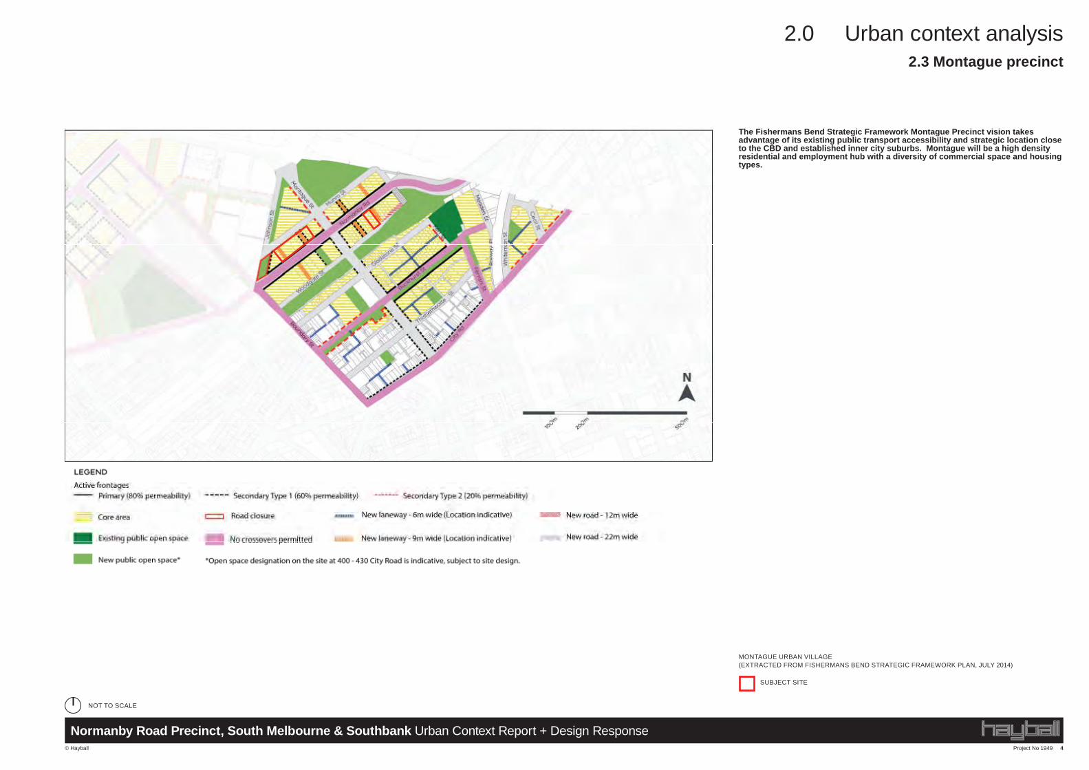
2.3 Montague precinct
SUBJECT SITE
The Fishermans Bend Strategic Framework Montague Precinct vision takes advantage of its existing public transport accessibility and strategic location close to the CBD and established inner city suburbs. Montague will be a high density residential and employment hub with a diversity of commercial space and housing types.
MONTAGUE URBAN VILLAGE (EXTRACTED FROM FISHERMANS BEND STRATEGIC FRAMEWORK PLAN, JULY 2014)
NOT TO SCALE
Project No 1949 5
2.0 Urban context analysis
© Hayball
Normanby Road Precinct, South Melbourne & Southbank Urban Context Report + Design Response
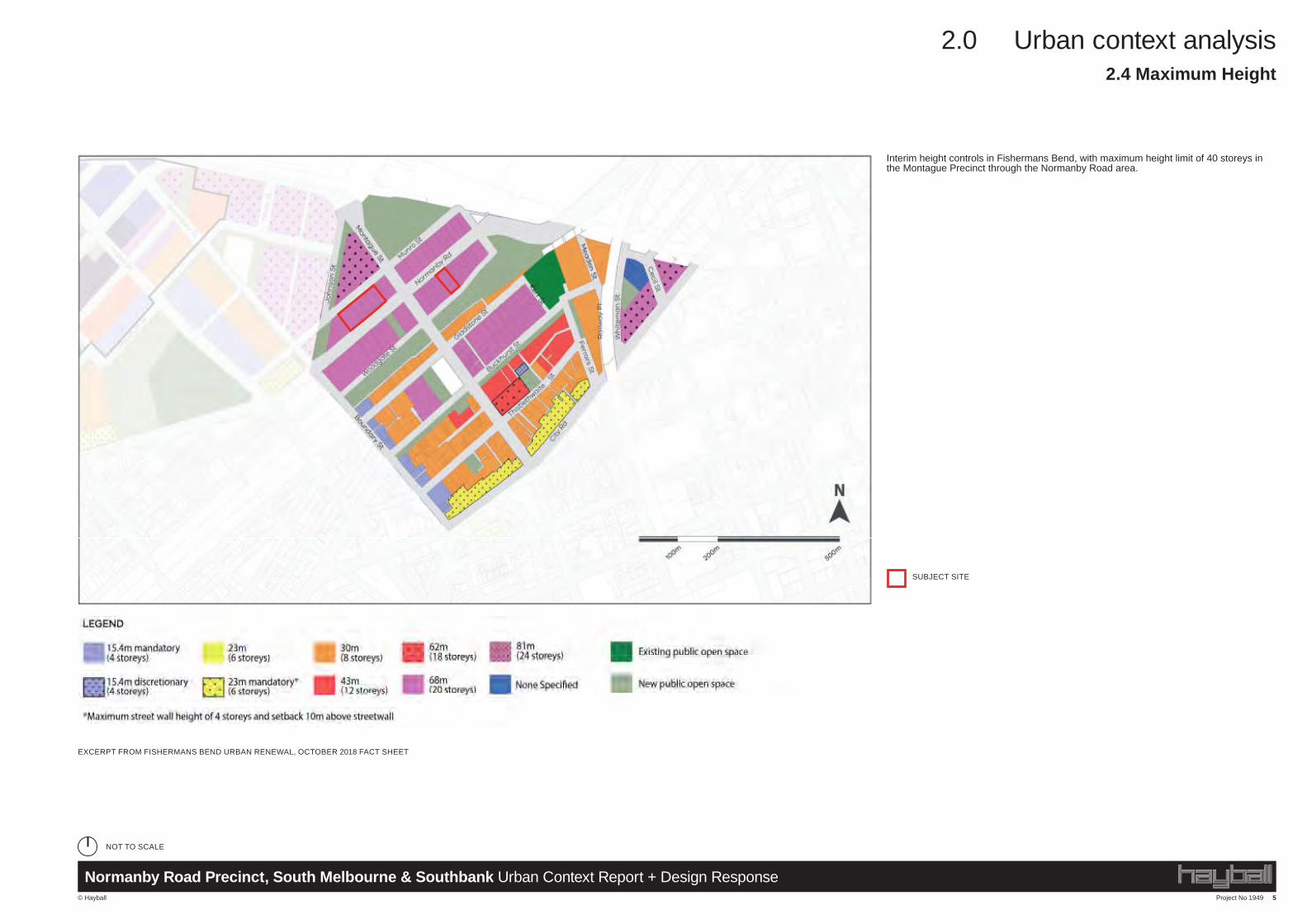
Interim height controls in Fishermans Bend, with maximum height limit of 40 storeys in the Montague Precinct through the Normanby Road area.
PORT PHILLIP PLANNING SCHEME
OVERLAYS - CLAUSE 43.02 - SCHEDULE 30 PAGE 16 OF 17
MAP 1: Building typologies
MAP 2: Building heights
2.4 Maximum Height
SUBJECT SITE
EXCERPT FROM FISHERMANS BEND URBAN RENEWAL, OCTOBER 2018 FACT SHEET
NOT TO SCALE
Project No 1949 6
2.0 Urban context analysis
© Hayball
Normanby Road Precinct, South Melbourne & Southbank Urban Context Report + Design Response
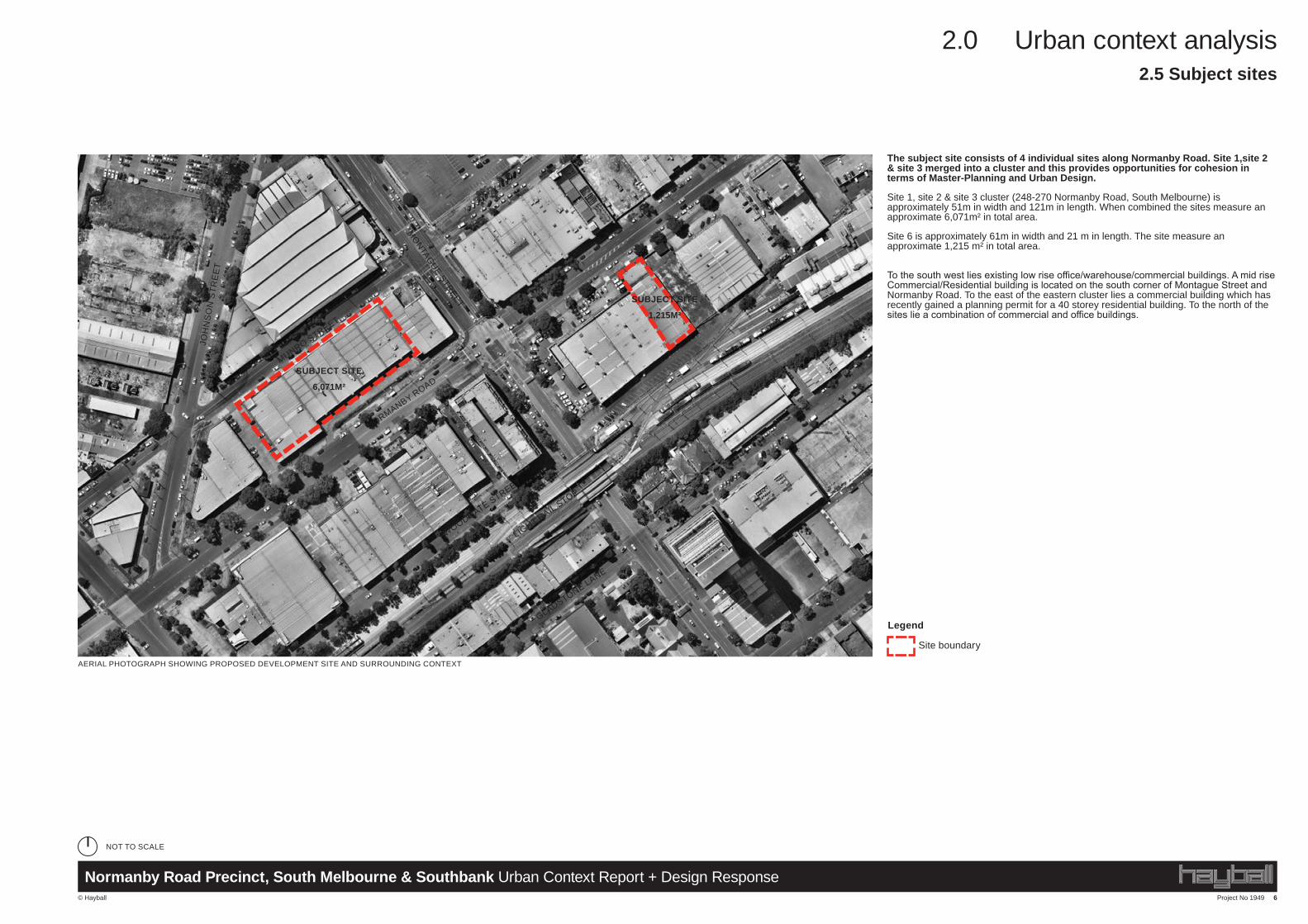
The subject site consists of 4 individual sites along Normanby Road. Site 1,site 2 & site 3 merged into a cluster and this provides opportunities for cohesion in terms of Master-Planning and Urban Design.
Site 1, site 2 & site 3 cluster (248-270 Normanby Road, South Melbourne) is approximately 51m in width and 121m in length. When combined the sites measure an approximate 6,071m² in total area.
Site 6 is approximately 61m in width and 21 m in length. The site measure an approximate 1,215 m² in total area.
To the south west lies existing low rise office/warehouse/commercial buildings. A mid rise Commercial/Residential building is located on the south corner of Montague Street and Normanby Road. To the east of the eastern cluster lies a commercial building which has recently gained a planning permit for a 40 storey residential building. To the north of the sites lie a combination of commercial and office buildings.
AERIAL PHOTOGRAPH SHOWING PROPOSED DEVELOPMENT SITE AND SURROUNDING CONTEXT
Site boundary
Legend
SUBJECT SITE
6,071M²
LIGHT RAIL STOP
NORMANBY ROAD
MONTAGUE STREET
MUNRO STREET
WOODGATE STREET
GLADSTONE LANE
JOH
NS
ON
STR
EE
T
SUBJECT SITE
1,215M²
2.5 Subject sites
NOT TO SCALE
Project No 1949 7
2.0 Urban context analysis
© Hayball
Normanby Road Precinct, South Melbourne & Southbank Urban Context Report + Design Response
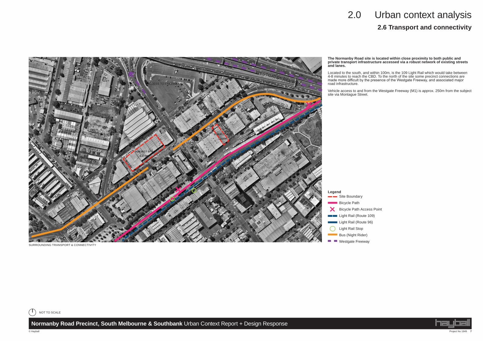
The Normanby Road site is located within close proximity to both public and private transport infrastructure accessed via a robust network of existing streets and lanes.
Located to the south, and within 100m, is the 109 Light Rail which would take between 4-8 minutes to reach the CBD. To the north of the site some precinct connections are made more difficult by the presence of the Westgate Freeway, and associated major road infrastructure.
Vehicle access to and from the Westgate Freeway (M1) is approx. 250m from the subject site via Montague Street.
Site Boundary
Bicycle Path
Bicycle Path Access Point
Light Rail (Route 109)
Light Rail (Route 96)
Light Rail Stop
Bus (Night Rider)
Westgate Freeway
Legend
NORMANBY ROAD
MUNRO STREET
MONTAGUE STREET
WESTGATE FREEWAY
GLADSTONE STREET
BUCKHURST STREET
WOODGATE STREET
LIGHT RAIL STOP
BOUNDARY STREET
JOH
NS
ON
STR
EE
T SUBJECT SITE
1,215M²
ACCESS TO FREEWAY
SUBJECT SITE
6,071M²
2.6 Transport and connectivity
SURROUNDING TRANSPORT & CONNECTIVITY
NOT TO SCALE
Project No 1949 8
2.0 Urban context analysis
© Hayball
Normanby Road Precinct, South Melbourne & Southbank Urban Context Report + Design Response
BUCKHURST STREET
BOUNDARY STREET
MUNRO STREET
WESTGATE FREEWAY
WOODGATE STREET
JOH
NS
ON
STR
EE
T
NORMANBY ROAD
Legend
Site Boundary
Freeway
Secondary State Arterial Roads
Major Roads
Local Traffic Streets
FBURA Proposed Laneways
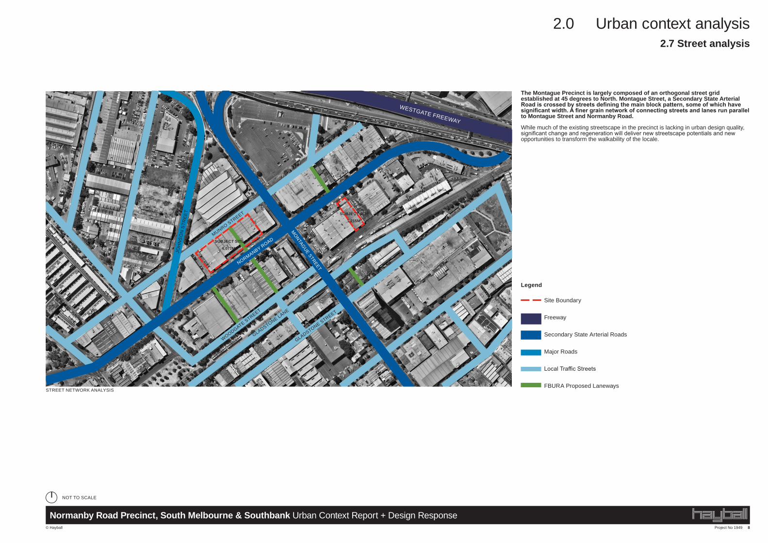
The Montague Precinct is largely composed of an orthogonal street grid established at 45 degrees to North. Montague Street, a Secondary State Arterial Road is crossed by streets defining the main block pattern, some of which have significant width. A finer grain network of connecting streets and lanes run parallel to Montague Street and Normanby Road.
While much of the existing streetscape in the precinct is lacking in urban design quality, significant change and regeneration will deliver new streetscape potentials and new opportunities to transform the walkability of the locale.
MONTAGUE STREET
2.7 Street analysis
GLADSTONE STREET
GLADSTONE LANE
STREET NETWORK ANALYSIS
NOT TO SCALE
SUBJECT SITE
1,215M²
SUBJECT SITE
6,071M²
Project No 1949 9
2.0 Urban context analysis
© Hayball
Normanby Road Precinct, South Melbourne & Southbank Urban Context Report + Design Response
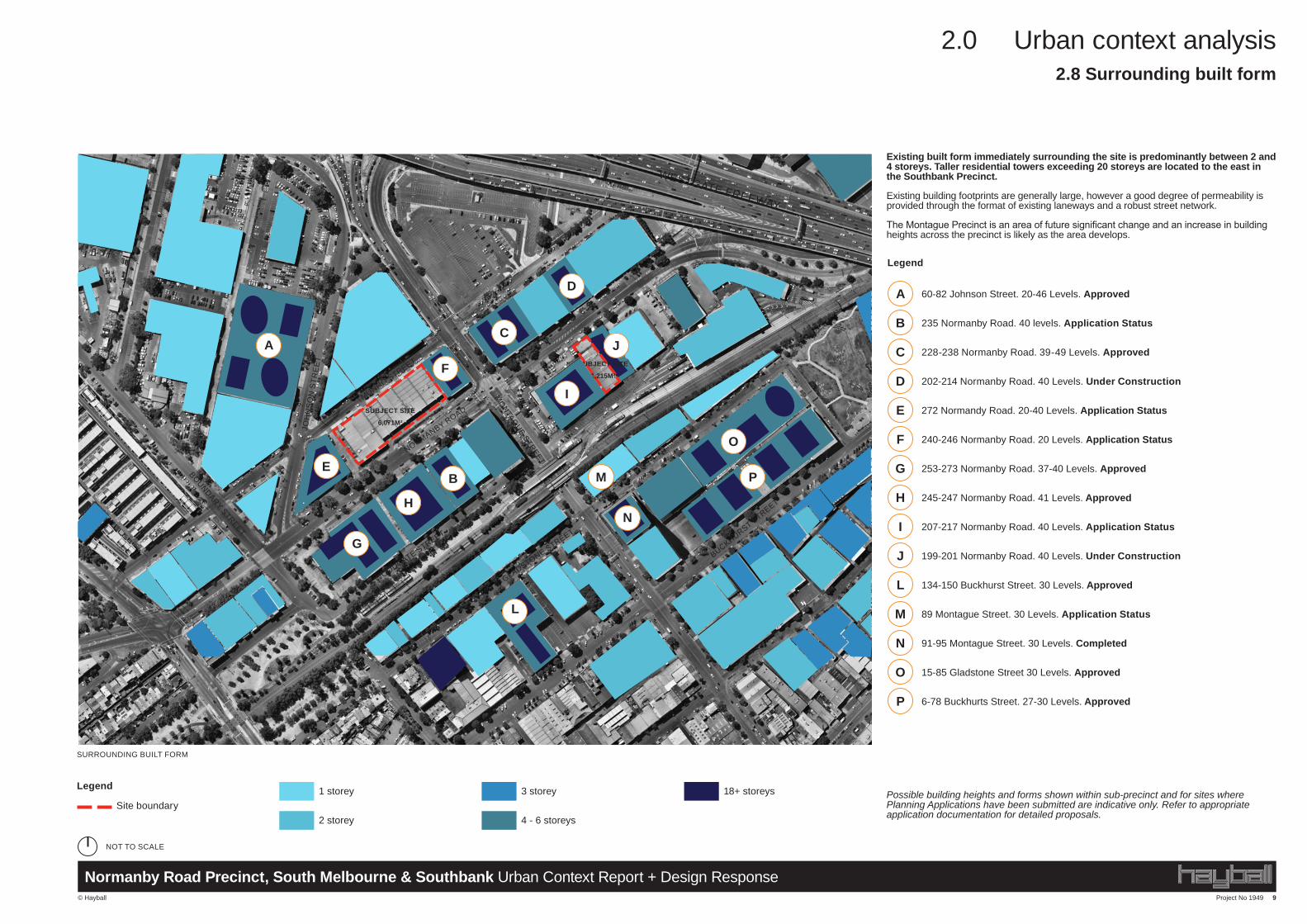
Existing built form immediately surrounding the site is predominantly between 2 and 4 storeys. Taller residential towers exceeding 20 storeys are located to the east in the Southbank Precinct.
Existing building footprints are generally large, however a good degree of permeability is provided through the format of existing laneways and a robust street network.
The Montague Precinct is an area of future significant change and an increase in building heights across the precinct is likely as the area develops.
Possible building heights and forms shown within sub-precinct and for sites where Planning Applications have been submitted are indicative only. Refer to appropriate application documentation for detailed proposals.
A
B
C
D
E
F
G
H
I
J
L
M
N
O
P
60-82 Johnson Street. 20-46 Levels. Approved
235 Normanby Road. 40 levels. Application Status
228-238 Normanby Road. 39-49 Levels. Approved
202-214 Normanby Road. 40 Levels. Under Construction
272 Normandy Road. 20-40 Levels. Application Status
240-246 Normanby Road. 20 Levels. Application Status
253-273 Normanby Road. 37-40 Levels. Approved
245-247 Normanby Road. 41 Levels. Approved
207-217 Normanby Road. 40 Levels. Application Status
199-201 Normanby Road. 40 Levels. Under Construction
134-150 Buckhurst Street. 30 Levels. Approved
89 Montague Street. 30 Levels. Application Status
91-95 Montague Street. 30 Levels. Completed
15-85 Gladstone Street 30 Levels. Approved
6-78 Buckhurts Street. 27-30 Levels. Approved
NORMANBY ROAD
MUNRO STREET
MONTAGUE STREET
WESTGATE FREEWAY
GLADSTONE STREET
BUCKHURST STREET
WOODGATE STREET
BOUNDARY STREET
JOH
NS
ON
STR
EE
T
A
2.8 Surrounding built form
SURROUNDING BUILT FORM
NOT TO SCALE
SUBJECT SITE
1,215M²
SUBJECT SITE
6,071M²
M
H
B
JC
N
O
P
Legend
Site boundary 1 storey
2 storey
3 storey
4 - 6 storeys
18+ storeys
Legend
F
E
G
I
L
D
Project No 1949 10
2.0 Urban context analysis
© Hayball
Normanby Road Precinct, South Melbourne & Southbank Urban Context Report + Design Response
Legend
Precinct boundaryMONTAGUE PRECINCT AND CHARACTER AREAS (EXTRACTED FROM MONTAGUE BACKGROUND PAPER, CITY OF PORT PHILLIP, JUNE 2012)
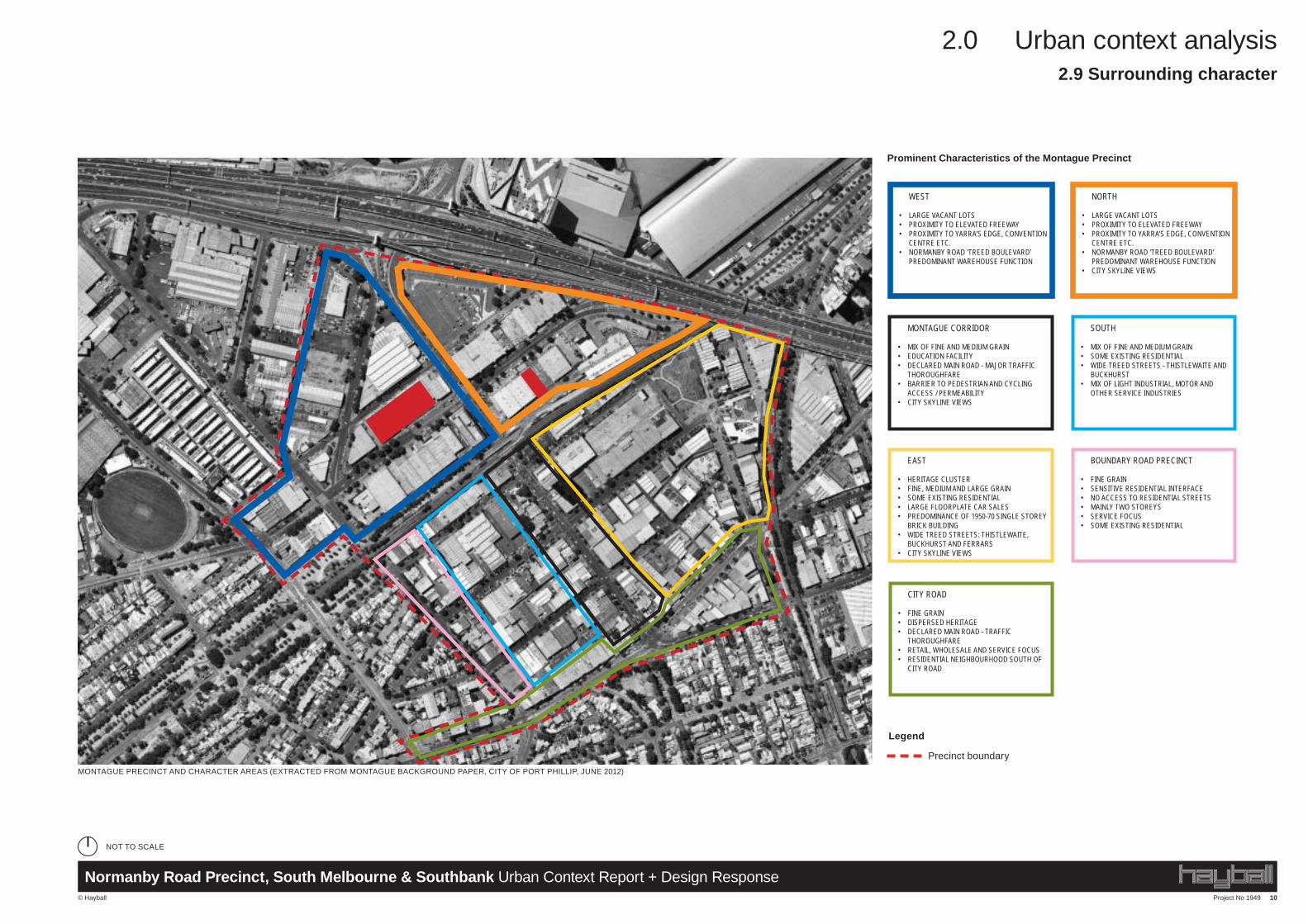
CITY ROAD
• FINE GRAIN• DISPERSED HERITAGE• DECLARED MAIN ROAD - TRAFFIC
THOROUGHFARE• RETAIL, WHOLESALE AND SERVICE FOCUS• RESIDENTIAL NEIGHBOURHOOD SOUTH OF
CITY ROAD
BOUNDARY ROAD PRECINCT
• FINE GRAIN• SENSITIVE RESIDENTIAL INTERFACE• NO ACCESS TO RESIDENTIAL STREETS• MAINLY TWO STOREYS• SERVICE FOCUS• SOME EXISTING RESIDENTIAL
SOUTH
• MIX OF FINE AND MEDIUM GRAIN• SOME EXISTING RESIDENTIAL• WIDE TREED STREETS - THISTLEWAITE AND
BUCKHURST• MIX OF LIGHT INDUSTRIAL, MOTOR AND
OTHER SERVICE INDUSTRIES
MONTAGUE CORRIDOR
• MIX OF FINE AND MEDIUM GRAIN• EDUCATION FACILITY• DECLARED MAIN ROAD - MAJOR TRAFFIC
THOROUGHFARE• BARRIER TO PEDESTRIAN AND CYCLING
ACCESS / PERMEABILITY• CITY SKYLINE VIEWS
NORTH
• LARGE VACANT LOTS• PROXIMITY TO ELEVATED FREEWAY• PROXIMITY TO YARRA’S EDGE, CONVENTION
CENTRE ETC.• NORMANBY ROAD ‘TREED BOULEVARD’
PREDOMINANT WAREHOUSE FUNCTION• CITY SKYLINE VIEWS
WEST
• LARGE VACANT LOTS• PROXIMITY TO ELEVATED FREEWAY• PROXIMITY TO YARRA’S EDGE, CONVENTION
CENTRE ETC.• NORMANBY ROAD ‘TREED BOULEVARD’
PREDOMINANT WAREHOUSE FUNCTION
EAST
• HERITAGE CLUSTER• FINE, MEDIUM AND LARGE GRAIN• SOME EXISTING RESIDENTIAL• LARGE FLOORPLATE CAR SALES• PREDOMINANCE OF 1950-70 SINGLE STOREY
BRICK BUILDING• WIDE TREED STREETS: THISTLEWAITE,
BUCKHURST AND FERRARS• CITY SKYLINE VIEWS
2.9 Surrounding character
Prominent Characteristics of the Montague Precinct
NOT TO SCALE
Project No 1949 11
2.0 Urban context analysis
© Hayball
Normanby Road Precinct, South Melbourne & Southbank Urban Context Report + Design Response
RAIL OVERBRIDGE
FORMER LAYCOCK SON AND CO. WOOLLEN MILL179-185 NORMANBY RD, CONSTRUCTED IN 1904
FORMER DUNLOP PNEUMATIC TYRE CO. MILL66 MONTAGUE ST, CONSTRUCTED IN 1913
HOUSES CONSTRUCTED IN 1935-4083-89 MONTAGUE ST, 108-116 GLADSTONE ST
BUILT FORM - LIKELY NO FUTURE CHANGE BUILT FORM - LIKELY FUTURE CHANGE
FORMER STATE SCHOOL (NO. 2784)90 MONTAGUE ST, CONSTRUCTED IN 1888
2.9 Surrounding character
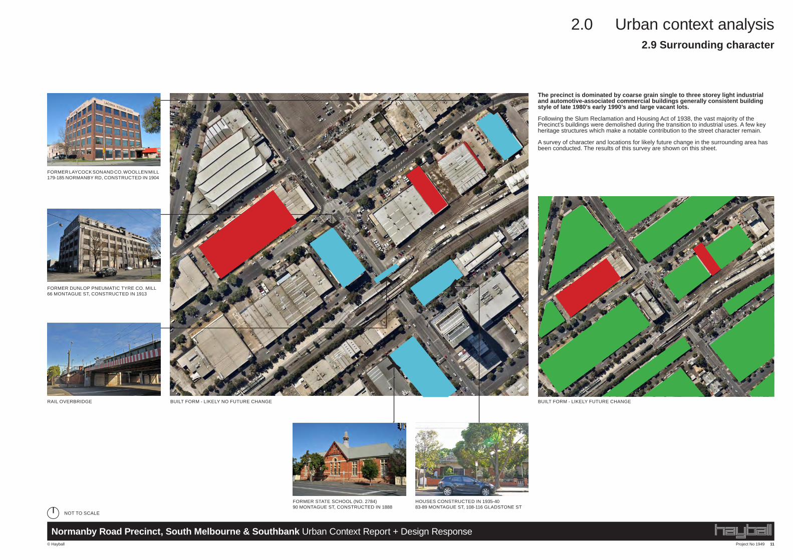
The precinct is dominated by coarse grain single to three storey light industrial and automotive-associated commercial buildings generally consistent building style of late 1980’s early 1990’s and large vacant lots.
Following the Slum Reclamation and Housing Act of 1938, the vast majority of the Precinct’s buildings were demolished during the transition to industrial uses. A few key heritage structures which make a notable contribution to the street character remain.
A survey of character and locations for likely future change in the surrounding area has been conducted. The results of this survey are shown on this sheet.
NOT TO SCALE
Project No 1949 12
2.0 Urban context analysis
© Hayball
Normanby Road Precinct, South Melbourne & Southbank Urban Context Report + Design Response
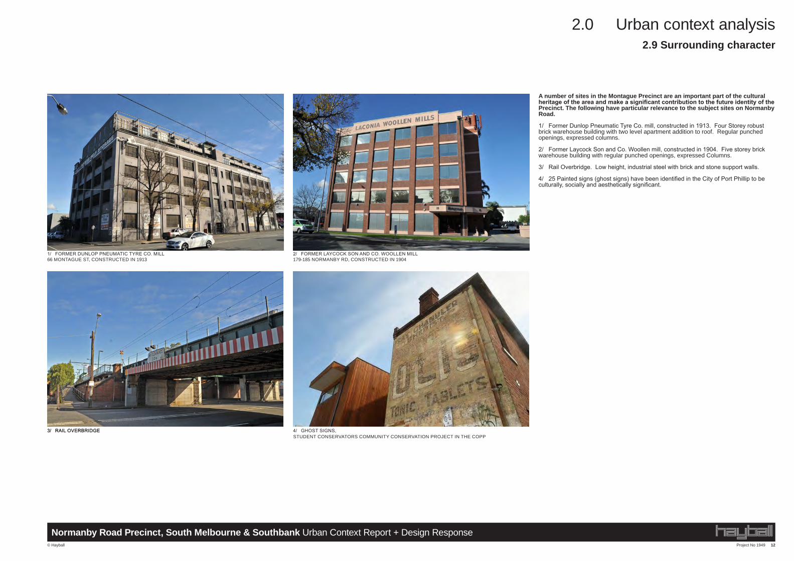
A number of sites in the Montague Precinct are an important part of the cultural heritage of the area and make a significant contribution to the future identity of the Precinct. The following have particular relevance to the subject sites on Normanby Road.
1/ Former Dunlop Pneumatic Tyre Co. mill, constructed in 1913. Four Storey robust brick warehouse building with two level apartment addition to roof. Regular punched openings, expressed columns.
2/ Former Laycock Son and Co. Woollen mill, constructed in 1904. Five storey brick warehouse building with regular punched openings, expressed Columns.
3/ Rail Overbridge. Low height, industrial steel with brick and stone support walls.
4/ 25 Painted signs (ghost signs) have been identified in the City of Port Phillip to be culturally, socially and aesthetically significant.
3/ RAIL OVERBRIDGE3/ RAIL OVERBRIDGE 4/ GHOST SIGNS, STUDENT CONSERVATORS COMMUNITY CONSERVATION PROJECT IN THE COPP
2/ FORMER LAYCOCK SON AND CO. WOOLLEN MILL179-185 NORMANBY RD, CONSTRUCTED IN 1904
1/ FORMER DUNLOP PNEUMATIC TYRE CO. MILL66 MONTAGUE ST, CONSTRUCTED IN 1913
2.9 Surrounding character
Project No 1949 13
2.0 Urban context analysis
© Hayball
Normanby Road Precinct, South Melbourne & Southbank Urban Context Report + Design Response
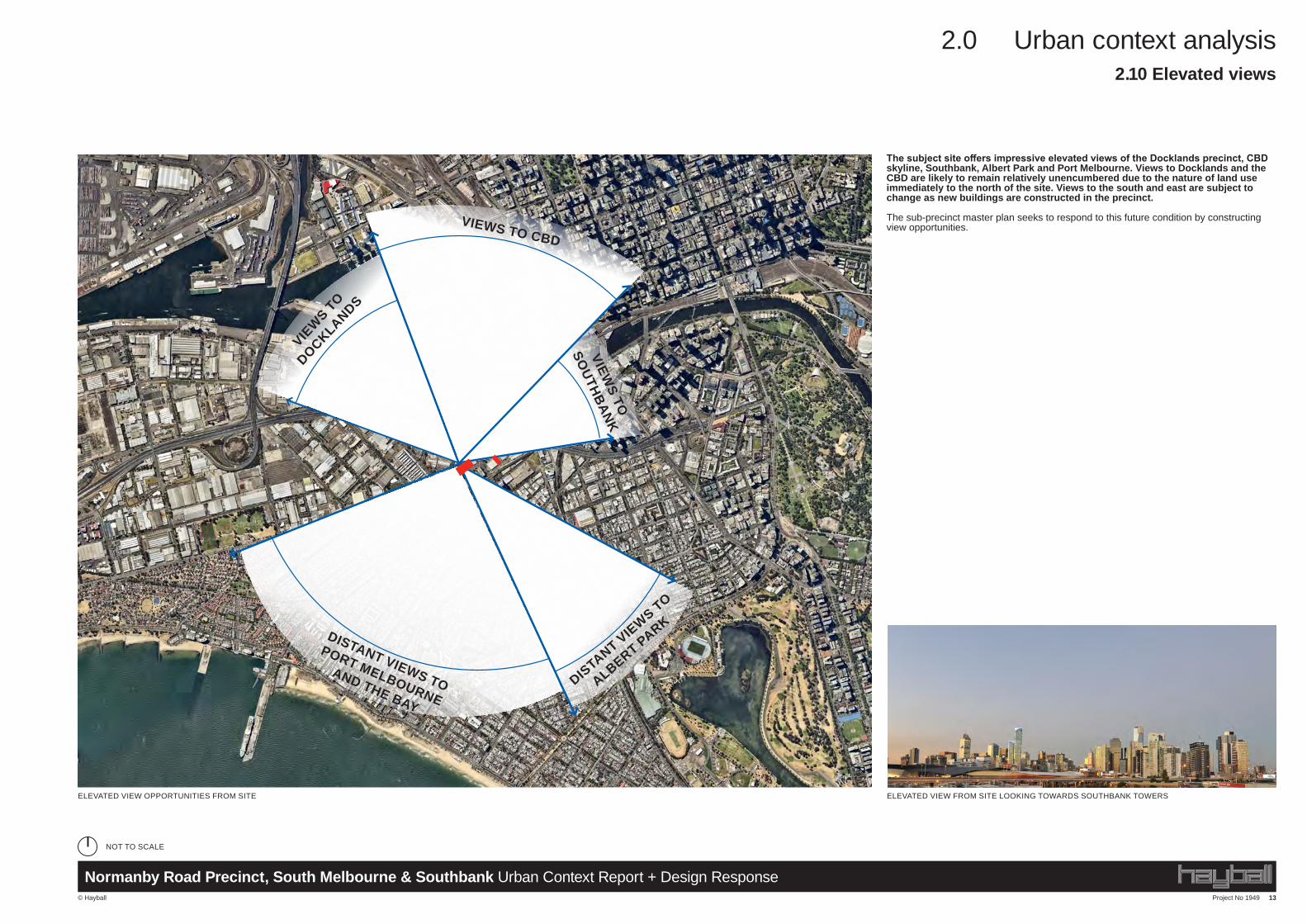
The subject site offers impressive elevated views of the Docklands precinct, CBD skyline, Southbank, Albert Park and Port Melbourne. Views to Docklands and the CBD are likely to remain relatively unencumbered due to the nature of land use immediately to the north of the site. Views to the south and east are subject to change as new buildings are constructed in the precinct. The sub-precinct master plan seeks to respond to this future condition by constructing view opportunities.
Project No 1949 15
2.0 Urban context analysis
© Hayball
Normanby Road Precinct, South Melbourne & Southbank Urban Context Report + Design Response
The subject site offers impressive elevated views of the Docklands precinct, CBD skyline, Southbank, Albert Park and Port Melbourne. Views to Docklands and the CBD are likely to remain relatively unencumbered due to the nature of land use immediately to the north of the site. Views to the south and east are subject to change as new buildings are constructed in the precinct. The sub-precinct master plan seeks to respond to this future condition by constructing view opportunities.
ELEVATED VIEW FROM SITE LOOKING TOWARDS SOUTHBANK TOWERSELEVATED VIEW OPPORTUNITIES FROM SITE
VIEWS TO CBD
VIEWS TO
DOCKLANDS
DISTANT VIEWS TO
ALBERT PARK
VIEWS TO
SOUTHBANK
DISTANT VIEWS TO
PORT MELBOURNE
AND THE BAY
2.12 Elevated views
NOT TO SCALE
ELEVATED VIEW FROM SITE LOOKING TOWARDS SOUTHBANK TOWERSELEVATED VIEW OPPORTUNITIES FROM SITE
VIEWS TO CBD
VIEWS TO
DOCKLANDS
DISTANT VIEWS TO
ALBERT PARK
VIEWS TO
SOUTHBANK
DISTANT VIEWS TO
PORT MELBOURNE
AND THE BAY
2.10 Elevated views
NOT TO SCALE