Embed Size (px)
Citation preview

North East Link Project Incorporated Document December 2019
1
1 INTRODUCTION
1.1 This document is an incorporated document in the Banyule, Boroondara, Manningham, Nillumbik, Whitehorse, Whittlesea and Yarra Planning Schemes (Planning Schemes) and is made pursuant to section 6(2)(j) of the Planning and Environment Act 1987.
1.2 This incorporated document facilitates the delivery of the North East Link Project (Project).
1.3 The control in Clause 4 prevails over any contrary or inconsistent provision in the Planning Schemes.
2 PURPOSE
2.1 The purpose of the control in Clause 4 is to permit and facilitate the use and development of the land described in Clause 3 for the purposes of the Project, in accordance with the requirements specified in Clause 4.
3 LAND
3.1 The control in Clause 4 applies to the land shown as SCO12 on the planning scheme maps forming part of the Planning Schemes (Project Land).
4 CONTROL
Exemption from Planning Scheme requirements
4.1 Despite any provision to the contrary, or any inconsistent provision in the Planning Schemes, no planning permit is required for, and no provision in the Planning Schemes operates to prohibit, restrict or regulate the use or development of the Project Land for the purposes of, or related to, constructing, maintaining or operating the Project.
4.2 The use and development of the Project Land for the purposes of, or related to, the Project includes, but is not limited to:
(a) A freeway standard road connecting the Metropolitan Ring Road (M80) to the Eastern Freeway.
(b) Twin road tunnels and associated infrastructure, including ventilation structures.
(c) Improvements to and widening of the Metropolitan Ring Road (M80) and the Eastern Freeway to provide for additional lanes in each direction.
(d) Elevated roads and road infrastructure, including gantries.
(e) Interchanges and grade separations associated with road connections.
(f) A dedicated busway in each direction along the Eastern Freeway together with associated infrastructure.
(g) A control centre and freeway maintenance facility.
(h) Utility installation, relocation and associated services including relocation of electricity transmission towers, telecommunication towers, lines, cables and associated substations, and relocation of water mains, water stations and sewers.
(i) Construction and relocation of rail infrastructure and associated services.
(j) Construction of at-grade or multi-level car parking facilities.
(k) Earthworks and related structures, kerbs, channels, water and soil transfer and treatment structures, facilities and works, water quality facilities, retaining walls,
2
flood walls, noise walls and screening barriers, cuttings, batters and fill associated with the Project.
(l) Any buildings or works or associated infrastructure or activities for the Project.
(m) Ancillary activities to the use and development of Project Land for the purposes of, or related to, the Project, including, but not limited to:
(i) Developing and using lay down areas for construction purposes.
(ii) Constructing and using temporary site workshops and storage, administration and amenities buildings.
(iii) Removing, destroying and lopping trees and vegetation, including native vegetation and dead vegetation.
(iv) Demolishing and removing buildings, fixtures, structures and infrastructure.
(v) Restoration and reinstatement works.
(vi) Developing and using land for walking and cycling infrastructure and facilities, including shared use paths, pedestrian and cycling overpasses and bridges.
(vii) Constructing or carrying out works for bridges, ramps, excavation, fences, temporary barriers, noise attenuation walls, stabilisation, creating bunds, mounds, landscaping, the salvage of artefacts, water treatment, water storage, flood mitigation and to alter drainage.
(viii) Creating or altering access to a road in a Road Zone, Category 1.
(ix) Creating or altering access to land in a Public Acquisition Overlay if the purpose of acquisition is for a Category 1 road.
(x) Storage and assembly of materials and equipment required for the Project.
(xi) Constructing and carrying out works to install, alter or relocate drainage infrastructure, utility installations and services.
(xii) Roadworks and constructing and using temporary access roads, diversion roads and vehicle parking areas.
(xiii) Displaying construction, directional and business identification signs.
(xiv) Stockpiling of excavation material.
(xv) Subdividing and consolidating land.
(xvi) The provision of new or upgraded public open space or sporting and recreation facilities including the construction of associated buildings and works and related infrastructure.
Conditions
4.3 The use and development permitted by this incorporated document is subject to the following conditions. In these conditions, reference to 'a stage' includes any stage or part of the Project, whether for construction or operation or both.
3
4.4 Tunnel land
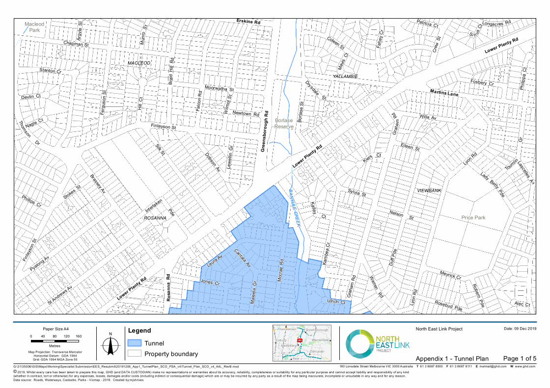
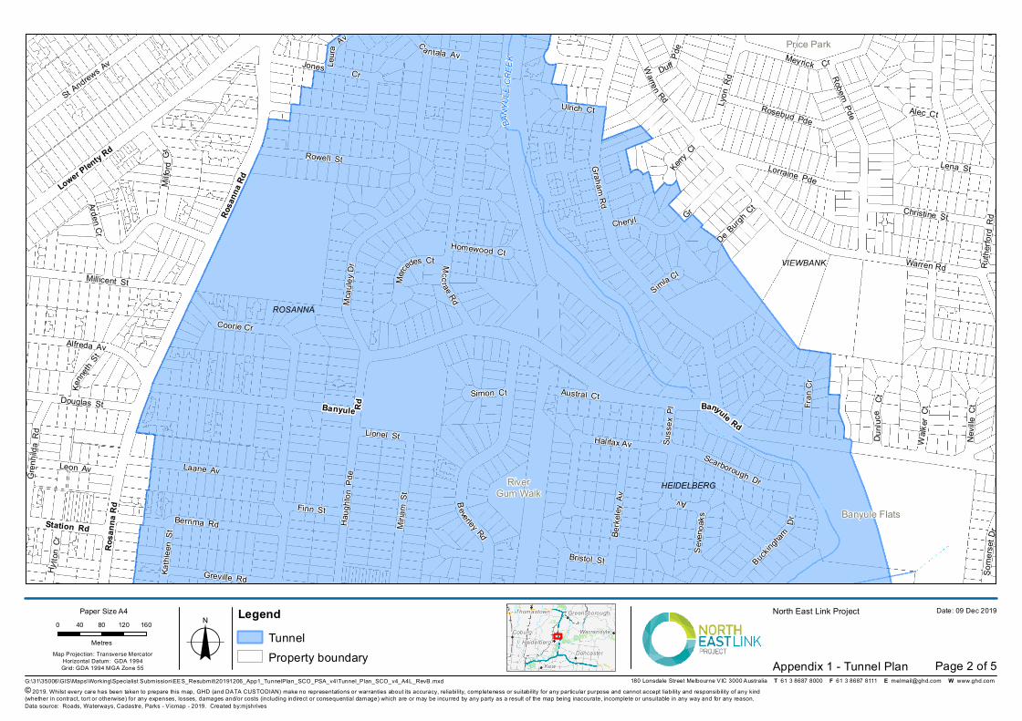
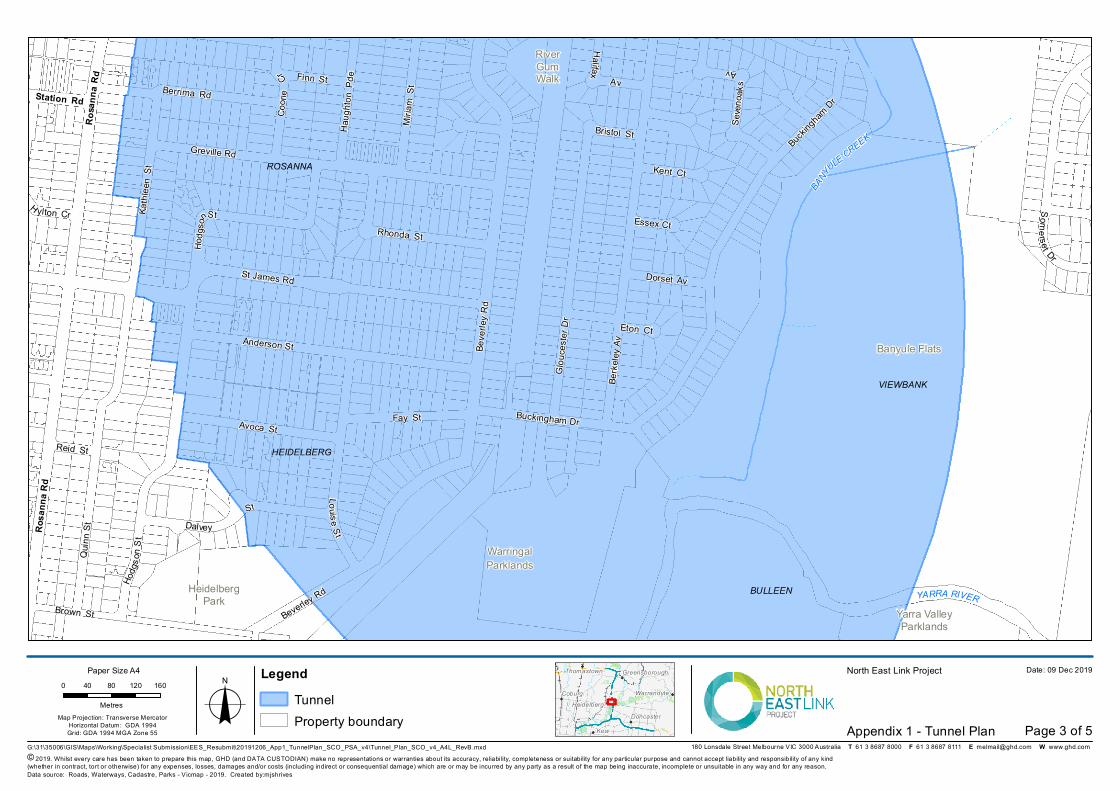
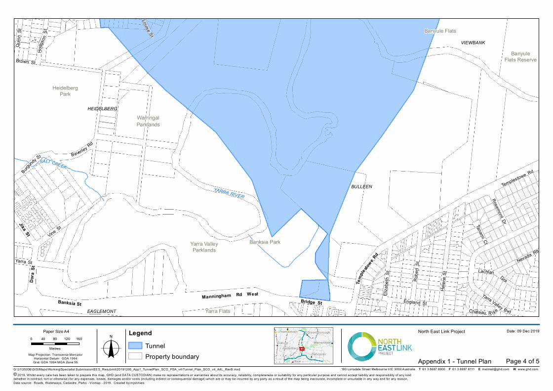
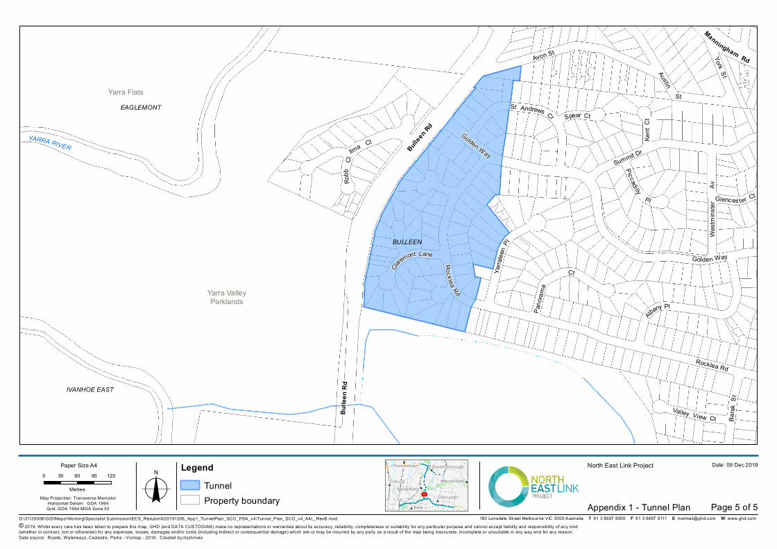
4.4.1 Except where necessary to provide for infrastructure associated with minor utility installations, all buildings and works within the area shown as ‘Tunnel’ on the attached plan titled ‘Appendix 1 – Tunnel Plan’ must be carried out at a depth greater than 15 metres below surface level.
4.5 Environmental Management Framework
4.5.1 Prior to the commencement of development (excluding preparatory buildings and works under Clause 4.13.1), an Environmental Management Framework (EMF) must be prepared to the satisfaction of the Minister for Planning.
4.5.2 The EMF must include Environmental Performance Requirements (EPRs) generally in accordance with the Minister’s Assessment dated 3 December 2019 made pursuant to the Environment Effects Act 1978 (EE Act) unless otherwise approved by the Minister for Planning. The EPRs must address the following areas and any other relevant matters:
(a) Aboriginal heritage
(b) Air quality
(c) Arboriculture
(d) Business
(e) Contamination and soil
(f) Environmental management
(g) Flora and fauna
(h) Ground movement
(i) Groundwater
(j) Historic heritage
(k) Land use planning
(l) Landscape and visual
(m) Noise and vibration (including tunnel vibration)
(n) Social and community
(o) Surface water
(p) Sustainability and climate change
(q) Traffic and transport
4.5.3 The EMF must:
(a) Set out the process and timing for development of a Construction Environmental Management Plan, Site Environmental Implementation Plan, Operations Environmental Management Plan and other plans and procedures required by the EPRs as relevant to any stage of the Project, including the process and timing for consultation with relevant councils, the Department of Transport, Heritage Victoria, the Roads Corporation, Melbourne Water, Public Transport Development Authority, the Department of Environment, Land, Water and Planning, Parks Victoria,
4
Environment Protection Authority and the Head, Transport for Victoria as relevant.
(b) Include a plan showing the extent of no-go zones where development is prohibited at the following locations, in accordance with the no-go zones shown in the Environment Effects Statement Map Book, April 2019:
(i) Bolin Bolin Billabong;
(ii) Grey-headed Flying Fox campsite within Yarra Bend Park;
(iii) Plains Grassy Woodland community between Enterprise Drive and the M80 Ring Road in Bundoora;
(iv) Rear of 49 Greenaway Street, Bulleen; and
(v) Banyule Flats and Warringal Parklands and Heide Museum of Modern Art, except for below ground development within the ‘project boundary – underground works’.
(c) Be accompanied by a statement explaining any difference between it (including the EPRs), and the matters set out in the Minister’s Assessment dated 3 December 2019 made pursuant to the EE Act.
4.5.4 The EMF may be prepared and approved in stages (including separately for construction and operation) but the EMF for any stage must be approved before the commencement of development (excluding preparatory buildings and works under Clause 4.13.1) for that stage.
4.5.5 The EMF may be amended from time to time, to the satisfaction of the Minister for Planning. An application for approval of an amendment to the EMF must be accompanied by:
(a) A ‘track changes’ version with a schedule explaining the proposed amendment/s and how it would be consistent with Project objectives in the North East Link Project, Business Case, May 2018.
(b) A description of the form and extent of any consultation undertaken concerning the proposed amendment/s with relevant councils, relevant government agencies and other stakeholders including community groups, business associations, sporting clubs and educational institutions.
(c) Any written comments from relevant councils, relevant government agencies and other stakeholders including community groups, business associations, sporting clubs and educational institutions.
4.5.6 The EMF must be amended to update references and requirements to be consistent with the Environment Protection (Amendment) Act 2018, to the satisfaction of the Minister for Planning. The amended EMF must be prepared in consultation with the Environment Protection Authority and must be submitted to the Minister for Planning for approval within 12 months of the commencement of the Environment Protection (Amendment) Act 2018.
4.5.7 The use and development of the Project must be carried out in accordance with the approved EMF including the EPRs and all plans and procedures required by them.
5
4.6 Review of the extent of the Specific Controls Overlay
4.6.1 A review of the extent of land affected by the Specific Controls Overlay (SCO) must be undertaken and a report prepared for the Minister for Planning which identifies land which is not required for the purpose of the Project and which may be removed from the SCO.
4.6.2 The report must be provided to the Minister for Planning as soon as practicable but no later than 3 months following the approval of Urban Design and Landscape Plans (UDLPs) under Clause 4.9.1.
4.7 Urban Design Advisory Panel
4.7.1 An Urban Design Advisory Panel (UDAP) must be established for the Project. The UDAP must include representatives of the following organisations:
(a) Office of the Victorian Government Architect
(b) Department of Transport
(c) North East Link Project
(d) Wurundjeri Woi-wurrung Cultural Heritage Aboriginal Corporation.
4.7.2 The membership of the UDAP must also include two independent design experts with exceptional design review skills, demonstrated expertise in urban design and experience in design delivery or design review of similar ‘city shaping’ infrastructure projects.
4.8 Urban Design Strategy
4.8.1 Prior to commencement of development (excluding preparatory buildings and works under Clause 4.13.1), an Urban Design Strategy (UDS) must be prepared to the satisfaction of the Minister for Planning.
4.8.2 The UDS must be generally in accordance with the draft North East Link Urban Design Strategy (April 2019) exhibited with the Environment Effects Statement (EES) but modified to include relevant matters set out in the Minister’s Assessment dated 3 December 2019 made pursuant to the EE Act. The UDS must include:
(a) An urban design vision.
(b) Urban design principles and objectives, and key design directions.
(c) Location-specific design directions or themes, including design guidelines.
(d) Modifications including:
(i) Prioritisation of the urban design principles and objectives, and key design directions that require an integrated design response and those that seek to minimise the project footprint and reduce the physical and visual impacts of the project over others, such as those that seek to provide a great experience for road users.
(ii) Use of more definitive language (such as ‘avoid’ instead of ‘minimise’) to guide outcomes particularly in relation to potential impacts on residential properties and open space.
(iii) Key design directions that seek to minimise visual impacts by prioritising the siting of infrastructure elements away from sensitive
6
receptors or reducing their scale in preference to alternative measures (such as material treatments).
(iv) An outline of, and response to, relevant principles from the Yarra River Protection (Wilip-gin Birrarung Murron) Act 2017.
(v) An outline of, and response to, the Cultural Values Assessment Report prepared by the Wurundjeri Woi-wurrung Aboriginal Heritage Corporation where the Wurundjeri Woi-wurrung Aboriginal Heritage Corporation consents to this requirement.
(vi) An outline of, and response to, the Yarra Strategic Plan (subject to the timing of its release).
(vii) Design directions to achieve acceptable urban design interfaces with schools along the Project alignment and its surrounds having regard to the setting and operational requirements of each school.
(viii) Conversion of elements of the place-specific requirements from complementary (and optional) to mandatory following further consideration as to where this is warranted. At a minimum, these should include all elements that are integral to ensuring the Project achieves relevant strategic objectives, including the Manningham Interchange, biodiversity and habitat links along the Yarra River corridor and opportunities for water sensitive urban design elements around the Yarra Valley Parklands.
4.8.3 The UDS must also include urban design framework plans for the following five key locations:
(a) M80/Greensborough Highway Interchange;
(b) Watsonia Neighbourhood Activity Centre and its surrounds;
(c) Borlase Reserve and Lower Plenty Road Interchange;
(d) Manningham/Bulleen Road Interchange; and
(e) Bulleen Road/Eastern Freeway Interchange.
4.8.4 The urban design framework plans must provide an outline of options for use and development of land at each of the five key locations having regard to strategic planning opportunities and constraints and its interaction with structures, works and facilities proposed by the Project. The urban design framework plans must include, where relevant:
(a) A set of design and development principles including all relevant elements of the UDS pertaining to that particular location.
(b) A framework plan to identify key action areas and important relationships including a layout of all active and passive movement networks to facilitate acceptable connectivity for pedestrians and vehicles, interactions with public facilities and infrastructure, and the location and nature of public open space.
(c) Diagrams, drawings and benchmark imagery illustrating how the Project design could respond to the design and development principles for that particular location.
(d) Action plans and an implementation strategy for the Project including key components proposed to be developed by the Project and identifying opportunities for development or upgrades by others.
7
4.8.5 The UDS submitted to the Minister for Planning under Clause 4.8.1 must be accompanied by:
(a) A statement explaining any differences between the UDS and the draft North East Link Urban Design Strategy (April 2019) exhibited with the EES and how it addresses all relevant matters set out in the Minister’s Assessment dated 3 December 2019 made pursuant to the EE Act.
(b) Written advice from the UDAP addressing the extent to which the UDS is consistent with all relevant matters set out in the Minister’s Assessment dated 3 December 2019 made pursuant to the EE Act and the EPRs included in the approved EMF.
(c) A summary of any consultation carried out with councils and land or waterway managers in preparing the UDS, all written comments received and a response to issues raised.
4.8.6 The UDS may be prepared and approved in stages but the UDS for any stage must be approved before the commencement of development (excluding preparatory buildings and works under Clause 4.13.1) for that stage.
4.8.7 The UDS may be amended from time to time, to the satisfaction of the Minister for Planning. Any request to amend the UDS must be accompanied by supporting documentation which outlines the result of UDAP’s consideration of the proposed amendment/s.
4.8.8 The use and development of the Project must be carried out in accordance with the approved UDS.
4.9 Urban Design and Landscape Plans
4.9.1 Prior to the commencement of development of permanent above-ground buildings or structures (excluding preparatory buildings and works under Clause 4.13.1), UDLPs must be prepared to the satisfaction of the Minister for Planning.
4.9.2 The UDLPs must show the final built form design for the Project and include, where relevant:
(a) A site layout plan that shows the location of permanent above-ground buildings and structures (including but not limited to proposed bridges, elevated roads, tunnel portals, ventilation structures, flood walls, noise walls, public transport infrastructure, and walking and cycling facilities).
(b) Architectural plans, including sections and elevations, with materials and finishes.
(c) Landscape plans, including sections and elevations, with plant species.
4.9.3 An Urban Design and Landscape Plan (UDLP) must be accompanied by the following, where relevant:
(a) An explanation demonstrating how the UDLP is in accordance with the approved UDS including any relevant urban design framework plan.
(b) An explanation demonstrating how the UDLP would comply with the EPRs included in the approved EMF.
(c) A plan which shows the extent of the UDLP area in relation to any publicly available or approved UDLP/s.
8
(d) A plan which shows the boundary of the Project Land and location of areas to be used for construction compounds consistent with the approved Construction Compound Plan under Clause 4.12.
4.9.4 Prior to the submission of an UDLP to the Minister for Planning for approval, an UDLP must be:
(a) Provided to the UDAP and relevant council/s for consultation.
(b) Provided to the Department of Transport, Roads Corporation, Public Transport Development Authority, Melbourne Water, Heritage Victoria, the Department of Environment, Land, Water and Planning (DELWP), Parks Victoria and the Head, Transport for Victoria for consultation where relevant.
(c) Made available for public inspection and comment on a clearly identifiable Project website. The website must set out details about the entity and contact details to which written comments can be directed during that time and specify the time and manner for the making of written comments. The minimum period for public comment must be 21 days.
For the avoidance of doubt, consultation in accordance with (a) and (b) can occur prior to, during and after the public inspection and comment period in (c).
4.9.5 Before, or on the same day as an UDLP is made available in accordance with Clause 4.9.4(c), a notice must be:
(a) Published in a newspaper generally circulating in the area to which an UDLP applies informing the community of the matters set out in Clause 4.9.4(c).
(b) Provided to owners and occupiers of land adjacent to the area/s to which an UDLP applies informing them of the matters set out in Clause 4.9.4(c). The minimum period for comment must be 21 days.
4.9.6 An UDLP submitted to the Minister for Planning for approval under Clause 4.9.1 must be accompanied by:
(a) A summary of the consultation carried out under Clause 4.9.4 and Clause 4.9.5, all written comments received and a response to issues raised.
(b) Written advice from the UDAP addressing the extent to which the UDLP is consistent with all relevant matters set out in the Minister’s Assessment dated 3 December 2019 made pursuant to the EE Act, the EPRs included in the approved EMF, and the approved UDS including any relevant urban design framework plan.
4.9.7 An UDLP may be prepared and approved in stages but an UDLP for any stage must be approved before commencement of development (excluding preparatory buildings and works under Clause 4.13.1) for that stage.
4.9.8 An UDLP may be amended from time to time, to the satisfaction of the Minister for Planning. The Minister for Planning must require an application for approval of an amendment to an UDLP to comply with the requirements of Clause 4.9.2, Clause 4.9.3, Clause 4.9.4 and Clause 4.9.5 unless, in the opinion of the Minister the proposed amendment:
(a) would not result in a material detriment to any person; or a person who may suffer a material detriment as a result of the Minister’s approval of
9
the amendment has already been consulted in respect of the proposed amendment; and
(b) any proposed amendment does not involve any change to an approved Environmental Performance Requirement.
4.9.9 The use and development of the Project must be carried out generally in accordance with the approved UDLPs.
4.10 Native vegetation
4.10.1 Prior to removal, destruction or lopping of native vegetation:
(a) Information about that native vegetation, including an avoid and minimise statement, in accordance with application requirements 1, 5 and 9 in Table 4 of the Guidelines for removal, destruction or lopping of native vegetation (DELWP, December 2017) must be provided to the satisfaction of the Secretary to DELWP.
(b) The biodiversity impacts from the removal, destruction or lopping of that native vegetation must be offset in accordance with the Guidelines for removal, destruction or lopping of native vegetation (DELWP, December 2017).
(c) Evidence that the required offset/s has been secured must be provided to the satisfaction of the Secretary to DELWP.
4.10.2 The requirements of Clause 4.10.1 may be satisfied in stages, however, each requirement must be satisfied prior to the removal, destruction or lopping of native vegetation for that stage.
4.10.3 The secured offset/s for the Project may be reconciled at the completion of the project in accordance with the Assessor’s handbook – Applications to remove, destroy or lop native vegetation (DELWP, October 2018).
4.11 Subdivision and consolidation
4.11.1 Before a plan is certified under the Subdivision Act 1988, a plan of the proposed subdivision or consolidation must be prepared to the satisfaction of the Minister for Planning.
4.12 Construction Compound Plan
4.12.1 Prior to the use and development of any construction compound, a Construction Compound Plan (CCP) must be prepared to the satisfaction of the Minister for Planning.
4.12.2 The CCP must include:
(a) A plan showing the location and layout of each compound and the categories of works and operations proposed within each compound.
(b) The estimated duration of activity within each compound.
(c) Demonstration that any compound proposed on land which is not to be permanently acquired are reasonably required in the location in which they are proposed, including demonstration that alternatives which reduce the impact of the compounds on such land are not feasible or practical.
(d) Demonstration that the compounds (and categories of permissible works within each compound) have been sited to avoid, then minimise, then
10
mitigate, impacts on sensitive uses (including residences, open space, schools, community organisations and sporting and recreation areas).
(e) Demonstration that the categories of works proposed within the compounds are appropriate having regard to whether the land is flood prone, including any flood modelling where appropriate, or has any particular environmental sensitivity, and that the works will be suitably managed to address any flood risk.
(f) Measures to restore the former use of the land used for construction once these activities are complete.
4.12.3 A CCP may be prepared and approved in stages but a CCP for any stage must be approved before the commencement of use and development for that stage.
4.12.4 A CCP may be amended from time to time, to the satisfaction of the Minister for Planning.
4.12.5 All construction compounds must be located and operated in accordance with the approved CCP and relevant EPRs included in the approved EMF.
4.13 Preparatory buildings and works
4.13.1 Subject to clause 4.13.2, the following buildings and works may be commenced before the requirements specified in Clause 4 are satisfied:
(a) Preparatory buildings and works for the Project, limited to:
(i) Works, including vegetation removal, where, but for this incorporated document, a planning permit would not be required under the provisions of the Planning Schemes. Prior to the removal, destruction or lopping of vegetation under this sub-clause, information about that vegetation must be provided to the Minister for Planning. The information provided to the Minister for Planning must include a description of, and maps showing, the location, species and size of that vegetation.
(ii) Investigating, testing and preparatory works to determine the suitability of land, and property condition surveys.
(iii) Construction, protection, modification, removal or relocation of electricity transmission towers on land that forms part of an existing electricity transmission easement area, minor utility installations, rail signalling, and overhead and associated infrastructure.
(iv) Establishment of environment and traffic controls.
(v) Demolition to the minimum extent necessary to enable preparatory works.
(vi) Salvaging and relocating artefacts and other preparatory works required to be undertaken in accordance with the approved Cultural Heritage Management Plan prepared for the project under the Aboriginal Heritage Act 2006.
4.13.2 Despite Clause 4.13.1:
(a) Clause 4.10 applies to any removal, destruction or lopping of native vegetation required to carry out preparatory buildings and works referred to in Clause 4.13.1; and
11
(b) Clause 4.12 (save to the extent Clause 4.12.5 refers to the relevant EPRs included in the approved EMF) applies to any construction compound required to carry out preparatory buildings and works referred to in Clause 4.13.1, unless the Minister for Planning has provided prior written approval exempting the particular construction compound(s) from the requirements of Clause 4.12.
4.14 Availability of approved plans and documents
4.14.1 The current version of the following plans and documents must be available on a clearly identifiable Project website from the date of approval and must remain available on such website for at least five years after the commencement of operation of the Project:
(a) Environmental Management Framework approved under Clause 4.5.1;
(b) Urban Design Strategy approved under Clause 4.8.1;
(c) Urban Design and Landscape Plans approved under Clause 4.9.1;
(d) Construction Compound Plan approved under Clause 4.12.1; and
(e) Communications and Community Engagement Plan.
5 EXPIRY
5.1 The control in this incorporated document expires if any of the following circumstances apply:
(a) The development allowed by the control is not started by 31 December 2021.
(b) The development allowed by the control is not completed by 31 December 2030.
(c) The use allowed by the control is not started by 1 January 2031.

Appendix 1 – Tunnel Plan
R osa
nna
Rd
Martins Lane
Lower Plenty Rd
Lower Plenty Rd
Lower Plenty Rd
Gree
nsbo
roug
h Rd
Erskine Rd
Cre
wSt
LascellesA
vW
arrenRd
Finl
ayso
n St
Finlayson St
Hill
Ct
Borla
se S
t
Longac res Rd
Si ri us
Ct
Thomson
Dr
Fahe
y C
r
Duf
f Pde
Meyrick Cr
LadyBetty
Pde
Coleen St
Gra
ham
Rd
Gra
ham
RdWilm
otS
t
Robern PdeLyon
Rd
Lyon Rd
Falc
on R
d
Bra
idH
il lR
d
Brassey Av
Ferg
uson
St
Alec Ct
Mcc
rae
Rd
Dobson Av
Jones Cr
Mal
eela
Gr
Mav
isCt
Nagle Ct
Ulrich Ct
Cantala Av
Argy
le S
t
Interlaken
Pde
Moorwatha St
Nelson St
Devlin Ct
Kiers Ct
Chapman St
Kam
bea
Cr
Ka llay
Ct
Patricia Ct
Drysdale
St
Toumlin
Gr
Mun
roS
tEileen St
Sylvia StPhillips Cr
Newtown Rd
Lew
ellin
Gr
Leura Av
Philip
pa C
t
Stokes St
Rosebud Pde
Willa Av
Fosbery Cr
Silk St
Pyalong Av
St Andrews Av
Stanton Cr
BANYULECREEK
YALLAMBIE
VIEWBANK
MACLEOD
ROSANNA
MacleodPark
Price Park
BorlaseReserve
G:\31\35006\GIS\Maps\Working\Specialist Submission\EES_Resubmit\20191206_App1_TunnelPlan_SCO_PSA_v4\Tunnel_Plan_SCO_v4_A4L_RevB.mxd
Map Projection: Transverse MercatorHorizontal Datum: GDA 1994Grid: GDA 1994 MGA Zone 55
0 40 80 120 160
Metres o© 2019. Whilst every care has been taken to prepare this map, GHD (and DATA CUSTODIAN) make no representations or warranties about its accuracy, reliability, completeness or suitability for any particular purpose and cannot accept liability and responsibility of any kind (whether in contract, tort or otherwise) for any expenses, losses, damages and/or costs (including indirect or consequential damage) which are or may be incurred by any party as a result of the map being inaccurate, incomplete or unsuitable in any way and for any reason.
Date: 09 Dec 2019North East Link Project
Appendix 1 - Tunnel Plan
Data source: Roads, Waterways, Cadastre, Parks - Vicmap - 2019. Created by:mjshrives
180 Lonsdale Street Melbourne VIC 3000 Australia T 61 3 8687 8000 F 61 3 8687 8111 E [email protected] W www.ghd.com
Paper Size A4 LegendTunnelProperty boundary Doncaster
Coburg
Thomastown Greensborough
Warrandyte
Kew
Heidelberg
Page 1 of 5
Banyule Rd Banyule Rd
Rosa
nna R
d
Rosa
nna R
d
Lower Plenty Rd
Station Rd
Buckingh
amD
r
Som
erse
tDr
Rut
herfo
rd R
d
Scarborough Dr
Warren
Rd
Warren Rd
Greville Rd
Lyon
Rd
Mcc
raeRd
Berrima Rd
Gre
nhild
a R
d
Meyrick Cr
Kath
leen
St
Hau
ghto
n Pd
e
Robern Pde
Berk
eley
Av
Ca ntala Av
Douglas St
Lena St
Beverley Rd
Coorie Cr
Alec Ct
Graham
Rd
Simla Cl
Mca
uley
Dr
Jones Cr
Simon Ct
Halifax Av
Ulrich Ct
Leu r
a
Av
Alfreda Av
Suss
ex P
l
Bristol St
Kerry
Cl
Duff
Pde
Lionel St
Arden Cr
Homewood Ct
Nev
ille
Ct
Hylto
nC
r
Wa l
k er
Ct
De Burg
h Ct
Kenn
eth
St
Austral Ct
Finn St
Dun
luce
Ct
Merc
edes Ct
Millicent St
Leon Av
Milf
o rd
Gr
Christine St
Rosebud Pde
Rowell StLorraine Pde
Miri
am S
t
St Andrews Av
Cheryl Gr
Laane Av
Fran
Cr
Sev
enoa
ks
Av
BANY
U LE
CREE
K
VIEWBANK
ROSANNA
HEIDELBERG
Price Park
RiverGum Walk
Banyule Flats
G:\31\35006\GIS\Maps\Working\Specialist Submission\EES_Resubmit\20191206_App1_TunnelPlan_SCO_PSA_v4\Tunnel_Plan_SCO_v4_A4L_RevB.mxd
Map Projection: Transverse MercatorHorizontal Datum: GDA 1994Grid: GDA 1994 MGA Zone 55
0 40 80 120 160
Metres o© 2019. Whilst every care has been taken to prepare this map, GHD (and DATA CUSTODIAN) make no representations or warranties about its accuracy, reliability, completeness or suitability for any particular purpose and cannot accept liability and responsibility of any kind (whether in contract, tort or otherwise) for any expenses, losses, damages and/or costs (including indirect or consequential damage) which are or may be incurred by any party as a result of the map being inaccurate, incomplete or unsuitable in any way and for any reason.
Date: 09 Dec 2019North East Link Project
Appendix 1 - Tunnel Plan
Data source: Roads, Waterways, Cadastre, Parks - Vicmap - 2019. Created by:mjshrives
180 Lonsdale Street Melbourne VIC 3000 Australia T 61 3 8687 8000 F 61 3 8687 8111 E [email protected] W www.ghd.com
Paper Size A4 LegendTunnelProperty boundary Doncaster
Coburg
Thomastown Greensborough
Warrandyte
Kew
Heidelberg
Page 2 of 5
Rosa
nnaR
dStation Rd
Rosa
nna R
d
Brown St Beverley Rd
Beve
rley
Rd
Coo
ri eCr
Berk
eley
Av
Buckingham Dr
Buckin
gham
Dr
Berrima Rd
Loui seS
t
Greville Rd
Som
erset Dr
Hodg
son
St
Ho d
gson
St
Eton Ct
Essex Ct
Hau
ghto
n Pd
e
Reid St
H ylton Cr
Bristol StKa
thle
en S
t Kent Ct
Finn St
Dorset Av
Halifax
Av
Glo
uces
ter D
r
Anderson St
Fay StM
iriam
St
Qui
nn S
t
Avoca St
Sev
eno a
ks
Av
Rhonda St
Dalvey
St
St James Rd
BANYULE CREEK
YARRA RIVER
VIEWBANK
ROSANNA
BULLEEN
HEIDELBERG
WarringalParklands
HeidelbergPark
RiverGumWalk
Banyule Flats
Yarra ValleyParklands
G:\31\35006\GIS\Maps\Working\Specialist Submission\EES_Resubmit\20191206_App1_TunnelPlan_SCO_PSA_v4\Tunnel_Plan_SCO_v4_A4L_RevB.mxd
Map Projection: Transverse MercatorHorizontal Datum: GDA 1994Grid: GDA 1994 MGA Zone 55
0 40 80 120 160
Metres o© 2019. Whilst every care has been taken to prepare this map, GHD (and DATA CUSTODIAN) make no representations or warranties about its accuracy, reliability, completeness or suitability for any particular purpose and cannot accept liability and responsibility of any kind (whether in contract, tort or otherwise) for any expenses, losses, damages and/or costs (including indirect or consequential damage) which are or may be incurred by any party as a result of the map being inaccurate, incomplete or unsuitable in any way and for any reason.
Date: 09 Dec 2019North East Link Project
Appendix 1 - Tunnel Plan
Data source: Roads, Waterways, Cadastre, Parks - Vicmap - 2019. Created by:mjshrives
180 Lonsdale Street Melbourne VIC 3000 Australia T 61 3 8687 8000 F 61 3 8687 8111 E [email protected] W www.ghd.com
Paper Size A4 LegendTunnelProperty boundary Doncaster
Coburg
Thomastown Greensborough
Warrandyte
Kew
Heidelberg
Page 3 of 5
Jika St
Dora
St
Banksia St
Temp
lestowe Rd
Manningham Rd WestBridge St
Brown St
Yarra Valley Bvd
Vine St
Burgu
ndy St
Hel
ene
St
Rob
ert
St
Eliz
abet
h St
Yarra St
England St
LachlanGra
LouiseSt
Beverley Rd
Nevada Rtt
Tanami Ct
Chateau R is e
Qui
nn S
t
Hod
gson
St
Templestowe Rd
Rosemont Dr
SALT CREEK
YARRA RIVER
VIEWBANK
BULLEEN
HEIDELBERG
EAGLEMONT
Banksia Park
BanyuleFlats Reserve
WarringalParklands
Yarra Flats
HeidelbergPark
Banyule Flats
Yarra ValleyParklands
G:\31\35006\GIS\Maps\Working\Specialist Submission\EES_Resubmit\20191206_App1_TunnelPlan_SCO_PSA_v4\Tunnel_Plan_SCO_v4_A4L_RevB.mxd
Map Projection: Transverse MercatorHorizontal Datum: GDA 1994Grid: GDA 1994 MGA Zone 55
0 40 80 120 160
Metres o© 2019. Whilst every care has been taken to prepare this map, GHD (and DATA CUSTODIAN) make no representations or warranties about its accuracy, reliability, completeness or suitability for any particular purpose and cannot accept liability and responsibility of any kind (whether in contract, tort or otherwise) for any expenses, losses, damages and/or costs (including indirect or consequential damage) which are or may be incurred by any party as a result of the map being inaccurate, incomplete or unsuitable in any way and for any reason.
Date: 09 Dec 2019North East Link Project
Appendix 1 - Tunnel Plan
Data source: Roads, Waterways, Cadastre, Parks - Vicmap - 2019. Created by:mjshrives
180 Lonsdale Street Melbourne VIC 3000 Australia T 61 3 8687 8000 F 61 3 8687 8111 E [email protected] W www.ghd.com
Paper Size A4 LegendTunnelProperty boundary Doncaster
Coburg
Thomastown Greensborough
Warrandyte
Kew
Heidelberg
Page 4 of 5
Manningham Rd
Bulle
en R
d
Bulleen Rd
Avon St
Golden Way
Golden Way
Rocklea
Rd
Rocklea Rd
Ilma Ct
Bar
akS
t
Summit Dr
YorkS
t
Clare
mont Lane
Kent
Ct
Rob
bC
l
Spear Ct
Glences ter Ct
Wes
tmin
ster
A
v
St Andrews CrAustin
St
Pic cadi lly
Pl
Valley View Ct
Yarra
leen
Pl
Pan
oram
a
Ct
Albany Pl
YARRA RIVER
IVANHOE EAST
BULLEEN
EAGLEMONTYarra Flats
Yarra ValleyParklands
G:\31\35006\GIS\Maps\Working\Specialist Submission\EES_Resubmit\20191206_App1_TunnelPlan_SCO_PSA_v4\Tunnel_Plan_SCO_v4_A4L_RevB.mxd
Map Projection: Transverse MercatorHorizontal Datum: GDA 1994Grid: GDA 1994 MGA Zone 55
0 30 60 90 120
Metres o© 2019. Whilst every care has been taken to prepare this map, GHD (and DATA CUSTODIAN) make no representations or warranties about its accuracy, reliability, completeness or suitability for any particular purpose and cannot accept liability and responsibility of any kind (whether in contract, tort or otherwise) for any expenses, losses, damages and/or costs (including indirect or consequential damage) which are or may be incurred by any party as a result of the map being inaccurate, incomplete or unsuitable in any way and for any reason.
Date: 09 Dec 2019North East Link Project
Appendix 1 - Tunnel Plan
Data source: Roads, Waterways, Cadastre, Parks - Vicmap - 2019. Created by:mjshrives
180 Lonsdale Street Melbourne VIC 3000 Australia T 61 3 8687 8000 F 61 3 8687 8111 E [email protected] W www.ghd.com
Paper Size A4 LegendTunnelProperty boundary Doncaster
Coburg
Thomastown Greensborough
Warrandyte
Kew
Heidelberg
Page 5 of 5