Embed Size (px)
Citation preview

TRANSFORM AND EXPLOIT THE VALUE OF LIDAR DATA
NOW FEATURING AN INTEGRATED 3D VIEWER
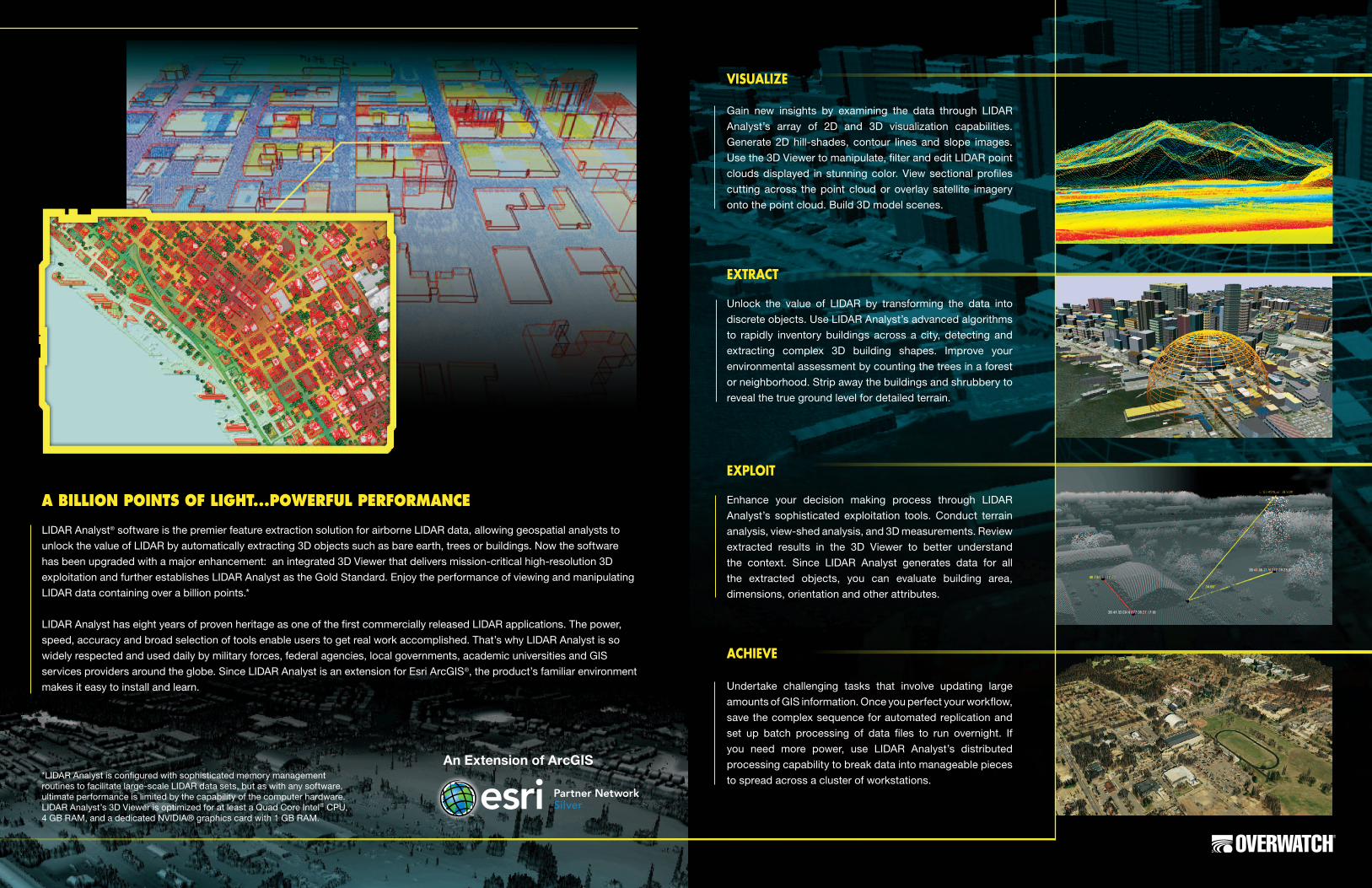
LIDAR Analyst® software is the premier feature extraction solution for airborne LIDAR data, allowing geospatial analysts to
unlock the value of LIDAR by automatically extracting 3D objects such as bare earth, trees or buildings. Now the software
has been upgraded with a major enhancement: an integrated 3D Viewer that delivers mission-critical high-resolution 3D
exploitation and further establishes LIDAR Analyst as the Gold Standard. Enjoy the performance of viewing and manipulating
LIDAR data containing over a billion points.*
LIDAR Analyst has eight years of proven heritage as one of the first commercially released LIDAR applications. The power,
speed, accuracy and broad selection of tools enable users to get real work accomplished. That’s why LIDAR Analyst is so
widely respected and used daily by military forces, federal agencies, local governments, academic universities and GIS
services providers around the globe. Since LIDAR Analyst is an extension for Esri ArcGIS®, the product’s familiar environment
makes it easy to install and learn.
A bILLION POINTS OF LIgHT...POwERFUL PERFORMANcE
Visualize
Gain new insights by examining the data through LIDAR
Analyst’s array of 2D and 3D visualization capabilities.
Generate 2D hill-shades, contour lines and slope images.
Use the 3D Viewer to manipulate, filter and edit LIDAR point
clouds displayed in stunning color. View sectional profiles
cutting across the point cloud or overlay satellite imagery
onto the point cloud. Build 3D model scenes.
extract
Unlock the value of LIDAR by transforming the data into
discrete objects. Use LIDAR Analyst’s advanced algorithms
to rapidly inventory buildings across a city, detecting and
extracting complex 3D building shapes. Improve your
environmental assessment by counting the trees in a forest
or neighborhood. Strip away the buildings and shrubbery to
reveal the true ground level for detailed terrain.
exploit
Enhance your decision making process through LIDAR
Analyst’s sophisticated exploitation tools. Conduct terrain
analysis, view-shed analysis, and 3D measurements. Review
extracted results in the 3D Viewer to better understand
the context. Since LIDAR Analyst generates data for all
the extracted objects, you can evaluate building area,
dimensions, orientation and other attributes.
achieVe
Undertake challenging tasks that involve updating large
amounts of GIS information. Once you perfect your workflow,
save the complex sequence for automated replication and
set up batch processing of data files to run overnight. If
you need more power, use LIDAR Analyst’s distributed
processing capability to break data into manageable pieces
to spread across a cluster of workstations.*LIDAR Analyst is configured with sophisticated memory management routines to facilitate large-scale LIDAR data sets, but as with any software, ultimate performance is limited by the capability of the computer hardware. LIDAR Analyst’s 3D Viewer is optimized for at least a Quad Core Intel® CPU, 4 GB RAM, and a dedicated NVIDIA® graphics card with 1 GB RAM.
An Extension of ArcGIS

www.overwatch.com
©2013 Overwatch Systems, Ltd. All rights reserved. Overwatch is a strategic business of Textron Systems Advanced Systems, an operating unit of Textron Systems, a Textron Inc. (NYSE: TXT) company. LIDAR Analyst is a registered trademark of Overwatch Systems, Ltd. ArcGIS and ArcMap are registered trademarks of Environmental Systems Research Institute, Inc. (Esri). Trademarks provided under license from Esri. NVIDIA is a registered trademark of NVIDIA Corporation. Intel is a registered trademark of Intel Corporation. HTCondor is a trademark of the University of Wisconsin-Madison. Google Earth is a registered trademark of Google, Inc. PowerPoint is a registered trademark of Microsoft Corporation.
Overwatch21660 Ridgetop CircleSuite 110Sterling, VA 20166
(703) 437-7651 or (800) [email protected]
World Ready DistributionClassified EAR99 by the US Government
wANT TO USE LIDAR DATA TO YOUR ADVANTAgE?PREMIUM cAPAbILITIES = MISSION AccOMPLISHED
Data ProcessingLoad and manipulate aerial LIDAR data files (billion+ points)
Import and process LIDAR data in a variety of data formats:
LAS, ASCII text, DEM, MrSID Compressed LAS, or point shape file
Convert ASCII text and point shape file formats to LAS file format
Convert LAS file format to Raster format
Initiate batch processing of a large number of LIDAR data files
Conduct distributed processing across a HTCondor™ cluster
Integrate feature extraction models into Esri’s ModelBuilder tool
Preview several extractions based on subtle parameter changes
Convert Ellipsoid to GEOID height for raster and point clouds
Classification and ExtractionExtract bare earth terrain
Extract 3D buildings with complex rooftops
Extract tree points and forest regions
Extract contour lines for depicting elevation
Classify LAS point clouds automatically based on extractions
Manipulate extracted vectors and terrain using clean-up tools
Edit cloud points by hand (delete, raise, lower and set attribute)
Review automatically collected data on building height, building
area, building orientation, tree diameter, crown width, etc.
Exploitation and AnalysisReport geo position of elevation, 3D models, and vector data
Perform 3D measurements of distance, area, angle and slope
Analyze terrain for areas that match specified characteristics
Display the radial line-of-sight around a feature
Display the point-to-point line-of-sight between two features
Display a map of potential landing zones
Display a customizable buffer zone around a feature
Visualize ellipsoidal threat domes
2D VisualizationDisplay elevation raster images derived from LAS
Create an aspect image displaying terrain gradient direction
Create a slope image displaying terrain gradient magnitude
Create customizable hill-shade images
Display extracted feature vector layers
Create an automatic mask image of data holes or flat areas
Generate normalized Digital Surface Models (nDSM)
3D VisualizationVisualize LIDAR data as an elevation raster
Visualize LIDAR as a point cloud or solid surface (TIN)
Visualize point clouds as a wireframe
Apply color palette using point height, intensity, or attributes
Filter display of point cloud based on attributes or return number
Perform z-clipping of point clouds
Color the point cloud using a registered RGB raster
View a point cloud cross section in the profile viewer
Visualize large terrain datasets with draped imagery
Visualize elevation data as a wireframe model
Apply a color palette to terrain based on height values
Adjust brightness, haze, contrast, sharpness and dynamic range
Display a compass, north arrow, and legend
Display a bearing indicator pointing to a user specified location
Store a list of frequent locations for use with the bearing indicator
Use synchronized viewing between 3D Viewer and ArcMap™
Travel to or orbit a selected location or feature
3D ModelingUse 3D models from the model library of 800+ different objects
Import 3D models (FLT, SKP, 3DS, DAE, OSG, LWO, DXF, STL, etc.)
Populate user defined areas automatically with 3D models
Extrude 3D lines and polygons using attribute data
Visualize markers and geo-markers in 3D
Apply texture to buildings using the library of 3000+ textures
Apply textures to sides and tops of extruded lines/polygons
Adjust sky and lighting conditions
Incorporate automated sun and moon locations based on time
Adjust environmental conditions like clouds and fog
Adjustable night vision simulation overlay
ProductionExport 3D scene chips to fully interactive 3D PDF documents
Export 3D scene chips as an image to clipboard
Export 3D scene chips as OpenFlight, COLLADA and SketchUp files
Export 3D scene chips to Google Earth® as KML or KMZ files
Export 3D scene chips as PowerPoint® slides